Embed Size (px)
Citation preview
Order Code RL32739
Tsunamis: Monitoring, Detection, and Early Warning Systems
Updated May 10, 2007
Wayne A. MorrisseyInformation Research Specialist (Science & Technology)
Knowledge Services Group
Tsunamis: Monitoring, Detection, and Early Warning Systems
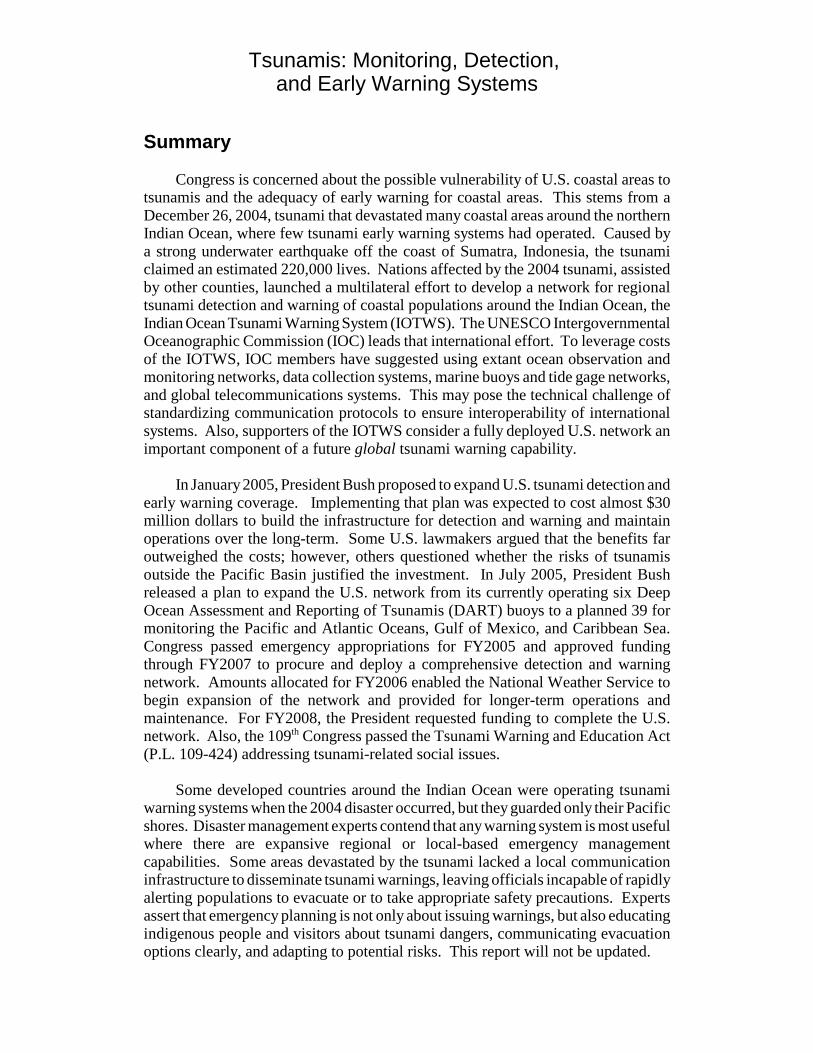
Summary
Congress is concerned about the possible vulnerability of U.S. coastal areas totsunamis and the adequacy of early warning for coastal areas. This stems from aDecember 26, 2004, tsunami that devastated many coastal areas around the northernIndian Ocean, where few tsunami early warning systems had operated. Caused bya strong underwater earthquake off the coast of Sumatra, Indonesia, the tsunamiclaimed an estimated 220,000 lives. Nations affected by the 2004 tsunami, assistedby other counties, launched a multilateral effort to develop a network for regionaltsunami detection and warning of coastal populations around the Indian Ocean, theIndian Ocean Tsunami Warning System (IOTWS). The UNESCO IntergovernmentalOceanographic Commission (IOC) leads that international effort. To leverage costsof the IOTWS, IOC members have suggested using extant ocean observation andmonitoring networks, data collection systems, marine buoys and tide gage networks,and global telecommunications systems. This may pose the technical challenge ofstandardizing communication protocols to ensure interoperability of internationalsystems. Also, supporters of the IOTWS consider a fully deployed U.S. network animportant component of a future global tsunami warning capability.
In January 2005, President Bush proposed to expand U.S. tsunami detection andearly warning coverage. Implementing that plan was expected to cost almost $30million dollars to build the infrastructure for detection and warning and maintainoperations over the long-term. Some U.S. lawmakers argued that the benefits faroutweighed the costs; however, others questioned whether the risks of tsunamisoutside the Pacific Basin justified the investment. In July 2005, President Bushreleased a plan to expand the U.S. network from its currently operating six DeepOcean Assessment and Reporting of Tsunamis (DART) buoys to a planned 39 formonitoring the Pacific and Atlantic Oceans, Gulf of Mexico, and Caribbean Sea.Congress passed emergency appropriations for FY2005 and approved fundingthrough FY2007 to procure and deploy a comprehensive detection and warningnetwork. Amounts allocated for FY2006 enabled the National Weather Service tobegin expansion of the network and provided for longer-term operations andmaintenance. For FY2008, the President requested funding to complete the U.S.network. Also, the 109th Congress passed the Tsunami Warning and Education Act(P.L. 109-424) addressing tsunami-related social issues.
Some developed countries around the Indian Ocean were operating tsunamiwarning systems when the 2004 disaster occurred, but they guarded only their Pacificshores. Disaster management experts contend that any warning system is most usefulwhere there are expansive regional or local-based emergency managementcapabilities. Some areas devastated by the tsunami lacked a local communicationinfrastructure to disseminate tsunami warnings, leaving officials incapable of rapidlyalerting populations to evacuate or to take appropriate safety precautions. Expertsassert that emergency planning is not only about issuing warnings, but also educatingindigenous people and visitors about tsunami dangers, communicating evacuationoptions clearly, and adapting to potential risks. This report will not be updated.
Contents
Introduction . . . . . . . . . . . . . . . . . . . . . . . . . . . . . . . . . . . . . . . . . . . . . . . . . . . . . . 1
A Global Tsunami Early Warning System? . . . . . . . . . . . . . . . . . . . . . . . . . . . . . . 3Challenges . . . . . . . . . . . . . . . . . . . . . . . . . . . . . . . . . . . . . . . . . . . . . . . . . . . 3International Proposals . . . . . . . . . . . . . . . . . . . . . . . . . . . . . . . . . . . . . . . . . . 4
Communication of Tsunami Warnings . . . . . . . . . . . . . . . . . . . . . . . . . 4U.Sx. DART Buoys for the Indian Ocean . . . . . . . . . . . . . . . . . . . . . . . 6
Tsunami Protection for the United States . . . . . . . . . . . . . . . . . . . . . . . . . . . . . . . 6Bush Administration Actions . . . . . . . . . . . . . . . . . . . . . . . . . . . . . . . . . . . . . 7
President Bush’s Tsunami Action Plan . . . . . . . . . . . . . . . . . . . . . . . . . 7
National Weather Service Tsunami Programs . . . . . . . . . . . . . . . . . . . . . . . . . . . . 8Tsunami Warning Centers . . . . . . . . . . . . . . . . . . . . . . . . . . . . . . . . . . . 9National Tsunami Hazard Mitigation Program (NTHMP) . . . . . . . . . . 9Tsunami Detection Operations . . . . . . . . . . . . . . . . . . . . . . . . . . . . . . 11Other Supporting Technologies . . . . . . . . . . . . . . . . . . . . . . . . . . . . . . 11
Related and Contributing U.Sx. Programs . . . . . . . . . . . . . . . . . . . . . . . . . . 13The U.Sx. Geological Survey (USGS) . . . . . . . . . . . . . . . . . . . . . . . . . 13World Weather Watch . . . . . . . . . . . . . . . . . . . . . . . . . . . . . . . . . . . . . 15National All Hazards Weather Radio (NAHWR) . . . . . . . . . . . . . . . . 15Cooperative Protection for the Pacific Basin . . . . . . . . . . . . . . . . . . . . 17
Conclusion . . . . . . . . . . . . . . . . . . . . . . . . . . . . . . . . . . . . . . . . . . . . . . . . . . . . . . 17
Appendix A: Tsunami-Related Legislation . . . . . . . . . . . . . . . . . . . . . . . . . . . . 20Legislation in the 109th Congress . . . . . . . . . . . . . . . . . . . . . . . . . . . . . . . . . 20
Sx. 50 (Inouye) . . . . . . . . . . . . . . . . . . . . . . . . . . . . . . . . . . . . . . . . . . . 20HxR. 1674 (Boehlert) . . . . . . . . . . . . . . . . . . . . . . . . . . . . . . . . . . . . . . 21
Appendix B: U.Sx. Tsunami Warning Program Funding . . . . . . . . . . . . . . . . . . 23
List of Figures
Figure 1. Proposed U.Sx. DART Buoy Network . . . . . . . . . . . . . . . . . . . . . . . . 10Figure 2. NOAA DART Platform . . . . . . . . . . . . . . . . . . . . . . . . . . . . . . . . . . . . 12
List of Tables
Table 1. NOAA U.Sx. Tsunami Program Funding: FY2001-FY2008 . . . . . . . . 24Table 2. Strengthening the U.Sx. Tsunami Warning Program:
Details of the President’s FY2008 Request . . . . . . . . . . . . . . . . . . . . . . . . . 27
1 A tsunami is a seismic sea wave (or a series of waves) usually generated by an underwaterearthquake or landslide, but occasionally caused by volcanic eruption or major landslide intothe ocean. Tsunami is translated from Japanese as “harbor wave.”2 Mw, the moment of magnitude, is a way to measure the force of an earthquake’s totalseismic energy released as a function of rock rigidity in the fault, the total area of contactwhere friction occurs, and the amount of slippage (or displacement). It is used forearthquakes greater than M8.2 on the Richter scale.3 U.N. World Health Organization, Department of Health Measurement and InformationSystems, “Asian Tsunami: Death-Toll Addiction and its Downside,” by Michel Thieren.Available at [http://www.who.int/bulletin/volumes/83/2/82.pdf].4 Presenters at that briefing included, David Applegate, Science Advisor for Earthquake andGeological Hazards at the USGS; General David Johnson, Assistant Director of NOAA’sNational Weather Service; Gregg Withee, Assistant Director for NOAA Satellite andInformation Services; and Eddie Bernard, Associate Director of NOAA’s Pacific MarineEnvironmental Laboratory (teleconferencing from Seattle, WA).
Tsunamis: Monitoring, Detection, and Early Warning Systems
Introduction
On December 26, 2004, a tsunami disaster was triggered by an underwaterearthquake off the west coast of northern Sumatra in Indonesia.1 Based on physicalevidence of displacement of the sea floor, U.S. seismologists determined theearthquake to have been a Mw 9.2.2 The ensuing tsunami devastated many coastalareas around the northern Indian Ocean and, with the earthquake, caused economicupheaval in many areas. International disaster agencies estimated that more than220,000 people may have lost their lives as a direct result of the tsunami.3 Thedisaster prompted some Members of the 109th Congress to raise questions about (1)the possibility of tsunamis occurring in U.S. coastal areas, (2) the extent to whichthese areas are currently monitored, (3) how tsunamis might be detected, and (4)whether there is a national capacity to issue evacuation warnings for tsunamis.
On January 5, 2005, the House Science Committee, the House Coastal Caucus,and the House Oceans Caucus co-sponsored a briefing organized by the U.S.Geological Survey (USGS) of the Department of the Interior whose purpose was toconsider possible implications of the type of the tsunami disaster that occurred in theIndian Ocean for the United States. Experts from USGS and the National Oceanicand Atmospheric Administration (NOAA) of the Department of Commerce deliveredpresentations about the scientific circumstances surrounding the Indian Oceantsunami and discussed international capabilities for tsunami monitoring, detection,and early warning.4
CRS-2
5 General David L. Johnson, “NOAA Tsunami and Natural Disaster Information,” Jan. 5,2005 House briefing.6 Lifelines are emergency response services, hospitals, other care facilities, energy and waterdelivery systems, telecommunications, and electronic commerce. See U.S. Congress,Senate, Committee on Commerce Science and Transportation, Earthquake HazardsReduction Act, Report to Accompany S. 910, 105th Cong., 1st sess., S.Rept. 105-59(Washington: GPO, 1997), p. 3.7 U.S. Office of Science and Technology Policy, “U.S. Announces Plan for ImprovedTsunami Detection and Warning System,” press release, OSTP News, Jan. 14, 2005,available at [http://www.ostp.gov/html/Tsunamiplanrelease.pdf], accessed Dec. 1, 2006.See also Eli Kintisch, “South Asia Tsunami: U.S. Clamor Grows for Global Network ofSensors,” Science, vol. 307, Jan. 14, 2005, p. 191.
Scientists and emergency experts who assessed the damage after the December26, 2004, tsunami disaster found that there were few, if any, systems for monitoringtsunamis in the Indian Ocean, and little, if any, capability to warn populations locally.Some nations affected by the tsunami, including Australia and Indonesia, did havetsunami early warning systems, but they monitored only their Pacific shores wherethey perceived the greatest threat.5 Due to the geographic proximity of many humansettlements to where the tsunami was generated, and without ability to receivetsunami warnings rapidly, post-disaster assessments indicate that for Indonesia’sIndian Ocean coastal populations emergency communications would have beenuseless in many cases. Other findings show that many indigenous people and touristswere not educated about the dangers of tsunamis or aware of the physical warningsigns of an onset of a tsunami. Also, for some communities, no backup procedureto issue evacuation alerts was included in local or regional emergency plans if“lifelines” such as electric utilities and telecommunications were disrupted.6
On January 29, 2005, the House Committee on Science, and on February 2,2005, the Senate Committee on Commerce, Science, and Transportation heldhearings about the need for expanding tsunami early warning protection for theUnited States and its possessions. Also discussed were long-term goals for guardingnon-U.S. coastal regions. Legislation introduced in the 109th Congress prior to thesehearings by Senator Lieberman of Connecticut (S. 34) and Senator Inouye of Hawaii(S. 50) called for a rapid U.S. response to upgrade existing U.S. capacity for tsunamiwarning in the Pacific, and to expand operations to include the Atlantic Ocean, theGulf of Mexico, and the Caribbean Sea. Senator Inouye’s bill was closely alignedwith President Bush’s proposal for U.S. tsunami protection released on January 14,2005.7 In addition, S. 50 addressed related social issues such as tsunami disastereducation, emergency preparedness, adaptation, and mitigation. (See “AppendixA.”)
Although most deadly tsunamis have occurred historically in the western PacificOcean, examples of recorded events and empirical scientific evidence for the easternPacific and North Atlantic Oceans go back centuries. In 1692, a tsunami generatedby massive underwater landslides in the Atlantic Puerto Rican Trench reachedJamaica’s coast, causing an estimated 2,000 deaths. In 1775, a tsunami struck in theeastern Atlantic Ocean on the coast of Portugal, killing an estimated 60,000 people.In 1929, a tsunami generated in the Grand Banks region of the east coast of Canada
CRS-3
8 Statistics on deaths resulting from tsunamis were compiled by CRS from online sources,including data from the Tsunami Laboratory of Novosibirsk, Russia, NOAA’s NationalGeophysical Data Center, the University of Southern California, Tsunami Research Group,and others. See [http://geology.about.com/library/bl/bltsunamideathtable.htm].
hit Newfoundland, killing 51 people. It was the third lethal tsunami for Canada’sAtlantic Coast within 150 years.8
A Global Tsunami Early Warning System?
In the wake of the 2004 tsunami disaster in the Indian Ocean, many internationalagencies expected that there would be technical, financial, and political challengesto overcome before a multinational tsunami early warning network could beestablished for the Indian Ocean or other international earthquake-prone areas, suchas the Black Sea. In some ways, those developed nations that had the resources andcapability to establish their own regional emergency management networks fordisaster warning and those who had executed comprehensive disaster plans were ableto avoid some of the challenges. Challenges
After the Indian Ocean tsunami disaster, international science agencies calledfor an inventory of existing capacity for tsunami monitoring, detection, and warningsystems that would be conducted under the auspices of the United Nations. Thatinventory would provide a baseline from which outstanding requirements for sucha network would be determined. Government policy analysts raised technologicaland national security issues as a consequence of building and sharing a truly “global”tsunami early warning network. Technological issues included internationalstandards for tsunami warning instrumentation, data collection, and communicationsprotocols required of systems that would receive data and relay warnings. Nationalsecurity issues included proposed open access to and sabotage of internationaltelecommunication networks. Also, U.S. intelligence experts were concerned thatcertain data collected could be considered sensitive and might reveal methodologiesthat could compromise U.S. and other nations’ intelligence-gathering operations.
Development of a “truly global” tsunami early warning system with a capabilityfor issuing regional and local warnings has required involvement of many nationswith widely varying technological capabilities and financial resources. Reportsindicate that international political leaders expected that most of the responsibilityfor paying for such a system would fall on the wealthiest nations. Resources toprocure state-of-the-art monitoring and detection technology, including scientificinstruments, platforms, and communications networks; to sustain international costsharing; and to provide long-term operations and maintenance of such systems appearto be the most critical obstacle toward achieving a collaborative international effortfor tsunami detection and early warning.
At a January 2005 House briefing, Assistant Director of NOAA for Satellite andInformation Services, Gregg Withee, raised another issue when he testified that some
CRS-4
9 Gregg Withee, January 5, 2005 House briefing. Stefan Maus of NOAA’s NationalGeophysical Data Center (NGDC) of the NOAA Environmental Satellite program (NESDIS)visited India October 22 to November 20, 2005 to enhance the exchange of geomagneticdata for space weather, main field, and crustal field modeling. See[http://www.ngdc.noaa.gov/products/news_archive_2005.html].10 British Broadcasting Corporation, “Indian Ocean Tsunami Warning System,” BBC News,Dec. 23, 2005, available at [http://news.bbc.co.uk/2/hi/science/nature/4524642.stm].“Thailand, India and Indonesia are forging ahead with their own systems and Australia,Malaysia and Singapore are planning to develop warning capacities.” 11 U.S. Executive Office of the President, Office of Science and Technology Policy, “OSTPDirector John Marburger to Head U.S. Delegation at Thai-Sponsored Meeting to DevelopTsunami Early Warning System for Indian Ocean and Southeast Asia,” press release, Jan.27, 2005.12 UN ISDR, “Meeting in Paris to Plan Tsunami Early-Warning System,” Press Release:IHA/1019 (Geneva, Mar. 1, 2005). See also, ISDR, Proposed Strategy for BuildingResilience to Tsunamis in the Indian Ocean 2006-2008, Jan. 27, 2006. Available at[http://www.unisdr.org/asiapacific/ap-iotsunami/proposed-TEWS-strategy-2006-2008.pdf].
nations in the Indian Ocean, including India, and elsewhere, maintained proprietaryrights to their real-time satellite data, meaning that global monitoring and disasterresponse institutions would have to pay for the data.9 Some of these data, Witheeasserted, could be critical for detecting and tracking tsunamis in the Indian Ocean andassessing post-disaster damage.
International Proposals
On January 6, 2005, the United Nations proposed an international effort todevelop a tsunami early warning capacity for potentially vulnerable populationslocated on Indian Ocean coasts. That endeavor is spearheaded by the U.N.Educational, Scientific, and Cultural Organization (UNESCO) IntergovernmentalOceanographic Commission (IOC). In addition, Australia, Japan, Thailand, and Indiainitiated individual efforts to expand existing monitoring capacity for Indian Oceancoastlines.10 The United States — a member of UNESCO — became involved in theinternational effort early on. The Government of Thailand held a ministerial meetingin Phuket, January 28-29, 2005, on tsunami early warning protection for the IndianOcean and Southeast Asia. President Bush’s Science Advisor and Director of theOffice of Science and Technology Policy, John Marburger III, represented the UnitedStates.11 This meeting was followed by an IOC summit in Paris, France, in March2005. Attendees included representatives from Indian Ocean countries affected bythe December 26, 2004, tsunami, and IOC members. The Director of the UNInternational Strategy for Disaster Reduction (ISDR) chaired the event.12 IOCofficials stated the session was the first of its kind to firm up plans and commitmentsfor an internationally coordinated tsunami early warning system for the Indian Ocean,including soliciting various member countries’ financial pledges.
Communication of Tsunami Warnings. The Director of NOAA’sNational Weather Service (NWS), Brig. Gen. David L. Johnson, USAF, (Ret.) —who also testified in January 2005 congressional hearings on U.S. tsunami earlywarning capabilities — emphasized that in addition to a network to monitor and
CRS-5
13 U.S. Congress, Senate Committee on Science, Commerce and Transportation, UnitedStates Tsunami Preparedness, hearing, Feb. 2, 2005. Oral testimony of Brig. Gen. JackKelly, Jr., former NWS Director, and present Deputy Administrator for NOAA on behalfof Vice Admiral Conrad Lautenbacher, Jr. (U.S. Navy, Ret.) Undersecretary of Commercefor Oceans and Atmosphere and NOAA Administrator, National Oceanic and AtmosphericAdministration, Department of Commerce.14 U.S. Dept. of Commerce, NOAA, Office of the Federal Coordinator for Meteorology,“World Weather Program: The Global Observing System: Its Impacts and Future,” byBGEN John J. Kelly Jr., (USAF, Ret.), The Federal Plan for Meteorological Services andSupporting Research: Fiscal Year 2006, Report FCM P1-2005, Appendix B: 237-243(Washington, DC: October 2005). Other examples of international communicationsnetworks are included.15 For example, one of the international observation networks currently being developed andproposed to be a major component of GEOSS is the International Global Ocean ObservingSystem (IGOOS). Another is a potential network of thousands of ARGO floats that monitorglobal climate variability in the equatorial Pacific, known collectively as the ARGO Array.For more information on ocean observing systems, see U.S. Congress, House ResourcesSubcommittee on Fisheries, Conservation, and Wildlife, Status of Ocean Observing Systemsin the United States, Oversight Hearing, serial no. 108-102, July 13, 2004 (Washington,DC: GPO, 2005).
detect possible tsunamis, emergency communication infrastructures are critical fordisseminating tsunami warnings regionally or locally so as to safeguard Indian,western Atlantic, and far Pacific Oceans’ coastal populations. He noted that in someregions at risk for tsunamis, local disaster management capabilities may beinadequate or non-existent.
Johnson emphasized that NOAA’s responsibilities for tsunami warningsterminate after communications are relayed to the Federal Emergency ManagementAgency (FEMA) in the Department of Homeland Security and to internationalemergency management officials.13 He added that in the United States local orregional forecasts and warnings of severe weather issued by NWS weather forecastoffices are often picked up and distributed by local emergency managers and thebroadcast media and that the NWS broadcasts warnings directly to individuals andinstitutions (e.g., public schools possessing NOAA Weather Radio receivers).
NOAA’s Administrator, Vice Admiral Conrad C. Lautenbacher, Jr. (Ret. Navy),leads the U.S. effort for developing and implementing an international, collaborativeGlobal Earth Observing System of Systems (GEOSS). This initiative also addressesbuilding capacity for global tsunami early detection and warning capabilities. Billedas “an excellent example of science serving society,” Lautenbacher has indicated thatGEOSS’s infrastructure will be built upon extant environmental data collectionplatforms, telecommunication capabilities, environmental observation systems, andcommunication lines operating around the world.14 Through planned interoperabilityof GEOSS and other systems, the United States would assist other IOC members indeveloping a tsunami early warning capacity in the Indian Ocean and eventually amore expansive global network.15 (See also “Tsunami Detection Operations.”) Withrespect to domestic and international discussions on developing new generation state-of-the-art deep water tsunami detection instrumentation, the U.S. Congress has urgedthat whatever technologies are adopted to upgrade the U.S. tsunami warning network
CRS-6
16 ICG/IOTWS Working Group 2 on Sea Level Data Collection and Exchange, IncludingDeep Ocean Tsunami Detection Instruments, Draft Minutes: Annex IV, Proposal by U.S.for Contribution of Two DART Buoys to the IOTWS, in Inter-sessional Meeting, 1-2, May2006, Melbourne, Australia, pp. 16-25, [41 p.], available at [http://ioc3.unesco.org/indotsunami/documents/wgfiles/WG2%20Intersessional%20meeting%20report%20Melbourne.pdf].17 Their placement is outside the limits of any single nation’s Exclusive EnterpriseZone (EEZ).18 IGO/PTWS Coordination Group, Article 4.9, p. 8.19 Statement of Representative Frank Pallone, Congressional Record, Jan. 4, 2005: H40.“There has been a lot of discussion and I think there is a need to expand the tsunami earlywarning system that exists in the Pacific not only to the Indian Ocean but also possibly to
(continued...)
also serve multiple purposes to enhance future global environmental observations ofsystems such as GEOSS.
Most international science agencies and non-governmental organizationsrepresenting Indian Ocean nations generally support the developing GEOSS as theinfrastructure for a future global tsunami early warning network. Many other nationspraised President Bush’s January 2005 proposal and then his July 2005 “action plan”for a U.S. tsunami warning system as “a good start,” and a model for a global system.
U.S. DART Buoys for the Indian Ocean. At a May 2006 meeting inMelbourne, Australia, the United States laid out plans for lending two “surplus”state-of-the-art Deep Ocean Assessment and Reporting of Tsunamis (DART II)buoys for “operational detection of tsunami and verification of non-events in theIndian Ocean.”16 U.S. contributions, and similar contributions from other developedcountries such as Germany, are helping to establish a limited archetypical IOTWS inthe near-term. NOAA selected two sites to deploy the Dart buoys:17 (1) near theAndaman Islands off Sumatra, Indonesia at, 0oN and (2) between Colombo, SriLanka, and Phuket, Thailand, at 9oN. NOAA deployed the first buoy in December2006 to commemorate the anniversary of the 2004 disaster. The second deploymentis scheduled for May 2007. NOAA officials say that they would provide technicalassistance and some funding for operation and maintenance (O&M) throughwhatever entity is established to manage the IOTWS. The IOC is also discussingmechanisms to fund a “tsunami watch capacity” that would include long-term O&Mof the entire IOTWS. Many IOC members have agreed that the development anddeployment of the IOTWS provides opportunities and platforms for hosting otherenvironmental sensors. They also have suggested joint uses of international fleets toassist in deployment and maintenance of the buoys.18
Tsunami Protection for the United States
In January 2005, Representative Pallone of New Jersey called for establishinga tsunami detection and warning network for the U.S. Atlantic coast, Gulf of Mexico,and Caribbean Sea.19 Other lawmakers questioned whether the risk of a tsunami for
CRS-7
19 (...continued)the Atlantic Ocean and throughout the world.”20 USGS, Woods Hole Science Center, “Caribbean Tsunami and Earthquake HazardsStudies Program,” available at [http://woodshole.er.usgs.gov/projects/project_get.php?proj=29210EQ&style=html].21 See “The Puerto Rico Trench: Implications for Plate Tectonics: Earthquake and TsunamiHazards” at [http://oceanexplorer.noaa.gov/explorations/03trench/trench/trench.html] andalso, University of Puerto Rico at Mayaguez, The Puerto Rico Warning and MitigationProgram at [http://poseidon.uprm.edu].22 State of New Hampshire, “Disaster Plan 409,” Sect. II, Geological Hazards, SeismicHazards, at [http://www.nhoem.state.nh.us/mitigation/state_of_new_hampshire.asp]. Seealso NOAA, National Weather Service TsunamiReady Program, “Is your Community Readyfor the Next Tsunami?,” at [http://tsunami.gov].23 NOAA, National Weather Service, “TsunamiReady Communities,” available at[http://www.tsunamiready.noaa.gov/ts-communities.htm].24 U.S. EOP, OSTP, Press release, Jan. 14, 2005.
the east coast justified such expenditures. At January 2005 congressional briefings,NOAA scientists pointed out the potential dangers related to the Puerto Rican Trench— the deepest point in the western Atlantic Ocean — to assure that the risks werereal.20 They cited massive landslides and sloughing that have occurred historicallyalong the North American continental shelf and strong underwater earthquakes thatoccurred off the coast of Puerto Rico, which, in some cases, generated tsunamis thatcaused loss of life in the thousands and widespread property damage.21
New Hampshire, among other states, has had a contingency plan for tsunami
emergencies and has managed a clearinghouse of information about historicaltsunami disasters that have affected the northeast United States.22 In 2005, two U.S.communities in the western Atlantic basin became the first of NWS TsunamiReadycommunities outside the Pacific Basin. One of these was in Florida on the Gulf ofMexico and the other was Norfolk, VA, on the mid-Atlantic Coast.23 Since then, fiveother Atlantic coast states and Puerto Rico have been declared TsunamiReady byNWS. In contrast, some areas potentially at risk for tsunamis in the eastern PacificOcean, including the U.S. mainland, Alaska, and Hawaii have had tsunamiemergency evacuation plans in place for over 40 years.
Bush Administration Actions
On January 14, 2005, the White House Office of Science and Technology Policy(OSTP) announced a proposal for an improved tsunami warning and detection systemfor the United States.24 The President’s plan stated that 32 dedicated tsunamiwarning and detection DART buoys would be procured and deployed by mid-2007.The President’s stated goal was to improve tsunami detection for the far Pacific andAtlantic Oceans, Gulf of Mexico, and Caribbean Sea.
President Bush’s Tsunami Action Plan. In December 2005, PresidentBush released Tsunami Risk Reduction for the United States: A Framework for
CRS-8
25 Executive Office of the President, National Science and Technology Council, TsunamiRisk Reduction For the United States: A Framework for Action, A Joint Report of theSubcommittee on Disaster Reduction and the United States Group on Earth Observations,July 2005 (released December 2005).26 Ibid., Ch. 4, “International Cooperation.” 27 Eileen Shea, Project Coordinator, East West Center, Honolulu, HI, “Testimony,” SenateCommerce Tsunami Preparedness hearing, Feb. 2, 2005, available at [http://commerce.senate.gov/hearings/testimony.cfm?id=1361&wit_id=3955].28 See Government Accountability Office (GAO), “State and Local Tsunami HazardMitigation Activities Are Under Way although Implementation Varies Considerably amongLocations,” in U.S. Tsunami Preparedness: Federal and State Partners Collaborate to HelpCommunities Reduce Potential Impacts, but Significant Challenges Remain, GAO ReportGAO-06-519, June 2006, p. 29. Prepared for Congressional Committees and Senator DianeFeinstein.29 See Eileen Shea, Project Coordinator, East West Center, Honolulu, HI, “Testimony,”Senate Commerce Tsunami Preparedness hearing, Feb. 2, 2005, available at[http://commerce.senate.gov/hearings/testimony.cfm?id=1361&wit_id=3955].
Action (dated July 2005).25 This plan outlined steps to be taken to reduce tsunamirisk on the U.S. mainland, Hawaii, and U.S. territories in the far Pacific Ocean andCaribbean Sea.26 To implement recommendations in his plan, President Bushproposed $20.4 million for the NWS for FY2007. He also requested $3.95 millionfor USGS’s Global Seismic Network (GSN) upgrades, about $35,000 more thanFY2006-enacted funding. That funding would enable real-time telemetry for 20%of 127 global seismic sensing platforms which lack that capability. (See “AppendixB,” Table 1.)
To complement the President’s plan, some social scientists argued for“institutionalizing” a public education component in implementing legislation thatmight serve to protect the United States from tsunamis.27 They envisioned trainingof local authorities as resident developers and deliverers of disaster education andlocal tsunami emergency planning, in addition to interagency resource sharing at alllevels of government and a visible federal agency-presence within the community.28
Finally, they recommend adaptation as an alternative means of disaster management,such as using low-tech, high-impact solutions for disseminating public evacuationorders.29 (See Appendix A, S. 50, 109th Cong.)
National Weather Service Tsunami Programs
NOAA’s National Weather Service (NWS) has managed the U.S. operationalprogram for tsunami warnings in U.S. Pacific coastal areas and has played a role ininternational tsunami protection. The National Tsunami Warning Program (NTWP)consists of two U.S. tsunami warning centers that monitor, detect, and warn forpossible tsunamis generated in the Pacific Ocean.
CRS-9
30 See NOAA, NWS, “How TsunamiReady Helps Communities and Counties at Risk,”available at [http://www.stormready.noaa.gov/tsunamiready/].31 USGS, “Local Tsunami Hazards in the Pacific Northwest from Cascadia Subduction ZoneEarthquakes,” by Eric L. Geist, at [http://pubs.usgs.gov/pp/pp1661b/pp1661b.pdf]. 32 NOAA, NWS, TsunamiReady, at [http://www.stormready.noaa.gov/tsunamiready/ts-communities.htm].
An associated program under the NTWP concentrates on reducing the rate offalse tsunami alarms issued for the Pacific Ocean. The National Tsunami HazardsMitigation Program (NTHMP) assists states in emergency planning and indeveloping maps of potential coastal innundation for a tsunami of a given intensity.The NTHMP also operates tsunami disaster outreach and education programsthrough NOAA’s TsunamiReady program.
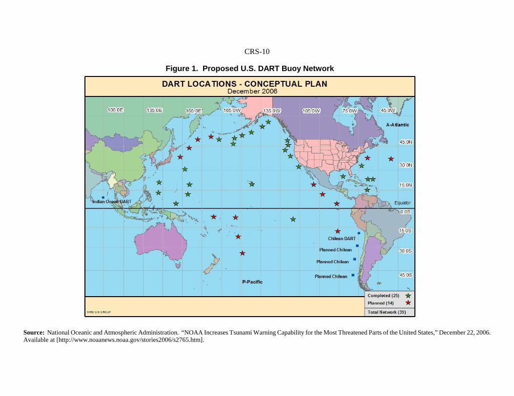
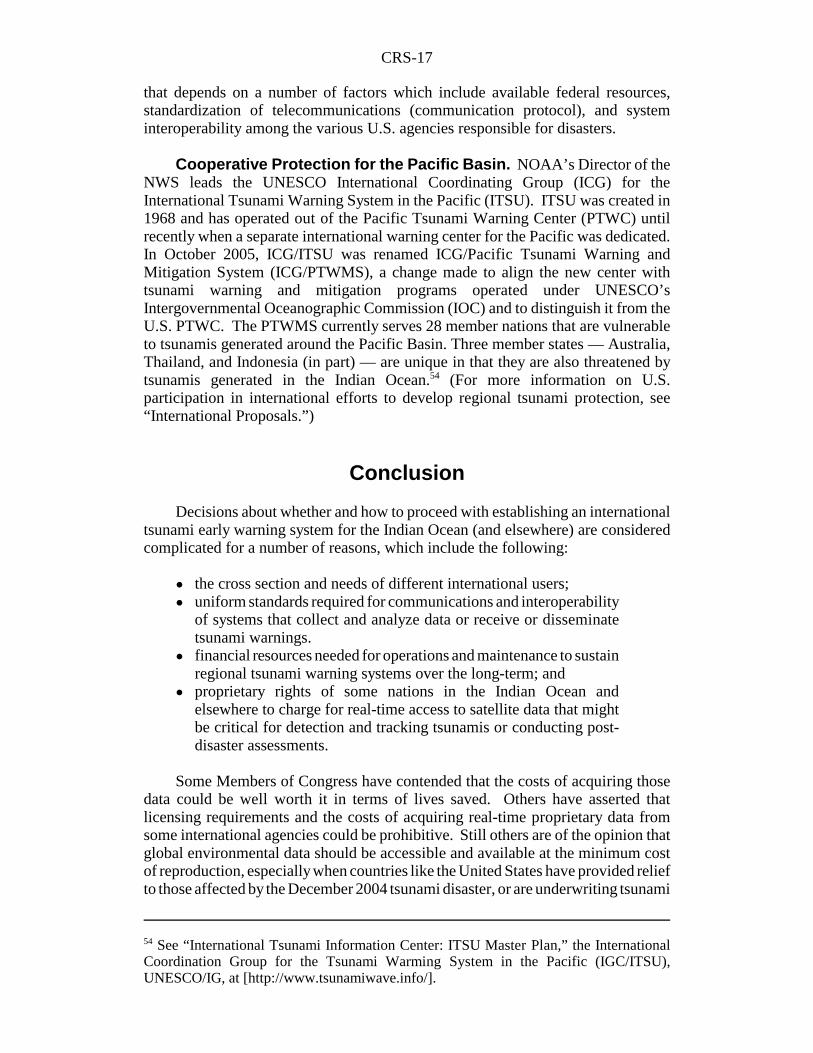
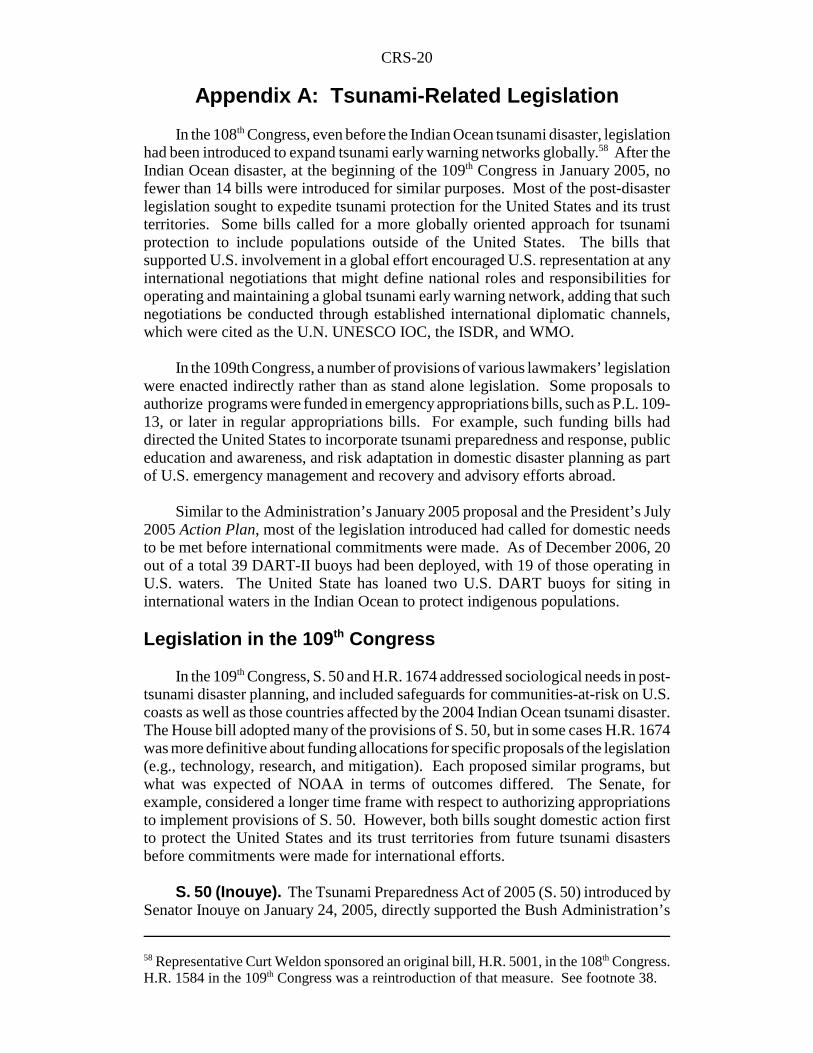
Tsunami Warning Centers. The NWS operates the Pacific TsunamiWarning Center (PTWC) at Ewa Beach, HI, and the West Coast/Alaska TsunamiWarning Center (WC/AKTWC) at Palmer, AK. The PTWC monitors for tsunamisand issues warnings for the Hawaiian Islands, the U.S. Pacific territories, and otherU.S. and international interests in the Pacific Basin. The center was established in1949, after a strong earthquake and massive landslides off the coast of southwestAlaska caused a disastrous tsunami for the Hawaiian Islands only hours later. TheWC/AKTWC was established in 1967, following a devastating earthquake of Mw9.2that struck Anchorage, AK, in 1964 and caused major earthquake and localizedtsunami damages.30 The WC/AKTWC is responsible for issuing tsunami warningsto emergency management officials in Alaska, British Columbia (Canada),Washington State, Oregon, and California. The WC/AKTWC now also serves as thecenter for warning U.S. populations located in the western Atlantic Ocean and islinked by telemetry with seven deep ocean DART buoys currently deployed off U.S.Atlantic, Caribbean, and Gulf of Mexico shores. (See Figure 1).
National Tsunami Hazard Mitigation Program (NTHMP). In 1992,NOAA launched the NTHMP to address the credibility of Pacific tsunami warnings.At that time, there had been a 75% false-alarm rate for tsunamis. Local officials inHawaii became concerned about significant social upheaval and economic disruptionbeing caused by false alarms and whether the public would continue to heed futuretsunami warnings. Through technological progress and iterative improvements, thefalse-alarm error rate has improved significantly since then. In addition, periodicdrills are conducted by the Hawaiian government to familiarize the public withproper emergency procedures to be followed in the event of an actual disaster.
Another major research effort at NTHMP considers the potential for a sizableearthquake in the Pacific Northwest Cascadia Region which USGS scientists andothers believe would generate tsunamis that could severely damage several U.S.Pacific coastal regions.31 The NTHMP has worked with five Pacific states — Alaska,California, Hawaii, Oregon, and Washington — and is now working with fiveAtlantic states and Puerto Rico in developing local tsunami emergency preparednessplans for “communities-at-risk” as part of NOAA’s TsunamiReady program.32
CRS-10
Source: National Oceanic and Atmospheric Administration. “NOAA Increases Tsunami Warning Capability for the Most Threatened Parts of the United States,” December 22, 2006.Available at [http://www.noaanews.noaa.gov/stories2006/s2765.htm].
Figure 1. Proposed U.S. DART Buoy Network
CRS-11
33 Hugh B. Milburn et al., “Real-Time Tsunami Reporting from the Deep Ocean,” NOAAPacific Marine Environmental Laboratory (1996), at [http://www.ndbc.noaa.gov/Dart/milburn_1996.shtml].34 NOAA FY07 Budget Briefing, National Press Club, Washington, DC, Feb. 9, 2006. Seealso Figure 1.35 For example, NWS weather buoys record data, such as temperature, wind speed anddirection, and atmospheric pressure at a fixed location. Other “drifting” marine data buoysmeasure the speed of ocean currents, changes in salinity (or density) of the ocean, andchanges in sea surface from the “mean height.” Sea surface height data can also be collectedby sensors on U.S. satellites. In all cases, those data are relayed to ground receivingstations.36 The National Ocean Service (NOS) operates the National Water Level ObservationNetwork of tide-gages off all U.S. coasts and in the Great Lakes (NWLON). In major U.S.harbors the NOS PORTS program, in addition to operating tide gages, assesses the physicalconditions of shipping channels which may bear on how a tsunami might impact thatparticular location. National tide gage operations are also found in other countries.
NTHMP research and development has resulted in technology transferred toassist tsunami warning operations. An example is a tsunami disaster model which— with the requisite seismic data and knowledge of location of where a tsunami istriggered — can project the trajectory and intensity of ensuing waves. The NTHMPalso assists states on behalf of coastal communities in producing maps of potentialtsunami inundation.
Tsunami Detection Operations. NOAA currently operates a network of20 dedicated tsunami detection and relay stations as part of the NWS DARTProgram. NWS will deploy a total of 39 stations as the backbone of the U.S. tsunamiearly warning network.33 (See Figure 1 for DART buoy locations and Figure 2 forthe technical components.) In April 2006, seven DART buoys were added to theU.S. network and deployed in the Atlantic Ocean, Caribbean Sea, and Gulf ofMexico.34 Eventually, 32 U.S. DART buoys will operate in the Pacific Ocean,including the current three off the Alaskan Peninsula and three in the mid-PacificOcean. Another DART buoy was developed for the Chilean government and isdeployed in the eastern South Pacific Ocean off Chile’s coast. Although the UnitedStates and partnering nations that rely on the network may have the capability forearly detection of tsunamis, NOAA officials have cautioned that subsequent warningsare only effective if national emergency officials can receive those communicationsand, in turn, alert the public to take the necessary precautions or actions.
Other Supporting Technologies. In addition to a planned 39 operatingDART buoys, the NWS operates hundreds of marine weather buoys around U.S.coasts. These buoys provide data for telecommunications-capable, meteorological-instrumented platforms which have figured into the overall plans for an expandedU.S. tsunami early warning network.35 Also, tide gages off all U.S. coasts and in theGreat Lakes can detect sudden surges and other disturbances such as changes insubmarine pressures which may be indicative of a possible approaching tsunami.36
CRS-12
37 NOAA/Woods Hole Oceanographic Institution, Observing the Ocean in Real-Time: Argo,a Global Array of Profiling Floats to Understand and Forecast Climate, ed. Stan Wilson(1996). Funded in part by private academic institutions.
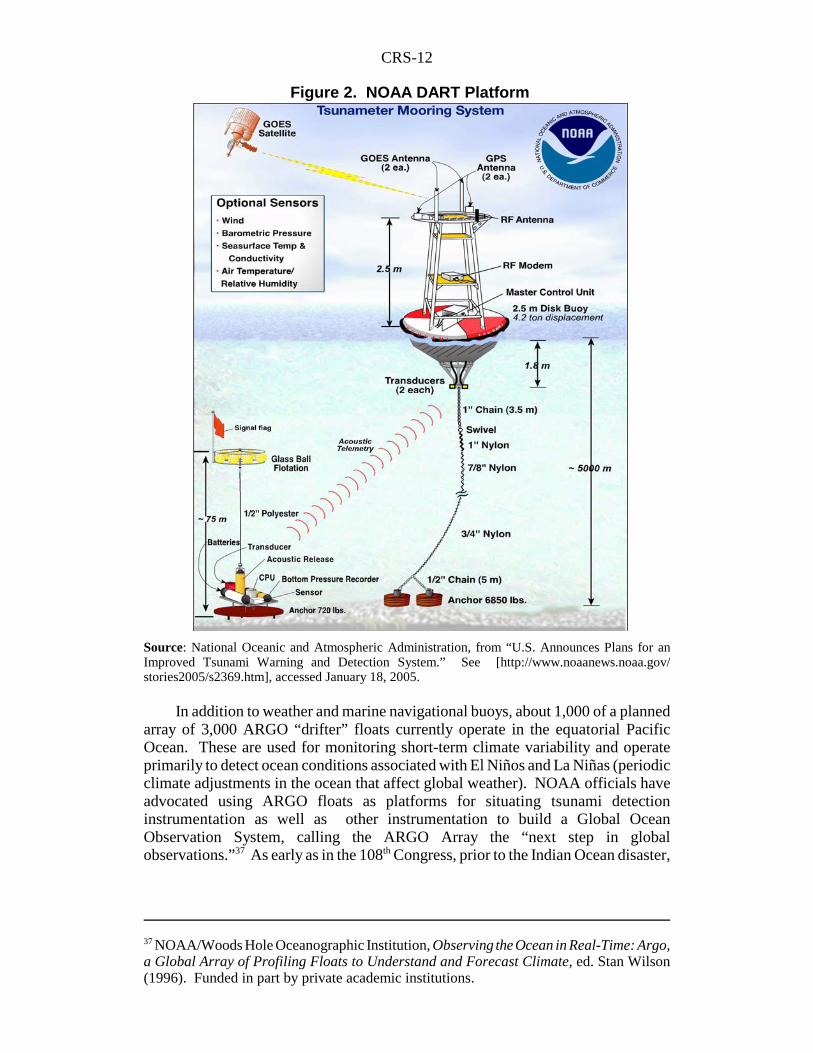
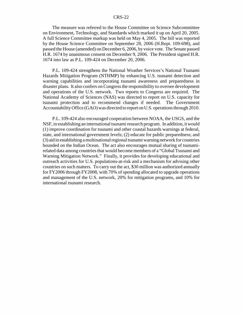
Figure 2. NOAA DART Platform
Source: National Oceanic and Atmospheric Administration, from “U.S. Announces Plans for anImproved Tsunami Warning and Detection System.” See [http://www.noaanews.noaa.gov/stories2005/s2369.htm], accessed January 18, 2005.
In addition to weather and marine navigational buoys, about 1,000 of a plannedarray of 3,000 ARGO “drifter” floats currently operate in the equatorial PacificOcean. These are used for monitoring short-term climate variability and operateprimarily to detect ocean conditions associated with El Niños and La Niñas (periodicclimate adjustments in the ocean that affect global weather). NOAA officials haveadvocated using ARGO floats as platforms for situating tsunami detectioninstrumentation as well as other instrumentation to build a Global OceanObservation System, calling the ARGO Array the “next step in globalobservations.”37 As early as in the 108th Congress, prior to the Indian Ocean disaster,
CRS-13
38 On Jan. 5, 2005, Representative Curt Weldon circulated a “Dear Colleague” letteradvocating the reintroduction of H.R. 5001 (108th Congress), the Ocean and CoastalObservation System Act, in the 109th Congress. This legislation promoted development ofan “Integrated Ocean Observation System,” to protect U.S. citizens in coastal communitiesfrom tsunamis. For further information on U.S. ocean observation systems, see U.S. HouseResources Subcommittee on Fisheries, Conservation, and Oceans, Status of OceanObserving Systems in the United States, Oversight Hearing, serial no. 108-102, July 13,2004 (Washington, DC: GPO 2005).39 University of Puerto Rico at Mayaguez, Puerto Rico Tsunami Warning and MitigationProgram, available at [http://poseidon.uprm.edu/].40 Kenneth B. Allen, Director of the Partnership for Public Warning, “Letter to PresidentBush,” Jan. 3, 2005, at [http://www.partnershipforpublicwarning.org/ppw/]. See also, JoabJackson, “Cisco, IBM Propose Internet-Based Disaster Alert System,” GovernmentComputer News, Feb. 11, 2005, available at [http://www.gcn.com].41 Incorporated Research Institutions for Seismology (IRIS), “Global Seismic Network(GSN) at [http://www.iris.edu/about/GSN/].
legislation had been introduced to consider the auxiliary technologies that mightenhance a U.S. tsunami detection and warning network.38
For the eastern United States, NOAA officials have suggested other platformsfor tsunami monitoring and detection in the Atlantic Ocean such as regional coastaland ocean observation networks currently operating or being developed for theeastern seaboard of Canada, U.S. coastal waters, and the Great Lakes. In support ofU.S. interests in the Gulf of Mexico coasts, in the Caribbean Sea, and Atlantic coastsof the Greater Antilles, the University of Puerto Rico at Mayaguez developed andnow operates a regional tsunami warning system and communications network.39
Related and Contributing U.S. Programs
The U.S. Geological Survey (USGS) is improving the earthquake monitoringand warning capabilities of the Global Seismic Network (GSN) by upgrading stationsthat have not had real-time data communication ability. USGS has also increasedcoverage of seismic alerts at the National Earthquake Information Center (NEIC) inGolden, CO. Other alternatives for broadcasting tsunami warnings may includeradios, cellular phone networks, and the Internet to reach local officials or ruralpopulations. International telecommunications networks, such as the GlobalTelecommunication System (GTS) (with common data transmission protocols)provide a capability for emergency communications among worldwide governmentinstitutions (i.e, weather bureaus).40
The U.S. Geological Survey (USGS). The USGS is also integral to theNWS National Tsunami Warning Program. USGS operation of the Global SeismicNetwork has been critical in identifying the potential for and issuing early warningof tsunamis. The GSN is a network of 127 global seismic monitoring stations, someof which are situated in the Indian Ocean. The GSN network is managed by theIncorporated Research Institutions for Seismology (IRIS), which is a consortium ofacademic institutions involved in earthquake monitoring, detection, and modeling.41
CRS-14
42 The formation of a tsunami.43 Dr. Charles Groat, Director of the USGS, presentation on the USGS FY2006 budget heldat the Dept. of the Interior, Washington, D.C., Feb. 7, 2005. Congress appropriated $8.1million in emergency supplemental appropriations for FY2005 in P.L. 109-13. 44 Dr. Charles Groat, Director of the USGS, presentation on USGS FY2007 budget held atthe Dept. of the Interior, Washington, D.C., Feb. 6, 2006.45 These include the USGS Advanced National Seismic System (ANSS), the Global SeismicNetwork (GSN), National Strong-motion Program, and other U.S. regional networks andcooperators. See [http://earthquake.usgs.gov/research/index.php?areaID=12].46 Rossella Lorenzi, “Top World Tsunami Hotspots Detailed,” Discovery News (online), Jan.11, 2005, available at [http://dsc.discovery.com/news/briefs/20050110/tsunamidanger.html].“According to Simon Day, Benfield Greig Hazard Research Center at University College
(continued...)
Although the USGS does not monitor directly for tsunamigenesis,42 the GSNmeasures intensity of land-based and submarine earthquakes around the globe in real-time. Depending on where they occur and their magnitude, the USGS determineswhether to alert NOAA (NWS) of the possible onset of a tsunami.
At the time of the tsunami disaster in the Indian Ocean, USGS officialsindicated that only about 80% of GSN instruments had capability for real-time datatelemetry.43 In FY2005, P.L. 109-13 funded President Bush’s request to upgrade theGSN network for 100% real-time communication capability. The 109th Congressappropriated $8.1 million in emergency supplemental appropriations for that purpose.Of the $8.1 million provided, a part of the funding was to increase the number ofseismic monitoring stations around the globe.44 Another part of the funding was toincrease the number of staff at the NEIC to monitor GSN data. Conferees on theemergency funding bill noted that resources recommended for GSN upgrades mightenable USGS and NWS to exchange more comprehensive data and information fortsunami modeling exercises in a more timely manner.
USGS scientists at the NEIC collect and analyze data on crustal deformation andocean floor displacement from earthquakes and determine which events may beprecursors to the generation of tsunamis. USGS topographical mapping data anddigital elevation models (DEM) have been used to develop more spatially accuratetsunami inundation maps for potential communities-at-risk. The inundation mapshave assisted emergency managers in developing tsunami evacuation plans and havealso guided decisions of local government authorities in land-use planning andprivate development by considering the possible impacts of tsunamis. USGSprimarily monitors for seismic activity on land, but its geologists have asserted thatland-based operations can be as important for tsunami detection and warning as deepocean buoys.45 In coastal areas of the United States, and especially along the Pacificcoast, earthquakes have generated landslides, some of which have resulted in abruptmass wasting of land into the ocean and displacing large volumes of water locally.Large submarine landslides occur beneath the ocean and off the continental shelfoccasionally generating tsunamis. Other research has been conducted at USGS toconsider the potential effects on the U.S. Atlantic coast from a “super tsunami” thatmay be caused by the collapse of a volcano in the Canary Islands off west Africa.46
CRS-15
46 (...continued)London, U.K., geological evidence suggests that during a future eruption, Cumbre ViejaVolcano on the island of La Palma in the Canary Islands, off West Africa, could experiencea catastrophic failure of the western flank.” 47 NOAA officials stress that, “The exchange and sharing of data on a worldwide basis isa critical part of developing descriptions and the understanding of our global environment.”U.S. Dept. of Commerce, NOAA, Office of the Federal Coordinator for Meteorology,“World Weather Program,” The Federal Plan for Meteorological Services and SupportingResearch: Fiscal Year 2005, Report FCM P1-2004, Appendix B: 223-228 (Washington,DC: Oct. 2004). Examples of international communications networks are included.48 NOAA, NESDIS, “About the World Data Center System.” Two of three WMO WorldWeather Program (WWP) data centers are housed in NOAA’s Environmental Satellite andData and Information Service (NESDIS) National Geophysical Data Center (NGDC). (See,[http://www.ngdc.noaa.gov/wdc/wdcmain.html]). These data centers archive global weatherdata and analysis, and are telecommunication enabled portals used for exchangingmeteorological and climatological data and scientific research around the globe. WWP dataarchives provided valuable information for post-disaster assessment of the 2004 IndianOcean tsunami. See, for example, “NOAA Scientists Able to Measure Tsunami Height fromSpace,” available at [http://www.noaanews.noaa.gov/stories2005/s2365.htm]. The U.S.Global Earth Observation (GEO) Workplan for 2006 “identifies the WDCs as one of thearchives for data collected over coastal regions subject to tsunami risk.” See[http://www.ngdc.noaa.gov/products/news_archive_2005.html].49 NESDIS’s National Oceanic Data Center (NODC) maintains the NOAA/IOC long-termarchive of global tsunami events, including inundation, and damage data. 50 Over time, Congress has expanded the reach of NOAA NWR by authorizing funds toconstruct more NWR transmission towers or adding repeaters that can be mounted on
(continued...)
World Weather Watch. The U.N. World Weather Watch (WWW) is acooperative program organized and administered by the U.N. World MeteorologicalOrganization (WMO). The mission of the WWW is to ensure that people no matterwhere they are around the globe are adequately warned about possible severe weatheror dangerous ocean-related conditions.47 NOAA officials regard the global reach ofWWW networks and associated World Weather Program (WWP) data centers48 asan important tool for communicating tsunami warnings and tsunami-related data andinformation to international governments and scientific institutions respectively.
NOAA also has a leadership role in the WWW with respect to meteorologicaldata collection, management, and archiving.49 The Department of State negotiateson behalf of the United States to achieve and maintain international agreements thatsustain WWW operations globally. WWW members, including the United Statesand its Far Pacific trust territories, use established international telecommunicationsprotocols (GTS) for receiving and disseminating weather data, forecasts, andwarnings.
National All Hazards Weather Radio (NAHWR). The NWS has operatedNOAA Weather Radio (NWR) for decades to warn individuals in their homes or atpublic institutions such as schools and hospitals of the potential of severe weatherand to take appropriate action.50 In 2003, the Department of Homeland Security
CRS-16
50 (...continued)existing structures in some localities to extend the range of existing NWR emergencytransmissions. The battery operated receiver is the critical component for receivingemergency warnings. An audible alarm is generated and the device activated by a NWStransmission of a severe weather warning. The instrument also generates a flashing light forthe hard of hearing. NWR receivers are made available to the public at a modest cost forindividuals, and at no cost to public schools applying for grant assistance. The NWS hasattempted to target rural areas so as many potentially affected communities as possible havean opportunity to receive severe weather-related warnings or other emergencycommunications from their nearest NWS Weather Service Office (WSO). Also, because ofsignificant advances in weather forecast technologies the lead time for emergency warningsin most cases has increased giving people more time to take appropriate action.51 National emergency management communications for the United States became theresponsibility of the Department of Homeland Security (DHS) in March 2003, when FEMAwas transferred to the newly established DHS. 52 See NOAA All Hazards Weather Radio (NWR) at [http://www.nws.noaa.gov/nwr/]. 53 Congress approved $156 million in §3010 of the Deficit Reduction Act of FY2005 (P.L.109-171). (See H.Rept. 109-362, p. 204). The funding would “provide for an all hazardsalert system to [issue] alerts in response to natural disasters, man-made accidents, and terrorincidents.” Of that amount, $50,000,000 would be used to implement a tsunami warning andcoastal vulnerability program that would be funded by proceeds from a FederalCommunications Commission (FCC) spectrum auction. The measure passed Congress onFeb. 6, 2006 (H.Rept. 109-366) and was signed by the President on February 8, 2006.
(DHS) initiated discussions with NWS to collaborate and modify NWR to enabledissemination of public warnings for all disasters, natural or otherwise.51 Anagreement between the two agencies paved the way for a DHS National All HazardsWeather Radio Network (NAHWR) that would broadcast warnings and hazard-related information over the existing NWR communications spectrum, now coinedthe Public Alert network.52 NOAA has retained management of the NWR network.
DHS envisions NAHWR disseminating warnings of earthquakes, tsunamis,volcanoes, floods, other natural disasters, and terrorist or industrial-related disasters.In 2003, Congress provided $10 million in the Emergency Wartime SupplementalAppropriations Act, 2003 (P.L. 108-11), to develop the architecture of the NAHWRnetwork.53 NOAA received appropriations of about $2.3 million for NWR in basefunding for local weather forecasts and warnings in FY2006 and the same amount forFY2007 (P.L. 110-5). President Bush requested $2.3 million for NWR for FY2008.However, some observers have argued that about $150 million is needed to developa broadband network capable of integrating multiple federal agency emergencycommunications.
Despite progress with NAHWR, the NWR network still stands on its own.NOAA officials have asserted that NWR can help to safeguard some people livingin coastal areas of the United States with early warning of an approaching tsunami,possible coastal flooding from storm surges, and other hazardous marine conditionssuch as rough waters or unusually high tides. They add that NWR can also serve tonotify coastal populations of tsunami false alarms, which may alleviate someresulting panic and economic disruption. Many emergency management expertsbelieve that an expansive NAHWR network will materialize in the future; however,
CRS-17
54 See “International Tsunami Information Center: ITSU Master Plan,” the InternationalCoordination Group for the Tsunami Warming System in the Pacific (IGC/ITSU),UNESCO/IG, at [http://www.tsunamiwave.info/].
that depends on a number of factors which include available federal resources,standardization of telecommunications (communication protocol), and systeminteroperability among the various U.S. agencies responsible for disasters.
Cooperative Protection for the Pacific Basin. NOAA’s Director of theNWS leads the UNESCO International Coordinating Group (ICG) for theInternational Tsunami Warning System in the Pacific (ITSU). ITSU was created in1968 and has operated out of the Pacific Tsunami Warning Center (PTWC) untilrecently when a separate international warning center for the Pacific was dedicated.In October 2005, ICG/ITSU was renamed ICG/Pacific Tsunami Warning andMitigation System (ICG/PTWMS), a change made to align the new center withtsunami warning and mitigation programs operated under UNESCO’sIntergovernmental Oceanographic Commission (IOC) and to distinguish it from theU.S. PTWC. The PTWMS currently serves 28 member nations that are vulnerableto tsunamis generated around the Pacific Basin. Three member states — Australia,Thailand, and Indonesia (in part) — are unique in that they are also threatened bytsunamis generated in the Indian Ocean.54 (For more information on U.S.participation in international efforts to develop regional tsunami protection, see“International Proposals.”)
Conclusion
Decisions about whether and how to proceed with establishing an internationaltsunami early warning system for the Indian Ocean (and elsewhere) are consideredcomplicated for a number of reasons, which include the following:
! the cross section and needs of different international users;! uniform standards required for communications and interoperability
of systems that collect and analyze data or receive or disseminatetsunami warnings.
! financial resources needed for operations and maintenance to sustainregional tsunami warning systems over the long-term; and
! proprietary rights of some nations in the Indian Ocean andelsewhere to charge for real-time access to satellite data that mightbe critical for detection and tracking tsunamis or conducting post-disaster assessments.
Some Members of Congress have contended that the costs of acquiring thosedata could be well worth it in terms of lives saved. Others have asserted thatlicensing requirements and the costs of acquiring real-time proprietary data fromsome international agencies could be prohibitive. Still others are of the opinion thatglobal environmental data should be accessible and available at the minimum costof reproduction, especially when countries like the United States have provided reliefto those affected by the December 2004 tsunami disaster, or are underwriting tsunami
CRS-18
55 Gregg Withee, Assistant Director for NOAA Satellite Data and Information Services,January 5, 2005, House briefing.56 USGS, Earthquake Hazards Program, “Off W Coast of Northern Sumatra, Can It Happenin the United States?” at [http://earthquake.usgs.gov/eqinthenews/2004/usslav/canit.html].57 University of Southern California, Viterbi, School of Engineering, Tsunami ResearchGroup [http://www.usc.edu/dept/tsunamis/caribbean/webpages/1918prindex.html] and[http://www.usc.edu/dept/tsunamis/caribbean/webpages/index.html].
detection and warning efforts for the Indian Ocean.55 Finally, concerns have beenraised about (inter)national security and compromise of intelligence-gatheringoperations if “open” access to multinational data and telecommunications is availed.
Some U.S. lawmakers had questioned the risk of a tsunami hitting the U.S.Atlantic coast.56 They argued that because the probability is low, the risk factorshould guide the scale of development and investment in a cooperative tsunami earlywarning system for the U.S. eastern seaboard. NOAA scientists rebutted that notion,asserting that the risks were real and could be disastrous for the U.S. Atlantic Basin.57
Since February 2005, the United States has taken important strides to define itsrole and responsibilities for tsunami protection in the global context. It has supportedinternational efforts through the U.S. Intergovernmental Oceanographic Committee(IOC) including financial resources and technological advice. It has also participatedin international planning for and development of a global tsunami warning network,including the development of an international warning system for the Indian Ocean.This work has proceeded along with the U.S. domestic effort. Recently, the UnitedStates deployed the first of two second generation DART buoys (DART II) as acontribution to an incipient but growing IOTWS network for the northeastern IndianOcean. That action demonstrated expanding involvement by the United States intsunami protection outside the Pacific Basin.
IOC members eagerly anticipate the launch of the Global Earth ObservationSystem of Systems (GEOSS), a U.S. initiative that is led by NOAA. Some countriespropose to “piggy back” on GEOSS as part of developing their own regional tsunamiearly warning capabilities. The IOC indicates that in the future, short of financialsupport, some countries may contribute in their own capacity through in-kindservices. One example presented by IOC included pledging national fleets to assistin deploying, repairing, and decommissioning tsunami monitoring and detectionequipment. A second example called for lesser developed nations with fewerresources to provide manpower to an international “corps” responsible formaintenance-related activities necessary to sustain the long-term multinational effortfor tsunami protection. Such a model, IOC indicated, works not only for globaltsunami detection and warning systems but also would serve in building, operating,and maintaining other observation networks of global scope (e.g., IGOOS). Thatnotwithstanding, NOAA officials are concerned that if GEOSS is not deployed, a“truly global” tsunami warning system may never be realized.
International scientists and engineers considered the Bush Administration actionplan for a U.S. tsunami early warning network as a viable model for other regions ofthe globe. Countries who have come to rely on the United States for their tsunami
CRS-19
warnings have supported plans to expand and upgrade U.S. tsunami detection andwarning capabilities. Members of Congress who have backed the President’s planhave introduced and acted on funding and legislation to implement actions necessaryfor protection of U.S. mainland coastlines, those of Hawaii, and of the Far Pacifictrust territories. Initially, this included providing emergency and later regularappropriations to procure the necessary equipment for an expanded U.S. tsunamiearly detection and warning network.
The President’s plan suggested that nearly $30 million would be required forFY2005-FY2006 to upgrade U.S. tsunami early warning capabilities. The 109th
Congress approved $25.4 million for that effort in H.R. 1268, the FY2005Emergency Supplemental Appropriations Act (P.L. 109-13), and in regularappropriation for FY2006 (P.L. 109-108). The 109th Congress passed H.R. 1674(enacted as P.L. 109-424) which, in addition to supporting efforts to strengthen theU.S. Tsunami Early Warning Network, called for research initiatives to study U.S.mitigation options and to enhance public education of the dangers of tsunamis. Theact also authorized U.S. involvement in supporting “in country” sociological needs(i.e., in those nations affected by the December 2004 tsunami), to include educatingindigenous populations and visitors about tsunamis and adaptation strategies that cancomplement detection and warning.
For FY2007, the President requested $12.5 million to complete procurement ofDART buoys for expansion and technology upgrades of the U.S. network. P.L. 110-5 — the Revised Continuing Appropriation Resolution, 2007 — essentially fundedNWS tsunami-related activities at the FY2006 appropriation level. In FY2008 thePresident has requested $20.4 million, including $1.8 million in new funding fordeploying the remaining DART buoys and for conducting network-associatedoperations and maintenance. If Congress approves the FY2008 request, the federalgovernment will have committed about $40 million to improve tsunami earlywarnings for the U.S. mainland, Hawaii, and territorial waters.
Finally, with the enactment of P.L. 109-424, the U.S. Tsunami Warning andEducation Act, $27 million would be authorized over the next five years to continueupgrading and servicing the U.S. tsunami early warning network as well asexpanding social components of the NWS National Tsunami Hazard MitigationProgram. (See Appendix A.) If funded at those levels, NOAA officials have statedthat there would be sufficient resources to finish deployment of DART buoys in U.S.waters; strengthen the National Tsunami Warning and the National TsunamiMitigation Program; and expand partnerships between NOAA’s NWS, U.S. states,and communities-at-risk through the TsunamiReady program. Others are moreoptimistic and believe that funding could go a long way towards long-termmaintenance of the U.S. network and to help to cover costs of U.S. advice indeveloping the IOTWS network. However, NWS officials have insisted that U.S.contributions alone cannot ensure success or longevity of global operations.
CRS-20
58 Representative Curt Weldon sponsored an original bill, H.R. 5001, in the 108th Congress.H.R. 1584 in the 109th Congress was a reintroduction of that measure. See footnote 38.
Appendix A: Tsunami-Related Legislation
In the 108th Congress, even before the Indian Ocean tsunami disaster, legislationhad been introduced to expand tsunami early warning networks globally.58 After theIndian Ocean disaster, at the beginning of the 109th Congress in January 2005, nofewer than 14 bills were introduced for similar purposes. Most of the post-disasterlegislation sought to expedite tsunami protection for the United States and its trustterritories. Some bills called for a more globally oriented approach for tsunamiprotection to include populations outside of the United States. The bills thatsupported U.S. involvement in a global effort encouraged U.S. representation at anyinternational negotiations that might define national roles and responsibilities foroperating and maintaining a global tsunami early warning network, adding that suchnegotiations be conducted through established international diplomatic channels,which were cited as the U.N. UNESCO IOC, the ISDR, and WMO.
In the 109th Congress, a number of provisions of various lawmakers’ legislationwere enacted indirectly rather than as stand alone legislation. Some proposals toauthorize programs were funded in emergency appropriations bills, such as P.L. 109-13, or later in regular appropriations bills. For example, such funding bills haddirected the United States to incorporate tsunami preparedness and response, publiceducation and awareness, and risk adaptation in domestic disaster planning as partof U.S. emergency management and recovery and advisory efforts abroad.
Similar to the Administration’s January 2005 proposal and the President’s July2005 Action Plan, most of the legislation introduced had called for domestic needsto be met before international commitments were made. As of December 2006, 20out of a total 39 DART-II buoys had been deployed, with 19 of those operating inU.S. waters. The United State has loaned two U.S. DART buoys for siting ininternational waters in the Indian Ocean to protect indigenous populations.
Legislation in the 109th Congress
In the 109th Congress, S. 50 and H.R. 1674 addressed sociological needs in post-tsunami disaster planning, and included safeguards for communities-at-risk on U.S.coasts as well as those countries affected by the 2004 Indian Ocean tsunami disaster.The House bill adopted many of the provisions of S. 50, but in some cases H.R. 1674was more definitive about funding allocations for specific proposals of the legislation(e.g., technology, research, and mitigation). Each proposed similar programs, butwhat was expected of NOAA in terms of outcomes differed. The Senate, forexample, considered a longer time frame with respect to authorizing appropriationsto implement provisions of S. 50. However, both bills sought domestic action firstto protect the United States and its trust territories from future tsunami disastersbefore commitments were made for international efforts.
S. 50 (Inouye). The Tsunami Preparedness Act of 2005 (S. 50) introduced bySenator Inouye on January 24, 2005, directly supported the Bush Administration’s
CRS-21
strategy for an expanded U.S. tsunami early warning system. Similarly, it proposedthat the United States and other nations act together to build a global detection andwarning capacity. In contrast to the President’s proposal however, S. 50 would haverequired that U.S.-produced tsunami-related information and scientific researchfindings be disseminated internationally, and that transfer of technology to assist inglobal tsunami hazard mitigation efforts be facilitated by the United States. Towardthat end, S. 50 proposed a U.S. multi-agency task force to include NOAA, theFederal Emergency Management Agency (FEMA), the USGS, and the NationalScience Foundation (NSF). NOAA would lead U.S. global tsunami warning effortsas part of developing a multi-purpose, international earth observation system(GEOSS). The bill also called for $35 million to be authorized for FY2006-FY2012.
The Senate Commerce Subcommittee on Disaster Preparedness held hearingson S. 50, on February 2, 2005 (S.Hrg. 109-93). At the hearing, Ranking MemberInouye, referring to potential tsunami disasters around the globe, noted that thesubcommittee could be effective in educating populations at risk. Inouye stated thatS.50 considered sociological needs associated with tsunami disasters in addition todetection and warning, thus requiring NSF’s contribution. He also noted a provisothat NOAA would be authorized to receive reimbursement of cash or services “in-kind” from international agencies it assisted in the development of a global tsunamiearly warning network.
On March 10, 2005, the full Commerce, Science, and Transportation Committeemarked up S. 50, and ordered the measure reported with an amendment in the natureof a substitute. Senator Stevens stated that if S. 50 were to be enacted, NOAA wouldbe required to notify Congress if a DART buoy malfunctioned so that arrangementfor a replacement could be made expeditiously. Also, $5 million was authorizedannually for an “integrated coastal vulnerability and adaption program.” On April19, 2005, Senator Stevens, Chair of the Committee, issued a written report (S.Rept.109-59). On July 1, S. 50, the Tsunami Preparedness Act (amended), was laid beforethe Senate. S.Amdt. 1101 was offered on behalf of Senator Steven in the nature ofa substitute bill. The amended bill proposed to authorize funding for theAdministrator of NOAA to strengthen its tsunami detection, forecast, warning, andmitigation program. It also would have authorized establishing an InternationalTsunami Warning Center for the Pacific (ITWCP) to monitor tsunamis and issuewarnings for U.S. trust territories in the far Pacific, as well as ITWCP-associatedcountries. Further, it proposed a clearinghouse for U.S. tsunami-related informationaccessible to the IOC Tsunami Unit (ITSU) member states. As amended, the billpassed the Senate by unanimous consent and was referred to the House. However,there was no further legislative action on S. 50. Instead, the Senate acted on a relatedbill. (See “H.R. 1674.”)
H.R. 1674 (Boehlert). Introduced on April 18, 2005, H.R. 1674, the UnitedStates Tsunami Warning Education Act of 2005, directed the National WeatherService to strengthen tsunami detection, forecasts, and warnings, and to increasesupport for related disaster mitigation activities. H.R. 1674 provided for upgrade andexpansion of the U.S. tsunami warning network for the Pacific (to include U.S.territories), the Atlantic Ocean, the Gulf of Mexico, and the Caribbean Sea. The billalso addressed sociological issues related to tsunami disasters.
CRS-22
The measure was referred to the House Committee on Science Subcommitteeon Environment, Technology, and Standards which marked it up on April 20, 2005.A full Science Committee markup was held on May 4, 2005. The bill was reportedby the House Science Committee on September 28, 2006 (H.Rept. 109-698), andpassed the House (amended) on December 6, 2006, by voice vote. The Senate passedH.R. 1674 by unanimous consent on December 9, 2006. The President signed H.R.1674 into law as P.L. 109-424 on December 20, 2006.
P.L. 109-424 strengthens the National Weather Services’s National TsunamiHazards Mitigation Program (NTHMP) by enhancing U.S. tsunami detection andwarning capabilities and incorporating tsunami awareness and preparedness indisaster plans. It also confers on Congress the responsibility to oversee developmentand operations of the U.S. network. Two reports to Congress are required. TheNational Academy of Sciences (NAS) was directed to report on U.S. capacity fortsunami protection and to recommend changes if needed. The GovernmentAccountability Office (GAO) was directed to report on U.S. operations through 2010.
P.L. 109-424 also encouraged cooperation between NOAA, the USGS, and theNSF, in establishing an international tsunami research program. In addition, it would(1) improve coordination for tsunami and other coastal hazards warnings at federal,state, and international government levels; (2) educate for public preparedness; and(3) aid in establishing a multinational regional tsunami warning network for countriesbounded on the Indian Ocean. The act also encourages mutual sharing of tsunami-related data among countries that would become members of a “Global Tsunami andWarning Mitigation Network.” Finally, it provides for developing educational andoutreach activities for U.S. populations-at-risk and a mechanism for advising othercountries on such matters. To carry out the act, $30 million was authorized annuallyfor FY2006 through FY2008, with 70% of spending allocated to upgrade operationsand management of the U.S. network, 20% for mitigation programs, and 10% forinternational tsunami research.
CRS-23
59 U.S. Congress, House Committee on Science, “Tsunamis: Is the U.S. Prepared?,” Hearing,January 26, 2005, p.41, [Serial No. 109-1], prepared statement of Rep. Sheila Jackson Lee.See [http://commdocs.house.gov/committees/science/hsy98395.000/hsy98395_0.htm].“DART stations cost about $250,000 to purchase and around $125,000 per year to maintain.Stations are now located off the coasts of Alaska, the Pacific Northwest, and Chile, but weneed to consider how this system can be expanded to other parts of the world. Reliabilityof the DART system needs to be understood as we consider its deployment worldwide.”
Appendix B: U.S. Tsunami Warning Program Funding
NOAA officials provided an original estimate of $30 million for implementingthe President’s January 2005 U.S. Tsunami Response and Protection plan. NWS hadsuggested more modest funding to mount tsunami detection instrumentation onexisting Atlantic Ocean platforms, such as weather buoys. However, the Presidentdecided that a number of DART platforms would be deployed instead (See Figure2 for illustration of a DART buoy). NOAA had estimated that costs could varydepending upon the scale of the project, for example, the number of DART buoys,and supporting instruments that would be deployed and obligation for operation andmaintenance (O&M) in the out-years.59 Other related federal expenditures to boostU.S. protection from tsunamis would have included funding for scientific research,disaster mitigation grants, public outreach and education, and, at the time, partneringwith six U.S. states with communities-at-risk bordering on the Pacific Ocean thoughthe NWS TsunamiReady program. It was also determined that telecommunicationupgrades were needed for the USGS Global Seismic Network (GSN) upon which theUnited States depends for earthquake detection and to determine the potential fortsunamis. (See “Related and Contributing U.S. Programs.”)
Table 1 includes funding for U.S. tsunami-related programs since FY2001.Prior to FY2004, all tsunami-related activities were funded by NOAA’s Office ofOceanic and Atmospheric Research (OAR) and obligated out of NOAA’s Operations,Research, and Facilities (ORF) account. In FY2004, NOAA’s National WeatherService assumed responsibility for administering these activities. After theDecember 2004 tsunami disaster, funds were obligated out of the NWS ORF and aProcurement, Acquisition, and Construction (PAC) account, the latter used mainlyto procure capital intensive tsunami detection hardware and associated supportingtechnologies. Congress has provided funding for U.S. tsunami monitoring anddetection operations, early warning capabilities, research, outreach and education,and mitigation. Such appropriations have been found under Title II, Department ofCommerce, National Oceanic and Atmospheric Administration, National WeatherService in Science, Justice, and Commerce Appropriations Acts.
Thus far, President Bush has requested almost $40 million for FY2005-FY2008to implement his July 2005 action plan (Table 1). (See also, “President Bush’sTsunami Action Plan.”) Upon release of the administration proposal in February2005, the Director of OSTP, John Marburger, noted that protection from the U.S.
CRS-24
60 John H. Marburger, Director of the White House Office of Science and TechnologyPolicy, “Testimony,” Hearing, Feb. 2, 2005.
system would “ultimately include the Indian Ocean,” with respect to tsunami warningbenefits.60
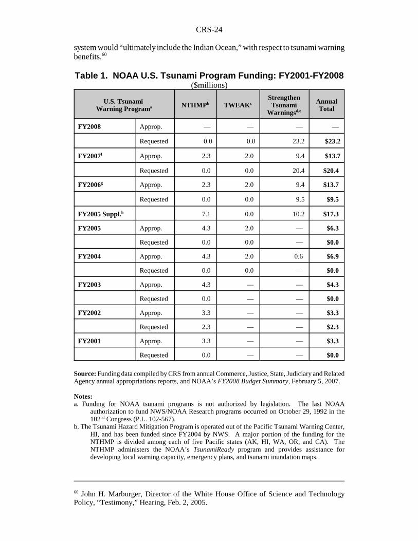
Table 1. NOAA U.S. Tsunami Program Funding: FY2001-FY2008($millions)
U.S. Tsunami Warning Programa NTHMPb TWEAKc
StrengthenTsunami
Warningsd,e
AnnualTotal
FY2008 Approp. — — — —
Requested 0.0 0.0 23.2 $23.2
FY2007f Approp. 2.3 2.0 9.4 $13.7
Requested 0.0 0.0 20.4 $20.4
FY2006g Approp. 2.3 2.0 9.4 $13.7
Requested 0.0 0.0 9.5 $9.5
FY2005 Suppl.h 7.1 0.0 10.2 $17.3
FY2005 Approp. 4.3 2.0 — $6.3
Requested 0.0 0.0 — $0.0
FY2004 Approp. 4.3 2.0 0.6 $6.9
Requested 0.0 0.0 — $0.0
FY2003 Approp. 4.3 — — $4.3
Requested 0.0 — — $0.0
FY2002 Approp. 3.3 — — $3.3
Requested 2.3 — — $2.3
FY2001 Approp. 3.3 — — $3.3
Requested 0.0 — — $0.0
Source: Funding data compiled by CRS from annual Commerce, Justice, State, Judiciary and RelatedAgency annual appropriations reports, and NOAA’s FY2008 Budget Summary, February 5, 2007.
Notes:a. Funding for NOAA tsunami programs is not authorized by legislation. The last NOAA
authorization to fund NWS/NOAA Research programs occurred on October 29, 1992 in the102nd Congress (P.L. 102-567).
b. The Tsunami Hazard Mitigation Program is operated out of the Pacific Tsunami Warning Center,HI, and has been funded since FY2004 by NWS. A major portion of the funding for theNTHMP is divided among each of five Pacific states (AK, HI, WA, OR, and CA). TheNTHMP administers the NOAA’s TsunamiReady program and provides assistance fordeveloping local warning capacity, emergency plans, and tsunami inundation maps.
CRS-25
61 The United States Group on Earth Observations (US GEO), Interagency Working Groupon Earth Observations is a standing subcommittee under the Committee on Environment andNatural Resources, the United States Group on Earth Observations (US GEO).” See[http://www.sdr.gov/Tsunami%20Risk%20Reduction%20for%20the%20US%20-%20A%20Framework%20for%20Action%202005-12-22.pdf].62 U.S. Congress, House Committee on Appropriations, “Communication from the Presidentof the United States Transmitting a Request for Supplemental Appropriations ... IncludingTsunami Relief and Reconstruction,” H.Doc. 109-9, Feb. 15, 2005 (Washington, DC, GPO:2005).
c. Prior to FY2004, the Tsunami Warning and Environmental (Observation Center), AK conductedexperimental tsunami warning system programs, but had no budget line. In FY2004, TWEAKwas transferred to NWS, along with all other U.S. tsunami-related programs. Funding has notbeen requested by the Administration since; Congress has appropriated $2.0 million annually.
d. Funding proposed by the President and authorized by Congress in P.L. 109-13 was allocated asSSJC appropriations for NOAA in FY2006.
e. Includes funding for PAC account to (1) procure DART buoys, (2) upgrade tsunami warningcommunications network capabilities and (3) assist in developing a global telecommunicationsinfrastructure for tsunami warning. (A separate request of $8.1 million in P.L. 109-13 was forUSGS’s Global Seismic Network (GSN) to upgrade GSN telecommunications and an increasein the number of seismic monitoring staff at the USGS National Earthquake information Center.)
f. For FY2007 P.L. 110-5, Revised Continuing Resolution on FY2007 Appropriations, funds mostNOAA programs at appropriation levels authorized for FY2006 whose funding was carried forthto FY2007, resulting in a net increase of $0.0 for FY2007.
g. FY2006 appropriations include a rescission of 1.28% in P.L. 109-148 and P.L. 109-108, Div. B,Title II-Department of Commerce,§638.
h. Emergency Supplemental Appropriations Act, 2005 (P.L. 109-13), first authorized funding to theNOAA subactivity, “Strengthen U.S. Tsunami Warning Network,” after the December 24, 2004tsunami disaster in the Indian Ocean. Congress provided funding for the NWS Procurement,Acquisition, and Construction (PAC) account from FY2005 emergency supplementalappropriations. This funding was used to procure replacement DART buoys (only three out ofsix were operating in the Pacific Ocean at the time of the tsunami disaster) and to expand theU.S. tsunami warning network into the far Pacific and Atlantic Oceans, the Gulf of Mexico, andthe Caribbean Sea.
Other funding obligations include the U.S. contribution to international tsunamiwarning efforts, including the IOTWS. NOAA officials assert that future U.S.support for a “global” tsunami warning network will be facilitated throughdevelopment of the NOAA-led Global Earth Observing System of Systems (GEOSS)whose implementation is being managed by the “US GEO” team.61 In addition, twoU.S. second generation deep-water tsunami detection buoys (DART II) are currentlyon loan and are being sited in the Indian Ocean for tsunami warnings.
P.L 109-13, Emergency Supplemental Appropriations for FY2005.The first round of funding to upgrade and expand U.S. tsunami detection andwarning capabilities was authorized by P.L. 109-13,62 and was reported as H.Rept.109-72, Div. A, which accompanied the Emergency Supplemental AppropriationsAct for Defense, the Global War on Terror, and Tsunami Relief, 2005. Congressapproved $17.3 million for FY2005-FY2006 for the NWS National TsunamiWarning Program and $8.1 million was for related USGS activities. Of the NWStotal, $7.1 million was for coastal inundation mapping and to expand outreach andpreparedness programs for U.S. communities-at-risk as part of the TsunamiReadyProgram under NOAA’s Operations, Research, and Facilities account. Congress alsodirected that a portion of total NWS tsunami-related funding be provided to the West
CRS-26
63 U.S. Congress, Senate Committee on Appropriations, Departments of Commerce andJustice, Science, and Related Agencies Appropriations Bill, 2006 ( S.Rept. 109-88 on H.R.2862), p. 78, “Tsunami Preparedness, Warnings, and Forecasts,” June 23, 2005.
Coast/Alaska Tsunami Warning Center (WC/AKTWC) to upgrade and expandservices. Congress authorized the NWS to hire an additional 43 full-time equivalentsat U.S. tsunami warning centers to monitor USGS seismic alerts and tsunamidetection instruments around the clock, so that tsunami warnings could be issued innear real-time and false alarms retracted in a timely manner. Still other funding wasprovided to develop an international warning center for the Pacific, in Hawaii, toserve IOC ITSU members.
Further, Congress approved $10.2 million for NOAA’s PAC account to procure32 new generation, DART II buoys for deployment in the Far Pacific and AtlanticOceans, the Gulf of Mexico, and the Caribbean Sea. The NWS indicated that theirdeployment would add several new data points observations of ocean conditions andsea-floor displacement at depth. (See “National Weather Service TsunamiPrograms.”) With respect to the U.S. GEOSS initiative, conferees also encouragedNOAA “to develop buoys with capabilities beyond the single purpose of tsunamireporting.”63
Finally, Congress approved $8.1 million for the USGS National Earthquake
Information Center (NEIC) in Golden, CO, to upgrade the Global Seismic Network(GSN) and to increase the number of GSN instruments capable of relaying real-timeseismic data. Funding was also included to hire additional staff for the NEIC tointerpret GSN data around the clock. At that time, only 80% of the 127 instrumentsin the GSN had real-time telemetry capability. Conferees noted that GSN seismicdata are critical for NWS tsunami warning centers in making a determination whetherthere is potential for a tsunami to be generated (tsunamigenesis) after an underwaterearthquake or other geological disturbance. In that respect, the WC/AKTWS hasresponsibility for modeling the tracking and potential intensity of tsunamis and, inturn, warn national and international emergency management officials.
House and Senate Appropriations Committees bill reports for FY2007 indicatedthat lawmakers would have provided appropriations requested by President Bush($20.4 million) to procure the remaining DART buoys needed to complete the U.S.tsunami network and to deploy them. The Revised Continuing AppropriationsResolution, 2007 (P.L. 110-5) funded NOAA at FY2006 appropriation levels and,thus, authorized nothing new for FY2007 or beyond.
Accordingly, for FY2008, President Bush has requested $23.2 million toprocure and deploy the remaining buoys (including two spares) as well as to bring theentire U.S. tsunami early detection and warning network online by the end ofcalendar year 2007. Table 2 shows the Administration’s estimates to completeimplementation of the U.S. tsunami early warning network and associated tsunamimitigation efforts.
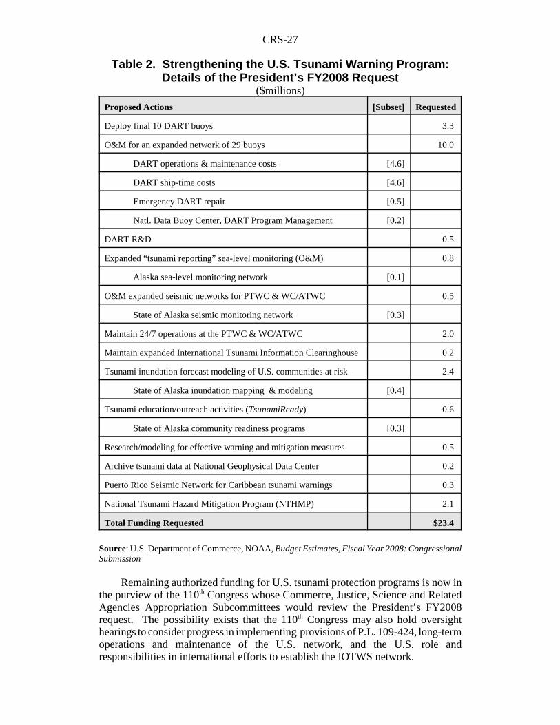
CRS-27
Table 2. Strengthening the U.S. Tsunami Warning Program:Details of the President’s FY2008 Request
($millions)
Proposed Actions [Subset] Requested
Deploy final 10 DART buoys 3.3
O&M for an expanded network of 29 buoys 10.0
DART operations & maintenance costs [4.6]
DART ship-time costs [4.6]
Emergency DART repair [0.5]
Natl. Data Buoy Center, DART Program Management [0.2]
DART R&D 0.5
Expanded “tsunami reporting” sea-level monitoring (O&M) 0.8
Alaska sea-level monitoring network [0.1]
O&M expanded seismic networks for PTWC & WC/ATWC 0.5
State of Alaska seismic monitoring network [0.3]
Maintain 24/7 operations at the PTWC & WC/ATWC 2.0
Maintain expanded International Tsunami Information Clearinghouse 0.2
Tsunami inundation forecast modeling of U.S. communities at risk 2.4
State of Alaska inundation mapping & modeling [0.4]
Tsunami education/outreach activities (TsunamiReady) 0.6
State of Alaska community readiness programs [0.3]
Research/modeling for effective warning and mitigation measures 0.5
Archive tsunami data at National Geophysical Data Center 0.2
Puerto Rico Seismic Network for Caribbean tsunami warnings 0.3
National Tsunami Hazard Mitigation Program (NTHMP) 2.1
Total Funding Requested $23.4
Source: U.S. Department of Commerce, NOAA, Budget Estimates, Fiscal Year 2008: CongressionalSubmission
Remaining authorized funding for U.S. tsunami protection programs is now inthe purview of the 110th Congress whose Commerce, Justice, Science and RelatedAgencies Appropriation Subcommittees would review the President’s FY2008request. The possibility exists that the 110th Congress may also hold oversighthearings to consider progress in implementing provisions of P.L. 109-424, long-termoperations and maintenance of the U.S. network, and the U.S. role andresponsibilities in international efforts to establish the IOTWS network.