Embed Size (px)
Citation preview

Transportation Concept Report State Route 12 (West)
District 4
Start of State Route 12 (West) from State Route 121 south of the City of Sonoma
Disclaimer: The information and data contained in this document are for planning purposes only and should not be relied upon for final design of any project. Any information in this Transportation Concept Report (TCR) is subject to modification as conditions change and new information is obtained. Although planning information is dynamic and continually changing, the District 4 System Planning Division makes every effort to ensure the accuracy and timeliness of the information contained in the TCR. The information in the TCR does not constitute a standard, specification, or regulation, nor is it intended to address design policies and procedures.
California Department of Transportation
Caltrans Improves Mobility Across California

Stakeholder Acknowledgement
District 4 is pleased to acknowledge the time and contributions of stakeholders and partner agencies to
this TCR. Development of System Planning documents such as this one is dependent upon the
participation and cooperation of key stakeholders. This TCR represents a cooperative planning effort for
SR 12 (West). Representatives of the Sonoma County Transportation Authority, the cities of Santa Rosa
and Sebastopol, the Sonoma County Regional Parks Department, and the Sonoma County Bicycle Coalition
provided essential information, advice and feedback for the preparation of this document.
This TCR will be posted on the Caltrans District 4 System Planning website at: http://www.dot.ca.gov/dist4/systemplanning/
Document Preparation
This SR-12 (West) Transportation Concept Report was prepared by: Mike Jones Associate Transportation Planner Office of System and Regional Planning Ina Gerhard District Branch Chief Office of System & Regional Planning
Stephen H. Yokoi, AICP District Office Chief Office of System and Regional Planning

Transportation Concept Report: State Route 12 (West)
California Department of Transportation 1
CONTENTS
About the Transportation Concept Report ..........................................................................................3
Stakeholder Participation ...................................................................................................................3
EXECUTIVE SUMMARY .......................................................................................................................4
Concept Summary ..................................................................................................................................... 4
Concept Rationale ..................................................................................................................................... 5
Segment A: 2C/4F ................................................................................................................................. 5
Segment B: 4F/4C .................................................................................................................................. 5
Segment C: 4C ....................................................................................................................................... 5
Segment D: 2-4C ................................................................................................................................... 6
Corridor Issues .......................................................................................................................................... 6
Layout of the Document .....................................................................................................................7
CHAPTER 1: PLANNING CONTEXT........................................................................................................8
State Planning ........................................................................................................................................... 8
Caltrans Smart Mobility Framework ......................................................................................................... 8
Place Types ................................................................................................................................................ 9
CHAPTER 2: CORRIDOR OVERVIEW ................................................................................................... 11
State Route 12 (West) ............................................................................................................................. 11
Route Segmentation ............................................................................................................................... 11
Corridor Description by Segment............................................................................................................ 14
Segment A: Sebastopol to US 101 ...................................................................................................... 14
Segment B: US 101 to Farmers Lane ................................................................................................... 15
Segment C: Farmers Lane to Los Alamos ............................................................................................ 16
Segment D: Los Alamos to SR 121 ...................................................................................................... 17
CHAPTER 3: CORRIDOR INFORMATION AND DATA ............................................................................ 18
Traffic Data for the Corridor ................................................................................................................... 19
Environmental Factors ............................................................................................................................ 20
Chapter 4: PLACE TYPES IN THE CORRIDOR ....................................................................................... 22
Using Place Types in the Corridor ........................................................................................................... 22

Transportation Concept Report: State Route 12 (West)
California Department of Transportation 2
Current Setting ........................................................................................................................................ 22
Future Potential ...................................................................................................................................... 25
CHAPTER 5: CORRIDOR ISSUES ......................................................................................................... 27
CHAPTER 6: CONCEPT & STRATEGIES BY SEGMENT ........................................................................... 33
Segment A: 2C/4F ............................................................................................................................... 34
Segment B: 4F/4C ................................................................................................................................ 34
Segment C: 4C ..................................................................................................................................... 34
Segment D: 2-4C ................................................................................................................................. 34
Summary of Suggested Strategies and Projects by Mode ...................................................................... 35
APPENDICIES ................................................................................................................................... 38
Appendix A: Regional Transportation Plan ............................................................................................. 38
Appendix B: State Transportation Planning ............................................................................................ 41
Appendix C: County Transportation Planning ......................................................................................... 42
Appendix D: Freeway Agreements ......................................................................................................... 43
Appendix E: Pertinent Transportation Plans, Policies, Legislation, and Programs ................................. 43
Appendix F: Functional Classification ..................................................................................................... 47
Appendix G: Freeway Agreements ......................................................................................................... 48

Transportation Concept Report: State Route 12 (West)
California Department of Transportation 3
ABOUT THE TRANSPORTATION CONCEPT REPORT
System Planning is the long-range transportation planning process for the California Department of
Transportation (Caltrans). The System Planning process fulfills Caltrans’ statutory responsibility as
owner/operator of the State Highway System (SHS) (Gov. Code §65086) by evaluating conditions and
proposing enhancements to the State’s transportation system. Through System Planning, Caltrans
focuses on developing an integrated multimodal transportation system that meets the State’s planning
and legislative objectives.
STAKEHOLDER PARTICIPATION
The following organizations were consulted during the production of this document:
Sonoma County Transportation Authority (SCTA)
City of Santa Rosa
City of Sebastopol
Sonoma County
Sonoma County Regional Parks Department
Sonoma County Bicycle Coalition
TCR Purpose
California’s State Highway System needs long-range planning documents to guide the logical
development of transportation systems as required by CA Gov. Code §65086 and as necessitated by
the public, stakeholders, and system users. The purpose of the TCR is to evaluate current and
projected conditions along the route and communicate the vision for the development of each route
in all Caltrans Districts during a 20-25 year planning horizon. The TCR is developed with the goals of
increasing safety, improving mobility, providing excellent stewardship, and meeting community and
environmental needs along the corridor through integrated management of the transportation
network, including the highway, transit, pedestrian, bicycle, freight, operational improvements and
travel demand management components of the corridor.

Transportation Concept Report: State Route 12 (West)
California Department of Transportation 4
EXECUTIVE SUMMARY
The State Route (SR) 12 (West) corridor is defined as the portion of SR 12 between the City of Sebastopol and SR 121 just south of the City of Sonoma. The corridor is entirely within Sonoma County and is approximately 30 miles in length. While the whole route is defined as part of the California Interregional Road System, most traffic is local. The corridor passes through the cities of Sebastopol, Santa Rosa and Sonoma, as well as unincorporated communities, and serves many different uses.
CONCEPT SUMMARY
Figure 1 – Corridor Concept Summary
Segment County Segment
Description
Existing
Facility
20-25 Year
Facility Concept
Smart Mobility Framework Strategies and
Concept Modifications to be Considered
A
PM 9.23 to R16.04
SON
Intersection with
SR 116 in
Sebastopol to
US 101 in Santa
Rosa
2C*/4F** 2C/4F
Consider traffic calming and diversion measures
(bypass, return to two-way streets) for downtown
Sebastopol;
Improve Joe Rodota Trail (lighting and other safety
enhancements);
Provide bike/ped crossing of SR 12 freeway section
between Fulton Road and Dutton Avenue;
Consider alternative intersection improvements
instead of planned full interchange at Fulton Road.
B
PM R16.04 to T18.54
SON
US 101 in Santa
Rosa to
Farmers Lane
and 4th
Street,
Santa Rosa
4F/4C 4F/4C
Consider “Complete Streets” changes and traffic
calming measures along Famers Lane.
C
PM T18.54 to 21.23
SON 4th Street to Los
Alamos Road, Santa Rosa
4C 4C Preserve and maintain “parkway” esthetic.
D
PM 21.23 to 41.36
SON
Los Alamos
Road, Santa Rosa
to intersection
with SR 121
2-4C 2-4C
Further develop “Complete Streets” measures in
communities along the corridor;
Consider transit frequency and service
improvements working with transit agencies;
Develop parallel bike facility.
*C=conventional highway **F=freeway

Transportation Concept Report: State Route 12 (West)
California Department of Transportation 5
CONCEPT RATIONALE
This TCR looks to the next 25 years and makes use of the planning principles developed in Caltrans
Smart Mobility Framework (SMF). SMF provides tools and strategies to meet the goals of Assembly Bill
32 (AB 32) and Senate Bill 375 (SB 375) on climate change and CO2 emissions reduction. (See Caltrans
Smart Mobility Framework on page 8.) The TCR raises issues that might result in a concept change in
part(s) of the corridor within the 20-25 year planning horizon. Many of these issues are not yet clearly
defined and will need further study and discussion with external partners. The nominal facility concept
for SR 12 remains “as is” for all segments (see Figure 1). Following is a summary of suggested strategies
for each segment.
Segment A: 2C/4F
Sebastopol and the surrounding areas are not expected to see significant growth. Therefore, the existing
two-lane highway between Sebastopol and Santa Rosa/US 101 remains as is. Downtown Sebastopol
would, however, benefit from measures to slow or divert traffic. Consideration should be given to an
eastern bypass or, returning the downtown streets from a one-way to two-way configuration. The
extension of the Joe Rodota Trail into downtown Santa Rosa presents a viable bike commute route
parallel to the highway, however, improved lighting and safety features would be needed to enhance its
role as a genuine transportation option.
The Fulton Road intersection is currently an issue due to recurring congestion, and construction of an
interchange is planned at this location. This TCR does not anticipate the existing freeway being
expanded any further west. Therefore, alternatives to an interchange should be considered. Improved
bike and pedestrian access across the SR 12 freeway portion could be achieved with construction of a
dedicated facility somewhere between Fulton Road and Dutton Avenue, linking the suburbs north of SR
12 to the PDA corridor along Sebastopol Road to the south.
Segment B: 4F/4C
This TCR does not anticipate the freeway portion of SR 12 being extended further than its present
terminus at Farmers Lane. Therefore, the currently unutilized right of way east from Farmers Lane to
Spring Lake Park should be declared as excess land. This process needs to be coordinated with the City
of Santa Rosa. The future of the unutilized right of way could be considered together with changes to
develop Farmers Lane as a more “livable street” serving the needs of the local communities, while not
significantly increasing traffic in the neighborhoods.
Segment C: 4C
Sonoma Highway is a parkway and, while it is not particularly pedestrian, bike or transit friendly, it
serves as an arterial for eastern Santa Rosa. Bike lanes are planned for this segment of SR 12, as well as
for the parallel Sonoma Avenue. The Sonoma Highway segment of SR 12 should remain as present, with
an emphasis on maintenance and preservation of its “parkway” esthetic.

Transportation Concept Report: State Route 12 (West)
California Department of Transportation 6
Segment D: 2-4C
Future development would increase traffic in this segment of the corridor, but the existing two-lane
highway (together with Arnold Drive) is expected to provide sufficient capacity so as to retaining its rural
character. The proposal for a Class 1 bike path, approximately in the SR 12 corridor, should be supported
as an important asset for the community. However, it should be recognized that at over 20 miles
between Sonoma and Santa Rosa regular commuting is not practical for most people, and that
consideration should be given to planning for some future enhanced or potentially dedicated transit
service (rail/bus). Within Sonoma, Boyes Hot Springs, and Agua Caliente, SR 12 should be constructed to
maximize Smart Mobility benefits over vehicle throughput, where appropriate.
CORRIDOR ISSUES
The following are a list of corridor issues discussed in this TCR that might impact the future concept. (Full
details are described in Chapter 5).
Sebastopol’s Downtown Traffic Circulation Possible
Future Fulton Road Interchange
Relinquishment or Redesignation of SR 12
Farmers Lane: Freeway Connector or
Commercial Corridor?
SR 12 Freeway Extension in Santa Rosa
Corridor Development and Traffic Growth between Sonoma and Santa Rosa
Role of SR 12 within Sonoma and Surrounding Communities

Transportation Concept Report: State Route 12 (West)
California Department of Transportation 7
LAYOUT OF THE DOCUMENT
Chapter 1: Planning Context explains the principles of SMF and introduces “place types” as a concept
for explaining existing and potential future land uses. SMF is a new way of looking at land
use/transportation interactions and solutions.
Chapter 2: Corridor Overview examines the existing conditions and transportation facilities in the
corridor, and explains the segmentation process used for this document. The descriptive elements of
this chapter make use of place types described in SMF, reducing ambiguity and suggesting solutions to
meet the legislation and planning objectives. It is therefore strongly recommended that the reader
become familiarized with the various place types in SMF prior to continuing through the document. A
summary is provided in Chapter 1: Planning Context.
Chapter 3: Corridor Information & Data presents traffic data and road classification information
providing a background of existing conditions. As SMF is about change, this section is given less weight
than in traditional TCRs, but it remains a useful source of information.
Chapter 4: Place Types in the Corridor describes the place types present in the corridor and assesses the
potential for place type changes. A map summarizes the place types for the entire corridor.
Chapter 5: Corridor Issues presents the main transportation issues identified in the TCR and stakeholder
input.
Chapter 6: Corridor Concept includes future transportation changes beyond the current highway
configuration. These are seen as potential solution to improve the corridor within the 20-25 year
planning horizon of the TCR.
The Appendices contain information on the region’s Plan Bay Area process (especially Priority
Development Areas), relevant plans, policies, programs, and project lists.

Transportation Concept Report: State Route 12 (West)
California Department of Transportation 8
CHAPTER 1: PLANNING CONTEXT
This section of the TCR introduces select State planning documents and outlines the principles of the Smart Mobility Framework (SMF) used throughout the TCR. (See Appendix for a complete list of State planning efforts.)
STATE PLANNING
The California Transportation Plan (CTP) provides a long-range policy framework to meet California’s future mobility needs and reduce greenhouse gas emissions. The CTP defines goals, performance-based policies, and strategies to achieve the collective vision for an integrated multimodal transportation system. The plan envisions a sustainable system that improves mobility and enhances quality of life. Key to this vision is considering “the 3 E’s of Sustainability”: a prosperous economy, quality environment and social equity in all transportation decisions. The CTP works to both support and guide regional transportation planning efforts to meet AB 32 and SB 375.
The California Interregional Blueprint (CIB) is a State-level document that articulates the State’s vision for an integrated multimodal transportation system which complements regional transportation and land use plans. It links statewide transportation goals with regional transportation and land use goals to produce a unified transportation strategy. It supports the development of Sustainable Communities Strategies at the regional level, and has been incorporated into the CTP.
CALTRANS SMART MOBILITY FRAMEWORK
Caltrans 2020 Smart Mobility: A Call to Action for the New Decade presents a new approach to the integration of transportation and land use. The Smart Mobility Framework (SMF), seeks to develop multi-modal and sustainable transportation strategies for California. SMF was prepared in partnership with the US Environmental Protection Agency, the Governor’s Office of Planning and Research, and the California Department of Housing and Community Development.
SMF aims to address:
The State’s mandate to reduce greenhouse gas (GHG) emissions and find solutions to climate change.
The need to reduce per capita vehicle miles traveled. Reduced per capita auto use will lower emissions of GHG and conventional pollutants, reduce petroleum consumption and associated household transportation costs, and minimize negative impacts on air quality, water quality, and noise environments.
The demand for a reliable and safe transportation system that gets people and goods to their destinations. SMF endorses the application of strategies that result in a shift away from higher-polluting modes to the use of transit, carpooling, walking, and biking to meet travel needs.

Transportation Concept Report: State Route 12 (West)
California Department of Transportation 9
The commitment to create a transportation system that advances social equity and environmental justice. SMF integrates social equity concerns into transportation decisions and investments.
SMF recognizes that transportation planning extends beyond the transportation system and sees land use as an important determinant in developing transportation solutions. The principles of SMF look to a multi-modal vision actively deemphasizing the use of vehicle-only Level of Service for transportation decision-making.
PLACE TYPES
While SMF does not mandate land use patterns, it does promote “location efficiency.” Location
efficiency describes the fit between a specific physical environment and its corresponding transportation
system and services to achieve more efficient integration of land use and transportation modes. The
physical environment is summarized as a “place type” for a particular location. SMF distinguishes seven
broad place types, listed below, which represent a distinct context where implementation of certain
transportation investments, along with other planning strategies, will help improve location efficiency
and achieve Smart Mobility benefits:
1. Urban Centers
2. Close-in Compact Communities
3. Compact Communities
4. Suburban Communities
5. Rural and Agricultural Lands
6. Protected Lands
7. Special Use Areas
The place types are themselves broken down further, though remain generalized for use in sketch
planning, not implying specific zoning or land use. Definitions and examples for place types are provided
in Figure 2.

Transportation Concept Report: State Route 12 (West)
California Department of Transportation 10
Figure 2 - List of Smart Mobility Framework Place Types
Place Type
Sub-Place Types
Examples
URBAN CENTERS
High-density, mixed-use places with well-connected street networks, high levels of transit service and pedestrian supportive environments.
1a. Urban Cores Downtowns of Long Beach, San Francisco, San Jose, Los Angeles, San Diego, Oakland
1b. Urban Centers Berkeley, Palo Alto, Pasadena, Stockton, Santa Monica
CLOSE-IN COMPACT COMMUNITIES
Close-in compact communities usually near urban centers; mostly residential housing centered along arterial corridors; transit available primarily serving commute trips.
2a. Close-in Centers Downtowns of Santa Rosa, San Rafael, Uptown San Diego
2b. Close in Corridors San Pablo Avenue - Berkeley; Mission District - San Francisco; Rockridge – Oakland
2c. Close in Neighborhoods Midtown Sacramento, North Beach - San Francisco, Little Italy - San Diego
COMPACT COMMUNITIES
Historic cities/towns and newer places with strong presence of community design elements; mostly outside metropolitan areas or on their periphery.
3. Compact Communities Eureka, San Luis Obispo, Santa Barbara, Paso Robles
SUBURBAN COMMUNITIES
Communities with low level of integration of housing with jobs, retail, and services, poorly connected street networks, low levels of transit service, large amounts of surface parking , and poor walking environment.
4a. Suburban Centers
Walnut Creek
4b. Suburban Corridors Farmers Lane and Santa Rosa Avenue - Santa Rosa
4c. Dedicated Use Areas
Warehouse District – Oakland
4d. Suburban Neighborhoods
Bennett Valley - Santa Rosa
RURAL & AGRICULTURAL LANDS
Settlement pattern with widely-spaced towns separated by farms, vineyards, orchards, or grazing lands; may include tourist and recreation destinations.
5a. Rural Towns
St. Helena, Ferndale, Sonoma, Sebastopol
5b. Rural Settlements and Agricultural Lands
Southwest Sebastopol
PROTECTED LANDS
6. Protected Lands
Lands protected from development (wildlife refuges, parks)
SPECIAL USE AREAS
7. Special Use Areas Airports, industrial and military facilities, some hospitals and universities.

Transportation Concept Report: State Route 12 (West)
California Department of Transportation 11
CHAPTER 2: CORRIDOR OVERVIEW
This section presents a summary description of the corridor followed by how the corridor was
segmented and finally a more detailed description of each segment. (See Appendix F for Functional
Classification (FC) designations.)
STATE ROUTE 12 (WEST)
SR 12 discussed in this report is all within Caltrans District 4 and the County of Sonoma. It is the western
portion of Highway 12 and extends from the intersection with SR 116 in the City of Sebastopol to the
intersection with SR 121 south of the City of Sonoma. SR 12 (West) is approximately 30 miles in length
and passes through the incorporated cities of Sebastopol, Santa Rosa and Sonoma. While the whole
route is defined as part of the California Interregional Road System, most traffic is local. Between Santa
Rosa and the City of Sonoma, SR 12 is designated a State Scenic Highway. Other than for the freeway
section in Santa Rosa (FC2 – other freeways or expressways), the highway is functionally classified FC3
(“other principal arterial”) in urban areas and FC4 (“minor arterial”) in the sections between the cities.
Traffic on the route is highest at the SR 12/US 101 interchange in Santa Rosa, reaching 75,000 annual
Average Daily Traffic (AADT) in 2012. The volumes decline rapidly outside of the City, but are still
comparatively high at over 20,000 AADT between Santa Rosa and Sebastopol. The AADT is low between
Santa Rosa and Sonoma, dropping to 12,200 where there are parallel alternate routes (Arnold Drive and
Napa Road). Other than for accessing Santa Rosa from US 101, truck traffic is low (below 1,000 AADT).
Transit in the corridor is provided by Sonoma Transit, with the addition of Golden Gate Transit services
on US 101 and local services in Santa Rosa provided by CityBus. In a number of locations SR 12 (West) is
a “Main Street”, requiring consideration of not only transportation needs of drivers, pedestrians and
bicyclists, but also of community and business interests.
ROUTE SEGMENTATION
The route has been segmented for planning, and not necessarily operational purposes. The defined
segments reflect the changing use and character of SR 12 (West). Legislatively, the route begins at the
intersection with SR 1 in Valley Ford, but there are no plans to construct this unbuilt 10-mile section
west of Sebastopol.
The section of highway between the intersection of SR 12 and 121 in Sonoma County and SR 12 (East) in
Napa County (Jameson Canyon) is not included in this TCR. It will be included in TCRs for SR 121 and SR
29. A Corridor System Management Plan (CSMP) was finalized for SR 12 (East) from SR 29 in Napa
County to the Solano/Sacramento County line in 2010.

Transportation Concept Report: State Route 12 (West)
California Department of Transportation 12
Figure 3 - SR 12 (West) Segmentation
Segment From To Post Miles
A Intersection with SR
116 in Sebastopol
US 101 in Santa
Rosa SON 12 PM 9.23 to PM R16.04
B US 101 in Santa Rosa 4
th Street in Santa
Rosa SON PM R16.04 to PM T18.56
C 4
th Street in Santa
Rosa
Los Alamos Road in
Santa Rosa
SON 12 PM T18.56 to PM
21.23
D Los Alamos Road in
Santa Rosa
Intersection with
SR 121 SON 12 PM 21.23 to PM 41.36
Segment A is the main access route between Sebastopol and Santa Rosa west of US 101.
Segment B provides access to US 101 from eastern Santa Rosa.
Segment C is a four-lane extension of 4th Street to/from downtown Santa Rosa.
Segment D is a two-lane rural road connecting Santa Rosa with the City of Sonoma, and a number of
smaller communities in between.

Transportation Concept Report: State Route 12 (West)
California Department of Transportation 13
Figure 4 - SR 12 (West) Segmentation Map
Transportation Concept Report: State Route 12 (West)
California Department of Transportation 14
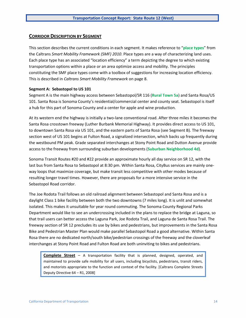
CORRIDOR DESCRIPTION BY SEGMENT
This section describes the current conditions in each segment. It makes reference to “place types” from
the Caltrans Smart Mobility Framework (SMF) 2010. Place types are a way of characterizing land uses.
Each place type has an associated “location efficiency” a term depicting the degree to which existing
transportation options within a place or an area optimize access and mobility. The principles
constituting the SMF place types come with a toolbox of suggestions for increasing location efficiency.
This is described in Caltrans Smart Mobility Framework on page 8.
Segment A: Sebastopol to US 101
Segment A is the main highway access between Sebastopol/SR 116 (Rural Town 5a) and Santa Rosa/US
101. Santa Rosa is Sonoma County’s residential/commercial center and county seat. Sebastopol is itself
a hub for this part of Sonoma County and a center for apple and wine production.
At its western end the highway is initially a two-lane conventional road. After three miles it becomes the
Santa Rosa crosstown freeway (Luther Burbank Memorial Highway). It provides direct access to US 101,
to downtown Santa Rosa via US 101, and the eastern parts of Santa Rosa (see Segment B). The freeway
section west of US 101 begins at Fulton Road, a signalized intersection, which backs up frequently during
the westbound PM peak. Grade separated interchanges at Stony Point Road and Dutton Avenue provide
access to the freeway from surrounding suburban developments (Suburban Neighborhood 4d).
Sonoma Transit Routes #20 and #22 provide an approximate hourly all day service on SR 12, with the
last bus from Santa Rosa to Sebastopol at 8:30 pm. Within Santa Rosa, CityBus services are mainly one-
way loops that maximize coverage, but make transit less competitive with other modes because of
resulting longer travel times. However, there are proposals for a more intensive service in the
Sebastopol Road corridor.
The Joe Rodota Trail follows an old railroad alignment between Sebastopol and Santa Rosa and is a
daylight Class 1 bike facility between both the two downtowns (7 miles long). It is unlit and somewhat
isolated. This makes it unsuitable for year round commuting. The Sonoma County Regional Parks
Department would like to see an undercrossing included in the plans to replace the bridge at Laguna, so
that trail users can better access the Laguna Park, Joe Rodota Trail, and Laguna de Santa Rosa Trail. The
freeway section of SR 12 precludes its use by bikes and pedestrians, but improvements in the Santa Rosa
Bike and Pedestrian Master Plan would make parallel Sebastopol Road a good alternative. Within Santa
Rosa there are no dedicated north/south bike/pedestrian crossings of the freeway and the cloverleaf
interchanges at Stony Point Road and Fulton Road are both uninviting to bikes and pedestrians.
Complete Street – A transportation facility that is planned, designed, operated, and
maintained to provide safe mobility for all users, including bicyclists, pedestrians, transit riders,
and motorists appropriate to the function and context of the facility. [Caltrans Complete Streets
Deputy Directive 64 – R1, 2008]

Transportation Concept Report: State Route 12 (West)
California Department of Transportation 15
Segment B: US 101 to Farmers Lane
Segment B is the part of SR 12 in Santa Rosa that provides access to US 101 from the eastern suburbs of
the city (Suburban Neighborhood 4d). It consists of two parts, the eastern freeway section and Farmers
Lane, which connects the freeway with 4th Street/Sonoma Highway. Farmers Lane is a conventional four-
lane road with center-turn lanes and significant commercial development (Suburban Corridor 4b), and
provides an inadequate environment for bikes and pedestrians. The freeway was constructed with the
expectation of an extension eastward directly through to Sonoma Highway east of Spring Lake Park. The
freeway ends at Farmers Lane and Santa Rosa subsequently constructed a direct connector to Hoen
Avenue for local traffic. While Caltrans owns the right of way east of Farmers Lane, there are no plans to
extend the freeway.
Transit in Santa Rosa is mainly provided by CityBus. It runs 30-minute frequency services to most parts
of the city until 7 to 8 p.m. on weekdays, but with much less frequent service on weekends. CityBus
routes are mainly one-way loops that maximize coverage, but make transit less competitive with other
modes due to longer travel times. Golden Gate Transit runs an hourly semi-express bus to San Francisco
on US 101, plus additional commute services. These do not use this segment of SR 12. Sonoma Transit
provides additional services to other locations in the County (see other segments).
Crossing US 101 in the vicinity of SR 12 is not easy for bikes or pedestrians. Practical crossing points are
about a mile apart on either side of SR 12.The Joe Rodota Trail is the only suitable alternative for
crossing US 101 near SR 12, connecting to the Prince Memorial Greenway along Santa Rosa Creek. The
trail, however, is not officially open after dark. Farmers Lane has heavy traffic with minimal shoulders or
bike lanes. The completion and expansion of the Santa Rosa Creek Trail (a County Measure M project),
to be constructed in the Fall of 2013, will provide an alternative east-west connection.
Figure 5 - Farmers Lane (SR 12) with its mix of commercial and residential development
Source: Google Maps

Transportation Concept Report: State Route 12 (West)
California Department of Transportation 16
Segment C: Farmers Lane to Los Alamos
This segment of SR 12 is called Sonoma Highway. It is a four-lane arterial road through the eastern
suburbs of Santa Rosa (Suburban Neighborhood 4d). Sonoma Highway connects with Farmers Lane
(Segment B), and continues as 4th Street into downtown Santa Rosa (Close-in Center 2a). For its full
length it has a center divide that limits left turns at intersections, and there are parallel frontage roads
with no direct access to the highway. The topography and layout of Santa Rosa make Sonoma Highway a
key route linking the eastern suburbs with both downtown and US 101. Despite high traffic volumes, it is
a “parkway” with bucolic vistas and some commercial development.
Parkways - The Highway Design Manual (HDM) defines a parkway as, “an arterial highway for non-
commercial vehicles, with full or partial control of access, which is typically located within a park or
a ribbon of park-like development.” Parkways, however, vary not only from place to place, but over
time. Initially constructed for pedestrians and equestrians, they became associated with
recreational highways for cars, their bridges and overpasses constructed too low for trucks. The
first freeway in California, the Pasadena Freeway (SR 110), was originally the Arroyo Seco Parkway
(in 2010 it reverted to this name officially). At the local level any road with a high degree of
landscaping may be called a parkway. Parkways are often associated with subdivisions where there
is no frontage development. Lack of frontage development means that they are generally not very
bike, pedestrian or transit friendly.
Transit in Santa Rosa is mainly provided by CityBus that runs 30-minute frequency services to most parts
of the city until 7 to 8 p.m. on weekdays, but with greatly reduced service on weekends. The limited
direct access from adjacent neighborhoods to the highway is to the detriment of bus riders, as stops are
often somewhat limited. Direct Regional and commute transit services do not extend into the suburban
parts of the city, making either transit transfers or a car a necessity for longer trips.
Figure 6 - Sonoma Highway near Los Alamos
Source: Google Maps

Transportation Concept Report: State Route 12 (West)
California Department of Transportation 17
This segment of SR 12 is proposed for bike lanes in the Santa Rosa Bike Plan. There are adequate
shoulders (five feet or more) along the majority of this segment and sidewalks where the road passes
through residential subdivisions. Sonoma Highway is not ideal for bicycles or pedestrians due to its high
traffic volumes and sometimes isolated conditions, giving a poor perception of safety and security.
Parallel local streets such as Montgomery Drive, Sonoma and Hoen Avenues are or will be better suited
to bicycling, with road diets reducing traffic lanes and adding bike lanes on these streets.
Segment D: Los Alamos to SR 121
Segment D is the 20-mile section of SR 12 from the edge of Santa Rosa to the City of Sonoma (Rural
Town 5a), ending south of Sonoma at the intersection with SR 121. For the most part, it is a
conventional two-lane highway, very much a country road with growing traffic in the prosperous
Sonoma Valley. Recently implemented projects were aimed at improving traffic flow to and from Santa
Rosa, and projects are underway to provide better bike and pedestrian facilities in “The Springs” area
(Rural Town 5a), just north of the City of Sonoma. In the City of Sonoma, SR 12 (Sonoma Highway and
West Napa Street) functions as a “Main Street,” a two-lane road with center double left-turn lanes,
parking lanes and sidewalks. It connects “The Springs” area and the west side of the City with downtown
and Sonoma Plaza. Broadway is the connection south between downtown and SR 121. In Sonoma the
highway configuration changes from four to three lanes with a center-turn lane. South of Sonoma,
though, SR 12 becomes a rural two-lane road with varying shoulder widths. It is not the main connection
to SR 121 as traffic primarily uses parallel Arnold Drive or Napa Road.
Sonoma County Transit services are not frequent and subject to the same congestion as other traffic
using SR 12. Due to the distance between Sonoma and Santa Rosa (20 miles), bike commuting is not
practicable for most people, and increased traffic is adversely impacting recreational biking.
This section of SR 12 has variable shoulders. Arnold Drive provides a quieter parallel biking route. As
mentioned above, bike and pedestrian facility improvements are underway in “The Springs” area and
bike lanes are proposed on SR 12 in the City of Sonoma. The County is proposing a Class 1 bike path
along the SR 12 corridor from the Santa Rosa city limits to Agua Caliente Road.

Transportation Concept Report: State Route 12 (West)
California Department of Transportation 18
CHAPTER 3: CORRIDOR INFORMATION AND DATA
In this section data is provided that describes the existing conditions in the corridor as well as current
route designation information for each segment.
Figure 7 - Corridor Data and Information
Segment A B C D
Freeway & Expressway Yes Yes/No No No
National Highway
System No No No No
Strategic Highway
Network No No No No
Scenic Highway No No No Partial*
Interregional Road
System Yes Yes Yes Yes
High Emphasis No No No No
Focus Route No No No No
Federal Functional
Classification
Freeway/Other
Principal Arterial/Minor
Arterial
Other Principal
Arterial/ Minor
Arterial
Other Principal
Arterial
Other Principal
Arterial/Minor
Arterial
Goods Movement
Route No No No No
Truck Designation Terminal Access Terminal Access Terminal Access Terminal Access, CA
Legal Advisory
Rural/Urban/Urbanized Urban Urban Urban Mainly Urban
Metropolitan Planning
Organization Metropolitan Transportation Commission
Congestion
Management Agency Sonoma County Transportation Authority
Air District Bay Area Air Quality Management District
Local Agencies Sonoma County, City of
Sebastopol City of Santa Rosa City of Santa Rosa
Sonoma County, City
of Sonoma
* Danielli Avenue east of Santa Rosa to London Way near Agua Caliente (PM 22.5 - 34.0)

Transportation Concept Report: State Route 12 (West)
California Department of Transportation 19
TRAFFIC DATA FOR THE CORRIDOR
Traffic Data
Figure 7 below shows the most recent (2012) Annual Average Daily Traffic (AADT) for the corridor for all
intersections on SR 12 West, where data is available. This data is presented to provide finer detail than
shown by segmentation, especially in the urban areas where traffic volumes vary considerably within
each segment. While AADT does not alone indicate congestion, it does give an indication of the relative
use of each section of roadway.
Figure 8 - SR 12 (West) Annual Average Daily Traffic (2012)
Segment PM Intersection Lanes AADT Jurisdiction
A
SR 116 to US 101
9.2 Jct. Rte. 116 3C*
24,700 Sebastopol 9.5 East City Limits 2-4C 23,200
12.9 Wright/Fulton Rds 4F* 40,500 Unincorporated Sonoma County
14.5 Stony Point Rd 4F 66,000
Santa Rosa
15.3 Dutton Ave Interchange 4F 77,000
B
US 101 to Farmers
Lane/4th
St.
16.0 Jct. Rte. 101 4F 75,000
16.6 Bennett Valley Rd 4F 53,000
17.1 Farmers Lane 4F 45,500
17.7 Farmers Lane/4th St. 4-5C 41,500
C Farmers
Lane to Los Alamos
18.4 Brush Creek Rd 4C 37,500
19.4 Middle Rincon Rd 4C 33,500
20.1 Calistoga Rd 4C 28,000
D
Los Alamos to
SR 121
21.2 Los Alamos Rd 3C 20,800
26.1 Adobe Canyon Rd 3C 17,500
Unincorporated Sonoma County
27.0 Kenwood, Warm Springs Rd 2C 15,900
30.1 Trinity Rd 2C 15,500
30.7 Arnold Dr 2C 14,500
32.9 Madrone Rd 2C 12,300
33.4 Cavedale Rd 2C 13,700
34.3 Agua Caliente Rd 2C 15,900
35.1 Boyes Blvd 3C 23,300
36.0 Verano Ave 3-4C 22,500
36.6 Petaluma Ave (Riverside Dr) 3C 24,900
City of Sonoma
37.0 Fifth St West 3C 17,400
37.5 First St West 5C 15,500
37.7 Patten St 5C 10,200
38.1 Mac Arthur St 2-5C 12,100
38.7 Napa Rd 2C 8,700 Unincorporated Sonoma County 39.4 Watmaugh Rd 2C 6,200
*C=conventional highway **F=freeway Source: Caltrans

Transportation Concept Report: State Route 12 (West)
California Department of Transportation 20
Approaching 77,000 vehicles AADT, the freeway portion of SR 12 (West) has moderate traffic for a four-
lane freeway. Toward Sebastopol traffic volumes drop considerably. Similarly, between Santa Rosa and
Sonoma traffic volumes decline significantly (outside of Santa Rosa). South of Sonoma the ADDT is low
(9,200 to 5,600 vehicles) as some traffic at this point has diverted to parallel routes, Napa Road and
Arnold Drive.
Figure 9 below shows the potential increase in traffic for each segment based upon the current Sonoma
County growth model. The model is based upon existing city and county General Plans. It is not
necessarily reflecting the Region’s Sustainable Communities Strategy (SCS) and assumes a generally
static pattern of trips and modes.
Figure 9 - SR 12 (West) Projected Traffic Growth by Segment (2012-2035)
Location
Current Traffic
Volumes
Forecast Traffic Volumes based on County Population Growth Model
Segment Description County Post Mile From
Post Mile To
2012 AADT Range
Potential Increase
2035
Increase Range
Existing Facility
A SR 116 to US 101
SON 9.23 R16.04 77,000- 23,200
13% 87,000- 26,000
4F/2C
B US 101 to Farmers
Lane/4th
St. SON R16.04 T18.54
75,000- 37,500
14% 85,500- 42,500
4F/4C
C Farmers
Lane to Los Alamos
SON T18.54 21.23 41,500- 20,300
5% 43,500- 21,500
4C
D Los Alamos to SR 121
SON 21.23 41.36 25,500- 5,600
16% 29,500- 6,500
2C/4C
ENVIRONMENTAL FACTORS
The SR 12 (West) corridor is constrained in its central portion by topography and various protected
lands, as shown in Figure 10. The quiet and bucolic nature of much of the corridor is a source of local
pride, and currently there are large greenbelt areas between cities and communities. The Greenbelt
Alliance’s report, “At Risk 2006”, shows the greatest threat to existing greenbelts to be the agricultural
lands surrounding Sonoma and Sebastopol. However, most of these are currently covered by Priority
Conservation Areas (PCAs) (areas designated by the Association of Bay Area Government’s FOCUS
Program to have high agricultural, natural resource, historical, scenic, cultural, recreational, and/or
ecological values and ecosystem functions). There are a number of historic bridges in the corridor. These
are on segments where it is expected that the roadway will remain as present.

Transportation Concept Report: State Route 12 (West)
California Department of Transportation 21
Figure 10 – SR 12 Corridor Environmental Factors and Constraints

Transportation Concept Report: State Route 12 (West)
California Department of Transportation 22
CHAPTER 4: PLACE TYPES IN THE CORRIDOR
In this section place types from Caltrans Smart Mobility Framework are used to describe the corridor
and its potential for change. (See Smart Mobility Framework in Chapter 1)
USING PLACE TYPES IN THE CORRIDOR
Place Types (shown in green) are a tool to help understand and summarize land uses in the corridor.
Figure 11 below shows the main place types identified in the corridor and two areas where the place
types may change under Smart Mobility Framework principles (Potential Transition Zones A and B).
Place types applicable to the corridor are summarized in the text. For full descriptions and the concept
of place types, see the reference document Smart Mobility 2010 – A Call to Action for a New Decade.
Places in square brackets [ ] are communities quoted as examples in the document.
CURRENT SETTING
Sebastopol (7,379 pop. 2010) is shown as a Rural Town (5a) and is expected to remain largely
unchanged, despite some expected growth within the City and its surrounding communities. It is also
expected that the area between Sebastopol and Santa Rosa will remain rural (Rural 5b). However,
Sebastopol with its proximity to Santa Rosa, and its role as a local hub, is expected to have higher than
average locational efficiency for this place type.
Rural Towns 5a - Contain a mix of housing, services and public institutions
in a compact form. They will continue to depend on a high level of
automobile use. Smart Mobility should focus on walkable streets with
speeds suitable for their context. Centrally locating community using
services (public & private) should be encouraged. [St. Helena]
Santa Rosa (167,815 pop. 2010) is the County seat and service center for the North Bay. The City is
expected to remain largely suburban outside the downtown. Downtown has a high level of services, but
a low level of regional transit connectivity. For that reason Santa Rosa has been classified as a Close-in
Center (2a) rather than an Urban Center (1b).
Close-in Centers 2a - Small and medium sized downtowns, with transit
oriented development, institutions, lifestyle centers and other centers of
activity. [San Rafael, Santa Monica]

Transportation Concept Report: State Route 12 (West)
California Department of Transportation 23
Largely suburban and bucolic, Santa Rosa has a number of Suburban Corridors (4b) including Farmers
Lane (SR 12) and Sebastopol Road. These offer a low level of locational efficiency and generally
perpetuate a poor walking and biking environment.
Suburban Corridors 4b - Arterial streets, frequently with setback development
types. Characterized by inadequate walk and bike environments, and poor
esthetics.
The suburban area of Santa Rosa extends east along SR 12, but there are a number of city and regional
parks within the corridor (Protected Lands 6). Further east the landscape is rural and so are the
communities around Sonoma (10,648 pop. in 2010). Both the City of Sonoma and the communities
north along SR 12, Boyes Hot Springs (6,656 pop. in 2010), Fetters Hot Springs and Agua Caliente (4,144
pop. in 2010) can be classified as Rural Towns (5a).
Rural Towns 5a - Rural towns provide a mix of housing, services and public
institutions. They vary in size from crossroads with single clusters of
commercial uses to towns offering a full range of retail and service
businesses.

Transportation Concept Report: State Route 12 (West)
California Department of Transportation 24
Figure 11 - Corridor Place Types

Transportation Concept Report: State Route 12 (West)
California Department of Transportation 25
FUTURE POTENTIAL
The future development of land use is mainly regulated by the County and cities, with some guidance
from State legislation. Economic factors and regional policies will impact growth and development
patterns. With significant population and economic growth projected for the State in the coming
decades, change is a certainty for California communities.
As mentioned previously, place types can be used as a tool, in combination with the Smart Mobility
principles, to support strategic decision-making on how a city or town will change over time and which
transportation programs and projects to chose to influence change. Two transition zones that affect the
SR 12 corridor have been identified because they are expected to see significant increases in population
and jobs under the region’s Sustainable Communities Strategy (SCS) (see Appendix A Regional
Transportation Plan). “Transition Zones” are defined as places that will see significant change, with the
potential to “evolve” over time with a significantly greater presence of location efficiency factors that
justify a change in the place type designation. The suggestion is that transportation solutions in the
transition zones should look more to desired future conditions, rather than the current place type.
Potential Transition Zone A: For Santa Rosa an increase in households of around 17,000 is projected
under Plan Bay Area (see Appendix A Regional Transportation Plan). Outside the immediate downtown,
the City quickly becomes suburban in density with the few local retail areas closer to Suburban
Corridors (4b) than to Suburban Centers (4a). However, with appropriate planning suburban areas of
Santa Rosa could become more like Close-in Neighborhoods (2c) than they are today.
Close in Neighborhoods 2c - Walkable neighborhoods with housing in close
proximity to shops, service and public facilities. Good multimodal
connections to urban centers, with medium to high density. [Midtown
Sacramento]
An important component of this transition would be a downtown with better regional and local transit
connectivity than there is today, making downtown an Urban Center (1b). The recent Golden Gate 101
express bus service, future SMART rail service, and plans for enhanced transit on major bus routes are
steps in this direction. The presently planned service level for SMART is not frequent enough to sustain
an Urban Center level of development, in particular the service planned for weekends and evenings.
Urban Centers 1b - Major activity centers with a full range of horizontally
and vertically mixed land uses, with high capacity transit stations/corridors
present. [Berkeley, Stockton, Fresno, Pasadena]

Transportation Concept Report: State Route 12 (West)
California Department of Transportation 26
Sonoma-Marin Area Rail Transit “SMART” is a rail project to link Cloverdale in Sonoma County
to the ferry terminal at Larkspur in Marin. This $700 million project is partially funded by Measure
Q, a ¼ Cent sales tax. It was passed in 2008 by 74% in Sonoma and 63% in Marin. Due to budgetary
constraints the project is being phased with Phase 1 ($360M) being 38 miles from North Santa Rosa
to San Rafael.
Using existing upgraded rail infrastructure, and seven 2-car Diesel Multiple Unit (DMU) trains,
SMART will run limited service on the largely single track line with numerous passing places. There
will be a peak 30-minute interval service to all nine Phase 1 stations. Off-peak and weekend
services will be less frequent. The project also includes a multi-use path adjacent to the route, and
has helped fund the Cal Park Tunnel between San Rafael and the ferry terminal at Larkspur for
bikes and pedestrians.
Potential Transition Zone B: At the eastern end of the corridor there are a number of small
communities, most notably Sonoma, but also Boyes Hot Springs, Fetters Hot Springs and Agua Caliente.
“The Springs” is a Growth Opportunity Area (GOA) under Plan Bay Area and designated to accommodate
an additional 1,150 households (24%) by 2040. Sonoma is not a PDA, but has 9% growth planned under
the region’s SCS. This will result in an increased number of households of over 1,500. Through planning
and coordination between these communities, this area has the potential to become a Compact
Community (3) with some of the following characteristics:
Compact Communities 3 - Historic towns characterized by a strong presence
of community design elements. Local and regional transit connectivity are
low, but mixed use development and mixed income housing together with
enhanced bike and pedestrian facilities give a high location efficiency.
[Eureka, Paso Robles]
The development of this area to become a Compact Community could result in better local services
reducing the need to travel to Santa Rosa, or other Bay Area communities. This is especially important as
the region’s SCS plans for a 29% increase in employment in Sonoma, which could then be
accommodated locally.

Transportation Concept Report: State Route 12 (West)
California Department of Transportation 27
CHAPTER 5: CORRIDOR ISSUES
In this section key transportation issues are discussed and a 20-25 year concept presented together with
potential improvement strategies for the corridor.
SR 12 (West) includes a number of different road types and environments, and serves very different
markets and needs, as described in Chapter 2: Corridor Overview. Some of the current and potential
future transportation issues in the corridor are listed below with particular reference to the principles
outlined in Caltrans Smart Mobility Framework. The place types introduced previously help define the
context and recommended solution. The issues are presented as talking points to frame future
discussions and the 20-25 year vision for the corridor. It is understood that further detailed study and
analysis will be necessary in order to fully understand the implications the proposed changes.
1. Sebastopol’s Downtown Traffic System
SR 12 and SR 116 converge in downtown Sebastopol (Rural Town 5a) in a circulation pattern that divides
the downtown. One-way streets and traffic diversions (see Figure 12 below), designed to improve
vehicle flow, make the downtown more a place to drive through rather than to walk or bike. The one-
way streets create the need to travel out of direction and vehicle speeds present a barrier to bicycle use.
Currently, there are no bike lanes; however, an upcoming bike lane project will be implemented by the
City. The street lay out is also an issue for pedestrians using the downtown area because of high vehicle
speeds and limited pedestrian crossing opportunities. The map below (Figure 12) shows the
arrangement of these one-way streets.
Rural Towns 5a - Maintaining and creating walkable rural towns with
streets that are operated and designed for speeds suitable for their context
and safety for all users.
Bypass – A term to describe the idea of an alternative route. There are many different types of
bypasses, each with different objectives. The term is sometimes associated with a highway that
includes multiple lanes of traffic and grade-separated intersections, but this does not necessarily
have to be the facility design. In this TCR, the term is used to suggest the idea of a reliever route
for through traffic to reduce congestion in downtown Sebastopol and allow for the development
of a more “livable” downtown. Careful planning and design could help avoid problems usually
associated with bypasses such as income losses for downtown businesses and peripheral sprawl.
Sebastopol has much to offer for visitors and is a destination for tourists in the area. Therefore, an
eastern bypass of Sebastopol that would permit through-traffic on SR 12 (and SR 116) to avoid the
downtown and allow a more conventional street system to be reintroduced does not necessarily have to
impact downtown businesses. A “one stop” parking strategy, whereby parking is shared between

Transportation Concept Report: State Route 12 (West)
California Department of Transportation 28
businesses, could also be developed to reduce vehicle impacts on the downtown. This has been
successfully implemented in Pasadena and helped revitalized its downtown.
Figure 12 - Current Traffic System in Downtown Sebastopol
2. Future Fulton Road Interchange
There is currently recurring congestion at this busy signalized intersection at the western edge of Santa
Rosa. In the PM peak, westbound traffic turning onto Fulton Road exceeds the storage capacity, causing
delay to westbound traffic. It has been suggested that SR 12/Fulton Road intersection be reconstructed
as a full interchange, to mitigate this congestion. This has been estimated to cost $70 million and is
included in Plan Bay Area. As there are no plans to extend the freeway westbound beyond Fulton Road,
lower-cost alternatives could be considered that would address some of the capacity issues and improve
bike and pedestrian access.

Transportation Concept Report: State Route 12 (West)
California Department of Transportation 29
3. Non-motorized Access Across the SR 12 Freeway
In western Santa Rosa between US 101 and Fulton Road, there is non-motorized access across SR 12 at
Dutton Avenue, Stony Point Road and Fulton Road. Both Stony Point Road and Fulton Road are fairly
isolated crossings and free-flow ramps present challenges for bicyclists and pedestrians. Dutton Avenue
has no free-flow ramps and includes bike lanes, but still does not represent an ideal solution, especially
for pedestrians. There is a freeway undercrossing close to US 101 at Olive Street.
Free-flow Ramps – When crossing free-flow ramps pedestrians and bicyclist face challenges
related to unyielding motorists, high vehicle speeds, limited visibility and the absence of bicycle
or pedestrian facilities. Bicyclists also face challenges related to unclear path of travel. [Complete
Intersections: A Guide to Reconstructing Intersections and Interchanges for Bicyclists and
Pedestrians. Caltrans 2010].
There is mostly low density suburban development on both sides of the freeway in this part of western
Santa Rosa (Suburban Neighborhood 4d), but the Sebastopol Avenue corridor and the Roseland area to
the south of SR 12 have been designated as PDAs. Currently, Sebastopol Avenue is a Suburban Corridor
4b, with some older light industrial uses. SMF principles suggest it be transitioned to a Close-in Compact
Community 2. These are planned to accommodate an additional 8,000 households along with
associated commercial development. Any commercial development would benefit from improved and
centrally-located non-motorized access from the residential areas north of the freeway.
Close-in Compact Communities 2 - Street network connectivity including an
extensive network of bicycle facilities and continuous pedestrian facilities
with high amenity level.
4. Relinquishment or Redesignation of SR 12
In a number of places, east of US 101, SR 12 is not the main arterial in the corridor. Arnold Drive west of
the City of Sonoma, and Napa Road to the east are busier than the parallel SR 12. Also, the designation
of Farmers Lane in Santa Rosa as an interregional highway is not necessarily maximizing the locational
efficiency for this part of the corridor. Similarly, east of Santa Rosa, as Highway 12 does not function as
an interregional highway to any significant degree, relinquishment or redesignation (reassigning the SR
12 designation to a potentially more appropriate route) may be a way to better use resources and/or
disperse traffic. This could correspond with transitioning inner Santa Rosa to a Close in Neighborhood
(2c) and Sonoma to a Compact Community (3), as mentioned in Chapter 3.
5. Farmers Lane: Freeway Connector or Commercial Corridor?
Traffic from the freeway portion of SR 12 is funneled onto Farmers Lane (still SR 12), which connects to
Sonoma Highway/4th Street (SR 12), the main route from the east to downtown Santa Rosa. While
Farmers Lane is a suburban corridor with poor walk and bike environments and low land use efficiency

Transportation Concept Report: State Route 12 (West)
California Department of Transportation 30
(Suburban Corridor 4c), it is also the commercial center for a relatively dense suburban area, including
two schools nearby. SMF suggests that the preferred strategy for these types of suburban corridors is to
try and transition them to Close-in Compact Corridors 2b. With a current AADT of over 40,000 vehicles,
improvements to make Farmers Lane more of a local street rather than just a connector street would
have adverse impacts on traffic flow, which would have to be weighed against benefits for the
neighborhood/city.
Close-in Compact Corridors 2b - Arterial streets with a variety of fronting
development types, with frequent transit service and transfer
opportunities.
This strategy would consist of providing bike and pedestrian facilities (as per Caltrans DD-64 R1
Complete Streets) and encourage more frontage development, rather than set back with front parking.
Currently, six CityBus and Sonoma County Transit buses are routed via the “Eastside Transfer Center”,
which allows for local transfers. Improvements and amenities to the transfer facility, which currently
only has a couple of curbside stops with small shelters, could be a focus to make transit service more
attractive. Providing bike facilities and street parking would not only make the street more amenable to
non-motorized users, but possibly impact the intersection at 4th Street and Farmers Lane. Further
studies would have to be done to evaluate the impacts on such changes on the surrounding street
network (traffic displacement, intersection of 4th Street and Farmers Lane).
6. SR 12 Freeway Extension
The SR 12 freeway within Santa Rosa was initially planned to extend east from Farmers Lane to connect
with the existing SR 12 alignment around Los Alamos Road (see Figure 13). Beginning in the late 1950s
and continuing throughout the 1960s, the right of way was purchased through to Spring Lake Park. (The
Park was designated subsequently). It is now not expected that either the State or the City of Santa Rosa
would want to continue this alignment through the park.
In the 1990s, the freeway alignment was removed from Santa Rosa’s General Plan. The current
Transportation Element includes a Class 1 bike facility along the right of way. A private group, the
Southeast Greenway Campaign, is proposing a linear park/non-motorized transportation corridor, and
has done some preliminary designs emphasizing bike and pedestrian access and maintaining the existing
de facto open space. Other alternatives could be additional housing, a wildlife corridor, or an urban
parkway (a distinctive feature of Santa Rosa - Sonoma Highway, Fountain Grove Parkway and others),
potentially providing relief to traffic-calmed Farmers Lane. The decision on the future use of the corridor
lies with the City and County in conjunction with the local community.
The State’s responsibility, once the land is declared excess, is to sell it at the highest possible value. This
policy reflects the original cost of purchase using gas-tax funds from taxpayers throughout the State.

Transportation Concept Report: State Route 12 (West)
California Department of Transportation 31
Figure 13 - Formally Proposed SR 12 Alignment in Santa Rosa
Source: Google Maps
The blue l ine above shows the exist ing alignment of SR 12, through eastern Santa Rosa, a long Farmers Lane and Sonoma Highway. The yellow l ine indicates the r ight of way that was reserved for a possible extension of the SR 12 freeway.
7. Corridor Development and Traffic Growth between Sonoma and Santa Rosa
Between 1992 and 2010 the AADT between Sonoma and Santa Rosa has increased from 12,100 to
15,000 (2010), a 24 percent increase. There is potential for further increase in traffic, but this will
depend on the growth that occurs in these communities. The area north of Sonoma (excluding the City)
has been designated a Growth Opportunity Area (GOA). The region’s SCS predicts a growth of almost
1,600 households by 2040 from the present 20,000 population, plus 2,500 additional jobs. In order to
minimize impacts on travel demand and commuting to and from Santa Rosa, Sonoma and “The Springs”
area need to be seen as part of a Compact Community (3), ensuring a mix of housing and other
development. Recent improvements to SR 12 between Sonoma and Santa Rosa have helped to keep
traffic moving, but anticipated housing and jobs growth is expected to result in future congestion and
Farmers Lane
Farmers Lane

Transportation Concept Report: State Route 12 (West)
California Department of Transportation 32
delay. Improved bus services, which are currently infrequent and slow, would be one strategy to
accommodate traffic growth.
The Sonoma County Regional Parks Department and local bike coalitions are developing a Class 1 bike
facility (Sonoma Valley Trail) from Santa Rosa to Agua Caliente Road. The Parks Department has received
a Caltrans grant to further study this project. Currently, Arnold Drive is an alternative bike route to SR 12
between Sonoma and Glen Ellen has lower vehicular speeds. To function as the de facto bike route,
improvements to Arnold Drive north of Sonoma would have to be made to emphasize bike and
pedestrian access over vehicular throughput.
Compact Communities 3 - Allocation of street space to benefit fronting land uses and non-motorized
modes e.g. road diets that reduce the number of through travel lanes and other cross-sectional
changes.
8. Role of SR 12 within Sonoma and Surrounding Communities.
SR 12 is a “Main Street” not only in the City of Sonoma, but also within Agua Caliente, Fetters Springs
and Boyes Hot Springs. Work is already underway to provide sidewalks and bike lanes north of Sonoma,
but overall the road varies in width, number of lanes, and bike/pedestrian facilities. These communities
could be developed as a Compact Community (3) with parking, pedestrian, bicycle and local traffic given
precedence over through traffic. Thought should be given to traffic calming in areas with high
business/retail presence, including removing turn lanes, where appropriate, to minimize pedestrian
crossing distances. On Broadway in Sonoma (and other four-lane sections in the “urban” area), reducing
the number of lanes by a combination of diagonal parking, bike lanes and/or a median would improve
the location efficiency and community design.

Transportation Concept Report: State Route 12 (West)
California Department of Transportation 33
CHAPTER 6: CONCEPT & STRATEGIES BY SEGMENT
This TCR raises issues that might result in a route concept change for parts of the corridor within the 20-
25-year planning horizon. The report acknowledges that many of these issues are not yet clearly defined
and will need further study and discussion with external partners. Although the basic concept for the
whole corridor remains “as is” as summarized in Figure 14, described below are some possible strategies
applicable to each segment to complement the existing facility.
Figure 12 - SR 12 (West) Corridor Concept
Segment County Segment
Description
Existing
Facility
20-25 Year
Facility Concept Smart Mobility Framework Strategies
A
PM 9.23 to R16.04
SON
Intersection with
SR 116 in
Sebastopol to
US 101 in Santa
Rosa
2C*/4F** 2C/4F
Consider traffic calming and diversion measures
(bypass, return to two-way streets) for downtown
Sebastopol;
Improve Joe Rodota Trail (lighting and other safety
enhancements);
Provide bike/ped crossing of SR 12 freeway section
between Fulton Road and Dutton Avenue;
Consider alternative intersection improvements
(instead of full interchange as planned) at Fulton
Road.
B
PM R16.04 to T18.54
SON
US 101 in Santa
Rosa to
Farmers Lane
and 4th
Street,
Santa Rosa
4F/4C 4F/4C
Consider “Complete Streets” changes and traffic
calming measures along Famers Lane.
C
PM T18.54 to 21.23
SON 4th Street to Los
Alamos Road, Santa Rosa
4C 4C Preserve and maintain “parkway” esthetic.
D
PM 21.23 to 41.36
SON
Los Alamos
Road, Santa Rosa
to intersection
with SR 121
2-4C 2-4C
Further develop “Complete Streets” in
communities along the corridor;
Consider transit frequency and service
improvements;
Develop parallel bike facility.
*C=conventional highway **F=freeway

Transportation Concept Report: State Route 12 (West)
California Department of Transportation 34
Segment A: 2C/4F
Sebastopol and the surrounding areas are not expected to see significant growth. Therefore, the existing
two-lane highway between Sebastopol and Santa Rosa/US 101 remains as is. However, downtown
Sebastopol would benefit from measures to slow down or divert traffic. Consideration should be given
to an eastern bypass or, if this is not feasible, returning the downtown streets from a one-way to two-
way. The extension of the Joe Rodota Trail into downtown Santa Rosa presents a viable bike commute
route parallel to the highway, but improved lighting and safety features would be needed to enhance its
role as a genuine transportation option.
The Fulton Road intersection is currently an issue due to recurring congestion, and construction of an
interchange is planned at this location. This TCR does not anticipate the existing freeway being
expanded any further west. Therefore, alternatives to an interchange should be considered. Improved
bike and pedestrian access across the SR 12 freeway portion could be achieved with construction of a
dedicated facility somewhere between Fulton Road and Dutton Avenue, linking the suburbs north of SR
12 to the PDA corridor along Sebastopol Road to the south.
Segment B: 4F/4C
As mentioned above, the TCR does not anticipate the freeway portion of SR 12 being extended further
than its present terminus at Farmers Lane. Therefore, the currently unutilized right of way east from
Farmers Lane to Spring Lake Park should be declared as excess land. This process needs to be
coordinated with the City of Santa Rosa. The future of the unutilized right of way could be considered
together with changes to develop Farmers Lane as a more “livable street” serving the needs of the local
communities, while not significantly increasing traffic in the neighborhoods.
Segment C: 4C
Sonoma Highway is a parkway and, while it is not particularly pedestrian, bike or transit friendly, it
serves as an arterial for eastern Santa Rosa. Bike lanes are planned for this segment of SR 12, as well as
for the parallel Sonoma Avenue. The Sonoma Highway segment of SR 12 should remain as present, with
an emphasis on maintenance and preservation of its “parkway” esthetic.
Segment D: 2-4C
Future development could make a big difference to this segment of the corridor, but the existing two-
lane highway (together with Arnold Drive) is expected to provide sufficient capacity while retaining its
rural character. The proposal for a Class 1 bike path, somewhere in the SR 12 corridor, should be
supported as an important asset for the community. However, it should be recognized that at over 20
miles between Sonoma and Santa Rosa regular commuting is not practical for most people, and that
consideration should be given to planning for some future enhanced or potentially dedicated transit
service (rail/bus). Within Sonoma, Boyes Hot Springs, and Agua Caliente, SR 12 should maximize Smart
Mobility benefits over vehicle throughput, where appropriate.

Transportation Concept Report: State Route 12 (West)
California Department of Transportation 35
SUMMARY OF SUGGESTED STRATEGIES AND PROJECTS BY MODE
Listed below are some strategies and projects as suggested by this TCR. They are listed by segment and
mode. This list does not constitute a program of projects, but provides an easy reference for each
segment of the corridor.
Highway:
Segment A Sebastopol to US 101 in Santa Rosa
Possible eastern bypass of Sebastopol.
Removal of downtown Sebastopol one-way system.
Additional downtown parking and parking strategy.
Segment B US 101 to Farmers Lane and 4th Street,
Santa Rosa
Development of Farmers Lane as a Complete Street.
Dispersal of traffic on to parallel arterials.
Segment C 4th Street to Los Alamos Road,
Santa Rosa
Maintain existing “parkway.”
Segment D Los Alamos Road to SR 121
Maintain existing highway as a Scenic highway.
Develop “The Springs” and downtown Sonoma sections as a “Main Street”
to maximize benefit to fronting land uses.
Transit:
Segment A Sebastopol to US 101 in Santa Rosa
Maintain or expand regional transit services.
Enhanced local transit service in the Sebastopol Road corridor.
Segment B US 101 to Farmers Lane and 4th Street,
Santa Rosa
Enhanced transit service, where appropriate, to support development of
PDAs.
Increased connectivity to the downtown core of Santa Rosa with its regional
transit services.

Transportation Concept Report: State Route 12 (West)
California Department of Transportation 36
Either develop “East Side Transfer Center” to a facility with amenities and
services that will attract users or abandon the concept.
Segment C 4th Street to Los Alamos Road,
Santa Rosa
Develop high intensity transit corridors, as planned for Sebastopol Road (see
Segment A above).
Segment D Los Alamos Road to SR 121
Increase transit frequency and extent of existing bus services to
accommodate future growth between Sonoma and Santa Rosa.
Develop transit priority measure to give transit time advantage over single
occupancy vehicle trips at peak periods.
Pedestrian:
Segment A Sebastopol to US 101 in Santa Rosa
Removal of downtown Sebastopol one-way system.
Construct trail undercrossing where SR 12 bridge crosses the Laguna de
Santa Rosa.
Reduce crossing distance at intersections and introduce traffic calming
measures
Pedestrian improvements associated with Sebastopol Road Corridor PDA.
Segment B US 101 to Farmers Lane and 4th Street,
Santa Rosa
Development of Farmers Lane as a Complete Street.
Improved pedestrian access across Farmers Lane.
Implement Safe routes to schools projects (St. Eugene’s and Montgomery
High School).
Segment C 4th Street to Los Alamos Road,
Santa Rosa
Completion and possible expansion of Santa Rosa Creek Trail.
Pedestrian improvements at intersections where there is significant
pedestrian activity from surrounding land uses.

Transportation Concept Report: State Route 12 (West)
California Department of Transportation 37
Segment D Los Alamos Road to SR 121
Develop “The Springs” and downtown Sonoma sections of SR 12 as “Main
Streets”.
Bicycle:
Segment A Sebastopol to US 101 in Santa Rosa
Two-way streets and lane reductions in downtown Sebastopol.
Additional bike lanes in downtown Sebastopol.
Lighting and security for Joe Rodota Trail.
Dedicated bicycle crossing(s) of SR 12 freeway between Dutton Avenue and
Fulton Road to avoid interchanges.
Construct trail undercrossing where SR 12 bridge crosses the Laguna de
Santa Rosa.
SR 12 crossing associated with Joe Rodota Trail (Fulton/Occidental).
Segment B US 101 to Farmers Lane and 4th Street,
Santa Rosa
Add bike lanes on Farmers Lane.
Segment C 4th Street to Los Alamos Road,
Santa Rosa
Add bike lanes.
Segment D Los Alamos Road to SR 121
Apply Complete Streets policy.
Develop alternative bike routes to SR 12, in including Class 1 from Santa
Rosa to Sonoma and from Sonoma to Schellville.

Transportation Concept Report: State Route 12 (West)
California Department of Transportation 38
APPENDICIES
APPENDIX A: REGIONAL TRANSPORTATION PLAN
Regional Planning
Plan Bay Area is the San Francisco Bay Area’s 2040 Regional Transportation Plan. It was adopted in July 2013. The Plan includes the region’s Sustainable Communities Strategy and the 2040 Regional Transportation Plan and represents the next iteration of a planning process that has been in place for decades. Plan Bay Area marks the nine-county region’s first long-range plan to meet the requirements of California’s landmark 2008 Senate Bill 375 (Steinberg), which calls on each of the state’s 18 metropolitan areas to develop a Sustainable Communities Strategy to accommodate future population growth and reduce greenhouse gas emissions from cars and light trucks. This is important because in the Bay Area the transportation sector represents about 40 percent of the GHG pollution that scientists say is causing climate change.
Under SB 375 each region must develop a Sustainable Communities Strategy (SCS) that promotes compact, mixed-use commercial and residential development that is walkable and bikable and close to mass transit, jobs, schools, shopping, parks, recreation and other amenities. Plan Bay Area is intended to give people more transportation choices, create more livable communities and reduce the pollution that causes climate change.
Land Use Planning
The Metropolitan Transportation Commission (MTC) 2040 Regional Transportation Plan (RTP) or Plan Bay Area, will incorporate the implementation of SB 375 through the designation of Priority Development Areas (PDAs), among other measures.
PDAs are locally-identified, infill development opportunity areas within existing communities. They are generally areas of at least 100 acres where there is local commitment to developing more housing along with amenities and services to meet the day-to-day needs of residents in a pedestrian-friendly environment served by transit. To be eligible to become a PDA, an area has to be within an existing community, near existing or planned fixed transit or served by comparable bus service, and planned for more housing. Within the SR 12 (West) corridor there are a number of designated PDAs as shown on the map below.
A 2010 survey by the Association of Bay Area Governments (ABAG) indicated that planned PDAs in the Bay Area expect to add approximately 209,000 housing units and 607,000 jobs over the next 25 years. As a result, in 2035 there are anticipated to be nearly 579,000 housing units and 1.6 million jobs in the region’s planned PDAs. These numbers indicate that, while the 92 planned PDAs included in this assessment account for a little over one percent of the land area of the Bay Area, they are planned to accommodate 32 percent of the housing growth and 37 percent of the job growth forecasted in ABAG’s Projections and Priorities 2009: Building Momentum. It is expected that the majority of this growth will take place in the inner Bay Area cities, if only because the majority of PDAs are found in these areas.
MTC/ABAG have chosen a preferred option and developed a list of projects associated with it. Below are specific projects in or affecting the corridor.

Transportation Concept Report: State Route 12 (West)
California Department of Transportation 39
ID # Project Cost $/Million
RTP # 22190 SR 116/121 Intersection alterations $15M
RTP # 22204 Widen Fulton Road between Guerneville and Piner $4M
RTP # 22207 Extend Farmers Lane from Bennett Valley Road $58M
RTP # 22438 Straighten Bodega Highway west of Sebastopol $2M
RTP # 94691 Traffic Signal at SR 121 and 8th St. $3M
RTP # 230368 Intersection alterations at Farmers Lane and 4th St. Santa Rosa $7M
RTP # 240524 Construct an interchange with bicycle and pedestrian $70M
enhancements at Route 12/Fulton Road
Priority Development Areas (PDA) & Growth Opportunity Areas (GOA)
PDAs are locally-selected areas for growth that have been formally designated, requiring city council
resolutions. GOAs are proposed growth areas for which further planning has to be done in order to gain
full PDA status.
PDAs and GOAs in SR-12 (West) Corridor:
The Plan Bay Area forecasts a growth in households of about 35,000 - 40,000 in Sonoma County from
between 2010 - 2040. Over 55% of this growth will be in or adjacent to the SR 12 (West) corridor, the
majority in Santa Rosa (20,000 new households).

Transportation Concept Report: State Route 12 (West)
California Department of Transportation 40
Figure 13 - Map of Priority Development Areas and Growth Opportunity Areas

Transportation Concept Report: State Route 12 (West)
California Department of Transportation 41
Figure 14 - MTCs Planned and Proposed PDAs and GOAs in the SR 12 Corridor (see map above)
PDA/GOA Households 2010 Households 2040 Household Increase
A Santa Rosa Downtown Station Area (PDA)
2,080 5,980 3,900
B Santa Rosa Mendocino/Santa Rosa Avenue Corridor (PDA)
6,810 9,510 2,700
C Santa Rosa Sebastopol Road Corridor (PDA)
2,750 8,050 5,300
D Santa Rosa Roseland (PDA) 3,600 6,600 3,000
E Santa Rosa North Santa Rosa Station (GOA) now PDA.
3,960 6,040 2,090
F Sebastopol Nexus Area (PDA)
2,360 2,750 390
G The Springs (GOA) (Just north of Sonoma)
4,700 5,850 1,150
H City of Sonoma (not a PDA) 4,960 5,390 430
APPENDIX B: STATE TRANSPORTATION PLANNING
Planned & Programmed Projects STIP Projects
SR 12 Boyes/Fetter Springs Highway Improvements $4.6M

Transportation Concept Report: State Route 12 (West)
California Department of Transportation 42
APPENDIX C: COUNTY TRANSPORTATION PLANNING
Figure 15 - Highway Projects in 2009 Sonoma County Transportation Plan
# Project Cost $/M
1 SR 116/SR 121 Intersection and Arnold Drive Improvements. 14.8
2 SR 12/Fulton Road Interchange and widen Fulton Road from 2 lanes to 4 lanes north of Guerneville Road to south of SR 12
38.0
3 Extend Farmers Lane as a 3-lane or 4-lane arterial from Yolanda Ave to SR 12 41.4
4 Phase 1 Stony Point Road widening and reconstruction from SR 12 to south of Sebastopol Road
10.0
5 Bennett Valley Road, Santa Rosa - Grange- reconstruct and widen 3.8
6 SR 12 at 4th Street, Santa Rosa 3.5
7 Calistoga Road - Montecito to Hwy 12 - traffic calming .25
8 Arnold Drive - construct center turn lane County Club to Madrone 2.5
9 SR 12 widening Los Alamos to Pythian 15.0
10 Farmers/4th Street intersection improvements 1.5
11 Intersection control on SR 116 at 4 locations in Sebastopol 1.4
12 SR 12 Widening Llano Road to South Wright TBD
13 Sebastopol Bypass- Llano Road improvements & extension Hwy 116 to occidental road 3.0
14 Hwy 12 widen from Llano to 116 in Sebastopol TBD
15 Hwy 12 center turn lane from SR to Sonoma TBD
16 Madrone Road- center turn lane from Arnold to Hwy 12 TBD
17 Aqua Caliente- center turn lane from Arnold to Hwy 12 TBD
18 Verano Avenue- center turn lane from Arnold to Hwy 12 TBD
19 Petaluma Avenue- center turn lane from Arnold to Hwy 12 TBD
Measure M (2011) Highway Projects in the SR 12 Corridor (See Measure M in Appendix E)
Highway 121/116 Intersection & Arnold Drive Improvements ($15M)
Hearn Avenue Interchange Improvements ($38M)
Farmers Lane Extension ($50M)
Fulton Road and Fulton Interchange ($38M)
Bodega Highway improvements ($2M)
Measure M (2011) Bicycle/Pedestrian Projects in the SR 12 Corridor
Santa Rosa Creek Trail- a class 1 multi-use trail paralleling SR 12 in eastern Santa Rosa ($1.5M)
Central Sonoma Valley Bikeway- a class 1/3 alternative to SR 12 between Agua Caliente Rd. and
the City of Sonoma ($2M)
Arnold Drive Bike lanes- a class 2 bike facility between the City of Sonoma and Glen Ellen ($2M)
Street Smart Sebastopol- bicycle and pedestrian improvements in the downtown area ($2.5M)

Transportation Concept Report: State Route 12 (West)
California Department of Transportation 43
APPENDIX D: FREEWAY AGREEMENTS
There are freeway agreements for this entire route from Sebastopol extending to where SR 121 meets
SR 37 at Sears Point. As mentioned for Segment B, there is no expectation that the freeway portion of SR
12 would be extended east from Farmers Lane through Spring Lake Park. It is also extremely unlikely
that a freeway would be constructed for any other part of this route in the foreseeable future. It is
therefore recommended that these freeway agreements be rescinded.
APPENDIX E: PERTINENT TRANSPORTATION PLANS, POLICIES, LEGISLATION, AND PROGRAMS
The following is a listing of federal, State, and regional transportation planning efforts and policies related to this Transportation Concept Report.
Federal
Moving Ahead for Progress in the 21st Century Act (MAP-21), P.L. 112-141, was signed into law in July 2012. This act will provide funding for surface transportation programs for Fiscal Year (FY) 2013/14. MAP-21 is the first long-term highway authorization bill enacted since 2005. MAP-21 creates a streamlined, performance-based, and multimodal program to address the many challenges facing the U.S. transportation system. These challenges include improving safety, improving and/or maintaining infrastructure condition, reducing traffic congestion, improving efficiency of the system and freight movement, protecting the environment, and reducing delays in project delivery.
Federal Transportation Improvement Program (FTIP) - All federally funded projects, and regionally significant projects vis-à-vis air quality (regardless of funding), must be listed in the FTIP, per federal law. A project is not eligible to be programmed in the FTIP until it is programmed in the State Transportation Improvement Program (STIP) or in the State Highway Operations and Protection Program (SHOPP). Other types of funding (Federal Demonstration, Congestion Mitigation and Air Quality (CMAQ), Transportation Enhancement Activities (TEA), or Surface Transportation Program (STP)) must be federally approved before the projects can be included in the FTIP.
State
California Transportation Plan (CTP) - The California Transportation Plan 2035 focuses on plans, policies, and processes that address the provisions of MAP 21. It is a statewide, long-range transportation policy plan that provides for the movement of people, goods, services, and information. The CTP offers a blueprint to guide future transportation decisions and investments that will ensure California's ability to compete globally, provide safe and effective mobility for all persons, better link transportation and land use decisions, improve air quality, and reduce petroleum energy consumption. An update of the CTP is currently underway and is expected to be finalized in 2015.
Interregional Transportation Strategic Plan (ITSP) –The Interregional Transportation Strategic Plan (ITSP) provides guidance for the identification and prioritization of interregional State highway projects with regard to the statutorily-identified Interregional Road System (IRRS) and interregional transportation modes, including intercity passenger rail. The IRRS serves interregional movement of people and goods. The ITSP is the counterpart to the Regional Transportation Plans prepared by the

Transportation Concept Report: State Route 12 (West)
California Department of Transportation 44
Regional Transportation Planning Agencies in California. Caltrans finalized an update of the ITSP in October 2013.
State Transportation Improvement Program (STIP) - The State Transportation Improvement Program (STIP) is a multi-year capital improvement program of transportation projects on and off the State Highway System, funded with revenues from the Transportation Investment Fund and other funding sources. The California Transportation Commission (CTC) biennially adopts and submits to the Legislature and Governor a STIP. The STIP is a resource management document to assist state and local entities to plan and implement transportation improvements and to utilize available resources in a cost-effective manner.
Interregional Transportation Improvement Program (ITIP) – The Interregional Transportation Improvement Program (ITIP) is a State-funding program. Caltrans nominates and the California Transportation Commission approves a listing of interregional highway and rail projects for 25 percent of the funds to be programmed in the STIP (the other 75% are Regional Improvement Program funds). The purpose of the ITIP is to improve interregional mobility for people and goods in the State of California. As an interregional program the ITIP is focused on increasing the throughput for highway and rail corridors of strategic importance outside the urbanized areas of the state. The ITIP compliments regional congestion reduction activities focused within the urbanized areas of the State. A sound transportation network between, and connecting, urbanized areas, ports and borders is vital to the State’s economic vitality.
State Highway Operation and Protection Program (SHOPP) - Caltrans prepares the SHOPP for the expenditure of transportation funds for improvements necessary to preserve and protect the State Highway System. The SHOPP is a four-year funding program. SHOPP projects are limited to capital improvements relative to maintenance, safety, and rehabilitation of State highways and bridges.
Senate Bill (SB) 45 (1997) – California’s Senate Bill 45 stipulates that the State will nominate transportation improvements that facilitate the movement of people and goods between the State’s transportation regions as well as to and through the State. The State is responsible for developing highway system performance standards, that will accommodate interregional travel demand, and specifying corridor facility concepts that improve interregional travel on the State Highway System. The corridor concepts included in Transportation Concept Reports reflect the State’s vision regarding System accommodation of interregional, regional and local travel needs.
Senate Bill 375 - California’s 2008 Senate Bill 375 requires each of the State’s 18 metropolitan areas to reduce greenhouse gas (GHG) emissions from cars and light trucks. It also states that each region must develop a Sustainable Communities Strategy (SCS) that promotes compact, mixed-use commercial and residential development that is walkable and bikeable and close to mass transit, jobs, schools, shopping, parks, recreation and other amenities.
California Interregional Blueprint (CIB) - The California Interregional Blueprint informs and enhances the State’s transportation planning process. Similar to requirements for regional transportation plans under Senate Bill 375, Senate Bill 391 requires the State’s long-range transportation plan to meet California’s climate change goals under Assembly Bill 32. In response to these statutes, Caltrans prepared a State-level transportation blueprint to inform CTP 2040 and articulate the State’s vision for an integrated, multi-modal interregional transportation system that complements regional transportation plans and land use visions. The CIB will integrate the State’s long-range multi-modal plans and Caltrans-sponsored programs to enhance our ability to plan for and monitor the transportation system as a whole, while meeting the GHG-reduction targets resulting from SB 375.

Transportation Concept Report: State Route 12 (West)
California Department of Transportation 45
California Strategic Growth Plan - The Governor and Legislature have initiated the first phase of a comprehensive Strategic Growth Plan to address California’s critical infrastructure needs over the next 20 years. California faces over $500 billion in infrastructure needs to meet the demands of a population expected to increase by 23 percent over the next two decades. In November 2006, the voters approved the first installment of that 20-year vision to rebuild California by authorizing a series of general obligation bonds totaling $42.7 billion.
District System Management Plan (DSMP) - The District System Management Plan (DSMP) is a long-range (20 year) strategic and policy planning document that presents the long range goals, policies, and programs the district intends to follow in maintaining, managing, and developing the transportation system. It serves as a resource for informing federal, state, regional, and local agencies, and the public and private sector of the plans the district intends to follow in its partnership role with local and regional agencies.
Goods Movement Action Plan (GMAP) - The Goods Movement Action Plan (GMAP) was issued by the California Business, Transportation and Housing Agency (Agency) and the California Environmental Protection Agency (Cal EPA) in two phases in 2005 and 2007. It was a major milestone in statewide policy and planning for freight transportation, trade corridors, and related air quality issues. The GMAP helped guide project selection for the allocation of funds under the $2 billion Trade Corridors Improvement Fund (TCIF) program, authorized by the voter-approved Highway Safety, Traffic Reduction, Air Quality and Port Security Bond Act of 2006 (Proposition 1B). An update of the GMAP, the California Freight Mobility Plan, is currently underway.
Caltrans Deputy Directive 64 R1: Complete Streets – Integrating the Transportation System - Caltrans fully considers the needs of non-motorized travelers (including pedestrians, bicyclists and persons with disabilities) in all programming, planning, maintenance, construction, operations and project development activities and products. The intent is to plan for multimodal transportation facilities.
State Assembly Bill 32 - Global Warming Solutions Act - This bill requires the State’s greenhouse gas emissions to be reduced to 1990 levels by the year 2020. Caltrans’ strategy to reduce global warming emissions has two elements. The first is to make transportation systems more efficient through operational improvements. The second is to integrate emission reduction measures into the planning, development, operations and maintenance of transportation elements.
Caltrans - Climate Action Plan - Greenhouse gas (GHG) emissions and the related subject of global climate change are emerging as critical issues for the transportation community. The California Department of Transportation (Caltrans) recognizes the significance of cleaner, more energy efficient transportation. On June 1, 2005 the State established climate change emissions reduction targets for California which lead to development of the Climate Action Program. This program highlights reducing congestion and improving efficiency of transportation systems through smart land use, operational improvements, and Intelligent Transportation Systems (objectives of the State’s Strategic Growth Plan). The Climate Action Plan approach also includes institutionalizing energy efficiency and GHG emission reduction measures and technology into planning, project development, operations, and maintenance of transportation facilities, fleets, buildings, and equipment.
Corridor Mobility Improvement Account (CMIA) - The California Transportation Commission adopted the $4.5 billion Corridor Mobility Improvement Account (CMIA) program, the first commitment of funds from the $19.9 billion transportation infrastructure bond approved by California voters as Proposition 1B in November 2006. The statewide CMIA program includes nearly $1.3 billion in Bay Area projects, plus an additional commitment of $405 million through the State Highway Operations and Protection

Transportation Concept Report: State Route 12 (West)
California Department of Transportation 46
Program (SHOPP) for replacement of Doyle Drive in San Francisco. This brings the total amount programmed for Bay Area transportation projects to roughly $1.7 billion.
Corridor System Management Plans (CSMP) - CSMPs were developed for corridors that received funding from the Corridor Mobility Improvement Account (CMIA). They were required by the California Transportation Commission per resolution adopted in 2007 stating that “…the Commission expects Caltrans and regional agencies to preserve the mobility gains of urban corridor capacity improvements over time that will be described in Corridor System Management Plans (CSMPs).” The CSMPs incorporate detailed operational analysis into corridor planning through performance assessments, analysis and evaluation, leading to recommendations of system management strategies for a corridor.
Trade Corridors Improvement Fund (TCIF) - In November 2006, voters approved Proposition 1B, a roughly $20 billion Transportation Bond. It established the Trade Corridors Improvement Fund that included a total of $3.1 billion for goods movement-related programs, of which $2 billion was set aside for infrastructure improvements statewide.
Freeway Performance Initiative (FPI) – This is the Metropolitan Transportation Commission’s effort to improve the operations, safety and management of the Bay Area’s freeway network by deploying system management strategies, completing the HOV lane system, addressing regional freight issues, and closing key freeway infrastructure gaps.
Region
Regional Transportation Plan – Plan Bay Area – See Appendix A.
Regional Transportation Improvement Program (RTIP)-The Regional Transportation Improvement Program is a sub-element of the State Transportation Improvement Program (STIP). The Metropolitan Transportation Commission is responsible for developing regional project priorities for the RTIP for the nine counties of the Bay Area. The biennial RTIP is then submitted to the California Transportation Commission for inclusion in the STIP
Local
Measure M – Sonoma County’s quarter cent sales tax measure passed in 2004. The measure generates between $15-20 million per year in revenue. Expenditures are allocated as follows.
Local Roads and Streets projects 20%
Local Roads Rehabilitation 20%
U.S. 101 Widening projects 40%
Local Bus Transit improvements 10%
SMART Passenger Rail 5%
Bicycle and Pedestrian projects 4%
Administration 1%

Transportation Concept Report: State Route 12 (West)
California Department of Transportation 47
APPENDIX F: FUNCTIONAL CLASSIFICATION

Transportation Concept Report: State Route 12 (West)
California Department of Transportation 48
APPENDIX G: FREEWAY AGREEMENTS
There are three Freeway Agreements between Caltrans and the respective local agency that cover the
portion of the right of way that this document proposes to declare surplus.
City of Santa Rosa - 20th August, 1958
County of Sonoma - 29th September, 1958
City of Santa Rosa - 5th May, 1959
Supplemental Freeway Agreements were enacted with the City of Santa Rosa on 22nd October, 1991 and
10th July, 2001 in relation to the construction of the Farmers Lane interchange.
Other Freeway Agreements in the corridor were enacted as follows:
City of Santa Rosa - 24th January, 1957; City lands east of the unbuilt segment.
County of Sonoma - 29th September 1958; Between Sebastopol and Santa Rosa.
County of Sonoma - 14th July, 1959; County lands east of the unbuilt segment to Melita Rd.
County of Sonoma - 8th January, 1962. From Melita Rd. to Kenwood.
County of Sonoma - 23rd May, 1962; From Kenwood to SR 121.
In the above agreements SR 12 is referenced as SR 51 and the freeway was assumed to continue to SR
37. Between SR 121 and SR 37 it is referenced as SR 8.