Embed Size (px)
Citation preview

Traffic Data Booklet 2002 - 2006
Published May 2007
Traffic Data Booklet 2002 - 2006
CONTENTS
1. PREFACE 2. DISCLAIMER
3. LATEST VERSION IMPROVEMENTS
4. EQUIPMENT USED
5. RELATED DOCUMENTATION
6. TRAFFIC MONITORING DATA INQUIRIES - CONTACTS LIST
7. NATIONAL GROWTH INFORMATION
8. AADT DATA TABLES WITH COLUMN DESCRIPTIONS
a. Auckland b. Hamilton c. Napier d. Wanganui e. Wellington f. Christchurch g. Dunedin
9. WiM DATA TABLES WITH COLUMN DESCRIPTION
a. Table 1 – Distribution by PAT Type b. Table 2 - Axle Group Distribution
Published May 2007
Traffic Data Booklet 2002 - 2006
1. PREFACE Traffic monitoring provides a fundamental tool for the management of the State Highway network. The measure of the traffic demand, imposed on the network, enables Transit New Zealand (Transit) to effectively and efficiently allocate resources. The information contained in this publication is derived from Transit’s traffic data collection system. The system consists of a hierarchy of equipment that ranges from sophisticated weigh-in-motion and vehicle classification collection via telemetry to simple portable tube traffic counters. The data collection, and processing, for the permanent weigh-in-motion (WiM) and telemetry sites is managed by Transit’s National Office in Wellington. The remaining sites, which represent the large majority of the sites throughout New Zealand, are not monitored continuously, and are counted several times a year as part of the Transit’s regional traffic counting programmes managed by the Transit regional offices. Transit welcomes any feedback on this publication. This document is available on the Transit website at www.transit.govt.nz 2. DISCLAIMER The traffic data contained in this document is intended to be used as an approximate indication of traffic flows on state highways throughout New Zealand. The traffic volumes are typically calculated from individual counts over one week intervals. Most sites are counted one, two or three times a year, with other sites counted on a continuous basis. The limitations of the traffic counters and their installation, conversion of axle pairs to vehicle counts (in the case of tube counts), seasonal variations, congestion effects, and various analysis procedures contribute to a level of approximation in the data. These factors should be taken into account when using the AADT data. For detailed design and project evaluation purposes, the actual traffic counts upon which this document is based can be obtained from the appropriate Transit Region office. Transit and its employees or agents involved in preparation and publication of this document cannot accept liability for its contents or for any consequences arising from its use. People using the contents of this document should apply, and rely upon, their own skill and judgement. The contents should not be used in isolation from other sources of advice and information. Chris Parkman Asset Manager Network Operations Transit New Zealand March 2007
Published May 2007
Traffic Data Booklet 2002 - 2006
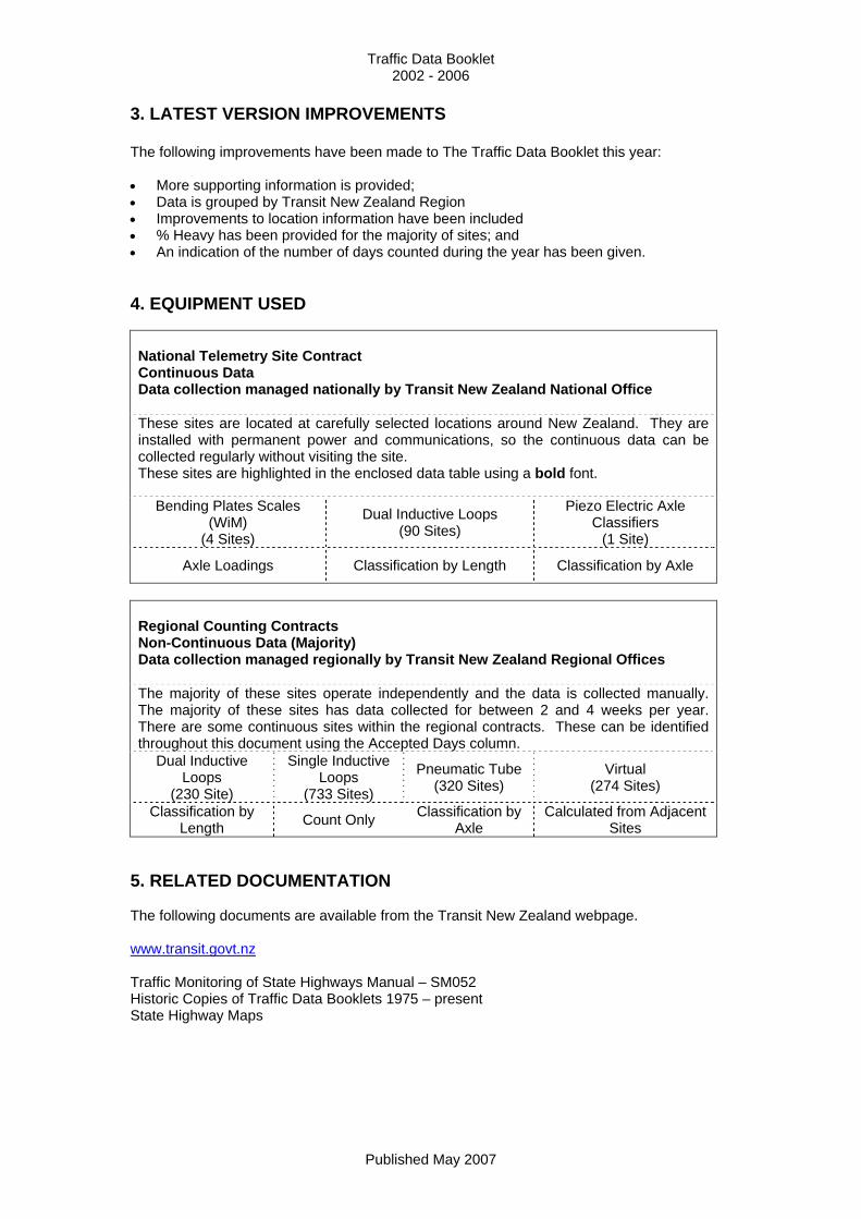
3. LATEST VERSION IMPROVEMENTS The following improvements have been made to The Traffic Data Booklet this year: • More supporting information is provided; • Data is grouped by Transit New Zealand Region • Improvements to location information have been included • % Heavy has been provided for the majority of sites; and • An indication of the number of days counted during the year has been given. 4. EQUIPMENT USED National Telemetry Site Contract Continuous Data Data collection managed nationally by Transit New Zealand National Office These sites are located at carefully selected locations around New Zealand. They are installed with permanent power and communications, so the continuous data can be collected regularly without visiting the site. These sites are highlighted in the enclosed data table using a bold font.
Bending Plates Scales (WiM)
(4 Sites)
Dual Inductive Loops (90 Sites)
Piezo Electric Axle Classifiers
(1 Site)
Axle Loadings Classification by Length Classification by Axle
Regional Counting Contracts Non-Continuous Data (Majority) Data collection managed regionally by Transit New Zealand Regional Offices The majority of these sites operate independently and the data is collected manually. The majority of these sites has data collected for between 2 and 4 weeks per year. There are some continuous sites within the regional contracts. These can be identified throughout this document using the Accepted Days column.
Dual Inductive Loops
(230 Site)
Single Inductive Loops
(733 Sites)
Pneumatic Tube (320 Sites)
Virtual (274 Sites)
Classification by Length Count Only Classification by
Axle Calculated from Adjacent
Sites 5. RELATED DOCUMENTATION The following documents are available from the Transit New Zealand webpage. www.transit.govt.nz Traffic Monitoring of State Highways Manual – SM052 Historic Copies of Traffic Data Booklets 1975 – present State Highway Maps
Published May 2007
Traffic Data Booklet 2002 - 2006
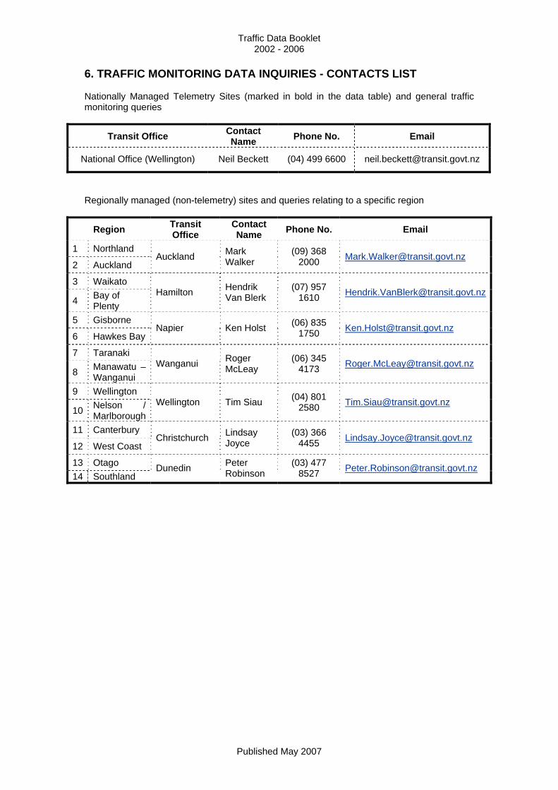
6. TRAFFIC MONITORING DATA INQUIRIES - CONTACTS LIST Nationally Managed Telemetry Sites (marked in bold in the data table) and general traffic monitoring queries
Transit Office Contact Name Phone No. Email
National Office (Wellington) Neil Beckett (04) 499 6600 [email protected]
Regionally managed (non-telemetry) sites and queries relating to a specific region
Region Transit Office
Contact Name Phone No. Email
1 Northland
2 Auckland Auckland Mark
Walker (09) 368
2000 [email protected]
3 Waikato
4 Bay of Plenty
Hamilton Hendrik Van Blerk
(07) 957 1610 [email protected]
5 Gisborne
6 Hawkes Bay Napier Ken Holst (06) 835
1750 [email protected]
7 Taranaki
8 Manawatu – Wanganui
Wanganui Roger McLeay
(06) 345 4173 [email protected]
9 Wellington
10 Nelson / Marlborough
Wellington Tim Siau (04) 801 2580 [email protected]
11 Canterbury
12 West Coast Christchurch Lindsay
Joyce (03) 366
4455 [email protected]
13 Otago 14 Southland
Dunedin Peter Robinson
(03) 477 8527 [email protected]
Published May 2007
Traffic Data Booklet 2002 - 2006
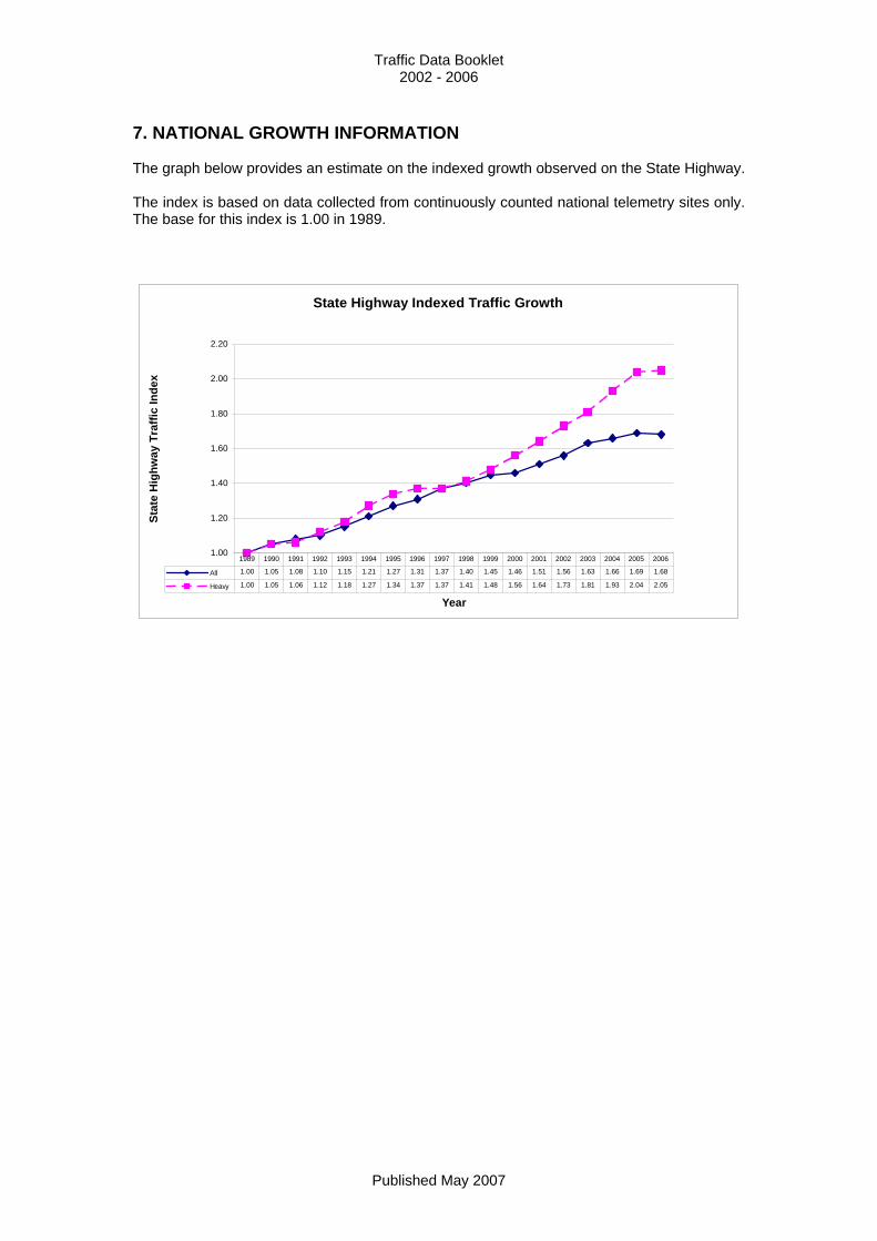
7. NATIONAL GROWTH INFORMATION The graph below provides an estimate on the indexed growth observed on the State Highway. The index is based on data collected from continuously counted national telemetry sites only. The base for this index is 1.00 in 1989.
State Highway Indexed Traffic Growth
1.00
1.20
1.40
1.60
1.80
2.00
2.20
Year
Stat
e H
ighw
ay T
raffi
c In
dex
All 1.00 1.05 1.08 1.10 1.15 1.21 1.27 1.31 1.37 1.40 1.45 1.46 1.51 1.56 1.63 1.66 1.69 1.68
Heavy 1.00 1.05 1.06 1.12 1.18 1.27 1.34 1.37 1.37 1.41 1.48 1.56 1.64 1.73 1.81 1.93 2.04 2.05
1989 1990 1991 1992 1993 1994 1995 1996 1997 1998 1999 2000 2001 2002 2003 2004 2005 2006
Published May 2007
Traffic Data Booklet 2002 - 2006
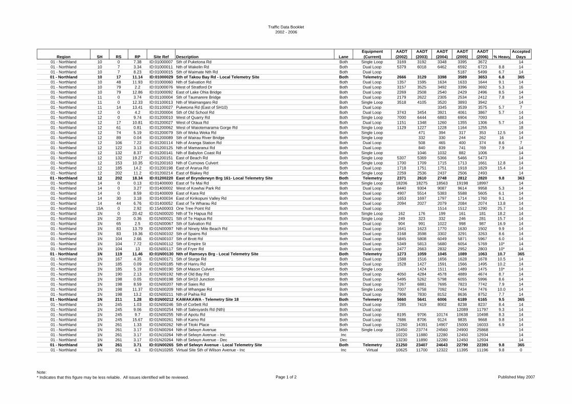
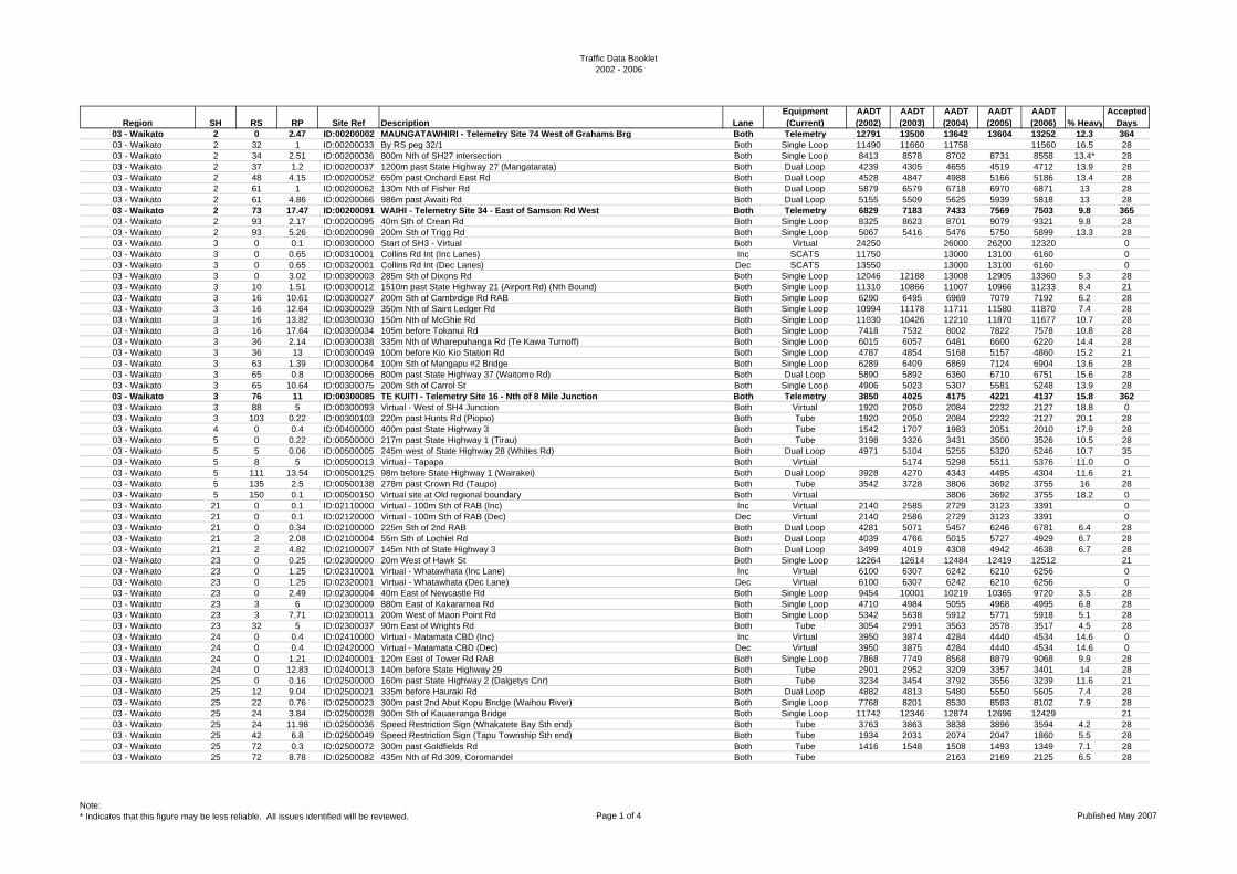
8. AADT DATA TABLES WITH COLUMN DESCRIPTIONS Region This is the Transit New Zealand Region responsible for the specific section of State Highway where the traffic counting site is located. SH State Highway State Highway 1 is suffixed N and S for the North and South Islands respectively. RS Reference Station This is a location, where it’s position is accurately know point on a State Highway, from which Route Position’s can be measured. These are usually fixed points, such as: SH starts / ends, bridges and intersection etc. RP Route Position This indicates the distance from the last RS to the specific location in kilometers. Site Ref This is the unique identifier used within Transit New Zealand’s Traffic Monitoring System (TMS). For further information on how these references are created, please refer to the Traffic Monitoring of State Highways Manual – SM052. Description This is an approximate descriptive location on the state highway of the traffic counting site. Lane This indicates if the AADT and % Heavy data, is reported separately in the increasing and decreasing directions or in both directions together. Equipment (Current) This details the primary equipment type being used to collect traffic data at the specific location. There may be a combination of equipment types used in some circumstances. AADT Annual Average Daily Traffic volume, This is an estimation of the daily traffic averaged over the (calendar) specified year. The majority of the traffic counts provided in this publication have been undertaken at the particular count site over two or more typical weeks in the year and seasonally adjusted, using continuous data obtained from Telemetry Sites, to provide a relatively robust estimate of the annual traffic volume at that location. Other traffic details such as the vehicle composition are available for some sites from the regional contact, see below. % Heavy This is an estimate of the proportion of the AADT, which is deemed a heavy vehicle: ie greater than 3.5 tonnes for the current year. Accepted Days This provides an indication of the sample size collected at the specific location during the year. This, along with other details provided above, will assist the user in sorting the data by confidence in the accuracy.
Published May 2007
Traffic Data Booklet2002 - 2006
Region SH RS RP Site Ref Description LaneEquipment (Current)
AADT (2002)
AADT (2003)
AADT (2004)
AADT (2005)
AADT (2006) % Heavy
Accepted Days
01 - Northland 10 0 7.38 ID:01000007 Sth of Puketona Rd Both Single Loop 3169 3192 3348 3395 3672 1401 - Northland 10 7 3.34 ID:01000011 Nth of Wakelin Rd Both Dual Loop 5379 6018 6462 6592 6723 8.8 1401 - Northland 10 7 8.23 ID:01000015 Sth of Waimate Nth Rd Both Dual Loop 5187 5499 6.7 1401 - Northland 10 17 11.14 ID:01000029 Sth of Takou Bay Rd - Local Telemetry Site Both Telemetry 2666 3129 3398 3589 3653 6.8 36501 - Northland 10 48 11.93 ID:01000060 Nth of Salvation Rd Both Dual Loop 1357 1595 1634 1633 1644 9.1 1401 - Northland 10 79 2.2 ID:01000076 West of Stratford Dr Both Dual Loop 3157 3525 3492 3396 3692 5.3 1601 - Northland 10 79 12.86 ID:01000092 East of Lake Ohia Bridge Both Dual Loop 2269 2508 2540 2429 2496 8.5 1401 - Northland 11 0 3.74 ID:01100004 Sth of Taumarere Bridge Both Dual Loop 2179 2622 2305 2534 2412 7.8 1401 - Northland 11 0 12.33 ID:01100013 Nth of Waimangaro Rd Both Single Loop 3518 4105 3520 3893 3942 1401 - Northland 11 14 13.41 ID:01100027 Puketona Rd (East of SH10) Both Dual Loop 3345 3539 3575 5.7 701 - Northland 12 0 4.2 ID:01200004 Sth of Old School Rd Both Dual Loop 3743 3454 3921 4061 3867 5.7 1401 - Northland 12 0 9.74 ID:01200010 West of Quarry Rd Both Single Loop 7000 6444 6883 6904 7093 1401 - Northland 12 17 10.81 ID:01200027 West of Otaua Rd Both Dual Loop 1151 1348 1260 1355 1306 5.7 1401 - Northland 12 61 0.81 ID:01200062 West of Waiotemarama Gorge Rd Both Single Loop 1129 1227 1228 1164 1255 1801 - Northland 12 74 5.19 ID:01200079 Sth of Weka Weka Rd Both Single Loop 471 394 317 353 12.5 1401 - Northland 12 89 0.04 ID:01200089 Sth of Wairau River Bridge Both Single Loop 332 330 244 262 16 1401 - Northland 12 106 7.22 ID:01200114 Nth of Aranga Station Rd Both Dual Loop 508 465 400 374 8.6 701 - Northland 12 122 3.13 ID:01200125 Nth of Mamaranui Rd Both Dual Loop 840 839 741 769 7.9 1401 - Northland 12 132 8.37 ID:01200141 Nth of Babylon Coast Rd Both Single Loop 1046 1032 882 1006 1401 - Northland 12 132 19.27 ID:01200151 East of Beach Rd Both Single Loop 5307 5369 5366 5466 5473 1401 - Northland 12 153 10.35 ID:01200163 Nth of Curnows Culvert Both Single Loop 1700 1709 1715 1713 1661 12.8 1401 - Northland 12 185 14.2 ID:01200198 East of Ararua Rd Both Dual Loop 1718 1751 1751 1918 1829 15.4 1401 - Northland 12 202 11.2 ID:01200214 East of Blakey Rd Both Single Loop 2259 2536 2437 2506 2493 1401 - Northland 12 202 18.34 ID:01200220 East of Brynderwyn Brg 161- Local Telemetry Site Both Telemetry 2371 2610 2748 2812 2820 9.8 36301 - Northland 14 0 0.13 ID:01400000 East of Te Mai Rd Both Single Loop 18206 18275 18563 19198 18997 1401 - Northland 14 0 3.27 ID:01400002 West of Kowhai Park Rd Both Dual Loop 8440 9304 9087 9614 9958 5.3 1401 - Northland 14 0 8.59 ID:01400009 East of Kara Rd Both Dual Loop 4907 5514 5383 5588 5605 6.1 1401 - Northland 14 30 3.18 ID:01400034 East of Kirikopuni Valley Rd Both Dual Loop 1653 1697 1797 1714 1760 9.1 1401 - Northland 14 44 6.76 ID:01400052 East of Te Wharau Rd Both Dual Loop 2094 2027 2079 2084 2074 13.8 1401 - Northland 15A 0 2.92 ID:15A00003 One Tree Point Rd Both Dual Loop 1514 1512 1290 25.7 1401 - Northland 1N 0 20.42 ID:01N00020 Nth of Te Hapua Rd Both Single Loop 162 176 199 161 181 18.2 1401 - Northland 1N 20 0.36 ID:01N00021 Sth of Te Hapua Rd Both Single Loop 249 323 332 246 281 15.7 1401 - Northland 1N 65 2.5 ID:01N00067 Sth of Salvation Rd Both Dual Loop 904 991 1022 998 987 16.9 1401 - Northland 1N 83 13.79 ID:01N00097 Nth of Ninety Mile Beach Rd Both Dual Loop 1641 1623 1770 1630 1502 9.9 1401 - Northland 1N 83 19.36 ID:01N00102 Sth of Spains Rd Both Dual Loop 3168 3598 3302 3291 3263 8.6 1401 - Northland 1N 104 2.66 ID:01N00107 Sth of Brott Rd Both Dual Loop 5845 5808 6049 5871 5967 6.0 1401 - Northland 1N 104 7.72 ID:01N00112 Sth of Empire St Both Dual Loop 5349 5813 5680 6054 5769 10* 1401 - Northland 1N 104 13 ID:01N00117 Sth of Fryer Rd Both Dual Loop 2477 2663 2832 2952 2803 10* 1401 - Northland 1N 119 11.46 ID:01N00130 Nth of Ramseys Brg - Local Telemetry Site Both Telemetry 1273 1059 1045 1089 1063 10.7 36501 - Northland 1N 167 4.35 ID:01N00171 Sth of Sturge Rd Both Dual Loop 1588 1516 1656 1628 1678 10.5 1401 - Northland 1N 185 0.09 ID:01N00185 Nth of Hariru Rd Both Dual Loop 1528 1427 1591 1566 1495 10.2 1401 - Northland 1N 185 5.19 ID:01N00190 Sth of Mason Culvert Both Single Loop 1424 1511 1489 1475 10* 1401 - Northland 1N 190 2.13 ID:01N00192 Nth of Old Bay Rd Both Dual Loop 4050 4284 4578 4889 4674 8.7 1401 - Northland 1N 198 0.05 ID:01N00198 Sth of SH10 Junction Both Dual Loop 5495 5262 5798 6055 5996 8.6 1401 - Northland 1N 198 8.59 ID:01N00207 Nth of Saies Rd Both Dual Loop 7267 6881 7695 7823 7742 7.9 1401 - Northland 1N 198 11.37 ID:01N00209 Nth of Whangae Rd Both Single Loop 7007 6758 7092 7434 7476 10.0 1401 - Northland 1N 198 13.2 ID:01N00211 Nth of Paihia Rd Both Dual Loop 7906 7830 8152 8636 8752 7.7 1401 - Northland 1N 211 1.28 ID:01N00212 KAWAKAWA - Telemetry Site 18 Both Telemetry 5660 5641 6006 6189 6165 9.5 36501 - Northland 1N 245 1.03 ID:01N00246 Sth of Corbett Rd Both Dual Loop 7285 7419 8002 8238 8237 8.4 1401 - Northland 1N 245 9.06 ID:01N00254 Nth of Salesyards Rd (Nth) Both Dual Loop 12089 11797 9.3 1401 - Northland 1N 245 9.7 ID:01N00255 Nth of Apotu Rd Both Dual Loop 8195 9706 10174 10638 10498 8.3 1401 - Northland 1N 245 15.67 ID:01N00261 Nth of Kamo Rd Both Dual Loop 7686 8706 9124 9835 9668 9.8 1401 - Northland 1N 261 1.33 ID:01N00262 Nth of Titoki Place Both Dual Loop 12260 14391 14907 15000 16033 6.9 1401 - Northland 1N 261 3.17 ID:01N00264 Nth of Selwyn Avenue Both Single Loop 23450 23774 24560 24900 25868 1401 - Northland 1N 261 3.17 ID:01N10264 Nth of Selwyn Avenue - Inc Inc 10220 11880 12280 12450 12934 1401 - Northland 1N 261 3.17 ID:01N20264 Nth of Selwyn Avenue - Dec Dec 13230 11890 12280 12450 12934 1401 - Northland 1N 261 3.71 ID:01N00265 Sth of Selwyn Avenue - Local Telemetry Site Both Telemetry 21250 23407 24643 22790 22393 9.8 36501 - Northland 1N 261 4.3 ID:01N10265 Virtual Site Sth of Wilson Avenue - Inc Inc Virtual 10625 11700 12322 11395 11196 9.8 0
Note:* Indicates that this figure may be less reliable. All issues identified will be reviewed. Page 1 of 2 Published May 2007

Traffic Data Booklet2002 - 2006
Region SH RS RP Site Ref Description LaneEquipment (Current)
AADT (2002)
AADT (2003)
AADT (2004)
AADT (2005)
AADT (2006) % Heavy
Accepted Days
01 - Northland 1N 261 4.3 ID:01N20265 Virtual Site Sth of Wilson Avenue - Dec Dec Virtual 10625 11710 12322 11395 11196 9.8 001 - Northland 1N 266 0.62 ID:01N00267 Sth of Tarewa Rd Both Single Loop 22121 23713 24234 24599 25341 1401 - Northland 1N 266 2.21 ID:01N00268 Sth of Cemetery Bridge Both Dual Loop 14828 17448 18655 20102 20809 6.3 1401 - Northland 1N 266 5.3 ID:01N00271 Nth of Loop Rd Both Dual Loop 12472 14543 15709 16695 16436 8.1 1401 - Northland 1N 266 7.88 ID:01N00274 Nth of Maungakaramea Rd - Local Telemetry Site Both Telemetry 13051 13082 13542 13434 8.8 36501 - Northland 1N 273 13.86 ID:01N00287 Nth of Yovich Rd Both Dual Loop 9938 10458 11244 11598 11376 10.0 1401 - Northland 1N 292 6.14 ID:01N00299 Nth of Uretiti Rd Both Dual Loop 8150 9079 9553 9760 9782 11.1 1401 - Northland 1N 303 5.75 ID:01N00309 Sth of Glenmohr Rd Both Dual Loop 6735 7123 7391 7584 7556 13.2 1401 - Northland 1N 319 16 ID:01N00335 Virtual Site at Region 1/2 Boundary Both Virtual 9257 9159 9.7 0
Note:* Indicates that this figure may be less reliable. All issues identified will be reviewed. Page 2 of 2 Published May 2007
Traffic Data Booklet2002 - 2006
Region SH RS RP Site Ref Description LaneEquipment (Current)
AADT (2002)
AADT (2003)
AADT (2004)
AADT (2005)
AADT (2006) % Heavy
Accepted Days
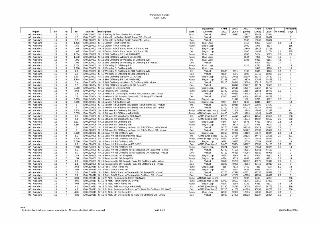
02 - Auckland 16 0 1.1 ID:01600001 SH16 Stanley St East of Alten Rd - Virtual Both Virtual 19000 16912 27937 33489 33514 002 - Auckland 16 0 1.3 ID:01610001 SH16 Alten Rd to Grafton Rd Off Ramp WB - Virtual Inc Virtual 20997 19853 19677 002 - Auckland 16 0 1.3 ID:01620001 SH16 Alten Rd to Grafton Rd On Ramp EB - Virtual Dec Virtual 6940 13636 13837 002 - Auckland 16 0 1.426 ID:01660001 SH16 Grafton Rd Off Ramp WB Ramp Dual Loop 6157 5937 5952 5.1 1402 - Auckland 16 0 1.55 ID:01650001 SH16 Grafton Rd On Ramp EB Ramp Single Loop 1000 1978 2133 36502 - Auckland 16 0 1.65 ID:01619001 SH16 Grafton Rd Off Ramp to SH1 Off Ramp WB Inc Single Loop 14840 13916 13725 36102 - Auckland 16 0 1.65 ID:01629001 SH16 Grafton Rd On Ramp to SH1 On Ramp EB Dec Single Loop 6940 11658 11704 3.1 36502 - Auckland 16 0 1.804 ID:01650002 SH16 SH1 On Ramp EB (Link 00146429) Ramp Dual Loop 4356 5154 5369 3.6 2602 - Auckland 16 0 1.872 ID:01660002 SH16 SH1 Off Ramp WB (Link 00136429) Ramp Dual Loop 6644 7886 7533 4.0 702 - Auckland 16 0 1.95 ID:01610002 SH16 SH1 Off Ramp to Wellesley St On Ramp WB Inc Dual Loop 8196 6030 6161 4.6 702 - Auckland 16 0 1.95 ID:01620002 SH16 SH1 On Ramp to Wellesley St Off Ramp EB -Virtual Dec Virtual 6504 6334 2.7 002 - Auckland 16 0 2.034 ID:01640002 SH16 Wellesley St Off Ramp EB Ramp Dual Loop 4314 4215 3891 1802 - Auckland 16 0 2.268 ID:01630002 SH16 Wellesley St On Ramp WB Ramp Dual Loop 3543 3278 2.3 1802 - Auckland 16 0 2.6 ID:01610003 SH16 Wellesley St On Ramp to SH1 On Ramp WB Inc Virtual 10680 8071 8196 9573 9470 1.9 002 - Auckland 16 0 2.6 ID:01620003 SH16 Wellesley St Off Ramp to SH1 Off Ramp EB Dec Virtual 8300 8895 6898 10719 10225 2.2 002 - Auckland 16 0 3.197 ID:01630003 SH16 SH1 On Ramp WB (Link 00140428) Ramp Single Loop 21520 20768 20500 21240 20730 3.2 002 - Auckland 16 0 3.348 ID:01640003 SH16 SH1 Off Ramp EB (Link 00130428) Ramp Single Loop 22363 19447 19879 20455 20373 3.3 002 - Auckland 16 0 3.4 ID:01610004 SH16 SH1 On Ramp to Hobson St On Ramp WB - Virtual Inc Virtual 32210 28840 28696 30813 30200 002 - Auckland 16 0 3.5 ID:01620004 SH16 SH1 Off Ramp to Nelson St Off Ramp EB Dec Virtual 28340 26777 31174 30598 3.3 002 - Auckland 16 0 3.513 ID:01630004 SH16 Hobson St On Ramp WB Ramp Single Loop 16910 20519 19797 19267 18756 002 - Auckland 16 0 3.63 ID:01640004 SH16 Nelson St Off Ramp EB Ramp Single Loop 19380 18072 18864 15861 15679 3.3 002 - Auckland 16 0 3.8 ID:01619004 SH16 Hobson St On Ramp to Newton Rd On Ramp WB - Virtual Inc Virtual 49120 49360 48493 50079 48956 002 - Auckland 16 0 3.8 ID:01629004 SH16 Nelson St Off Ramp to Newton Rd Off Ramp EB - Virtual Dec Virtual 41910 46400 45641 47034 46277 3.3 002 - Auckland 16 0 3.939 ID:01649004 SH16 Newton Rd Off Ramp EB Ramp Single Loop 11877 11381 9720 9587 3.3 002 - Auckland 16 0 3.989 ID:01639004 SH16 Newton Rd On Ramp WB Ramp Single Loop 9201 9422 9846 8816 8687 1802 - Auckland 16 0 5 ID:01610005 SH16 Newton Rd On Ramp to St Lukes Rd Off Ramp WB - Virtual Inc Virtual 58320 59010 58339 58895 57643 002 - Auckland 16 0 5 ID:01620005 SH16 Newton Rd Off Ramp to St Lukes Rd On Ramp EB - Virtual Dec Virtual 57350 57420 57022 56754 55864 3.3 002 - Auckland 16 0 5.808 ID:01650006 SH16 St Lukes Rd On Ramp EB (NW1) Ramp ATMS (Single Loop) 13030 12648 12348 12667 12337 34102 - Auckland 16 0 6.035 ID:01660006 SH16 St Lukes Rd Off Ramp WB (NW1) Ramp ATMS (Single Loop) 14400 14466 14269 14349 14082 18802 - Auckland 16 0 6.1 ID:01610006 SH16 St Lukes Rd Interchange WB (NW1) Inc ATMS (Dual Loop) 43920 44541 44070 44546 43562 3.0 18802 - Auckland 16 0 6.1 ID:01620006 SH16 St Lukes Rd Interchange EB (NW1) Dec ATMS (Dual Loop) 44320 44772 44674 44087 43527 3.3 28202 - Auckland 16 0 6.207 ID:01640006 SH16 St Lukes Rd Off Ramp EB Ramp Single Loop 5840 6267 6548 6450 6142 2.5 1402 - Auckland 16 0 6.584 ID:01630006 SH16 St Lukes Rd On Ramp WB Ramp Single Loop 8349 8830 9244 8875 9118 2.1 1402 - Auckland 16 0 7 ID:01610007 SH16 St Lukes Rd On Ramp to Great Nth Rd Off Ramp WB - Virtual Inc Virtual 52270 53370 53314 53421 52680 3.6 002 - Auckland 16 0 7 ID:01620007 SH16 St Lukes Rd Off Ramp to Great Nth Rd On Ramp EB - Virtual Dec Virtual 50110 51040 51222 50537 49669 3.7 002 - Auckland 16 0 7.989 ID:01660008 SH16 Great Nth Rd Off Ramp WB Ramp Single Loop 19058 19262 19189 18942 19044 2.5 1402 - Auckland 16 0 8.3 ID:01610008 SH16 Great Nth Rd Interchange WB (NW2) Inc ATMS (Dual Loop) 33190 34564 34125 34479 33636 3.7 32102 - Auckland 16 0 8.508 ID:01650008 SH16 Great Nth Rd On Ramp EB (NW2) Ramp ATMS (Single Loop) 16040 16189 15935 15481 15549 32102 - Auckland 16 0 8.666 ID:01630008 SH16 Great Nth Rd On Ramp WB Ramp Single Loop 9629 10087 10626 10582 10496 2.6 1402 - Auckland 16 0 8.7 ID:01620008 SH16 Great Nth Rd Interchange EB (NW2) Dec ATMS (Dual Loop) 34070 35554 35287 35056 34120 3.7 32102 - Auckland 16 0 8.928 ID:01640008 SH16 Great Nth Rd Off Ramp EB Ramp Single Loop 10071 10507 10777 10864 10975 3.7 1402 - Auckland 16 0 9.2 ID:01619008 SH16 Great Nth Rd On Ramp to Rosebank Rd Off Ramp WB - Virtual Inc Virtual 42720 44650 44751 45061 44132 002 - Auckland 16 0 9.2 ID:01629008 SH16 Great Nth Rd Off Ramp to Rosebank Rd On Ramp EB - Virtual Dec Virtual 43710 45450 46064 45920 45095 3.7 002 - Auckland 16 7 1.48 ID:01650009 SH16 Rosebank Rd On Ramp EB Ramp Single Loop 5490 4960 5410 5504 5182 6.7 1402 - Auckland 16 7 1.54 ID:01660009 SH16 Rosebank Rd Off Ramp WB Ramp Single Loop 4794 4875 4869 4686 4783 7.9 1402 - Auckland 16 7 2.1 ID:01610009 SH16 Rosebank Rd Off Ramp to Patiki Rd On Ramp WB - Virtual Inc Virtual 37880 39780 39882 40375 39349 3.6 002 - Auckland 16 7 2.1 ID:01620009 SH16 Rosebank Rd On Ramp to Patiki Rd Off Ramp EB - Virtual Dec Virtual 38220 40490 40654 40416 39913 3.3 002 - Auckland 16 7 2.68 ID:01630010 SH16 Patiki Rd On Ramp WB Ramp Single Loop 7365 7612 7469 7360 7228 5.3 1802 - Auckland 16 7 2.94 ID:01640010 SH16 Patiki Rd Off Ramp EB Ramp Single Loop 6403 6607 6636 6615 6718 7.7 1402 - Auckland 16 7 3.2 ID:01610010 SH16 Patiki Rd On Ramp to Te Atatu Rd Off Ramp WB - Virtual Inc Virtual 45170 47390 47351 47735 46577 3.6 002 - Auckland 16 7 3.2 ID:01620010 SH16 Patiki Rd Off Ramp to Te Atatu Nth On Ramp EB - Virtual Dec Virtual 44350 47100 47290 47031 46631 8.9 002 - Auckland 16 7 3.99 ID:01659011 SH16 Te Atatu Peninsula On Ramp EB (NW3) Ramp ATMS (Single Loop) 5899 5902 6174 5862 35602 - Auckland 16 7 4.01 ID:01660011 SH16 Te Atatu Rd Off Ramp WB (NW3) Ramp ATMS (Single Loop) 17910 18677 18346 18655 17868 35602 - Auckland 16 7 4.03 ID:01630011 SH16 Te Atatu Rd On Ramp WB Ramp Single Loop 6178 6193 6132 6335 6331 1.8 1402 - Auckland 16 7 4.2 ID:01610011 SH16 Te Atatu Rd Interchange WB (NW3) Inc ATMS (Dual Loop) 27260 28713 29005 29080 28709 3.4 35602 - Auckland 16 7 4.2 ID:01620011 SH16 Te Atatu Peninsula On Ramp to Te Atatu Sth On Ramp EB (NW3) Dec ATMS (Dual Loop) 38710 41202 41388 40857 40769 9.1 35602 - Auckland 16 7 4.31 ID:01650011 SH16 Te Atatu Sth On Ramp EB Ramp Dual Loop 12908 12860 12866 12630 12405 3.1 002 - Auckland 16 7 4.36 ID:01629011 SH16 Te Atatu Sth On Ramp to Te Atatu Rd Off Ramp EB - Virtual Dec Virtual 26600 27000 28522 28227 28364 3.3 0
Note:* Indicates that this figure may be less reliable. All issues identified will be reviewed. Page 1 of 9 Published May 2007
Traffic Data Booklet2002 - 2006
Region SH RS RP Site Ref Description LaneEquipment (Current)
AADT (2002)
AADT (2003)
AADT (2004)
AADT (2005)
AADT (2006) % Heavy
Accepted Days
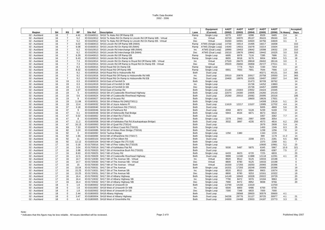
02 - Auckland 16 7 4.41 ID:01640011 SH16 Te Atatu Rd Off Ramp EB Ramp Single Loop 6275 6357 6398 6529 6465 2.4 1402 - Auckland 16 7 5.2 ID:01610012 SH16 Te Atatu Rd On Ramp to Lincoln Rd Off Ramp WB - Virtual Inc Virtual 33720 34970 35137 35415 35040 3.0 002 - Auckland 16 7 5.2 ID:01620012 SH16 Te Atatu Rd Off Ramp to Lincoln Rd On Ramp EB - Virtual Dec Virtual 33260 34591 34920 34756 34829 3.1 002 - Auckland 16 7 6.02 ID:01660013 SH16 Lincoln Rd Off Ramp WB (NW4) Ramp ATMS (Single Loop) 14730 15514 15495 16017 16008 31002 - Auckland 16 7 6.08 ID:01650013 SH16 Lincoln Rd On Ramp EB (NW4) Ramp ATMS (Single Loop) 14040 14915 15078 15314 15504 31002 - Auckland 16 7 6.2 ID:01610013 SH16 Lincoln Rd Interchange WB (NW4) Inc ATMS (Dual Loop) 18990 19453 19642 19398 19032 2.9 31002 - Auckland 16 7 6.2 ID:01620013 SH16 Lincoln Rd Interchange EB (NW4) Dec ATMS (Dual Loop) 19210 19676 19842 19442 19325 3.0 31002 - Auckland 16 7 6.29 ID:01640013 SH16 Lincoln Rd Off Ramp EB Ramp Single Loop 6695 6978 7116 7285 7686 3.1 2502 - Auckland 16 7 6.43 ID:01630013 SH16 Lincoln Rd On Ramp WB Ramp Single Loop 8655 9018 9176 9004 9084 5.5 1802 - Auckland 16 7 7.3 ID:01610014 SH16 Lincoln Rd On Ramp to Royal Rd Off Ramp WB - Virtual Inc Virtual 27520 28470 28818 28402 28116 3.0 002 - Auckland 16 7 7.3 ID:01620014 SH16 Lincoln Rd Off Ramp to Royal Rd On Ramp EB - Virtual Dec Virtual 25520 26650 26958 26727 27011 3.1 002 - Auckland 16 7 8.3 ID:01650015 SH16 Royal Rd On Ramp EB Ramp Single Loop 7774 7623 7230 7454 1402 - Auckland 16 7 8.32 ID:01660015 SH16 Royal Rd Off Ramp WB Ramp Single Loop 6901 7653 7901 7644 7566 1.3 1402 - Auckland 16 7 9.2 ID:01600016 SH16 Royal Rd to Hobsonville Rd Both Dual Loop 40271 40131 3.4 36502 - Auckland 16 7 9.2 ID:01610016 SH16 Royal Rd Off Ramp to Hobsonville Rd WB Inc Dual Loop 20510 20878 20917 20758 20550 3.4 36502 - Auckland 16 7 9.2 ID:01620016 SH16 Royal Rd On Ramp to Hobsonville Rd EB Dec Dual Loop 19400 19976 19335 19497 19557 3.4 36502 - Auckland 16 19 0.3 ID:01600019 SH16 East of Fernhill Dr Both Single Loop 31473 30709 30762 1402 - Auckland 16 19 0.3 ID:01610019 SH16 East of Fernhill Dr WB Inc Single Loop 15736 14252 13863 1402 - Auckland 16 19 0.3 ID:01620019 SH16 East of Fernhill Dr EB Dec Single Loop 15736 16457 16899 1402 - Auckland 16 19 1.07 ID:01600020 SH16 East of Dunlop Rd Both Single Loop 21140 23303 23552 24424 23345 1402 - Auckland 16 19 5 ID:01600023 SH16 Sth of Coatesville Riverhead Highway Both Single Loop 22074 24300 24005 24260 24143 1402 - Auckland 16 19 5.6 ID:01600024 SH16 Nth of Coatesville Riverhead Highway Both Dual Loop 25260 20010 20082 20095 20316 18502 - Auckland 16 19 9 ID:01600027 SH16 Nth of Access Rd Both Single Loop 18600 18626 17831 1002 - Auckland 16 19 11.84 ID:01600031 SH16 Sth of Matua Rd (Nth)(TS011) Both Single Loop 14308 13516 5.1 2402 - Auckland 16 19 13.4 ID:01600032 SH16 Sth of Joyce Adams Pl Both Dual Loop 11619 12217 13107 13085 12702 4.4 1402 - Auckland 16 37 3.18 ID:01600040 SH16 Sth of Hutchison Rd (TS012) Both Dual Loop 5005 4869 5.6 2502 - Auckland 16 37 9 ID:01600046 SH16 Sth of Parkhurst Rd Both Dual Loop 4559 4872 5128 5239 5169 7.0 1402 - Auckland 16 47 0.1 ID:01600048 SH16 Sth of Helensville Rail Bridge Both Single Loop 5943 6534 6671 6673 6622 1402 - Auckland 16 47 5.52 ID:01600052 SH16 Sth of Abel Rd (TS013) Both Dual Loop 3357 3362 7.7 1402 - Auckland 16 47 8 ID:01600055 SH16 Sth of Inland Rd Both Single Loop 2379 2943 2997 3099 3054 1402 - Auckland 16 47 11.2 ID:01600058 SH16 Nth of Kahikatea Flat Rd (Kaukapakapa Bridge) Both Dual Loop 3532 3897 4235 4573 4816 6.2 25002 - Auckland 16 47 16.13 ID:01600063 SH16 Sth of Quail Rd (TS014) Both Dual Loop 2679 2608 5.4 1402 - Auckland 16 69 7.33 ID:01600076 SH16 Nth of West Coast Rd (TS015) Both Single Loop 1400 1346 8.3 2502 - Auckland 16 82 3.24 ID:01600085 SH16 Sth of Hoteo River Bridge (TS016) Both Dual Loop 1238 1256 7.8 1402 - Auckland 16 92 0 ID:01600092 SH16 Tauhoa Bridge Both Single Loop 1250 1380 1163 1220 1402 - Auckland 16 92 1.65 ID:01600094 SH16 Nth of Wharehine Rd (TS017) Both Single Loop 999 1179 11.2 1402 - Auckland 16 92 11 ID:01600103 SH16 Nth of Port Albert Rd Both Dual Loop 2208 2371 2281 6.5 36502 - Auckland 16 92 12.12 ID:01600104 SH16 Nth of Clague Rd (TS 018) Both Single Loop 2370 2268 8.1 702 - Auckland 17 16 0.18 ID:01700016 SH17 Nth of Pine Valley Rd (TS019) Both Single Loop 10600 10961 5.2 2002 - Auckland 17 16 3.04 ID:01700019 SH17 Nth of Kahikatea Flat Rd Both Dual Loop 5030 5487 5875 6345 5967 10.9 32102 - Auckland 17 16 3.98 ID:01700020 SH17 Sth of Horseshoe Bush Rd (TS020) Both Dual Loop 6565 6387 7.5 1702 - Auckland 17 16 8.63 ID:01700025 SH17 Nth of Durey Rd Both Single Loop 6433 6623 6720 7225 6833 2002 - Auckland 17 16 12.5 ID:01700029 SH17 Sth of Coatesville Riverhead Highway Both Dual Loop 9999 11340 11988 12118 12291 4.1 2002 - Auckland 17 16 14.7 ID:01710030 SH17 Nth of The Avenue SB - Virtual Inc Virtual 8520 8512 9125 10033 10198 002 - Auckland 17 16 14.7 ID:01720030 SH17 Nth of The Avenue NB - Virtual Dec Virtual 8800 8780 9125 10033 10198 002 - Auckland 17 16 15 ID:01700030 SH17 Nth of The Avenue - Virtual Both Virtual 16330 17293 18250 20065 20396 002 - Auckland 17 16 15.04 ID:01700031 SH17 Sth of The Avenue Both Single Loop 16331 17293 18248 20065 20396 1902 - Auckland 17 16 15.25 ID:01710031 SH17 Sth of The Avenue SB Inc Single Loop 8520 8512 8994 9903 10074 1902 - Auckland 17 16 15.25 ID:01720031 SH17 Sth of The Avenue NB Dec Single Loop 8800 8780 9253 10161 10322 1902 - Auckland 17 16 16.4 ID:01700032 SH17 Sth of Albany Highway Both Single Loop 14149 16943 18328 20022 19729 2002 - Auckland 17 16 16.4 ID:01710032 SH17 Sth of Albany Highway SB Inc Single Loop 7790 8472 9376 10184 9963 2002 - Auckland 17 16 16.4 ID:01720032 SH17 Sth of Albany Highway NB Dec Single Loop 7990 8472 8952 9838 9766 2002 - Auckland 18 0 1.8 ID:01800002 SH18 West of Unsworth Dr Both Single Loop 13790 14150 13319 1370002 - Auckland 18 0 1.8 ID:01810002 SH18 West of Unsworth Dr WB Inc Single Loop 6500 6800 6486 6700 670002 - Auckland 18 0 1.8 ID:01820002 SH18 West of Unsworth Dr EB Dec Single Loop 7300 7348 6833 7000 700002 - Auckland 18 0 2.44 ID:01800003 SH18 Albany Highway Both Dual Loop 28568 28920 30579 30600 4.102 - Auckland 18 0 3.47 ID:01800004 SH18 West of Albany Highway Both Dual Loop 34236 29776 31127 30725 30977 4.1 2102 - Auckland 18 0 4.4 ID:01800005 SH18 West of Greenhithe Rd Both Dual Loop 24000 24468 23933 24187 23773 3.3 21
Note:* Indicates that this figure may be less reliable. All issues identified will be reviewed. Page 2 of 9 Published May 2007
Traffic Data Booklet2002 - 2006
Region SH RS RP Site Ref Description LaneEquipment (Current)
AADT (2002)
AADT (2003)
AADT (2004)
AADT (2005)
AADT (2006) % Heavy
Accepted Days
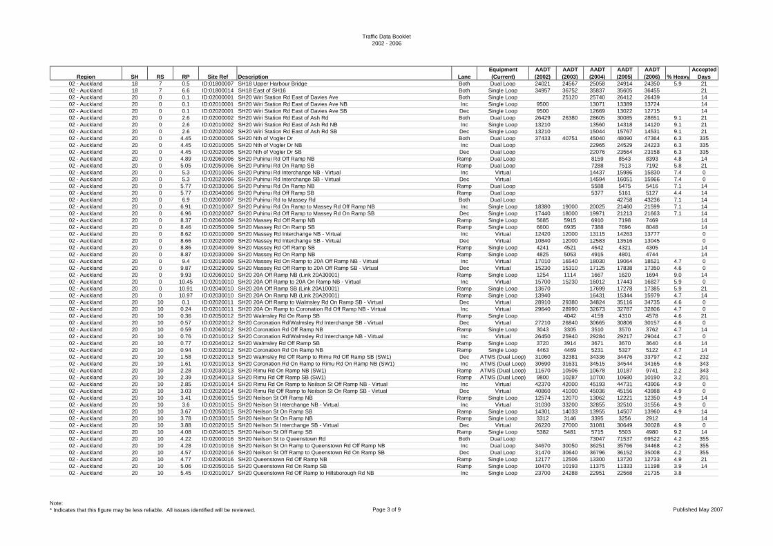
02 - Auckland 18 7 0.5 ID:01800007 SH18 Upper Harbour Bridge Both Dual Loop 24021 24567 25058 24914 24350 5.9 2102 - Auckland 18 7 6.6 ID:01800014 SH18 East of SH16 Both Single Loop 34957 36752 35837 35605 36455 2102 - Auckland 20 0 0.1 ID:02000001 SH20 Wiri Station Rd East of Davies Ave Both Single Loop 25120 25740 26412 26439 1402 - Auckland 20 0 0.1 ID:02010001 SH20 Wiri Station Rd East of Davies Ave NB Inc Single Loop 9500 13071 13389 13724 1402 - Auckland 20 0 0.1 ID:02020001 SH20 Wiri Station Rd East of Davies Ave SB Dec Single Loop 9500 12669 13022 12715 1402 - Auckland 20 0 2.6 ID:02000002 SH20 Wiri Station Rd East of Ash Rd Both Dual Loop 26429 26380 28605 30085 28651 9.1 2102 - Auckland 20 0 2.6 ID:02010002 SH20 Wiri Station Rd East of Ash Rd NB Inc Single Loop 13210 13560 14318 14120 9.1 2102 - Auckland 20 0 2.6 ID:02020002 SH20 Wiri Station Rd East of Ash Rd SB Dec Single Loop 13210 15044 15767 14531 9.1 2102 - Auckland 20 0 4.45 ID:02000005 SH20 Nth of Vogler Dr Both Dual Loop 37433 40751 45040 48090 47364 6.3 33502 - Auckland 20 0 4.45 ID:02010005 SH20 Nth of Vogler Dr NB Inc Dual Loop 22965 24529 24223 6.3 33502 - Auckland 20 0 4.45 ID:02020005 SH20 Nth of Vogler Dr SB Dec Dual Loop 22076 23564 23158 6.3 33502 - Auckland 20 0 4.89 ID:02060006 SH20 Puhinui Rd Off Ramp NB Ramp Dual Loop 8159 8543 8393 4.8 1402 - Auckland 20 0 5.05 ID:02050006 SH20 Puhinui Rd On Ramp SB Ramp Dual Loop 7288 7513 7192 5.8 2102 - Auckland 20 0 5.3 ID:02010006 SH20 Puhinui Rd Interchange NB - Virtual Inc Virtual 14437 15986 15830 7.4 002 - Auckland 20 0 5.3 ID:02020006 SH20 Puhinui Rd Interchange SB - Virtual Dec Virtual 14594 16051 15966 7.4 002 - Auckland 20 0 5.77 ID:02030006 SH20 Puhinui Rd On Ramp NB Ramp Dual Loop 5588 5475 5416 7.1 1402 - Auckland 20 0 5.77 ID:02040006 SH20 Puhinui Rd Off Ramp SB Ramp Dual Loop 5377 5161 5127 4.4 1402 - Auckland 20 0 6.9 ID:02000007 SH20 Puhinui Rd to Massey Rd Both Dual Loop 42758 43236 7.1 1402 - Auckland 20 0 6.91 ID:02010007 SH20 Puhinui Rd On Ramp to Massey Rd Off Ramp NB Inc Single Loop 18380 19000 20025 21460 21599 7.1 1402 - Auckland 20 0 6.96 ID:02020007 SH20 Puhinui Rd Off Ramp to Massey Rd On Ramp SB Dec Single Loop 17440 18000 19971 21213 21663 7.1 1402 - Auckland 20 0 8.37 ID:02060009 SH20 Massey Rd Off Ramp NB Ramp Single Loop 5685 5915 6910 7198 7469 1402 - Auckland 20 0 8.46 ID:02050009 SH20 Massey Rd On Ramp SB Ramp Single Loop 6600 6935 7388 7696 8048 1402 - Auckland 20 0 8.62 ID:02010009 SH20 Massey Rd Interchange NB - Virtual Inc Virtual 12420 12000 13115 14263 13777 002 - Auckland 20 0 8.66 ID:02020009 SH20 Massey Rd Interchange SB - Virtual Dec Virtual 10840 12000 12583 13516 13045 002 - Auckland 20 0 8.86 ID:02040009 SH20 Massey Rd Off Ramp SB Ramp Single Loop 4241 4521 4542 4321 4305 1402 - Auckland 20 0 8.87 ID:02030009 SH20 Massey Rd On Ramp NB Ramp Single Loop 4825 5053 4915 4801 4744 1402 - Auckland 20 0 9.4 ID:02019009 SH20 Massey Rd On Ramp to 20A Off Ramp NB - Virtual Inc Virtual 17010 16540 18030 19064 18521 4.7 002 - Auckland 20 0 9.87 ID:02029009 SH20 Massey Rd Off Ramp to 20A Off Ramp SB - Virtual Dec Virtual 15230 15310 17125 17838 17350 4.6 002 - Auckland 20 0 9.93 ID:02060010 SH20 20A Off Ramp NB (Link 20A30001) Ramp Single Loop 1254 1114 1667 1620 1694 9.0 1402 - Auckland 20 0 10.45 ID:02010010 SH20 20A Off Ramp to 20A On Ramp NB - Virtual Inc Virtual 15700 15230 16012 17443 16827 5.9 002 - Auckland 20 0 10.91 ID:02040010 SH20 20A Off Ramp SB (Link 20A10001) Ramp Single Loop 13670 17699 17278 17385 5.9 2102 - Auckland 20 0 10.97 ID:02030010 SH20 20A On Ramp NB (Link 20A20001) Ramp Single Loop 13940 16431 15344 15979 4.7 1402 - Auckland 20 10 0.1 ID:02020011 SH20 20A Off Ramp to Walmsley Rd On Ramp SB - Virtual Dec Virtual 28910 29380 34824 35116 34735 4.6 002 - Auckland 20 10 0.24 ID:02010011 SH20 20A On Ramp to Coronation Rd Off Ramp NB - Virtual Inc Virtual 29640 28990 32673 32787 32806 4.7 002 - Auckland 20 10 0.36 ID:02050012 SH20 Walmsley Rd On Ramp SB Ramp Single Loop 4042 4159 4310 4578 4.6 2102 - Auckland 20 10 0.57 ID:02020012 SH20 Coronation Rd/Walmsley Rd Interchange SB - Virtual Dec Virtual 27210 26840 30665 30806 30157 4.6 002 - Auckland 20 10 0.59 ID:02060012 SH20 Coronation Rd Off Ramp NB Ramp Single Loop 3043 3305 3510 3570 3762 4.7 1402 - Auckland 20 10 0.76 ID:02010012 SH20 Coronation Rd/Walmsley Rd Interchange NB - Virtual Inc Virtual 26450 25940 29284 29217 29044 4.7 002 - Auckland 20 10 0.77 ID:02040012 SH20 Walmsley Rd Off Ramp SB Ramp Single Loop 3720 3914 3671 3670 3640 4.6 1402 - Auckland 20 10 0.94 ID:02030012 SH20 Coronation Rd On Ramp NB Ramp Single Loop 4463 4469 5231 5327 5122 4.7 1402 - Auckland 20 10 1.58 ID:02020013 SH20 Walmsley Rd Off Ramp to Rimu Rd Off Ramp SB (SW1) Dec ATMS (Dual Loop) 31060 32381 34336 34476 33797 4.2 23202 - Auckland 20 10 1.61 ID:02010013 SH20 Coronation Rd On Ramp to Rimu Rd On Ramp NB (SW1) Inc ATMS (Dual Loop) 30690 31631 34515 34544 34165 4.6 34302 - Auckland 20 10 2.28 ID:02030013 SH20 Rimu Rd On Ramp NB (SW1) Ramp ATMS (Dual Loop) 11670 10506 10678 10187 9741 2.2 34302 - Auckland 20 10 2.39 ID:02040013 SH20 Rimu Rd Off Ramp SB (SW1) Ramp ATMS (Dual Loop) 9800 10287 10700 10680 10190 3.2 20102 - Auckland 20 10 2.85 ID:02010014 SH20 Rimu Rd On Ramp to Neilson St Off Ramp NB - Virtual Inc Virtual 42370 42000 45193 44731 43906 4.9 002 - Auckland 20 10 3.03 ID:02020014 SH20 Rimu Rd Off Ramp to Neilson St On Ramp SB - Virtual Dec Virtual 40860 41000 45036 45156 43988 4.9 002 - Auckland 20 10 3.41 ID:02060015 SH20 Neilson St Off Ramp NB Ramp Single Loop 12574 12070 13062 12221 12350 4.9 1402 - Auckland 20 10 3.6 ID:02010015 SH20 Neilson St Interchange NB - Virtual Inc Virtual 31030 33200 32855 32510 31556 4.9 002 - Auckland 20 10 3.67 ID:02050015 SH20 Neilson St On Ramp SB Ramp Single Loop 14301 14033 13955 14507 13960 4.9 1402 - Auckland 20 10 3.78 ID:02030015 SH20 Neilson St On Ramp NB Ramp Single Loop 3312 3146 3395 3256 2912 1402 - Auckland 20 10 3.88 ID:02020015 SH20 Neilson St Interchange SB - Virtual Dec Virtual 26220 27000 31081 30649 30028 4.9 002 - Auckland 20 10 4.08 ID:02040015 SH20 Neilson St Off Ramp SB Ramp Single Loop 5382 5481 5715 5503 4980 9.2 1402 - Auckland 20 10 4.22 ID:02000016 SH20 Neilson St to Queenstown Rd Both Dual Loop 73047 71537 69522 4.2 35502 - Auckland 20 10 4.28 ID:02010016 SH20 Neilson St On Ramp to Queenstown Rd Off Ramp NB Inc Dual Loop 34670 30050 36251 35766 34468 4.2 35502 - Auckland 20 10 4.57 ID:02020016 SH20 Neilson St Off Ramp to Queenstown Rd On Ramp SB Dec Dual Loop 31470 30640 36796 36152 35008 4.2 35502 - Auckland 20 10 4.77 ID:02060016 SH20 Queenstown Rd Off Ramp NB Ramp Single Loop 12177 12506 13300 13720 12733 4.9 2102 - Auckland 20 10 5.06 ID:02050016 SH20 Queenstown Rd On Ramp SB Ramp Single Loop 10470 10193 11375 11333 11198 3.9 1402 - Auckland 20 10 5.45 ID:02010017 SH20 Queenstown Rd Off Ramp to Hillsborough Rd NB Inc Single Loop 23700 24288 22951 22568 21735 3.8
Note:* Indicates that this figure may be less reliable. All issues identified will be reviewed. Page 3 of 9 Published May 2007
Traffic Data Booklet2002 - 2006
Region SH RS RP Site Ref Description LaneEquipment (Current)
AADT (2002)
AADT (2003)
AADT (2004)
AADT (2005)
AADT (2006) % Heavy
Accepted Days
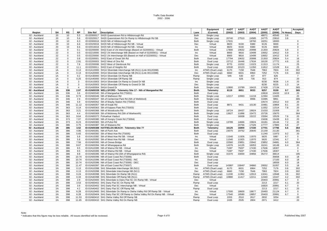
02 - Auckland 20 10 5.5 ID:02000017 SH20 Queenstown Rd to Hillsborough Rd Both Single Loop 48071 45545 3.802 - Auckland 20 10 5.6 ID:02020017 SH20 Queenstown Rd On Ramp to Hillsborough Rd SB Dec Single Loop 20740 27510 24585 24775 23810 3.802 - Auckland 20 10 6.3 ID:02000018 SH20 Nth of Hillsborough Rd Both Single Loop 17631 18760 18251 18000 002 - Auckland 20 10 6.6 ID:02020018 SH20 Nth of Hillsborough Rd SB - Virtual Dec Virtual 8820 9100 9380 9126 9000 002 - Auckland 20 10 6.6 ID:02010018 SH20 Nth of Hillsborough Rd NB - Virtual Inc Virtual 8820 9100 9380 9126 9000 002 - Auckland 22 0 0.1 ID:02200000 SH22 East of 1N Interchange (Based on 02200001) - Virtual Both Virtual 17800 19632 20998 21303 20824 5.9 002 - Auckland 22 0 0.5 ID:02210000 SH22 1N Interchange WB (Based on Half of 02200001) - Virtual Inc Virtual 8900 9816 10499 10652 10412 5.9 002 - Auckland 22 0 0.5 ID:02220000 SH22 1N Interchange EB (Based on Half of 02200001) - Virtual Dec Virtual 8900 9816 10499 10652 10412 5.9 002 - Auckland 22 0 0.8 ID:02200001 SH22 East of Great Sth Rd Both Dual Loop 17794 19632 20998 21303 20824 5.4 1602 - Auckland 22 0 2.91 ID:02200003 SH22 West of Oira Rd Both Dual Loop 15712 16446 17634 18130 17772 4.6 1502 - Auckland 22 0 7.8 ID:02200008 SH22 West of Glenbrook Rd Both Single Loop 9770 10202 11023 11313 11174 2502 - Auckland 22 0 11.1 ID:02200011 SH22 East of Heights Rd Both Dual Loop 10530 10123 11350 11812 11528 8.4 2502 - Auckland 1A 0 0.13 ID:01A10000 SH1A Silverdale Interchange NB (N11) (Link 00120398) Inc ATMS (Dual Loop) 6170 7158 7646 7963 7824 0.9 30202 - Auckland 1A 0 0.13 ID:01A20000 SH1A Silverdale Interchange SB (N11) (Link 00110398) Dec ATMS (Dual Loop) 6660 6631 6964 7252 7176 0.6 30202 - Auckland 1A 0 0.2 ID:01A30000 SH1A Silverdale On Ramp NB Ramp Single Loop 545 530 437 877 626 702 - Auckland 1A 0 0.25 ID:01A40000 SH1A Silverdale Off Ramp SB Ramp Single Loop 626 735 913 874 2002 - Auckland 1A 0 3 ID:01A10003 SH1A Silverdale On Ramp to Grand Dr NB Inc Single Loop 9230 9036 1.4 2002 - Auckland 1A 0 3 ID:01A20003 SH1A Silverdale Off Ramp to Grand Dr SB Dec Single Loop 8230 8225 1.3 1402 - Auckland 1A 0 4 ID:01A00004 SH1A Grand Dr Both Single Loop 12800 13789 16415 17428 17134 36502 - Auckland 1N 336 2.97 ID:01N00339 WELLSFORD - Telemetry Site 17 - Nth of Mangawhai Rd Both Telemetry 8119 8651 9033 9257 9159 9.7 36502 - Auckland 1N 336 3.6 ID:01N00340 Sth of Mangawhai Rd (TS001) Both Dual Loop 10818 10433 10.9 2002 - Auckland 1N 336 9.74 ID:01N00346 Nth of Matheson Rd Both Single Loop 12217 10993 11219 12394 11605 2002 - Auckland 1N 346 2.9 ID:01N00347 Sth of Centennial Park Rd (Sth of Wellsford) Both Single Loop 9996 10485 9851 36502 - Auckland 1N 346 5.9 ID:01N00352 Sth of Wayby Station Rd (TS002) Both Dual Loop 10574 10412 9.0 2002 - Auckland 1N 346 11.12 ID:01N00357 Nth of Kraak Rd Both Dual Loop 8871 9431 10130 10481 10864 8.1 2002 - Auckland 1N 363 0.14 ID:01N00363 Sth of Kaipara Flats Rd (TS003) Both Dual Loop 11552 11514 7.8 2002 - Auckland 1N 363 3.21 ID:01N00366 Nth of Woodcocks Rd Both Single Loop 18724 18437 19924 21033 21009 2002 - Auckland 1N 363 4.4 ID:01N00369 Sth of Mckinney Rd (Sth of Warkworth) Both Single Loop 13627 11896 15472 15726 15670 36402 - Auckland 1N 363 9.64 ID:01N00372 Pohuehue Viaduct Both Dual Loop 16938 15222 15594 15529 7.6 2002 - Auckland 1N 373 7.07 ID:01N00380 Nth of Hungry Creek Rd (TS004) Both Dual Loop 15636 15439 8.3 2002 - Auckland 1N 373 8.23 ID:01N00383 Sth of Puhoi Rd Both Single Loop 13789 14666 15824 16181 16144 7.2 2002 - Auckland 1N 386 0.75 ID:01N00387 Sth of Waiwera Rd Both Single Loop 20766 17326 17777 17883 5.8 2702 - Auckland 1N 386 3.52 ID:01N00388 HATFIELDS BEACH - Telemetry Site 77 Both Telemetry 16125 16800 17330 17701 17796 6.6 36402 - Auckland 1N 386 4.86 ID:01N00391 Nth of Puriri Ave Both Dual Loop 23070 19752 20640 21159 21130 36102 - Auckland 1N 386 5.65 ID:01N00392 Sth of West Hoe Rd (TS005) Both Dual Loop 11240 11973 9.2 2002 - Auckland 1N 386 5.8 ID:01N10392 Sth of West Hoe Rd SB - Virtual Inc Virtual 11540 11926 11970 5620 5987 6.7 002 - Auckland 1N 386 5.8 ID:01N20392 Sth of West Hoe Rd NB - Virtual Dec Virtual 11540 11925 11970 5620 12341 6.7 002 - Auckland 1N 386 7.56 ID:01N00393 Nth of Orewa Bridge Both Dual Loop 22560 23851 23942 23852 24681 6.0 36402 - Auckland 1N 386 8.67 ID:01N00394 Nth of Whangaparoa Rd Both Single Loop 14376 14135 16053 16241 16148 6.4 2002 - Auckland 1N 386 9.5 ID:01N10395 Nth of Wainui Rd SB - Virtual Inc Virtual 7190* 7920* 17430 17636 18307 002 - Auckland 1N 386 9.5 ID:01N20395 Nth of Wainui Rd NB - Virtual Dec Virtual 7190* 7920* 17430 17636 18307 002 - Auckland 1N 386 9.8 ID:01N00395 Nth of Wainui Rd (Sth of Whangaparoa Rd) Both Single Loop 31070 33000 34856 35272 36614 18502 - Auckland 1N 386 10.74 ID:01N00396 Nth of East Coast Rd (TS006) Both Dual Loop 35658 6.0 1802 - Auckland 1N 386 10.74 ID:01N10396 Nth of East Coast Rd (TS006) - INC Inc Dual Loop 17100 6.0 1802 - Auckland 1N 386 10.74 ID:01N20396 Nth of East Coast Rd (TS006) - DEC Dec Dual Loop 18559 6.0 1802 - Auckland 1N 386 11.47 ID:01N00397 Sth of East Coast Rd (TS007) Both Dual Loop 14380* 15840* 34860 29552 31057 5.5 1802 - Auckland 1N 398 0.13 ID:01N10398 SH1 Silverdale Interchange SB (N11) Inc ATMS (Dual Loop) 6170 6631 6964 7252 7176 0.6 30202 - Auckland 1N 398 0.13 ID:01N20398 SH1 Silverdale Interchange NB (N11) Dec ATMS (Dual Loop) 6660 7158 7646 7963 7824 0.9 30202 - Auckland 1N 398 0.24 ID:01N30398 SH1 Silverdale On Ramp SB (N11) Ramp ATMS (Dual Loop) 11330 11962 12913 13241 13948 3.6 30202 - Auckland 1N 398 0.33 ID:01N40398 SH1 Silverdale Off Ramp NB (N11) Ramp ATMS (Dual Loop) 10880 11417 12211 12440 13167 4.2 30202 - Auckland 1N 398 2.9 ID:01N20400 SH1 Silverdale to Dairy Flat SC On Ramp NB - Virtual Dec Virtual 20403 20991 6.7 002 - Auckland 1N 398 3.53 ID:01N50402 SH1 Dairy Flat SC On Ramp NB Ramp Dual Loop 2213 2217 6.1 2002 - Auckland 1N 398 3.9 ID:01N20402 SH1 Dairy Flat SC Interchange NB - Virtual Dec Virtual 16820 20991 6.7 002 - Auckland 1N 398 4.2 ID:01N40402 SH1 Dairy Flat SC Off Ramp NB Ramp Dual Loop 2213 2217 6.1 2002 - Auckland 1N 398 6.28 ID:01N10400 SH1 Silverdale On Ramp to Oteha Valley Rd Off Ramp SB - Virtual Inc Virtual 17500 18600 19877 20493 21124 6.7 002 - Auckland 1N 398 6.28 ID:01N20404 SH1 Dairy Flat SC Off Ramp to Oteha Valley Rd On Ramp NB - Virtual Dec Virtual 17540 18580 19857 20403 20991 6.7 002 - Auckland 1N 398 11.53 ID:01N60410 SH1 Oteha Valley Rd Off Ramp SB Ramp Dual Loop 2203 2510 2617 2832 3254 2002 - Auckland 1N 398 11.65 ID:01N50410 SH1 Oteha Valley Rd On Ramp NB Ramp Dual Loop 2435 2535 2804 2971 3412 20
Note:* Indicates that this figure may be less reliable. All issues identified will be reviewed. Page 4 of 9 Published May 2007
Traffic Data Booklet2002 - 2006
Region SH RS RP Site Ref Description LaneEquipment (Current)
AADT (2002)
AADT (2003)
AADT (2004)
AADT (2005)
AADT (2006) % Heavy
Accepted Days
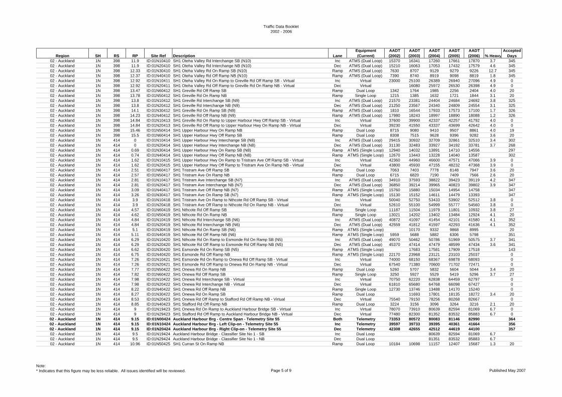
02 - Auckland 1N 398 11.9 ID:01N10410 SH1 Oteha Valley Rd Interchange SB (N10) Inc ATMS (Dual Loop) 15370 16341 17260 17661 17870 3.7 34502 - Auckland 1N 398 11.9 ID:01N20410 SH1 Oteha Valley Rd Interchange NB (N10) Dec ATMS (Dual Loop) 15210 16063 17053 17432 17579 4.6 34502 - Auckland 1N 398 12.33 ID:01N30410 SH1 Oteha Valley Rd On Ramp SB (N10) Ramp ATMS (Dual Loop) 7630 8707 9129 9279 9226 12.7 34502 - Auckland 1N 398 12.37 ID:01N40410 SH1 Oteha Valley Rd Off Ramp NB (N10) Ramp ATMS (Dual Loop) 7390 8740 8919 9098 8819 1.8 34502 - Auckland 1N 398 12.92 ID:01N10411 SH1 Oteha Valley Rd On Ramp to Greville Rd Off Ramp SB - Virtual Inc Virtual 23000 25100 26389 26940 27096 4.9 002 - Auckland 1N 398 12.92 ID:01N20411 SH1 Oteha Valley Rd Off Ramp to Greville Rd On Ramp NB - Virtual Dec Virtual 16080 25972 26530 26398 4.9 002 - Auckland 1N 398 13.47 ID:01N60412 SH1 Greville Rd Off Ramp SB Ramp Dual Loop 1342 1764 1985 2256 2404 4.0 2002 - Auckland 1N 398 13.78 ID:01N50412 SH1 Greville Rd On Ramp NB Ramp Single Loop 1215 1385 1632 1721 1844 3.1 2002 - Auckland 1N 398 13.8 ID:01N10412 SH1 Greville Rd Interchange SB (N9) Inc ATMS (Dual Loop) 21570 23381 24404 24684 24692 3.8 32502 - Auckland 1N 398 13.8 ID:01N20412 SH1 Greville Rd Interchange NB (N9) Dec ATMS (Dual Loop) 21250 23567 24340 24809 24554 3.1 32502 - Auckland 1N 398 14.1 ID:01N30412 SH1 Greville Rd On Ramp SB (N9) Ramp ATMS (Dual Loop) 1810 16544 17933 17573 17100 1.7 32602 - Auckland 1N 398 14.23 ID:01N40412 SH1 Greville Rd Off Ramp NB (N9) Ramp ATMS (Dual Loop) 17980 18243 18997 18890 18088 1.2 32602 - Auckland 1N 398 14.84 ID:01N10413 SH1 Greville Rd On Ramp to Upper Harbour Hwy Off Ramp SB - Virtual Inc Virtual 37600 39900 42337 42257 41792 4.0 002 - Auckland 1N 398 14.84 ID:01N20413 SH1 Greville Rd Off Ramp to Upper Harbour Hwy On Ramp NB - Virtual Dec Virtual 39230 41550 43337 43699 42642 4.0 002 - Auckland 1N 398 15.46 ID:01N50414 SH1 Upper Harbour Hwy On Ramp NB Ramp Dual Loop 8715 9080 9410 9507 8861 4.0 1902 - Auckland 1N 398 15.5 ID:01N60414 SH1 Upper Harbour Hwy Off Ramp SB Ramp Dual Loop 8308 7515 9628 9396 9282 3.6 2002 - Auckland 1N 414 0 ID:01N10414 SH1 Upper Harbour Hwy Interchange SB (N8) Inc ATMS (Dual Loop) 29415 30932 32709 32861 32510 3.4 30202 - Auckland 1N 414 0 ID:01N20414 SH1 Upper Harbour Hwy Interchange NB (N8) Dec ATMS (Dual Loop) 31130 32483 33927 34192 33781 3.7 26802 - Auckland 1N 414 0.69 ID:01N30414 SH1 Upper Harbour Hwy On Ramp SB (N8) Ramp ATMS (Single Loop) 12940 14032 13891 14710 14556 29702 - Auckland 1N 414 0.74 ID:01N40414 SH1 Upper Harbour Hwy Off Ramp NB (N8) Ramp ATMS (Single Loop) 12670 13443 13228 14040 13587 30202 - Auckland 1N 414 1.62 ID:01N10415 SH1 Upper Harbour Hwy On Ramp to Tristram Ave Off Ramp SB - Virtual Inc Virtual 42360 44960 46600 47571 47066 3.9 002 - Auckland 1N 414 1.62 ID:01N20415 SH1 Upper Harbour Hwy Off Ramp to Tristram Ave On Ramp NB - Virtual Dec Virtual 43800 45930 47155 48232 47368 3.9 002 - Auckland 1N 414 2.51 ID:01N60417 SH1 Tristram Ave Off Ramp SB Ramp Dual Loop 7063 7403 7778 8148 7947 3.6 2002 - Auckland 1N 414 2.57 ID:01N50417 SH1 Tristram Ave On Ramp NB Ramp Dual Loop 6715 6820 7190 7409 7566 2.6 2002 - Auckland 1N 414 2.81 ID:01N10417 SH1 Tristram Ave Interchange SB (N7) Inc ATMS (Dual Loop) 34910 37593 38822 39423 39119 4.2 34702 - Auckland 1N 414 2.81 ID:01N20417 SH1 Tristram Ave Interchange NB (N7) Dec ATMS (Dual Loop) 36850 39214 39965 40823 39802 3.9 34702 - Auckland 1N 414 3.09 ID:01N40417 SH1 Tristram Ave Off Ramp NB (N7) Ramp ATMS (Single Loop) 15760 15880 15034 14954 14758 34702 - Auckland 1N 414 3.26 ID:01N30417 SH1 Tristram Ave On Ramp SB (N7) Ramp ATMS (Single Loop) 15130 15152 14611 14479 13393 34702 - Auckland 1N 414 3.9 ID:01N10418 SH1 Tristram Ave On Ramp to Nthcote Rd Off Ramp SB - Virtual Inc Virtual 50040 52750 53433 53902 52512 3.8 002 - Auckland 1N 414 3.9 ID:01N20418 SH1 Tristram Ave Off Ramp to Nthcote Rd On Ramp NB - Virtual Dec Virtual 52610 55100 54999 55777 54560 3.8 002 - Auckland 1N 414 4.57 ID:01N60419 SH1 Nthcote Rd Off Ramp SB Ramp Single Loop 11187 11504 11979 11801 10932 3.8 2702 - Auckland 1N 414 4.62 ID:01N50419 SH1 Nthcote Rd On Ramp NB Ramp Single Loop 13021 14202 13402 13484 12924 4.1 2002 - Auckland 1N 414 4.84 ID:01N10419 SH1 Nthcote Rd Interchange SB (N6) Inc ATMS (Dual Loop) 40872 41097 41454 42101 41580 4.1 35202 - Auckland 1N 414 4.84 ID:01N20419 SH1 Nthcote Rd Interchange NB (N6) Dec ATMS (Dual Loop) 42559 41812 41597 42293 41636 4.1 35202 - Auckland 1N 414 5.1 ID:01N30419 SH1 Nthcote Rd On Ramp SB (N6) Ramp ATMS (Single Loop) 10170 9332 9868 8995 2002 - Auckland 1N 414 5.11 ID:01N40419 SH1 Nthcote Rd Off Ramp NB (N6) Ramp ATMS (Single Loop) 5959 5688 5882 6306 5798 35102 - Auckland 1N 414 6.29 ID:01N10420 SH1 Nthcote Rd On Ramp to Esmonde Rd On Ramp SB (N5) Inc ATMS (Dual Loop) 49070 50462 50786 51969 50575 3.7 34102 - Auckland 1N 414 6.29 ID:01N20420 SH1 Nthcote Rd Off Ramp to Esmonde Rd Off Ramp NB (N5) Dec ATMS (Dual Loop) 45370 47414 47479 48599 47434 3.6 34102 - Auckland 1N 414 6.62 ID:01N30420 SH1 Esmonde Rd On Ramp SB (N5) Ramp ATMS (Single Loop) 17683 17581 17909 17518 14302 - Auckland 1N 414 6.75 ID:01N40420 SH1 Esmonde Rd Off Ramp NB Ramp ATMS (Single Loop) 22170 23968 23121 23103 25037 002 - Auckland 1N 414 7.26 ID:01N10421 SH1 Esmonde Rd On Ramp to Onewa Rd Off Ramp SB - Virtual Inc Virtual 74000 68150 68367 69878 68093 002 - Auckland 1N 414 7.26 ID:01N20421 SH1 Esmonde Rd Off Ramp to Onewa Rd On Ramp NB - Virtual Dec Virtual 67540 71380 70600 71702 72471 002 - Auckland 1N 414 7.77 ID:01N50422 SH1 Onewa Rd On Ramp NB Ramp Dual Loop 5260 5707 5832 5604 5044 3.4 2002 - Auckland 1N 414 7.82 ID:01N60422 SH1 Onewa Rd Off Ramp SB Ramp Single Loop 3250 5927 5529 5419 5296 3.7 2702 - Auckland 1N 414 7.98 ID:01N10422 SH1 Onewa Rd Interchange SB - Virtual Inc Virtual 70750 62220 62838 64459 62797 002 - Auckland 1N 414 7.98 ID:01N20422 SH1 Onewa Rd Interchange NB - Virtual Dec Virtual 61810 65680 64768 66098 67427 002 - Auckland 1N 414 8.22 ID:01N40422 SH1 Onewa Rd Off Ramp NB Ramp Single Loop 12730 13746 13488 14170 15240 002 - Auckland 1N 414 8.27 ID:01N30422 SH1 Onewa Rd On Ramp SB Ramp Dual Loop 11693 17801 18135 18272 3.4 2002 - Auckland 1N 414 8.53 ID:01N20423 SH1 Onewa Rd Off Ramp to Stafford Rd Off Ramp NB - Virtual Dec Virtual 75540 79150 78256 80268 82667 002 - Auckland 1N 414 8.85 ID:01N40423 SH1 Stafford Rd Off Ramp NB Ramp Dual Loop 3224 3156 3096 3264 3216 2.1 2002 - Auckland 1N 414 9 ID:01N19423 SH1 Onewa Rd On Ramp to Auckland Harbour Bridge SB - Virtual Inc Virtual 78070 73910 80639 82594 81069 6.7 002 - Auckland 1N 414 9 ID:01N29423 SH1 Stafford Rd Off Ramp to Auckland Harbour Bridge NB - Virtual Dec Virtual 77480 82300 81352 83532 85883 6.7 002 - Auckland 1N 414 9.15 ID:01N00424 Auckland Harbour Brg - Centre Span - Telemetry Site 55 Both Telemetry 73353 80572 80083 81146 82990 36402 - Auckland 1N 414 9.15 ID:01N10424 Auckland Harbour Brg - Left Clip-on - Telemetry Site 55 Inc Telemetry 39597 39733 39395 40361 41664 35602 - Auckland 1N 414 9.15 ID:01N20424 Auckland Harbour Brg - Right Clip-on - Telemetry Site 55 Dec Telemetry 42308 42655 42512 44619 44100 35702 - Auckland 1N 414 9.5 ID:01N19424 Auckland Harbour Bridge - Classifier Site No 1 - SB Inc Dual Loop 80639 82594 81069 6.702 - Auckland 1N 414 9.5 ID:01N29424 Auckland Harbour Bridge - Classifier Site No 1 - NB Dec Dual Loop 81351 83532 85883 6.702 - Auckland 1N 414 10.96 ID:01N50425 SH1 Curran St On Ramp NB Ramp Dual Loop 10184 10698 11157 12407 15687 1.3 20
Note:* Indicates that this figure may be less reliable. All issues identified will be reviewed. Page 5 of 9 Published May 2007
Traffic Data Booklet2002 - 2006
Region SH RS RP Site Ref Description LaneEquipment (Current)
AADT (2002)
AADT (2003)
AADT (2004)
AADT (2005)
AADT (2006) % Heavy
Accepted Days
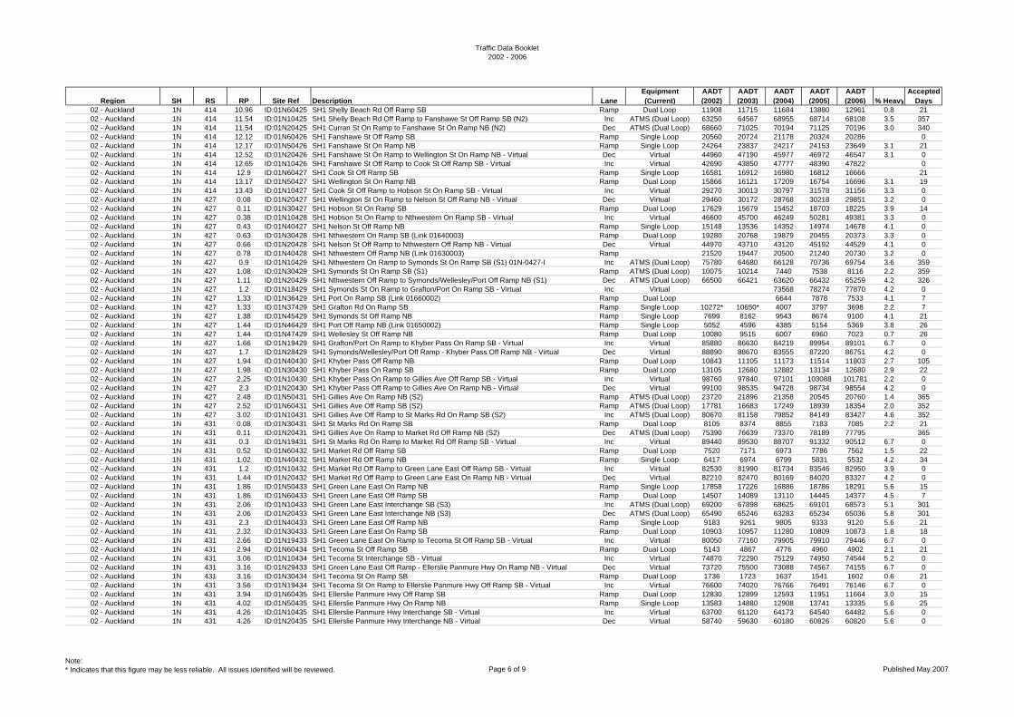
02 - Auckland 1N 414 10.96 ID:01N60425 SH1 Shelly Beach Rd Off Ramp SB Ramp Dual Loop 11908 11715 11684 13880 12961 0.8 2102 - Auckland 1N 414 11.54 ID:01N10425 SH1 Shelly Beach Rd Off Ramp to Fanshawe St Off Ramp SB (N2) Inc ATMS (Dual Loop) 63250 64567 68955 68714 68108 3.5 35702 - Auckland 1N 414 11.54 ID:01N20425 SH1 Curran St On Ramp to Fanshawe St On Ramp NB (N2) Dec ATMS (Dual Loop) 68660 71025 70194 71125 70196 3.0 34002 - Auckland 1N 414 12.12 ID:01N60426 SH1 Fanshawe St Off Ramp SB Ramp Single Loop 20560 20724 21178 20324 20286 002 - Auckland 1N 414 12.17 ID:01N50426 SH1 Fanshawe St On Ramp NB Ramp Single Loop 24264 23837 24217 24153 23649 3.1 2102 - Auckland 1N 414 12.52 ID:01N20426 SH1 Fanshawe St On Ramp to Wellington St On Ramp NB - Virtual Dec Virtual 44960 47190 45977 46972 46547 3.1 002 - Auckland 1N 414 12.65 ID:01N10426 SH1 Fanshawe St Off Ramp to Cook St Off Ramp SB - Virtual Inc Virtual 42690 43850 47777 48390 47822 002 - Auckland 1N 414 12.9 ID:01N60427 SH1 Cook St Off Ramp SB Ramp Single Loop 16581 16912 16980 16812 16666 2102 - Auckland 1N 414 13.17 ID:01N50427 SH1 Wellington St On Ramp NB Ramp Dual Loop 15866 16121 17209 16754 16696 3.1 1902 - Auckland 1N 414 13.43 ID:01N10427 SH1 Cook St Off Ramp to Hobson St On Ramp SB - Virtual Inc Virtual 29270 30013 30797 31578 31156 3.3 002 - Auckland 1N 427 0.08 ID:01N20427 SH1 Wellington St On Ramp to Nelson St Off Ramp NB - Virtual Dec Virtual 29460 30172 28768 30218 29851 3.2 002 - Auckland 1N 427 0.11 ID:01N30427 SH1 Hobson St On Ramp SB Ramp Dual Loop 17629 15679 15452 18703 18225 3.9 1402 - Auckland 1N 427 0.38 ID:01N10428 SH1 Hobson St On Ramp to Nthwestern On Ramp SB - Virtual Inc Virtual 46600 45700 46249 50281 49381 3.3 002 - Auckland 1N 427 0.43 ID:01N40427 SH1 Nelson St Off Ramp NB Ramp Single Loop 15148 13536 14352 14974 14678 4.1 002 - Auckland 1N 427 0.63 ID:01N30428 SH1 Nthwestern On Ramp SB (Link 01640003) Ramp Dual Loop 19280 20768 19879 20455 20373 3.3 002 - Auckland 1N 427 0.66 ID:01N20428 SH1 Nelson St Off Ramp to Nthwestern Off Ramp NB - Virtual Dec Virtual 44970 43710 43120 45192 44529 4.1 002 - Auckland 1N 427 0.78 ID:01N40428 SH1 Nthwestern Off Ramp NB (Link 01630003) Ramp 21520 19447 20500 21240 20730 3.2 002 - Auckland 1N 427 0.9 ID:01N10429 SH1 Nthwestern On Ramp to Symonds St On Ramp SB (S1) 01N-0427-I Inc ATMS (Dual Loop) 75780 64680 66128 70736 69754 3.6 35902 - Auckland 1N 427 1.08 ID:01N30429 SH1 Symonds St On Ramp SB (S1) Ramp ATMS (Dual Loop) 10075 10214 7440 7538 8116 2.2 35902 - Auckland 1N 427 1.11 ID:01N20429 SH1 Nthwestern Off Ramp to Symonds/Wellesley/Port Off Ramp NB (S1) Dec ATMS (Dual Loop) 66500 66421 63620 66432 65259 4.2 32602 - Auckland 1N 427 1.2 ID:01N18429 SH1 Symonds St On Ramp to Grafton/Port On Ramp SB - Virtual Inc Virtual 73568 78274 77870 4.2 002 - Auckland 1N 427 1.33 ID:01N36429 SH1 Port On Ramp SB (Link 01660002) Ramp Dual Loop 6644 7878 7533 4.1 702 - Auckland 1N 427 1.33 ID:01N37429 SH1 Grafton Rd On Ramp SB Ramp Single Loop 10272* 10650* 4007 3797 3698 2.2 702 - Auckland 1N 427 1.38 ID:01N45429 SH1 Symonds St Off Ramp NB Ramp Single Loop 7699 8162 9543 8674 9100 4.1 2102 - Auckland 1N 427 1.44 ID:01N46429 SH1 Port Off Ramp NB (Link 01650002) Ramp Single Loop 5052 4596 4385 5154 5369 3.8 2602 - Auckland 1N 427 1.44 ID:01N47429 SH1 Wellesley St Off Ramp NB Ramp Dual Loop 10080 9515 6007 6960 7023 0.7 2602 - Auckland 1N 427 1.66 ID:01N19429 SH1 Grafton/Port On Ramp to Khyber Pass On Ramp SB - Virtual Inc Virtual 85880 86630 84219 89954 89101 6.7 002 - Auckland 1N 427 1.7 ID:01N28429 SH1 Symonds/Wellesley/Port Off Ramp - Khyber Pass Off Ramp NB - Virtual Dec Virtual 88890 88670 83555 87220 86751 4.2 002 - Auckland 1N 427 1.94 ID:01N40430 SH1 Khyber Pass Off Ramp NB Ramp Dual Loop 10843 11105 11173 11514 11803 2.7 10502 - Auckland 1N 427 1.98 ID:01N30430 SH1 Khyber Pass On Ramp SB Ramp Dual Loop 13105 12680 12882 13134 12680 2.9 2202 - Auckland 1N 427 2.25 ID:01N10430 SH1 Khyber Pass On Ramp to Gillies Ave Off Ramp SB - Virtual Inc Virtual 98760 97840 97101 103088 101781 2.2 002 - Auckland 1N 427 2.3 ID:01N20430 SH1 Khyber Pass Off Ramp to Gillies Ave On Ramp NB - Virtual Dec Virtual 99100 98535 94728 98734 98554 4.2 002 - Auckland 1N 427 2.48 ID:01N50431 SH1 Gillies Ave On Ramp NB (S2) Ramp ATMS (Dual Loop) 23720 21896 21358 20545 20760 1.4 36502 - Auckland 1N 427 2.52 ID:01N60431 SH1 Gillies Ave Off Ramp SB (S2) Ramp ATMS (Dual Loop) 17781 16683 17249 18939 18354 2.0 35202 - Auckland 1N 427 3.02 ID:01N10431 SH1 Gillies Ave Off Ramp to St Marks Rd On Ramp SB (S2) Inc ATMS (Dual Loop) 80670 81158 79852 84149 83427 4.6 35202 - Auckland 1N 431 0.08 ID:01N30431 SH1 St Marks Rd On Ramp SB Ramp Dual Loop 8105 8374 8855 7183 7085 2.2 2102 - Auckland 1N 431 0.11 ID:01N20431 SH1 Gillies Ave On Ramp to Market Rd Off Ramp NB (S2) Dec ATMS (Dual Loop) 75390 76639 73370 78189 77795 36502 - Auckland 1N 431 0.3 ID:01N19431 SH1 St Marks Rd On Ramp to Market Rd Off Ramp SB - Virtual Inc Virtual 89440 89530 88707 91332 90512 6.7 002 - Auckland 1N 431 0.52 ID:01N60432 SH1 Market Rd Off Ramp SB Ramp Dual Loop 7520 7171 6973 7786 7562 1.5 2202 - Auckland 1N 431 1.02 ID:01N40432 SH1 Market Rd Off Ramp NB Ramp Single Loop 6417 6974 6799 5831 5532 4.2 3402 - Auckland 1N 431 1.2 ID:01N10432 SH1 Market Rd Off Ramp to Green Lane East Off Ramp SB - Virtual Inc Virtual 82530 81990 81734 83546 82950 3.9 002 - Auckland 1N 431 1.44 ID:01N20432 SH1 Market Rd Off Ramp to Green Lane East On Ramp NB - Virtual Dec Virtual 82210 82470 80169 84020 83327 4.2 002 - Auckland 1N 431 1.86 ID:01N50433 SH1 Green Lane East On Ramp NB Ramp Single Loop 17858 17226 16886 18786 18291 5.6 1502 - Auckland 1N 431 1.86 ID:01N60433 SH1 Green Lane East Off Ramp SB Ramp Dual Loop 14507 14089 13110 14445 14377 4.5 702 - Auckland 1N 431 2.06 ID:01N10433 SH1 Green Lane East Interchange SB (S3) Inc ATMS (Dual Loop) 69200 67898 68625 69101 68573 5.1 30102 - Auckland 1N 431 2.06 ID:01N20433 SH1 Green Lane East Interchange NB (S3) Dec ATMS (Dual Loop) 65490 65246 63283 65234 65036 5.8 30102 - Auckland 1N 431 2.3 ID:01N40433 SH1 Green Lane East Off Ramp NB Ramp Single Loop 9183 9261 9805 9333 9120 5.6 2102 - Auckland 1N 431 2.32 ID:01N30433 SH1 Green Lane East On Ramp SB Ramp Dual Loop 10903 10957 11280 10809 10873 1.8 1802 - Auckland 1N 431 2.66 ID:01N19433 SH1 Green Lane East On Ramp to Tecoma St Off Ramp SB - Virtual Inc Virtual 80050 77160 79905 79910 79446 6.7 002 - Auckland 1N 431 2.94 ID:01N60434 SH1 Tecoma St Off Ramp SB Ramp Dual Loop 5143 4867 4776 4960 4902 2.1 2102 - Auckland 1N 431 3.06 ID:01N10434 SH1 Tecoma St Interchange SB - Virtual Inc Virtual 74870 72290 75129 74950 74544 5.2 002 - Auckland 1N 431 3.16 ID:01N29433 SH1 Green Lane East Off Ramp - Ellerslie Panmure Hwy On Ramp NB - Virtual Dec Virtual 73720 75500 73088 74567 74155 6.7 002 - Auckland 1N 431 3.16 ID:01N30434 SH1 Tecoma St On Ramp SB Ramp Dual Loop 1736 1723 1637 1541 1602 0.6 2102 - Auckland 1N 431 3.56 ID:01N19434 SH1 Tecoma St On Ramp to Ellerslie Panmure Hwy Off Ramp SB - Virtual Inc Virtual 76600 74020 76766 76491 76146 6.7 002 - Auckland 1N 431 3.94 ID:01N60435 SH1 Ellerslie Panmure Hwy Off Ramp SB Ramp Dual Loop 12830 12899 12593 11951 11664 3.0 1502 - Auckland 1N 431 4.02 ID:01N50435 SH1 Ellerslie Panmure Hwy On Ramp NB Ramp Single Loop 13583 14880 12908 13741 13335 5.6 2502 - Auckland 1N 431 4.26 ID:01N10435 SH1 Ellerslie Panmure Hwy Interchange SB - Virtual Inc Virtual 63700 61120 64173 64540 64482 5.6 002 - Auckland 1N 431 4.26 ID:01N20435 SH1 Ellerslie Panmure Hwy Interchange NB - Virtual Dec Virtual 58740 59630 60180 60826 60820 5.6 0
Note:* Indicates that this figure may be less reliable. All issues identified will be reviewed. Page 6 of 9 Published May 2007
Traffic Data Booklet2002 - 2006
Region SH RS RP Site Ref Description LaneEquipment (Current)
AADT (2002)
AADT (2003)
AADT (2004)
AADT (2005)
AADT (2006) % Heavy
Accepted Days
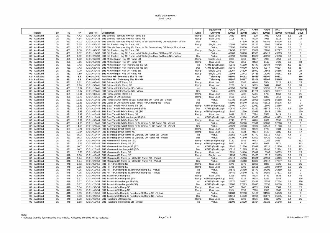
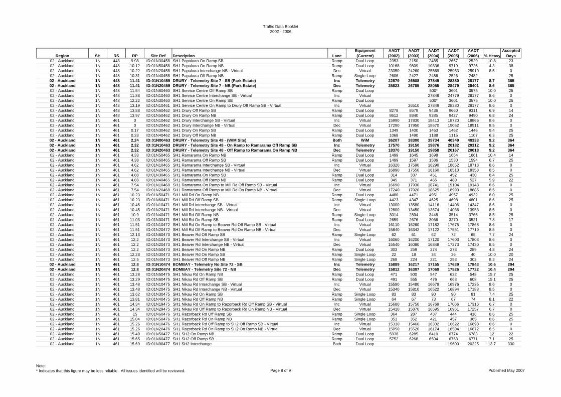
02 - Auckland 1N 431 4.42 ID:01N30435 SH1 Ellerslie Panmure Hwy On Ramp SB Ramp Dual Loop 7083 6605 7279 7083 7258 5.2 2202 - Auckland 1N 431 4.54 ID:01N40435 SH1 Ellerslie Panmure Hwy Off Ramp NB Ramp Dual Loop 7108 7670 8009 7926 8116 2.4 1902 - Auckland 1N 431 4.72 ID:01N20436 SH1 Ellerslie Panmure Hwy Off Ramp to Sth Eastern Hwy On Ramp NB - Virtual Dec Virtual 67300 68189 68752 68936 5.2 002 - Auckland 1N 431 5.75 ID:01N50437 SH1 Sth Eastern Hwy On Ramp NB Ramp Single Loop 20193 19708 19163 19662 19406 5.6 2202 - Auckland 1N 431 6.13 ID:01N10436 SH1 Ellerslie Panmure Hwy On Ramp to Sth Eastern Hwy Off Ramp SB - Virtual Inc Virtual 70890 69730 71452 71623 71740 5.2 002 - Auckland 1N 431 6.58 ID:01N60437 SH1 Sth Eastern Hwy Off Ramp SB Ramp Single Loop 21498 22362 21869 22205 22027 5.2 2102 - Auckland 1N 431 6.82 ID:01N10438 SH1 Sth Eastern Hwy Off Ramp to Mt Wellington Hwy Off Ramp SB - Virtual Inc Virtual 49700 50180 49583 49418 49713 5.6 002 - Auckland 1N 431 6.82 ID:01N20438 SH1 Sth Eastern Hwy On Ramp to Mt Wellington Hwy On Ramp NB - Virtual Dec Virtual 48090 50080 49026 49090 49530 5.2 002 - Auckland 1N 431 6.92 ID:01N60439 SH1 Mt Wellington Hwy Off Ramp SB Ramp Single Loop 8884 8869 8137 7984 8959 5.2 702 - Auckland 1N 431 7.16 ID:01N50439 SH1 Mt Wellington Hwy On Ramp NB Ramp Dual Loop 8950 9651 8452 8113 9426 9.6 3402 - Auckland 1N 431 7.42 ID:01N10439 SH1 Mt Wellington Hwy Interchange SB (S5) Inc ATMS (Dual Loop) 40940 41309 41447 41434 40756 4.5 35702 - Auckland 1N 431 7.42 ID:01N20439 SH1 Mt Wellington Hwy Interchange NB (S5) Dec ATMS (Dual Loop) 39940 40430 40573 40977 40104 4.6 35702 - Auckland 1N 431 7.79 ID:01N30439 SH1 Mt Wellington Hwy On Ramp SB Ramp Single Loop 13267 14529 15042 14866 15565 5.2 2902 - Auckland 1N 431 7.89 ID:01N40439 SH1 Mt Wellington Hwy Off Ramp NB Ramp Single Loop 12965 12742 14733 14290 15161 5.6 2502 - Auckland 1N 431 8.9 ID:01N10440 PANAMA Rd - Telemetry Site 79 - SB Inc Telemetry 53951 56092 56489 56300 56321 36402 - Auckland 1N 431 8.9 ID:01N20440 PANAMA RD - Telemetry Site 79 - NB Dec Telemetry 54987 54997 55306 55267 55265 36402 - Auckland 1N 431 9.62 ID:01N60441 SH1 Princes St Off Ramp SB Ramp Dual Loop 6097 6062 6140 5504 5126 4.6 2502 - Auckland 1N 431 9.96 ID:01N50441 SH1 Princes St On Ramp NB Ramp Dual Loop 5279 5411 5585 5042 4607 2.0 3902 - Auckland 1N 431 10.07 ID:01N10441 SH1 Princes St Interchange SB - Virtual Inc Virtual 49650 50030 50349 50796 51195 6.3 002 - Auckland 1N 431 10.07 ID:01N20441 SH1 Princes St Interchange NB - Virtual Dec Virtual 49120 49590 49721 50225 50657 6.6 002 - Auckland 1N 431 10.11 ID:01N30441 SH1 Princes St On Ramp SB Ramp Dual Loop 5263 5202 5616 5795 4963 7.3 2102 - Auckland 1N 431 10.78 ID:01N40441 SH1 Water St Off Ramp NB Ramp Dual Loop 5601 5958 6579 6393 5918 3.5 2402 - Auckland 1N 431 11.86 ID:01N10443 SH1 Princes St On Ramp to East Tamaki Rd Off Ramp SB - Virtual Inc Virtual 52730 55230 55965 56591 56158 4.6 002 - Auckland 1N 431 11.86 ID:01N20443 SH1 Water St Off Ramp to East Tamaki Rd On Ramp NB - Virtual Dec Virtual 54100 55540 56300 56618 56575 4.7 002 - Auckland 1N 431 12.89 ID:01N60444 SH1 East Tamaki Rd Off Ramp SB (S6) Ramp ATMS (Single Loop) 12490 12724 12932 12690 12685 12002 - Auckland 1N 431 12.93 ID:01N20444 SH1 East Tamaki Rd Interchange NB (S6) Dec ATMS (Dual Loop) 40630 42448 43210 43975 44091 6.6 12002 - Auckland 1N 431 12.93 ID:01N50444 SH1 East Tamaki Rd On Ramp NB (S6) Ramp ATMS (Single Loop) 13480 12616 13091 12643 12484 12002 - Auckland 1N 431 12.98 ID:01N40444 SH1 East Tamaki Rd Off Ramp NB Ramp Dual Loop 6698 6625 7694 7573 7429 6.1 2502 - Auckland 1N 431 13.17 ID:01N10444 SH1 East Tamaki Rd Interchange SB (S6) Inc ATMS (Dual Loop) 40240 42494 43033 43901 43473 6.3 12002 - Auckland 1N 431 13.32 ID:01N30444 SH1 East Tamaki Rd On Ramp SB Ramp Dual Loop 7746 7578 8478 8379 8595 12.9 2502 - Auckland 1N 431 14.56 ID:01N10445 SH1 East Tamaki Rd On Ramp to Te Irirangi Dr Off Ramp SB - Virtual Inc Virtual 47650 50070 51511 52280 52068 6.3 002 - Auckland 1N 431 14.56 ID:01N20445 SH1 East Tamaki Rd Off Ramp to Te Irirangi Dr On Ramp NB - Virtual Dec Virtual 47620 49070 50904 51548 51520 6.6 002 - Auckland 1N 431 15.71 ID:01N60447 SH1 Te Irirangi Dr Off Ramp SB Ramp Dual Loop 9077 8503 9739 9770 9484 3.5 1502 - Auckland 1N 431 15.84 ID:01N50447 SH1 Te Irirangi Dr On Ramp NB Ramp Dual Loop 8182 7934 9104 9123 9185 4.1 1702 - Auckland 1N 431 16.2 ID:01N10447 SH1 Te Irirangi Dr Off Ramp to Manukau Off Ramp SB - Virtual Inc Virtual 38160 41570 41772 42510 42584 7.4 002 - Auckland 1N 431 16.2 ID:01N20447 SH1 Te Irirangi Dr On Ramp to Manukau On Ramp NB - Virtual Dec Virtual 39790 41140 41800 42425 42335 7.0 002 - Auckland 1N 431 16.54 ID:01N60448 SH1 Manukau Off Ramp SB (S7) Ramp ATMS (Single Loop) 9130 9545 9753 10286 10357 31302 - Auckland 1N 431 16.65 ID:01N50448 SH1 Manukau On Ramp NB (S7) Ramp ATMS (Single Loop) 9090 9435 9475 9929 9971 31302 - Auckland 1N 431 16.7 ID:01N10448 SH1 Manukau Interchange SB (S7) Inc ATMS (Dual Loop) 29040 31526 32019 32224 32226 7.0 31302 - Auckland 1N 431 16.7 ID:01N20448 SH1 Manukau Interchange NB (S7) Dec ATMS (Dual Loop) 30710 31815 32324 32496 32364 6.5 31302 - Auckland 1N 431 16.76 ID:01N30448 SH1 Manukau On Ramp SB Ramp Dual Loop 13831 14160 15012 15167 14703 5.7 2502 - Auckland 1N 448 0.66 ID:01N40448 SH1 Manukau Off Ramp NB Ramp Single Loop 14293 14093 15483 15316 15183 7.0 2502 - Auckland 1N 448 1.74 ID:01N10450 SH1 Manukau On Ramp to Hill Rd Off Ramp SB - Virtual Inc Virtual 43410 45690 47031 47391 46929 8.6 002 - Auckland 1N 448 1.74 ID:01N20450 SH1 Manukau Off Ramp to Hill Rd On Ramp NB - Virtual Dec Virtual 45430 45910 47807 47812 47547 8.5 002 - Auckland 1N 448 2.83 ID:01N50451 SH1 Hill Rd On Ramp NB Ramp Dual Loop 9279 9370 10058 9828 9726 3.5 2502 - Auckland 1N 448 2.85 ID:01N60451 SH1 Hill Rd Off Ramp SB Ramp Dual Loop 9235 9209 10561 10088 10440 1.6 2502 - Auckland 1N 448 4.15 ID:01N10452 SH1 Hill Rd Off Ramp to Takanini Off Ramp SB - Virtual Inc Virtual 34540 36480 36470 37302 36489 8.6 002 - Auckland 1N 448 4.15 ID:01N20452 SH1 Hill Rd On Ramp to Takanini On Ramp NB - Virtual Dec Virtual 36440 36540 37749 37982 37821 8.5 002 - Auckland 1N 448 5.45 ID:01N60454 SH1 Takanini Off Ramp SB Ramp Dual Loop 8296 7502 8978 9749 8836 4.8 4602 - Auckland 1N 448 5.67 ID:01N50454 SH1 Takanini On Ramp NB (S8) Ramp ATMS (Single Loop) 8650 9028 9135 9226 9143 32602 - Auckland 1N 448 5.77 ID:01N10454 SH1 Takanini Interchange SB (S8) Inc ATMS (Dual Loop) 26570 26487 27491 27553 27654 7.8 32602 - Auckland 1N 448 5.77 ID:01N20454 SH1 Takanini Interchange NB (S8) Dec ATMS (Dual Loop) 27780 27513 28615 28756 28678 7.5 32602 - Auckland 1N 448 5.84 ID:01N30454 SH1 Takanini On Ramp SB Ramp Dual Loop 6405 6246 6669 6552 6389 8.6 2502 - Auckland 1N 448 5.89 ID:01N40454 SH1 Takanini Off Ramp NB Ramp Dual Loop 6554 6559 7290 6916 6967 7.5 1802 - Auckland 1N 448 7.83 ID:01N10456 SH1 Takanini On Ramp to Papakura Off Ramp SB - Virtual Inc Virtual 31680 32730 34160 34105 34043 8.6 002 - Auckland 1N 448 7.83 ID:01N20456 SH1 Takanini Off Ramp to Papakura On Ramp NB - Virtual Dec Virtual 34010 34070 35905 35672 35645 8.5 002 - Auckland 1N 448 9.78 ID:01N60458 SH1 Papakura Off Ramp SB Ramp Dual Loop 8882 8906 8796 8383 8395 3.4 2502 - Auckland 1N 448 9.88 ID:01N10458 SH1 Papakura Interchange SB - Virtual Inc Virtual 21000 23820 25364 25723 25648 8.6 0
Note:* Indicates that this figure may be less reliable. All issues identified will be reviewed. Page 7 of 9 Published May 2007
Traffic Data Booklet2002 - 2006
Region SH RS RP Site Ref Description LaneEquipment (Current)
AADT (2002)
AADT (2003)
AADT (2004)
AADT (2005)
AADT (2006) % Heavy
Accepted Days
02 - Auckland 1N 448 9.98 ID:01N30458 SH1 Papakura On Ramp SB Ramp Dual Loop 2353 2150 2485 2657 2529 10.8 2302 - Auckland 1N 448 10.12 ID:01N50458 SH1 Papakura On Ramp NB Ramp Dual Loop 10168 9809 10336 9719 9726 4.3 3802 - Auckland 1N 448 10.22 ID:01N20458 SH1 Papakura Interchange NB - Virtual Dec Virtual 23350 24260 25569 25953 25919 8.5 002 - Auckland 1N 448 10.31 ID:01N40458 SH1 Papakura Off Ramp NB Ramp Single Loop 2606 2427 2486 2526 2482 2502 - Auckland 1N 448 11.41 ID:01N10459 DRURY - Telemetry Site 7 - SB (Park Estate) Inc Telemetry 22879 26508 27849 28380 28177 8.7 36502 - Auckland 1N 448 11.41 ID:01N20459 DRURY - Telemetry Site 7 - NB (Park Estate) Dec Telemetry 25823 26785 28055 28479 28401 8.6 36502 - Auckland 1N 448 11.54 ID:01N60460 SH1 Service Centre Off Ramp SB Ramp Dual Loop 500* 3601 3575 10.0 2502 - Auckland 1N 448 11.88 ID:01N10460 SH1 Service Centre Interchange SB - Virtual Inc Virtual 27849 24779 28177 8.6 002 - Auckland 1N 448 12.22 ID:01N30460 SH1 Service Centre On Ramp SB Ramp Dual Loop 500* 3601 3575 10.0 2502 - Auckland 1N 448 13.19 ID:01N10461 SH1 Service Centre On Ramp to Drury Off Ramp SB - Virtual Inc Virtual 26510 27849 28380 28177 8.6 002 - Auckland 1N 448 13.88 ID:01N60462 SH1 Drury Off Ramp SB Ramp Dual Loop 8278 8679 9436 9660 9311 6.9 1402 - Auckland 1N 448 13.97 ID:01N50462 SH1 Drury On Ramp NB Ramp Dual Loop 8612 8840 9385 9427 9490 6.8 2402 - Auckland 1N 461 0 ID:01N10462 SH1 Drury Interchange SB - Virtual Inc Virtual 15990 17830 18413 18720 18866 8.6 002 - Auckland 1N 461 0 ID:01N20462 SH1 Drury Interchange NB - Virtual Dec Virtual 17290 17950 18670 19052 18911 8.5 002 - Auckland 1N 461 0.17 ID:01N30462 SH1 Drury On Ramp SB Ramp Dual Loop 1349 1400 1463 1462 1446 9.4 2502 - Auckland 1N 461 0.33 ID:01N40462 SH1 Drury Off Ramp NB Ramp Dual Loop 1068 1490 1188 1115 1107 6.3 2502 - Auckland 1N 461 2.24 ID:01N00463 DRURY - Telemetry Site 48 - (WIM Site) Both WiM 36207 38300 39734 40349 40333 9.2 36402 - Auckland 1N 461 2.32 ID:01N10463 DRURY - Telemetry Site 48 - On Ramp to Ramarama Off Ramp SB Inc Telemetry 17570 19150 19876 20182 20312 9.2 36402 - Auckland 1N 461 2.32 ID:01N20463 DRURY - Telemetry Site 48 - Off Ramp to Ramarama On Ramp NB Dec Telemetry 18370 19150 19858 20167 20018 9.2 36402 - Auckland 1N 461 4.33 ID:01N50465 SH1 Ramarama On Ramp NB Ramp Dual Loop 1499 1645 1698 1654 1661 10.4 1402 - Auckland 1N 461 4.38 ID:01N60465 SH1 Ramarama Off Ramp SB Ramp Dual Loop 1499 1597 1586 1530 1594 6.7 2502 - Auckland 1N 461 4.62 ID:01N10465 SH1 Ramarama Interchange SB - Virtual Inc Virtual 16320 17590 18290 18652 18718 8.6 002 - Auckland 1N 461 4.62 ID:01N20465 SH1 Ramarama Interchange NB - Virtual Dec Virtual 16890 17550 18160 18513 18358 8.5 002 - Auckland 1N 461 4.88 ID:01N30465 SH1 Ramarama On Ramp SB Ramp Dual Loop 314 337 451 452 430 8.4 2502 - Auckland 1N 461 4.88 ID:01N40465 SH1 Ramarama Off Ramp NB Ramp Dual Loop 345 371 465 480 527 5.9 2202 - Auckland 1N 461 7.54 ID:01N10468 SH1 Ramarama On Ramp to Mill Rd Off Ramp SB - Virtual Inc Virtual 16690 17930 18741 19104 19148 8.6 002 - Auckland 1N 461 7.54 ID:01N20468 SH1 Ramarama Off Ramp to Mill Rd On Ramp NB - Virtual Dec Virtual 17240 17920 18625 18993 18885 8.5 002 - Auckland 1N 461 10.23 ID:01N50471 SH1 Mill Rd On Ramp NB Ramp Dual Loop 4480 4471 4951 4957 4932 8.0 2502 - Auckland 1N 461 10.23 ID:01N60471 SH1 Mill Rd Off Ramp SB Ramp Single Loop 4423 4347 4625 4698 4801 8.6 2502 - Auckland 1N 461 10.45 ID:01N10471 SH1 Mill Rd Interchange SB - Virtual Inc Virtual 13000 13580 14116 14406 14347 8.6 002 - Auckland 1N 461 10.45 ID:01N20471 SH1 Mill Rd Interchange NB - Virtual Dec Virtual 12800 13450 13674 14036 13953 8.5 002 - Auckland 1N 461 10.9 ID:01N40471 SH1 Mill Rd Off Ramp NB Ramp Single Loop 3014 2894 3448 3514 3766 8.5 2502 - Auckland 1N 461 11.03 ID:01N30471 SH1 Mill Rd On Ramp SB Ramp Dual Loop 2659 2676 3066 3270 3521 7.8 1702 - Auckland 1N 461 11.51 ID:01N10472 SH1 Mill Rd On Ramp to Beaver Rd Off Ramp SB - Virtual Inc Virtual 16110 16260 17182 17675 17868 8.6 002 - Auckland 1N 461 11.51 ID:01N20472 SH1 Mill Rd Off Ramp to Beaver Rd On Ramp NB - Virtual Dec Virtual 15840 16342 17122 17551 17719 8.5 002 - Auckland 1N 461 12.13 ID:01N60473 SH1 Beaver Rd Off Ramp SB Ramp Single Loop 62 61 62 72 65 7.7 2402 - Auckland 1N 461 12.2 ID:01N10473 SH1 Beaver Rd Interchange SB - Virtual Inc Virtual 16060 16200 17120 17603 17803 8.6 002 - Auckland 1N 461 12.2 ID:01N20473 SH1 Beaver Rd Interchange NB - Virtual Dec Virtual 15540 16080 16848 17273 17430 8.5 002 - Auckland 1N 461 12.2 ID:01N50473 SH1 Beaver Rd On Ramp NB Ramp Dual Loop 303 259 274 278 289 4.8 2402 - Auckland 1N 461 12.28 ID:01N30473 SH1 Beaver Rd On Ramp SB Ramp Single Loop 22 18 34 36 40 10.0 2002 - Auckland 1N 461 12.5 ID:01N40473 SH1 Beaver Rd Off Ramp NB Ramp Single Loop 268 224 221 253 302 8.3 2402 - Auckland 1N 461 12.8 ID:01N10474 BOMBAY - Telemetry No Site 72 - SB Inc Telemetry 15889 16217 17155 17639 17843 10.6 29402 - Auckland 1N 461 12.8 ID:01N20474 BOMBAY - Telemetry Site 72 - NB Dec Telemetry 15812 16307 17069 17526 17732 10.4 29402 - Auckland 1N 461 13.28 ID:01N50475 SH1 Nikau Rd On Ramp NB Ramp Dual Loop 471 500 547 632 548 15.7 2502 - Auckland 1N 461 13.29 ID:01N60475 SH1 Nikau Rd Off Ramp SB Ramp Dual Loop 491 555 476 663 608 15.1 2502 - Auckland 1N 461 13.48 ID:01N10475 SH1 Nikau Rd Interchange SB - Virtual Inc Virtual 15590 15480 16679 16976 17235 8.6 002 - Auckland 1N 461 13.48 ID:01N20475 SH1 Nikau Rd Interchange NB - Virtual Dec Virtual 15340 15810 16522 16894 17183 8.5 002 - Auckland 1N 461 13.62 ID:01N30475 SH1 Nikau Rd On Ramp SB Ramp Single Loop 83 83 90 90 81 7.4 2502 - Auckland 1N 461 13.81 ID:01N40475 SH1 Nikau Rd Off Ramp NB Ramp Single Loop 64 67 73 67 74 8.1 2202 - Auckland 1N 461 14.34 ID:01N19475 SH1 Nikau Rd On Ramp to Razorback Rd Off Ramp SB - Virtual Inc Virtual 15680 15750 16769 17066 17316 6.7 002 - Auckland 1N 461 14.34 ID:01N29475 SH1 Nikau Rd Off Ramp to Razorback Rd On Ramp NB - Virtual Dec Virtual 15410 15870 16595 16961 17257 6.7 002 - Auckland 1N 461 15 ID:01N60476 SH1 Razorback Rd Off Ramp SB Ramp Single Loop 364 287 437 444 418 8.6 2502 - Auckland 1N 461 15.04 ID:01N50476 SH1 Razorback Rd On Ramp NB Ramp Single Loop 351 352 421 457 385 8.6 2502 - Auckland 1N 461 15.26 ID:01N10476 SH1 Razorback Rd Off Ramp to SH2 Off Ramp SB - Virtual Inc Virtual 15310 15460 16332 16622 16898 8.6 002 - Auckland 1N 461 15.26 ID:01N20476 SH1 Razorback Rd On Ramp to SH2 On Ramp NB - Virtual Dec Virtual 15050 15520 16174 16504 16872 8.5 002 - Auckland 1N 461 15.49 ID:01N50477 SH1 SH2 On Ramp NB Ramp Dual Loop 5938 6285 6410 6774 6783 12 2202 - Auckland 1N 461 15.65 ID:01N60477 SH1 SH2 Off Ramp SB Ramp Dual Loop 5752 6268 6504 6753 6771 7.1 2502 - Auckland 1N 461 15.69 ID:01N00477 SH1 SH2 Interchange Both Dual Loop 19600 20225 13.7 330
Note:* Indicates that this figure may be less reliable. All issues identified will be reviewed. Page 8 of 9 Published May 2007
Traffic Data Booklet2002 - 2006
Region SH RS RP Site Ref Description LaneEquipment (Current)
AADT (2002)
AADT (2003)
AADT (2004)
AADT (2005)
AADT (2006) % Heavy
Accepted Days
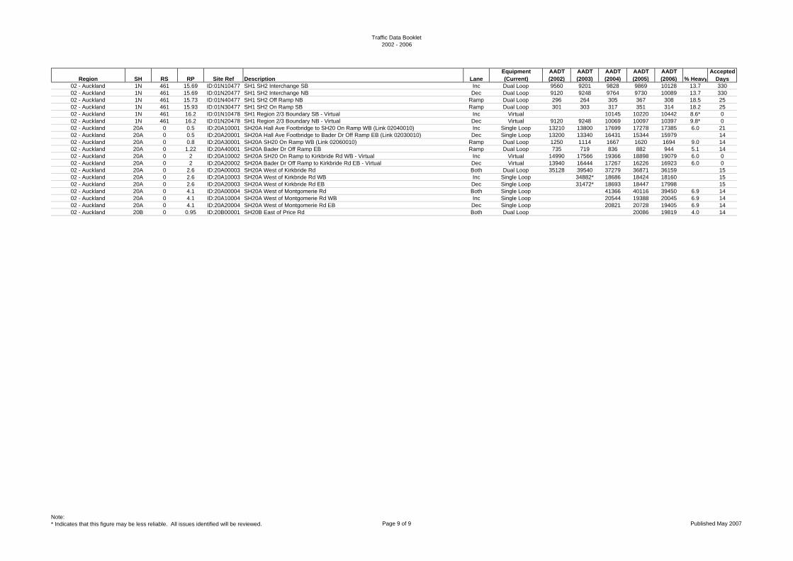
02 - Auckland 1N 461 15.69 ID:01N10477 SH1 SH2 Interchange SB Inc Dual Loop 9560 9201 9828 9869 10128 13.7 33002 - Auckland 1N 461 15.69 ID:01N20477 SH1 SH2 Interchange NB Dec Dual Loop 9120 9248 9764 9730 10089 13.7 33002 - Auckland 1N 461 15.73 ID:01N40477 SH1 SH2 Off Ramp NB Ramp Dual Loop 296 264 305 367 308 18.5 2502 - Auckland 1N 461 15.93 ID:01N30477 SH1 SH2 On Ramp SB Ramp Dual Loop 301 303 317 351 314 18.2 2502 - Auckland 1N 461 16.2 ID:01N10478 SH1 Region 2/3 Boundary SB - Virtual Inc Virtual 10145 10220 10442 8.6* 002 - Auckland 1N 461 16.2 ID:01N20478 SH1 Region 2/3 Boundary NB - Virtual Dec Virtual 9120 9248 10069 10097 10397 9.8* 002 - Auckland 20A 0 0.5 ID:20A10001 SH20A Hall Ave Footbridge to SH20 On Ramp WB (Link 02040010) Inc Single Loop 13210 13800 17699 17278 17385 6.0 2102 - Auckland 20A 0 0.5 ID:20A20001 SH20A Hall Ave Footbridge to Bader Dr Off Ramp EB (Link 02030010) Dec Single Loop 13200 13340 16431 15344 15979 1402 - Auckland 20A 0 0.8 ID:20A30001 SH20A SH20 On Ramp WB (Link 02060010) Ramp Dual Loop 1250 1114 1667 1620 1694 9.0 1402 - Auckland 20A 0 1.22 ID:20A40001 SH20A Bader Dr Off Ramp EB Ramp Dual Loop 735 719 836 882 944 5.1 1402 - Auckland 20A 0 2 ID:20A10002 SH20A SH20 On Ramp to Kirkbride Rd WB - Virtual Inc Virtual 14990 17566 19366 18898 19079 6.0 002 - Auckland 20A 0 2 ID:20A20002 SH20A Bader Dr Off Ramp to Kirkbride Rd EB - Virtual Dec Virtual 13940 16444 17267 16226 16923 6.0 002 - Auckland 20A 0 2.6 ID:20A00003 SH20A West of Kirkbride Rd Both Dual Loop 35128 39540 37279 36871 36159 1502 - Auckland 20A 0 2.6 ID:20A10003 SH20A West of Kirkbride Rd WB Inc Single Loop 34882* 18686 18424 18160 1502 - Auckland 20A 0 2.6 ID:20A20003 SH20A West of Kirkbride Rd EB Dec Single Loop 31472* 18693 18447 17998 1502 - Auckland 20A 0 4.1 ID:20A00004 SH20A West of Montgomerie Rd Both Single Loop 41366 40116 39450 6.9 1402 - Auckland 20A 0 4.1 ID:20A10004 SH20A West of Montgomerie Rd WB Inc Single Loop 20544 19388 20045 6.9 1402 - Auckland 20A 0 4.1 ID:20A20004 SH20A West of Montgomerie Rd EB Dec Single Loop 20821 20728 19405 6.9 1402 - Auckland 20B 0 0.95 ID:20B00001 SH20B East of Price Rd Both Dual Loop 20086 19819 4.0 14
Note:* Indicates that this figure may be less reliable. All issues identified will be reviewed. Page 9 of 9 Published May 2007
Traffic Data Booklet2002 - 2006
Region SH RS RP Site Ref Description LaneEquipment (Current)
AADT (2002)
AADT (2003)
AADT (2004)
AADT (2005)
AADT (2006) % Heavy
Accepted Days
03 - Waikato 2 0 2.47 ID:00200002 MAUNGATAWHIRI - Telemetry Site 74 West of Grahams Brg Both Telemetry 12791 13500 13642 13604 13252 12.3 36403 - Waikato 2 32 1 ID:00200033 By RS peg 32/1 Both Single Loop 11490 11660 11758 11560 16.5 2803 - Waikato 2 34 2.51 ID:00200036 800m Nth of SH27 intersection Both Single Loop 8413 8578 8702 8731 8558 13.4* 2803 - Waikato 2 37 1.2 ID:00200037 1200m past State Highway 27 (Mangatarata) Both Dual Loop 4239 4305 4655 4519 4712 13.9 2803 - Waikato 2 48 4.15 ID:00200052 650m past Orchard East Rd Both Dual Loop 4528 4847 4988 5166 5186 13.4 2803 - Waikato 2 61 1 ID:00200062 130m Nth of Fisher Rd Both Dual Loop 5879 6579 6718 6970 6871 13 2803 - Waikato 2 61 4.86 ID:00200066 986m past Awaiti Rd Both Dual Loop 5155 5509 5625 5939 5818 13 2803 - Waikato 2 73 17.47 ID:00200091 WAIHI - Telemetry Site 34 - East of Samson Rd West Both Telemetry 6829 7183 7433 7569 7503 9.8 36503 - Waikato 2 93 2.17 ID:00200095 40m Sth of Crean Rd Both Single Loop 8325 8623 8701 9079 9321 9.8 2803 - Waikato 2 93 5.26 ID:00200098 200m Sth of Trigg Rd Both Single Loop 5067 5416 5476 5750 5899 13.3 2803 - Waikato 3 0 0.1 ID:00300000 Start of SH3 - Virtual Both Virtual 24250 26000 26200 12320 003 - Waikato 3 0 0.65 ID:00310001 Collins Rd Int (Inc Lanes) Inc SCATS 11750 13000 13100 6160 003 - Waikato 3 0 0.65 ID:00320001 Collins Rd Int (Dec Lanes) Dec SCATS 13550 13000 13100 6160 003 - Waikato 3 0 3.02 ID:00300003 285m Sth of Dixons Rd Both Single Loop 12046 12188 13008 12905 13360 5.3 2803 - Waikato 3 10 1.51 ID:00300012 1510m past State Highway 21 (Airport Rd) (Nth Bound) Both Single Loop 11310 10866 11007 10966 11233 8.4 2103 - Waikato 3 16 10.61 ID:00300027 200m Sth of Cambrdige Rd RAB Both Single Loop 6290 6495 6969 7079 7192 6.2 2803 - Waikato 3 16 12.64 ID:00300029 350m Nth of Saint Ledger Rd Both Single Loop 10994 11178 11711 11580 11870 7.4 2803 - Waikato 3 16 13.82 ID:00300030 150m Nth of McGhie Rd Both Single Loop 11030 10426 12210 11870 11677 10.7 2803 - Waikato 3 16 17.64 ID:00300034 105m before Tokanui Rd Both Single Loop 7418 7532 8002 7822 7578 10.8 2803 - Waikato 3 36 2.14 ID:00300038 335m Nth of Wharepuhanga Rd (Te Kawa Turnoff) Both Single Loop 6015 6057 6481 6600 6220 14.4 2803 - Waikato 3 36 13 ID:00300049 100m before Kio Kio Station Rd Both Single Loop 4787 4854 5168 5157 4860 15.2 2103 - Waikato 3 63 1.39 ID:00300064 100m Sth of Mangapu #2 Bridge Both Single Loop 6289 6409 6869 7124 6904 13.6 2803 - Waikato 3 65 0.8 ID:00300066 800m past State Highway 37 (Waitomo Rd) Both Dual Loop 5890 5892 6360 6710 6751 15.6 2803 - Waikato 3 65 10.64 ID:00300075 200m Sth of Carrol St Both Single Loop 4906 5023 5307 5581 5248 13.9 2803 - Waikato 3 76 11 ID:00300085 TE KUITI - Telemetry Site 16 - Nth of 8 Mile Junction Both Telemetry 3850 4025 4175 4221 4137 15.8 36203 - Waikato 3 88 5 ID:00300093 Virtual - West of SH4 Junction Both Virtual 1920 2050 2084 2232 2127 18.8 003 - Waikato 3 103 0.22 ID:00300103 220m past Hunts Rd (Piopio) Both Tube 1920 2050 2084 2232 2127 20.1 2803 - Waikato 4 0 0.4 ID:00400000 400m past State Highway 3 Both Tube 1542 1707 1983 2051 2010 17.9 2803 - Waikato 5 0 0.22 ID:00500000 217m past State Highway 1 (Tirau) Both Tube 3198 3326 3431 3500 3526 10.5 2803 - Waikato 5 5 0.06 ID:00500005 245m west of State Highway 28 (Whites Rd) Both Dual Loop 4971 5104 5255 5320 5246 10.7 3503 - Waikato 5 8 5 ID:00500013 Virtual - Tapapa Both Virtual 5174 5298 5511 5376 11.0 003 - Waikato 5 111 13.54 ID:00500125 98m before State Highway 1 (Wairakei) Both Dual Loop 3928 4270 4343 4495 4304 11.6 2103 - Waikato 5 135 2.5 ID:00500138 278m past Crown Rd (Taupo) Both Tube 3542 3728 3806 3692 3755 16 2803 - Waikato 5 150 0.1 ID:00500150 Virtual site at Old regional boundary Both Virtual 3806 3692 3755 18.2 003 - Waikato 21 0 0.1 ID:02110000 Virtual - 100m Sth of RAB (Inc) Inc Virtual 2140 2585 2729 3123 3391 003 - Waikato 21 0 0.1 ID:02120000 Virtual - 100m Sth of RAB (Dec) Dec Virtual 2140 2586 2729 3123 3391 003 - Waikato 21 0 0.34 ID:02100000 225m Sth of 2nd RAB Both Dual Loop 4281 5071 5457 6246 6781 6.4 2803 - Waikato 21 2 2.08 ID:02100004 55m Sth of Lochiel Rd Both Dual Loop 4039 4766 5015 5727 4929 6.7 2803 - Waikato 21 2 4.82 ID:02100007 145m Nth of State Highway 3 Both Dual Loop 3499 4019 4308 4942 4638 6.7 2803 - Waikato 23 0 0.25 ID:02300000 20m West of Hawk St Both Single Loop 12264 12614 12484 12419 12512 2103 - Waikato 23 0 1.25 ID:02310001 Virtual - Whatawhata (Inc Lane) Inc Virtual 6100 6307 6242 6210 6256 003 - Waikato 23 0 1.25 ID:02320001 Virtual - Whatawhata (Dec Lane) Dec Virtual 6100 6307 6242 6210 6256 003 - Waikato 23 0 2.49 ID:02300004 40m East of Newcastle Rd Both Single Loop 9454 10001 10219 10365 9720 3.5 2803 - Waikato 23 3 6 ID:02300009 880m East of Kakaramea Rd Both Single Loop 4710 4984 5055 4968 4995 6.8 2803 - Waikato 23 3 7.71 ID:02300011 200m West of Maori Point Rd Both Single Loop 5342 5638 5912 5771 5918 5.1 2803 - Waikato 23 32 5 ID:02300037 90m East of Wrights Rd Both Tube 3054 2991 3563 3578 3517 4.5 2803 - Waikato 24 0 0.4 ID:02410000 Virtual - Matamata CBD (Inc) Inc Virtual 3950 3874 4284 4440 4534 14.6 003 - Waikato 24 0 0.4 ID:02420000 Virtual - Matamata CBD (Dec) Dec Virtual 3950 3875 4284 4440 4534 14.6 003 - Waikato 24 0 1.21 ID:02400001 120m East of Tower Rd RAB Both Single Loop 7868 7749 8568 8879 9068 9.9 2803 - Waikato 24 0 12.83 ID:02400013 140m before State Highway 29 Both Tube 2901 2952 3209 3357 3401 14 2803 - Waikato 25 0 0.16 ID:02500000 160m past State Highway 2 (Dalgetys Cnr) Both Tube 3234 3454 3792 3556 3239 11.6 2103 - Waikato 25 12 9.04 ID:02500021 335m before Hauraki Rd Both Dual Loop 4882 4813 5480 5550 5605 7.4 2803 - Waikato 25 22 0.76 ID:02500023 300m past 2nd Abut Kopu Bridge (Waihou River) Both Single Loop 7768 8201 8530 8593 8102 7.9 2803 - Waikato 25 24 3.84 ID:02500028 300m Sth of Kauaeranga Bridge Both Single Loop 11742 12346 12874 12696 12429 2103 - Waikato 25 24 11.98 ID:02500036 Speed Restriction Sign (Whakatete Bay Sth end) Both Tube 3763 3863 3838 3896 3594 4.2 2803 - Waikato 25 42 6.8 ID:02500049 Speed Restriction Sign (Tapu Township Sth end) Both Tube 1934 2031 2074 2047 1860 5.5 2803 - Waikato 25 72 0.3 ID:02500072 300m past Goldfields Rd Both Tube 1416 1548 1508 1493 1349 7.1 2803 - Waikato 25 72 8.78 ID:02500082 435m Nth of Rd 309, Coromandel Both Tube 2163 2169 2125 6.5 28
Note:* Indicates that this figure may be less reliable. All issues identified will be reviewed. Page 1 of 4 Published May 2007
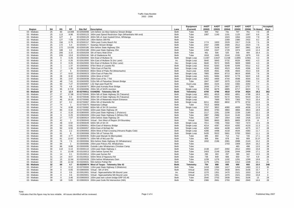
Traffic Data Booklet2002 - 2006
Region SH RS RP Site Ref Description LaneEquipment (Current)
AADT (2002)
AADT (2003)
AADT (2004)
AADT (2005)
AADT (2006) % Heavy
Accepted Days
03 - Waikato 25 84 14.008 ID:02500098 12m before 1st Abut Opitonui Stream Bridge Both Tube 600 702 741 707 761 7.0 2803 - Waikato 25 113 9.98 ID:02500123 340m past Speed Restriction Sign (Wharekaho Nth end) Both Tube 1087 1140 1191 1125 1267 6.6 2803 - Waikato 25 127 2 ID:02500129 400m Nth of Joan Gaskell Drive, Whitianga Both Tube 1023 1064 1103 7.9 2803 - Waikato 25 127 7.08 ID:02500134 190m Before 309 Rd Both Tube 2269 2380 2432 8.2 2803 - Waikato 25 156 0.79 ID:02500157 790m past Cooks Beach Rd Both Tube 1774 1833 2029 1917 2126 7.5 2803 - Waikato 25 172 5.4 ID:02500177 Swampy Stream Bridge Both Tube 2437 2389 2589 2512 2423 7.6 2803 - Waikato 25 172 13.035 ID:02500185 65m before State Highway 25A Both Tube 2797 3108 3137 3097 2861 10.9 2803 - Waikato 25 188 0.2 ID:02500188 200m past State Highway 25A Both Tube 1459 1547 1729 1974 1433 12.4 2803 - Waikato 25 206 3.15 ID:02500209 Sth of Harry Watt Drive Both Tube 461 506 525 545 494 16.4 2103 - Waikato 25 226 13.8 ID:02500240 Nth of Gladestone Rd Both Tube 1918 1945 2144 2150 1979 9.9 2803 - Waikato 26 0 0.26 ID:02600000 50m East of Mullane St Both Single Loop 11287 11637 11238 11855 12061 4.3 2803 - Waikato 26 0 0.26 ID:02610000 50m East of Mullane St (Inc Lane) Inc Single Loop 5640 5843 5732 6026 6092 4.3 2803 - Waikato 26 0 0.26 ID:02620000 50m East of Mullane St (Dec Lane) Dec Single Loop 5640 5572 5505 5828 5969 4.3 2803 - Waikato 26 1 1.37 ID:02600002 875m West of Lissette Rd Both Single Loop 5016 5263 5248 5349 5312 6.2 2803 - Waikato 26 7 1.35 ID:02600009 700m East of Platt Rd Both Single Loop 4156 4592 4523 4549 4266 8.9 2803 - Waikato 26 17 5 ID:02600022 855m West of Piako Rd (Motumaoho) Both Dual Loop 4028 4561 4436 4603 4313 8.8 2803 - Waikato 26 17 6.02 ID:02600023 150m East of Piako Rd Both Single Loop 7865 8064 8713 8619 8595 7.6 2803 - Waikato 26 26 8.32 ID:02600034 100m West of SH27 Both Single Loop 5431 5684 6032 5779 5622 6.8 2803 - Waikato 26 35 2.67 ID:02600038 250m East of No. 7 Rd Both Single Loop 4362 4469 4744 4598 4544 8.0 2803 - Waikato 26 48 7.41 ID:02600055 515m Nth of Patuwhao Stream Bridge Both Tube 1847 1997 2075 2129 2090 7.4 3503 - Waikato 26 60 7.27 ID:02600067 LSZ Sign past Ryall Rd Both Dual Loop 3894 4104 4150 4382 4292 7.7 2103 - Waikato 26 70 4.8 ID:02600075 380m past Komata River Bridge Both Tube 2608 2774 2807 2872 2757 8.2 2103 - Waikato 26 95 0.719 ID:02600096 200m Sth of SH25 Junction Both Single Loop 6768 6679 6885 6717 6624 7.9 2803 - Waikato 27 0 12.4 ID:02700011 KAIHERE - Telemetry Site 33 Both Telemetry 4700 4796 4818 4734 4524 19.2 36203 - Waikato 27 27 17.98 ID:02700045 300m Nth of State Highway 26 (Tatuanui) Both Single Loop 4831 4919 4958 4851 4788 18.9 2803 - Waikato 27 46 0.3 ID:02700046 300m Sth of State Highway 26 (Tatuanui) Both Single Loop 4911 5030 5172 5041 5019 16.2 2103 - Waikato 27 46 19.16 ID:02700065 200m Sth of Matamata Airport Entrance Both Single Loop 7669 7870 7363 7413 15.4 2803 - Waikato 27 67 0.2 ID:02700067 200m Sth of Wardville Rd Both Single Loop 8211 8583 8832 8775 8732 13.5 2103 - Waikato 27 74 1 ID:02700075 Matamata College Both Tube 7013 6858 7503 11.6 2803 - Waikato 27 74 8.98 ID:02700082 600m Nth of SH 29 Junction Both Single Loop 3797 3852 4080 4009 4036 17.8 2103 - Waikato 27 83 0.32 ID:02700083 320m past State Highway 29 Both Tube 3833 3783 3883 3884 3923 18.9 2803 - Waikato 28 0 0.16 ID:02800000 163m past State Highway 1 (Putaruru) Both Tube 2117 2281 2208 2239 2180 12.1 2803 - Waikato 28 9 0.25 ID:02800009 245m past State Highway 5 (Whites Rd) Both Tube 2887 2986 3144 3140 2940 15.5 2803 - Waikato 28 17 7.07 ID:02800024 105m before State Highway 29 Both Tube 1285 1467 1554 1469 1426 13.6 2803 - Waikato 29 42 1 ID:02900043 Virtual - 1km West of Region 3/4 Boundary Both Virtual 7800 8663 8925 8805 8735 14 003 - Waikato 29 48 0.92 ID:02900049 500m Sth of SH 24 Both Single Loop 7011 7296 7550 7402 7374 12.5 2803 - Waikato 29 50 0.81 ID:02900051 400m East of Waimou Bridge Both Single Loop 4214 4287 4319 4282 4133 11.3 2103 - Waikato 29 50 6.55 ID:02900057 450m East of McNab Rd Both Single Loop 4292 4464 4438 4429 4275 12.7 2803 - Waikato 29 61 2.2 ID:02900063 350m West of Rail Crossing (Hinuera Rugby Club) Both Single Loop 4286 4498 4218 4544 4383 11.7 2103 - Waikato 29 61 8 ID:02900069 200m Sth of Totman Rd Both Single Loop 5435 5522 5661 5783 5563 11.1 2803 - Waikato 30 30 4.77 ID:03000035 918m past Manaiti St (Bennydale) Both Tube 685 694 713 712 720 17.1 2803 - Waikato 30 61 13.67 ID:03000075 100m Nth of McLean Rd Both Tube 806 956 878 945 909 31.5* 2803 - Waikato 30 76 7.5 ID:03000084 90m before State Highway 32 (Whakamaru) Both Tube 1932 2196 2081 2088 2143 15.2 2803 - Waikato 30 84 1 ID:03000085 235m past Pokuru Rd, Whakamaru Both Tube 1703 1909 1924 16.2 2803 - Waikato 30 86 8.88 ID:03000095 Outside Lake Whakamaru Christian Camp Both Tube 483 498 13.5 2803 - Waikato 30 110 0.13 ID:03000110 133m past State Highway 1 Both Tube 2138 2247 2092 2012 1993 15.8 2803 - Waikato 31 0 13.49 ID:03100013 130m before Symes Rd Both Tube 2403 2149 2336 2444 2499 17.1 2803 - Waikato 31 14 0.1 ID:03100014 100m past Symes Rd Both Tube 290 303 297 289 342 13.5 2803 - Waikato 31 14 8.07 ID:03100022 500m West of Ngutunui Rd Both Tube 736 649 666 650 707 6.9 2803 - Waikato 32 15 12.64 ID:03200028 230m before Whakamaru Dam Both Tube 1239 1276 1192 1291 1299 19.8 2103 - Waikato 32 29 12.42 ID:03200041 55m before Poihipi Rd Both Tube 1179 1251 1415 1312 1348 10.1 2103 - Waikato 32 69 4.7 ID:03200074 West of Taupo - Telemetry Site 43 Both Telemetry 754 688 695 690 693 10.0 34803 - Waikato 37 0 0.12 ID:03700000 115m past State Highway 3 (Waitomo) Both Tube 1418 1384 1417 1454 1483 12.3 3503 - Waikato 39 0 0.05 ID:03900000 Virtual - Sth of SH1 Both Virtual 2540 2702 2939 3041 3106 15.7 003 - Waikato 39 0 0.6 ID:03910001 Virtual - Ngaruawhahia Sth Bound Lane Inc Virtual 1270 1351 1470 1521 1553 15.8 003 - Waikato 39 0 0.6 ID:03920001 Virtual - Ngaruawhahia Nth Bound Lane Dec Virtual 1270 1351 1470 1521 1553 15.8 003 - Waikato 39 0 3.46 ID:03900003 100m past twin culvert bridge ERP 0/3.46 Both Tube 2540 2702 2939 3041 3106 13 2903 - Waikato 39 18 5.65 ID:03900024 200m past Goile Rd Intersection (Nth) Both Tube 2380 2661 2793 2992 2940 16.6 28
Note:* Indicates that this figure may be less reliable. All issues identified will be reviewed. Page 2 of 4 Published May 2007
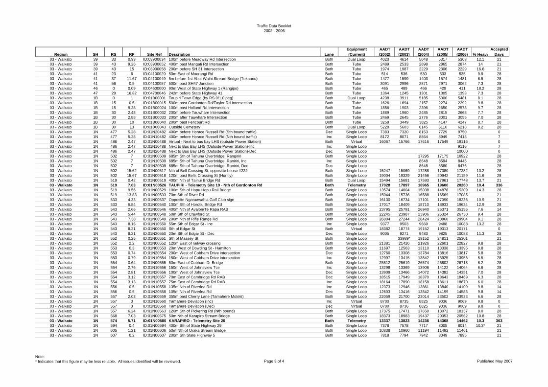
Traffic Data Booklet2002 - 2006
Region SH RS RP Site Ref Description LaneEquipment (Current)
AADT (2002)
AADT (2003)
AADT (2004)
AADT (2005)
AADT (2006) % Heavy
Accepted Days
03 - Waikato 39 33 0.93 ID:03900034 100m before Meadway Rd Intersection Both Dual Loop 4020 4614 5048 5317 5363 12.1 2103 - Waikato 39 43 9.26 ID:03900052 400m past Mangati Rd Intersection Both Tube 2489 2533 2898 2865 2874 14 2103 - Waikato 39 43 15 ID:03900058 200m before SH 31 Intersection Both Tube 1974 1987 2229 2306 2229 16.6 2103 - Waikato 41 23 6 ID:04100029 50m East of Moerangi Rd Both Tube 514 536 530 533 535 9.9 2803 - Waikato 41 37 11.67 ID:04100049 5m before 1st Abut Waihi Stream Bridge (Tokaanu) Both Tube 1477 1599 1403 1574 1481 6.5 2803 - Waikato 41 56 0.5 ID:04100057 500m past SH47 Junction Both Tube 3091 2996 2871 2971 3062 7.3 2803 - Waikato 46 0 0.09 ID:04600000 90m West of State Highway 1 (Rangipo) Both Tube 465 489 466 429 411 18.2 2803 - Waikato 47 29 16.82 ID:04700046 242m before State Highway 41 Both Tube 1364 1245 1301 1305 1393 7.3 2803 - Waikato 1B 0 1 ID:01B00001 Taupiri Town Edge (by RS 0/1.0 peg) Both Dual Loop 4238 3911 5185 5300 5481 8.1 2803 - Waikato 1B 15 0.5 ID:01B00015 500m past Gordonton Rd/Taylor Rd Intersection Both Tube 1626 1694 2157 2274 2292 9.8 2803 - Waikato 1B 15 9.38 ID:01B00024 100m past Holland Rd Intersection Both Tube 1856 1903 2396 2650 2573 9.7 2803 - Waikato 1B 30 2.48 ID:01B00032 200m before Tauwhare Intersection Both Tube 1889 1960 2485 2815 2668 7.7 2803 - Waikato 1B 30 2.88 ID:01B00033 200m after Tauwhare Intersection Both Tube 2469 2645 2776 3001 3055 7.0 2803 - Waikato 1B 30 10 ID:01B00040 200m past Fencourt Rd Both Tube 3258 3449 3825 4147 4247 8.7 2803 - Waikato 1B 30 13 ID:01B00043 Outside Cemetery Both Dual Loop 5228 5603 6145 6110 6218 9.2 2803 - Waikato 1N 477 5.28 ID:01N20482 400m before Horace Russell Rd (Sth bound traffic) Dec Single Loop 7383 7320 8153 7729 9750 003 - Waikato 1N 477 5.28 ID:01N10482 400m before Horace Russell Rd (Nth bound traffic) Inc Single Loop 8172 8071 8864 8949 7418 703 - Waikato 1N 486 2.47 ID:01N00488 Virtual - Next to bus bay LHS (outside Power Station) Both Virtual 16067 15766 17616 17549 19116 003 - Waikato 1N 486 2.47 ID:01N10488 Next to Bus Bay LHS (Outside Power Station)-Inc Inc Single Loop 9116 703 - Waikato 1N 486 2.47 ID:01N20488 Next to Bus Bay LHS (Outside Power Station)-Dec Dec Single Loop 10000 003 - Waikato 1N 502 7 ID:01N00509 685m Sth of Tahuna Overbridge, Rangiriri Both Single Loop 17295 17175 16922 2803 - Waikato 1N 502 7 ID:01N10509 685m Sth of Tahuna Overbridge, Raniriri, Inc Inc Single Loop 8648 8594 8445 2803 - Waikato 1N 502 7 ID:01N20509 685m Sth of Tahuna Overbridge, Raniriri, Dec Dec Single Loop 8648 8580 8476 2803 - Waikato 1N 502 15.62 ID:01N00517 Nth of Bell Crossing St. oppositte house #222 Both Single Loop 15247 15069 17288 17380 17282 13.2 2803 - Waikato 1N 502 15.67 ID:01N00518 120m past Bells Crossing St (Huntly) Both Single Loop 19004 19329 21456 20942 21159 11.6 2803 - Waikato 1N 519 0.42 ID:01N00519 400m Nth of Tainui Bridge Rd Both Dual Loop 15494 15681 17593 17961 17748 13.7 2103 - Waikato 1N 519 7.03 ID:01N00526 TAUPIRI - Telemetry Site 19 - Nth of Gordonton Rd Both Telemetry 17028 17897 18965 19600 20260 10.4 33603 - Waikato 1N 519 9.56 ID:01N00529 100m Sth of Hopu Hopu Rail Bridge Both Single Loop 13574 14004 15038 14878 15209 14.3 2803 - Waikato 1N 519 13.83 ID:01N00533 70m Sth of River Rd Both Single Loop 15044 15736 16588 16569 17085 2103 - Waikato 1N 533 4.33 ID:01N00537 Opposite Ngaruawahia Golf Club sign Both Single Loop 16130 16734 17101 17090 18236 10.9 2103 - Waikato 1N 533 6.84 ID:01N00540 100m Sth of Horotiu Bridge Rd Both Single Loop 17017 18409 18710 18933 19634 12.9 2803 - Waikato 1N 543 2.66 ID:01N00546 400m Nth of Avalon/Te Rapa RAB Both Single Loop 23795 25791 26940 26371 35155 7.6 1403 - Waikato 1N 543 5.44 ID:01N00548 50m Sth of Crawford St Both Single Loop 22245 23987 23906 25324 26730 9.4 2803 - Waikato 1N 543 7.38 ID:01N00549 200m Nth of Rifle Range Rd Both Single Loop 26004 27244 28424 28860 29904 9.1 2803 - Waikato 1N 543 8.16 ID:01N10550 55m Sth of Edgar St - Inc Inc Single Loop 9377 9503 9669 9488 10088 13.2 2803 - Waikato 1N 543 8.21 ID:01N00550 Sth of Edgar St Both Virtual 18382 18774 19152 19313 20171 003 - Waikato 1N 543 8.21 ID:01N20550 20m Sth of Edgar St - Dec Dec Single Loop 9005 9271 9483 9825 10083 11.3 2803 - Waikato 1N 552 0.25 ID:01N00551 Sth of Massey St Both Single Loop 33989* 19152 24811 25301 2103 - Waikato 1N 552 2.2 ID:01N00552 120m East of railway crossing Both Single Loop 21381 21426 21926 22601 22827 9.8 2803 - Waikato 1N 553 0.3 ID:01N00553 20m West of Dowding St - Hamilton Both Single Loop 11697 12563 13110 13338 13395 8.8 2803 - Waikato 1N 553 0.74 ID:01N20554 200m West of Cobham Drive intersection Dec Single Loop 12760 13308 13784 13816 13817 5.8 2803 - Waikato 1N 553 0.79 ID:01N10554 150m West of Cobham Drive intersection Inc Single Loop 12997 13415 13842 13925 13956 5.5 2803 - Waikato 1N 554 0.64 ID:01N00555 50m East of Cobham Dr Bridge Both Single Loop 25812 25619 26574 26802 26718 6.2 2803 - Waikato 1N 554 2.76 ID:01N10556 150m West of Johnsview Tce Inc Single Loop 13298 13369 13906 14122 14064 6.6 2803 - Waikato 1N 554 2.81 ID:01N20556 100m West of Johnsview Tce Dec Single Loop 13909 13466 14072 14382 14351 7.0 2803 - Waikato 1N 554 3.12 ID:01N20557 70m East of Cambridge Rd RAB Dec Single Loop 18515 17949 18370 18643 18469 6.3 2803 - Waikato 1N 554 3.13 ID:01N10557 75m East of Cambridge Rd RAB Inc Single Loop 18164 17890 18158 18611 18670 6.0 2803 - Waikato 1N 556 0.5 ID:01N10558 135m Nth of Riverlea Rd Inc Single Loop 12373 12946 13861 13840 14109 9.8 1403 - Waikato 1N 556 0.5 ID:01N20558 105m Nth of Riverlea Rd Dec Single Loop 12603 13416 13842 14199 14583 9.8 1403 - Waikato 1N 557 2.03 ID:01N00559 355m past Cherry Lane (Tamahere Motels) Both Single Loop 22059 21700 23014 23502 23923 6.6 2803 - Waikato 1N 557 3 ID:01N10560 Tamahere Deviation (Inc) Inc Virtual 8700 8735 8825 9036 9069 9.8 003 - Waikato 1N 557 3 ID:01N20560 Tamahere Deviation (Dec) Dec Virtual 8700 8736 8825 9036 9069 9.8 003 - Waikato 1N 557 6.24 ID:01N00563 120m Sth of Pickering Rd (Nth bound) Both Single Loop 17375 17471 17650 18072 18137 8.0 2803 - Waikato 1N 568 7.03 ID:01N00575 50m Nth of Karapiro Stream Bridge Both Single Loop 18373 18983 19437 20353 20562 10.8 2803 - Waikato 1N 574 5.71 ID:01N00580 KARAPIRO - Telemetry Site 20 Both Telemetry 13337 13823 14236 14368 14462 10.3 36303 - Waikato 1N 594 0.4 ID:01N00594 400m Sth of State Highway 29 Both Single Loop 7378 7578 7717 8005 8014 10.3* 2103 - Waikato 1N 605 1.21 ID:01N00606 50m Nth of Oraka Stream Bridge Both Single Loop 10838 10960 11194 11492 11461 2103 - Waikato 1N 607 0.2 ID:01N00607 200m Sth State Highway 5 Both Single Loop 7818 7794 7942 8049 7895 21
Note:* Indicates that this figure may be less reliable. All issues identified will be reviewed. Page 3 of 4 Published May 2007
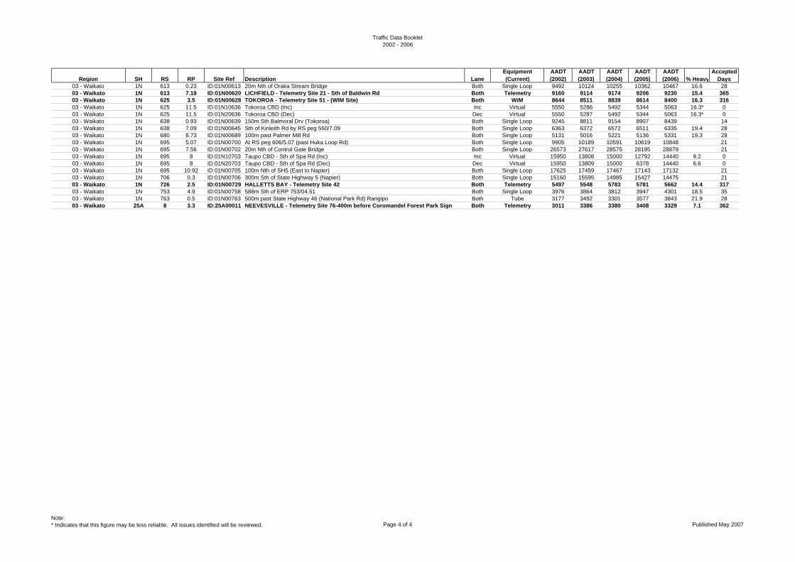
Traffic Data Booklet2002 - 2006
Region SH RS RP Site Ref Description LaneEquipment (Current)
AADT (2002)
AADT (2003)
AADT (2004)
AADT (2005)
AADT (2006) % Heavy
Accepted Days
03 - Waikato 1N 613 0.23 ID:01N00613 20m Nth of Oraka Stream Bridge Both Single Loop 9492 10124 10255 10362 10467 16.6 2803 - Waikato 1N 613 7.18 ID:01N00620 LICHFIELD - Telemetry Site 21 - Sth of Baldwin Rd Both Telemetry 9160 9114 9174 9206 9230 15.4 36503 - Waikato 1N 625 3.5 ID:01N00628 TOKOROA - Telemetry Site 51 - (WIM Site) Both WiM 8644 8511 8839 8614 8400 16.3 31603 - Waikato 1N 625 11.5 ID:01N10636 Tokoroa CBD (Inc) Inc Virtual 5550 5286 5492 5344 5063 16.3* 003 - Waikato 1N 625 11.5 ID:01N20636 Tokoroa CBD (Dec) Dec Virtual 5550 5287 5492 5344 5063 16.3* 003 - Waikato 1N 638 0.93 ID:01N00639 150m Sth Balmoral Drv (Tokoroa) Both Single Loop 9245 8811 9154 8907 8439 1403 - Waikato 1N 638 7.09 ID:01N00645 Sth of Kinleith Rd by RS peg 550/7.09 Both Single Loop 6363 6372 6572 6511 6335 19.4 2803 - Waikato 1N 680 8.73 ID:01N00689 100m past Palmer Mill Rd Both Single Loop 5131 5016 5221 5136 5331 19.3 2803 - Waikato 1N 695 5.07 ID:01N00700 At RS peg 606/5.07 (past Huka Loop Rd) Both Single Loop 9905 10189 10591 10619 10848 2103 - Waikato 1N 695 7.56 ID:01N00702 20m Nth of Control Gate Bridge Both Single Loop 26573 27617 28575 28195 28879 2103 - Waikato 1N 695 8 ID:01N10703 Taupo CBD - Sth of Spa Rd (Inc) Inc Virtual 15950 13808 15000 12792 14440 9.2 003 - Waikato 1N 695 8 ID:01N20703 Taupo CBD - Sth of Spa Rd (Dec) Dec Virtual 15950 13809 15000 6378 14440 6.6 003 - Waikato 1N 695 10.92 ID:01N00705 100m Nth of SH5 (East to Napier) Both Single Loop 17625 17459 17467 17143 17132 2103 - Waikato 1N 706 0.3 ID:01N00706 300m Sth of State Highway 5 (Napier) Both Single Loop 15160 15595 14985 15427 14475 2103 - Waikato 1N 726 2.5 ID:01N00729 HALLETTS BAY - Telemetry Site 42 Both Telemetry 5497 5548 5783 5781 5662 14.4 31703 - Waikato 1N 753 4.9 ID:01N00758 588m Sth of ERP 753/04.51 Both Single Loop 3976 3864 3812 3947 4301 18.5 3503 - Waikato 1N 763 0.5 ID:01N00763 500m past State Highway 46 (National Park Rd) Rangipo Both Tube 3177 3492 3301 3577 3843 21.9 2803 - Waikato 25A 8 3.3 ID:25A00011 NEEVESVILLE - Telemetry Site 76-400m before Coromandel Forest Park Sign Both Telemetry 3011 3386 3380 3408 3329 7.1 362
Note:* Indicates that this figure may be less reliable. All issues identified will be reviewed. Page 4 of 4 Published May 2007
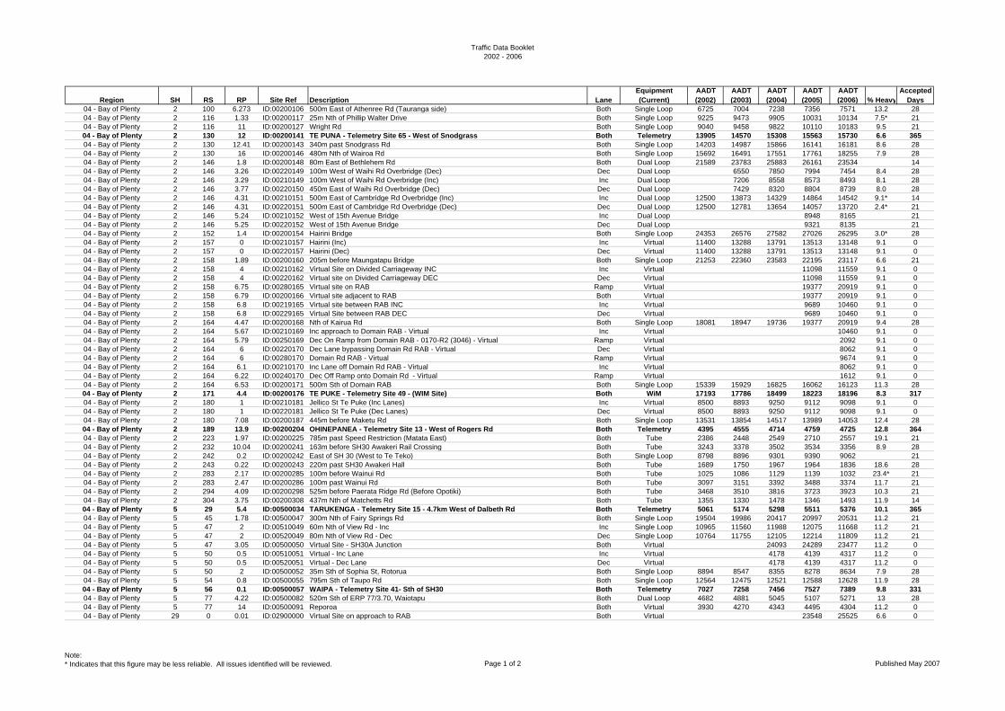
Traffic Data Booklet2002 - 2006
Region SH RS RP Site Ref Description LaneEquipment (Current)
AADT (2002)
AADT (2003)
AADT (2004)
AADT (2005)
AADT (2006) % Heavy
Accepted Days
04 - Bay of Plenty 2 100 6.273 ID:00200106 500m East of Athenree Rd (Tauranga side) Both Single Loop 6725 7004 7238 7356 7571 13.2 2804 - Bay of Plenty 2 116 1.33 ID:00200117 25m Nth of Phillip Walter Drive Both Single Loop 9225 9473 9905 10031 10134 7.5* 2104 - Bay of Plenty 2 116 11 ID:00200127 Wright Rd Both Single Loop 9040 9458 9822 10110 10183 9.5 2104 - Bay of Plenty 2 130 12 ID:00200141 TE PUNA - Telemetry Site 65 - West of Snodgrass Both Telemetry 13905 14570 15308 15563 15730 6.6 36504 - Bay of Plenty 2 130 12.41 ID:00200143 340m past Snodgrass Rd Both Single Loop 14203 14987 15866 16141 16181 8.6 2804 - Bay of Plenty 2 130 16 ID:00200146 480m Nth of Wairoa Rd Both Single Loop 15692 16491 17551 17761 18255 7.9 2804 - Bay of Plenty 2 146 1.8 ID:00200148 80m East of Bethlehem Rd Both Dual Loop 21589 23783 25883 26161 23534 1404 - Bay of Plenty 2 146 3.26 ID:00220149 100m West of Waihi Rd Overbridge (Dec) Dec Dual Loop 6550 7850 7994 7454 8.4 2804 - Bay of Plenty 2 146 3.29 ID:00210149 100m West of Waihi Rd Overbridge (Inc) Inc Dual Loop 7206 8558 8573 8493 8.1 2804 - Bay of Plenty 2 146 3.77 ID:00220150 450m East of Waihi Rd Overbridge (Dec) Dec Dual Loop 7429 8320 8804 8739 8.0 2804 - Bay of Plenty 2 146 4.31 ID:00210151 500m East of Cambridge Rd Overbridge (Inc) Inc Dual Loop 12500 13873 14329 14864 14542 9.1* 1404 - Bay of Plenty 2 146 4.31 ID:00220151 500m East of Cambridge Rd Overbridge (Dec) Dec Dual Loop 12500 12781 13654 14057 13720 2.4* 2104 - Bay of Plenty 2 146 5.24 ID:00210152 West of 15th Avenue Bridge Inc Dual Loop 8948 8165 2104 - Bay of Plenty 2 146 5.25 ID:00220152 West of 15th Avenue Bridge Dec Dual Loop 9321 8135 2104 - Bay of Plenty 2 152 1.4 ID:00200154 Hairini Bridge Both Single Loop 24353 26576 27582 27026 26295 3.0* 2804 - Bay of Plenty 2 157 0 ID:00210157 Hairini (Inc) Inc Virtual 11400 13288 13791 13513 13148 9.1 004 - Bay of Plenty 2 157 0 ID:00220157 Hairini (Dec) Dec Virtual 11400 13288 13791 13513 13148 9.1 004 - Bay of Plenty 2 158 1.89 ID:00200160 205m before Maungatapu Bridge Both Single Loop 21253 22360 23583 22195 23117 6.6 2104 - Bay of Plenty 2 158 4 ID:00210162 Virtual Site on Divided Carriageway INC Inc Virtual 11098 11559 9.1 004 - Bay of Plenty 2 158 4 ID:00220162 Virtual site on Divided Carriageway DEC Dec Virtual 11098 11559 9.1 004 - Bay of Plenty 2 158 6.75 ID:00280165 Virtual site on RAB Ramp Virtual 19377 20919 9.1 004 - Bay of Plenty 2 158 6.79 ID:00200166 Virtual site adjacent to RAB Both Virtual 19377 20919 9.1 004 - Bay of Plenty 2 158 6.8 ID:00219165 Virtual site between RAB INC Inc Virtual 9689 10460 9.1 004 - Bay of Plenty 2 158 6.8 ID:00229165 Virtual Site between RAB DEC Dec Virtual 9689 10460 9.1 004 - Bay of Plenty 2 164 4.47 ID:00200168 Nth of Kairua Rd Both Single Loop 18081 18947 19736 19377 20919 9.4 2804 - Bay of Plenty 2 164 5.67 ID:00210169 Inc approach to Domain RAB - Virtual Inc Virtual 10460 9.1 004 - Bay of Plenty 2 164 5.79 ID:00250169 Dec On Ramp from Domain RAB - 0170-R2 (3046) - Virtual Ramp Virtual 2092 9.1 004 - Bay of Plenty 2 164 6 ID:00220170 Dec Lane bypassing Domain Rd RAB - Virtual Dec Virtual 8062 9.1 004 - Bay of Plenty 2 164 6 ID:00280170 Domain Rd RAB - Virtual Ramp Virtual 9674 9.1 004 - Bay of Plenty 2 164 6.1 ID:00210170 Inc Lane off Domain Rd RAB - Virtual Inc Virtual 8062 9.1 004 - Bay of Plenty 2 164 6.22 ID:00240170 Dec Off Ramp onto Domain Rd - Virtual Ramp Virtual 1612 9.1 004 - Bay of Plenty 2 164 6.53 ID:00200171 500m Sth of Domain RAB Both Single Loop 15339 15929 16825 16062 16123 11.3 2804 - Bay of Plenty 2 171 4.4 ID:00200176 TE PUKE - Telemetry Site 49 - (WIM Site) Both WiM 17193 17786 18499 18223 18196 8.3 31704 - Bay of Plenty 2 180 1 ID:00210181 Jellico St Te Puke (Inc Lanes) Inc Virtual 8500 8893 9250 9112 9098 9.1 004 - Bay of Plenty 2 180 1 ID:00220181 Jellico St Te Puke (Dec Lanes) Dec Virtual 8500 8893 9250 9112 9098 9.1 004 - Bay of Plenty 2 180 7.08 ID:00200187 445m before Maketu Rd Both Single Loop 13531 13854 14517 13989 14053 12.4 2804 - Bay of Plenty 2 189 13.9 ID:00200204 OHINEPANEA - Telemetry Site 13 - West of Rogers Rd Both Telemetry 4395 4555 4714 4759 4725 12.8 36404 - Bay of Plenty 2 223 1.97 ID:00200225 785m past Speed Restriction (Matata East) Both Tube 2386 2448 2549 2710 2557 19.1 2104 - Bay of Plenty 2 232 10.04 ID:00200241 163m before SH30 Awakeri Rail Crossing Both Tube 3243 3378 3502 3534 3356 8.9 2804 - Bay of Plenty 2 242 0.2 ID:00200242 East of SH 30 (West to Te Teko) Both Single Loop 8798 8896 9301 9390 9062 2104 - Bay of Plenty 2 243 0.22 ID:00200243 220m past SH30 Awakeri Hall Both Tube 1689 1750 1967 1964 1836 18.6 2804 - Bay of Plenty 2 283 2.17 ID:00200285 100m before Wainui Rd Both Tube 1025 1086 1129 1139 1032 23.4* 2104 - Bay of Plenty 2 283 2.47 ID:00200286 100m past Wainui Rd Both Tube 3097 3151 3392 3488 3374 11.7 2104 - Bay of Plenty 2 294 4.09 ID:00200298 525m before Paerata Ridge Rd (Before Opotiki) Both Tube 3468 3510 3816 3723 3923 10.3 2104 - Bay of Plenty 2 304 3.75 ID:00200308 437m Nth of Matchetts Rd Both Tube 1355 1330 1478 1346 1493 11.9 1404 - Bay of Plenty 5 29 5.4 ID:00500034 TARUKENGA - Telemetry Site 15 - 4.7km West of Dalbeth Rd Both Telemetry 5061 5174 5298 5511 5376 10.1 36504 - Bay of Plenty 5 45 1.78 ID:00500047 300m Nth of Fairy Springs Rd Both Single Loop 19504 19986 20417 20997 20531 11.2 2104 - Bay of Plenty 5 47 2 ID:00510049 60m Nth of View Rd - Inc Inc Single Loop 10965 11560 11988 12075 11668 11.2 2104 - Bay of Plenty 5 47 2 ID:00520049 80m Nth of View Rd - Dec Dec Single Loop 10764 11755 12105 12214 11809 11.2 2104 - Bay of Plenty 5 47 3.05 ID:00500050 Virtual Site - SH30A Junction Both Virtual 24093 24289 23477 11.2 004 - Bay of Plenty 5 50 0.5 ID:00510051 Virtual - Inc Lane Inc Virtual 4178 4139 4317 11.2 004 - Bay of Plenty 5 50 0.5 ID:00520051 Virtual - Dec Lane Dec Virtual 4178 4139 4317 11.2 004 - Bay of Plenty 5 50 2 ID:00500052 35m Sth of Sophia St, Rotorua Both Single Loop 8894 8547 8355 8278 8634 7.9 2804 - Bay of Plenty 5 54 0.8 ID:00500055 795m Sth of Taupo Rd Both Single Loop 12564 12475 12521 12588 12628 11.9 2804 - Bay of Plenty 5 56 0.1 ID:00500057 WAIPA - Telemetry Site 41- Sth of SH30 Both Telemetry 7027 7258 7456 7527 7389 9.8 33104 - Bay of Plenty 5 77 4.22 ID:00500082 520m Sth of ERP 77/3.70, Waiotapu Both Dual Loop 4682 4881 5045 5107 5271 13 2804 - Bay of Plenty 5 77 14 ID:00500091 Reporoa Both Virtual 3930 4270 4343 4495 4304 11.2 004 - Bay of Plenty 29 0 0.01 ID:02900000 Virtual Site on approach to RAB Both Virtual 23548 25525 6.6 0
Note:* Indicates that this figure may be less reliable. All issues identified will be reviewed. Page 1 of 2 Published May 2007
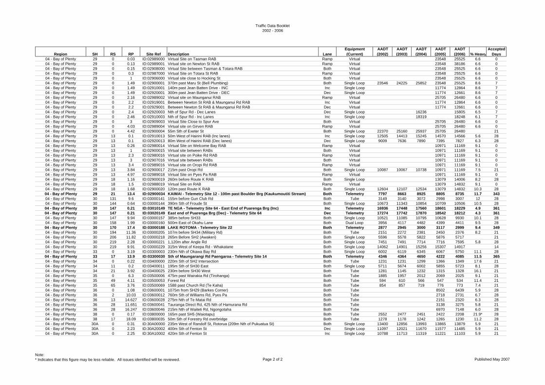
Traffic Data Booklet2002 - 2006
Region SH RS RP Site Ref Description LaneEquipment (Current)
AADT (2002)
AADT (2003)
AADT (2004)
AADT (2005)
AADT (2006) % Heavy
Accepted Days
04 - Bay of Plenty 29 0 0.03 ID:02989000 Virtual Site on Tasman RAB Ramp Virtual 23548 25525 6.6 004 - Bay of Plenty 29 0 0.13 ID:02989001 Virtual site on Newton St RAB Ramp Virtual 23548 38186 6.6 004 - Bay of Plenty 29 0 0.15 ID:02908000 Virtual Site between Tasman & Totara RAB Both Virtual 23548 25525 6.6 004 - Bay of Plenty 29 0 0.3 ID:02987000 Virtual Site on Totara St RAB Ramp Virtual 23548 25525 6.6 004 - Bay of Plenty 29 0 1 ID:02906000 Virtual site close to Hocking St Both Virtual 23548 25525 6.6 004 - Bay of Plenty 29 0 1.49 ID:02900001 370m past Maru St (Bell Plumbing) Both Single Loop 23546 24225 25852 23548 25525 8.6 704 - Bay of Plenty 29 0 1.49 ID:02910001 140m past Jean Batten Drive - INC Inc Single Loop 11774 12864 8.6 704 - Bay of Plenty 29 0 1.49 ID:02920001 300m past Jean Batten Drive - DEC Dec Single Loop 11774 12661 8.6 704 - Bay of Plenty 29 0 2.16 ID:02989002 Virtual site on Maunganui RAB Ramp Virtual 25705 26480 6.6 004 - Bay of Plenty 29 0 2.2 ID:02919001 Between Newton St RAB & Maunganui Rd RAB Inc Virtual 11774 12864 6.6 004 - Bay of Plenty 29 0 2.2 ID:02929001 Between Newton St RAB & Maunganui Rd RAB Dec Virtual 11774 12661 6.6 004 - Bay of Plenty 29 0 2.4 ID:02920003 Nth of Spur Rd - Dec Lanes Dec Single Loop 16236 15805 6.5 704 - Bay of Plenty 29 0 2.46 ID:02910003 Nth of Spur Rd - Inc Lanes Inc Single Loop 18319 18248 6.1 704 - Bay of Plenty 29 0 3 ID:02909003 Virtual Site Close to Spur Ave Both Virtual 25705 26480 6.6 004 - Bay of Plenty 29 0 4.03 ID:02989004 Virtual site on Girven RAB Ramp Virtual 25705 26480 6.6 004 - Bay of Plenty 29 0 4.42 ID:02900004 55m Sth of Exeter St Both Single Loop 22370 25160 25937 25705 26480 2104 - Bay of Plenty 29 13 0.1 ID:02910013 50m West of Hairini RAB (Inc lanes) Inc Single Loop 12505 14413 15245 14570 14566 5.6 2804 - Bay of Plenty 29 13 0.1 ID:02920013 80m West of Hairini RAB (Dec lanes) Dec Single Loop 9009 7636 7890 7395 7827 6.3 2804 - Bay of Plenty 29 13 0.26 ID:02980014 Virtual Site on Welcome Bay RAB Ramp Virtual 10971 11169 9.1 004 - Bay of Plenty 29 13 1 ID:02900015 Virtual site between RABs Both Virtual 10971 11169 9.1 004 - Bay of Plenty 29 13 2.3 ID:02980016 Virtual site on Poike Rd RAB Ramp Virtual 10971 11169 9.1 004 - Bay of Plenty 29 13 3 ID:02907016 Virtual site between RABs Both Virtual 10971 11169 9.1 004 - Bay of Plenty 29 13 3.4 ID:02989016 Virtual site on Oropi Rd RAB Ramp Virtual 10971 11169 9.1 004 - Bay of Plenty 29 13 3.84 ID:02900017 215m past Oropi Rd Both Single Loop 10087 10067 10738 10971 11169 7.5 2104 - Bay of Plenty 29 13 4.97 ID:02989018 Virtual Site on Pyes Pa RAB Ramp Virtual 10971 11169 9.1 004 - Bay of Plenty 29 18 1.16 ID:02900019 260m before Route K RAB Both Single Loop 13079 14006 8.2 2804 - Bay of Plenty 29 18 1.5 ID:02988019 Virtual Site on RAB Ramp Virtual 13079 14832 9.1 004 - Bay of Plenty 29 18 1.68 ID:02900020 120m past Route K RAB Both Single Loop 12604 12107 12534 13079 14832 10.3 2804 - Bay of Plenty 29 21 13.4 ID:02900034 KAIMAI - Telemetry Site 12 - 100m past Boulder Brg (Kaukumoutiti Stream) Both Telemetry 7797 8663 8925 8805 8735 11.7 34304 - Bay of Plenty 30 131 9.6 ID:03000141 155m before Gun Club Rd Both Tube 3149 3140 3072 2998 3007 12 2804 - Bay of Plenty 30 144 0.64 ID:03000144 390m Sth of Froude St Both Single Loop 10673 11343 10854 10709 10506 10.5 2804 - Bay of Plenty 30 147 0.21 ID:03010149 TE NGA - Telemetry Site 64 - East End of Puarenga Brg (Inc) Inc Telemetry 16936 17448 17560 18601 18229 4.9 36104 - Bay of Plenty 30 147 0.21 ID:03020149 East end of Puarenga Brg (Dec) - Telemetry Site 64 Dec Telemetry 17274 17742 17870 18542 18212 4.3 36104 - Bay of Plenty 30 147 9.94 ID:03000157 385m before SH33 Both Single Loop 10521 11085 10795 10628 9930 10.1 2804 - Bay of Plenty 30 158 1.99 ID:03000160 500m East of Okahu Lane Both Dual Loop 3956 4117 4482 4399 4411 9.5 2804 - Bay of Plenty 30 170 17.4 ID:03000188 LAKE ROTOMA - Telemetry Site 22 Both Telemetry 2877 2945 3000 3117 2999 9.4 34904 - Bay of Plenty 30 194 11.36 ID:03000205 107m before SH34 (Military Rd) Both Tube 2151 2272 2381 2450 2376 8.2 2104 - Bay of Plenty 30 206 11.82 ID:03000218 265m Before SH2 (Awakeri) Both Single Loop 5596 5578 5822 5876 5717 2104 - Bay of Plenty 30 219 2.28 ID:03000221 1,120m after Angle Rd Both Single Loop 7451 7491 7714 7716 7595 5.8 2804 - Bay of Plenty 30 219 9.91 ID:03000229 315m West of Keepa Rd - Whakatane Both Single Loop 14062 14901 15256 15307 14917 1404 - Bay of Plenty 33 0 3.19 ID:03300003 230m Nth of Okawa Bay Rd Both Single Loop 6002 6119 6345 6067 5750 11.1 2804 - Bay of Plenty 33 17 13.9 ID:03300030 Sth of Maungarangi Rd Paengaroa - Telemetry Site 14 Both Telemetry 4346 4364 4650 4222 4085 11.5 36504 - Bay of Plenty 34 0 0.22 ID:03400000 220m Sth of SH2 Intersection Both Tube 1231 1231 1299 1366 1349 17.6 2104 - Bay of Plenty 34 11 0.2 ID:03400011 195m Sth of SH30 East Both Single Loop 5711 5674 6002 5855 5723 8.1 2804 - Bay of Plenty 34 21 3.92 ID:03400025 230m before SH30 West Both Tube 1281 1145 1232 1315 1328 16.1 2104 - Bay of Plenty 35 0 6.3 ID:03500006 475m past Wairakia Rd (Tirohanga) Both Tube 1885 1957 2012 2069 2025 9.1 2104 - Bay of Plenty 35 49 4.11 ID:03500053 Forest Rd Both Tube 594 610 566 547 534 11.4 2104 - Bay of Plenty 35 65 3.76 ID:03500069 1588 past Church Rd (Te Kaha) Both Tube 854 857 719 776 773 7.4 2104 - Bay of Plenty 36 0 1.08 ID:03600001 1075m from SH29 (Barkes Corner) Both Tube 8502 6439 5.9 2804 - Bay of Plenty 36 2 10.03 ID:03600012 760m Sth of Williams Rd, Pyes Pa Both Tube 2718 2731 6.7 2804 - Bay of Plenty 36 13 14.627 ID:03600028 275m Nth of Te Matai Rd Both Tube 2151 2320 6.3 2804 - Bay of Plenty 36 28 11.651 ID:03600041 Tauranga Direct Rd, 425 Nth of Hamurana Rd Both Tube 3138 3275 5.8 2104 - Bay of Plenty 36 28 16.247 ID:03600046 215m Nth of Waiteti Rd, Ngongotaha Both Tube 6970 7148 6.0 2804 - Bay of Plenty 38 0 0.17 ID:03800000 165m past SH5 (Waiotapu) Both Tube 2552 2477 2451 2422 2208 21.9* 2804 - Bay of Plenty 38 17 18.09 ID:03800035 50m Sth of Forestry Rd overbridge Both Tube 1278 1178 1242 1265 1230 11.2 2804 - Bay of Plenty 30A 0 0.31 ID:30A00000 235m West of Randolf St, Rotorua (209m Nth of Pukuatua St) Both Single Loop 13400 12856 13993 13865 13879 5.9 2104 - Bay of Plenty 30A 0 2.23 ID:30A20002 400m Sth of Fenton St Dec Single Loop 11097 12021 11670 11577 11485 5.9 2104 - Bay of Plenty 30A 0 2.25 ID:30A10002 420m Sth of Fenton St Inc Single Loop 10788 11713 11319 11221 11103 5.9 21
Note:* Indicates that this figure may be less reliable. All issues identified will be reviewed. Page 2 of 2 Published May 2007
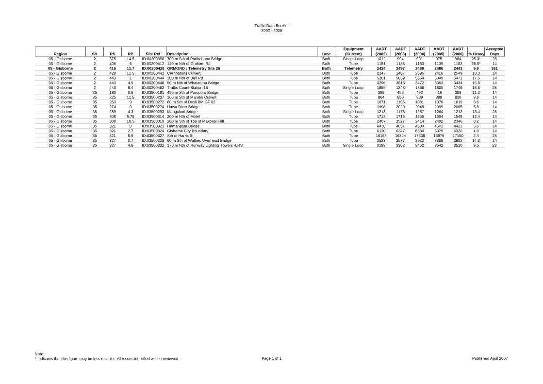
Traffic Data Booklet2002 - 2006
Region SH RS RP Site Ref Description LaneEquipment (Current)
AADT (2002)
AADT (2003)
AADT (2004)
AADT (2005)
AADT (2006) % Heavy
Accepted Days
05 - Gisborne 2 375 14.5 ID:00200390 700 m Sth of Parihohonu Bridge Both Single Loop 1012 994 991 975 964 25.3* 2805 - Gisborne 2 406 6 ID:00200412 140 m Nth of Graham Rd Both Tube 1151 1138 1153 1139 1183 26.5* 1405 - Gisborne 2 416 11.7 ID:00200428 ORMOND : Telemetry Site 26 Both Telemetry 2424 2497 2489 2486 2443 9.9 36105 - Gisborne 2 429 11.5 ID:00200441 Carringtons Culvert Both Tube 2247 2407 2596 2416 2549 13.3 1405 - Gisborne 2 443 1 ID:00200444 200 m Nth of Bell Rd Both Tube 5261 5639 5654 5349 5471 17.5 1405 - Gisborne 2 443 4.5 ID:00200448 50 m Nth of Whatatuna Bridge Both Tube 3296 3513 3472 3353 3434 15.8 1405 - Gisborne 2 443 9.4 ID:00200452 Traffic Count Station 15 Both Single Loop 1855 1848 1868 1800 1746 15.8 2805 - Gisborne 35 180 0.5 ID:03500181 450 m Sth of Poroporo Bridge Both Tube 389 456 492 416 388 11.3 1405 - Gisborne 35 225 11.5 ID:03500237 100 m Sth of Marotiri Culvert Both Tube 864 850 889 889 830 9.6 1405 - Gisborne 35 263 9 ID:03500272 60 m Sth of Dosli BM GF 82 Both Tube 1071 1105 1081 1070 1019 8.6 1405 - Gisborne 35 274 0 ID:03500274 Uawa River Bridge Both Tube 1998 2020 2048 2099 2065 5.8 1405 - Gisborne 35 289 4.3 ID:03500293 Mangakuri Bridge Both Single Loop 1213 1178 1287 1264 1212 13.4 2805 - Gisborne 35 308 5.75 ID:03500314 200 m Nth of Motel Both Tube 1713 1715 1666 1694 1548 12.4 1405 - Gisborne 35 308 10.5 ID:03500319 200 m Sth of Top of Makorori Hill Both Tube 2407 2527 2414 2492 2346 8.2 1405 - Gisborne 35 321 0 ID:03500321 Hamanatua Bridge Both Tube 4430 4651 4500 4501 4421 5.6 1405 - Gisborne 35 321 2.7 ID:03500324 Gisborne City Boundary Both Tube 6120 6347 6380 6379 6320 4.8 1405 - Gisborne 35 321 5.9 ID:03500327 Sth of Harris St Both Tube 16158 16324 17339 16979 17150 2.4 2805 - Gisborne 35 327 0.7 ID:03500328 60 m Sth of Watties Overhead Bridge Both Tube 3523 3577 3930 3889 3982 14.3 1405 - Gisborne 35 327 4.6 ID:03500332 170 m Nth of Runway Lighting Towers -LHS Both Single Loop 3193 3302 3452 3542 3510 9.5 28
Note:* Indicates that this figure may be less reliable. All issues identified will be reviewed. Page 1 of 1 Published April 2007
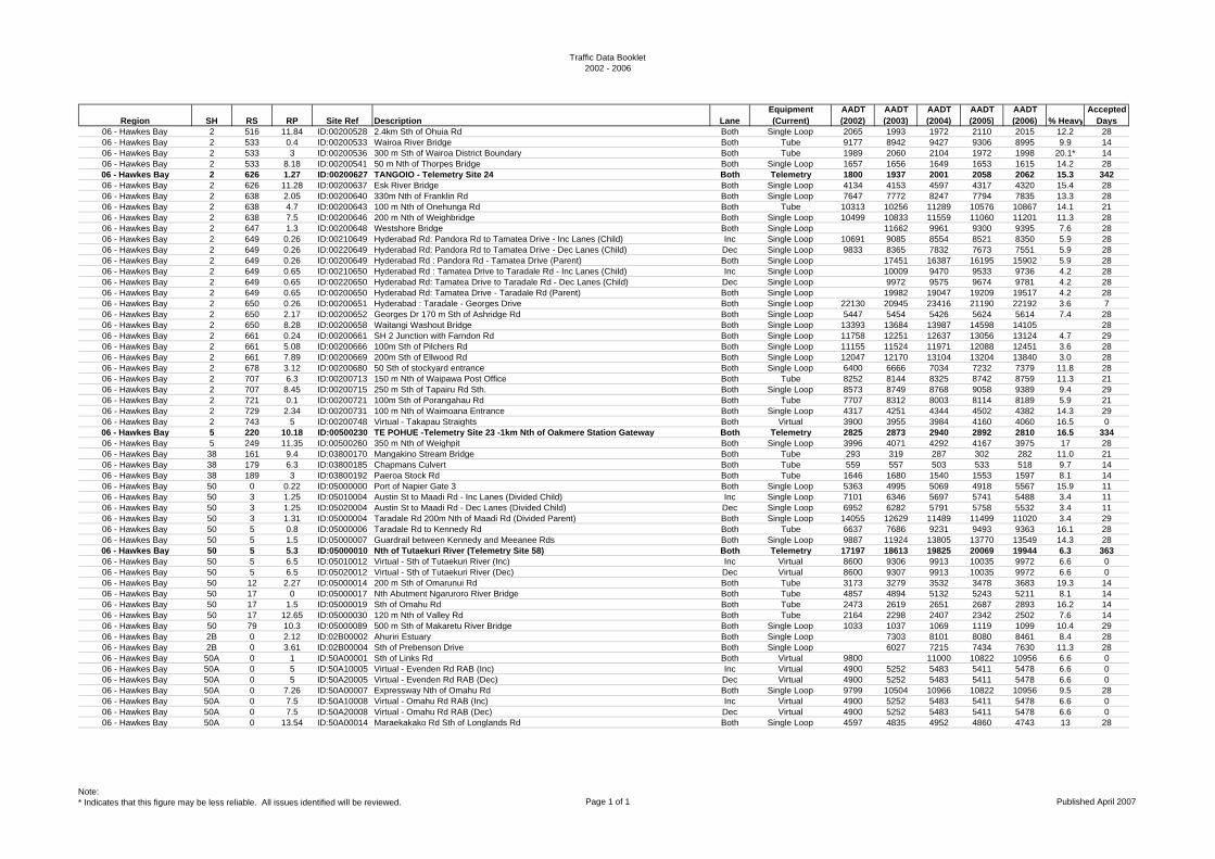
Traffic Data Booklet2002 - 2006
Region SH RS RP Site Ref Description LaneEquipment (Current)
AADT (2002)
AADT (2003)
AADT (2004)
AADT (2005)
AADT (2006) % Heavy
Accepted Days
06 - Hawkes Bay 2 516 11.84 ID:00200528 2.4km Sth of Ohuia Rd Both Single Loop 2065 1993 1972 2110 2015 12.2 2806 - Hawkes Bay 2 533 0.4 ID:00200533 Wairoa River Bridge Both Tube 9177 8942 9427 9306 8995 9.9 1406 - Hawkes Bay 2 533 3 ID:00200536 300 m Sth of Wairoa District Boundary Both Tube 1989 2060 2104 1972 1998 20.1* 1406 - Hawkes Bay 2 533 8.18 ID:00200541 50 m Nth of Thorpes Bridge Both Single Loop 1657 1656 1649 1653 1615 14.2 2806 - Hawkes Bay 2 626 1.27 ID:00200627 TANGOIO - Telemetry Site 24 Both Telemetry 1800 1937 2001 2058 2062 15.3 34206 - Hawkes Bay 2 626 11.28 ID:00200637 Esk River Bridge Both Single Loop 4134 4153 4597 4317 4320 15.4 2806 - Hawkes Bay 2 638 2.05 ID:00200640 330m Nth of Franklin Rd Both Single Loop 7647 7772 8247 7794 7835 13.3 2806 - Hawkes Bay 2 638 4.7 ID:00200643 100 m Nth of Onehunga Rd Both Tube 10313 10256 11289 10576 10867 14.1 2106 - Hawkes Bay 2 638 7.5 ID:00200646 200 m Nth of Weighbridge Both Single Loop 10499 10833 11559 11060 11201 11.3 2806 - Hawkes Bay 2 647 1.3 ID:00200648 Westshore Bridge Both Single Loop 11662 9961 9300 9395 7.6 2806 - Hawkes Bay 2 649 0.26 ID:00210649 Hyderabad Rd: Pandora Rd to Tamatea Drive - Inc Lanes (Child) Inc Single Loop 10691 9085 8554 8521 8350 5.9 2806 - Hawkes Bay 2 649 0.26 ID:00220649 Hyderabad Rd: Pandora Rd to Tamatea Drive - Dec Lanes (Child) Dec Single Loop 9833 8365 7832 7673 7551 5.9 2806 - Hawkes Bay 2 649 0.26 ID:00200649 Hyderabad Rd : Pandora Rd - Tamatea Drive (Parent) Both Single Loop 17451 16387 16195 15902 5.9 2806 - Hawkes Bay 2 649 0.65 ID:00210650 Hyderabad Rd : Tamatea Drive to Taradale Rd - Inc Lanes (Child) Inc Single Loop 10009 9470 9533 9736 4.2 2806 - Hawkes Bay 2 649 0.65 ID:00220650 Hyderabad Rd: Tamatea Drive to Taradale Rd - Dec Lanes (Child) Dec Single Loop 9972 9575 9674 9781 4.2 2806 - Hawkes Bay 2 649 0.65 ID:00200650 Hyderabad Rd: Tamatea Drive - Taradale Rd (Parent) Both Single Loop 19982 19047 19209 19517 4.2 2806 - Hawkes Bay 2 650 0.26 ID:00200651 Hyderabad : Taradale - Georges Drive Both Single Loop 22130 20945 23416 21190 22192 3.6 706 - Hawkes Bay 2 650 2.17 ID:00200652 Georges Dr 170 m Sth of Ashridge Rd Both Single Loop 5447 5454 5426 5624 5614 7.4 2806 - Hawkes Bay 2 650 8.28 ID:00200658 Waitangi Washout Bridge Both Single Loop 13393 13684 13987 14598 14105 2806 - Hawkes Bay 2 661 0.24 ID:00200661 SH 2 Junction with Farndon Rd Both Single Loop 11758 12251 12637 13056 13124 4.7 2906 - Hawkes Bay 2 661 5.08 ID:00200666 100m Sth of Pilchers Rd Both Single Loop 11155 11524 11971 12088 12451 3.6 2806 - Hawkes Bay 2 661 7.89 ID:00200669 200m Sth of Ellwood Rd Both Single Loop 12047 12170 13104 13204 13840 3.0 2806 - Hawkes Bay 2 678 3.12 ID:00200680 50 Sth of stockyard entrance Both Single Loop 6400 6666 7034 7232 7379 11.8 2806 - Hawkes Bay 2 707 6.3 ID:00200713 150 m Nth of Waipawa Post Office Both Tube 8252 8144 8325 8742 8759 11.3 2106 - Hawkes Bay 2 707 8.45 ID:00200715 250 m Sth of Tapairu Rd Sth. Both Single Loop 8573 8749 8768 9058 9389 9.4 2906 - Hawkes Bay 2 721 0.1 ID:00200721 100m Sth of Porangahau Rd Both Tube 7707 8312 8003 8114 8189 5.9 2106 - Hawkes Bay 2 729 2.34 ID:00200731 100 m Nth of Waimoana Entrance Both Single Loop 4317 4251 4344 4502 4382 14.3 2906 - Hawkes Bay 2 743 5 ID:00200748 Virtual - Takapau Straights Both Virtual 3900 3955 3984 4160 4060 16.5 006 - Hawkes Bay 5 220 10.18 ID:00500230 TE POHUE -Telemetry Site 23 -1km Nth of Oakmere Station Gateway Both Telemetry 2825 2873 2940 2892 2810 16.5 33406 - Hawkes Bay 5 249 11.35 ID:00500260 350 m Nth of Weighpit Both Single Loop 3996 4071 4292 4167 3975 17 2806 - Hawkes Bay 38 161 9.4 ID:03800170 Mangakino Stream Bridge Both Tube 293 319 287 302 282 11.0 2106 - Hawkes Bay 38 179 6.3 ID:03800185 Chapmans Culvert Both Tube 559 557 503 533 518 9.7 1406 - Hawkes Bay 38 189 3 ID:03800192 Paeroa Stock Rd Both Tube 1646 1680 1540 1553 1597 8.1 1406 - Hawkes Bay 50 0 0.22 ID:05000000 Port of Napier Gate 3 Both Single Loop 5363 4995 5069 4918 5567 15.9 1106 - Hawkes Bay 50 3 1.25 ID:05010004 Austin St to Maadi Rd - Inc Lanes (Divided Child) Inc Single Loop 7101 6346 5697 5741 5488 3.4 1106 - Hawkes Bay 50 3 1.25 ID:05020004 Austin St to Maadi Rd - Dec Lanes (Divided Child) Dec Single Loop 6952 6282 5791 5758 5532 3.4 1106 - Hawkes Bay 50 3 1.31 ID:05000004 Taradale Rd 200m Nth of Maadi Rd (Divided Parent) Both Single Loop 14055 12629 11489 11499 11020 3.4 2906 - Hawkes Bay 50 5 0.8 ID:05000006 Taradale Rd to Kennedy Rd Both Tube 6637 7686 9231 9493 9363 16.1 2806 - Hawkes Bay 50 5 1.5 ID:05000007 Guardrail between Kennedy and Meeanee Rds Both Single Loop 9887 11924 13805 13770 13549 14.3 2806 - Hawkes Bay 50 5 5.3 ID:05000010 Nth of Tutaekuri River (Telemetry Site 58) Both Telemetry 17197 18613 19825 20069 19944 6.3 36306 - Hawkes Bay 50 5 6.5 ID:05010012 Virtual - Sth of Tutaekuri River (Inc) Inc Virtual 8600 9306 9913 10035 9972 6.6 006 - Hawkes Bay 50 5 6.5 ID:05020012 Virtual - Sth of Tutaekuri River (Dec) Dec Virtual 8600 9307 9913 10035 9972 6.6 006 - Hawkes Bay 50 12 2.27 ID:05000014 200 m Sth of Omarunui Rd Both Tube 3173 3279 3532 3478 3683 19.3 1406 - Hawkes Bay 50 17 0 ID:05000017 Nth Abutment Ngaruroro River Bridge Both Tube 4857 4894 5132 5243 5211 8.1 1406 - Hawkes Bay 50 17 1.5 ID:05000019 Sth of Omahu Rd Both Tube 2473 2619 2651 2687 2893 16.2 1406 - Hawkes Bay 50 17 12.65 ID:05000030 120 m Nth of Valley Rd Both Tube 2164 2298 2407 2342 2502 7.6 1406 - Hawkes Bay 50 79 10.3 ID:05000089 500 m Sth of Makaretu River Bridge Both Single Loop 1033 1037 1069 1119 1099 10.4 2906 - Hawkes Bay 2B 0 2.12 ID:02B00002 Ahuriri Estuary Both Single Loop 7303 8101 8080 8461 8.4 2806 - Hawkes Bay 2B 0 3.61 ID:02B00004 Sth of Prebenson Drive Both Single Loop 6027 7215 7434 7630 11.3 2806 - Hawkes Bay 50A 0 1 ID:50A00001 Sth of Links Rd Both Virtual 9800 11000 10822 10956 6.6 006 - Hawkes Bay 50A 0 5 ID:50A10005 Virtual - Evenden Rd RAB (Inc) Inc Virtual 4900 5252 5483 5411 5478 6.6 006 - Hawkes Bay 50A 0 5 ID:50A20005 Virtual - Evenden Rd RAB (Dec) Dec Virtual 4900 5252 5483 5411 5478 6.6 006 - Hawkes Bay 50A 0 7.26 ID:50A00007 Expressway Nth of Omahu Rd Both Single Loop 9799 10504 10966 10822 10956 9.5 2806 - Hawkes Bay 50A 0 7.5 ID:50A10008 Virtual - Omahu Rd RAB (Inc) Inc Virtual 4900 5252 5483 5411 5478 6.6 006 - Hawkes Bay 50A 0 7.5 ID:50A20008 Virtual - Omahu Rd RAB (Dec) Dec Virtual 4900 5252 5483 5411 5478 6.6 006 - Hawkes Bay 50A 0 13.54 ID:50A00014 Maraekakako Rd Sth of Longlands Rd Both Single Loop 4597 4835 4952 4860 4743 13 28
Note:* Indicates that this figure may be less reliable. All issues identified will be reviewed. Page 1 of 1 Published April 2007
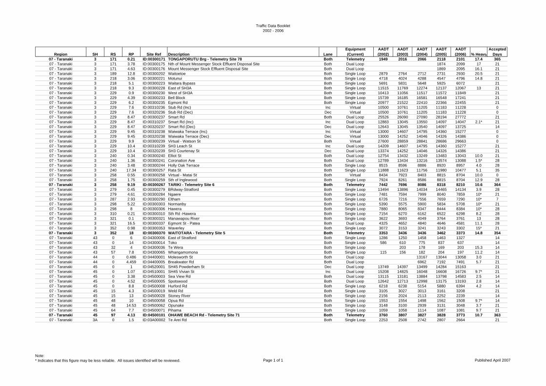
Traffic Data Booklet2002 - 2006
Region SH RS RP Site Ref Description LaneEquipment (Current)
AADT (2002)
AADT (2003)
AADT (2004)
AADT (2005)
AADT (2006) % Heavy
Accepted Days
07 - Taranaki 3 171 0.21 ID:00300171 TONGAPORUTU Brg - Telemetry Site 78 Both Telemetry 1949 2016 2066 2118 2101 17.4 36507 - Taranaki 3 171 3.78 ID:00300175 Nth of Mount Messenger Stock Effluent Disposal Site Both Dual Loop 1874 2099 17 2107 - Taranaki 3 171 4.63 ID:00300176 Mount Messenger Stock Effluent Disposal Site Both Dual Loop 1869 2095 16.1 2107 - Taranaki 3 189 12.8 ID:00300202 Waitoetoe Both Single Loop 2879 2764 2712 2731 2930 20.5 2107 - Taranaki 3 218 3.06 ID:00300221 Motunui Both Single Loop 4718 4024 4288 4547 4796 14.8 2107 - Taranaki 3 218 5.1 ID:00300223 Waitara Bypass Both Single Loop 5691 5831 5648 5925 6072 2107 - Taranaki 3 218 9.3 ID:00300228 East of SH3A Both Single Loop 11515 11769 12274 12137 12067 13 2107 - Taranaki 3 229 0.9 ID:00300230 West of SH3A Both Single Loop 10413 11056 11517 11572 11849 2107 - Taranaki 3 229 4.39 ID:00300233 Bell Block Both Single Loop 15739 16185 16581 16548 17241 2107 - Taranaki 3 229 6.2 ID:00300235 Egmont Rd Both Single Loop 20977 21522 22410 22366 22455 2107 - Taranaki 3 229 7.6 ID:00310236 Stub Rd (Inc) Inc Virtual 10500 10761 11205 11183 11228 007 - Taranaki 3 229 7.6 ID:00320236 Stub Rd (Dec) Dec Virtual 10500 10761 11205 11183 11228 007 - Taranaki 3 229 8.47 ID:00300237 Smart Rd Both Dual Loop 25526 26090 27090 28194 27772 2107 - Taranaki 3 229 8.47 ID:00310237 Smart Rd (Inc) Inc Dual Loop 12883 13045 13550 14097 14047 2.1* 2107 - Taranaki 3 229 8.47 ID:00320237 Smart Rd (Dec) Dec Dual Loop 12643 13045 13540 14097 13725 1407 - Taranaki 3 229 9.45 ID:00310238 Waiwaka Terrace (Inc) Inc Virtual 13000 14607 14795 14360 15277 007 - Taranaki 3 229 9.45 ID:00320238 Waiwaka Terrace (Dec) Dec Virtual 13000 14252 14046 14326 14386 007 - Taranaki 3 229 9.9 ID:00300239 Virtual - Watson St Both Virtual 27600 28859 28841 28686 29663 007 - Taranaki 3 229 10.4 ID:00310239 SH3 Leach St Inc Dual Loop 14209 14607 14795 14360 15277 2107 - Taranaki 3 229 10.4 ID:00320239 SH3 Courtenay St Dec Dual Loop 13374 14252 14046 14326 14386 2107 - Taranaki 3 240 0.34 ID:00300240 Elliot St Both Dual Loop 12754 13432 13249 13483 13043 10.0 2107 - Taranaki 3 240 1.36 ID:00300241 Coronation Ave Both Dual Loop 12789 13434 13216 13574 13088 1.5* 2807 - Taranaki 3 240 3.48 ID:00300244 Holly Oak Terrace Both Single Loop 8515 8596 8886 8920 8957 4.0 2807 - Taranaki 3 240 17.34 ID:00300257 Rata St Both Single Loop 11888 11623 11756 11980 10477 5.1 3507 - Taranaki 3 258 0.55 ID:00300258 Virtual - Matai St Both Virtual 8434 7923 8403 8815 8704 10.0 007 - Taranaki 3 258 1.75 ID:00300259 Sth of Inglewood Both Single Loop 7924 8261 8586 8815 8704 12.9 2807 - Taranaki 3 258 9.19 ID:00300267 TARIKI - Telemetry Site 6 Both Telemetry 7442 7696 8086 8318 8210 10.6 36407 - Taranaki 3 279 0.45 ID:00300279 BRdway-Stratford Both Single Loop 13494 13896 14034 14465 14134 3.9 2807 - Taranaki 3 279 4.61 ID:00300284 Ngaere Both Single Loop 7481 7594 7999 8040 7859 10* 2107 - Taranaki 3 287 2.93 ID:00300290 Eltham Both Single Loop 6726 7216 7556 7659 7290 10* 707 - Taranaki 3 298 5.22 ID:00300303 Normanby Both Single Loop 5390 5575 5900 5834 5708 10* 2107 - Taranaki 3 298 8 ID:00300306 Hawera Both Single Loop 7880 8065 8347 8444 8384 10* 2807 - Taranaki 3 310 0.21 ID:00300310 Sth Rd -Hawera Both Single Loop 7154 6270 6162 6522 6298 8.2 2807 - Taranaki 3 321 0.1 ID:00300321 Manawapou River Both Single Loop 3622 3693 4049 3764 3761 13 2807 - Taranaki 3 321 16.5 ID:00300337 Egmont St - Patea Both Dual Loop 4325 4652 4840 4646 4581 11.1 2807 - Taranaki 3 352 0.98 ID:00300353 Waverley Both Single Loop 3072 3153 3241 3243 3302 15* 2107 - Taranaki 3 352 18 ID:00300370 WAITOTARA - Telemetry Site 5 Both Telemetry 3353 3436 3436 3462 3373 14.8 35407 - Taranaki 43 0 6 ID:04300006 East of Stratford Both Single Loop 1286 1250 1458 1463 1327 1407 - Taranaki 43 0 14 ID:04300014 Toko Both Single Loop 586 610 775 837 637 1407 - Taranaki 43 32 4 ID:04300036 Te Wera Both Single Loop 203 178 169 203 15.3 1407 - Taranaki 43 57 7.8 ID:04300065 Whangamomona Both Single Loop 115 156 182 204 197 11.2 1407 - Taranaki 44 0 0.486 ID:04400001 Molesworth St Both Dual Loop 13167 13044 13058 3.0 2107 - Taranaki 44 0 4.459 ID:04400005 Breakwater Rd Both Dual Loop 6962 7192 7491 5.7 2107 - Taranaki 45 0 1 ID:04520001 SH45 Powderham St Dec Dual Loop 13749 14397 13499 14284 15163 2107 - Taranaki 45 0 1.07 ID:04510001 SH45 Vivian St Inc Dual Loop 15208 14825 16048 16608 16726 9.7* 2107 - Taranaki 45 0 3.38 ID:04500003 Sea View Rd Both Dual Loop 13115 13181 13884 13798 14583 2.5 1407 - Taranaki 45 0 4.52 ID:04500005 Spotswood Both Dual Loop 12642 12713 12998 13175 13193 2.8 1407 - Taranaki 45 0 8.8 ID:04500008 Hurford Rd Both Single Loop 6218 6238 5154 5880 6394 4.2 1407 - Taranaki 45 15 4.3 ID:04500019 Weld Rd Both Single Loop 3105 3027 3013 3161 3208 2107 - Taranaki 45 15 13 ID:04500028 Stoney River Both Single Loop 2156 2024 2113 2252 2239 1407 - Taranaki 45 48 10 ID:04500058 Opua Rd Both Single Loop 1553 1554 1498 1562 1508 9.7* 1407 - Taranaki 45 48 14.53 ID:04500062 Opunake Both Single Loop 3148 3100 2939 3131 3048 3.7 2107 - Taranaki 45 64 7.7 ID:04500071 Pihama Both Single Loop 1059 1058 1114 1087 1081 9.7 2107 - Taranaki 45 97 4.13 ID:04500101 OHAWE BEACH Rd - Telemetry Site 71 Both Telemetry 3760 3807 3827 3828 3773 10.7 36307 - Taranaki 3A 0 1.5 ID:03A00002 Te Arei Rd Both Single Loop 2253 2508 2742 2807 2664 21
Note:* Indicates that this figure may be less reliable. All issues identified will be reviewed. Page 1 of 1 Published April 2007
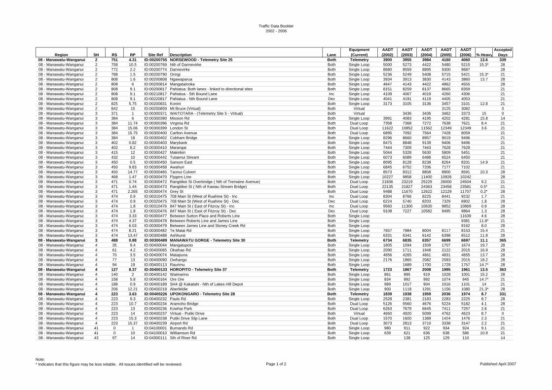
Traffic Data Booklet2002 - 2006
Region SH RS RP Site Ref Description LaneEquipment (Current)
AADT (2002)
AADT (2003)
AADT (2004)
AADT (2005)
AADT (2006) % Heavy
Accepted Days
08 - Manawatu-Wanganui 2 751 4.31 ID:00200755 NORSEWOOD - Telemetry Site 25 Both Telemetry 3900 3955 3984 4160 4060 13.6 33908 - Manawatu-Wanganui 2 758 10.5 ID:00200769 Nth of Dannevirke Both Single Loop 5000 5273 4422 5480 5215 15.3* 2808 - Manawatu-Wanganui 2 772 2.2 ID:00200774 Dannevirke Both Single Loop 8680 8559 8895 9300 9687 2808 - Manawatu-Wanganui 2 788 1.5 ID:00200790 Oringi Both Single Loop 5236 5249 5408 5715 5421 15.3* 2108 - Manawatu-Wanganui 2 808 1.6 ID:00200808 Ngawaparua Both Single Loop 3934 3913 3830 4143 3860 13.7 2808 - Manawatu-Wanganui 2 808 6 ID:00200814 Mangatainoka Both Single Loop 4647 4143 4422 4862 4555 2808 - Manawatu-Wanganui 2 808 9.1 ID:00200817 Pahiatua: Both lanes - linked to directional sites Both Single Loop 8151 8259 8137 8665 8359 2108 - Manawatu-Wanganui 2 808 9.1 ID:00210817 Pahiatua - Sth Bound Lane Inc Single Loop 4109 4067 4019 4260 4306 2108 - Manawatu-Wanganui 2 808 9.1 ID:00220817 Pahiatua - Nth Bound Lane Dec Single Loop 4041 4191 4119 4405 4053 2108 - Manawatu-Wanganui 2 825 5.75 ID:00200831 Konini Both Single Loop 3173 3105 3136 3457 3101 12.8 2108 - Manawatu-Wanganui 2 842 15 ID:00200859 Mt Bruce (Virtual) Both Virtual 3125 3082 008 - Manawatu-Wanganui 3 371 1 ID:00300371 WAITOTARA - (Telemetry Site 5 - Virtual) Both Virtual 3436 3436 3462 3373 15 008 - Manawatu-Wanganui 3 384 6 ID:00300390 Mission Rd Both Single Loop 3991 4083 4195 4202 4281 15.8 1408 - Manawatu-Wanganui 3 384 11.74 ID:00300396 Virginia Rd Both Dual Loop 7358 7368 7272 7638 7621 8.4 2108 - Manawatu-Wanganui 3 384 15.06 ID:00300399 London St Both Dual Loop 11622 10852 11562 12349 12349 3.6 2108 - Manawatu-Wanganui 3 384 15.75 ID:00300400 Carlton Avenue Both Dual Loop 6895 7092 7564 7428 8059 2108 - Manawatu-Wanganui 3 384 18 ID:00300402 Cobham Bridge Both Single Loop 8296 8660 8957 9019 9496 2108 - Manawatu-Wanganui 3 402 0.82 ID:00300403 Marybank Both Single Loop 8475 8848 9139 9406 9496 2108 - Manawatu-Wanganui 3 402 8.2 ID:00300410 Marangai Both Single Loop 7444 7309 7443 7628 7628 2108 - Manawatu-Wanganui 3 415 12 ID:00300427 Makirikiri Both Single Loop 5044 5328 5630 5809 5451 2108 - Manawatu-Wanganui 3 432 10 ID:00300442 Tutaenui Stream Both Single Loop 6073 6089 6488 6524 6450 2108 - Manawatu-Wanganui 3 450 0.5 ID:00300450 Sanson East Both Single Loop 8095 8128 8238 8264 8331 14.9 2108 - Manawatu-Wanganui 3 450 9.83 ID:00300458 Awahuri Both Single Loop 6845 6752 7206 7177 7102 2108 - Manawatu-Wanganui 3 450 14.77 ID:00300465 Taonui Culvert Both Single Loop 8573 8312 8858 8900 8591 10.3 2808 - Manawatu-Wanganui 3 468 1.47 ID:00300470 Flygers Line Both Single Loop 10227 9858 11400 10926 10242 2808 - Manawatu-Wanganui 3 471 0.74 ID:00300472 Rangitikei St Overbridge ( Nth of Tremaine Avenue) Both Dual Loop 21836 23219 25229 26000 24504 9.2 2108 - Manawatu-Wanganui 3 471 1.44 ID:00300473 Rangitikei St ( Nth of Kawau Stream Bridge) Both Dual Loop 22135 21827 24363 23458 23581 0.5* 2108 - Manawatu-Wanganui 3 471 2.265 ID:00300474 Grey St Both Dual Loop 9488 11670 12622 12129 11707 0.2* 2808 - Manawatu-Wanganui 3 474 0.9 ID:00310475 708 Main St (West of Ruahine St) - Inc Inc Dual Loop 8304 8766 8225 8441 9232 1.7 2108 - Manawatu-Wanganui 3 474 0.9 ID:00320475 708 Main St (West of Ruahine St) - Dec Dec Dual Loop 6224 5740 8203 7329 6902 1.8 2808 - Manawatu-Wanganui 3 474 1.8 ID:00310476 847 Main St ( East of Fitzroy St) - Inc Inc Dual Loop 9560 11300 10630 9852 10869 0.9 2808 - Manawatu-Wanganui 3 474 1.8 ID:00320476 847 Main St ( East of Fitzroy St) - Dec Dec Dual Loop 9108 7227 10582 9495 9864 1.3 2808 - Manawatu-Wanganui 3 474 3.33 ID:00300477 Between Sutton Place and Roberts Line Both Single Loop 11639 4.6 2808 - Manawatu-Wanganui 3 474 4.37 ID:00300478 Between Roberts Line and James Line Both Single Loop 9381 11.8* 2108 - Manawatu-Wanganui 3 474 6.03 ID:00300479 Between James Line and Stoney Creek Rd Both Single Loop 9162 8.0 2808 - Manawatu-Wanganui 3 474 8.21 ID:00300482 Te Matai Rd Both Single Loop 7657 7984 8004 8117 8153 15.4 2108 - Manawatu-Wanganui 3 474 13.47 ID:00300488 Ashhurst Both Single Loop 6331 6341 6142 6398 6512 11.8 2808 - Manawatu-Wanganui 3 488 0.88 ID:00300489 MANAWATU GORGE - Telemetry Site 30 Both Telemetry 6734 6835 6357 6699 6697 11.1 36508 - Manawatu-Wanganui 4 35 9.4 ID:00400044 Mangatupoto Both Single Loop 1805 1594 1509 1707 1674 19.7 2808 - Manawatu-Wanganui 4 61 4.2 ID:00400065 Okaihae Rd Both Single Loop 2090 1711 1948 2122 2015 16.9 2808 - Manawatu-Wanganui 4 70 3.5 ID:00400074 Matapuna Both Single Loop 4656 4265 4661 4831 4655 13.7 2808 - Manawatu-Wanganui 4 77 13 ID:00400090 Owhango Both Single Loop 2176 1865 2082 2093 2015 18.2 2808 - Manawatu-Wanganui 4 94 19 ID:00400113 Raurimu Both Single Loop 1689 1700 1729 1757 14.7* 2808 - Manawatu-Wanganui 4 127 8.37 ID:00400133 HOROPITO - Telemetry Site 37 Both Telemetry 1723 1867 2008 1995 1961 13.5 36308 - Manawatu-Wanganui 4 140 2 ID:00400142 Waimarino Both Single Loop 861 895 919 1028 1001 15.2 2808 - Manawatu-Wanganui 4 158 5.8 ID:00400164 Ore Ore Both Single Loop 834 892 992 1074 945 14.7* 2108 - Manawatu-Wanganui 4 188 0.9 ID:00400189 SH4 @ Kakatahi - Nth of Lakes Hill Depot Both Single Loop 989 1017 904 1016 1101 14 2108 - Manawatu-Wanganui 4 206 12.21 ID:00400218 Aberfeldie Both Single Loop 900 1118 1291 1156 1080 21.3* 2808 - Manawatu-Wanganui 4 223 3.63 ID:00400226 UPOKONGARO - Telemetry Site 28 Both Telemetry 1839 1938 1959 2036 1974 8.7 33108 - Manawatu-Wanganui 4 223 9.3 ID:00400232 Pauls Rd Both Single Loop 2528 2381 2183 2283 2225 8.7 2808 - Manawatu-Wanganui 4 223 10.7 ID:00400234 Aramoho Bridge Both Dual Loop 5126 5560 4676 5224 5182 4.1 2808 - Manawatu-Wanganui 4 223 13 ID:00400236 Kowhai Park Both Dual Loop 6263 7679 6645 7411 7257 2.6 2108 - Manawatu-Wanganui 4 223 14 ID:00400237 Virtual - Putiki Drive Both Virtual 4650 4920 5099 4762 4623 8.7 008 - Manawatu-Wanganui 4 223 15.3 ID:00400238 Putiki Drive Slip Lane Both Dual Loop 1570 1600 1389 1424 1476 2.3 2108 - Manawatu-Wanganui 4 223 15.37 ID:00400239 Airport Rd Both Dual Loop 3073 2813 3710 3338 3147 2.2 2108 - Manawatu-Wanganui 41 0 1 ID:04100001 Burnands Rd Both Single Loop 980 911 922 934 924 9.1 2108 - Manawatu-Wanganui 41 0 10 ID:04100010 Williamson Rd Both Single Loop 639 621 636 638 586 10.9 2108 - Manawatu-Wanganui 43 97 14 ID:04300111 Sth of River Rd Both Single Loop 138 125 129 110 14
Note:* Indicates that this figure may be less reliable. All issues identified will be reviewed. Page 1 of 2 Published April 2007
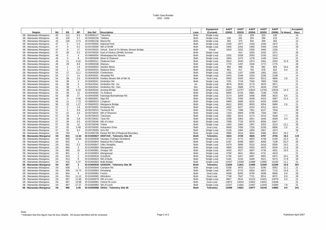
Traffic Data Booklet2002 - 2006
Region SH RS RP Site Ref Description LaneEquipment (Current)
AADT (2002)
AADT (2003)
AADT (2004)
AADT (2005)
AADT (2006) % Heavy
Accepted Days
08 - Manawatu-Wanganui 43 111 6.5 ID:04300117 Tokorima Both Single Loop 211 209 220 145 1408 - Manawatu-Wanganui 43 130 5.7 ID:04300136 TeMaire Both Single Loop 228 291 354 356 219 1408 - Manawatu-Wanganui 43 130 17.5 ID:04300148 Mania Rd Both Single Loop 363 370 504 499 363 1408 - Manawatu-Wanganui 47 0 0.2 ID:04700000 National Park Both Single Loop 2193 1977 2150 2200 1672 2108 - Manawatu-Wanganui 47 9 0.2 ID:04700009 Nth of SH48 Both Single Loop 1905 2252 2300 2400 1255 2808 - Manawatu-Wanganui 47 9 17 ID:04700025 Virtual - East of Te Whaiau Stream Bridge Both Virtual 1910 2252 2300 2400 1255 008 - Manawatu-Wanganui 47 26 0.2 ID:04700026 East of Otukou (SH46) Junction Both Single Loop 914 1625 1532 1071 2808 - Manawatu-Wanganui 48 0 4 ID:04800004 Whakapapa-Nui Stream Both Single Loop 2252 2039 2050 2150 1512 2108 - Manawatu-Wanganui 49 0 8 ID:04900008 West of Ohakune Both Single Loop 1904 1473 1278 1449 1244 2108 - Manawatu-Wanganui 49 11 0.32 ID:04900011 Ohakune East Both Single Loop 2912 2040 1874 2261 2334 21.9 2808 - Manawatu-Wanganui 49 29 8.9 ID:04900038 Waiouru Both Single Loop 1770 1497 1545 1772 1775 2808 - Manawatu-Wanganui 54 1 1.6 ID:05400003 Sandon Block Both Single Loop 860 898 766 892 809 19.4 2808 - Manawatu-Wanganui 54 1 14 ID:05400015 Waituna West Both Single Loop 861 917 762 878 823 8.4 2108 - Manawatu-Wanganui 54 17 11.1 ID:05400028 Cheltenham Both Single Loop 1192 1107 1069 1081 1051 2108 - Manawatu-Wanganui 54 17 14 ID:05400031 Almadale Rd Both Single Loop 2443 2348 2310 2336 2198 1408 - Manawatu-Wanganui 54 38 2.6 ID:05400039 Kiwitea Stream Nth of Nth St Both Dual Loop 4500 4330 4524 5513 4890 2.8 2108 - Manawatu-Wanganui 54 38 3 ID:05400041 Kimbolton Rd Both Single Loop 7291 7218 7540 7905 7636 2108 - Manawatu-Wanganui 54 38 3 ID:05410041 Kimbolton Rd - Inc Inc Single Loop 3676 3630 3770 3876 3871 2108 - Manawatu-Wanganui 54 38 3 ID:05420041 Kimbolton Rd - Dec Dec Single Loop 3614 3588 3770 4028 3765 2108 - Manawatu-Wanganui 54 38 6.19 ID:05400044 Aorangi Bridge Both Single Loop 13297 12757 13822 13763 13524 14.3 2108 - Manawatu-Wanganui 54 38 12 ID:05400050 Te Arakura Both Single Loop 6693 6734 6981 7248 7249 2108 - Manawatu-Wanganui 54 38 17 ID:05400055 Kairanga-Bunnythorpe Rd Both Single Loop 3174 3259 3466 3585 3616 6.9 2108 - Manawatu-Wanganui 56 0 0.48 ID:05600001 Ngui Rd Both Single Loop 3793 3780 3548 4010 4067 12.4 2108 - Manawatu-Wanganui 56 11 7.72 ID:05600019 Longburn Both Single Loop 5969 5686 6225 6333 6308 1408 - Manawatu-Wanganui 56 22 1.27 ID:05600023 Mangaone Bridge Both Single Loop 8412 9092 9003 9354 9484 2.6 2108 - Manawatu-Wanganui 57 0 1.8 ID:05700002 Kimberley Rd Both Single Loop 4302 4227 4153 4512 4414 2808 - Manawatu-Wanganui 57 0 9.6 ID:05700010 Tavistock Rd Both Single Loop 7734 7268 7561 8127 7918 2808 - Manawatu-Wanganui 57 21 2.6 ID:05700024 Nth of Shannon Both Single Loop 7103 6909 6780 7334 7087 2808 - Manawatu-Wanganui 57 26 7 ID:05700033 Tokomaru Both Single Loop 3382 3016 3174 3219 3328 7.7 2808 - Manawatu-Wanganui 57 36 5.8 ID:05700042 Tane Rd Both Single Loop 4198 4364 4321 4445 4569 9.4 2808 - Manawatu-Wanganui 57 36 9.5 ID:05700046 Nth of Linton Both Single Loop 7058 7729 8376 8056 8447 2108 - Manawatu-Wanganui 57 36 12 ID:05700048 Tiritea Both Single Loop 1943 1964 1957 2024 2013 12.1 2808 - Manawatu-Wanganui 57 50 0.48 ID:05700050 Aokautere Drive Both Dual Loop 6948 7456 7226 8109 6896 2.5 1008 - Manawatu-Wanganui 57 50 9.4 ID:05700059 Orrs Rd Both Single Loop 2135 1984 1800 2007 1974 2808 - Manawatu-Wanganui 1N 794 1 ID:01N00795 Desert Rd Sth of Regional Boundary Both Single Loop 3980 3416 3634 3485 3523 19.2 708 - Manawatu-Wanganui 1N 815 11.64 ID:01N00827 HIHITAHI - Telemetry Site 29 Both Telemetry 4424 4729 4826 4797 4755 19.2 11908 - Manawatu-Wanganui 1N 828 10.64 ID:01N00839 Hautapu (Taihape Deviation) Both Single Loop 4719 4772 4820 4758 5159 22.3 2108 - Manawatu-Wanganui 1N 842 1 ID:01N00843 Mataroa Rd (Taihape) Both Single Loop 6187 6498 6667 6569 7108 19.2* 2808 - Manawatu-Wanganui 1N 842 5.2 ID:01N00847 Utiku Straights Both Single Loop 5479 5689 5510 5418 5936 19.2 2108 - Manawatu-Wanganui 1N 865 0 ID:01N00865 Mangaweka Both Single Loop 4869 4653 5053 4876 5546 21.6 2808 - Manawatu-Wanganui 1N 865 16 ID:01N00881 Vinegar Hill Both Single Loop 4433 4527 4807 4739 4631 19.5 2108 - Manawatu-Wanganui 1N 901 3 ID:01N00904 Mangaraupi Both Single Loop 4793 4641 4854 4731 4619 2108 - Manawatu-Wanganui 1N 914 2 ID:01N00916 Greatford Both Single Loop 5736 5257 6087 5991 5972 19.1 2808 - Manawatu-Wanganui 1N 914 9 ID:01N00923 Nth of Bulls Both Single Loop 5182 5135 5449 5521 5373 17.8 2808 - Manawatu-Wanganui 1N 925 1.27 ID:01N00926 Bulls Bridge Both Single Loop 12447 12569 12888 12965 13193 11.1 2108 - Manawatu-Wanganui 1N 927 2 ID:01N00930 SANSON - Telemetry Site 38 Both Telemetry 11830 11841 11995 12300 12290 10.6 35708 - Manawatu-Wanganui 1N 939 1 ID:01N00940 Campion Rd Both Single Loop 5258 4975 5124 5290 5052 11.1 2108 - Manawatu-Wanganui 1N 939 14.72 ID:01N00954 Himatangi Both Single Loop 6875 6715 6933 6922 7115 15.8 2108 - Manawatu-Wanganui 1N 954 8 ID:01N00962 Foxton Both Dual Loop 9438 8593 8790 9338 8958 6.9 2808 - Manawatu-Wanganui 1N 954 11.12 ID:01N00965 Whirokino Both Dual Loop 7748 7947 7721 8514 8072 8.9 2808 - Manawatu-Wanganui 1N 967 11.66 ID:01N00979 Nth of Levin Both Single Loop 9837 9524 10124 10401 10079 6.3 2108 - Manawatu-Wanganui 1N 967 13.58 ID:01N00981 Oxford St Levin Both Dual Loop 13872 14044 14502 14931 14648 2108 - Manawatu-Wanganui 1N 967 17.27 ID:01N00984 Sth of Levin Both Single Loop 12157 11662 12467 12343 12085 7.8 2108 - Manawatu-Wanganui 1N 985 3.48 ID:01N00988 OHAU - Telemetry Site 56 Both Telemetry 14399 14831 14977 15145 14860 9.0 341
Note:* Indicates that this figure may be less reliable. All issues identified will be reviewed. Page 2 of 2 Published April 2007
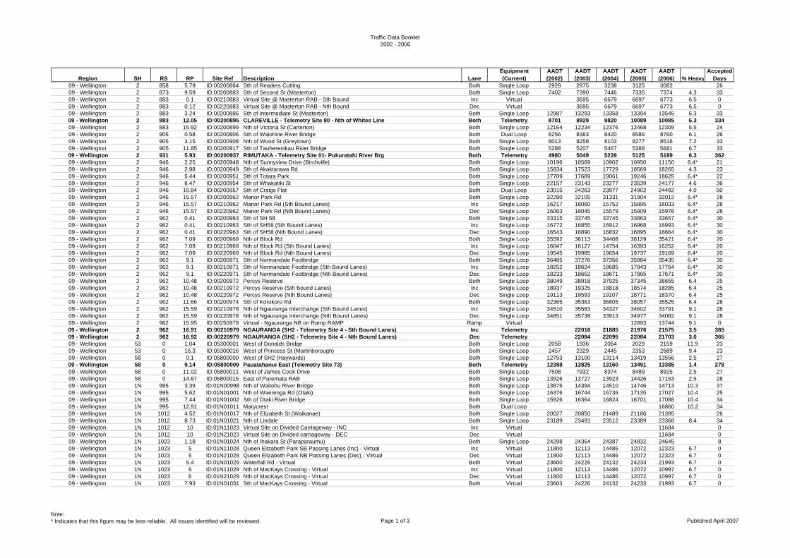
Traffic Data Booklet2002 - 2006
Region SH RS RP Site Ref Description LaneEquipment (Current)
AADT (2002)
AADT (2003)
AADT (2004)
AADT (2005)
AADT (2006) % Heavy
Accepted Days
09 - Wellington 2 858 5.79 ID:00200864 Sth of Readers Cutting Both Single Loop 2929 2975 3238 3125 3082 2609 - Wellington 2 873 9.59 ID:00200883 Sth of Second St (Masterton) Both Single Loop 7402 7390 7446 7335 7374 4.3 3309 - Wellington 2 883 0.1 ID:00210883 Virtual Site @ Masterton RAB - Sth Bound Inc Virtual 3695 6679 6697 6773 6.5 009 - Wellington 2 883 0.12 ID:00220883 Virtual Site @ Masterton RAB - Nth Bound Dec Virtual 3695 6679 6697 6773 6.5 009 - Wellington 2 883 3.24 ID:00200886 Sth of Intermediate St (Masterton) Both Single Loop 12987 13293 13358 13394 13545 6.3 3309 - Wellington 2 883 12.05 ID:00200895 CLAREVILLE - Telemetry Site 80 - Nth of Whites Line Both Telemetry 8701 8929 9820 10089 10085 6.3 33409 - Wellington 2 883 15.92 ID:00200899 Nth of Victoria St (Carterton) Both Single Loop 12164 12234 12376 12468 12309 5.5 2409 - Wellington 2 905 0.58 ID:00200906 Sth of Waiohine River Bridge Both Dual Loop 8256 8383 8420 8586 8760 6.1 2609 - Wellington 2 905 3.15 ID:00200908 Nth of Wood St (Greytown) Both Single Loop 8013 8258 8103 8277 8516 7.2 3309 - Wellington 2 905 11.85 ID:00200917 Sth of Tauherenikau River Bridge Both Single Loop 5288 5207 5467 5388 5681 6.7 3309 - Wellington 2 931 5.93 ID:00200937 RIMUTAKA - Telemetry Site 01- Pukuratahi River Brg Both Telemetry 4980 5049 5239 5125 5189 6.3 36209 - Wellington 2 946 2.25 ID:00200948 Nth of Sunnyview Drive (Birchville) Both Single Loop 10196 10569 10902 10950 11150 6.4* 2109 - Wellington 2 946 2.98 ID:00200949 Sth of Akaktarawa Rd Both Single Loop 15834 17523 17729 18569 18265 4.3 2309 - Wellington 2 946 5.44 ID:00200951 Sth of Totara Park Both Single Loop 17709 17689 19061 19246 18625 6.4* 2209 - Wellington 2 946 8.47 ID:00200954 Sth of Whakatiki St Both Single Loop 22157 23143 23277 23539 24177 4.6 3609 - Wellington 2 946 10.84 ID:00200957 Sth of Craigs Flat Both Dual Loop 23015 24263 23977 24902 24492 4.0 5009 - Wellington 2 946 15.57 ID:00200962 Manor Park Rd Both Single Loop 32280 32105 31331 31904 32012 6.4* 2809 - Wellington 2 946 15.57 ID:00210962 Manor Park Rd (Sth Bound Lanes) Inc Single Loop 16217 16060 15752 15995 16033 6.4* 2809 - Wellington 2 946 15.57 ID:00220962 Manor Park Rd (Nth Bound Lanes) Dec Single Loop 16063 16045 15579 15909 15978 6.4* 2809 - Wellington 2 962 0.41 ID:00200963 Sth of SH 58 Both Single Loop 33315 33745 33745 33863 33657 6.4* 3009 - Wellington 2 962 0.41 ID:00210963 Sth of SH58 (Sth Bound Lanes) Inc Single Loop 16772 16855 16912 16968 16993 6.4* 3009 - Wellington 2 962 0.41 ID:00220963 Sth of SH58 (Nth Bound Lanes) Dec Single Loop 16543 16890 16832 16895 16664 6.4* 3009 - Wellington 2 962 7.09 ID:00200969 Nth of Block Rd Both Single Loop 35592 36113 34408 36129 35421 6.4* 2009 - Wellington 2 962 7.09 ID:00210969 Nth of Block Rd (Sth Bound Lanes) Inc Single Loop 16047 16127 14754 16393 16252 6.4* 2009 - Wellington 2 962 7.09 ID:00220969 Nth of Block Rd (Nth Bound Lanes) Dec Single Loop 19545 19985 19654 19737 19169 6.4* 2009 - Wellington 2 962 9.1 ID:00200971 Sth of Normandale Footbridge Both Single Loop 36485 37276 37356 35984 35435 6.4* 3009 - Wellington 2 962 9.1 ID:00210971 Sth of Normandale Footbridge (Sth Bound Lanes) Inc Single Loop 18252 18624 18685 17843 17764 6.4* 3009 - Wellington 2 962 9.1 ID:00220971 Sth of Normandale Footbridge (Nth Bound Lanes) Dec Single Loop 18233 18652 18671 17865 17671 6.4* 3009 - Wellington 2 962 10.48 ID:00200972 Percys Reserve Both Single Loop 38049 38918 37925 37345 36655 6.4 2509 - Wellington 2 962 10.48 ID:00210972 Percys Reserve (Sth Bound Lanes) Inc Single Loop 18937 19325 18818 18574 18285 6.4 2509 - Wellington 2 962 10.48 ID:00220972 Percys Reserve (Nth Bound Lanes) Dec Single Loop 19113 19593 19107 18771 18370 6.4 2509 - Wellington 2 962 11.66 ID:00200974 Sth of Korokoro Rd Both Single Loop 32365 35363 36805 38057 35525 6.4 2809 - Wellington 2 962 15.59 ID:00210978 Nth of Ngauranga Interchange (Sth Bound Lanes) Inc Single Loop 34510 35583 34327 34602 33791 9.1 2809 - Wellington 2 962 15.59 ID:00220978 Nth of Ngauranga Interchange (Nth Bound Lanes) Dec Single Loop 34851 35738 33913 34977 34082 9.1 2809 - Wellington 2 962 15.95 ID:00250979 Virtual - Ngauranga NB on Ramp RAMP Ramp Virtual 12893 13744 9.1 009 - Wellington 2 962 16.91 ID:00210979 NGAURANGA (SH2 - Telemetry Site 4 - Sth Bound Lanes) Inc Telemetry 22016 21885 21976 21575 3.5 36509 - Wellington 2 962 16.92 ID:00220979 NGAURANGA (SH2 - Telemetry Site 4 - Nth Bound Lanes) Dec Telemetry 22084 22095 22084 21703 3.0 36509 - Wellington 53 0 1.04 ID:05300001 West of Donalds Bridge Both Single Loop 2058 1936 2064 2029 2159 11.9 2309 - Wellington 53 0 16.3 ID:05300016 West of Princess St (Martinborough) Both Single Loop 2457 2329 2445 2353 2689 9.4 2309 - Wellington 58 0 0.1 ID:05800000 West of SH2 (Haywards) Both Single Loop 12753 13100 13114 13419 13556 2.5 2709 - Wellington 58 0 9.14 ID:05800009 Pauatahanui East (Telemetry Site 73) Both Telemetry 12398 12825 13160 13491 13385 1.4 27809 - Wellington 58 0 11.02 ID:05800011 West of James Cook Drive Both Single Loop 7508 7932 8374 8489 8925 2.5 2709 - Wellington 58 0 14.67 ID:05800015 East of Paremata RAB Both Single Loop 13926 13727 13923 14426 17153 2.5 2809 - Wellington 1N 995 3.39 ID:01N00998 Nth of Waitohu River Bridge Both Single Loop 13875 14394 14510 14746 14713 10.3 3709 - Wellington 1N 995 5.62 ID:01N01001 Nth of Waerenga Rd (Otaki) Both Single Loop 16376 16744 16736 17135 17027 10.4 2509 - Wellington 1N 995 7.44 ID:01N01002 Sth of Otaki River Bridge Both Single Loop 15926 16364 16824 16701 17088 10.4 3409 - Wellington 1N 995 12.91 ID:01N01011 Marycrest Both Dual Loop 16860 10.2 3409 - Wellington 1N 1012 4.52 ID:01N01017 Nth of Elizabeth St (Waikanae) Both Single Loop 20027 20850 21489 21186 21395 2609 - Wellington 1N 1012 8.73 ID:01N01021 Nth of Lindale Both Single Loop 23189 23491 23512 23389 23368 8.4 3409 - Wellington 1N 1012 10 ID:01N11023 Virtual Site on Divided Carriageway - INC Inc Virtual 11684 009 - Wellington 1N 1012 10 ID:01N21023 Virtual Site on Divided carriageway - DEC Dec Virtual 11684 009 - Wellington 1N 1023 1.18 ID:01N01024 Nth of Ihakara St (Paraparaumu) Both Single Loop 24298 24364 24387 24832 24645 809 - Wellington 1N 1023 5 ID:01N11028 Queen Elizabeth Park SB Passing Lanes (Inc) - Virtual Inc Virtual 11800 12113 14486 12072 12323 6.7 009 - Wellington 1N 1023 5 ID:01N21028 Queen Elizabeth Park NB Passing Lanes (Dec) - Virtual Dec Virtual 11800 12113 14486 12072 12323 6.7 009 - Wellington 1N 1023 5.4 ID:01N01029 Waterfall Rd - Virtual Both Virtual 23600 24226 24132 24233 21993 6.7 009 - Wellington 1N 1023 6 ID:01N11029 Nth of MacKays Crossing - Virtual Inc Virtual 11800 12113 14486 12072 10997 6.7 009 - Wellington 1N 1023 6 ID:01N21029 Nth of MacKays Crossing - Virtual Dec Virtual 11800 12113 14486 12072 10997 6.7 009 - Wellington 1N 1023 7.93 ID:01N01031 Sth of MacKays Crossing - Virtual Both Virtual 23603 24226 24132 24233 21993 6.7 0
Note:* Indicates that this figure may be less reliable. All issues identified will be reviewed. Page 1 of 3 Published April 2007
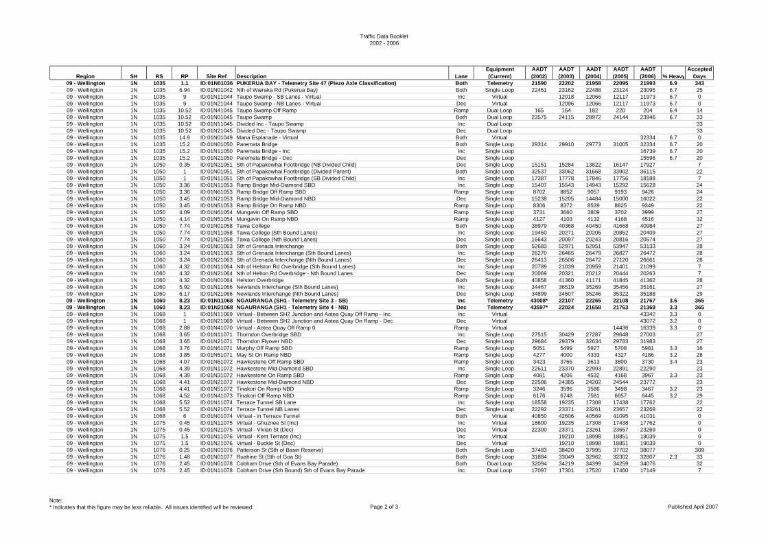
Traffic Data Booklet2002 - 2006
Region SH RS RP Site Ref Description LaneEquipment (Current)
AADT (2002)
AADT (2003)
AADT (2004)
AADT (2005)
AADT (2006) % Heavy
Accepted Days
09 - Wellington 1N 1035 1.1 ID:01N01036 PUKERUA BAY - Telemetry Site 47 (Piezo Axle Classification) Both Telemetry 21590 22202 21958 22095 21993 6.9 34309 - Wellington 1N 1035 6.94 ID:01N01042 Nth of Wairaka Rd (Pukerua Bay) Both Single Loop 22451 23162 22488 23124 23095 6.7 2509 - Wellington 1N 1035 9 ID:01N11044 Taupo Swamp - SB Lanes - Virtual Inc Virtual 12018 12066 12117 11973 6.7 009 - Wellington 1N 1035 9 ID:01N21044 Taupo Swamp - NB Lanes - Virtual Dec Virtual 12096 12066 12117 11973 6.7 009 - Wellington 1N 1035 10.52 ID:01N41045 Taupo Swamp Off Ramp Ramp Dual Loop 165 164 182 220 204 6.4 1409 - Wellington 1N 1035 10.52 ID:01N01045 Taupo Swamp Both Dual Loop 23575 24115 28972 24144 23946 6.7 3309 - Wellington 1N 1035 10.52 ID:01N11045 Divided Inc - Taupo Swamp Inc Dual Loop 3309 - Wellington 1N 1035 10.52 ID:01N21045 Divided Dec - Taupo Swamp Dec Dual Loop 3309 - Wellington 1N 1035 14.9 ID:01N01049 Mana Esplanade - Virtual Both Virtual 32334 6.7 009 - Wellington 1N 1035 15.2 ID:01N01050 Paremata Bridge Both Single Loop 29314 29910 29773 31005 32334 6.7 2009 - Wellington 1N 1035 15.2 ID:01N11050 Paremata Bridge - Inc Inc Single Loop 16739 6.7 2009 - Wellington 1N 1035 15.2 ID:01N21050 Paremata Bridge - Dec Dec Single Loop 15596 6.7 2009 - Wellington 1N 1050 0.35 ID:01N21051 Sth of Papakowhai Footbridge (NB Divided Child) Dec Single Loop 15151 15284 13822 16147 17927 709 - Wellington 1N 1050 1 ID:01N01051 Sth of Papakowhai Footbridge (Divided Parent) Both Single Loop 32537 33062 31668 33902 36115 2209 - Wellington 1N 1050 1 ID:01N11051 Sth of Papakowhai Footbridge (SB Divided Child) Inc Single Loop 17387 17778 17846 17756 18188 709 - Wellington 1N 1050 3.36 ID:01N11053 Ramp Bridge Mid-Diamond SBD Inc Single Loop 15407 15543 14943 15292 15628 2409 - Wellington 1N 1050 3.36 ID:01N61053 Ramp Bridge Off Ramp SBD Ramp Single Loop 8702 8852 9057 9193 9426 2409 - Wellington 1N 1050 3.45 ID:01N21053 Ramp Bridge Mid-Diamond NBD Dec Single Loop 15238 15205 14484 15000 16022 2209 - Wellington 1N 1050 3.45 ID:01N51053 Ramp Bridge On Ramp NBD Ramp Single Loop 8306 8372 8539 8825 9349 2209 - Wellington 1N 1050 4.09 ID:01N61054 Mungavin Off Ramp SBD Ramp Single Loop 3731 3660 3809 3702 3999 2709 - Wellington 1N 1050 4.14 ID:01N51054 Mungavin On Ramp NBD Ramp Single Loop 4127 4103 4132 4168 4516 3209 - Wellington 1N 1050 7.74 ID:01N01058 Tawa College Both Single Loop 38979 40368 40450 41668 40984 2709 - Wellington 1N 1050 7.74 ID:01N11058 Tawa College (Sth Bound Lanes) Inc Single Loop 19450 20271 20206 20852 20409 2709 - Wellington 1N 1050 7.74 ID:01N21058 Tawa College (Nth Bound Lanes) Dec Single Loop 16643 20097 20243 20816 20574 2709 - Wellington 1N 1060 3.24 ID:01N01063 Sth of Grenada Interchange Both Single Loop 52683 52971 52951 53947 53133 2809 - Wellington 1N 1060 3.24 ID:01N11063 Sth of Grenada Interchange (Sth Bound Lanes) Inc Single Loop 26270 26465 26479 26827 26472 2809 - Wellington 1N 1060 3.24 ID:01N21063 Sth of Grenada Interchange (Nth Bound Lanes) Dec Single Loop 26413 26506 26472 27120 26661 2809 - Wellington 1N 1060 4.32 ID:01N11064 Nth of Helston Rd Overbridge (Sth Bound Lanes) Inc Single Loop 20789 21039 20959 21401 21099 709 - Wellington 1N 1060 4.32 ID:01N21064 Nth of Helton Rd Overbridge - Nth Bound Lanes Dec Single Loop 20069 20321 20212 20444 20263 709 - Wellington 1N 1060 4.32 ID:01N01064 Helston Overbridge Both Single Loop 40858 41360 41171 41845 41362 2809 - Wellington 1N 1060 5.92 ID:01N11066 Newlands Interchange (Sth Bound Lanes) Inc Single Loop 34467 36519 35269 35456 35161 2709 - Wellington 1N 1060 6.17 ID:01N21066 Newlands Interchange (Nth Bound Lanes) Dec Single Loop 34899 34507 35246 35322 35188 2909 - Wellington 1N 1060 8.23 ID:01N11068 NGAURANGA (SH1 - Telemetry Site 3 - SB) Inc Telemetry 43008* 22107 22265 22108 21767 3.6 36509 - Wellington 1N 1060 8.23 ID:01N21068 NGAURANGA (SH1 - Telemetry Site 4 - NB) Dec Telemetry 43597* 22024 21658 21763 21369 3.3 36509 - Wellington 1N 1068 1 ID:01N11069 Virtual - Between SH2 Junction and Aotea Quay Off Ramp - Inc Inc Virtual 43342 3.3 009 - Wellington 1N 1068 1 ID:01N21069 Virtual - Between SH2 Junction and Aotea Quay On Ramp - Dec Dec Virtual 43072 3.2 009 - Wellington 1N 1068 2.88 ID:01N41070 Virtual - Aotea Quay Off Ramp 0 Ramp Virtual 14436 16339 3.3 009 - Wellington 1N 1068 3.65 ID:01N11071 Thorndon Overbridge SBD Inc Single Loop 27515 30429 27287 29648 27003 2709 - Wellington 1N 1068 3.65 ID:01N21071 Thorndon Flyover NBD Dec Single Loop 29684 29379 32634 29783 31983 2709 - Wellington 1N 1068 3.76 ID:01N61071 Murphy Off Ramp SBD Ramp Single Loop 5051 5499 5927 5708 5981 3.3 1609 - Wellington 1N 1068 3.85 ID:01N51071 May St On Ramp NBD Ramp Single Loop 4277 4000 4333 4327 4186 3.2 2809 - Wellington 1N 1068 4.07 ID:01N61072 Hawkestone Off Ramp SBD Ramp Single Loop 3423 3766 3613 3800 3730 3.4 2309 - Wellington 1N 1068 4.39 ID:01N11072 Hawkestone Mid-Diamond SBD Inc Single Loop 22611 23370 22993 22891 22290 2309 - Wellington 1N 1068 4.39 ID:01N31072 Hawkestone On Ramp SBD Ramp Single Loop 4081 4206 4532 4168 3967 3.3 2309 - Wellington 1N 1068 4.41 ID:01N21072 Hawkestone Mid-Diamond NBD Dec Single Loop 22506 24385 24202 24544 23772 2309 - Wellington 1N 1068 4.41 ID:01N51072 Tinakori On Ramp NBD Ramp Single Loop 3246 3596 3586 3498 3467 3.2 2309 - Wellington 1N 1068 4.52 ID:01N41073 Tinakori Off Ramp NBD Ramp Single Loop 6176 6748 7581 6657 6445 3.2 2909 - Wellington 1N 1068 5.52 ID:01N11074 Terrace Tunnel SB Lane Inc Single Loop 18558 19235 17308 17438 17762 2209 - Wellington 1N 1068 5.52 ID:01N21074 Terrace Tunnel NB Lanes Dec Single Loop 22292 23371 23261 23657 23269 2209 - Wellington 1N 1068 6 ID:01N01074 Virtual - in Terrace Tunnel Both Virtual 40850 42606 40569 41095 41031 009 - Wellington 1N 1075 0.45 ID:01N11075 Virtual - Ghuznee St (Inc) Inc Virtual 18600 19235 17308 17438 17762 009 - Wellington 1N 1075 0.45 ID:01N21075 Virtual - Vivian St (Dec) Dec Virtual 22300 23371 23261 23657 23269 009 - Wellington 1N 1075 1.5 ID:01N11076 Virtual - Kent Terrace (Inc) Inc Virtual 19210 18998 18851 19039 009 - Wellington 1N 1075 1.5 ID:01N21076 Virtual - Buckle St (Dec) Dec Virtual 19210 18998 18851 19039 009 - Wellington 1N 1076 0.25 ID:01N01076 Patterson St (Sth of Basin Reserve) Both Single Loop 37483 38420 37995 37702 38077 30909 - Wellington 1N 1076 1.48 ID:01N01077 Ruahine St (Sth of Goa St) Both Single Loop 31884 33049 32962 32302 32807 2.3 3309 - Wellington 1N 1076 2.45 ID:01N01078 Cobham Drive (Sth of Evans Bay Parade) Both Dual Loop 32094 34219 34399 34259 34076 3209 - Wellington 1N 1076 2.45 ID:01N11078 Cobham Drive (Sth Bound) Sth of Evans Bay Parade Inc Dual Loop 17097 17301 17520 17460 17149 7
Note:* Indicates that this figure may be less reliable. All issues identified will be reviewed. Page 2 of 3 Published April 2007
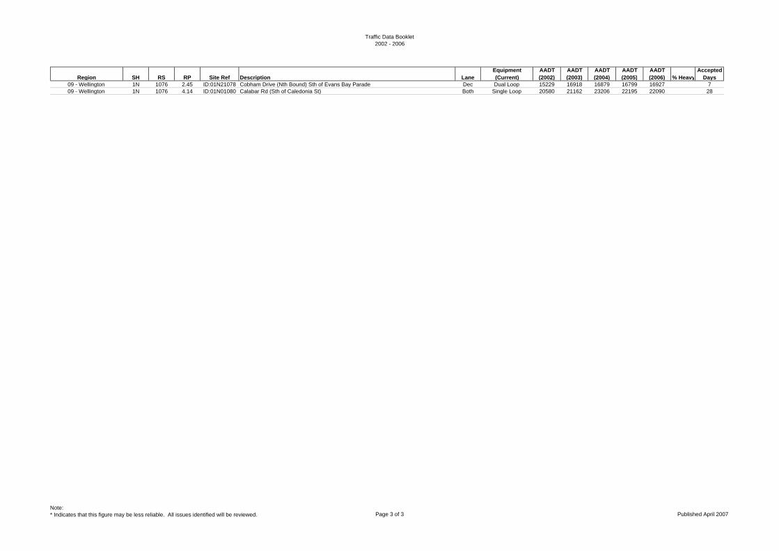
Traffic Data Booklet2002 - 2006
Region SH RS RP Site Ref Description LaneEquipment (Current)
AADT (2002)
AADT (2003)
AADT (2004)
AADT (2005)
AADT (2006) % Heavy
Accepted Days
09 - Wellington 1N 1076 2.45 ID:01N21078 Cobham Drive (Nth Bound) Sth of Evans Bay Parade Dec Dual Loop 15229 16918 16879 16799 16927 709 - Wellington 1N 1076 4.14 ID:01N01080 Calabar Rd (Sth of Caledonia St) Both Single Loop 20580 21162 23206 22195 22090 28
Note:* Indicates that this figure may be less reliable. All issues identified will be reviewed. Page 3 of 3 Published April 2007

Traffic Data Booklet2002 - 2006
Region SH RS RP Site Ref Description LaneEquipment (Current)
AADT (2002)
AADT (2003)
AADT (2004)
AADT (2005)
AADT (2006) % Heavy
Accepted Days
10 - Nelson/Marlborough 6 0 2.048 ID:00600002 Colman Rd (Blenheim West) Both Single Loop 10132 10858 10309 11440 11581 4.2 3510 - Nelson/Marlborough 6 0 9.227 ID:00600009 Godfrey Rd (Woodbourne) Both Single Loop 5985 6188 6535 6631 6728 7.4 3010 - Nelson/Marlborough 6 10 2.593 ID:00600013 Gibson Creek Both Tube 3965 3691 3808 3829 4123 11.6 3510 - Nelson/Marlborough 6 16 2.377 ID:00600018 Kaituna - Rock Falls sign Both Tube 2894 3355 3362 3345 3558 12.6 2910 - Nelson/Marlborough 6 34 6.043 ID:00600040 Havelock School - speed sign Both Single Loop 4060 3777 3676 3822 3999 12.4 3510 - Nelson/Marlborough 6 50 13.05 ID:00600063 Bulford at Twidle Culvert Both Tube 2351 2414 2499 2512 2617 16.7 33
10 - Nelson/Marlborough 6 99 1.25 ID:00600100 HIRA - Telemetry Site 36 Both Telemetry 3015 3172 3236 3235 3348 13.2 36210 - Nelson/Marlborough 6 99 13.095 ID:00600114 Nelson Nth - Atawhai Cemetry Both Single Loop 9897 10405 10539 10382 10425 7.0 3610 - Nelson/Marlborough 6 116 0.5 ID:00610118 Virtual - Sth of Haven Rd RAB (Inc) Inc Virtual 11260 10238 10350 10040 10524 5.9 010 - Nelson/Marlborough 6 116 0.5 ID:00620118 Virtual - Sth of Haven Rd RAB (Dec) Dec Virtual 11260 10239 10350 10040 10524 5.9 010 - Nelson/Marlborough 6 116 2.235 ID:00600118 Basin Reserve (Rocks Rd) Both Single Loop 22528 20477 20700 20080 21047 5.9 7
10 - Nelson/Marlborough 6 116 7.88 ID:00600122 STOKE - Telemetry Site 81 - Whakatu Drive at Songer St Both Telemetry 19575 20053 20225 20118 20440 5.8 33810 - Nelson/Marlborough 6 116 14.37 ID:00600130 Richmond 3 Bros (Humes) Both Single Loop 19247 19066 18881 18963 18898 6.1 3610 - Nelson/Marlborough 6 131 4.37 ID:00600135 Wairoa Rr (Burkes Bank) Both Single Loop 8802 9410 10388 10063 9696 6.5 3610 - Nelson/Marlborough 6 131 7.624 ID:00600138 Brightwater (Pitfure Bridge) Both Single Loop 6073 6433 6806 7350 7586 9.3 3610 - Nelson/Marlborough 6 131 13.82 ID:00600144 Eighty Eight Vly Stm bridge Both Tube 3647 3275 3576 3987 3637 11.3 4010 - Nelson/Marlborough 6 150 4.792 ID:00600153 Spooners Hill (Higgins Cul) Both Tube 2073 1868 1979 2143 2019 15.4 38
10 - Nelson/Marlborough 6 225 10.943 ID:00600232 MURCHISON - Telemetry Site 35 Both Telemetry 1654 1718 1758 1778 1787 12.2 34010 - Nelson/Marlborough 6 239 4.338 ID:00600242 Murchison Town Both Tube 2662 2469 2514 2523 2240 13.4 4010 - Nelson/Marlborough 6 239 10.167 ID:00600248 Murchison Dellows Bluff Both Tube 1639 1604 1963 1985 1761 15 2810 - Nelson/Marlborough 6 255 12.55 ID:00600268 Virtual - Nth of Region 10/12 Boundary Both Virtual 830 881 891 777 636 14.3 010 - Nelson/Marlborough 60 0 0.45 ID:06000000 Appleby Overbridge Both Single Loop 7985 8106 8148 8182 7689 7.2 3710 - Nelson/Marlborough 60 0 7.836 ID:06000008 Research Orchard Rd Both Single Loop 6774 7681 8017 7984 7864 6.0 3010 - Nelson/Marlborough 60 17 0.85 ID:06000018 Ruby Bay Both Tube 6888 6671 5.8 3410 - Nelson/Marlborough 60 33 1.163 ID:06000034 Motueka (Shell garage) Both Single Loop 12199 13032 13407 12831 14709 4.5 3610 - Nelson/Marlborough 60 33 3.575 ID:06000036 Motueka Nth (Bridge) Both Single Loop 6236 6634 6597 7373 6115 5.3 36
10 - Nelson/Marlborough 60 33 6.65 ID:06000040 SH60 Riwaka Telemetry Site 86 Both Telemetry 3545 3766 3689 5.9 36310 - Nelson/Marlborough 60 42 3.2 ID:06000044 Takaka Hill (Riwaka Valley Rd) Both Tube 1218 1266 1480 1257 12.7 2310 - Nelson/Marlborough 60 89 3.9 ID:06000091 Takaka (Reilly St) Both Tube 3535 3677 3397 3627 3373 3.8 4210 - Nelson/Marlborough 60 89 8.445 ID:06000096 Waitapu Bridge (Rangihaeata) Both Tube 1960 1946 1992 1922 6.3 3010 - Nelson/Marlborough 62 0 8.717 ID:06200009 Jefferies Rd to Jackson Rd Both Tube 1994 2400 2525 12.9 3010 - Nelson/Marlborough 63 0 0.232 ID:06300000 Renwick Brydon St Both Tube 2080 2296 2384 2443 2665 4.6 3410 - Nelson/Marlborough 63 0 3.653 ID:06300004 Waihopai Valley Rd Both Tube 2570 2501 2699 1810 8.8 2410 - Nelson/Marlborough 63 29 0 ID:06300029 Anderson Bridge Both Tube 566 601 692 782 677 13.4 4210 - Nelson/Marlborough 63 84 7.695 ID:06300091 St Arnaud Speed Signs Both Tube 535 548 535 616 631 11.7 3410 - Nelson/Marlborough 63 109 6.75 ID:06300116 Kawitiri Both Tube 314 308 265 314 321 16.2 2710 - Nelson/Marlborough 65 17 16.638 ID:06500034 Shenandoah Saddle Both Virtual 880 903 876 1021 1100 14.4 010 - Nelson/Marlborough 1S 0 0.639 ID:01S00001 Picton - Waitohi Bridge Both Single Loop 5562 5317 5135 5650 5959 4.7 3610 - Nelson/Marlborough 1S 0 6.682 ID:01S00007 Koromiko Both Single Loop 5099 5120 5430 5544 5610 13.9* 3510 - Nelson/Marlborough 1S 18 8.871 ID:01S00026 Opawa - Blenheim Nth Both Single Loop 8914 9485 9632 9709 10009 8.3 3610 - Nelson/Marlborough 1S 28 0.671 ID:01S00028 Park Terrace (Blenheim) Both Single Loop 9569 10430 9658 9251 10423 10.2 3610 - Nelson/Marlborough 1S 28 3.751 ID:01S00031 Riverlands (Blenheim Sth) Both Single Loop 5807 6083 6489 6467 5929 15.4 42
10 - Nelson/Marlborough 1S 28 9 ID:01S00037 Blenheim Telemetry Site 87 Both Telemetry 3533 3622 3791 12.3 32510 - Nelson/Marlborough 1S 43 5.202 ID:01S00049 Dashwood - Molesworth sign Both Tube 3040 3085 3386 3793 3774 15.9 4110 - Nelson/Marlborough 1S 73 16 ID:01S00089 Nth of Region 10/11 Boundary Both Virtual 2260 2315 2514 2491 2520 11.0 0
Note:* Indicates that this figure may be less reliable. All issues identified will be reviewed. Page 1 of 1 Published April 2007
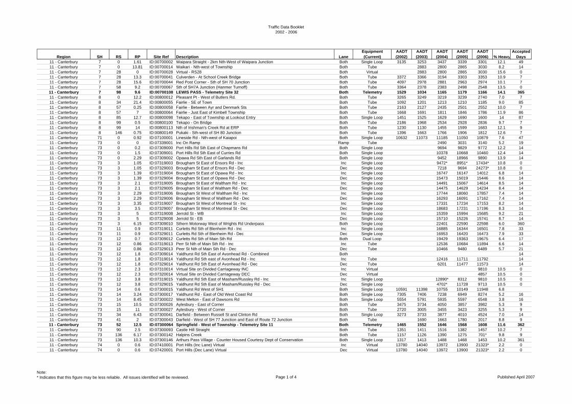
Traffic Data Booklet2002 - 2006
Region SH RS RP Site Ref Description LaneEquipment (Current)
AADT (2002)
AADT (2003)
AADT (2004)
AADT (2005)
AADT (2006) % Heavy
Accepted Days
11 - Canterbury 7 0 1.61 ID:00700002 Waipara Straight - 2km Nth-West of Waipara Junction Both Single Loop 3135 3253 3437 3339 3301 12.1 4911 - Canterbury 7 0 13.81 ID:00700014 Waikari - Nth-west of Township Both Tube 2883 2800 2865 3030 8.2 1411 - Canterbury 7 28 0 ID:00700028 Virtual - RS28 Both Virtual 2883 2800 2865 3030 15.6 011 - Canterbury 7 28 13.3 ID:00700041 Culverden - At School Creek Bridge Both Tube 3372 3366 3194 3303 3353 10.9 711 - Canterbury 7 28 15.6 ID:00700044 Red Post Corner - Sth of SH 70 Junction Both Tube 4097 2978 2881 2963 2974 10.1 711 - Canterbury 7 58 9.2 ID:00700067 Sth of SH7A Junction (Hanmer Turnoff) Both Tube 3364 2378 2383 2498 2548 13.5 011 - Canterbury 7 98 9.6 ID:00700108 LEWIS PASS - Telemetry Site 32 Both Telemetry 1529 1034 1165 1179 1166 14.1 36511 - Canterbury 8 0 12.2 ID:00800012 Pleasant Pt - West of Butlers Rd. Both Tube 3265 3249 3219 3239 2740 7.0 711 - Canterbury 8 34 21.4 ID:00800055 Fairlie - SE of Town Both Tube 1092 1201 1213 1210 1185 9.0 8511 - Canterbury 8 57 0.25 ID:00800058 Fairlie - Between Ayr and Denmark Sts Both Tube 2163 2127 2435 2501 2552 10.0 711 - Canterbury 8 57 7 ID:00800064 Fairlie - Just East of Kimbell Township Both Tube 1668 1691 1811 1846 1786 11.9 8611 - Canterbury 8 85 12.7 ID:00800098 Tekapo - East of Township at Lookout Entry Both Single Loop 1451 1525 1629 1690 1600 14 8711 - Canterbury 8 99 0.5 ID:00800100 Tekapo - On Bridge Both Tube 2186 1968 2534 2928 2836 9.7 711 - Canterbury 8 99 14 ID:00800113 Nth of Irishman's Creek Rd at ERP Both Tube 1230 1130 1455 1599 1683 12.1 911 - Canterbury 8 146 0.75 ID:00800149 Pukaki - Sth-west of SH 80 Junction Both Tube 1396 1663 1766 1906 1812 12.6 711 - Canterbury 71 0 0.92 ID:07100001 Lineside Rd - Nth-west of Kaiapoi Both Single Loop 10632 11073 11185 11050 10879 7.6 4711 - Canterbury 73 0 0 ID:07339001 Inc On Ramp Ramp Tube 2490 3031 3140 5.2 1911 - Canterbury 73 0 0.2 ID:07309000 Port Hills Rd Sth East of Chapmans Rd Both Single Loop 9694 9829 9772 12.2 1411 - Canterbury 73 0 1.5 ID:07309001 Port Hills Rd Sth East of Curries Rd Both Single Loop 10378 10668 10460 12.4 1411 - Canterbury 73 0 2.29 ID:07309002 Opawa Rd Sth East of Garlands Rd Both Single Loop 9452 18966 9890 13.9 1411 - Canterbury 73 3 1.05 ID:07319003 Brougham St East of Ensors Rd - Inc Inc Single Loop 9472* 8951* 17434* 10.8 011 - Canterbury 73 3 1.05 ID:07329003 Brougham St East of Ensors Rd - Dec Dec Single Loop 7218 9694 24273* 10.8 011 - Canterbury 73 3 1.39 ID:07319004 Brougham St East of Opawa Rd - Inc Inc Single Loop 16747 16147 14012 6.8 1411 - Canterbury 73 3 1.39 ID:07329004 Brougham St East of Opawa Rd - Dec Dec Single Loop 15473 15019 15446 8.6 1411 - Canterbury 73 3 2.1 ID:07319005 Brougham St East of Waltham Rd - Inc Inc Single Loop 14491 15067 14614 8.5 1411 - Canterbury 73 3 2.1 ID:07329005 Brougham St East of Waltham Rd - Dec Dec Single Loop 14475 14629 14234 8.4 1411 - Canterbury 73 3 2.29 ID:07319006 Brougham St West of Waltham Rd - Inc Inc Single Loop 17744 18060 17857 7.4 1411 - Canterbury 73 3 2.29 ID:07329006 Brougham St West of Waltham Rd - Dec Dec Single Loop 16293 16091 17162 7.4 1411 - Canterbury 73 3 3.35 ID:07319007 Brougham St West of Montreal St - Inc Inc Single Loop 17331 17234 17153 8.2 1411 - Canterbury 73 3 3.5 ID:07329007 Brougham St West of Montreal St - Dec Dec Single Loop 18683 17231 17196 8.3 1411 - Canterbury 73 3 5 ID:07319008 Jerrold St - WB Inc Single Loop 15359 15994 15685 9.2 2111 - Canterbury 73 3 5 ID:07329008 Jerrold St - EB Dec Single Loop 15710 15226 15741 8.7 1411 - Canterbury 73 3 6.15 ID:07309010 Sthern Motorway West of Wrights Rd Underpass Both Single Loop 22401 22590 22598 6.0 36011 - Canterbury 73 11 0.9 ID:07319011 Curletts Rd Sth of Blenheim Rd - Inc Inc Single Loop 16885 16344 16501 7.8 3311 - Canterbury 73 11 0.9 ID:07329011 Curletts Rd Sth of Blenheim Rd - Dec Dec Single Loop 16953 16420 16473 7.9 3311 - Canterbury 73 12 0.7 ID:07309012 Curletts Rd Sth of Main Sth Rd Both Dual Loop 19429 19363 19675 6.4 1711 - Canterbury 73 12 0.86 ID:07319013 Perr St Nth of Main Sth Rd - Inc Inc Tube 12536 10684 11894 6.6 1411 - Canterbury 73 12 0.86 ID:07329013 Peer St Nth of Main Sth Rd - Dec Dec Tube 10466 9480 6489 5.7 2111 - Canterbury 73 12 1.8 ID:07309014 Yaldhurst Rd Sth East of Avonhead Rd - Combined Both 1411 - Canterbury 73 12 1.8 ID:07319014 Yaldhurst Rd Sth east of Avonhead Rd - Inc Inc Tube 12416 11711 11792 1411 - Canterbury 73 12 1.8 ID:07329014 Yaldhurst Rd Sth East of Avonhead Rd - Dec Dec Tube 6201 11477 11573 1411 - Canterbury 73 12 2.3 ID:07310014 Virtual Site on Divided Carriageway INC Inc Virtual 9810 10.5 011 - Canterbury 73 12 2.3 ID:07320014 Virtual Site on Divided Carriageway DEC Dec Virtual 4857 10.5 011 - Canterbury 73 12 3.8 ID:07319015 Yaldhurst Rd Sth East of Masham/Russley Rd - Inc Inc Single Loop 12890* 8312 9810 10.5 011 - Canterbury 73 12 3.8 ID:07329015 Yaldhurst Rd Sth East of Masham/Russley Rd - Dec Dec Single Loop 4702* 11728 9713 10.5 011 - Canterbury 73 14 0.6 ID:07300015 Yaldhurst Rd West of SH1 Both Single Loop 10591 11398 10755 10149 11948 6.811 - Canterbury 73 14 3.24 ID:07300017 Yaldhurst Rd - East of Old West Coast Rd Both Single Loop 7305 7406 7238 6949 8274 5.2 1611 - Canterbury 73 14 8.45 ID:07300022 West Melton - East of Dawsons Rd Both Single Loop 5554 5791 5935 5597 6548 3.8 1611 - Canterbury 73 15 10.5 ID:07300026 Aylesbury - East of Corner Both Tube 3475 3734 4050 3857 3982 5.3 911 - Canterbury 73 15 11 ID:07300027 Aylesbury - West of Corner Both Tube 2720 3005 3455 3423 3255 5.3 911 - Canterbury 73 34 6.43 ID:07300041 Darfield - Between Russell St and Clinton Rd Both Single Loop 3273 3733 3877 4010 4524 7.0 1411 - Canterbury 73 41 2 ID:07300043 Darfield - West of SH 77 Junction and East of Route 72 Junction Both Tube 1690 1663 1780 2017 8.8 911 - Canterbury 73 52 12.5 ID:07300064 Springfield - West of Township - Telemetry Site 11 Both Telemetry 1465 1552 1646 1568 1608 11.6 36211 - Canterbury 73 90 2.5 ID:07300093 Castle Hill Straight Both Tube 1351 1411 1516 1382 1457 10.2 711 - Canterbury 73 136 6.17 ID:07300142 Halpins Creek Both Tube 1157 1126 1390 1275 701* 9.8 911 - Canterbury 73 136 10.3 ID:07300146 Arthurs Pass Village - Counter Housed Courtesy Dept of Conservation Both Single Loop 1317 1413 1488 1468 1453 10.2 36111 - Canterbury 74 0 0.6 ID:07410001 Port Hills (Inc Lane) Virtual Inc Virtual 13780 14040 13972 13900 21323* 2.2 011 - Canterbury 74 0 0.6 ID:07420001 Port Hills (Dec Lane) Virtual Dec Virtual 13780 14040 13972 13900 21323* 2.2 0
Note:* Indicates that this figure may be less reliable. All issues identified will be reviewed. Page 1 of 4 Published April 2007
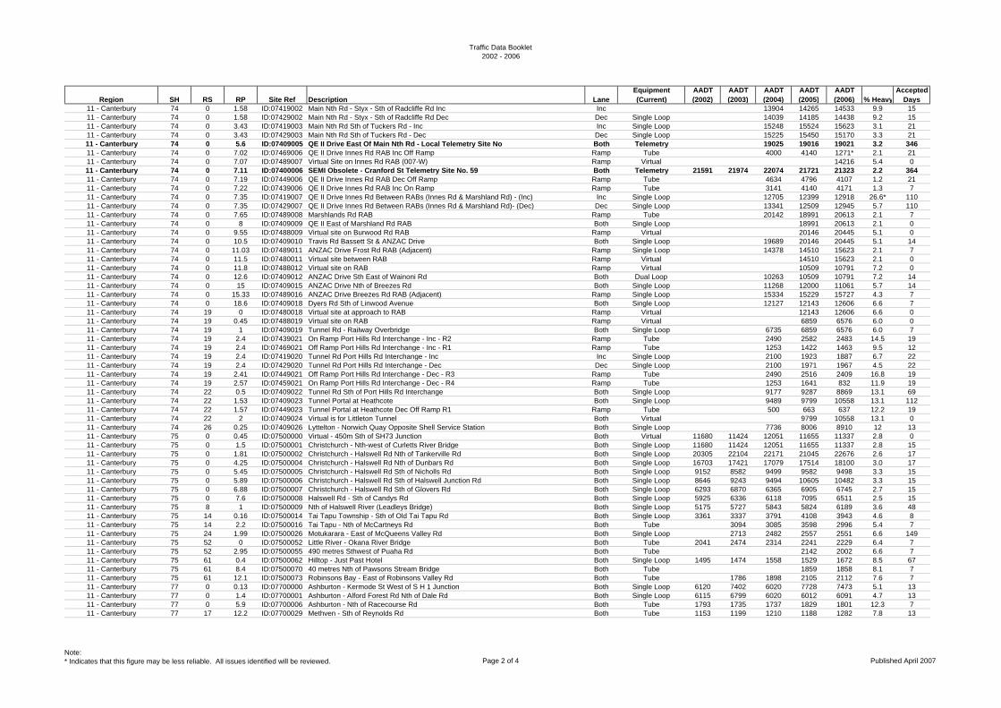
Traffic Data Booklet2002 - 2006
Region SH RS RP Site Ref Description LaneEquipment (Current)
AADT (2002)
AADT (2003)
AADT (2004)
AADT (2005)
AADT (2006) % Heavy
Accepted Days
11 - Canterbury 74 0 1.58 ID:07419002 Main Nth Rd - Styx - Sth of Radcliffe Rd Inc Inc 13904 14265 14533 9.9 1511 - Canterbury 74 0 1.58 ID:07429002 Main Nth Rd - Styx - Sth of Radcliffe Rd Dec Dec Single Loop 14039 14185 14438 9.2 1511 - Canterbury 74 0 3.43 ID:07419003 Main Nth Rd Sth of Tuckers Rd - Inc Inc Single Loop 15248 15524 15623 3.1 2111 - Canterbury 74 0 3.43 ID:07429003 Main Nth Rd Sth of Tuckers Rd - Dec Dec Single Loop 15225 15450 15170 3.3 2111 - Canterbury 74 0 5.6 ID:07409005 QE II Drive East Of Main Nth Rd - Local Telemetry Site No Both Telemetry 19025 19016 19021 3.2 34611 - Canterbury 74 0 7.02 ID:07469006 QE II Drive Innes Rd RAB Inc Off Ramp Ramp Tube 4000 4140 1271* 2.1 2111 - Canterbury 74 0 7.07 ID:07489007 Virtual Site on Innes Rd RAB (007-W) Ramp Virtual 14216 5.4 011 - Canterbury 74 0 7.11 ID:07400006 SEMI Obsolete - Cranford St Telemetry Site No. 59 Both Telemetry 21591 21974 22074 21721 21323 2.2 36411 - Canterbury 74 0 7.19 ID:07449006 QE II Drive Innes Rd RAB Dec Off Ramp Ramp Tube 4634 4796 4107 1.2 2111 - Canterbury 74 0 7.22 ID:07439006 QE II Drive Innes Rd RAB Inc On Ramp Ramp Tube 3141 4140 4171 1.3 711 - Canterbury 74 0 7.35 ID:07419007 QE II Drive Innes Rd Between RABs (Innes Rd & Marshland Rd) - (Inc) Inc Single Loop 12705 12399 12918 26.6* 11011 - Canterbury 74 0 7.35 ID:07429007 QE II Drive Innes Rd Between RABs (Innes Rd & Marshland Rd)- (Dec) Dec Single Loop 13341 12509 12945 5.7 11011 - Canterbury 74 0 7.65 ID:07489008 Marshlands Rd RAB Ramp Tube 20142 18991 20613 2.1 711 - Canterbury 74 0 8 ID:07409009 QE II East of Marshland Rd RAB Both Single Loop 18991 20613 2.1 011 - Canterbury 74 0 9.55 ID:07488009 Virtual site on Burwood Rd RAB Ramp Virtual 20146 20445 5.1 011 - Canterbury 74 0 10.5 ID:07409010 Travis Rd Bassett St & ANZAC Drive Both Single Loop 19689 20146 20445 5.1 1411 - Canterbury 74 0 11.03 ID:07489011 ANZAC Drive Frost Rd RAB (Adjacent) Ramp Single Loop 14378 14510 15623 2.1 711 - Canterbury 74 0 11.5 ID:07480011 Virtual site between RAB Ramp Virtual 14510 15623 2.1 011 - Canterbury 74 0 11.8 ID:07488012 Virtual site on RAB Ramp Virtual 10509 10791 7.2 011 - Canterbury 74 0 12.6 ID:07409012 ANZAC Drive Sth East of Wainoni Rd Both Dual Loop 10263 10509 10791 7.2 1411 - Canterbury 74 0 15 ID:07409015 ANZAC Drive Nth of Breezes Rd Both Single Loop 11268 12000 11061 5.7 1411 - Canterbury 74 0 15.33 ID:07489016 ANZAC Drive Breezes Rd RAB (Adjacent) Ramp Single Loop 15334 15229 15727 4.3 711 - Canterbury 74 0 18.6 ID:07409018 Dyers Rd Sth of Linwood Avenue Both Single Loop 12127 12143 12606 6.6 711 - Canterbury 74 19 0 ID:07480018 Virtual site at approach to RAB Ramp Virtual 12143 12606 6.6 011 - Canterbury 74 19 0.45 ID:07488019 Virtual site on RAB Ramp Virtual 6859 6576 6.0 011 - Canterbury 74 19 1 ID:07409019 Tunnel Rd - Railway Overbridge Both Single Loop 6735 6859 6576 6.0 711 - Canterbury 74 19 2.4 ID:07439021 On Ramp Port Hills Rd Interchange - Inc - R2 Ramp Tube 2490 2582 2483 14.5 1911 - Canterbury 74 19 2.4 ID:07469021 Off Ramp Port Hills Rd Interchange - Inc - R1 Ramp Tube 1253 1422 1463 9.5 1211 - Canterbury 74 19 2.4 ID:07419020 Tunnel Rd Port Hills Rd Interchange - Inc Inc Single Loop 2100 1923 1887 6.7 2211 - Canterbury 74 19 2.4 ID:07429020 Tunnel Rd Port Hills Rd Interchange - Dec Dec Single Loop 2100 1971 1967 4.5 2211 - Canterbury 74 19 2.41 ID:07449021 Off Ramp Port Hills Rd Interchange - Dec - R3 Ramp Tube 2490 2516 2409 16.8 1911 - Canterbury 74 19 2.57 ID:07459021 On Ramp Port Hills Rd Interchange - Dec - R4 Ramp Tube 1253 1641 832 11.9 1911 - Canterbury 74 22 0.5 ID:07409022 Tunnel Rd Sth of Port Hills Rd Interchange Both Single Loop 9177 9287 8869 13.1 6911 - Canterbury 74 22 1.53 ID:07409023 Tunnel Portal at Heathcote Both Single Loop 9489 9799 10558 13.1 11211 - Canterbury 74 22 1.57 ID:07449023 Tunnel Portal at Heathcote Dec Off Ramp R1 Ramp Tube 500 663 637 12.2 1911 - Canterbury 74 22 2 ID:07409024 Virtual is for Littleton Tunnel Both Virtual 9799 10558 13.1 011 - Canterbury 74 26 0.25 ID:07409026 Lyttelton - Norwich Quay Opposite Shell Service Station Both Single Loop 7736 8006 8910 12 1311 - Canterbury 75 0 0.45 ID:07500000 Virtual - 450m Sth of SH73 Junction Both Virtual 11680 11424 12051 11655 11337 2.8 011 - Canterbury 75 0 1.5 ID:07500001 Christchurch - Nth-west of Curletts River Bridge Both Single Loop 11680 11424 12051 11655 11337 2.8 1511 - Canterbury 75 0 1.81 ID:07500002 Christchurch - Halswell Rd Nth of Tankerville Rd Both Single Loop 20305 22104 22171 21045 22676 2.6 1711 - Canterbury 75 0 4.25 ID:07500004 Christchurch - Halswell Rd Nth of Dunbars Rd Both Single Loop 16703 17421 17079 17514 18100 3.0 1711 - Canterbury 75 0 5.45 ID:07500005 Christchurch - Halswell Rd Sth of Nicholls Rd Both Single Loop 9152 8582 9499 9582 9498 3.3 1511 - Canterbury 75 0 5.89 ID:07500006 Christchurch - Halswell Rd Sth of Halswell Junction Rd Both Single Loop 8646 9243 9494 10605 10482 3.3 1511 - Canterbury 75 0 6.88 ID:07500007 Christchurch - Halswell Rd Sth of Glovers Rd Both Single Loop 6293 6870 6365 6905 6745 2.7 1511 - Canterbury 75 0 7.6 ID:07500008 Halswell Rd - Sth of Candys Rd Both Single Loop 5925 6336 6118 7095 6511 2.5 1511 - Canterbury 75 8 1 ID:07500009 Nth of Halswell River (Leadleys Bridge) Both Single Loop 5175 5727 5843 5824 6189 3.6 4811 - Canterbury 75 14 0.16 ID:07500014 Tai Tapu Township - Sth of Old Tai Tapu Rd Both Single Loop 3361 3337 3791 4108 3943 4.6 811 - Canterbury 75 14 2.2 ID:07500016 Tai Tapu - Nth of McCartneys Rd Both Tube 3094 3085 3598 2996 5.4 711 - Canterbury 75 24 1.99 ID:07500026 Motukarara - East of McQueens Valley Rd Both Single Loop 2713 2482 2557 2551 6.6 14911 - Canterbury 75 52 0 ID:07500052 Little River - Okana River Bridge Both Tube 2041 2474 2314 2241 2229 6.4 711 - Canterbury 75 52 2.95 ID:07500055 490 metres Sthwest of Puaha Rd Both Tube 2142 2002 6.6 711 - Canterbury 75 61 0.4 ID:07500062 Hilltop - Just Past Hotel Both Single Loop 1495 1474 1558 1529 1672 8.5 6711 - Canterbury 75 61 8.4 ID:07500070 40 metres Nth of Pawsons Stream Bridge Both Tube 1859 1858 8.1 711 - Canterbury 75 61 12.1 ID:07500073 Robinsons Bay - East of Robinsons Valley Rd Both Tube 1786 1898 2105 2112 7.6 711 - Canterbury 77 0 0.13 ID:07700000 Ashburton - Kermode St West of S H 1 Junction Both Single Loop 6120 7402 6020 7728 7473 5.1 1311 - Canterbury 77 0 1.4 ID:07700001 Ashburton - Alford Forest Rd Nth of Dale Rd Both Single Loop 6115 6799 6020 6012 6091 4.7 1311 - Canterbury 77 0 5.9 ID:07700006 Ashburton - Nth of Racecourse Rd Both Tube 1793 1735 1737 1829 1801 12.3 711 - Canterbury 77 17 12.2 ID:07700029 Methven - Sth of Reynolds Rd Both Tube 1153 1199 1210 1188 1282 7.8 13
Note:* Indicates that this figure may be less reliable. All issues identified will be reviewed. Page 2 of 4 Published April 2007
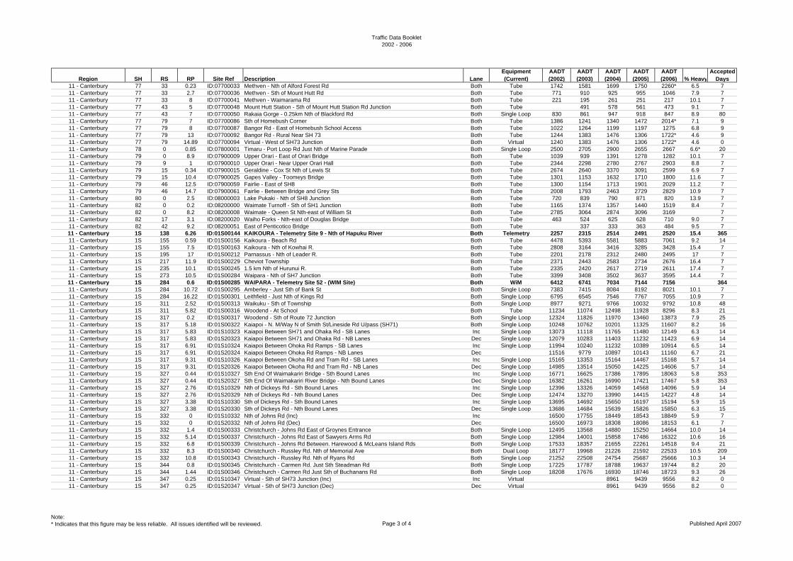
Traffic Data Booklet2002 - 2006
Region SH RS RP Site Ref Description LaneEquipment (Current)
AADT (2002)
AADT (2003)
AADT (2004)
AADT (2005)
AADT (2006) % Heavy
Accepted Days
11 - Canterbury 77 33 0.23 ID:07700033 Methven - Nth of Alford Forest Rd Both Tube 1742 1581 1699 1750 2260* 6.5 711 - Canterbury 77 33 2.7 ID:07700036 Methven - Sth of Mount Hutt Rd Both Tube 771 910 925 955 1046 7.9 711 - Canterbury 77 33 8 ID:07700041 Methven - Waimarama Rd Both Tube 221 195 261 251 217 10.1 711 - Canterbury 77 43 5 ID:07700048 Mount Hutt Station - Sth of Mount Hutt Station Rd Junction Both Tube 491 578 561 473 9.1 711 - Canterbury 77 43 7 ID:07700050 Rakaia Gorge - 0.25km Nth of Blackford Rd Both Single Loop 830 861 947 918 847 8.9 8011 - Canterbury 77 79 7 ID:07700086 Sth of Homebush Corner Both Tube 1386 1241 1340 1472 2014* 7.1 911 - Canterbury 77 79 8 ID:07700087 Bangor Rd - East of Homebush School Access Both Tube 1022 1264 1199 1197 1275 6.8 911 - Canterbury 77 79 13 ID:07700092 Bangor Rd - Rural Near SH 73 Both Tube 1244 1383 1476 1306 1722* 4.6 911 - Canterbury 77 79 14.89 ID:07700094 Virtual - West of SH73 Junction Both Virtual 1240 1383 1476 1306 1722* 4.6 011 - Canterbury 78 0 0.85 ID:07800001 Timaru - Port Loop Rd Just Nth of Marine Parade Both Single Loop 2500 2705 2900 2655 2667 6.6* 2011 - Canterbury 79 0 8.9 ID:07900009 Upper Orari - East of Orari Bridge Both Tube 1039 939 1391 1278 1282 10.1 711 - Canterbury 79 9 1 ID:07900010 Upper Orari - Near Upper Orari Hall Both Tube 2344 2298 2780 2767 2903 8.8 711 - Canterbury 79 15 0.34 ID:07900015 Geraldine - Cox St Nth of Lewis St Both Tube 2674 2640 3370 3091 2599 6.9 711 - Canterbury 79 15 10.4 ID:07900025 Gapes Valley - Toomeys Bridge Both Tube 1301 1153 1632 1710 1800 11.6 711 - Canterbury 79 46 12.5 ID:07900059 Fairlie - East of SH8 Both Tube 1300 1154 1713 1901 2029 11.2 711 - Canterbury 79 46 14.7 ID:07900061 Fairlie - Between Bridge and Grey Sts Both Tube 2008 1793 2463 2729 2829 10.9 711 - Canterbury 80 0 2.5 ID:08000003 Lake Pukaki - Nth of SH8 Junction Both Tube 720 839 790 871 820 13.9 711 - Canterbury 82 0 0.2 ID:08200000 Waimate Turnoff - Sth of SH1 Junction Both Tube 1165 1374 1357 1440 1519 8.4 711 - Canterbury 82 0 8.2 ID:08200008 Waimate - Queen St Nth-east of William St Both Tube 2785 3064 2874 3096 3169 711 - Canterbury 82 17 3.1 ID:08200020 Waiho Forks - Nth-east of Douglas Bridge Both Tube 463 524 625 628 710 9.0 711 - Canterbury 82 42 9.2 ID:08200051 East of Penticotico Bridge Both Tube 337 333 363 484 9.5 711 - Canterbury 1S 138 6.26 ID:01S00144 KAIKOURA - Telemetry Site 9 - Nth of Hapuku River Both Telemetry 2257 2315 2514 2491 2520 15.4 36511 - Canterbury 1S 155 0.59 ID:01S00156 Kaikoura - Beach Rd Both Tube 4478 5393 5581 5883 7061 9.2 1411 - Canterbury 1S 155 7.5 ID:01S00163 Kaikoura - Nth of Kowhai R. Both Tube 2808 3164 3416 3285 3428 15.4 711 - Canterbury 1S 195 17 ID:01S00212 Parnassus - Nth of Leader R. Both Tube 2201 2178 2312 2480 2495 17 711 - Canterbury 1S 217 11.9 ID:01S00229 Cheviot Township Both Tube 2371 2443 2583 2734 2676 16.4 711 - Canterbury 1S 235 10.1 ID:01S00245 1.5 km Nth of Hurunui R. Both Tube 2335 2420 2617 2719 2611 17.4 711 - Canterbury 1S 273 10.5 ID:01S00284 Waipara - Nth of SH7 Junction Both Tube 3399 3408 3502 3637 3595 14.4 711 - Canterbury 1S 284 0.6 ID:01S00285 WAIPARA - Telemetry Site 52 - (WIM Site) Both WiM 6412 6741 7034 7144 7156 36411 - Canterbury 1S 284 10.72 ID:01S00295 Amberley - Just Sth of Bank St Both Single Loop 7383 7415 8084 8192 8021 10.1 711 - Canterbury 1S 284 16.22 ID:01S00301 Leithfield - Just Nth of Kings Rd Both Single Loop 6795 6545 7546 7767 7055 10.9 711 - Canterbury 1S 311 2.52 ID:01S00313 Waikuku - Sth of Township Both Single Loop 8977 9271 9766 10032 9792 10.8 4811 - Canterbury 1S 311 5.82 ID:01S00316 Woodend - At School Both Tube 11234 11074 12498 11928 8296 8.3 2111 - Canterbury 1S 317 0.2 ID:01S00317 Woodend - Sth of Route 72 Junction Both Single Loop 12324 11826 11970 13460 13873 7.9 2511 - Canterbury 1S 317 5.18 ID:01S00322 Kaiapoi - N. M/Way N of Smith St/Lineside Rd U/pass (SH71) Both Single Loop 10248 10762 10201 11325 11607 8.2 1611 - Canterbury 1S 317 5.83 ID:01S10323 Kaiapoi Between SH71 and Ohaka Rd - SB Lanes Inc Single Loop 13073 11118 11765 11480 12149 6.3 1411 - Canterbury 1S 317 5.83 ID:01S20323 Kaiapoi Between SH71 and Ohaka Rd - NB Lanes Dec Single Loop 12079 10283 11403 11232 11423 6.9 1411 - Canterbury 1S 317 6.91 ID:01S10324 Kaiapoi Between Ohoka Rd Ramps - SB Lanes Inc Single Loop 11994 10240 11232 10389 10914 6.5 1411 - Canterbury 1S 317 6.91 ID:01S20324 Kaiapoi Between Ohoka Rd Ramps - NB Lanes Dec 11516 9779 10897 10143 11160 6.7 2111 - Canterbury 1S 317 9.31 ID:01S10326 Kaiapoi Between Okoha Rd and Tram Rd - SB Lanes Inc Single Loop 15165 13353 15164 14467 15168 5.7 1411 - Canterbury 1S 317 9.31 ID:01S20326 Kaiapoi Between Okoha Rd and Tram Rd - NB Lanes Dec Single Loop 14985 13514 15050 14225 14606 5.7 1411 - Canterbury 1S 327 0.44 ID:01S10327 Sth End Of Waimakariri Bridge - Sth Bound Lanes Inc Single Loop 16771 16625 17386 17895 18063 5.8 35311 - Canterbury 1S 327 0.44 ID:01S20327 Sth End Of Waimakariri River Bridge - Nth Bound Lanes Dec Single Loop 16382 16261 16990 17421 17467 5.8 35311 - Canterbury 1S 327 2.76 ID:01S10329 Nth of Dickeys Rd - Sth Bound Lanes Inc Single Loop 12396 13326 14059 14568 14096 5.9 1411 - Canterbury 1S 327 2.76 ID:01S20329 Nth of Dickeys Rd - Nth Bound Lanes Dec Single Loop 12474 13270 13990 14415 14227 4.8 1411 - Canterbury 1S 327 3.38 ID:01S10330 Sth of Dickeys Rd - Sth Bound Lanes Inc Single Loop 13695 14692 15650 16197 15194 5.9 1511 - Canterbury 1S 327 3.38 ID:01S20330 Sth of Dickeys Rd - Nth Bound Lanes Dec Single Loop 13686 14684 15639 15826 15850 6.3 1511 - Canterbury 1S 332 0 ID:01S10332 Nth of Johns Rd (Inc) Inc 16500 17755 18449 18543 18849 5.9 711 - Canterbury 1S 332 0 ID:01S20332 Nth of Johns Rd (Dec) Dec 16500 16973 18308 18086 18153 6.1 711 - Canterbury 1S 332 1.4 ID:01S00333 Christchurch - Johns Rd East of Groynes Entrance Both Single Loop 12495 13568 14880 15250 14664 10.0 1411 - Canterbury 1S 332 5.14 ID:01S00337 Christchurch - Johns Rd East of Sawyers Arms Rd Both Single Loop 12984 14001 15858 17486 16322 10.6 1611 - Canterbury 1S 332 6.8 ID:01S00339 Christchurch - Johns Rd Between. Harewood & McLeans Island Rds Both Single Loop 17533 18357 21655 22261 14518 9.4 2111 - Canterbury 1S 332 8.3 ID:01S00340 Christchurch - Russley Rd. Nth of Memorial Ave Both Dual Loop 18177 19968 21226 21592 22533 10.5 20911 - Canterbury 1S 332 10.8 ID:01S00343 Christchurch - Russley Rd. Nth of Ryans Rd Both Single Loop 21252 22508 24754 25687 25666 10.3 1411 - Canterbury 1S 344 0.8 ID:01S00345 Christchurch - Carmen Rd. Just Sth Steadman Rd Both Single Loop 17225 17787 18788 19637 19744 8.2 2011 - Canterbury 1S 344 1.44 ID:01S00346 Christchurch - Carmen Rd Just Sth of Buchanans Rd Both Single Loop 18208 17676 16930 18746 18723 9.3 2611 - Canterbury 1S 347 0.25 ID:01S10347 Virtual - Sth of SH73 Junction (Inc) Inc Virtual 8961 9439 9556 8.2 011 - Canterbury 1S 347 0.25 ID:01S20347 Virtual - Sth of SH73 Junction (Dec) Dec Virtual 8961 9439 9556 8.2 0
Note:* Indicates that this figure may be less reliable. All issues identified will be reviewed. Page 3 of 4 Published April 2007
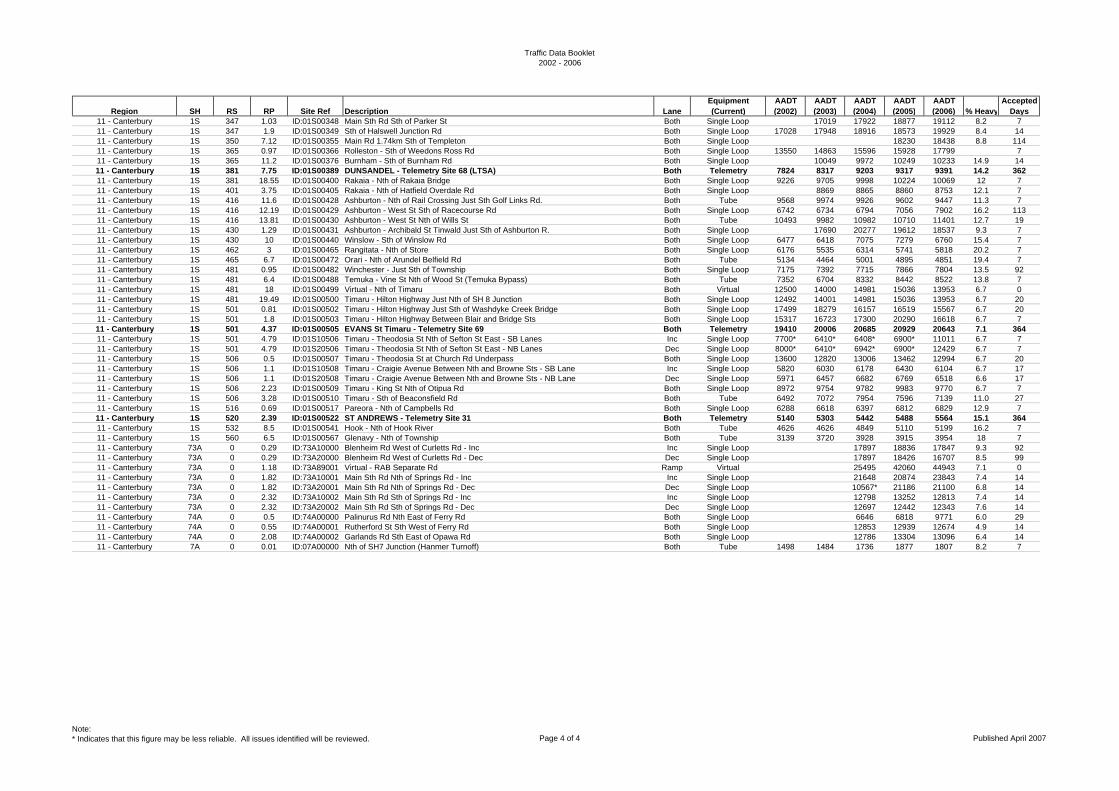
Traffic Data Booklet2002 - 2006
Region SH RS RP Site Ref Description LaneEquipment (Current)
AADT (2002)
AADT (2003)
AADT (2004)
AADT (2005)
AADT (2006) % Heavy
Accepted Days
11 - Canterbury 1S 347 1.03 ID:01S00348 Main Sth Rd Sth of Parker St Both Single Loop 17019 17922 18877 19112 8.2 711 - Canterbury 1S 347 1.9 ID:01S00349 Sth of Halswell Junction Rd Both Single Loop 17028 17948 18916 18573 19929 8.4 1411 - Canterbury 1S 350 7.12 ID:01S00355 Main Rd 1.74km Sth of Templeton Both Single Loop 18230 18438 8.8 11411 - Canterbury 1S 365 0.97 ID:01S00366 Rolleston - Sth of Weedons Ross Rd Both Single Loop 13550 14863 15596 15928 17799 711 - Canterbury 1S 365 11.2 ID:01S00376 Burnham - Sth of Burnham Rd Both Single Loop 10049 9972 10249 10233 14.9 1411 - Canterbury 1S 381 7.75 ID:01S00389 DUNSANDEL - Telemetry Site 68 (LTSA) Both Telemetry 7824 8317 9203 9317 9391 14.2 36211 - Canterbury 1S 381 18.55 ID:01S00400 Rakaia - Nth of Rakaia Bridge Both Single Loop 9226 9705 9998 10224 10069 12 711 - Canterbury 1S 401 3.75 ID:01S00405 Rakaia - Nth of Hatfield Overdale Rd Both Single Loop 8869 8865 8860 8753 12.1 711 - Canterbury 1S 416 11.6 ID:01S00428 Ashburton - Nth of Rail Crossing Just Sth Golf Links Rd. Both Tube 9568 9974 9926 9602 9447 11.3 711 - Canterbury 1S 416 12.19 ID:01S00429 Ashburton - West St Sth of Racecourse Rd Both Single Loop 6742 6734 6794 7056 7902 16.2 11311 - Canterbury 1S 416 13.81 ID:01S00430 Ashburton - West St Nth of Wills St Both Tube 10493 9982 10982 10710 11401 12.7 1911 - Canterbury 1S 430 1.29 ID:01S00431 Ashburton - Archibald St Tinwald Just Sth of Ashburton R. Both Single Loop 17690 20277 19612 18537 9.3 711 - Canterbury 1S 430 10 ID:01S00440 Winslow - Sth of Winslow Rd Both Single Loop 6477 6418 7075 7279 6760 15.4 711 - Canterbury 1S 462 3 ID:01S00465 Rangitata - Nth of Store Both Single Loop 6176 5535 6314 5741 5818 20.2 711 - Canterbury 1S 465 6.7 ID:01S00472 Orari - Nth of Arundel Belfield Rd Both Tube 5134 4464 5001 4895 4851 19.4 711 - Canterbury 1S 481 0.95 ID:01S00482 Winchester - Just Sth of Township Both Single Loop 7175 7392 7715 7866 7804 13.5 9211 - Canterbury 1S 481 6.4 ID:01S00488 Temuka - Vine St Nth of Wood St (Temuka Bypass) Both Tube 7352 6704 8332 8442 8522 13.8 711 - Canterbury 1S 481 18 ID:01S00499 Virtual - Nth of Timaru Both Virtual 12500 14000 14981 15036 13953 6.7 011 - Canterbury 1S 481 19.49 ID:01S00500 Timaru - Hilton Highway Just Nth of SH 8 Junction Both Single Loop 12492 14001 14981 15036 13953 6.7 2011 - Canterbury 1S 501 0.81 ID:01S00502 Timaru - Hilton Highway Just Sth of Washdyke Creek Bridge Both Single Loop 17499 18279 16157 16519 15567 6.7 2011 - Canterbury 1S 501 1.8 ID:01S00503 Timaru - Hilton Highway Between Blair and Bridge Sts Both Single Loop 15317 16723 17300 20290 16618 6.7 711 - Canterbury 1S 501 4.37 ID:01S00505 EVANS St Timaru - Telemetry Site 69 Both Telemetry 19410 20006 20685 20929 20643 7.1 36411 - Canterbury 1S 501 4.79 ID:01S10506 Timaru - Theodosia St Nth of Sefton St East - SB Lanes Inc Single Loop 7700* 6410* 6408* 6900* 11011 6.7 711 - Canterbury 1S 501 4.79 ID:01S20506 Timaru - Theodosia St Nth of Sefton St East - NB Lanes Dec Single Loop 8000* 6410* 6942* 6900* 12429 6.7 711 - Canterbury 1S 506 0.5 ID:01S00507 Timaru - Theodosia St at Church Rd Underpass Both Single Loop 13600 12820 13006 13462 12994 6.7 2011 - Canterbury 1S 506 1.1 ID:01S10508 Timaru - Craigie Avenue Between Nth and Browne Sts - SB Lane Inc Single Loop 5820 6030 6178 6430 6104 6.7 1711 - Canterbury 1S 506 1.1 ID:01S20508 Timaru - Craigie Avenue Between Nth and Browne Sts - NB Lane Dec Single Loop 5971 6457 6682 6769 6518 6.6 1711 - Canterbury 1S 506 2.23 ID:01S00509 Timaru - King St Nth of Otipua Rd Both Single Loop 8972 9754 9782 9983 9770 6.7 711 - Canterbury 1S 506 3.28 ID:01S00510 Timaru - Sth of Beaconsfield Rd Both Tube 6492 7072 7954 7596 7139 11.0 2711 - Canterbury 1S 516 0.69 ID:01S00517 Pareora - Nth of Campbells Rd Both Single Loop 6288 6618 6397 6812 6829 12.9 711 - Canterbury 1S 520 2.39 ID:01S00522 ST ANDREWS - Telemetry Site 31 Both Telemetry 5140 5303 5442 5488 5564 15.1 36411 - Canterbury 1S 532 8.5 ID:01S00541 Hook - Nth of Hook River Both Tube 4626 4626 4849 5110 5199 16.2 711 - Canterbury 1S 560 6.5 ID:01S00567 Glenavy - Nth of Township Both Tube 3139 3720 3928 3915 3954 18 711 - Canterbury 73A 0 0.29 ID:73A10000 Blenheim Rd West of Curletts Rd - Inc Inc Single Loop 17897 18836 17847 9.3 9211 - Canterbury 73A 0 0.29 ID:73A20000 Blenheim Rd West of Curletts Rd - Dec Dec Single Loop 17897 18426 16707 8.5 9911 - Canterbury 73A 0 1.18 ID:73A89001 Virtual - RAB Separate Rd Ramp Virtual 25495 42060 44943 7.1 011 - Canterbury 73A 0 1.82 ID:73A10001 Main Sth Rd Nth of Springs Rd - Inc Inc Single Loop 21648 20874 23843 7.4 1411 - Canterbury 73A 0 1.82 ID:73A20001 Main Sth Rd Nth of Springs Rd - Dec Dec Single Loop 10567* 21186 21100 6.8 1411 - Canterbury 73A 0 2.32 ID:73A10002 Main Sth Rd Sth of Springs Rd - Inc Inc Single Loop 12798 13252 12813 7.4 1411 - Canterbury 73A 0 2.32 ID:73A20002 Main Sth Rd Sth of Springs Rd - Dec Dec Single Loop 12697 12442 12343 7.6 1411 - Canterbury 74A 0 0.5 ID:74A00000 Palinurus Rd Nth East of Ferry Rd Both Single Loop 6646 6818 9771 6.0 2911 - Canterbury 74A 0 0.55 ID:74A00001 Rutherford St Sth West of Ferry Rd Both Single Loop 12853 12939 12674 4.9 1411 - Canterbury 74A 0 2.08 ID:74A00002 Garlands Rd Sth East of Opawa Rd Both Single Loop 12786 13304 13096 6.4 1411 - Canterbury 7A 0 0.01 ID:07A00000 Nth of SH7 Junction (Hanmer Turnoff) Both Tube 1498 1484 1736 1877 1807 8.2 7
Note:* Indicates that this figure may be less reliable. All issues identified will be reviewed. Page 4 of 4 Published April 2007
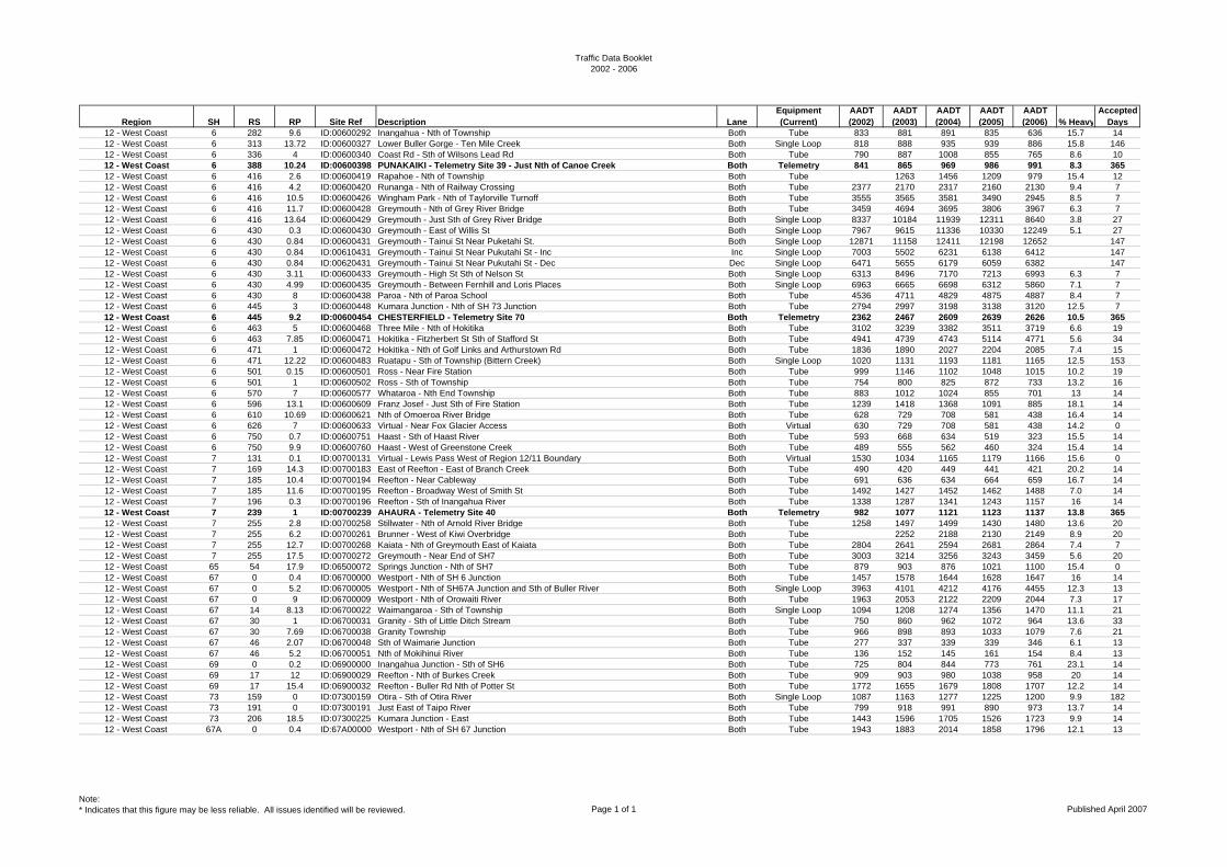
Traffic Data Booklet2002 - 2006
Region SH RS RP Site Ref Description LaneEquipment (Current)
AADT (2002)
AADT (2003)
AADT (2004)
AADT (2005)
AADT (2006) % Heavy
Accepted Days
12 - West Coast 6 282 9.6 ID:00600292 Inangahua - Nth of Township Both Tube 833 881 891 835 636 15.7 1412 - West Coast 6 313 13.72 ID:00600327 Lower Buller Gorge - Ten Mile Creek Both Single Loop 818 888 935 939 886 15.8 14612 - West Coast 6 336 4 ID:00600340 Coast Rd - Sth of Wilsons Lead Rd Both Tube 790 887 1008 855 765 8.6 1012 - West Coast 6 388 10.24 ID:00600398 PUNAKAIKI - Telemetry Site 39 - Just Nth of Canoe Creek Both Telemetry 841 865 969 986 991 8.3 36512 - West Coast 6 416 2.6 ID:00600419 Rapahoe - Nth of Township Both Tube 1263 1456 1209 979 15.4 1212 - West Coast 6 416 4.2 ID:00600420 Runanga - Nth of Railway Crossing Both Tube 2377 2170 2317 2160 2130 9.4 712 - West Coast 6 416 10.5 ID:00600426 Wingham Park - Nth of Taylorville Turnoff Both Tube 3555 3565 3581 3490 2945 8.5 712 - West Coast 6 416 11.7 ID:00600428 Greymouth - Nth of Grey River Bridge Both Tube 3459 4694 3695 3806 3967 6.3 712 - West Coast 6 416 13.64 ID:00600429 Greymouth - Just Sth of Grey River Bridge Both Single Loop 8337 10184 11939 12311 8640 3.8 2712 - West Coast 6 430 0.3 ID:00600430 Greymouth - East of Willis St Both Single Loop 7967 9615 11336 10330 12249 5.1 2712 - West Coast 6 430 0.84 ID:00600431 Greymouth - Tainui St Near Puketahi St. Both Single Loop 12871 11158 12411 12198 12652 14712 - West Coast 6 430 0.84 ID:00610431 Greymouth - Tainui St Near Pukutahi St - Inc Inc Single Loop 7003 5502 6231 6138 6412 14712 - West Coast 6 430 0.84 ID:00620431 Greymouth - Tainui St Near Pukutahi St - Dec Dec Single Loop 6471 5655 6179 6059 6382 14712 - West Coast 6 430 3.11 ID:00600433 Greymouth - High St Sth of Nelson St Both Single Loop 6313 8496 7170 7213 6993 6.3 712 - West Coast 6 430 4.99 ID:00600435 Greymouth - Between Fernhill and Loris Places Both Single Loop 6963 6665 6698 6312 5860 7.1 712 - West Coast 6 430 8 ID:00600438 Paroa - Nth of Paroa School Both Tube 4536 4711 4829 4875 4887 8.4 712 - West Coast 6 445 3 ID:00600448 Kumara Junction - Nth of SH 73 Junction Both Tube 2794 2997 3198 3138 3120 12.5 712 - West Coast 6 445 9.2 ID:00600454 CHESTERFIELD - Telemetry Site 70 Both Telemetry 2362 2467 2609 2639 2626 10.5 36512 - West Coast 6 463 5 ID:00600468 Three Mile - Nth of Hokitika Both Tube 3102 3239 3382 3511 3719 6.6 1912 - West Coast 6 463 7.85 ID:00600471 Hokitika - Fitzherbert St Sth of Stafford St Both Tube 4941 4739 4743 5114 4771 5.6 3412 - West Coast 6 471 1 ID:00600472 Hokitika - Nth of Golf Links and Arthurstown Rd Both Tube 1836 1890 2027 2204 2085 7.4 1512 - West Coast 6 471 12.22 ID:00600483 Ruatapu - Sth of Township (Bittern Creek) Both Single Loop 1020 1131 1193 1181 1165 12.5 15312 - West Coast 6 501 0.15 ID:00600501 Ross - Near Fire Station Both Tube 999 1146 1102 1048 1015 10.2 1912 - West Coast 6 501 1 ID:00600502 Ross - Sth of Township Both Tube 754 800 825 872 733 13.2 1612 - West Coast 6 570 7 ID:00600577 Whataroa - Nth End Township Both Tube 883 1012 1024 855 701 13 1412 - West Coast 6 596 13.1 ID:00600609 Franz Josef - Just Sth of Fire Station Both Tube 1239 1418 1368 1091 885 18.1 1412 - West Coast 6 610 10.69 ID:00600621 Nth of Omoeroa River Bridge Both Tube 628 729 708 581 438 16.4 1412 - West Coast 6 626 7 ID:00600633 Virtual - Near Fox Glacier Access Both Virtual 630 729 708 581 438 14.2 012 - West Coast 6 750 0.7 ID:00600751 Haast - Sth of Haast River Both Tube 593 668 634 519 323 15.5 1412 - West Coast 6 750 9.9 ID:00600760 Haast - West of Greenstone Creek Both Tube 489 555 562 460 324 15.4 1412 - West Coast 7 131 0.1 ID:00700131 Virtual - Lewis Pass West of Region 12/11 Boundary Both Virtual 1530 1034 1165 1179 1166 15.6 012 - West Coast 7 169 14.3 ID:00700183 East of Reefton - East of Branch Creek Both Tube 490 420 449 441 421 20.2 1412 - West Coast 7 185 10.4 ID:00700194 Reefton - Near Cableway Both Tube 691 636 634 664 659 16.7 1412 - West Coast 7 185 11.6 ID:00700195 Reefton - Broadway West of Smith St Both Tube 1492 1427 1452 1462 1488 7.0 1412 - West Coast 7 196 0.3 ID:00700196 Reefton - Sth of Inangahua River Both Tube 1338 1287 1341 1243 1157 16 1412 - West Coast 7 239 1 ID:00700239 AHAURA - Telemetry Site 40 Both Telemetry 982 1077 1121 1123 1137 13.8 36512 - West Coast 7 255 2.8 ID:00700258 Stillwater - Nth of Arnold River Bridge Both Tube 1258 1497 1499 1430 1480 13.6 2012 - West Coast 7 255 6.2 ID:00700261 Brunner - West of Kiwi Overbridge Both Tube 2252 2188 2130 2149 8.9 2012 - West Coast 7 255 12.7 ID:00700268 Kaiata - Nth of Greymouth East of Kaiata Both Tube 2804 2641 2594 2681 2864 7.4 712 - West Coast 7 255 17.5 ID:00700272 Greymouth - Near End of SH7 Both Tube 3003 3214 3256 3243 3459 5.6 2012 - West Coast 65 54 17.9 ID:06500072 Springs Junction - Nth of SH7 Both Tube 879 903 876 1021 1100 15.4 012 - West Coast 67 0 0.4 ID:06700000 Westport - Nth of SH 6 Junction Both Tube 1457 1578 1644 1628 1647 16 1412 - West Coast 67 0 5.2 ID:06700005 Westport - Nth of SH67A Junction and Sth of Buller River Both Single Loop 3963 4101 4212 4176 4455 12.3 1312 - West Coast 67 0 9 ID:06700009 Westport - Nth of Orowaiti River Both Tube 1963 2053 2122 2209 2044 7.3 1712 - West Coast 67 14 8.13 ID:06700022 Waimangaroa - Sth of Township Both Single Loop 1094 1208 1274 1356 1470 11.1 2112 - West Coast 67 30 1 ID:06700031 Granity - Sth of Little Ditch Stream Both Tube 750 860 962 1072 964 13.6 3312 - West Coast 67 30 7.69 ID:06700038 Granity Township Both Tube 966 898 893 1033 1079 7.6 2112 - West Coast 67 46 2.07 ID:06700048 Sth of Waimarie Junction Both Tube 277 337 339 339 346 6.1 1312 - West Coast 67 46 5.2 ID:06700051 Nth of Mokihinui River Both Tube 136 152 145 161 154 8.4 1312 - West Coast 69 0 0.2 ID:06900000 Inangahua Junction - Sth of SH6 Both Tube 725 804 844 773 761 23.1 1412 - West Coast 69 17 12 ID:06900029 Reefton - Nth of Burkes Creek Both Tube 909 903 980 1038 958 20 1412 - West Coast 69 17 15.4 ID:06900032 Reefton - Buller Rd Nth of Potter St Both Tube 1772 1655 1679 1808 1707 12.2 1412 - West Coast 73 159 0 ID:07300159 Otira - Sth of Otira River Both Single Loop 1087 1163 1277 1225 1200 9.9 18212 - West Coast 73 191 0 ID:07300191 Just East of Taipo River Both Tube 799 918 991 890 973 13.7 1412 - West Coast 73 206 18.5 ID:07300225 Kumara Junction - East Both Tube 1443 1596 1705 1526 1723 9.9 1412 - West Coast 67A 0 0.4 ID:67A00000 Westport - Nth of SH 67 Junction Both Tube 1943 1883 2014 1858 1796 12.1 13
Note:* Indicates that this figure may be less reliable. All issues identified will be reviewed. Page 1 of 1 Published April 2007
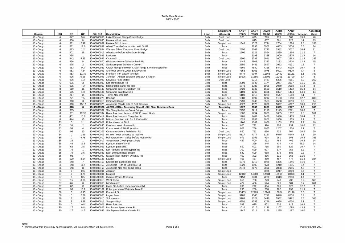
Traffic Data Booklet2002 - 2006
Region SH RS RP Site Ref Description LaneEquipment (Current)
AADT (2002)
AADT (2003)
AADT (2004)
AADT (2005)
AADT (2006) % Heavy
Accepted Days
13 - Otago 6 847 5.6 ID:00600853 Lake Wanaka Camp Creek Bridge Both Dual Loop 520 625 793 773 582 15.3 4813 - Otago 6 866 14 ID:00600880 Hawea Nth of dam Both Dual Loop 815 607 861 828 14 1313 - Otago 6 881 2.97 ID:00600882 Hawea Sth of dam Both Single Loop 1346 1523 1744 1704 1784 7.8 28813 - Otago 6 881 11.6 ID:00600892 Albert Town-before junction with SH89 Both Tube 3693 3901 4033 3604 6.6 1413 - Otago 6 893 1.2 ID:00600894 Wanaka Sth of Cardrona River Bridge Both Dual Loop 2390 2742 2745 2982 3017 10.4 2113 - Otago 6 901 16 ID:00600917 Albertburn-before Albertburn Bridge Both Tube 1500 1325 1564 1829 1564 11.2 713 - Otago 6 938 1 ID:00600939 Lowburn Both Tube 2193 2328 2609 2505 11.9 1413 - Otago 6 942 5.23 ID:00600946 Cromwell Both Dual Loop 2500 2789 2941 3007 2963 11.4 33713 - Otago 6 956 14 ID:00600970 Gibbston-before Gibbston Back Rd Both Tube 2445 2808 3333 3132 3210 12.8 1513 - Otago 6 978 2 ID:00600980 Swiftburn-past Swiftburn Culvert Both Tube 2850 3441 3897 3922 4131 12 713 - Otago 6 983 0.2 ID:00600983 Crown Range-between Crown range & Whitechapel Rd Both Tube 4660 4540 4386 5443 6139 10.7 813 - Otago 6 983 7.84 ID:00600991 Shotover-before Lower Shotover Rd Both Single Loop 7353 6951 7975 8691 9609 7.4 813 - Otago 6 983 11.39 ID:00600993 Frankton- Nth east of junction Both Single Loop 8779 9984 11563 12459 13151 6.1 33713 - Otago 6 996 0.26 ID:00600996 Junction - Airport-between SH6&6A & Airport Both Single Loop 10695 11385 12692 12201 13700 5.4 813 - Otago 6 996 1.3 ID:00600997 Kawarau Falls Bridge Both Dual Loop 6217 5437 5325 4581 7.0 36213 - Otago 6 996 3 ID:00600999 Sth of Peninsula Rd Both Tube 2300 2846 3174 2967 3117 11.5 1513 - Otago 6 996 4.2 ID:00601000 Remarkables after ski field Both Tube 1840 1783 1906 2060 2968 11.3 813 - Otago 8 169 11 ID:00800180 Omarama before Quailburn Rd Both Tube 1420 1343 1600 1510 1492 15.3 1413 - Otago 8 185 1.3 ID:00800186 Omarama past township Both Tube 1103 1368 1381 1307 1404 14.6 1413 - Otago 8 247 15 ID:00800262 Tarras Nth of SH 8A Both Tube 1109 1313 1220 1547 1560 14 713 - Otago 8 271 7.5 ID:00800279 Bendigo Both Single Loop 1088 1097 1212 1193 1188 12.7 30813 - Otago 8 310 3 ID:00800313 Cromwell Gorge Both Tube 2790 3240 3553 3568 3650 9.0 1413 - Otago 8 310 15.17 ID:00800325 Alexandra (Clyde side of Golf Course) Both Single Loop 4027 4578 4889 5027 4897 10.0 21313 - Otago 8 328 8 ID:00800336 ALEXANDRA - Telemetry Site 44 - Sth Near Butchers Dam Both Telemetry 1927 2036 2081 2095 2077 9.3 36513 - Otago 8 365 1 ID:00800362 Sth Slaughterhouse Creek Bridge Both Tube 2232 2211 2110 2125 2071 10.0 713 - Otago 8 381 12.95 ID:00800394 Raes Junction - before of SH 90 island block Both Single Loop 1682 1754 1800 1805 1752 9.6 31113 - Otago 8 401 10.8 ID:00800412 Raes Junction past Craigellachie Both Tube 1401 1402 1488 1486 1419 10.4 713 - Otago 8 444 15 ID:00800459 Milton - Junction with SH 1 Clarksville Both Tube 1626 1938 1801 1850 1809 9.7 713 - Otago 83 0 2.1 ID:08300002 Pukeuri west of SH 1 Both Tube 1160 1343 1066 1153 1205 9.2 1913 - Otago 83 34 2 ID:08300036 Duntroon west of township Both Tube 600 732 970 705 839 10.0 1213 - Otago 83 58 4 ID:08300062 Kurow west of SH 82 junction Both Tube 902 766 1065 1207 1234 8.1 713 - Otago 83 96 10 ID:08300106 Omarama-before Prohibition Rd Both Dual Loop 650 721 696 722 764 10.5 3013 - Otago 84 0 1.55 ID:08400001 Mt Iron - near entrance to reserve Both Single Loop 5117 4777 5157 6575 5949 6.1 1913 - Otago 85 0 9.78 ID:08500010 Palmerston Inch Valley-before McLew Rd Both Single Loop 971 1051 998 981 958 10.4 36313 - Otago 85 16 1 ID:08500017 Sweetwater Creek-past culvert Both Tube 427 500 492 484 469 10.2 1413 - Otago 85 49 11.8 ID:08500061 Kyeburn east of SH87 Both Tube 399 445 435 434 26.3* 1413 - Otago 85 62 3.5 ID:08500066 Kyeburn past SH87 Both Tube 650 601 715 650 629 10.7 713 - Otago 85 79 1 ID:08500080 Nth Ranfurly-before Bypass Rd Both Tube 700 699 907 877 758 8.3 713 - Otago 85 79 3.5 ID:08500083 East Eweburn-near bridge Both Tube 640 609 688 676 688 9.3 713 - Otago 85 92 7 ID:08500099 Idaburn-past Idaburn-Omakau Rd Both Tube 400 302 336 321 363 11.0 713 - Otago 85 120 8.24 ID:08500128 Lauder Both Single Loop 405 457 480 487 477 11.3 32413 - Otago 85 148 7 ID:08500155 Keddell Rd-past Keddell Rd Both Tube 1070 1215 1085 1336 1346 11.0 713 - Otago 85 148 11.4 ID:08500159 Alexandra - Nth of Galloway Rd Both Tube 1220 1005 973 1210 1196 8.4 713 - Otago 85 148 15 ID:08500163 Alexandra Nth-past camp gates Both Tube 2340 2673 2806 3038 2986 4.0 713 - Otago 86 0 0.6 ID:08600001 Allanton Both Single Loop 3025 3217 3299 3.6 713 - Otago 87 0 0.74 ID:08700001 Mosgiel Both Single Loop 12012 14900 12484 15965 16093 4.1 713 - Otago 87 0 8.5 ID:08700009 Outram Wylies Crossing Both Tube 2150 2801 2220 2613 2850 4.4 713 - Otago 87 15 0.36 ID:08700015 West Taieri Both Single Loop 656 700 723 743 732 9.2 36513 - Otago 87 65 0 ID:08700065 Middlemarch Both Single Loop 477 456 524 520 504 8.7 36113 - Otago 87 82 11 ID:08700093 Hyde Sth-before Hyde-Macraes Rd Both Tube 280 292 334 305 320 12.2 713 - Otago 87 96 13.2 ID:08700109 Kokonga-before Waipiata Turnoff Both Tube 230 260 288 282 293 11.9 713 - Otago 88 0 0.95 ID:08800001 Frederick St Both Single Loop 13483 12205 12149 13904 13176 6.6 713 - Otago 88 0 2.79 ID:08800003 Logan Point Both Single Loop 9185 9545 8711 8840 8506 5.4 713 - Otago 88 8 1.37 ID:08800010 St Leonards Both Single Loop 5188 5329 5449 5552 5422 6.5 36313 - Otago 88 8 3.38 ID:08800011 Sawyers Bay Both Single Loop 4951 4753 4796 4698 4730 7.1 713 - Otago 90 0 0.8 ID:09000001 Raes Junction Both Tube 599 625 602 632 612 10.6 713 - Otago 90 17 8.8 ID:09000026 Nth Tapanui-past Heriot Rd Both Tube 1010 1216 1126 1107 1088 13.4 713 - Otago 90 17 14.5 ID:09000032 Sth Tapanui-before Victoria Rd Both Tube 1147 1311 1176 1235 1187 10.0 7
Note:* Indicates that this figure may be less reliable. All issues identified will be reviewed. Page 1 of 3 Published April 2007
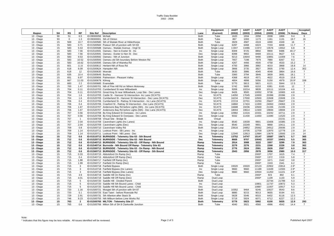
Traffic Data Booklet2002 - 2006
Region SH RS RP Site Ref Description LaneEquipment (Current)
AADT (2002)
AADT (2003)
AADT (2004)
AADT (2005)
AADT (2006) % Heavy
Accepted Days
13 - Otago 90 51 6.5 ID:09000058 McNab Both Tube 1620 1934 2058 2008 1866 9.4 913 - Otago 93 0 1.3 ID:09300001 Sth of Clinton Both Tube 867 1093 1173 1161 1131 19.7 1613 - Otago 1S 569 10.7 ID:01S00580 Sth of Waitaki River at Hilderthorpe Both Tube 3929 4587 4319 4490 4349 16 713 - Otago 1S 583 0.71 ID:01S00584 Pukeuri Sth of junction with SH 83 Both Single Loop 6287 6468 6324 7233 6658 11.7 713 - Otago 1S 583 5.53 ID:01S00588 Oamaru - Waitaki Avenue - Virgil St Both Single Loop 11947 13486 11972 13576 13552 6.8 813 - Otago 1S 583 7.56 ID:01S10591 Oamaru - Nen to Exeter St - Inc Inc Single Loop 8309 9725 8850 9900 9486 40.1* 713 - Otago 1S 583 7.56 ID:01S20591 Oamaru - Exeter to Nen St - Dec Dec Single Loop 8398 9902 8469 10111 9627 6.6 713 - Otago 1S 583 9.53 ID:01S00592 Oamaru - Nth of Junction Both Single Loop 9213 10644 9490 10891 11009 7.6 713 - Otago 1S 583 10.52 ID:01S00593 Oamaru old Sth boundary Before Weston Rd Both Single Loop 7657 7198 7879 7880 8267 9.3 913 - Otago 1S 583 16.62 ID:01S00595 Oamaru-Sth of Waireka Rd Both Single Loop 4267 4466 4500 4758 4533 15.2 713 - Otago 1S 601 11.8 ID:01S00612 Herbert-Nth of Ross Rd Both Single Loop 4700 3966 3982 4010 3868 18.8 1413 - Otago 1S 618 6.09 ID:01S00624 Hampden Nth Both Single Loop 3666 3735 3927 3935 3790 12.4 30213 - Otago 1S 618 12 ID:01S00630 Moeraki Both Tube 3630 3986 4045 4048 3864 16.6 713 - Otago 1S 635 10.4 ID:01S00645 Bushey Both Tube 3360 3794 3846 3839 3691 18.1 713 - Otago 1S 651 6.97 ID:01S00656 Palmerston - Pleasant Valley Both Single Loop 4368 4619 4571 4622 4519 15.8 713 - Otago 1S 667 11.03 ID:01S00678 Kilmog Both Single Loop 4804 4898 5056 5150 4979 20.9* 33813 - Otago 1S 683 2.2 ID:01S00685 Evansdale Both Tube 5770 5813 5821 6121 5944 12.5 713 - Otago 1S 700 1.47 ID:01S00701 Nth of Pine Hill Rd on Nthern Motorway Both Single Loop 5742 5609 6153 6381 6165 12 713 - Otago 1S 704 0.11 ID:01S10703 Cumberland St near Willowbank Inc Single Loop 9269 10214 9839 10111 10104 4.6 713 - Otago 1S 704 0.11 ID:01S20703 Great King St near Willowbank, Loop Site - Dec Lanes Dec Single Loop 9426 9500 10052 9738 10083 4.8 713 - Otago 1S 704 1.6 ID:01S10705 Castle St - Hanover St Intersection- Inc Lane (SCATS) Inc SCATS 14050 17045 10000 20396 20396 2.913 - Otago 1S 704 1.6 ID:01S20705 Cumberland St - Hanover St Intersection - Dec Lane (SCATS) Dec SCATS 16234 17000 10500 22608 22608 2.913 - Otago 1S 706 0.4 ID:01S10706 Cumberland St - Rattray St Intersection - Inc Lane (SCATS) Inc SCATS 22219 22701 10250 25607 25607 2.913 - Otago 1S 706 0.4 ID:01S20706 Crawford St - Rattray St Intersection - Dec Lane (SCATS) Dec SCATS 16860 17424 11000 24063 24063 2.913 - Otago 1S 706 1.67 ID:01S10707 Andersons Bay Rd before Lights (Sth) - Inc Lane (SCATS) Inc SCATS 16688 19236 10500 21335 21335 2.913 - Otago 1S 706 1.67 ID:01S20707 Andersons Bay Rd before Lights (Nth) - Dec Lane (SCATS) Dec SCATS 18004 19614 11500 19694 19694 2.913 - Otago 1S 707 0.56 ID:01S10708 By King Edward St Overpass - Inc Lanes Inc Single Loop 10982 11516 10331 10242 10711 2.9 713 - Otago 1S 707 0.56 ID:01S20708 By King Edward St Overpass - Dec Lanes Dec Single Loop 9332 11430 11650 11690 11520 2.9 713 - Otago 1S 707 1 ID:01S09708 Virtual Site - Bridge St Both Virtual 22231 2.9 013 - Otago 1S 707 2.04 ID:01S10709 Caversham Lights (Inc Lanes) Inc Single Loop 8540 10039 9901 10406 10385 2.9 713 - Otago 1S 707 2.04 ID:01S20709 Caversham Lights (Dec) Dec Single Loop 8540 10249 9901 9868 10411 2.9 713 - Otago 1S 709 0.8 ID:01S00710 Caversham Valley Rd Both Single Loop 23616 24852 25062 24912 25936 2.9 713 - Otago 1S 709 1.14 ID:01S10711 Lookout Point - SB Lanes - Inc Inc Single Loop 14705 12709 12870 12779 2.9 1413 - Otago 1S 709 1.14 ID:01S20711 Lookout Point - NB Lanes - Dec Dec Single Loop 12340 12813 12884 13679 13593 2.9 1413 - Otago 1S 712 0.6 ID:01S10713 BURNSIDE - Telemetry Site 63 - Sth Bound Inc Telemetry 13752 14747 15147 15587 15671 5.7 36513 - Otago 1S 712 0.6 ID:01S20713 BURNSIDE - Telemetry Site 63 - Nth Bound Dec Telemetry 8669 9707 10043 10337 10451 5.5 36513 - Otago 1S 712 0.6 ID:01S40713 BURNSIDE - Telemetry Site 63 - Off Ramp - Nth Bound Ramp Telemetry 2914 3088 3222 3307 3299 7.9 36313 - Otago 1S 712 0.6 ID:01S40714 Burnside - Nth Bound Off Ramp - Telemetry Site 63 Ramp Telemetry 2279 2276 2231 2268 2226 3.8 36213 - Otago 1S 712 0.6 ID:01S50713 BURNSIDE - Telemetry Site 63 - On Ramp - Nth Bound Ramp Telemetry 2776 2624 2591 2626 2597 6.0 36413 - Otago 1S 712 0.6 ID:01S60713 BURNSIDE - Telemetry Site 63 - Off Ramp - Sth Bound Ramp Telemetry 2943 2956 2978 3056 2980 10.0 31713 - Otago 1S 715 0.33 ID:01S30715 Abbotsford On Ramp (Inc) Ramp Tube 2000* 1707 1615 7.4 713 - Otago 1S 715 0.4 ID:01S40715 Abbotsford Off Ramp (Dec) Ramp Tube 2000* 1372 1319 5.8 713 - Otago 1S 715 1.88 ID:01S60717 Fairfield Off Ramp (Inc) Ramp Tube 2000* 1671 1542 3.8 713 - Otago 1S 715 1.99 ID:01S50717 Fairfield On Ramp (Dec) Ramp Tube 2000* 1533 1541 6.2 713 - Otago 1S 715 3 ID:01S00718 Fairfield Bypass Both Single Loop 19320 19320 22123 22902 22814 2.9* 713 - Otago 1S 715 3 ID:01S10718 Fairfield Bypass (Inc Lanes) Inc Single Loop 9660 9660 11189 11639 11593 2.9* 713 - Otago 1S 715 3 ID:01S20718 Fairfield Bypass (Dec Lanes) Dec Single Loop 9660 9660 10934 11263 11221 2.9* 713 - Otago 1S 715 3.9 ID:01S30719 Saddle Hill On Ramp (Inc) Ramp Tube 2000* 923 892 6.1 713 - Otago 1S 715 4.01 ID:01S40719 Saddle Hill Off Ramp (Dec) Ramp Dual Loop 2000* 1139 1133 5.9 713 - Otago 1S 715 5 ID:01S00720 Saddle Hill - Divided Parent Both Dual Loop 22744 21789 5.3 713 - Otago 1S 715 5 ID:01S10720 Saddle Hill Sth Bound Lanes - Child Inc Dual Loop 10801 11737 10872 5.3 713 - Otago 1S 715 5 ID:01S20720 Saddle Hill Nth Bound Lanes - Child Dec Dual Loop 10887 11007 10917 5.3 713 - Otago 1S 720 1.16 ID:01S00721 Mosgiel Sth of junction with SH 87 Both Dual Loop 10352 9464 9246 10027 9543 8.6 713 - Otago 1S 720 5.1 ID:01S00725 East Taieri - before Riverside Rd Both Dual Loop 8880 9215 9013 9655 9194 9.5 713 - Otago 1S 729 2.91 ID:01S00731 Sth Allanton-after Stack St Both Single Loop 5628 5546 6015 6432 6116 12.5 713 - Otago 1S 746 9.23 ID:01S00755 Nth Milburn-before Lime Works Rd Both Single Loop 5719 5924 6071 6712 6227 12.2 713 - Otago 1S 763 2 ID:01S00765 MILTON - Telemetry Site 27 Both Telemetry 5779 5923 5992 6100 5835 12.9 29313 - Otago 1S 765 0.6 ID:01S00766 Milton Sth of SH 8 Clarksville Junction Both Tube 4040 3921 4560 4996 4542 14.4 7
Note:* Indicates that this figure may be less reliable. All issues identified will be reviewed. Page 2 of 3 Published April 2007
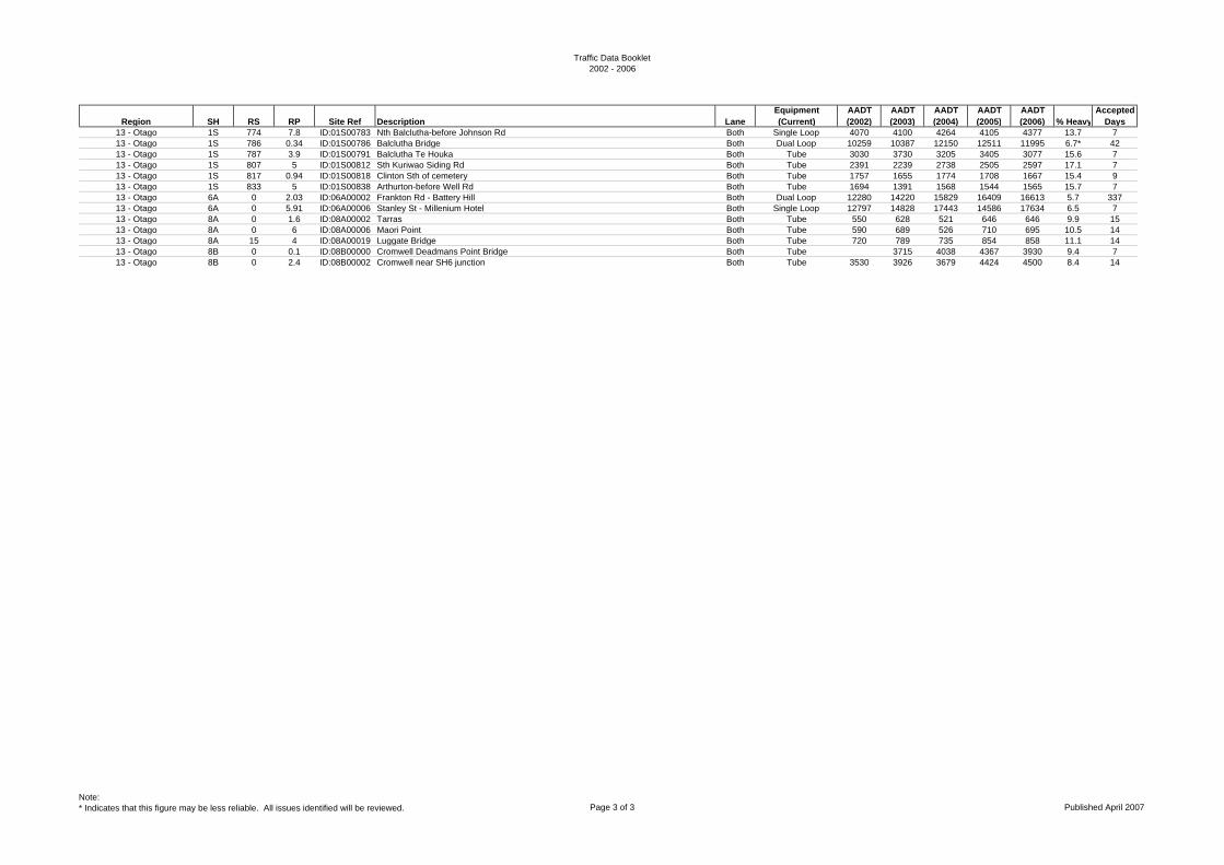
Traffic Data Booklet2002 - 2006
Region SH RS RP Site Ref Description LaneEquipment (Current)
AADT (2002)
AADT (2003)
AADT (2004)
AADT (2005)
AADT (2006) % Heavy
Accepted Days
13 - Otago 1S 774 7.8 ID:01S00783 Nth Balclutha-before Johnson Rd Both Single Loop 4070 4100 4264 4105 4377 13.7 713 - Otago 1S 786 0.34 ID:01S00786 Balclutha Bridge Both Dual Loop 10259 10387 12150 12511 11995 6.7* 4213 - Otago 1S 787 3.9 ID:01S00791 Balclutha Te Houka Both Tube 3030 3730 3205 3405 3077 15.6 713 - Otago 1S 807 5 ID:01S00812 Sth Kuriwao Siding Rd Both Tube 2391 2239 2738 2505 2597 17.1 713 - Otago 1S 817 0.94 ID:01S00818 Clinton Sth of cemetery Both Tube 1757 1655 1774 1708 1667 15.4 913 - Otago 1S 833 5 ID:01S00838 Arthurton-before Well Rd Both Tube 1694 1391 1568 1544 1565 15.7 713 - Otago 6A 0 2.03 ID:06A00002 Frankton Rd - Battery Hill Both Dual Loop 12280 14220 15829 16409 16613 5.7 33713 - Otago 6A 0 5.91 ID:06A00006 Stanley St - Millenium Hotel Both Single Loop 12797 14828 17443 14586 17634 6.5 713 - Otago 8A 0 1.6 ID:08A00002 Tarras Both Tube 550 628 521 646 646 9.9 1513 - Otago 8A 0 6 ID:08A00006 Maori Point Both Tube 590 689 526 710 695 10.5 1413 - Otago 8A 15 4 ID:08A00019 Luggate Bridge Both Tube 720 789 735 854 858 11.1 1413 - Otago 8B 0 0.1 ID:08B00000 Cromwell Deadmans Point Bridge Both Tube 3715 4038 4367 3930 9.4 713 - Otago 8B 0 2.4 ID:08B00002 Cromwell near SH6 junction Both Tube 3530 3926 3679 4424 4500 8.4 14
Note:* Indicates that this figure may be less reliable. All issues identified will be reviewed. Page 3 of 3 Published April 2007
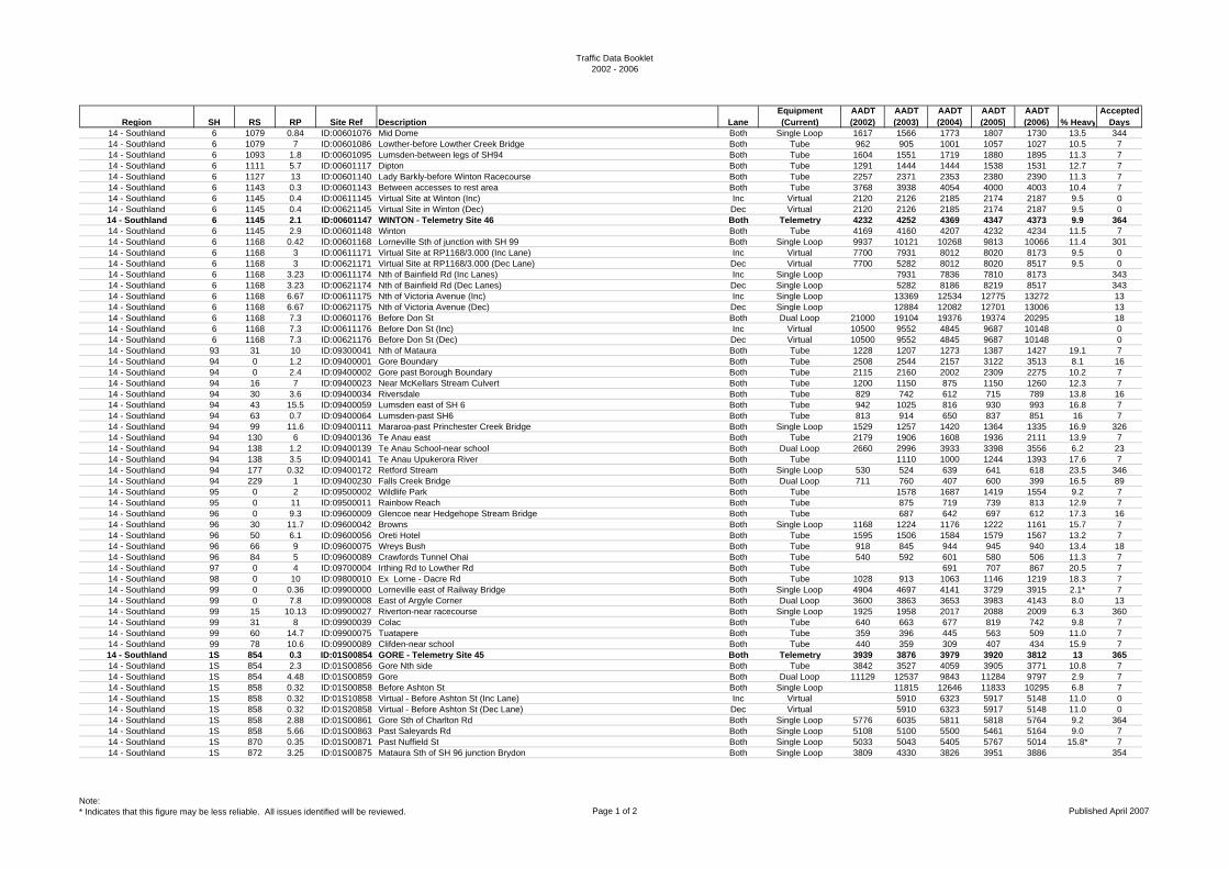
Traffic Data Booklet2002 - 2006
Region SH RS RP Site Ref Description LaneEquipment (Current)
AADT (2002)
AADT (2003)
AADT (2004)
AADT (2005)
AADT (2006) % Heavy
Accepted Days
14 - Southland 6 1079 0.84 ID:00601076 Mid Dome Both Single Loop 1617 1566 1773 1807 1730 13.5 34414 - Southland 6 1079 7 ID:00601086 Lowther-before Lowther Creek Bridge Both Tube 962 905 1001 1057 1027 10.5 714 - Southland 6 1093 1.8 ID:00601095 Lumsden-between legs of SH94 Both Tube 1604 1551 1719 1880 1895 11.3 714 - Southland 6 1111 5.7 ID:00601117 Dipton Both Tube 1291 1444 1444 1538 1531 12.7 714 - Southland 6 1127 13 ID:00601140 Lady Barkly-before Winton Racecourse Both Tube 2257 2371 2353 2380 2390 11.3 714 - Southland 6 1143 0.3 ID:00601143 Between accesses to rest area Both Tube 3768 3938 4054 4000 4003 10.4 714 - Southland 6 1145 0.4 ID:00611145 Virtual Site at Winton (Inc) Inc Virtual 2120 2126 2185 2174 2187 9.5 014 - Southland 6 1145 0.4 ID:00621145 Virtual Site in Winton (Dec) Dec Virtual 2120 2126 2185 2174 2187 9.5 014 - Southland 6 1145 2.1 ID:00601147 WINTON - Telemetry Site 46 Both Telemetry 4232 4252 4369 4347 4373 9.9 36414 - Southland 6 1145 2.9 ID:00601148 Winton Both Tube 4169 4160 4207 4232 4234 11.5 714 - Southland 6 1168 0.42 ID:00601168 Lorneville Sth of junction with SH 99 Both Single Loop 9937 10121 10268 9813 10066 11.4 30114 - Southland 6 1168 3 ID:00611171 Virtual Site at RP1168/3.000 (Inc Lane) Inc Virtual 7700 7931 8012 8020 8173 9.5 014 - Southland 6 1168 3 ID:00621171 Virtual Site at RP1168/3.000 (Dec Lane) Dec Virtual 7700 5282 8012 8020 8517 9.5 014 - Southland 6 1168 3.23 ID:00611174 Nth of Bainfield Rd (Inc Lanes) Inc Single Loop 7931 7836 7810 8173 34314 - Southland 6 1168 3.23 ID:00621174 Nth of Bainfield Rd (Dec Lanes) Dec Single Loop 5282 8186 8219 8517 34314 - Southland 6 1168 6.67 ID:00611175 Nth of Victoria Avenue (Inc) Inc Single Loop 13369 12534 12775 13272 1314 - Southland 6 1168 6.67 ID:00621175 Nth of Victoria Avenue (Dec) Dec Single Loop 12884 12082 12701 13006 1314 - Southland 6 1168 7.3 ID:00601176 Before Don St Both Dual Loop 21000 19104 19376 19374 20295 1814 - Southland 6 1168 7.3 ID:00611176 Before Don St (Inc) Inc Virtual 10500 9552 4845 9687 10148 014 - Southland 6 1168 7.3 ID:00621176 Before Don St (Dec) Dec Virtual 10500 9552 4845 9687 10148 014 - Southland 93 31 10 ID:09300041 Nth of Mataura Both Tube 1228 1207 1273 1387 1427 19.1 714 - Southland 94 0 1.2 ID:09400001 Gore Boundary Both Tube 2508 2544 2157 3122 3513 8.1 1614 - Southland 94 0 2.4 ID:09400002 Gore past Borough Boundary Both Tube 2115 2160 2002 2309 2275 10.2 714 - Southland 94 16 7 ID:09400023 Near McKellars Stream Culvert Both Tube 1200 1150 875 1150 1260 12.3 714 - Southland 94 30 3.6 ID:09400034 Riversdale Both Tube 829 742 612 715 789 13.8 1614 - Southland 94 43 15.5 ID:09400059 Lumsden east of SH 6 Both Tube 942 1025 816 930 993 16.8 714 - Southland 94 63 0.7 ID:09400064 Lumsden-past SH6 Both Tube 813 914 650 837 851 16 714 - Southland 94 99 11.6 ID:09400111 Mararoa-past Princhester Creek Bridge Both Single Loop 1529 1257 1420 1364 1335 16.9 32614 - Southland 94 130 6 ID:09400136 Te Anau east Both Tube 2179 1906 1608 1936 2111 13.9 714 - Southland 94 138 1.2 ID:09400139 Te Anau School-near school Both Dual Loop 2660 2996 3933 3398 3556 6.2 2314 - Southland 94 138 3.5 ID:09400141 Te Anau Upukerora River Both Tube 1110 1000 1244 1393 17.6 714 - Southland 94 177 0.32 ID:09400172 Retford Stream Both Single Loop 530 524 639 641 618 23.5 34614 - Southland 94 229 1 ID:09400230 Falls Creek Bridge Both Dual Loop 711 760 407 600 399 16.5 8914 - Southland 95 0 2 ID:09500002 Wildlife Park Both Tube 1578 1687 1419 1554 9.2 714 - Southland 95 0 11 ID:09500011 Rainbow Reach Both Tube 875 719 739 813 12.9 714 - Southland 96 0 9.3 ID:09600009 Glencoe near Hedgehope Stream Bridge Both Tube 687 642 697 612 17.3 1614 - Southland 96 30 11.7 ID:09600042 Browns Both Single Loop 1168 1224 1176 1222 1161 15.7 714 - Southland 96 50 6.1 ID:09600056 Oreti Hotel Both Tube 1595 1506 1584 1579 1567 13.2 714 - Southland 96 66 9 ID:09600075 Wreys Bush Both Tube 918 845 944 945 940 13.4 1814 - Southland 96 84 5 ID:09600089 Crawfords Tunnel Ohai Both Tube 540 592 601 580 506 11.3 714 - Southland 97 0 4 ID:09700004 Irthing Rd to Lowther Rd Both Tube 691 707 867 20.5 714 - Southland 98 0 10 ID:09800010 Ex Lorne - Dacre Rd Both Tube 1028 913 1063 1146 1219 18.3 714 - Southland 99 0 0.36 ID:09900000 Lorneville east of Railway Bridge Both Single Loop 4904 4697 4141 3729 3915 2.1* 714 - Southland 99 0 7.8 ID:09900008 East of Argyle Corner Both Dual Loop 3600 3863 3653 3983 4143 8.0 1314 - Southland 99 15 10.13 ID:09900027 Riverton-near racecourse Both Single Loop 1925 1958 2017 2088 2009 6.3 36014 - Southland 99 31 8 ID:09900039 Colac Both Tube 640 663 677 819 742 9.8 714 - Southland 99 60 14.7 ID:09900075 Tuatapere Both Tube 359 396 445 563 509 11.0 714 - Southland 99 78 10.6 ID:09900089 Clifden-near school Both Tube 440 359 309 407 434 15.9 714 - Southland 1S 854 0.3 ID:01S00854 GORE - Telemetry Site 45 Both Telemetry 3939 3876 3979 3920 3812 13 36514 - Southland 1S 854 2.3 ID:01S00856 Gore Nth side Both Tube 3842 3527 4059 3905 3771 10.8 714 - Southland 1S 854 4.48 ID:01S00859 Gore Both Dual Loop 11129 12537 9843 11284 9797 2.9 714 - Southland 1S 858 0.32 ID:01S00858 Before Ashton St Both Single Loop 11815 12646 11833 10295 6.8 714 - Southland 1S 858 0.32 ID:01S10858 Virtual - Before Ashton St (Inc Lane) Inc Virtual 5910 6323 5917 5148 11.0 014 - Southland 1S 858 0.32 ID:01S20858 Virtual - Before Ashton St (Dec Lane) Dec Virtual 5910 6323 5917 5148 11.0 014 - Southland 1S 858 2.88 ID:01S00861 Gore Sth of Charlton Rd Both Single Loop 5776 6035 5811 5818 5764 9.2 36414 - Southland 1S 858 5.66 ID:01S00863 Past Saleyards Rd Both Single Loop 5108 5100 5500 5461 5164 9.0 714 - Southland 1S 870 0.35 ID:01S00871 Past Nuffield St Both Single Loop 5033 5043 5405 5767 5014 15.8* 714 - Southland 1S 872 3.25 ID:01S00875 Mataura Sth of SH 96 junction Brydon Both Single Loop 3809 4330 3826 3951 3886 354
Note:* Indicates that this figure may be less reliable. All issues identified will be reviewed. Page 1 of 2 Published April 2007

Traffic Data Booklet2002 - 2006
Region SH RS RP Site Ref Description LaneEquipment (Current)
AADT (2002)
AADT (2003)
AADT (2004)
AADT (2005)
AADT (2006) % Heavy
Accepted Days
14 - Southland 1S 886 12.9 ID:01S00899 Dacre near transmitting station Both Single Loop 4220 4282 4447 4480 4123 15.3 1414 - Southland 1S 900 14.95 ID:01S00916 Invercargill - Kennington Both Single Loop 4638 4767 4723 5483 5047 7.6 2914 - Southland 1S 900 19.45 ID:01S00919 Invercargill Nth of Rockdale Rd Both Dual Loop 5142 4537 6050 5960 6414 8.9 714 - Southland 1S 920 0.1 ID:01S10920 Virtual - Racecourse Rd (Inc Lanes) Inc Virtual 5710 5825 5841 5872 5853 2.9 014 - Southland 1S 920 0.1 ID:01S20920 Virtual - Racecourse Rd (Dec Lanes) Dec Virtual 5550 5825 5841 5872 5853 2.9 014 - Southland 1S 920 2.27 ID:01S00923 INVERCARGILL - Telemetry Site 62 Both Telemetry 11584 11650 11681 11744 11705 3.0 36514 - Southland 1S 920 2.5 ID:01S00922 Invercargill east of Queens Dr Both Dual Loop 12292 11558 12244 12165 12026 3.1 714 - Southland 1S 920 3.35 ID:01S00924 Past Pedestrian Crossing Both Single Loop 7364 7550 6959 6.7 714 - Southland 1S 920 3.35 ID:01S10924 Past Pedestrian Crossing ( Inc Lane) Inc Single Loop 3500 3932 4002 3911 6.8 714 - Southland 1S 920 3.35 ID:01S20924 Past Pedestrian Crossing (Dec Lane) Dec Single Loop 3500 3432 3548 3048 6.7 714 - Southland 1S 923 0.2 ID:01S10921 Sth of Forth St, Nth of Tyne St - Inc Inc Single Loop 5710 6344 6516 6731 5979 2.9* 714 - Southland 1S 923 0.2 ID:01S20921 Sth of Forth St, Nth of Tyne St - Dec Dec Single Loop 5537 6052 6175 6214 5995 2.9* 714 - Southland 1S 926 3 ID:01S00929 Invercargill Sth of Avon Rd Both Tube 3181 3246 3495 3331 3510 10.6 714 - Southland 1S 933 2 ID:01S00935 Invercargill Nth of Awarua Radio Station Both Tube 2179 2364 2306 2662 2543 12.7 714 - Southland 1S 933 17 ID:01S00950 Bluff-Sth of township Both Tube 910* 867* 870* 890* 2991 4.4 7
Note:* Indicates that this figure may be less reliable. All issues identified will be reviewed. Page 2 of 2 Published April 2007
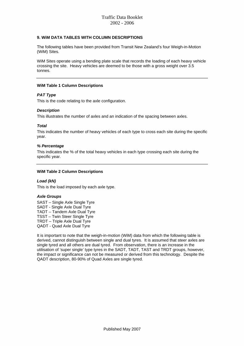
Traffic Data Booklet 2002 - 2006
9. WiM DATA TABLES WITH COLUMN DESCRIPTIONS The following tables have been provided from Transit New Zealand’s four Weigh-in-Motion (WiM) Sites. WiM Sites operate using a bending plate scale that records the loading of each heavy vehicle crossing the site. Heavy vehicles are deemed to be those with a gross weight over 3.5 tonnes. WiM Table 1 Column Descriptions PAT Type This is the code relating to the axle configuration. Description This illustrates the number of axles and an indication of the spacing between axles. Total This indicates the number of heavy vehicles of each type to cross each site during the specific year. % Percentage This indicates the % of the total heavy vehicles in each type crossing each site during the specific year. WiM Table 2 Column Descriptions Load (kN) This is the load imposed by each axle type. Axle Groups SAST – Single Axle Single Tyre SADT - Single Axle Dual Tyre TADT – Tandem Axle Dual Tyre TSST – Twin Steer Single Tyre TRDT – Triple Axle Dual Tyre QADT - Quad Axle Dual Tyre It is important to note that the weigh-in-motion (WiM) data from which the following table is derived, cannot distinguish between single and dual tyres. It is assumed that steer axles are single tyred and all others are dual tyred. From observation, there is an increase in the utilisation of ‘super single’ type tyres in the SADT, TADT, TAST and TRDT groups, however, the impact or significance can not be measured or derived from this technology. Despite the QADT description, 80-90% of Quad Axles are single tyred.
Published May 2007
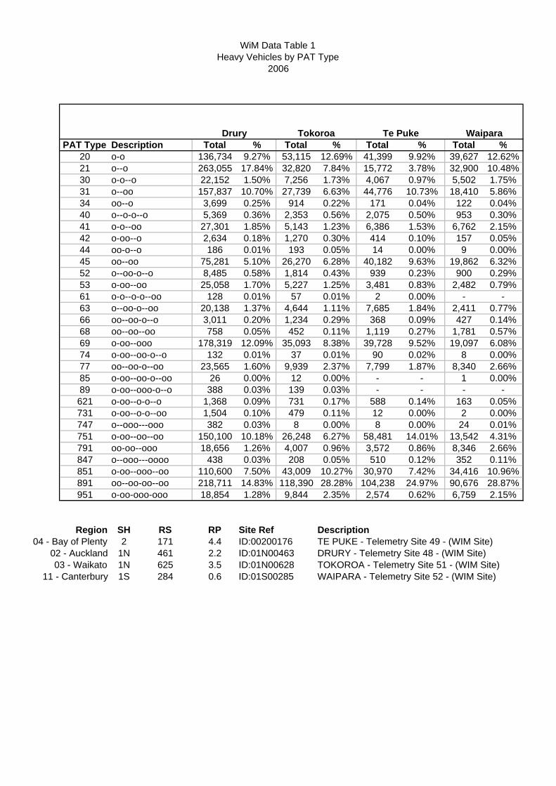
WiM Data Table 1Heavy Vehicles by PAT Type
2006
PAT Type Total % Total % Total % Total %20 136,734 9.27% 53,115 12.69% 41,399 9.92% 39,627 12.62%21 263,055 17.84% 32,820 7.84% 15,772 3.78% 32,900 10.48%30 22,152 1.50% 7,256 1.73% 4,067 0.97% 5,502 1.75%31 157,837 10.70% 27,739 6.63% 44,776 10.73% 18,410 5.86%34 3,699 0.25% 914 0.22% 171 0.04% 122 0.04%40 5,369 0.36% 2,353 0.56% 2,075 0.50% 953 0.30%41 27,301 1.85% 5,143 1.23% 6,386 1.53% 6,762 2.15%42 2,634 0.18% 1,270 0.30% 414 0.10% 157 0.05%44 186 0.01% 193 0.05% 14 0.00% 9 0.00%45 75,281 5.10% 26,270 6.28% 40,182 9.63% 19,862 6.32%52 8,485 0.58% 1,814 0.43% 939 0.23% 900 0.29%53 25,058 1.70% 5,227 1.25% 3,481 0.83% 2,482 0.79%61 128 0.01% 57 0.01% 2 0.00% - -63 20,138 1.37% 4,644 1.11% 7,685 1.84% 2,411 0.77%66 3,011 0.20% 1,234 0.29% 368 0.09% 427 0.14%68 758 0.05% 452 0.11% 1,119 0.27% 1,781 0.57%69 178,319 12.09% 35,093 8.38% 39,728 9.52% 19,097 6.08%74 132 0.01% 37 0.01% 90 0.02% 8 0.00%77 23,565 1.60% 9,939 2.37% 7,799 1.87% 8,340 2.66%85 26 0.00% 12 0.00% - - 1 0.00%89 388 0.03% 139 0.03% - - - -621 1,368 0.09% 731 0.17% 588 0.14% 163 0.05%731 1,504 0.10% 479 0.11% 12 0.00% 2 0.00%747 382 0.03% 8 0.00% 8 0.00% 24 0.01%751 150,100 10.18% 26,248 6.27% 58,481 14.01% 13,542 4.31%791 18,656 1.26% 4,007 0.96% 3,572 0.86% 8,346 2.66%847 438 0.03% 208 0.05% 510 0.12% 352 0.11%851 110,600 7.50% 43,009 10.27% 30,970 7.42% 34,416 10.96%891 218,711 14.83% 118,390 28.28% 104,238 24.97% 90,676 28.87%951 18,854 1.28% 9,844 2.35% 2,574 0.62% 6,759 2.15%
Region SH RS RP Site Ref Description04 - Bay of Plenty 2 171 4.4 ID:00200176 TE PUKE - Telemetry Site 49 - (WIM Site)
02 - Auckland 1N 461 2.2 ID:01N00463 DRURY - Telemetry Site 48 - (WIM Site)03 - Waikato 1N 625 3.5 ID:01N00628 TOKOROA - Telemetry Site 51 - (WIM Site)
11 - Canterbury 1S 284 0.6 ID:01S00285 WAIPARA - Telemetry Site 52 - (WIM Site)
Waipara
o-oo-ooo-ooo
Drury Tokoroa Te Puke
oo-o--ooo--ooo--oo-o--oo-oo--ooo-o--o-o--ooo--oo-o--oooo--oo-o--ooo--oo--oo
o-oo--o-o--ooo--ooo---ooo
o-oo--oooo-oo--oo-o--ooo--oo-o--ooo-oo--oo-o--oo
oo--oo-oo--oo
o-oo--oo-o--ooo--o-o--o
o-oo--oo--oooo-oo--oooo--ooo---ooooo-oo--ooo--oo
o-oo--ooo-o--oo-oo--o-o--o
o-oDescription
oo--oo--ooo-o--oo--o

WiM Data Table 1Heavy Vehicles by PAT Type
2006
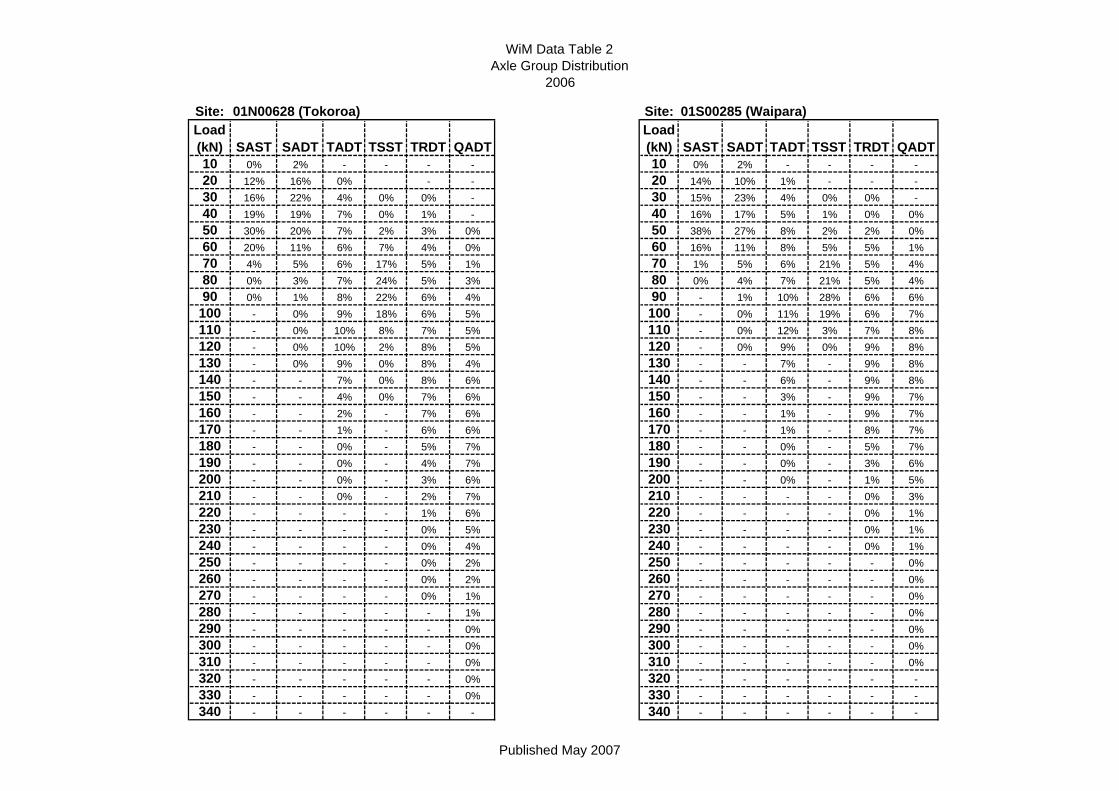
WiM Data Table 2Axle Group Distribution
2006
Site: 01N00628 (Tokoroa) Site: 01S00285 (Waipara)Load (kN) SAST SADT TADT TSST TRDT QADT
Load (kN) SAST SADT TADT TSST TRDT QADT
10 0% 2% - - - - 10 0% 2% - - - -20 12% 16% 0% - - 20 14% 10% 1% - - -30 16% 22% 4% 0% 0% - 30 15% 23% 4% 0% 0% -40 19% 19% 7% 0% 1% - 40 16% 17% 5% 1% 0% 0%50 30% 20% 7% 2% 3% 0% 50 38% 27% 8% 2% 2% 0%60 20% 11% 6% 7% 4% 0% 60 16% 11% 8% 5% 5% 1%70 4% 5% 6% 17% 5% 1% 70 1% 5% 6% 21% 5% 4%80 0% 3% 7% 24% 5% 3% 80 0% 4% 7% 21% 5% 4%90 0% 1% 8% 22% 6% 4% 90 - 1% 10% 28% 6% 6%
100 - 0% 9% 18% 6% 5% 100 - 0% 11% 19% 6% 7%110 - 0% 10% 8% 7% 5% 110 - 0% 12% 3% 7% 8%120 - 0% 10% 2% 8% 5% 120 - 0% 9% 0% 9% 8%130 - 0% 9% 0% 8% 4% 130 - - 7% - 9% 8%140 - - 7% 0% 8% 6% 140 - - 6% - 9% 8%150 - - 4% 0% 7% 6% 150 - - 3% - 9% 7%160 - - 2% - 7% 6% 160 - - 1% - 9% 7%170 - - 1% - 6% 6% 170 - - 1% - 8% 7%180 - - 0% - 5% 7% 180 - - 0% - 5% 7%190 - - 0% - 4% 7% 190 - - 0% - 3% 6%200 - - 0% - 3% 6% 200 - - 0% - 1% 5%210 - - 0% - 2% 7% 210 - - - - 0% 3%220 - - - - 1% 6% 220 - - - - 0% 1%230 - - - - 0% 5% 230 - - - - 0% 1%240 - - - - 0% 4% 240 - - - - 0% 1%250 - - - - 0% 2% 250 - - - - - 0%260 - - - - 0% 2% 260 - - - - - 0%270 - - - - 0% 1% 270 - - - - - 0%280 - - - - - 1% 280 - - - - - 0%290 - - - - - 0% 290 - - - - - 0%300 - - - - - 0% 300 - - - - - 0%310 - - - - - 0% 310 - - - - - 0%320 - - - - - 0% 320 - - - - - -330 - - - - - 0% 330 - - - - - -340 - - - - - - 340 - - - - - -
Published May 2007
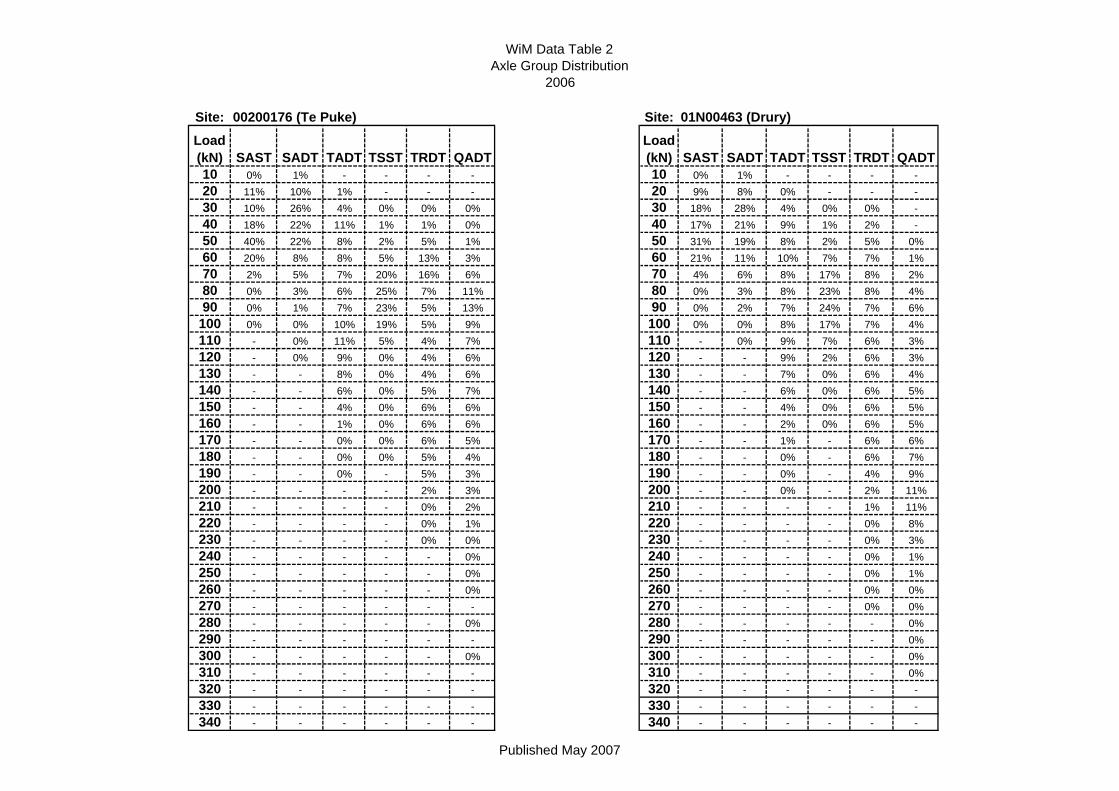
WiM Data Table 2Axle Group Distribution
2006
Site: 00200176 (Te Puke) Site: 01N00463 (Drury)Load (kN) SAST SADT TADT TSST TRDT QADT
Load (kN) SAST SADT TADT TSST TRDT QADT
10 0% 1% - - - - 10 0% 1% - - - -20 11% 10% 1% - - - 20 9% 8% 0% - - -30 10% 26% 4% 0% 0% 0% 30 18% 28% 4% 0% 0% -40 18% 22% 11% 1% 1% 0% 40 17% 21% 9% 1% 2% -50 40% 22% 8% 2% 5% 1% 50 31% 19% 8% 2% 5% 0%60 20% 8% 8% 5% 13% 3% 60 21% 11% 10% 7% 7% 1%70 2% 5% 7% 20% 16% 6% 70 4% 6% 8% 17% 8% 2%80 0% 3% 6% 25% 7% 11% 80 0% 3% 8% 23% 8% 4%90 0% 1% 7% 23% 5% 13% 90 0% 2% 7% 24% 7% 6%
100 0% 0% 10% 19% 5% 9% 100 0% 0% 8% 17% 7% 4%110 - 0% 11% 5% 4% 7% 110 - 0% 9% 7% 6% 3%120 - 0% 9% 0% 4% 6% 120 - - 9% 2% 6% 3%130 - - 8% 0% 4% 6% 130 - - 7% 0% 6% 4%140 - - 6% 0% 5% 7% 140 - - 6% 0% 6% 5%150 - - 4% 0% 6% 6% 150 - - 4% 0% 6% 5%160 - - 1% 0% 6% 6% 160 - - 2% 0% 6% 5%170 - - 0% 0% 6% 5% 170 - - 1% - 6% 6%180 - - 0% 0% 5% 4% 180 - - 0% - 6% 7%190 - - 0% - 5% 3% 190 - - 0% - 4% 9%200 - - - - 2% 3% 200 - - 0% - 2% 11%210 - - - - 0% 2% 210 - - - - 1% 11%220 - - - - 0% 1% 220 - - - - 0% 8%230 - - - - 0% 0% 230 - - - - 0% 3%240 - - - - - 0% 240 - - - - 0% 1%250 - - - - - 0% 250 - - - - 0% 1%260 - - - - - 0% 260 - - - - 0% 0%270 - - - - - - 270 - - - - 0% 0%280 - - - - - 0% 280 - - - - - 0%290 - - - - - - 290 - - - - - 0%300 - - - - - 0% 300 - - - - - 0%310 - - - - - - 310 - - - - - 0%320 - - - - - - 320 - - - - - -330 - - - - - - 330 - - - - - -340 - - - - - - 340 - - - - - -
Published May 2007