Embed Size (px)
Citation preview
Planning 4 Sustainable Development Pty LtdP4SD Pty Ltd
ABN: 76 071 918 888M: 04080 72821 Ph: 07 5435 23777Int: +61 4080 72821 +61 7 5435 2377
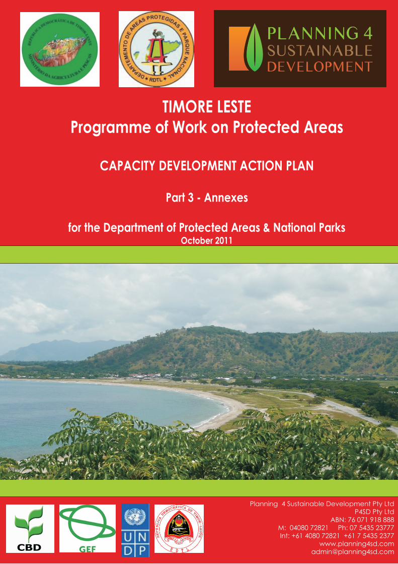
TIMORE LESTEProgramme of Work on Protected Areas
CAPACITY DEVELOPMENT ACTION PLAN
Part 3 - Annexes
for the Department of Protected Areas & National ParksOctober 2011

© Planning 4 Sustainable Development Pty. Ltd. +61 7 54352377
2
TABLE OF CONTENTS
ANNEX 1: MAF ORGANIZATION STRUCTURE (2009) ................................................................................................. 3
ANNEX 2: PROBLEM TREE SUMMARY TABLES – KEY INSTITUTIONAL ISSUES ............................................. 4
ANNEX 3: PROBLEM TREE SUMMARY TABLES – KEY THEMATIC ISSUES ..................................................... 18
ANNEX 4: CAPACITY NEEDS ASSESSMENT ON-LINE SURVEYS .......................................................................... 28
ANNEX 5: LIST OF PARTICIPANTS AT THE MULTI-STAKEHOLDER PRESENTATION ................................. 29
ANNEX 6: CAPACITY ASSESSMENT FOR VEGETATION SURVEY AND MAPPING ......................................... 30
ANNEX 7: CURRENT IT EQUIPMENT DPANP ............................................................................................................. 35
ANNEX 8: EDUCATION AND TRAINING PLAN – A FRAMEWORK TO PLAN AND MONITOR ...................... 36
ANNEX 9: FINANCIAL PLAN – LOG FRAME MATRIX ............................................................................................. 39
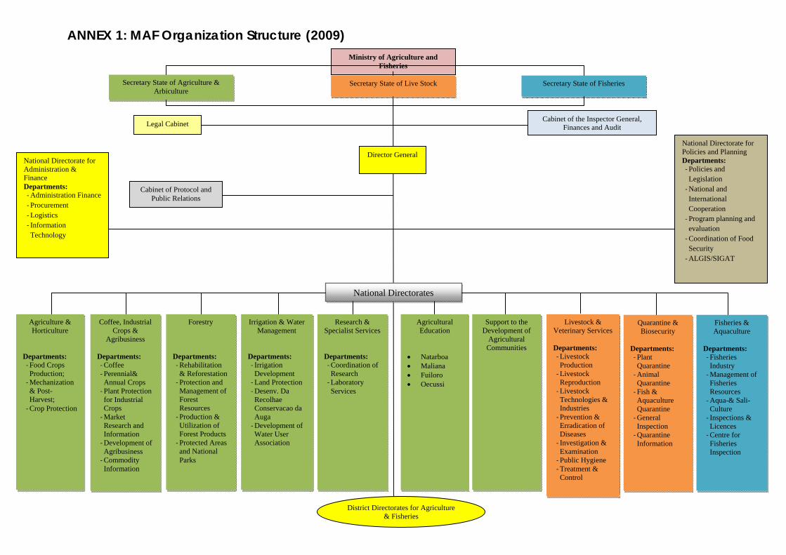
ANNEX 1: MAF Organization Structure (2009) Ministry of Agriculture and
Fisheries
Secretary State of Agriculture & Arbiculture
Secretary State of Fisheries
Legal Cabinet Cabinet of the Inspector General,
Finances and Audit
Cabinet of Protocol and Public Relations
National Directorate for Administration & Finance Departments: ‐ Administration Finance ‐ Procurement ‐ Logistics ‐ Information Technology
National Directorate for Policies and Planning Departments: ‐ Policies and Legislation ‐ National and International Cooperation ‐ Program planning and evaluation ‐ Coordination of Food Security ‐ ALGIS/SIGAT
Agriculture & Horticulture
Departments: ‐ Food Crops Production; ‐ Mechanization & Post-Harvest; ‐ Crop Protection
Coffee, Industrial Crops &
Agribusiness Departments: ‐ Coffee ‐ Perennial& Annual Crops ‐ Plant Protection for Industrial Crops ‐ Market Research and Information ‐ Development of Agribusiness ‐ Commodity Information
Forestry Departments: ‐ Rehabilitation & Reforestation ‐ Protection and Management of Forest Resources ‐ Production & Utilization of Forest Products ‐ Protected Areas and National Parks
Irrigation & Water Management
Departments: ‐ Irrigation Development ‐ Land Protection ‐ Desenv. Da Recolhae Conservacao da Auga ‐ Development of Water User Association
Research & Specialist Services Departments: ‐ Coordination of Research ‐ Laboratory Services
Agricultural Education
Natarboa Maliana Fuiloro Oecussi
Support to the Development of
Agricultural Communities
Livestock & Veterinary Services Departments: ‐ Livestock Production ‐ Livestock Reproduction ‐ Livestock Technologies & Industries ‐ Prevention & Erradication of Diseases ‐ Investigation & Examination ‐ Public Hygiene ‐ Treatment & Control
Quarantine & Biosecurity
Departments: ‐ Plant Quarantine ‐ Animal Quarantine ‐ Fish & Aquaculture Quarantine ‐ General Inspection ‐ Quarantine Information
Fisheries & Aquaculture
Departments: ‐ Fisheries Industry ‐ Management of Fisheries Resources ‐ Aqua-& Sali-Culture ‐ Inspections & Licences ‐ Centre for Fisheries Inspection
Director General
Secretary State of Live Stock
District Directorates for Agriculture & Fisheries
National Directorates
© Planning 4 Sustainable Development Pty. Ltd. +61 7 54352377
4
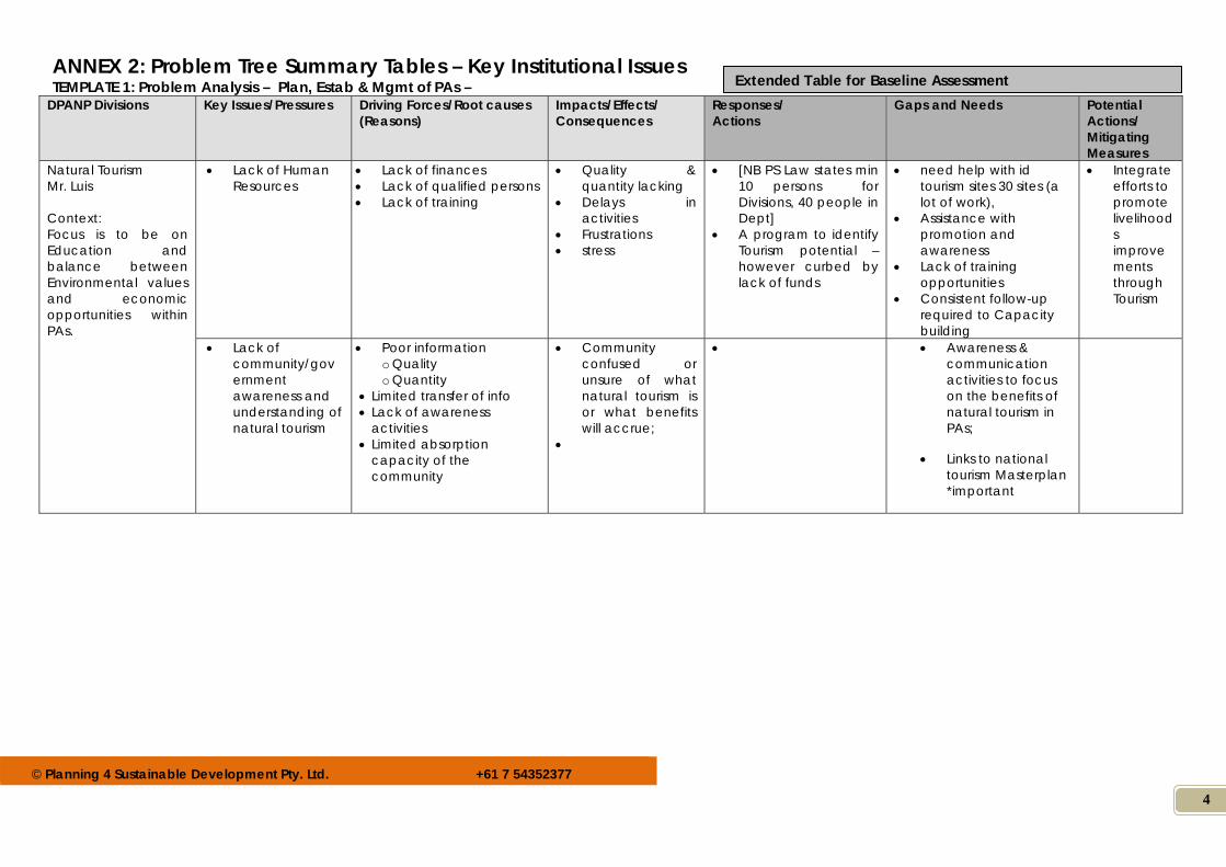
ANNEX 2: Problem Tree Summary Tables – Key Institutional Issues TEMPLATE 1: Problem Analysis – Plan, Estab & Mgmt of PAs –
DPANP Divisions Key Issues/Pressures Driving Forces/Root causes (Reasons)
Impacts/Effects/ Consequences
Responses/ Actions
Gaps and Needs Potential Actions/ Mitigating Measures
Natural Tourism Mr. Luis Context: Focus is to be on Education and balance between Environmental values and economic opportunities within PAs.
Lack of Human Resources
Lack of finances Lack of qualified persons Lack of training
Quality & quantity lacking
Delays in activities
Frustrations stress
[NB PS Law states min 10 persons for Divisions, 40 people in Dept]
A program to identify Tourism potential – however curbed by lack of funds
need help with id tourism sites 30 sites (a lot of work),
Assistance with promotion and awareness
Lack of training opportunities
Consistent follow-up required to Capacity building
Integrate efforts to promote livelihoods improvements through Tourism
Lack of community/government awareness and understanding of natural tourism
Poor information o Quality o Quantity
Limited transfer of info Lack of awareness
activities Limited absorption
capacity of the community
Community confused or unsure of what natural tourism is or what benefits will accrue;
Awareness & communication activities to focus on the benefits of natural tourism in PAs;
Links to national tourism Masterplan *important
Extended Table for Baseline Assessment
© Planning 4 Sustainable Development Pty. Ltd. +61 7 54352377
5
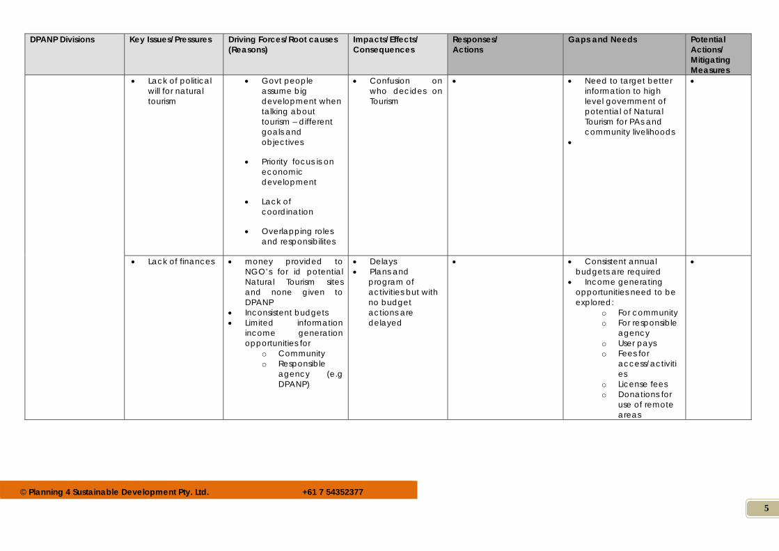
DPANP Divisions Key Issues/Pressures Driving Forces/Root causes (Reasons)
Impacts/Effects/ Consequences
Responses/ Actions
Gaps and Needs Potential Actions/ Mitigating Measures
Lack of political will for natural tourism
Govt people assume big development when talking about tourism – different goals and objectives
Priority focus is on economic development
Lack of coordination
Overlapping roles and responsibilites
Confusion on who decides on Tourism
Need to target better information to high level government of potential of Natural Tourism for PAs and community livelihoods
Lack of finances
money provided to NGO’s for id potential Natural Tourism sites and none given to DPANP
Inconsistent budgets Limited information
income generation opportunities for
o Community o Responsible
agency (e.g DPANP)
Delays Plans and
program of activities but with no budget actions are delayed
Consistent annual budgets are required
Income generating opportunities need to be explored:
o For community o For responsible
agency o User pays o Fees for
access/activities
o License fees o Donations for
use of remote areas
© Planning 4 Sustainable Development Pty. Ltd. +61 7 54352377
6
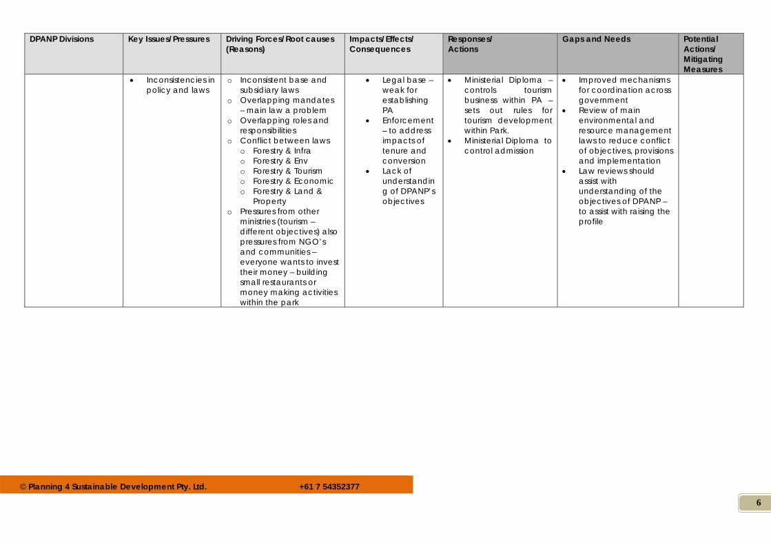
DPANP Divisions Key Issues/Pressures Driving Forces/Root causes (Reasons)
Impacts/Effects/ Consequences
Responses/ Actions
Gaps and Needs Potential Actions/ Mitigating Measures
Inconsistencies in policy and laws
o Inconsistent base and subsidiary laws
o Overlapping mandates – main law a problem
o Overlapping roles and responsibilities
o Conflict between laws o Forestry & Infra o Forestry & Env o Forestry & Tourism o Forestry & Economic o Forestry & Land &
Property o Pressures from other
ministries (tourism – different objectives) also pressures from NGO’s and communities – everyone wants to invest their money – building small restaurants or money making activities within the park
Legal base – weak for establishing PA
Enforcement – to address impacts of tenure and conversion
Lack of understanding of DPANP’s objectives
Ministerial Diploma – controls tourism business within PA – sets out rules for tourism development within Park.
Ministerial Diploma to control admission
Improved mechanisms for coordination across government
Review of main environmental and resource management laws to reduce conflict of objectives, provisions and implementation
Law reviews should assist with understanding of the objectives of DPANP – to assist with raising the profile
© Planning 4 Sustainable Development Pty. Ltd. +61 7 54352377
7
DPANP Divisions Key Issues/Pressures Driving Forces/Root causes (Reasons)
Impacts/Effects/ Consequences
Responses/ Actions
Gaps and Needs Potential Actions/ Mitigating Measures
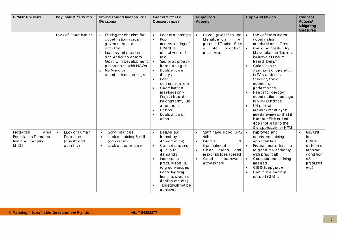
Lack of Coordination
o Existing mechanism for coordination across government not effective
o Inconsistent programs and activities: across Govt, with Development projects and with NGOs
o No X-sector coordination meetings
Poor relationships Poor
understanding of DPANP’s objectives and role
Sector approach based on egos
Duplication & delays
Poor communications
Coordination meetings only Project based: inconsistency, Silo approach;
Delays Duplication of
effort
Have guidelines on Identification of potential Tourism Sites – site selection; prioritizing.
Lack of cross-sector coordination mechanisms in Govt
Could be assisted by Masterplan for Tourism, inclusive of Nature based Tourism
Guidelines on standards of operation in PAs: activities, Services, Socio-economic performance.
Needs for x-sector coordination meetings in NRM Ministries;
UN project management cycle – needs review so that it is more efficient and does not lead to the Silo approach for NRM
Protected Area Boundaries/Demarcation and mapping Mr.Gil
Lack of Human Resources (quality and quantity)
Govt Finances Lack of training & skill
(consistent) Lack of opportunity
Delays (e.g boundary demarcation)
Cannot respond quickly to demands
Increase in pressures on PA (e.g conversions, illegal logging, hunting, species decline etc etc)
Targets will not be achieved
Staff have good GPS skills
Interest & Commitment
Clear areas and responsibilities agreed
Good teamwork atmosphere
Improved and consistent training opportunities
Programmatic training (a good mix of theory with practical)
Cross-sectoral training needed
GIS Skills upgrade Continued backup
support (GIS….
GIS Unit for DPANP: state and monitor conditions & pressures etc)
© Planning 4 Sustainable Development Pty. Ltd. +61 7 54352377
8
DPANP Divisions Key Issues/Pressures Driving Forces/Root causes (Reasons)
Impacts/Effects/ Consequences
Responses/ Actions
Gaps and Needs Potential Actions/ Mitigating Measures
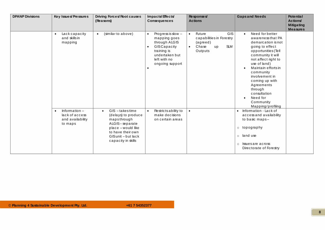
Lack capacity and skills in mapping
(similar to above) Progress is slow – mapping goes through ALGIS
GIS Capacity training is undertaken but left with no ongoing support
Future GIS capabilities in Forestry (agreed)
Chase up SLM Outputs
Need for better awareness that PA demarcation is not going to effect opportunities (Tell community it will not affect right to use of land)
Maintain efforts in community involvement in coming up with Agreements through consultation
Need for Community Mapping/profiling
Information – lack of access and availability to maps
GIS – takes time (delays) to produce maps through ALGIS – separate place – would like to have their own GIS unit – but lack capacity in skills
Restricts ability to make decisions on certain areas
Information - Lack of access and availability to basic maps –
o topography
o land use
o Issues are across Directorate of Forestry
© Planning 4 Sustainable Development Pty. Ltd. +61 7 54352377
9
DPANP Divisions Key Issues/Pressures Driving Forces/Root causes (Reasons)
Impacts/Effects/ Consequences
Responses/ Actions
Gaps and Needs Potential Actions/ Mitigating Measures
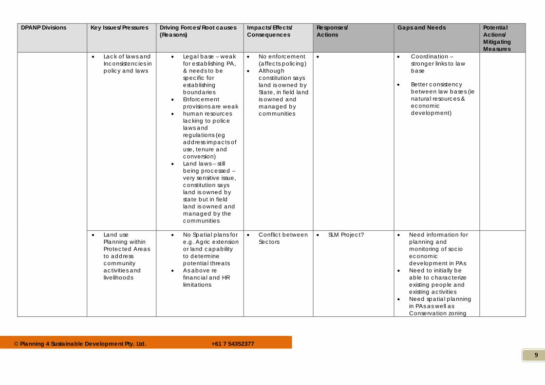
Lack of laws and Inconsistencies in policy and laws
Legal base – weak for establishing PA, & needs to be specific for establishing boundaries
Enforcement provisions are weak
human resources lacking to police laws and regulations (eg address impacts of use, tenure and conversion)
Land laws – still being processed – very sensitive issue, constitution says land is owned by state but in field land is owned and managed by the communities
No enforcement (affects policing)
Although constitution says land is owned by State, in field land is owned and managed by communities
Coordination – stronger links to law base
Better consistency between law bases (ie natural resources & economic development)
Land use Planning within Protected Areas to address community activities and livelihoods
No Spatial plans for e.g. Agric extension or land capability to determine potential threats
As above re financial and HR limitations
Conflict between Sectors
SLM Project? Need information for planning and monitoring of socio economic development in PAs
Need to initially be able to characterize existing people and existing activities
Need spatial planning in PAs as well as Conservation zoning
© Planning 4 Sustainable Development Pty. Ltd. +61 7 54352377
10
DPANP Divisions Key Issues/Pressures Driving Forces/Root causes (Reasons)
Impacts/Effects/ Consequences
Responses/ Actions
Gaps and Needs Potential Actions/ Mitigating Measures
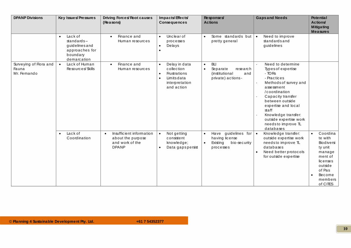
Lack of standards – guidelines and approaches for boundary demarcation
Finance and Human resources
Unclear of processes
Delays
Some standards but pretty general
Need to improve standards and guidelines
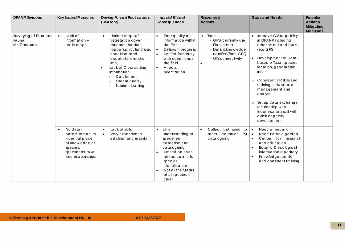
Surveying of Flora and Fauna Mr. Fernando
Lack of Human Resources/Skills
Finance and Human resources
Delay in data collection
Frustrations Limits data
interpretation and action
BLI Separate research
(institutional and private) actions -
‐ Need to determine Types of expertise - TORs - Practices
‐ Methods of survey and assessment /coordination
‐ Capacity transfer between outside expertise and local staff
‐ Knowledge transfer: outside expertise work needs to improve TL databases
Lack of Coordination
Insufficient information about the purpose and work of the DPANP
Not getting consistent knowledge;
Data gaps persist
Have guidelines for having license
Existing bio-security processes
Knowledge transfer: outside expertise work needs to improve TL databases
Need better protocols for outside expertise
Coordinate with Biodiversity unit management of licenses outside of Pas
Become members of CITES
© Planning 4 Sustainable Development Pty. Ltd. +61 7 54352377
11
DPANP Divisions Key Issues/Pressures Driving Forces/Root causes (Reasons)
Impacts/Effects/ Consequences
Responses/ Actions
Gaps and Needs Potential Actions/ Mitigating Measures
Surveying of Flora and Fauna Mr. Fernando
Lack of information – basic maps
Limited maps of vegetation cover, structure, habitat, topographic, land use, condition, land capability, climatic info,
Lack of Cross cutting information o Catchment o Stream quality o Nutrient loading
Poor quality of information within the PAs
Delays in progress Limited familiarity
with conditions in the field
Affects prioritization
Tools ‐ GPS (currently use) ‐ Plani meter ‐ Data &knowledge
transfer (from GPS) ‐ GIS connectivity
Improve GIS capability in DPANP including other associated tools (e.g GPS
Development of Data-bases re Taxa, species location, geographic info–
o Consistent HR skills and training in database management and analysis
o Set up data exchange relationship with Indonesia to assist with quick capacity development
No data-bases/Herbarium – central place of knowledge of species, specimens, taxa and relationships
Lack of skills Very expensive to
establish and maintain
Little understanding of specimen collection and cataloguing
Limited on-hand reference info for species identification
Not all the Status of all species is clear
Collect but send to other countries for cataloguing
Need a herbarium Need Botanic garden Centre for research
and education Botanic & ecological
information repository Knowledge transfer
and consistent training
© Planning 4 Sustainable Development Pty. Ltd. +61 7 54352377
12
DPANP Divisions Key Issues/Pressures Driving Forces/Root causes (Reasons)
Impacts/Effects/ Consequences
Responses/ Actions
Gaps and Needs Potential Actions/ Mitigating Measures
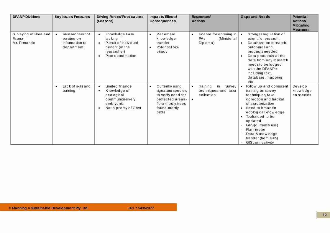
Surveying of Flora and Fauna Mr. Fernando
Researchers not passing on information to department
Knowledge Base lacking
Pursuit of individual benefit (of the researcher)
Poor coordination
Piecemeal knowledge transfer
Potential bio-piracy
License for entering in PAs (Ministerial Diploma)
Stronger regulation of scientific research.
Database on research, outcomes and products needed
Data protocols: all the data from any research needs to be lodged with the DPANP = including text, database, mapping etc.
Lack of skills and training
Limited finance Knowledge of
ecological communities very embryonic
Not a priority of Govt
Currently using signature species, to verify need for protected areas - flora-mostly trees, fauna-mostly birds
Training in Survey techniques and taxa collection
Follow up and consistent training on survey techniques, taxa collection and habitat characterization
Need to broaden ecological knowledge
Tools need to be updated
‐ GPS (currently use) ‐ Plani meter ‐ Data &knowledge
transfer (from GPS) ‐ GIS connectivity
Develop knowledge on species
© Planning 4 Sustainable Development Pty. Ltd. +61 7 54352377
13
DPANP Divisions Key Issues/Pressures Driving Forces/Root causes (Reasons)
Impacts/Effects/ Consequences
Responses/ Actions
Gaps and Needs Potential Actions/ Mitigating Measures
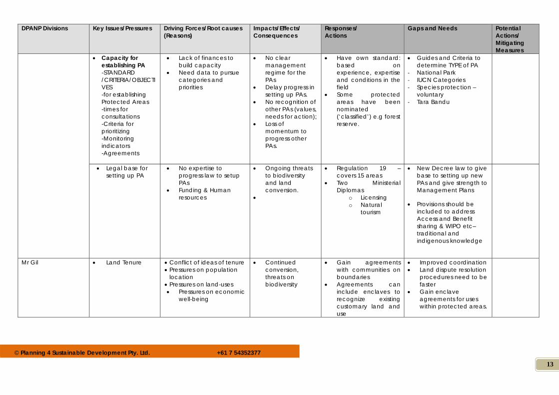
Capacity for establishing PA -STANDARD /CRITERIA/OBJECTIVES -for establishing Protected Areas -times for consultations -Criteria for prioritizing -Monitoring indicators -Agreements
Lack of finances to build capacity
Need data to pursue categories and priorities
No clear management regime for the PAs
Delay progress in setting up PAs.
No recognition of other PAs (values, needs for action);
Loss of momentum to progress other PAs.
Have own standard: based on experience, expertise and conditions in the field
Some protected areas have been nominated (‘classified’) e.g forest reserve.
Guides and Criteria to determine TYPE of PA
‐ National Park ‐ IUCN Categories ‐ Species protection –
voluntary ‐ Tara Bandu
Legal base for setting up PA
No expertise to progress law to setup PAs
Funding & Human resources
Ongoing threats to biodiversity and land conversion.
Regulation 19 – covers 15 areas
Two Ministerial Diplomas
o Licensing o Natural
tourism
New Decree law to give base to setting up new PAs and give strength to Management Plans
Provisions should be included to address Access and Benefit sharing & WIPO etc– traditional and indigenous knowledge
Mr Gil Land Tenure
Conflict of ideas of tenure Pressures on population
location Pressures on land-uses Pressures on economic
well-being
Continued conversion, threats on biodiversity
Gain agreements with communities on boundaries
Agreements can include enclaves to recognize existing customary land and use
Improved coordination Land dispute resolution
procedures need to be faster
Gain enclave agreements for uses within protected areas.
© Planning 4 Sustainable Development Pty. Ltd. +61 7 54352377
14
DPANP Divisions Key Issues/Pressures Driving Forces/Root causes (Reasons)
Impacts/Effects/ Consequences
Responses/ Actions
Gaps and Needs Potential Actions/ Mitigating Measures
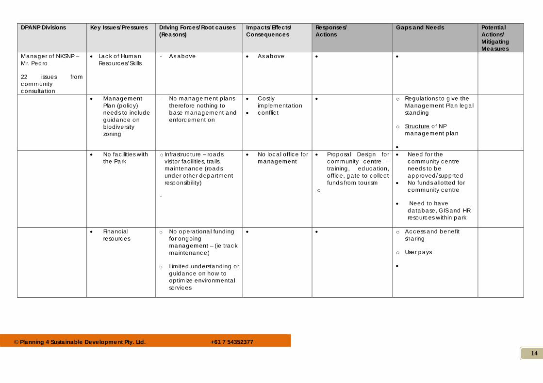
Manager of NKSNP – Mr. Pedro
22 issues from community consultation
Lack of Human Resources/Skills
‐ As above As above
Management Plan (policy) needs to include guidance on biodiversity zoning
‐ No management plans therefore nothing to base management and enforcement on
Costly implementation
conflict
o Regulations to give the Management Plan legal standing
o Structure of NP management plan
No facilities with the Park
o Infrastructure – roads, visitor facilities, trails, maintenance (roads under other department responsibility)
‐
No local office for management
Proposal Design for community centre – training, education, office, gate to collect funds from tourism
o
Need for the community centre needs to be approved/supprted
No funds allotted for community centre
Need to have database, GIS and HR resources within park
Financial resources
o No operational funding for ongoing management – (ie track maintenance)
o Limited understanding or guidance on how to optimize environmental services
o Access and benefit sharing
o User pays
© Planning 4 Sustainable Development Pty. Ltd. +61 7 54352377
15
DPANP Divisions Key Issues/Pressures Driving Forces/Root causes (Reasons)
Impacts/Effects/ Consequences
Responses/ Actions
Gaps and Needs Potential Actions/ Mitigating Measures
Knowledge on how to manage both marine and terrestrial side of National Park
Knowledge transfer Capacity
‐
Lack of nurtured development of knowledge among stakeholders
o Capacity, resources, choices, links to other government dept, operation, choices
Integrated planning
‐ Need to undertake conservation within a broader community development framework.
Conflict confusion
o Land use planning
o Social and cultural planning
o NRM planning
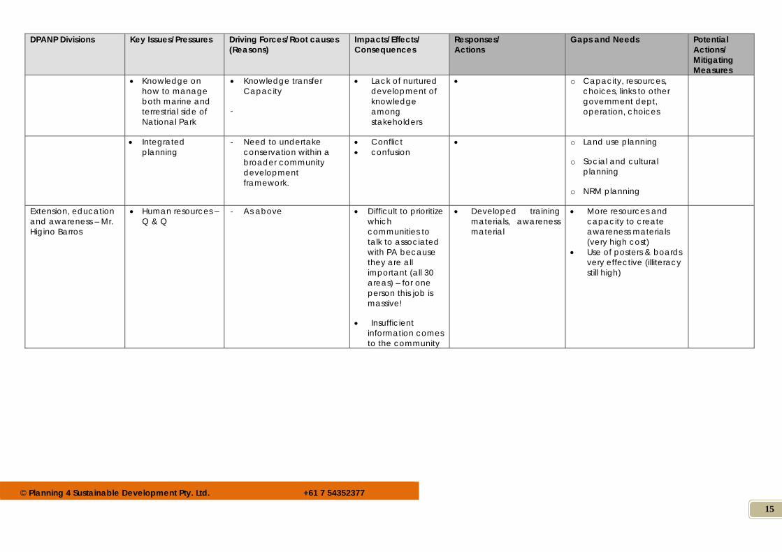
Extension, education and awareness – Mr. Higino Barros
Human resources – Q & Q
‐ As above Difficult to prioritize which communities to talk to associated with PA because they are all important (all 30 areas) – for one person this job is massive!
Insufficient information comes to the community
Developed training materials, awareness material
More resources and capacity to create awareness materials (very high cost)
Use of posters & boards very effective (illiteracy still high)
© Planning 4 Sustainable Development Pty. Ltd. +61 7 54352377
16
DPANP Divisions Key Issues/Pressures Driving Forces/Root causes (Reasons)
Impacts/Effects/ Consequences
Responses/ Actions
Gaps and Needs Potential Actions/ Mitigating Measures
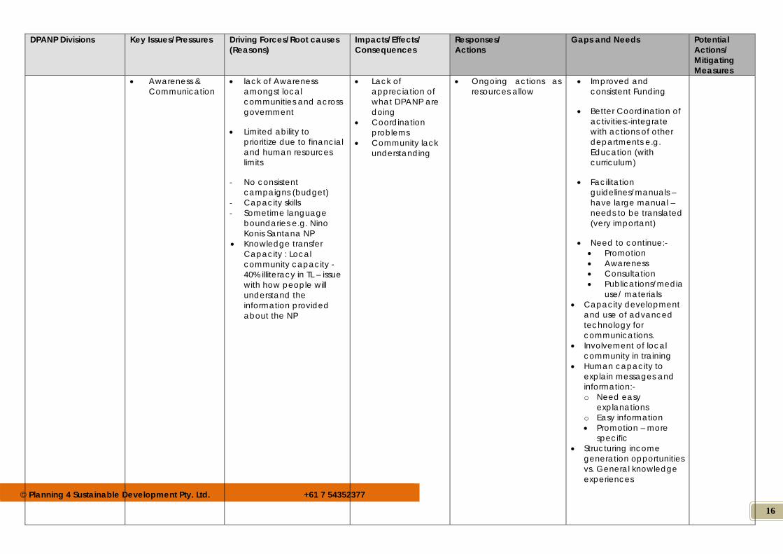
Awareness & Communication
lack of Awareness amongst local communities and across government
Limited ability to prioritize due to financial and human resources limits
‐ No consistent campaigns (budget)
‐ Capacity skills ‐ Sometime language
boundaries e.g. Nino Konis Santana NP
Knowledge transfer Capacity : Local community capacity - 40% illiteracy in TL – issue with how people will understand the information provided about the NP
Lack of appreciation of what DPANP are doing
Coordination problems
Community lack understanding
Ongoing actions as resources allow
Improved and consistent Funding
Better Coordination of activities:-integrate with actions of other departments e.g. Education (with curriculum)
Facilitation guidelines/manuals – have large manual – needs to be translated (very important)
Need to continue:- Promotion Awareness Consultation Publications/media
use/ materials Capacity development
and use of advanced technology for communications.
Involvement of local community in training
Human capacity to explain messages and information:- o Need easy
explanations o Easy information Promotion – more
specific Structuring income
generation opportunities vs. General knowledge experiences
© Planning 4 Sustainable Development Pty. Ltd. +61 7 54352377
17
DPANP Divisions Key Issues/Pressures Driving Forces/Root causes (Reasons)
Impacts/Effects/ Consequences
Responses/ Actions
Gaps and Needs Potential Actions/ Mitigating Measures
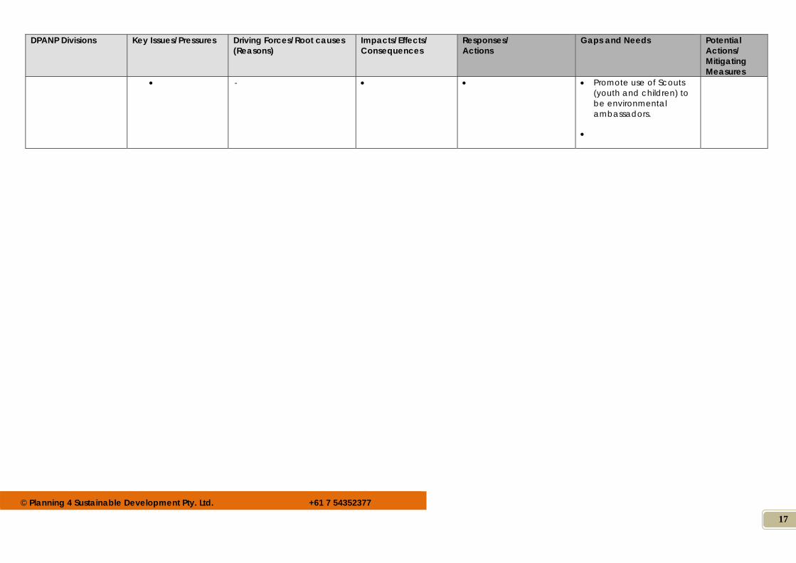
‐ Promote use of Scouts (youth and children) to be environmental ambassadors.
© Planning 4 Sustainable Development Pty. Ltd. +61 7 54352377
18
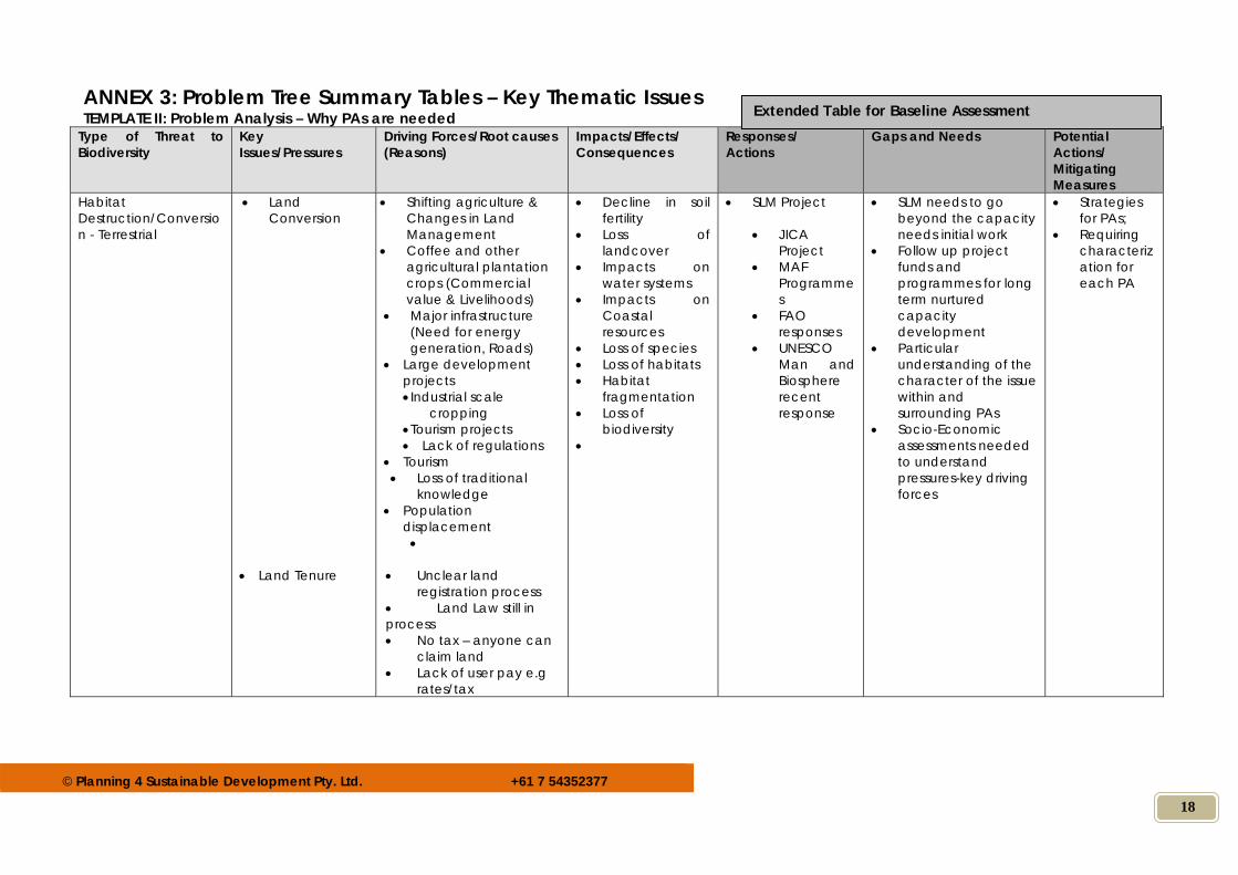
ANNEX 3: Problem Tree Summary Tables – Key Thematic Issues TEMPLATE II: Problem Analysis – Why PAs are needed
Type of Threat to Biodiversity
Key Issues/Pressures
Driving Forces/Root causes (Reasons)
Impacts/Effects/ Consequences
Responses/ Actions
Gaps and Needs Potential Actions/ Mitigating Measures
Habitat Destruction/Conversion - Terrestrial
Land Conversion
Land Tenure
Shifting agriculture & Changes in Land Management
Coffee and other agricultural plantation crops (Commercial value & Livelihoods)
Major infrastructure (Need for energy generation, Roads)
Large development projects Industrial scale
cropping Tourism projects Lack of regulations
Tourism Loss of traditional
knowledge Population
displacement
Unclear land
registration process Land Law still in process No tax – anyone can
claim land Lack of user pay e.g
rates/tax
Decline in soil fertility
Loss of landcover
Impacts on water systems
Impacts on Coastal resources
Loss of species Loss of habitats Habitat
fragmentation Loss of
biodiversity
SLM Project
JICA Project
MAF Programmes
FAO responses
UNESCO Man and Biosphere recent response
SLM needs to go beyond the capacity needs initial work
Follow up project funds and programmes for long term nurtured capacity development
Particular understanding of the character of the issue within and surrounding PAs
Socio-Economic assessments needed to understand pressures-key driving forces
Strategies for PAs;
Requiring characterization for each PA
Extended Table for Baseline Assessment
© Planning 4 Sustainable Development Pty. Ltd. +61 7 54352377
19
Type of Threat to Biodiversity
Key Issues/Pressures
Driving Forces/Root causes (Reasons)
Impacts/Effects/ Consequences
Responses/ Actions
Gaps and Needs Potential Actions/ Mitigating Measures
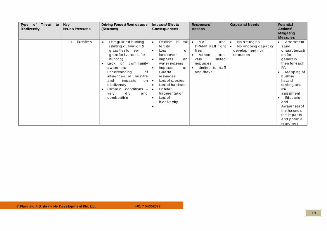
1. Bushfires
Unregulated burning (shifting cultivation & grass fires for new grass for livestock, for hunting)
Lack of community awareness, understanding of influences of bushfire and impacts on biodiversity
Climatic conditions – very dry and combustible
Decline in soil fertility
Loss of landcover
Impacts on water systems
Impacts on Coastal resources
Loss of species Loss of habitats Habitat
fragmentation Loss of
biodiversity
MAF and DPANP staff fight fires
Adhoc and very limited resources
Limited to staff and shovel!!
No strategies No ongoing capacity
development nor resources
Assessments and characterization for generally then for each PA
Mapping of bushfire hazard ranking and risk assessment
Education and Awareness of the hazards, the impacts and possible responses
© Planning 4 Sustainable Development Pty. Ltd. +61 7 54352377
20
Type of Threat to Biodiversity
Key Issues/Pressures
Driving Forces/Root causes (Reasons)
Impacts/Effects/ Consequences
Responses/ Actions
Gaps and Needs Potential Actions/ Mitigating Measures
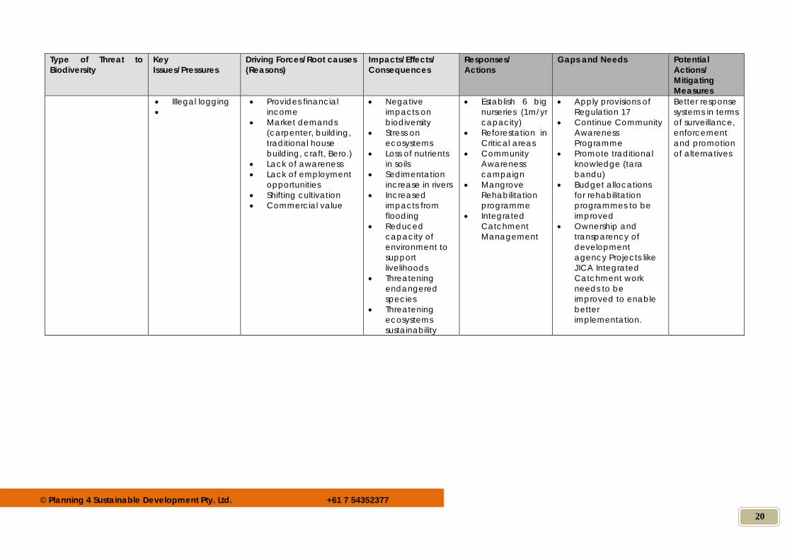
Illegal logging
Provides financial income
Market demands (carpenter, building, traditional house building, craft, Bero.)
Lack of awareness Lack of employment
opportunities Shifting cultivation Commercial value
Negative impacts on biodiversity
Stress on ecosystems
Loss of nutrients in soils
Sedimentation increase in rivers
Increased impacts from flooding
Reduced capacity of environment to support livelihoods
Threatening endangered species
Threatening ecosystems sustainability
Establish 6 big nurseries (1m/yr capacity)
Reforestation in Critical areas
Community Awareness campaign
Mangrove Rehabilitation programme
Integrated Catchment Management
Apply provisions of Regulation 17
Continue Community Awareness Programme
Promote traditional knowledge (tara bandu)
Budget allocations for rehabilitation programmes to be improved
Ownership and transparency of development agency Projects like JICA Integrated Catchment work needs to be improved to enable better implementation.
Better response systems in terms of surveillance, enforcement and promotion of alternatives
© Planning 4 Sustainable Development Pty. Ltd. +61 7 54352377
21
Type of Threat to Biodiversity
Key Issues/Pressures
Driving Forces/Root causes (Reasons)
Impacts/Effects/ Consequences
Responses/ Actions
Gaps and Needs Potential Actions/ Mitigating Measures
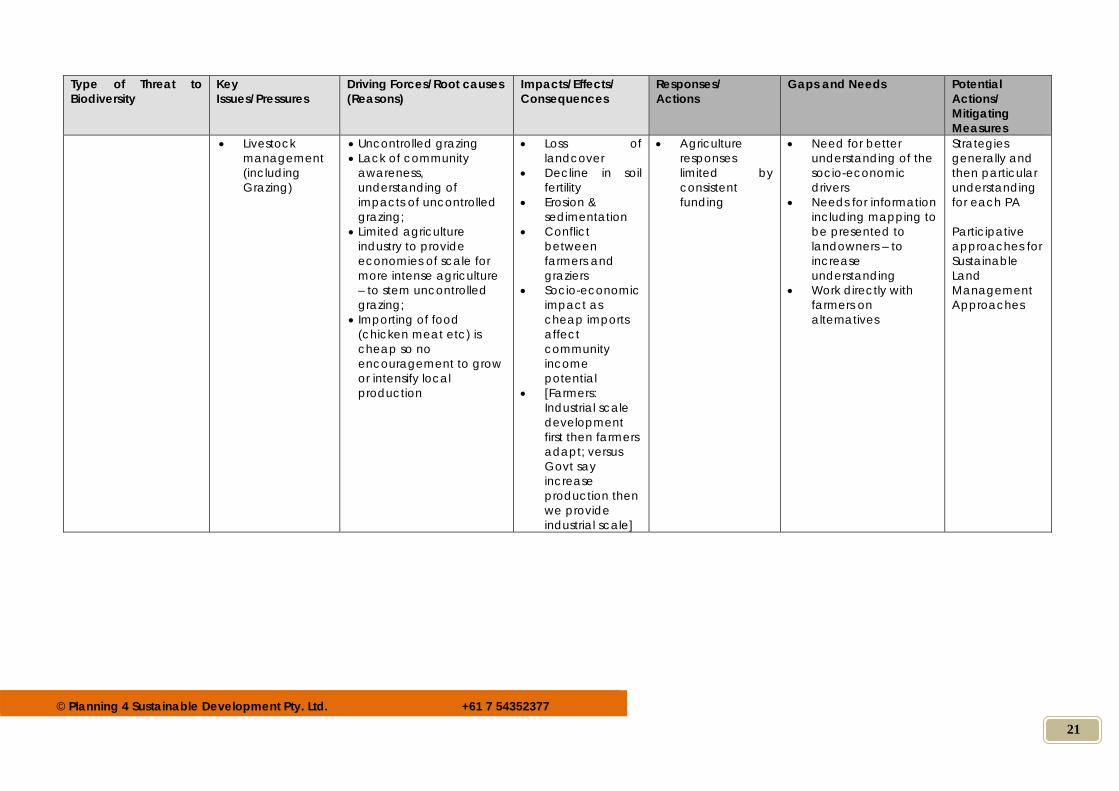
Livestock management (including Grazing)
Uncontrolled grazing Lack of community
awareness, understanding of impacts of uncontrolled grazing;
Limited agriculture industry to provide economies of scale for more intense agriculture – to stem uncontrolled grazing;
Importing of food (chicken meat etc) is cheap so no encouragement to grow or intensify local production
Loss of landcover
Decline in soil fertility
Erosion & sedimentation
Conflict between farmers and graziers
Socio-economic impact as cheap imports affect community income potential
[Farmers: Industrial scale development first then farmers adapt; versus Govt say increase production then we provide industrial scale]
Agriculture responses limited by consistent funding
Need for better understanding of the socio-economic drivers
Needs for information including mapping to be presented to landowners – to increase understanding
Work directly with farmers on alternatives
Strategies generally and then particular understanding for each PA Participative approaches for Sustainable Land Management Approaches
© Planning 4 Sustainable Development Pty. Ltd. +61 7 54352377
22
Type of Threat to Biodiversity
Key Issues/Pressures
Driving Forces/Root causes (Reasons)
Impacts/Effects/ Consequences
Responses/ Actions
Gaps and Needs Potential Actions/ Mitigating Measures
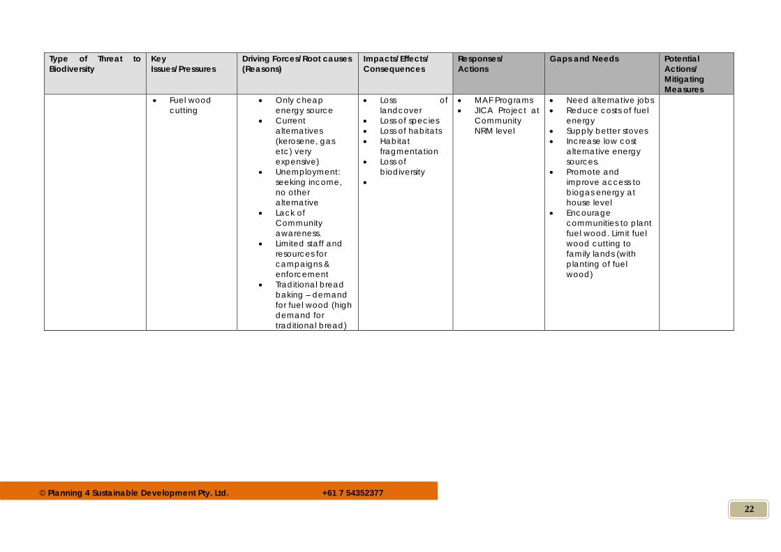
Fuel wood cutting
Only cheap energy source
Current alternatives (kerosene, gas etc) very expensive)
Unemployment: seeking income, no other alternative
Lack of Community awareness.
Limited staff and resources for campaigns & enforcement
Traditional bread baking – demand for fuel wood (high demand for traditional bread)
Loss of landcover
Loss of species Loss of habitats Habitat
fragmentation Loss of
biodiversity
MAF Programs JICA Project at
Community NRM level
Need alternative jobs Reduce costs of fuel
energy Supply better stoves Increase low cost
alternative energy sources.
Promote and improve access to biogas energy at house level
Encourage communities to plant fuel wood. Limit fuel wood cutting to family lands (with planting of fuel wood)
© Planning 4 Sustainable Development Pty. Ltd. +61 7 54352377
23
Type of Threat to Biodiversity
Key Issues/Pressures
Driving Forces/Root causes (Reasons)
Impacts/Effects/ Consequences
Responses/ Actions
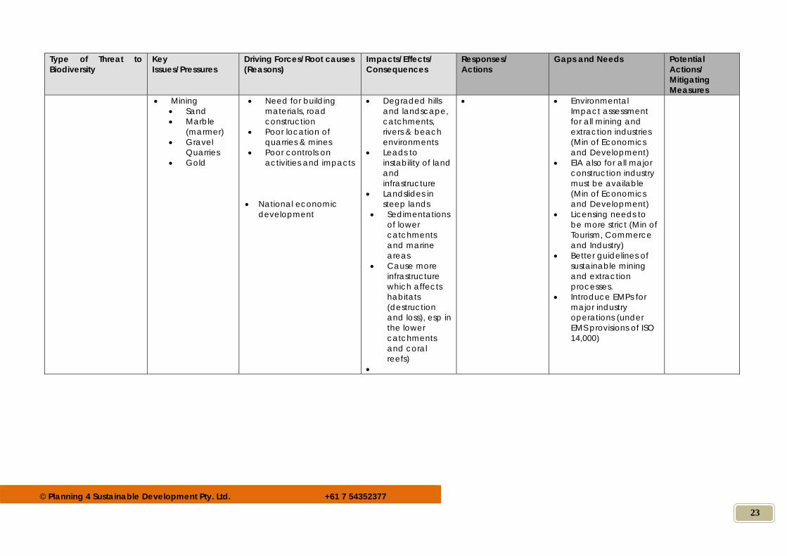
Gaps and Needs Potential Actions/ Mitigating Measures
Mining Sand Marble
(marmer) Gravel
Quarries Gold
Need for building materials, road construction
Poor location of quarries & mines
Poor controls on activities and impacts
National economic
development
Degraded hills and landscape, catchments, rivers & beach environments
Leads to instability of land and infrastructure
Landslides in steep lands
Sedimentations of lower catchments and marine areas
Cause more infrastructure which affects habitats (destruction and loss), esp in the lower catchments and coral reefs)
Environmental Impact assessment for all mining and extraction industries (Min of Economics and Development)
EIA also for all major construction industry must be available (Min of Economics and Development)
Licensing needs to be more strict (Min of Tourism, Commerce and Industry)
Better guidelines of sustainable mining and extraction processes.
Introduce EMPs for major industry operations (under EMS provisions of ISO 14,000)
© Planning 4 Sustainable Development Pty. Ltd. +61 7 54352377
24
Type of Threat to Biodiversity
Key Issues/Pressures
Driving Forces/Root causes (Reasons)
Impacts/Effects/ Consequences
Responses/ Actions
Gaps and Needs Potential Actions/ Mitigating Measures
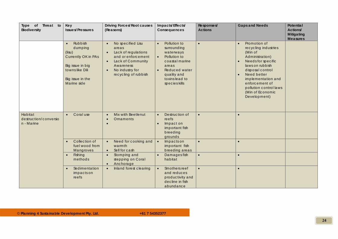
Rubbish dumping
(lisu) Currently OK in PAs Big issue in big towns like Dili Big issue in the Marine side
No specified Lisu areas
Lack of regulations and or enforcement
Lack of Community Awareness
No industry for recycling of rubbish
Pollution to surrounding waterways
Pollution to coastal marine areas
Reduced water quality and toxins lead to species kills
Promotion of recycling industries (Min of Administration)
Needs for specific laws on rubbish disposal control
Need better implementation and enforcement of pollution control laws (Min of Economic Development)
Habitat destruction/conversion - Marine
Coral use Mix with Beetlenut Ornaments
Destruction of reefs
Impact on important fish breeding grounds
Collection of fuel wood from Mangroves
Need for cooking and warmth
Sell for cash
Impacts on important fish breeding areas
Fishing methods
Stomping and stepping on Coral
Anchorage
Damages fish habitat
Sedimentation impacts on reefs
Inland forest clearing
Smothers reef and reduces productivity and decline in fish abundance
© Planning 4 Sustainable Development Pty. Ltd. +61 7 54352377
25
Type of Threat to Biodiversity
Key Issues/Pressures
Driving Forces/Root causes (Reasons)
Impacts/Effects/ Consequences
Responses/ Actions
Gaps and Needs Potential Actions/ Mitigating Measures
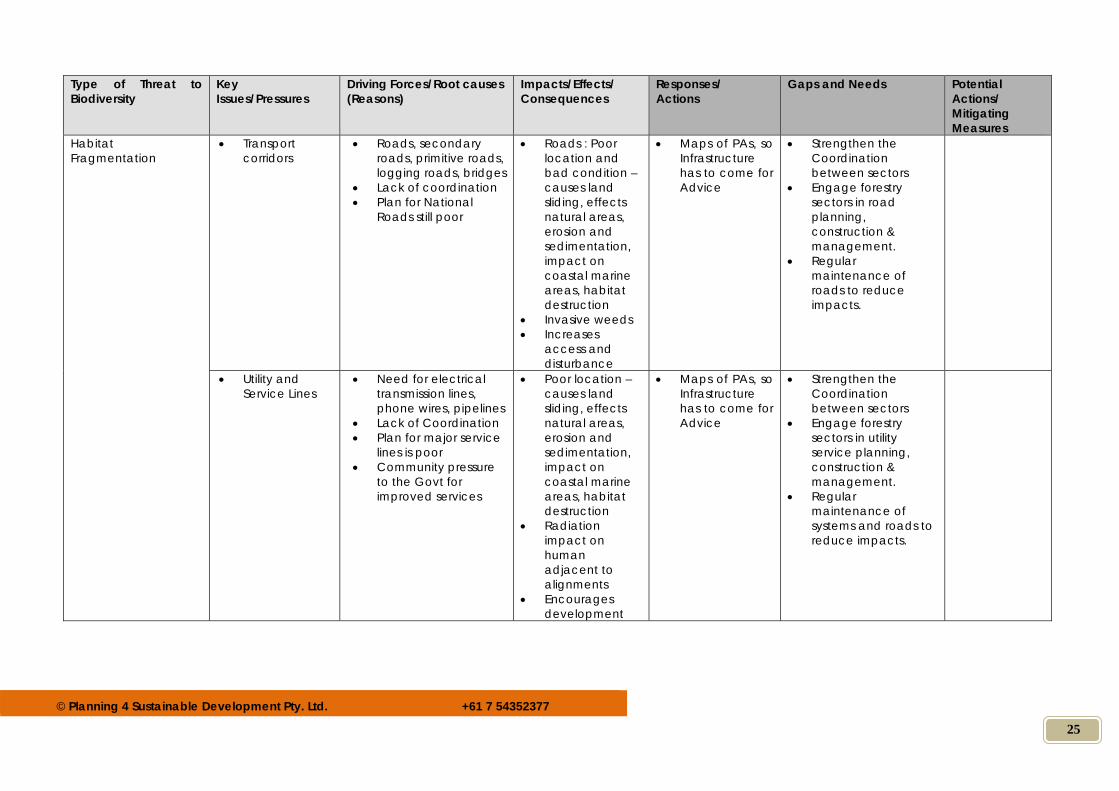
Habitat Fragmentation
Transport corridors
Roads, secondary roads, primitive roads, logging roads, bridges
Lack of coordination Plan for National
Roads still poor
Roads : Poor location and bad condition – causes land sliding, effects natural areas, erosion and sedimentation, impact on coastal marine areas, habitat destruction
Invasive weeds Increases
access and disturbance
Maps of PAs, so Infrastructure has to come for Advice
Strengthen the Coordination between sectors
Engage forestry sectors in road planning, construction & management.
Regular maintenance of roads to reduce impacts.
Utility and Service Lines
Need for electrical transmission lines, phone wires, pipelines
Lack of Coordination Plan for major service
lines is poor Community pressure
to the Govt for improved services
Poor location – causes land sliding, effects natural areas, erosion and sedimentation, impact on coastal marine areas, habitat destruction
Radiation impact on human adjacent to alignments
Encourages development
Maps of PAs, so Infrastructure has to come for Advice
Strengthen the Coordination between sectors
Engage forestry sectors in utility service planning, construction & management.
Regular maintenance of systems and roads to reduce impacts.
© Planning 4 Sustainable Development Pty. Ltd. +61 7 54352377
26
Type of Threat to Biodiversity
Key Issues/Pressures
Driving Forces/Root causes (Reasons)
Impacts/Effects/ Consequences
Responses/ Actions
Gaps and Needs Potential Actions/ Mitigating Measures
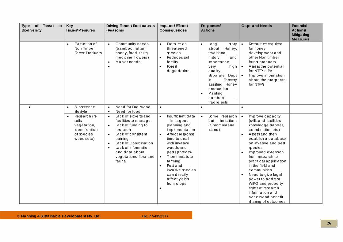
Extraction of Non Timber Forest Products
Community needs (bamboo, rattan, honey, food, fruits, medicine, flowers )
Market needs
Pressure on threatened species
Reduces soil fertility
Forest degradation
Long story about Honey: traditional history and importance; very high quality. Separate Dept in Forestry assisting Honey production
Planting bamboo – fragile soils
Resources required for honey development and other Non timber forest products.
Assess the potential for NTFP in PAs
Improve information about the prospects for NTFPs
Subsistence lifestyle
Need for Fuel wood Need for food
Research (re soils, vegetation, identification of species, weeds etc)
Lack of experts and facilities to manage
Lack of funding to research
Lack of consistent training
Lack of Coordination Lack of information
and data about vegetations, flora and fauna
Insufficient data – limits good planning and implementation
Affect response time to deal with invasive weeds and pests (threats)
Then threats to farming
Pest and invasive species can directly affect yields from crops
Some research but limitations (Chromolaena Island)
Improve capacity (skills and facilities, knowledge transfer, coordination etc)
Assess and then establish a database on invasive and pest species
Improved extension from research to practical application in the field and communities
Need to give legal power to address WIPO and property rights of research information and access and benefit sharing of outcomes
© Planning 4 Sustainable Development Pty. Ltd. +61 7 54352377
27
Type of Threat to Biodiversity
Key Issues/Pressures
Driving Forces/Root causes (Reasons)
Impacts/Effects/ Consequences
Responses/ Actions
Gaps and Needs Potential Actions/ Mitigating Measures
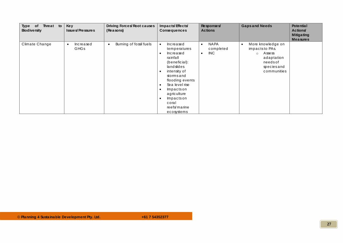
Climate Change Increased GHGs
Burning of fossil fuels Increased temperatures
Increased rainfall (beneficial): landslides
intensity of storms and flooding events
Sea level rise Impacts on
agriculture Impacts on
coral reefs/marine ecosystems
NAPA completed
INC
More knowledge on impacts to PAs.
o Assess adaptation needs of species and communities
© Planning 4 Sustainable Development Pty. Ltd. +61 7 54352377
28
ANNEX 4: Capacity Needs Assessment On-line Surveys
Page 1
Institutional Capacity Assessment - GISInstitutional Capacity Assessment - GISInstitutional Capacity Assessment - GISInstitutional Capacity Assessment - GIS
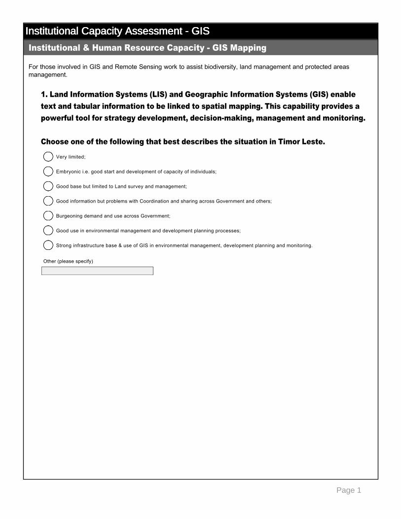
For those involved in GIS and Remote Sensing work to assist biodiversity, land management and protected areas management.
1. Land Information Systems (LIS) and Geographic Information Systems (GIS) enable text and tabular information to be linked to spatial mapping. This capability provides a powerful tool for strategy development, decisionmaking, management and monitoring. Choose one of the following that best describes the situation in Timor Leste.
Institutional & Human Resource Capacity GIS Mapping
Very limited;
nmlkj
Embryonic i.e. good start and development of capacity of individuals;
nmlkj
Good base but limited to Land survey and management;
nmlkj
Good information but problems with Coordination and sharing across Government and others;
nmlkj
Burgeoning demand and use across Government;
nmlkj
Good use in environmental management and development planning processes;
nmlkj
Strong infrastructure base & use of GIS in environmental management, development planning and monitoring.
nmlkj
Other (please specify)
Page 2
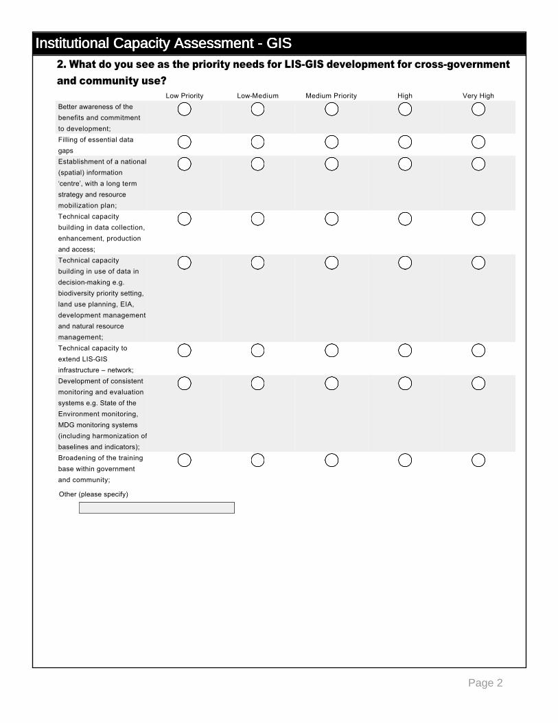
Institutional Capacity Assessment - GISInstitutional Capacity Assessment - GISInstitutional Capacity Assessment - GISInstitutional Capacity Assessment - GIS2. What do you see as the priority needs for LISGIS development for crossgovernment and community use?
Low Priority LowMedium Medium Priority High Very HighBetter awareness of the benefits and commitment to development;
nmlkj nmlkj nmlkj nmlkj nmlkj
Filling of essential data gaps
nmlkj nmlkj nmlkj nmlkj nmlkj
Establishment of a national (spatial) information ‘centre’, with a long term strategy and resource mobilization plan;
nmlkj nmlkj nmlkj nmlkj nmlkj
Technical capacity building in data collection, enhancement, production and access;
nmlkj nmlkj nmlkj nmlkj nmlkj
Technical capacity building in use of data in decisionmaking e.g. biodiversity priority setting, land use planning, EIA, development management and natural resource management;
nmlkj nmlkj nmlkj nmlkj nmlkj
Technical capacity to extend LISGIS infrastructure – network;
nmlkj nmlkj nmlkj nmlkj nmlkj
Development of consistent monitoring and evaluation systems e.g. State of the Environment monitoring, MDG monitoring systems (including harmonization of baselines and indicators);
nmlkj nmlkj nmlkj nmlkj nmlkj
Broadening of the training base within government and community;
nmlkj nmlkj nmlkj nmlkj nmlkj
Other (please specify)
Page 3
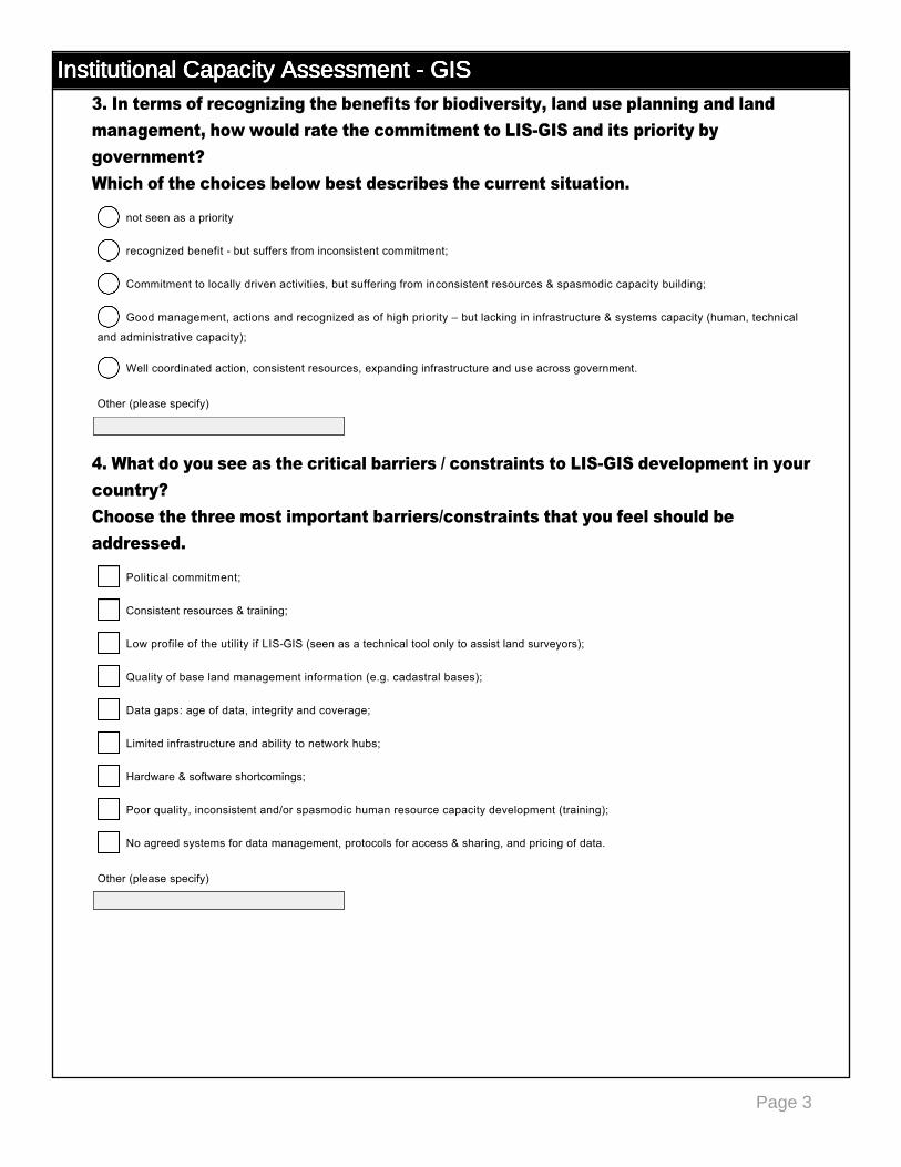
Institutional Capacity Assessment - GISInstitutional Capacity Assessment - GISInstitutional Capacity Assessment - GISInstitutional Capacity Assessment - GIS3. In terms of recognizing the benefits for biodiversity, land use planning and land management, how would rate the commitment to LISGIS and its priority by government? Which of the choices below best describes the current situation.
4. What do you see as the critical barriers / constraints to LISGIS development in your country? Choose the three most important barriers/constraints that you feel should be addressed.
not seen as a priority
nmlkj
recognized benefit but suffers from inconsistent commitment;
nmlkj
Commitment to locally driven activities, but suffering from inconsistent resources & spasmodic capacity building;
nmlkj
Good management, actions and recognized as of high priority – but lacking in infrastructure & systems capacity (human, technical
and administrative capacity);
nmlkj
Well coordinated action, consistent resources, expanding infrastructure and use across government.
nmlkj
Other (please specify)
Political commitment;
gfedc
Consistent resources & training;
gfedc
Low profile of the utility if LISGIS (seen as a technical tool only to assist land surveyors);
gfedc
Quality of base land management information (e.g. cadastral bases);
gfedc
Data gaps: age of data, integrity and coverage;
gfedc
Limited infrastructure and ability to network hubs;
gfedc
Hardware & software shortcomings;
gfedc
Poor quality, inconsistent and/or spasmodic human resource capacity development (training);
gfedc
No agreed systems for data management, protocols for access & sharing, and pricing of data.
gfedc
Other (please specify)
Page 4
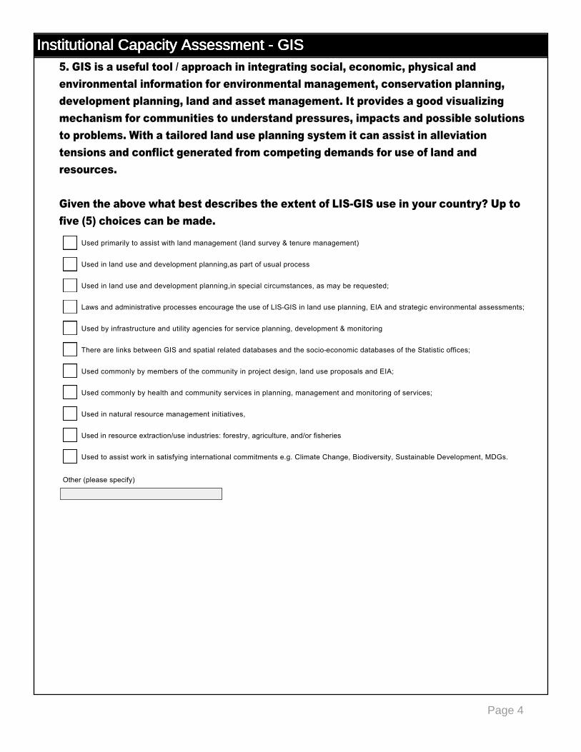
Institutional Capacity Assessment - GISInstitutional Capacity Assessment - GISInstitutional Capacity Assessment - GISInstitutional Capacity Assessment - GIS5. GIS is a useful tool / approach in integrating social, economic, physical and environmental information for environmental management, conservation planning, development planning, land and asset management. It provides a good visualizing mechanism for communities to understand pressures, impacts and possible solutions to problems. With a tailored land use planning system it can assist in alleviation tensions and conflict generated from competing demands for use of land and resources. Given the above what best describes the extent of LISGIS use in your country? Up to five (5) choices can be made.
Used primarily to assist with land management (land survey & tenure management)
gfedc
Used in land use and development planning,as part of usual process
gfedc
Used in land use and development planning,in special circumstances, as may be requested;
gfedc
Laws and administrative processes encourage the use of LISGIS in land use planning, EIA and strategic environmental assessments;
gfedc
Used by infrastructure and utility agencies for service planning, development & monitoring
gfedc
There are links between GIS and spatial related databases and the socioeconomic databases of the Statistic offices;
gfedc
Used commonly by members of the community in project design, land use proposals and EIA;
gfedc
Used commonly by health and community services in planning, management and monitoring of services;
gfedc
Used in natural resource management initiatives,
gfedc
Used in resource extraction/use industries: forestry, agriculture, and/or fisheries
gfedc
Used to assist work in satisfying international commitments e.g. Climate Change, Biodiversity, Sustainable Development, MDGs.
gfedc
Other (please specify)
Page 5
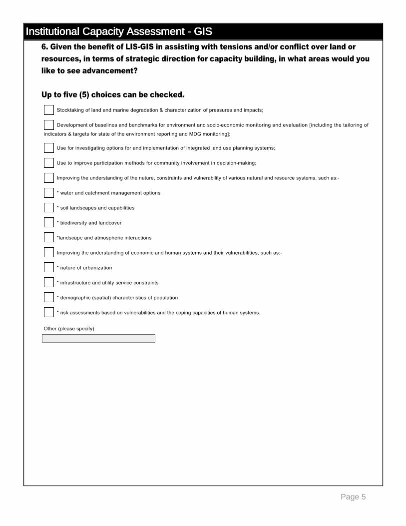
Institutional Capacity Assessment - GISInstitutional Capacity Assessment - GISInstitutional Capacity Assessment - GISInstitutional Capacity Assessment - GIS6. Given the benefit of LISGIS in assisting with tensions and/or conflict over land or resources, in terms of strategic direction for capacity building, in what areas would you like to see advancement? Up to five (5) choices can be checked.
Stocktaking of land and marine degradation & characterization of pressures and impacts;
gfedc
Development of baselines and benchmarks for environment and socioeconomic monitoring and evaluation [including the tailoring of
indicators & targets for state of the environment reporting and MDG monitoring];
gfedc
Use for investigating options for and implementation of integrated land use planning systems;
gfedc
Use to improve participation methods for community involvement in decisionmaking;
gfedc
Improving the understanding of the nature, constraints and vulnerability of various natural and resource systems, such as:
gfedc
* water and catchment management options
gfedc
* soil landscapes and capabilities
gfedc
* biodiversity and landcover
gfedc
*landscape and atmospheric interactions
gfedc
Improving the understanding of economic and human systems and their vulnerabilities, such as:
gfedc
* nature of urbanization
gfedc
* infrastructure and utility service constraints
gfedc
* demographic (spatial) characteristics of population
gfedc
* risk assessments based on vulnerabilities and the coping capacities of human systems.
gfedc
Other (please specify)
Page 6
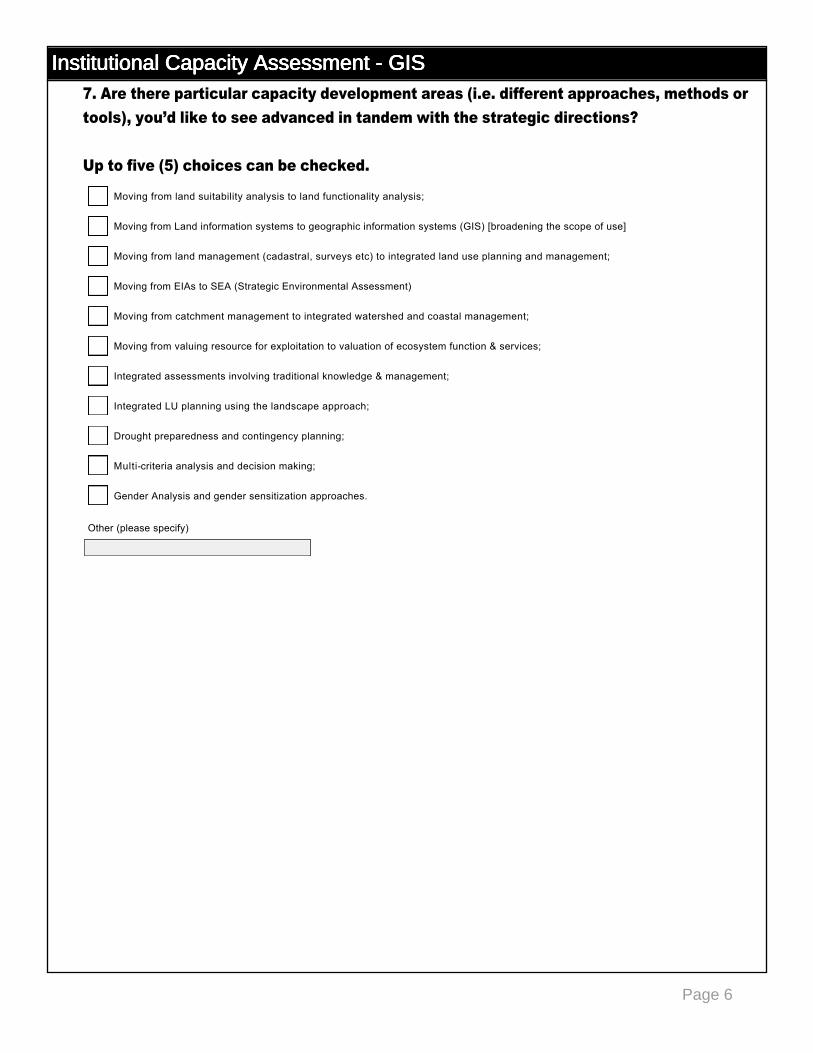
Institutional Capacity Assessment - GISInstitutional Capacity Assessment - GISInstitutional Capacity Assessment - GISInstitutional Capacity Assessment - GIS7. Are there particular capacity development areas (i.e. different approaches, methods or tools), you’d like to see advanced in tandem with the strategic directions? Up to five (5) choices can be checked.
Moving from land suitability analysis to land functionality analysis;
gfedc
Moving from Land information systems to geographic information systems (GIS) [broadening the scope of use]
gfedc
Moving from land management (cadastral, surveys etc) to integrated land use planning and management;
gfedc
Moving from EIAs to SEA (Strategic Environmental Assessment)
gfedc
Moving from catchment management to integrated watershed and coastal management;
gfedc
Moving from valuing resource for exploitation to valuation of ecosystem function & services;
gfedc
Integrated assessments involving traditional knowledge & management;
gfedc
Integrated LU planning using the landscape approach;
gfedc
Drought preparedness and contingency planning;
gfedc
Multicriteria analysis and decision making;
gfedc
Gender Analysis and gender sensitization approaches.
gfedc
Other (please specify)
Page 1
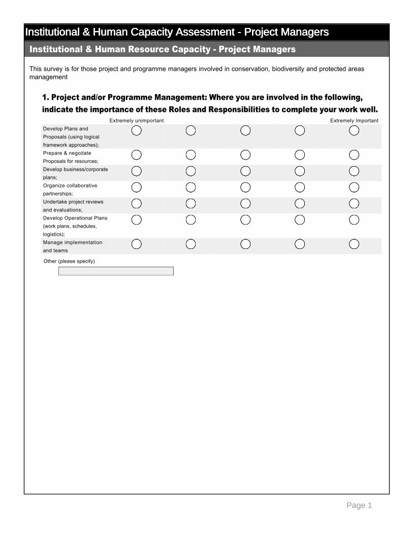
Institutional & Human Capacity Assessment - Project ManagersInstitutional & Human Capacity Assessment - Project ManagersInstitutional & Human Capacity Assessment - Project ManagersInstitutional & Human Capacity Assessment - Project Managers
This survey is for those project and programme managers involved in conservation, biodiversity and protected areas management
1. Project and/or Programme Management: Where you are involved in the following, indicate the importance of these Roles and Responsibilities to complete your work well.
Institutional & Human Resource Capacity Project Managers
Extremely unimportant Extremely ImportantDevelop Plans and Proposals (using logical framework approaches);
nmlkj nmlkj nmlkj nmlkj nmlkj
Prepare & negoitate Proposals for resources;
nmlkj nmlkj nmlkj nmlkj nmlkj
Develop business/corporate plans;
nmlkj nmlkj nmlkj nmlkj nmlkj
Organize collaborative partnerships;
nmlkj nmlkj nmlkj nmlkj nmlkj
Undertake project reviews and evaluations;
nmlkj nmlkj nmlkj nmlkj nmlkj
Develop Operational Plans (work plans, schedules, logistics);
nmlkj nmlkj nmlkj nmlkj nmlkj
Manage implementation and teams
nmlkj nmlkj nmlkj nmlkj nmlkj
Other (please specify)
Page 2
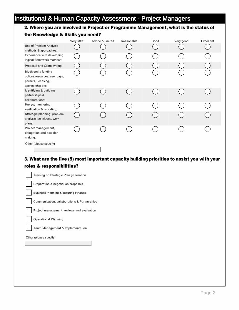
Institutional & Human Capacity Assessment - Project ManagersInstitutional & Human Capacity Assessment - Project ManagersInstitutional & Human Capacity Assessment - Project ManagersInstitutional & Human Capacity Assessment - Project Managers2. Where you are involved in Project or Programme Management, what is the status of the Knowledge & Skills you need?
3. What are the five (5) most important capacity building priorities to assist you with your roles & responsibilities?
Very little Adhoc & limited Reasonable Good Very good ExcellentUse of Problem Analysis methods & approaches;
nmlkj nmlkj nmlkj nmlkj nmlkj nmlkj
Experience with developing logical framework matrices;
nmlkj nmlkj nmlkj nmlkj nmlkj nmlkj
Proposal and Grant writing; nmlkj nmlkj nmlkj nmlkj nmlkj nmlkj
Biodiversity funding options/resources: user pays, permits, licensing, sponsorship etc;
nmlkj nmlkj nmlkj nmlkj nmlkj nmlkj
Identifying & building partnerships & collaborations;
nmlkj nmlkj nmlkj nmlkj nmlkj nmlkj
Project monitoring, verification & reporting;
nmlkj nmlkj nmlkj nmlkj nmlkj nmlkj
Strategic planning, problem analysis techniques, work plans;
nmlkj nmlkj nmlkj nmlkj nmlkj nmlkj
Project management, delegation and decisionmaking.
nmlkj nmlkj nmlkj nmlkj nmlkj nmlkj
Other (please specify)
Training on Strategic Plan generation
gfedc
Preparation & negotiation proposals
gfedc
Business Planning & securing Finance
gfedc
Communication, collaborations & Partnerships
gfedc
Project management: reviews and evaluation
gfedc
Operational Planning
gfedc
Team Management & Implementation
gfedc
Other (please specify)
Page 1
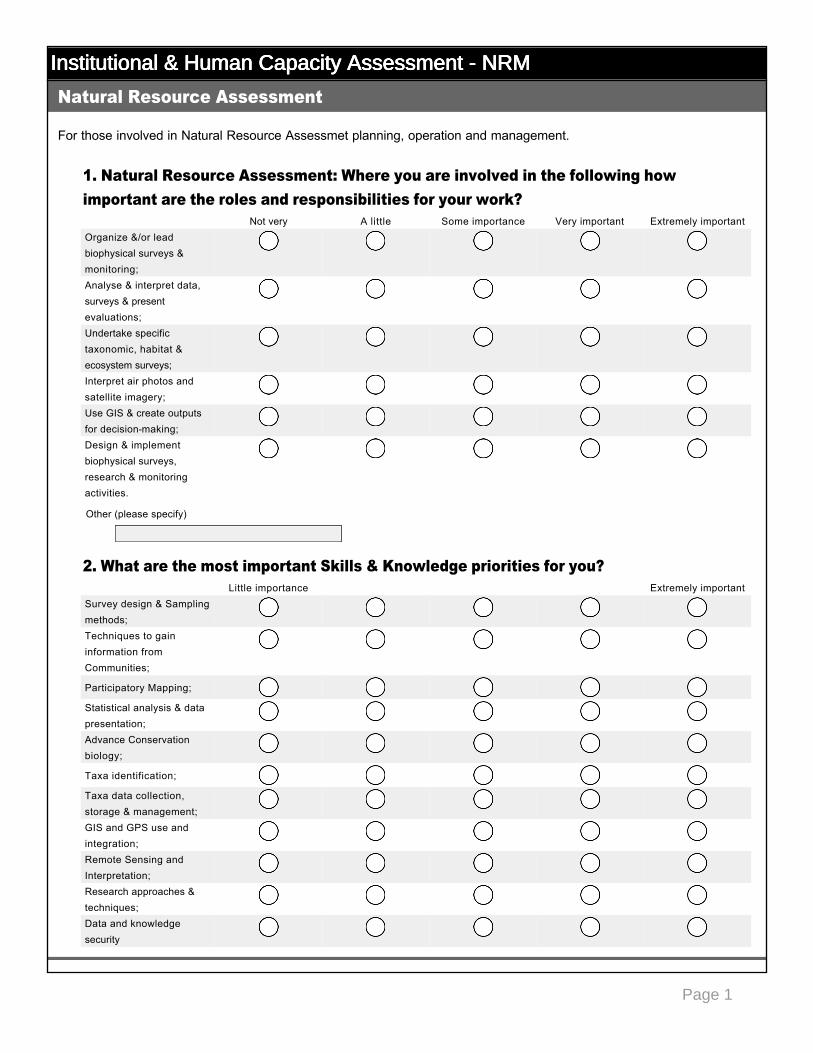
Institutional & Human Capacity Assessment - NRMInstitutional & Human Capacity Assessment - NRMInstitutional & Human Capacity Assessment - NRMInstitutional & Human Capacity Assessment - NRM
For those involved in Natural Resource Assessmet planning, operation and management.
1. Natural Resource Assessment: Where you are involved in the following how important are the roles and responsibilities for your work?
2. What are the most important Skills & Knowledge priorities for you?
Natural Resource Assessment
Not very A little Some importance Very important Extremely importantOrganize &/or lead biophysical surveys & monitoring;
nmlkj nmlkj nmlkj nmlkj nmlkj
Analyse & interpret data, surveys & present evaluations;
nmlkj nmlkj nmlkj nmlkj nmlkj
Undertake specific taxonomic, habitat & ecosystem surveys;
nmlkj nmlkj nmlkj nmlkj nmlkj
Interpret air photos and satellite imagery;
nmlkj nmlkj nmlkj nmlkj nmlkj
Use GIS & create outputs for decisionmaking;
nmlkj nmlkj nmlkj nmlkj nmlkj
Design & implement biophysical surveys, research & monitoring activities.
nmlkj nmlkj nmlkj nmlkj nmlkj
Little importance Extremely importantSurvey design & Sampling methods;
nmlkj nmlkj nmlkj nmlkj nmlkj
Techniques to gain information from Communities;
nmlkj nmlkj nmlkj nmlkj nmlkj
Participatory Mapping; nmlkj nmlkj nmlkj nmlkj nmlkj
Statistical analysis & data presentation;
nmlkj nmlkj nmlkj nmlkj nmlkj
Advance Conservation biology;
nmlkj nmlkj nmlkj nmlkj nmlkj
Taxa identification; nmlkj nmlkj nmlkj nmlkj nmlkj
Taxa data collection, storage & management;
nmlkj nmlkj nmlkj nmlkj nmlkj
GIS and GPS use and integration;
nmlkj nmlkj nmlkj nmlkj nmlkj
Remote Sensing and Interpretation;
nmlkj nmlkj nmlkj nmlkj nmlkj
Research approaches & techniques;
nmlkj nmlkj nmlkj nmlkj nmlkj
Data and knowledge security
nmlkj nmlkj nmlkj nmlkj nmlkj
Other (please specify)

Page 2
Institutional & Human Capacity Assessment - NRMInstitutional & Human Capacity Assessment - NRMInstitutional & Human Capacity Assessment - NRMInstitutional & Human Capacity Assessment - NRM
For those involved in natural resource and conservation management
3. Natural Resource Management: Where you are involved in the following how important are the roles and responsibilities for your work?
4. Natural Resource Management: What are the most important Skills & Knowledge priorities for you?
For those involved in actual Conservation, Cultural heritage or Protected Areas site management or field operations
Natural Resource Management
Not very A little Some importance Very important Extremely importantSpecify management requirements for habitats & ecosystems;
nmlkj nmlkj nmlkj nmlkj nmlkj
Advise on measures for protection, survival or recovery of key species or habitats;
nmlkj nmlkj nmlkj nmlkj nmlkj
Develop comanagement/participatory management systems for Protected Areas & Natural resources;
nmlkj nmlkj nmlkj nmlkj nmlkj
Little importance Extremely importantKnowledge of habitats & ecosystems;
nmlkj nmlkj nmlkj nmlkj nmlkj
Knowledge & skills for conservation of specific species, ecosystems & habitats;
nmlkj nmlkj nmlkj nmlkj nmlkj
Insitu conservation methods;
nmlkj nmlkj nmlkj nmlkj nmlkj
Understanding the purpose, impact & uses of various habitat management measures;
nmlkj nmlkj nmlkj nmlkj nmlkj
Understanding of recovery and restoration techniques;
nmlkj nmlkj nmlkj nmlkj nmlkj
Skills in comanagement & collaborative management systems;
nmlkj nmlkj nmlkj nmlkj nmlkj
Stakeholder analysis & Facilitation skills
nmlkj nmlkj nmlkj nmlkj nmlkj
Site Management & Field Operations
Other (please specify)
Page 3
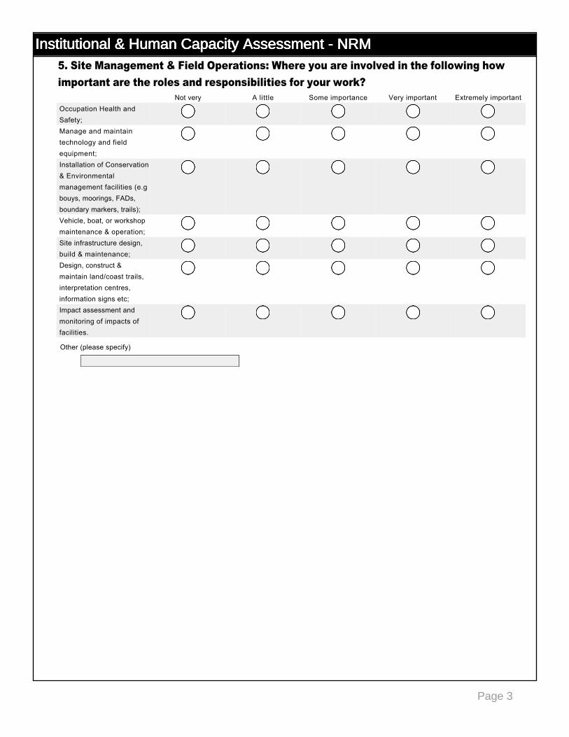
Institutional & Human Capacity Assessment - NRMInstitutional & Human Capacity Assessment - NRMInstitutional & Human Capacity Assessment - NRMInstitutional & Human Capacity Assessment - NRM5. Site Management & Field Operations: Where you are involved in the following how important are the roles and responsibilities for your work?
Not very A little Some importance Very important Extremely importantOccupation Health and Safety;
nmlkj nmlkj nmlkj nmlkj nmlkj
Manage and maintain technology and field equipment;
nmlkj nmlkj nmlkj nmlkj nmlkj
Installation of Conservation & Environmental management facilities (e.g bouys, moorings, FADs, boundary markers, trails);
nmlkj nmlkj nmlkj nmlkj nmlkj
Vehicle, boat, or workshop maintenance & operation;
nmlkj nmlkj nmlkj nmlkj nmlkj
Site infrastructure design, build & maintenance;
nmlkj nmlkj nmlkj nmlkj nmlkj
Design, construct & maintain land/coast trails, interpretation centres, information signs etc;
nmlkj nmlkj nmlkj nmlkj nmlkj
Impact assessment and monitoring of impacts of facilities.
nmlkj nmlkj nmlkj nmlkj nmlkj
Other (please specify)
Page 4
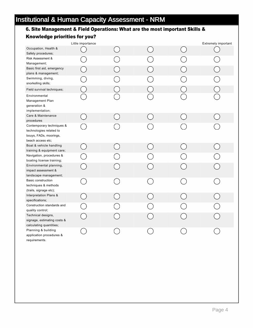
Institutional & Human Capacity Assessment - NRMInstitutional & Human Capacity Assessment - NRMInstitutional & Human Capacity Assessment - NRMInstitutional & Human Capacity Assessment - NRM6. Site Management & Field Operations: What are the most important Skills & Knowledge priorities for you?
Little importance Extremely importantOccupation, Health & Safety procedures;
nmlkj nmlkj nmlkj nmlkj nmlkj
Risk Assessment & Management;
nmlkj nmlkj nmlkj nmlkj nmlkj
Basic first aid, emergency plans & management;
nmlkj nmlkj nmlkj nmlkj nmlkj
Swimming, diving, snorkelling skills;
nmlkj nmlkj nmlkj nmlkj nmlkj
Field survival techniques; nmlkj nmlkj nmlkj nmlkj nmlkj
Environmental Management Plan generation & implementation;
nmlkj nmlkj nmlkj nmlkj nmlkj
Care & Maintenance procedures
nmlkj nmlkj nmlkj nmlkj nmlkj
Contemporary techniques & technologies related to bouys, FADs, moorings, beach access etc;
nmlkj nmlkj nmlkj nmlkj nmlkj
Boat & vehicle handling training & equipment care;
nmlkj nmlkj nmlkj nmlkj nmlkj
Navigation, procedures & boating license training;
nmlkj nmlkj nmlkj nmlkj nmlkj
Environmental planning, impact assessment & landscape management;
nmlkj nmlkj nmlkj nmlkj nmlkj
Basic construction techniques & methods (trails, signage etc);
nmlkj nmlkj nmlkj nmlkj nmlkj
Interpretation Plans & specifications;
nmlkj nmlkj nmlkj nmlkj nmlkj
Construction standards and quality control;
nmlkj nmlkj nmlkj nmlkj nmlkj
Technical designs, signage, estimating costs & calculating quantities;
nmlkj nmlkj nmlkj nmlkj nmlkj
Planning & building application procedures & requirements.
nmlkj nmlkj nmlkj nmlkj nmlkj
Page 1
Institutional & Human Capacity Assessment - Socio EconomicsInstitutional & Human Capacity Assessment - Socio EconomicsInstitutional & Human Capacity Assessment - Socio EconomicsInstitutional & Human Capacity Assessment - Socio Economics
For those involved in SocioEconomic, Cultural Heritage Management & Community Livelihoods planning, assessment and management.
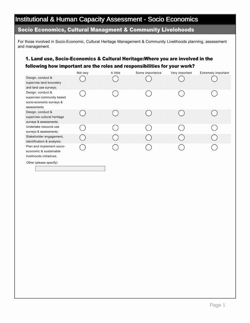
1. Land use, SocioEconomics & Cultural Heritage:Where you are involved in the following how important are the roles and responsibilities for your work?
Socio Economics, Cultural Managment & Community Livelohoods
Not very A little Some importance Very important Extremely importantDesign, conduct & supervise land boundary and land use surveys;
nmlkj nmlkj nmlkj nmlkj nmlkj
Design, conduct & supervise community based socioeconomic surveys & assessments;
nmlkj nmlkj nmlkj nmlkj nmlkj
Design, conduct & supervise cultural heritage surveys & assessments;
nmlkj nmlkj nmlkj nmlkj nmlkj
Undertake resource use surveys & assessments;
nmlkj nmlkj nmlkj nmlkj nmlkj
Stakeholder engagement, identification & analysis;
nmlkj nmlkj nmlkj nmlkj nmlkj
Plan and implement socioeconomic & sustainable livelihoods initiatives.
nmlkj nmlkj nmlkj nmlkj nmlkj
Other (please specify)
Page 2
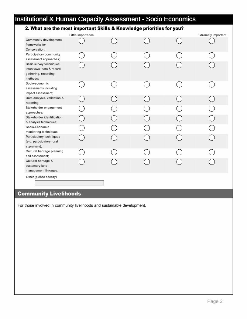
Institutional & Human Capacity Assessment - Socio EconomicsInstitutional & Human Capacity Assessment - Socio EconomicsInstitutional & Human Capacity Assessment - Socio EconomicsInstitutional & Human Capacity Assessment - Socio Economics2. What are the most important Skills & Knowledge priorities for you?
For those involved in community livelihoods and sustainable development.
Little importance Extremely importantCommunity development frameworks for Conservation;
nmlkj nmlkj nmlkj nmlkj nmlkj
Participatory community assessment approaches;
nmlkj nmlkj nmlkj nmlkj nmlkj
Basic survey techniques: interviews, data & record gathering, recording methods;
nmlkj nmlkj nmlkj nmlkj nmlkj
Socioeconomic assessments including impact assessment;
nmlkj nmlkj nmlkj nmlkj nmlkj
Data analysis, validation & reporting;
nmlkj nmlkj nmlkj nmlkj nmlkj
Stakeholder engagement approaches;
nmlkj nmlkj nmlkj nmlkj nmlkj
Stakeholder identification & analysis techniques;
nmlkj nmlkj nmlkj nmlkj nmlkj
SocioEconomic monitoring techniques;
nmlkj nmlkj nmlkj nmlkj nmlkj
Participatory techniques (e.g. participatory rural appraisals);
nmlkj nmlkj nmlkj nmlkj nmlkj
Cultural heritage planning and assessment;
nmlkj nmlkj nmlkj nmlkj nmlkj
Cultural heritage & customary land management linkages.
nmlkj nmlkj nmlkj nmlkj nmlkj
Community Livelihoods
Other (please specify)
Page 3
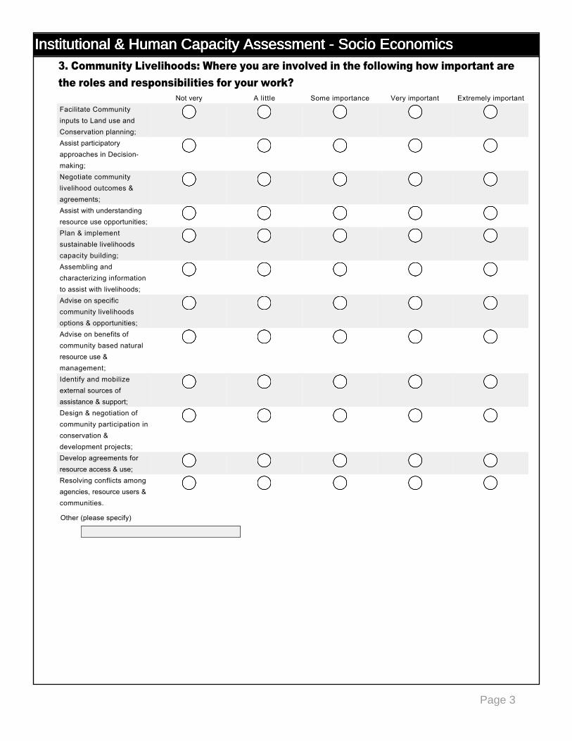
Institutional & Human Capacity Assessment - Socio EconomicsInstitutional & Human Capacity Assessment - Socio EconomicsInstitutional & Human Capacity Assessment - Socio EconomicsInstitutional & Human Capacity Assessment - Socio Economics3. Community Livelihoods: Where you are involved in the following how important are the roles and responsibilities for your work?
Not very A little Some importance Very important Extremely importantFacilitate Community inputs to Land use and Conservation planning;
nmlkj nmlkj nmlkj nmlkj nmlkj
Assist participatory approaches in Decisionmaking;
nmlkj nmlkj nmlkj nmlkj nmlkj
Negotiate community livelihood outcomes & agreements;
nmlkj nmlkj nmlkj nmlkj nmlkj
Assist with understanding resource use opportunities;
nmlkj nmlkj nmlkj nmlkj nmlkj
Plan & implement sustainable livelihoods capacity building;
nmlkj nmlkj nmlkj nmlkj nmlkj
Assembling and characterizing information to assist with livelihoods;
nmlkj nmlkj nmlkj nmlkj nmlkj
Advise on specific community livelihoods options & opportunities;
nmlkj nmlkj nmlkj nmlkj nmlkj
Advise on benefits of community based natural resource use & management;
nmlkj nmlkj nmlkj nmlkj nmlkj
Identify and mobilize external sources of assistance & support;
nmlkj nmlkj nmlkj nmlkj nmlkj
Design & negotiation of community participation in conservation & development projects;
nmlkj nmlkj nmlkj nmlkj nmlkj
Develop agreements for resource access & use;
nmlkj nmlkj nmlkj nmlkj nmlkj
Resolving conflicts among agencies, resource users & communities.
nmlkj nmlkj nmlkj nmlkj nmlkj
Other (please specify)
Page 4
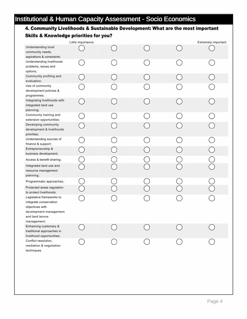
Institutional & Human Capacity Assessment - Socio EconomicsInstitutional & Human Capacity Assessment - Socio EconomicsInstitutional & Human Capacity Assessment - Socio EconomicsInstitutional & Human Capacity Assessment - Socio Economics4. Community Livelihoods & Sustainable Development: What are the most important Skills & Knowledge priorities for you?
Little importance Extremely importantUnderstanding local community needs, aspirations & constraints;
nmlkj nmlkj nmlkj nmlkj nmlkj
Understanding livelihoods problems, issues and options;
nmlkj nmlkj nmlkj nmlkj nmlkj
Community profiling and evaluation;
nmlkj nmlkj nmlkj nmlkj nmlkj
Use of community development policies & programmes;
nmlkj nmlkj nmlkj nmlkj nmlkj
Integrating livelihoods with integrated land use planning;
nmlkj nmlkj nmlkj nmlkj nmlkj
Community training and extension opportunities;
nmlkj nmlkj nmlkj nmlkj nmlkj
Developing community development & livelihoods priorities;
nmlkj nmlkj nmlkj nmlkj nmlkj
Understanding sources of finance & support;
nmlkj nmlkj nmlkj nmlkj nmlkj
Entrepreneurship & business development;
nmlkj nmlkj nmlkj nmlkj nmlkj
Access & benefit sharing; nmlkj nmlkj nmlkj nmlkj nmlkj
Integrated land use and resource management planning;
nmlkj nmlkj nmlkj nmlkj nmlkj
Programmatic approaches; nmlkj nmlkj nmlkj nmlkj nmlkj
Protected areas regulation to protect livelihoods;
nmlkj nmlkj nmlkj nmlkj nmlkj
Legislative frameworks to integrate conservation objectives with development management and land tenure management;
nmlkj nmlkj nmlkj nmlkj nmlkj
Enhancing customary & traditional approaches in livelihood opportunities;
nmlkj nmlkj nmlkj nmlkj nmlkj
Conflict resolution, mediation & negotiation techniques
nmlkj nmlkj nmlkj nmlkj nmlkj
Page 1
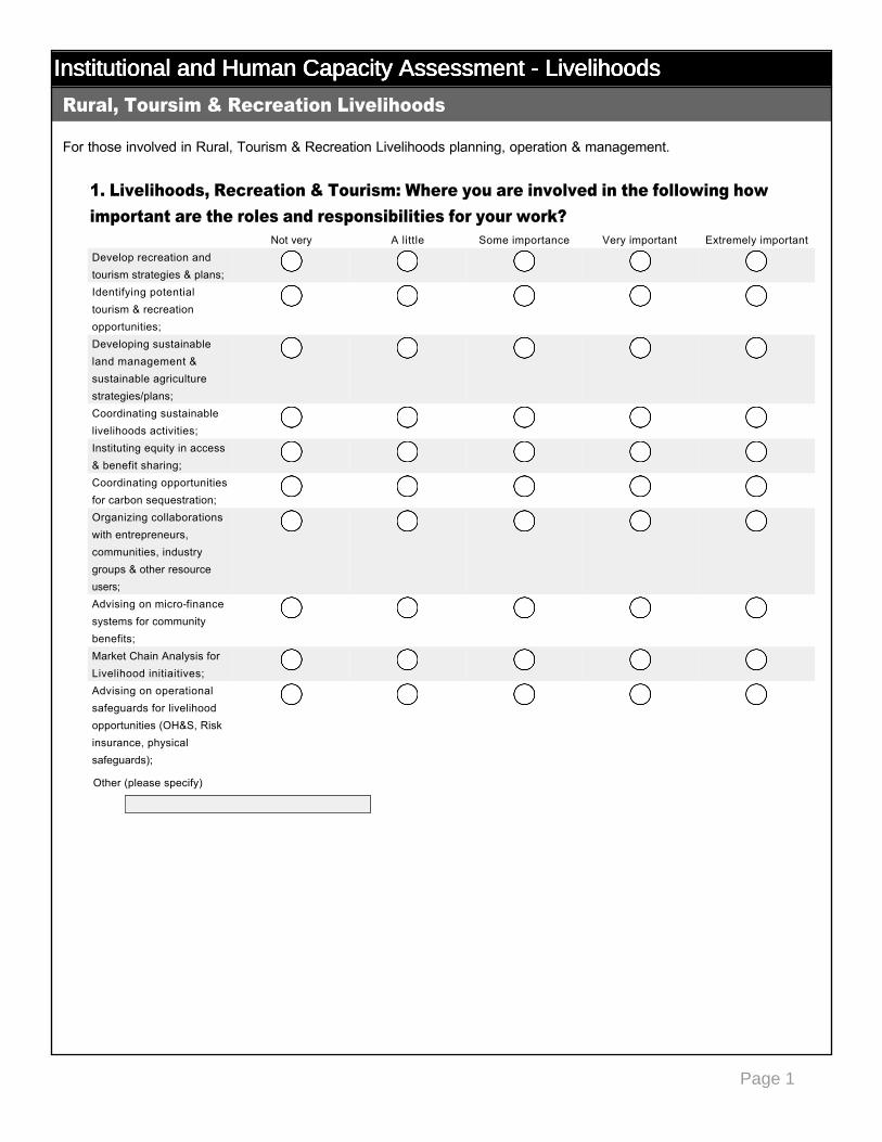
Institutional and Human Capacity Assessment - LivelihoodsInstitutional and Human Capacity Assessment - LivelihoodsInstitutional and Human Capacity Assessment - LivelihoodsInstitutional and Human Capacity Assessment - Livelihoods
For those involved in Rural, Tourism & Recreation Livelihoods planning, operation & management.
1. Livelihoods, Recreation & Tourism: Where you are involved in the following how important are the roles and responsibilities for your work?
Rural, Toursim & Recreation Livelihoods
Not very A little Some importance Very important Extremely importantDevelop recreation and tourism strategies & plans;
nmlkj nmlkj nmlkj nmlkj nmlkj
Identifying potential tourism & recreation opportunities;
nmlkj nmlkj nmlkj nmlkj nmlkj
Developing sustainable land management & sustainable agriculture strategies/plans;
nmlkj nmlkj nmlkj nmlkj nmlkj
Coordinating sustainable livelihoods activities;
nmlkj nmlkj nmlkj nmlkj nmlkj
Instituting equity in access & benefit sharing;
nmlkj nmlkj nmlkj nmlkj nmlkj
Coordinating opportunities for carbon sequestration;
nmlkj nmlkj nmlkj nmlkj nmlkj
Organizing collaborations with entrepreneurs, communities, industry groups & other resource users;
nmlkj nmlkj nmlkj nmlkj nmlkj
Advising on microfinance systems for community benefits;
nmlkj nmlkj nmlkj nmlkj nmlkj
Market Chain Analysis for Livelihood initiaitives;
nmlkj nmlkj nmlkj nmlkj nmlkj
Advising on operational safeguards for livelihood opportunities (OH&S, Risk insurance, physical safeguards);
nmlkj nmlkj nmlkj nmlkj nmlkj
Other (please specify)

Page 2
Institutional and Human Capacity Assessment - LivelihoodsInstitutional and Human Capacity Assessment - LivelihoodsInstitutional and Human Capacity Assessment - LivelihoodsInstitutional and Human Capacity Assessment - Livelihoods2. What are the most important Skills & Knowledge priorities for you?
Little importance Extremely importantDeveloping tourism & rural livelihood strategies & plans;
nmlkj nmlkj nmlkj nmlkj nmlkj
Generating criteria to consider livelihood opportunities;
nmlkj nmlkj nmlkj nmlkj nmlkj
Identification & evaluation of tourism opportunities;
nmlkj nmlkj nmlkj nmlkj nmlkj
Identification of recreation opportunities;
nmlkj nmlkj nmlkj nmlkj nmlkj
Identification & evaluation of rural livelihood opportunties;
nmlkj nmlkj nmlkj nmlkj nmlkj
Understanding business approaches & models for commercial activities;
nmlkj nmlkj nmlkj nmlkj nmlkj
Understanding basic business administration & customer services;
nmlkj nmlkj nmlkj nmlkj nmlkj
Natural resource economics & valuation methods;
nmlkj nmlkj nmlkj nmlkj nmlkj
Feasibility analysis and EIA;
nmlkj nmlkj nmlkj nmlkj nmlkj
Undertaking market chain analysis;
nmlkj nmlkj nmlkj nmlkj nmlkj
Identifying opportunities for Certification;
nmlkj nmlkj nmlkj nmlkj nmlkj
Implementing Health & Safety policies & procedures;
nmlkj nmlkj nmlkj nmlkj nmlkj
Other (please specify)
Page 1
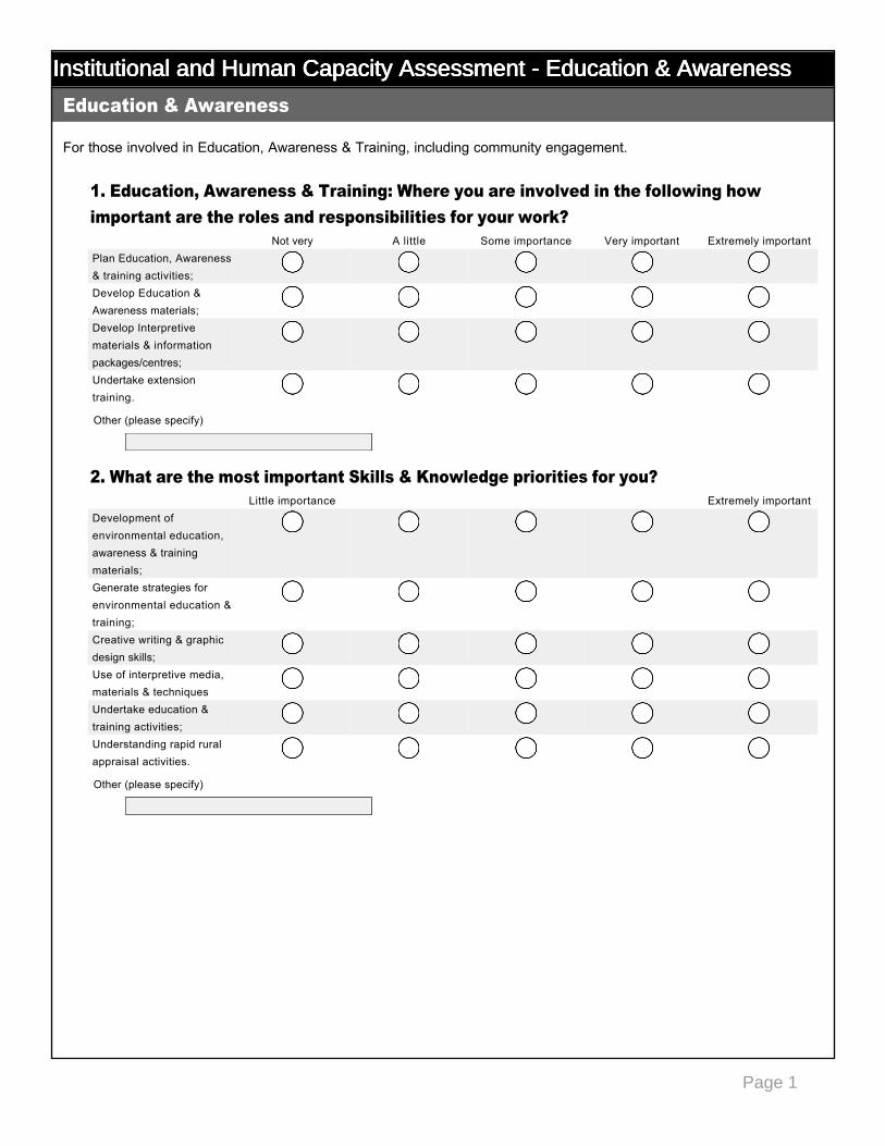
Institutional and Human Capacity Assessment - Education & AwarenessInstitutional and Human Capacity Assessment - Education & AwarenessInstitutional and Human Capacity Assessment - Education & AwarenessInstitutional and Human Capacity Assessment - Education & Awareness
For those involved in Education, Awareness & Training, including community engagement.
1. Education, Awareness & Training: Where you are involved in the following how important are the roles and responsibilities for your work?
2. What are the most important Skills & Knowledge priorities for you?
Education & Awareness
Not very A little Some importance Very important Extremely importantPlan Education, Awareness & training activities;
nmlkj nmlkj nmlkj nmlkj nmlkj
Develop Education & Awareness materials;
nmlkj nmlkj nmlkj nmlkj nmlkj
Develop Interpretive materials & information packages/centres;
nmlkj nmlkj nmlkj nmlkj nmlkj
Undertake extension training.
nmlkj nmlkj nmlkj nmlkj nmlkj
Little importance Extremely importantDevelopment of environmental education, awareness & training materials;
nmlkj nmlkj nmlkj nmlkj nmlkj
Generate strategies for environmental education & training;
nmlkj nmlkj nmlkj nmlkj nmlkj
Creative writing & graphic design skills;
nmlkj nmlkj nmlkj nmlkj nmlkj
Use of interpretive media, materials & techniques
nmlkj nmlkj nmlkj nmlkj nmlkj
Undertake education & training activities;
nmlkj nmlkj nmlkj nmlkj nmlkj
Understanding rapid rural appraisal activities.
nmlkj nmlkj nmlkj nmlkj nmlkj
Other (please specify)
Other (please specify)
Page 1
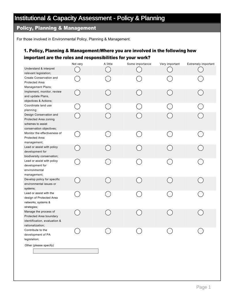
Institutional & Capacity Assessment - Policy & PlanningInstitutional & Capacity Assessment - Policy & PlanningInstitutional & Capacity Assessment - Policy & PlanningInstitutional & Capacity Assessment - Policy & Planning
For those involved in Environmental Policy, Planning & Management.
1. Policy, Planning & Management:Where you are involved in the following how important are the roles and responsibilities for your work?
Policy, Planning & Management
Not very A little Some importance Very important Extremely importantUnderstand & interpret relevant legislation;
nmlkj nmlkj nmlkj nmlkj nmlkj
Create Conservation and Protected Area Management Plans;
nmlkj nmlkj nmlkj nmlkj nmlkj
Implement, monitor, review and update Plans, objectives & Actions;
nmlkj nmlkj nmlkj nmlkj nmlkj
Coordinate land use planning;
nmlkj nmlkj nmlkj nmlkj nmlkj
Design Conservation and Protected Area zoning schemes to assist conservation objectives;
nmlkj nmlkj nmlkj nmlkj nmlkj
Monitor the effectiveness of Protected Area management;
nmlkj nmlkj nmlkj nmlkj nmlkj
Lead or assist with policy development for biodiversity conservation;
nmlkj nmlkj nmlkj nmlkj nmlkj
Lead or assist with policy development for environmental management;
nmlkj nmlkj nmlkj nmlkj nmlkj
Develop policy for specific environmental issues or systems;
nmlkj nmlkj nmlkj nmlkj nmlkj
Lead or assist with the design of Protected Area networks, systems & strategies;
nmlkj nmlkj nmlkj nmlkj nmlkj
Manage the process of Protected Area boundary identification, evaluation & rationalization;
nmlkj nmlkj nmlkj nmlkj nmlkj
Contribute to the development of PA legislation;
nmlkj nmlkj nmlkj nmlkj nmlkj
Other (please specify)
Page 2
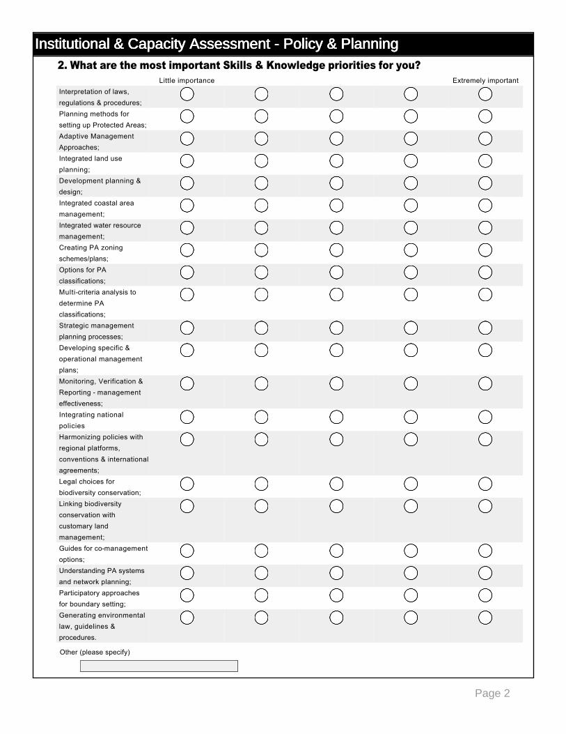
Institutional & Capacity Assessment - Policy & PlanningInstitutional & Capacity Assessment - Policy & PlanningInstitutional & Capacity Assessment - Policy & PlanningInstitutional & Capacity Assessment - Policy & Planning2. What are the most important Skills & Knowledge priorities for you?
Little importance Extremely importantInterpretation of laws, regulations & procedures;
nmlkj nmlkj nmlkj nmlkj nmlkj
Planning methods for setting up Protected Areas;
nmlkj nmlkj nmlkj nmlkj nmlkj
Adaptive Management Approaches;
nmlkj nmlkj nmlkj nmlkj nmlkj
Integrated land use planning;
nmlkj nmlkj nmlkj nmlkj nmlkj
Development planning & design;
nmlkj nmlkj nmlkj nmlkj nmlkj
Integrated coastal area management;
nmlkj nmlkj nmlkj nmlkj nmlkj
Integrated water resource management;
nmlkj nmlkj nmlkj nmlkj nmlkj
Creating PA zoning schemes/plans;
nmlkj nmlkj nmlkj nmlkj nmlkj
Options for PA classifications;
nmlkj nmlkj nmlkj nmlkj nmlkj
Multicriteria analysis to determine PA classifications;
nmlkj nmlkj nmlkj nmlkj nmlkj
Strategic management planning processes;
nmlkj nmlkj nmlkj nmlkj nmlkj
Developing specific & operational management plans;
nmlkj nmlkj nmlkj nmlkj nmlkj
Monitoring, Verification & Reporting management effectiveness;
nmlkj nmlkj nmlkj nmlkj nmlkj
Integrating national policies
nmlkj nmlkj nmlkj nmlkj nmlkj
Harmonizing policies with regional platforms, conventions & international agreements;
nmlkj nmlkj nmlkj nmlkj nmlkj
Legal choices for biodiversity conservation;
nmlkj nmlkj nmlkj nmlkj nmlkj
Linking biodiversity conservation with customary land management;
nmlkj nmlkj nmlkj nmlkj nmlkj
Guides for comanagement options;
nmlkj nmlkj nmlkj nmlkj nmlkj
Understanding PA systems and network planning;
nmlkj nmlkj nmlkj nmlkj nmlkj
Participatory approaches for boundary setting;
nmlkj nmlkj nmlkj nmlkj nmlkj
Generating environmental law, guidelines & procedures.
nmlkj nmlkj nmlkj nmlkj nmlkj
Other (please specify)
Page 3
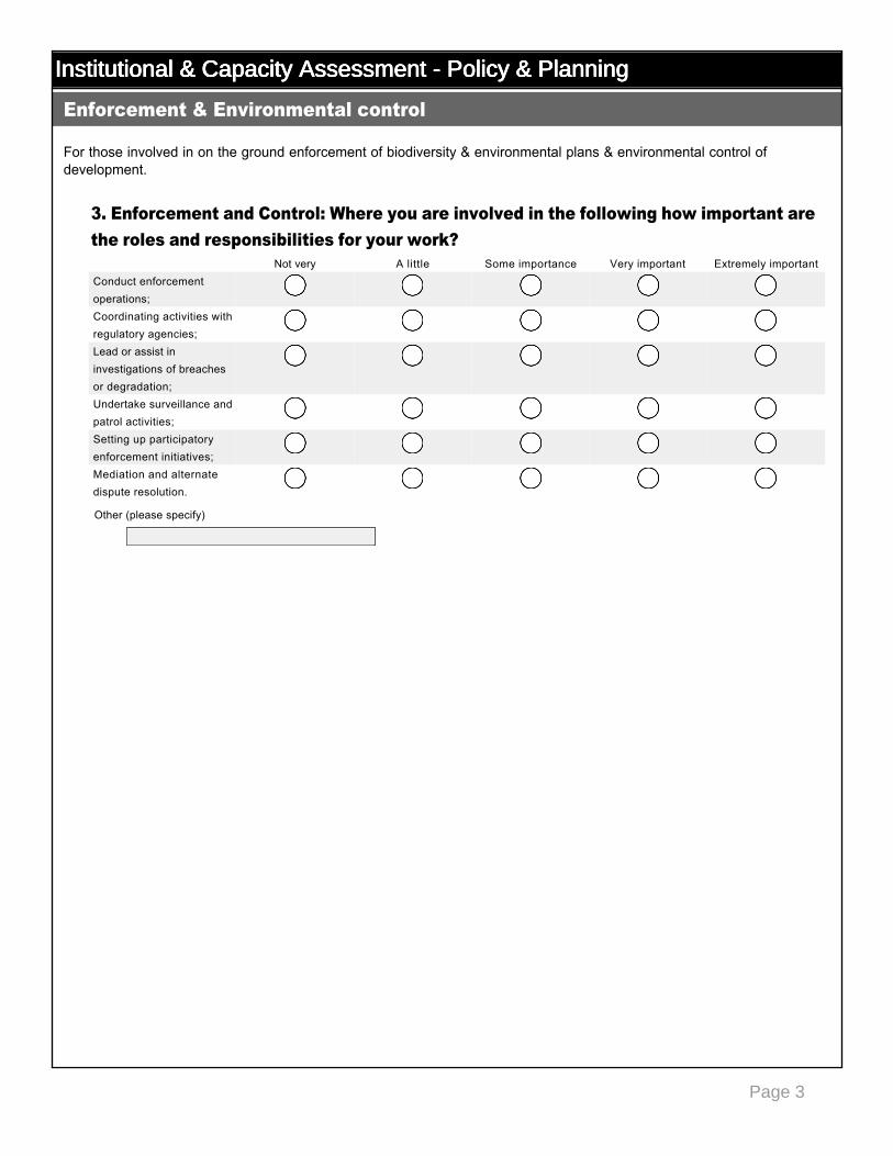
Institutional & Capacity Assessment - Policy & PlanningInstitutional & Capacity Assessment - Policy & PlanningInstitutional & Capacity Assessment - Policy & PlanningInstitutional & Capacity Assessment - Policy & Planning
For those involved in on the ground enforcement of biodiversity & environmental plans & environmental control of development.
3. Enforcement and Control: Where you are involved in the following how important are the roles and responsibilities for your work?
Enforcement & Environmental control
Not very A little Some importance Very important Extremely importantConduct enforcement operations;
nmlkj nmlkj nmlkj nmlkj nmlkj
Coordinating activities with regulatory agencies;
nmlkj nmlkj nmlkj nmlkj nmlkj
Lead or assist in investigations of breaches or degradation;
nmlkj nmlkj nmlkj nmlkj nmlkj
Undertake surveillance and patrol activities;
nmlkj nmlkj nmlkj nmlkj nmlkj
Setting up participatory enforcement initiatives;
nmlkj nmlkj nmlkj nmlkj nmlkj
Mediation and alternate dispute resolution.
nmlkj nmlkj nmlkj nmlkj nmlkj
Other (please specify)
Page 4
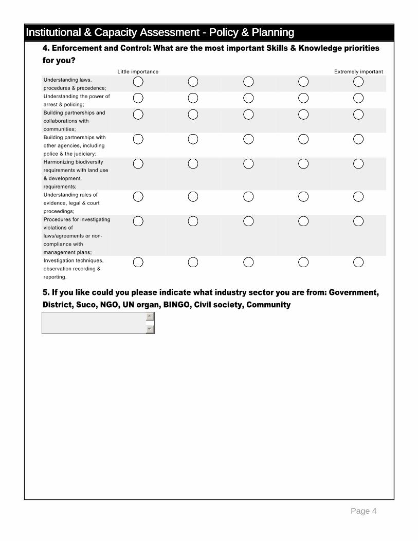
Institutional & Capacity Assessment - Policy & PlanningInstitutional & Capacity Assessment - Policy & PlanningInstitutional & Capacity Assessment - Policy & PlanningInstitutional & Capacity Assessment - Policy & Planning4. Enforcement and Control: What are the most important Skills & Knowledge priorities for you?
5. If you like could you please indicate what industry sector you are from: Government, District, Suco, NGO, UN organ, BINGO, Civil society, Community
Little importance Extremely importantUnderstanding laws, procedures & precedence;
nmlkj nmlkj nmlkj nmlkj nmlkj
Understanding the power of arrest & policing;
nmlkj nmlkj nmlkj nmlkj nmlkj
Building partnerships and collaborations with communities;
nmlkj nmlkj nmlkj nmlkj nmlkj
Building partnerships with other agencies, including police & the judiciary;
nmlkj nmlkj nmlkj nmlkj nmlkj
Harmonizing biodiversity requirements with land use & development requirements;
nmlkj nmlkj nmlkj nmlkj nmlkj
Understanding rules of evidence, legal & court proceedings;
nmlkj nmlkj nmlkj nmlkj nmlkj
Procedures for investigating violations of laws/agreements or noncompliance with management plans;
nmlkj nmlkj nmlkj nmlkj nmlkj
Investigation techniques, observation recording & reporting.
nmlkj nmlkj nmlkj nmlkj nmlkj
55
66
© Planning 4 Sustainable Development Pty. Ltd. +61 7 54352377
29
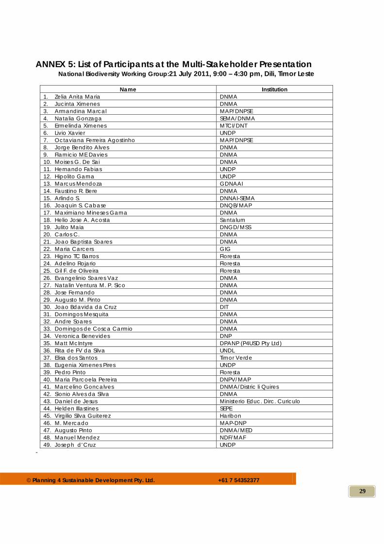
ANNEX 5: List of Participants at the Multi-Stakeholder Presentation National Biodiversity Working Group:21 July 2011, 9:00 – 4:30 pm, Dili, Timor Leste
Name Institution
1. Zelia Anita Maria DNMA 2. Jucinta Ximenes DNMA 3. Armandina Marcal MAP/DNPSE 4. Natalia Gonzaga SEMA/DNMA 5. Ermelinda Ximenes MTCI/DNT 6. Livio Xavier UNDP 7. Octaviana Ferreira Agostinho MAP/DNPSE 8. Jorge Bendito Alves DNMA 9. Flamicio ME Davies DNMA 10. Moises G. De Sai DNMA 11. Hernando Fabias UNDP 12. Hipolito Gama UNDP 13. Marcus Mendoza GDNAAI 14. Faustino R. Bere DNMA 15. Arlindo S. DNNAI-SEMA 16. Joaquin S. Cabase DNQB/MAP 17. Maximiano Mineses Gama DNMA 18. Helio Jose A. Acosta Santalum 19. Julito Maia DNGD/MSS 20. Carlos C. DNMA 21. Joao Baptista Soares DNMA 22. Maria Carcers GIG 23. Higino TC Barros Floresta 24. Adelino Rojario Floresta 25. Gil F. de Oliveira Floresta 26. Evangelinio Soares Vaz DNMA 27. Natalin Ventura M. P. Sico DNMA 28. Jose Fernando DNMA 29. Augusto M. Pinto DNMA 30. Joao Bdavida da Cruz DIT 31. Domingos Mesquita DNMA 32. Andre Soares DNMA 33. Domingos de Cosca Carmio DNMA 34. Veronica Benevides DNP 35. Matt McIntyre DPANP (P4USD Pty Ltd) 36. Rita de FV da Silva UNDL 37. Elisa dos Santos Timor Verde 38. Eugenia Ximenes Pires UNDP 39. Pedro Pinto Floresta 40. Maria Parcoela Pereira DNPV/MAP 41. Marcelino Goncalves DNMA/Distric li Quires 42. Sionio Alves da Silva DNMA 43. Daniel de Jesus Ministerio Educ. Dirc. Curiculo 44. Helden Illastines SEPE 45. Virgilio Silva Guiterez Haribon 46. M. Mercado MAP-DNP 47. Augusto Pinto DNMA/MED 48. Manuel Mendez NDF/MAF 49. Joseph d’Cruz UNDP
-
© Planning 4 Sustainable Development Pty. Ltd. +61 7 54352377
30
ANNEX 6: Capacity Assessment for Vegetation Survey and Mapping [Extracts from the Vegetation Survey and Mapping Review and Planning Nino Konis Santana National Park, Timor Leste, 2009. Birdlife International and Darwin Initiative]. The assessment of capacity and function for vegetation survey and mapping was primarily carried out in DPANP office of National Directorate of Forestry in Dili, particularly to DPANP personnel, and in the district office of Ministry of Agriculture and Forestry in Lospalos, Lautem District. The assessment was also carried out to selected personnel of ALGIS, lecturers of the Department of Educational Biology at the National University of Timor Leste UNTL), NGO’s personnel, and personnel of other relevant community organizations. The assessment was carried out through informal interviews Assessment of Quality of Data and Maps for Vegetation Management Vegetation Data The assessment was carried out on vegetation data available from surveys funded by the Darwin Initiative and data from other sources. The appropriateness of the available data was determined using the following criteria:
1) Area coverage, whether the data cover the whole national park area or only a particular part of the area 2) Representativeness of data, whether the available data are representative of most existing vegetation types or cover only on some vegetation types. 3) Mappability of data, whether the available data have or do not have geographic coordinates. 4) Form of data, whether the data are readily available in the form of files or in the form of hardcopy. 5) Accessibility and copyright issues, whether the data are open access (under public domain) or copyright issues have to be negotiated.
Base Map Data The assessment was carried out on base maps available at ALGIS or other institutions. The appropriateness of the available base maps was determined using the following criteria:
1) Date of data, whether the available base maps are up to date or obsolete 2) Form of data, whether the available base maps are in the form of files or hardcopies. If in the form of files, whether they are in the format of shape files (shp) or in other formats. 3) Accessibility and copyright issues, whether the base maps are open access (under public domain) or copyright issues have to be negotiated.
Findings Examples of maps produced from base data and base maps available at ALGIS:
(a) village boundary, (b) overlay of road network base map on aerial photographs, (c) collated composite earth surface map sheets available from Indonesian BAKOSURTANAL, (d) topography map, (e) geology formation map, (f) soil order map, (g) annual rainfall map, and (h) annual mean of air temperature
Among those base maps available at ALGIS, the most useful one, at least for preliminary vegetation mapping, is the land cover thematic map. The map is very general, but it can be used at least as guidance in developing a representative sampling procedure by placing transects and quadrats for each recognizable land cover type. This is however would have been very useful if such base data
© Planning 4 Sustainable Development Pty. Ltd. +61 7 54352377
31
and base maps had been collected by project management prior to carrying out the already finished floristic surveys. This was possibly because ALGIS was not appropriately approached or there was not any specific request to the assigned specialists to achieve a particular purpose in designing their vegetation surveys.
Considering that vegetation survey was from the very beginning conceived as a mean to produce map at the end, the available land cover thematic map could even be overlaid with other base maps, for example with topography, geology, and topography thematic maps, to produce a new map of stratified land cover. This stratified land cover map would provide a better basis for designing an appropriate sampling procedure. Data from Surveys Funded by Darwin Initiative As already reported by Mudita (2007), before this vegetation survey for mapping purpose was finally envisioned, two floristic surveys had already been carried out, i.e. one by Whistler (2001) and another by Cowie (2006). Both surveys have in fact produced comprehensive floristic accounts of the vegetation in NKSNP area. The resulting floristic data from both surveys should have been very valuable in generating attributes for vegetation mapping provided that the surveys included spatial aspects in their methodology. Unfortunately, there are a number of factors that mean hese floristic surveys are not of much use for vegetation mapping purposes:
1) Surveys were conducted without prior envision of mapping purpose and understanding on the need of a vegetation classification scheme as an important requirement to meet the purpose.
2) In the previous surveys, both Whistler (2001) and Cowie (2006) had tried to provide some sort of vegetation classes, but such classes were not based on a particular classification standard. In addition, in both surveys, vegetation classes were simply proposed without any provision of a clear procedure on how the resulting vegetation classes were related to the sampling procedure in use.
3) Sampling was not intended to represent any existing vegetation assemblages although for this purpose interpretive materials were available from ALGIS.
4) Because sampling was not intended to being representative, some vegetation assemblages, particularly those in areas with good access, were over-represented while others, mostly those in difficult areas, were under-represented.
5) The resulting data were unmappable simply because geographic coordinates and elevations were not available.
6) According to DPANP staff, GPS receivers were used in the surveys and therefore spatial data must have been collected. However, such data are not available in the report of both surveys and effort has to be made by project management to ask the researchers to provide such data.
7) Both surveys emphasized the floristic composition of the vegetation and gave less attention to vegetation structure. The reports provide some sorts of structural descriptions, but again, such descriptions were not based on a particular vegetation classification scheme and being so, they are of not much use for mapping purposes.
8) Data from both surveys are not available because the project does not have a formal structure with responsibility to manage all resulting data from the three-year-long Darwin Initiative.
9) engagement with National Directorate of Forestry. Mr. Fernando Santana, the Head of Forest Survey and Inventory Section at DPANP, with whom the project closely worked almost within its entire lifespan, does not have any formal position in the project structure and, therefore, can not be assumed as being responsible for the maintenance of project data.
10) In terms of manageability, such detailed floristic surveys by Whistler (2001) and by Cowie (2006) should have been carried out only after a preliminary survey and mapping for the entire area of national park was finished.
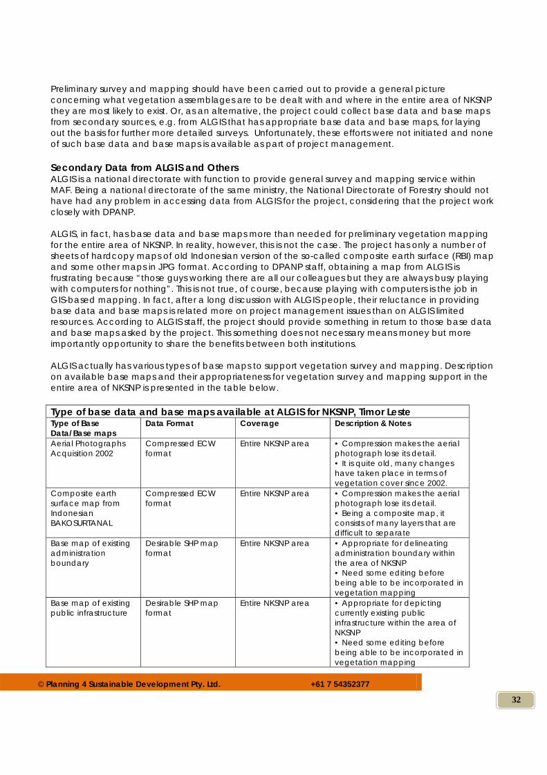
© Planning 4 Sustainable Development Pty. Ltd. +61 7 54352377
32
Preliminary survey and mapping should have been carried out to provide a general picture concerning what vegetation assemblages are to be dealt with and where in the entire area of NKSNP they are most likely to exist. Or, as an alternative, the project could collect base data and base maps from secondary sources, e.g. from ALGIS that has appropriate base data and base maps, for laying out the basis for further more detailed surveys. Unfortunately, these efforts were not initiated and none of such base data and base maps is available as part of project management. Secondary Data from ALGIS and Others ALGIS is a national directorate with function to provide general survey and mapping service within MAF. Being a national directorate of the same ministry, the National Directorate of Forestry should not have had any problem in accessing data from ALGIS for the project, considering that the project work closely with DPANP. ALGIS, in fact, has base data and base maps more than needed for preliminary vegetation mapping for the entire area of NKSNP. In reality, however, this is not the case. The project has only a number of sheets of hardcopy maps of old Indonesian version of the so-called composite earth surface (RBI) map and some other maps in JPG format. According to DPANP staff, obtaining a map from ALGIS is frustrating because “those guys working there are all our colleagues but they are always busy playing with computers for nothing”. This is not true, of course, because playing with computers is the job in GIS-based mapping. In fact, after a long discussion with ALGIS people, their reluctance in providing base data and base maps is related more on project management issues than on ALGIS limited resources. According to ALGIS staff, the project should provide something in return to those base data and base maps asked by the project. This something does not necessary means money but more importantly opportunity to share the benefits between both institutions. ALGIS actually has various types of base maps to support vegetation survey and mapping. Description on available base maps and their appropriateness for vegetation survey and mapping support in the entire area of NKSNP is presented in the table below. Type of base data and base maps available at ALGIS for NKSNP, Timor Leste Type of Base Data/Base maps
Data Format Coverage Description & Notes
Aerial Photographs Acquisition 2002
Compressed ECW format
Entire NKSNP area • Compression makes the aerial photograph lose its detail. • It is quite old, many changes have taken place in terms of vegetation cover since 2002.
Composite earth surface map from Indonesian BAKOSURTANAL
Compressed ECW format
Entire NKSNP area • Compression makes the aerial photograph lose its detail. • Being a composite map, it consists of many layers that are difficult to separate
Base map of existing administration boundary
Desirable SHP map format
Entire NKSNP area • Appropriate for delineating administration boundary within the area of NKSNP • Need some editing before being able to be incorporated in vegetation mapping
Base map of existing public infrastructure
Desirable SHP map format
Entire NKSNP area • Appropriate for depicting currently existing public infrastructure within the area of NKSNP • Need some editing before being able to be incorporated in vegetation mapping
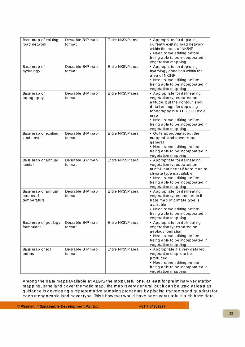
© Planning 4 Sustainable Development Pty. Ltd. +61 7 54352377
33
Base map of existing road network
Desirable SHP map format
Entire NKSNP area • Appropriate for depicting currently existing road network within the area of NKSNP • Need some editing before being able to be incorporated in vegetation mapping
Base map of hydrology
Desirable SHP map format
Entire NKSNP area • Appropriate for depicting hydrology condition within the area of NKSNP • Need some editing before being able to be incorporated in vegetation mapping
Base map of topography
Desirable SHP map format
Entire NKSNP area • Appropriate for delineating vegetation types based on altitude, but the contour is not detail enough for depicting topography in a <1:50.000 scale map • Need some editing before being able to be incorporated in vegetation mapping
Base map of existing land cover
Desirable SHP map format
Entire NKSNP area • Quite appropriate, but the mapped land cover is too general • Need some editing before being able to be incorporated in vegetation mapping
Base map of annual rainfall
Desirable SHP map format
Entire NKSNP area • Appropriate for delineating vegetation types based on rainfall, but better if base map of climate type is available • Need some editing before being able to be incorporated in vegetation mapping
Base map of annual means of temperature
Desirable SHP map format
Entire NKSNP area • Appropriate for delineating vegetation types, but better if base map of climate type is available • Need some editing before being able to be incorporated in vegetation mapping
Base map of geology formations
Desirable SHP map format
Entire NKSNP area • Appropriate for delineating vegetation types based on geology formation • Need some editing before being able to be incorporated in vegetation mapping
Base map of soil orders
Desirable SHP map format
Entire NKSNP area • Appropriate if a very detailed vegetation map is to be produced • Need some editing before being able to be incorporated in vegetation mapping
Among the base maps available at ALGIS, the most useful one, at least for preliminary vegetation mapping, is the land cover thematic map. The map is very general, but it can be used at least as guidance in developing a representative sampling procedure by placing transects and quadrats for each recognizable land cover type. This is however would have been very useful if such base data
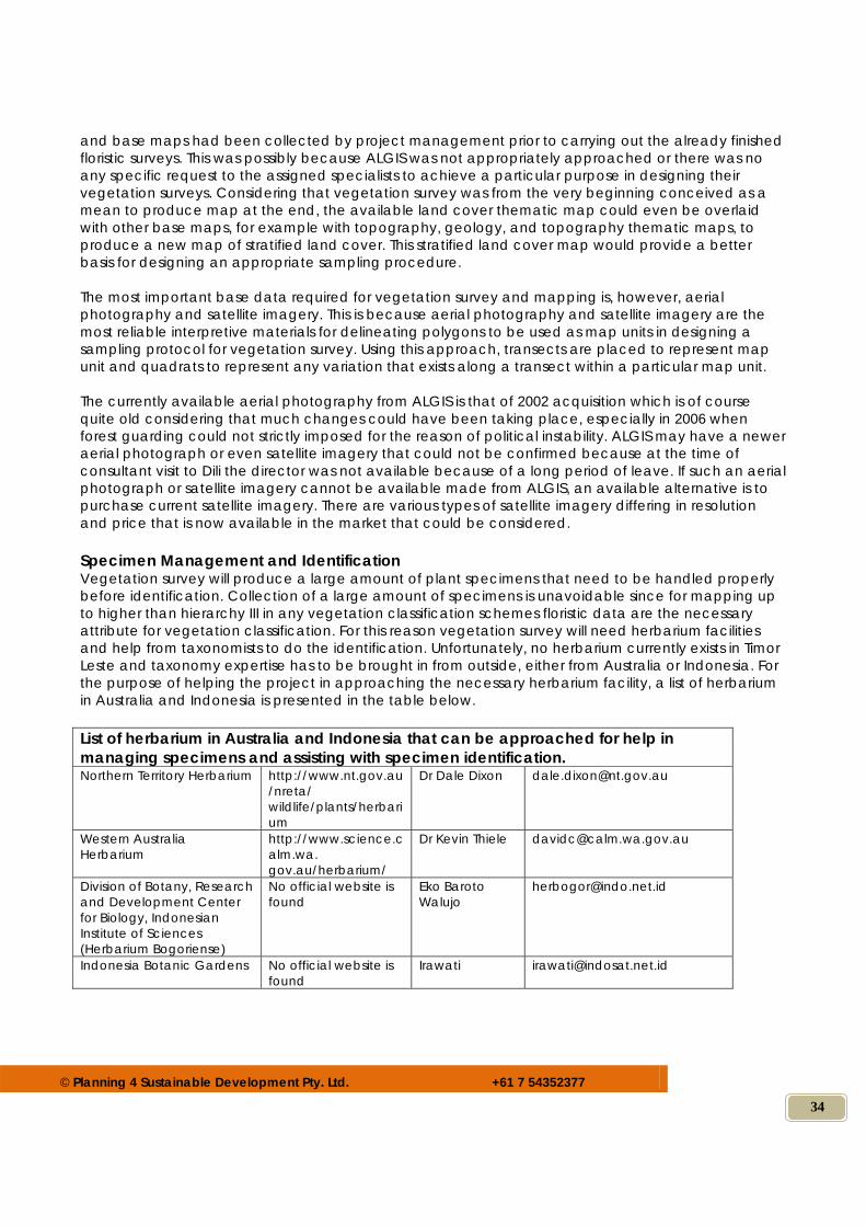
© Planning 4 Sustainable Development Pty. Ltd. +61 7 54352377
34
and base maps had been collected by project management prior to carrying out the already finished floristic surveys. This was possibly because ALGIS was not appropriately approached or there was no any specific request to the assigned specialists to achieve a particular purpose in designing their vegetation surveys. Considering that vegetation survey was from the very beginning conceived as a mean to produce map at the end, the available land cover thematic map could even be overlaid with other base maps, for example with topography, geology, and topography thematic maps, to produce a new map of stratified land cover. This stratified land cover map would provide a better basis for designing an appropriate sampling procedure. The most important base data required for vegetation survey and mapping is, however, aerial photography and satellite imagery. This is because aerial photography and satellite imagery are the most reliable interpretive materials for delineating polygons to be used as map units in designing a sampling protocol for vegetation survey. Using this approach, transects are placed to represent map unit and quadrats to represent any variation that exists along a transect within a particular map unit. The currently available aerial photography from ALGIS is that of 2002 acquisition which is of course quite old considering that much changes could have been taking place, especially in 2006 when forest guarding could not strictly imposed for the reason of political instability. ALGIS may have a newer aerial photograph or even satellite imagery that could not be confirmed because at the time of consultant visit to Dili the director was not available because of a long period of leave. If such an aerial photograph or satellite imagery cannot be available made from ALGIS, an available alternative is to purchase current satellite imagery. There are various types of satellite imagery differing in resolution and price that is now available in the market that could be considered. Specimen Management and Identification Vegetation survey will produce a large amount of plant specimens that need to be handled properly before identification. Collection of a large amount of specimens is unavoidable since for mapping up to higher than hierarchy III in any vegetation classification schemes floristic data are the necessary attribute for vegetation classification. For this reason vegetation survey will need herbarium facilities and help from taxonomists to do the identification. Unfortunately, no herbarium currently exists in Timor Leste and taxonomy expertise has to be brought in from outside, either from Australia or Indonesia. For the purpose of helping the project in approaching the necessary herbarium facility, a list of herbarium in Australia and Indonesia is presented in the table below. List of herbarium in Australia and Indonesia that can be approached for help in managing specimens and assisting with specimen identification. Northern Territory Herbarium http://www.nt.gov.au
/nreta/ wildlife/plants/herbarium
Dr Dale Dixon [email protected]
Western Australia Herbarium
http://www.science.calm.wa. gov.au/herbarium/
Dr Kevin Thiele [email protected]
Division of Botany, Research and Development Center for Biology, Indonesian Institute of Sciences (Herbarium Bogoriense)
No official website is found
Eko Baroto Walujo
Indonesia Botanic Gardens No official website is found
Irawati [email protected]
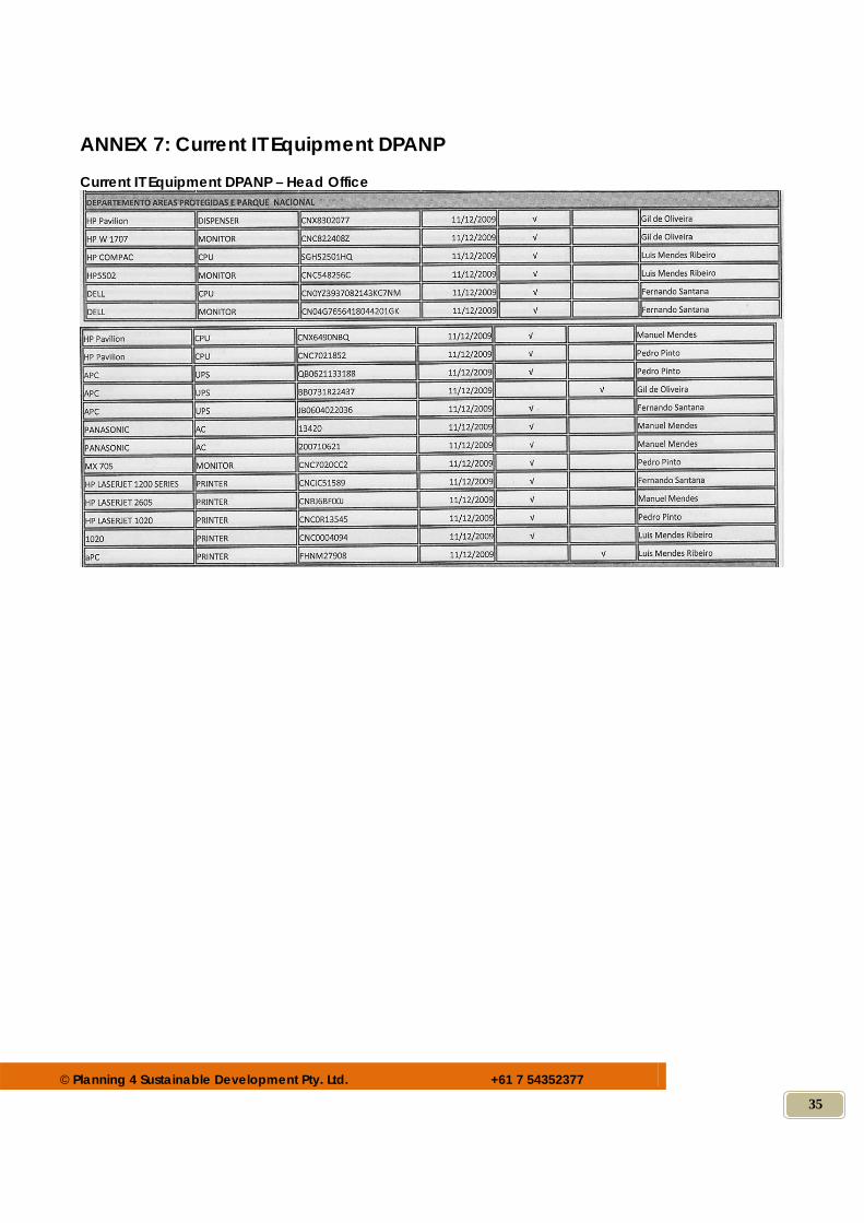
© Planning 4 Sustainable Development Pty. Ltd. +61 7 54352377
35
ANNEX 7: Current IT Equipment DPANP Current IT Equipment DPANP – Head Office
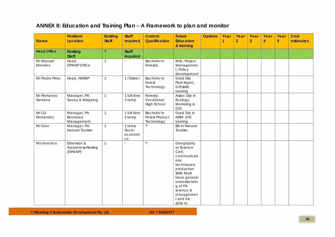
© Planning 4 Sustainable Development Pty. Ltd. +61 7 54352377
36
ANNEX 8: Education and Training Plan – A Framework to plan and monitor Name
Position/ Location
Existing Staff
Staff required
Current Qualification
Future Education & training
Options Year 1
Year 2
Year 3
Year 4
Year 5
Cost estimates
Head Office Existing Staff
7 Staff required
Mr Manuel Mendes
Head DPANP Office
1 - Bachelor in Forestry
MSc, Project Management, Policy development
Mr Pedro Pinto Head, NKSNP 1 1 /District Bachelor in Forest Technology
Grad Dip Park Mgmt, GIS skills training
Mr Fernando Santana
Manager, PA Survey & Mapping
1 1 full time 2 temp
Forestry Vocational High School
Assoc Dip in Ecology, Modeling & GIS
Mr Gil Fernandez
Manager, PA Boundary Management
1 1 full time 2 temp
Bachelor in Forest Product Technology
Grad Dip in NRM, GIS training
Mr Gino Manager, PA Natural Tourism
1 1 temp Socio-economics
? BA in Natural Tourism,
Ms Veronica Extension & Awareness Raising (DPANP)
1 - ? Geography or Science Cert; communications techniques; production skills. Must have general understanding of PA science & management and be able to
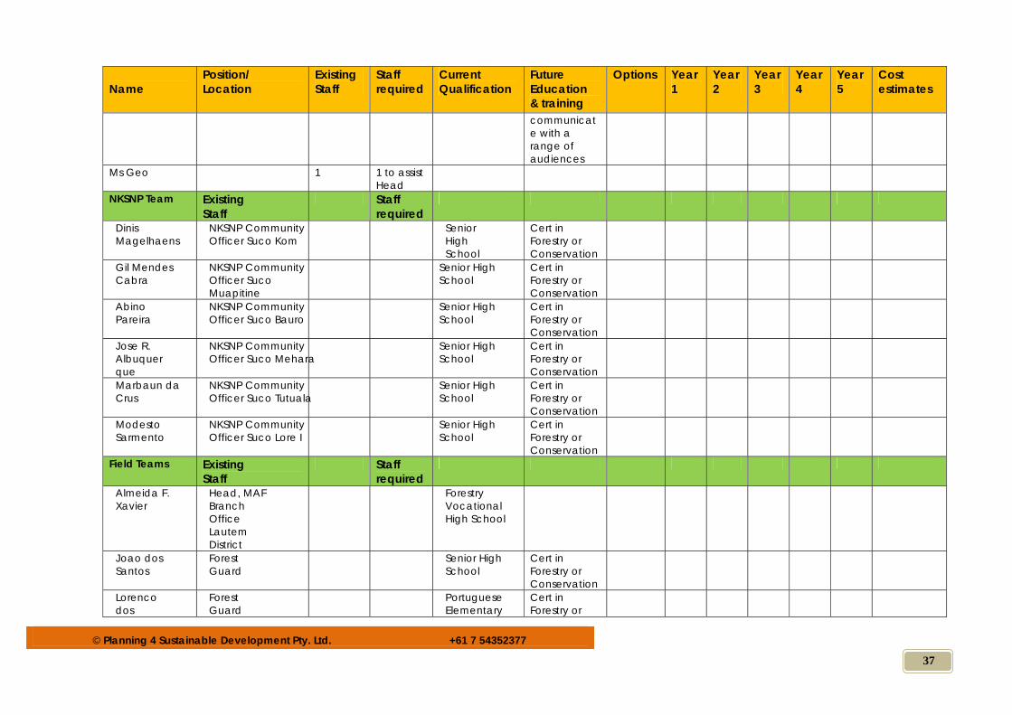
© Planning 4 Sustainable Development Pty. Ltd. +61 7 54352377
37
Name
Position/ Location
Existing Staff
Staff required
Current Qualification
Future Education & training
Options Year 1
Year 2
Year 3
Year 4
Year 5
Cost estimates
communicate with a range of audiences
Ms Geo 1 1 to assist Head
NKSNP Team Existing Staff
Staff required
Dinis Magelhaens
NKSNP Community Officer Suco Kom
Senior High School
Cert in Forestry or Conservation
Gil Mendes Cabra
NKSNP Community Officer Suco Muapitine
Senior High School
Cert in Forestry or Conservation
Abino Pareira
NKSNP Community Officer Suco Bauro
Senior High School
Cert in Forestry or Conservation
Jose R. Albuquerque
NKSNP Community Officer Suco Mehara
Senior High School
Cert in Forestry or Conservation
Marbaun da Crus
NKSNP Community Officer Suco Tutuala
Senior High School
Cert in Forestry or Conservation
Modesto Sarmento
NKSNP Community Officer Suco Lore I
Senior High School
Cert in Forestry or Conservation
Field Teams Existing Staff
Staff required
Almeida F. Xavier
Head, MAF Branch Office Lautem District
Forestry Vocational High School
Joao dos Santos
Forest Guard
Senior High School
Cert in Forestry or Conservation
Lorenco dos
Forest Guard
Portuguese Elementary
Cert in Forestry or
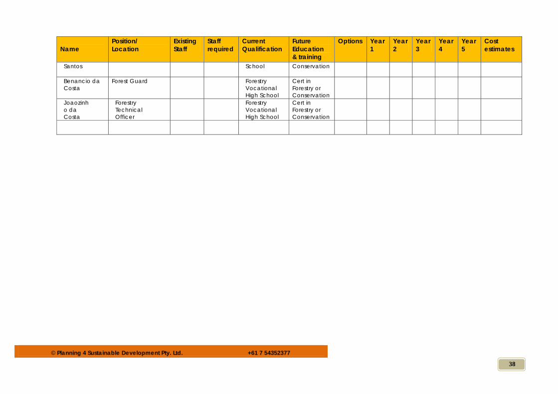
© Planning 4 Sustainable Development Pty. Ltd. +61 7 54352377
38
Name
Position/ Location
Existing Staff
Staff required
Current Qualification
Future Education & training
Options Year 1
Year 2
Year 3
Year 4
Year 5
Cost estimates
Santos
School
Conservation
Benancio da Costa
Forest Guard Forestry Vocational High School
Cert in Forestry or Conservation
Joaozinho da Costa
Forestry Technical Officer
Forestry Vocational High School
Cert in Forestry or Conservation
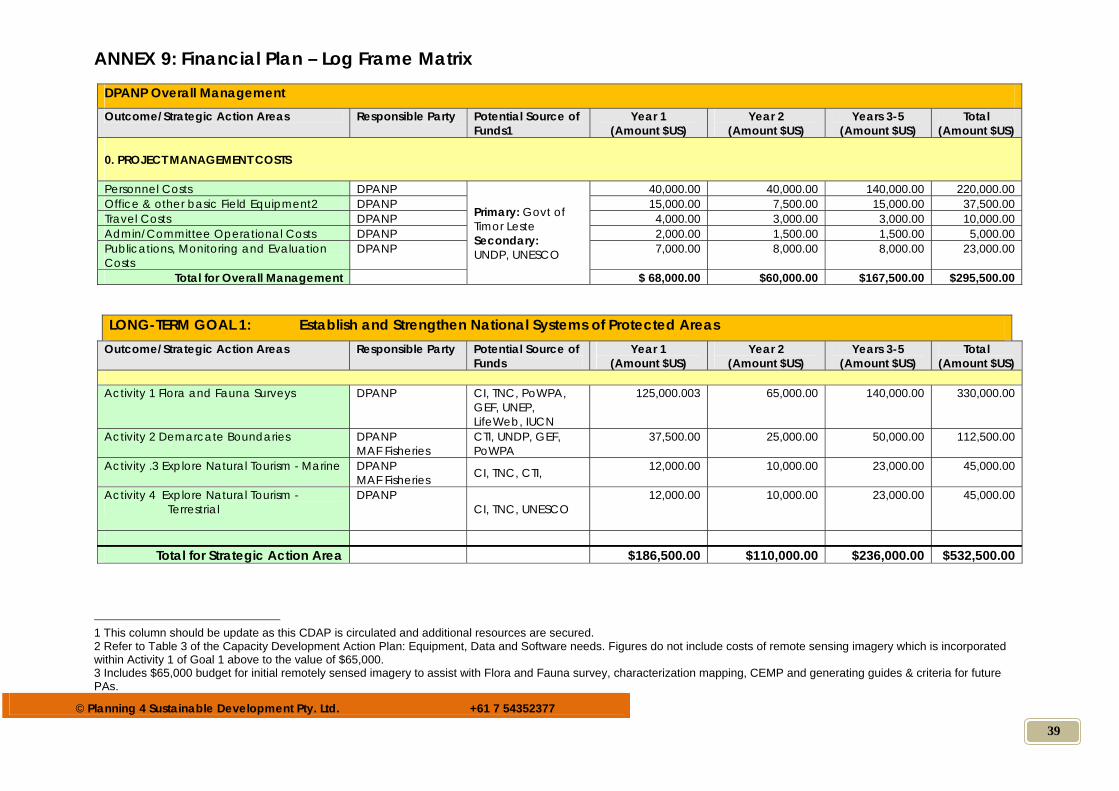
© Planning 4 Sustainable Development Pty. Ltd. +61 7 54352377
39
ANNEX 9: Financial Plan – Log Frame Matrix
DPANP Overall Management Outcome/Strategic Action Areas Responsible Party Potential Source of
Funds1 Year 1
(Amount $US) Year 2
(Amount $US) Years 3-5
(Amount $US) Total
(Amount $US) 0. PROJECT MANAGEMENT COSTS
Personnel Costs DPANP
Primary: Govt of Timor Leste Secondary: UNDP, UNESCO
40,000.00 40,000.00 140,000.00 220,000.00 Office & other basic Field Equipment2 DPANP 15,000.00 7,500.00 15,000.00 37,500.00 Travel Costs DPANP 4,000.00 3,000.00 3,000.00 10,000.00 Admin/Committee Operational Costs DPANP 2,000.00 1,500.00 1,500.00 5,000.00 Publications, Monitoring and Evaluation Costs
DPANP 7,000.00 8,000.00 8,000.00 23,000.00
Total for Overall Management $ 68,000.00 $60,000.00 $167,500.00 $295,500.00
LONG-TERM GOAL 1: Establish and Strengthen National Systems of Protected Areas Outcome/Strategic Action Areas Responsible Party Potential Source of
Funds Year 1
(Amount $US) Year 2
(Amount $US) Years 3-5
(Amount $US) Total
(Amount $US) Activity 1 Flora and Fauna Surveys DPANP CI, TNC, PoWPA,
GEF, UNEP, LifeWeb, IUCN
125,000.003 65,000.00 140,000.00 330,000.00
Activity 2 Demarcate Boundaries DPANP MAF Fisheries
CTI, UNDP, GEF, PoWPA
37,500.00 25,000.00 50,000.00 112,500.00
Activity .3 Explore Natural Tourism - Marine DPANP MAF Fisheries CI, TNC, CTI, 12,000.00 10,000.00 23,000.00 45,000.00
Activity 4 Explore Natural Tourism - Terrestrial
DPANP CI, TNC, UNESCO
12,000.00 10,000.00 23,000.00 45,000.00
Total for Strategic Action Area $186,500.00 $110,000.00 $236,000.00 $532,500.00 1 This column should be update as this CDAP is circulated and additional resources are secured. 2 Refer to Table 3 of the Capacity Development Action Plan: Equipment, Data and Software needs. Figures do not include costs of remote sensing imagery which is incorporated within Activity 1 of Goal 1 above to the value of $65,000. 3 Includes $65,000 budget for initial remotely sensed imagery to assist with Flora and Fauna survey, characterization mapping, CEMP and generating guides & criteria for future PAs.
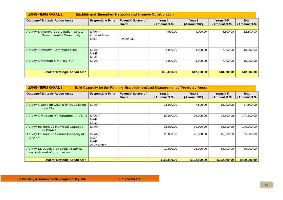
© Planning 4 Sustainable Development Pty. Ltd. +61 7 54352377
40
LONG-TERM GOAL 2: Establish and Strengthen Networks and Improve Collaboration Outcome/Strategic Action Areas Responsible Party Potential Source of
Funds Year 1
(Amount $US) Year 2
(Amount $US) Years 3-5
(Amount $US) Total
(Amount $US) Activity 5: Improve Coordination across
Government & Community DPANP Govt of Timor Leste
UNDP GEF
4,000.00 4,000.00 4,500.00 12,500.00
Activity 6: Improve Communication DPANP MAF NGO
4,000.00 4,000.00 7,000.00 15,000.00
Activity 7: Promote & Market PAs DPANP 4,000.00 4,000.00 7,000.00 15,000.00
Total for Strategic Action Area $12,000.00 $12,000.00 $18,500.00 $42,500.00
LONG-TERM GOAL 3: Build Capacity for the Planning, Establishment and Management of Protected Areas
Outcome/Strategic Action Areas Responsible Party Potential Source of Funds
Year 1 (Amount $US)
Year 2 (Amount $US)
Years 3-5 (Amount $US)
Total (Amount $US)
Activity 8: Develop Criteria for establishing
new PAs DPANP
15,000.00 7,500.00 15,000.00 37,500.00
Activity 9: Produce PA Management Plans DPANP MAF NGO
80,000.00 35,000.00 32,500.00 147,500.00
Activity 10: Improve Individual Capacity of DPANP
DPANP 35,000.00 30,000.00 75,000.00 140,000.00
Activity 11: Improve Systems Capacity of DPANP
DPANP MOF MAF AG’s Office
25,000.00 25,000.00 45,000.00 95,000.00
Activity 12: Develop capacity to advise on Livelihoods Opportunities
10,000.00 25,000.00 35,000.00 70,000.00
Total for Strategic Action Area $165,000.00 $122,500.00 $202,500.00 $490,000.00
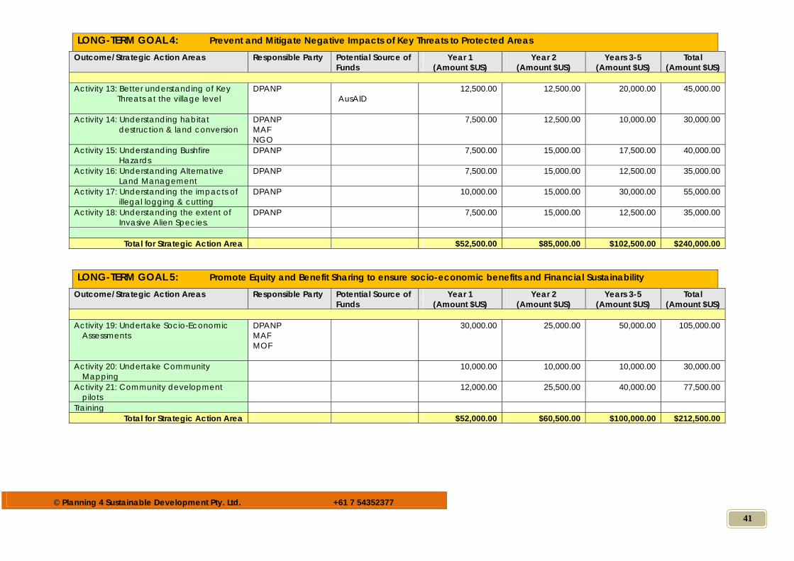
© Planning 4 Sustainable Development Pty. Ltd. +61 7 54352377
41
LONG-TERM GOAL 4: Prevent and Mitigate Negative Impacts of Key Threats to Protected Areas
Outcome/Strategic Action Areas Responsible Party Potential Source of Funds
Year 1 (Amount $US)
Year 2 (Amount $US)
Years 3-5 (Amount $US)
Total (Amount $US)
Activity 13: Better understanding of Key
Threats at the village level DPANP
AusAID 12,500.00 12,500.00 20,000.00 45,000.00
Activity 14: Understanding habitat destruction & land conversion
DPANP MAF NGO
7,500.00 12,500.00 10,000.00 30,000.00
Activity 15: Understanding Bushfire Hazards
DPANP 7,500.00 15,000.00 17,500.00 40,000.00
Activity 16: Understanding Alternative Land Management
DPANP 7,500.00 15,000.00 12,500.00 35,000.00
Activity 17: Understanding the impacts of illegal logging & cutting
DPANP 10,000.00 15,000.00 30,000.00 55,000.00
Activity 18: Understanding the extent of Invasive Alien Species.
DPANP 7,500.00 15,000.00 12,500.00 35,000.00
Total for Strategic Action Area $52,500.00 $85,000.00 $102,500.00 $240,000.00
LONG-TERM GOAL 5: Promote Equity and Benefit Sharing to ensure socio-economic benefits and Financial Sustainability
Outcome/Strategic Action Areas Responsible Party Potential Source of Funds
Year 1 (Amount $US)
Year 2 (Amount $US)
Years 3-5 (Amount $US)
Total (Amount $US)
Activity 19: Undertake Socio-Economic
Assessments
DPANP MAF MOF
30,000.00 25,000.00 50,000.00 105,000.00
Activity 20: Undertake Community Mapping
10,000.00 10,000.00 10,000.00 30,000.00
Activity 21: Community development pilots
12,000.00 25,500.00 40,000.00 77,500.00
Training Total for Strategic Action Area $52,000.00 $60,500.00 $100,000.00 $212,500.00
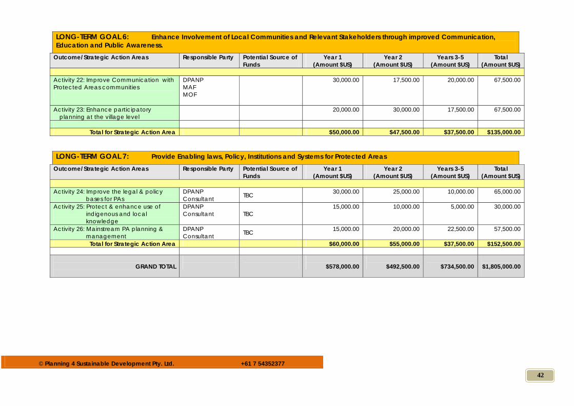
© Planning 4 Sustainable Development Pty. Ltd. +61 7 54352377
42
LONG-TERM GOAL 6: Enhance Involvement of Local Communities and Relevant Stakeholders through improved Communication, Education and Public Awareness.
Outcome/Strategic Action Areas Responsible Party Potential Source of Funds
Year 1 (Amount $US)
Year 2 (Amount $US)
Years 3-5 (Amount $US)
Total (Amount $US)
Activity 22: Improve Communication with Protected Areas communities
DPANP MAF MOF
30,000.00 17,500.00 20,000.00 67,500.00
Activity 23: Enhance participatory planning at the village level
20,000.00 30,000.00 17,500.00 67,500.00
Total for Strategic Action Area $50,000.00 $47,500.00 $37,500.00 $135,000.00
LONG-TERM GOAL 7: Provide Enabling laws, Policy, Institutions and Systems for Protected Areas
Outcome/Strategic Action Areas Responsible Party Potential Source of Funds
Year 1 (Amount $US)
Year 2 (Amount $US)
Years 3-5 (Amount $US)
Total (Amount $US)
Activity 24: Improve the legal & policy
bases for PAs DPANP Consultant TBC 30,000.00 25,000.00 10,000.00 65,000.00
Activity 25: Protect & enhance use of indigenous and local knowledge
DPANP Consultant TBC
15,000.00 10,000.00 5,000.00 30,000.00
Activity 26: Mainstream PA planning & management
DPANP Consultant TBC 15,000.00 20,000.00 22,500.00 57,500.00
Total for Strategic Action Area $60,000.00 $55,000.00 $37,500.00 $152,500.00
GRAND TOTAL
$578,000.00
$492,500.00
$734,500.00
$1,805,000.00