Embed Size (px)
Citation preview
1. Introduction
Hydrometric information is fundamental to the plan-ning, operation and management of water resourcesand flood defence. Hydrometeorology is defined as theaspects of meteorology which are applied to the solu-tion of hydrological problems. As such, therefore, itincludes the analysis of the hydrological cycle to assistin the effective control and management of surfacewater and groundwater and the management and con-trol of flood flows. The data used include, for example,rainfall, snowmelt, soil moisture deficit and other cli-mate data, river flows and groundwater levels. TheEnvironment Agency (the Agency) generally uses rain-fall information to generate river level or river flowestimates or forecasts. Because the Agency does noteasily distinguish between decisions made on the basisof river flow data or rainfall data which is then used toestimate river flows, the remainder of the paper willconsider decisions based on the use of both rainfall andriver flow data. The UK is fortunate in having an exten-sive network for hydrometric data collection which iswell used by regulators such as the EnvironmentAgency and the Scottish Environment ProtectionAgency and other organisations such as theMeteorological Office, the water companies, localauthorities, the research community and others.
The Agency is not only a collector of data but also col-lates information for the Meteorological Office and forthe national archives held by the Institute of Hydrologyand the British Geological Survey. The Agency is also asignificant user of data in the investigation and solutionof water resources and flood defence management prob-lems. In addition, the Agency also provides data to thoseoutside the Agency who require it.
While the hydrometric data network is valued greatlyby those who use it, assignment of a monetary or eco-
nomic value to its information has been extremely dif-ficult to quantify. Within the paper, attention will befocused on the use and value of hydrometric data inwater resources management and flood control withinthe Environment Agency, though attention will bedrawn to the wider use of such information in estimatesof benefits.
2. Flood defence and water resources activitiesin the Agency
Flood defence and water resources are only two of thekey functions of the Agency; others include environ-mental protection and fisheries, conservation andrecreation. The Agency prefers to think in terms ofintegrated environmental management rather than indi-vidual functions. The Agency has identified key envi-ronmental themes which it needs to address eitheralone or working in partnership with others. These are:climate change, improvement of air quality, manage-ment of water resources, enhancement of biodiversity,management of freshwater fisheries, delivery of inte-grated river basin management, conservation of theland, and regulation of major industries.
The Agency approaches these through its strategy forthe environment in which it takes a snapshot of theenvironment, identifies the stresses and strains on it,considers the options and takes action before taking afurther snapshot. Hydrometric data underpins theaddressing of many of the issues. For example, in set-ting consent conditions associated with discharges torivers and in the management of air quality, in settingof river flow objectives for fisheries and in the manage-ment of flows for navigation purposes. However, thispaper will concentrate on the value of hydrometric datato the water resources and flood defence functions forwhich it is fundamental. Tables 1 and 2 summarise the
Meteorol. Appl. 7, 387–397 (2000)
The value of hydrometric information in waterresources management and flood control Susan Walker, Geography Department, University of Aberdeen, Elphinstone Road, AberdeenAB9 2UF, UK (formerly Regional Water Manager, Environment Agency (North WestRegion), Warrington WA4 1HG, UK)
Hydrometric information is fundamental to the planning, operation and management of waterresources and flood defence. The data network is greatly valued by those who use it, yet assignment of amonetary or economic value is problematic. Data managers are often frustrated by the need to continueto justify a network. The paper focuses on the uses of data within the Environment Agency of the UK,explores the difficulties in assigning a value to the data and attempts to review the value ascribed tosuch data by drawing on some UK and wider examples.
387
uses of hydrometric information within these twofunctions of the Agency.
Most of those who abstract water need a licence fromthe Agency authorising them to do so. Licence holdersare then required to pay an annual charge to theAgency. The income generated through this route paysfor the Agency’s expenditure in water resources activi-ties and it is therefore the abstractors who ultimatelypay for the collection of hydrometric data for waterresources management purposes. In contrast, flood
defence funding comes from a combination of localgovernment levies and central government grants. Thesplit varies across the Agency’s regions with some 97%of income coming from local authorities and only 3%from central government in the North West Region,compared with 65% coming from local authorities inthe Anglian Region. Hence the ultimate customers forhydrometric data for water resources and flood defenceare abstractors, local and central government, thoughthe main beneficiaries are the community and theenvironment.
S Walker
388
Table 1. Uses of hydrometric data within the Environment Agency for flood defence
Activity Purpose Analysis
Flood alleviation Design of flood defences and Analysis of rainfall and flood flows/or evaluation of performance of existing tidal levels to a specified return period.works. Review of past events.
Flood warning Provision of flood warnings to the public, Real-time provision of observed rainfall, river emergency services, local authorities and and tidal levels, weather radar, satellite imagery others. and weather forecast analysis of past events to
develop robust flood warning models that canbe used in real time.
Maintenance Maintenance of watercourses in Real-time provision of observed rainfall, river anticipation of flood events, operation of and tidal levels, weather radar, satellite imagery pumping stations, clearing of debris and weather forecasts analysis of past events to screens and culverts in anticipation of a develop robust flood warning models that can flood event. be used in real time.
Regulation/development Assess impact of proposed development Analysis of past events to assess flood risk.control in river works on flood risk.
Provision of flood risk maps.
Table 2. Uses of hydrometric data within the Environment Agency for water resources
Activity Purpose Analysis
Water resources planning Strategic planning and design of socially Simulation/optimisation/reliability assessments and environmentally sustainable water of design and operation of surface andresources systems. groundwater systems using rainfall, river,
reservoir and groundwater levels, river flows.
Abstraction licensing Setting abstraction licence conditions Analysis of patterns of rainfall, runoff and and monitoring their effectiveness in groundwater also temperature (for water protecting other water users and the demand).environment. Real time rainfall, runoff and groundwater Enforcement of existing licences. information.
Assessment of the impact Assessing environmental impacts, Rainfall, runoff, groundwater and temperature of operating policies operating costs and risks to supplies and information.
the environment. Reservoir levels.
Alleviation of low flows Modification of abstraction practices to River flow analysis.prevent existing low flow/level problems Simulation/optimisationon watercourses and wetlands.
Contingency planning Managing risks to supplies and the Probabilistic assessments of rainfall and runoff.including droughts environment in unforeseen circumstances. Cumulative simulation weather forecasts.
Observation of rainfall, runoff, groundwaterand temperature level.

Of the Agency’s expenditure some 14% was spent onwater resources activities in 1996–97. Flood defenceaccounted for over £250 million or 45% of the overallAgency expenditure. As hydrometric data supports allthis expenditure, it is clearly important that the net-work delivers the quality and quantity of informationrequired to an appropriate timeliness. In the NorthWest Region, for example, hydrometry accounted foralmost half of the overall expenditure on waterresources in the region (i.e. approximately £3 million).
3. Water resources management in the Agency
The Agency aims to ensure that the existing manage-ment and future development of water resources is car-ried out in a sustainable way, by balancing the needs ofabstractors with those of the environment. This is pri-marily achieved using abstraction licensing legislation.In determining abstraction licences, the Agency mustbe satisfied that the need for the licence is justified. Theenvironmental implications need to be consideredtogether with the impact of the proposed abstractionon existing abstractors. The Agency needs to avoidderogation of existing abstractors and will seek mitiga-tion measures, where necessary, to reduce the environ-mental impact of the proposals.
Analytical techniques together with hydrometric dataare used to mimic the behaviour of the proposedabstraction or variation to an existing abstraction andits impact on the watercourse or aquifer. Hydrometricdata is also needed by Agency enforcement teams whocheck that licence holders are complying with the termsof their licence. Information is also needed to checkthat, once commissioned, an abstraction has the impactwhich was anticipated when the licence conditionswere originally set.
For abstractions which form part of a complex waterresources system, it is normal to carry out a simulationand even optimisation of the operation of the waterresources system. The Agency needs to be convincedthat realistically varying patterns of runoff and demandhave been considered by the licence applicant.Underpinning this will not just be the pattern of riverflow and groundwater levels but also the impact oftemperature on water demand. It may be necessary tocarry out extensive rainfall-runoff modelling or catch-ment-wide physical modelling in addition to modellingthe water resources themselves. In assessing licenceapplications, it is essential that the anticipated methodof operation of the source is taken into account sincethis has a fundamental impact on reliability of supplies,risk to the environment and operating costs.
In deriving these operating policies, setting abstractionconditions and assessing their impact by simulation,the appropriate environmental constraints need to beincluded. This may be, for example, requiring abstrac-
tion to cease at certain times of year if river flowsbecome critical to the migration of fish. The outputsfrom the simulation process, in addition to the quanti-ties available for abstraction at different times of year,will normally include the costs of operation of theabstraction. While this information is of primary inter-est to the abstractor, the Agency also has to be mindfulof the impact of its policies on costs and benefits. Fromthe Agency’s point of view, the key output from thesimulation process is the environmental indicatorswhich, for example, may be the pattern of reservoir lev-els or river flows in response to different weather con-ditions. It is important to investigate these thoroughlyin order that the Agency can be satisfied that a pro-posed abstraction does not compromise environmentalsafeguards. Analysis of these may take the form of asimple hydrograph analysis or be more complex,requiring the frequency analysis of flows in differentcritical flow regimes at different times of the year.Having assessed the hydrological implications, theimpact on water quality, ecology, fisheries and thewider environment are then examined.
Within North West Region, there are approximately3,500 abstraction licences. The majority of these haveminimal detrimental impact on the environment.However, at some sites there are concerns about theimpact of existing abstractions on the environment.Abstractors, operating entirely legally under long-standing licences, are causing environmental problemsdue to over generous abstraction conditions in thelicence. These were set at a time when either the envi-ronment implications were not understood, or theenvironment was not valued as much as it is today. Thisresults in low river flows and, in some cases, lowgroundwater levels even in non-drought periods.
Analysis of hydrometric data has formed the basis ofattempts to review these licences and provide solutions tothe low flow problems. In one example, on the RiverLowther in the Lake District, simulation techniques wereused to assess how the compensation flows in a series oftributaries should be redistributed in order to ensure ade-quate flows for fisheries purposes. Real improvements tothe fisheries in the catchment have been detected fiveyears after the operating regime was modified.
The Agency needs to ensure the effective operationalmanagement of water resources by having contingencyplans, for example, in case of drought or the need toremove a source from supply because of a pollutionincident. The Agency needs to be satisfied that watercompanies also have such plans. Probabilistic assess-ments of rainfall and runoff, together with cumulativesimulations, are used to assess and monitor the risks tosupply and the environment throughout the year(Walker et al., 1993). This is necessary to ensure thatabstractors are prudent in their operations so that earlyremedial action can be taken to avoid unnecessary envi-ronmental damage later in the year or in succeeding
Information for water resources and flood defence
389
years for water resources with long critical periods.Should a drought or other non-routine situation occur,these techniques are used to try to balance the risks tosupply and minimise damage to the environment. Thisis achieved by reducing abstraction in those catchmentsand at those times of year that are most sensitive froman environmental point of view, recognising that lesssensitive catchments may, of necessity, be subject tosome environmental deterioration if public water sup-plies are to be maintained at the essential level. Suchtechniques can also be used to identify the level of pub-lic water supply which can be sustained in order thatappeals to the public for water conservation or statu-tory restrictions on water use can be targeted in themost appropriate areas. These approaches were usedextensively and successfully in the North West Regionin the 1995–96 drought which was the worst on recordin the region in terms of geographical extent, durationand severity (Walker & Smithers, 1998). The Agencyaimed to safeguard essential water supplies while min-imising environmental damage, assuming a repeat ofthe worst conditions in the historical record. Even so,significant environmental consequences were felt withhigh temperatures, poor water quality and low riverflows and lake levels leading to stress and death in fishand other wildlife populations. Whilst the weather pro-vided opportunities for water-based recreation, accesswas often difficult due to low flows and low reservoirand lake levels. Angling conditions were poor evenafter river flows initially recovered.
The Agency has an extensive resource planning role. Itis developing a national water resources developmentstrategy for England and Wales which will identifyenvironmentally sustainable options for meetingdemands for water into the first quarter of the twenty-first century. Hydrometric information is essential notonly to assess the needs for and implications of newwater resources, but also to assess the demand for waterand the opportunities for reducing the need for newresources by developing water conservation anddemand management techniques.
In evaluating resource options, the analysis of rainfalland runoff and the assessment of the impact of weatheron water usage are fundamental if a sustainableapproach to water resources development is to beachieved in which there is no long-term deteriorationin the water environment due to either resource devel-opment or water use.
There is currently a lot of impetus in the resource plan-ning role as the Agency is currently heavily involved inthe Periodic Review process. This is the mechanism bywhich the Director General of Water Services setswater company prices for the year 2000 onwards.Fundamental to this is the identification by the Agencyof a programme of environmental improvements whichwill generate not just a better environment for its ownsake but which will also act as a catalyst to economic
development and social well-being. In addition, watercompanies are required to produce water resourcesplans to a consistent format which will for the first timein many years allow a national perspective of the sus-tainability of water resources across the country. TheAgency will then vet these plans. It is clear that goodquality hydrometric data is essential to underpin all thiswork. As a result of the last Periodic Review, environ-mental improvements to a value of £1.4 billions willhave been delivered in the North West Region alone.With this level of potential investment it is thereforefundamental that the information on which such deci-sions are made is robust.
Even on a more local scale, yield assessments, determi-nation of supply availability from different waterresources and the potential for demand managementare fundamental to the effective planning and manage-ment of water resources. Assessments of hydrometricdata combined with simulation, are used as a matter ofroutine to carry out these analyses. Such investigationshave already been carried out in the North WestRegion as part of the Periodic Review process. Theresults have shown a reduction of 17% in resourceavailability compared with previous estimates. This isdue to the need to cater for a repeat of the 95/96drought and an improved level of service to water com-pany customers. In West Cumbria the percentagereduction is even more significant. The challenge isnow to establish how the shortfall between supplyavailability and demand can be overcome in a sustain-able way. Fundamental to this will be an understandingof the hydrology of the situation.
In water resources planning there are many uncertain-ties. A number of these relate to the hydrometric datasupporting the analyses. For example, regardingresource assessment, the availability, timeliness, spatialand temporal resolution of the data are key issues.Issues such as short-term variability and potential cli-mate change are also significant. The impact of climateand weather on the demand side of the equation arealso important uncertainties.
4. Flood defence in the Agency
The Agency aims to provide effective defence and warn-ing systems, where it is cost beneficial to do so, to pro-tect people and property against flooding from riversand the sea and do this in a way which is sympathetic tothe natural environment. Nationally, 51% of the flooddefence budget is spent on flood alleviation, 41% on themaintenance of watercourses and assets such as pump-ing stations, 4% is spent on flood warning and 4% isspent on regulation and development control.
The Agency has permissive powers to build defences toreduce the risk of flooding. It can also use these powersto replace defences approaching the end of their life.
S Walker
390
The powers apply to Main River (principal watercourses) and sea defences. Local authorities have simi-lar powers regarding Non-Main River and coastal pro-tection. If existing defences in England and Wales wereallowed to fall into disrepair it has been estimated thatthe consequent annual average financial damage wouldconservatively be £2 billion. This is compounded bythe welfare and social impact on the communitiesaffected by flooding. Agency defences protect some 1.2million hectares of land, 850 000 houses and over 2 mil-lion people. The design of such defences is complex andthe analysis of hydrometric data is fundamental to this.Bearing in mind the long design life of such defences,the need to assess the sensitivity of the design to poten-tial climate change has become an increasingly impor-tant issue. The nature of analyses undertaken dependon the type of defence being considered, be it a floodstorage reservoir, channel works, managed retreat orother alleviation strategy. However, basic to all theassessments is the analysis of rainfall and flood flows ortidal levels to a specified return period. Review of datafrom past events is important in both the design of newworks and in the evaluation of the performance ofexisting works.
When it is not cost beneficial to provide a flooddefence, or where a defence has still to be constructed,the Agency has powers to provide a flood warning ser-vice. Where flood warnings are provided, the Agency isresponsible for the dissemination of warnings to thepolice, local authorities, utilities and, since September1996, the public directly. In contrast to the need for his-torical hydrometric data for other elements of theAgency’s business, the time imperative of flood warn-ing requires the real-time provision of data in orderthat the Agency can continually monitor weather fore-casts, weather radar, rainfall and tidal and river levels.Real-time forecasting is then used to predict when andwhere, and at what magnitude a flood is likely to occurin order that appropriate warnings can be given.Hydrometric data is fundamental to the design, devel-opment, calibration and operation of flood forecastingand warning systems. It is within this element of theAgency’s business that weather radar estimates of pre-cipitation and the qualitative use of satellite imageryhave been found to be so valuable. The aim is to pro-vide at least four hours warning, but it is recognisedthat in many areas the forecasting methodologies avail-able do not allow this length of lead time and in somesituations a reliable forecast is currently impossible toproduce. The flooding events in the Midlands and EastAnglia in April 1998 will focus attention on the effec-tiveness of data collection networks and their manage-ment systems.
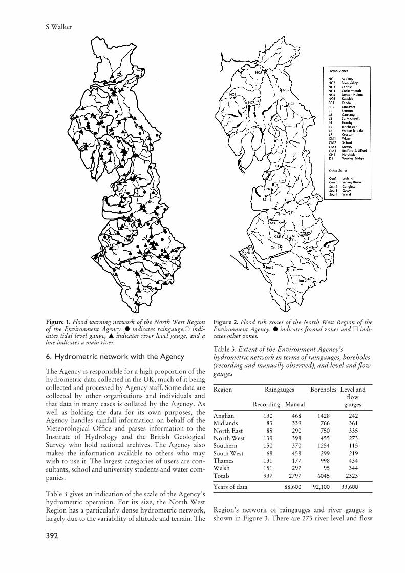
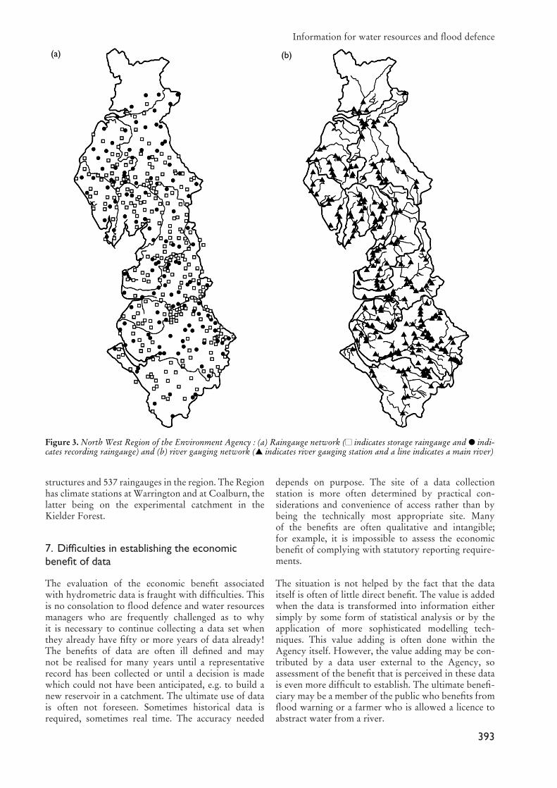
As part of the flood warning system of the North WestRegion there are 43 raingauges, 127 river level gaugesand 4 tidal monitoring sites (Figure 1) which are usedto provide warnings to 22 flood risk zones (Figure 2)across the region.
In addition to constructing flood defences, the Agencyimproves and maintains them to ensure that they oper-ate as planned under flood conditions. The Agency haspowers to maintain watercourses in anticipation offlood events. When flood flows or high tides are pre-dicted, effective operation of the flood defence infra-structure, such as pumping stations and the clearing ofdebris from screens and culverts and other emergencymaintenance, is an essential part of the Agency’s busi-ness in order to reduce the risk of flood damage.
The Agency assesses flood risk both in the context of asignificant flood event which could lead to a regional ornational emergency and also in relation to less extremeevents. There is a need to analyse hydrometric data inorder to assess flood risk and the potential for increasingflood risk due to development pressures or assess theimpact of proposed in-river works which require a con-sent from the Agency. The Agency is keen that flood-plain development is discouraged and may object todevelopment on environmental grounds or where thereis inadequate flood protection on site or where develop-ment will lead to an increased risk of flooding elsewhere.However, the Agency has no power of veto and localauthorities may choose to set aside the Agency’s objec-tions if it feels that other imperatives apply.
5. Climate change
The potential for climate change can impact signifi-cantly on the water resources and flood defence activi-ties of the Agency. An increased variability of meteo-rological patterns could lead to an increased risk offloods and droughts in terms of frequency and severity.Pressure on water resources and hence on the environ-ment in the longer term will probably increase withincreased demand for water and reduced availability ofwater resources due to climate change. There will be aneed to implement demand management measures withincreased vigour and further development of waterresources may be required. The potential for rises in sealevel and an increase in storminess could have signifi-cant implications for flood defence as they would leadto an increase in flood risk — possibly within the life ofexisting defences. Mechanisms for adaption havebecome crucial. It is therefore essential to continue tomonitor meteorological variables on an ongoing basisto establish whether early precautionary action is nec-essary to counter any variation in meteorological pat-terns. Predictions regarding climate change are helpful,but what is even more helpful is predictions of changesto meteorological patterns. In managing waterresources and flood defence, the opportunity and abil-ity to respond to the changing pattern is essential. Thecause for the change, be it due to natural variabilitywithin an existing time series, or whether it is due toclimate change is less of an issue, though clearly, byunderstanding the process, greater prediction capabil-ity is more likely.
Information for water resources and flood defence
391
6. Hydrometric network with the Agency
The Agency is responsible for a high proportion of thehydrometric data collected in the UK, much of it beingcollected and processed by Agency staff. Some data arecollected by other organisations and individuals andthat data in many cases is collated by the Agency. Aswell as holding the data for its own purposes, theAgency handles rainfall information on behalf of theMeteorological Office and passes information to theInstitute of Hydrology and the British GeologicalSurvey who hold national archives. The Agency alsomakes the information available to others who maywish to use it. The largest categories of users are con-sultants, school and university students and water com-panies.
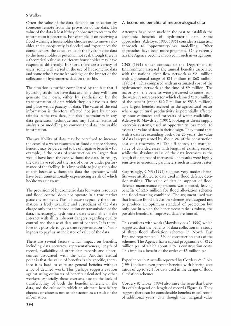
Table 3 gives an indication of the scale of the Agency’shydrometric operation. For its size, the North WestRegion has a particularly dense hydrometric network,largely due to the variability of altitude and terrain. The
Region’s network of raingauges and river gauges isshown in Figure 3. There are 273 river level and flow
S Walker
392
Figure 2. Flood risk zones of the North West Region of theEnvironment Agency. � indicates formal zones and �� indi-cates other zones.
Table 3. Extent of the Environment Agency’shydrometric network in terms of raingauges, boreholes(recording and manually observed), and level and flowgauges
Region Raingauges Boreholes Level and flow
Recording Manual gauges
Anglian 130 468 1428 242Midlands 83 339 766 361North East 85 290 750 335North West 139 398 455 273Southern 150 370 1254 115South West 68 458 299 219Thames 131 177 998 434Welsh 151 297 95 344Totals 937 2797 6045 2323
Years of data 88,600 92,100 33,600
Figure 1. Flood warning network of the North West Regionof the Environment Agency. � indicates raingauge,�� indi-cates tidal level gauge, � indicates river level gauge, and aline indicates a main river.
structures and 537 raingauges in the region. The Regionhas climate stations at Warrington and at Coalburn, thelatter being on the experimental catchment in theKielder Forest.
7. Difficulties in establishing the economicbenefit of data
The evaluation of the economic benefit associatedwith hydrometric data is fraught with difficulties. Thisis no consolation to flood defence and water resourcesmanagers who are frequently challenged as to whyit is necessary to continue collecting a data set whenthey already have fifty or more years of data already!The benefits of data are often ill defined and maynot be realised for many years until a representativerecord has been collected or until a decision is madewhich could not have been anticipated, e.g. to build anew reservoir in a catchment. The ultimate use of datais often not foreseen. Sometimes historical data isrequired, sometimes real time. The accuracy needed
depends on purpose. The site of a data collectionstation is more often determined by practical con-siderations and convenience of access rather than bybeing the technically most appropriate site. Manyof the benefits are often qualitative and intangible;for example, it is impossible to assess the economicbenefit of complying with statutory reporting require-ments.
The situation is not helped by the fact that the dataitself is often of little direct benefit. The value is addedwhen the data is transformed into information eithersimply by some form of statistical analysis or by theapplication of more sophisticated modelling tech-niques. This value adding is often done within theAgency itself. However, the value adding may be con-tributed by a data user external to the Agency, soassessment of the benefit that is perceived in these datais even more difficult to establish. The ultimate benefi-ciary may be a member of the public who benefits fromflood warning or a farmer who is allowed a licence toabstract water from a river.
Information for water resources and flood defence
393
Figure 3. North West Region of the Environment Agency : (a) Raingauge network (�� indicates storage raingauge and � indi-cates recording raingauge) and (b) river gauging network (� indicates river gauging station and a line indicates a main river)
(a) (b)
Often the value of the data depends on an action bysomeone remote from the provision of the data. Thevalue of the data is lost if they choose not to react to theinformation it generates. For example, if on receiving aflood warning a householder chooses not to move valu-ables and subsequently is flooded and experiences theconsequences, the actual value of the hydrometric datato the householder is potential not real, though there isa theoretical value as a different householder may haveresponded differently. In short, there are a variety ofusers, some well versed in the use of hydrometric dataand some who have no knowledge of the impact of thecollection of hydrometric data on their life.
The situation is further complicated by the fact that ifhydrologists do not have data available they will oftengenerate their own, either by synthesis or by thetransformation of data which they do have to a timeand place with a paucity of data. The value of the endinformation is therefore affected not just by uncer-tainties in the raw data, but also uncertainties in anydata generation technique and any further statisticalanalysis or modelling to convert the data into usableinformation.
The availability of data may be perceived to increasethe costs of a water resources or flood defence scheme,hence it may be perceived to be of negative benefit − forexample, if the costs of construction are larger thanwould have been the case without the data. In reality,the data have reduced the risk of over or under perfor-mance of the facility. It is impossible to judge the valueof this because without the data the operator wouldhave been unintentionally experiencing a risk of whichhe/she was unaware.
The provision of hydrometric data for water resourcesand flood control does not operate in a true marketplace environment. This is because typically the infor-mation is freely available and custodians of the datacharge only for the reproduction or transmission of thedata. Increasingly, hydrometric data is available on theInternet with all its inherent dangers regarding qualitycontrol and the use of data out of context. It is there-fore not possible to get a true representation of ‘will-ingness to pay’ as an indicator of value of the data.
There are several factors which impact on benefits,including data accuracy, representativeness, length ofrecord, availability of other data records and uncer-tainties associated with the data. Another criticalpoint is that the value of benefits is site specific, there-fore it is hard to calculate general benefits withouta lot of detailed work. This perhaps suggests cautionagainst using estimates of benefits calculated by otherworkers, especially those overseas due to the lack oftransferability of both the benefits inherent in thedata, and the culture in which an ultimate beneficiarychooses or chooses not to take action as a result of theinformation.
7. Economic benefits of meteorological data
Attempts have been made in the past to establish theeconomic benefits of hydrometric data. Someapproaches (Adeloye, 1995, 1996) consider a statisticalapproach to opportunity/loss modelling. Otherapproaches have been more pragmatic. Only recentlyhas the Agency become involved in such investigations.
CNS (1991) under contract to the Department ofEnvironment assessed the annual benefits associatedwith the national river flow network as £21 millionwith a potential range of £11 million to £60 million(Table 4). This compared with an estimated cost of thehydrometric network at the time of £9 million. Themajority of the benefits were perceived to come fromthe water resources sector which claimed £18.3 millionof the benefit (range £10.7 million to £53.5 million).The largest benefits accrued in the agricultural sectorwhere agricultural productivity is potentially affectedby poor estimates and forecasts of water availability.Adeloye & Mawdsley (1991), looking at direct supplyreservoir systems, used an opportunity loss model toassess the value of data in their design. They found that,with a data set extending back over 25 years, the valueof data is represented by about 3% of the constructioncost of a reservoir. As Table 5 shows, the marginalvalue of data decreases with length of existing record,while the absolute value of the data increases as thelength of data record increases. The results were highlysensitive to economic parameters such as interest rates.
Surprisingly, CNS (1991) suggests very modest bene-fits were attributed to data used in flood defence deci-sion-making. The value of data in support of flooddefence maintenance operations was omitted, leavingbenefits of £2.5 million for flood alleviation schemesand flood warning combined. The argument used wasthat because flood alleviation schemes are designed notto produce an optimum standard of protection butonly one in which the benefit/cost ratio is robust, thepossible benefits of improved data are limited.
This conflicts with work (Mawdsley et al., 1990) whichsuggested that the benefits of data collection in a studyof three flood alleviation schemes in North EastEngland represented 4–5% of construction costs of theschemes. The Agency has a capital programme of £120million p.a. of which about 80% is construction costs.This implies a benefit of the order of £5 million p.a.
Experiences in Australia reported by Cordery & Cloke(1994) indicate even greater benefits with benefit−costratios of up to 80:1 for data used in the design of floodalleviation schemes.
Cordery & Cloke (1994) also raise the issue that bene-fits often depend on length of record (Figure 4). Theysuggest there can be considerable benefits in collectionof additional years’ data though the marginal value
S Walker
394
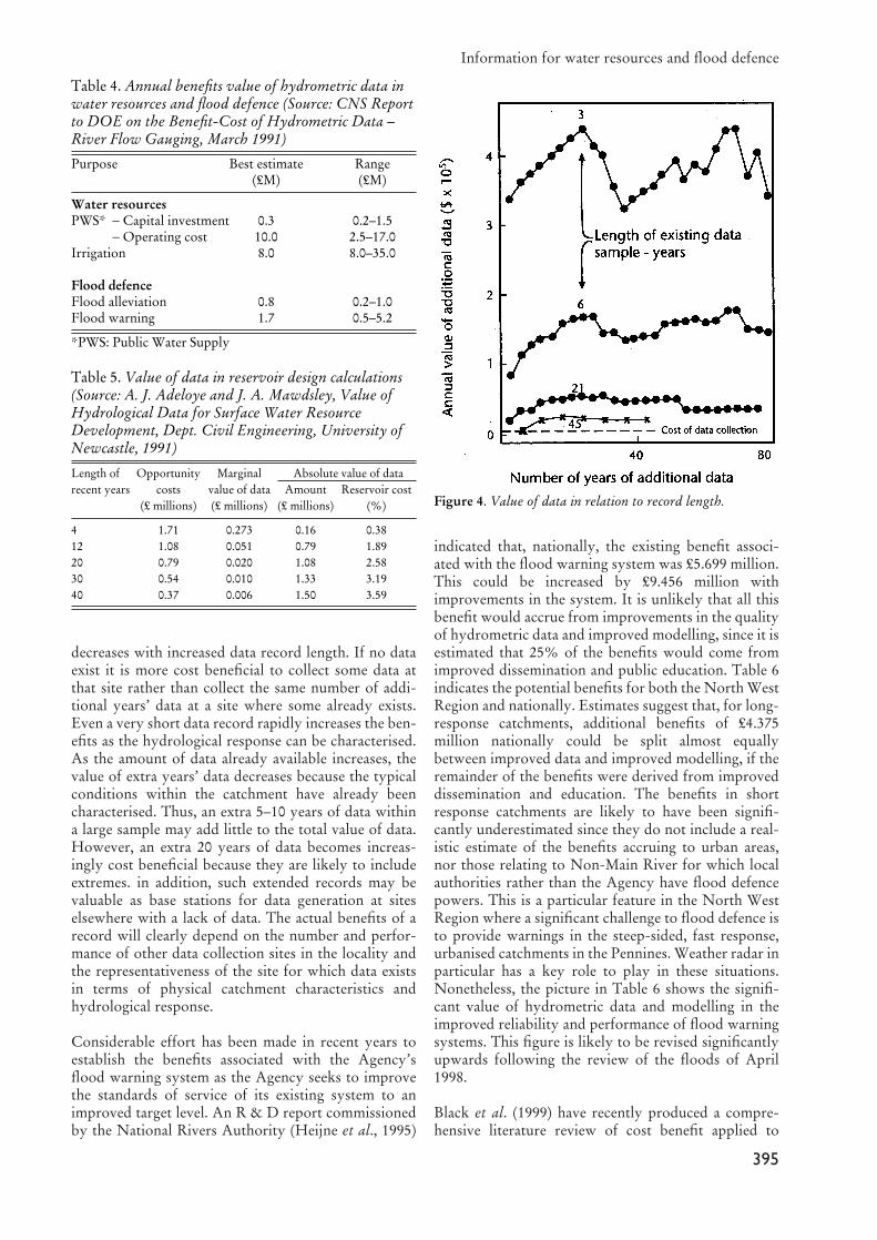
decreases with increased data record length. If no dataexist it is more cost beneficial to collect some data atthat site rather than collect the same number of addi-tional years’ data at a site where some already exists.Even a very short data record rapidly increases the ben-efits as the hydrological response can be characterised.As the amount of data already available increases, thevalue of extra years’ data decreases because the typicalconditions within the catchment have already beencharacterised. Thus, an extra 5–10 years of data withina large sample may add little to the total value of data.However, an extra 20 years of data becomes increas-ingly cost beneficial because they are likely to includeextremes. in addition, such extended records may bevaluable as base stations for data generation at siteselsewhere with a lack of data. The actual benefits of arecord will clearly depend on the number and perfor-mance of other data collection sites in the locality andthe representativeness of the site for which data existsin terms of physical catchment characteristics andhydrological response.
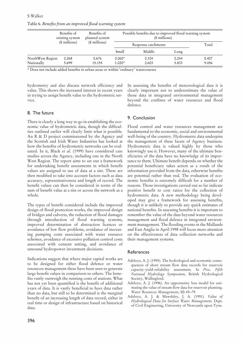
Considerable effort has been made in recent years toestablish the benefits associated with the Agency’sflood warning system as the Agency seeks to improvethe standards of service of its existing system to animproved target level. An R & D report commissionedby the National Rivers Authority (Heijne et al., 1995)
indicated that, nationally, the existing benefit associ-ated with the flood warning system was £5.699 million.This could be increased by £9.456 million withimprovements in the system. It is unlikely that all thisbenefit would accrue from improvements in the qualityof hydrometric data and improved modelling, since it isestimated that 25% of the benefits would come fromimproved dissemination and public education. Table 6indicates the potential benefits for both the North WestRegion and nationally. Estimates suggest that, for long-response catchments, additional benefits of £4.375million nationally could be split almost equallybetween improved data and improved modelling, if theremainder of the benefits were derived from improveddissemination and education. The benefits in shortresponse catchments are likely to have been signifi-cantly underestimated since they do not include a real-istic estimate of the benefits accruing to urban areas,nor those relating to Non-Main River for which localauthorities rather than the Agency have flood defencepowers. This is a particular feature in the North WestRegion where a significant challenge to flood defence isto provide warnings in the steep-sided, fast response,urbanised catchments in the Pennines. Weather radar inparticular has a key role to play in these situations.Nonetheless, the picture in Table 6 shows the signifi-cant value of hydrometric data and modelling in theimproved reliability and performance of flood warningsystems. This figure is likely to be revised significantlyupwards following the review of the floods of April1998.
Black et al. (1999) have recently produced a compre-hensive literature review of cost benefit applied to
Information for water resources and flood defence
395
Table 4. Annual benefits value of hydrometric data inwater resources and flood defence (Source: CNS Reportto DOE on the Benefit-Cost of Hydrometric Data –River Flow Gauging, March 1991)
Purpose Best estimate Range(£M) (£M)
Water resourcesPWS* − Capital investment 0.3 0.2–1.5
− Operating cost 10.0 2.5–17.0Irrigation 8.0 8.0–35.0
Flood defenceFlood alleviation 0.8 0.2–1.0Flood warning 1.7 0.5–5.2
*PWS: Public Water Supply
Table 5. Value of data in reservoir design calculations(Source: A. J. Adeloye and J. A. Mawdsley, Value ofHydrological Data for Surface Water ResourceDevelopment, Dept. Civil Engineering, University ofNewcastle, 1991)
Length of Opportunity Marginal Absolute value of datarecent years costs value of data Amount Reservoir cost
(£ millions) (£ millions) (£ millions) (%)
4 1.71 0.273 0.16 0.3812 1.08 0.051 0.79 1.8920 0.79 0.020 1.08 2.5830 0.54 0.010 1.33 3.1940 0.37 0.006 1.50 3.59
Figure 4. Value of data in relation to record length.
hydrometry and also discuss network efficiency andvalue. This shows the increased interest in recent yearsin trying to assign benefit value to the hydrometric ser-vice.
8. The future
There is clearly a long way to go in establishing the eco-nomic value of hydrometric data, though the difficul-ties outlined earlier will clearly limit what is possible.An R & D project commissioned by the Agency andthe Scottish and Irish Water Industries has looked athow the benefits of hydrometric networks can be eval-uated. In it, Black et al. (1999) have considered casestudies across the Agency, including one in the NorthWest Region. The report aims to set out a frameworkfor undertaking benefit assessments in which benefitvalues are assigned to use of data at a site. These arethen modified to take into account factors such as dataaccuracy, representativeness and length of record. Thebenefit values can then be considered in terms of thesum of benefit value at a site or across the network as awhole.
The types of benefit considered include the improveddesign of flood protection works, the improved designof bridges and culverts, the reduction of flood damagesthrough introduction of flood warning systems,improved determination of abstraction licences oravoidance of low flow problems, avoidance of increas-ing pumping costs associated with water resourceschemes, avoidance of excessive pollution control costsassociated with consent setting, and avoidance ofunsound hydropower investment decisions.
Indications suggest that where major capital works areto be designed for either flood defence or waterresources management these have been seen to generatelarge benefit values in comparison to others. The bene-fits vastly outweigh the running costs of stations. Whathas not yet been quantified is the benefit of additionalyears of data. It is vastly beneficial to have data ratherthan no data, but still to be determined is the marginalbenefit of an increasing length of data record, either inreal time or design of infrastructure based on historicaldata.
In assessing the benefits of meteorological data it isclearly important not to underestimate the value ofthose data in integrated environmental managementbeyond the confines of water resources and flooddefence.
9. Conclusion
Flood control and water resources management arefundamental to the economic, social and environmentalwell-being of the country. Hydrometric data underpinsthe management of these facets of Agency business.Hydrometric data is valued highly by those whoknowingly use it. However, many of the ultimate ben-eficiaries of the data have no knowledge of its impor-tance to them. Ultimate benefit depends on whether thepotential beneficiary takes action as a result of theinformation provided from the data, otherwise benefitsare potential rather than real. The evaluation of eco-nomic benefits is extremely difficult for a number ofreasons. Those investigations carried out so far indicatepositive benefit to cost ratios for the collection ofhydrometric data. A new methodology being devel-oped may give a framework for assessing benefits,though it is unlikely to provide any quick estimates ofnational benefits. In assessing benefits it is important toremember the value of the data beyond water resourcesmanagement and flood defence in integrated environ-ment management. The flooding events in the Midlandsand East Anglia in April 1998 will focus more attentionon the effectiveness of data collection networks andtheir management systems.
References
Adeloye, A. J. (1995). The hydrological and economic conse-quences of short stream flow data records for reservoircapacity-yield-reliability assessment. In Proc. FifthNational Hydrology Symposium, British HydrologicalSociety, Wallingford.
Adeloye, A. J. (1996). An opportunity loss model for esti-mating the value of stream flow data for reservoir planning.Water Resources Management, 10: 45−79.
Adeloye, A. J. & Mawdsley, J. A. (1991). Value ofHydrological Data for Surface Water Management. Dept.of Civil Engineering, University of Newcastle upon Tyne.
S Walker
396
Table 6. Benefits from an improved flood warning system
Benefits of Benefits of Possible benefits due to improved flood warning system existing system planned system (£ millions)
(£ millions) (£ millions)Response catchments Total
Small Middle Long
NorthWest Region 0.268 0.676 0.060* 0.104 0.244 0.407 Nationally 5.699 15.155 1.020* 2.603 5.833 9.456
* Does not include added benefits in urban areas or within ‘ordinary’ watercourses

Black, A. R., Bennett, A. M., Hanley, N. D., Nevin, C. L. &Steel, M. E. (1999). Evaluating the benefits of hydrometricnetworks. R & D Technical Report W6/005, EnvironmentAgency, Bristol.
CNS (1991). The Benefit-Cost of Hydrometric Data – RiverFlow Gauging. Foundation for Water Research, Marlow.
Cordery, I. & Cloke, P. S. (1994). Benefits of flow data forflood protection design. J. Instn. of Wat. & Environ.Managt, 8(1): 33−38.
Heijne, I. S., Robinson, C. J. & Chalterton, J. (1995). An assess-ment of the costs and benefits of fluvial flood forecasting. R& D Note 463, National Rivers Authority, Bristol.
Mawdsley, J. A., Ball, D. B. & Adeloye, A. J. (1990).Evaluating a streamgauge network: a case study of data
value for flood protection schemes. In Proc. of Conf. onEconomic and Social Benefits of Meteorological andHydrological Services, WMO, Geneva, 325−332.
Walker, S. (1994). Systems analysis and its practical applica-tion in the regulation of water resources management. InAdvances in Water Resources Technology and Management(eds. Tsakiris, G. & Santos, M. A.), Balkema, Rotterdam.
Walker, S. Jowitt, P. W. & Bunch, A. H. (1993). Developmentor a decision support system for drought managementwithin North West Water. J. Instn. Wat. & Environ.Managt, 7(3): 295−303.
Walker, S. & Smithers, H. A. (1998) A review of the 1995-6drought in the North West. J. Chart. Instn. Wat. &Environ. Managt. 12 (4): 273−279.
Information for water resources and flood defence
397