Embed Size (px)
Citation preview

Republic of Togo Directorate General of Cartography
The Study on Establishment of Topographic Database in Togo
Final Report (Summary)
September 2013
JAPAN INTERNATIOAL COOPERATION AGENCY
PASCO CORPORATION AERO ASAHI CORPORATION
EI
JR
13-212

Currency exchange rate Unit of Currency: CFA franc
1 euro = 655.957CFA francs (rate September 10, 2013) 1 euro = 130.22yen (rate September, 2013)

TABLE OF CONTENTS CHAPTER 1 OUTLINE OF STUDY ..................................................................................... 1
1-1. OBJECTIVES ................................................................................................................................ 1
1-2. PROBLEMS IN ACHIEVING THE PURPOSES AND STRATEGIES AND ACHIEVEMENT IN THE STUDY ........... 1
1-3. STUDY AREA ............................................................................................................................... 4
1-4. DETAILS AND WORKLOAD OF STUDY ............................................................................................. 5
1-5. FINAL PRODUCTS OF THE STUDY ................................................................................................... 6
1-6. WORKFLOW ................................................................................................................................ 7
CHAPTER 2 OUTPUTS OF THE STUDY, IMPACT OF THE OUTPUTS AND
RECOMMENDATIONS ......................................................................................................... 9
2-1. CASES OF UTILIZATION OF THE TOPOGRAPHIC MAP DATA ............................................................... 9
2-2. ORGANIZATIONAL STRUCTURE FOR UTILIZATION OF THE OUTPUTS AND DEVELOPMENT OF DATA .....13
2-3. TECHNOLOGY TRANSFER............................................................................................................16
CHAPTER 3 DETAILS OF WORK .................................................................................... 23
3-1. COLLECTION, ORGANIZATION AND ANALYSIS OF RELATED MATERIALS/INFORMATION
[WORK IN JAPAN] ................................................................................................................................23
3-2. PREPARATION OF INCEPTION REPORT [WORK IN JAPAN] ................................................................23
3-3. EXPLANATION AND DISCUSSION OF INCEPTION REPORT [WORK IN TOGO] ....................................23
3-4. DISCUSSIONS ON SPECIFICATIONS [WORK IN TOGO]....................................................................24
3-5. MUTUAL DISCUSSIONS ON TECHNOLOGY TRANSFER [WORK IN TOGO] ........................................25
3-6. COLLECTION AND ORGANIZATION OF EXISTING MATERIALS [WORK IN TOGO] ..............................26
3-7. ACQUISITION OF SATELLITE IMAGES [WORK IN JAPAN] ...............................................................26
3-8. CONTROL POINT SURVEY IN SOUTHERN AREA [WORK IN TOGO] ..................................................27
3-9. DISCUSSIONS ON EXPANSION OF STUDY AREA [WORK IN TOGO] ..................................................28
3-10. FIELD IDENTIFICATION IN SOUTHERN AREA [WORK IN TOGO] ..................................................28
3-11. AERIAL TRIANGULATION IN SOUTHERN AREA [WORK IN JAPAN / WORK IN TOGO] ....................30
3-12. CONTROL POINT SURVEY IN NORTHERN AREA [WORK IN TOGO]..............................................30
3-13. FIELD IDENTIFICATION IN NORTHERN AREA [WORK IN TOGO] .................................................31
3-14. EXPLANATION AND DISCUSSION OF INTERIM REPORT [WORK IN TOGO] ......................................31
3-15. AERIAL TRIANGULATION IN NORTHERN AREA [WORK IN JAPAN / WORK IN TOGO] .....................32
3-16. DIGITAL PLOTTING [WORK IN JAPAN / WORK IN TOGO] .............................................................32
3-17. DIGITAL COMPILATION [WORK IN JAPAN / WORK IN TOGO] .......................................................33
3-18. FIELD COMPLETION IN SOUTHERN AREA [WORK IN TOGO] ........................................................33
3-19. FIELD COMPLETION IN NORTHERN AREA [WORK IN TOGO] ........................................................34
3-20. DIGITAL COMPILATION AFTER FIELD COMPLETION [WORK IN JAPAN / WORK IN TOGO] ..............34
3-21. DIGITAL DATA STRUCTURIZATION [WORK IN JAPAN / WORK IN TOGO] ......................................35
3-22. MAP SYMBOLIZATION [WORK IN JAPAN / WORK IN TOGO].......................................................35
3-23. PREPARATION OF PROGRESS REPORT (PR/R) [WORK IN JAPAN] ................................................36
3-24. EXPLANATION AND DISCUSSION OF PROGRESS REPORT (PR/R) [WORK IN TOGO] ......................36
3-25. CREATION OF DATA FILE [WORK IN JAPAN / WORK IN TOGO] ...................................................36
3-26. PROMOTION OF UTILIZATION [WORK IN TOGO] ......................................................................37
3-27. PREPARATION OF DRAFT FINAL REPORT (DF/R) [WORK IN JAPAN] ...........................................37
3-28. EXPLANATION AND DISCUSSION OF DRAFT FINAL REPORT (DF/R) [WORK IN TOGO] .................37
3-29. PREPARATION OF FINAL REPORT (F/R) [WORK IN JAPAN] .........................................................38
CHAPTER 4 TECHNOLOGY TRANSFER ........................................................................ 39
4-1. TECHNOLOGY TRANSFER IN CONTROL POINT SURVEY ..................................................................39
4-2. TECHNOLOGY TRANSFER IN FIELD IDENTIFICATION ......................................................................41
4-3. TECHNOLOGY TRANSFER IN AERIAL TRIANGULATION ...................................................................43
4-4. TECHNOLOGY TRANSFER IN DIGITAL PLOTTING ...........................................................................44
4-5. TECHNOLOGY TRANSFER IN FIELD COMPLETION ..........................................................................46
4-6. TECHNOLOGY TRANSFER IN DIGITAL COMPILATION/DIGITAL COMPILATION AFTER FIELD
COMPLETION/MAP SYMBOLIZATION .......................................................................................................47
4-7. TECHNOLOGY TRANSFER IN DATA STRUCTURIZATION ...................................................................48
4-8. TECHNOLOGY TRANSFER IN QUALITY CONTROL ..........................................................................50
4-9. TECHNOLOGY TRANSFER IN PARTIAL CORRECTION .......................................................................52
CHAPTER 5 WORK PROCESS SCHEDULE AND PERSONNEL PLAN ............................. 54
5-1. WORK PROCESS SCHEDULE AND WORK FLOWCHART ...................................................................54
5-2. PERSONNEL PLAN ......................................................................................................................57

List of Figures Figure 1 Study Area for Digital Topographic Map Development ............................... 4
Figure 2 Workflow of the Study ........................................................ 7
Figure 3 Organizational Structure for Implementation of the Study .............................. 8
Figure 4 Conceptual Diagram of Data Utilization .......................................... 10
Figure 5 Organizational Structure and Personnel of the General Directorate of Cartography .......... 13
Figure 6 Idea of finance about budjet and utilization of the General Directorate of Cartography ....... 14
Figure 7 Strategies for Utilzation ...................................................... 15
Figure 8 IC/R Briefing (Left: Briefing, Right: Reporting to the Minister of Housing) ............... 24
Figure 9 Workflow of Control Point Survey .............................................. 27
Figure 10 Control Point Survey (Left: Control point origin, Right: Levelling) .................... 27
Figure 11 Existing Benchmark Control Sheet ............................................. 28
Figure 12 Workflow of Field Identification in Southern Area ................................. 29
Figure 13 Left: Interview survey, Right: Entry of coordinates (handy GPS unit) ................... 29
Figure 14 Workflow of Aerial triangulation .............................................. 30
Figure 15 Seminar on the ITR (Left: Presentation, Right: People from a TV station and the Director
General of DGC) ................................................................ 31
Figure 16 Workflow of Digital Plotting .................................................. 32
Figure 17 Workflow of Digital Compilation .............................................. 33
Figure 18 Workflow of Field Completion ................................................ 34
Figure 19 Workflow of Digital Compilation after Field Completion ............................ 34
Figure 20 Workflow of Data Structurization .............................................. 35
Figure 21 Workflow of Map Symbolization .............................................. 36
Figure 22 Technology Transfer in Control Point Survey (Top left: Joint training, Top right: Field
reconnaissance for selection of control points, Bottom left: Leveling, Bottom right: Network
adjustment) .................................................................... 40
Figure 23 Technology Transfer in Field Identification (Left: Preliminary survey, Right: Manipulation of
equipment) ..................................................................... 42
Figure 24 Technology Transfer in Aerial Triangulation (Left: Lecture on theory, Right: Practice) ...... 44
Figure 25 Technology Transfer in Digital Plotting (Left: Practice in contour lines, Right: Inspection and
correction of data) ............................................................... 45
Figure 26 Field Completion (Left: Interview survey, Right: Filing of the results) .................. 47
Figure 27 Digital Compilation and Map Symbolization (Left: Practice in digital compilation, right:
Lecture on map symbolization) ..................................................... 48

Figure 28 Data Structurization (Left: Data analysis, Right: Creation of structured data) ............. 49
Figure 29 Technology Transfer in Quality Control (Left: Preparation of quality control table of the results
of aerial triangulation, Right: Symbolization composition chart) ............................ 51
Figure 30 Technology Transfer in Partial Correction (Left: Digital plotting, Right: Symbolization) .... 53
List of Tables Table 1 Problems in achieving the purposes and strategies and achievement in the Study ............. 2
Table 2 Details and Workload of Study ................................................... 5
Table 3 Final Products of the Study ...................................................... 6
Table 4 Cases of Utilization .......................................................... 10
Table 5 Contents of the Work Implemented on Extension of Data Utilization ..................... 11
Table 6 Organizations/Institutions Expected to be Potential Future Users of the Data Developed in the
Study ......................................................................... 11
Table 7 Selling Prices of Topographic Maps in Countries in the Region ......................... 14
Table 8 Problems in DGC ............................................................ 16
Table 9 Participants in the Technology Transfer ........................................... 17
Table 10 Objectives Established for the Technology Transfer ................................. 17
Table 11 Contents of the Technology Transfer in Quality Control .............................. 19
Table 12 Setting of the Standards for the Selection of Data to be Corrected ...................... 20
Table 13 Characteristics of, measures taken in and outcomes of the technology transfer ............. 21
Table 14 Finalized Map Specifications .................................................. 24
Table 15 Equipment and Materials for Technology Transfer .................................. 25
Table 16 Procured Satellite Images ..................................................... 26
Table 17 Objectives and Evaluation Procedures of the Technology Transfer in Control Point Survey ... 39
Table 18 Objectives and Evaluation Procedures of the Technology Transfer in Field Identification .... 41
Table 19 Objectives and Evaluation Procedures of the Technology Transfer in Aerial Triangulation .... 43
Table 20 Objectives and Evaluation Procedures of the Technology Transfer in Digital Plotting ....... 44
Table 21 Objectives and Evaluation Procedures of the Technology Transfer in Field Completion ...... 46
Table 22 Objectives and Evaluation Procedures of the Technology Transfer in Digital Compilation/Digital
Compilation after Field Completion .................................................. 47
Table 23 Objectives and Evaluation Procedures of the Technology Transfer in Data Structurization .... 48
Table 24 Objectives and Evaluation Procedures of the Technology Transfer in Quality Control ....... 50
Table 25 Features Used as Objects of the Technology Transfer in Partial Correction ................ 52
Table 26 Activities in the Technology Transfer in Partial Correction ............................ 53

Abbreviations 2D 2 Dimension
3D 3 Dimension (Stereo)
ALOS Advanced Land Observing Satellite
CAD Computer Aided Design
CPU Central Processing Unit
DEM Digital Elevation Model
DF/R Draft Final Report
DGC Directorate General of Cartography
DTP Desktop prepress
GCP Ground Control Point
GIS Geographic Information System
GNSS Global Navigation Satellite System(s)
GPS Global Positioning System
GRS80 Geodetic Reference System 1980
GSD Ground Sample Distance
IC/R Inception Report
IGN Institut Geographique National
IGS International GNSS Service
ITRF International Terrestrial Reference Frame
IT/R Interim Report
JICA Japan International Cooperation Agency
MM Minutes of Meeting
OJT On the Job Training
PDF Portable Document Format
RTK Real Time Kinematic
RPC Rational Polynomial Coefficient
SHP Shapefile
SPOT Satellite Pour l'Observation de la Terre
TIFF Tagged Image File Format
UPS Uninterruptible Power Supply
UTM Universal Transverse Mercator
WGS84 World Geodetic System 1984

The Study on Establishment of Topographic Database in Togo Final Report (Summary)
1
Chapter 1 Outline of Study
The necessity for the development and upgrade of a geographic information system (GIS) as an essential
tool for “infrastructure development for economic development” is mentioned in the Poverty Reduction
Strategy Paper (PRSP) of the Republic of Togo (hereinafter referred to as “Togo”) for the period between
2009 and 2011.
However, the most recent topographic maps which Togo has analog topographic maps created between
1964 and 1987 and Togo does not have original plates for printing of those maps. Therefore, it is not
always possible to provide topographic maps to their users in various administrative institutions in Togo.
This situation has been a great obstacle to the utilization of topographic maps in the country.
Against this background, the decision to implement this Study was made for the development of
topographic map database in Togo.
1-1. Objectives
The objectives of the Study are as follows: (1) 1/50,000-scale digital topographic maps of the entire national land area of approximately
56,000km2 of the Republic of Togo (hereinafter referred to as “Togo”) shall be developed. (2) Technology for developing digital topographic maps shall be transferred to the Directorate
General of Cartography (hereinafter referred to as “DGC”) as the counterpart agency of Togo.
a. The capacity of staff members of DGC shall be developed so that they can create
topographic maps by themselves after the completion of the Project.
b. The capacity of staff members of DGC shall be developed so that they can update
topographic maps by themselves after the completion of the Project.
c. The capacity of staff members of DGC shall be developed so that they can promote the
utilization of topographic maps by themselves after the completion of the Project.
1-2. Problems in Achieving the Purposes and Strategies and Achievement in the Study
The Study Team conducted a study on the status of DGC before the commencement of the Study and the capacities to be developed for the achievement of the purposes of the Study with the Report on the Detailed Planning Survey for the Establishment of Topographic Database in Togo (draft) and the information obtained independently by the team. The team established the activities and basic strategies to improve various capacities required by DGC during the Study on the basis of the result of the above-mentioned study and implemented the Study in accordance with the basic strategies. The table below shows the subjects, methods

The Study on Establishment of Topographic Database in Togo Final Report (Summary)
2
and basic strategies of the capacity development and the criteria for the implementation of the Project and achievement of the purposes.
Table 1 Problems in achieving the purposes and strategies and achievement in the Study
Purpose Problem in achieving the purpose
Required capacity Activity Basic strategy Achievement
Creation of digital topographic maps
Problem regarding quality
Updated survey standards or specifications have not been established
Establishment of survey standards Establishment of the specifications for the quality of topographic maps
Various types of discussions Quality control
Implementation of the work in accordance with the Survey International Specifications Establishment of updated survey standards. Creation of high-quality topographic map data
1/50,000-scale topographic maps of sufficient quality have been successfully created.
Technology transfer in the creation of digital topographic maps
Technical Problem
Technologies are to be transferred to staff members without experience in them.
Survey technology
Technology transfer in the control point survey
Technology transfer focused on basic technologies Technology transfer with OJT Clarification of problems with preparation of the technology transfer evaluation sheet
Technologies at the basic level have been successfully transferred.
Technology to create (compile) topographic map data
Field identification/ field completion Aerial triangulation Digital plotting/ compilation Map symbolization
Technology to analyze topographic map data
Technology transfer in the data structurization and GIS analysis
Quality control technology
Inspection and preparation of the quality control tables
Implementation of technology transfer in the quality control
Inspection of accuracy of outputs and preparation of the quality control tables have been successfully implemented at each stage of the work.
PC technology
To be included in the technology transfer in each subject
Technology transfer focused on basic technologies
Technologies at the basic level have been successfully transferred.
Organizational problem
DGC does not have sufficient equipment for the creation and printing of topographic maps
Acquisition of required hardware and software
Provision of equipment
All the equipment to be procured have been procures.

The Study on Establishment of Topographic Database in Togo Final Report (Summary)
3
Technology transfer in the update of digital topographic maps
Technical Problem
Technologies are to be transferred to staff members without experience in them.
Technology to modify maps for changes over time
Modification of maps for changes over time using the materials provided by donors and satellite imagery
Implementation of the technology transfer in the partial modification
The technology to modify changes over time expected in future, except for large-scale ones, has been successfully transferred.
Organizational problem
DGC does not have sufficient human resource for the update of topographic maps
Reinforcement of personnel Sharing of technologies and knowledge and technology transfer within the organization
To be included in the technology transfer in each subject
It is necessary to reinforce the organizational structure for the update of maps for large-scale changes.
DGC does not have sufficient financial resource to continue to update the maps
Securing of a financial resource for the continuous update in future
Transfer of cost-efficient technologies
A recommendation is to be made on the cost for the update.
It is necessary to have a separate budget for the purchase of satellite imagery and field works as the need for them may arise.
Technology transfer in the promotion of data utilization
Technical Problem
DGC does not have sufficient knowledge on promotion of the use of digital data
Transfer of technologies for promotion of the use of digital data
Creation of data which can be used in GIS and technology transfer in the creation of such data
A recommendation is to be made on the utilization of digital data.
It is necessary to create GIS models which satisfy a large number of requirements of organizations concerned.
Organizational problem
DGC does not have a sufficient organizational structure to promote utilization of digital data
Reinforcement of personnel Sharing of technologies and knowledge and technology transfer within the organization Development of laws on the promotion of the utilization of digital data
An opportunity for cooperation between DGC and relevant organizations is to be provided during the Study Holding of seminars
A recommendation is to be made on the utilization of digital data and an organizational structure to be developed for the utilization.
It is necessary to develop an organizational structure both physically and technically for the promotion of the utilization of digital data.
DGC does not have sufficient budget for the facilitation of the promotion of digital data
Securing the budget required for the promotion of the utilization
Various types of discussions
A recommendation is to be made on sales of topographic maps and an organizational structure to be developed for the sales.
It is recommended that decision should be made on the sales prices of topographic maps and that the cost required for the promotion of their utilization should be estimated.
The Study on Establishment of Topographic Database in Togo Final Report (Summary)
4
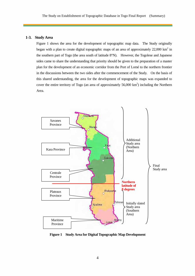
1-3. Study Area
Figure 1 shows the area for the development of topographic map data. The Study originally began with a plan to create digital topographic maps of an area of approximately 22,000 km2 in the southern part of Togo (the area south of latitude 8°N). However, the Togolese and Japanese sides came to share the understanding that priority should be given to the preparation of a master plan for the development of an economic corridor from the Port of Lomé to the northern frontier in the discussions between the two sides after the commencement of the Study. On the basis of this shared understanding, the area for the development of topographic maps was expanded to cover the entire territory of Togo (an area of approximately 56,000 km2) including the Northern Area.
Figure 1 Study Area for Digital Topographic Map Development
FinalStudy area
Northern latitude of 8 degrees
AdditionalStudy area (Northern Area)
Savanes Province
Kara Province
Centrale Province
Plateaux Province
Maritime Province
Initially slated Study area (Southern Area)

The Study on Establishment of Topographic Database in Togo Final Report (Summary)
5
1-4. Details and Workload of Study
The following table shows details and workload of this Study.
Table 2 Details and Workload of Study Work Workload Work category
Control point survey South 2 points Control point origin Work in Togo
Technology transfer (OJT)
32points Control points
North 3 points Control point origin29 points Control points
Leveling (New simple leveling)
South 20 points at control points Work in TogoTechnology transfer (OJT)North 11 points at control points
Satellite image acquisition
South
148 images(37× front, orthotropic, back
views, AVNIR)ALOS images
Work in Japan
13 Scenes SPOT images
Approx. 1,280 km2 WorldView-2 satellite images
North
248 images(62 × front, orthotropic, back,
AVNIR)ALOS images
5 Scenes SPOT images
Aerial triangulation North 294 Scenes ALOS satellite images Work in Japan Technology transfer South
Field identification South 37 Sheets
(Approx. 22,000km2) Existing data collection/organization Interview survey Field reconnaissance
Work in Togo Technology transfer (OJT) North 61 Sheets
(Approx. 34,000km2)
Digital plotting South 37 Sheets
(Approx. 22,000km2)Data acquisition from ALOS, SPOT, WorldView-2 and the results of field identification
Work in Japan Technology transfer
North 61 Sheets(Approx. 34,000km2)
Digital compilation South 37 Sheets
(Approx. 22,000km2)Proofreading, inspection for logical errors and correction of logical errors in the plotted data
Work in Japan Technology transfer
North 61 Sheets(Approx. 34,000km2)
Field completion South 37 Sheets
(Approx. 22,000km2) Field identification of ambiguities identified in the plotting
Work in Togo Technology transfer (OJT) North 61 Sheets
(Approx. 34,000km2)
Digital compilation after field completion
South 37 Sheets(Approx. 22,000km2)
Compilation of plotted data into which the results of field completion have been imported
Work in Japan Technology transfer
North 61 Sheets(Approx. 34,000km2)
Map symbolization South 37 Sheets
(Approx. 22,000km2)Symbolization of data created in the digital compilation after field completion
Work in Japan Technology transfer North 61 Sheets
(Approx. 34,000km2)
Digital data structurization
South 37 Sheets(Approx. 22,000km2)
Structurization of data created in the digital compilation after field completion
Work in Japan Technology transfer North 61 Sheets
(Approx. 34,000km2)
The Study on Establishment of Topographic Database in Togo Final Report (Summary)
6
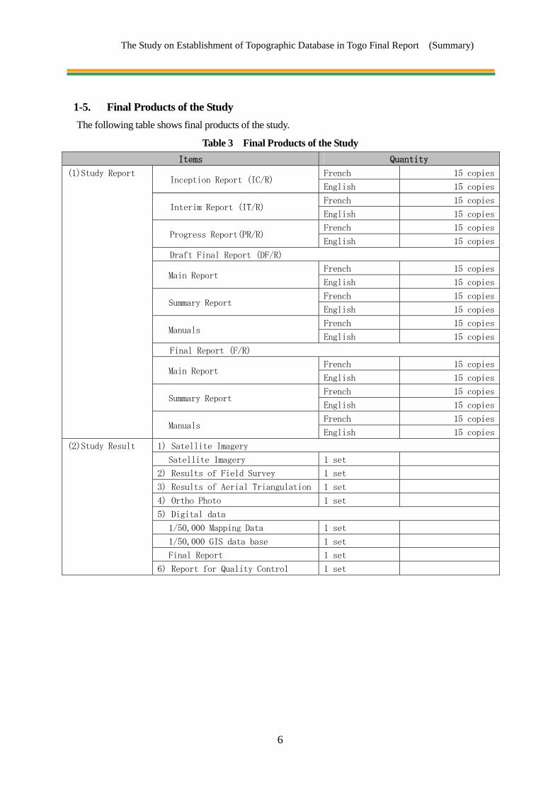
1-5. Final Products of the Study The following table shows final products of the study.
Table 3 Final Products of the Study Items Quantity
(1) Study Report Inception Report(IC/R)
French 15 copies
English 15 copies
Interim Report(IT/R)
French 15 copies
English 15 copies
Progress Report(PR/R)
French 15 copies
English 15 copies
Draft Final Report(DF/R)
Main Report
French 15 copies
English 15 copies
Summary Report
French 15 copies
English 15 copies
Manuals
French 15 copies
English 15 copies
Final Report(F/R)
Main Report
French 15 copies
English 15 copies
Summary Report
French 15 copies
English 15 copies
Manuals
French 15 copies
English 15 copies
(2) Study Result 1) Satellite Imagery
Satellite Imagery 1 set
2) Results of Field Survey 1 set
3) Results of Aerial Triangulation 1 set
4) Ortho Photo 1 set
5) Digital data
1/50,000 Mapping Data 1 set
1/50,000 GIS data base 1 set
Final Report 1 set
6) Report for Quality Control 1 set

The Study on Establishment of Topographic Database in Togo Final Report (Summary)
7
1-6. Workflow The table below shows an outline of the workflow in this Study.
Year Month Work in Japan Work in Togo
2011
Apr.
May
Jun.
Jul.
Aug.
Sep.
Oct.
Nov.
Dec.
2012
Jan.
Feb.
Mar.
Apr.
May
Jun.
Jul.
Aug.
Sep.
Oct.
Nov.
Dec.
2013
Jan.
Feb.
Mar.
Apr.
May
Jun.
Jul.
Aug.
Sep.
Figure 2 Workflow of the Study
Collection, sorting and analysis of reference materials/information, preparation of IC/R Discussion of IC/R, specifications and technology
transfer
Acquisition of satellite images
Field identification (Southern Area)
Control point survey, leveling (Southern Area)
Control point survey, leveling (Northern Area)
Aerial triangulation
Preparation of IT/R
Field identification (Northern Area)
Map symbolization Data structurization
Preparation of DF/R
Digital plotting
Field completion (Southern Area)
Discussion of IT/R
Creation of data files
Discussion of DF/R, dissemination of geospatial information, seminar Preparation of Final Report
Digital compilation
Digital compilation after field
completion
Preparation of PR/R
Technology transfer (Aerial triangulation/digital plotting)
(Digital compilation/data structurization)
Field Completion (Northern Area)
Quality control Technology transfer (Aerial triangulation/digital plotting)
(map symbolization/data structurization)
Discussion of PR/R
The Study on Establishment of Topographic Database in Togo Final Report (Summary)
8
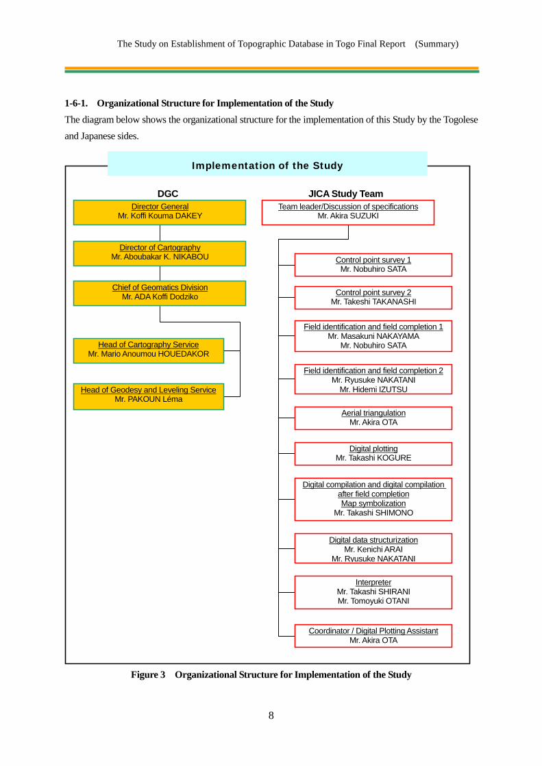
1-6-1. Organizational Structure for Implementation of the Study The diagram below shows the organizational structure for the implementation of this Study by the Togolese and Japanese sides.
Figure 3 Organizational Structure for Implementation of the Study
Implementation of the Study
Team leader/Discussion of specifications Mr. Akira SUZUKI
Control point survey 1 Mr. Nobuhiro SATA
Control point survey 2 Mr. Takeshi TAKANASHI
Field identification and field completion 1 Mr. Masakuni NAKAYAMA
Mr. Nobuhiro SATA
Field identification and field completion 2 Mr. Ryusuke NAKATANI
Mr. Hidemi IZUTSU
Digital data structurization Mr. Kenichi ARAI
Mr. Ryusuke NAKATANI
Director General Mr. Koffi Kouma DAKEY
Head of Cartography Service Mr. Mario Anoumou HOUEDAKOR
Head of Geodesy and Leveling Service Mr. PAKOUN Léma
JICA Study Team DGC
Digital compilation and digital compilation after field completion Map symbolization
Mr. Takashi SHIMONO
Digital plotting Mr. Takashi KOGURE
Aerial triangulation Mr. Akira OTA
Coordinator / Digital Plotting Assistant Mr. Akira OTA
Interpreter Mr. Takashi SHIRANI Mr. Tomoyuki OTANI
Chief of Geomatics Division Mr. ADA Koffi Dodziko
Director of Cartography Mr. Aboubakar K. NIKABOU

The Study on Establishment of Topographic Database in Togo Final Report (Summary)
9
Chapter 2 Outputs of the Study, Impact of the Outputs and Recommendations
Import of data accumulated independently by government ministries and offices, local governments, international aid organizations and private companies involved in Togo into the topographic map data to be developed in this Study is expected to generate use of such data in a wide variety of areas. In addition, the control points established for the development of topographic maps in this Study can be used as the control points for positional coordinates in a wide variety of areas, including cadastral surveys, as they are provided with highly accurate positional coordinates. Following recommendations were summarized about the dissemination of utilization in this chapter. ・ Introduction of case examples and users for mapping data
・ Organizational, Personnel, Finance of Togo Government or DGC for distribution and update of
mapping data
・ Problems Related to Utilization of the Outputs
2-1. Cases of Utilization of the Topographic Map Data
As the scale of the data developed in this Study is 1/50,000, map utilization can be expected in planning and implementation of projects to be implemented in the whole of Togo such as those for development of roads, public facilities and wide-area infrastructure. For example, the outputs of this Study were used in “the Project for the Study on Togo Logistics Corridor Development” at the stages of the preparation of a plan to facilitate the use of the corridor in Togo between the Port of Lomé and the border with Burkina Faso and the outline design of roads and bridges in the process of the preparation of plans for the priority construction projects in the above-mentioned plan which could pass the loan screening of development partners. Such use of the outputs have enabled improvement in the efficiency of field works and detailing of the information of the study results in the Project.

The Study on Establishment of Topographic Database in Togo Final Report (Summary)
10
2-1-1. Concept of Data Utilization
Figure 4 Conceptual Diagram of Data Utilization
Table 4 Cases of Utilization Field Contents
Urban planning Equitable development of the national land and promotion of public welfare may be realized by utilization of the topographic map data as basic maps in projects for development of city areas, port districts and land transport.
Development and maintenance of infrastructure
Quick delivery of services to citizens may be realized by utilization of the topographic mapdata as background maps for data on maintenance of urban facilities above and below the ground (e.g. power transmission lines) and as basic maps in urban infrastructure development projects.
Water resource management
Improvement in services to citizens concerning water resources, an important lifeline, may be realized by utilization of the topographic map data as basic maps for maintenance of water towers, water sources and water-supply and sewage aqueducts and wells.
Measures against natural disasters
Utilization of the topographic map data will enable development of a disaster prevention plan against flooding caused by rainfall, which has become frequent in recent years, taking into consideration the scale of flooding, priority in protection of structures, urgency of projects and impact of projects.
Agricultural development
Utilization of the topographic map data as basic maps for a master plan for the development of farmland will lead to an increase in agricultural potential through development of the domestic road network and improvement in the competitiveness of Togo’s agricultural products on international and domestic markets.
Tourism
Services to domestic and foreign tourists may be improved by utilization of the topographic map data as basic maps for registration, maintenance and search of tourism resources. The data may also be utilized in the preparation and implementation of a national tourism plan.
Education The topographic map data may be used as teaching materials on interpretation of maps and topography and GIS in school education.
DGC
Water resource management
Urban Planning
Measures against natural disasters
Tourism/ Education
Agricultural development
Infrastructure development /maintenance
Selection/ analysis of information
Original Control Points Large Scale Mapping
Government ministries, Agencies, local governments of Togo International aid organizations
Various types of information
Elevation Data
Vegetation Data
Water bodies and water facilities
Public facilities
Residential areas and buildings
Roads and railways

The Study on Establishment of Topographic Database in Togo Final Report (Summary)
11
2-1-2. Potential User Organizations The team conducted individual interviews with organizations which owned data that could be utilized as reference materials in the development of topographic maps. In addition, the team invited staff members from those organizations to participate in the technology transfer and exchanged views on the subject with them.
Table 5 Contents of the Work Implemented on Extension of Data Utilization
Work Time Participating organizations Contents
Inception Report Seminar May 2011 11 organizations (See Appendix about participant)
Explanation of the Project Questions and answers Questionnaire
Interim Report Seminar February 2012
12 organizations (See Appendix about participant)
Explanation of the Project Questions and answers Demonstration of GIS Questionnaire
Collection of reference materials during field identification/field
completion
March 2012 Ministry of Home Affairs Request for provision of
reference materials
Collection of reference materials during field identification/field
completion
December 2012
Benin Electricity Community Directorate of Water Source Planning and Maintenance
Request for provision of reference materials
Transfer of laboratory technologies May 2013
General Directorate of Public Works, Ministry of Public Works
Provision of sample data for partial correction
Ministry of Primary and Secondary Education and Literacy
Proposal of simple GIS model
Table 6 Organizations/Institutions Expected to be Potential Future Users of the Data Developed in the Study
Organization/ institution
Potential Expected area of utilization Highly feasible case
of the utilization
General Directorate of Public Works
Ministry of Public Works
The directorate maintains road data on planned national highways in analog format. It provided data for the technology transfer in the Study.
Urban planning
Use in planning development of new administrative and business districts and new roads
Update of the topographic maps with sharing of development plans prepared on the background of the outputs of this Study and the outcome of the development with DGC
Ministry of Home Affairs The ministry provided data for the Study.
Urban planning
Sharing information with other institutions and use of the information kept by the ministry in urban planning
Information sharing with other institutions by adding more details to positional information of administrative vector data

The Study on Establishment of Topographic Database in Togo Final Report (Summary)
12
General Directorate of Statistics
The directorate provided data for the Study.
Urban planning
Sharing information with other institutions and use of the information kept by the general directorate in urban planning
Information sharing with other institutions with addition of more detailed positional information to statistic data
Directorate for Water Source Planning and
Maintenance Ministry of Water,
Sanitation and Rural Water Supply
While the directorate has digitized data on water sources, it has not encoded them. It provided data for the technology transfer in the Study.
Development and maintenance of infrastructure
Improvement in the efficiency of the maintenance system and the services in the entire country
Maintenance of facilities including reservoirs and water sources using the outputs of the Study as background information and update of topographic maps with sharing of information on development plans and their outcomes with DGC
Togolese Water Supply Company
The company owns ArcGIS and uses Shape and Geodatabase for data management.
Development and maintenance of infrastructure
Improvement in the efficiency of the maintenance system and the services in the entire country
Maintenance of facilities including aqueducts using the outputs of the Study as background information and update of topographic maps with sharing of information on development plans and their outcomes with DGC
Benin Electricity Community
Ministry of Mines and Energy
The community owns ArcGIS and uses Shape for data management. It is conducting a field survey on the location of domestic power transmission lines.
Development and maintenance of infrastructure
Improvement in the efficiency of the maintenance system and the services in the entire country
Maintenance of facilities including power transmission lines using the outputs of the Study as background information and update of topographic maps with sharing of information on development plans and their outcomes with DGC
Ministry of Environment and Forest Resources
The ministry maintains data on quarries, sand pits and mines in analog format.
Measures against natural disasters
Improvement in the efficiency of the maintenance system and the services in the entire country
Directorate for Rural Development
Ministry of Agriculture, Animal Breeding and
Fisheries
The directorate maintains data on occupation of farmland, water channels and irrigation reservoirs in analog format
Agricultural development
The data use is expected in the agriculture sector and disaster management
Ministry of Tourism The ministry creates tourist maps independently. Tourism
Improvement in the efficiency of the maintenance system and the services in the entire country
Head Office of University Section, Ministry of Higher
These organizations have submitted a proposal for a GIS model. There are no classes using GIS.
Education Improvement in the efficiency of the maintenance system
Improvement in the efficiency in school facility maintenance

The Study on Establishment of Topographic Database in Togo Final Report (Summary)
13
Education and Research Ministry of Primary and
Secondary Education and Literacy
and the services in the entire country
and incorporation in the study of maps and topography and practical lessons on GIS
2-2. Organizational Structure for Utilization of the Outputs and Development of Data
DGC will be the organization to manage utilization of the outputs of this Study and maintenance and updating of the data. It is important for DGC to cooperate with various government ministries and offices, the private sector and foreign aid organizations in Togo in utilization of the outputs. A view of the organizational structure required for DGC to continue to maintain and distribute the outputs of the Study is described in the following.
2-2-1. Organizational Structure and Finances of DGC
The organization of the counterpart of this Study, DGC, is following. This organization has 23 members under the Director General.
Figure 5 Organizational Structure and Personnel of the General Directorate of Cartography
DGC budget for 2013 is following. A budget for establishing reference points and updating new maps is not enough. In order to make a good use of mapping data and GIS data of the study (such as data updating, data sharing, and practical data application), a system that enables continuous update of mapping data needs to be arranged. The evolution of the budget is as follows.
2013 Total amount : 57.214.600CFA, Personnel expenses: 33.214.600CFA, Operational costs :
24.000.000CFA
2012 Total amount : 48.764.600CFA, Personnel expenses: 33.214.600CFA, Operational costs :
Director General of Cartography
Director of Cartography
Division Geomatics Division Topographic Division Adoministrative Finance

The Study on Establishment of Topographic Database in Togo Final Report (Summary)
14
15.550.000CFA
2011 Total amount : 45.004.600CFA, Personnel expenses: 33.214.600CFA, Operational costs :
11.800.000CFA
Therefore, as follows, a fund for depreciation expense and updating cost for the future need to be taken into account for a selling price of the mapping data in the study. In that way, a selling price of an old map and nearby countries can be used as references.
Figure 6 Idea of finance about budjet and utilization of the General Directorate of Cartography
Table 7 Selling Prices of Topographic Maps in Countries in the Region
Country Scale Price (CFA franc) Remarks
Togo
1/15,000 5,000
1/50,000 Not on sale IGN of France sells raster format maps at 60 euros per map.
1/200,000 5,000 1/500,000 5,000
Senegal 1/1,000 2,500
1/50,000 4,0001/200,000 5,000
Map Sales charges/Year
Annual budget (2013):57,214,600 CFA
Labor Cost:33,214,600 CFA Operating Cost:24,000,000 CFA
(Supplies, Adm., Project, etc)
Utilization-adjusted Annual budget
Updating Cost/Year, CGP Installation Cost/Year
Labor Cost Operating Cost
(Supplies, Admn., Fuel, etc)
Labor Cost Operating Cost
(Supplies, Adm.,
Amortization, etc)
Gain
In
sales

The Study on Establishment of Topographic Database in Togo Final Report (Summary)
15
1/1,000,000 3,000
Burkina Faso
1/50,000 2,0001/200,000 2,0001/500,000 2,000
1/1,000,000 5,000
Mali 1/50,000 5,0001/200,000 5,000
2-2-2. Problems Related to Utilization of the Outputs The mapping data and the GIS data produced in this project include a whole domain of Togo so that they are essential for basic social service (such as education, medical insurance, and water supply) and development project for disaster counter measurement that a country of Togo holds. Following actions are necessary to make a good use of these data
Figure 7 Strategies for Utilzation
2-2-3. Recommendations on Projects and Organizational Structure of DGC in Future Large-scale (1/2,500 and 1/5,000) topographic maps will be required for the preparation of plans to
alleviate the problems found in cities including the capital, Lomé, in future. Creation of such maps will
require development of a geodetic control point network using the five control point origins established in
this Study as reference points. Facilitation of these projects will require development of the capacity to
solve the physical and technical problems mentioned below. It will also require solid independent status
of DGC, as well as an increase in the importance of DGC, in the Government of Togo.
DGC is reportedly considering strengthening its organizational structure. If it materializes, the feasibility
of the expansion of the scale of the organization is expected to increase and the problems in human resource
and financial problems are expected to be alleviated. When these problems have been alleviated, an issue
of training and education of staff members will remain. Solution of this issue will require implementation
of technical cooperation projects by international aid agencies including the EU, Japan and the World Bank
or the establishment of an educational institution for the entire region of West Africa.
Increase a number of user
Dissemination of Digital Data
Improve social services
Workshop seminars practical useMaintenance of
digital data
Prevention of illegal copies
Strengthen selling counters
Propulsion of GIS projects

The Study on Establishment of Topographic Database in Togo Final Report (Summary)
16
Table 8 Problems in DGC
Area
Work and problems
Control point network
development
Update of topographic
maps
Creation of large-scale
topographic maps
Digital data management
Miscellaneous
Phys
ical
Budget
Shortage of budget for procurement of equipment, the costs associated with vehicles and the personnel cost
Shortage of budget for procurement of new imagery, costs associated with vehicles and personnel cost
Shortage of budget for the development of systems for maintenance and distribution of data
Organization and personnel
Shortage of human resource for the establishment and maintenance of control points and benchmarks
Shortage of human resource for the maintenance and update of the 1/50,000-scale topographic maps
Shortage of human resource for the creation of the large-scale topographic maps
Shortage of human resource for provision and promotion of the utilization of the topographic map data, GIS data, etc.
Shortage of human resource for overall planning and budgeting of DGC
Tech
nica
l
Technology and knowledge
Lack of technical capacity of newly-employed personnel
Lack of technical capacity to create large-scale topographic maps
Lack of knowledge concerning sales of digital data
2-3. Technology Transfer
2-3-1. Purposes of the Technology Transfer Technology transfer to DGC in the series of work associated with the development of topographic maps was implemented even after the completion of the Study in order to ensure that DGC is capable of updating, maintaining and operating the data independently. The Study Team established the objectives of the technology transfer mentioned in the table below before its commencement and selected the contents of the technology transfer in accordance with the experience, capacity and needs of the DGC engineers. Most of the DGC engineers had no experience in the works concerned and were at an elementary level regarding basic works and manipulation of the equipment used. The Study Team implemented the technology transfer with the goal of equipping the counterparts with the experience and capacity mentioned above to implement the work required for data update independently in future in a limited time. The team evaluated the achievements of the technology transfer and defined a strategy for measures for the acquisition of knowledge and technology required after the completion of the Project. The details of the technology transfer in each subject are described in Chapter 4 below.

The Study on Establishment of Topographic Database in Togo Final Report (Summary)
17
Table 9 Participants in the Technology Transfer
Name
Control point
survey
Field identification/
Field completion
Aerial triangulation
Digital plotting
Digital compilation/
SymbolizationStructurization
Remarks
1 PAKOUN Léma 2 2 2 2
Team 1 2 SODAGNI Yawo 2 2 2 2 3 GUEGUE Diwèfé-Esso 1 1 1 1 4 AGBOFOATI Kudzo 1 1 1 1 5 KPODZRO Kwami Valentin 2 2 2 2 6 BOURAIMA Soumaila 2 Directorate of
Real Estate 7 Georges Laté LAWSON-BETUM
2
8 HOUEDAKOR Anoumou Mario
2 2 2 2
Team2 9 ESTEVE Moudjibou 2 2 10 ADJATI Amèvi Agossi 1 1 1 1 11 ADJOH Mawussi 1 1 1 2 12 BESSEH Koffitsè 2 2
13 FAGBEDJI John 2
Ministry of Urban Planning and Housing
Table 10 Objectives Established for the Technology Transfer Item Work Objective
Control point survey
Field reconnaissance for selection of control points
Comprehension of the basic concept of GPS (Comprehension of point allocation for aerial triangulation, interpretation of images and positional correlation)
GPS survey Acquisition of methods to manipulate equipment, prompt and accurate equipment settingPreparation of points control point details register
GPS analysis
Data download from equipmentBasic manipulation of softwareVerification and interpretation of the observation resultsBasic baseline analysisAdvanced baseline analysisComprehension of the parameters and analysis resultsBasic network adjustmentAdvanced network adjustmentComprehension of the parameters and analysis results
Leveling
Prompt and accurate equipment setting, acquisition of methods to manipulate equipmentData download from equipmentVerification and interpretation of the observation results
Control point maintenance procedure
Creation of awareness of control points/dissemination of information on control points to area residents
Aerial triangulation
Aerial triangulation by satellite images
Basic manipulation of digital photogrammetry system (creation of projects, import of various types of data)Basic processing of satellite imagesBasic manipulation of the software for aerial triangulation

The Study on Establishment of Topographic Database in Togo Final Report (Summary)
18
Item Work ObjectiveVerification, interpretation and evaluation of the results of aerial triangulation Advanced manipulation of the software for aerial triangulationComprehension of the parameters and the results of aerial triangulation
Field identification/ Field completion
Preliminary work Comprehension of the work, sorting of existing materials, interpretation of images
Field identification Manipulation of handy GPS unitPrompt identification of features in the field
Filing of survey results Systematic representation of the results of identification on printed imagesEntry of the results of identification as data
Digital plotting Digital plotting by use of satellite images
Basic manipulation of the digital photogrammetry system (for plotting)Basic manipulation of CAD softwareAdvanced manipulation of CAD software (including detailed condition setting)Comprehension of map symbolsComprehension of data acquisition methods for different scalesComprehension of plotting planimetric features and plotting contour linesDifferent data interpretation methods for different types of satellite imagesPreparation of a work manual
Digital compilation/ Digital compilation after field completion
Digital compilation Digital compilation after field completion
Basic manipulation of CAD softwareComprehension and implementation of data cleaning Comprehension and implementation of the creation of polygon dataEdge matching with existing topographic map dataPreparation of a work manual
Map symbolization
Allotment of symbols to topographic map data
Comprehension of map adjustmentComprehension of different symbolization methods for different map scales Basic manipulation of the software for symbolizationAdvanced manipulation of the software for symbolization (including detailed condition setting)
Digital data structurization
Digital data structurization GIS basic data creation
Comprehension of GIS (comprehension of the standard data structure)Basic manipulation of GIS softwareAdvanced manipulation of GIS softwareRecommendations on utilization of GIS data
Promotion of utilization
Monitoring of need for topographic maps
Collection and sorting of reference materialsCollection of information from organizations concerned
Quality Control
Quality control by work process Preparation of quality control table
Comprehension of quality controlPreparation of quality control table
Implementation of quality control
2-3-2. Technology Transfer in Quality Control DGC had neither engineers with experience in the work required for the development of 1/50,000-scale topographic map data nor engineers with experience in quality control of such data. Therefore, the Study Team implemented the technology transfer aimed at enabling the staff members of DGC to prepare a quality control table in accordance with the Survey International Specifications at each stage of the work and to conduct inspections and verification and correction of errors in quality control. Details of the technology transfer in quality control are mentioned in Chapter 4 below.

The Study on Establishment of Topographic Database in Togo Final Report (Summary)
19
Table 11 Contents of the Technology Transfer in Quality Control Item Activities in quality control
Control point survey
GPS observation
Inspection of required equipment Verification of the observation results Evaluation of the results of baseline analysis Evaluation of the results of network adjustment Preparation of quality control table
Leveling Inspection of required equipment Verification of the observation results Preparation of quality control table
Aerial triangulation
Evaluation of the results of relative orientation Re-observation of tie points Evaluation of the results of adjustment calculation Re-observation of the control points and tie points Preparation of quality control table
Field identification/Field completion Inspection of preliminary survey maps Inspection of the outputs of field identification
Digital plotting Inspection of planimetric features Inspection of contour lines Preparation of quality control table
Digital compilation/Digital compilation after field completion
Edge-matching between maps Inspection and correction of logical errors in the data Topology check Preparation of quality control table
Map symbolization Inspection of the status of data conversion Inspection of output maps Preparation of quality control table
Digital data structurization Inspection of the status of data conversion Inspection of attributes of the created data
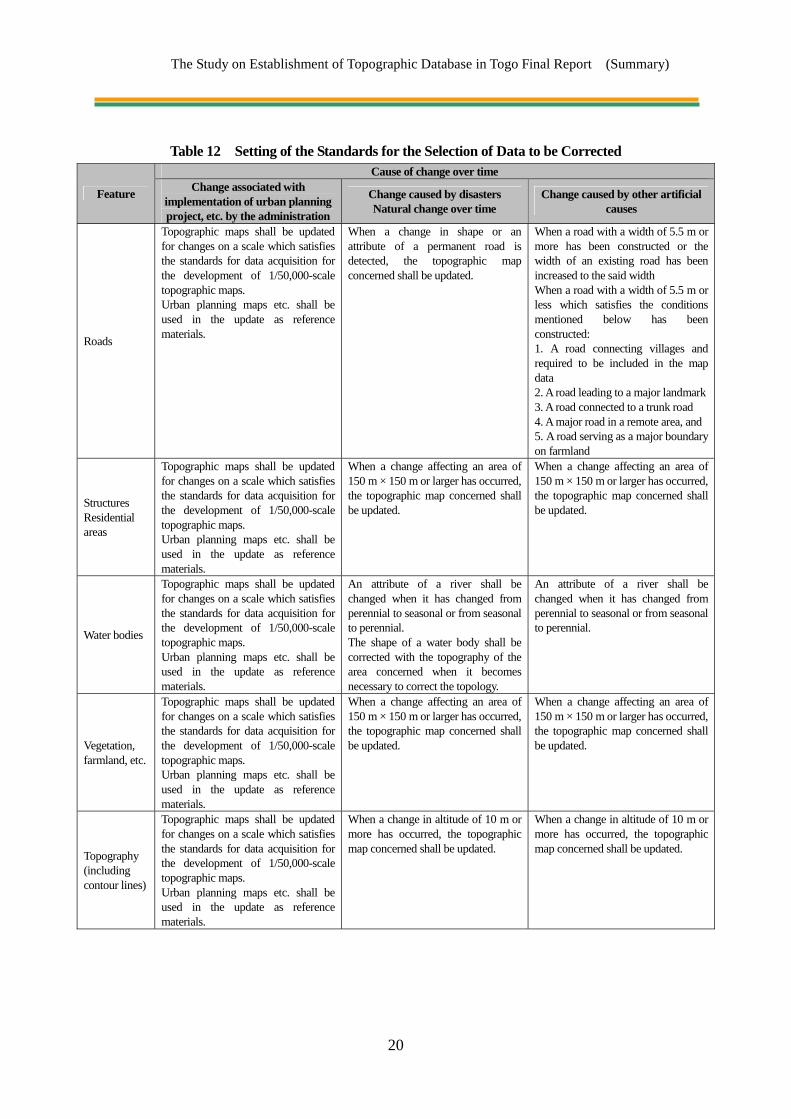
2-3-3. Technology Transfer in Partial Correction The Study Team provided the counterparts with technology transfer in partial correction of the data on locations where correction was required at the stages of “digital plotting,” “digital compilation,” “symbolization” and “structurization,” so that DGC would be able to update the topographic map data to be developed in this Project. In this part of the technology transfer, a data source likely to be used by DGC in the update of topographic maps in future was selected for the exercise. WorldView-2 satellite images taken in May 2012 and data on planned bridges and roads in a General Directorate of Public Works, Ministry of Public Works project were used as reference materials. The reference data and newly plotted topographic maps were comparatively analyzed and, if a change was identified, the cause/causes and extent of the change were identified. Whether or not to correct the data was determined in accordance with the criteria for correction and, when correction was deemed necessary, the work required for data correction was implemented.
The Study on Establishment of Topographic Database in Togo Final Report (Summary)
20
Table 12 Setting of the Standards for the Selection of Data to be Corrected
Feature
Cause of change over time Change associated with
implementation of urban planning project, etc. by the administration
Change caused by disasters Natural change over time
Change caused by other artificial causes
Roads
Topographic maps shall be updated for changes on a scale which satisfies the standards for data acquisition for the development of 1/50,000-scale topographic maps. Urban planning maps etc. shall be used in the update as reference materials.
When a change in shape or an attribute of a permanent road is detected, the topographic map concerned shall be updated.
When a road with a width of 5.5 m or more has been constructed or the width of an existing road has been increased to the said width When a road with a width of 5.5 m or less which satisfies the conditions mentioned below has been constructed: 1. A road connecting villages and required to be included in the map data 2. A road leading to a major landmark3. A road connected to a trunk road 4. A major road in a remote area, and 5. A road serving as a major boundary on farmland
Structures Residential areas
Topographic maps shall be updated for changes on a scale which satisfies the standards for data acquisition for the development of 1/50,000-scale topographic maps. Urban planning maps etc. shall be used in the update as reference materials.
When a change affecting an area of 150 m × 150 m or larger has occurred, the topographic map concerned shall be updated.
When a change affecting an area of 150 m × 150 m or larger has occurred, the topographic map concerned shall be updated.
Water bodies
Topographic maps shall be updated for changes on a scale which satisfies the standards for data acquisition for the development of 1/50,000-scale topographic maps. Urban planning maps etc. shall be used in the update as reference materials.
An attribute of a river shall be changed when it has changed from perennial to seasonal or from seasonal to perennial. The shape of a water body shall be corrected with the topography of the area concerned when it becomes necessary to correct the topology.
An attribute of a river shall be changed when it has changed from perennial to seasonal or from seasonal to perennial.
Vegetation, farmland, etc.
Topographic maps shall be updated for changes on a scale which satisfies the standards for data acquisition for the development of 1/50,000-scale topographic maps. Urban planning maps etc. shall be used in the update as reference materials.
When a change affecting an area of 150 m × 150 m or larger has occurred, the topographic map concerned shall be updated.
When a change affecting an area of 150 m × 150 m or larger has occurred, the topographic map concerned shall be updated.
Topography (including contour lines)
Topographic maps shall be updated for changes on a scale which satisfies the standards for data acquisition for the development of 1/50,000-scale topographic maps. Urban planning maps etc. shall be used in the update as reference materials.
When a change in altitude of 10 m or more has occurred, the topographic map concerned shall be updated.
When a change in altitude of 10 m or more has occurred, the topographic map concerned shall be updated.
The Study on Establishment of Topographic Database in Togo Final Report (Summary)
21
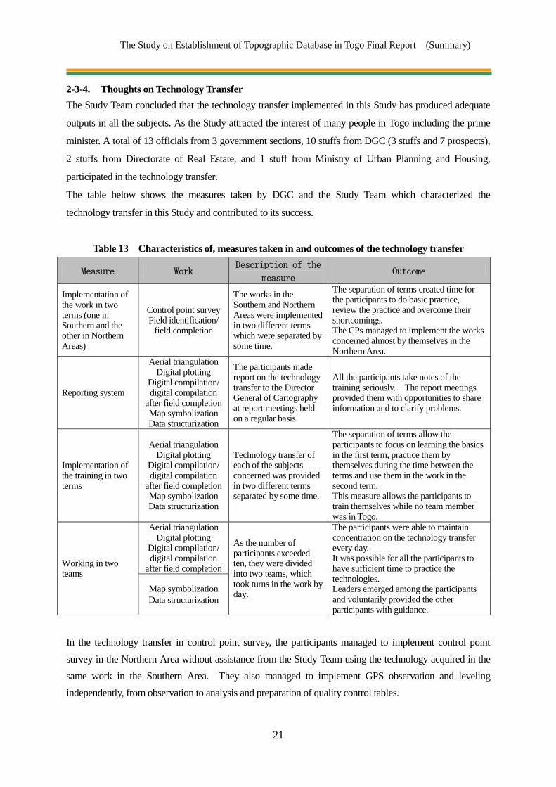
2-3-4. Thoughts on Technology Transfer The Study Team concluded that the technology transfer implemented in this Study has produced adequate
outputs in all the subjects. As the Study attracted the interest of many people in Togo including the prime
minister. A total of 13 officials from 3 government sections, 10 stuffs from DGC (3 stuffs and 7 prospects),
2 stuffs from Directorate of Real Estate, and 1 stuff from Ministry of Urban Planning and Housing,
participated in the technology transfer.
The table below shows the measures taken by DGC and the Study Team which characterized the
technology transfer in this Study and contributed to its success.
Table 13 Characteristics of, measures taken in and outcomes of the technology transfer
Measure Work Description of the
measure Outcome
Implementation of the work in two terms (one in Southern and the other in Northern Areas)
Control point survey Field identification/
field completion
The works in the Southern and Northern Areas were implemented in two different terms which were separated by some time.
The separation of terms created time for the participants to do basic practice, review the practice and overcome their shortcomings. The CPs managed to implement the works concerned almost by themselves in the Northern Area.
Reporting system
Aerial triangulation Digital plotting
Digital compilation/ digital compilation
after field completion Map symbolization Data structurization
The participants made report on the technology transfer to the Director General of Cartography at report meetings held on a regular basis.
All the participants take notes of the training seriously. The report meetings provided them with opportunities to share information and to clarify problems.
Implementation of the training in two terms
Aerial triangulation Digital plotting
Digital compilation/ digital compilation
after field completion Map symbolization Data structurization
Technology transfer of each of the subjects concerned was provided in two different terms separated by some time.
The separation of terms allow the participants to focus on learning the basics in the first term, practice them by themselves during the time between the terms and use them in the work in the second term. This measure allows the participants to train themselves while no team member was in Togo.
Working in two teams
Aerial triangulation Digital plotting
Digital compilation/ digital compilation
after field completion
As the number of participants exceeded ten, they were divided into two teams, which took turns in the work by day.
The participants were able to maintain concentration on the technology transfer every day. It was possible for all the participants to have sufficient time to practice the technologies. Leaders emerged among the participants and voluntarily provided the other participants with guidance.
Map symbolization Data structurization
In the technology transfer in control point survey, the participants managed to implement control point survey in the Northern Area without assistance from the Study Team using the technology acquired in the same work in the Southern Area. They also managed to implement GPS observation and leveling independently, from observation to analysis and preparation of quality control tables.

The Study on Establishment of Topographic Database in Togo Final Report (Summary)
22
Although the study area in the Northern Area was huge, in particular, the counterparts prepared a plan for field identification and field completion in order to acquire data on all the survey items within the limited time by themselves and managed to complete the works within the given time periods. Since the DGC staff members managed to implement and complete the work at all stages in the transfer of laboratory technologies, from aerial triangulation to digital data structurization, and control the quality of the work for the area of the map independently, the team concluded that they understood the concept and basic procedures at each stage of the work. As they managed to create sample GIS models showing the photographs taken during field identification and representing three-dimensional topography in the technology transfer in digital data structurization, the team concluded that they have acquired the capacity required for creating new models in future. The Study Team expects DGC to take the lead in utilization of the knowledge and technology obtained in the technology transfer in the Study to continue partial correction of the outputs of the Study with satellite images and input from various government ministries and offices. The team also expects them to carry out awareness creation activities to increase the number of donors of data to the GIS data and users of the GIS data in other government ministries and offices.

The Study on Establishment of Topographic Database in Togo Final Report (Summary)
23
Chapter 3 Details of Work
3-1. Collection, Organization and Analysis of Related Materials/Information [Work in Japan]
The materials collected by the Preliminary Study Team, the information independently studied and acquired by the Study Team and the related information available in Japan were analyzed and arranged. The specifications (draft) of the map specifications and outputs were created with reference to the Survey International Specifications of JICA, the Collection of Map specifications/ Specifications issued by the Geospatial Information Authority, Ministry of Land, Infrastructure, Transport and Tourism, and experience and knowledge in similar projects that have been implemented by PASCO so far.
3-2. Preparation of Inception Report [Work in Japan] Based on analysis and examination of the Terms of Reference (TOR), the Report on the Study of Detailed Plan Formulation in Togo (draft) and the collected materials, the Inception Report was prepared for implementation of this Study and the results of preliminary explanation to and discussions with JICA were also reflected to finalize the Inception Report. English, French and Japanese versions of the report were prepared.
3-3. Explanation and Discussion of Inception Report [Work in Togo] The details of the Inception Report were explained to the DGC, and the items and policies of the Study
were discussed with the DGC. The methods of the control point survey, field identification and field
completion, and the areas for implementing OJT were determined through mutual discussions.
The progress and results of the discussions were summarized in the Minutes of Meeting (MM), which were
signed by representatives of both parties. (See Appendix-1 for MM.)
On May 11th, 2011, a seminar was held under the auspices of the DGC and members of the related
ministries and agencies who are expected to be future users participated in the seminar in which the
Inception Report was explained to the members. Following organizations participated to the meeting and
implemented question-and-answer session.

The Study on Establishment of Topographic Database in Togo Final Report (Summary)
24
3-4. Discussions on Specifications [Work in Togo] The work items and work processes were explained to the counterpart agency through discussion of the
detailed specifications including the survey standards, data acquisition items in the digital plotting work,
map specifications, annotation specifications and data structures. As a result, the discussions led to mutual
agreement by both parties.
Table 14 Finalized Map Specifications Item Conclusion
Projection Method UTM(Universal Transverse Mercator)Zone 31Geographic coordinate system ITRF94
Reference ellipsoid GRS80 Standard for elevation The existing control points to be used as control points
Area for the development of topographic maps
The two parties agreed to develop maps of an area of approximately 56,000 km2 (in October 2011).
Strategy on the use of reference materials in the development of
topographic maps
Planimetric features
The two parties agreed to procure ALOS, SPOT and WorldView-2 satellite images, in this order, to obtain images covering the entire study area and to use the existing topographic maps as reference materials to obtain data on areas which had not been captured on any of satellite images.
Contour lines, etc.
The two parties agreed to use ALOS satellite images and existing topographic maps, in this order, to obtain data on the entire study area and to use existing aerial photographs to obtain data on areas which did not appear on either ALOS images or the maps. The parties agreed to use an interval of 20 m between principal contour lines.
Scope of OJT for the transfer of laboratory technologies One 1/50,000-scale topographic map
Map symbols (Data acquisition items)
See Appendix-6.
Boundaries/names of maps See Figure 8. Marginal information See Figure 9.
Annotation
Cette carte numérique a été préparée conjointement par l’Agence Japonaise de Coopération Internationale (JICA) et le Gouvernement du Togo dans le cadre du Programme de la Coopération Technique du Gouvernement Japonais. (This digital map was prepared jointly by the Japan International Cooperation Agency (JICA) and the Government of Togo under the Japanese Government Technical Cooperation Program.)
Figure 8 IC/R Briefing (Left: Briefing, Right: Reporting to the Minister of Housing)

The Study on Establishment of Topographic Database in Togo Final Report (Summary)
25
3-5. Mutual Discussions on Technology Transfer [Work in Togo] The Study Team presented proposals for OJT and technology transfer, and requested assignment of local workers to the DGC in the mutual discussions. As a result, the following items were agreed upon by both parties as shown below. Although the IC/R described two maps as the target of the scope of work in the transfer of laboratory technologies, the two parties reached a final agreement to reduce the scope to one map on the basis of the results of analysis of the technical capacity of the participants at the time of the discussions on IT/R.
Table 15 Equipment and Materials for Technology Transfer
Name of Equipment Q’tyAcceptance and validation
of equipment GPS Survey Equipment 4 April 2011 GPS Mobile Station Equipment 3 April 2011 GPS Analyzer 1 April 2011 Leveling Equipment 4 April 2011 Handy GPS (incl. rechargeable dry cell batteries) 4 April 2011 Digital Camera (incl. data recording media) 4 April 2011 Basic Software for Aerial Triangulation/ Plotting/Compilation (LPS Core) 1 July 2012 Software for Aerial Triangulation/Plotting/Compilation (LPS Stereo) 1 July 2012 Software for Aerial Triangulation (Adjustment calculation portion) (ORIMA DP-TE/GPS) 1 July 2012
Software for Aerial Triangulation (DEM creation portion) (LPS ATE) 1 July 2012 Basic Software for Plotting/Compilation (PRO600 FOR LPS/DPW) 1 July 2012 Software for Plotting/Compilation (DEM compilation portion) (LPS TE) 1 July 2012 Software for Plotting/Compilation (Bentley MicroStation) 2 July 2012 Software for Plotting/Compilation (Bentley Map) 1 July 2012 Software for GIS Structurization (ESRI ArcGIS / ArcInfo) 1 July 2012 Software for GIS Application (ESRI 3D Analyst) 1 July 2012 Software for GIS Application (ESRI Spatial Analyst) 1 July 2012 Software for GIS Application (ESRI Network Analyst) 1 July 2012 Software for Map symbolization (Adobe Illustrator) 1 July 2012 Image Processing Software (Adobe Photoshop) 1 July 2012 Workstation (for Plotter) 1 July 2012 Personal Computer (incl. peripheral equipment) 2 July 2012 Stereo Image Display Unit 1 July 2012 Mouse for Photogrammetry 1 July 2012 Hard Disk for Data Server 1 July 2012 Uninterrupted Power Supply (UPS) 4 July 2012 Scanner & Printer for Map Output (A0 size) (incl. consumables) 1 June 2013 Color Laser Printer (A3 size, incl. consumables) 1 June 2013

The Study on Establishment of Topographic Database in Togo Final Report (Summary)
26
3-6. Collection and Organization of Existing Materials [Work in Togo] In addition to the materials collected in “(1) Collection, Organization and Analysis of Materials/Information” in the Preparatory Work in Japan, additional related materials and information were collected in Togo.
3-7. Acquisition of Satellite Images [Work in Japan] Satellite images covering the entire national land of Togo (approx. 56,000 km2) were acquired and the quality of the satellite images was checked taking into consideration whether or not the following were appropriate: (1) capability of stereoscopic viewing; (2) images photographed in and after 2006; (3) quality of satellite images; (4) amount of haze and cloud; and (5) overlap and side lap. It follows that ALOS (PRISM) images were preferentially acquired, however, it was impossible to acquire ALOS satellite images due to failure of the satellite since April 22nd, 2011. Therefore, images acquired during the period of aerial photography from November 16th, 2006 to December 23rd, 2010 were to be procured. ALOS (AVNIR) images covering the area for the procurement of ALOS (PRISM) images were procured for the creation of color orthophotos. SPOT5 or WorldView-2 satellite images were to be used for areas which had not been captured on ALOS images or areas for which data could not be obtained from the ALOS images because of cloud cover. These satellite images were used in the control point survey and the field identification, and little difference was observed between the planimetric features on the ground and on the satellite images. Even if there happens to be a significant difference, it can be corrected in the field identification. Thus, these observations confirmed absence of problem in using the satellite images for mapping work. The satellite images are therefore deemed to have a quality required for developing topographic maps. The table below shows the ALOS (PRISM) images and other types of satellite images procured in the Study covering the entire country and the areas covered by the different types of satellite images.
Table 16 Procured Satellite Images
Item Specification Description
ALOS-PRISM Monochrome,
Stereo-images, GSD: 2.5m
297 scenes (99 scenes * front view + orthotropic view
+ back view)
ALOS-AVNIR Color, Single-image, GSD: 10m 99 scenes
SPOT5 Color, Single-image, GSD: 2.5m 14 scenes
WorldView-2 Color, Single-image, GSD: 0.5m Approx. 1,280 km2

The Study on Establishment of Topographic Database in Togo Final Report (Summary)
27
3-8. Control Point Survey in Southern Area [Work in Togo] The Study Team carried out the control point survey (GPS observation and leveling) in accordance with the workflow shown below. The allocation of the control points at which GPS observation was carried out and the specifications followed in the GPS observation are described in the following.
Figure 9 Workflow of Control Point Survey
Figure 10 Control Point Survey (Left: Control point origin, Right: Levelling)
Selection of and observation at control point origins
Reconnaissance/Selection of control points
GPS observation
Leveling
Control point maintenance
Two national control points (the control point origins in this Study) were established (as permanent monuments) in the Southern Area and observation was carried out at the two points.
Thirty-four control points were established and marked by simple monumenting in the Southern Area.
A total of 14 sessions of simultaneous observation by the static method with four receivers at four locations was carried out.
The elevations of 20 control points were determined by direct leveling.
Information on the control point origins and the benchmarks used in the Study was maintained.

The Study on Establishment of Topographic Database in Togo Final Report (Summary)
28
A 0 1 0 0 1 7
X(m) Y(m)302210 683454
ORDER 1ALTITUDE(m) 27.509
NIMERO DU POINTCROQUIS DE REPERAGE
LIEUNOM DU POINT
DATE DEVERIFICATION
5/6/2011ETAT
LOMEC.H.U du CampusBon
Figure 11 Existing Benchmark Control Sheet
3-9. Discussions on Expansion of Study Area [Work in Togo] The Study Team recommended to the DGC that the work area determined in “3-4 Discussions on
Specifications” in October 2011 be expanded from approx. 22,000km2 (Southern Area) to 56,000km2 (the
whole area of Togo), and the DGC agreed to it.
3-10. Field Identification in Southern Area [Work in Togo] In the Study, the field identification was conducted as follows using simplified orthophotos produced from
satellite images for field identification and existing materials, etc. in order to examine the planimetric
features, public buildings, linear objects (power lines and pipelines) and public facilities (including water
sites), road types, administrative names, annotations and other objects which were difficult to interpret from
the satellite images during mapping work. These items were also verified by collecting existing materials
as well as interviews with related agencies.

The Study on Establishment of Topographic Database in Togo Final Report (Summary)
29
Figure 12 Workflow of Field Identification in Southern Area
Figure 13 Left: Interview survey, Right: Entry of coordinates (handy GPS unit)
Planning/preparation
Preliminary survey
Field identification
Filing of the results
An overall work plan is prepared for efficient implementation of field identification and materials required for field identification are prepared.
The main objects of field identification are identified using the results of photo interpretation, existing topographic maps and existing reference materials.
Positional information on the identification objects is obtained with a handy GPS unit, photographs are taken on the ground and their locations are marked on the existing 1/50,000-scale topographic maps.
Reference materials for subsequent plotting are created by sorting the results of identification by location (coordinates) and detail (attributes and name).
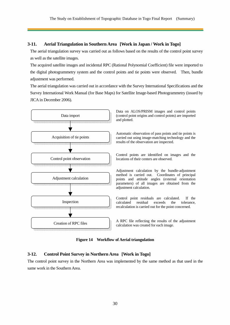
The Study on Establishment of Topographic Database in Togo Final Report (Summary)
30
3-11. Aerial Triangulation in Southern Area [Work in Japan / Work in Togo] The aerial triangulation survey was carried out as follows based on the results of the control point survey as well as the satellite images. The acquired satellite images and incidental RPC (Rational Polynomial Coefficient) file were imported to the digital photogrammetry system and the control points and tie points were observed. Then, bundle adjustment was performed. The aerial triangulation was carried out in accordance with the Survey International Specifications and the Survey International Work Manual (for Base Maps) for Satellite Image-based Photogrammetry (issued by JICA in December 2006).
Figure 14 Workflow of Aerial triangulation
3-12. Control Point Survey in Northern Area [Work in Togo] The control point survey in the Northern Area was implemented by the same method as that used in the same work in the Southern Area.
Data import
Acquisition of tie points
Control point observation
Adjustment calculation
Inspection
Creation of RPC files
Data on ALOS/PRISM images and control points (control point origins and control points) are imported and plotted.
Automatic observation of pass points and tie points is carried out using image-matching technology and the results of the observation are inspected.
Control points are identified on images and the locations of their centers are observed.
Adjustment calculation by the bundle-adjustment method is carried out. Coordinates of principal points and attitude angles (external orientation parameters) of all images are obtained from the adjustment calculation.
Control point residuals are calculated. If the calculated residual exceeds the tolerance, recalculation is carried out for the point concerned.
A RPC file reflecting the results of the adjustment calculation was created for each image.

The Study on Establishment of Topographic Database in Togo Final Report (Summary)
31
3-13. Field Identification in Northern Area [Work in Togo] The field identification in the Northern Area (an area covered by 61 1/50,000-scale topographic maps) was carried out using the same method as that used in the same work in the Southern Area.
3-14. Explanation and Discussion of Interim Report [Work in Togo] The Study Team prepared IT/R, explained the contents of IT/R to DGC, held discussions with DGC on the outputs produced so far in the Study and the schedule of the Study and compiled the details of the discussions and decisions reached in the discussions, including agreement that the transfer of laboratory technologies was to be implemented for one map, into minutes of meeting (MM) (see Appendix-2). The two sides authorized the MM with the signatures of their respective representatives. DGC sponsored a seminar, to which members of government ministries and offices who were potential users of the topographic data had been invited, on February 28th, 2012. Presentations focused on the issues mentioned below were made in the seminar. The participants of the seminar included not only members of the ministries and government offices which had sent their representatives to the IC/R seminar, but also members of the “Ministry of Water, Sanitation and Rural Water Supply,” the “Ministry of Environment and Forest Resources,” the “Ministry of Higher Education and Research” and the “Ministry of Mines and Energy.” There was a lively exchange of opinions among the participants in the seminar. Articles in newspapers and television programs on the seminar drew the attention of many people to the seminar. The participants of the seminar and a summary of the question-and-answer session which took place in the seminar are shown below. (See Appendix-5 for the results of the questionnaire survey.)
・ Expansion of the Study area (from the Southern Area to the whole of Togo) ・ Explanation of the Interim Report ・ Demonstration on examples of the use of the data to be created in this project
Figure 15 Seminar on the ITR (Left: Presentation, Right: People from a TV station and the Director General of DGC)

The Study on Establishment of Topographic Database in Togo Final Report (Summary)
32
3-15. Aerial triangulation in Northern Area [Work in Japan / Work in Togo] Aerial triangulation was carried out in accordance with the same specifications as those used in the same work in the Southern Area. In order to improve the accuracy of aerial triangulation in the whole of Togo, not only the satellite images of the Northern Area and the outputs of the control point survey of the Northern Area, but also the outputs of the survey of the Southern Area, were used in the aerial triangulation.
3-16. Digital Plotting [Work in Japan / Work in Togo] The digital plotting was conducted based on the results of the aerial triangulation. Topographic map data at a scale of 1/50,000 was created by using a digital plotter for measuring the oriented stereo models and acquiring shapes and locations of features as graphic data, in accordance with the conclusions of the discussion on the specifications. Features were classified by type of feature (feature type) provided in the specifications. In addition, efficiency of the work was improved by actively importing the data of the results of the field identifications obtained with the handy GPS units into CAD data.
Figure 16 Workflow of Digital Plotting
Data import
Digital plotting (of planimetric features)
Edge matching
Inspection
ALOS satellite images and the outputs of aerial triangulation (RPC files) are imported into the photogrammetry system and the topography is reproduced as a stereo model.
Digital plotting is carried out in the background of the ALOS stereo models and SPOT images using the results of field identification and interpretation of satellite images. Ambiguous points are filed as items to be identified in field completion.
Edge matching is established between adjacent maps.
Plotted data are inspected for consistency with the results of the field identification, work specifications and map specifications and errors are rectified.
Digital plotting (of contour lines, etc.) Data on spot heights and contour lines are acquired in the background of the ALOS stereo models, existing maps and existing aerial photographs.
Import of the results of field completion The results of field completion are incorporated in the data.
Creation of maps for field completion Maps showing the locations and details of ambiguous points found in the plotting and points on which additional information is required are prepared.
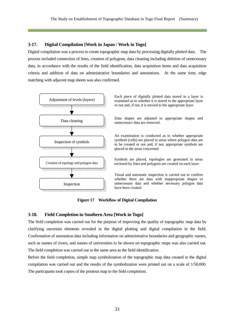
The Study on Establishment of Topographic Database in Togo Final Report (Summary)
33
3-17. Digital Compilation [Work in Japan / Work in Togo] Digital compilation was a process to create topographic map data by processing digitally plotted data. The process included connection of lines, creation of polygons, data cleaning including deletion of unnecessary data, in accordance with the results of the field identification, data acquisition items and data acquisition criteria and addition of data on administrative boundaries and annotations. At the same time, edge matching with adjacent map sheets was also confirmed.
Figure 17 Workflow of Digital Compilation
3-18. Field Completion in Southern Area [Work in Togo] The field completion was carried out for the purpose of improving the quality of topographic map data by clarifying uncertain elements revealed in the digital plotting and digital compilation in the field. Confirmation of annotation data including information on administrative boundaries and geographic names, such as names of rivers, and names of universities to be shown on topographic maps was also carried out. The field completion was carried out in the same area as the field identification. Before the field completion, simple map symbolization of the topographic map data created in the digital compilation was carried out and the results of the symbolization were printed out on a scale of 1/50,000. The participants took copies of the printout map to the field completion.
Adjustment of levels (layers)
Data cleaning
Inspection of symbols
Creation of topology and polygon data
Inspection
Each piece of digitally plotted data stored in a layer is examined as to whether it is stored in the appropriate layer or not and, if not, it is moved to the appropriate layer.
Data shapes are adjusted to appropriate shapes and unnecessary data are removed.
An examination is conducted as to whether appropriate symbols (cells) are placed in areas where polygon data are to be created or not and, if not, appropriate symbols are placed in the areas concerned.
Symbols are placed, topologies are generated in areas enclosed by lines and polygons are created on each layer.
Visual and automatic inspection is carried out to confirm whether there are data with inappropriate shapes or unnecessary data and whether necessary polygon data have been created.

The Study on Establishment of Topographic Database in Togo Final Report (Summary)
34
Figure 18 Workflow of Field Completion
3-19. Field Completion in Northern Area [Work in Togo] Field completion in the Northern Area was implemented in the same way as in the Southern Area. The technology transfer concerned was implemented in the form of OJT with guidance, supervision and work management by the members of the Study Team responsible for field completion. (See Chapter 4.)
3-20. Digital Compilation after Field Completion [Work in Japan / Work in Togo] The plotted data were inspected and corrected for edge matching, etc. after the results of field completion in the Southern and Northern Areas were imported. Then, the data was cleaned by connection of line data, creation of polygon data and deletion of unnecessary data. Finally, data on administrative boundaries and annotation data were added to the cleaned data to develop topographic map data.
Figure 19 Workflow of Digital Compilation after Field Completion
Preparation
CAD data correction 1
Inspection/correction
Required data are selected and the coordinate system for data import is standardized with use of the results of field completion and new reference materials.
Required data mentioned above (data related to point, line and polygon data) are imported.
Visual and automatic inspection is carried out to confirm whether there are data with inappropriate shapes or unnecessary data and whether the necessary polygon data have been created.
CAD data correction 2 New data cleaning and/or polygon topology creation is carried out if the status of the imported data requires such a procedure.
Planning/preparation
Field completion
Filing of the results of the field completion
An overall work schedule and reference materials (including field completion maps) required for efficient implementation of the field completion are prepared.
Field completion, including acquisition of information on administrative boundaries and geographic names, is carried out.
The results of the field completion are sorted and filed for use in the subsequent processes.

The Study on Establishment of Topographic Database in Togo Final Report (Summary)
35
3-21. Digital Data Structurization [Work in Japan / Work in Togo] The digital topographic map data created in the digital compilation after field completion were structured in accordance with the outcome of the discussions on the specifications in order to make the data usable with GIS. Practical, user-friendly and versatile GIS basic data were created in the data structurization.
Figure 20 Workflow of Data Structurization
3-22. Map Symbolization [Work in Japan / Work in Togo] Map symbolization, the addition of map symbols to the topographic map data created in the digital compilation after field completion, was carried out in accordance with the specifications agreed upon in the discussions on specifications. Illustrator, which can be used for creation of design data, storage of data in PDF files and creation of color separation data for DTP, was used as a tool for map symbolization.
Data selection and conversion
Addition of attributes
Inspection
Required data are selected from the data created in the digital compilation after field completion and converted into a data format compatible with GIS software.
Attributes required for GIS analysis are added to the data using GIS software.
Visual and automatic inspection is carried out to confirm whether the data contain all the information required for GIS basic data or not.

The Study on Establishment of Topographic Database in Togo Final Report (Summary)
36
Figure 21 Workflow of Map Symbolization
3-23. Preparation of Progress Report (PR/R) [Work in Japan] The results of the Study conducted after the Interim Report (IT/R), the progress of the technology transfer and topographic map data development, and the future plans and schedule were summarized to prepare the Progress Report (PR/R). The contents of this report were explained to JICA before preparation and approval was obtained.
3-24. Explanation and Discussion of Progress Report (PR/R) [Work in Togo] The prepared Progress Report (PR/R) was submitted to the DGC and the details were explained to and discussed with the DGC. Decisions were made on the names of the maps and administrative annotations in the discussions. Details of the discussions were summarized in the minutes of meeting (MM). The two parties approved the MM with the signatures of their respective representatives. (See Appendix-3 for MM.)
3-25. Creation of Data File [Work in Japan / Work in Togo] The created data outputs were stored in appropriate external storage media (external hard disk and DVD). When storing the data, a password was set to protect the data against disclosure. Technology transfer in format conversion was also provided.
Definition of layout and marginal information
Data import
Addition of symbols
Symbolization of line data
Addition of patterns
Relocation and hidden line elimination
Printing/inspection/correction
The data created in the digital compilation after field completion are imported using Illustrator.
Plotted point data are converted, with symbols for point data created and registered in accordance with the map specifications.
Line data are converted, with colors, styles and widths of line data created and registered in accordance with the map specifications.
Polygon data are converted, with patterns (filing colors and patterns) created and registered in accordance with the map specifications.
Relocation and hidden line elimination of data are carried out in order to make overlapping or juxtaposing data easily distinguishable on printouts.
Output proofs of the symbolized data are inspected visually to confirm whether the data conform to the specifications for 1/50,000-scale topographic maps or not.
Layout and marginal information of topographic maps are defined as agreed upon between the DGC and Study Team

The Study on Establishment of Topographic Database in Togo Final Report (Summary)
37
3-26. Promotion of Utilization [Work in Togo] On 28th August 2013, the final seminar was held to promote the utilization of the project’s results. There were the participants from various government ministries of Togo, local governments, and international aid organizations. Before the date of seminar, the Study Team paid a visit to the President of Togo, giving a report. Also, the Minister of Urban Planning and Housing visited the Study Team’s room. Since these events were reported by the mass media such as television and newspapers, the seminar was informed to the public beforehand. On the day of the seminar, there were the opening speech by the Minister of Urban Planning and Housing and the Representative Resident of JICA in Ivory Coast. Then, the following presentations were made.
・ Explanation of the work in this Study ・ Explanation of outputs ・ Elucidation of the digital technology used in this Study ・ Introduction of ways of using the topographic map data and GIS base data developed in this
Study ・ Recommendations for usage trends and spread of geographic information
There were many participants from organizations and agencies expected as potential users. Thus, confirmed the importance of the close contact between DGC and these organizations.
3-27. Preparation of Draft Final Report (DF/R) [Work in Japan] The work that had been carried out was summarized to prepare the Draft Final Report. The Work Manual that had been prepared in the course of the work was compiled separately from the Draft Final Report in consideration of usability. The contents of the Draft Final Report are as follows.
・ Outline of the Study ・ Comprehensive report on development of topographic map data ・ Comprehensive report on technology transfer ・ Recommendations for technical capacity building from the organizational and systematization
aspects ・ Recommendations for joint use of geographic information
The details of the Draft Final Report had been explained to JICA in advance, getting its approval.
3-28. Explanation and Discussion of Draft Final Report (DF/R) [Work in Togo] The draft of the final report was handed to the FGD, and its content was discussed. The two parties agreed on the marginal information, the symbols of topographic map, etc. The content of this discussion was summarized in the minutes (MM), where the two parties have signed.

The Study on Establishment of Topographic Database in Togo Final Report (Summary)
38
3-29. Preparation of Final Report (F/R) [Work in Japan] The Final Report was completed upon receiving comments from the counterpart agency, reflecting them in the report and making the necessary additions and corrections. As with the Draft Final Report, the Work Manual was prepared as a separate volume from the Final Report in consideration of usability.

The Study on Establishment of Topographic Database in Togo Final Report (Summary)
39
Chapter 4 Technology Transfer Technology transfer in the series of work required for the development of topographic map data was conducted in this Study. The Study Team evaluated the technical capacities of the counterparts in order to identify problems and establish targets appropriate for their technical capacities prior to the technology transfer.
4-1. Technology Transfer in Control Point Survey
The technology transfer in control point survey/establishment of aerial markers was implemented in the form of OJT in accordance with the scheduled workflow.
4-1-1. Purposes and Principal Objectives The technology transfer in control point survey was carried out with the principal objectives mentioned in the table below.
Table 17 Objectives and Evaluation Procedures of the Technology Transfer in Control Point Survey
Item Consideration Work Goal LevelObjectively
Verifiable Indicators Means of
Verification
Control point survey
Comprehension of effective allocation and control point details register
Field reconnaissance for selection of control points
Comprehension of basic theory (Control point allocation, image interpretation, positional correlation)
1-2
Improvement in operation speed and accuracy through OJT (First, middle, last stage)
Qualitative evaluation by members of the Study Team
GPS survey
Speedy and accurate equipment setting Learning of equipment manipulation
1-2 Self-setting and manipulation by the C/P
Preparation of control point details register 1-2
Self-creation of the details register by the C/P
Evaluation based on the checklist for the details register
GPS analysis
Data download from equipment 1-2
Self-manipulation by the C/P
Evaluation by an examination in later period and qualitative evaluation by members of the Study Team
Basic manipulation of software 1-2
Verification and comprehension of results 2
Self-preparation of quality control table by the C/P
Evaluation of the quality control table by members of the Study Team
Fundamental baseline analysis 2
Self-report preparation by the C/P
Evaluation by an examination in later period and qualitative evaluation by members of the Study Team
Basic network adjustment 2 Self-report preparation by the C/P
Leveling
Speedy and accurate equipment setting Learning of equipment manipulation
1-2 Self-setting and manipulation by the C/P
Evaluation by an examination in later period and qualitative evaluation by members of the Study Team
Data download from equipment 1-2 Self-manipulation by
the C/P

The Study on Establishment of Topographic Database in Togo Final Report (Summary)
40
Item Consideration Work Goal LevelObjectively
Verifiable Indicators Means of
Verification
Verification and comprehension of results 2
Self-report preparation by the C/P
Evaluation based on the checklist for the report
Control point maintenance procedure
Edification and publicity about control points to peripheral people
1-2 Self-preparation of signs and publicity by the C/P
Qualitative evaluation by members of the Study Team
4-1-2. Outputs and Impact on DGC of the Technology Transfer and Problems Found in the Technology Transfer
The staff members of DGC managed to implement the inspection survey independently and obtained good results from the survey and subsequent data analysis in GPS observation in the Northern Area. They also managed to prepare the quality control table by themselves. They managed to inspect the results of their own observations and prepared the quality control table in leveling in the Northern Area. The above-mentioned facts prove that the staff members of DGC acquired the capacity to implement the control point survey independently during the technology transfer.
Figure 22 Technology Transfer in Control Point Survey (Top left: Joint training, Top right: Selection of control points, Bottom left: Leveling, Bottom right: Network adjustment)

The Study on Establishment of Topographic Database in Togo Final Report (Summary)
41
4-2. Technology Transfer in Field Identification
4-2-1. Purposes and Principal Objectives
The technology transfer in field identification was implemented with the principal objectives shown in the
table below.
Table 18 Objectives and Evaluation Procedures of the Technology Transfer in Field Identification
Item Consideration Work Goal Level Objectively Verifiable Indicators
Means of Verification
Field identification/ Field completion
Comprehension of specifications Arrangement of feature trend of urban area, rural area, mountain area
Preliminary work
Comprehension of work Filing of existing materials Image interpretation
1-2 Self-implementation by the C/P
Qualitative evaluation by members of the Study Team
Field identification
Manipulation of mobile GPS 1-2 Self-manipulation
by the C/P
Qualitative evaluation by members of the Study Team
Speedy detection of destination on the field 1-2
Filing of results
Filing of results on printed image 1-2 Visual evaluation on
printed map Scoring with the comparison with a model data Data filing of results 2
Evaluation by completeness and thematic accuracy
4-2-2. Outputs and Impact on DGC of the Technology Transfer and Problems Found in the Technology Transfer
The eight DGC staff members carried out the field identification in four work groups. The member of the Study Team in charge of field identification accompanied different teams on different days to provide OJT. The team member evaluated the DGC staff members’ progress in understanding the activities in field identification by observing their attitude in the field and inspecting the detailed results of the field identification in the second half of the technology transfer. In the first half, the participants occasionally used the wrong code numbers for the identification objects, failed to identify them or marked them in the wrong locations on the maps. However, with continuous instruction and advice from the team member, the participants improved their understanding of the identification objects and the number of omissions and errors decreased as the technology transfer progressed. Although the participants took a long time to master the interpretation of ALOS images, they acquired the capacity to interpret ALOS images independently through the field identification work in the Southern and Northern Areas and the technology transfer in digital plotting. Although the counterparts had difficulty in the beginning in handling data with the hardware (handy GPS unit) and software (Microsoft Excel and CAD) used in the Study, they had acquired the capacity to do so independently and without problem by the completion of field identification in the Northern Area.

The Study on Establishment of Topographic Database in Togo Final Report (Summary)
42
Figure 23 Technology Transfer in Field Identification (Left: Preliminary survey, Right: Manipulation of equipment)

The Study on Establishment of Topographic Database in Togo Final Report (Summary)
43
4-3. Technology Transfer in Aerial Triangulation
4-3-1. Purposes and Principal Objectives The technology transfer in aerial triangulation was implemented with the principal objectives shown below. Table 19 Objectives and Evaluation Procedures of the Technology Transfer in Aerial Triangulation
Item Consideration Work Goal Level Objectively Verifiable Indicators
Means of Verification
Aerial triangulation
Comprehension of working process and focusing to basic techniques
Basics of Digital Photogrammetric system
Basic manipulation of digital photogrammetric system
1-2
Self-manipulation by the C/P
Evaluation by an examination in later period Qualitative evaluation by members of the Study Team
Basic data processing of satellite imagery 1-2
Aerial Triangulation
Basic manipulation of AT software 1-2
Filing of AT Results
Verification and comprehension of AT results
1-2 Self-report preparation by the C/P
Evaluation of the quality control tables for completeness
4-3-2. Outputs and Impact on DGC of the Technology Transfer and Problems Found in the Technology Transfer
The participants had acquired the capacity to conduct aerial triangulation independently based on understanding of the differences among “analog aerial photographs,” “digital aerial photographs” and “satellite images” by the end of the technology transfer through repeated exercises in the first and second sessions. The outputs of their aerial triangulation satisfied the specifications for the development of 1/50,000-scale topographic maps. They also acquired the capacity to evaluate the outputs independently. These facts prove that the participants have acquired the capacity to carry out aerial triangulation independently using “analog aerial photographs,” “digital aerial photographs” and “satellite images” in future projects. Meanwhile, some of them made mistakes when entering the sensor parameters or data on control points. When aerial triangulation is conducted with a large number of images, a long time is required for data processing. In order to prevent such a long time loss because of errors in the parameter settings, the input data will have to be inspected at each step of the work.

The Study on Establishment of Topographic Database in Togo Final Report (Summary)
44
Figure 24 Technology Transfer in Aerial Triangulation (Left: Lecture on theory, Right: Practice)
4-4. Technology Transfer in Digital Plotting
4-4-1. Purposes and Principal Objectives The technology transfer in digital plotting was implemented with the principal objectives shown in the table below.
Table 20 Objectives and Evaluation Procedures of the Technology Transfer in Digital Plotting
Item Consideration Work Goal LevelObjectively Verifiable
Indicators Means of Verification
Digital plotting
Comprehension of scale-based method Quality control, achieving consistency Manual preparation Supplement for areas where image interpretation is difficult
Digital plotting with satellite images
Basic manipulation of Digital photogrammetric system (for plotting)
1-2 Self-manipulation by the C/P
Evaluation by an examination in later period Qualitative evaluation by members of the Study Team
Basic manipulation of CAD software 1-2
Comprehension of map symbols 1-2
Evaluation of OJT result (1 Sheet) Qualitative evaluation
by members of the Study Team
Comprehension of scale-based data acquisition
1-2 Evaluation of OJT result (1 Sheet) Evaluation on printed map
Comprehension of planimetric feature plotting 1-2 Evaluation of
OJT result (1 Sheet) Evaluation by comparison to sample data
Scoring with the comparison with a model data Comprehension of contour
plotting 1-2
Preparation of Work Manual 1-2 Evaluation of level-based
description in the manual Third-party evaluation using questionnaire

The Study on Establishment of Topographic Database in Togo Final Report (Summary)
45
4-4-2. Outputs and Impact on DGC of the Technology Transfer and Problems Found in the
Technology Transfer In the first session, the counterparts still had problems. In the second session, all the participants showed progress in manipulation of the mouse and software and had improved their understanding of map representation on a scale of 1/50,000. The number of locations with inconsistencies between spot elevations and contour lines declined drastically. Although it was still difficult for them to create perfect data, they had acquired the capacity to inspect and correct their outputs and prepare the quality control table by themselves. Therefore, the Study Team recommends that they should continue to use their energy and ingenuity to improve the outputs to completeness. As it is difficult even for Japanese operators with ample experience to plot contour lines of tree-covered areas, the counterparts will have to repeat the practice tenaciously.
Figure 25 Technology Transfer in Digital Plotting (Left: Practice in contour lines, Right: Inspection and correction of data)

The Study on Establishment of Topographic Database in Togo Final Report (Summary)
46
4-5. Technology Transfer in Field Completion
4-5-1. Purposes and Principal Objectives The technology transfer in field completion was implemented with the principal objectives shown in the table below. The objectives and the technologies to be acquired are the same as those in the field identification. As the participants had achieved the objectives of the technology transfer in field identification, the Study Team selected principal objectives that were different from those achieved in the field identification, i.e. interpretation of completion maps and improvement in the efficiency of filing outputs (from the level at the time of field identification), for this technology transfer.
Table 21 Objectives and Evaluation Procedures of the Technology Transfer in Field Completion
Item Consideration Work Goal Level Objectively Verifiable Indicators
Means of Verification
Field identification/ Field completion
Comprehension of specifications Arrangement of feature trend of urban area, rural area, mountain area
Preliminary work
Comprehension of work Filing of existing materials Image interpretation
1-2 Self-implementation by the C/P
Qualitative evaluation by members of the Study Team
Field Completion
Manipulation of mobile GPS 1-2 Self-manipulation
by the C/P
Qualitative evaluation by members of the Study Team
Speedy detection of destination on the field 1-2
Filing of survey results
Filing of results on printed image 1-2 Visual evaluation on
printed map Scoring with the comparison with a model data Data filing of results 2
Evaluation by completeness and thematic accuracy
4-5-2. Outputs and Impact on DGC of the Technology Transfer and Problems Found in the Technology Transfer
The staff members of DGC prepared the plan for field completion and managed to verify all the objects of the completion within the given time by themselves. They were unable to carry out the work of filing the data obtained in the field completion on maps and data smoothly and made mistakes in the work during the field completion in the Southern Area. However, by the end of the field completion in the Northern Area, they had acquired the capacity to perform the work properly and detect and correct errors in the data by themselves. They further improved their understanding of the method for filing the outputs of the field completion in the review of the method during the data import in the digital compilation after field completion provided later in the Study.

The Study on Establishment of Topographic Database in Togo Final Report (Summary)
47
Figure 26 Field Completion (Left: Interview survey, Right: Filing of the results)
4-6. Technology Transfer in Digital Compilation/Digital Compilation after Field Completion/Map Symbolization
4-6-1. Purposes and Principal Objectives The technology transfer in digital compilation/digital compilation after field completion was implemented with the principal objectives shown in the table below.
Table 22 Objectives and Evaluation Procedures of the Technology Transfer in Digital Compilation/Digital Compilation after Field Completion
Item Consideration Work Goal LevelObjectively Verifiable Indicators
Means of Verification
Digital compilation/ Digital compilation after field completion
Comprehension of scale-based method Quality control, achieving consistency Manual preparation Supplement for areas where image interpretation is difficult
Digital compilation Digital compilation after field completion
Basic manipulation of CAD software 1-2
Self-manipulation by the C/P
Evaluation by an examination in later period Qualitative evaluation by members of the Study Team
Comprehension and practice of Data cleaning 1-2 Evaluation of
OJT result (1 Sheet) (Automatic checking)
Comprehension and practice of polygon creation
1-2
Preparation of Work Manual 1-2
Evaluation of level-based description in the manual
Third-party evaluation using questionnaire
Map symbolization
To follow the conclusions of the discussions on specifications
Allocation of symbols to topographic map data
Understanding of map adjustment 1-2
Evaluation of OJT result (1 Sheet) Evaluation by comparison to sample data
Qualitative evaluation by members of the Study Team
Understanding of different symbolization procedures for different scales
1-2
Basic manipulation of the software for symbolization
1-2

The Study on Establishment of Topographic Database in Togo Final Report (Summary)
48
4-6-2. Outputs and Impact on DGC of the Technology Transfer and Problems Found in the Technology Transfer
At the first technology transfer, attendees could comprehend a concept of digital compilation and the basic
operation of the software, yet, few problems have left at some stages of work.
At the second technology transfer, attendees could solve the problems that have left at the first technical
transfer by repetition training. Regarding data cleaning and polygon making, more repetition training
arranged by attendees themselves would be desirable after the project.
Figure 27 Digital Compilation and Map Symbolization (Left: Practice in digital compilation, right: Lecture on map symbolization)
4-7. Technology Transfer in Data Structurization
4-7-1. Purposes and Principal Objectives The technology transfer in data structurization was implemented with the principal objectives shown in the table below. Table 23 Objectives and Evaluation Procedures of the Technology Transfer in Data Structurization
Item Consideration Work Goal Level Objectively Verifiable
Indicators Means of
Verification
Digital data structurization
Easy-to-use GIS creation
Digital data structurization GIS basic data creation
Comprehension of GIS (Standard data structure) 2 Self-report preparation
by the C/P
Evaluation based on the checklist for the report
Basic manipulation of GIS software 1-2 Self-manipulation by
the C/P
Evaluation by an examination in later period Qualitative evaluation by members of the Study Team
Recommendation for utilization of GIS data 2
Self-presentation data preparation by the C/P for seminar
Third-party evaluation using questionnaire

The Study on Establishment of Topographic Database in Togo Final Report (Summary)
49
4-7-2. Outputs and Impact on DGC of the Technology Transfer and Problems Found in the Technology Transfer
In the first session, all the participants acquired the capacity to perform basic manipulation of the software including addition of new data, drawing, addition of attributes, setting of data representation by attribute and simple calculation of distance and area. However, their capacity had not reached the level of conducting analysis applicable to their work. Therefore, acquisition of such capacity was decided to be the goal of the second session. In the second session, all the participants mastered the procedures for simple geospatial analysis, in addition to basic manipulation of the software. They also mastered the procedures for two-dimensional representation of maps and three-dimensional representation of topography. Some of the participants even tried more sophisticated geospatial analysis and obtained the expected results. In addition, all the participants acquired the capacity to create structured data as they had already mastered basic manipulation of the software through repeated self-practice.
Figure 28 Data Structurization (Left: Data analysis, Right: Creation of structured data)

The Study on Establishment of Topographic Database in Togo Final Report (Summary)
50
4-8. Technology Transfer in Quality Control 4-8-1. Purposes and Principal Objectives The technology transfer in quality control was implemented with the principal objectives shown in the table below and as part of the technology transfer at each stage in the development of topographic map data.
Table 24 Objectives and Evaluation Procedures of the Technology Transfer in Quality Control Stage Timing Activity Description of the transferred technology
Control point survey
Before observation Inspection of the required equipment Procedures for preparation of the inspection lists
After completion of GPS observation
Inspection of the required equipment Verification of the observation results
Procedures for preparation of the inspection lists After completion of leveling
Baseline analysis Evaluation of the results of baseline analysis
Procedures for automatic evaluation by software
Network adjustment Evaluation of the results of network adjustment
Procedures for automatic evaluation by software Procedures for preparation of the quality control table
Aerial triangulation
After GCP and tie point observation
Evaluation of the results of relative orientation
Procedures for automatic evaluation by software
Re-observation of tie points Manipulation of software and re-evaluation procedures
After implementation of adjustment calculation
Evaluation of the results of adjustment calculation
Procedures for automatic evaluation by software
Re-observation of GCPs and tie points Manipulation of software and re-evaluation procedures
Preparation of quality control table Procedures for preparation of the quality control table
Field identification Field Completion
Before the work Inspection of the preliminary survey maps
Methods of visual inspection
During the work Inspection of the outputs of field identification
Methods of visual inspection (for completeness, positional accuracy and thematic accuracy)
Digital plotting After digital plotting
Inspection of planimetric features
Procedures for visual inspection using output maps (for completeness, positional accuracy appropriate for the map scale and thematic accuracy such as attributes)Procedures for inspection of attributes by software manipulation
Inspection of contour lines
Procedures for visual inspection using output mapsProcedures for automatic inspection of non-elevation dataProcedures for automatic inspection of contour lines and spot elevations
Preparation of quality control table Procedures for preparation of the quality control table
Digital compilation Digital compilation after field completion
After digital compilation After digital compilation after field completion
Edge matching between maps
Procedures for automatic inspection of data and correction of erroneous data
Inspection of the data for logical errors and correction of erroneous data
Procedures for automatic inspection of data (for logical consistency) and correction of erroneous data
Topology check Procedures for automatic inspection of data (for logical consistency) and correction of erroneous data
Preparation of the quality control table Procedures for preparation of the quality control table

The Study on Establishment of Topographic Database in Togo Final Report (Summary)
51
Stage Timing Activity Description of the transferred technology
Map symbolization
After map symbolization
Inspection of the status of data conversion
Procedures for automatic inspection of data (for completeness) and correction of erroneous data
Inspection of output maps Procedures for visual inspection using output maps
Preparation of the quality control table Procedures for preparation of the quality control table
Digital data structurization
After digital data structurization
Inspection of the status of data conversion
Procedures for automatic inspection of data (for completeness) and correction of erroneous data
Edge matching between maps
Procedures for automatic inspection of data and correction of erroneous data
Figure 29 Technology Transfer in Quality Control (Left: Preparation of quality control table of the results of aerial triangulation, Right: Symbolization composition chart)
4-8-2. Outputs and Impact on DGC of the Technology Transfer and Problems Found in the
Technology Transfer The table below shows the results of evaluation of the outputs of the technology transfer in quality control. The participants acquired the capacity to inspect and correct the outputs by themselves and to prepare the quality control table, the document in which the quality of the final outputs of each stage is compiled systematically at the stages at which quality control is required. The participants are expected to continue their endeavors to maintain documents in which the results of evaluation of the quality of the outputs at each stage of the project are kept in projects to be implemented in future and to standardize the procedures at the stages, such as digital plotting, in which the quality of the outputs is likely to vary among operators.
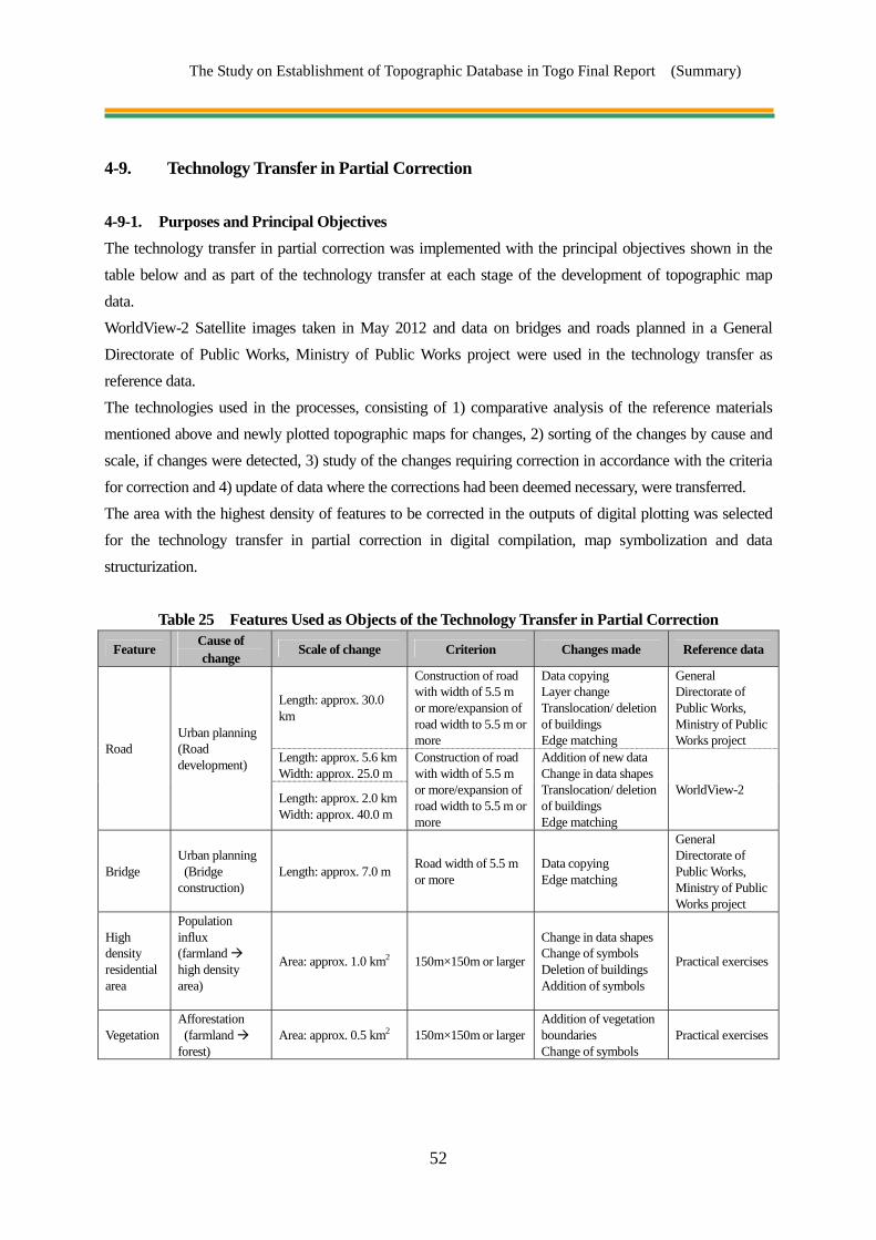
The Study on Establishment of Topographic Database in Togo Final Report (Summary)
52
4-9. Technology Transfer in Partial Correction
4-9-1. Purposes and Principal Objectives The technology transfer in partial correction was implemented with the principal objectives shown in the table below and as part of the technology transfer at each stage of the development of topographic map data. WorldView-2 Satellite images taken in May 2012 and data on bridges and roads planned in a General Directorate of Public Works, Ministry of Public Works project were used in the technology transfer as reference data. The technologies used in the processes, consisting of 1) comparative analysis of the reference materials mentioned above and newly plotted topographic maps for changes, 2) sorting of the changes by cause and scale, if changes were detected, 3) study of the changes requiring correction in accordance with the criteria for correction and 4) update of data where the corrections had been deemed necessary, were transferred. The area with the highest density of features to be corrected in the outputs of digital plotting was selected for the technology transfer in partial correction in digital compilation, map symbolization and data structurization.
Table 25 Features Used as Objects of the Technology Transfer in Partial Correction
Feature Cause of change
Scale of change Criterion Changes made Reference data
Road Urban planning (Road development)
Length: approx. 30.0 km
Construction of road with width of 5.5 m or more/expansion of road width to 5.5 m or more
Data copying Layer change Translocation/ deletion of buildings Edge matching
General Directorate of Public Works, Ministry of Public Works project
Length: approx. 5.6 kmWidth: approx. 25.0 m
Construction of road with width of 5.5 m or more/expansion of road width to 5.5 m or more
Addition of new data Change in data shapes Translocation/ deletion of buildings Edge matching
WorldView-2 Length: approx. 2.0 kmWidth: approx. 40.0 m
Bridge Urban planning (Bridge construction)
Length: approx. 7.0 m Road width of 5.5 m or more
Data copying Edge matching
General Directorate of Public Works, Ministry of Public Works project
High density residential area
Population influx (farmland high density area)
Area: approx. 1.0 km2 150m×150m or larger
Change in data shapes Change of symbols Deletion of buildings Addition of symbols
Practical exercises
Vegetation Afforestation (farmland forest)
Area: approx. 0.5 km2 150m×150m or largerAddition of vegetation boundaries Change of symbols
Practical exercises

The Study on Establishment of Topographic Database in Togo Final Report (Summary)
53
Table 26 Activities in the Technology Transfer in Partial Correction Stage Activity
Digital plotting Detection of area requiring update by cause and scale of change over time Data update Edge matching with surrounding area
Digital compilation Digital compilation after field completion
Data cleaning appropriate for the condition of the areas requiring data update Generalization of polygons
Map symbolization Conversion of data on the locations requiring update Edge matching with surrounding area
Digital data structurization Conversion of data on the locations requiring update Edge matching with surrounding area
Figure 30 Technology Transfer in Partial Correction (Left: Digital plotting, Right: Symbolization) 4-9-2. Outputs and Impact on DGC of the Technology Transfer and Problems Found in the
Technology Transfer The table below shows the results of the evaluation of the technology transfer in partial correction. Roads, a bridge, a high-density residential area and vegetation were the features requiring partial correction in the area selected for the technology transfer. The participants were able to practice all the manipulations required for partial correction, e.g. changing the point, line and polygon data layers, copying/deleting data, changing the data shapes and edge-matching. Although it was not possible to handle three-dimensional partial changes such as changes in topography in the technology transfer, the participants will be able to handle such changes without problems by applying the contents of the technology transfer to digital plotting. The Study Team expects that DGC, as the manager of the topographic map data, will take the lead in the establishment of a mechanism by which the topographic map data are shared between DGC and users and updated with feedback from the users to DGC on the outputs of projects planned with the use of the topographic map data.

The Study on Establishment of Topographic Database in Togo Final Report (Summary)
54
Chapter 5 Work Process Schedule and Personnel Plan
5-1. Work Process Schedule and Work Flowchart The Work Process Schedule and Work Flowchart for this Study are shown in the following pages.

The Study on Establishment of Topographic D
atabase in Togo Final Report
(Summ
ary)
55
Work Plan
【1】 Collection, organization, and analysis of relevant data andinformation
【2】 Preparation of Inception Report (IC/R)
【3】 Explanation and discussion of Inception Report (IC/R)
【4】 Discussion on specifications
【5】 Explanation and discussion related to technology transfer
【6】 Collection and organization of existing materials
【7】 Acquisition of satelite images
【8】 Control point survey
【9】 Field identification
【10】 Aerial triangulation
Aerial triangulation and digital mapping (technology transfer)
【11】 Digital mapping
【12】 Digital compilation
Digital compilation (technology transfer)
【13】 Preparation of Interim Report (IT/R)
【14】 Explanation and discussion of Interim Report (IT/R)
【15】 Field completion
【16】 Digital compilation after field completion
【17】 Digital data structuralization
【18】 Map symbolizationDigital compilation, digital compilation after field completion,map symbolization (technology transfer)Digital data structuralization (technology transfer)
Quality control
【19】 Preparation of Progress Report (PR/R)
【20】 Explanation and discussion of Progress Report (PR/R)
【21】 Creation of data file
【22】 Promotion of utilization
【23】 Preparation of Draft Final Report (DF/R)
【24】 Explanation and discussion of Draft Final Report (DF/R)
【25】 Preparation of Final Report (F/R)
ReportIC/R IT/R PR/R DF/R F/R
2013
8 94 5 6 71 212 1 4 1210984 5 6 31111 765
Period
Work item 3 2 37 9
20122011
8 10
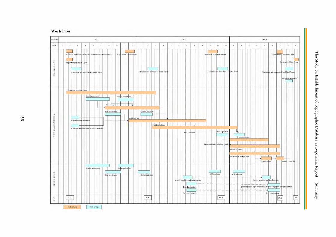
The Study on Establishment of Topographic D
atabase in Togo Final Report
(Summ
ary)
56

The Study on Establishment of Topographic D
atabase in Togo Final Report
(Summ
ary)
57
5-2. Personnel Plan
The personnel plan is as follows:


![[XLS] · Web viewPhoto Date of Commencemet of course Date of Completion of Course Course Duration Dropped Out (date) Sent to OJT (date) OJT Company (Name OJT (Company Rep Name) OJT](https://img.pdfslide.us/doc/110x75/5b0254ef7f8b9a84338f78f8/xls-viewphoto-date-of-commencemet-of-course-date-of-completion-of-course-course.jpg)