Embed Size (px)
Citation preview
INTRO
DU
CTIO
NTH
E AREA
TOD
AYTH
E PLAN
IMPLEM
ENTATIO
NCO
NTEXT FO
R CHA
NG
E
21
1.0INTRODUCTION
2.0CONTEXT FOR CHANGE
3.0THE AREA TODAY
4.0THE PLAN
5.0IMPLEMENTATION
3 The Area TodayFrom rural beginnings over 200 years ago, the study area has evolved into a complex piece of urban fabric within dynamic Ottawa. This section looks at the distinct precincts or neighbourhoods that make up the area and the systems, in terms of transportation, utilities and the public realm, that provide connections and infrastructure. The analysis of existing conditions in the area, together with the policy framework described in the previous section, sets the stage for the Community Design Plan.
INTRO
DU
CTIO
NTH
E AREA
TOD
AYTH
E PLAN
IMPLEM
ENTATIO
NCO
NTEXT FO
R CHA
NG
E
22
3.1 Land Use and Character
Historical BackgroundFrom the subdivision of farmland in the former Nepean Township and the development of estates along Richmond Road (Wellington Street today) emerged the communities of Hintonburg and Mechanicsville in the mid-to-late 19th century. Railroads were built through the area to transport lumber from the Ottawa River, and a major roundhouse was built where the Tom Brown Arena stands today. Home to mill and railroad workers, the area’s growth was further encouraged when a streetcar line was added to Richmond Road in 1896. This led to more housing for civil servants and middle-class professionals, with Richmond Road becoming a hub of commercial and cultural activity. In 1907, Hintonburg was annexed by the City of Ottawa, followed by Mechanicsville four years later.
In the 1950s and 1960s, Jacques Gréber’s plan for the National Capital resulted in significant changes to the Scott Street area. The objective to decentralize government offices led to the development of Tunney’s Pasture. The expropriation of properties in Mechanicsville was necessary to create a scenic parkway along the Ottawa River. And the rail lines in the area were removed with the goal of improving transportation. In the 1980s, one of the rail corridors would become the Transitway.
Many area homes and commercial buildings built in the late 19th and early 20th century remain today. More than three dozen are listed on the City’s Heritage Reference List, and the former Richmond Lodge on Armstrong Street along with three
of the original buildings in Tunney’s Pasture are designated under Part IV of the Heritage Act. While having a lesser role today as a transit and vehicular corridor, Wellington Street West nevertheless retains the mainstreet role it historically held.
The Scott Street area’s historical evolution has resulted in one of the most diverse parts of Ottawa in terms of land use, building types and sizes, and general character. Within the mixed-use pattern overall are distinct neighbourhoods and precincts that each contain discrete opportunities for positive change.
LISTED HERITAGE BUILDINGS
Through the CDP process, staff with Heritage Services requested that the following properties be added to the Heritage Register:
50 Carruthers Avenue 129 Carruthers Avenue86 Carruthers Avenue 11 Hilda Street91 Carruthers Avenue 179 Hinchey Avenue121 Carruthers Avenue 12 Stirling (original building)
Section 27 (1.2) of the Ontario Heritage Act gives the municipality the power to add non-designated properties of cultural heritage value or interest to the City of Ottawa Heritage Register. Adding non-designated properties to the Heritage Register means that the owner of the building is required to provide the City of Ottawa with 60 days notice prior to demolition. This notice provides a pause in the process where City staff can negotiate with the owner of the property for the retention and integration of the existing building into any proposed development. In addition, the notice period can provide the City with the time to complete a full heritage survey and evaluation on the property to determine whether it meets the criteria for designation under Part IV of the Ontario Heritage Act.
INTRO
DU
CTIO
NTH
E AREA
TOD
AYTH
E PLAN
IMPLEM
ENTATIO
NCO
NTEXT FO
R CHA
NG
E
23
Provincial HighwayAutoroute provinciale
Federally Owned RoadRoute fédérale
ArterialArtère
Major CollectorGrande collectrice
CollectorRoute collectrice
Potential Collector onTunney`s Pasture(Conceptual)Route collectrice possible (conceptuelle)
Potential Federally Owned RoadRoute locale possible
Potential Local Street onTunney`s Pasture(Conceptual)au pré Tunney (conceptuelle)
Future Local StreetRue locale future
Right-of-Way Protection Priority(26m)Protection de l’emprise (26 m)
Signalized IntersectionCarrefour avec feux de circulation
Proposed Number of Car LanesNombre de voies pour les voitures proposées
LRT StationStation du TLR
Bayview Station CDPDu Secteur do la station Bayview
Provincial HighwayAutoroute provinciale
Federally Owned RoadRoute fédérale
ArterialArtère
Major CollectorImportante route collectrice
CollectorRoute collectrice
Right-of-Way Protection Priority(26m)Protection de l’emprise (26 m)
Existing Signalized IntersectionCarrefour avec feux de circulation actuel
Transitway StationStation du Transitway
CDP Study Area
CDP Area BoundaryLimite du PCC
CDP Focus AreaSecteur d’intérêt du PCC
General Urban AreaZone urbaine générale
Central AreaZone centrale
Mixed Use Centre Centre d’utilisations polyvalentes
Major Open SpaceEspaces verts d’importance
Urban Natural FeaturesCaractéristiques naturelles de zone urbaine
Traditional Main StreetRue principale traditionnelle
Existing Multi-use PathwaySentier polyvalent existant
Proposed Multi-use PathwaySentier polyvalent proposé
Future Pedestrian Pathway Sentier piétonnier futur
Future PathwaySentier futur
Enhanced Community PathwaySentier communautaire amélioré
Existing PathwaySentier existant
Enhanced Cross WalkPassage pour piétons amélioré
Signalized IntersectionCarrefour avec feux de circulation
Future LRT StationStation du TLR future
Bayview Station CDPDu Secteur do la station Bayview
Existing Multi-use PathwaySentier polyvalent existant
Proposed Multi-use PathwaySentier polyvalent proposé
Future Cycle Track (O�-Road)Voie cyclable future (hors rue)
Future Bike Lane (On-Road)Voie cyclable future (sur rue)
Future Shared Use Lane (Signed Route)Future voie partagée (tracé balisé)
Enhanced Cross WalkPassage pour piétons amélioré
Signalized IntersectionCarrefour avec feux de circulation
Future LRT StationStation du Transitway
Bayview Station CDPDu Secteur do la station Bayview
Existing Multi-use PathwaySentier polyvalent existant
Existing O�-Street Multi-use PathwaySentier polyvalent hors rue existant
Existing PathwaySentier existant
Existing Signalized IntersectionCarrefour avec feux de circulation actuel
BRT StationStation de transport en commun rapide par autobus (TCRA)
LRT Station
LRT Line
Existing Bus Route
Existing O-train/Planned LRT Line
LRT Station Plaza
LRT Station
BRT
Planned LRT Line
Bus Route (Based on Existing)
Existing O-train/Planned LRT Line
Interim Transfer Bus Station
Interim Bus Parking
BRT Station
BRT
Existing Bus Route
Existing O-train/Planned LRT Line
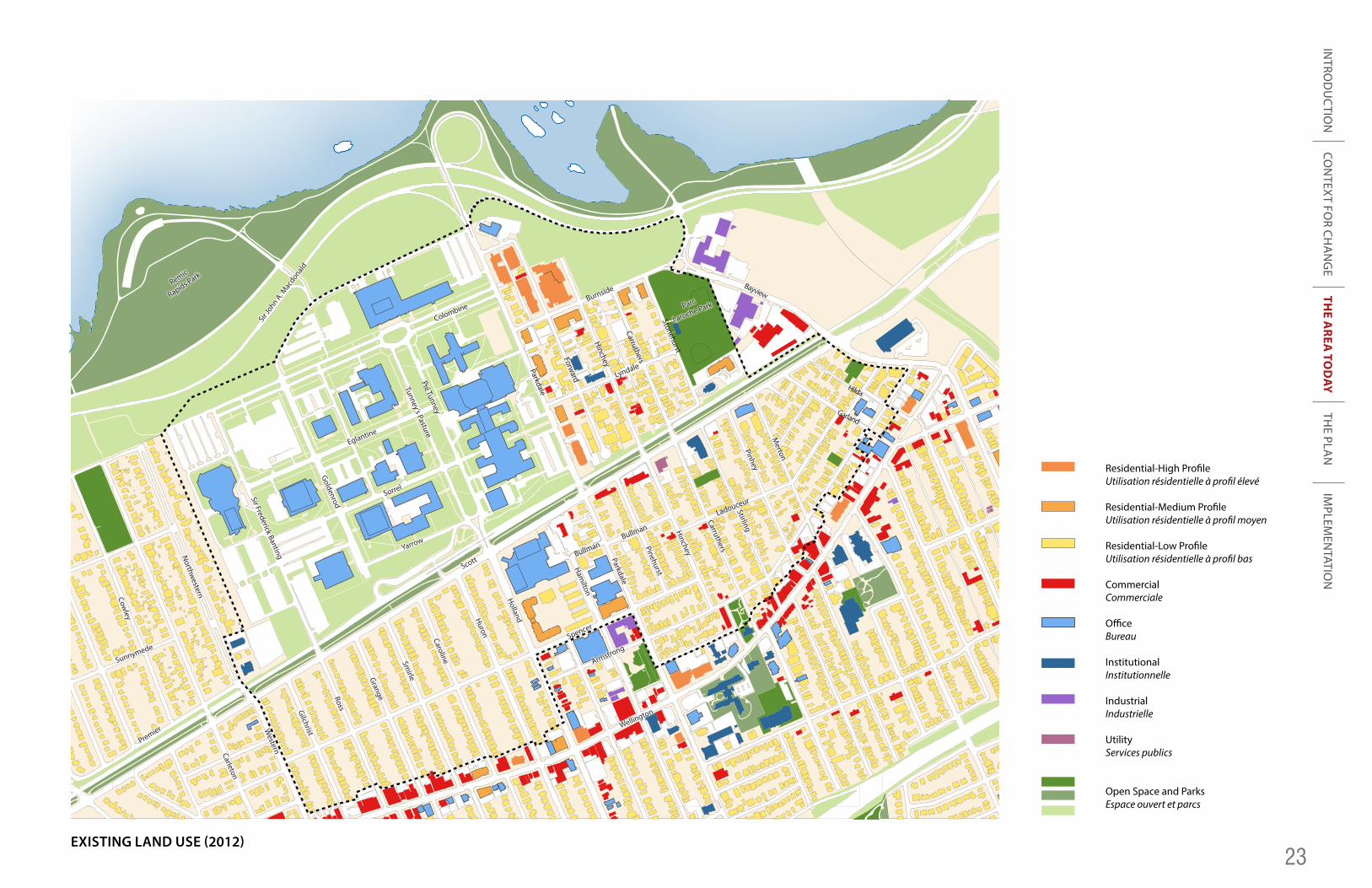
Residential-High Pro�leUtilisation résidentielle à pro�l élevé
Residential-Medium Pro�leUtilisation résidentielle à pro�l moyen
Residential-Low Pro�leUtilisation résidentielle à pro�l bas
CommercialCommerciale
O�ceBureau
InstitutionalInstitutionnelle
IndustrialIndustrielle
UtilityServices publics
Open Space and ParksEspace ouvert et parcs
Low-Pro�le Residential BuildingMedium-Pro�le Residential BuildingHigh-Pro�le Residential BuildingResidential Mixed-Use BuildingO�ce BuildingRetail Space BuildingPublic/Institutional Building
Low-Rise Neighbourhood
Tunneys Pasture Mixed-Use CentreSubject to Tunneys Pasture Master Plan
Holland-Parkdale NodeMixed-Use Centre
Secondary Mainstreet
Active Frontage
NCC
Existing/Proposed Open Space
Existing/Proposed Plaza
Community Centre/Facility
LRT Station
CDP Study Area
BRT Station/Planned LRT StationStation de transport en commun rapide par autobus (TCRA)/station du TLR plani�é
BRT Line/ Planned LRT LineLigne de transport en commun rapide par autobus/ ligne de TLR prévue
Existing Bus Route Circuit d’autobus existant
Existing O-train/Planned LRT LineTracé actuel de l’O-Train/ligne du TLR prévue
Planned LRT Station PlazaPlace de la station du TLR prévue
Bayview Station CDPDu Secteur do la station Bayview
Existing Multi-use PathwaySentier polyvalent existant
Existing O�-Street Multi-use PathwaySentier polyvalent hors rue existant
Existing Bike Lane (On-Road)Voie cyclable actuelle (sur rue)
Existing Shared Use LaneVoie partagée actuelle
Existing Signalized IntersectionCarrefour avec feux de circulation actuel
Transitway StationStation du Transitway
ApprovedApprouvées
Under ReviewEn examen
Under Construction/Recently CompletedEn construction/Achevé récemment
CDP AreasSecteurs des PCC
Scott St. CDP Study AreaSecteur à l’étude du PCC de la rue Scott
Height Limits Subject toTunney`s Pasture Master Plan
Low Pro�leUp to 11mUp to 14.5 m (4 Storeys ) Up to 14.5 m (4 Storeys ) *Except Where Angular Premits Greater Height-See Guidelines Section 4.2.2(C)
Medium Pro�leUp to 19 m (6 Storeys)
High Pro�le Up to 76m (25 Storeys)Up to 55m (18 Storeys)Up to 37m (12 Storeys)
Maximum Height Subjuct to Angular Plane and CDP Tall-Building Guidelines
Height Limits Varies as Per Existing Zoning
General Location for Tall Building*Subject to CDP Tall-Building Guidelines
Neighbourhood Line
LRT Station
CDP Study Area
Transit Plaza
Parkdale Greenway
Sir Frederick Banting Greenway
Columbine Cycling Route
Transitway Greenway
Neighbourhood Park and Community Centre
T
1
2
3
4
5
6
Mixed-Use CentreCentre d’utilisations polyvalentes
Secondary MainstreetRue principale résidentielle
Low-Rise Residential Secteur résidentiel de faible hauteur
Low-Rise Residential (Max 6 Storeys)Secteur résidentiel de faible hauteur (6 étages)
Apartment NeighbourhoodQuartier d’immeubles de logements
Local CommercialLocal commercial
Public/Institutional AreaSecteur public/institutionnel
Open SpaceEspace ouvert
Mid Block Connection Lien à mi pâté
Mid Block Connection-ConceptualLien à mi pâté-Conceptuel
Tunney`s Pasture Open SpaceEspace ouvert pré Tunney
Capital FunctionFunction de la Capital
NCC Open SpaceEspace vert de la CCN
Subject to NCC Urban Land MasterplanSous reserve de l'achèvement du Plan directeur des terrains urbains de la capitale
UtilityServices publics
Potential Community Centre/ FacilityCentre/installations communautaires potentiels
LRT StationStation du TLR
Neighbourhood LineLigne de quartier
CDP Study AreaSecteur d’étude du PCC
**
Scott
Burnside
Ladouceur
Bullman
Bullman
Parc
Laroche Park
Remic
Rapids Park
Lyndale
Sorrel
Sir Jo
hn A. M
acdonald
Eglantine
Sunnymede
Premier
Yarrow
Tunney’s PasturePré Tunney
Bayview
Garland
Hilda
Goldenrod
Sir Frederick BantingNorthw
esternCowley
Spencer
Armstrong
Wellington
Parkdale
Pinehurst
Hinchey
Carruthers
Stirling
Parkdale
Forward
Hinchey
Carruthers
Stonehurst
Pinhey
Merton
Holland
Hamilton
Huron
CarolineSmirleGrangeRossGilchristW
esternCarleton
Colombine
EXISTING LAND USE (2012)
INTRO
DU
CTIO
NTH
E AREA
TOD
AYTH
E PLAN
IMPLEM
ENTATIO
NCO
NTEXT FO
R CHA
NG
E
24
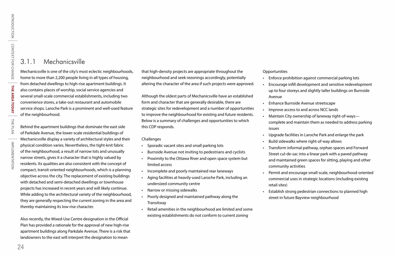
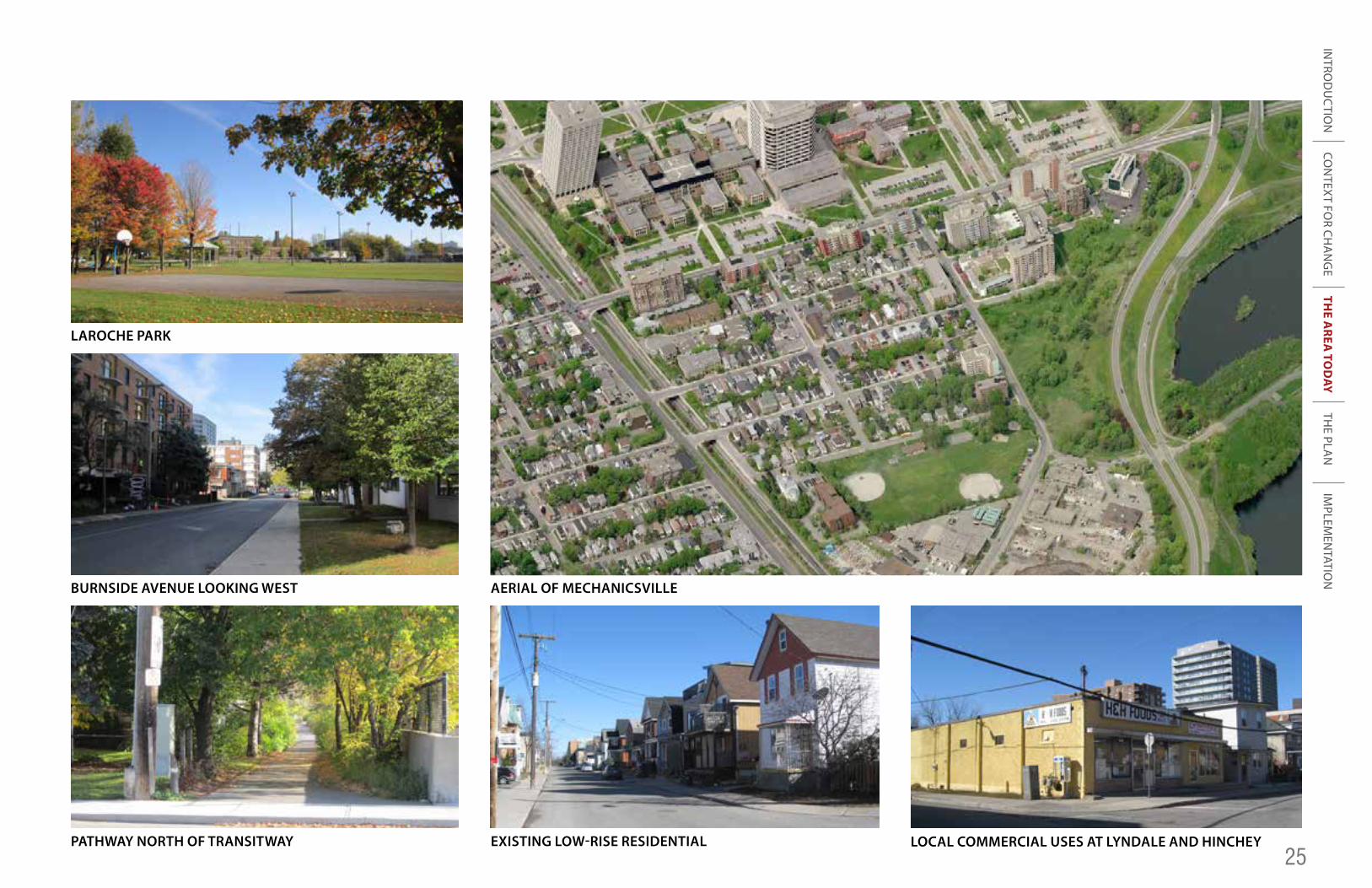
3.1.1 MechanicsvilleMechanicsville is one of the city’s most eclectic neighbourhoods, home to more than 2,200 people living in all types of housing, from detached dwellings to high-rise apartment buildings. It also contains places of worship, social service agencies and several small-scale commercial establishments, including two convenience stores, a take-out restaurant and automobile service shops. Laroche Park is a prominent and well-used feature of the neighbourhood.
Behind the apartment buildings that dominate the east side of Parkdale Avenue, the lower-scale residential buildings of Mechanicsville display a variety of architectural styles and their physical condition varies. Nevertheless, the tight-knit fabric of the neighbourhood, a result of narrow lots and unusually narrow streets, gives it a character that is highly valued by residents. Its qualities are also consistent with the concept of compact, transit-oriented neighbourhoods, which is a planning objective across the city. The replacement of existing buildings with detached and semi-detached dwellings or townhouse projects has increased in recent years and will likely continue. While adding to the architectural variety of the neighbourhood, they are generally respecting the current zoning in the area and thereby maintaining its low-rise character.
Also recently, the Mixed-Use Centre designation in the Official Plan has provided a rationale for the approval of new high-rise apartment buildings along Parkdale Avenue. There is a risk thatlandowners to the east will interpret the designation to mean
that high-density projects are appropriate throughout the neighbourhood and seek rezonings accordingly, potentially altering the character of the area if such projects were approved.
Although the oldest parts of Mechanicsville have an established form and character that are generally desirable, there are strategic sites for redevelopment and a number of opportunities to improve the neighbourhood for existing and future residents. Below is a summary of challenges and opportunities to which this CDP responds.
Challenges
• Sporadic vacant sites and small parking lots
• Burnside Avenue not inviting to pedestrians and cyclists
• Proximity to the Ottawa River and open space system but limited access
• Incomplete and poorly maintained rear laneways
• Aging facilities at heavily-used Laroche Park, including an undersized community centre
• Narrow or missing sidewalks
• Poorly designed and maintained pathway along the Transitway
• Retail amenities in the neighbourhood are limited and some existing establishments do not conform to current zoning
Opportunities
• Enforce prohibition against commercial parking lots
• Encourage infill development and sensitive redevelopment up to four storeys and slightly taller buildings on Burnside Avenue
• Enhance Burnside Avenue streetscape
• Improve access to and across NCC lands
• Maintain City ownership of laneway right-of-ways—complete and maintain them as needed to address parking issues
• Upgrade facilities in Laroche Park and enlarge the park
• Build sidewalks where right-of-way allows
• Transform informal pathway, orphan spaces and Forward Street cul-de-sac into a linear park with a paved pathway and maintained green spaces for sitting, playing and other community activities
• Permit and encourage small-scale, neighbourhood-oriented commercial uses in strategic locations (including existing retail sites)
• Establish strong pedestrian connections to planned high street in future Bayview neighbourhood
INTRO
DU
CTIO
NTH
E AREA
TOD
AYTH
E PLAN
IMPLEM
ENTATIO
NCO
NTEXT FO
R CHA
NG
E
25
LAROCHE PARK
BURNSIDE AVENUE LOOKING WEST
PATHWAY NORTH OF TRANSITWAY
AERIAL OF MECHANICSVILLE
EXISTING LOW-RISE RESIDENTIAL LOCAL COMMERCIAL USES AT LYNDALE AND HINCHEY
INTRO
DU
CTIO
NTH
E AREA
TOD
AYTH
E PLAN
IMPLEM
ENTATIO
NCO
NTEXT FO
R CHA
NG
E
26
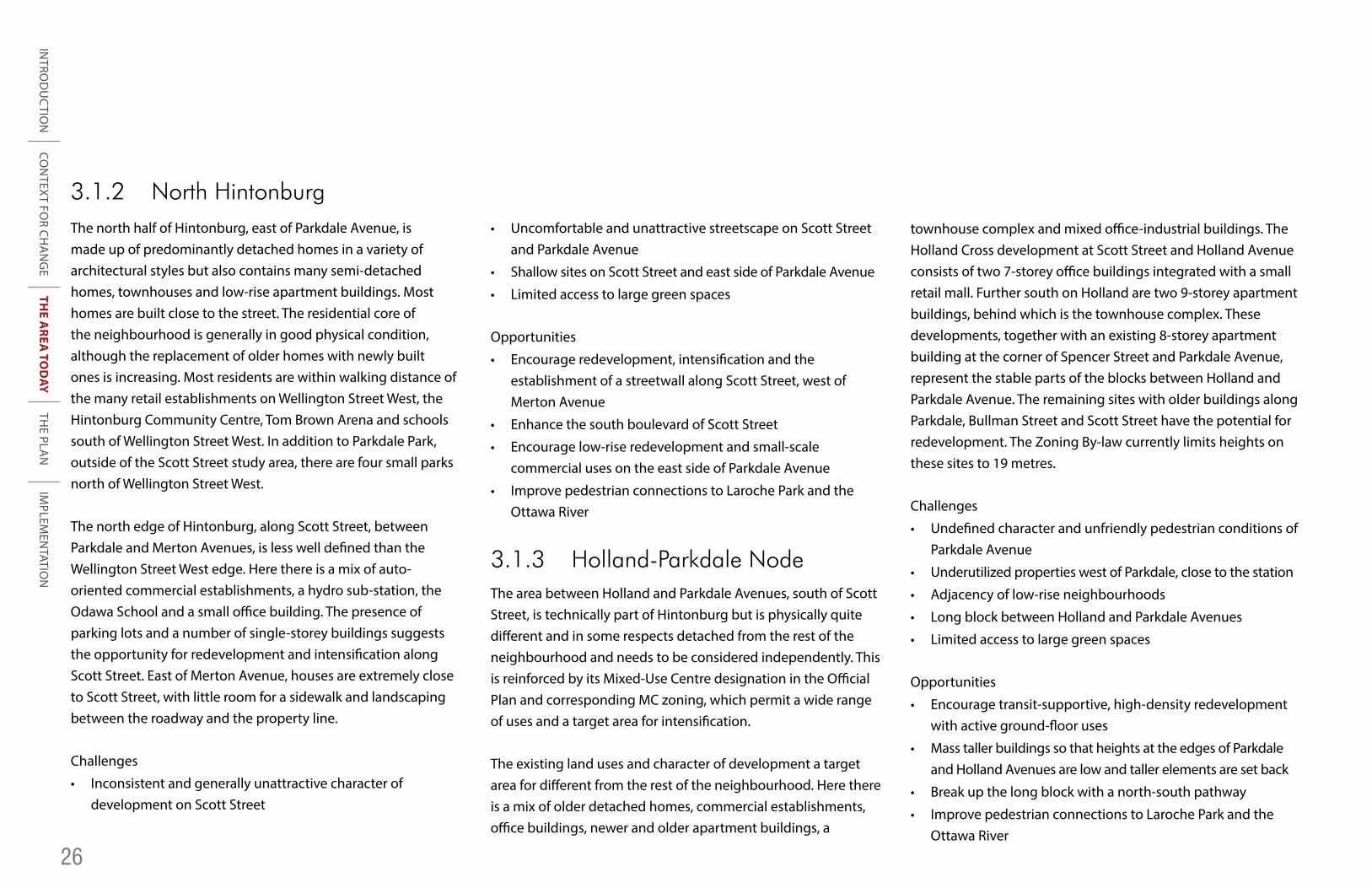
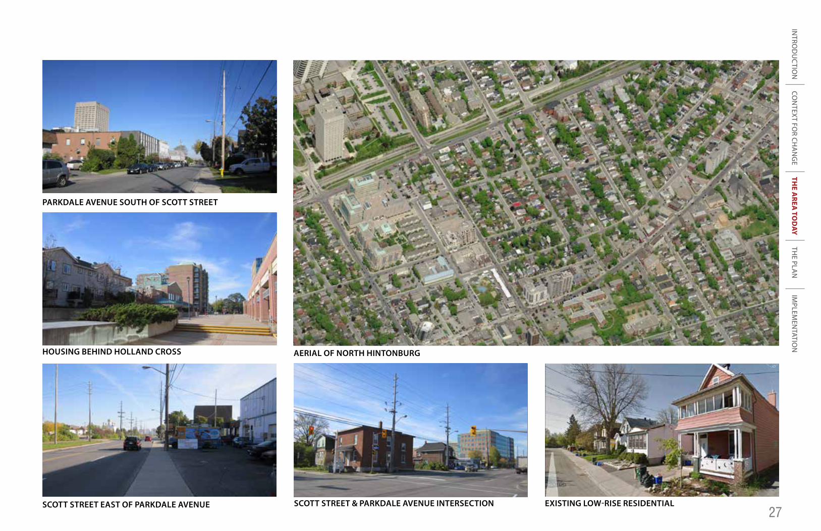
3.1.2 North HintonburgThe north half of Hintonburg, east of Parkdale Avenue, is made up of predominantly detached homes in a variety of architectural styles but also contains many semi-detached homes, townhouses and low-rise apartment buildings. Most homes are built close to the street. The residential core of the neighbourhood is generally in good physical condition, although the replacement of older homes with newly built ones is increasing. Most residents are within walking distance of the many retail establishments on Wellington Street West, the Hintonburg Community Centre, Tom Brown Arena and schools south of Wellington Street West. In addition to Parkdale Park, outside of the Scott Street study area, there are four small parks north of Wellington Street West.
The north edge of Hintonburg, along Scott Street, between Parkdale and Merton Avenues, is less well defined than the Wellington Street West edge. Here there is a mix of auto-oriented commercial establishments, a hydro sub-station, the Odawa School and a small office building. The presence of parking lots and a number of single-storey buildings suggests the opportunity for redevelopment and intensification along Scott Street. East of Merton Avenue, houses are extremely close to Scott Street, with little room for a sidewalk and landscaping between the roadway and the property line.
Challenges
• Inconsistent and generally unattractive character of development on Scott Street
• Uncomfortable and unattractive streetscape on Scott Street and Parkdale Avenue
• Shallow sites on Scott Street and east side of Parkdale Avenue
• Limited access to large green spaces
Opportunities
• Encourage redevelopment, intensification and the establishment of a streetwall along Scott Street, west of Merton Avenue
• Enhance the south boulevard of Scott Street
• Encourage low-rise redevelopment and small-scale commercial uses on the east side of Parkdale Avenue
• Improve pedestrian connections to Laroche Park and the Ottawa River
3.1.3 Holland-Parkdale NodeThe area between Holland and Parkdale Avenues, south of Scott Street, is technically part of Hintonburg but is physically quite different and in some respects detached from the rest of the neighbourhood and needs to be considered independently. This is reinforced by its Mixed-Use Centre designation in the Official Plan and corresponding MC zoning, which permit a wide range of uses and a target area for intensification.
The existing land uses and character of development a target area for different from the rest of the neighbourhood. Here there is a mix of older detached homes, commercial establishments, office buildings, newer and older apartment buildings, a
townhouse complex and mixed office-industrial buildings. The Holland Cross development at Scott Street and Holland Avenue consists of two 7-storey office buildings integrated with a small retail mall. Further south on Holland are two 9-storey apartment buildings, behind which is the townhouse complex. These developments, together with an existing 8-storey apartment building at the corner of Spencer Street and Parkdale Avenue, represent the stable parts of the blocks between Holland and Parkdale Avenue. The remaining sites with older buildings along Parkdale, Bullman Street and Scott Street have the potential for redevelopment. The Zoning By-law currently limits heights on these sites to 19 metres.
Challenges
• Undefined character and unfriendly pedestrian conditions of Parkdale Avenue
• Underutilized properties west of Parkdale, close to the station
• Adjacency of low-rise neighbourhoods
• Long block between Holland and Parkdale Avenues
• Limited access to large green spaces
Opportunities
• Encourage transit-supportive, high-density redevelopment with active ground-floor uses
• Mass taller buildings so that heights at the edges of Parkdale and Holland Avenues are low and taller elements are set back
• Break up the long block with a north-south pathway
• Improve pedestrian connections to Laroche Park and the Ottawa River
INTRO
DU
CTIO
NTH
E AREA
TOD
AYTH
E PLAN
IMPLEM
ENTATIO
NCO
NTEXT FO
R CHA
NG
E
27
PARKDALE AVENUE SOUTH OF SCOTT STREET
HOUSING BEHIND HOLLAND CROSS
SCOTT STREET EAST OF PARKDALE AVENUE
AERIAL OF NORTH HINTONBURG
SCOTT STREET & PARKDALE AVENUE INTERSECTION EXISTING LOW-RISE RESIDENTIAL
INTRO
DU
CTIO
NTH
E AREA
TOD
AYTH
E PLAN
IMPLEM
ENTATIO
NCO
NTEXT FO
R CHA
NG
E
28
3.1.4 Wellington Village and Champlain ParkWellington Village is an attractive, stable neighbourhood consisting of mostly detached and semi-detached homes. Several older houses on Holland Avenue have been partially or fully converted to commercial uses. Generally deeper lots than are found in Mechanicsville and Hintonburg allow for front yards and deeper backyards. The neighbourhood enjoys close proximity to shops, restaurants and other attractions on Wellington Street West, but contains no parkland.
Champlain Park, further from Wellington Street West but closer to the river, contains a sizable neighbourhood park and an elementary school. Leafy like Wellington Village, it is comprised of detached and semi-detached homes, with the replacement of smaller homes with larger ones increasing. At the southeast corner of the neighbourhood are two places of worship, including a mosque that draws worshipers from across the city.
Challenge
• Lack of green space in Wellington Village
Opportunity
• Improve connections through Tunney’s Pasture to riverfront open space
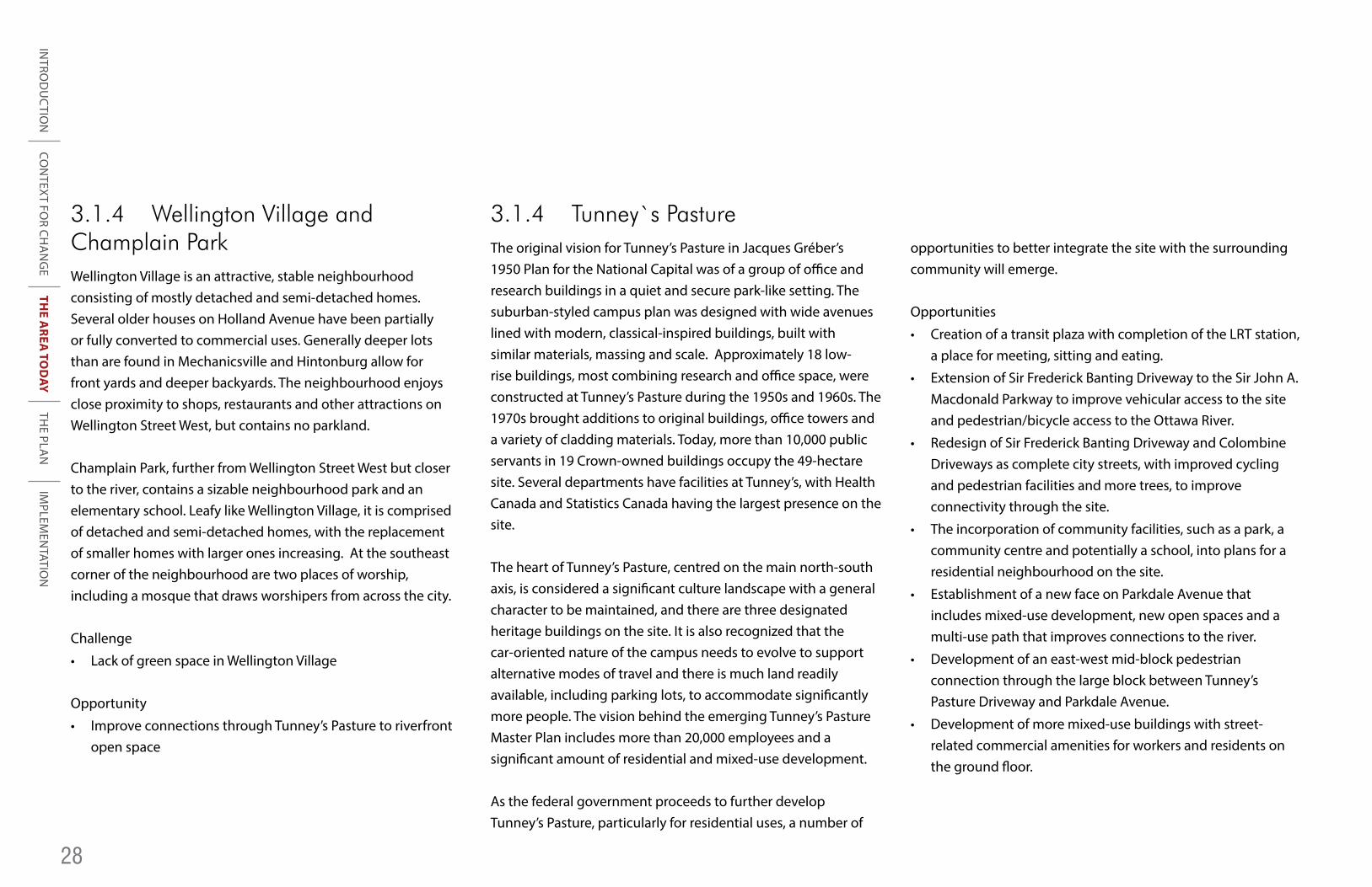
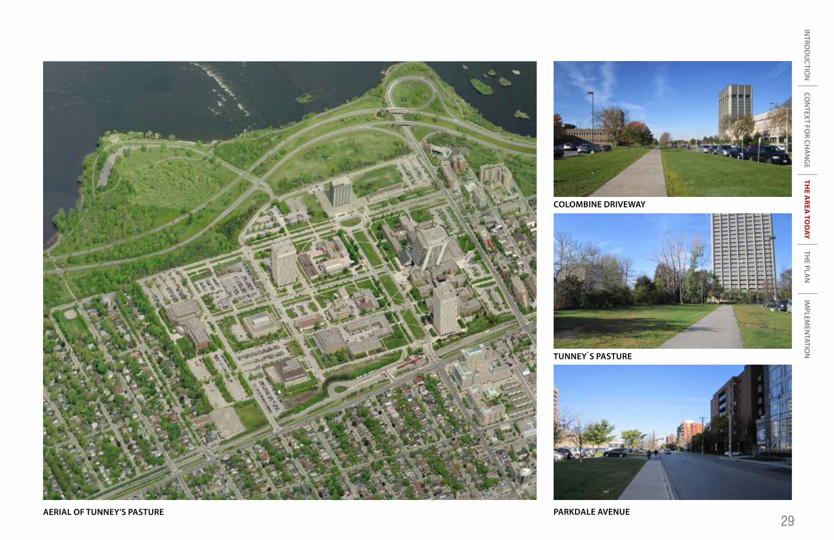
3.1.4 Tunney`s PastureThe original vision for Tunney’s Pasture in Jacques Gréber’s 1950 Plan for the National Capital was of a group of office and research buildings in a quiet and secure park-like setting. The suburban-styled campus plan was designed with wide avenues lined with modern, classical-inspired buildings, built with similar materials, massing and scale. Approximately 18 low-rise buildings, most combining research and office space, were constructed at Tunney’s Pasture during the 1950s and 1960s. The 1970s brought additions to original buildings, office towers and a variety of cladding materials. Today, more than 10,000 public servants in 19 Crown-owned buildings occupy the 49-hectare site. Several departments have facilities at Tunney’s, with Health Canada and Statistics Canada having the largest presence on the site.
The heart of Tunney’s Pasture, centred on the main north-south axis, is considered a significant culture landscape with a general character to be maintained, and there are three designated heritage buildings on the site. It is also recognized that the car-oriented nature of the campus needs to evolve to support alternative modes of travel and there is much land readily available, including parking lots, to accommodate significantly more people. The vision behind the emerging Tunney’s Pasture Master Plan includes more than 20,000 employees and a significant amount of residential and mixed-use development.
As the federal government proceeds to further develop Tunney’s Pasture, particularly for residential uses, a number of
opportunities to better integrate the site with the surrounding community will emerge.
Opportunities
• Creation of a transit plaza with completion of the LRT station, a place for meeting, sitting and eating.
• Extension of Sir Frederick Banting Driveway to the Sir John A. Macdonald Parkway to improve vehicular access to the site and pedestrian/bicycle access to the Ottawa River.
• Redesign of Sir Frederick Banting Driveway and Colombine Driveways as complete city streets, with improved cycling and pedestrian facilities and more trees, to improve connectivity through the site.
• The incorporation of community facilities, such as a park, a community centre and potentially a school, into plans for a residential neighbourhood on the site.
• Establishment of a new face on Parkdale Avenue that includes mixed-use development, new open spaces and a multi-use path that improves connections to the river.
• Development of an east-west mid-block pedestrian connection through the large block between Tunney’s Pasture Driveway and Parkdale Avenue.
• Development of more mixed-use buildings with street-related commercial amenities for workers and residents on the ground floor.
INTRO
DU
CTIO
NTH
E AREA
TOD
AYTH
E PLAN
IMPLEM
ENTATIO
NCO
NTEXT FO
R CHA
NG
E
29 AERIAL OF TUNNEY’S PASTURE
COLOMBINE DRIVEWAY
TUNNEY`S PASTURE
PARKDALE AVENUE
INTRO
DU
CTIO
NTH
E AREA
TOD
AYTH
E PLAN
IMPLEM
ENTATIO
NCO
NTEXT FO
R CHA
NG
E
30
As the federal government proceeds to further develop Tunney’s Pasture, particularly for residential uses, a number of opportunities to better integrate the site with the surrounding community will emerge. Opportunities
- Creation of a transit plaza with completion of the LRT station, a place for meeting, sitting and eating.
- Extension of Sir Frederick Banting to the Sir John A. Macdonald Parkway to improve vehicular access to the site and pedestrian/bicycle access to the Ottawa River.
- Redesign of Sir Frederick Banting and Colombine as complete city streets, with improved cycling and pedestrian facilities and more trees, to improve connectivity through the site.
- The incorporation of community facilities, such as a park, a community centre and potentially a school, into plans for a residential neighbourhood on the site.
- Establishment of a new face on Parkdale Avenue that includes mixed-use development, new open spaces and a multi-use path that improves connections to the river.
- Development of an east-west mid-block pedestrian connection through the large block between Tunney’s Pasture Driveway and Parkdale.
- Development of more mixed-use buildings with street-related commercial amenities for workers and residents on the ground floor.
Map of TP opportunities 3.2 Density The Mixed-Use Centre (MUC) within the Scott Street area is intended to accommodate both residential and employment growth, which will support investments in public transit and help ensure the city as a whole grows sustainably. To inform policies and guidelines directing how much growth should occur and the form it should take, Table X below breaks down estimates of the existing population of the MUC and the overall density today. The area of the MUC excludes the established core of Mechanicsville since it is not considered an appropriate location for significant intensification, as discussed in Section 3.1.1.
The approximate density of 241 people and jobs per hectare that will be achieved when the approved apartment buildings on Parkdale are built and occupied is close to the City’s minimum target for the MUC of 250. The addition of a further approximately 520 people and jobs to the area would meet the target.
Scott
Burnside
Ladouceur
Bullman
Bullman
Parc
Laroche Park
Remic
Rapids Park
Lyndale
Sorrel
Sir Jo
hn A. M
acdonald
Eglantine
Sunnymede
Premier
Yarrow
Tunney’s PasturePré Tunney
Bayview
Garland
Hilda
Goldenrod
Sir Frederick BantingNorthw
esternCowley
Spencer
Armstrong
Wellington
Parkdale
Pinehurst
Hinchey
Carruthers
Stirling
Parkdale
Forward
Hinchey
Carruthers
Stonehurst
Pinhey
Merton
Holland
Hamilton
Huron
CarolineSmirleGrangeRossGilchristW
esternCarletonColombine
TUNNEY`S PASTURE
BAYVIEW
TUNNEY`S PASTURE
HOLLAND-PARKDALE NODE
EAST OF PARKDALE
MIXED-USE CENTRE WITHIN THE STUDY AREA
3.2 Density
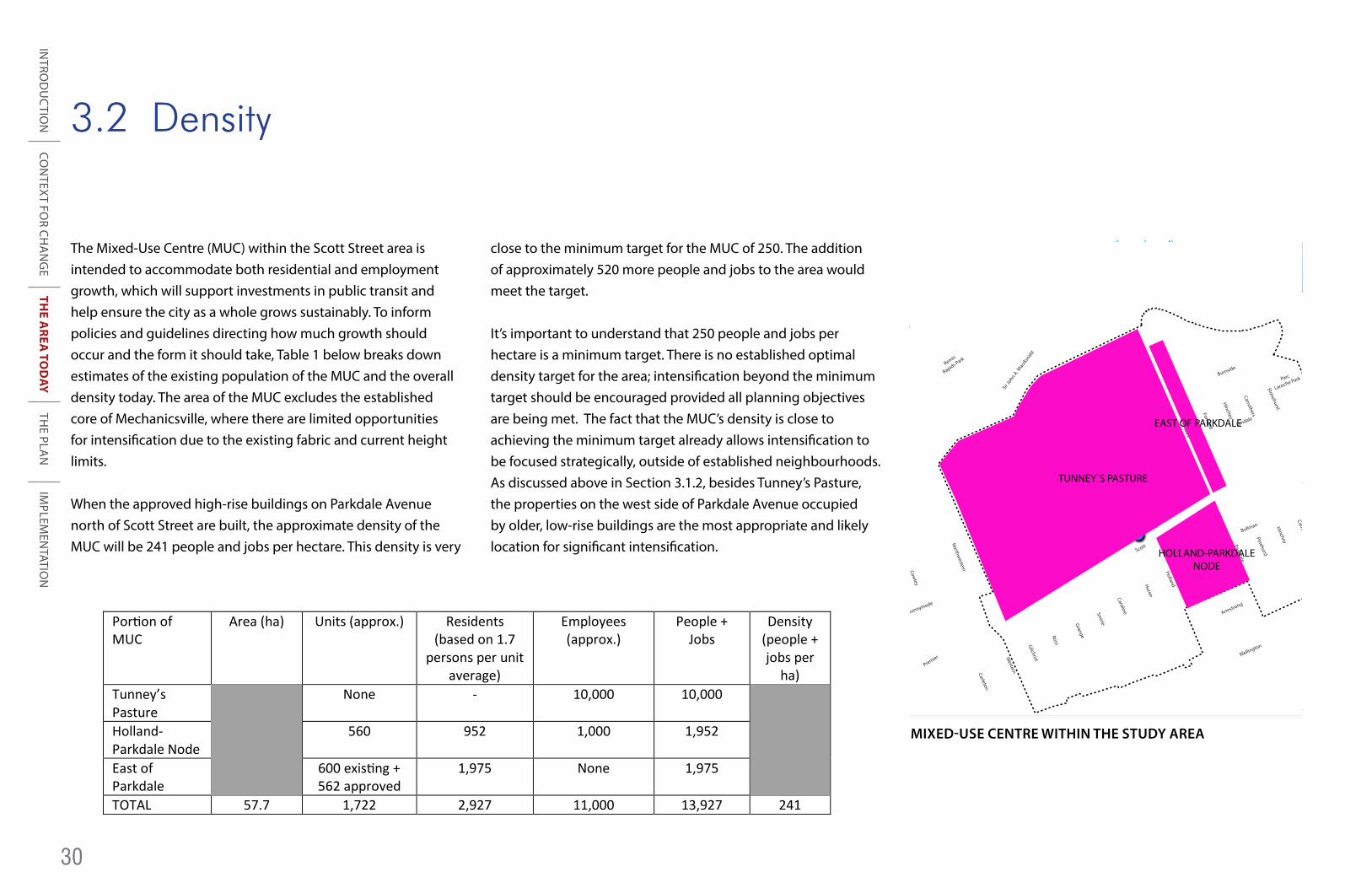
The Mixed-Use Centre (MUC) within the Scott Street area is intended to accommodate both residential and employment growth, which will support investments in public transit and help ensure the city as a whole grows sustainably. To inform policies and guidelines directing how much growth should occur and the form it should take, Table 1 below breaks down estimates of the existing population of the MUC and the overall density today. The area of the MUC excludes the established core of Mechanicsville, where there are limited opportunities for intensification due to the existing fabric and current height limits.
When the approved high-rise buildings on Parkdale Avenue north of Scott Street are built, the approximate density of the MUC will be 241 people and jobs per hectare. This density is very
close to the minimum target for the MUC of 250. The addition of approximately 520 more people and jobs to the area would meet the target.
It’s important to understand that 250 people and jobs per hectare is a minimum target. There is no established optimal density target for the area; intensification beyond the minimum target should be encouraged provided all planning objectives are being met. The fact that the MUC’s density is close to achieving the minimum target already allows intensification to be focused strategically, outside of established neighbourhoods.As discussed above in Section 3.1.2, besides Tunney’s Pasture, the properties on the west side of Parkdale Avenue occupied by older, low-rise buildings are the most appropriate and likely location for significant intensification.
Portion of MUC
Area (ha) Units (approx.) Residents (based on 1.7
persons per unit average)
Employees (approx.)
People + Jobs
Density (people + jobs per
ha) Tunney’s Pasture
None - 10,000 10,000
Holland- Parkdale Node
560 952 1,000 1,952
East of Parkdale
600 existing + 562 approved
1,975 None 1,975
TOTAL 57.7 1,722 2,927 11,000 13,927 241