Embed Size (px)
Citation preview
KANATA WEST CONCEPT PLANAppendix A
1
1. SITE CONTEXT AND EXISTING CONDITIONS ANALYSIS
The following section examines and outlines the site context and condi-tions, as well as the existing opportunities and constraints that direct and define the concept planning process. The findings are presented by discipline as follows: land use planning, environment, transportation, servicing, urban design, and financial analysis.
1.1 Site Context and Existing Land Uses
1.1.1 Surrounding Communities The 725 hectares (1791 acres) study area sits on the junction of three former municipalities: the Township of Goulbourn, the Township of West Carleton, and the City of Kanata. While the City has formally amalga-mated into one municipality and the site bridges the three communities, the communities remain distinct - each with its own unique culture, issues, and vision. Many of the residents of the communities surrounding the Kanata West site have been actively involved in the concept planning process and have expressed a direct interest in the results.
Stittsville The former Village of Stittsville, which lies immediately south of the study area, is a largely residential community with an active and evolving main street commercial area. Stittsville was incorporated in 1974 and is the largest settlement in former Goulbourn Township. The current population of Stittsville is given as 15, 950 people. This figure is projected to grow to 21,050 in 2006 and to 26,700 by 20111 . Business uses also exist along Iber Road on the eastern edge of Stittsville, as well as along Hazeldean, north of Main Street. Municipal water and sewer service the former village, and as a result the community is defined as part of the ‘General Urban Area’ in the Regional Official Plan.
West Carleton The former Township of West Carleton sits north-west of the study area. It covers approximately 600 square kilometres and is primarily rural in character. Concentrations of residential development occur in six vil-lages, although there is also settlement hamlets, acreage subdivisions, cottages and single lots along rural roads. The closest village to the study area is Carp, which lies approximately 8 km north of Highway 417, along Carp Road. Rural lot subdivision has been significant recently in West
1 Population figures taken from the “Scenario-B” city-wide projections which received City Council approval on October 10, 2001. Scenario-B was one of four possible growth scenarios detailed in the report entitled “City of Ottawa Population, Employment, Household and Dwelling Projections 1996 to 2031”.
KANATA WEST CONCEPT PLANAppendix A
2
Carleton, with approximately 2,900 new lots approved in the period 1975-2000.
Agri-business is significant to the growth and development of West Carleton and is important to the Township’s economy. Much of the land north of the study area remains rural and actively farmed. Mineral extrac-tion and associated industries are also important to the local economy, such as the Spratt Quarry at the intersection of Carp Road and Highway 417.
The Carp Airport is located approximately 7 km north from the Corel Centre on Carp Road. The airport is an important piece of the area trans-portation network as it provides an alternative to the MacDonald-Cartier International Airport for corporate uses and also serves as the base for local air ambulance services.
Kanata The former City of Kanata lies to the east of the study area and is at a signification point in its evolution. The community, largely as a result of the burgeoning high technology industry, has grown considerably in population and economic stature in previous years. With a growing population of approximately 50,000 people, new businesses and services have flourished in recent years.
The majority of jobs in Kanata are found in the Kanata North Business Park, with almost 90% percentage of Kanata’s high technology jobs located there. The Kanata North, Kanata South and Terry Fox Business Park represent approximately 60% of the total number of jobs in the community. The remaining jobs are distributed primarily within commer-cially designated areas such as Beaverbrook Mall, Hazeldean Mall and Hazeldean Road, Kanata Centrum and the Kanata Town Centre. The City of Kanata Official Plan envisions the 230 ha Kanata Town Centre as “an active, vibrant core, containing a diverse mix of uses…[and] a uniquely identifiable place that caters to residents and visitors” (Kanata Official Plan Office Consolidation, 1996). Ultimately there are expected to be at least 12,500 jobs in the Town Centre and between 2,600 to 3,650 dwell-ings. The Corel Centre accounts for just over 9% of the jobs.2
1.1.2 Schools and Recreation Facilities
Schools Three school boards serve the Ottawa-Carleton area - the Ottawa Carleton District School Board, the Ottawa Carleton Catholic School Board, and the French Language Catholic School Board.
The Ottawa Carleton District School Board has eleven elementary and two secondary schools in the Kanata and Stittsville areas. In the 2000 school year, these schools were generally near or beyond their enrolment capacities. The school board plans to open a new elementary school in North Kanata in 2002 and in Stittsville in 2003.
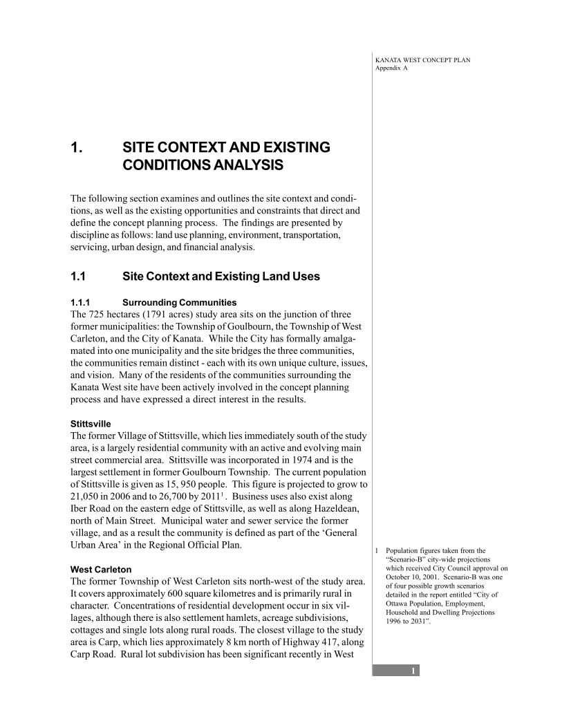
Figure 1-1 Kanata Communities Key Map
2 Malone Givens Parson Ltd. and FoTenn Consultants Inc., City of Kanata, Employment and Commercial Land Use Study, November, 1998.
KANATA WEST CONCEPT PLANAppendix A
3
The French Language Catholic School Board has two elementary schools and one combined elementary/secondary school which serve Kanata. Based on 2000 enrolment figures, these schools currently have one-third to one-quarter of their capacity remaining. In the long term, the board foresees a need for an additional elementary and secondary school in Kanata or Stittsville.
The Ottawa Carleton Catholic School Board has a total of ten elementary schools and one secondary school in Kanata and Stittsville. In the 2000 school year, six of the ten elementary schools were over the Ministry of Education enrolment capacity, three were close to 90% capacity, and the final one was at 67% capacity. The Catholic School Board is currently building a new secondary school in Kanata, which will be open in Septem-ber 2002.
Recreation Facilities There are a number of City of Ottawa recreation facilities in the Kanata and Stittsville: • a variety of arenas and community centres; • the Kanata Leisure Centre and Wave Pool; • the Kanata Recreation Complex; • the Kanata Seniors Centre; • the Ron Maslin Playhouse (Kanata); and • the Kanata Civic Art Gallery.
1.1.3 Land Uses within the Study Area Although the study area is largely undeveloped land, there are a number of existing uses within the area which have informed the concept planning process. These include:
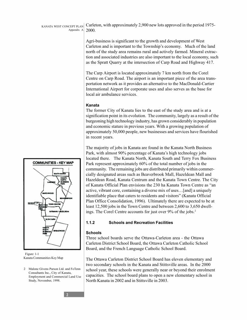
Corel Centre The Corel Centre is undoubtedly the largest landmark on the site. The 18,500-seat arena was completed in 1996 and is the home of the Ottawa Senators NHL hockey team. The 600,000 square foot arena also serves as a venue for other sport, concert, recreation, and exhibition events throughout the year and, thus functions as a major regional attraction. Within the building “ancillary facilities included restaurants, banquet and meeting rooms, Ottawa Senators merchandise store, YM-YWCA, sport medicine and physiotherapy centre and office space” (Malone Given Parsons 1999, 6). The facility hosts 110-140 events per year drawing 1.2 to 1.7 million visitors (Malone Given Parsons 1999, 6).
The Corel Centre is situated immediately adjacent to Highway 417 and has excellent visibility and access from the Highway. Both the Terry Fox Drive and Palladium/Huntmar Drive interchanges serve the Corel Centre. The facility “serves a population of 1.3 million people living within an hour’s drive. The site is located within a 30-40 minute drive from the Ottawa Macdonald-Cartier International Airport and 15-20 minutes from downtown Ottawa” (Malone Given Parsons 1999, 4).
Figure 1-2 The Corel Centre
KANATA WEST CONCEPT PLANAppendix A
4
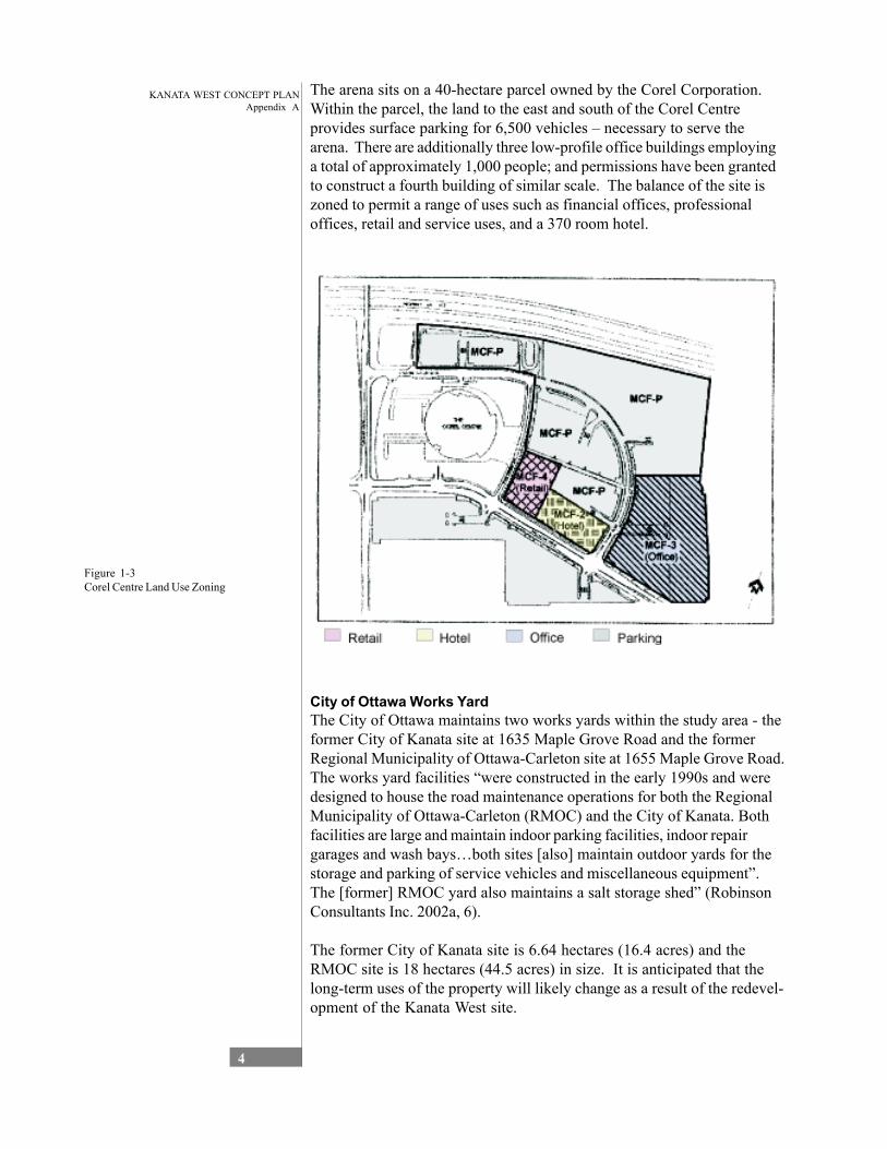
The arena sits on a 40-hectare parcel owned by the Corel Corporation. Within the parcel, the land to the east and south of the Corel Centre provides surface parking for 6,500 vehicles – necessary to serve the arena. There are additionally three low-profile office buildings employing a total of approximately 1,000 people; and permissions have been granted to construct a fourth building of similar scale. The balance of the site is zoned to permit a range of uses such as financial offices, professional offices, retail and service uses, and a 370 room hotel.
Figure 1-3 Corel Centre Land Use Zoning
City of Ottawa Works Yard The City of Ottawa maintains two works yards within the study area - the former City of Kanata site at 1635 Maple Grove Road and the former Regional Municipality of Ottawa-Carleton site at 1655 Maple Grove Road. The works yard facilities “were constructed in the early 1990s and were designed to house the road maintenance operations for both the Regional Municipality of Ottawa-Carleton (RMOC) and the City of Kanata. Both facilities are large and maintain indoor parking facilities, indoor repair garages and wash bays…both sites [also] maintain outdoor yards for the storage and parking of service vehicles and miscellaneous equipment”. The [former] RMOC yard also maintains a salt storage shed” (Robinson Consultants Inc. 2002a, 6).
The former City of Kanata site is 6.64 hectares (16.4 acres) and the RMOC site is 18 hectares (44.5 acres) in size. It is anticipated that the long-term uses of the property will likely change as a result of the redevel-opment of the Kanata West site.
KANATA WEST CONCEPT PLANAppendix A
5
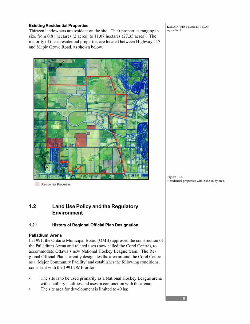
Existing Residential Properties Thirteen landowners are resident on the site. Their properties ranging in size from 0.81 hectares (2 acres) to 11.07 hectares (27.35 acres). The majority of these residential properties are located between Highway 417 and Maple Grove Road, as shown below.
Figure 1-4 Residential properties within the study area.
1.2 Land Use Policy and the Regulatory Environment
1.2.1 History of Regional Official Plan Designation
Palladium Arena In 1991, the Ontario Municipal Board (OMB) approved the construction of the Palladium Arena and related uses (now called the Corel Centre), to accommodate Ottawa’s new National Hockey League team. The Re-gional Official Plan currently designates the area around the Corel Centre as a ‘Major Community Facility’ and establishes the following conditions, consistent with the 1991 OMB order:
• The site is to be used primarily as a National Hockey League arena with ancillary facilities and uses in conjunction with the arena;
• The site area for development is limited to 40 ha;
KANATA WEST CONCEPT PLANAppendix A
6
• The major community facility is to consist of a NHL arena with a capacity of 18,500 spectators and may have such separate ancillary facilities as a hotel, office space not exceeding 12,000 square me-tres, and retail space not exceeding 5,580 square metres, and associ-ated parking; and
• The owner shall provide at no cost the required right-of-way for a future Transitway facility within the lands designated Major Commu-nity Facility.
1997 Regional Official Plan – Additional Study Policy With the completion of the Corel Centre in 1996, it was apparent that the Centre and its related infrastructure could offer significant economic opportunities. As a result, as part of the Regional Official Plan update in 1997, Policy 4.1.2.17 was incorporated which directed that a study be undertaken to investigate if and how the Corel Centre could be used as the basis for increased economic activity and employment opportunities. The resulting study, Economic Study of the Corel Centre Area (Malone Given Parsons Ltd. and Delcan 1999) was carried out in conjunction with the Townships of Goulbourn and West Carleton, the City of Kanata and the affected landowners. It was concluded that the Corel Centre should be a catalyst for increased economic activity and employment. The study found that economic development in the area should include entertainment, retail, and services in close proximity to the Centre if it was to be driven solely by the Corel Centre arena.
The recommended development option as discussed in Chapter 2, was for a high technology business park north of Highway 417, a leisure sport entertainment focus south of Highway 417 adjacent to the Corel Centre, and a business park between Maple Grove Road and Hazeldean Road.
Regional Official Plan Amendment 3 – Palladium Auto Park Applications to permit the development of an integrated 12-dealership auto-park, accessory offices, a gas bar/car wash, a farmer’s market and two restaurants were also filed in 1997 with the former Township of West Carleton. Palladium Auto Park Ltd. also applied to amend the Regional Plan in 1997 to extend both water and sanitary services to the site located west of the Corel Centre, located both within the Palladium/Highway 417 interchange and to the south of Palladium Drive.
The application to amend the Regional Official Plan to extend services to the Palladium Auto Park was approved by Regional Council on March 8, 2000. The applications to amend the local official plan and zoning by-law were also subsequently approved by the Township of West Carleton in 2000. An appeal to the OMB over servicing concerns was eventually withdrawn and ROPA 3 is now in full force and effect. Palladium Auto-Park Ltd. is currently both a participating landowner in the Kanata West Business Park concept planning process and they are also proceeding with their plans for the auto-park development.
KANATA WEST CONCEPT PLANAppendix A
7
The property is currently designated Business Park in the Regional Plan, with a site-specific policy which extends municipal services and permits the above-mentioned auto-park concept.
Applications to Amend the Corel Centre Zoning (2001) When the OMB approved the Corel Centre plans in 1991, the Corel Centre lands were designated Major Community Facility. The OMB approval aimed to allow for mixed-use development on the site and, to support this, both the Regional and Local Official Plans set specific limits for the various uses permitted on site. Site-specific by-law were assigned to various blocks within the site in accordance with the development concept envisioned at that time.
Since 1991 there have been three occasions where this site specific by-law has been amended to rearrange the land use blocks within the site. The first amendment was undertaken to improve the function of the site by moving parking closer to the arena. The second was to permit the devel-opment of office uses adjacent to Palladium Drive rather than immediately abutting Highway 417. The third amendment refined the land use blocks by increasing the office component from 12,000m2 to 26,900m2. In order to permit additional office space and not exceed the servicing capacity of the site, retail and hotel capacity were reduced. However, the general development criteria for the lands (i.e. Parking requirements, setbacks, heights etc.) and the intent to ensure mixed-use development remained the same.
1.2.2 Local Official Plans and Zoning Until a new official plan and zoning by-law is adopted for the amalgamated City of Ottawa, the official plans and by-laws of the former municipalities continue to apply. The following is a summary of the current policy and regulatory framework of these local areas as they apply to the site. The official plans and zoning bylaws described below all require amendment to conform to the approved land uses in ROPA 9 and to complete the expan-sion of this urban area.
Former Township of West Carleton The Official Plan for the former Township of West Carleton was approved in 1980 and was consolidated in 2000. The land use designations in the Plan pertinent to the study area are as follows:
• Land west of Corel Centre, south of Highway 417 are designated ‘Marginal Resource - Highway Commercial’ and reflect the ap-proved auto-park development. Permitted uses include an automo-tive campus and secondary facilities. The site is to be used primarily for automobile dealerships, with secondary facilities of up to: • 11,150 square metres of office directly related to auto
mobile sales; • 930 square metres of commercial restaurant space; and • 3,720 square metres of indoor and outdoor space for
sale of foods, crafts and other goods, which at no time
KANATA WEST CONCEPT PLANAppendix A
8
may exceed the combined indoor automobile service and sales area.
• Lands north of Highway 417 within the bounds of the Palladium Road are designated as ‘Marginal Resource’. This designation is reserved for lands of lower agricultural value. Permitted uses may include agriculture, forestry, recreational and preservation uses, square metres all-scale commercial and quasi-industrial uses that serve or are related to the rural economy, tourist commercial uses, residential uses accessory to the permitted uses, and certain non-farm residential development (including country lot residential subdivisions and severances).
• Lands north of Highway 417, within Concession I, are designated primarily ‘Agricultural Resource - High Priority’. This designation indicates that these lands are highly valued for agriculture. Uses other than farms are discourage; however, farm related severances are permitted. In order to minimize the loss of agricultural land, the creation of new lots for commercial or industrial uses is not permit-ted.
• Existing mineral aggregate operations north of Highway 417 (lots 3,4, south half of 5 – Concession II; and parts of lot 4 and 5 – Concession III) – Pits and Quarries
The lands in the former Township of West Carleton are zoned for a variety of activities, inconsistent with ROPA 9. They include RU – Rural, HC – Highway Commercial, CR (27) – Rural Commercial (limited non-residential uses), and RU (45) – Rural (limited office uses).Figure 1-5
West Carleton Official Plan Designations
KANATA WEST CONCEPT PLANAppendix A
9
Former Township of Goulbourn Lands within the study area are designated in the Official Plan for the former Township of Goulbourn as follows:
Figure 1-6 Township of Goulbourn Official Plan Schedule A Land Use Designation
• The lands located between Maple Grove Road and Hazeldean Road, along the easterly boundary of Stittsville, are designated Agricultural Resources. Permitted land uses include agriculture, limited public uses, farm severances, and limited agriculturally related uses.
• The lands located between Maple Grove Road and Hazeldean Road, in the western portion of the study area are designated Marginal Resource. Permitted land uses include agriculture, com-mercial/industrial uses related to the rural economy, country lot development, forestry, funeral homes, institutional uses, recreation and conservation, and wayside pits and quarries.
Poole Creek is identified on Schedule B1 environmental Constraints as containing a Flood Plan and Unstable Slope. The Plan also designates a proposed Minor Arterial Road along the eastern edge of Stittsville. It would extend south from Maple Grove Road to Fernbank Road, at which point it would turn to the south-west to Shea Road just north of Flewellyn Road.
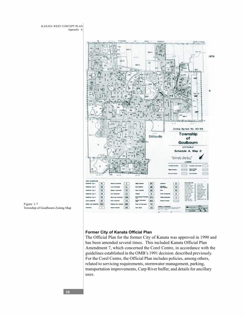
As illustrated, the zoning on the lands in the former Township of Goulbourn include RU –Rural Zone, A1 –Agricultural Zone, A1-2 – Agricultural Zone (with additional permitted use of Retail Nursery) and EPA – Envi-ronmental Protection Area.
KANATA WEST CONCEPT PLANAppendix A
10
Figure 1-7 Township of Goulbourn Zoning Map
Former City of Kanata Official Plan The Official Plan for the former City of Kanata was approved in 1990 and has been amended several times. This included Kanata Official Plan Amendment 7, which concerned the Corel Centre, in accordance with the guidelines established in the OMB’s 1991 decision described previously. For the Corel Centre, the Official Plan includes policies, among others, related to servicing requirements, stormwater management, parking, transportation improvements, Carp River buffer, and details for ancillary uses.
KANATA WEST CONCEPT PLANAppendix A
11
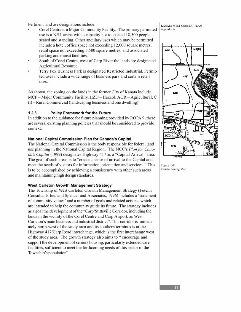
Pertinent land use designations include: • Corel Centre is a Major Community Facility. The primary permitted
use is a NHL arena with a capacity not to exceed 18,500 people seated and standing. Other ancillary uses which may be permitted include a hotel, office space not exceeding 12,000 square metres, retail space not exceeding 5,580 square metres, and associated parking and transit facilities.
• South of Corel Centre, west of Carp River the lands are designated Agricultural Resource.
• Terry Fox Business Park is designated Restricted Industrial. Permit-ted uses include a wide range of business park and certain retail uses.
As shown, the zoning on the lands in the former City of Kanata include MCF – Major Community Facility, HZD – Hazard, AGR – Agricultural, C (i) – Rural Commercial (landscaping business and one dwelling)
Figure 1-8 Kanata Zoning Map
1.2.3 Policy Framework for the Future In addition to the guidance for future planning provided by ROPA 9, there are several existing planning policies that should be considered to provide context.
National Capital Commission Plan for Canada’s Capital The National Capital Commission is the body responsible for federal land use planning in the National Capital Region. The NCC’s Plan for Cana-da’s Capital (1999) designates Highway 417 as a “Capital Arrival” area. The goal of such areas is to “create a sense of arrival to the Capital and meet the needs of visitors for information, orientation and services.” This is to be accomplished by achieving a consistency with other such areas and maintaining high design standards.
West Carleton Growth Management Strategy The Township of West Carleton Growth Management Strategy (Fotenn Consultants Inc. and Spencer and Associates, 1996) includes a ‘statement of community values’ and a number of goals and related actions, which are intended to help the community guide its future. The strategy includes as a goal the development of the “Carp/Stittsville Corridor, including the lands in the vicinity of the Corel Centre and Carp Airport, as West Carleton’s main business and industrial district”. This corridor is immedi-ately north-west of the study area and its southern terminus is at the Highway 417/Carp Road interchange, which is the first interchange west of the study area. The growth strategy also aims to “ encourage and support the development of seniors housing, particularly extended care facilities, sufficient to meet the forthcoming needs of this sector of the Township’s population”
KANATA WEST CONCEPT PLANAppendix A
12
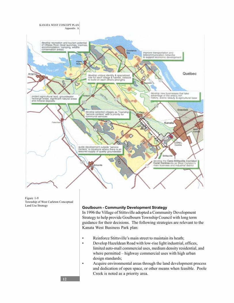
Figure 1-9 Township of West Carleton Conceptual Land Use Strategy Goulbourn - Community Development Strategy
In 1996 the Village of Stittsville adopted a Community Development Strategy to help provide Goulbourn Township Council with long term guidance for their decisions. The following strategies are relevant to the Kanata West Business Park plan:
• Reinforce Stittsville’s main street to maintain its heath; • Develop Hazeldean Road with low-rise light industrial, offices,
limited auto-mall commercial uses, medium density residential, and where permitted – highway commercial uses with high urban design standards;
• Acquire environmental areas through the land development process and dedication of open space, or other means when feasible. Poole Creek is noted as a priority area.
KANATA WEST CONCEPT PLANAppendix A
13
• Maintain a visual and spatial buffer between Kanata and Stittsville by maintaining the rural nature of these lands. Urban expansion around the Palladium can be allowed provided that a wide buffer is maintained.
• Provide a north-south link so that truck traffic can be removed from Main Street. Priorities identified include a road link from Hazeldean to the Palladium interchange (Huntmar extension), and encouraging Iber Road to be completed as a link between Abbott Street and Hazeldean Road. Additionally, leaving the option open for future permanent parkway to be constructed in the buffer zone to the east of Iber Road and/or south of Abbott Street to Shea Road.
• Development of a portion of the north-east corner of the town for employment uses be pursued, conditional upon the construction of the Huntmar link.
• The only expansion of the Stittsville boundary as indicated in the Goulbourn and Regional Official Plans be for employment in the vicinity of an extension of Huntmar Road from Maple Grove Road to Hazeldean Road.
Goulbourn – Official Plan There are a number of other policies in the Goulbourn Official Plan which are also relevant to the Kanata West development. These include state-ments that: • The design of new residential developments will respect the char-
acter of adjacent neighbourhoods and the natural environment; • Infilling of vacant land within Stittsville, Richmond, Munster, and
Ashton should be encouraged and that a compatible transition between existing and new residential areas and buildings shall be required;
• Housing policies should strive to ensure the provision of a full range of housing types, in particular in Stittsville. This should include medium/high density housing along main street and mixed density development in new plans of subdivision;
• A minimum of 25% of all new housing produced each year shall meet the definition of affordable housing as established by the Region (Policy 5.3.1 d).
Kanata Town Centre Policy The policy for the Kanata Town Centre area is addressed in the Regional Official Plan and in the former City of Kanata’s Official Plan. The Town Centre is considered an urban community with its own development concept policies and it is recognised that the vision may take 20-40 years to be achieved. Uses in Kanata Town Centre include:
Main Street Main Street is to be predominantly ground floor retail, service commercial, government, entertainment and cultural use, with upper floor employment, residential uses and a civic square. About 4,600 square metres of gross leasable area is anticipated on Main Street with specialty commercial development (i.e., baked goods, clothing, etc.) encouraged. This area is
KANATA WEST CONCEPT PLANAppendix A
14
intended to compliment the general retail uses of the Regional Shopping Centre, with particular attention to be paid to high quality built form.
Central Business District This designation applies to land in central part of the Town Centre which is intended to provide the primary employment, civic and cultural focus for Kanata, complemented by higher density residential uses. Eventually intend to achieve a floor space index of at least 1.5, and a job target of 10,000. Uses include office, light manufacturing (i.e., high technology), other employment typical of CBDs, and hotels and commercial uses to serve the business community. Higher density (65-100 units per net ha) or medium density (50-65 up net ha) ids permitted, if included in a mixed-use development
Regional Shopping Centre Over the long term, this area will be developed for a regional scale shop-ping area of at least 35,000 square metres of gross leasable area. The uses will be integrated with the westerly transitway station proposed for the site. The westerly half of this site can be developed partly for com-munity commercial, and partly as larger independent stores serving the automobile travelling public. Policies limiting community commercial have been included to help ensure the viability of the regional shopping centre. A full range of retail stores, restaurants, clinics, banks, places of entertain-ment, hotel, convention centre, institutional and limited office development. Total eventual development may be in the range of 125,000 square me-tres.
Town Centre Residential Applies to lands in the north-east, south-east and south-west portions of the Town Centre Community. Medium density housing (rows, stacked townhouses, apartments, etc.), limited small lot singles, institutional and other uses which support the primary uses is to be encouraged in this area. Neighbourhood shopping facilities totalling up to about 500 square metres of gross leasable area north of Highway 417, which support the primary uses is also encouraged.
Low Density Employment Area The Low Density Employment Area is to consist of low-rise buildings with office, light industrial, and retail uses, with retail limited to 10,000 square metres of gross leasable area.
Neigbourhood Service Community services, offices, or similar employment opportunities an ancillary retail uses not exceeding 1,500 square metres GLA. To be developed in a mixed use form which combines residential/business or commercial/business in an integrated form. Mixed use node at the eastern transitway link.
KANATA WEST CONCEPT PLANAppendix A
15
Region of Ottawa Carleton Official Plan In addition to the specific policies in the Region of Ottawa Carleton Offi-cial Plan for the Corel Centre lands, there are a number of general policies that must be considered in future plans. Overall, the policies of the RMOC have been considered as part of the ROPA 9 process; however, this section provides further clarification on additional policies.
Major Community Facility The Plan acknowledges that the Corel Centre is designated as a Major Community Facility on Schedule A - Rural Policy Plan. These are the sites for a range of significant users, including major sports, recreation and cultural activities. Major Community Facilities are to be located close to major roads and public transit. The previously discussed site-specific policy for the Corel Centre is found within Section 3.5 of the Regional Plan on major community facilities.
Employment Centres Employment Centres include lands designated at select rapid transit sta-tions. The Plan foresees that these Centres have the potential to become over time, mixed-use at relatively high densities and serve as focal points in the communities. The Official Plan established policies to ensure employ-ment centres are accessible for walking, cycling and transit service. The higher density employment uses are to be close to transit service.
Job/Housing Ratios Section 4.2.1 Employment Objectives, establishes a target of 1.1 jobs per household in each urban area outside the central area. Kanata and Stittsville are considered one economic unit in the Regional Plan for the calculation of the jobs/housing ratio.
Urban Design and Entry /Scenic Routes ROPA 9 extends the Highway 417 Entry Route designation to within the study area. Entry Routes are the principal roads used by visitors and business travelers arriving to Ottawa-Carleton. It is intended that these routes provide visitors with a favourable impression of Ottawa, through such means as providing amenities, information and directional signs, appropriate mitigation measures.
Limestone Resource Area The Plan designates an area to the north-west of the study area as Lime-stone Resource. The intent of the policies for Limestone Resource areas is to preserve a non-renewable resource for future generations in close proximity to the local market place. Development on land within 450 metres of a Limestone Resource Area must ensure that “the opportunity to extract aggregates will not be restricted by the proposed development.”
KANATA WEST CONCEPT PLANAppendix A
16
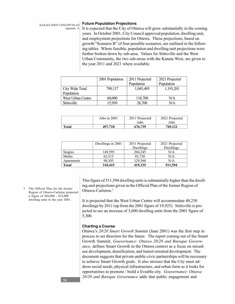
Future Population Projections It is expected that the City of Ottawa will grow substantially in the coming years. In October 2001, City Council approved population, dwelling unit, and employment projections for Ottawa. These projections, based on growth “Scenario B” of four possible scenarios, are outlined in the follow-ing tables. Where feasible, population and dwelling unit projections were further broken down by sub-area. Values for Stittsville and the West Urban Community, the two sub-areas with the Kanata West, are given to the year 2011 and 2021 where available.
2001 Population 2011 Projected Population
2021 Projected Population
City Wide Total 790,137 1,045,405 1,193,201 Population West Urban Centre 60,000 118,700 N/A Stittsville 15,950 26,700 N/A
Jobs in 2001 2011 Projected Jobs
2021 Projected Jobs
Total 497,718 676,739 749,121
Dwellings in 2001 2011 Projected Dwellings
2021 Projected Dwellings
Singles 149,595 204,245 N/A Multis 62,515 85,730 N/A Apartments 98,305 129,360 N/A Total 310,415 419,335 511,594
This figure of 511,594 dwelling units is substantially higher than the dwell-ing unit projections given in the Official Plan of the former Region of Ottawa-Carleton.3
It is projected that the West Urban Centre will accommodate 40,250 dwellings by 2011 (up from the 2001 figure of 19,925). Stittsville is pro-jected to see an increase of 3,600 dwelling units from the 2001 figure of 5,300.
Charting a Course Ottawa’s 20/20 Smart Growth Summit (June 2001) was the first step in process to set direction for the future. The report coming out of the Smart Growth Summit, Gouvernance: Ottawa 20/20 and Baroque Govern-ance, defines Smart Growth in the Ottawa context as a focus on mixed-use development, densification, and transit oriented development. The document suggests that private-public-civic partnerships will be necessary to achieve Smart Growth goals. It also stresses that the City must ad-dress social needs, physical infrastructure, and urban form as it looks for opportunities to promote / build a liveable city. Gouvernance: Ottawa 20/20 and Baroque Governance adds that public engagement and
3 The Official Plan for the former Region of Ottawa-Carleton projected a figure of 420,000 - 432,000 dwelling units to the year 2001.
KANATA WEST CONCEPT PLANAppendix A
17
ongoing monitoring of progress towards smart growth goals will be essen-tial.
Gouvernance: Ottawa 20/20 and Baroque Governance led to the development of Charting a Course; a document which sets the frame-work for the development of Ottawa’s new Official Plan and the growth plans that will be the basis for decision making. Charting a Course sets principles to guide decisions, identifies possible (targets / standards), and suggests tools the City may use to achieve positive change. The document suggests that City growth should move forward based on the principles of Equilibrium, Diversity, Accessibility, and Sustainability.
The principle of Equilibrium suggests that “Ottawa’s policies and programs will promote and achieve a positive balance of wealth, equity, environment, health, and endeavour. Charting a Course states that Ottawa should “promote and preserve diversity to create a social, economic, and natural environment with the highest potential for productivity”. The principle of Accessibility is explained by the statement “Ottawa will preserve and protect the integrity of its communities, ensure universal access to services, and work to narrow gaps in wealth, health, and opportunity”. The final principle, Sustainability suggests that Ottawa should be planned, developed and managed to minimize environmental impact and that the integrity of the natural environment should be preserved, protected, and restored. These principles suggest how the City can manage change and growth while ensuring and enhancing liveability.
1.2.4 Best Practices In land use planning, much can be learned from sharing experiences between cities, although transferring lessons can be more difficult due to the variety of legal and cultural issues on which planning systems are based. Nevertheless, the following principles represent some of the best practices from the land use planning perspective:
• New developments should seek to replicate the vitality of mixed-use urban living conditions. This can be achieved by a variety of meth-ods: • formal methods (the precise allocation of land and
building); • flexible methods (to allow mixed use and change of use
within an area subject to environmental impact); and • a blended approach of the above.
• Density should be increased around points of high accessibility, especially near public transportation.
• The mobility needs of businesses should be matched with the acces-sibility needs of the location. In other words, a business with high worker/visitor intensity should be guided to locations with high accessibility.
• While a compact development form has many advantages, the plan must also integrate open space and environmental features, and provide for a diversity of land use opportunities.
KANATA WEST CONCEPT PLANAppendix A
18
• Priority should be placed on the environment in the early stages of the concept plan. Natural features should provide the framework within which the development is set and stormwater management facilities should be integrated into the natural setting.
• Open space should play a variety of roles - social (in terms of meeting places, and areas for entertainment, recreation, and relaxa-tion), amenity (contribution to quality of life) and ecological.
• Clear urban design guidelines for buildings and public spaces area essential to ensuring integrated, human scale, pedestrian friendly development.
• While a clear planning framework is important to influence action, zoning by-laws need to be flexible (e.g. flexible range of uses, focus on development control within the framework of clear guidelines) to be able to respond to the complexity of mixed-use schemes.
• There is the need to integrate land use, transportation, and servicing decisions so that one does not drive the other.
1.3 Environmental Analysis
1.3.1 Introduction The following environmental analysis summaries of two reports prepared for Robinson Consultants Inc. The first is entitled ‘Terrestrial Natural Environment Assessment: Kanata West Concept Plan Area’, by Daniel Brunton Consulting Services, December 2001; and the second is entitled Aquatic Environmental Study – Kanata West Concept Plan’ by Beak International Incorporated, January 20023 .
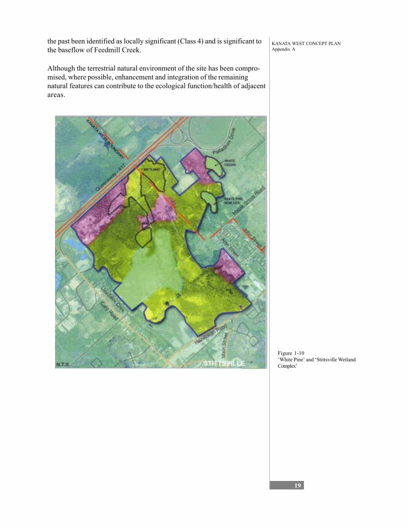
1.3.2 The Terrestrial Natural Environment Due to a long history of human activity, relatively little natural environment habitat and ecological diversity remain with the study area. At the same time, much of the natural/ near-natural habitat that does remain has been fragmented and/ or degraded. However, as also identified in the above-noted Terrestrial Natural Environment Assessment report, there are significant site features that should be considered in development planning. Three of these feature areas and the issues associated with each are identified as:
• the “maintenance and protection of the locally significant White Pine grove and the large Eastern Hemlock tree in the south end of the study [which] would provide valuable aesthetic and landscaping assets to the community”;
• the “existing and potential wildlife corridor values along Poole, Feedmill and Hazeldean Creeks and their contribution to the mainte-nance of ecological values in the Carp River”; and
• the “potential contributions and support for documented off-site natural features such as downstream Carp River features and functions and fisheries values” (Brunton 2001, 12-13).
Additionally, south of the Queensway the Stittsville Wetland Complex extends to the west and southwest of the study area. This wetland has in
KANATA WEST CONCEPT PLANAppendix A
19
the past been identified as locally significant (Class 4) and is significant to the baseflow of Feedmill Creek.
Although the terrestrial natural environment of the site has been compro-mised, where possible, enhancement and integration of the remaining natural features can contribute to the ecological function/health of adjacent areas.
Figure 1-10 ‘White Pine’ and ‘Stittsville Wetland Complex’
KANATA WEST CONCEPT PLANAppendix A
20
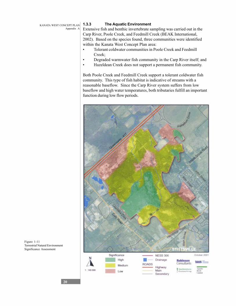
1.3.3 The Aquatic Environment Extensive fish and benthic invertebrate sampling was carried out in the Carp River, Poole Creek, and Feedmill Creek (BEAK International, 2002). Based on the species found, three communities were identified within the Kanata West Concept Plan area: • Tolerant coldwater communities in Poole Creek and Feedmill
Creek; • Degraded warmwater fish community in the Carp River itself; and • Hazeldean Creek does not support a permanent fish community.
Both Poole Creek and Feedmill Creek support a tolerant coldwater fish community. This type of fish habitat is indicative of streams with a reasonable baseflow. Since the Carp River system suffers from low baseflow and high water temperatures, both tributaries fulfill an important function during low flow periods.
Figure 1-11 Terrestrial Natural Environment Significance Assessment

KANATA WEST CONCEPT PLANAppendix A
21
1.3.4 Floodplains The Carp River, Poole Creek, and Feedmill Creek have regulated floodplains that are under the jurisdiction of Mississippi Valley Conserva-tion. The Feedmill Creek Floodplain extends from Highway 417 up-stream and does not have a significant impact on the Kanata West Concept Plan area.
The Carp River floodplain is shallow and wide. The banks are stable. Through the study area, the Carp River floodplain varies in width from less than 100 m to approximately 500 m. Poole Creek has a well-defined valley with a relatively narrow floodplain. Downstream of Hazeldean Road, the existing Poole Creek floodplain is between 50 and 75 m in width.
Although Feedmill Creek does not have a regulatory floodplain down-stream of Highway 417, the watercourse is, like Poole Creek, in a well-defined valley. The valley is relatively deep, especially in the vicinity of Huntmar Road. It is expected that minimum setbacks from Feedmill Creek will be determined on the basis of slope stability and recreational requirements, rather than floodplain considerations.
Beyond the floodline, the fill line marks the extent of the area that is regulated by Mississippi Valley Conservation Authority. The minimum fill line setback is 15 m. Along Poole Creek and the Carp River, the fill line setback varies from 15 m to approximately 65 m.
Current regulations do not recognize the so-called two-zone concept (floodway and floodfringe). It is expected that a two-zone policy for the reach of the Carp River between Glen Cairn and Richardson Side Road will be recommended as part of the Carp River Watershed/Subwatershed Study.
1.3.5 Significance of Environmental Features Fundamental to the protection and enhancement of the aquatic environ-ments is the maintenance of stream corridors of the Poole Creek, Feedmill Creek, and Carp River watercourse and the minimization of any diversion of drainage from one watercourse to another. Primary en-hancement opportunities relate to naturalization of the river corridors, protection of recharge areas, nutrient management, base flow augmenta-tion and maintaining linkages between tableland features and these aquatic corridors. Another key opportunity is the enhancement of the Carp floodplain as a natural and recreational corridor. There are also significant opportunities to capitalize on the growing interest in nature appreciation, environmental awareness and environmental stewardship through such things as a nature interpretive center, an urban fishing program, recreational trail and interpretive signage.
Existing ecological features are focused in the following areas:
KANATA WEST CONCEPT PLANAppendix A
22
NESS 306 (Within Study Area) This complex of young to sub-mature White Cedar swamp forest, and low upland coniferous forest of White Cedar and White Spruce and young, low deciduous forest of Trembling Aspen and White Birch dominate the woodland area north of Maple Grove Road west of the Corel Centre. This largely represents regenerating agricultural land. A small area of largely natural forest within this woodland is highlighted by a grove of sub-mature White Pine and a single ancient, < 1 m dbh Eastern Hemlock in the southern portion of this area. No regionally significant features are known.
Feedmill Creek Ravine This narrow woodland cover along the slopes of Feedmill Creek, north and west of Huntmar Road, offers potentially natural deciduous forest domi-nated ravine vegetation. The edge effect along either edge of the wood-land is expected to be significant
Poole Creek Ravine This area consists of remnant natural scrub and trees areas along the creek ravine north of Hazeldean Road and offers little natural habitat representation, but has the potential for both terrestrial and aquatic wildlife corridor functions within the study area
Carp River Floodplain Even more than the Poole Creek corridor, the riverside vegetation of Carp River corridor offers limited natural habitat, but is know to provide both terrestrial and aquatic wildlife corridor functions within the study area.
Poole Creek / Feedmill Creek This cold water fish community represents one of the last cold water fisheries in the Ottawa area. Both creeks are significant contributors to the baseflow of the Carp River. The creeks exhibit sufficient pool-riffle morphology to support cold water fish communities, although ongoing sedimentation in the Carp River is affecting the lower reaches of both creeks.
Fundamental to the protection and enhancement of the aquatic environ-ments is the maintenance of stream corridors of the Poole Creek, Feedmill Creek, and Carp River watercourse and the minimization of any diversion of drainage from one watercourse to another. Primary enhancement opportunities relate to naturalization of the river corridors, protection of recharge areas, nutrient management, base flow augmentation and main-taining linkages between tableland features and these aquatic corridors.
1.3.6 Phase 1: Environmental Site Assessment A Phase I Environmental Assessment (ESA) was conducted by Robinson Consultants Inc. to identify the potential for soil, surface water and/or groundwater contamination within the study area . The Phase I ESA included site reconnaissance visits, a review of federal, provincial and municipal records, a review of historical records, and interviews with former Regional Municipality of Ottawa-Carleton and City of Kanata
KANATA WEST CONCEPT PLANAppendix A
23
Staff. The ESA did not reveal any evidence of potential recognised environmental conditions pertaining to the study area except as follows:
• The areas located on the north side of Highway 417 that have variable amounts of fill.
• The property identified as site number 72, located on the north side of Maple Grove Road just east of Poole Creek. This property has been identified as being used for equipment and vehicle storage.
• The former Regional Municipality of Ottawa-Carleton Garage (site number 66) located on Maple Grove Road. This site has been observed to have several oil stains throughout the building and a salt storage facility on site. In addition, there are underground fuel storage tanks that are used to supply both the “Regional Fleet” and the former City of Kanata fleet. There is a large septic system that services the facility.
• The former City of Kanata works garage (site number 70), which is located on Maple Grove Road immediately east of the former Regional Garage. This site also exhibits the presence of oil stains throughout the facility. In addition, much of the eastern portion of the outside grounds is not paved. These areas are used for the outdoor storage of chemicals and other debris. The former Kanata Site also has a large septic system.
• The area behind both the former Regional Yard and the former City of Kanata Yard has been used for snow disposal.
The ESA revealed some evidence of potential environmental concerns and recommended the following actions: • If development is planned on the north side of highway 417 on those
properties that have been used to accommodate fill material, consid-eration should be given to undertake a limited sampling program of the fill material. The material should be visually investigated and analysed for “MOE decommissioning inorganic chemical param-eters”.
• In order to determine the presence of any impact beneath the floor slab of the respective “Works Yards” a program of coring and sampling of the material beneath documented area of oil spillage is recommended (selected areas in the garage and oil storage rooms). Chemical testing should include the analysis of Total Petroleum Hydrocarbons (TPH), oil and grease, Benzene, Toluene, Ethylbenzene and Xylene.
• In the event that the “Works Yards” will be connected to municipal services or decommissioned, the septic systems should similarly be decommissioned.
KANATA WEST CONCEPT PLANAppendix A
24
• Investigate by test pits or coring the subsurface conditions of the outside areas of both the “Works Yards”. Chemical testing should include the analysis of Total Petroleum Hydrocarbons (TPH), oil and grease, Benzene, Toluene, Ethylbenzene and Xylene and decommissioning metals.
• Investigate by test pits or coring the subsurface conditions of the area used for snow disposal along the Carp River. Chemical testing should include the analysis of Total Petroleum Hydrocarbons (TPH), oil and grease, and decommissioning metals.
• Investigate by test pits or coring the subsurface conditions of the property east of Poole Creek and the two garages. Chemical testing should include the analysis of Total Petroleum Hydrocarbons (TPH), oil and grease, Benzene, Toluene, Ethylbenzene and Xylene and decommissioning metals.
1.4 Transportation Analysis The following section reviews the transportation-related opportunities and constraints associated with the development of the Kanata West area. The findings were prepared based on a review of related transportation and planning reports, a review of current traffic data, meetings with City of Ottawa staff, a series of site visits, and a review of literature detailing “best-practices”. The information is presented in three sections. These are:
• Section 3.4.1Area Roads - The opportunities and constraints associ-ated with the area roads are presented in terms of existing condi-tions on key road segments and intersections, followed by a concise review of proposed road widenings and extensions as indicated in the City’s Official Plan and Transportation Master Plan, and as described by City staff;
• Section 3.4.2 Transit Overview - A transit overview is provided in terms of key points required for development of an effective public transit strategy; and
• Section 3.4.3 Transportation-Related Best Practices - A framework for transportation best practices is identified that incorporates elements of scope (land use, transportation system, or travel de-mand management) and scale (area level or site level).
1.4.1 Existing and Planned Study Area Transportation Facilities
Study Area The following roads define the approximate study area for purposes of the transportation overview. This general study area, as illustrated in Figure 3-12, was confirmed with City Staff at the project’s commencement.
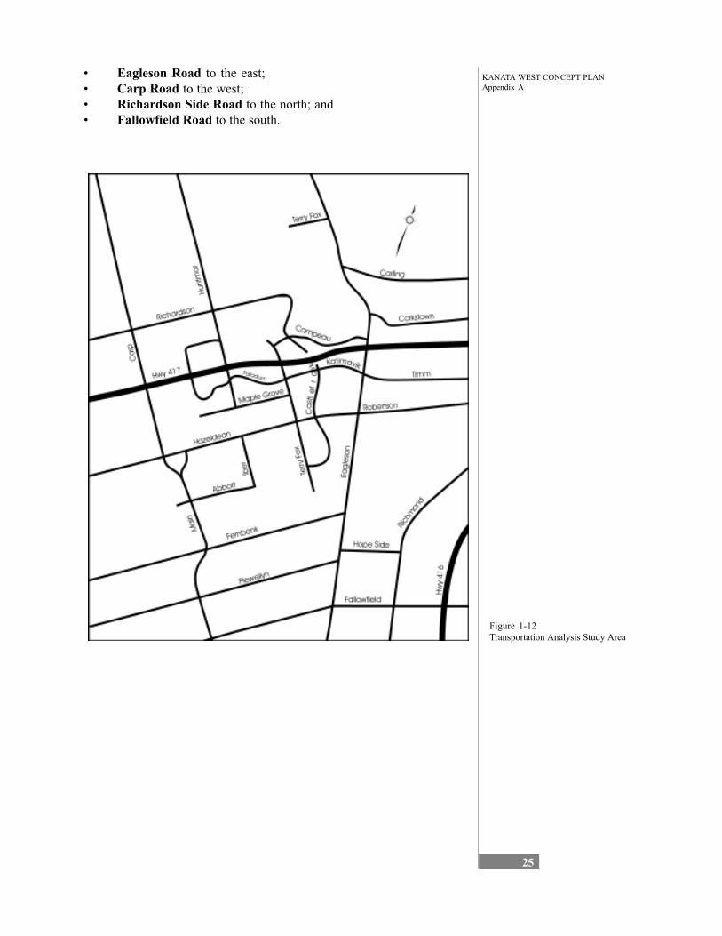
KANATA WEST CONCEPT PLANAppendix A
25
• Eagleson Road to the east; • Carp Road to the west; • Richardson Side Road to the north; and • Fallowfield Road to the south.
Figure 1-12 Transportation Analysis Study Area
KANATA WEST CONCEPT PLANAppendix A
26
Existing Roads The key road network elements that currently exist within the study area are summarised in Table 1-1.
Road Description Richardson Side Road
2-lane east-west rural road that runs to the north edge of the study area, connecting Carp Road to Castlefrank Road
Highway 417 4-lane east-west freeway through the study area Palladium Drive 4-lane urban road that connects Highway 417/Palladium Drive interchange
with Terry Fox Drive Maple Grove Road 2-lane east-west rural road that connects north Stittsville (John Street) with
Terry Fox Drive Hazeldean Road 2-lane east-west arterial that runs along the south edge of the site,
transitioning to a 4-lane urban road east of Terry Fox Drive Huntmar Drive 2-lane north-south rural road extending from Maple Grove Road northerly to
Richardson Side Road Terry Fox Drive 2-lane north-south urban arterial (some 4-lane sections) through the study
area, including an interchange with Highway 417.
Table 1-1 Existing Study Area Roads A more comprehensive description of the existing road network, including
proposed road widenings and extensions, is presented in Table 1-5.
Based on traffic volume data collected on Highway 417 east of Eagleson Road, the current peak direction of commuter flow is eastbound (towards downtown Ottawa) during the AM period, and westbound (from down-town Ottawa) during the PM period. However, peak hour traffic vol-umes in the peak direction (approximately 3800 veh/h) are only marginally higher than those in the non-peak direction (3500 veh/h) at this location. On and off-ramp traffic volumes during the AM and PM peak hours are highest at the Eagleson Road interchange (1300 to 2300 veh/h), followed by the Terry Fox Drive interchange (700 to 900 veh/h) and then Palla-dium Drive interchange (50 to 150 veh/h).
Existing Intersections A preliminary analysis of intersection performance indicated that the majority of the signalized intersections within the study area currently operate acceptably. This analysis can be considered slightly optimistic in that it does not explicitly account for the effects of localized intersection improvements that do not extend downstream. The poorest level-of-service (LoS) noted is at the intersection of March Road (northern extension of Eagleson Road) with Campeau Drive (western extension of Highway 417 westbound off-ramp), which is currently over capacity (volume to capacity ratio of 1.06) during the PM peak period. The level-of-service results for each peak hour are presented in Table 1-2.
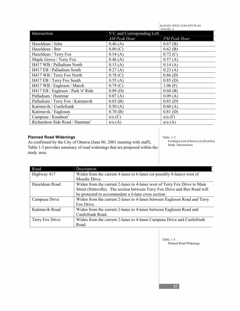
KANATA WEST CONCEPT PLANAppendix A
27
Intersection V/C and Corresponding LoS AM Peak Hour PM Peak Hour
Hazeldean / John 0.46 (A) 0.67 (B) Hazeldean / Iber 0.80 (C) 0.62 (B) Hazeldean / Terry Fox 0.54 (A) 0.72 (C) Maple Grove / Terry Fox 0.46 (A) 0.57 (A) H417 WB / Palladium North 0.15 (A) 0.14 (A) H417 EB / Palladium South 0.27 (A) 0.23 (A) H417 WB / Terry Fox North 0.78 (C) 0.86 (D) H417 EB / Terry Fox South 0.55 (A) 0.85 (D) H417 WB / Eagleson / March 0.79 (C) 1.06 (F) H417 EB / Eagleson / Park 'n' Ride 0.89 (D) 0.68 (B) Palladium / Huntmar 0.07 (A) 0.09 (A) Palladium / Terry Fox / Katimavik 0.65 (B) 0.85 (D) Katimavik / Castlefrank 0.50 (A) 0.60 (A) Katimavik / Eagleson 0.70 (B) 0.81 (D)
1Campeau / Knudson n/a (C) n/a (F) Richardson Side Road / Huntmar1 n/a (A) n/a (A)
Table 1-2 Existing Level of Service (LoS) at Key Study Intersections
Planned Road Widenings As confirmed by the City of Ottawa (June 06, 2001 meeting with staff), Table 1-3 provides summary of road widenings that are proposed within the study area.
Road Description Highway 417 Widen from the current 4-lanes to 6-lanes (or possibly 8-lanes) west of
Moodie Drive. Hazeldean Road Widen from the current 2-lanes to 4-lanes west of Terry Fox Drive to Main
Street (Stittsville). The section between Terry Fox Drive and Iber Road will be protected to accommodate a 6-lane cross section.
Campeau Drive Widen from the current 2-lanes to 4-lanes between Eagleson Road and Terry Fox Drive.
Katimavik Road Widen from the current 2-lanes to 4-lanes between Eagleson Road and Castlefrank Road.
Terry Fox Drive Widen from the current 2-lanes to 4-lanes Campeau Drive and Castlefrank Road.
Table 1-3 Planned Road Widenings
KANATA WEST CONCEPT PLANAppendix A
28
Planned Road Extensions As confirmed by the City of Ottawa, Table 1-4 provides summary of road extensions that are being considered within the study area, which would impact road capacity and travel patterns.
Road Description
Huntmar Road Extend southerly to Hazeldean Road to connect to Iber Road. Palladium Drive Extend southerly to Maple Grove Road or beyond as a new north-south
arterial. Campeau Drive Extend westerly to Huntmar Road. Castlefrank Road Provide bridge crossing of Highway 417 and a partial interchange that would
accommodate westbound off- and eastbound on-movements to the freeway. Terry Fox Drive Extend southerly from Castlefrank Road to Eagleson Road. Via Hope Side
Road it could then interchange with Highway 416. Extend northerly from Campeau Drive to March Road.
Outer Ring Road Conceptual road around suburban Ottawa linking Highway 417 in the east with Highway 416 / Highway 417 / Highway 7 in the west.
Stittsville Bypass Conceptual road link around the Village of Stittsville, which could also be the above-noted north-south arterial.
Table 1-4 Planned Road Extensions
Summary of Planned Transportation Infrastructure Certain road widenings/extensions have been identified in the Transporta-tion Master Plan (TMP) to accommodate traffic increases related to future “committed” growth within the urban envelope. In the western portion of the City, these include:
• Widening of Highway 417 to 6-lanes; • Castlefrank Road crossing of Highway 417 and a partial inter-
change; • Widening of Hazeldean Road to 4-lanes; • Extension and widening of Terry Fox Drive to 4-lanes; • Widening of Campeau Drive to 4-lanes; and • Widening of Katimavik Road to 4-lanes.
Should the proposed development within Kanata West generate traffic that requires additional road capacity beyond that required to service the above-noted “committed” growth, there is still opportunity to improve the road infrastructure. These additional opportunities include:
• Extension of Campeau Drive west to Huntmar Road; • Extension of Huntmar Road south to Hazeldean Road; • Extension of Palladium Drive south to Maple Grove Road and/or
Hazeldean Road as a new north-south arterial; • Widening of Hazeldean Road to 6-lanes; and • Widening of Highway 417 to 8-lanes.

KANATA WEST CONCEPT PLANAppendix A
29
It is important to note that much of the transportation infrastructure planned for in the western portion of the City is intended to accommodate the peak direction traffic generated (AM eastbound and PM westbound) by both residential and employment land uses. As the majority of planned development in the Kanata West area is employment-based, it will gener-ate traffic predominantly in the off-peak direction. This is a key point, as there is generally surplus road capacity in the off-peak direction. This condition will tend to reduce the new transportation infrastructure required to accommodate growth within the Kanata West area.
KANATA WEST CONCEPT PLANAppendix A
30
Roa
d N
ame
and
Sect
ion
Cla
ssifi
catio
n Ex
istin
g C
ondi
tions
Pr
op
Num
La
neN
umbe
r of
Lane
s Sp
eed
Lim
it (k
m/h
) Si
dew
alk
Bic
ycle
Lan
e Tr
ansi
t
Cam
peau
Driv
e T e
rry
Fox
Driv
e to
Hun
tmar
Roa
d PR
OPO
SED
N
/A
N/A
N
/A
N/A
N
/A
4 Te
rry
Fox
Driv
e to
Mar
ch R
oad
Pave
d, u
rban
cro
ss-s
ectio
n 2
60
Nor
th si
de
Nor
th a
nd so
uth
side
s Pe
ak ro
ute
65;
Reg
ular
rout
e 16
2
4
Haz
elde
an R
oad
Mai
n St
reet
to
Iber
Roa
d Pa
ved,
rura
l cro
ss-s
ectio
n 2
70 –
80
Non
e N
one
Peak
rout
es 2
02,
203
and
205
(AM
Inbo
und
/ PM
Out
boun
d)
4
Iber
Roa
d to
Ter
ry F
ox D
rive
Pave
d, ru
ral c
ross
-sec
tion
2 70
– 8
0 N
one
Non
e Pe
ak ro
utes
202
, 20
3 an
d 20
5 (A
M In
boun
d /
PM O
utbo
und)
6
Hig
hway
417
Ea
gles
on R
oad
to H
wy7
/17
Split
Pa
ved
freew
ay, r
ural
cro
ss-
sect
ion
4 10
0 N
/A
N/A
N
one
6 or
8
Kat
imav
ik R
oad
Terr
y Fo
x D
rive
to C
astle
frank
Roa
d Pa
ved,
urb
an c
ross
-sec
tion
2 40
- 50
N
orth
/sou
th si
de
Non
e Pe
ak ro
utes
63,
64
, 167
and
169
R
egul
ar ro
utes
11
8, 1
62, 9
7 an
d 16
0
2
Cas
tlefra
nk R
oad
to E
agle
son
Roa
d Pa
ved,
urb
an c
ross
-sec
tion
2 40
- 50
N
orth
/sou
th si
de
Non
e 4
Table 1-5 Summary of Existing Conditions by Road Segment
KANATA WEST CONCEPT PLANAppendix A
31
Roa
d N
ame
and
Sect
ion
Cla
ssifi
catio
nEx
istin
g C
ondi
tions
Num
ber o
fLa
nes
Spee
dLi
mit
(km
/h)
Side
wal
kB
icyc
le L
ane
Tran
sit
Prop
Nu m
Lan e
Table 1-5Summary of Existing Conditions by RoadSegment (continued)
Map
le G
rove
Roa
d Jo
hn S
treet
to H
untm
ar R
oad
Pave
d, ru
ral c
ross
-sec
tion
2 60
N
one
Non
e N
one
2 H
untm
ar R
oad
to T
erry
Fox
Driv
e Pa
ved,
rura
l cro
ss-s
ectio
n 2
50
Non
e N
one
Non
e 4
Palla
dium
Driv
e H
untm
ar R
oad
to H
wy
417
(nor
th)
Pave
d, ru
ral c
ross
-sec
tion
2 50
N
one
Non
e N
one
4 H
wy
417
to H
untm
ar R
oad
(sou
th)
Pave
d, ru
ral c
ross
-sec
tion
4 50
N
one
Non
e N
one
4 H
untm
ar R
oad
to T
erry
Fox
Driv
e Pa
ved,
urb
an c
ross
-sec
tion
4 50
N
orth
side
N
one
Non
e 4
Ric
hard
son
Side
Roa
d C
arp
Roa
d to
Ter
ry F
ox D
rive
Pave
d, ru
ral c
ross
-sec
tion
2 60
N
one
Non
e N
one
2 C
astle
frank
Roa
d Te
rry
Fox
Driv
e to
Kat
imav
ik R
oad
Pave
d, u
rban
cro
ss se
ctio
n 4
40
Rec
reat
ion
path
on
ly
Non
e Pe
ak ro
ute
65
Re g
ular
rout
e 16
2
4
Kat
imav
ik R
oad
t o C
ampe
au D
rive
(bri d
g e c
ross
ing
o f H
wy
417,
incl
udin
g pa
rt ial
inte
rcha
nge )
PRO
POSE
D
N/A
N
/A
N/A
N
/A
N/A
4
Hun
tmar
Roa
d R
icha
rdso
n Si
de R
oad
to P
alla
dium
Driv
e N
orth
U
npav
ed, r
ural
cro
ss-s
ectio
n 2
70
Non
e N
one
Non
e 4
Palla
dium
Driv
e N
orth
to P
alla
dium
Driv
e So
uth
Pave
d, ru
ral c
ross
-sec
tion
2-4
50
Non
e N
one
Non
e 4
Palla
dium
Driv
e So
uth
to M
aple
Gro
ve
Roa
d Pa
ved,
rura
l cro
ss-s
ectio
n 2
70
Non
e N
one
Non
e 4
KANATA WEST CONCEPT PLANAppendix A
32
Roa
d N
ame
and
Sect
ion
Cla
ssifi
catio
nEx
istin
g C
ondi
tions
Num
ber o
fLa
nes
Spee
dLi
mit
(km
/h)
Side
wal
kB
icyc
le L
ane
Tran
sit
Prop
Nu m
Lan e
Hun
tmar
Roa
d (c
on’t)
Map
le G
rove
Roa
d to
Haz
elde
an R
oad
PRO
POSE
D
N/A
N
/A
N/A
N
/A
N/A
4
Haz
elde
an R
oad
to F
lew
elly
n R
oad
(cur
rent
ly Ib
er R
oad)
PR
OPO
SED
N
/A
N/A
N
/A
N/A
N
/A
2 or
4
John
Stre
et
Map
le G
rove
Roa
d to
Haz
elde
an R
oad
Pave
d, ru
ral c
ross
-sec
tion
2 40
W
est s
ide
(sou
th
end
only
) N
one
Non
e 2
Terr
y Fo
x D
rive
Mar
ch R
oad
to C
ampe
au D
rive
PRO
POSE
D
2 N
/A
N/A
N
/A
N/A
4
Cam
peau
Driv
e to
Map
le G
rove
Roa
d Pa
ved,
urb
an c
ross
-sec
tion
4 (2
lane
s acr
oss
Hw
y 41
7)
70
Non
e N
one
Peak
rout
e 63
R
e gul
ar ro
utes
11
8 an
d 16
2
4
Map
le G
rove
Roa
d to
Haz
elde
an R
oad
Pave
d, ru
ral c
ross
-sec
tion
2 70
N
one
Non
e R
egul
ar ro
ute
118
4
Haz
elde
an R
oad
to E
agle
son/
Hop
e Si
de
Roa
d Pa
ved,
urb
an c
ross
-sec
tion
2 60
Ea
st sid
e N
one
Reg
ular
rout
e 16
2 4
Rap
id T
rans
it Ex
tens
ion
o f th
e e x
isti n
g T o
wn
Ce n
tre
rapi
d tr a
nsi t
corr
i dor
wes
t of t
he T
o wn
Ce n
rt e a
n d so
uth
to H
a zel
d ean
Ra o
d w
ith
appr
o pri a
tely
loca
ted
stat
ions
.
PRO
POSE
D
N/A
N
/A
N/A
N
/A
N/A
Table 1-5Summary of Existing Conditions by RoadSegment (continued)
KANATA WEST CONCEPT PLANAppendix A
33
1.4.2 Transit Overview
Existing Transit Currently there are no regular or express bus routes which operate west of Terry Fox Drive with the exception of the peak period Stittsville / Stanley Corners shuttles on Hazeldean Road. Routes that could be ex-tended into the study area as it develops include:
• Route 97 (Kanata – Airport) This route operates almost exclu-sively on the Transitway and serves the downtown core of Ottawa. The current terminus is the Kanata Town Centre, north of Katimavik Drive.
• Route 118 (Kanata – Hurdman) This route also terminates at Kanata Town Centre. It travels via portions of Katimavik, Terry Fox and Hazeldean / Robertson and continues along Baseline Road and the Southeast Transitway to / from Hurdman Station.
As both of these routes provide frequent transit service at a cross-regional level, they are logical candidates for peak period service extensions to Kanata West.
The existing transit service in the eastern portion of the study area (i.e. east of Terry Fox Drive) is primarily oriented to peak period service to / from downtown Ottawa. While these routes will not generally be utilized by patrons of the Kanata West area, they serve an important role in providing travel mode choices for the existing community and in reducing transportation-related infrastructure.
Transit Opportunities and Constraints An effective public transit strategy for the Kanata West Concept Plan will be dependent upon: • Recognizing, that regardless of the quality of transit service pro-
vided, the share of travel by transit to and from nearby residential areas will be minimal.
• Recognizing that the primary transit markets will be the urban area inside the Greenbelt west of the Rideau River plus Barrhaven.
• Exploiting and reinforcing long-term rapid transit servicing for the Kanata/Stittsville community.
• Exploiting and reinforcing transit services being provided for other purposes.
• The provision of a mature urban environment that ensures that peak period services can: • be provided by counter peak direction express services; • operate with a minimum of circuitry; • provide service within 400 m of all uses; and • be delivered by the minimum number of routes.
KANATA WEST CONCEPT PLANAppendix A
34
• A phasing of development that ensures: • introduction of high quality peak period service(s) at
the onset of development; • initial services closely resemble those of the mature
system; and • services can be incrementally enhanced.
Implications A particular significance of the foregoing is that West Transitway exten-sion projects, and interim transitway measures (such as shoulder bus lanes on the Queensway) introduced at locations remote from this site, primarily to address commuting needs between the West Urban Community and the Downtown will also substantially enhance the transit accessibility of this new community from all urban areas.
As the location of specific rapid transit improvements can be very remote from this development, it raises a series of interesting questions related to corridor priorities and cost responsibilities.
1.4.3 Best Practices4
The term “best practices” commonly refers to ways of doing things that are more efficient or effective. In the realm of transportation, best prac-tices usually:
• reduce costs (either capital or operating); • reduce delays for people or goods in transit; • reduce negative impacts such as air pollution and noise genera-
tion; • improve safety; • improve aesthetics; or • improve equity.
It should be noted that individual “best practices” can work against each other. For example, wider, faster roads can reduce delay for a given volume of traffic, but they also increase capital costs and noise, compro-mise aesthetics, and hinder equity by reducing the mobility of non-drivers. Therefore, transportation best practices applicable to a given situation are best viewed from a “systems” perspective. The result should achieve a balance among different travel modes, and provide a flexible and robust transportation system that offers users meaningful choices. This will, in turn, contribute to a balance among our higher-level social, economic and environmental goals. Transportation best practices can contribute to the achievement of several objectives of the Kanata West Concept Plan, including:
• relatively high densities; • sustainable mix of land uses (offices, housing, retail, institutional,
entertainment, leisure); • high-quality urban design of sites, roads and other linkages;
4 Section 4.3.3 Best Practices was prepared by Noxon Associates.
KANATA WEST CONCEPT PLANAppendix A
35
• high-quality transit service and transportation demand manage-ment (TDM);
• linkages to support walking and cycling, within and external to Kanata West and particularly on Hazeldean Road; and
• control cut-through traffic impacts on established residential neighbourhoods.
Transportation Best Practices Framework The transportation demands that must be addressed by the Kanata West Concept Plan can be categorized as follows:
• circulation – the movement of people within the area; • local access – the movement of people to and from the adjacent
areas of Kanata and Stittsville; • regional access – the movement of people to and from the remain-
der of Ottawa and other areas; and • freight – the movement of goods by truck, principally to and from
Highway 417.
In addressing ways to meet the transportation demands of Kanata West, this report uses a framework (see Figure 3-13) to present transportation best practices based on their scope (i.e., land use, transportation system or TDM) and scale (i.e., area level or site level). The diagram indicates the delivery mechanisms for best practices that are applicable to each combi-nation of scope and scale:
• Land use best practices and transportation system best practices could be delivered through the area concept plan, subdivi-sion control, zoning bylaws and site plan control.
• TDM best practices could be implemented through City programs, individual tenants, or a transportation management association (TMA) of Kanata West landowners and tenants.

KANATA WEST CONCEPT PLANAppendix A
36
Figure 1-13 Framework of Best Practises
Land Use Best Practices The land use best practices presented here can have a significant impact on the creation and fulfillment of transportation demands. Many other land use best practices exist aside from these, but would have a relatively minor impact on transportation.
Area Level These practices deal with major land use issues, such as the nature, magnitude and location of permitted uses. They would be implemented through the area concept plan and the subdivision approval process.
• Land use mix and dispersion are principal determinants of accessibility. The proximity of origins and destinations governs whether or not people can reasonably make trips by foot. The traditional segregation of residential, commercial, retail and recrea-tional uses tends to create trip lengths that exceed what most people are willing to walk (up to 0.5 km for simple errands, and 1 to 2 km for a commute).
Land use
Transportationsystem
Transportationdem and
m anagem ent
Area level Site level
Kanata W estConcept Plan
Transportation Best Practices Fram ew ork
Applied through concept plan and subdivision control
A pplied through zoning bylaw and site plan control
A pplied through City program and/or TM A *
A pplied either throughCity program and/or TM A *,
or by area tenants
A pplied byarea tenants
BestPractices
Scope
Scale
*TM A = Transportation m anagem ent association (of area landownersand tenants)
KANATA WEST CONCEPT PLANAppendix A
37
• Density is a vital element of a transit-supportive environment. Increasing the number of residents and jobs per hectare can in-crease transit ridership and reduce the cost of providing the required services.
Site Level These practices deal with the configuration and design of individual devel-opment parcels. They would be implemented through zoning by-laws and the site plan approval process.
• Building location & orientation contribute to the ease of com-muters in reaching their destination. Transit users are discouraged by the need to walk between transit stops and building entrances when large setbacks exist, particularly when the setback area is used for vehicle parking. Entrances close to the street can enable transit passengers to wait indoors for the next scheduled bus.
Transportation System Best Practices
Area Level These practices deal with the road network, transit service and other major connections among land uses in the area, and linking Kanata West to adjacent areas. They would be implemented through the area concept plan and the subdivision approval process.
1. Roads • Roadway layout should integrate a hierarchy of roads (arterial,
collector and local streets). While it is problematic to identify a desirable maximum traffic volume on each type of road, it is rela-tively straightforward to establish guidelines for the nature of traffic on them: • arterial roads should principally carry traffic travelling
to, from or through the area; • collector roads should principally carry traffic between
arterial roads and local roads; • local roads should principally carry traffic travelling to
or from addresses along that road or an adjacent one.
• Roadway levels of service should be acceptable for all users. Level of service for pedestrians and cyclists tends to be evaluated qualitatively, and reflects factors such as convenience (e.g., direct-ness of route), user comfort, and real and perceived safety levels. For motorized vehicles, level of service is largely a function of delay at signalized intersections. Intersection level of service ‘D’ (where ‘A’ is free-flow and ‘F’ is failure) is the desired minimum for peak hours in Ottawa. At this level of service, intersections would be quite busy and motorists would experience some delay. Streets that are constructed to provide a higher level of service in peak hours could be considered to be “over-built”, although new roads should be built in a manner that makes some allowances for expected growth in traffic demands over time.
KANATA WEST CONCEPT PLANAppendix A
38
• Road design must accommodate all right-of-way users including pedestrians, cyclists, buses, trucks and cars. Design must take into account existing guidelines for safety (e.g., sightline and geometric standards), efficiency (e.g., vehicle storage at intersections) and convenience (e.g., frequent pedestrian crossing opportunities).
2. Walking and cycling • Sidewalks are a fundamental requirement for pedestrian mobility in
an urban area. By North American standards, the Official Plan of the former Region of Ottawa-Carleton contained relatively ambi-tious policies in this regard – it called for sidewalks on both sides of all new roads serving transit routes, and on at least one side of all new roads in business parks. The Official Plan also called for a minimum effective sidewalk width of 2.0 m and a 2.0 m boulevard between sidewalk and curb, where feasible. As a matter of course, sidewalks in urban areas should also be barrier-free, cleared of snow in winter, and illuminated at night.
• On-road cycling facilities can take several forms, but should be included in the design of all new roads on which cycling is a legal activity (i.e., all except limited-access highways and Transitways). Dedicated cycling lanes are generally appropriate for roads with operating speeds of more than 60 km/h, and should be at least 1.5 m wide. Shared-use curb lanes are generally appropriate for roads with operating speeds of 60 km/h or less, and should be at least 4.5 m wide to allow safe sharing of the lane by cyclists and motorized vehicles. Where accessory lanes (e.g., deceleration or acceleration lanes) exist between a shared-use lane and the curb, the use of “bike pockets” (short, dedicated bicycle lanes) can provide cyclists with additional guidance and security.
• Recreational pathways provide an off-road environment for walking, cycling and in-line skating. Pathways can be a valuable complement to sidewalks and on-road cycling facilities, but should not be considered as a replacement for them. In general, recrea-tional pathways should be at least 3.0 m wide to allow for shared use by cyclists and pedestrians in different directions. Paved path-ways are preferred, but pathways surfaced with compacted stone dust can also be acceptable on lower-volume routes.
3. Transit • Rapid transit services are virtually essential to providing a devel-
oping area with high-quality (i.e., frequent, reliable and fast) transit service. The Kanata West area is immediately adjacent to Highway 417, by which OC Transpo already provides Kanata proper with Transitway-quality service via shoulder bus lanes on Highway 417 between from Moodie Drive and Eagleson Road. In the long term, extension of the West Transitway along the north edge of Highway 417 from Bayshore Station to Terry Fox Drive is envisioned; further extension of this bus rapid transit system to the west is possible. While rapid transit best practices include heavy rail (e.g., commuter
KANATA WEST CONCEPT PLANAppendix A
39
rail, subway) and light rail (e.g., streetcar, diesel multiple unit) technology, these are likely not relevant to Kanata West in the foreseeable future.
• Surface transit routes are required to link Kanata West to sur-rounding areas (Stittsville and Kanata proper), and to provide localized access to rapid transit stations. Two kinds of local routes will likely be applicable to Kanata West: local routes that operate on the street network in two directions simultaneously, and express routes that operate on both the street network and the rapid transit network in one direction only. Over the last few years, OC Transpo has gained substantial experience in serving rapidly-growing subur-ban employment areas with “reverse-flow” service (i.e., buses going opposite to the peak traffic direction); in some cases, routes have even been customized to match demands based on shift changes.
• Transit nodes provide a comfortable environment for transit passenger waiting and transfer movements, and provide accessory uses for the comfort and convenience of passengers (e.g., public telephones, seating, newspaper boxes, shade trees, convenience stores, etc.). While minor bus stops are also necessary, transit users are willing to walk a little further to wait in a more comfortable environment or to accomplish an errand in their waiting time. From a design perspective, transit nodes can provide a visual community focus and serve as a small-scale “public square”.
• Transit priority measures can help to preserve high-quality operation of surface transit routes in a congested road network, by allowing buses to bypass busy intersections or other areas where traffic moves slowly. Such measures not only speed up transit service, but help to ensure on-time performance and minimize operating costs.
4. High-occupancy vehicles • Carpool facilities can support reduced automobile use in a devel-
oping area, but in general their value is limited to cities with limited public transit and extensive carpool lane networks. Ottawa is not such a city, and our history reflects an emphasis on serving transit (as demonstrated by the shoulder bus lanes on Highway 417, Regional Road 174 and Albert and Slater Streets). It is conceivable that very localized carpool priority measures (e.g., queue jump lanes at congested intersections) could be used, but experience has shown that the required enforcement would be problematic and costly.
Site Level These practices deal with the infrastructure provided by a developer or tenant for the users of a particular site; many have been implemented by Nortel Networks at its Carling campus in Ottawa, and are referenced where applicable. They would be implemented through zoning bylaws and the site plan approval process.
KANATA WEST CONCEPT PLANAppendix A
40
1. Walking and cycling • Cycling and walking links to off-site facilities (i.e., sidewalks, on-
road cycling facilities and recreational paths) ensure that pedestri-ans, cyclists and transit users can get to their destinations safely and conveniently. Nortel Networks has included extensive pathways and sidewalks within its Carling campus and connecting to off-site networks.
• Bicycle parking areas are essential to allow cyclists to leave their bikes protected from the elements and secure from theft. Nortel Networks provides both sheltered at-grade bicycle racks and lockable underground bicycle cages at its Carling campus.
• Showers & change rooms are essential to allow active commut-ers to get ready for work. While many large single-tenant buildings offer such facilities, it is not complex to do the same in multiple-tenant buildings. There are examples in the United States of free-standing shower and change facilities being constructed to serve multiple buildings in one area. Nortel Networks provides several shower and change facilities at its Carling campus.
2. Transit • Passenger waiting areas are an important feature of site design in
the relatively rare instances when transit service is provide on-site, rather than simply on adjacent roads. Nortel Networks provides high-quality outdoor shelters and benches at on-site bus stops, as well as one heated waiting area located in a major building lobby.
3. High-occupancy vehicles • Preferential parking can provide an incentive for employees to
carpool by dedicating the most convenient on-site parking spaces to their use. Nortel Networks provides over 600 preferential carpool spaces at the Carling campus, including all underground parking; registered carpool vehicles display a windshield placard to simplify enforcement.
4. Parking • Parking location and design influences the ease with which
pedestrians and transit users can reach a building entrance. Large or poorly-designed parking areas that separate streets and buildings create an unpleasant and unsafe walking environment. Parking areas are better situated beside or behind buildings. Where it is essential to have parking in front of a building, clearly-delineated pedestrian routes should provide a safe travel path through or around the vehicular areas.
• Shared parking by several distinct land uses can reduce land consumption as well as capital and operating costs, by taking advan-tage of different times of peak parking usage. For example, an office building used mostly in the daytime and an adjacent entertain-ment complex used mostly in the evening could share one parking
KANATA WEST CONCEPT PLANAppendix A
41
lot that is considerably smaller than the two parking lots needed to serve the land uses independently.
Transportation Demand Management Best Practices In the United States, where experience with TDM is much greater than in Canada, there is substantial evidence that confirms the importance and effectiveness of TDM practices at both the area and site level. At the area level, these practices are implemented either by a public-sector program such as the City of Ottawa’s TravelWise program, or by a public-private partnership known as a transportation management association (TMA). This section presents best practices under the assumption that a TMA for Kanata West would exist, providing a platform for area-wide service delivery. It is conceivable, although much less likely, that the City would take full responsibility for these services.
TMAs allow cities, transit authorities, institutions and businesses to share the costs and responsibilities of creating and operating TDM programs for mutual benefit. TMAs allow for greater market penetra-tion, program consistency and cost-effectiveness than would be achieved through a collection of TDM programs delivered by individual employers. They also relieve tenants of many of the staffing, training, planning, communications and monitoring activities implied by a site-specific TDM program. TMAs allow landowners and tenants to lobby for transportation improvements, and negotiate contracts with service providers.
Governments usually subsidize TMA start-up and operating costs. Annual membership costs paid by members typically range from $3 to $10 annually per employee, with costs decreasing as company size increases. TMAs typically aim to be fully cost-recoverable on an operating basis, and may also provide special fee-based services to members.
Area Level TDM best practices at the area level relate to services that support non-single-occupant vehicle (non-SOV) travel and that are generally negotiated for and/or delivered to a large client pool. For this reason, they are best implemented either at the area level through a TMA or a public-sector program. In some instances, large employers (or a collec-tive of smaller employers, say those occupying a single building) could choose to effectively implement these practices independently; for example, Nortel Networks provides some of these services to its employees throughout Ottawa.
1. Promotion • Marketing programs undertake TDM branding and communi-
cations activities. They work to improve awareness of the TMA, deliver information to TMA members and their employees regarding new or updated services, organize and advertise special events, and serve as a conduit for public information concerning
KANATA WEST CONCEPT PLANAppendix A
42
consultation, planning or construction activities. They also serve to recruit new TMA members and to maintain a dialogue with their employees that can help to identify new opportunities.
• “Commuter stores” provide one-stop access to the services of a TMA or public-sector program such as transit information and ticket sales, ridematching services, or bicycle training and repair. These storefront operations usually double as the administrative centre of a TMA, or the satellite office of a public-sector TDM program or transit authority.
• Guaranteed ride home programs ensure that non-driving commuters are not “stranded” in the case of an emergency or the need to work overtime. These programs typically take the form of negotiated arrangements with taxi companies to provide employ-ees of TMA members with a small number of no-cost taxi trips each year, under certain circumstances. These programs have proven to be an essential element of successful TDM programs, and typically have very low utilization (and therefore cost); em-ployees view them as “commuting insurance”, rather than as something to take advantage of on a regular basis.
2. Carpooling • Ridematching services provide a convenient way for people to
identify potential carpool partners. Most new services are on-line, provide confidentiality, require little maintenance, and allow a great deal of flexibility in matching riders according to home and work location, work schedules, driver or non-driver status, smoking or non-smoking status, and even musical tastes.
• Vanpools are a subscription-based, door-to-door transportation service provided by private, public or non-profit organizations. Vans usually carry eight to twelve passengers in comfort, and are owned and maintained by the service provider. Van drivers are also passengers, and are allowed personal use of the vehicles on evenings and weekends. Vanpools are best-suited for long-dis-tance commutes (typically 30 km or more) where quality transit service is not available – for this reason, suburb-to-suburb services (e.g., Orleans to Kanata) or rural-to-urban services (e.g., Rich-mond to Kanata) tend to work well.
3. Transit • Transit information is an essential building-block of strong
ridership since transit riders are extremely interested in route or fare changes that affect them directly. By supplementing the local transit authority’s information program, a TMA offers a direct channel to current and potential transit users, and can highlight the news that is most relevant to users of a specific route by targeting businesses along it.
KANATA WEST CONCEPT PLANAppendix A
43
• Special transit services can be purchased from the local transit provider or other contractor, to supplement regular transit service in an area. Special services can include lunchtime shuttles to nearby areas with shops or restaurants, or peak hour shuttles to and from rapid transit stations if the local transit provider cannot offer service that adequately meets demands. These services can make use of vehicles ranging from sedans to full-size buses, depending on usage, and are typically free to the user.
4. Cycling • Cycling skills training can help to overcome the safety concerns
that pose a significant barrier to bicycle commuting for many people. Training courses can be offered to area employees on either a cost-free or cost-recovery basis.
Site Level These practices support non-SOV travel, and are best provided by a
tenant due to their relationship to corporate policy and operational considerations.
1. Mobility options • Telework programs can boost employee morale and productivity
by allowing managers and staff to choose an optimal work loca-tion. Companies can reduce their facility budgets by eliminating dedicated office spaces for employees who work mostly from home.
• Flexible work hours can reduce congestion by allowing employ-ees to travel outside peak hours, or even work a four-day week. A related issue is the timing of shifts to take advantage of transit service opportunities and avoid times of maximum congestion.
• Taxi chits & fleet cars provided for work trips during the day can remove an obstacle to non-SOV commuting, and save employ-ees the cost of owning and using a car.
2. Incentives/disincentives • Transit passes sold through payroll deduction offer a conven-
ient permanent transit pass at a discount. For example, OC Transpo’s Ecopass offers a 15% annual cost reduction below the cost of regular monthly passes.
• Transit subsidies by employers are currently a taxable benefit in Canada, but offer an opportunity to offset the benefit of free parking which is generally not taxed.
• Transportation allowances are also taxable in Canada, but not in the United States where companies can offer all employees a monthly allowance to be spent on commuting; the amount is usually equivalent to the cost of parking, so non-drivers can spend the money as they wish.
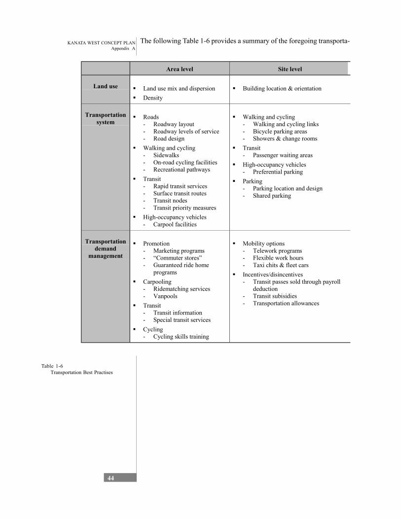
KANATA WEST CONCEPT PLANAppendix A
44
The following Table 1-6 provides a summary of the foregoing transporta-
Area level Site level
Land use Land use mix and dispersion Density
Building location & orientation
Transportation system
Roads- Roadway layout- Roadway levels of service- Road design Walking and cycling- Sidewalks- On-road cycling facilities- Recreational pathways Transit- Rapid transit services- Surface transit routes- Transit nodes- Transit priority measures High-occupancy vehicles- Carpool facilities
Walking and cycling- Walking and cycling links- Bicycle parking areas- Showers & change rooms Transit- Passenger waiting areas High-occupancy vehicles- Preferential parking Parking- Parking location and design- Shared parking
Transportation demand
management
Promotion- Marketing programs- “Commuter stores”- Guaranteed ride home
programs Carpooling- Ridematching services- Vanpools Transit- Transit information- Special transit services Cycling- Cycling skills training
Mobility options- Telework programs- Flexible work hours- Taxi chits & fleet cars Incentives/disincentives- Transit passes sold through payroll
deduction- Transit subisidies- Transportation allowances
Table 1-6 Transportation Best Practises
KANATA WEST CONCEPT PLANAppendix A
45
1.5 Servicing Analysis
1.5.1 Water Supply and Servicing
Background The entire Kanata West area lands lie within water Pressure Zone 3W of the City of Ottawa’s central water distribution system. This zone also includes all of Stittsville and the majority of the (former) Kanata lands. Potable water to this area is pressured at the Glen Cairn Pump Station located near Castlefrank and Hazaldean Roads – a major water storage reservoir is located at this site. Major watermains into this pressure zone from the pump station are located along Castlefrank to the north, Hazaldean to the west and Eagleson to the south. The Hazaldean watermain borders the Kanata West area lands to the south and currently provides the primary source of potable water to Stittsville; a new 406mm watermain from Terry Fox to Iber (along the Abbott Street ROW) pro-vides a secondary feed to Stittsville.
The Glen Cairn Reservoir is fed with water primarily through a large diameter (1220mm) watermain from Woodroffe along Baseline and Robertson Roads. This watermain, and the reservoir itself, are located within Pressure Zone 2W. A second smaller diameter watermain (406mm) on Corkstown Road from Moodie Drive (also within Zone 2W) is also capable of supplying water to the reservoir. Both these pipes are fed from the Britannia Water Purification Plant through a single 1525mm watermain, which also feeds a large diameter watermain heading south along Woodroffe to Barrhaven. In addition to the Britannia WPP feed, the Carlington Heights Pump Station provides a secondary source of water to Zone 2W.
The City has recently completed a draft report entitled “Barrhaven, 2W and 3W Pressure Zones Infrastructure Assessment – Predesign Study” (Stantec; October, 2001) which includes recommendations on infrastruc-ture needs required to service the projected growth in the west end of the City. The report considered future development in the West Urban Community (including the proposed Kanata West area) to approximately 150,000 persons by 2021, of which approximately 130,000 persons would reside in Zone 3W (part of the WUC north of the Queensway and east of March Road lies within Zone 2W). Currently, there are approximately 54,000 persons being serviced with potable water in Pressure Zone 3W, so significant growth is anticipated for this area.
The draft report includes the following recommendations with respect to the external servicing for development in the WUC. These include the following elements:
• Expand Glen Cairn PS capacity by 30ML/d including diesel backup • Upgrade throttling control valves at the Britannia 2W WPP • Construct new 75ML/d Pump Station to Zone 3W • Construct 1,075m of new 610mm watermain to new Zone 3W PS • Add 110ML/d treatment capacity to Lemieux Island WPP
KANATA WEST CONCEPT PLANAppendix A
46
• Expand Carlington Heights PS by 50ML/d • Construct 10,375m of new 760mm watermain to WUC from Britan-
nia WPP (staging possible) • Expand Glen Cairn Reservoir by 34ML • Expand Glen Cairn or new 3W PS by 50ML/d including diesel
backup • Add 100ML/d treatment capacity to Britannia or Lemieux Island
WPP • Construct new 9.0ML elevated water tank in Zone 3W • Expand Zone 2W Pumping by 50ML/d
None of the above major facilities are expected to lie within the KWCP Study Area. However, since these facilities are required to accommodate future growth in the WUC, there will likely be some financial implications associated with the construction of each of these infrastructure elements.
Guiding Principles and Best Practices The principal goal of the City’s water supply system is to continue to provide a reliable water supply system with adequate treatment facilities, pumping stations, storage facilities and watermains to deliver high quality potable water to all customers to meet all consumer demands (Water Master Plan; RMOC, 1997). To achieve these goals, the following guiding principles must be incorporated into the design of all new facilities:
• Provision of adequate pumping, storage and piping to meet peak daily demands;
• Provision of adequate pumping, storage and piping to meet the fire flow needs of the customers;
• Provision of secondary sources of water where appropriate to ensure an reliable supply of water; and
• Minimization of travel times in the distribution system to maintain high quality water “at the tap”.
Water quality is paramount in any water supply system. Even if water is treated to a very high level at the water purification plants, there exists the possibility that it may degrade through time as it travels through the distribu-tion system. By decreasing the time of travel to the consumer, the possibil-ity of degradation is minimised. Time of travel includes time spent within storage facilities as well as major feedermains and local distribution watermains. Smaller storage reservoirs and smaller pipe diameters thus result in quicker travel times. As such, it is considered good practice to maintain appropriately sized facilities – bigger is not necessarily better. Even at the local level, pipes should be designed to provide the required demands only (either fire or domestic usage) and over-sizing should be avoided unless there is a reasonably good opportunity that the larger size is needed in the near future.
Reliability issues in a water system are generally met through looping of watermains and/or twining of major transmission mains where appropriate. In the event of a break or failure of part of the system, water may still be provided by the “second” pipe; although these are normally designed to
KANATA WEST CONCEPT PLANAppendix A
47
meet only the basic consumer demands during the outage period. A looped watermain system is generally able to provide increased flows when necessary (i.e. two sources of supply to a fire hydrant) while maintaining smaller diameter watermains. Thus, looping provides benefits from a reliability perspective as well as a water quality perspective.
1.5.2 Stormwater Management
Background The Kanata West lands lie within the Carp River watershed. More specifically, under present conditions parts of the site (north western and south western parts) drain to two tributaries of the Carp River, namely Poole Creek and Feedmill Creek. These areas are located at the down stream ends of the two watersheds. The central portion of the site lo-cated between the Poole Creek and Feedmill Creek watersheds and the most northern portion drains directly to the Carp River.
Storm drainage studies to date have generally focused on runoff quantity control and channel erosion protection requirements and flood plain deline-ation along the Carp River and Poole Creek. No flood plain limits are available for Feedmill Creek within the Kanata West area limits. Since the completion of these studies, the Ministry of Environment introduced guidelines and criteria in 1994 for urban runoff, which required new developments to implement runoff quality control in addition to peak flow and erosion control. The quality control criterion was defined on the basis fish habitat protection defined according to the fish habitat classification of the receiving stream. For sections of a water-course used for water contact recreation, the water quality control criterion also identify the need to address runoff borne pathogens.
At present, the City of Ottawa, together with the Mississippi Valley Conservation, Ministry of Natural Resources, Ministry of Agriculture, Food and Rural Affairs and the Ministry of the Environment are presently undertaking the Carp River Watershed /Subwatershed Study. A draft report entitled “Carp River Watershed / Subwatershed Report Card”, October 2001 prepared by Robinson Consultants Inc. et. al, for the City of Ottawa, provides a detailed review of existing conditions based on previ-ous reports, field investigations and technical analyses as well as an assessment of interrelationships among environmental features together with opportunities and constraints. Subsequent phases of the study will include:
• Watershed Goals and Objectives (Phase II); • Development of Watershed and Subwatershed Plans (Phase III); • An implementation plan (Phase IV).
The Report Card (Phase 1) has been reviewed and consultation with the Carp River Watershed / Subwatershed Study Team was undertaken in order to identify/confirm the watershed constraints to be addressed in the stormwater management (SWM) plan for the Kanata West Concept Plan
KANATA WEST CONCEPT PLANAppendix A
48
as well as to ensure that the KWCP SWM plan is consistent with the objectives of the Watershed / Subwatershed Study.
Guiding Principles and Best Practices The development of the Kanata West Concept Plan was coordinated with the stormwater management (SWM) requirements. This plan recognised that the underground storm drainage system would follow the street net-work within the development. Also, during storm events that generate flows in excess of the storm sewer capacity, the excess flow - referred to as the major system flow - will also follow the street network to a dedi-cated outlet into a watercourse or to a storage area. In establishing the street layout and drainage system, consideration was given to:
• Routing the street network so suitable storm sewer outlets to the receiving streams could be implemented.
• At the storm sewer outlet locations, sufficient lands should be re-served for the implementation of stormwater management facilities.
• Storage of major system flow will be provided in parks within resi-dential areas.
• Within commercial / business park areas major system flows are to be controlled by implementing on-site detention in parking lots.
Best management practices (BMP) is a term used to describe techniques for quantity and quality control of stormwater. A range of BMPs was considered in the preparation of the stormwater management plan for the KWCP development. The impacts were evaluated to identify suitable BMPs. BMPs were considered in the following order:
1. Stormwater lot level controls; 2. Stormwater conveyance controls; and 3. End-of-pipe stormwater management facilities.
Stormwater Lot Level Controls Stormwater lot level controls involve measures to treat stormwater before it reaches the conveyance system (storm sewers, ditches, swales). For large developments lot level control measures are generally implemented to assist in the improvement of the two other types of BMPs. It is recom-mended that lot level control measures be implemented on a site by site basis and measures to be considered are to include:
• Drainage of rooftops within residential areas should be diverted onto grassed rear-yard or side-yard areas to maximize infiltration opportu-nities.
• Rainwater downspouts should be directed onto grassed areas away from basement walls, to avoid infiltration into the foundation drainage system.
• Within sandy pocket areas of the development, stormwater infiltra-tion should be maximized by careful attention to site grading.
• Within the commercial and business park areas roofs should also be discharged to grassed areas. Where this is not feasible, roofs can be discharged to a gravelled trench that provides a volume of 5 to 7 m3/
KANATA WEST CONCEPT PLANAppendix A
49
ha. Within the parking lot areas, the drainage system should also include measures to infiltrate 5 to 7 m3/ha of runoff. This could be accommodated by using a perforated pipe structure or a gravelled trench. Alternative measures to enhance infiltration and baseflows would involve stormwater conveyance control systems as described below.
• Within the business park areas, biofilter and parking lot sand filter systems could also be implemented to provide water quality treat-ment and mitigation of baseflow impacts. This type of local control measure will be more suitable for areas adjacent to the water-courses.
Stormwater Conveyance Controls Stormwater conveyance controls are normally implemented as part of the stormwater conveyance system. These BMPs include pervious pipe systems, pervious catch basins, manhole grit separators and grassed swales. These BMP’s will be considered for the mitigation of baseflow impacts due to the reduction of the pervious areas.
End-of-pipe Stormwater Management Facilities End-of-pipe BMPs reviewed for consideration in the KWCP development include: dry ponds, extended detention ponds, wet ponds and artificial wetlands, infiltration ponds, and vegetative BMPs.
Dry ponds are effective in quantity control with little quality benefit. Due to the water quality control requirement for the development, dry ponds are not considered feasible.
Extended detention dry ponds which rely primarily on settling to remove pollutants, can be considered although water tolerant plants would be required for biological uptake of soluble pollutants and a batch type opera-tion is required for Level 2 fish habitat protection. These types of ponds are effective in protecting against erosion and can also be designed to provide quantity control.
Wet ponds and artificial wetlands have a high capacity for removing most urban pollutants. Wet ponds can be designed with artificial marshes to improve biological uptake capabilities. Considering the constraints of the dry ponds, as an end-of-pipe BMP, a wet pond would be preferable.
Infiltration ponds have a high removal rate for particulate pollutants and moderate rate for soluble pollutants. The predominantly clay soils and bedrock in the area preclude the consideration of this type of BMP.
Screening of BMPs The BMP’s were screened considering the hydrologic and water quality impacts of the proposed KWCP development and the environmental attributes of the receiving streams. Water quality protection and erosion control is considered of utmost importance to protect / restore the fisheries resources and environmental attributes of the receiving streams. Of the BMP types listed above, the end-of-pipe type BMP is considered most
KANATA WEST CONCEPT PLANAppendix A
50
suitable considering the size of the proposed development. Of the available end-of-pipe type BMPs, wet pond type facilities are recommended as compared to artificial wetland type facilities.
In addition to the end-of-pipe type BMP, both conveyance type and local BMPs are also recommended. While the end-of-pipe BMP will provide the water quality and erosion control requirements for the proposed devel-opment, the conveyance and local BMPs will address concerns relating to baseflow impacts. The conveyance type BMP recommended will include in addition to the conventional storm sewer, a second perforated sewer designed so that the initial runoff will be collected by the perforated sewer and larger flows will overflow to the conventional sewer system similar to the Etobicoke Exfiltration System. The water collected by the perforated sewer system will exfiltrate into the crushed stone backfill to promote ground infiltration and mitigate baseflow impacts.
Local control measures will also assist in the mitigation of base flow impacts. The local control measures are recommended where feasible and has to be addressed at the detailed design stage for each phase of develop-ment.
1.5.3 Sanitary Servicing
Background In 1997 the former Region of Ottawa-Carleton completed a Wastewater Master Plan for the entire Region. The plan identified the infrastructure necessary to convey sanitary flows to the year 2021. The plan only ac-counted for those areas already approved in the urban areas, whereas the Kanata West Concept Plan was not part of the Wastewater Master Plan. Since 1997 growth in the Kanata area has occurred at a rate substantially higher than anticipated. The Region initiated a recent study (North Kanata Sanitary Sewage Infrastructure Upgrade Study) from which some modifi-cations have been identified as being necessary to convey the new esti-mated flows. That study has considered some of the area in the Kanata West Concept Plan but not all; the study estimated 456 hectares for the KWCP, instead of the 532 hectares proposed as the preferred concept. As such the current sanitary sewer system in Kanata cannot convey the flows that will be generated from the Kanata West Concept Plan when fully developed.
Sanitary Sewer – Best Practices Within the urban core of the City of Ottawa the sanitary sewer flows should be conveyed in pipes to the Robert O. Pickard Environmental Centre (ROPEC) for treatment. For the KWCP area a new treatment plant would most likely not be acceptable due to cost and location, and it is highly unlikely that the Carp River could assimilate the discharged flows. Septic beds would not be acceptable within this urban area and would most likely limit the amount of building space and area for development.
KANATA WEST CONCEPT PLANAppendix A
51
The best practice would be to service the KWCP area with sanitary sewer pipes by gravity to a new pumping station. The pumping station would discharge the flows to the Glen Cairn Collector.
Sanitary Sewer – Existing Conditions Analysis The existing sanitary sewer system in the Kanata area is composed of several major components, including pump stations, forcemains, and gravity trunk sewers.
Signature Ridge Pumping Station: Currently the urban core of Kanata is serviced by a sanitary sewer system that collects and conveys the flows to ROPEC for treatment. The system consists of gravity sewers, pumping stations and forcemains. Kanata has a rock ridge that runs north-south which limits the area to be cost effectively serviced by gravity sewers. To overcome this constraint the Signature Ridge Pumping Station was built to service the development along First Line and the Palladium Complex. A total of 187.05 hectares were allocated to flow to the pump-ing station with a generated theoretical flow of 263 l/s. The ultimate capacity of the pumping station is about 280 l/s, which only leaves about 17 l/s spare capacity. As the KWCP adjoins this area one would consider the Signature Ridge to service the area. Currently the Signature Ridge Pumping Station is configured to pump 140 l/s. Use of the SRPS to service the KWCP must realize that any use of the pumping station would only borrow capacity from other already allocated development and therefore would have to be removed, or alternate servicing implemented, once the previously allocated development proceeded.
Signature Ridge Forcemain: This forcemain is designed to convey the flow from the Signature Ridge Pumping Station and is a single forcemain, which provides no system redundancy. If the KWCP flows were to go through the pumping station, a second forcemain would be required.
First Line Sewer: The First Line sewer cuts across the east end of the KWCP. Based on ultimate theoretical flows allocated to First Line, the existing sewer has no spare capacity to convey the anticipated total flows from the KWCP.
Tie in to the Main Street Sewer: Currently all flows from the Signa-ture Ridge Pumping Station go to the Kanata Lakes Sewer. No spare capacity is available in this sewer. A diversion chamber at Castlefrank and Campeau is proposed to split the flows with the remaining flows going to the Main Street Sewer. The first few hundred metres of the sewer along Castlefrank and the diversion chamber would have to be built before the Signature Ridge Pumping Station is upgraded to convey 280 l/s.
Main Street Sewer: The Main Street Sewer has been sized to convey more flow than the local development area, but it cannot convey the anticipated flow from the KWCP. This is a new sewer in a developing area, as such replacing this sewer would not be considered realistic.
KANATA WEST CONCEPT PLANAppendix A
52
Penfield Drive Sewer: This sewer cannot convey the flows from the fully built out area currently connected to it. Upgrades have been pro-posed but only to the extent to address the area already designated to it.
Local sewers on Katimavik and Rowe: These local sewers have some spare capacity but are limited by the capacity of the Penfield Drive sewer. Some short-term options may be viable for these sewers.
March Ridge Trunk and Siphon: This sewer has no spare capacity for the KWCP under the current configuration of the sanitary sewer system.
Tri-Township Collector: This sewer is separated into two distinct reaches, one from structure tr02200 to tr01000 and the second from structure tr01000 to wa03000. From structure tr02200 to tr01000 the sewer has some spare capacity for the KWCP but cannot convey the estimated full build out flows. The lower end (structure tr01000 to wa03000) has no spare capacity for the KWCP.
As the current flow is almost exceeding the capacity of the lower end of the Tri-Township Collector, the City of Ottawa is implementing the installation of a portion of the North Kanata Trunk. The intent is to construct this sewer over the 2002 spring/summer months. Some spare capacity would be available in the sewer for part of the KWCP, but upsizing may be required to convey all of the KWCP flows in the future.
The second portion of the North Kanata Trunk is scheduled for installa-tion by 2007. Once this sewer is installed, additional capacity will become available in the March Ridge Trunk and Tri-Township Collector (structure tr02200 to tr01000). This scheduling could have a significant impact on how and when the KWCP is fully developed, and how much can be developed before 2007.
1.3.4 Utilities
Electrical
Background The proposed development area is split between the Hydro One Net-works Inc. service area and the Hydro Ottawa Ltd. service area. The division occurs along Huntmar Drive (to the South) and then westerly along Maple Grove Road.
A preliminary consultation meeting was held with Hydro One (who acted as lead representing both utilities) to discuss the proposed development.
Consequent upon this, a letter containing more precise details of the development and its servicing needs was forwarded to the utility compa-nies requesting information on the electrical infrastructure requirements needed to support the ultimate development and the portion of such costs that would become the Developer’s responsibility.
KANATA WEST CONCEPT PLANAppendix A
53
Existing and Future Substation Capacity
Hydro Ottawa Ltd. The firm supply capacity of the Hydro Ottawa 28 kV distribution stations in the Kanata service area will be 112 MW by the end of 2002. The peak 28 kV system demand recorded in the summer of 2001 was 93 MW. The available capacity therefore is about 20 MW to supply future load growth in Kanata and Goulbourn. Thus the proposed West Kanata Business Park load within the Hydro Ottawa service territory of 46 MW clearly cannot be supported without expansion of HOL station capacity. Since Hydro Ottawa is obligated to take supply from the South March TS at 44 kV, it is expected that a new 44/28 kV station must be built with the HOL territory. Given the magnitude of the projected West Kanata load, this station may have to be built somewhere within the Business Park.
Hydro One Networks Inc. The load in this area of the former West Carleton is supplied from both the South March TS and the Alexander DS. The South March TS has about 50 MVA of available 44 kV capacity. The 44/28 kV Alexander station however is approaching its maximum load rating. To supply the ultimate load projected for the area of the Park that is within the HONI territory, an expansion of the Alexander Station may be required, or a new distribution station built within the vicinity of the WKBP.
Existing and Planned 28 kV and 44 kV Trunk Feeders There are existing 28 and 44 kV feeders in the area of the future WKBP. The existing and proposed feeders for each of the two supply areas are discussed separately below.
Hydro Ottawa There is currently an underground 28 kV looped feeder along Palladium Drive which supplies the Corel Centre and other commercial/industrial loads in the area.
The proposed future supply configuration to serve the West Kanata development, within the Hydro Ottawa service territory, consists of new 28 kV feeders installed along the east side of Huntmar Drive, Maple Grove Road, Hazeldean Road, and the future extension of Campeau Drive.
The HOL proposed feeders that will be along arterial roads are planned to be installed on overhead pole lines, unless an outside party is willing to fund the difference in cost between overhead an underground construc-tion. Budget costs for an overhead single circuit 28 kV feeder is about $125,000/kM; the cost for an underground feeder is in the order of $500,000/kM, provided that excavation is not in rock and that conven-tional construction techniques can be employed. Using these figures and based on adding a total additional quantity of 4 km of new feeders, the cost premium for constructing all of the proposed feeders underground is estimated at about $1.5 Million. Note that the actual amount to be paid
KANATA WEST CONCEPT PLANAppendix A
54
however, will be based on detailed construction estimates for underground and overhead systems.
Hydro One There is an existing HONI overhead line running on the west side of Huntmar Drive which supports two 44 kV feeders and a single circuit 28 kV feeder. The capacity of the circuits on this pole line are nearing their maximum. Thus it is planned by HONI that a third 44 kV circuit will be constructed from South March TS to the West Kanata location once any significant development proceeds with their service area. This is planned to be done by replacing the existing poles with larger ones and adding the additional 44 kV circuit to the existing ones. Should the Developer want the existing overhead lines replaced with underground plant, than this will be entirely at their cost.
Electrical Supply Conditions for New Development In accordance with the OEB’s Distribution System Code, each licensed Local Distribution Company (LDC) must formulate a Conditions of Supply document detailing the practices and policies that will apply to existing and future customers. These documents are not completed as yet by either Hydro Ottawa or Hydro One. The Conditions of Supply documents also may be subject to revision from time to time as permitted by the OEB. Thus, the foregoing reflects the current supply policies of the two LDCs.
Hydro Ottawa Residential subdivisions must be installed with underground servicing of the houses. The Developer has two options in having the underground facilities installed. They may have Hydro Ottawa perform the installation and pay a unit cost for each single or townhouse, or they may elect to retain their own Contractor, approved by Hydro Ottawa, to supply and install the plant. Details regarding the installation requirements and costing of the two options, can be provided by Hydro Ottawa, if required.
The installation costs of on-site electrical facilities for commercial, indus-trial and apartment developments are entirely the responsibility of the Developer. Again though, the Developer may choose to pay Hydro Ottawa for the installation, or retain an approved Contractor for the work.
Individual properties with a total transformation requirement of up to 2,500 kVA may be supplied off the 28 kV distribution system. Loads larger than this may have to be connected to the 44 kV system via a customer owned substation.
Costs of expanding upstream Hydro Ottawa facilities, such as trunk feeders and utility-owned substations, will normally be offset by the projected future revenue for a proposed customer load. This is deter-mined by performing an Economic Evaluation for a proposed develop-ment. In cases whether there is a significant cost to expand Hydro Ottawa facilities into a new load area, in order to provide financial protec-tion against the possibility that the load my not materialize, Hydro Ottawa may require that the facility’s cost be paid upfront by the Developer.
KANATA WEST CONCEPT PLANAppendix A
55
Annual rebates would then be issued by Hydro Ottawa to the Developer based on actual revenues derived from a particular project.
Hydro One For registerd subdivisions, the Developer is responsible for the cost and installation of all distribution supply facilities within the boundaries and at interfaces to the existing distribution system. While it is not expected to be required, if the existing system must be extended to the development, the Developer may be responsible for associated costs. If the supply to the subdivision must be reinforced, then those costs will generally be paid by Hydro One.
The design of electrical facilities on the streets of the development will be done by Hydro One, and this engineering work is at Developer’s cost. It may be based on a per meter fee or actual charges, and is initiated by Developer’s request. Construction of new facilities is contestable, but must be to the Hydro One design for facilities in order to be assumed by Hydro One for ownership/future maintenance responsibility. Subdivision Agreements will be required.
Reconstruction of existing Hydro One facilities will be done by Hydro One personnel.
At the West Kanata Business Park location, individual services requiring installed transformer capacity in excess of 1000 kVA will be required to connect directly to the 44 kV system via a customer owned substation. All customers with service sizes in excess of 200 A will have individual studies, using an OEB approved calculation method, made to determine what portion of the cost of connection will be paid by Hydro One. Smaller service sizes will have connection cost determined from tables for which OEB concurrence has been received. The normal transformer ownership allowances and all other service conditions will apply.
General Requirements Regardless of whether the development within the WKBP occurs within the HOL service area or that of HONI, the utility companies request that the Developer provide as much lead time as possible when advising of their intent to proceed. This will minimize the likelihood of any problems being encountered due to design delays, unavailability of materials, or scheduling problems.
To provide more detailed cost calculations than are provided herein would require additional particulars on subdivision sizes, locations and schedul-ing. When this information is available, the utility companies would provide specific cost estimates.
KANATA WEST CONCEPT PLANAppendix A
56
Communications
Background Two service providers have expressed an interest in providing communi-cations facilities in the Kanata west Concept Plan area. Bell has existing fiber in the area and Telecom Ottawa are expanding their infrastructure throughout Ottawa and will have service to this area in the near future.
Telecom Ottawa a newly created separate affiliate of Hydro Ottawa will provide TLS ETHERNET (1G) service which is geared to service all data related services excluding voice.
The existing Bell communications facilities, installed in 1996, consist of a shared trench with Hydro containing copper plus fiber and 2 spare con-duits. This installation has the ability to provide subscribers with a full suite of services offered by Bell Canada (including, T1, DS3, ATM and HS Internet.) The copper and fiber was sized to handle a projected 5 to 10 years growth forecast. A remote switching facility exists at 580 Terry Fox for switched service. The network is monitored and reinforced, as needed, to meet growth.
Opportunities and Constraints
Utilities Electrical There is adequate capacity to begin to serve initial loads in the Hydro One development area through existing facilities. As loads exceed the capac-ity of these lines and stations, new sources will have to be brought in to the area. Current projections indicate the need to add capacity almost equivalent to 2 new 44 kV feeders in order to serve all of the loads indicated. There would also be a need to add substation capacity with a new station located in the development area. These needs could be offset somewhat if Hydro Ottawa develops plans for alternate feeds to some loads that are currently supplied by Hydro One facilities. The timing of such plans depends on growth in the development area. There may be some alternatives whereby large-scale construction by Hydro One can be avoided by the building of smaller facilities within Hydro Ottawa that would be less costly overall.
Existing spare capacity in the area is between 10 and 15 MVA, depending on the nature of the loads. Line extensions will be required to feed any new developments that do not border on existing facilities and may be needed in some places even where facilities exist.
There are no foreseen constraints with respect to electrical supply, which would impact the development of the concept plan. Phasing opportunities and developing a cost-effective electrical system will be the primary focus of the design team as Hydro One supply future information.
KANATA WEST CONCEPT PLANAppendix A
57
Opportunities and Constraints
Utilities - Communications Funding is in place by both Telecom Ottawa and Bell to invest in Sepa-rate large fiber optic cable facilities, which would allow subscribers to be connected to diverse routed fiber (fiber ring.) This means that in the event of a cable cut, subscribers would be switched to a redundant path with no loss of data transmission.
There are no foreseen constraints with respect to this communication facility that would hinder the development of the concept plan.
1.5.5 Discussion
Opportunities and Constraints
Water Supply and Servicing As indicated previously, there are no major water supply facilities (except for watermains) envisioned to lie within the KWCP development lands. A new internal water distribution system, consisting of watermains and hydrants and valving, will be required. It is anticipated that these pipes can be constructed along road corridors within the development area, and would thus have very little, if any impact on the development of the Concept Plan for the area. At least one major looped watermain through the Study Area is expected, likely from Castlefrank to west of Palladium drive and then southwards towards Hazeldean, which will require a crossing of Highway 417. It is expected that the highway crossing can easily be undertaken by drilling under the roadway surface. The ability of the existing infrastructure (primarily watermains) will be investigated to verify its ability to provide the appropriate level of service to KWCP and other growth in the WUC – upgrading may be required for some of the pipes adjacent to, or feeding the Study Area. Environmental Assess-ments will likely be required for any crossings of major streams and/or rivers, which will be required to complete the looped watermain network (regardless of the local road layout).
A major consideration in the development of these lands will be the “external” servicing needs. This includes the facilities required to supply water to all of Zone 3W, and will include at least the elevated tank in Kanata North, the Glen Cairn Reservoir Expansion, the new feed across the Greenbelt to the WUC and the additional pumping feeding Zone 3W. These facilities will likely be required regardless of the development anticipated in the KWCP, but the KWCP development will affect the sizing of these facilities as well as the timing requirements for construc-tion.
KANATA WEST CONCEPT PLANAppendix A
58
Stormwater Management The change in land use from rural to urban typically leads to hydrologic, water quality, erosion and environmental impacts to the receiving stream. These impacts are associated with the increased impervious areas which results in an increase in runoff and a reduction in groundwater infiltration and base flows. The increased runoff has the potential to increase flooding problems and stream bank erosion, while the reduction in baseflows could impact the aquatic resources of the watercourse.
Flood Control In 1983 flood plain mapping was completed by the Mississippi Valley Conservation. The flood lines along the Carp River were delineated based on the 100 year flows. Along the upper reaches of the Carp River the peak flows were generated by rainfall events while along the lower reaches peak flows were governed by snowmelt. The Carp River was identified as having a mild gradient and under peak runoff events, its flow velocities are fairly low (approximately 1 m/s). The channel is also not well defined resulting in wide flood plains during more severe events.
The Carp River Watershed / Subwatershed Report Card recognizes that “stream flow in a river with an urbanized watershed would typically show much higher and faster peaks from rainfall and meltwater events than a rural watershed”. However, the report notes that “due to the shallow gradients and distance from the urbanized area, the expected severe responses are not detectable by the time the flow reaches the gauge at Kinbrun” (downstream location on carp River), suggesting that the severe peak flows from the upstream urban areas does not extend downstream to the lower reaches of the river.
The 1983 Flood Plain Mapping shows that the widths of the flood plain of the Carp River bordering the KWCP development varies between 100 m to 200 m south of Highway 417 and 50 m to 500 m north of Highway 417.
The Carp River Watershed / Subwatershed Study Team has indicated that due to the deteriorated condition of the Carp River bordering the KWCP area, the Watershed / Subwatershed Study will recommend that river be rehabilitated using natural channel design principles and that the rehabilitation will require a width of approximately 100 m. Consequently, the traditional peak flow control will not be required, however, the reha-bilitation works are expected to be provided as part of the SWM require-ments for the KWCP development. The Carp River Watershed / Subwatershed Study Team at the request of the Mississippi Valley Conservation, is required to confirm that flood elevations will not increase with the proposed management strategy for the Carp River.
Preliminary hydrologic modelling for the Carp River up to the northern limit of the KWCP area indicates that the KWCP development will not lead to a significant increase (less than 8%) in peak flows for both the 5 year and 100 year storms. The increase in water levels associated with
KANATA WEST CONCEPT PLANAppendix A
59
the small increase in peak flows is negligible and therefore, peak flow control is not warranted.
For Poole and Feedmill creeks, since the KWCP area is situated at the downstream limits of the subwatersheds, and the drainage for the KWCP development will be managed so that storm sewer outlets are directed to Carp River, peak flows along these creeks will not increase.
Considering the above, peak flow control is not required for the KWCP development. However, onsite control measures such as roof and parking lot storage within the commercial and business park areas and park storage within residential areas will be implemented to control major system flows through the development.
Erosion Control The Carp River Watershed / Subwatershed Report Card completed a geomorphic assessment of the Carp River and its main tributaries in order to assess the state of erosion and stability of the watercourses. As indicated in this report the stability of a channel is related to the sediment flow regime, valley gradient, boundary material characteristics and veg-etation type, density and distribution. A significant section of the Carp River including the total length upstream of March Road has been altered and is in a degraded state with significant sediment deposition and is considered unstable. This condition will be addressed in the rehabilitation measures being considered in the watershed / Subwatersheds Study.
The lower sections of Poole and Feedmill creeks were also classified as unstable in the Carp River Watershed / Subwatershed Report Card. The report indicates that most tributaries and the Upper Carp River have insufficient stream power to transport sediments resulting in aggradation and sediment build up. The impact of the sediment build will trigger a series of channel adjustments in the stream such as channel widening, streambed erosion and straightening.
The KWCP stormwater management plan will include measures to remove sediment loadings from the storm runoff prior to discharge to the Carp River. Storage volume to control the flows from the frequent storms up to the 25 mm storm will also be provided to reduce the erosion potential of the stream. The runoff from the 25 mm storm is to be de-tained for a minimum of 24 hours in accordance with the Stormwater Management Practices Planning and Design (SWMPPD) Manual, Ministry of Environment and Energy, June 1994.
It is also noted that the KWCP development will not impact the erosion conditions within Poole and Feedmill Creeks since the runoff from the frequent storms will be conveyed directly to the Carp River.
KANATA WEST CONCEPT PLANAppendix A
60
Baseflows / Water Budget The water budget analysis completed in the Carp River Watershed / Subwatershed Study was reviewed to assess potential impacts due to the KWCP development and to develop best management practices to address the impacts. The report indicates that approximately 112.5 mm of rainfall infiltrates into the ground. This annual infiltration represents approximately 12 % of the annual rainfall. The report also notes that the watershed has little potential to store peak events and as a result, the baseflow, which supports the aquatic ecosystems during dry periods, is very low.
The soils within the Kanata West Concept Plan area are predominantly clay. Based on the infiltration rates of the soils within the watershed, the Carp River Watershed / Subwatershed Study indicates that clay soils contribute 32.2 mm of infiltration per year to the ground. The 32.2 mm of infiltration per year represents 3.5 percent of the annual rainfall (910.5 mm). In the Ottawa area approximately 80 % of the annual rainfall events are less than 20 mm. For 20 mm rainfall events, groundwater infiltration would amount to 7 m3/ha within clay soils.
Based on the above assessment, groundwater infiltration and baseflow impacts as a result of the proposed development could be mitigated by incorporating best management practices to facilitate approximately 5 to 7 m3/ha of ground water infiltration.
Water Quality Water quality control to treat urban runoff is required to protect the fisheries resources of the receiving streams. Storage volume require-ments for quality control provided in the SWMPPD manual are based on the imperviousness ratios of the proposed developments and the receiving streams’ fish habitat classification. The fisheries information provided in the Carp River Watershed/Subwatershed Study indicated that the Upper Carp River (upstream of Richardson Road) supports a degraded warmwater fish community. Poole and Feedmill creeks support a tolerant coldwater fish community.
Based on the above fisheries information and the management strategy being considered for the Upper Carp River, water quality control require-ments for the KWCP development is required to provide Level 2 fish habitat protection, which corresponds to 70 % removal of total suspended solids from the stormwater runoff.
A short-term surface water quality baseline sampling/monitoring was undertaken in order to obtain an indication of the existing water quality in the Carp River. The results of the monitoring program are given in the Appendices. The monitoring results indicate that the total suspended solids concentration in the Carp River is relatively low. No definite conclusion can be drawn from the suspended solids results since the monitoring period was relatively dry and for wet weather conditions, first
KANATA WEST CONCEPT PLANAppendix A
61
flush runoff may have been missed. For phosphorus and E. Coli, the monitored results generally exceed the Provincial Water Quality Objectives guidelines.
Sanitary Sewer – Existing Site Features A number of existing site features will impact the cost and on how the sanitary sewer will service the KWCP area. The intent is to install the new sewers under the proposed local road system. The ground generally slopes from west to east, which will be used to keep the sewers from becoming overly deep. Some features are briefly discussed as follows:
Highway 417 (Queensway): If one or more crossings of Highway 417 will be required to service the KWCP with sanitary sewers and to convey the flows to a new pumping station, the crossings will most likely require the use of a directional drilling method or jack and bore system. This increases the costs but allows the Highway to operate as normal.
Soil Conditions: Kanata is prevalent with rock close to the surface and certainly nearer the east boundary of the KWCP. Also, soils in the Carp River reach could be suspect. Both of these soils’ conditions may increase installation costs and require special construction procedures.
Carp River: The Carp River is an environmentally sensitive area and any crossing will require mitigation measures to minimize impacts. To reduce the impacts, directional drilling or jack and bore methods may be employed. This will increase the installation costs but would eliminate the need for open cut across the river.
Existing Road Configuration: On the eastern boundary of the KWCP, asphalt roads service the existing development as well as the Corel Centre. The KWCP surrounds this partially developed area and as such the new sewers will have to be conveyed through this area to get to a new pumping station. This will require construction on existing roadways, which will impact the overall cost.
Sanitary Sewer - Opportunities and Constraints The existing infrastructure in place has spare capacity that presents and opportunity for cost savings. If spare capacity could be used in the initial phases of KWCP then benefits are realized. The existing utilities can operate at designed capacity and the costs of new infrastructure can be deferred.
KANATA WEST CONCEPT PLANAppendix A
62
1.6 Financial Analysis This section summarises the findings of the financial analysis for the Kanata West area. The purposes of the financial analysis for the Kanata West Concept Plan are to: • summarise methods used by the former Region and its constituent
urban municipalities to fund growth related municipal infrastructure for major development proposals;
• review and assess approaches used in other jurisdictions, particu-larly for business parks; and
• provide a framework to respond to the financial policy requirements of ROPA 9.
The financial analysis summarises the key points of relevance for the Kanata West development as follows:
• Municipal powers with respect to funding or requiring emplacement of growth-related works are limited, and arise mainly from legisla-tive authority in the Development Charges Act, 1997, the Plan-ning Act, and the Municipal Act.
• The former Region and most of its constituent municipalities used development charges (DC) as the primary source of funding for major growth-related works. The development charge bylaws in force prior to the January 1, 2001 amalgamation remain in force until they are replaced by the new City (subject to any amend-ments) or expire.
• The works required for KWCP were not included in the current DC bylaws, since the area was not designated when the bylaws were passed (1999).
• The maximum Kanata residential DC rate (Summer, 2001) totalled $17,161 per single detached residential unit (with lower rates for other types of units). The maximum commercial/institutional DC in force in the former City totalled $76.79 per square metres of gross floor area.
• There is precedent for the use of Municipal Act, 221 area rating bylaws for recovery of growth-related sanitary sewer and storm water management costs in the former Region.
• Practice with respect to funding over-sizing of collector roads and sanitary sewer trunks varied by former municipality, with some (e.g., Kanata) including over-sizing costs in their DC bylaw.
• Business park infrastructure funding practices were researched both within and outside the former Region, as input to the process of developing a financial strategy for KWCP.
KANATA WEST CONCEPT PLANAppendix A
63
• Within the former Region, the municipal role in contributing to business park infrastructure financing included: • a significant reduction in the implemented Regional
industrial and commercial DC; • municipal front-ending (e.g., municipal debenture) of
local infrastructure costs in some cases; • area specific DC’s (or Municipal Act, s. 221 charges) to
recover area infrastructure costs; and • in some cases, encouragement of private cost sharing
for local over-sizing costs.
• In the remainder of the Province, practices in GTA municipality varied from those in non-GTA municipalities, where, in general, demand for business park land is more limited. Outside the GTA, many municipalities make substantial contributions to non-residential infrastructure costs (at least on an up-front basis), and often own and develop the business parks. These municipalities need to offer significant incentives to attract businesses, due to competition from the GTA and outside of Ontario.
• Within the GTA, municipal assistance in financing infrastructure in business parks is limited, with the primary approach being reduced DC’s. Area specific DC’s to recover developer front-end costs are sometimes used, and may provide some incentive. Direct municipal contributions to servicing costs are not the norm in the GTA.
• The key ROPA 9 financial policy requires that the cost of infrastruc-ture to develop KWCP be funded primarily by the development through a means other than taxes. The KWCP financial strategy, which will be developed once the required infrastructure is identified and costed, will consider the background in this report.