Embed Size (px)
DESCRIPTION
A synthesis of our knowledge of the Palaeolithic and Mesolithic archaeology in Romanian Banat
Citation preview

THE PREHISTORY OF BANATI. The Palaeolithic and Mesolithic
Editors-in-Chief
Nikola Tasić (Belgrade)Florin Draşovean (Timişoara)
Editors of the first volume
Florin Draşovean (Timişoara)Borislav Jovanović (Belgrade)
Editorial Board
Bogdan Brukner (Novi Sad)Nikola Tasić (Belgrade)
Florin Draşovean (Timişoara)Borislav Jovanović (Belgrade)
Gheorghe Lazarovici (Cluj-Napoca)Dragana Antonović (Belgrade)
Valeriu Sîrbu (Brăila)
THE ROMANIAN ACADEMY THE SERBIAN ACADEMY OF SCIENCES AND ARTS
THE MUSEUM OF BANAT TIMIŞOARA
The Publishing House of the Romanian Academy Bucharest, 2011
THE PREHISTORY OF BANATEditors-in-Chief
Nikola Tasić and Florin Draşovean
I. THE PALAEOLITHIC AND MESOLITHIC
Edited byFlorin Draşovean and Borislav Jovanović
Technical operator: Crina SincoviciCover design: Javor Rasajški
English text revised by Alex W. Barker and Clive Bonsall
Final proof: 22.04.2011; Format: 8/64 × 88; Proof in sheets: 15Clasifi cările zecimale: 9(498.74)<<…:00>>
902.6(498.74)D.C.L. for large libraries: {D.C.L. for small libraries: 9
THE PUBLICATION OF THIS VOLUME WAS SUPPORTED BY THE TIMIŞ COUNTY COUNCIL AND THE MUSEUM OF BANAT
Peer reviewer: Acad. Alexandru Vulpe
THE PUBLISHING HOUSE OF THE ROMANIAN ACADEMYCalea 13 Septembrie nr. 13, sector 5, 050711
Bucureşti, România, P.O. Box 5-42Tel.: 4021-3188146; 4021-3188106
Fax: 4021-3182444E-mail: [email protected]
Internet: http://www.ear.ro
Printed in Romania by Mega Print SRL, Cluj-Napocawww.edituramega.ro | e-mail: [email protected]
Descrierea CIP a Bibliotecii Naţionale a RomânieiTh e Prehistory of Banat / editors-in-chief: Nikola Tasić and Florin Draşovean ;
ed. by Florin Draşovean and Borislav Jovanović. - Bucureşti : Editura Academiei Române, 2011-vol.ISBN 978-973-27-2057-8Vol. 1 : The Palaeolithic and Mesolithic.- 2011. - ISBN 978-973-27-2058-5
I. Tasić, Nikola (ed.)II. Draşovean, Florin (ed.)III. Jovanović, Borislav (ed.)
94(498)
Copyright © 2011, Th e Publishing House of the Romanian Academy.All rights reserved.
FOREWORD 11(Dr Nikola TASIĆ)
FOREWORD 13(Dr Florin DRA ŞOVEAN)
I. INTRODUCTION 15
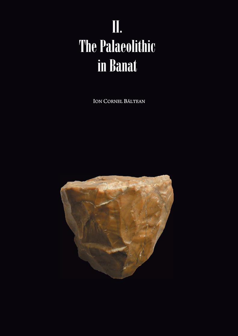
II. THE PALAEOLITHIC IN BANAT 19(Ion Cornel BĂLTEAN)II.1 General considerations 21
II.1.1 General remarks on the period II.1.2 Some terminological remarks on the use of quartz/quartzite
as raw material in some Palaeolithic sett lements in the Banat 22II.2 Geological structure in the Banat region 23
II.2.1 General remarks 23 II.2.2 Th e Sviniţa–Svinecea 24 II.2.3 Th e Presacina 25 II.2.4. Th e Cerna–Jiu 26 II.2.5 Th e Reşiţa–Moldova Nouă 27 II.2.6 Th e Haţeg 29 II.2. 7 Th e Rusca Montană II.2.8 Th e Caransebeş–Mehadia Depression 30 II.2.9 Th e Bozovici Depression 30II.2.10 Th e Sicheviţa Depression 31II.2.11 Th e Făget Depression 31II.2.12 Th e Lugoj Depression 31II.2.13 Th e Oraviţa Depression 31II.2.14 Th e southern Apuseni Mountains 31II.2.15 Some remarks on the rock types used in Prehistory 32
II.3 Quaternary sedimentary deposits in the Banat region 34II.4 Research history of the Palaeolithic in the Banat region 39II.5 Th e Palaeolithic archaeological evidence in the Banat area 40
II.5.1 Pedological analyzes, sedimentological remarks on stratigraphical profi les of the palaeolithic sett lements in the Banat 40
Table of Contents
6 | Table of Contents
II.5.1.1 Băile Herculane–Hoţilor Cave 40 II.5.1.2 Coşava 41 II.5.1.3 Gornea–Dealul Căuniţei 42 II.5.1.4 Gornea–Păzărişte 42 II.5.1.5 Pescari–Livadiţei Cave 42 II.5.1.6 Româneşti–Dumbrăviţa 43 II.5.1.7 Tincova–Sălişte 44
II.5.2. Repertoir of Palaeolithic archaeological sites 45 II.5.2.1 Băile Herculane–Hoţilor Cave 45 II.5.2.2 Caransebeş 46 II.5.2.3 Constantin Daicoviciu 47 II.5.2.4 Coşava 47 II.5.2.5 Curtea 49 II.5.2.6 Curtea 49 II.5.2.7 Duleu 50 II.5.2.8 Gornea–Dealul Căuniţei 50 II.5.2.9 Gornea–Păzărişte 51II.5.2.10 Gornea–Vodneac 53II.5.2.11 Grădinari 53II.5.2.12 Iabalcea–Cerbului Cave 53II.5.2.13 Iabalcea–Popovăţ Cave 53II.5.2.14 Leucuşeşti 53II.5.2.15 Liborajdea 54II.5.2.16 Pescari–Gaura Chindiei I Cave 54II.5.2.17 Pescari–Livadiţei Cave 54II.5.2.18 Adi’s Cave 55II.5.2.19 Dubanăţ Cave 55II.5.2.20 Oilor–Bobot Cave 55II.5.2.21 Vraşka Cave 55II.5.2.22 Româneşti–Dumbrăviţa 56II.5.2.23 Româneşti–Water Cave 60II.5.2.24 Sadova Veche 60II.5.2.25 Bones Cave 61II.5.2.26 La Hoţu Cave 62II.5.2.27 Tincova–Sălişte 65II.5.2.28 Vişag 68II.5.2.29 Zăvoi 68
II.6. Geochronological elements of the upper pleistocene from southwest Romania 68II.6.1 Introductive issues. Several palaeoclimatical and chronological landmarks 68II.6.2 Chrono-climatic slott ing of the Banat Palaeolithic levels 69
II.7. Conclusions 70II.7.1 Lithic industries using quartz/quartzite raw materials from southwest Romania 70II.7.2 Th e Banat Aurignacian industries. Characterisation and chronologic position 73II.7.3 Lithic industries from southwest Romania assigned to the Tardigravett ian horizon 75
III. THE PALAEOLITHIC IN NORTHERN SERBIA 77(Dušan MIHAILOVIĆ, Bojana MIHAILOVIĆ, Milica LOPIČIĆ)III.1 Natural environment 79III.2 History of researches 81III.3 Palaeolithic sites 82
III.3.1 Crvenka-At, Balata and other Palaeolithic sites in the vicinity of Vršac 82III.3.2 Petrovaradin Fortress 85III.3.3 Baranica Cave and Tabula Traiana Cave 87III.3.4 Šalitrena Cave 89III.3.5 Other Palaeolithic sites 90
Table of Contents | 7
III.4. Palaeolithic of Northern Serbia in its regional context 91III.4.1 Middle Palaeolithic 91III.4.2 Upper Palaeolithic 93
IV. THE MESOLITHIC IN BANAT 103(Adina BORONEANŢ)IV.1 Introduction – Mesolithic studies in Romania 105IV.2 Mesolithic in the Banat area 106
IV.2.1 Th e Hoțu Cave 106IV.2.2 Th e Iron Gates 107
IV.2.2.1 Th e environmental context of the Iron Gates sites 107IV.2.2.2 Th e Iron Gates climate 109
IV.3 Short history of the research 110IV.4 Epipalaeolithic and Mesolithic in the Iron Gates 111
IV.4.1 Th e Early Mesolithic (13000–7200 cal BC) 113IV.4.1.1 Cuina Turcului Rockshelter 114IV.4.1.2 Climente II Cave 116IV.4.1.3 Veterani Cave 117IV.4.1.4 Băile Herculane–Hoţilor Cave 118IV.4.1.5 Ostrovul Banului 118IV.4.1.6 Th e Early Mesolithic – a summary 120
IV.4.2 Th e Late Mesolithic (7200–6300 cal BC) 121IV.4.2.1 Veterani Terasă 121IV.4.2.2 Răzvrata 122IV.4.2.3 Icoana 123IV.4.2.4 Ostrovul Banului 126IV.4.2.5 Schela Cladovei 126
IV.3 Th e Final Mesolithic (6300–6000 cal BC) 132IV.3.1 Alibeg 132IV.3.2 Final Mesolithic–Early Neolithic contacts? 134
IV.4 Conclusions 136
V. CONTINUITY AND FUTURE RESEARCH 143
VI. APPENDIX 151VI.1 Bibliography 153VI.2 Figures 169

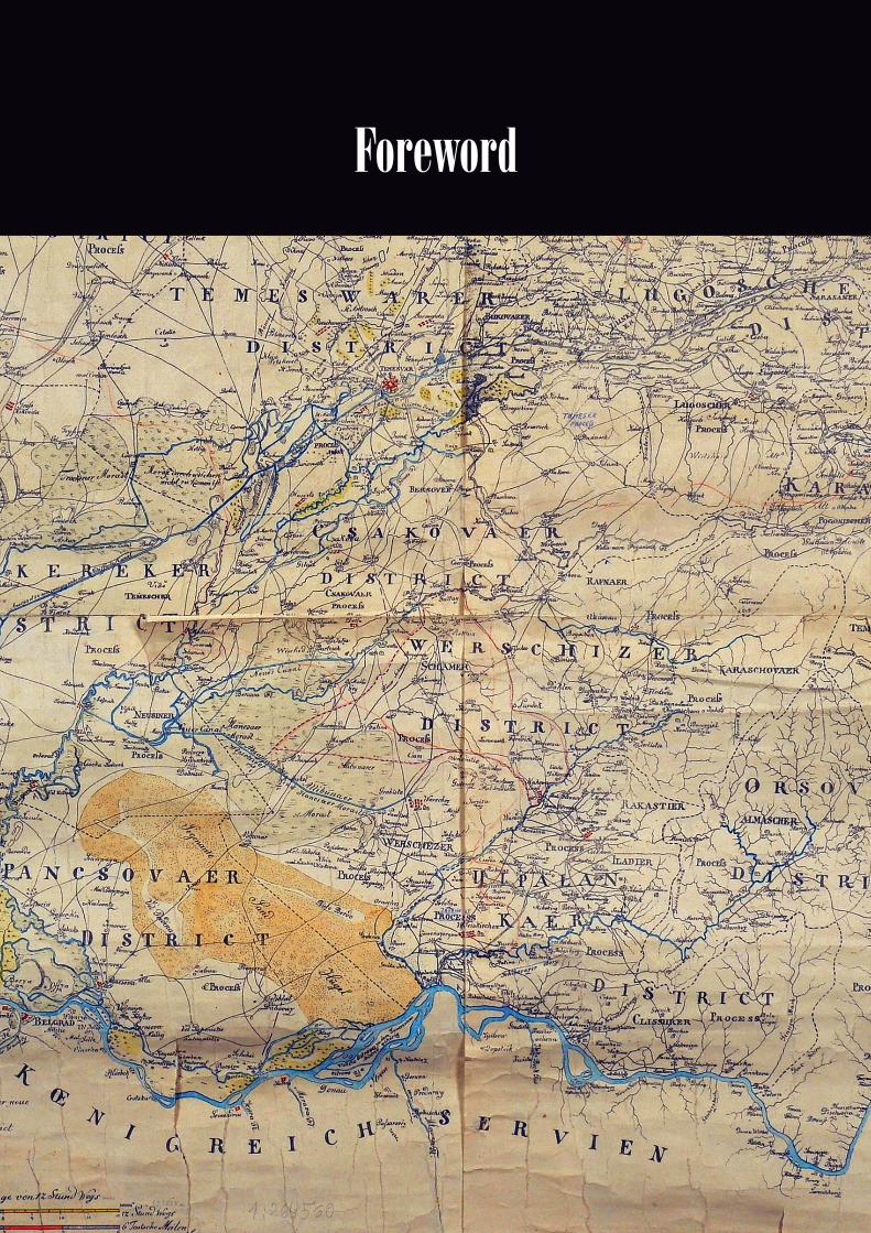

Th e Banat, as well as the entire Middle Danube region of which it forms part, is one of Europe’s most interesting geographical regions when it comes to studying the formation and development of prehistoric cultures. In the north, it opens onto the Pannonian expanses, onto the tall loess ridges and steppes, an area rich in water resources and fertile land. In the east, the left -bank tributaries of the Tisa (Tisza) provided easy access to the rich Transylvanian hills which off ered game hunting opportunities, but also precious mineral resources, copper, iron, gold and, especially, salt indispensable for a pastoral economy. In the south, the Morava river valley provided communication with the central-Balkan hinterland and, in some periods, the Danube tribes, as a result of pastoral movement or, rarely, plundering campaigns, reached as far as the prosperous Mediterranean world. Finally, in the west, the Sava and the Drava, two large right-bank tributaries of the Danube, enabled contact, varying in intensity, with the Alpine foothills which played an important role in the development of metallurgy in the Bronze and Iron ages. In such a markedly favourable geographical sett ing, the cultures to which the multivolume series “Th e Prehistory of the Banat” will be devoted arose and developed.
Geo-topographic and economic factors led to the Banat region’s cultural and historical unity. It is refl ected in the same or similar processes of culture formation, the same or similar autochthonous substratum, the same or similar forms within material culture, and similar levels of socioeconomic development. Th e region’s cultural unity can be traced as far back as the late Palaeolithic. Continuing into the Neolithic and Eneolithic periods, it was at its peak in the late Bronze and the Iron Age. Th e archaeological record abounds with supporting evidence – such as pott ery and, even more, metal tools, weapons and jewellery – for very close ties and economic interests among the prehistoric cultures in this broad area.
Th e region’s cultural unity on the one hand and the artifi cial barriers in the form of modern state borders on the other have reinforced the old idea of publishing
F ew regions in prehistoric Europe were the scene of such a lively and constant cultural, ethnic, stylistic, and economic interaction as the modern-day Pannonian Plain in general and the Banat in particular. Over the millennia,
diff erent prehistoric cultural groups coexisted or succeeded one another there, and their diff erent stylistic features lend particular interest to the study of the Banat region’s cultural past.
Foreword
12 | Foreword
a series devoted to the prehistory of the Banat as a region. Engaged in the project are the Romanian Academy of Sciences, the Timişoara Branch, the Museum of Banat and the Serbian Academy of Sciences and Arts, the Novi Sad Branch, but also a number of Banat and Vojvodina museums: the Museum of Vojvodina, Novi Sad; the city museums at Bečej and Vršac; and the national museums at Zrenjanin, Kikinda and Pančevo. Th e series will consist of fi ve volumes, each devoted to a period of prehistory: I. Th e Palaeolithic and Mesolithic; II. Th e Neolithic; III. Th e Eneolithic; IV. Th e Bronze Age; and V. Th e Iron Age. Th e project assembles many archaeologists from both Serbia, notably Vojvodina, and Romania. Th e two countries have a long tradition of archaeological collaboration headed by G. Lazarovici, V. Dumitrescu, P. Roman, D. Berciu, F. Draşovean, M. Garašanin, N. Tasić, B. Jovanović, R. Rašajski, M. Girić, and especially the late Bogdan Brukner, who was one of the initi-ators of the publication project and the co-author, along with the writer of these lines and Borislav Jovanović, of the seminal volume “Th e Prehistory of Vojvodina” published by the Institute for the Historical Study of Vojvodina in 1974. Given that many important prehistoric sites have since been discovered in the Banat and other parts of Vojvodina, the basic idea of the team assembled round this project is to present all excavation results for prehistoric sites in the Banat, and to off er, based on the archaeological record, an interpretation as complete as possible of the formation and devel-opment of cultures in this part of Europe, their stylistic, cultural and chronological relationship with the adjacent regions – Pannonian, Transylvanian and Balkan – their importance for the genesis of other cultures in vertical and horizontal projections. Th e plentiful archaeological material, previ-ously unpublished, will also be included in this multivolume publication which will undoubtedly make useful reading of more than local interest.
Belgrade, September 2010Dr Nikola TasićVice-President of the Serbian Academy of Sciences and Arts
From the very beginning, we must mention as the initiator and promoter of this editorial project the outstanding personality of the late Professor Bogdan Brukner, who, with his exuberant energy, managed to gather in 1995 a group of researchers from the two countries who began to plan the writing of a prehistory of Banat. Th is initial group included Nikola Tasić, Borislav Jovanović, Milorad Girić, Gh. Lazarovici but also the late Florin Medeleţ, Marian Gumă, Jovan Uzelac. Following lively debates of ideas upon the archaeological data, the editorial committ ee decided to structure the work into fi ve volumes which focus, in sequence, on the Palaeolithic, Neolithic, Eneolithic, Bronze Age and Iron Age. Th e research work is to close with the period of the Roman conquest of Banat.
Th e work, inaugurated now by the fi rst volume dedicated to the Palaeolithic and Mesolithic, gathers the results obtained by research undertaken in this geographic area in the latt er half of the twentieth century and the fi rst decade of the new century and millennium. In this period, archaeological research in the two parts of Banat, Romanian and Serbian, evolved at varying paces. If during the fi rst three decades aft er World War II the research undertaken by Serbian specialists developed signifi cantly and materialized in remarkable publications, since the 1980s the Romanian specialists have been the ones to take the initiative. At present, a positive moment in Romanian archaeology, large-scale archaeological excavation
T he historical province of Banat, defi ned by natural borders – the Tisza River to the west, the Danube to the south, the West Carpathians to the east and the Mureş River to the north – is one of those areas which, due to
their special geographic position, represented an important contact zone between the Balkans and Central Europe. Due to this fact, as both historical documents and the present day situation show, Banat became an ethnic and cultural mosaic rarely encountered elsewhere on the Continent, a mosaic in which various peoples and ethnic groups sett led, lived together and largely preserved their cultural identity unchanged despite the vicissitudes of history. Th is characteristic feature, which can also be traced in prehistory, was the main reason why a group of scholars from Serbia and Romania came to the conclusion that it would be both useful and necessary to edit a book dedicated to the prehistory of this area, an area divided aft er World War I among Serbia, Hungary and Romania.
Foreword
14 | Foreword
areas have been opened in the most important prehistoric sites under the patronage of the museums in Timişoara, Reşiţa and Cluj-Napoca. Despite this fact, and although extensive research has been undertaken on both sides, the vast majority of the material discovered has remained unpublished or has only been the subject of dig reports, small-scale studies or, at best, of several monographs. Th is situation, corroborated with the unfortunate lack of a joint strategy for the scholarly use of the results, rendered diffi cult the understanding of the cultural phenomena which took place in Banat and made it impossible for researchers to write works of synthesis that present the ancient history of the province in its entirety. Th is was the fi rst argument that triggered the initiative of editing the Prehistory of Banat.
In the same time, the prehistoric civilizations that developed in Banat naturally expanded beyond the present-day political borders and exerted a very strong infl uence upon the neighbouring areas, determining the birth and development of a new culture, both in the Pannonic and Central European areas as well as the area of the Lower Danube. All these important contributions of Banat to the evolution of the ancient history of a great part of Europe have strengthened the need for the existence of such a work. Th ese are several of the arguments that determined specialists in the two countries to set out to edit a work of synthesis.
We hope that the publication of the Prehistory of Banat, which relies on previously unpub-lished material resulting from research undertaken over the last six decades, will off er specialists a useful and necessary research tool both for understanding the cultural phenomena that took place in this area at the dawn of history and for the clearer defi nition of the role that Banat played in the genesis and evolution of some of the prehistoric civilizations in Central and Southeast Europe.
Timişoara, September 2010 Dr Florin DraşoveanTh e Museum of Banat Timişoara


There is no doubt that the Banat region is of great signifi cance for understanding the cultural processes during the Palaeolithic and the Mesolithic, both because of its geographical position and ecological characteristics, and of
the archaeological fi nds recorded so far. On the one hand, the Banat is situated at the intersection of geographical routes connecting the East and Central Balkans with Central Europe and the Southwest Carpathians, making investigations in this area of exceptional importance for the study of human migrations during early prehistory. On the other hand, the Banat is situated on the southwestern fringes of the Carpathian basin, where climatic and ecological factors were relatively favourable (in comparison with the northern regions) and where conditions for the exploitation of diverse ecological zones also existed. Th erefore, it is not surprising that the Banat was inhabited throughout most of the ages. It is no surprise that rich Middle Palaeolithic sites, the earliest remains of modern man in Europe and very important sites from Early and Late Upper Palaeolithic are to be found here or the neighbouring regions. Of particular signifi cance is the fact that a whole series of Mesolithic sites were investigated in the southern Banat (including only a part of the Iron Gates region). Th ese sites gained worldwide fame for their unique heritage in terms of the art, economy and society of the Mesolithic period.
Th e writing of the fi rst volume on the Banat prehistory was associated with great diffi culties resulting from the uneven degree of investigations as well as the inadequate degree of publication of archaeological and palaeoecological material. Important problems were encountered when dealing with poor knowledge of the palaeogeography of the region, the lack of absolute dates for some of the sites and litt le information on the sources of raw materials used for knapping. All these factors made a synthetic approach to an integrated study of the Banat Palaeolithic extremely diffi cult.
Because of relatively small number of systematically investigated sites, we were compelled to study the Palaeolithic of the region within a wider regional framework. Another justifi cation for such an approach lies in the fact that the lowland areas of the Banat are naturally linked to the Pannonian basin, while the mountainous areas are connected to the rest of the Carpathian range. Still, we had to deviate from this particular approach as far as the Iron Gates area was concerned. Th e volume only presents the sites formally included in the Banat area, while the sites downstream of the Iron Gates gorge proper were not included. Th e sites on the right bank of the Danube appear in the volume with less detailed information and are mentioned only within the general approach to the Mesolithic development in the area.
Some of the Palaeolithic investigations from both sides of the Romanian–Serbian border were brought to the public eye for the fi rst time. We described in detail the sites in western Romania with fi nds from earlier excavations, but also
18 | Introduction
new data on recent Palaeolithic investigations in northern Serbia. Special att ention was paid to questions of wider regional importance and particularly to the transition from the Middle to the Upper Palaeolithic. Th ese new issues were triggered by the considerable breakthrough achieved in this particular fi eld in both countries during the past few years.
Th e Mesolithic sites on the left Danube bank are considered in the context of more recent interpretations, generated both by the availability of new 14C dates, stable isotope analysis and new excavations, employing new techniques and methodologies.
It is true that investigations of the Palaeolithic and Mesolithic in Southeastern Europe did not follow the tempo of those in the western part of the continent, neither from the theoretical, nor from the methodological aspect. At one point in time, research was mostly directed at compre-hending the phenomena exclusively within state borders. Th e Mesolithic research in the Iron Gates was perhaps an exception, as specialists from various other countries were included quite early in the research teams. More recent discoveries in Romania and Serbia also prompted international cooper-ation. However, many things still need to be done. It is necessary to provide the conditions to ensure access to scientifi c resources and facilitate information exchange, as well as to coordinate and unify research criteria and methods. Only these will help to address and perhaps solve problems of general importance for understanding the cultural, economic and social changes in the early prehistory of Southeast Europe.

II.1 General consideration
II.1.1 General remarks on the period
The passage to the Upper Palaeolithic, from the archaeological point of view, across wide spaces, still involves some discussions about both the type of the material and especially about its creators in the anthropological sense.
Th e fact is generally known that in the Near East the fi rst Homo sapiens sapiens populations came before the Neanderthalian groups and that in Europe the two groups lived together and came in contact with each other by around 30,000 BP.
Th e interdisciplinary research undertaken by contemporary archaeology highlights diff erent strategies of raw material exploitation, thus determining the local origin, the origin from the nearest neighbouring area or from an area up to a radius of 20 km, in some cases, up to 80 km (meso-local sources) or even beyond that, up to a 1,000 km (extra-local sources). Th e raw material supply took place either by direct exploitation of an outcropping source at the moment of dwelling or by digging wells through which the strata containing the desired raw material were reached, or by bartering relations with other communities, a situation in which one could come by both semi-fi nished tools (cores, blades, chips) or by fi nished tools (scrapers, chisels, scratchers, etc.). It is the period in which we witness the qualitative and quantitative increase of spiritual and artistic phenomena (ornamented pieces, cave paintings, statuett es, etc.), the “planned” exploitation of a well-delineated territory (“logistic mobility”) by “task groups”, circumstances under which we can speak of a hierarchy of dwelling systems (“residential sett lements”, “temporary sett lements”). Starting from the data supplied by the ethnology of the present-day groups of hunters-gatherers, we can speak in the case of the Upper Palaeolithic of basic groups of 25 individuals, of groups made up of 175 individuals who can ensure biological reproduction and thus the survival of a population and of regional populations that can reach a maximum number of 500 individuals. From an ethno-archaeological point of view it is considered that a group made up of 25 individuals take up an area of approxi-mately 250 m2.1
Obviously, the scarcity of available data does not allow us a more nuanced approach based on the archaeological material dug up on the Banat territory, in the present-day state of research. We can only correlate the data reaped from this area with the data from the more or less nearby areas, which, on account of objective reasons and, why not, on account of sometimes subjective reasons, benefi ted from a clearly superior extent of archaeological research focusing on the Palaeolithic Age.
1 DJINDJIAN, F. et alii 1999.
22 | Ion Cornel Băltean
Th e Quaternary was beyond any doubt a fertile period regarding the morphological trans-formations undergone by the temperate zone as the successive geographic states left their strong imprint on the organization of terrestrial geosystems. Some of these transformations were substantial (extensions and withdrawals of sea shore, the shaping and building of subglacial and proglacial morphological levels, the organization and reorganization of hydrographical systems with the entire array of their consequences, the repeated reshuffl ing of biotic systems under the climatic spell, etc.). Others were more discrete, but almost everyone has left conclusive evidence of their existence.
Th ese traces are not always easy to read and the spacial and temporal infl uences oft en render scientifi c analysis diffi cult. Th e forms that remained relatively inert relict forms are relatively scarce and they are only on a macroscale. Most of them have undergone functional changes depending on the intensity and typology of morphogenetic fi eld typology.
Unfortunately, the archaeological research undertaken along the time in the Palaeolithic sett lements of the Banat have not benefi ted from extensive studies regarding the microsedimen-tation context of the Palaeolithic dwelling levels, on the one hand, and on the other hand, they have not considered the geomorphologic evolution of the area to which the Palaeolithic site belonged, and so much the less it has considered the coroboration of relief forms with the Palaeoclimatic information.
Th e geomorphologists role is not only to identify the forms that belong to this period, but also to solve the diffi cult question of their genesis. To this eff ect, the specialist falls back on a varied, interdisciplinary methodology. Th e scientifi c product is only valid when the form is expressed by means of the geomorphological environment parameters, environment that engendered the form and when it is contextualized in time and space.
Th e expansion of spatial-analytical techniques may solve the inconsistencies that crop up between the processual and areal geomorphological approaches, thus lending climatic geomor-phology the power to solve the issue of spatial-temporal variations brought about by climate on the forms of relief on condition that the relations climate-process-form should be clearly sorted out.
To conclude, we can say that the morphological transformation of the relief under the spell of climatic parameters is a continuous process, even if the morpho-stratigraphic and pedo-stratigraphic testimony may sometimes give the impression of sudden leaps of evolution followed by long periods of relative balance.
As a consequence thereof, the present-day forms of relief keep many of the features of the past states as the form has an intrinsic capacity of self-preservation and, in addition to it, the new geological processes have partially or completely erased the testimony of the older ones2.
II.1.2 Some terminological remarks on the use of quartz/quartzite as raw material in some Palaeolithic sett lements in the Banat
Considering the fact that the terminological aspect represents one of the important sources of gener-ating confusion in archaeology, we have tried as much as possible to use the international termi-nology avoiding translations more oft en than not inaccurate as well as the use of terms referring directly to certain more or less conspicuous human activities. Regarding the tool types we shall use the recognized terms by the special-fi eld literature (especially by the French one), both for the purely typological and for the technological aspects.
Technology. Before highlighting some aspects of quartzite chipping, the sorting out of a terminological aspect of cortex and neocortex should be done:
2 PENDEA, F. 2005: 3.
The Paleolithic in Banat | 23
• the cortex is an oft en irregular surface, of a diff erent geological nature from the mass of the material which delineates it and which is usually a poor transmitt er of the percussion energy. Th is is the reason why generally when one chips fl int, one should fi rst decorticate the nodule before one shapes the core and begins the actual knapping.
• the neocortex is the outer layer of the river nodules, formed by mechanical weathering in the water during transport; it is a smooth, regular surface, of the same geological nature as the raw material that delineates it and which may be used as a percussion plane3.
Th e knapping accidents, of the “burin de Siret type”, crop up as a result of an unwanted fracture plane, which cuts through the percussion point and which divides the support into two more or less equal parts4. One also fi nds réfl échi type accidents and, to a lesser extent, the outrepassé type, which are to be put down to a poor dosage of percussion intensity and to the variation of the mechanical characteristics of the quartz block. One should also mention that the outrepassé type accidents are somewhat atypical forms due to the sudden change of direction of the shock waves along a less resistant area falling perpendicularly on the cutt ing axis5.
In general, the lithic industries of quartz have been characterized as mediocre and atypical, which made some prehistorians speak of an archaic character of these and this due to the raw material which has a diaclasis-rich structure. Th us, the accidental fractures due to the shock waves propagation along a plane of tectonical diaclasis are frequent accompanying the chipping of vein quartz.
In the case of the vein quartz, the percussion bulb is visible, even the bulb cracks are sometimes visible if the material evinces a fi ne structure. Anvil percussion is a technique that enables one to obtain a series of chips of foreseeable shape, starting from nodules or vein quartz blocks that are too big for one to hold them in one’s hand, or from unusable cores on account of the dwindling favourable angles6.
Th e stigmata due to the use of a nodule as a percussor are recorded by the material on percussion areas in two ways: with and without loss of material. Th e hard direct percussion bring about any knapping accidents, especially those of “burin de Siret type”, whereas direct percussion with a soft percussor is used to accomplish certain edge shapes of some bifacial tools or retouchings.
What concerns the terminological aspect of typological makeup of quartz tool industries, one generally uses recognized terms for the fl int implements, but the typological variability is much narrower and implicitly the use of some terms referring to subtypes of well-defi ned fl int pieces is harder to justify.
Before closing these lines, we would surely like to utt er our wish and hope to be able to resume the archaeological research on the Banat in order to grant more depth to the issues brought up by the Palaeolithic discoveries here.
II.2 Geological structure of the Banat region
II.2.1 General remarks
From a geological perspective, the territory of the Banat belongs to the Southern Carpathians in which one distinguishes two tectonic units: the Danubian Autochtonous and the Getic nappe7. Th e tectonic structure lends architecture to the relief, this being in close connection with lithology, too,
3 MOURRE, V. 1997: 202.4 MOURRE, V. 1996: 208–209; 1997: 205.5 MOURRE, V. 1997: 208.6 MOURRE, V. 1997: 207.7 SĂNDULESCU, M. 1984: 210–216; ONCESCU, N. 1965: 15; GEOG. ROM. 1987: 373.
24 | Ion Cornel Băltean
which diff erentiates the relief according to the origin of the constitutive rocks8 and last, but not least, with palaeoclimatology, which brings on structural changes9.
Th e Danubian Autochtonous is generally built up of epimetamorphic crystalline schists pierced by old granite intrusions, and sedimentary formations that cover the crystalline mountain ranges; it crops out in the southwestern part of the Southern Carpathians, between the Olteţ Valley and the Danube.
In the considered area, the Danubian unit outcrops within the Retezat Mountains and within the larger part of the Ţarcu, Cerna Mountains, Almăj and the Mehedinţi plateau10. Across this area certain parts are covered by formations that belong to the Getic nappe and partially to the Severin nappe11.
In the Almăj Mountains there are three pre-Hercynic granitoid bodies laid out from north to south. Th e Sfârdinu body, the northernmost one, is emplaced into the Ielova and the Poiana Mraconia crystalline basement. Th e Cherbelezu granite, lying more to the south, shoots through the Corbu crystalline. Th e Ogradena granite body, the southernmost one, was intruded into the Neamţu crystalline schists and has a complex structure12. Also in the area of the Almăj Mountains one can mention the basic and ultrabasic rocks from Iuţi and Plavişeviţa set off by the serpentinite range of Tisoviţa13.
Th e intrusive body Muntele Mic has a northeast–southwest strike and is made up of granites, granodiorites and quartziferous diorites with porphiritic structure14.
Th e pre-alpine sedimentary sequences have been preserved only on limited areas, most of them being removed during the later exondations15.
Within the Alpine cycle, the Danubian autochthonous becomes submerged again; the sedimentation occurs within longitudinally oriented areas which evolve as depressions (Sviniţa-Svinecea, Presacina, Cerna-Jiu)16 and lasts until the end of the Cretaceous with some discontinuities.
II.2.2 The Sviniţa–Svinecea area is located in the southern part of the Almăj Mountains and is drained by the Danube between Cozla and Sviniţa; to the north it extends somewhat towards the Svinecea Mare peak17.
Th e Upper Carboniferous deposits are of a continental facies, prevailingly psephitic-psammitic sequences, with coal, conglomerates, sandstones, and clay shales18.
Following the Carboniferous, the Permian sedimentary deposits have a continental-lacus-trine character and are of terrigenous and volcanogenic origin. Th e terrigenous deposits are made up of conglomerates, sandstones, clay shales (oft en of a red colour) and freshwater limestone. Th e fl ora from the clay shales and the fauna from the freshwater limestone interspersed with the sandstones
8 IANOVICI, V. et alii 1969: 73; COTEŢ, P. 1973: 38; GEOG. ROM. 1983: 104.9 PENDEA, F. 2005.10 ONCESCU, N. 1965: 338, Fig. 107; HARTA GEOL. 25: 16, 51–52; HARTA GEOL. 31: 29; HARTA GEOL. 32: 11,
17; HARTA GEOL. 40: 11; MUTIHAC, V. & IONESI, L. 1974: 364–365; GEOG. ROM. 1983, 91; MUTIHAC, V. 1990: 227–231, Fig. 59.
11 BUCUR, I. I. 1997: 20–21.12 HARTA GEOL. 31: 29; HARTA GEOL. 32: 17–20; HARTA GEOL. 40: 11–12; MUTIHAC, V. & IONESI, L.
1974: 366–367, 377; SĂNDULESCU, M. 1984: 242; 248; MUTIHAC, V. 1990: 233.13 ONCESCU, N. 1965: 338–339; HARTA GEOL. 32: 25–26; HARTA GEOL. 40: 13–15; COTEŢ, P. 1973: 40, 236;
MUTIHAC, V. & IONESI, L. 1974: 381–382; GEOG. ROM. 1987: 373; MUTIHAC, V. 1990: 235.14 HARTA GEOL. 25, 28, 52; MUTIHAC, V. & IONESI, L. 1974: 369, 376–377; MUTIHAC, V. 1990: 233. 15 MUTIHAC, V. 1990: 236.16 MUTIHAC, V. & IONESI, L. 1974: 383; GEOG. ROM. 1983: 91; MUTIHAC, V. 1990: 236–237.17 GEOG. ROM. 1987: 373.18 ONCESCU, N. 1965: 344; HARTA GEOL. 40: 16; MUTIHAC, V. & IONESI, L. 1974: 384; MUTIHAC, V.
1990: 237.
The Paleolithic in Banat | 25
point to a Lower Permian age19. Th e volcanogenic material is made up of rhyolites and more rarely of basalts20.
Th e beginning of the Jurassic is characterized by a marine transgression aft er the exondation which began during Permian. On the area outskirts, the Liassic starts with massive conglomerates, followed by siliceous sandstones interspersed with argillaceous shales with coals. Th is succcession is also present in Drencova area, where quartzarenites are overlaid by clay sandstones, marls and abundant fossiliferous sandstones. Th e Lower Jurassic sedimentary sequence ends with Toarcian arcosik quartzarenite21.
In the central part of the Sviniţa-Svinecea area (at Munteana) one encounters a limestone facies of the Liassic22. Here, aft er a sedimentation intermission, the Dogger (Middle Jurassic) starts with a micro-conglomerate level followed by spatic limestones, oolitic limestones and ferrugineous limestones23, and in other marginal areas, as for example west of Sviniţa, this becomes very thin or is completely absent. One mentions in the basal part an important sequence of whitish quartzarenites interspersed with micro-conglomerates24.
Th e Malm is mainly composed of limestones (the complete succession may be found in the Munteana area and in the area of the village Sviniţa). At its basis lies a nodular red limestone horizon, 5 to 15 m thick, followed by a reddish-grey or greyish limestone horizon with silica bands (jaspers). Th ese bands become so frequent that they make up a 3 to 4 m thick horizon of silico-lites (radiolarites)25. Th is horizon is followed by red limestones (marly limestones) with siliceous accidents, with a thickness of 10–15 m26.
At the beginning of the Cretaceous, the Danubian domain evolves under conditions of tectonic calmness, with the formation of carbonatic deposits. Th e Neocomian includes stratifi ed, fossiliferous micritic limestones, with fl int bands27. Th e Berriasian contains a bundle of fi ne limestone, and the Valanginian and the Hauterivian include the rest of the limestone suite of the Neocomian, stratifi ed micritic limestones with siliceous accidents, oft en in the form of bands28 with a thickness of 25–50 m which are outcropping in the Sirinia Valley and along the Vodânschi rut, close to Sviniţa village29.
Th e stratigraphic column continues with alternating limestones and marly-limestones with siliceous accidents30. Th e Upper Cretaceous is represented by deposits bearing the imprint of tectonic movements of the Late Cretaceous, which are made up of carbonatic sandstones and marly clays31.
II.2.3 The Presacina area, in its present-day structure, is delineated between the Caransebeş–Mehadia couloir to the west and the Godeanu to the east, the lower Cerna river marking off its southern edge, and the Ţarcu Mountains, marking its northern edge32.
19 ONCESCU, N. 1965: 345; HARTA GEOL. 40, 16; MUTIHAC, V. & IONESI, L. 1974: 384–386; MUTIHAC, V. 1990: 237.
20 HARTA GEOL. 40: 17.21 ONCESCU, N. 1965:, 345; HARTA GEOL. 40: 17–18; MUTIHAC, V. & IONESI, L. 1974: 387; MUTIHAC, V. 1990:
239, Fig. 60.22 HARTA GEOL. 40: 17; MUTIHAC, V. 1990: 239.23 HARTA GEOL. 40: 18–19; MUTIHAC, V. & IONESI, L. 1974: 388; MUTIHAC, V. 1990: 239.24 HARTA GEOL. 40: 19.25 HARTA GEOL. 40: 19; MUTIHAC, V. & IONESI, L. 1974: 389, Fig. 143; TĂTĂRÂM, N. 1984: 113; MUTIHAC, V.
1990: 239–240.26 MUTIHAC, V. & IONESI, L. 1974: 389.27 ONCESCU, N. 1965: 347.28 ONCESCU, N. 1965: 347; HARTA GEOL. 40: 20; TĂTĂRÂM, N. 1984: 199, Tab. 17; MUTIHAC, V. 1990: 240.29 MUTIHAC, V. & IONESI, L. 1974: 390.30 HARTA GEOL. 40: 21.31 ONCESCU, N. 1965: 347; MUTIHAC, V. & IONESI, L. 1974: 390–391; MUTIHAC, V. 1990: 240.32 MUTIHAC, V. & IONESI, L. 1974: 392.
26 | Ion Cornel Băltean
Th e conglomerates from the southern part of the Presacina area, on the basis of the similar-ities to the area of Sviniţa–Svinecea are ascribed to the Carboniferous. Th e conglomerates and the red sandstones, with thin clay strips to which volcanic material is added, are ascribed to the Permian and may be found on the southwestern edge of the area, while in the central part they can be seen along the Mehadia–Cornereva alignment33.
Th e alpine cover is similar to the one of the Sviniţa–Svinecea area, belonging to the Jurassic-Cretaceous. Within the base of the Liassic suite conglomerates and sandstones prevail, and then follow black clays and sandstones, with marly-limestone lenses34. Th e Dogger starts with quart-zarenites and arkosic sandstones and then the sedimentation continues with limestone deposits. Th e Malm (Upper Jurassic) is mainly carbonaceous, the series beginning with limestones and siliceous accidents (50 m thick)35, which, without a palaeontological argumentation, are ascribed to the Oxfordian. Th ese strata are overlain by stratifi ed nodular, black-greenish limestones, which are 20–60 m thick. Th e Malm deposits crop out in the basins of the valleys of the Ramna, Topla, Ciumârna (the central part of the area of Presacina), in the valleys to the south and east of Mount Arjana and two alignments running parallel to the river Cerna36. In the Bogâltin area one mentions nodular limestone of a reddish or greenish tint with rare siliceous accidents37.
From the Cretaceous (Valanginian and Hauterivian) one can observe micritic limestones alternating with siliceous concretions38.
During the Upper Cretaceous, due to tectonic instability, a huge mass of rocks was deformed.Th e northern half of the Presacina area is covered by a volcano-sedimentary formation,
in which the pyroclastic material is associated with terrigenous materials made up of black clays, sandstones, diff erent limestone varieties (oft en fossiliferous), nodular limestones and jasper limestones39. Based on palaeontological evidence one considers that the formation belongs to the Middle and Late Jurassic (running up perhaps even to the Early Cretaceous).
From the tectonic point of view, the Presacina area is folded as one can distinguish synclines and anticlines oriented north–south40.
II.2.4 The Cerna–Jiu area is delineated to the east by the Cerna valley as it stretches beyond the Jiu valley along the southern slope of the Vâlcan Mountains into the Olteţ valley, towards Polovraci. To the south and the west the Cerna–Jiu area stretches out towards the Cazane area41. Th is area functioned as a marginal sedimentation area on which Upper Jurassic and Lower Cretaceous reefs formed42. Starting at the end of the Lower Cretaceous the Cerna–Jiu area entered into a period of tectonic instability43.
In the Cerna area, the grey stratifi ed limestones with siliceous accidents and the nodular black-greenish, sometimes reddish limestones, which bear up against Stamberg facies massive limestones are ascribed to the Oxfordian–Kimmerindgian44.
Along the Dubova-Topleţ alignment a clear alochthonous succession crops out. Th ree forma-tions have been distinguished: the fi rst one is clayey-silty shales (80 m thick), with siliceous nodules
33 ONCESCU, N. 1965: 347; MUTIHAC, V. & IONESI, L. 1974: 393–394; MUTIHAC, V. 1990: 242.34 HARTA GEOL. 32: 28; MUTIHAC, V. 1990: 243.35 HARTA GEOL. 32: 28; MUTIHAC, V. 1990: 243.36 TĂTĂRÂM, N. 1984: 113; MUTIHAC, V. 1990: 243–244, Fig. 60.37 ONCESCU, N. 1965: 348; MUTIHAC, V. & IONESI, L. 1974: 395.38 MUTIHAC, V. 1990: 244.39 HARTA GEOL. 32: 30; MUTIHAC, V. 1990: 245.40 MUTIHAC, V. & IONESI, L. 1974: 396–397; GEOG. ROM. 1983, 91; MUTIHAC, V. 1990: 246–247.41 MUTIHAC, V. & IONESI, L. 1974: 397.42 MUTIHAC, V. & IONESI, L. 1974: 389–399; GEOG. ROM. 1983: 91.43 MUTIHAC, V. 1990: 247–254.44 TĂTĂRÂM, N. 1984: 114.
The Paleolithic in Banat | 27
and thin strips of micrites and biomicrites belonging to the Oxfordian–Early Tithonic; the second one, prevailingly carbonatic (30 m thick), contains especially clayey micrites and biomicrites with silicious nodules and belongs to the Upper Tithonic-Berriasian; the third formation, an upper clayey-silty one, does not contain silicolites45.
On the Mehedinţi plateau, the “Nadanova strata” that belong to the Vranconian–Cenomanian includes a lower level made up of alternating limestones with siliceous accidents (black fl int) and marly shales and an upper level made up of marly-limestones, marls and clays interspersed with fi ne sandstones46.
Th e main tectonic elements and at the same time typical of the Danubian Autochthonous are the duplicates. Th e tectonic lay-out of the Danubian Autochthonous bears the imprint of the Getic nappe overthrust47.
Th e Getic nappe crops out across a wide surface in the Southern Carpathians from the Olt Valley to the Danube and it contains mesometamorphic crystalline schists and a group of epimeta-morphic schists48.
In our area of interest, the southern Poiana Ruscă Mountains, Muntele Mic, the Semenic Mountains, part of Almăj Mountains and the Reşiţa–Moldova Nouă area belong to the Getic nappe49.
Th e mesometamorphic crystalline schists of the Getic nappe are one of the most developed and homogenous units from the Southern Carpathians, being made up of micaceous paragneisses, micaschists, together with amphibolites, quartzites and subordinately crystalline limestones and dolomites50. Th e epimetamorphic crystalline schists are located in the southern half of the Poiana Ruscă and Semenic Mountains, where they overlay the mesometamorphic crystalline schists51.
Aft er the completion of the Baikalian cycle52, the Getic domain evolved as an exondated area, becoming again an accumulation area during the Upper Carboniferous. In the Jurassic it appeared as a depression zone which would evolve later as a sedimentation area that is the Reşiţa–Moldova Nouă area53.
II.2.5 The Reşiţa–Moldova Nouă area lies in the western part of the Banat, between the two towns having a north–south orientation54. Th e pre-Alpine sedimentary cover contains prevail-ingly continental deposits ascribed to the Upper Carboniferous (breccias and conglomerates with torrential stratifi cation, well-stratifi ed sandstones with clayly shales strips with coals) and to the Lower Permian (black clayly shales interspersed with sandstones and micro-conglomerates, red conglomerates, red or green clays)55.
Th e Alpine sedimentary cover formed aft er the Upper Permian–Triassic exondation. One ascribes to the Werfenian the quartz conglomerates and the quartzarenites with plant traces lying at the bott om of the succession, which discordantly cover older formations56.
45 MUTIHAC, V. & IONESI, L. 1974: 402, Fig. 151; MUTIHAC, V. 1990: 252, Fig. 60.46 ONCESCU, N. 1965: 348; HARTA GEOL. 32, 31; MUTIHAC, V. & IONESI, L. 1974: 405; TĂTĂRÂM, N. 1984:
202, Tab. 17; MUTIHAC, V. 1990: 250.47 HARTA GEOL. 25: 53–54; MUTIHAC, V. 1990: 254–255.48 ONCESCU, N. 1965: 15–16, 324; HARTA GEOL. 32: 11, 12; MUTIHAC, V. & IONESI, L. 1974: 409–410;
MUTIHAC, V. 1990: 257.49 HARTA GEOL. 25: 16, 17, 50–51; HARTA GEOL. 31: 9; HARTA GEOL. 32: 12; GEOG. ROM. 1983: 90–91;
GEOG. ROM. 1987: 373; MUTIHAC, V. 1990: 257, Fig. 64.50 MUTIHAC, V. 1990: 259.51 HARTA GEOL. 25: 17–19; MUTIHAC, V. & IONESI, L. 1974: 414–417, Fig. 157–158; GRIDAN, T. 1981: 14–16,
Fig. 2; MUTIHAC, V. 1990: 261–262, Fig. 64.52 MUTIHAC, V. & IONESI, L. 1974: 421–423, Fig. 160–161.53 MUTIHAC, V. 1990: 263.54 ONCESCU, N. 1965: 332, Fig. 105A; GEOG. ROM. 1983: 91.55 ONCESCU, N. 1965: 335; HARTA GEOL. 31: 14–15; MUTIHAC, V. & IONESI, L. 1974: 430–432; MUTIHAC, V.
1990: 264.56 TĂTĂRÂM, N. 1984: 49.
28 | Ion Cornel Băltean
Th e Liasic develops in the Gresten facies and includes polygenic conglomerates followed by sandstones and shales with coal layers57. Basically, this period of time relates to so-called Steierdorf Formation made up by three members: the conglomeratic member of Budinic, sandy member from Terezia Valley and clay member of Uteriş58. Th e Dogger is prevailingly made of limestone, as one encounters limestone with siliceous accidents (elipsoids) with Reineckeia anceps59. Th ese sequences are also called “Gumpina limestones”60 followed by a sequence of metric or decimetre banks of siliceous limestone, where the silica may sometimes prevail resulting in genuine silicolite banks. Th e Malm starts out through a marly-limestones level followed by dark limestones with siliceous bands (250m thick), which lends a special aspect to those sedimentary rocks (they represent the Upper Oxfordian and Lower Kimmeridgian) which pass into nodular limestones with rarely siliceous accidents (“Brădet limestones” belong to Upper Kimmeridgian–Lower Tithonian61. In the Reşiţa area the Lower Oxfordian formations are overlaid by a horizon of fi ne grey-yellowish limestones, which is characterized by the presence of numerous layered siliceous accidents62. Basically, their age is established without palaeontologic arguments, being deducted on grounds of stratigraphical links with the under and suprajacent deposits63. Taking into consideration that the Inferior Oxfordian is palaeontological dated within the marl-limestones of Tămaşa through a fauna of ammonites, it is admitt ed for the limestone from Anina Valley a Superior Oxfordian age, established according to the presence of the Colomisphaera fi brata species, but corroborated with the Superior Kimmridgian age of the subsequent layers – thus, it can be said that part of the limestone from Anina Valley are dated from the Inferior Kimmeridgian64.
Th e basis of the Cretaceous is represented by an alternance of sub-micritic limestones and marly-limestones followed by a 150 m thick sequence of marls and marly-limestones (Valanginian and Hauterivian) covered by limestones with siliceous concretions (especially north of Cobelişte range)65 and takes up the largest part of the Reşiţa–Moldova area. Th e Inferior Cretacic in the section is based on the Formation of Marila Limestones (Inferior and Middle Berriasian–Superior Valaginian), the Formation of the limestones from Plopa (Superior Barremiam–Gargasian) and the Formation of sandstone from Gura Golumbului (Superior Clansayesian – Albian)66. Th e central facies is well developed on the Miniş Valley up to the confl uence with Steier Valley and encloses marly-limestones and grey or yellowish limestones with more or less spherical fl int concretion, with the diametre of 3–40 cm67. Th e Barremian (massive organogenic limestones) in the Reşiţa-Moldova Nouă area marks off the sett ing in of favourable conditions to the formation of the reef facies. To the Lower Barremian one ascribes a level of stratifi ed limestones with spherical silici-fi cations68. With the Albian deposits (conglomerates, glauconite bearing sandstones, micaceous sandstones and siltic clay) the sedimentary suite from the Reşiţa–Moldova Nouă area ends69. In the
57 ONCESCU, N. 1965: 335–336; HARTA GEOL. 31: 16–17; TĂTĂRÂM, N. 1984: 111; MUTIHAC, V. 1990: 265–266.58 BUCUR, I. I. 1997: 30–38; 50.59 HARTA GEOL. 31: 18–19; HARTA GEOL. 121B; MUTIHAC, V. & IONESI, L. 1974: 433, Fig. 163; TĂTĂRÂM, N.
1984: 111; MUTIHAC, V. 1990: 266, Fig. 65; BUCUR, I. I. 1997: 50.60 ONCESCU, N. 1965: 336; BUCUR, I. I. 1997: 125.61 HARTA GEOL. 31: 21–22; HARTA GEOL. 121B; MUTIHAC, V. & IONESI, L. 1974: 434; TĂTĂRÂM, N.
1984: 112.62 HARTA GEOL. 31: 20.63 BUCUR, I. I. 1997: 46–47.64 BUCUR, I. I. 1997: 4765 ONCESCU, N. 1965: 336; HARTA GEOL. 31: 24; HARTA GEOL. 121B; MUTIHAC, V. & IONESI, L. 1974: 435;
TĂTĂRÂM, N. 1984: 197, Tab. 15; MUTIHAC, V. 1990: 266–267.66 BUCUR, I. I. 1997: 90–91.67 HARTA GEOL. 31: 24.68 ONCESCU, N. 1965: 336; BUCUR, I. I. 1997: 127.69 HARTA GEOL. 31: 25–27.
The Paleolithic in Banat | 29
Reşiţa area the Upper Cretaceous may be sporadically found at Doman, Radimna Valley and east of Coronini70. On the other hand, there also may be encountered the so-called “transition deposits” represented by the limestone from Lindinei Valley, accumulated in four sequences and charac-terized by decimetre up to metric banks with numerous spheroidic, ellipsoidal or irregular silica intrusions, located from stratigraphical and chronological perspective between the marl of Crivina and the massive Barremien limestone71.
Th e complete succession of the Lower Cretaceous (conglomerates and carbonaceous limestones, marly sandstones, marly-limestones, detrital deposits and marl deposits) may be found in the western part of the Almăj Mountains, in the Şopot area, respectively72.
Having reached this point of our geological trip, it would be polite to mention that the Minişului Valley, well-known to the archaeological literature from the past years due to the discoveries of early times human bones, as well as due to multiple inhabiting levels, – is is dug in the so-called Limestone of Minişului Valley, of Superior Barremian age – Apţian (Bedoulian and Gargasian) sett led due to some conditions of the Urgonian bio-sedimentary system (plurality of favourable biologic, climatic and dynamic conditions)73. Th e carstic hyporelief from the Miniş basin is made up of several small and middle-sized caves, with relatively wide outward-looking openings, which were once part of one of more underground complexes, whose communication is nowadays to a great extent silted up. Within this carstic system, the main drainage levels are the following:
1. main drainage, active at present; 2. subfossile level;3. fossile level, to which both Peştera cu Oase (Cave with Bones) and other caves belong,
which at present are separated as a consequence of cave-ins and silt-ups (Peştera Ponor-Uscată, Peştera din Dolină, Peştera La Hoţu, Peştera cu Abri).
Th e sediment input that has been carried out by wind or by water seems to have been very intense during the interglaciary periods74. Basically, the deposits accumulated in Pleistocene–Holocene in this micro-region are characterized by Pleistocene and/or Holocene gravel, clays and sands, or calcareous tufa mainly encountered along the valleys which cross the calcareous massif75.
II.2.6 In the Haţeg area, the Middle Jurassic stratigraphic column (Dogger) also includes a sequence of spatic violaceous silty limestones with siliceous accidents of about 40 m thick76. Th e Malm encloses a series of silexite stratifi ed limestones, identical with those from the Anina Valley from the Reşiţa–Moldova Nouă area, and the Upper Jurassic ends with nodular, weakly silty strat-ifi ed limestones, with rare red-greenish siliceous concretions77.
II.2.7 The Rusca Montană area was singled out as a sedimentation basin towards the end of the Lower Cretaceous (reef massive limestones, detrital deposits) and evolved until the end of the Cretaceous78.
70 HARTA GEOL. 31: 27–29.71 BUCUR, I. I. 1997: 134.72 ONCESCU, N. 1965: 337; MUTIHAC, V. & IONESI, L. 1974: 438; TĂTĂRÂM, N. 1984: 199; MUTIHAC, V.
1990: 274, Fig. 67.73 BUCUR, I. I. 1997: 80–87.74 LAZAROVICI, G. et alii 2005: 355–359.75 BUCUR, I. I. 1997: 103.76 MUTIHAC, V. & IONESI, L. 1974: 444; TĂTĂRÂM, N. 1984: 111; MUTIHAC, V. 1990: 268.77 MUTIHAC, V. & IONESI, L. 1974: 445; TĂTĂRÂM, N. 1984: 112; MUTIHAC, V. 1990: 269.78 ONCESCU, N. 1965: 363; HARTA GEOL. 25, 31, 33–34; MUTIHAC, V. & IONESI, L. 1974: 440–443;
MUTIHAC, V. 1990: 273–274, Fig. 67.
30 | Ion Cornel Băltean
Th e Turonian–Coniacian deposits consist of grey muscovitic carbonaceous sandstones, which gradually pass into hard reddish-grey marly-limestones, stratifi ed in banks (with a thickness ranging between 5 cm to 1–2 m), within which a level of silicolites crop up79.
Th e Supragetic units also includes the northern part of the Poiana Ruscă, Dognecea and Locva Mountains, where one can fi nd small exposures of mesometamorphic crystalline schists80; a great development is shown by the Hercynic crystalline schists81.
Along a north–south alignment, between Sasca and Moldova Nouă, one can notice a fl ake-like structure consisting of Triassic and Jurassic deposits82. Th ese sedimentary rocks which belong to the Jurassic (Dogger and Malm), are represented by micritic limestones, nodular limestones with frequent siliceous accidents and silty-limestones83.
Towards the end of the Cretaceous and the beginning of the Palaeogene, an intense magmatic activity took place. Th e intrusive bodies spread out along three north-south alignments84. Th e westernmost alignment runs along the Moldova Nouă–Sasca–Oraviţa–Bocşa Română–Nădrag line. Along this alignment, in the Rusca Montană area, one can fi nd the Tincova–Nădrag mountain range, consisting of diorites, granodiorites, andesites and subordonately rhyolites and dacites85. Th e second alignment, Berzasca–Şopot–Poiana Ruscă, consists of granodiorites, diorites, gabbros, dacites, andesites, lamprophyres86. Th e easternmost alignment runs along the line Lăpuşnicel–Teregova–Armeniş and also includes small intrusive bodies, similar to the previous alignment87.
Laramic (Banatitic) magmatism represents the fi nal act in the major lay-out of the Southern Carpathians; the later changes (ruptural) have led up to the sinking of limited parts, which have become sedimentation basins thus forming the postt ectonic or intramountainous depressions88.
II.2.8 The Caransebeş–Mehadia Depression is delineated to the east by the Godeanu and Ţarcu Mountains, to the west by the Semenic Mountains, and to the south by the Almăj Mountains. Th is depression formed during the Badenian (represented by a sandy-conglomerate level, followed by a marly-sand one and then by detrital and carbonatic deposits), being silted up at the beginning of the Pliocene, represented by sands, gravels and clays89. Th is depression repre-sents the last gulf through which the water from the Pannonian Lake thrust into the range of the Carpathians.
II.2.9 The Bozovici Depression lies in the Nera basin90. It came into being during the Burdigalian or even during the Aquitanian and is fi lled by continental-lacustrine deposits with torrential stratifi cation including conglomerates, carbonatic limestones, sands, gravels, marls and ribbon clays91.
79 HARTA GEOL. 25, 32; MUTIHAC, V. 1990:273.80 MUTIHAC, V. 1990: 279–280.81 MUTIHAC, V. 1990: 281–285, Fig. 68–69.82 MUTIHAC, V. 1990: 288.83 MUTIHAC, V. 1990: 289.84 MUTIHAC, V. 1990: 292.85 HARTA GEOL. 24, 16–18; MUTIHAC, V. & IONESI, L. 1974: 448–450; MUTIHAC, V. 1990: 293.86 HARTA GEOL. 31, 30–31; MUTIHAC, V. & IONESI, L. 1974: 450–451.87 MUTIHAC, V. & IONESI, L. 1974: 451; TĂTĂRÂM, N. 1984: 204; GEOG. ROM. 1987: 375; MUTIHAC, V.
1990: 293.88 ONCESCU, N. 1965: 355–356; MUTIHAC, V. 1990: 294.89 ONCESCU, N. 1965: 368–369, Tab. 10; MUTIHAC, V. & IONESI, L. 1974: 460–462; GRIDAN, T. 1981: 63–64;
MUTIHAC, V. 1990: 299–300, Fig. 71.90 GEOG. ROM. 1987: 401.91 ONCESCU, N. 1965: 369, Tab. 10; HARTA GEOL. 31, 32; MUTIHAC, V. & IONESI, L. 1974: 462; MUTIHAC, V.
1990: 300.
The Paleolithic in Banat | 31
II.2.10 The Sicheviţa Depression lies in the western part of Almăj Mountains. Its fi lling consists of continental-lacustrine deposits that contain conglomerates and gravels, followed by sandstones, marls and clays92. On the outskirts of the depression one may fi nd freshwater limestones with siliceous concretions93. Th e age of these deposits is the same as those from the Bozovici depression.
Starting with the Badenian, some areas on the outskirts of the elevated areas that came in contact with the Pannonian depression underwent a sinking and were covered by water. Th us, they functioned as nearby (adjacent) depression areas near to the Pannonian Depression as the tectonic lay-out and the lithofacial composition thereof lending the aspect of a plain to these morphological units94.
II.2.11 The Făget Depression is bounded to the east by Dobra, and to the south of the Mureş it is crossed by the Bega River. Th e Badenian develops in the eastern part being represented by marls and clays, in some places with a carbonatic character (Lăpugiu and Coşteiu area), and the Pliocene covers most of the depression with sands, gravels, clays and marls with torrential stratifi cation95.
II.2.12 The Lugoj Depression stretches out among the Poiana Ruscă Mountains (to the east), Dognecea Mountains (to the southwest) and the Semenic Mountains (to the south). It is crossed by the Timiş River, and to the southeast it is connected to the Caransebeş–Mehadia Depression. Th e Badenian covers the crystalline-mesozoic basement and crops out only along the edges of the area. Th e Sarmatian can be found in limited areas and includes sands with gravels, argillites, and 2–3 m thick concretionary limestones. Th e Pliocene, as in other depressions is represented by gravels, sandstones, sands, clays and very fossiliferous marls96.
II.2.13 The Oraviţa Depression formed by the caving in of the western part of the Banat Mountains (during the Badenian) and had a similar evolution with the other adjoining depressions97.
II.2.14 The southern Apuseni Mountains crop out limestones with sliceous accidents (Oxfordian), which support the Upper Jurassic limestones mountain ranges98. During the Kimmeridgian a uniformization of the sedimentation conditons takes place in the Mureş couloir as one may come across grey limestones sometimes with rare silicifi cation99 while in other areas it is assumed that this state of geological evolution might be usually represented by stratifi ed limestones with siliceous accidents100.
As far as the Căprioara sector is concerned, it is appreciated that the Malm succession starts with brown or greenish jaspers (they only crop out southwest of Căprioara village, in banks of 0.5 to 1 m thick and continue with grey slaty limestones with siliceous intrusions101. Frequently encountered between the Peştiş Valley and the village of Pojoga are siliceous intrusions of a brown or violet colour (amorphous opal sometimes with the tendency to get recrystallized) ocurring as lenses, nodules or bands102. In the
92 ONCESCU, N. 1965, 369, Tab. 10.93 MUTIHAC, V. & IONESI, L. 1974: 463; MUTIHAC, V. 1990: 300–301.94 MUTIHAC, V. 1990: 390.95 MUTIHAC, V. 1990: 395–396.96 MUTIHAC, V. & IONESI, L. 1974: 623–624; MUTIHAC, V. 1990: 396–397.97 MUTIHAC, V. & IONESI, L. 1974: 625; MUTIHAC, V. 1990: 397.98 ONCESCU, N. 1965: 403–404; IANOVICI, V. et alii 1969: 152–153; TĂTĂRÂM, N. 1984: 115.99 IANOVICI, V. et alii 1969: 154–155.100 MUTIHAC, V. & IONESI, L. 1974: 540.101 HARTA GEOL. 25, 35; DUŞA, A. 1969: 24, 27; IANOVICI, V. et alii 1969: 153; MUTIHAC, V. & IONESI, L.
1974: 538, Fig. 205.102 DUŞA, A. 1969: 28.
32 | Ion Cornel Băltean
Deva-Zam area, upon a layer of jaspers develops the Căbeşti strata consisting of siliceous sandstones alternating with dark argillites103 which belong to the Barremian–Aptian104.
In the Petriş area, the series belonging to the Neocomian (800–1000 m thick) is based upon rough conglomerates, with diabasic elements, porphyritic granites, jaspers (green and brown), Stramberg limestones hold together in an argillaceous–carbonatic cement overlaid by pyroclastic sandstones and white limestones, marly-limestones, marly-schists and sandstones. In detrital and argillaceous rocks one can fi nd interspersions of siliceous rocks with a high occurrence of radio-larians and sponge spicules105.
II.2.15 Some Remarks on the rock types used in Prehistory
In order not have to come back during the work to some aspects touched upon in the previous pages, we should discuss now some matt ers concerning the raw material used in Palaeolithic sett lements from the study area.
In the Româneşti, Coşava and Tincova sett lements, the raw material is uniform, characterized by the prevalence of opal (over 80%), with diff erent brownish shades and with black-purple inclusions, along with which we can also fi nd jaspers, radiolarites, black or green schists and quartzites106. For the southern Banat one mentions the prevalence of quartziferous rocks, sandstones, schists and calcedonia107.
For the classifi cation of the sedimentary rocks, the compositional criteria allow the determi-nation of the main petrographical types: detrital, pyroclastic, clays, siliceous, aluminium, phosphatic, ferruginous and manganese, evaporitic rocks108.
Mineralogically, the silicolites are dominated by the presence of the metastable and stable components of silica (SiO2) opal A, opal C–T, calcedonia109, quartz110 and to an extent of 5–10%, clay minerals, carbonates, haematite, volcanic glass, and organic matt er111.
Nodular silicolites (siliceous accidents) are green, red or black and, considering the host rock and their relationships, we can divide them into:
• fl int, consisting of hard cryptocrystalline material, 98% silica, which mainly occur in chalks;
• chert, siliceous cryptocrystalline thick and compact rocks;• chaille, siliceous accidents that formed through the silifi cation of limestones and merge
with the host rock112.Stratiformous silicolites may be organogenic (diatomites, radiolarites, and spongolites),
chemical (sinters or siliceous crusts) and mechanical113. Jaspers formed through the epigenesis of the radiolarites: jasper is a ferruginous chert, usually red, but it can be yellow, brown or black114. Radiolarites are made up of radiolaria remnants held together in a silicious matrix and are usually
103 MUTIHAC, V. 1990: 354, Fig. 79.104 ONCESCU, N. 1965: 408–409, Fig. 135; DUŞA, A. 1969: 43–44; TĂTĂRÂM, N. 1984: 204–207, Tab. 18.105 HARTA GEOL. 24: 15.106 MOGOŞANU, F. 1978: 18.107 MOGOŞANU, F. 1970: 533; 1973: 17; 1978: 19.108 GRIDAN, T. 1983: 94.109 RĂDULESCU, D. & ANASTASIU, N. 1979: 367, Fig. 9.1.; PAVELESCU, L. 1980: 40.110 CAILLEUX, A. 1974: 39, Tab.1–2; HAMILTON, W. R. et alii 1976: 128; PÂRVU, G. et alii 1977: 29; PAVELESCU,
L. 1976: 57–60; 1980:, 38–39; ANASTASIU, N. 1988: 162–164.111 ANASTASIU, N. 1988: 283, 287.112 HAMILTON, W. R. et alii 1976: 204; RĂDULESCU, D. & ANASTASIU, N. 1979: 373–374; GRIDAN, T. 1983:
102; ANASTASIU, N. 1988: 286, 288–289.113 CAILLEUX, A. 1974: 43; ANASTASIU, N. 1988: 284, Tab. 4.20; 288.114 HAMILTON, W. R. et alii 1976: 130; RĂDULESCU, D. & ANASTASIU, N. 1979: 373; GRIDAN, T. 1983: 102.
The Paleolithic in Banat | 33
red, brown, black or green115. Spongolites – of grey, brown or reddish colour – consist of sponge spicule clusters caught in an opal or chalcedonic mass116. Sandstones are a psammitic cemented rock consisting of clastic grains with a diameter ranging between 0.2–2 mm. Marls are a sedimentary rock lying between clays and limestones according to the mineralogical composition117.
Th e term quartz covers a wide variety of materials, diff ering from the point of view of their nature (crystals and monocrystalline rocks), their colour, their homogeneity (the presence or absence of diaclases), their texture and petrographic structure (the relative display of the consti-tuting minerals).
Quartz, the most frequent crystalline variety of silica, is the constitutive mineral of certain polycrystalline rocks, but it can also exist in an isolated state, or in the shape of automorphic crystals in the case of hialin quartz, or in the shape of monocrystalline aggregates made up of xenomorphic quartz crystals in the case of vein quartz118.
Hialin quartz or rock crystal is a crystalline form encountered in numerous geological contexts, which, under normal formation circumstances has prism, rhombohedron or bipyramid faces. Th e anisotropy of this material comes in in two types: cleavage and diaclases.
Vein quartz or ordinary quartz covers a wide variety of monocrystalline agglomerates of xenomorphic quartz. Th e chromatic variations are put down to the contained impurities depending on the temperature of the formation inside the vein. Th e presence of diaclases is accounted for by the tectonic evolutions to which the vein quartz is subjected aft er crystallization119.
Th e essential diff erence between quartz and quartzite is linked to their formation mode: the quartz is a vein magmatic rock (hydrothermal origin) whereas quartzite is a massive metamorphic rock120.
Quartzites are compact siliceous rocks with conchoidal fracture consisting of detrital quartz grains, which may be sedimentary (orthoquartzites), when they come from the cementation of sandstones through diagenesis or metamorphic (metaquartzites), when they come from the recrys-tallization of a sandstone or even of a quartz vein; they are white or yellow-reddish or grey121. Th e distinction between orthoquartzites and metaquartzites is only possible by observing their structure along a thin section. Th e quartzarenites are characterized by over 90% quartz content122.
Concerning the use of “quartzite” in Palaeolithic sett lements we should mention that the distinction cannot be carried out by naked eye between vein quartz (consisting of a complex of quartz crystals, but of a magmatic origin) and quartzite123, that is why petrographical analyzes are necessary as the use of the generic term of quartz is not to the benefi t of lithic technology studies124. Th e diff erence between the name given by the archaeologists (quartzite) and the the one given by the geologists (quartz) is also remarked by Florea Mogoşanu, although he prefers the term of quartzite125.
Concerning the raw material sources, we consider that they are local as we here understand mobility in a limited area126, and they exist in outcrops of Mesozoic deposits127, obviously without
115 RĂDULESCU, D. & ANASTASIU, N. 1979: 372; GRIDAN, T. 1983: 103; ANASTASIU, N. 1988: 285.116 RĂDULESCU, D. & ANASTASIU, N. 1979: 373; GRIDAN, T. 1983: 102–103; ANASTASIU, N. 1988: 286.117 PÂRVU, G. et alii 1977: 23–24; RĂDULESCU, D. & ANASTASIU, N. 1979: 282; GRIDAN, T. 1983: 99.118 MOURRE, V. 1996: 206; 1997: 202.119 MOURRE, V. 1996: 207; 1997: 203.120 MOURRE, V. 1996: 207.121 MOURRE, V. 1997: 204, Tab. 1; PÂRVU, G. et alii 1977: 14–15.122 CAILLEUX, A. 1974: 42; HAMILTON, W. R. et alii 1976: 194; PÂRVU, G. et alii 1977: 20–22; RĂDULESCU, D.
& ANASTASIU, N. 1979: 233, 236–237; GRIDAN, T. 1983: 96–97.123 MOURRE, V. 1997: 204.124 COLLINA-GIRA RD, J. 1997: 212–213; MOURRE, V. 1997: 202–203.125 MOGOŞANU, F. 1978: 18–19.126 STRA TAN, I. 1970: 10; COMŞA, E. 1971: 16; MOGOŞANU, F. 1973: Note 10; 1978: 19; PĂUNESCU, A. 1970a: 85.127 PĂUNESCU, A. 1970a: 83–84; STOICOVICI, E. 1985–1986: 51.
34 | Ion Cornel Băltean
being able to rule out in the present state of research – for lack of petrographic analysis (according to our knowledge for the Palaeolithic setlements in the Banat only one petrographic analysis has been carried out, the one from Româneşti–Dumbrăviţa, level II)128 – and a travel in order to come by the raw material across a larger territory.
II.3 The quaternary sedimentary deposits in the Banat region
Th e drainage network (for example its lay-out is swayed by the neotectonic movements) is seen as being the most important motive force of moulding relief129, having as a fi rst consequence both the terrace formation with prevailingly river deposits and the sinking of the mountainous valleys130.
Generally speaking, the geological studies underline the fact that most of the Lugoj and Oraviţa depressions are covered by Quaternary deposits131. Th us one considers the yellow-reddish clays deposits to belong to the Upper Pleistocene132, with ferromanganoan concretions, from the western part of the Oraviţa depression133.
Across the Caransebeş–Mehadia depression (Fig. 4), from this period, we encounter river terraces, bott om land plains and debris cones134. Th e sedimentation within this depression- couloir, but also within other depressions of the Banat came about through more erosion cycles that aff ected the mountains, yielding sand and gravel spreads oft en encountered in the make-up of geomorpho-logical formations of Pleistocene age. Along the Timiş Valley, in the region of Gărâna–Brebu Nou, the terraces that correspond to the fi rst interstadium of the Würm Glaciary Age have a width of 20–30 m (the third terrace), 30–35 m (the fourth terrace) and are made up mainly of well-rounded gravels; the fi ft h terace is poorly developped and belongs to the Riss–Würm Interglaciary Age135. In the Zgribeşti and Copăcele area (north-west of Caransebeş) the old Timiş Valley terrace is made up of alluvial deposits and belongs to the Middle Pleistocene136 (Fig. 4).
In the Poiana Ruscă Mountains, the sediments belonging to the Pleistocene (Lower – Upper) can be found on the terraces with relative heights of 8–12 m, 18–25 m, 35–40 m, 50–60 m, 80–90 m, 100–110 m137.
Th e reddish clays typical of the Upper Pleistocene, can be found both in the north–east of Mănăştur along the Bega Valley as well as to the west, on the territory covered by Timişoara geological sheet138. In the Căprioara – Coşteiu de Sus area, the Quaternary deposits have a small development, being represented by terrace deposits, boulder fi elds, debris cones139.
Along the Bega River, in the area of Româneşti village, Quaternary deposits are well developed. Th ese can be especially found to the west and north-west of the village, on the terraces with a height of 90–100 m ascribed to the Middle Pleistocene (Mindel – Riss) made up of gravels and sands covered by reddish clays with concretions, but also on the terraces with a height of 60–65 m of Riss Age, made up of gravels and sands. For the considered area there are other deposits mentioned as
128 PĂUNESCU, A. 1970a: 218.129 COTEŢ, P. 1973: 138–144.130 COTEŢ, P. 1973: 134, 141, 145–146; GEOG. ROM. 1983: 145; MUTIHAC, V. 1990: 399.131 MUTIHAC, V. & IONESI, L. 1974: 625, 632; MUTIHAC, V. 1990: 397.132 MUTIHAC, V. & IONESI, L. 1974: 639.133 HARTA GEOL. 31: 34.134 ONCESCU, N. 1965: 369.135 GEOG. ROM. 1987: 383.136 HARTA GEOL. 25: 46.137 GEOG. ROM. 1987: 428.138 HARTA GEOL. 24: 23; HARTA GEOL. 25: 47.139 DUŞA, A. 1969: 82–83.
The Paleolithic in Banat | 35
belonging to the Quaternary (Upper Pleistocene) and namely the deluvial deposits (clays mixed with gravel in the area of morphological contact), the colluvial deposits (detritus) and proluvial deposits (gravels, sands belonging to the debris cones) to which one can add the terrace alluviums of 35–40 m (W1) and 20–25 m (W2) consisting mainly of gravels and sands140 .
Along the Danube141 (between Baziaş and Moldova Veche) and Nera, the Pleistocene is represented by the high (upper) and medium terrace deposits142 consisting mainly of gravels with altered crystalline schist fragments and sandy material.
Loessoid deposits formed during Quaternary143 can be found in the West Plain (Timiş Plain)144.In the West Plain the Quaternary deposits contain an alternance of sandy clays, gravels and
cobblestones, with a thickness that ranges from a few centimetres to approximately 400 m145. Th e rough deposits in this area have been intepreted either as debris cones or alluviums of the higher terraces sett led in places due to continuous sinking146. On the whole, the West Plain has the shape of a stripe running from north to south, with variable breadth. Its maximum breadth is between Lipova and Beba Veche. It is tranversally furrowed by a rich drainage network with lower, lacustrine-marshy areas147.
In the present-day structure, the Banat relief is characterized by an obvious asymmetry, an intense tectonic fragmentation, the lay-out of rivers and depressions, the sloping of the relief from east to west, being as many features thereof148.
From the geographic point of view, in the Occidental Carpathians (that are bounded to the south by the Danube) one can distinguish two subunits of the third degree, the Apuseni Mountains and the Banat Mountains149, the last one beeing situated between the Mureş Valley, to the north and the Danube Valley to the south150. Th e western edge of the Meridional Carpathians is set by the Cerna–Timiş couloir and the Danube gorge151. Th us the relief of the area under discussion is dominated in the eastern part by the Ţarcu, Godeanu Mountains and to the south by the Cerna Mountains152
140 HARTA GEOL. 25: 46.141 Th e sector of the Gorge (Baziaş – Vârciorova) represents a transversal valley consisting of several narrow areas
(ravines and gorges) and wide areas (Neogene Depressions of Moldova, Liubcova – Berzeasca, Iuţi – Milanovăţ, Ogradena – Orşova), remnants of an Old Miocene Sea Channel (COTEŢ, P. 1973: 143, 229). Along the Gorge, the Danube cuts into rocks of various petrography and structure, yielding an unhomogenous morphology of the valley along a longitudinal section. Between Baziaş and Pescari the Danube river bed cuts the crystalline schists of the Locva Mountains up to the confl uence with the Liborajdea River it cuts the limestone of the sedimentary area Reşiţa – Moldova Nouă, then it fl ows through the granite of Liborajdea, the sandstones, conglomerates, gravels and clays from the Liubcova Neogene basin. Between Berzasca and Cozla, the Danube cuts through the Ialova crystalline and then through carboniferous conglomerates and ardesian shales, suddenly sloping down into the syncline of Sirinia, further down from Cozla (SENCU, V. 1979: 13). Up to Plavişeviţa the river cuts into limestones, marls, carbonaceous sandstones, gabbros and serpentinites, further down from this village the Danube fl ows throught the Cazane, aft er which the riverbed rises in the area of the granites from Ogradena, and then it slopes steadily down into the Bahna – Eşelniţa neogene basin. Along the last tract of the gorge, between Orşova and Drobeta Turnu Severin, the Danube cuts through crystalline schists, through a small limestone area at Vârciorova through the Sinaia strata, Neogene and Quaternary deposits (SENCU, V. 1979: 14, Fig. 2–3).
142 HARTA GEOL. 31: 35.143 ZEUNER, F. E. 1959: 24, 29–40; ONCESCU, N. 1965: 512; MUTIHAC, V. & IONESI, L. 1974: 632, 637;
RĂDULESCU, D. & ANASTASIU, N. 1979: 240–242, 249–250; GRIDAN, T. 1983: 97; MUTIHAC, V. 1990: 399; PETRESCU, I. 1990: 193–195; TUFFREAU, A. & MARCY, J. L. 1998: 8.
144 HARTA GEOL. 24: 24; COTEŢ, P. 1973: 96, Fig. 42a, 360; MUTIHAC, V. & IONESI, L. 1974: 639.145 GEOG. ROM. 1983: 86.146 GEOG. ROM. 1983: 154; MUTIHAC, V. 1990: 403.147 COTEŢ, P. 1973: 354–355.148 GEOG. ROM. 1983: 611; GEOG. ROM. 1987: 373.149 COTEŢ, P. 1973: 232–233; GEOG. ROM. 1983: 611, Fig. 143.150 GEOG. ROM. 1983: 611; GEOG. ROM. 1987: 365.151 COTEŢ, P. 1973: Fig. 105; GEOG. ROM. 1983: 605; GEOG. ROM. 1987: 365.152 CARA Ş 1981: 13, Fig. 1; GEOG. ROM. 1987: 342–344.
36 | Ion Cornel Băltean
and Mehedinţi Mountains153. Th e Banat Mountains are made up of the Semenic Mountains, which have a maximum height of 1447 m with the Piatra Goznei peak154, the Almăj Mountains which rarely rise above 1000 m reaching 1224 m only with the Svinecea Mare peak155, Anina Mountains with the Leordiş peak, 1160 m156 and Locva and Dognecea Mountains157. Poiana Ruscă Mountains, lying in the north-east of the Banat stand out as a well delineated unit, set off by a system of faults and couloirs (Bistra, Timiş, Mureş, Strei) reaching a maximum height of 1374 m with the Padeş peak158 representing at the same time a typical horst lying among crystalline geomorphological units Ţarcu–Retezat, Cibin and Biharia.
On their whole, the Banat Mountains have the appearance of horsts, semi-horsts and grabens159, a distinct note being lent by the big river gorges of the Danube, Cerna, Timiş, Bistra and Mureş160.
As we have mentioned before, the mountain relief of the Banat decreases in height from east to west (under the shape of an amphitheatre), being continued in the mentioned direction by the Piedmont Hills (Western Hills), with heights generally ranging between 200 m and 300 m, whose main morphological features were imprinted by the drainage network by its sett ling into the bott oms of the depressions – the Mureş in the Bega depression, the Timiş in the Caransebeş depression, the Bârzava in the Bocşa depression and the Caraş in the Oraviţa depression161. Among the most representative units are worth mentioning: the Lipova Plateau, the Făget Hills, the Buziaş Hills, the Ramna Hills, the Tirol Hills162, these being in their turn followed by plains like the Timiş and Bârzava Plains163. Th e depressions are generally small, being either of tectonic origin or generated by erosion, developing a hilly relief with large terraces164.
Before closing our brief presentation of the Banat relief, we should mention the gorges (typical of and important for archaeology, from the viewpoint of habitation and not only) which cut through the mountains. So, in the south of the Banat we fi nd the gorges of the Danube165, from this towards north, through the litt le golf cut by the Cerna river, up with the Orşova town, one can enter the Cerna–Timiş gorge166 which connects the area with the Bistra Valley to the east, this one making the access way towards the Ţara Haţegului. Th e northern part of the Banat is delineated by the Mureş couloir, which connects the area with the Transylavania depression167. Th is couloir has the appearance of a geomorphological contact region, which gets singled out by the graben character, consisting of the Mesozoic basement and intensely fractured crystalline rocks168.
153 CARA Ş 1981: 13; GEOG. ROM. 1987: 339–342.154 COTEŢ, P. 1973: 239–240; CARA Ş 1981: 15; GEOG. ROM. 1983: 613; GEOG. ROM. 1987: 375, 379, Fig. 138.155 CARA Ş 1981: 13–15; GEOG. ROM. 1983: 611; GEOG. ROM. 1987: 398–399.156 CARA Ş 1981: 15–16; GEOG. ROM. 1983: 611; GEOG. ROM. 1987: 386.157 COTEŢ, P. 1973: 240–241, Fig. 110; CARA Ş 1981: 15–16; GEOG. ROM. 1983: 611; GEOG. ROM. 1987: 392, 398.158 COTEŢ, P. 1973: 242–244; TIMIŞ 1981: 21; CARA Ş 1981: 12; GEOG. ROM. 1983: 613; GEOG. ROM. 1987:
421–426.159 GEOG. ROM. 1987: 375.160 GEOG. ROM. 1987: 375.161 COTEŢ, P. 1973: 298, 307.162 COTEŢ, P. 1973: 297–298, Fig. 145, 305–307, Fig. 152; TIMIŞ 1981: 24–25; CARA Ş 1981: 17.163 COTEŢ, P. 1973: 354–358, Fig. 174, 360–362; TIMIŞ 1981: 25–26.164 COTEŢ, P. 1973: 242.165 By the name of the Cazane one designates the gorge tract between Plavişeviţa and Ogradena, the Miocene basin
Dubova dividing the area in Cazanele Mari and Cazanele Mici (SENCU, V. 1979: 17). Th e Iron Gates of the Danube is the name given to the area between Gura Văii and Vârciorova where the Danube rolls over craggy rocks (SENCU, V. 1979: 14); COTEŢ, P. 1973: 143, 229–232, Fig. 107; CARA Ş 1981: 16.
166 CARA Ş 1981: 16, 25–26, 28–29; GEOG. ROM. 1987: 412–415, Fig. 151.167 COTEŢ, P. 1973: 243–244; MUTIHAC, V. & IONESI, L. 1974: 620–622; GEOG. ROM. 1987: 426, Fig. 153.168 COTEŢ, P. 1973: 243.
The Paleolithic in Banat | 37
Obviously one should not leave out, in the present context of the discussion, the other rivers wich cut their river bed through the Banat, of which we only mention the most important ones: the Nera, Caraş, Bârzava, Bega rivers, the hydrographic network being almost completely tributary to the Danube169.
* * *
Th e numerous studies of Quaternary geomorphology carried out on the continental scale put forward diff erent situations from one case to another; that is why the detailed extrapolation of the results and especially of the regional models cannot be unanimously accepted. Most studies carried out in the last decades take into consideration reference periods of the size of stadial-interstadial cycles from a Quaternary macro-cycle170, as being relevant from the geomorphological viewpoint, sometimes spelling out things in detail within these cycles. Other studies of palaeogeomorphology uncover and analyze distinct geomorphological events within a stadial-interstadial hemicycle. For example, ANDRES et al. (2001) pointed out changes of the river geomorphological regime within an extremely short span of time such as the Young Dryas and deal with the changes in the state of the geomorphological system with periods running up to several hundreds of years. In another study, VANDENBERGHE et al. (1998) sets forth at least 5 tempered-cold climate changes within a time span ranging between 41 and 27 ka on the basis of geomorphological evidence.
All these issues are not anything else but problems connected to the change of balance states of the geomorphological systems as a response to the climatic changes, of course with the secondary contri-bution of other factors like the neotectonic ones171.
Unfortunately, on the Banat territory, the geomorphological studies have a general character; the detailed geological studies have focussed mainly on the industrial exploitation of coals, bituminous shales, stones as construction materials and of other raw materials.
Th e Quaternary deposits are treated briefl y by the archaeologists, in general terms and on a very wide scale, which makes the obtaining of information an almost impossible business, which might enable one to understand the chrono-climatic and palaeo-sedimentological context of palaeo-lithic habitation in the Banat.
Th e lack of any information from Palaeolithic sites slow down or even render impossible the reconstruction of the palaeogeographic environment of the Pleistocene within the area delineated by the Mureş and the Danube.
From the palaeofl oristical viewpoint, with palaeoclimatic consequences, we only have the pollen analysis available, which were carried out in the 70’s, and which are oft en considered lacunary and not-representative, especially because of the fact that they were not verifi ed in the region from nearby the prehistoric site, to which we add the total absence of absolute dating (14C sau TL). Th is practically renders impossible the link to the new studies on the European geomorphology, palaeo-climate and, last, but not least, the geomorphological development of this area172.
Th e recent analysis of Geomorphological Palaeoenvironment of Upper Quaternary in the Depression of Transylvania (Eemian-Weichselian-Holocene)173 focuses on the special features of the Transylvanian Depression micromorphology, of the slope processes, of the permafrost issues, fi nding some general features, too, which are also valid for the adjoining micro-areas174:
169 CARA Ş 1981: 24–30; GEOG. ROM. 1987: 376.170 DE MOOR, G. et alii 1978; GIBBARD, P. L. et alii 1981; LATRIDOU, J. P. 1986; MANGERUND, J. 1991;
VANDENBERGHE, J. 1992; 1993; KA SSE, C. BOHNCKE, S. 1992; KA SSE, C. et alii 1995; MOL, J. 1997; HUIJZER, A. S. & VANDENBERGHE, J. 1998.
171 PENDEA, F. 2005: 9.172 HAESAERTS, P. et alii 2003; SHACKLETON, N. J. et alii 2004; WILLIS, K. & VAN ANDEL, T. H. 2004.173 PENDEA, F. 2005.174 PENDEA, F. 2005: 11.
38 | Ion Cornel Băltean
• the alluvial aggradation terraces stand proof of intense, alluvial processes, followed by short periods of incision into the own alluvia, the terrace bridge corresponding to the old alluvial surface of the river meadow;
• the alluvial erosion terraces crop up when there is lateral erosion from the river onto the alluvial river fl ood plain during a period of river level stagnation (static balance) aft er which the river gets deep again leaving the old erosion surface in the alluvia as a terrace bridge;
• the terraces hard rock can be genetically likened to the previous ones, the only diff erence is that in the statical balance periods the river frets sideways at the stone in situ, leaving sometimes a thin alluvial deposit on the surface. Th e subsequent aggradation periods, climatically induced, can heap over this “erosion surface” thick alluvial deposits of the following cycle.
On the other hand, the concept of response time175 helps us understand that the climatically induced changes in the shape and morphology of the riverbed, for example, do not occur at the same time as the climatic event in question, but aft er a period which is made up of the response time (the time between the occurrence of the disturbance and the beginning of the erosion or accumulation processes) and the relaxation time or the time necessary for the system to reach another balance state176.
Th e main geomorphological eff ects which the numerous glaciary cycles had on Europe are in general: proximal glaciation-induced morphogenesis, which contains the complex of processes and forms directly connected to the action of ice masses and those associated with it (e.g. river-glaciation complex, glacial-lacustrine complex) and distal glaciation-induced morphogenesis, which contains a wide variety of processes and forms, but which falls into diff erent categories according to distance to the glaciary bodies: periglacial processes and forms of relief and Quaternary processes and forms of relief fr om low latitudes177.
Th e Eemian (Oxygen Isotope Stage 5) is, unfortunately, very hard to assess from the geomor-phological viewpoint as due to its nature, the long temperate period with which this macrocycle started, did not evince any expressive morphodynamic features and, moreover, most deposits or morphology that goes back to this stage were strongly frett ed away during the Weichselian.
Th e Lower Plenicial (Weichselian, 75–60 ka BP) represents one of the main phases of severe cold climate of the Last Glacial. From the geomorphological point of view one can notice a substantial wind activity responsible for the loessoid deposits syngenetically modifi ed through areola processes. One can also notice cryoclastism and torrentialitaty processes, but these do not reach the size of the later glacial maximum. Th e gasteropodes fauna from the loessoid deposits point out to a quite cold steppe environment. Th e alluvial cycle of the present-day terrace no. 2 (8–12 m) highly probably started out in this stage. Th e evacuation of Carpathian origin materials and their deposition as gross hydraulic bed of the above-mentioned terrace was delayed by either the reduced transport capacity of the rivers or by the relaxation time of the river systems178.
Th e geomorphocronological information of the Interpleniglacial and Upper Pleniglacial stops at the level of the years 25 ka BP, when a new period of sparing climate is proved by the devel-opment of some pedogenetical processes of sub-arid type within the span 25–21 ka BP. Th e devel-opment of very high energy processes down the slopes and with almost integral evacuation down to the level of the main riverbed of the present-day terrace no. 2 is prompted by the small amount of accumulative formations across the slope sections. We can say that the slopes are typifi ed by erosive processes. Th is is proved by the numerous stratigraphic hiatus instances and the small thickness
175 ALLEN, J. R. L. 1974.176 BULL, W. B. 1991.177 PENDEA, F. 2005: 15.178 PENDEA, F. 2005: 185.
The Paleolithic in Banat | 39
of the slope deposits from the present-day terrace no. 2 which also suggests its instability due to frequent riverbed modifi cations179.
In Tardiglacial (15–10 ka BP), the morphodynamic regime of the rivers is predominantly meandering throughout this period.
Obviously, in general, these are the features that can be found along the Timiş, Bega, Cerna or Danube valleys.
II.4 Research history of the Palaeolithic in the Banat region
For the Banat territory, although the signalling of archaeological material appeared quite early180, the fi rst mentions of Palaeolithic discovery showed up in the 20th century.
In the 19th century the main palaeontological discovery is assigned to R. Hoernes – or Bodog Milleker in 1891181 – who, in 1875, signals some fauna remains belonging to the Upper Pleistocene (Ursus spelaeus, Capra ibex) in Buhui Cave from Steierdorf–Anina182. One should mention that the cave is active, having a length of 3200 m, and near the main exit there is a secondary gallery with sediments, but the research carried out by Emilian Alexandrescu did not lead to the discovery of lithic pieces. Th e repertory of palaeolithical fi ndings would be later on enriched by the activity of the speologist Ernö Balogh, who, between 1936 and 1939, carried out research in several caves from the Caraş Valley. Heinz Feichter carried out research down the Timiş Valley, fi nding a macrolithic piece in 1943 which he traces back to the Palaeolithic.
Aft er WW 2, Marius Moga carried out systematic diggings in the Peştera cu Apă (Water Cave) from Româneşti considering, under reserve, that some osteological materials are palaeolithic183. Th e research in this cave would be resumed in 1960 by Florea Mogoşanu.
Th e start of the Palaeolithic research in the Banat, based on theorethical and methodological foundations, occurs in 1954 on the occasion of the resuming of the diggings in the Peştera Hoţilor (Th ieves’ Cave) from Băile Herculane by a group headed by C. S. Nicolăescu-Plopşor. Th e impor-tance of the discovery (Palaeolithic and post-Palaeolithic) and the problems it raised spurred on the pursuit of research headed by C. S. Nicolăescu-Plopşor, Alexandru Păunescu (1960–1961) and Petre Roman (1965–1972)184. Th e co-operation of the Herculane group with the Banat museums – and here we should mention the important role played by Ion Stratan, in his capacity as Director of the History Museum of Lugoj – turned out to be very fruitful, as one had managed to identify and inves-tigate the sett lements of Tincova (1958), Româneşti (1959), Coşava (1961). Th e research in these sett lements was conducted by C. S. Nicolăescu-Plopşor at Tincova (between 1965 and 1966 the diggings were conducted by Florea Mogoşanu) and by Florea Mogoşanu at Româneşti and Coşava.
To all these discoveries one will add the Palaeolithic, Epipalaeolithic and Mesolithic sites brought to light by the “Iron Gates” research complex group starting with the year 1964. On this occasion four Palaeolithic sett lements were dug up: Băile Herculane (Florea Mogoşanu, 1968–1970, 1972), Gornea – Căuniţei Hill and Păzărişte Hill – (Florea Mogoşanu, 1969–1970 and Vasile Boroneanţ, 1970) and Climente I (Vasile Boroneanţ, 1965)185. Th e natural result of this research has been the publication of several reports, articles and studies that round off the image of the Palaeolithic in Banat as much as possible186. All these will peak with the publication of Paleoliticul din Banat (Th e
179 PENDEA, F. 2005: 187.180 MEDELEŢ, F. 1997: 63–67.181 PĂUNESCU, A. 1987: 15.182 PĂUNESCU, A. 1992: 2.183 MOGOŞANU, F. 1978: 13–15; PĂUNESCU, A. 1987a: 15.184 PĂUNESCU, A. 1992: 2.185 MOGOŞANU, F. 1978: 15–16, 25, 30, 79; PĂUNESCU, A. 1987: 15–16.186 MEDELEŢ, F. 1997: 67–69.
40 | Ion Cornel Băltean
Banat Palaeolithic) (Florea Mogoşanu, 1978) and of Paléolithique supérieur et épipaléolithique de la zone des Portes de Fer (Vasile Boroneanţ, 2000a).
In the period between the two monographic studies, the research concerning the Banat Palaeolithic comes down to a few cases of lithic materials dug up in some caves or on the occasion of some building works. In 1989, during a digging campaign, at the prehistoric sett lement of Gornea187, at the Păzărişte point, one reached the Palaeolithic layer, too and the resulting materials could round off the image of Palaeolithic at this point.
In the summer of 2001, the archaeological survey aiming at the Banat Palaeolithic sett le-ments were resumed under the supervision of Emilian Alexandrescu with a view to start systematic digging, especially at the Româneşti sett lement and let us hope that in a not too distant future, at the Tincova sett lement, too.
Starting with 2002–2003, the accidental discovery of human bones from early modern times from the Peştera cu Oase, was the stimulus staring a multidisciplinary archaeological research project, with international participation. In this context, archaeological, sedimentological and palaeonto-logical research was carried out among the bear bones deposits from the Peştera cu Oase and in the multi-layered site from the Peştera La Hoţu (Th e Th ief ’s Cave). All these and the resuming of research in the sites that are in the open (Tincova, Românești and Coșava) will shed a new light on the archaeological evidence of Pleistocene in southwestern Romania.
II.5 The Palaeolithic archaeological evidence in the Banat area
Over time the archaeological literature has recorded more than 20 fi nd spots with archaeological materials considered as the Palaeolithic in the Banat, ranging from the Lower Palaeolithic to the Epipalaeolithic.
Obviously, not many of these materials have lived up to criticism as they were the results of natural factors and did not hold any special scientifi c interest. Having in mind Banat’s archaeological potential, we cannot believe that only 4 caves were able to off er real dwelling conditions to the Palaeolithic man188 (we consider, as we mentioned in the introductory chapter, only the Palaeolithic discoveries from the present-day counties Caraş-Severin and Timiş) of approximately 100189 – in this repertory there some caves included were also included that lie the present-day Mehedinţi county). Regarding to the open air sett lements, we consider that their existence should be an argument for the resuming of Palaeolithic research in Banat.
II.5.1 Pedological analyzes and sedimentological remarks on stratigraphical profiles of the Palaeolithic sett lements in the Banat
II.5.1.1 Băile Herculane–Hoţilor Cave (Caraş-Severin County) (Fig. 3). Also known as Grota Haiducilor (Th ieves’ Cave), this cave lies on the right bank of the Cerna river, at approximately 200 m behind the present-day Hotel Roman, at an absolute height of 257 m. Th e cave has three entrances, named A, B, C, oriented towards east and southeast, but the only accessible one is the middle one, which, through a corridor, connects to the large gallery (20 × 8 m), where one fi nds the rotonda (with a maximum diametre spans 10 m and a height of approximately 12 m). Th is is where the excavations took place, leading to the discovery of the “quartzite” tool190.
187 LAZAROVICI, G. et alii 1993: 295–319.188 PĂUNESCU 1992, 3.189 PETRESCU, S. M. 2000: 18–35.190 MOGOŞANU, F. 1971: 5.
The Paleolithic in Banat | 41
Th e geological stratigraphy, resulted from the 14 m2 excavated in the cave rotonda, is the following191 (Fig. 9a):
1. a deposit with gromerular aspect, made up of small clay concretions mixed with sundry organic-mineral compounds (the lower tract follows the micro relief of the cave bed, so that one cannot rule out the water environment sedimentation); this stratum may be traced back to the end of Interglacial W1–W2 and the beginning of W2.
2. a deposit of loessoid aspect, of a dark yellow colour on its lower part (with limestone grains cropping up) and of a light colour on its upper side, within a mixture of rolled pebbles; at the base of this deposit (Würm II), the “quartzite” pieces were found;
3. a layer of brown colour with sedimentedly rolled pebbles dating to the interstadium W2–W3;
4. non-homogenous deposits (in what their structure and colours are concerned);5. a 15 cm thick deposit made up of large rocks, bound together by a limestone cement of a
light yellow colour on its lower side and of a reddish colour on its upper side;6. a deposit of a reddish colour, aff ected on its upper part by a fi re taking place during the
fi rst stage of Neolithic habitation.
II.5.1.2 Coşava (Curtea village, Timiş County). In the summer of 1961, the Palaeolithic sett lement of Coşava192 was uncovered on the banks of the Bega river. Th e site was lying at a height of over 100 m from the river level, on a spot the locals call Cuca, consisting of two knolls (Cuca Mare and Cuca Mică), that are connected by a slightly riverbed-like area (Fig. 7). Th e site lies to the southwest of the Coşava village outskirts, on the right bank of the river Bega, in the southeast part of the Lipova plateau193.
Earliest archaeological research (with a mere sampling purpose) occured as early as 1961194, continuing until 1964. Aft er a two year intermission, the research was resumed in 1967 and went on until 1969. A total area of 226 m2 was excavated, the trenches running as deep as 1.5 m but in order to get a complete stratigraphical succession, they should have been approx. 3.00 m deep195.
Th e succession of deposits in the sett lement area is the following one (from bott om to top) (Fig. 10b):
1. a white-yellowish sandy layer (∇ – 320–280 cm);2. a layer with reddish sandy bands (∇ – 280–255 cm);3. a layer made up of very fi ne white-yellowish sand (∇ – 255–230 cm);4. a layer made up of very fi ne yellow-reddish sand (∇ – 230–135 cm);5. reddish sandy clay, shot through by grey-bluish stripes (∇ – 135–85 cm);6. a layer made up of brown-reddish compact sandy clay, with rich prismatic structure,
containing iron oxyde concretions and rolled pebbles on its lower side (∇ – 85–35 cm);7. a wind blown deposit of yellow-whitish colour (∇ – 35–15 cm);8. a grey-yellowish dusty layer (∇ – 15– 0 cm).Archaeologically speaking a stratigraphic196 succession of three layers (yielding only lithic
material) was identifi ed. Th us, the fi rst level one, known as Coşava I, lies between the depth of 191 MOGOŞANU, F. 1971: 3–6; 1972: 10; 1973: 14; 1978: 25–27.192 STRA TAN, I. 1965: 412.193 MOGOŞANU, F. 1967a: 556; STRA TAN, I. 1970: 12.194 STRA TAN, I. 1965: 412.195 MOGOŞANU, F. & STRA TAN, I. 1966: 344; 1969: 89–90; MOGOŞANU, F. 1978: 73–74; STRA TAN, I. 1970:
12–13.196 We must say that this stratigraphic profi le, like those determined for the other sett lements also, lacks a spatial context
framing (no information on the trench number, its location within the sett lement or orientation of the profi le). Concerning the numbering of the layers, we shall consider as “1” for the oldest sedimented layer, references such as “in the lower part of” or “in the upper part of…” were expressed considering on a present-day “zero” level.
42 | Ion Cornel Băltean
85–75 cm, in the lower part of layer 6; second archaeological layer, known as Coşava II lies between the depths of 60–45 cm, approximately in the middle of the same layer 6; Coşava III was observed at the depths of 35–25 cm, to the lower part of layer 7197.
II.5.1.3 Gornea–Dealul Căuniţei (Sicheviţa village, Caraş-Severin County) (Fig. 2). Th e site is located in the Danube Gorge, on the north–eastern edge of the depressionary basin of Liubcova, at the contact point between the Almăj and Locva Mountains.
Th e geological stratigraphy (from bott om to top) (Fig. 10a) is the following198:1. a grey-yellowish sandy layer with limestone concretions (∇ – 80–60 cm); 2. a brown-reddish layer with prismatic structure (∇ – 60–30 cm);3. a transition reddish layer (∇ – 30–15 cm);4. a grey, less compact with yellowish shades (∇ – 15–0 cm).To the lower part of layer 2 of a variable depth between –60–40 cm, a cultural layer was
found, containing 154 lithic pieces. Th eir stratigraphic position calls for some remarks. Th e above mentioned layer is directly overlapped by Holocene deposits (lacking the typical W3 deposits), thus drawing att ention to possible processes of solifl uction; therefore we are in fact dealing with an uncertain stratigraphic position of the Palaeolithic layer199. Taking into consideration some charac-teristics of lithic tools of Upper Palaeolithic origin and also the prismatic structure of layer 2, Florea Mogoşanu suggested the layer belonged to the interstadium W2–W3, which also entails an even later position for the Palaeolithic layer200. We hope the resumed research will clarify the stratigraphic position of this Palaeolithic occupation.
II.5.1.4 Gornea–Păzărişte. Păzărişte Hill lies east of the Cameniţa Valley (Fig. 2) and has a height of 40 m against the Danube level. Th e researched area excavated until now measures 36 m2 reaching an average depth of 75 cm201. For stratigraphic purposes, an area of 9 m2 was deepened to 180 cm202, and the following succession was observed (from bott om to top):
1. a layer with loessoid aspect, rich in limestone concretions (∇ – 180–60 cm);2. a brown-reddish layer with prismatic structure (∇ – 60–25 cm);3. a grey-reddish arable layer (∇ – 25–0 cm).In the lower part of layer number 3, at the point of contact with layer 2 at a depth of
∇ – 25–20 cm (at the centre of the plateau reaching 40–30 cm) a few Palaeolithic pieces were found.
II.5.1.5 Pescari–Livadiţei Cave (2222/xxx) lies within the area of Pescari village at a relative height of 70–80 m; it is a small slightly ascending cave, oriented towards south-southwest, dug out in the limestone rock of the Pescari-Alibeg strait. Vasile Boroneanţ, following his research carried out here between 1972 and 1975 (together with Elena Terzea), determines on the ground of the profi les from SI and SII the following stratigraphic succession203 (from bott om to top):
1. an archaeologically sterile layer, made up of two clay horizons (a lower brow-dark reddish one, 10–15 cm thick, overlain by a brown-light reddish to orange one, noted 1A) 40 cm thick;
2. a layer rich in clastic material, made up of three loessoid horizons, 85 cm thick, named 2, 3, 4;
197 MOGOŞANU, F. 1978: 74, 78; MOGOŞANU, F. & STRA TAN, I. 1966: 341.198 MOGOŞANU, F. 1970: 535, Fig. 5; 1978: 30, Fig. 7.199 MOGOŞANU, F. 1970: 537; 1972: 10; 1973: 17; 1978: 32, 105.200 MOGOŞANU, F. 1970: 537; 1978: 32.201 MOGOŞANU, F. 1978: 34; LAZAROVICI, G. 1977: 22–23.202 MOGOŞANU, F. 1970: 532; 1978: 34.203 BORONEANŢ, V. 1979: 143; 2000b: 20; TERZEA, E. 1979: 111–114, Fig. 23.
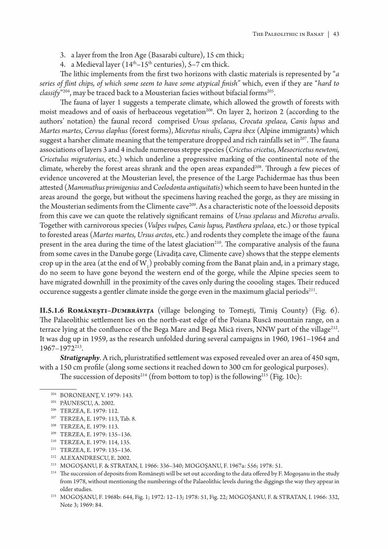
The Paleolithic in Banat | 43
3. a layer from the Iron Age (Basarabi culture), 15 cm thick;4. a Medieval layer (14th–15th centuries), 5–7 cm thick.Th e lithic implements from the fi rst two horizons with clastic materials is represented by “a
series of fl int chips, of which some seem to have some atypical fi nish” which, even if they are “hard to classify”204, may be traced back to a Mousterian facies without bifacial forms205.
Th e fauna of layer 1 suggests a temperate climate, which allowed the growth of forests with moist meadows and of oasis of herbaceous vegetation206. On layer 2, horizon 2 (according to the authors’ notation) the faunal record comprised Ursus spelaeus, Crocuta spelaea, Canis lupus and Martes martes, Cervus elaphus (forest forms), Microtus nivalis, Capra ibex (Alpine immigrants) which suggest a harsher climate meaning that the temperature dropped and rich rainfalls set in207. Th e fauna associations of layers 3 and 4 include numerous steppe species (Cricetus cricetus, Mesocricetus newtoni, Cricetulus migratorius, etc.) which underline a progressive marking of the continental note of the climate, whereby the forest areas shrank and the open areas expanded208. Th rough a few pieces of evidence uncovered at the Mousterian level, the presence of the Large Pachidermae has thus been att ested (Mammuthus primigenius and Coelodonta antiquitatis) which seem to have been hunted in the areas around the gorge, but without the specimens having reached the gorge, as they are missing in the Mousterian sediments from the Climente cave209. As a characteristic note of the loessoid deposits from this cave we can quote the relatively signifi cant remains of Ursus spelaeus and Microtus arvalis. Together with carnivorous species (Vulpes vulpes, Canis lupus, Panthera spelaea, etc.) or those typical to forested areas (Martes martes, Ursus arctos, etc.) and rodents they complete the image of the fauna present in the area during the time of the latest glaciation210. Th e comparative analysis of the fauna from some caves in the Danube gorge (Livadiţa cave, Climente cave) shows that the steppe elements crop up in the area (at the end of W1) probably coming from the Banat plain and, in a primary stage, do no seem to have gone beyond the western end of the gorge, while the Alpine species seem to have migrated downhill in the proximity of the caves only during the coooling stages. Th eir reduced occurence suggests a gentler climate inside the gorge even in the maximum glacial periods211.
II.5.1.6 Româneşti–Dumbrăviţa (village belonging to Tomeşti, Timiş County) (Fig. 6). Th e Palaeolithic sett lement lies on the north-east edge of the Poiana Ruscă mountain range, on a terrace lying at the confl uence of the Bega Mare and Bega Mică rivers, NNW part of the village212. It was dug up in 1959, as the research unfolded during several campaigns in 1960, 1961–1964 and 1967–1972213.
Stratigraphy. A rich, pluristratifi ed sett lement was exposed revealed over an area of 450 sqm, with a 150 cm profi le (along some sections it reached down to 300 cm for geological purposes).
Th e succession of deposits214 (from bott om to top) is the following215 (Fig. 10c):
204 BORONEANŢ, V. 1979: 143.205 PĂUNESCU, A. 2002.206 TERZEA, E. 1979: 112.207 TERZEA, E. 1979: 113, Tab. 8.208 TERZEA, E. 1979: 113.209 TERZEA, E. 1979: 135–136.210 TERZEA, E. 1979: 114, 135.211 TERZEA, E. 1979: 135–136.212 ALEXANDRESCU, E. 2002.213 MOGOŞANU, F. & STRA TAN, I. 1966: 336–340; MOGOŞANU, F. 1967a: 556; 1978: 51.214 Th e succession of deposits from Româneşti will be set out according to the data off ered by F. Mogoşanu in the study
from 1978, without mentioning the numberings of the Palaeolithic levels during the diggings the way they appear in older studies.
215 MOGOŞANU, F. 1968b: 644, Fig. 1; 1972: 12–13; 1978: 51, Fig. 22; MOGOŞANU, F. & STRA TAN, I. 1966: 332, Note 3; 1969: 84.
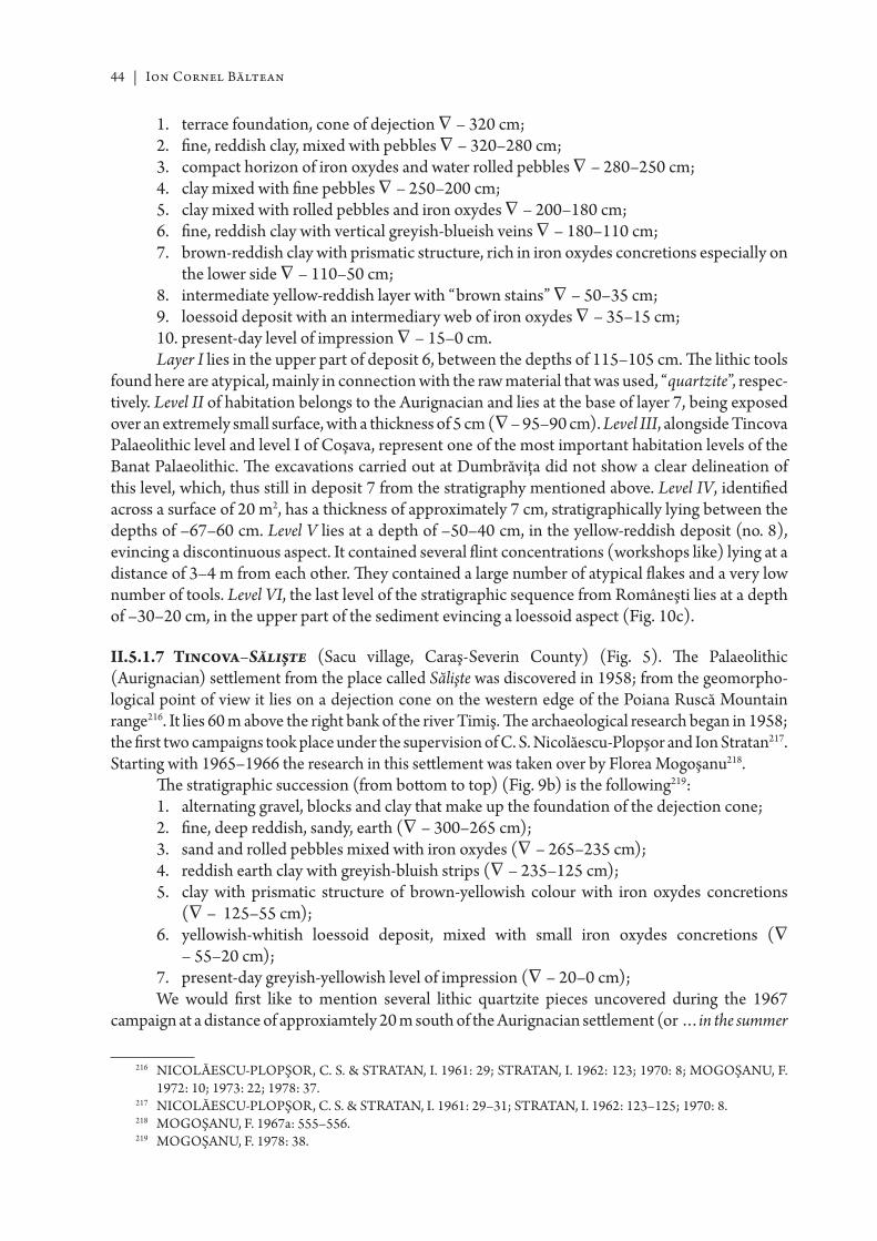
44 | Ion Cornel Băltean
1. terrace foundation, cone of dejection ∇ – 320 cm;2. fi ne, reddish clay, mixed with pebbles ∇ – 320–280 cm;3. compact horizon of iron oxydes and water rolled pebbles ∇ – 280–250 cm;4. clay mixed with fi ne pebbles ∇ – 250–200 cm;5. clay mixed with rolled pebbles and iron oxydes ∇ – 200–180 cm;6. fi ne, reddish clay with vertical greyish-blueish veins ∇ – 180–110 cm;7. brown-reddish clay with prismatic structure, rich in iron oxydes concretions especially on
the lower side ∇ – 110–50 cm;8. intermediate yellow-reddish layer with “brown stains” ∇ – 50–35 cm;9. loessoid deposit with an intermediary web of iron oxydes ∇ – 35–15 cm;10. present-day level of impression ∇ – 15–0 cm.Layer I lies in the upper part of deposit 6, between the depths of 115–105 cm. Th e lithic tools
found here are atypical, mainly in connection with the raw material that was used, “quartzite”, respec-tively. Level II of habitation belongs to the Aurignacian and lies at the base of layer 7, being exposed over an extremely small surface, with a thickness of 5 cm (∇ – 95–90 cm). Level III, alongside Tincova Palaeolithic level and level I of Coşava, represent one of the most important habitation levels of the Banat Palaeolithic. Th e excavations carried out at Dumbrăviţa did not show a clear delineation of this level, which, thus still in deposit 7 from the stratigraphy mentioned above. Level IV, identifi ed across a surface of 20 m2, has a thickness of approximately 7 cm, stratigraphically lying between the depths of –67–60 cm. Level V lies at a depth of –50–40 cm, in the yellow-reddish deposit (no. 8), evincing a discontinuous aspect. It contained several fl int concentrations (workshops like) lying at a distance of 3–4 m from each other. Th ey contained a large number of atypical fl akes and a very low number of tools. Level VI, the last level of the stratigraphic sequence from Româneşti lies at a depth of –30–20 cm, in the upper part of the sediment evincing a loessoid aspect (Fig. 10c).
II.5.1.7 Tincova–Sălişte (Sacu village, Caraş-Severin County) (Fig. 5). Th e Palaeolithic (Aurignacian) sett lement from the place called Sălişte was discovered in 1958; from the geomorpho-logical point of view it lies on a dejection cone on the western edge of the Poiana Ruscă Mountain range216. It lies 60 m above the right bank of the river Timiş. Th e archaeological research began in 1958; the fi rst two campaigns took place under the supervision of C. S. Nicolăescu-Plopşor and Ion Stratan217. Starting with 1965–1966 the research in this sett lement was taken over by Florea Mogoşanu218.
Th e stratigraphic succession (from bott om to top) (Fig. 9b) is the following219:1. alternating gravel, blocks and clay that make up the foundation of the dejection cone;2. fi ne, deep reddish, sandy, earth (∇ – 300–265 cm);3. sand and rolled pebbles mixed with iron oxydes (∇ – 265–235 cm);4. reddish earth clay with greyish-bluish strips (∇ – 235–125 cm);5. clay with prismatic structure of brown-yellowish colour with iron oxydes concretions
(∇ – 125–55 cm);6. yellowish-whitish loessoid deposit, mixed with small iron oxydes concretions (∇
– 55–20 cm);7. present-day greyish-yellowish level of impression (∇ – 20–0 cm);We would fi rst like to mention several lithic quartzite pieces uncovered during the 1967
campaign at a distance of approxiamtely 20 m south of the Aurignacian sett lement (or …in the summer
216 NICOLĂESCU-PLOPŞOR, C. S. & STRA TAN, I. 1961: 29; STRA TAN, I. 1962: 123; 1970: 8; MOGOŞANU, F. 1972: 10; 1973: 22; 1978: 37.
217 NICOLĂESCU-PLOPŞOR, C. S. & STRA TAN, I. 1961: 29–31; STRA TAN, I. 1962: 123–125; 1970: 8.218 MOGOŞANU, F. 1967a: 555–556.219 MOGOŞANU, F. 1978: 38.
The Paleolithic in Banat | 45
of 1966… about 200 m north…)220 – in a small test pit (3 × 2 m)221. Th eir stratigraphic position is uncertain, as one could not determine if the deposit they originated from was “reshuffl ed” or not. Th ere are about 15 “quartzite” pieces uncovered in the degraded loess deposit (lying at the base of the present day vegetal deposit) of yellowish-greyish colour, at a depth of 40–30 cm. Th e Aurignacian lithic matrials included in a single cultural level, have been dug up in the upper part of deposit 5.
II.5.2 Repertoir of Palaeolithic archaeological sites
II.5.2.1 Băile Herculane–Hoţilor Cave (Fig. 11). Th e fi rst information on the archaeological research carried out in this cave was given to us from Nicolae Stoica de Haţeg, who mentions that in 1778 the priest Samoilă Popovici and Ignatie Sandală from Mehadia discovered various ‘buckles’ and ‘harnessing pieces’222. In 1872, the year when the Society for History and Archaeology of Timişoara was founded, the fi rst excavations also started, under the supervision of dr. Ludwig Arányi, A. Józsa and Th . Lehotzky223 followed by the research carried out by Bódrog Milleker and G. Téglás around 1880, by Agoston Solymásy in 1904, Ott okar Kadić in 1916 and by a group of museologists from Craiova in 1927224. Th e scientifi c research began in 1954, Peştera Hoţilor being tackled under the framework of “the archaeologic site Cerna-Olt”225. Th e excavations carried out on several campaigns have brought forth a stratigraphic sequence that is important for several cultural-chronological horizons. Th e lithic tools uncovered at the foot of the loessoid deposits that make up layer 2, at the depth of 270–250 cm, count 125 pieces; typologically we should mention the following pieces226 (Fig. 12):
• 5 scrapers created on triangular-shaped falkes (2) with neocortical butt or on alternately retouched fl akes (3);
• 3 Mousterian atypical points of a triangular shape with a thick neocortical butt ;• 8 retouched fl akes with a neocortical butt , some seeming to be denticulated;• pieces of a natural couteau à dos.Th is tool points out to a Mousterian industry characterized by the absence of the Levallois
technique and of the bifacial shapes, but rich in scrapers. Th e stratigraphic position and the uncovered fauna remainders (high frequency of Microtus nivalis and Marvalis suggesting a cold climate) enabled us to att ribute these pieces back to a presumed Late Mousterian, which developed at the beginning of W2
227.Other than the above-mentioned pieces, in the same (greyish-yellow) sediment as well as in
sediment B (dark yellowish with many pebbles) from the big gallery, pieces of Upper Palaeolithic origin were found228. Among them we would like to mention some blades with continuous retouches on one side, one notched piece, one piece with retouched truncation, a burin-scraper, an angle burin on break, 5 atypical scrapers and two prismatic cores- that can be traced back to the Aurignacian. Within this context one should also mention the only hearth identifi ed for the Palaeolithic. It was quasi-round in shape, with a size of 90 × 80 cm and a thickness of 6–9 cm. Th e fauna associated with this horizons consists of, among others, micromammals (Microtus nivalis, Microtus arvalis, Microtus agrestis etc.), Ursus spelaeus, Cervus elaphus, etc., all pointing out to a certain amelioration of the climate, favouring an expansion of forest, mainly of decidous trees229. Th is occupation period here represents the only Aurignacian cave occupation discovered in the Banat up to the present moment.
220 MOGOŞANU, F. 1968a: 303; 1972: 11.221 MOGOŞANU, F. 1978: 48–49.222 PETRESCU, S. M. 2000: 16.223 PETRESCU, S. M. 2000: 16.224 PĂUNESCU, A. 1987: 15; MOGOŞANU, F. 1971: 3; 1972: 9; 1978: 23.225 NICOLĂESCU-PLOPŞOR, C. S. et alii 1955: 140–146.226 MOGOŞANU, F. 1978: 27–29; PĂUNESCU, A. 2002.227 PĂUNESCU, A. 1992: 3; MOGOŞANU, F. 1968a: 309; 1971: 9–12; 1972: 9–10; 1973: 14–17; 1978: 29, 102.228 MOGOŞANU, F. 1978: 29.229 PĂUNESCU, A. 1992: 4–5; 2002.
46 | Ion Cornel Băltean
Th e fi rst pre-Neolithic discoveries made in this cave provoked a lengthy debate among the Romanian archaeologists. Th e topic of this debate was the discovery of hearth with microliths and no pott ery in squares 11–14 on the 1954 campaign230. Essentially, it centered around the occupation level III from Herculane, identifi ed both in the rotonda (in a light yellow sediment in the lower part and reddish in the upper part) and in the big gallery in sediment C of greyish-black colour. In this gallery an oval shaped “habitation complex” (385 × 180 cm, approx. 10 cm thick) was found. In its proximity there were four hearths231. In the lithic assemblage there were 475 (mostly) fl int pieces, and some radiolarite pieces. 90 of them are tools: scrapers (in great numbers), backed blades, notched pieces, side-scrapers, pieces of the raclett e type, burins, piercers, pieces esquillées232, narrow backed blades, truncated blades and very few geometrical armatures (scalene triangle, circle segments, asymmetrical trapezese) and pieces of backed knife type (Fig. 13)233.
From the fl oristic point of view one identifi ed following coal samples testing, Pinus sp. and some indeterminable decidous trees. Th e uncovered fauna comprises micromammals (Microtus arvalis, Microtus agrestis, Cricetulus migratorius, etc.), big mammals (Ursus arctos, Cervus elaphus, Castor fi ber, etc.), birds (Pyrrhocorax cf. graculus), fi sh (Cyprinus carpio, Aspis rapax) and several (fossile Cerithium sp.) shells used for adornments234.
Th e discovery of these complexes made 14C dating possible. Th us, sample 1 (calcinated bones from hearth no. 2, squares 3–4 of the longitudinal sections (southern profi le) in the big gallery, 119–107 cm deep) provided the date 11490±75 BP (GrN–16978) considered to be accurate, if we consider the features of the lithic material, of the fauna and fl ora, being at the same time an argument for considering this Epipalaeolithic dwelling that probably developed within the Alleröd and Dryas III oscillation235. All these lead one to trace this lithic assemblage to the Tardigravett ian of a Mediterranean type, also found in the Danube gorge at Cuina Turcului236.
II.5.2.2 Caransebeş (Caraş-Severin County). At Carbonifera Veche (New Caransebeş, left of the Caransebeş–Orşova road) 3–4 fl int objects were found and assigned by Richard Petrovszky to the Upper Palaeolithic. Another piece was found while digging a ditch for a high voltage post. In the Timiş fl oodplain on its left bank, at the Măhală, other pieces were found and considered to be Palaeolithic237. In the absence of a stratigraphic context as well as a formal description and graphic illustration, they should be looked upon with utmost caution. During some fi eld research carried out recently isolated lithic pieces that could be Palaeolithic were found: a “quartzite” fl ake found on Dealul Iepura, about 1 km east of the town, on the right-hand side of the road to Lugoj, or an atypical fl ake from the same raw material found at Zborâşte (approximately 1.5 km from Dealul Iepura)238. Beside these pieces, in the colections of the County Museum of Ethnography and of the Border Brigade Caransebeş one can also fi nd an opal chip with retouchings in the distal area found in the area of the village Lăpugiul de Sus (Hunedoara County), a macrolithic yellowish-brown fl int piece with directly retouched parts on either side, the back side preserving cortex areas, found in the area of the villages Româneşti–Baloşeşti (Timiş County) and a ‘quartzite’ blade found by Octavian Popescu at the point called Ocna lui Vucu, near the peak of Pleşiva in Anina Mountains239.
230 NICOLĂESCU-PLOPŞOR, C. S. et alii 1955: 143; NICOLĂESCU-PLOPŞOR, C. S. et alii 1957: 51–53.231 PĂUNESCU, A. 1992: 5; NICOLĂESCU-PLOPŞOR, C. S. & COMŞA, E. 1957: 18–21; NICOLĂESCU-
PLOPŞOR, C. S. & PĂUNESCU, A. 1961: 203–213.232 BITIRI, M. 1959: 453–454.233 PĂUNESCU, A. 1992: 5.234 PĂUNESCU, A. 1992: 5.235 PĂUNESCU, A. 1992: 5.236 PĂUNESCU 1970b: 3–28; 1979: 11–28; 1984: 251–252; 1989: 146–150; 2001: 68–70, 336–361.237 PETROVSZKY, R. 1975: 365; JUNGBERT, B. 1978: 9–10.238 Octavian Popescu, personal communication.239 Emilian Alexandrescu, personal communication.
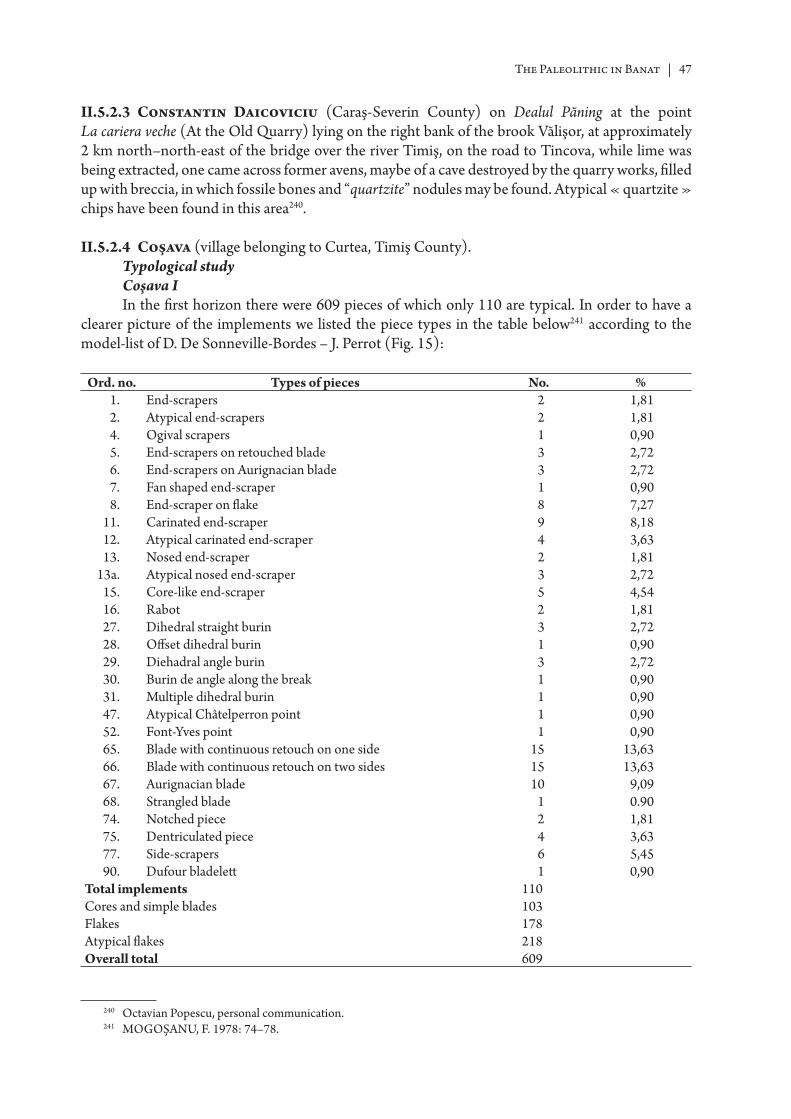
The Paleolithic in Banat | 47
II.5.2.3 Constantin Daicoviciu (Caraş-Severin County) on Dealul Păning at the point La cariera veche (At the Old Quarry) lying on the right bank of the brook Vălişor, at approximately 2 km north–north-east of the bridge over the river Timiş, on the road to Tincova, while lime was being extracted, one came across former avens, maybe of a cave destroyed by the quarry works, fi lled up with breccia, in which fossile bones and “quartzite” nodules may be found. Atypical « quartzite » chips have been found in this area240.
II.5.2.4 Coşava (village belonging to Curtea, Timiş County). Typological studyCoşava IIn the fi rst horizon there were 609 pieces of which only 110 are typical. In order to have a
clearer picture of the implements we listed the piece types in the table below241 according to the model-list of D. De Sonneville-Bordes – J. Perrot (Fig. 15):
Ord. no. Types of pieces No. %1. End-scrapers 2 1,812. Atypical end-scrapers 2 1,814. Ogival scrapers 1 0,905. End-scrapers on retouched blade 3 2,726. End-scrapers on Aurignacian blade 3 2,727. Fan shaped end-scraper 1 0,908. End-scraper on fl ake 8 7,27
11. Carinated end-scraper 9 8,1812. Atypical carinated end-scraper 4 3,6313. Nosed end-scraper 2 1,81
13a. Atypical nosed end-scraper 3 2,7215. Core-like end-scraper 5 4,5416. Rabot 2 1,8127. Dihedral straight burin 3 2,7228. Off set dihedral burin 1 0,9029. Diehadral angle burin 3 2,7230. Burin de angle along the break 1 0,9031. Multiple dihedral burin 1 0,9047. Atypical Châtelperron point 1 0,9052. Font-Yves point 1 0,9065. Blade with continuous retouch on one side 15 13,6366. Blade with continuous retouch on two sides 15 13,6367. Aurignacian blade 10 9,0968. Strangled blade 1 0.9074. Notched piece 2 1,8175. Dentriculated piece 4 3,6377. Side-scrapers 6 5,4590. Dufour bladelett 1 0,90
Total implements 110Cores and simple blades 103Flakes 178Atypical fl akes 218Overall total 609
240 Octavian Popescu, personal communication.241 MOGOŞANU, F. 1978: 74–78.
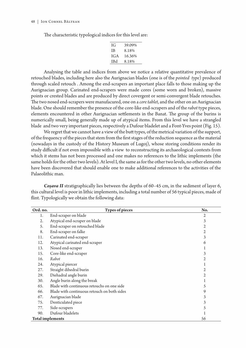
48 | Ion Cornel Băltean
Th e characteristic typological indices for this level are:
IG 39.09%IB 8.18%IGA 16.36%IBd 8.18%
Analysing the table and indices from above we notice a relative quantitative prevalence of retouched blades, including here also the Aurignacian blades (one is of the pointed type) produced through scaled retouch . Among the end-scrapers an important place falls to those making up the Aurignacian group. Carinated end-scrapers were made cores (some worn and broken), massive points or crested blades and are produced by direct covergent or semi-convergent blade retouches. Th e two nosed end-scrapers were manufacured, one on a core tablet, and the other on an Aurignacian blade. One should remember the presence of the core-like end-scrapers and of the rabot type pieces, elements encountered in other Aurignacian sett lements in the Banat. Th e group of the burins is numerically small, being generally made up of atypical items. From this level we have a strangled blade and two very important pieces, respectively a Dufour bladelet and a Font-Yves point (Fig. 15).
We regret that we cannot have a view of the butt types, of the metrical variation of the support, of the frequency of the pieces that stem from the fi rst stages of the reduction sequence as the material (nowadays in the custody of the History Museum of Lugoj), whose storing conditions render its study diffi cult if not even impossible with a view to reconstructing its archaeological contexts from which it stems has not been processed and one makes no references to the lithic implements (the same holds for the other two levels). At level I, the same as for the other two levels, no other elements have been discovered that should enable one to make additional references to the activities of the Palaeolithic man.
Coșava II stratigraphically lies between the depths of 60–45 cm, in the sediment of layer 6, this cultural level is poor in lithic implements, including a total number of 56 typical pieces, made of fl int. Typologically we obtain the following data:
Ord. no. Types of pieces No.1. End-scraper on blade 22. Atypical end-scraper on blade 35. End-scraper on retouched blade 28. End-scraper on falke 2
11. Carinated end-scraper 312. Atypical carinated end-scraper 613. Nosed end-scraper 115. Core-like end-scraper 316. Rabot 224. Atypical piercer 127. Straight dihedral burin 229. Diehadral angle burin 230. Angle burin along the break 165. Blade with continuous retouchs on one side 566. Blade with continuous retouch on both sides 967. Aurignacian blade 375. Denticulated piece 377. Side-scrapers 590. Dufour bladelets 1
Total implements 56
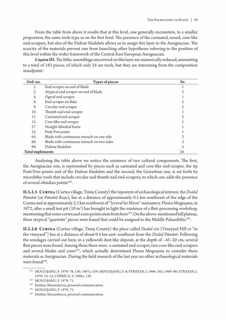
The Paleolithic in Banat | 49
From the table from above it results that at this level, one generally encounters, to a smaller proportion, the same tools type as on the fi rst level. Th e presence of the carinated, nosed, core-like end-scrapers, but also of the Dufour bladelets allows us to assign this layer to the Aurignacian. Th e scarcity of the materials prevent one from launching other hypotheses referring to the position of this level within the wider framework of the Central-East European Aurignacian.
Coșava III. Th e lithic assemblage uncovered on this layer are numerically reduced, amounting to a total of 183 pieces, of which only 24 are tools, but they are interesting from the composition standpoint:
Ord. no. Types of pieces Nr.
1. End-scraper on end of blade 12. Atypical end-scraper on end of blade 24. Ogival end-scraper 18. End-scraper on fl ake 29. Circular end-scraper 2
10. Th umb-nail end-scraper 111. Carinated end-scraper 215. Core-like end-scraper 127. Straight dihedral burin 152. Font-Yves point 165. Blade with continuous retouch on one side 266. Blade with continuous retouch on two sides 390. Dufour bladelets 5
Total implements 24
Analysing the table above we notice the existence of two cultural components. Th e fi rst, the Aurignacian one, is represented by pieces such as carinated and core-like end-scraper, the tip Font-Yves points and of the Dufour bladelets and the second, the Gravett ian one, is set forth by microlithic tools that include circular and thumb-nail end-scrapers, to which one adds the presence of several obsidian points242.
II.5.2.5 Curtea (Curtea village, Timiş County) the toponym of archaeological interest, the Dealul Pământ (or Pământ Roşu), lies at a distance of approximately 0.5 km southwest of the edge of the Curtea and at approximately 2.5 km southwest of “Izvorul lui Miron” monastery. Florea Mogoşanu, in 1972, aft er a small test pit (10 m2) has brought to light the existence of a fl int-processing workshop, mentioning that some cortex and cores points stem from here243. On the above-mentioned hill plateau, three atypical “quartzite” pieces were found that could be assigned to the Middle Palaeolithic244.
II.5.2.6 Curtea (Curtea village, Timiş County) the place called Dealul viei (Vineyard Hill or “in the vineyard”) lies at a distance of about 0.4 km east–southeast from the Dealul Pământ. Following the sondages carried out here, in a yellowish dust-like deposit, at the depth of –45–20 cm, several fl int pieces were found. Among them there were: a carinated end-scraper, two core-like end-scrapers and several blades and cores245, which actually determined Florea Mogoşanu to consider these materials as Aurignacian. During the fi eld research of the last year no other archaeological materials were found246.
242 MOGOŞANU, F. 1978: 78, 130; 1967a: 559; MOGOŞANU, F. & STRA TAN, I. 1966: 343; 1969: 90; STRA TAN, I. 1970: 14–15; CHIRICA, V. 1996a: 138.
243 MOGOŞANU, F. 1978: 71.244 Emilian Alexandrescu, personal communication.245 MOGOŞANU, F. 1978: 71.246 Emilian Alexandrescu, personal communication.
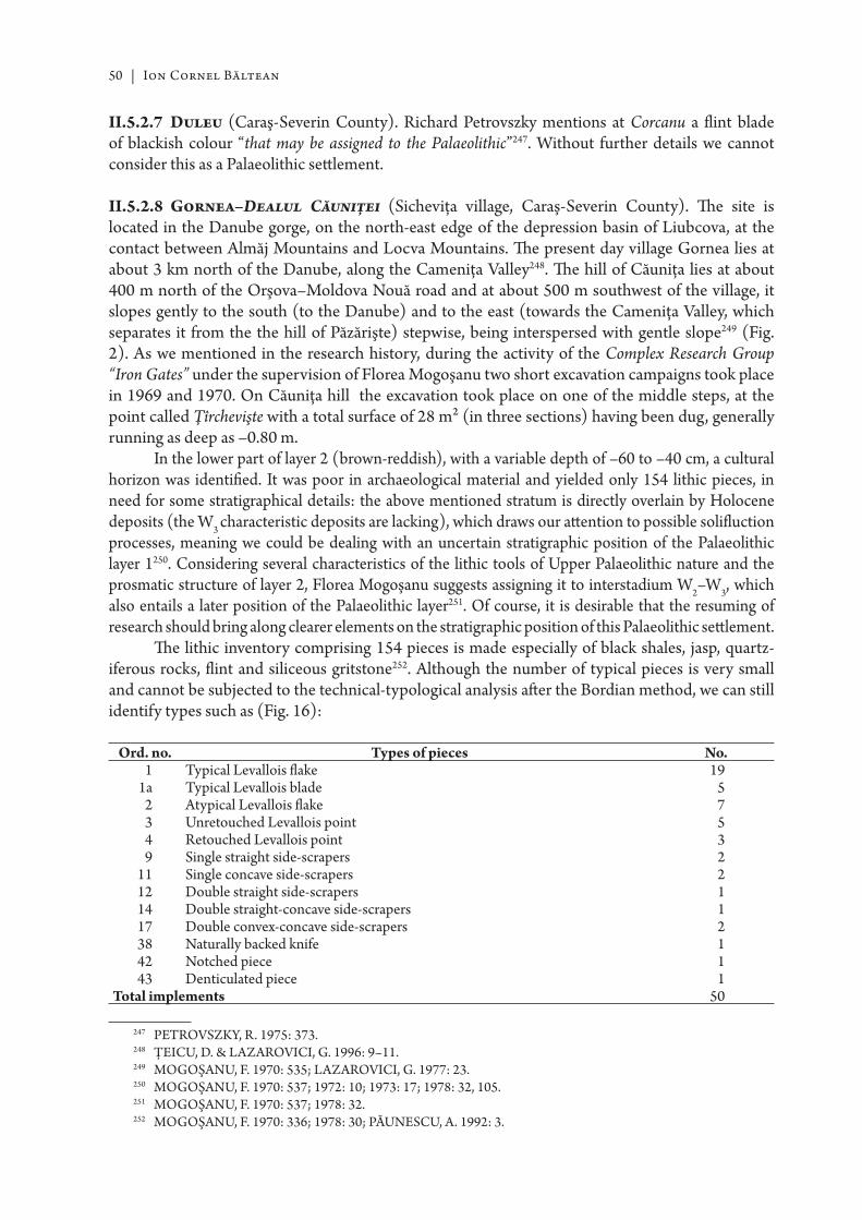
50 | Ion Cornel Băltean
II.5.2.7 Duleu (Caraş-Severin County). Richard Petrovszky mentions at Corcanu a fl int blade of blackish colour “that may be assigned to the Palaeolithic”247. Without further details we cannot consider this as a Palaeolithic sett lement.
II.5.2.8 Gornea–Dealul Căuniţei (Sicheviţa village, Caraş-Severin County). Th e site is located in the Danube gorge, on the north-east edge of the depression basin of Liubcova, at the contact between Almăj Mountains and Locva Mountains. Th e present day village Gornea lies at about 3 km north of the Danube, along the Cameniţa Valley248. Th e hill of Căuniţa lies at about 400 m north of the Orşova–Moldova Nouă road and at about 500 m southwest of the village, it slopes gently to the south (to the Danube) and to the east (towards the Cameniţa Valley, which separates it from the the hill of Păzărişte) stepwise, being interspersed with gentle slope249 (Fig. 2). As we mentioned in the research history, during the activity of the Complex Research Group “Iron Gates” under the supervision of Florea Mogoşanu two short excavation campaigns took place in 1969 and 1970. On Căuniţa hill the excavation took place on one of the middle steps, at the point called Ţîrchevişte with a total surface of 28 m2 (in three sections) having been dug, generally running as deep as –0.80 m.
In the lower part of layer 2 (brown-reddish), with a variable depth of –60 to –40 cm, a cultural horizon was identifi ed. It was poor in archaeological material and yielded only 154 lithic pieces, in need for some stratigraphical details: the above mentioned stratum is directly overlain by Holocene deposits (the W3 characteristic deposits are lacking), which draws our att ention to possible solifl uction processes, meaning we could be dealing with an uncertain stratigraphic position of the Palaeolithic layer 1250. Considering several characteristics of the lithic tools of Upper Palaeolithic nature and the prosmatic structure of layer 2, Florea Mogoşanu suggests assigning it to interstadium W2–W3, which also entails a later position of the Palaeolithic layer251. Of course, it is desirable that the resuming of research should bring along clearer elements on the stratigraphic position of this Palaeolithic sett lement.
Th e lithic inventory comprising 154 pieces is made especially of black shales, jasp, quartz-iferous rocks, fl int and siliceous gritstone252. Although the number of typical pieces is very small and cannot be subjected to the technical-typological analysis aft er the Bordian method, we can still identify types such as (Fig. 16):
Ord. no. Types of pieces No.1 Typical Levallois fl ake 19
1a Typical Levallois blade 52 Atypical Levallois fl ake 73 Unretouched Levallois point 54 Retouched Levallois point 39 Single straight side-scrapers 2
11 Single concave side-scrapers 212 Double straight side-scrapers 114 Double straight-concave side-scrapers 117 Double convex-concave side-scrapers 238 Naturally backed knife 142 Notched piece 143 Denticulated piece 1
Total implements 50
247 PETROVSZKY, R. 1975: 373.248 ŢEICU, D. & LAZAROVICI, G. 1996: 9–11.249 MOGOŞANU, F. 1970: 535; LAZAROVICI, G. 1977: 23.250 MOGOŞANU, F. 1970: 537; 1972: 10; 1973: 17; 1978: 32, 105.251 MOGOŞANU, F. 1970: 537; 1978: 32.252 MOGOŞANU, F. 1970: 336; 1978: 30; PĂUNESCU, A. 1992: 3.
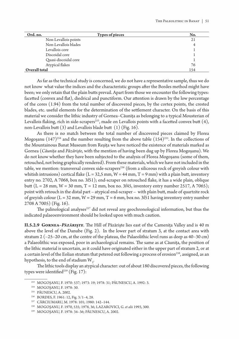
The Paleolithic in Banat | 51
Ord. no. Types of pieces No.Non-Levallois points 21Non-Levallois blades 4Levallois core 1Discoidal core 1Quasi-discoidal core 1Atypical fl akes 76
Overall total 154
As far as the technical study is concerned, we do not have a representative sample, thus we do not know what value the indices and the characteristic groups aft er the Bordes method might have been; we only retain that the plain butt s prevail. Apart from those we encounter the following types: facett ed (convex and fl at), diedrical and punctiform. Our att ention is drawn by the low percentage of the cores (1.94) from the total number of discovered pieces, by the cortex points, the crested blades, etc. useful elements for the determination of the sett lement character. On the basis of this material we consider the lithic industry of Gornea–Căuniţa as belonging to a typical Mousterian of Levallois fl aking, rich in side-scrapers253, made on Levallois points with a facett ed convex butt (4), non-Levallois butt (3) and Levallois blade butt (1) (Fig. 16).
As there is no match between the total number of discovered pieces claimed by Florea Mogoşanu (147)254 and the number resulting from the above table (154)255. In the collections of the Mountainous Banat Museum from Reşiţa we have noticed the existence of materials marked as Gornea (Căuniţa and Păzărişte, with the mention of having been dug up by Florea Mogoşanu). We do not know whether they have been subjected to the analysis of Florea Mogoşanu (some of them, retouched, not being graphically rendered). From these materials, which we have not included in the table, we mention: transversal convex side-scrapers256 (from a siliceous rock of greyish colour with whitish intrusions) cortical fl ake (L = 32,5 mm, W = 44 mm, T = 9 mm) with a plain butt , inventory entry no. 2702, A 7068, box no. 3f51); end-scraper on retouched fl ake, it has a wide plain, oblique butt (L = 28 mm, W = 30 mm, T = 12 mm, box no. 3f45, inventory entry number 2517, A 7065); point with retouch in the distal part – atypical end-scraper – with plain butt , made of quartzite rock of greyish colour (L = 32 mm, W = 29 mm, T = 6 mm, box no. 3f51 having inventory entry number 2708 A 7005) (Fig. 16).
Th e palinological analyses257 did not reveal any geochronological information, but thus the indicated palaeoenvironment should be looked upon with much caution.
II.5.2.9 Gornea–Păzărişte. Th e Hill of Păzărişte lies east of the Cameniţa Valley and is 40 m above the level of the Danube (Fig. 2). In the lower part of stratum 3, at the contact area with stratum 2 (–25–20 cm, at the centre of the plateau, the Palaeolithic level runs as deep as 40–30 cm) a Palaeolithic was exposed, poor in archaeological remains. Th e same as at Căuniţa, the position of the lithic material is uncertain, as it could have originated either in the upper part of stratum 2, or at a certain level of the Eolian stratum that petered out following a process of erosion258, assigned, as an hypothesis, to the end of stadium W3.
Th e lithic tools display an atypical character: out of about 180 discovered pieces, the following types were identifi ed259 (Fig. 17):
253 MOGOŞANU, F. 1970: 537; 1973: 19; 1978: 31; PĂUNESCU, A. 1992: 3.254 MOGOŞANU, F. 1978: 30.255 PĂUNESCU, A. 2002.256 BORDES, F. 1961: 12, Fig. 3/1–4, 28.257 CÂRCIUMARU, M. 1978: 101; 1980: 142–144.258 MOGOŞANU, F. 1970, 535; 1978, 36; LAZAROVICI, G. et alii 1993, 300.259 MOGOŞANU, F. 1978: 34–36; PĂUNESCU, A. 2002.
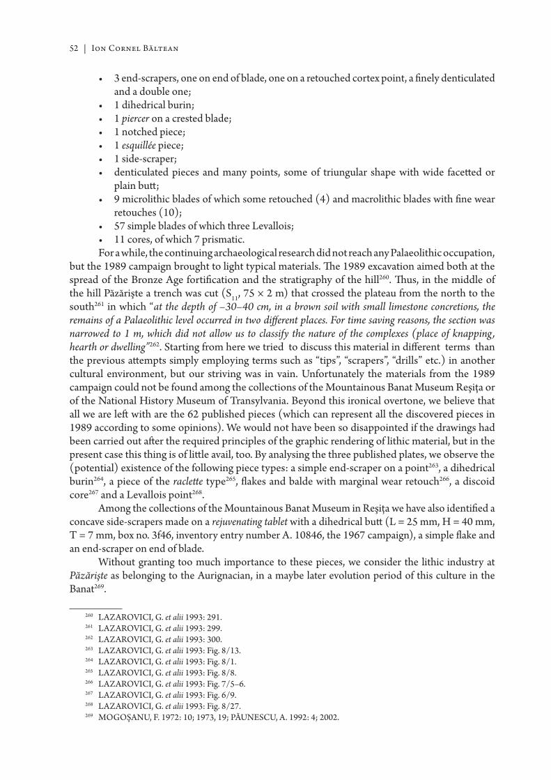
52 | Ion Cornel Băltean
• 3 end-scrapers, one on end of blade, one on a retouched cortex point, a fi nely denticulated and a double one;
• 1 dihedrical burin;• 1 piercer on a crested blade;• 1 notched piece;• 1 esquillée piece;• 1 side-scraper;• denticulated pieces and many points, some of triungular shape with wide facett ed or
plain butt ;• 9 microlithic blades of which some retouched (4) and macrolithic blades with fi ne wear
retouches (10);• 57 simple blades of which three Levallois;• 11 cores, of which 7 prismatic.For a while, the continuing archaeological research did not reach any Palaeolithic occupation,
but the 1989 campaign brought to light typical materials. Th e 1989 excavation aimed both at the spread of the Bronze Age fortifi cation and the stratigraphy of the hill260. Th us, in the middle of the hill Păzărişte a trench was cut (S11, 75 × 2 m) that crossed the plateau from the north to the south261 in which “at the depth of –30–40 cm, in a brown soil with small limestone concretions, the remains of a Palaeolithic level occurred in two diff erent places. For time saving reasons, the section was narrowed to 1 m, which did not allow us to classify the nature of the complexes (place of knapping, hearth or dwelling”262. Starting from here we tried to discuss this material in diff erent terms than the previous att empts simply employing terms such as “tips”, “scrapers”, “drills” etc.) in another cultural environment, but our striving was in vain. Unfortunately the materials from the 1989 campaign could not be found among the collections of the Mountainous Banat Museum Reşiţa or of the National History Museum of Transylvania. Beyond this ironical overtone, we believe that all we are left with are the 62 published pieces (which can represent all the discovered pieces in 1989 according to some opinions). We would not have been so disappointed if the drawings had been carried out aft er the required principles of the graphic rendering of lithic material, but in the present case this thing is of litt le avail, too. By analysing the three published plates, we observe the (potential) existence of the following piece types: a simple end-scraper on a point263, a dihedrical burin264, a piece of the raclett e type265, fl akes and balde with marginal wear retouch266, a discoid core267 and a Levallois point268.
Among the collections of the Mountainous Banat Museum in Reşiţa we have also identifi ed a concave side-scrapers made on a rejuvenating tablet with a dihedrical butt (L = 25 mm, H = 40 mm, T = 7 mm, box no. 3f46, inventory entry number A. 10846, the 1967 campaign), a simple fl ake and an end-scraper on end of blade.
Without granting too much importance to these pieces, we consider the lithic industry at Păzărişte as belonging to the Aurignacian, in a maybe later evolution period of this culture in the Banat269.
260 LAZAROVICI, G. et alii 1993: 291.261 LAZAROVICI, G. et alii 1993: 299.262 LAZAROVICI, G. et alii 1993: 300.263 LAZAROVICI, G. et alii 1993: Fig. 8/13.264 LAZAROVICI, G. et alii 1993: Fig. 8/1.265 LAZAROVICI, G. et alii 1993: Fig. 8/8.266 LAZAROVICI, G. et alii 1993: Fig. 7/5–6.267 LAZAROVICI, G. et alii 1993: Fig. 6/9.268 LAZAROVICI, G. et alii 1993: Fig. 8/27.269 MOGOŞANU, F. 1972: 10; 1973, 19; PĂUNESCU, A. 1992: 4; 2002.
The Paleolithic in Banat | 53
II.5.2.10 Gornea–Vodneac (Caraş-Severin County). Here, lying on a sloping plateau at the Păzărişte foothill, 400 m north of the Orşova–Moldova Nouă road, Alexandru Păunescu (quoting page 3 of the abstract of V. Boroneanţ’s doctoral thesis from 1981) mentions the discovery of several fl int pieces (a core-like end-scraper, a double notched, an end-scraper, etc.) assigned to the Aurignacian270 the same as those from Păzărişte. Vasile Boroneanţ’s published version of the doctoral thesis is said that “…l’homme continua-t-il d’habiter cett e contrée pendant le paléolithique supérieur, comme le prouvent les documents archéologiques mis au jour dans la grott e Climente I de Dubova, à Gornea, dans la colline de Păzărişte, ainsi qu’à Vodneac”271. Also “in the same area, and even in the profi le of a section of the colleague Boroneanţ, I have found pott ery fr agments that belong to Starčevo-Criş culture to which the fl int discoveries made by our colleague may belong”272. According to more recent opinions referring to these materials, one cannot rule out the possiblity of their provenance from Păzărişte273.
II.5.2.11 Grădinari (Caraş-Severin County). Among the collections of the Mountainous Banat Museum from Reşiţa there is a piece (box no. 3f45, inventory entry number 2487) of orange colour, very strongly water rolled, without a clear pointing facet and evincing on its right side, two deep depressions giving it the appearance of a denticulated piece. It was considered to be Palaeolithic.
II.5.2.12 Iabalcea–Cerbului Cave (2240/1, village of Caraşova, Caraş-Severin County) lies at about 5.5 km southeast of the village, on the right bank of the Caraş river, at a height of 504 m. During the sondages carried out here, Ernő Balogh found (under a guano stratum, at the depth of –0.50) several (“purposely”), broken bones which he assignes to the Aurignacian. Together with them there were limestone and quartzite rocks among which a triungular point with several retouches, which he considers to be Mousterian274. We retain here, under some reserve, for the present-day state of the research, the presence of the points and of a “Musterian tip made of quartzite” as arguments referring to the existence of a Palaeolithic sett lement in this cave. It is worth mentioning that, periodically, the cave becomes wet as there probably are underground springs275.
II.5.2.13 Iabalcea–Popovăţ Cave (Popovăţ Cave, village of Caraşova, Caraş-Severin County) has only one entrance, its maximum length amounts to 112 m, and its absolute altitude is 421 m276. Ernö Balogh carried out a sondage here (12 × 1 m, –0,75 m). In clayish yellow deposit, he found several Ursus spelaeus broken bones, among which he identifi ed some tools: daggers, points, scarpers and even some blades of the Kiskevély type. Between 1958 and 1960 fi eld surveys took place in this cave, on which occasion several Ursus spelaeus bone were gathered277 which ended up in the custody of the then County Museum of Reşiţa. It needs to be stressed that the so-called Palaeolithic bone tools discovered are doubtful showing nothing else but natural breaks278 a result of the physical-chemical and mechanical processes that have aff ected the cave sediments.
II.5.2.14 Leucuşeşti (village of Bethausen, Timiş County). On the upper terrace of the Bega river, following some surface research carried out by Ion Stratan between 1967 and 1968, an Aurignacian
270 PĂUNESCU, A. 1992: 4.271 BORONEANŢ, V. 2000a: 22.272 LAZAROVICI, G. 1977: 30.273 Emilian Alexandrescu, personal communication.274 PETROVSZKY, R. 1975: 368; MOGOŞANU, F. 1978: 13–14; JUNGBERT, B. 1979: 400; PĂUNESCU, A. 1987:
15; PETRESCU, S. M. 2000: 21.275 Emilian Alexandrescu, personal communication.276 BORONEANŢ, V. 2000b: 27.277 PETROVSZKY, R. 1975: 368; MOGOŞANU, F. 1978: 14; JUNGBERT, B. 1979: 400–401.278 MOGOŞANU, F. 1978: 14; PĂUNESCU, A. 1987a: 15.
54 | Ion Cornel Băltean
sett lement was postulated279. Considering the range of the Palaeolithic research in the Banat in the 60’s and 70’s we believe that a new Aurignacian sett lement would have made the subject of at least a modest test pit. Th e fact that this station has not been retained by the special fi eld literature leads us to believe that its signalling is a mere step of the fi eld survey research in the Banat, obviously until the fi eld corroboration of the above mentioned information.
II.5.5.15 Liborajdea (village of Sicheviţa, Caraş-Severin Country). Th e point Gura Liborajdea lies at the intersection of the river Liborajdea into the Danube, near the road leading to Pescari. Four microlithic fl int blades, three fl int cores and a crested blade were found here à crête, but on the occasion of the fi eld survey from the summer of 2001 no other materials were found280. Without further sondages looking for new materials and clear detemination of their stratigraphic position, we cannot consider this point as a Palaeolithic sett lement.
II.5.5.16 Pescari–Gaura Chindiei I Cave (2222/1) lies at 6 km downstream of village Pescari (Caraş-Severin Country) at a relative height of 80 m. It consists of one gallery with a total length of 24 m281. We do not know what the Palaeolithic fi nds (the material has disappeared) from the cave were like282 but the author of the research remarked that “the oldest cultural stratum probably belongs to the Early Iron Age”283. In order to clarify the matt er, we briefl y describe the stratigraphy of the cave (from bott om to top), resulting aft er the excavation in 1971 of three trenches:
• archaeologically sterile stratum (overlapping the rock bed).• stratum with materials from the First Iron Age• stratum with mixed materials (Dacian and Medieval).• recent stratum of catt le and goats’ droppings, ashes and coal, contemporary pott ery fragments284.For these reasons we do not consider this cave as a new Palaeolithic sett lement.
II.5.2.17 Pescari–Livadiţei Cave (2222/xxx) lies within the area of the village of Pescari, at a relative height of 70–80 m; it is a small cave, gently sloping up, with south-south-west orientation, dug out in the limestone mountain range of the strait of Pescari-Alibeg. Vasile Boroneanţ, aft er excavations carried out between 1972 and 1975 (together with Elena Terzea), found some lithic tools in the fi rst two clastic material horizons: “a series of fl int points, some of which appear to have an atypical retouch”. Despite the fact they are typologically “diffi cult to classify”285, may be assigned to a Mousterian without bifacial shapes286.
In a black-brown-greyish soil, rich in clastic material, stratum 2, horizon 4 (we believe that is horizon 5 since stratum 1 has two clearly chromatically distinguishable horizons), the Bucharest researcher uncovered a Palaeolithic occupation287 from which “several pieces” were gathered288 among which a few side-scrapers stand out289. Th e number of discovered pieces is very small (8, 7 on fl int of diff erent nuances and 1 of grey gritstone), but one can make out the following types290:
279 MOROZ-POP, M. 1983, 475.280 Emilian Alexandrescu, personal communication.281 BORONEANŢ, V. 1979: 144; 2000b: 35.282 ROGOZEA, P. 1987: 348; PETRESCU, S. M. 2000: 25.283 BORONEANŢ, V. 1979: 144.284 BORONEANŢ, V. 2000b: 35.285 BORONEANŢ, V. 1979: 143.286 PĂUNESCU, A. 2002.287 JUNGBERT, B. 1982: 551; PETRESCU, S. M. 2000: 29.288 BORONEANŢ, V. 1979: 143, Pl. XXVI/1–3.289 BORONEANŢ, V. 2000b: Pl. 28.290 PĂUNESCU, A. 2002.
The Paleolithic in Banat | 55
• simple bifacial straight side-scraper (dos aminci) with retouches of the semi-Quina type (dimensions: L = 6,9 cm, H = 3,8 cm, T = 1,3 cm);
• double biconvex side-scraper on a non-Levallois blade with a partially removed butt (dimensions: L = 8.1 cm, H= 3.6 cm, T = 1.1 cm);
• convergent convex side-scraper on a non-Levallois point with a quasi-plain butt ;• simple straight side-scraper, with thick retouches, made on a Levallois blade;• simple non-Levallois fl ake with cortical butt ;• simple non-Levallois fake with facett ed butt ;• two atypical, microlithic fl akes.Although numerically reduced, the lithic inventory of this horizon might belong to a
Mousterian knapping non-Levallois facies, rich in side-scrapers291. At this level, a human bone was found which, according to Dardu Nicolăescu-Plopşor, represents phalanx I of Homo, probably, Neandertaliensis292. One should mention that no tests have been run in order to obtain an absolute dating chronology for the level of Mousterian from that cave. Based on the fauna and the archaeo-logical material, one practically traces this stratum back to fi nal Würm I293.
Th e archaeological research did not reveal any hearths from the Mousterian ocupation neither any element that might point out to artistic expression is lacking.
II.5.2.18 Adi’s Cave (3022/6) lies in the basin of Căprionişca, on the left slope of the Mureş; it has the length of 58.5 and a relative height of 50 m. Palaeolithic tools were mentioned294 but the materials are lost. Th e fi eld research was carried out in 1976–1977 by Vasile Boroneanţ, and continued later by groups of speleologists from Arad. On these ocassions fossile faunal elements were found (Ursus spelaeus) but also some fl int pieces which might belong to the Upper Palaeolithic295.
II.5.2.19 Dubanăţ Cave lies within the area of the village of Sasca Montană296. Flint points, a side-scraper a tip and Palaeolithic end-scrapers were mentioned here297. All these materials (occuring with some slightly burnt, brown pott ery) are thus no conclusions can be drawn.
II.5.2.20 Oilor–Bobot Cave (2143/2) is a slumped (fossile) cave with a grott o aspect lying at about 150–200 m from the landmark of km 14 towards Godeanu (26 km towards Băile Herculane). During the sondages (0.50–0.60 m, –0.50 m) carried out near the left wall of the fi rst entrance a fl int piece was found of brown colour. It was seen as Upper Palaeolithic298. On the grounds of the presented drawing and in the absence of the description we cannot subscribe to the authors’ fi rm claim and consider this piece as a Palaeolithic one.
II.5.2.21 Vraşka Cave (2238/10) lies at a height of about 50 m against the Caraş river middle line within the area of Caraşova299. In this fossile warm cave, without air currents, a test pit was excavated in which an Aurignacian fl int of light brown colour was discovered300. From the drawing, the piece is an end-scraper on a retouched blade with a slightly convergent front side, but its isolated presence
291 PĂUNESCU, A. 1992: 3; 2002.292 TERZEA, E. 1979: 114; PĂUNESCU, A. 1992: 3.293 BORONEANŢ, V. 1979: 143; TERZEA, E. 1979: 114.294 ROGOZEA, P. 1987: 353, 360; PETRESCU, S. M. 2000: 19.295 BORONEANŢ, V. 2000b: 4.296 BORONEANŢ, V. 2000b: 38.297 ROGOZEA, P. 1987: 349, 358; PETRESCU, S. M. 2000: 24; BORONEANŢ, V. 2000b: 38.298 PETROVSZKY, R. et alii 1981: 436, Pl. II/3; PETRESCU, S. M. 2000: 31; BORONEANŢ, V. 2000b: 33.299 BORONEANŢ, V. 2000b: 27–28.300 PETROVSZKY, R. et alii 1981: 432, Pl. II/2; PETRESCU, S. M. 2000: 35.
56 | Ion Cornel Băltean
without a certain stratigraphic context makes its assignation to the Aurignacian problematic (prehis-torical ceramic fragments were also found, probably Coţofeni).
II.5.2.22 Româneşti–Dumbrăviţa (village of Tomeşti, Timiş County). Th e Palaeolithic sett lement (Fig. 18) lies at the confl uence of the rivers Bega Mare and Bega Mică, in the NNV part of the village. It was found in 1959; the research took place over several campaigns in 1960, 1961–1964 and 1967–1972301.
Th e stratigraphical sequence. A rich, multistratifi ed area of 450 m, with a profi le of 150 cm (on some trenches even 300 cm) was excavated. Th e succession of the deposits from this sett lement (from bott om to top, see supra) made the object of several presentations302.
Horizon I lies in the upper part of deposit 6, between the depths of 115–105 cm. Th e lithic tools found here show an atypical character, triggered mostly by the raw material that was used, respectively «quartzite». Of the 48 discovered pieces only a few can be classifi ed typologically (Fig. 19/1–5):
• 3 pieces of triangular shape of Musteroid aspect with a neocortical butt (2) and wear retouches on the distal end (1);
• 1 massive fl ake partially covered by neocortex with its left side retouched on the distal end;
• 2 pieces of the naturally backed knife type couteau à dos naturel, one of them with fi ne wear retouches;
• 2 end-scrapers made on fl akes; one has a convex active part and the other has a rectilinear part;
• 1 prismatic core preserving the negatives of laminary knapping.
Based on the presence of these tools Florea Mogoşanu believed that this horizon I could be dated to a later date, proof thereof being both the stratigraphic position and the last three mentioned pieces deemed to be Upper Palaeolithic303. From here, V. Chirica saw this entire horizon as Upper Palaeolithic304 making up a diff erent Aurignacian and obviously previous culture, respectively “the Upper Quartzite Palaeolithic”305. Such issues cannot be solved through a mere approach of the raw materials used, but mainly through further interdisciplinary research.
Horizon II lies at the basie of stratum 7. It was exposed over an extremely small surface, with a thickness of only 5 cm (–95–90 cm). Th e lithic assemblage is also very poor, including only a few piece types. Together with the atypical material there are several fragmented blades with direct or reverse retouches (2), two atypical end-scrapers, a dihedrical burin made on a massive blade, partially covered in cortex, with the right side directly retouched, and a macrolithic side-scraper (Fig. 19/6–9) (L = 16.2 cm, H = 13.9 cm, T = 4 cm) with scalariform retouches306. No other remains assigned to this Palaeolithic level were found.
Horizon III. Together with the Tincova horizon and Coşava I, this horizon represents one of the most important elements of the Banat Palaeolithic. Th e excavations carried out here did not lead to the delineation of this occupational level, which stratigraphically lies at a depth of –86–70 cm,
301 MOGOŞANU, F. & STRA TAN, I. 1966: 336–340; MOGOŞANU, F. 1967: 556A; 1978: 51.302 MOGOŞANU, F. 1968b: 644, Fig. 1; 1972: 12–13; 1978: 51, Fig. 22; MOGOŞANU, F. & STRA TAN, I. 1966: 332,
Note 3; 1969: 84.303 MOGOŞANU, F. 1968a: 304–306; 1978: 54.304 CHIRICA, V. 1996a: 132.305 CHIRICA, V. 1996a: 137.306 MOGOŞANU, F. 1967a: 556, Fig. 1; 1978: 54–56; MOGOŞANU, F. & STRA TAN, I. 1966: 336, Fig. 1.
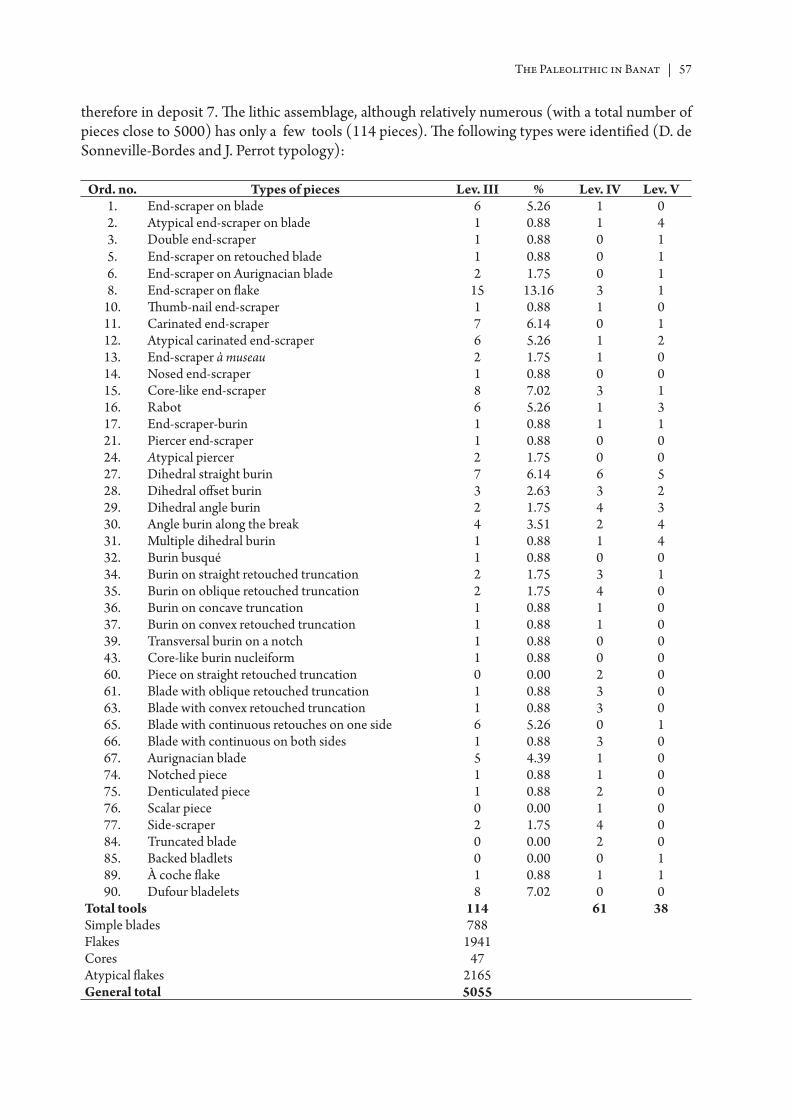
The Paleolithic in Banat | 57
therefore in deposit 7. Th e lithic assemblage, although relatively numerous (with a total number of pieces close to 5000) has only a few tools (114 pieces). Th e following types were identifi ed (D. de Sonneville-Bordes and J. Perrot typology):
Ord. no. Types of pieces Lev. III % Lev. IV Lev. V1. End-scraper on blade 6 5.26 1 02. Atypical end-scraper on blade 1 0.88 1 43. Double end-scraper 1 0.88 0 15. End-scraper on retouched blade 1 0.88 0 16. End-scraper on Aurignacian blade 2 1.75 0 18. End-scraper on fl ake 15 13.16 3 1
10. Th umb-nail end-scraper 1 0.88 1 011. Carinated end-scraper 7 6.14 0 112. Atypical carinated end-scraper 6 5.26 1 213. End-scraper à museau 2 1.75 1 014. Nosed end-scraper 1 0.88 0 015. Core-like end-scraper 8 7.02 3 116. Rabot 6 5.26 1 317. End-scraper-burin 1 0.88 1 121. Piercer end-scraper 1 0.88 0 024. Atypical piercer 2 1.75 0 027. Dihedral straight burin 7 6.14 6 528. Dihedral off set burin 3 2.63 3 229. Dihedral angle burin 2 1.75 4 330. Angle burin along the break 4 3.51 2 431. Multiple dihedral burin 1 0.88 1 432. Burin busqué 1 0.88 0 034. Burin on straight retouched truncation 2 1.75 3 135. Burin on oblique retouched truncation 2 1.75 4 036. Burin on concave truncation 1 0.88 1 037. Burin on convex retouched truncation 1 0.88 1 039. Transversal burin on a notch 1 0.88 0 043. Core-like burin nucleiform 1 0.88 0 060. Piece on straight retouched truncation 0 0.00 2 061. Blade with oblique retouched truncation 1 0.88 3 063. Blade with convex retouched truncation 1 0.88 3 065. Blade with continuous retouches on one side 6 5.26 0 166. Blade with continuous on both sides 1 0.88 3 067. Aurignacian blade 5 4.39 1 074. Notched piece 1 0.88 1 075. Denticulated piece 1 0.88 2 076. Scalar piece 0 0.00 1 077. Side-scraper 2 1.75 4 084. Truncated blade 0 0.00 2 085. Backed bladlets 0 0.00 0 189. À coche fl ake 1 0.88 1 190. Dufour bladelets 8 7.02 0 0
Total tools 114 61 38Simple blades 788Flakes 1941Cores 47Atypical fl akes 2165General total 5055
58 | Ion Cornel Băltean
On the ground of the data in the table above, the following characteristic typological indices were calculated:
IG 44.74%IB 22.80%IGA 14.04%IBd 14.91%IBt 5.26%ILD+FY 7.02%
As one can see, the end-scrapers group holds the greatest weight, taking up 44.74% of the total number of tools found at this level. Our att ention naturally goes to the typical nosed and carinated shapes of the Aurignacian that reach 14.04% to which we add the core-like end-scrapers and the pieces of the rabot type. Seen against the group of the end-scrapers, the percentage of the burins group, which amounts to 22.80%, defi nitely higher than the Tincova percentage, seems quite important to us. Interesting is the fact that inside this group the dihedral burins prevail, reaching almost 15%. Compared to the Aurignacian sett lement from Tincova here the Dufour bladelets amount to only 7.02%. Th e rest of the lithic tools is made up of retouched blades on one or both sides (1), mostly fragmented, while one can distinguish the pieces with scalar retouches typical of the Aurignacian (Fig. 20–21).
Th e raw material, which is quantitatively important, is largely unstudied. Given the storage conditions it seems unlikely for a future att empt to meet a high degree of success. Naturally, the great number of the blades, points and atypical points speak themselves for the character of the sett lement, obviously connected to the processing of fl int. Unfortunately lacking such information it is imposible to determine the frequency of the butt s types, the type of economy, or the operational chain. Th e discovered cores make 0.92% of the total numer of pieces of this level; most of them do not have a typical shape, but there are some pyramidal, prismatic, uni- or bipolar (Fig. 24–26), shapes frequently encountered in the Aurignacian environment. Without knowing what “middle-size blades” mean, we retain that they prevail (592), followed by 158 microlithic blades and 38 macrolithic blades (Fig. 27/2, 5, 6; Fig. 28/1, 2; Fig. 36)307.
Horizon IV. Identifi ed across a surface of about 20 m2 this level of occupation has a thickness of about 7 cm, stratigraphically lying between 67 and 60 cm. Compared to the previous level, it is much poorer, yielding only 61 typical pieces. Generally, the same types as in level III were identifi ed, even if in a smaller proportion in the case of the end-scraper group, but slightly higher in the case of the burins on retouched truncation (Fig. 22/1–7) or of the pieces with retouched truncation. We have no information on the rest of the discovered material in this horizon, and even less metrical data or technological data. No other elements that might be connected to Palaeolihic man were discovered.
Horizon V lies at the depth of 50–40 cm in the yellow-reddish deposit (8) evincing a discon-tinuous aspect showing several fl int concentrations, perhaps workshops lying at a distance of 3–4 m of each other. Th ey yielded a high number of atypical points and a very small number of tools, many of them atypical (Fig. 22/8–12). Studying the typological table, one can notice a decrease on the number of the end-scrapers and an increase on the number of burins. Based on the characteristic of the assemblage, this horizon was assigned to the Aurignacian.
307 MOGOŞANU, F. 1978: 61.
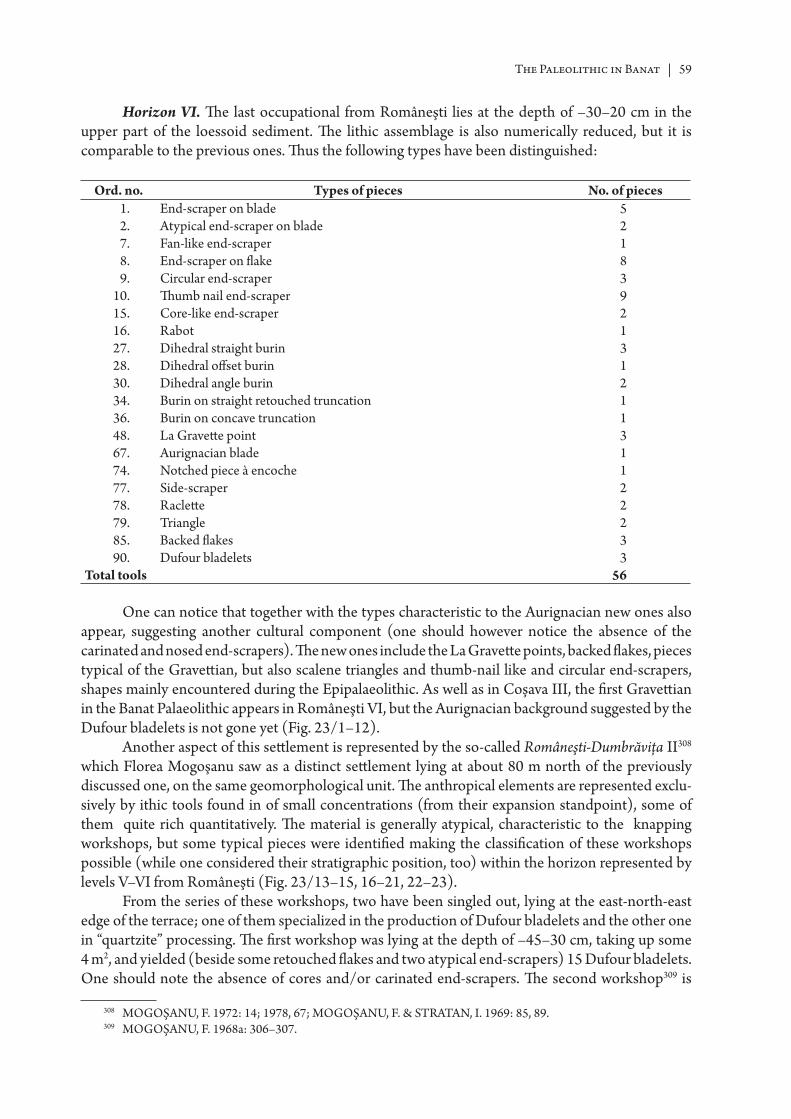
The Paleolithic in Banat | 59
Horizon VI. Th e last occupational from Româneşti lies at the depth of –30–20 cm in the upper part of the loessoid sediment. Th e lithic assemblage is also numerically reduced, but it is comparable to the previous ones. Th us the following types have been distinguished:
Ord. no. Types of pieces No. of pieces1. End-scraper on blade 52. Atypical end-scraper on blade 27. Fan-like end-scraper 18. End-scraper on fl ake 89. Circular end-scraper 3
10. Th umb nail end-scraper 915. Core-like end-scraper 216. Rabot 127. Dihedral straight burin 328. Dihedral off set burin 130. Dihedral angle burin 234. Burin on straight retouched truncation 136. Burin on concave truncation 148. La Gravett e point 367. Aurignacian blade 174. Notched piece à encoche 177. Side-scraper 278. Raclett e 279. Triangle 285. Backed fl akes 390. Dufour bladelets 3
Total tools 56
One can notice that together with the types characteristic to the Aurignacian new ones also appear, suggesting another cultural component (one should however notice the absence of the carinated and nosed end-scrapers). Th e new ones include the La Gravett e points, backed fl akes, pieces typical of the Gravett ian, but also scalene triangles and thumb-nail like and circular end-scrapers, shapes mainly encountered during the Epipalaeolithic. As well as in Coşava III, the fi rst Gravett ian in the Banat Palaeolithic appears in Româneşti VI, but the Aurignacian background suggested by the Dufour bladelets is not gone yet (Fig. 23/1–12).
Another aspect of this sett lement is represented by the so-called Româneşti-Dumbrăviţa II308 which Florea Mogoşanu saw as a distinct sett lement lying at about 80 m north of the previously discussed one, on the same geomorphological unit. Th e anthropical elements are represented exclu-sively by ithic tools found in of small concentrations (from their expansion standpoint), some of them quite rich quantitatively. Th e material is generally atypical, characteristic to the knapping workshops, but some typical pieces were identifi ed making the classifi cation of these workshops possible (while one considered their stratigraphic position, too) within the horizon represented by levels V–VI from Româneşti (Fig. 23/13–15, 16–21, 22–23).
From the series of these workshops, two have been singled out, lying at the east-north-east edge of the terrace; one of them specialized in the production of Dufour bladelets and the other one in “quartzite” processing. Th e fi rst workshop was lying at the depth of –45–30 cm, taking up some 4 m2, and yielded (beside some retouched fl akes and two atypical end-scrapers) 15 Dufour bladelets. One should note the absence of cores and/or carinated end-scrapers. Th e second workshop309 is
308 MOGOŞANU, F. 1972: 14; 1978, 67; MOGOŞANU, F. & STRA TAN, I. 1969: 85, 89.309 MOGOŞANU, F. 1968a: 306–307.
60 | Ion Cornel Băltean
characterized by “quartzite” as raw material and yielded macrolithic tools among which one singles concave lateral side-scraper made on a fl ake with well-marked neocortical and chonchoidal butt , with reverse retouches, a piece of a triangular shape with well-marked neocortical and chonchoidal aspect. Th e character of this material is Musteroid, raising the problem of its classifi cation within the context of the Banat Palaeolithic; on one hand, the relations with other “quartzite” discoveries, and on the other hand, with the Aurignacian environment.
In what the present author is concerned, Româneşti-Dumbrăviţa II is not considered as a distinct Palaeolithic sett lement, mainly because level V is described as being “very large, but discontinuous, being made up of small agglomerations, small workshops for fl int processing , lying at 3–4 m fr om each other“310. As refi tt ing and technology studies are lacking (it is well-known the case when aft er refi tt ing the potential contemporaneity between two occupations was brought to the fore311, despite the fact they lay at a far greater distance than those discussed by us at Româneşti) we suggest as a working hypothesis that these workshops belong to occupational level V from Româneşti. Our hypothesis takes into account both the stratigraphic position and the compo-sition of the lithic assemblage (as it is set out), from which elements are absent that particularize level VI, but are of Aurignacian origin (Dufour bladelets, Font-Yves points, core-like end-scrapers s, notched pieces).
Like other Banat Palaeolithic sett lements, at Româneşti too one failed to fi nd other remains than the lithic material such as hearths, fl oral and faunal elements that should support the succession of 6 chronological Palaeolithic horizons. Under such circumstances, the only edifying tests are the granulometrical ones, while the palinological tests carried out by Marin Cârciumaru312, according to whom the climatic oscillation Româneşti = Lascaux was defi ned313, are not deemed to be relevant by specialists.
II.5.2.23 Româneşti–The Water Cave (Peştera cu Apă, 2273/1). It lies at 5 km east–southeast of the village of Româneşti (Tomeşti, Timiş County), on the road leading to Fărăşeşti. Marius Moga considered, under some reserve, that among the numerous broken bones of Ursus spelaeus some Palaeolithic tools might have been lying around314. Th e research in this cave was hindered by the existence of a thick layer of rocks fallen from the cave ceiling and covering the deposits of the Upper Pleistocene315. It was mentioned316 that down the depth of –3.20 m only Postpalaeolithic materials were uncovered while Palaeolithic fi nds occured at a depth of –3.20 m317. Among the lithic materials discovered here and stored in the Banat Museum of Timişoara, Vasile Boroneanţ identifi ed several pieces he considered to be Palaeolithic318.
II.5.2.24 Sadova Veche (village of Slatina Timiş, Caraş-Severin County). Heinz Feichter discovered a macrolithic piece (L = 30 cm, lH= 14 cm, T = 6 cm) in the Timiş Valley, within the area of Sadova Veche which he assigned to the Lower Palaeolithic319. As it was shown in the fi eld literature, this piece is, based on its size, the result of natural processes.
310 MOGOŞANU, F. 1978: 61.311 CATT IN, M. I. 1992: 35–42.312 CÂRCIUMARU, M. 1978: 90–97; 1980: 190–196; 1985: 19; 1993: 229.313 CÂRCIUMARU, M. 1987: 101; 1999b: 138–139, Fig. 88, Tab. 3.314 MOGOŞANU, F. 1978: 15.315 MOGOŞANU, F. & STRA TAN, I. 1966: 335; MOGOŞANU, F. 1978: 15; ROGOZEA, P. 1994: 155, Pl. I–II.316 Marius Moga, Field notes, 1948.317 PETRESCU, S. M. 2000: 20.318 V. Cedică, personal communication.319 MOGOŞANU, F. 1978: 14; JUNGBERT, B. 1985–1986: 389–390.
The Paleolithic in Banat | 61
II.5.2.25 Bones Cave (Peştera cu Oase, village of Steierdof–Anina, Caraş-Severin County). It lies in the carstic system of the Miniş Valley, on the right slope, thereof practically enclosed in the under-ground between Peştera Plopa and Ponor (N. 45o 01’; E. 21o 50’).
Summerizing, we mention 3 important sectors: 1. Peştera Plopa – the lower sector (from the entrance of the cave to the Syphon), 2. Puţul (the Well) (from the Syphon to the upper level), 3. Peştera cu Oase (the upper sector). Peştera cu Oase has about 12 galleries, but we discuss here the gallery called Galeria Culcuşurilor (the Lairs Gallery) (between the gate and the topo 7 station), Panta Strămoşilor (“Th e Ancestors’ Slope” (between topo 7 station and 7a) and Sala Mandibulei (the Mandible Hall, aft er Panta Strămoşilor). Th e human bones were found in Sala Mandibulei (Oase/Bones 1 – lower jaw) and Panta Strămoşilor (Oase/Bones 2).
Th e grid system (1 m2) is linked to the topo 7a–7 station, point “0” (the horizontal plane) being determined with a water level Laser Mark Magna Pro Level. If we consider topography of the area, we see the distance from the gate to the topo-station 7a (30 m): squares numberings begins at 31, increasing towards station 7, while the other axis is marked with lett ers M–O. Each square was subdivided into 4 quadrants (A–D) from left to right and from top to bott om.
In the period 2004–2005 excavations were carried out, in the area overlaying the place where the human bones were found in the previous years.
Th e archaeological situation does not diff er from that presented following the 2004 campaign320; practically, no anthropic activity was remarked in the cave (artefacts, coal, parietal art or others). Th us, with the 2005 campaign, the research at this point ended, but in order to understand the context in which the human bones ended in the underground, our att ention should be focussed on the upper levels of the Carstic system, especially on those galleries with Pleistocene fauna and sedimental deposits which seem undisturbed.
Chronologically, the deposit succession from the cave Peştera cu Oase is the following one:• Level 2, a succession of diff erent torrential events, the latest occuring around approx.
47 ka cal BP ago;• Level 1 – about 46 ka cal BP – similar to material in the whole area from the Oase/Bones.Th e surface material from the sector Panta Strămoşilor is made up of:• bone material from Level 1 (bear, deer, wolf);• late human remains OIS–3 (< 42 ka cal BP);• ibex remains OIS–2 (< 30 ka cal BP).Until recently, the presence and biological nature of the Southeastern European early modern
humans has remained largely hypothetical, based on palaeogeography and unsubstantiated assump-tions of associations between archaeological complexes and human biology, accompanied by a few poorly dated and/or undiagnostic human remains. However, the 2002, 2003 and 2004 discoveries of early modern human remains in a palaeontological context (without archaeological evidence) in the Peştera cu Oase, in the Banat Mountains of Caraş-Severin, has provided a window on the biology of these earliest modern humans in Europe321.
Because these materials were the subject of more numerous scientifi c publications in the last few years, we will not repeat the same descriptive discussions regarding the anthropological features of these human bones322. In the present article we are referring only to the conditions in which the remains were found, and to their age. Th ey were discovered in a secondary strati-graphical position at the surface of a palaeontological deposit without an archaeological context. Th eir presence in the cave is explained through an accidental fall from the exterior. Due to this fact, we can presume the existence of a contemporaneous archaeological horizon located in one of the caves from this karstic system.
320 LAZAROVICI, G. et alii 2005: 357–359.321 TRINKA US, E. et alii 2005a.322 TRINKA US, E. et alii 2003; 2003a; 2005a; 2005b; ROUGIER, H. et alii 2007; RICHARDS, M. P. et alii 2008.
62 | Ion Cornel Băltean
As the Oase 1 mandible was a surface fi nd, a bone sample of 350 mg was removed from the broken edge of its inferior right ramus and submitt ed for AMS radiocarbon dating to the Oxford Radiocarbon Accelerator Unit (ORA U). Th e second sample provided a δ13C of –19.0‰, a C:N ratio of 2.6, and an organic yield weight of 28.5 mg. Th e resulted age is 34,290 14C years BP +970–870 (GrA–22810). Combining the 14C activity ratios from the two analyzes yielded a combined age of 34,950 14C years BP, +990, –890 (38,561 ± ca1025 cal. years BP)323.
II.5.2.26 La Hoţu Cave (village of Steierdorf – Anina, Caraş-Severin County). Peştera La Hoţu’ or Hoţilor – (Th ieves’ Cave, speological code 2233/6)324 lies in the karstic system of the Miniş Valley, on its right slope, at an approximate height of 600 m (N. 45o 01’; E. 21o 49’).
Geologic context – general fr ameworkTh e Miniş Valley has been hollowed out in massive limestone, Barremian reefs, of Plopa and
Miniş, and is part of the limestone from the Southwestern Carpathians, which represent the largest carstic area of Romania. Th e karstic hyporelief from the basin of the Miniş is made up of several small and middle-size caves, with relatively widely gaping openings to the outside, which were once part of one or more underground complexes, whose communication is silted up to a large extent.
Given the intense degree of fragmentation of this carstic system, supported by numerous cave-ins sink holes, of big dimensions, we draw the att ention to the fact that the understanding of the anthropic presence in this karstic system in the Upper Pleistocene and Holocene cannot be done without an analysis going into two directions, a vertical analysis (underneath – Peştera cu Oase and the at surfacce – cave-ins sink holes, fossile fl oors, partially caved-in galleries) and one horizontal analysis (intercorrelation of undisturbed stratigraphic sequences of some cave-galleries with natural access – Peştera cu Abri (quasi-silted up), Peştera din Dolină (3 galleries with Pleistocene), Peştera La Hoţu.
In this context the excavations in Hoţu cave and Peştera cu Abri (2004–2007) are very important for the understanding of the palaeoclimatic changes and also for understanding the prehistoric human presence in Plopa-Ponor sector. It is also very important to continue excavations in these caves, so that we can bett er understand the chronology, the palaeoclimatic and cultural changes from the Upper Palaeolithic until the modern age.
Th e sector of the karstic system where our research is located is defi ned by the following geographic coordinate in national reference system STEREO 70:
Y: 249360 X: 396307 | Y: 249360 X: 398307 | Y: 251360 X: 398307 | Y. 251360 X: 396307Archaeological occupation levels and structures325:- modern level (Level. 1.1) (black sediment);- medieval level (Level. 1.2) (brown-black sediment);- roman level(Level. 2) (brown sediment with rocks);- Coţofeni level (Levels. 3.1–3.5) (grey sediment);- Neolithic level (Level. 4.1);- Starčevo-Criş level (Level. 4.2) (yellow-brownish sediment)326;
323 TRINKA US, E. et alii 2003a; 2003b; 2005a.324 GORA N, C. 1982: 156.325 LAZAROVICI, G. et alii 2005; 2006; PETRESCU, S. M. et alii 2007; 2008.326 A very important fi replace discovered at a depth of –261/263–271/275 cm was investigated in 2004–2005 and
appears to be from the IIb-IIIa phase of the Starčevo-Criş complex (LAZAROVICI, G. 1979; BIAGI, P. & SPATARO, M. 2004). Th e fi replace had a quasi-oval stone arrangement, developed around a big limestone block, well pegged in the cave sediment at the moment when the Starčevo-Criş inhabitants were using the cave. Th e charcoal in this Starčevo-Criş context was entirely made up of thin branches of Fagus sylvatica, whence a sample submitt ed to the Lisbon Radiocarbon laboratory yielded a conventional date of 6710±80 BP (SAC–2001). Associated with this structure we found more pott ery fragments, lithic and bone tools dated to the Starčevo-Criş cultural complex (LAZAROVICI, G. 1979; 1984; 1998; LAZAROVICI, G. & MAXIM, Z., 1995).
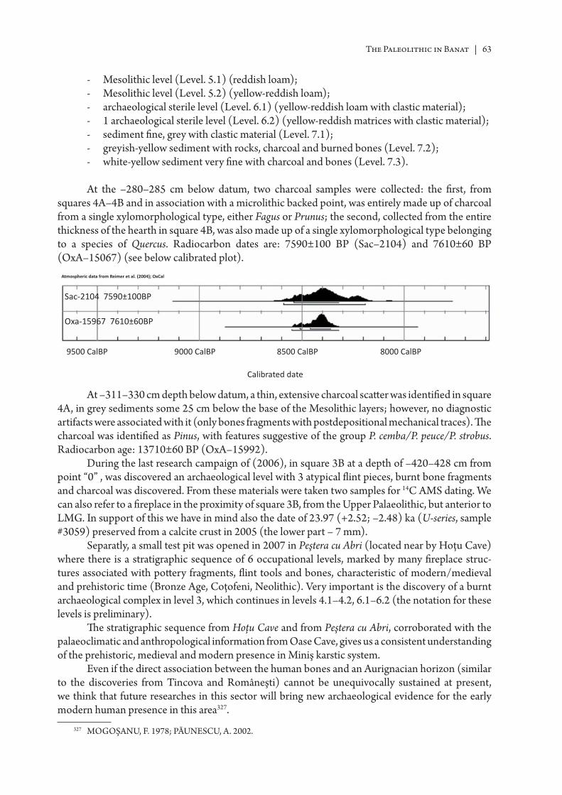
The Paleolithic in Banat | 63
- Mesolithic level (Level. 5.1) (reddish loam);- Mesolithic level (Level. 5.2) (yellow-reddish loam);- archaeological sterile level (Level. 6.1) (yellow-reddish loam with clastic material);- 1 archaeological sterile level (Level. 6.2) (yellow-reddish matrices with clastic material);- sediment fi ne, grey with clastic material (Level. 7.1); - greyish-yellow sediment with rocks, charcoal and burned bones (Level. 7.2);- white-yellow sediment very fi ne with charcoal and bones (Level. 7.3).
At the –280–285 cm below datum, two charcoal samples were collected: the fi rst, from squares 4A–4B and in association with a microlithic backed point, was entirely made up of charcoal from a single xylomorphological type, either Fagus or Prunus; the second, collected from the entire thickness of the hearth in square 4B, was also made up of a single xylomorphological type belonging to a species of Quercus. Radiocarbon dates are: 7590±100 BP (Sac–2104) and 7610±60 BP (OxA–15067) (see below calibrated plot).
At –311–330 cm depth below datum, a thin, extensive charcoal scatt er was identifi ed in square 4A, in grey sediments some 25 cm below the base of the Mesolithic layers; however, no diagnostic artifacts were associated with it (only bones fragments with postdepositional mechanical traces). Th e charcoal was identifi ed as Pinus, with features suggestive of the group P. cemba/P. peuce/P. strobus. Radiocarbon age: 13710±60 BP (OxA–15992).
During the last research campaign of (2006), in square 3B at a depth of –420–428 cm from point “0” , was discovered an archaeological level with 3 atypical fl int pieces, burnt bone fragments and charcoal was discovered. From these materials were taken two samples for 14C AMS dating. We can also refer to a fi replace in the proximity of square 3B, from the Upper Palaeolithic, but anterior to LMG. In support of this we have in mind also the date of 23.97 (+2.52; –2.48) ka (U-series, sample #3059) preserved from a calcite crust in 2005 (the lower part – 7 mm).
Separatly, a small test pit was opened in 2007 in Peştera cu Abri (located near by Hoţu Cave) where there is a stratigraphic sequence of 6 occupational levels, marked by many fi replace struc-tures associated with pott ery fragments, fl int tools and bones, characteristic of modern/medieval and prehistoric time (Bronze Age, Coţofeni, Neolithic). Very important is the discovery of a burnt archaeological complex in level 3, which continues in levels 4.1–4.2, 6.1–6.2 (the notation for these levels is preliminary).
Th e stratigraphic sequence from Hoţu Cave and from Peştera cu Abri, corroborated with the palaeoclimatic and anthropological information from Oase Cave, gives us a consistent understanding of the prehistoric, medieval and modern presence in Miniş karstic system.
Even if the direct association between the human bones and an Aurignacian horizon (similar to the discoveries from Tincova and Româneşti) cannot be unequivocally sustained at present, we think that future researches in this sector will bring new archaeological evidence for the early modern human presence in this area327.
327 MOGOŞANU, F. 1978; PĂUNESCU, A. 2002.
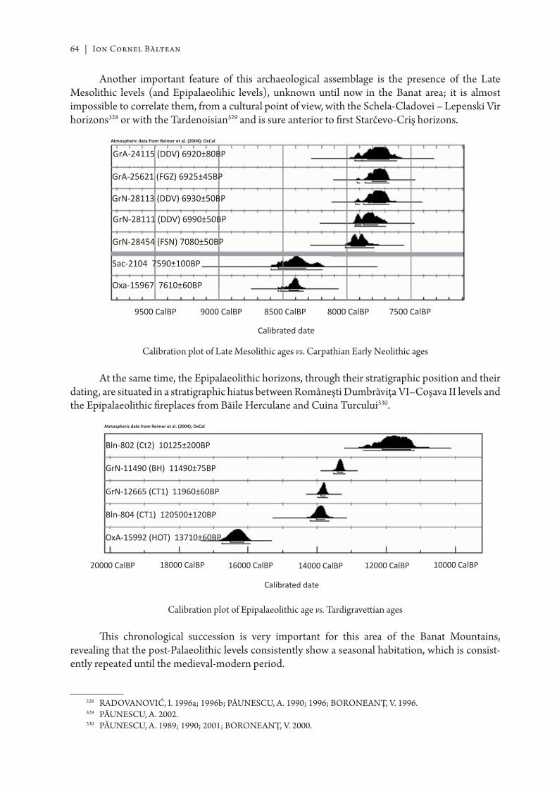
64 | Ion Cornel Băltean
Another important feature of this archaeological assemblage is the presence of the Late Mesolithic levels (and Epipalaeolihic levels), unknown until now in the Banat area; it is almost impossible to correlate them, from a cultural point of view, with the Schela-Cladovei – Lepenski Vir horizons328 or with the Tardenoisian329 and is sure anterior to fi rst Starčevo-Criş horizons.
Calibration plot of Late Mesolithic ages vs. Carpathian Early Neolithic ages
At the same time, the Epipalaeolithic horizons, through their stratigraphic position and their dating, are situated in a stratigraphic hiatus between Româneşti Dumbrăviţa VI–Coşava II levels and the Epipalaeolithic fi replaces from Băile Herculane and Cuina Turcului330.
Calibration plot of Epipalaeolithic age vs. Tardigravett ian ages
Th is chronological succession is very important for this area of the Banat Mountains, revealing that the post-Palaeolithic levels consistently show a seasonal habitation, which is consist-ently repeated until the medieval-modern period.
328 RA DOVANOVIĆ, I. 1996a; 1996b; PĂUNESCU, A. 1990; 1996; BORONEANŢ, V. 1996.329 PĂUNESCU, A. 2002.330 PĂUNESCU, A. 1989; 1990; 2001; BORONEANŢ, V. 2000.
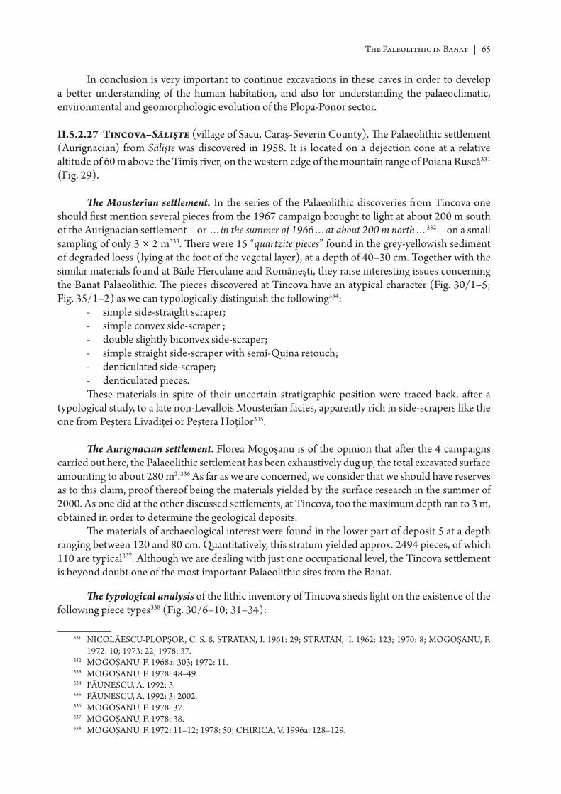
The Paleolithic in Banat | 65
In conclusion is very important to continue excavations in these caves in order to develop a bett er understanding of the human habitation, and also for understanding the palaeoclimatic, environmental and geomorphologic evolution of the Plopa-Ponor sector.
II.5.2.27 Tincova–Sălişte (village of Sacu, Caraş-Severin County). Th e Palaeolithic sett lement (Aurignacian) from Sălişte was discovered in 1958. It is located on a dejection cone at a relative altitude of 60 m above the Timiş river, on the western edge of the mountain range of Poiana Ruscă331 (Fig. 29).
Th e Mousterian sett lement. In the series of the Palaeolithic discoveries from Tincova one should fi rst mention several pieces from the 1967 campaign brought to light at about 200 m south of the Aurignacian sett lement – or …in the summer of 1966…at about 200 m north…332 – on a small sampling of only 3 × 2 m333. Th ere were 15 “quartzite pieces” found in the grey-yellowish sediment of degraded loess (lying at the foot of the vegetal layer), at a depth of 40–30 cm. Together with the similar materials found at Băile Herculane and Româneşti, they raise interesting issues concerning the Banat Palaeolithic. Th e pieces discovered at Tincova have an atypical character (Fig. 30/1–5; Fig. 35/1–2) as we can typologically distinguish the following334:
- simple side-straight scraper;- simple convex side-scraper ;- double slightly biconvex side-scraper;- simple straight side-scraper with semi-Quina retouch;- denticulated side-scraper;- denticulated pieces.Th ese materials in spite of their uncertain stratigraphic position were traced back, aft er a
typological study, to a late non-Levallois Mousterian facies, apparently rich in side-scrapers like the one from Peştera Livadiţei or Peştera Hoţilor335.
Th e Aurignacian sett lement. Florea Mogoşanu is of the opinion that aft er the 4 campaigns carried out here, the Palaeolithic sett lement has been exhaustively dug up, the total excavated surface amounting to about 280 m2.336 As far as we are concerned, we consider that we should have reserves as to this claim, proof thereof being the materials yielded by the surface research in the summer of 2000. As one did at the other discussed sett lements, at Tincova, too the maximum depth ran to 3 m, obtained in order to determine the geological deposits.
Th e materials of archaeological interest were found in the lower part of deposit 5 at a depth ranging between 120 and 80 cm. Quantitatively, this stratum yielded approx. 2494 pieces, of which 110 are typical337. Although we are dealing with just one occupational level, the Tincova sett lement is beyond doubt one of the most important Palaeolithic sites from the Banat.
Th e typological analysis of the lithic inventory of Tincova sheds light on the existence of the following piece types338 (Fig. 30/6–10; 31–34):
331 NICOLĂESCU-PLOPŞOR, C. S. & STRA TAN, I. 1961: 29; STRA TAN, I. 1962: 123; 1970: 8; MOGOŞANU, F. 1972: 10; 1973: 22; 1978: 37.
332 MOGOŞANU, F. 1968a: 303; 1972: 11.333 MOGOŞANU, F. 1978: 48–49.334 PĂUNESCU, A. 1992: 3.335 PĂUNESCU, A. 1992: 3; 2002.336 MOGOŞANU, F. 1978: 37.337 MOGOŞANU, F. 1978: 38.338 MOGOŞANU, F. 1972: 11–12; 1978: 50; CHIRICA, V. 1996a: 128–129.
66 | Ion Cornel Băltean
Ord. no. Types of pieces No. %1a. End-scraper on blade 10 9.09
2. Atypical end-scraper on blade 2 1.825. End-scraper on retouched blade 4 3.648. End-scraper on fl ake 3 2.73
11. Carinated end-scraper 3 2.7312. Atypical carinated end-scraper 1 0.9113. Nosed end-scraper 1 0.9114. Atypical nosed end-scraper 1 0.9115. Core-like end-scraper 4 3.6416. Rabot 2 1.8217. End-scraper-burin 1 0.9121. Piercer-end-scraper 1 0.9127. Dihedral straight burin 1 0.9129. Dihedral angle burin 2 1.8230. Burin along the break angle 2 1.8234. Burin on straight retouched truncation 2 1.8243. Core-like burin 1 0.9152. Font-Yves point 3 2.7360. Piece with straight retouched truncation 1 0.9165. Blade with continuous retouchings on one side 6 5.4566. Bade with continuous retouchings on both sides 10 9.0967. Aurignacian blade 9 8.1874. Notched piece 7 6.3675. Denticulated piece 2 1.8277. Side-scraper 6 5.4584. Truncated fl ake 2 1.8289. Flake à coche 1 0.9190. Dufour bladelets 22 20.00
Total number of tools 110Simple blades 359Cores 10Atypical fl akes 2015Overall total 2494
According to the compiled table, the following typological indices were calculated:
IG 26.36%IB 7.27%IGA 5.45%IBd 4.55%IBt 1.82%ILD+FY 22,73%
From the typological table results a numerical prevalence of the end-scrapers group and of the group of the blades retouched either on one side or on both sides, to which one adds the Aurignacian blades (3 are of the pointed type) characterized by a typical scalar retouch339. Th e end-scrapers group is made up of the common types of end-scraper on blade ends, end-scraper on retouched blade end (Fig. 30/6–10) or end-scraper on fl ake, but the distinct note is given by the pieces that make up the Aurignacian end-scraper group. Th e carinated end-scrapers (Fig. 31/1–6) are usually made on core-like, pyramidal supports, through a direct fl ake retouchings, be they convergent or not. Th e
339 MOGOŞANU, F. 1978: 43.
The Paleolithic in Banat | 67
nosed end-scrapers, although numerically few, are important because as they provide clues pointing to the cultural assignation of the Tincova site.
Th ese pieces are made, one on a massive point ad one on a rejuvenation tablet, but they evince a less typical character340. To the pieces typical of the Aurignacian belong the Dufour bladelets, too (Fig. 32/1–6, 9–10), which together with the points of the Font-Yves type (Fig. 32/7–8) stand for it within the Tincova sett lement 22.73%341. Th e Dufour bladelets are defi ned as small sized pieces with “edges that are retouched abruptly or semi-abruptly”342 (Fig. 33b) oft en alternately, suggesting the cultural assignment to a certain technical complex. Another important group is the burins group seen thought its relation with the end-scrapers group (Fig. 31/7–11). Inside the burins group a high rate is hold by the dihedral burins, but there are two pieces on straight retouched truncation, too. A relatively important weight within the tools from this sett lement is held by the notched pieces (Fig. 32/14–16; Fig. 33a) accounting for 6.36%. Th ey are made on fl ake supports through direct retouches. Th e side-scrapprs generally have an atypical character, but a double biconvex piece stands out showing a Mousterian character.
Th e raw material is quantitatively dominated by atypical points (knapping debris), which is a natural fact if we consider the invoked character of a workshop-sett lement. We do not know what the weight of the cortical points, of the crested blades, of the rejuvenation tablet type is but our att ention was drawn by the very small number of cores that account for only 0.40% of all the imple-ments (situation explained out by Florea Mogoşanu through the re-use of the cores as supports for the core-like end-scrapers or the carinated ones). Most of these pieces are of globular type343, but one can come across cores of prismatic type (2) or conic type (1). Tehnologically speaking, from the published material results that most of the pieces stem from the phase of pleine débitage; the anarhical knapping brought out by the sinousity of the margins and edges is caused by the poor quality of the raw material. It is illustrated by various cracks that break off the normal knapping procedure, thus resulting in many knapping accidents of the réfl échi type or outrepassé type, which would explain the presence of the many atypical points.
Altough the material displays a fragmentary character, we do not know what the frequency of the diff erent parts of the piece, a similar situation being valid for the butt types of which we only know344 that the plain (sometimes wide) and the facett ed types (with a well developed bulb suggesting the use of indirect percussion with hard percussor or punctiform percussor).
Aft er the surface survey done in 2001, more than 30 lithic pieces were gathered of which we mention 2 end-scrapers (one on retouched point and one on a blade end with a plain butt , with convex active part, being oblique against the percussion axis, manufactured through non-convergent fl ake retouching), a double angle burin along the break made on retouched blade, a blade with direct retouches in the median area, on one side, a macrolithic core, blades and fragmented fl akes (especially median parts, some with edge wear retouches). Th e presence of these pieces in a somewhat eccentric position compared to the systematically researched area made us believe that the sett lement was larger than we were able to ascertain at the moment of the excavations.
Unfortunately, no other elements were identifi ed that would allow us to complete the data on the Palaeolithic man. To this eff ect, one tried to carry out palinological tests or bett er said the testing of one profi le, which was encountered for that matt er at the other stations in question345. Following these tests, the dating set forth by Florea Mogoşanu was not altered (interstadium W2–W3) only
340 MOGOŞANU, F. 1978: 42.341 MOGOŞANU, F. 1978: 45–48.342 BRÉZILLON, M. 1983: 114, 262.343 MOGOŞANU, F. 1978: 48.344 MOGOŞANU, F. 1978: 48.345 CÂRCIUMARU, M. 1978: 97–101; 1980: 196–200; 1985: 20.
68 | Ion Cornel Băltean
mentioning (if the test is deemed to be relevant) that the Aurignacian habitation took place in the last part of this interstadium346.
II.5.2.28 Vişag (village of Victor Vlad Delamarina, Timiş County). In 1956, at about 1 km south-east of the village, at the confl uence of the Bogarul Mare and Pârâul Satului brooks, one found a folia-ceous, bifacial (“szeletian” style) piece made of black-grey opal was found (but lacking a stratigraphic position and, consequently, special scientifi c interest)347. Th e fi eld research from the summer of 2001 did not lead to the discovery of any other siliceous artefacts348.
II.5.2.29 Zăvoi (Caraş-Severin County), while construction works were being carried out within the limits of the railway station, several fl int pieces were found, some of them likely Palaeolithic349. Obviously, in the present state of the research, these materials could not be seen as evidence for the existence of a Palaeolithic sett lement at Zăvoi.
As we mentioned at the beginning of this chapter, many of the places mentioned in the archaeologic literature as places where Palaeolithic discoveries were made, should be treated with some reserve since, in most cases, the materials disappeared before they were analyzed (also isolated lithic pieces found do not represent a piece of evidence for a Palaeolithic occupation; for that matt er we all know the “beauty” of the pieces created by nature). Many of these discoveries were made at random, and lack a precise stratigraphic context.
II.6 Geochronological elements of the Upper Pleistocene from southwest Romania
II.6.1 Introductive issues. Several palaeoclimatical and chronological landmarks
According to the research results of the past 30 years carried out by Marin Cârciumaru350, it was considered that the oldest Pleistocene sequence exists in the Cioarei–Boroşteni cave (also called the warming complex of Boroşteni). From a sedimentological point of view seems to be older than the age yielded by the 14C dates (about 50000 BP). From the fl ora point of view, one retained for this period fi rst a steppe, cold and dry episode, than an episode with coniferous trees and cold and wet climate and fi nally another cold and dry episode, to which one adds the temperate stage, characterized by coniferous and decidous trees. From the fauna standpoint, one noticed the following association: Cervus elaphus, Capreolus capreolus, Sus scrofa, Megaceros giganteus, Bos Primigenius351.
Aft er a cooling (stadial) came a warmer climate again called the Nandru interstadial complex, including the climatic oscillations Nandru A and B (with the stages Nandru 1, 2 respectively 3, 4). Variation Nandru A (45000 +1400/–1200 BP, 49300+3200/–1100 BP) has been equalized to interstadia Amersfoort and Brörup. A date for the fi nal sequence of stage Nandru 4 gave the result of 37750+950 BP, which seems to be the end of this interstadial complex and practically the beginning of a new glacial stadium, contemporary chronologically to the Upper Palaeolithic in Western Europe352.
346 MOGOŞANU, F. 1978: 102.347 STRA TAN, I. 1970: 8, Pl. I/Foto 1; MOGOŞANU, F. 1978: 15; JUNGBERT, B. 1985–1986: 399; MOROZ-POP,
M. 1983, 481.348 Emilian Alexandrescu, personal communication.349 JUNGBERT, B. 1985–1986: 399.350 CÂRCIUMARU, M. 1980; 1985; 1987; 1993; 1995.351 CÂRCIUMARU, M. 1999: 57.352 CÂRCIUMARU, M. 1999: 52–53.
The Paleolithic in Banat | 69
Th is cooling period is followed by the Ohaba interstadial complex, with the variations Ohaba A (warmer) and Ohaba B, ending around 28780±290 BP353. It involved, in general, a massive aff ores-tation, especially through the spread of the decidous trees in the western region354. Until approx. 25,000–24,000 BP another stadial type period took place, followed by the climatic variation Herculane I (23450+2000/–1450 BP, Bistricioara). Th e next glacial state, which set in right aft er Herculane I variation, saw a short climate amelioration period called Mitoc I (22,160±90 BP – Gura Cheii-Râşnov/Râşnov gorge mouth). Th e forest returned during the next two climatic variations Herculane II (about 20,000 BP) and respectively, Româneşti (about 16,000 BP), but a decrease of the forest can be noticed, in a period of slight climatic improvement, between these two variations, dated at Bistricioara in about 18800±1200 BP355. At Româneşti-Dumbrăviţa, during Herculane II variation, the landscape remains of moderate silvo-steppe, with slightly higher temperatures, followed by steppe landscape , opening the way for the Româneşti climatic variation.
Aft er the Româneşti variation followed another period with a harsher climate, interrupted by the Mitoc II variation. Towards 12600±120 BP a climatic variation Erbiceni started, followed by a short cold period, halted by the Erbiceni B variation.
Th e palinologic and palaeoclimatic records from the Alpine areas point out, aft er variation Româneşti, to a cold period characterized by the prevalence of the pine (stage of the pine) that can be paralleled at the continental level with Dryas I–Bölling (Erbiceni A)–Dryas II–Alleröd (Erbiceni B)–Dryas III356.
Since the climatic reconstruction of the Upper Pleistocene in the Carpathian space was based on the pollinic tests sampled from caves, but also from outdoors sites, this new geochronological schema should be looked upon with caution until new interdisciplinary takes place. We support the idea that “la reconstitution paléoclimatique est obtenue par la corrélation de séquences de grott es carpa-tiques lacunaires calées chronologiquement essentiellement à partir des dates 14C de niveaux moustériens démarche particulièrement fr agile pour les raisons évoquées plus haut. Cett e courbe paléoclimatique est en contradiction avec les courbes connues pour l’Europe, obtenues à partir de carott es de calott e glaciaire, de carott es de lacs glaciaires et de carott es de mer Méditerranée. … En conclusion, les dernières résultats connus à Mitoc ( fouilles Chirica), tendent à remmener le Paléolithique supérieur et moyen de Roumanie à un schéma identique à celui des territoires avoisinants, en contradiction avec le schéma chrono-clima-tologique proposé, dont les faiblesses sont dues à la trop grande confi ance dans les datations 14C surtout anciennes et à la fr agilité des corrélations des séquences lacunaires de grott es, et qui est à reprendre avec de nouvelles dates 14C A.M.S. et des enregistrements paléoclimatiques continus”357.
II.6.2 Chrono-climatic context of the Banat Palaeolithic levels
As we lack all absolute dating elements for the Palaeolithic occupational levels in the Banat, the only methods that were available to the researchers were the comparative techno-typological analysis of the materials, the stratigraphic position of the pieces corroborated with some pedological and granulometrical observations, to which one adds pollinic tests carried out during the seventies. Th us, Fl. Mogoşanu chose a Würmian chronology with three stadia and two interstadia making the specialized terminology purely speculative, as such research ended in the eighties while comple-mentary multidisciplinary information is lacking.
“Th e quartzite complex” from the southwest of Romania (Herculane I, Româneşti I, Tincova) is very poorly documented, showing a quantitatively reduced material and uncertain stratigraphic context (the exception is Herculane I), oft en in a disturbed sediment. It seems to develop during the
353 CÂRCIUMARU, M. 1999: 54.354 CÂRCIUMARU, M. 1999: 65355 CÂRCIUMARU, M. 1999: 119–120.356 CÂRCIUMARU, M. 1999: 124–125.357 DJINDJIAN, F. 2000, 311–312.
70 | Ion Cornel Băltean
Interpleniglacial, isotopic stadium 3a (the interstadia Hengelo-Arcy). In support of this observation we bring some pedological arguments and, as far as we consider them correct and relevant for some of the sites the pollinic tests carried out by M. Cârciumaru in the Banat Palaeolithic sites358. Level I from Peştera Hoţilor, from Băile Herculane through its stratigraphic position and the discovered faunla remains enable us to assign the quartzite lithic tools to a Mousterian, considered to be late, developing at the beginning of W2
359.Th e latest archaeological discovery that contains “quartzite” pieces is the workshop of
Româneşti–Dumbrăviţa (II). Its stratigraphic position, places it at the end of W3, thus being a much later expression of the quartzite Upper Palaeolithic. According to Florea Mogoşanu, this survival of the quartzite Upper Palaeolithic might form the base for the later development of the Schela Cladovei–Lepenski Vir culture360, with the quartzite, present to a large extent during the Mesolithic in the Iron Gates region of the Danube 361.
According to the granulometrical tests mentioned in the previous chapter, level I from Româneşti–Dumbrăviţa belongs to stadium W2, levels II–IV fall under interstadium W2–W3, level V covers the transition from interstadium W2–W3 to stadium W3, level VI covers the end period of W3
362. At Tincova, paleoclimatic data was needed and last, but not least, a relative chronology, so
it was tried to carry out palinological tests, or bett er said one test for one profi le. Th is situation occurred also in other sites. Still, the date put forward by Florea Mogoşanu (interstadium W2–W3) did not change with the provision that, if the test will be considered relevant, then the Aurignacian habitation might have evolved during the last part of this stadium363.
At Gornea, both at Păzărişte and Căuniţa, one can notice that the position of lithic materials is uncertain, as they were assigned to the upper part of stratum 2, or at a certain level to the Eolian stratum (which disappeared aft er an intense erosion process)364, so that this archaeologic horizon may be hypothetically assigned to the end of stadium W3 also.
II.7 Conclusions
II.7.1 Lithic industries using quartz/quartzite raw materials from southwest Romania
Considering all the above mentioned archaeological materials, we notice that the situation of the discoveries from the caves in the Middle Carpathians is not a clear one. Neither is the one of similar discoveries in the Banat Mountains. Th us several hypotheses concerning the origin and the place of this facies within the Palaeolithic from the Carpathians region can be launched.
Florea Mogoşanu defi ned the Quartzite Upper Palaeolithic as the result of the Charentinian + Pontinian + Quartzite365 and was seen as a culture belonging to the Upper Palaeolithic, separated from the Aurignacian that developed in parallel and lasted until the Holocene366.
358 CÂRCIUMARU, M. 1978: 97–101; 1980: 196–200; 1985: 20.359 PĂUNESCU, A. 1992: 3; MOGOŞANU, F. 1968: 309; 1972: 9–10; 1973: 14–17; 1978: 29, 102.360 MOGOŞANU, F. 1978: 138, 139.361 BORONEANŢ, V. 1970b: 2, 12, 18–19; 1996: 65–68; 2000a: 97–212; MOGOŞANU, F. 1978a:, 342–343, 347;
PĂUNESCU, A. 1990: 130–134; 1996: 136–141; 2001: 49–52, 421–427, 444–445; RA DOVANOVIĆ, I. 1996a: 225–252.
362 MOGOŞANU, F. 1978: 102–103.363 MOGOŞANU, F. 1978: 102.364 MOGOŞANU, F. 1970: 535; 1978: 36; LAZAROVICI, G. et alii 1993: 300.365 MOGOŞANU, F. 1978: 134.366 MOGOŞANU, F. 1968: 309; 1978: 133.
The Paleolithic in Banat | 71
Vasile Chirica believes too that the stratigraphic situation and the lithic assemblages from Băile Herculane and Româneşti–Dumbrăviţa I, level I show that the quartzite Upper Palaeolithic comes before the Aurignacian and that it survived among isolated groups until the Tardiglacial and even later into the Holocene367.
Stratigraphically, the earliest level of this “culture” in the Banat was revealed in Peştera Hoţilor from Băile Herculane in a sediment traced back to W2, followed by level I from Româneşti.
Th e discovery of level I in Peştera Hoţilor from Băile Herculane made possible a cultural connection to the Mousterian from the Carpathian Caves (Peştera Curată, Peştera Spurcată, Peştera Muierilor, Peştera Cioarei, Peştera Bordu Mare, Peştera Gura Cheii), seen as a regional variant of the Charentinian. Chronologically, this Mousterian facies develops between 49,500±3200/2100 BP (GrN 13002), data obtained for level II of Peştera Cioarei, 43,600±2800/2100 BP (GrN 12676) for level IIIb from Peştera Bordu Mare and 33300±900 BP (GrN 13009) for level IIa and 29700±1700/1400 BP for level IIb from Peştera Gura Cheii–Râşnov368. We would like to mention within this context other two dates obtained recently, the one from Peştera Mare at Cioclovina (a skull fragment of Homo sapiens) 29,000±700 BP (LuA 5229), respectively the one from Peştera Muierilor in Baia de Fier (skull, lower jaw, shoulder blade, tibia diaphysis of Homo sapiens) 30,150±800 BP (LuA 5228)369, dates that fall within the limits of the Aurignacian.
In general lines, the industries from the above mentioned caves are characterized, the same as the one from Peştera Hoţilor, by non-Levallois knapping, a great number of end-scrapers, denticu-lated pieces, notched pieces, and a small numer of bifacials. Another common element is represented by the use of ‘quartzite’ as raw material, 90%. Within this context one should mention the materials discovered in the Peştera Climente I (lev. I–II)370 or in the Alpine caves from Slovenia, dated to the end of W1 (Mornova Zijialka, Špehovka, Jama, Beralov Spodmol), characterized by the prevalence of a “quartzite” of low quality, making them less expressive typologically371.
Within a wider framework, the industries from the Meridional Carpathians were paralleled to the Mousterian levels from Erd (Hungary), where quartz/quartzite is used in a proportion of 75%. Considering the archaeological materials from here, one considered that this cultural manifestation on nodules, employing the so-called “Pontinian” knapping technique, represents the Charentinian of Southeastern Europe372. In what the position and role played by these materials within the Romanian Palaeolithic are concerned, other opinions existed: Marin Cârciumaru, suggests that these indus-tries represent the transition from Middle Palaeolithic to the Upper Palaeolithic forming a so called Carpathian facies373. Th is att empt at defi ning a transition period as being represented by a certain Mousterian facies was rejected by many researchers374. At the same time, M. Cârciumaru makes the distinction between the caves with only one habitation level and the ones with two habitation levels, separated by an archaeologically sterile level and which developing prior to the Ohaba interstadial375.
It remains problematic the sett lement with a Mousterian character from Tincova, whose stratigraphic position is uncertain and we cannot determine if the sediment in which the quartzite pieces were found was disturbed or not376. Florea Mogoşanu considered these materials to be part of another evolution stage of the Quartzite Upper Palaeolithic, to which the “quartzite” knapping
367 CHIRICA, V. 1996a: 137–138.368 PĂUNESCU, A. 1984: 246; 1988: 75–76; 1989: 135–136; 1991: 17; HONEA, K. 1991: 19–20; 1993: 66–72.369 PĂUNESCU, A. 2002, 86.370 PĂUNESCU, A. 2000: 362–363, 366–367.371 OSOLE, F. 1971: 248; BRODAR, S. 1971: 201–203.372 DOBOSI, V. T. 1991: 93; PĂUNESCU, A. 1988: 77; 1989: 136; 2000a: 43.373 CÂRCIUMARU, M. 1999: 112–113; 1995: 101–103.374 PĂUNESCU, A. 2000: 280, 284; ALEXANDRESCU, E. 2002; DJINDJIAN, F. 2000: 312.375 CÂRCIUMARU, M. 1999: 109–111; 1985: 7–34, 1988: 50–51.376 PĂUNESCU, A. 1992: 3; 2002: 170.
72 | Ion Cornel Băltean
workshop from Româneşti–Dumbrăviţa could also be assigned to. Th is stage developed around the area of the Balta Caldă spring377, dated to the end of W3, being thus a much later expression of the Quartzite Upper Palaeolithic.
Also, from point of view of the history of the research, we must note here another Florea Mogoşanu’s opinion: the survival of the Quartzite Upper Palaeolithic might underlie the development of the Schela Cladovei–Lepenski Vir culture 378, with a high occurrence of the quartzite, present there to high proportions during the Mesolithic in the area of the Iron Gates of the Danube379.
Th e survival into the Holocene of the Quartzite Upper Palaeolithic is actually a hypothesis put forth by Florea Mogoşanu, still needing to be proved through interdisciplinary archaeologic research. Lacking clear data, we cannot rule out the fact that the late Mousterian from Băile Herculane, Gornea, Româneşti, Tincova etc. could have paralleled the evolution of the Aurignacian380, from which it seems isolated in space381. But if we accept such a situation one can naturally ask the following question: anthropologically speaking, who are the creators of this culture?
Obviously, the present state of the Palaeolithic research in the Banat, and not only, does not allow us an immediate answer to the question. Starting from here, we consider that only multidis-ciplinary archaeological research can answer many of the problems set forth today in the special fi eld literature.
Summing up, the quartzite Palaeolithic is characterized by lithic tools with an arcahic Mousteroid aspect, made on “quartzite” supports, a raw material most probably gathered from places near the sett lement as its choice probably answered some preferences yielded by a possible tradition of the group (e.g. Peştera Cioarei Boroşteni).
From the technological point of view, the nodule morphology was used, most of the times without a special prior preparation; surely this happened because the cortex did not call for it and the knapping was based on putt ing to good use of nodule volume through a centripetal approach or entrecroisé approach on more percussion planes, as uni- and bipolar cores were also found. Th e supports, generally splinter-like, sometimes fl ake-like, are of average size, rarely macrolithic, with a neocortical butt , frequently fractured during the knapping along some diaclases, which explains the high number of knapping accidents of the Burin de Siret type (ex. Porţ). Broad butt s facilitate the visibility of the impact point to which we add the existence of so-called metal loss percussors, suggesting direct percussion with hard percussor. On the other hand, the variability of the “opera-tional chain” cannot be but presupposed, speculated upon as no lithic assemblage in question has ever been subjected to a refi tt ing; in order to bring out continuity or variability of technical gestures in a given space and within a given chronological span, the refi tt ing as an experimental study is absolutely necessary382.
From the typological point of view, the lateral or transversal scrapers (racloirs) are prevalent. Th ey are made on fl akes, sometimes of Levallois type, through a slim edge retouch, on supports with suitable morphology, as the retouch is superfi cial and does not alter the shape of the fl ake (ex. Porţ, Peştera Cioarei). On the other hand, many “tools” were obtained a posteriori through the mere use of supports in a raw state, and the so-called “retouching” appears as a reuse retouching, oft en as émousse retouching (ex. Porţ). Th e character of bifacial pieces, numerically reduced, is somewhat atypical with the exception of the pieces found at Cladova.
377 PĂUNESCU, A. 2002: 200–201.378 MOGOŞANU, F. 1978: 138, 139.379 BORONEANŢ, V. 1970b: 2, 12, 18–19; 1996: 65–68; 2000a: 97–212; MOGOŞANU, F. 1978a: 342–343, 347;
PĂUNESCU, A. 1990: 130–134; 1996: 136–141; 2000: 49–52, 421–427, 444–445; RA DOVANOVIĆ, I. 1996a: 225–252.
380 PĂUNESCU, A. 1992: 3; 2002: 52, 170; CHIRICA, V. 1995: 105–109; 1996, 137.381 MOGOŞANU, F. 1978: 131, 132.382 BOËDA, E. 1994: 27–45; 1995: 57–72; PASTY, J. P. 2000: 165–190.
The Paleolithic in Banat | 73
From the data available to us, the lithic indistries with quartz/quartzite tools belong to a lithic techno-complex deemed to be of non-Levallois knapping, rich in scrapers (racloirs), notched pieces in general globular, prismatic or most oft en shapeless cores, without one’s being able to remark that the Levallois technique is absent.
Th e pieces of the backed knife type, with or without neocortex, the pieces in the shape of a “lemon slice” and the inside splinters, most oft en fragmentary are also frequent.
Th e quartzite complex of the Upper Palaeolithic from southwest Romania seems to develop in the Interpleniglacial, isotopic stage 3a (interstadial Hengelo–Arcy).
II.7.2 The Banat Aurignacian industries. Characterization and chronologic position
Th e Aurignacian is the fi rst compact civilization of the Superior Palaeolithic of whose origins, geographic location and chronology engaged numerous pre-historians in searching an “Aurignacian 0” horizon stratigraphical located below, and diff erent from typology perspective, from the standard Aurignacian383. In general, we can say that the lithic industry of the Aurignacian is characterized by the supremacy of the scrapers, a group that holds a high index of Aurignacian scrapers, in comparison to the burins, where the dihedral burins prevail over those on truncation384.
As it has been noticed above, the Aurignacian is observed through systematic archaeological research within several sites with the most important ones being those at Româneşti–Dumbrăviţa, Tincova and Coşava. One of the fi rst tools used by Florea Mogoşanu in establishing connections with the Aurignacian from the neighbouring territories are the Dufour bladelets and the Font-Yves type points in the Banat area Palaeolithic sett lements385 occuring in percentages of 22.73% at Tincova and 7.02% at Româneşti–Dumbrăviţa, level III. To this we add the group of Aurignacian scrapers (16.36% at Coşava, level I, 14.04% at Româneşti, level III and 5.45% at Tincova) and the group of burins (22.80% at Româneşti level III, 8.18% at Coşava level I, 7.27% at Tincova). Th e statistical assessments conducted by Florea Mogoşanu highlighted the existing propinquity between the sett lements from Tincova and that from Krems–Hundssteig (Austria), Româneşti–Dumbrăviţa, level III and that from Breitenbach (Germany), Coşava level I and those from Willendorf I (layers II–IV), Getzersdorf (Austria) and Vogelheard (Germany). From such perspective emerges the fact that the Aurignacian represented by those three Banat sett lements belongs to the same cultural area developed in Central-Eastern Europe386.
In comparison to the discoveries of “Aurignacian 0” in Europe387, the Aurignacian discoveries from the above mentioned sett lements seem a bit later, presenting the characteristics of an advanced Aurignacian, dated in the Arcy oscillation388.
Without gett ing into much detail, we can say that, in the Central-Eastern European area, the beginning of the Upper Palaeolithic is characterized by the existence of several techno-complexes, considered of transition, which seem to develop, at least in some cases, in parallel with the horizon named “Aurignacian 0” and basically, with the fi rst arrived Homo sapiens389.
Transition industries at Central-Eastern European level: – Bohunician and Szeletian–Brno-Bohunice and Stránska skála 36–43 kyr BP390.– Bachokirian–Bacho Kiro, Cultural Horizon I, level 11 and Temnata, level VI, Sector TD-II.
14C old dating are over 43 kyr, but the AMS ages for level 11/11a are 38.5±1.7, 37.7±1.5, 34.8±1.2 383 DJINDJIAN, F. 1993: 136–142.384 BANESZ, L. 1993: 135–136.385 MOGOŞANU, F. 1967b: 141–146; 1968b: 643–647; 1978: 122.386 MOGOŞANU, F. 1978: 125–126, 128; PĂUNESCU, A. 1984: 258–259; 1992, 4.387 DJINDJIAN, F. 1993, 142–149.388 DJINDJIAN, F. 1993: 137.389 ZILHAO, J. & D’ERRICO, F. 2003.390 BOLUS, M. & CONARD, N. 2001: 29–30.
74 | Ion Cornel Băltean
and 33.8±0.9 kyr BP. At Temnata, level 4, Sector TD-I was dated at 38.2, 38.8, 39.1 kyr BP. Th e upper part of the sequence has the age of 33.9±0.9, 31.9±1.6 kyr BP391.
– In the Vindija cave from Croatia, level G1 was dated at 33±0.4 kyr BP and 28–29 kyr BP. Th e main raw material is the quartz. Th e Neanderthalian presence in this cave is documented aft er the occurrence of the Aurignacian and Homo sapiens in other parts of the Central Europe392.
In the same context, we are also reminding about the techno-complex393:– Streletian (Kostienki 12, level III 36280 ±360 BP);– Spitsyan (Kostienki 17, level II 36400 ± 1700/–1400 BP);– Jerzmanovician (Nietoperzowa, level 6 38500 ±1240 BP).Aurignacian “0”– Castillo Cave: 38500 ±1300 BP (level 18b2)– Arbreda Cave: 37700 ±1000 BP (level E2BE111)– Willendorf II: 37930 ±750 BP (level 3-C8)– Aurignacian 2– Willendorf II: 31210 ±260 BP (level 4-C4)– Oblazowa Cave: 32400 ±650 BP (level VIII)– Mitoc: 32730 ±220 BP (level 12b)– Kostienki I: 32600±400 BP (level 3)Th e next progress phase of the Aurignacian in Banat could be represented, according to the
opinion of Florea Mogoşanu, by the level IV from Româneşti394. Perhaps we could also place the occupations from Gornea–Vodneac, Gornea–Păzărişte and Peştera Hoţilor (Th ieves Cave) at this chronologic level395 but we also subscribe to the observations of Vasile Chirica according to which “en l’absence de certains éléments de chronologie absolue il est diffi cile de réaliser un encadrement certe de ces canpements dans une évolution des étapes du Paléolithique supérieur…”396.
Th e last two occupational levels with Aurignacian elements discovered in Banat are those observed at Româneşti, level V and at Coşava, level II. Th e current status of the research, the scarcity of the material and especially their unusual character determine the impossibility of having a more nuanced discussion regarding these sett lements. Th e last horizons from Româneşti and Coşava, as shown above, are characterized by the existence of the fi rst tools used for engraving, represented by the backed bladelets, La Gravett e points and pieces standard for Epipalaeolithic (circular, thumb-nail scrapers, obsidian pieces). It is to be noticed that Aurignacoide items such as streamlined scrapers and even Dufour bladelets are also present.
Naturally, the issues concerning the Aurignacian horizons and the use of the fi rst engraving items must be studied thoroughly, and we can only hope this will be the aim of future research.
In a larger area, the Aurignacian from Banat represents a later phase in comparison to some Aurignacian occupations from Moldova397.
In the Romanian Plain it is assumed that the beginning of the fi rst evolution phase of the Aurignacian techno-complex is placed “before the commencement of the Würmx III” being repre-sented by the sett lements from Ciuperceni–La Tir and Vădastra, level I398. For the Aurignacian level from Giurgiu Malu-Roşu two radiocarbon dates were obtained, indicating the age of 22790±130 BP
391 ZILHAO, J. & D’ERRICO, F. 2000, 36, 39–40.392 BOLUS, M. & CONARD, N. 2001: 31.393 DJINDJIAN, F. et alii 1999: 158–159, 179–180.394 MOGOŞANU, F. 1978: 129.395 PĂUNESCU, A. 1992: 4.396 CHIRICA, V. 1996a: 132–133.397 PĂUNESCU, A. 1984: 247–248, 1989: 136–139; 1993: 131–140; 1998: 39, 68–69; 1999: 29–30, 33, 59;
CHIRICA, V. & BORZIAK, I. 1996: 99–121.398 ALEXANDRESCU, E. 1997: 17, Pl. 15; PĂUNESCU, A. 2000b: 28–31.
The Paleolithic in Banat | 75
(GrA–6037) and 21140±120 (GrA–5094). We can thus conclude that in this area, the Aurigancian lasts longer, developing in parallel with the Gravett ian from Moldova and Dobrogea399. Th e lithics industry from Giurgiu Malu-Roşu consists of carinated scrapers, core-like, dihedral burins, burins on truncation, strangled blades, Dufour bladelets, side-scrapers400 showing many similarities with the fi nds from Banat, to which is was genetically linked (hypothetically) especially aft er the discovery of a workshop “specialized” in Dufour bladelets.
In the same time, for the chronologic interval 23000–17000 BP over large areas, a series of Aurignacoide industries were recorded. Th ey were given various names: Aurignacian, inter-gravett o-solutréen industries, Epi-Aurignacian, Epi-gravett ian-aurignacoid. Th e territory of Banat can not be excluded from such a context taking into consideration especially levels IV–V from Româneşti and II from Coşava401.
Under the circumstances, we believe it is a necessity to resume the Palaeolithic research in Banat, as the hypothetically rhythm of transformations can no longer be supported by the materials assessed at the limit of statistics method (typological indexes and cumulative charts). New research is needed which could highlight the technological particularities of the Aurignacian techno-complex from Banat.
7.3 Lithic industries from south-west Romania assigned to the Tardigravett ian horizon
Th e last Palaeolitic inhabiting from the discussed area is Peştera Hoţilor (Th ieves Cave) from Băile Herculane assigned to the Mediterranean Tardigravett ian type.
Th e fi rst evolution phase of this cultural manifestation is represented in the region of Porţile de Fier (Iron Gates) by Climente I Cave; the second phase is represented by the fi nds from Climente II cave, and the third phase consists of the inhabiting of layer I from Cuina Turcului, dated between 12600±120 BP (Bln 803) and 11960±60 BP (Gr N 12665), the fourth phase is illustrated by levels I and II from Ostrovul Banului, the fi ft h phase relates to layer II from Cuina Turcului, dated 10125±200 BP (Bln 802), and the last phase could be illustrated by the fi nds from Veterani–terrace (level I), Ogradena–Icoana (level I), Ogradena–Răzvrata (level I) and Schela Cladovei (level I)402. In this chronological-evolution scheme, the inhabiting from Băile Herculane could be placed in the fourth phase of Mediterranean type Tardigravett ian evolution403.
Th e technical-typological assessment of the lithic material enables us to establish certain links to the fi nal Epigravetian from the Italian Peninsula, especially with the sites from the Adriatic coast. Th e imbuing of the fi nal Epigravetian from the Italian Peninsula happened in several waves, two ways, a maritime one crossing the Adriatic sea and a terrestrial one along the Northern and Western side of Adriatic sea, following the fl ow of Sava and Drava Rivers up to the Danube404.
399 PĂUNESCU, A. 1999: 59–60; ALEXANDRESCU, E. 1997: 16.400 PĂUNESCU, A. & ALEXANDRESCU, E. 1996: 44–48; 1997a: 19–23; 1997b: 19–26; ALEXANDRESCU, E.
1998a: 33–52; 1998b: 59–67; ALEXANDRESCU, E. & POPA, I. 2000, 41–45; PĂUNESCU, A. 2001, 249–284.401 DJINDJIAN, F. 1996: 41–54; BAZILE, F. 1996: 55–67; OLIVA, M. 1996: 69–81; 1991: 111, 114–115;
KOZŁOWSKI, J. 1996: 83–98; BOSSELIN, B. & DJINDJIAN, F. 1997: 107–125; DJINDJIAN, F. et alii 1999: 241.402 PĂUNESCU, A. 1984: 251; 1989: 146–150; 2001: 48–49; 68–69, 338–360, 366–367, 376–379, CHIRICA, V.
1996b: 80–81; BORONEANŢ, V. 1996: 63–64.403 PĂUNESCU, A. 1992: 5.404 PĂUNESCU, A. 1989: 151.
76 | Ion Cornel Băltean
Th e lack of recent research leads to the fact that the end of this cultural manifestation becomes a contradictory subject for the experts, concerning the existing transfer or technological-typological hiatus in Tardigravett ian and the Schela Cladovei–Lepenski Vir Mesolithic cultural manifestation405.
Overall, the Upper Palaeolithic from Banat, as it’s currently understood, seems to be formed by cultural manifestations located at the outskirts of the great Central European techno-complex. From such a perspective, we believe that the data of the issues raised in relation to the discoveries from Banat should be re-assessed (“Quartzitic Palaeolithic”, belay Aurignacian, the late Gravett ian infl uences, stratigraphical issues and chronology, raw material supply sources, technology of lithics industry), but this is not possible only by resuming the research for the purpose of obtaining as many information as possible about the humans from Palaeolithic.
405 SREJOVIĆ, D. et alii 1980: 195–205; KOZŁOWSKI, J. & KOZŁOWSKI, S. 1982: 11–109; 1983: 259–278; RA DOVANOVIĆ, I. 1996a: 225–252, 286–287; BORONEANŢ, V. 2000a: 156–183.

III.1 Natural environment
Th e geological substructure of the south part of the Pannonian basin consists of deeply sunken ground similar in origin to the modern Rhodope mass consisting of schists and igneous rocks406. On top of this substructure are deep marine deposits of the Th etis and Parathetis seas, and on top of them thick layers of loess had been deposited in the Neogene period. Th e elevations constituting the mountain fringe – the Fruška Gora and Vršac Mountains – are the remains of the ancient ground. Fruška Gora are composed of schists, phyllites, serpentinites, granites, basalts, peridotites, andesites and dacites, as well as Mesozoic limestones and basal conglomerates, and the Vršac Mountains are composed of Paleozoic schists, which represent the north-ernmost exposure of the ancient Serbian-Macedonian mass407.
Vojvodina is geographically divided into Srem, Bačka and south Banat. Srem encompasses the area between the rivers Danube and Sava, Bačka includes the area between the rivers Tisza and Danube, and the south Banat includes an area from the Tisza River to the southwestern Carpathians. Th e geomorphological structure of these regions is quite similar but there are still certain diff erences. Loess deposits are very frequent in Srem and Bačka and they are most prominent on the Srem loess plateau, the Titel Breg, middle Bačka loess plateau and south Banat loess plateau. Th ese plateaus are intersected by the Danube and the Tisza river basins, and in
406 BUKUROV, B. 1975; KUKIN, A. 1984.407 ZEREMSKI, M. 1985.
I n the Serbian part of Banat, in contrast to the Romanian Banat, a very small number of the Palaeolithic sites have been confi rmed. Not one of them has been systematically excavated so the Palaeolithic period in this part of Banat
can be discussed only within its wider regional context. Th ere are, however, also other reasons for the regional approach in these investigations. South Banat could be considered from a climatic, ecological and geomorphologic point of view as an integral part of the south Pannonian area, which mostly also includes the low hilly terrain to the south of the rivers Sava and Danube. In this treatise we will therefore discuss the Palaeolithic of northern Serbia in a similar way as the Palaeolithic of the southwestern Romania has been treated. In recent years a few Palaeolithic sites off ering an entirely new insight into the early prehistory of this part of Europe have been investigated in this region. So, we are going to present here, in detail, the results of these recent investigations, and we will try to document the distinct role of the Carpathian-Danubian region in the diff erent phases of the Palaeolithic period.
80 | Dušan Mihailovic
northern and eastern sections sand areas were formed in contact with loess, such as near Ludoš Lake on the fringes of which Mesolithic and Neolithic sites have been discovered, and at Deliblatska Peščara (Deliblato Sands) in the area of the south Banat.
Th e relief of the Serbian Banat diff ers to a certain extent from the relief of Bačka and Srem. It is well known that until recently many parts of Vojvodina were covered with marshes, which were drained only in the 19th and the 20th centuries.
Th e marshy-lake zone was particularly prominent in the north of the Serbian Banat so it must be emphasized that, despite the fact that this area had been inhabited in the past, the northern Banat was unsuitable for sett lement during most of the prehistoric period. Th e situation is somewhat diff erent in the central and south Banat where the sediments had been deposited mostly in a dry environment. Th e loess deposits are not so prominent in the central Banat while in the south is the South Banat loess plateau where the deposits are up to 10 metres thick.
In the eastern Banat there are two depressions. Th ese are Alibunar and Vršac depressions at the foot of the Vršac Mountains on the very border with Romania. It is thought that the Vršac depression was formed during the maximum of the last glacial and the Alibunar depression in much earlier times408. Th ese two depressions are separated by the elevated plateau called At where numerous fi nds from the early Upper Palaeolithic have been discovered.
Mačva and Donja Kolubara to the south of the Sava represent the bott om of the Pannonian plain and the segment of the Srem-Mačva basin extending from Fruška Gora in the north to the Sava fault-erosive section in the south409. In the Sava Valley occur large fl uvio-denudational zones and in Podrinje and Podgorina are island mountains composed of schist, limestone and serpentine. In the Lelić and Valjevo karst and in the Pocerski merokarst appear many karst forms, while in Šalitrena Cave situated in Gornja Kolubara were discovered many fi nds dating from the Upper Palaeolithic. Because of diff erences in the quantity of precipitation the area closer to the Sava is characterized by the steppic-continental climate while temperate continental climate prevails in Podrinje and Podgorina.
Central Serbia as well as northern Bosnia belongs to the fringes of the Pannonian basin, i.e. to the peri-Pannonian region extending to the Jastrebac Mountains and the Starovlaške Mountains in the south. In Šumadija, which includes the territory from Velika to Zapadna Morava hilly relief is prevalent, while karst forms are few: they appear in the Belgrade merokarst and in rather small zones around the Bukulja Mountains. Th e climate nowadays in this area is of a distinctively temperate-continental type.
Th e east part of northern Serbia, from the Danube to the Nišava river basin, belongs to the Carpathian-Balkan geotectonic unit410. Isolated limestone areas appear, separated by the neogenic basins and rocks refl ecting Tertiary volcanism. Th is area is inseparably connected with the south-western Carpathians not only on the basis of geologic structure but also based on climatic and ecological characteristics. Th e single distinct entity within this unit is the Iron Gates gorge, which was in the past the refugium for many plants and animal species411. In this area a few Palaeolithic and many Mesolithic sites have been investigated.
In contrast to the Romanian Banat where much information had been gathered in the course of archaeological investigations, most of the palaeoecological data in Vojvodina were obtained by investigating the loess deposits. Th e Middle Pleistocene deposits were studied in the loess profi les of Čot at Stari Slankamen, Batajnica-Kapela and Neštin412, while Late Pleistocene sediments have been investigated at many locations in Srem and Bačka413. On the basis of sedimentological and
408 ZEREMSKI, M. 1985.409 MARKOVIĆ, J. D. 1970.410 ĆIRIĆ, B. 1996.411 MIŠIĆ, V. 1981.412 ZEREMSKI, M. et alii 1991.413 MARKOVIĆ, S. 2001; MARKOVIĆ, S. et alii 2004.
The Palaeolithic in Northern Serbia | 81
malacological investigations and the study of magnetic susceptibility a correlation has been estab-lished between the south Pannonian and Chinese loess deposits414. Th ese investigations confi rmed the assumptions that somewhat more mild (and wett er) climate prevailed in south Pannonia during the Late Pleistocene and that forest vegetation existed not only in the interglacials but also in the glacial refugiums415.
In the caves in eastern Serbia has been confi rmed the association of the Pleistocene mammals characteristic of the north Balkans416. Large faunal species inhabiting the steppe and open areas (horses, bisons and even rhinoceroses), forest areas (deers, roe deers, etc.) and mountain areas (ibexes and chamoises) were identifi ed, as well as various types of carnivores and animals living in caves (hyenas, wolves, cave bears). Because of the limited investigation results it is still unknown what the incidence of species from diff erent biomes was in diff erent phases of the Middle and Late Pleistocene.
III.2 History of researches
Th e investigations of the Palaeolithic in the territory of present-day Serbia were belated in relation to the study of the later prehistoric periods, despite the fact that fi rst Palaeolithic artifacts had been discovered already by the end of the 19th century. In 1891 J. Cvijić and Đ. Jovanović found one stone blade in the Pleistocene layer of Prekonoška cave417, while F. Mileker gathered quite a lot of chipped stone artifacts from the Zapadna strana (modern At), Mesić kanal and Kozluk sites near Vršac between 1888 and 1919418. Unfortunately, investigations of the Palaeolithic did not gain currency in Serbia aft er these fi rst discoveries. In the 1920s H. Breuil mentions the Palaeolithic sites in the vicinity of Belgrade and some of these caves (where just the faunal remains were recorded) were identifi ed by Gavela in 1955419.
In the beginning of the 1950s B. Gavela started investigations in Pećina pod Jerininim brdom near Kragujevac and in Risovača Cave near Arandjelovac. Both caves yielded large quantities of remains of Pleistocene fauna and smaller number of stone artifacts. Th e artifacts from the Upper and Middle Palaeolithic were found in Pećina pod Jerininim brdom, while in Risovača an industry was recorded, which, because of the leaf-like points, was associated with the Szeletian420 and later with the Middle Palaeolithic facies Muselievo-Samuilitsa421.
Just when it seemed that investigations of the Palaeolithic would gain momentum everything came to a standstill once again. Th e end of the 1960s and beginning of the 1970s were characterized by gathering activity, which continued also in the 1980s. R. Rašajski gathered many thousands of Aurignacian artifacts at the Crvenka-At site near Vršac and Aurignacian fi nds were gathered at the Balata site422. P. Medović found one Middle Palaeolithic artifact at the Cigan site near Irig423 while J. Šarić gathered considerable numbers of artifacts from various periods at the Beljarica and Ekonomija 13. maj in Zemun sites in the beginning of the 1980s424.
414 MARKOVIĆ, S. et alii 2004.415 JANKOVIĆ, M. 1984; MARKOVIĆ, S. et alii 2004.416 DIMITRIJEVIĆ, V. 1997.417 CVIJIĆ, J. 1891.418 MILLEKER, F. 1937.419 GAVELA, B. 1988.420 GAVELA, B. 1988.421 KA LUĐEROVIĆ, Z. 1991.422 MIHAILOVIĆ, D. 1992a; 1992b.423 MEDOVIĆ, P. 1970.424 ŠARIĆ, J. 1984; ŠARIĆ, J. 2009.
82 | Dušan Mihailovic
Th e decisive step forward came in the 1980s when I. Radovanović started to apply modern methods of investigation to the Palaeolithic sites and to analyses of their chipped stone artifacts. Th ese investigations were focused on Montenegro where D. Srejović organized excavations of a few rich and multilayered Palaeolithic sites: Mališina Stijena, Medena Stijena, Trebački Krš, and Bioče425. Th e excavations in Serbia continued but on a limited scale. Z. Kaludjerović carried out test-trench excavations in many caves fi nding just a few artifacts in many of them, while more signifi cant results were achieved in Smolućka and Šalitrena caves426. Th e Middle Palaeolithic horizons, which yielded around two hundred artifacts, were investigated in Smolućka Cave, while many hundreds of artifacts were found in Šalitrena Cave near Mionica. Th e artifacts from this site have been ascribed to the Middle and Late Upper Palaeolithic.
Th ese investigative activities decreased once again during 1990s due to the unfavorable social circumstances, and small-scale excavations have been carried out at just a few Palaeolithic sites (Mirilovska Cave, Baranica, and Pečurski kamen)427. Only with the beginning of this millennium did the investigations of Palaeolithic sites start to yield more tangible results. First, three Middle Palaeolithic and one Upper Palaeolithic horizons were investigated in Hadži Prodanova Cave near Ivanjica in 2003428 and many fi nds from the Middle Palaeolithic were discovered in the same year at the Petrovaradin fortress429. In the same year a rich Gravett ian horizon was reached in Šalitrena Cave430, while many layers with the Middle Palaeolithic fi nds have been recorded in Balanica Cave in southeast Serbia431. Th e investigations continued also in the following years: layers with Aurignacian and Middle Palaeolithic fi nds were investigated in Šalitrena Cave while in the Balanica Cave complex human remains had been encountered beside the Mousterian artifacts432. Th e results of these inves-tigations, along with already known facts, made it possible for the fi rst time to understand in general terms the beginning of human sett lement in the central Balkans.
III.3 Palaeolithic sites
We included in this survey excavated sites, sites for which the context of fi nds is known and also any homogeneous assemblages. As there is no clear border between the north and middle part of the central Balkans we presented only the sites in the area to the north of the rivers Nišava and Zapadna Morava which we think to be relevant for the study of these phenomena in south Pannonia (Fig. 37).
III.3.1 Crvenka-At, Balata and other Palaeolithic sites in the vicinity of Vršac
Appearance, investigation results and stratigraphyAlmost all artifacts gathered at the sites in the vicinity of Vršac were obtained by purchase from communal works and work on sand exploitation. Th e material from Kozluk, Zapadna strana and Mesić kanal were gathered by F. Mileker at the end of the 19th and beginning of the 20th century433,
425 RA DOVANOVIĆ, I. 1986b; SREJOVIĆ, D. 1996.426 KA LUĐEROVIĆ, Z. 1991.427 MIHAILOVIĆ, D. et alii 1997.428 MIHAILOVIĆ, D. 2003a.429 MIHAILOVIĆ, D. 2003b.430 MIHAILOVIĆ, B. 2008.431 MIHAILOVIĆ, D. 2008a; 2009a.432 ROKSANDIĆ, M. et alii in press.433 MILLEKER, F. 1937; BRODAR, S. 1955.
The Palaeolithic in Northern Serbia | 83
while the fi nds from At, Crvenka and Balata were gathered by R. Rašajski between 1952 and 1978. I. Radovanović also conducted test-trench excavations of the Pleistocene layers at At434.
All sites are situated on the fringes of the Vršac depression at the foot of the Vršac Mountains Kozluk is located on the east side of the depression, on the bank of the Kozluk brook and the site Crvenka is just across from it at Zapadna strana. Th erefore it is assumed that Mileker’s site Zapadna strana is in fact the Crvenka site. Th is site was reidentifi ed only in the 1950s when R. Rašajski noticed there were chipped stone artifacts in the sand exploited at that location (Fig. 38). Th e archaeological sites Crvenka and At belong geomorphologically to the At plateau (Crvenka is the fossil valley crossing the plateau in the north) but the southeastern part of the plateau is marked as Crvenka on the topographic maps. Th erefore, the archaeological site is also known by that name. Balata and Mesić kanal are located on the surface of the ‘lake-loess terrace’ near the terminal end of the plateau435.
Th e At plateau was created, according to Zeremski (1985), as a result of tectonic movements aft er formation of the Vršac depression. Th is is confi rmed, according to this author, by the fact that at its base appear layers of sand deposited there before the formation of the depression, in the time of intensive denudation of the quartz material from the northern slopes of the Vršac Mountains. Th anks to the data of R. Rašajski, who recorded the fi nding context for most of the artifacts, and the stratigraphic observations of D. Rukavina436, it has been established that the stratigraphy of deposits in diff erent sand mines in this area corresponds to a great extent. In all sand mines under the humus loess up to 4 metres thick appears, whose upper segment is darker in color and more compact, and lighter in the lower segment. Upper and lower levels of loess are separated in some places by greenish to gray-brown sediment containing many small quartz pebbles437. Under the loess are layers of sand, and at the bott om is clay. Th e top layer of sand is of yellowish color and rather thin and is followed by layers of fi ne sand, coarse sand and fi ne sand again resting on the clay layer. Th ere is also a layer of sand under the clay, at the relative depth of 8.30 m. Th e chipped stone artifacts were found in all sand layers. Th e largest number of fi nds were located in the lower segment of the stratigraphic sequence (in the coarse sand and the layer immediately beneath).
Structure of raw materials and products of knappingA detailed analysis was performed in the early 1990s in order to establish whether the industry
is homogeneous and whether there are diff erences in spatial and stratigraphic distribution of the artifacts and their att ributes438. It was concluded that at both locations the artifacts were made of the same raw materials: quartz and quartzite, jasper and diff erent sorts of the good quality fl int. At Crvenka and At alike the most frequent is a fl int of heterogeneous structure sometimes with black spots (so-called Banat fl int), green, red and brown fl int of homogeneous structure and polychro-matic reddish-yellow and brown fl int, which is diffi cult to defi ne macroscopically. Artifacts covered with patina and burnt are considerably more frequent at At.
Th e cores (Fig. 39) appear in the structure of the industry in very small quantity (under 2% in all layers) and in the lower layers, there are 65–80% unretouched artifacts and 30% tools (Table 1). Th e cortical fl akes and fl akes with traces of cortex do not exceed 15% at Crvenka while there are 25–30% of them in the lower layers at At. Considering that very small numbers of discoid and irregular cores have been recorded at both sites it might be assumed that most of the fl akes with multidirectional scars originate from preparation and rejuvenation of the single-platform cores,
434 RA DOVANOVIĆ, I. 1986a.435 ZEREMSKI, M. 1985.436 RUKA VINA, D. 1984.437 RUKA VINA, D. 1984.438 MIHAILOVIĆ, D. 1992b.
84 | Dušan Mihailovic
which are signifi cantly more common. Besides these cores, which oft en have cortex and traces of lateral preparation, were also found cores on smaller pieces of fl int without traces of preparation. Burin-like cores as well as the cores for microbladelets were also recorded.
Th e structure of striking platform is similar to the structure of the dorsal side but the specimens with cortical platforms are even less frequent than the specimens with cortex on the dorsal side. Th e specimens with plain platforms prevail, the facett ed platform is less frequent and edge platforms are rather frequent on the blades. A certain percentage of specimens (ca 10%) at At have the broad platform of the ‘chapeau de gendarme’ type while a few fl akes could be ascribed to the fl akes of the Levallois type with certain reservations (as there are no elements allowing complete reconstruction of the technological process).
When, however, the products of knapping are concerned it should be emphasized that the most common specimens among the blades are those of 2.5–5 cm in size. Th e larger pieces have been found only in the lower layers, while specimens of smaller size (under 2.5 cm) at Crvenka as well as at At have been encountered only in the coarse sand in the middle segment of the sequence.
Tool structureEndscrapers are the most commonly encountered tools (30–50%) followed by retouched
blades (10–25%), which are somewhat more frequent near the bott om than in the middle segment of the sequence (Table 2). Burins are more frequent than retouched blades at At, while the situation is reversed at Crvenka. Th e endscrapers are also more frequent at At, in part because of a higher incidence of denticulated and notched tools.
Distinct typological variability has been noticed within these three categories of tools (Fig. 40). Th e various variants of multiple burins on retouched truncations of thick blades and fl akes are confi rmed at Crvenka, while dihedral burins are characteristic of the lowest horizon at At. Besides plain endscrapers on retouched and unretouched blades and fl akes, the fan-shaped endscrapers are characteristic of both sites – for Crvenka the endscrapers on cortical fl akes and conical-core-like endscrapers, and for At the carinated endscrapers on fl akes. Plain shallow retouched blades are well represented both at Crvenka and at At, while the blades retouched by invasive Aurignacian retouch are more frequent at Crvenka. Strangled blades have been also found at this site.
Most frequent among the sidescrapers are lateral specimens, and a couple of specimens with undoubtedly Middle Palaeolithic characteristics have been also encountered at At. Retouched truncations and borers are not particularly frequent. Th e same situation is found with notched tools and splintered pieces but they are signifi cantly more numerous. Lateral denticulated sidescrapers of larger size are characteristic of Crvenka; transversal specimens were recorded at At, while one semi-abruptly retouched segment was found at Crvenka.
Assemblage fr om BalataTh e Balata site where 173 artifacts have been found is in the immediate vicinity of Crvenka
and At439. Th is assemblage greatly resembles the assemblages from Crvenka and At in terms of raw materials, technological products and tools. Th e structure of raw materials is identical and good quality fl int of heterogeneous structure prevails as is also the case at Crvenka and At. Th e same patina, roundness, gloss and traces of burning were identifi ed on some specimens. In contrast to the material from Crvenka and At among the fi nds from Balata were typical Levallois specimens: one Levallois core and fi ve Levallois fl akes. In all other elements, however, the industry exhibits Upper Palaeolithic characteristics. Typical Upper Palaeolithic cores, blades and rejuvenation fl akes have been recorded and among the retouched tools there were no identifi ed Middle Palaeolithic tool types apart from a few sidescrapers. Considering the structure of industry and stylistic traits of tools there are many
439 MIHAILOVIĆ, D. 1992a.
The Palaeolithic in Northern Serbia | 85
parallels with the industry from Crvenka and At. Th e endscrapers, retouched blades and burins are the most frequent tool categories, denticulated and notched tools are also present in considerable quantity and many tool types documented at Crvenka and particularly at At (fan-shaped, carinated and nosed endscrapers etc.) have also been found. As at At there are no Aurignacian blades but bladelets were found, which have not been found at the two neighboring sites.
Summary for the sites around VršacTh e analyzes revealed that industries from Crvenka, At and Balata are rather homogeneous.
Many correlations between the assemblages from Crvenka and At originating from approximately the same level have been noticed. It is obvious that structure of the assemblages could be explained by cultural factors and activities of the communities rather than as a result of the post-depositional disturbances. Th e distribution of sites on the fringes of the depression indicates that this area had been sett led probably aft er the depression formation. Although the inventory of the assem-blages from these sites is rather similar, certain diff erences were still encountered. Th e Levallois component is most frequent at Balata where distinct association of the Middle Palaeolithic and Upper Palaeolithic elements has been perceived. Th e Middle Palaeolithic elements are also present at At, situated in the north, and the industry is characterized by the presence of dihedral burins, pointed and carinated endscrapers and large-sized sidescrapers. At Crvenka, which perhaps could be most closely related to the Aurignacian of the Krems type (documented at the sites in Romanian Banat440) the Middle Palaeolithic artifacts are least common and the industry includes carinated-conical endscrapers, Aurignacian blades, nosed endscrapers on blades and various types of burins on truncations. All in all, the investigations of the material from the Vršac sites carried out so far have raise many unanswered questions concerning the time and character of sett ling of the northern slopes of the Vršac Mountains.
III.3.2 Petrovaradin Fortress
Investigation results and stratigraphyTh e Petrovaradin fortress is situated on a dominant elevation above the right Danube bank near Novi Sad. Palaeolithic artifacts were discovered in the course of rescue excavations at the fortress in 2002, and already by 2003, systematic excavations of the Pleistocene layers at the site had been organized. An area of 38 square metres (sector I) was explored at the highest section of the plateau, and in the following year excavations were extended to sector II (parallel to sector I) covering 54 square metres. More than one thousand artifacts have been discovered during two campaigns and additional Palaeolithic fi nds have also been encountered in other trenches in the course of rescue excavations.
In contrast to the surrounding terrain where the Pleistocene layers and virgin rock are much deeper, at the top of the plateau they appear just under the surface. Under the Holocene layer, which contains a variety of remains from prehistory, antiquity and the Middle Ages, there is a somewhat darker loess denoted as layer 2a. Near the bott om of this layer a horizon with rock fragments was recorded, while the lower layer consists of somewhat lighter loess sediment resting on the virgin rock. Th e contact zone between layers 2a and 2b is considerably disturbed as the strips of sediment from the upper layer penetrate deeply in the lower layer. Th e character of this disturbance has not yet been explained.
It was assumed aft er preliminary observations that the upper layer is the palaeosoil in the initial phase of formation while the lower layer dates from the phase L1L2 (i.e. MIS4) aft er the Chinese stratigraphic system441. However, as the material of the Middle Pleistocene date that could
440 MOGOŞANU, F. 1978.441 MARKOVIĆ, S.B. et alii 2004.
86 | Dušan Mihailovic
correspond to OIS6 has also been recorded in the lowest layer442 the question could be asked whether the fi nds from layer 2a (which are most frequent) belong to OIS3 or to some of the interstadial phases within OIS5 from which the sediment is not preserved and when the erosion of the terrain could had occured.
Material analysis resultsDetailed analysis of the material from the Petrovaradin fortress has recently been published443.
Th e analysis included over one thousand artifacts from layer 2a, horizon of disturbance (2a/2b) and layer 2b. Th e assemblage from layer 2a contains the largest number of fi nds, which are mostly distributed in the lower segment of the layer.
Most of the artifacts are made of white fl int, from deposits which were recently discovered about 15 kilometres from the site, and of quartz pebbles which were probably gathered on the river bank. Only small numbers of artifacts were made of other raw materials: black and green and yellow fl int, matt fl int, etc. Th ese raw materials were mostly used for tool production, so it could be assumed that at least some of them had been brought to the sett lement.
In general structure the incidence of cores is 3–3.5%, fl akes 67–73% and tools 18–23% (Table 3). Th erefore, as at Crvenka and At, the structure of the industry corresponds to the sett lement activities and a somewhat longer occupation of the sett lement. Th is is also confi rmed by the fact that a rather high proportion of burnt pieces (around 9%) appear in the assemblages, although it should be emphasized that neither hearths nor animal bones have been encountered during excavations.
Analysis of cores and products of knapping revealed that diff erent knapping techniques were used. Th e use of the preferential (lineal) Levallois method is confi rmed by small numbers of cores and fl akes with a central scar on the dorsal side. Products of knapping indicating the use of recurrent technique were also recorded, but much more abundant are artifacts which could be related to some sort of simplifi ed Levallois technique adapted to the small dimensions of cores and the low quality of raw materials. Many fl akes have a broad and prepared platform of the ‘chapeau de gendarme’ type, and rejuvenation fl akes of the ‘éclat debordant’ type were also recorded, although there is lack of agreement regarding whether they should be associated with Levallois technology or with the technology of knapping discoid and centripetal cores. It is interesting that only a few retouched tools had been made on Levallois fl akes.
Most of the quartz artifacts were struck from pieces of raw material where only one or two scars are discernible, and also the Kombewa technique was used with fl akes being struck from the edge of other, larger fl akes. Special techniques were used for the production of backed tools. Th e cores of this type have not been found but it is clear on some massive fl akes that, before their striking, a series of smaller fl akes had been struck from the former core platform (preserved on the back of the fl ake).
Th e products of knapping from various raw materials and produced using diff erent techniques are of surprisingly uniform size. Th us an average length of artifacts in sector I in layer 2a is 25.5 mm and 25.2 mm in sector II, while their average width in sector I is 24.0 mm and 23.4 mm in sector II. Nevertheless, it should be emphasized that there are diff erences between the technique of knapping the cores of fl int and those of quartz. Among the artifacts made of quartz there is somewhat greater incidence of cortical fl akes (29.4%), and platform preparation was recorded on just 7.9% of specimens, in contrast to the fl int artifacts where a prepared platform appears on 28.6% of specimens.
Th e most frequent tools in layer 2a and in both sectors are sidescrapers, and denticulated and notched tools are also rather frequent (Fig. 41; Table 4–5). Th e most common sidescrapers are straight and arched lateral sidescrapers but transversal sidescrapers (Fig. 45, 46), sidescrapers
442 T. Gaudenyi, personal communication.443 MIHAILOVIĆ, D. 2009b.
The Palaeolithic in Northern Serbia | 87
of déjeté type and massive backed sidescrapers have also been found (Fig. 42, 43, 44). Tools of the Upper Palaeolithic type are relatively frequent but they are not standardized, and they obviously had an ad hoc purpose (many of them were made of quartz). Th e denticulated tools, though frequent, are not characteristic. Mousterian points have not been recorded.
Th e small quantity of artifacts from layer 2a were found only in sector I and based on the structure of raw materials, technological products and tools do not diff er substantially from the material from the upper layer. In that regard it could actually be concluded that the industry from the Petrovaradin fortress is homogeneous and includes the fi nds from the upper as well as from the lower layer. Nevertheless, it has been noted that a small number of artifacts of yellow fl int, Charentian elements and bifacial backed sidescrapers were grouped in the lower horizon of layer 2a, in the contact zone and in layer 2b. For that matt er it is quite probable that this location was sett led in diff erent phases, which are impossible to distinguish stratigraphically at this moment.
Th e spatial analysis of artifacts revealed that the center of the sett lement was on top of the plateau, under the present building of the City Museum of Novi Sad. Separate zones of activities are not clearly distinguished. Higher concentration of cores, notched pieces and endscrapers and sidescrapers were recorded in the squares of the western section of sector II, while the sidescrapers and burins appear in somewhat larger quantity in the eastern section of the same sector. Th ese were perhaps associated with a working area in the western section of sector I (where a higher incidence of artifacts was also recorded) some ten metres away.
Based on the high incidence of sidescrapers and low Levallois index, the industry from the Petrovaradin fortress corresponds to the non-Levalloisian facies of typical Mousterian and the taxonomic status of the assemblage is compromised at least formally only by the high incidence of denticulated tools (Table 6). It is, however, evident that three components are combined in the material from the fortress. Th e Taubahian-Charentian component is manifested in the tradition of producing tools on asymmetrical fl akes, the use of quartz and transversal sidescrapers (although it should be emphasized that there is no typical Quina retouch on tools); the Levallois technology is rather infrequent while a middle European component is evident in the fact that production technology of bifacial sidescrapers from the fortress corresponds closely with the method of production in the Micoquian and the earlier industries in the northwest of the Carpathian basin.
III.3.3 Baranica Cave and Tabula Traiana Cave
Many site surveying campaigns and test-trench excavations of the prehistoric cave sites have been undertaken in northeastern Serbia. Yet, only a few artifacts have been discovered at many sites: thus only two Middle Palaeolithic artifacts were recorded in the cave of Pećurski Kamen near Sokobanja, and one backed implement was found in Mirilovska Cave in the vicinity of Senje. Somewhat bett er results were achieved in the excavations of two caves: Baranica near Knjaževac where two Upper Palaeolithic and one Middle Palaeolithic horizons have been investigated and Tabula Traiana Cave where a small number of artifacts from the Middle and Upper Palaeolithic were recorded.
BaranicaBaranica Cave is situated 5 km to the southeast of Knjaževac, about ten metres above the
right bank of the Trgoviški Timok River. It has a rock shelter entrance and three rather small inner rooms (Fig. 47). Th e Palaeolithic artifacts were found in the course of test-trenching in 1994 and most of the fi nds were collected from systematic excavations, conducted in 1995, 1997 and 2004444. In the upper layer, consisting of lighter brown sediment with eboulis (geological layer 2), only three Palaeolithic artifacts were recorded: one laterally retouched sidescraper, one blade and one bladelet.
444 MIHAILOVIĆ, D. et alii 1997.
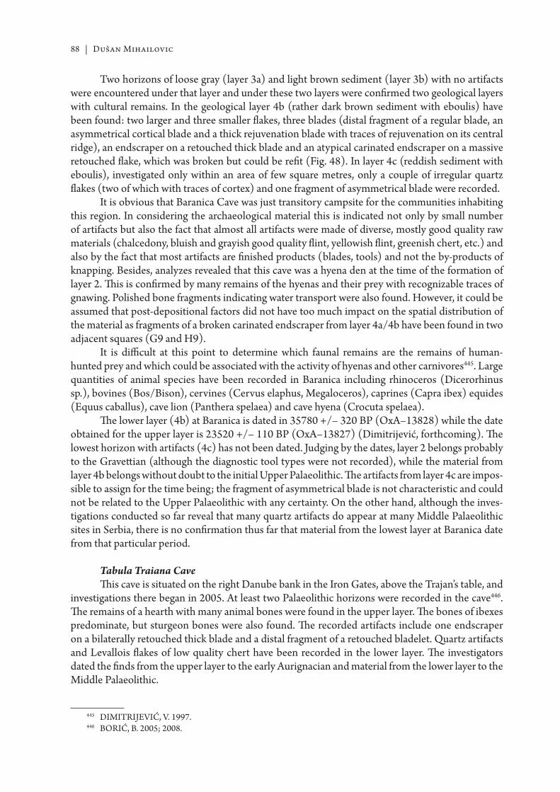
88 | Dušan Mihailovic
Two horizons of loose gray (layer 3a) and light brown sediment (layer 3b) with no artifacts were encountered under that layer and under these two layers were confi rmed two geological layers with cultural remains. In the geological layer 4b (rather dark brown sediment with eboulis) have been found: two larger and three smaller fl akes, three blades (distal fragment of a regular blade, an asymmetrical cortical blade and a thick rejuvenation blade with traces of rejuvenation on its central ridge), an endscraper on a retouched thick blade and an atypical carinated endscraper on a massive retouched fl ake, which was broken but could be refi t (Fig. 48). In layer 4c (reddish sediment with eboulis), investigated only within an area of few square metres, only a couple of irregular quartz fl akes (two of which with traces of cortex) and one fragment of asymmetrical blade were recorded.
It is obvious that Baranica Cave was just transitory campsite for the communities inhabiting this region. In considering the archaeological material this is indicated not only by small number of artifacts but also the fact that almost all artifacts were made of diverse, mostly good quality raw materials (chalcedony, bluish and grayish good quality fl int, yellowish fl int, greenish chert, etc.) and also by the fact that most artifacts are fi nished products (blades, tools) and not the by-products of knapping. Besides, analyzes revealed that this cave was a hyena den at the time of the formation of layer 2. Th is is confi rmed by many remains of the hyenas and their prey with recognizable traces of gnawing. Polished bone fragments indicating water transport were also found. However, it could be assumed that post-depositional factors did not have too much impact on the spatial distribution of the material as fragments of a broken carinated endscraper from layer 4a/4b have been found in two adjacent squares (G9 and H9).
It is diffi cult at this point to determine which faunal remains are the remains of human-hunted prey and which could be associated with the activity of hyenas and other carnivores445. Large quantities of animal species have been recorded in Baranica including rhinoceros (Dicerorhinus sp.), bovines (Bos/Bison), cervines (Cervus elaphus, Megaloceros), caprines (Capra ibex) equides (Equus caballus), cave lion (Panthera spelaea) and cave hyena (Crocuta spelaea).
Th e lower layer (4b) at Baranica is dated in 35780 +/– 320 BP (OxA–13828) while the date obtained for the upper layer is 23520 +/– 110 BP (OxA–13827) (Dimitrijević, forthcoming). Th e lowest horizon with artifacts (4c) has not been dated. Judging by the dates, layer 2 belongs probably to the Gravett ian (although the diagnostic tool types were not recorded), while the material from layer 4b belongs without doubt to the initial Upper Palaeolithic. Th e artifacts from layer 4c are impos-sible to assign for the time being; the fragment of asymmetrical blade is not characteristic and could not be related to the Upper Palaeolithic with any certainty. On the other hand, although the inves-tigations conducted so far reveal that many quartz artifacts do appear at many Middle Palaeolithic sites in Serbia, there is no confi rmation thus far that material from the lowest layer at Baranica date from that particular period.
Tabula Traiana CaveTh is cave is situated on the right Danube bank in the Iron Gates, above the Trajan’s table, and
investigations there began in 2005. At least two Palaeolithic horizons were recorded in the cave446. Th e remains of a hearth with many animal bones were found in the upper layer. Th e bones of ibexes predominate, but sturgeon bones were also found. Th e recorded artifacts include one endscraper on a bilaterally retouched thick blade and a distal fragment of a retouched bladelet. Quartz artifacts and Levallois fl akes of low quality chert have been recorded in the lower layer. Th e investigators dated the fi nds from the upper layer to the early Aurignacian and material from the lower layer to the Middle Palaeolithic.
445 DIMITRIJEVIĆ, V. 1997.446 BORIĆ, B. 2005; 2008.
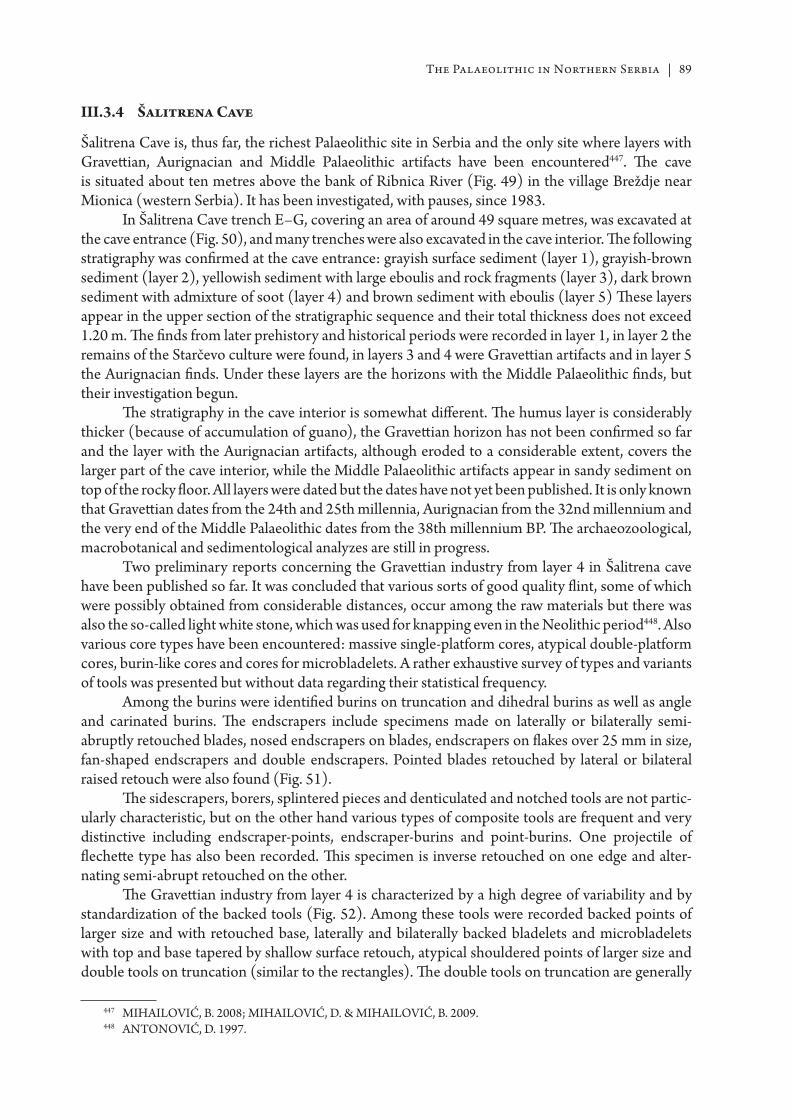
The Palaeolithic in Northern Serbia | 89
III.3.4 Šalitrena Cave
Šalitrena Cave is, thus far, the richest Palaeolithic site in Serbia and the only site where layers with Gravett ian, Aurignacian and Middle Palaeolithic artifacts have been encountered447. Th e cave is situated about ten metres above the bank of Ribnica River (Fig. 49) in the village Breždje near Mionica (western Serbia). It has been investigated, with pauses, since 1983.
In Šalitrena Cave trench E–G, covering an area of around 49 square metres, was excavated at the cave entrance (Fig. 50), and many trenches were also excavated in the cave interior. Th e following stratigraphy was confi rmed at the cave entrance: grayish surface sediment (layer 1), grayish-brown sediment (layer 2), yellowish sediment with large eboulis and rock fragments (layer 3), dark brown sediment with admixture of soot (layer 4) and brown sediment with eboulis (layer 5) Th ese layers appear in the upper section of the stratigraphic sequence and their total thickness does not exceed 1.20 m. Th e fi nds from later prehistory and historical periods were recorded in layer 1, in layer 2 the remains of the Starčevo culture were found, in layers 3 and 4 were Gravett ian artifacts and in layer 5 the Aurignacian fi nds. Under these layers are the horizons with the Middle Palaeolithic fi nds, but their investigation begun.
Th e stratigraphy in the cave interior is somewhat diff erent. Th e humus layer is considerably thicker (because of accumulation of guano), the Gravett ian horizon has not been confi rmed so far and the layer with the Aurignacian artifacts, although eroded to a considerable extent, covers the larger part of the cave interior, while the Middle Palaeolithic artifacts appear in sandy sediment on top of the rocky fl oor. All layers were dated but the dates have not yet been published. It is only known that Gravett ian dates from the 24th and 25th millennia, Aurignacian from the 32nd millennium and the very end of the Middle Palaeolithic dates from the 38th millennium BP. Th e archaeozoological, macrobotanical and sedimentological analyzes are still in progress.
Two preliminary reports concerning the Gravett ian industry from layer 4 in Šalitrena cave have been published so far. It was concluded that various sorts of good quality fl int, some of which were possibly obtained from considerable distances, occur among the raw materials but there was also the so-called light white stone, which was used for knapping even in the Neolithic period448. Also various core types have been encountered: massive single-platform cores, atypical double-platform cores, burin-like cores and cores for microbladelets. A rather exhaustive survey of types and variants of tools was presented but without data regarding their statistical frequency.
Among the burins were identifi ed burins on truncation and dihedral burins as well as angle and carinated burins. Th e endscrapers include specimens made on laterally or bilaterally semi-abruptly retouched blades, nosed endscrapers on blades, endscrapers on fl akes over 25 mm in size, fan-shaped endscrapers and double endscrapers. Pointed blades retouched by lateral or bilateral raised retouch were also found (Fig. 51).
Th e sidescrapers, borers, splintered pieces and denticulated and notched tools are not partic-ularly characteristic, but on the other hand various types of composite tools are frequent and very distinctive including endscraper-points, endscraper-burins and point-burins. One projectile of fl echett e type has also been recorded. Th is specimen is inverse retouched on one edge and alter-nating semi-abrupt retouched on the other.
Th e Gravett ian industry from layer 4 is characterized by a high degree of variability and by standardization of the backed tools (Fig. 52). Among these tools were recorded backed points of larger size and with retouched base, laterally and bilaterally backed bladelets and microbladelets with top and base tapered by shallow surface retouch, atypical shouldered points of larger size and double tools on truncation (similar to the rectangles). Th e double tools on truncation are generally
447 MIHAILOVIĆ, B. 2008; MIHAILOVIĆ, D. & MIHAILOVIĆ, B. 2009.448 ANTONOVIĆ, D. 1997.
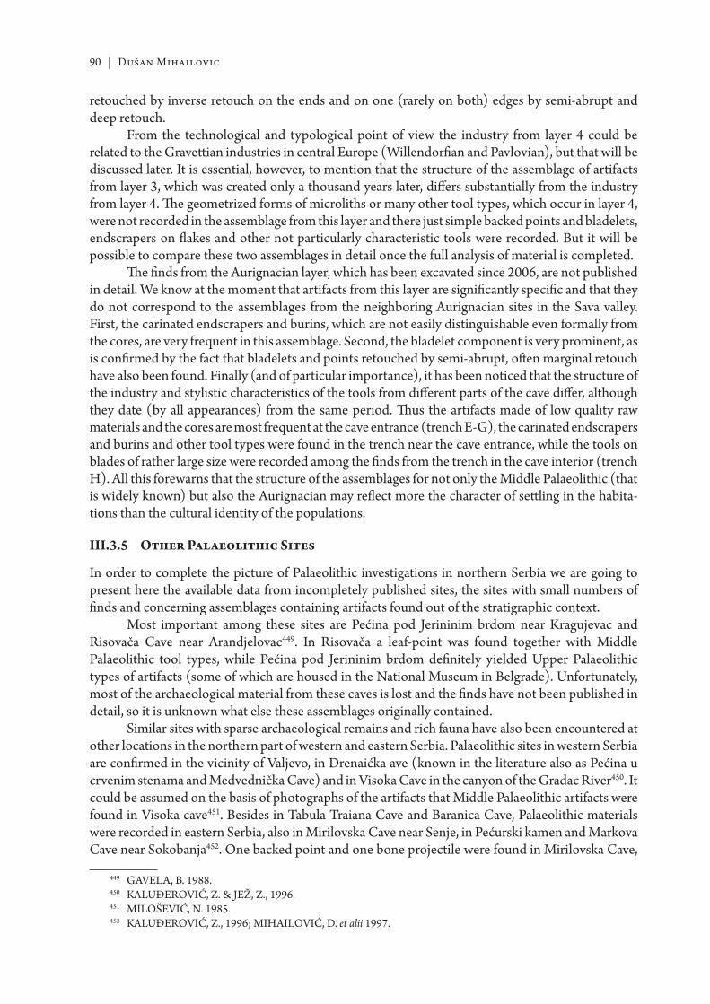
90 | Dušan Mihailovic
retouched by inverse retouch on the ends and on one (rarely on both) edges by semi-abrupt and deep retouch.
From the technological and typological point of view the industry from layer 4 could be related to the Gravett ian industries in central Europe (Willendorfi an and Pavlovian), but that will be discussed later. It is essential, however, to mention that the structure of the assemblage of artifacts from layer 3, which was created only a thousand years later, diff ers substantially from the industry from layer 4. Th e geometrized forms of microliths or many other tool types, which occur in layer 4, were not recorded in the assemblage from this layer and there just simple backed points and bladelets, endscrapers on fl akes and other not particularly characteristic tools were recorded. But it will be possible to compare these two assemblages in detail once the full analysis of material is completed.
Th e fi nds from the Aurignacian layer, which has been excavated since 2006, are not published in detail. We know at the moment that artifacts from this layer are signifi cantly specifi c and that they do not correspond to the assemblages from the neighboring Aurignacian sites in the Sava valley. First, the carinated endscrapers and burins, which are not easily distinguishable even formally from the cores, are very frequent in this assemblage. Second, the bladelet component is very prominent, as is confi rmed by the fact that bladelets and points retouched by semi-abrupt, oft en marginal retouch have also been found. Finally (and of particular importance), it has been noticed that the structure of the industry and stylistic characteristics of the tools from diff erent parts of the cave diff er, although they date (by all appearances) from the same period. Th us the artifacts made of low quality raw materials and the cores are most frequent at the cave entrance (trench E-G), the carinated endscrapers and burins and other tool types were found in the trench near the cave entrance, while the tools on blades of rather large size were recorded among the fi nds from the trench in the cave interior (trench H). All this forewarns that the structure of the assemblages for not only the Middle Palaeolithic (that is widely known) but also the Aurignacian may refl ect more the character of sett ling in the habita-tions than the cultural identity of the populations.
III.3.5 Other Palaeolithic Sites
In order to complete the picture of Palaeolithic investigations in northern Serbia we are going to present here the available data from incompletely published sites, the sites with small numbers of fi nds and concerning assemblages containing artifacts found out of the stratigraphic context.
Most important among these sites are Pećina pod Jerininim brdom near Kragujevac and Risovača Cave near Arandjelovac449. In Risovača a leaf-point was found together with Middle Palaeolithic tool types, while Pećina pod Jerininim brdom defi nitely yielded Upper Palaeolithic types of artifacts (some of which are housed in the National Museum in Belgrade). Unfortunately, most of the archaeological material from these caves is lost and the fi nds have not been published in detail, so it is unknown what else these assemblages originally contained.
Similar sites with sparse archaeological remains and rich fauna have also been encountered at other locations in the northern part of western and eastern Serbia. Palaeolithic sites in western Serbia are confi rmed in the vicinity of Valjevo, in Drenaićka ave (known in the literature also as Pećina u crvenim stenama and Medvednička Cave) and in Visoka Cave in the canyon of the Gradac River450. It could be assumed on the basis of photographs of the artifacts that Middle Palaeolithic artifacts were found in Visoka cave451. Besides in Tabula Traiana Cave and Baranica Cave, Palaeolithic materials were recorded in eastern Serbia, also in Mirilovska Cave near Senje, in Pećurski kamen and Markova Cave near Sokobanja452. One backed point and one bone projectile were found in Mirilovska Cave,
449 GAVELA, B. 1988.450 KA LUĐEROVIĆ, Z. & JEŽ, Z., 1996.451 MILOŠEVIĆ, N. 1985.452 KA LUĐEROVIĆ, Z., 1996; MIHAILOVIĆ, D. et alii 1997.
The Palaeolithic in Northern Serbia | 91
one fl ake and one typical Middle Palaeolithic sidescraper were found in Pećurski kamen, while in Markova Cave one core which the author of the excavations report believes to date from the late Upper Palaeolithic was recovered453.
Sites in the open have not been systematically excavated. One transversal sidescraper dated to the Middle Palaeolithic was found at Rušanj near Belgrade454, while a rather large quantity of artifacts were found at the Beljarica and Ekonomija 13. Maj sites near Zemun. Th ese artifacts have been gathered on the Danube river bank under the profi le of the Zemun loess plateau455. Th e fi nds were classifi ed according to their technological and typological characteristics as: a) artifacts of the Middle Palaeolithic type (Mousterian points, tools of cleaver type, sidescrapers, Levallois fl akes), b) fi nds that could be related to Gravett ian or Epigravett ian (abruptly retouched points, short endscrapers, etc.); and c) tools, which could be dated to the Mesolithic period (trapezes and truncated bladelets).
Th e data about the sites in Vojvodina (except those already described) do not provide much information. Th e artifact from Irig in the Fruška Gora Mountains was found in the sand and gravel mine in the vicinity of the mammoth remains456; a few loess profi les with traces of hearths have been recorded and as we already mentioned the Middle Palaeolithic and Upper Palaeolithic tool types have been recorded in the impoverished assemblages from Kozluk and Mesić kanal in the vicinity of Vršac457.
III.4 Palaeolithic of northern Serbia in its regional context
III.4.1 Middle Palaeolithic
As we already mentioned we can discuss the Palaeolithic in the Balkans as well as in the entirety of northern Serbia only in a broader regional context because of the limited investigation results. Th is approach is particularly signifi cant if we discuss the very beginning of sett lement of the south Pannonian–north Balkan region.
Th e issue of the so-called quartzite Palaeolithic and the Carpathian Mousterian has been raised by Romanian archaeologists, and with reason considering that Palaeolithic industries with quartz and quartzite artifacts are only documented in the south Carpathians458. It is entirely justifi ed to mention in that context the material from Betalov Spodmol459 and other sites in the westernmost areas of the Pannonian-Slavonic region as well as the Erd site in Hungary460. We believe in that context that recent investigations of the Palaeolithic in Serbia and southern Romania contribute to the completion of the fragmentary picture of the quartz industries, which in many parts of the Carpathian basin have been recognized as geographically limited cultural phenomenon, and also make possible its reconsideration as a regional technological tradition.
It is well-known that there are similarities between Taubahian industries of the Carpathian basin (Tata, Kulna 11, Predmost II, Oblazowa XXb–XVI) and microlithizied industries with tools on pebbles and fl akes from Vértesszöllös and Bilcingsleben461. Small-sized fl akes had been struck from the cores regardless of whether smaller or larger pebbles were used as raw material. Most of the pebbles were just roughly knapped. It has been noticed that the chaine operatoire is similar in many
453 KA LUĐEROVIĆ, Z., 1996.454 KA LUĐEROVIĆ, Z., 1991.455 ŠARIĆ, J. 1984; ŠARIĆ, J. 2009.456 MEDOVIĆ, P. 1970.457 BRODAR, S. 1955; RA DOVANOVIĆ, I. 1984.458 MOGOŞANU, F. 1968a; PAUNESCU, A. 1989; CARCIUMARU, M. & ANGHELINU, M. 2000.459 OSOLE, F. 1991.460 GÁBORI-CSÁNK, V. 1968.461 MONCEL, M. E. 2003.
92 | Dušan Mihailovic
elements and that two fl aking surfaces oft en appear on the cores. Th e knapping technology at Erd deviates slightly from this standard because somewhat larger pebbles had been used.
Th e succession of Taubahian and Charentian has been confi rmed at a few sites in the northern Carpathians. For example, at the site of Oblazowa in Poland the Charentian layer was encountered under the Taubahian layer and under the Charentian layer was recorded an industry with a larger quantity of denticulated tools462. Th e Levallois technology is not signifi cantly represented at this site, as the most of the Taubahian sites, and a small number of the bifacially retouched tools were also recorded. Similarly, in the area eastward of the Carpathians, the eastern Taubahian is followed by the late Taubahian and Stinkovian, which also has the traits of the denticulated Mousterian463. Th e industry from the Petrovaradin fortress has parallels with all mentioned facies: the tools on irregular fl akes are prevailing, quartz was used to a considerable extent, denticulated tools are abundant, microlithization is prominent and the Levallois technique and bifacially chipped sidescrapers were recorded in small quantity.
Th e Charentian and quartz component in the material from the Petrovaradin fortress is somewhat unexpected phenomenon, considering that Charentian sites situated to the north (Erd), west (Betalov Spodmol, Krapina, Vindija) and east of Petrovaradin fortress are at a considerable distance. Even though the Charentoid character had been at one time ascribed to the Balkan Mousterian464, that facies has not been confi rmed until recently at any sites to the south of the Sava and the Danube. Th e only exception is the industry of the Pontinian type in layers XXII, XXI and XVIII at Crvena Stijena465.
Signifi cant progress has been made in recent years in comprehending the Charentian in southeast Europe. Th e rich Charentian industry has been recorded in the cave complex at Balanica near Niš (in Mala Balanica of the Quina type) and the Middle Palaeolithic quartz industry has been encountered also at the site of Golema Pesht in the vicinity of Skopje466. It has become apparent that the territory within which Charentian and quartz industries do appear reaches to the southern fringes of the Pannonian basin and that penetrate deep into the Balkan interior along the Morava-Vardar route. It is still impossible to conclude whether this refl ects the problem of mutually connected phenomena, chronological or regional facies, or a distinct method of adaptation to the environment. In contrast to western Europe where most of the Charentian sites are dated in OIS4, the Charentian in central and southeast Europe and in Anatolia covers a long time span: the proto-Charentian in Karain is generally dated to 330–300 ka467, the date obtained for Krapina is 130 ka468 and industries from Betalov Spodmol and Erd continued until the end of OIS4 and the beginning of OIS3469.
Typical Mousterian is a common phenomenon in many parts of the Carpathian basin and the Balkan peninsula, but due to circumstances it is not well documented in Serbia. Levallois artifacts have been encountered at Petrovaradin fortress and many other sites including Hadži Prodanova Cave, Smolućka Cave, Tabula Traiana Cave, Beljarica and Ekonomija 13. maj. Th e preferential technique had been mostly used but specimens confi rming the use of the recurrent method have also been recorded. Rejuvenation fl akes of the éclat debordant type were also found, which are diffi cult to relate to either the centripetal recurrent Levallois technique or the discoid technique.
Industries with leaf-points confi rmed at many sites in Bulgaria have not been documented in Serbia. Still, bifacially retouched tools occur at sites in the north of the Balkans even in the early
462 VALDE-NOWAK, P. 2009.463 COHEN, V. & STEPANCHUK, V. N. 1999.464 KOZŁOWSKI, J. 1992.465 BASLER, D. 1975.466 MIHAILOVIĆ, D. 2008a; 2009a; SALAMANOV-KOROBAR, L.J., 2008.467 KOZŁOWSKI, J. 2002.468 SIMEK, J. F., SMITH, F. H. 1997.469 GÁBORI-CSÁNK, V. 1968; OSOLE, F. 1991.
The Palaeolithic in Northern Serbia | 93
phase of the Middle Palaeolithic. Th e backed sidescrapers from the Petrovaradin fortress could not be directly related to the Micoquian of central Europe either technologically, stylistically or according to size and context470 but they certainly confi rm that communities inhabiting south Pannonia had similar concepts of biface production. Leaf-points were recorded at a few sites in the Sava valley and in the western Balkans (Kamen, Vindija)471 and in Risovača they were found together with artifacts of the Middle Palaeolithic type472.
Middle Palaeolithic sites with impoverished assemblages, which could not be taxonomically determined, are rather numerous in northern Serbia and in the neighboring regions. Th e artifacts of quartz (made on the spot) generally prevail at these sites and a small quantity of (oft en worn-out) tools of fl int and some Levallois fl akes mostly brought from other locations are also recorded. Because of the dominance of quartz these assemblages were once ascribed to the ‘cave’ or quartz Mousterian473. However, it should be pointed out that means of procurement and use of quartz in the temporary cave habitations (obtaining it on the way along with other activities) probably diff ers substantially from the means of procurement of this raw material during longer occupations at base camps. And while technological tradition may have played an important role in the pebble-fl ake industries in central Europe, the appearance of quartz in temporary camps was certainly decisively infl uenced by functional factors.
III.4.2 Upper Palaeolithic
Th e question of the emergence of the Upper Palaeolithic techno-complexes is inseparable from the question of their bearers, and the North Balkan–South Carpathian region off ers great opportunities to study this topic. Th e oldest remains of Homo sapiens in Europe are 36000 years old (in the case of Peştera cu Oase) and were found in the caves of southwestern Romania474, while in the westernmost parts of the south Pannonian region (in Vindija) very well-known Neanderthal remains dated to the 32nd–33rd millennia BP have been documented475. Th e earliest Upper Palaeolithic sites in this part of Europe (Kozarnika, Temnata, Bacho Kiro) were discovered in this area and they, according to some scholars, suggest the expansion of Upper Palaeolithic and modern humans from the east or southeast towards central Europe, while according to the others this is evidence of technological transformation within the Mousterian techno-complex. Th ese investigations posed many questions: how to explain the morphological variability of populations inhabiting south Pannonia and the northern Balkans before around 40 ka, whether certain facies could be associated with distinct kinds of hominids, along which routes, when and how the Upper Palaeolithic expanded, and what was the character of interactions between the Neanderthals and modern humans?
Th e key for understanding the transition from Middle to Upper Palaeolithic in the eastern Balkans are the remains from Bacho Kiro and Temnata caves in northern Bulgaria. Th e fi nds from layer 11 at Bacho Kiro were initially dated to the period before 43000 BP, att ributed to the Upper Palaeolithic and defi ned as Bachokirien476. In the same layer a fragment of human mandible which was assumed to belong to a primitive type of modern man transitional between the Neanderthal and Homo sapiens was found. In Temnata, however, in layer VI in trench TD–II an industry of transi-tional type dated to the period before 38700 BP477 is confi rmed, while the Bachokirien was also
470 BOSINSKI, G. 1967.471 IVANOVA, S. 1979.472 GAVELA, B. 1988.473 PĂUNESCU, A. 1989.474 TRINKA US, E. et alii 2003a.475 HIGHAM, T. et alii 2006.476 KOZŁOWSKI, J. et alii 1982.477 DROBNIEWICZ, B. et alii 2000a.
94 | Dušan Mihailovic
encountered in layer 4 in trench TD-I dated to 38200–39100 BP478. It has been assumed that Bacho Kiro and Temnata were ‘on the path to the west’ of Upper Palaeolithic communities, which had inhabited Europe, and that the transitional industry from Temnata only confi rms that a process of leptolithization (elongation) of the artifacts and technological transformations from the Levallois technology towards the production of blades from the volumetric cores had started but had not been completed479.
Th e 1990s witnessed the reinterpretation of fi nds from the Bulgarian sites. It has been pointed out that new dates for Bacho Kiro are somewhat later and that they correspond to the 38th –39th millennium BP. Th ere were also opinions that fossil remains from layer 11 should be related more to the Neanderthals than to modern humans, and many authors suggested that Bachokirien, i.e. pre-Aurignacian industries from Bacho Kiro and Temnata, are of Middle Palaeolithic character and that they represent the fi nal phase in the evolution of the transitional industries480. Th e so-called Protoaurignacian was identifi ed as the earliest representative of the Upper Palaeolithic, while early Aurignacian with carinated endscrapers and split-based points was ascribed to a somewhat later period481. On the basis of the material from layer VII at Kozarnika a distinct facies (Kozarnikien) has been distinguished and dated to the 36th–38th millennium BP. Th is industry was associated with the Protoaurignacian as well as with the Ahmarien from the Near East because of its lamellar character482.
In contrast to Bulgaria and the Czech Republic, industries of transitional type have not been discovered in south Pannonia and in the central Balkans, with the only exceptions being Vindija (where the remains of the Neanderthals and a split-based point were found in layer G1), Mališina Stijena (where Upper Palaeolithic artifacts occur in a Middle Palaeolithic context) and previously described assemblages from Balata. It turns out, however, that the stratigraphic context of the fi nds from Vindija is not entirely certain483, that the industry from Mališina Stijena probably does not go beyond the frameworks customary for the Middle Palaeolithic484, and the artifacts from Balata are neither obtained from regular excavations nor are there any transitional forms, which are recorded at Temnata and at Bohunician sites485. Th erefore it must be concluded that for the time being there are no reliable indications that the process of transformation documented in Bulgaria ever took place here. In contrast to that, an almost monotonous succession of the Middle and Upper Palaeolithic appears at most sites in this area.
Th e artifacts from Baranica and (probably) Tabula Traiana Cave date, judging by the absolute dates and the characteristics of the fi nds, from the early Upper Palaeolithic. Unfortunately these assemblages are too impoverished to be meaningfully related to some Aurignacian facies. On the other hand, there is no question that Aurignacian fi nds from Tincova, Coşava and Româneşti–Dumbrăviţa in the Romanian Banat486 and Crvenka and At on the Serbian side belong to the same cultural complex, and the same catchment area connected the Begej (Bega) and the Tamiš (Timiş) river basins. Th ese industries have been at one time att ributed to the Aurignacian of the Krems type, and dated generally to Arcy-Stillfried B times. However, the industry from Tincova has recently been att ributed to the Protoaurignacian. It is important to emphasize here that almost all elements
478 DROBNIEWICZ, B. et alii 2000b.479 DROBNIEWICZ, B. et alii 2000a.480 CHURCHILL, S. E. & SMITH, F. H., 2000; TSANOVA, T. & BORDES, J-G., 2003; RIGAUD, J-P. & LUCAS, P.,
2006; TSANOVA, T. 2008.481 TEYSSANDIER, N. 2003; 2008.482 TSANOVA, T. 2008.483 D’ERICCO, F. et alii 1998; KA RA VANIĆ, I. & SMITH, F. H., 2000; KA RA VANIĆ, I. 2000.484 RA DOVANOVIĆ, I. 1986b; MIHAILOVIĆ, D. 2009b.485 MIHAILOVIĆ, D. 1992a.486 MOGOŞANU, F. 1978.
The Palaeolithic in Northern Serbia | 95
of the Protoaurignacian487 like pyramidal cores, carinated core scrapers and plain retouched blades (sometimes of strangled type) rarely with typical Aurignacian retouch, actually do appear at Crvenka and At as well as at Tincova (and also at two other Romanian sites). Simple endscrapers on blades are also prevalent, nosed and carinated endscrapers are rather infrequent, and the points of the Krems type and Dufour bladelets were also found at sites in Romania (in contrast to Crvenka and At, which have not been systematically investigated). It should be borne in mind, however, that the chronology of these sites has not yet been established with certainty, so their att ribution to the Protoaurignacian remains open to discussion.
As we can see, the existing material off ers the potential for diff erent interpretations. We consider it, however, not debatable that investigations conducted so far revealed that dates for the earliest Upper Palaeolithic and the latest Middle Palaeolithic sites decrease from the east to the west of the Balkans. It is also obvious that the Aurignacian sites do not appear in the interior of the Balkans, outside the Sava-Danube corridor. Th erefore, it seems at the moment that the Upper Palaeolithic cultures advanced along the Danube route but that advance was of a diff usional character and that it encompassed a rather large territory. But it still remains to be established whether other communi-cations (Morava-Vardar route, valleys of the rivers Strumica and Nišava) have also been employed in areas where more wide-ranging investigations have not yet been conducted.
Th ere still remains an open question whether the expansion of the Upper Palaeolithic followed the retreat of Neanderthal communities in the inaccessible mountainous regions of the Balkans (for which there are certain indications), or the retreat had been in the face of the direct advance of Upper Palaeolithic populations. Despite the fact that the Neanderthals and the bearers of the Upper Palaeolithic cultures had been coexisting in the Balkans for many thousand years (as evidenced by the fi nds from Vindija), and even though the Neanderthals took over many innovations usually associated with the Upper Palaeolithic and modern humans, it has not been established with any certainty that members of these two species inhabited some of the smaller geographic regions concurrently. Th is suggests that strong social and ecological competition existed between the Neanderthals and modern humans, that social interactions were of low intensity and that modern humans probably did not perceive Neanderthals as members of their own species. In that context it is not very probable that hybridization between these two populations took place to any considerable extent.
Th e Aurignacian entirely replaced the Middle Palaeolithic in the south Pannonian region aft er 35000BP. In that period this culture had the traits of typical Balkan Aurignacian but it should be pointed out that the industry from Šalitrena Cave (which has yet to be published) diff ers consid-erably on the basis of distinct association of carinated and nosed endscrapers and burins, straight semi-abruptly retouched lamellae and points and pointed blades, from all Aurignacian industries, which have been encountered in this part of the Balkans so far.
Th e Gravett ian was, until recently, insuffi ciently studied in central and southern regions of the Carpathian basin. Only a few sites dating from that period have been confi rmed in Hungary, northern Bosnia, northern Croatia and Slovenia and the situation was similar in northern Serbia, where outside of a couple of artifacts discovered in the course of regular excavations (Baranica) and a small quantity of artifacts collected out of context, there were no traces of its presence. Investigations in Bulgaria and northern Serbia have shed more more light on this problem. In Šalitrena Cave an industry has been found which corresponds in many elements to the industry from layers 8 and 9 at Willendorf II488: the backed truncations are frequent, there were also recorded pointed blades, and two (not so typical) shouldered points have been also found. Parallels could also be drawn with the industries from Temnata and particularly Kozarnika (layer IVb) where, as in Šalitrena Cave, laterally and bilaterally retouched points (including the points of Kozarnika type), micropoints with
487 TEYSSANDIER, N. 2008.488 OTT E, M. et alii 1996; VALOCH, K. 1996.
96 | Dušan Mihailovic
retouched base and backed truncations have been encountered489. All these sites except Temnata (which covers a somewhat longer time span) date from the 26th and 25th millennia BP.
Bearing in mind the fact that Gravett ian sites in the north of the Balkans are grouped in the Sava-Danube corridor, and considering that elements which occur somewhat earlier in the north of central Europe (in Pavlovian) also appear at these sites, it is not out of the question that shift ing of human communities from central Europe towards the Balkans took place in the beginning of the Upper Pleniglacial (26000–20000 BP)490. Nevertheless, it remains unclear why Gravett ian sites have not been encountered so far in the central parts of the Balkans, which are considered a refugium in that period. Th e reason why typical (central European) Gravett ian does not appear in this area lays perhaps in the fact that with the advance of the maximum of the last glacial the industries in the Balkans lost Gravett ian traits and acquired more and more the characteristics of the undiff erentiated early Epigravett ian491. It has been established that these industries are characterized by a restricted repertoire of endscrapers, burins, retouched blades, retouched truncations and backed tools. Th is change is quite noticeable in Temnata, it is conspicuous in the Climente I Cave in the Iron Gates492 and it is also suggested by the fi nds from Šalitrena Cave, but that will be clearer aft er completion of the analysis of this material. Th e lack of Gravett ian characteristics could be the result of a breaking with tradition (in the technological sphere) but may also refl ect diff erent hunting activities related to the use of shouldered points493.
An entirely diff erent process of spreading the technological innovations that could be more closely related to cultural change than population movements took place in the late glacial, and it is confi rmed by the appearance of ‘Mediterranean’ elements in the south Pannonian and south Carpathian Epigravett ian. In contrast to the coastal region, the fi nal Epigravett ian is insuffi ciently known in the northern Balkans but it is, on the other hand, very well studied in the south Carpathians, at the Climente II and Cuina Turcului sites in the Iron Gates494.
Almost all elements characteristic of the fi nal Epigravett ian of the Adriatic-Ionian zone including microlithization of artifacts, thumbnail and circular endscrapers, geometric microliths (segments and triangles) and arched backed points, have been recorded in the industry from Cuina Turcului495. Th at period is characterized by complex specialization in various fi elds of human activity, the eclectic obtaining of resources from diff erent biomes and the introduction of fi shing – which had already been practiced in the earlier period as the fi nds from Tabula Traiana Cave and Climente I confi rm496. Th e cold spell in Younger Dryas could have forced these communities to more inten-sively inhabit the sheltered area of the Iron Gates gorge and to intensify hunting the ibexes (which in association with bison and other steppic species represent 60% of total remains)497.
Th e hunter-gatherer communities in the Iron Gates established an entire network of sett le-ments in the beginning of the Holocene. Whether because of affl uence, diversity and/or reduced seasonality of resources, or because the fi shing could ‘have had the role of the key resource for the survival of the communities’, (regardless of whether it was really the case), social and cultural integration took place at this time in the Iron Gates, and sett lements with formal interment areas also emerged498. In the Balkans a tendency toward general technological decline, manifested in
489 DROBNIEWICZ, B. et alii 1992; TSANOVA, T. 2003.490 KOZLOWSKI, J. 1996.491 MIHAILOVIĆ, D. & MIHAILOVIĆ, B. 2007.492 BORONEANŢ, V. 2000a.493 KOZLOWSKI, J. 1999.494 PĂUNESCU, A. 1978; BORONEANŢ, V. 2000a.495 PĂUNESCU, A. 1978.496 BORONEANŢ, V. 2000a; BORIĆ, D. 2005.497 MIHAILOVIĆ, D. 2008b.498 RA DOVANOVIĆ, I. 1996.
The Palaeolithic in Northern Serbia | 97
the technological sphere by a decrease in the quality of raw materials used for knapping, in the use of expedient technology, in the decrease in quantity of the Epigravett ian tool types, and in use of asymmetrical tools on fl akes, is noticeable during this period499. Similar tendencies in economy and technology have been encountered in all three regions where Epipalaeolithic and Mesolithic sites have been investigated: in the Iron Gates, in Montenegro and in Greece. Th ese tendencies could be traced from the earliest phase (Cuina Turcului II, Ostrovul Banului I–II, Padina A) and reached a climax with the appearance of the quartz industries in the Lower Gorge (Razvrata, Icoana, Schela Cladovei). From these foundations originated the Lepenski Vir culture in the beginning of the 7th millennium cal BC.
499 MIHAILOVIĆ, D. 2001.
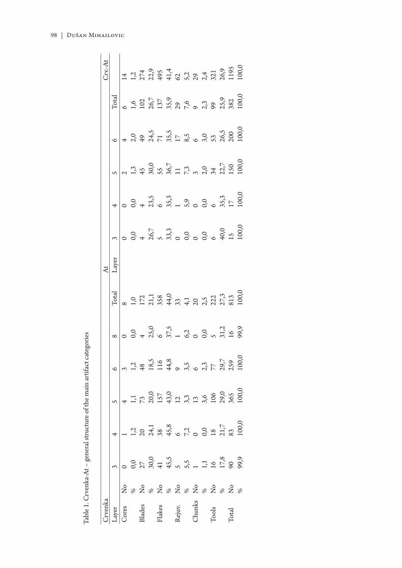
98 | Dušan Mihailovic
Tabl
e 1. C
rven
ka-A
t – ge
nera
l str
uctu
re o
f the
mai
n ar
tifac
t cat
egor
ies
Crv
enka
AtC
rv.-A
tLa
yer
34
56
8To
tal
Laye
r3
45
6To
tal
Cor
esN
o%
0 0,0
1 1,2
4 1,1
3 1,2
0 0,0
8 1,0
0 0,0
0 0,0
2 1,3
4 2,0
6 1,6
14 1,2
Blad
esN
o%
27 30,0
20 24,1
73 20,0
48 18,5
4 25,0
172
21,1
4 26,7
4 23,5
45 30,0
49 24,5
102
26,7
274
22,9
Flak
esN
o%
41 45,5
38 45,8
157
43,0
116
44,8
6 37,5
358
44,0
5 33,3
6 35,3
55 36,7
71 35,5
137
35,9
495
41,4
Rej
uv.
No
%5 5,
56 7,
212 3,
39 3,
51 6,
233 4,
10 0,
01 5,
911 7,
317 8,
529 7,
662 5,
2C
hunk
sN
o%
1 1,1
0 0,0
13 3,6
6 2,3
0 0,0
20 2,5
0 0,0
0 0,0
3 2,0
6 3,0
9 2,3
29 2,4
Tool
sN
o%
16 17,8
18 21,7
106
29,0
77 29,7
5 31,2
222
27,3
6 40,0
6 35,3
34 22,7
53 26,5
99 25,9
321
26,9
Tota
lN
o%
90 99,9
83 100,
036
510
0,0
259
100,
016 99
,981
310
0,0
15 100,
017 10
0,0
150
100,
020
010
0,0
382
100,
011
9510
0,0
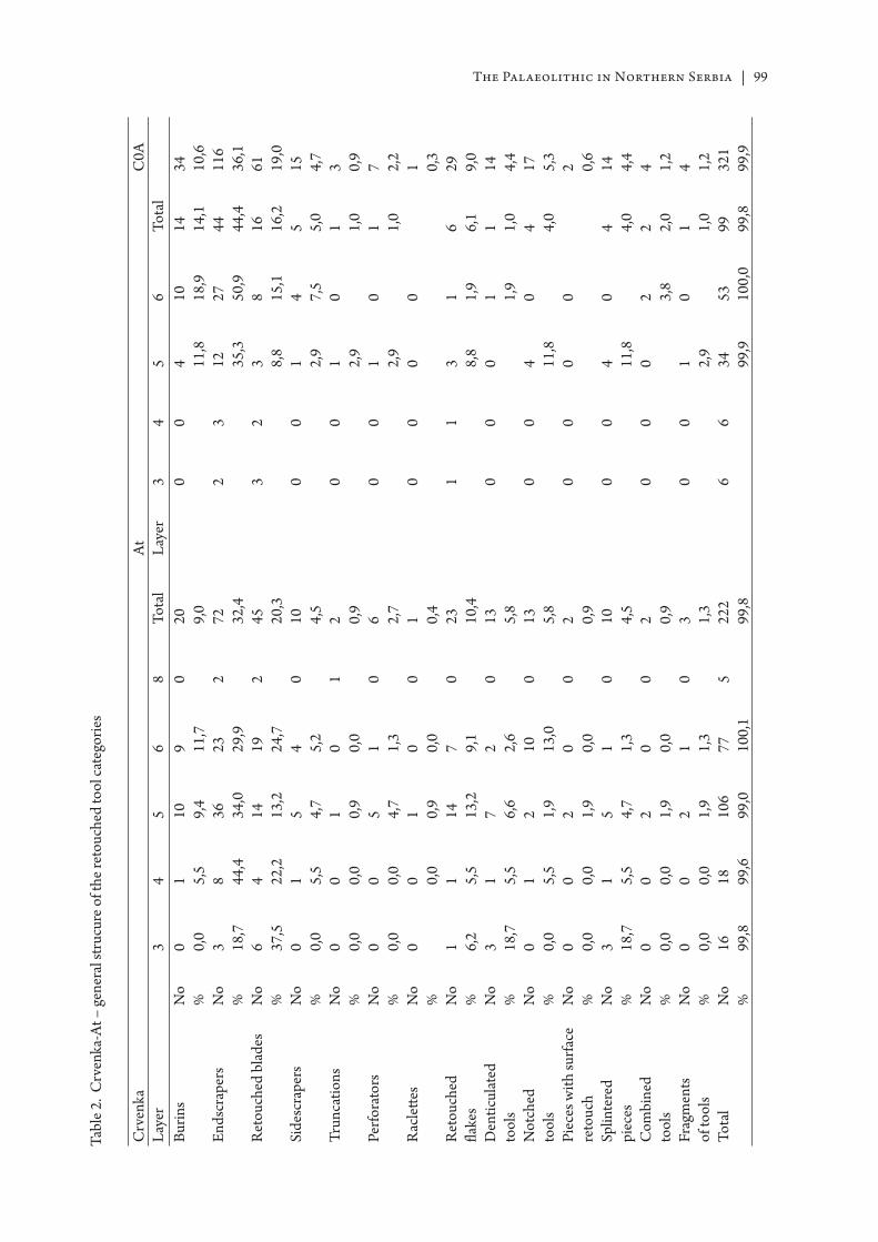
The Palaeolithic in Northern Serbia | 99Ta
ble 2
. Crv
enka
-At –
gene
ral s
truc
ure o
f the
reto
uche
d to
ol ca
tego
ries
Crv
enka
AtC
0ALa
yer
34
56
8To
tal
Laye
r3
45
6To
tal
Burin
sN
o%
0 0,0
1 5,5
10 9,4
9 11,7
020 9,
00
04 11
,810 18
,914 14
,134 10
,6En
dscr
aper
sN
o%
3 18,7
8 44,4
36 34,0
23 29,9
272 32
,42
312 35
,327 50
,944 44
,411
636
,1R
etou
ched
bla
des
No
%6 37
,54 22
,214 13
,219 24
,72
45 20,3
32
3 8,8
8 15,1
16 16,2
61 19,0
Side
scra
pers
No
%0 0,
01 5,
55 4,
74 5,
20
10 4,5
00
1 2,9
4 7,5
5 5,0
15 4,7
Trun
catio
nsN
o%
0 0,0
0 0,0
1 0,9
0 0,0
12 0,
90
01 2,
90
1 1,0
3 0,9
Perfo
rato
rsN
o%
0 0,0
0 0,0
5 4,7
1 1,3
06 2,
70
01 2,
90
1 1,0
7 2,2
Rac
lett e
sN
o%
00 0,
01 0,
90 0,
00
1 0,4
00
00
1 0,3
Ret
ouch
edfl a
kes
No
%1 6,
21 5,
514 13
,27 9,
10
23 10,4
11
3 8,8
1 1,9
6 6,1
29 9,0
Den
ticul
ated
tool
sN
o%
3 18,7
1 5,5
7 6,6
2 2,6
013 5,
80
00
1 1,9
1 1,0
14 4,4
Not
ched
tool
sN
o%
0 0,0
1 5,5
2 1,9
10 13,0
013 5,
80
04 11
,80
4 4,0
17 5,3
Piec
es w
ith su
rface
re
touc
hN
o%
0 0,0
0 0,0
2 1,9
0 0,0
02 0,
90
00
02 0,
6Sp
linte
red
piec
esN
o%
3 18,7
1 5,5
5 4,7
1 1,3
010 4,
50
04 11
,80
4 4,0
14 4,4
Com
bine
dto
ols
No
%0 0,
00 0,
02 1,
90 0,
00
2 0,9
00
02 3,
82 2,
04 1,
2Fr
agm
ents
of to
ols
No
%0 0,
00 0,
02 1,
91 1,
30
3 1,3
00
1 2,9
01 1,
04 1,
2To
tal
No
%16 99
,818 99
,610
699
,077 10
0,1
522
299
,86
634 99
,953 10
0,0
99 99,8
321
99,9
100 | Dušan Mihailovic
Table 3. Petrovaradin fortress – general structure of the main artifact categories: cores, blades, fl akes, chunks, tools, products of the secondary tools modifi cation, chips and small undeterminable fragments (≤ 15 mm)
Sector I Sector IILayer 2a 2a/2b 2b Total 2a 2a/2bCores 6
3,5%35,4%
17,1%
104,2%
83,2%
15,0%
93,3%
Blades 52,9%
23,6%
00,0%
72,9%
104,0%
00,0%
103,7%
Flakes 12573,1%
3869,1%
1071,4%
17372,1%
17368,6%
1470%
18768,7%
Chunks 31,8%
11,8%
00,0%
41,7%
31,2%
00,0%
31,1%
Tools 3118,1%
1018,2%
321,4%
4418,3%
5722,6%
525,0%
6222,8%
Sec.m. 10,6%
11,8%
00,0%
20,8%
10,4
00,0%
10,4%
Total 171100,0%
5599,9%
1499,9%
240100,0%
252100,0%
20100%
272100,0%
+ Chips 79 37 7 123 168 14 182+ Frg. 74 14 6 94 98 10 108
Table 4. Petrovaradin fortress – general strucure of the retouched tool categories
Sector I Sector IILayer 2a 2a/2b 2b Total 2a 2a/2b TotalEndscrapers 5 1 1 7 5 0 5Burins 1 1 0 2 6 0 6Retouched blades 0 0 0 0 1 0 1Retouched fl akes 5 1 0 6 11 1 12Sidescrapers 6 4 2 12 12 2 14Denticulated tools 4 0 0 4 3 1 4Notched tools 6 0 0 6 10 0 10Splintered pieces 0 0 0 0 2 0 2Raclett es 0 0 0 0 0 1 1Perforators 0 1 0 1 2 0 2Truncations 1 1 0 2 2 0 2Fragments of tools 3 1 0 4 3 0 3Total 31 10 3 44 57 5 62
The Palaeolithic in Northern Serbia | 101
Table 5. Petrovaradin fortress – occurrence of types according to F. Bordes list, by layers
Sector I Sector IILayer 2a 2a/2b 2b 2a 2a/2b1 2 2 62 5 1 15 4 2 489 3 510 1 2 415 121 122 123 2 1 124 125 128 2 130 1 131 4 1 1 333 1 1 634 135 1 137 138 239 140 1 1 242 6 1043 4 3 14546–49 5 1 11 156 162 3 1 5Total 43 (31) 14 (11) 4 (3) 70 (52) 5 (4)
Table 6. Petrovaradin fortress – typological and technological indices according to F. Bordes
Sector I Sector II Both sectorsLayer 2a 2a/2b Average (2a+2a/2b) 2a Average (2a+2a/2b) Average (2a+2a/2b)IL 4,09 3,63 3,98 2,77 2,57 3,21IF (l) 20,45 20,00 20,33 23,61 24,34 22,59IF (ess) 5,68 20,00 9,32 9,02 9,21 9,25ILam* 4,67 5,45 4,86 5,55 5,14 5,02ILty (l) 16,27 14,28 15,78 10,00 9,33 12,12IR (l) 13,95 28,57 17,54 18,57 20,00 18,93IC (l) 4,65 28,57 10,52 8,57 9,33 9,84I (l) 16,27 14,28 15,78 10,0 9,33 12,12II (l) 23,25 42,85 28,07 24,28 25,33 26,51III (l) 18,60 28,57 21,05 20,00 18,66 19,69IV (l) 23,25 0 17,54 18,57 18,66 18,18IR (ess) 19,35 36,36 23,80 25,00 26,78 25,51IC (ess) 6,45 36,36 14,28 11,53 12,50 13,26II (ess) 32,25 54,54 38,09 32,69 33,92 35,71III (ess) 25,80 36,36 28,57 26,92 25,00 26,53IV (ess) 32,25 0 23,80 25,00 25,00 24,48


IV.1 Introduction – Mesolithic studies in Romania
“How can we summarize the Mesolithic age? Was it the glorious fi nale to hunter-gatherer adaptations in Europe or the prelude to the social and economic systems of later prehistory? Or, was it a play within itself, requiring reference neither to what went before, nor aft er, for
its identity? Perhaps we should try to see it as all three: a period with many complex threads which we are just beginning to unravel and understand. If we need a single image to characterize the Mesolithic we cannot choose a particular environmental type, sett lement system or socio-economic organization. Th ese all varied markedly across Mesolithic Europe and through time. Th e only constant we have is at the level of the individual forager making decisions about which tools to produce, which resources to exploit, and which alliances to form. Such decisions were made on the basis of imperfect information about the options available, under the infl uence of the society’s traditions, and with the creativity that is inherent to the human mind. It was fr om such decisions, fr om the many intended and unintended consequences that the social and economic structures of the Mesolithic emerged. It was these day-to-day, indeed minute-minute, decisions – made as Mesolithic foragers went about their daily business – that created one of the most critical periods of transformation in European prehistory.” (S. Mithen)500
In South-East Europe, the general perception of the role and importance of the Mesolithic has always been acutely variable, function of its presence/absence within diff erent areas, or the archaeological traditions of the region.
Romanian archaeologists started to pay att ention to the Mesolithic age at the beginning of the XX century. In many cases it was quoted just as just a period of transition, a bridge between the Palaeolithic and the Neolithic – the two bright stars of Prehistory501, or as simply the surviving remains of the Palaeolithic.502 It was very rarely seen as a time ‘of deep changes of the material and the spiritual, of transformations and adaptations to new ways of life”.503
Th e second half of the XXth century saw the att empt by C. S. Nicolăescu-Plopşor504 to eliminate the term “Mesolithic” altogether, as it was ‘lacking substance,’ and ‘the Proto-Neolithic is naturally and directly linked to the Epipalaeolithic, with no other intermediary period between them”.505 Th e same authors stressed that “there is a direct transition fr om the Upper Palaeolithic to the Early Neolithic, developing on a late
500 MITHEN, S. 1994: 133.501 MOROŞAN, N. N. 1932: 12; BERCIU, D. 1939: 11.502 BERCIU, D. 1939:11, NICOLĂESCU-PLOPŞOR, C. S. 1941.503 BERCIU, D. 1941: 14.504 Th e irony is the same archaeologist was the fi rst one to introduce the term in Romanian archaeology
(NICOLĂESCU-PLOPȘOR, C. S. 1929, 1931).505 NICOLĂESCU-PLOPȘOR, C. S. 1954: 69; 1965.
106 | Adina Boroneanţ
microlithic Magdalenian background, with tight connections in the East”.506 Th e idea was pushed forward again and again507 and echoed until the 1980s.508
Aft er the death of C. S. Nicolăescu-Plopşor, a fraction of the Romanian archaeologists reintroduced the Mesolithic in the early 1970s, but never explaining its meaning. Its characteristics were rather blurred, diff erences between the Mesolithic and the Epipalaeolithic were never substan-tiated and sometimes the two were used as interchangeable terms.509
With the discovery of the Iron Gates sites, terminology became even more complicated and more controversies appeared. For reasons that will be explained further on, the present author has chosen to use (for the Iron Gates area only) the term Mesolithic even when dealing with sites previ-ously identifi ed as Epipalaeolithic.
IV.2 Mesolithic in the Banat area
Th e Mesolithic of Banat is represented, with a couple of exceptions, by sites located in the Iron Gates region of the Danube (Fig. 53). Th e fi rst exception is Hoţu Cave, near Steierdorf (Caraș Severin county)510. Th e second one is the Peştera Hoţilor Cave, at Băile Herculane511. Both are just 50–60 km north from the Danube, but not within the Iron Gates proper. Whether this situation refl ects only the present state of research, time will tell.
Until now, no direct link (other than chronological) can be made between Hoţu Cave and the Iron Gates sites. Th us, the former will be presented separately.
IV.2.1 The Hoţu Cave512 (Fig. 55/1–3)
Th e cave, part of a karstic system dug in Barremian–Aptian limstones, is located in the Miniş valley, in the south-western part of Romania, not far away from the town of Anina (Caraş Severin county). Th e local karst consists of a series of small and medium sized caves, once upon a time forming an impressive subterranean system. Nowadays communication among caves is blocked.
Excavations started in 2004, in the hope the cave would off er a cultural context for the human remains found in Oase Cave (Peştera cu Oase), dated ca 38.500 cal BP513. Research continued until 2008.
17 occupation layers were identifi ed:• Level. 1.1: black sediment, modern period;• Level. 1.2: brownish-black sediment, Medieval age;• Level. 2: brown sediments with medium and large clasts;• Levels 3.1 – to 3.5: grey sediment, Bronze Age (Coţofeni culture);• Level. 4.1: yellowish-brown sediment, rich in clastic material, Early Neolithic;• Level. 4.2: yellowish-brown sediment, Early Neolithic;• Level. 5.1: reddish clay, Final Mesolithic;
506 NICOLĂESCU-PLOPȘOR, C. S.1954: 70: 1965.507 NICOLĂESCU-PLOPȘOR, C. S. 1957: 56; NICOLĂESCU-PLOPȘOR, C. S. et alii 1959: 63; MOGOȘANU, FL.
1960: 128; PĂUNESCU, A. 1966.508 BRUDIU, M. 1971:363; 1974:7; CÂRCIUMARU, M. & PĂUNESCU, A. 1975: 317; IST.MIL 1984: 8; CHIRICA,
V. & ENACHE, GH. 1984: 317.509 PĂUNESCU, A. 1978: 280; 1979a: 239; 1979b: 507; DUMITRESCU, V. 1971: 88; BORONEANŢ, V. 1970a: 28.510 BĂLTEAN, I. et alii 2011a, in press.511 NICOLĂESCU-PLOPŞOR, C. S. & PĂUNESCU, A. 1962; PĂUNESCU, A. 2000.512 BĂLTEAN, I. et alii, in press; PETRESCU, S. M. et alii 2009: 202–204.513 TRINKA US, E. et alii 2005a.
The Mesolithic in Banat | 107
• Level. 5.2: yellowish-reddish clay, Mesolithic;• Level. 6.1: yellowish-reddish clay with clastic material, Epipalaeolithic;• Level. 6.2: yellowish-redish matrix with clastic material, Epipalaeolithic;• Level. 7.1: grey fi ne sediment fi n, with clastic material;• Level. 7.2 grey-yellowish sediment with pebbles, charcoal and burnt bones, • Level. 7.3 very fi ne white-yellowish sediment with charcoal and bones.
In Level 5.1 the excavation exposed a hearth (Fig. 55b) and a few lithic artefacts (among which a backed microlithic point made of fl int (Fig. 55c). Two samples from the hearth (Fagus and/or Pru-nus, Quercus) yielded the dates of 7590±100 BP (Sac–2104) (6633–6244 cal BC – OxCal 4.1) and 7610±60 BP (OxA–15067), 6596–6378 cal BC.
Charcoal from the grey sediment underlying the Mesolithic (where two “atypical” fl int piec-es and some bone fragments aff ected by post-depositional processes appeared) gave the date of 13.710±60 BP (OxA–15992) (15 075–14 718 cal BC).
Given the small number of Mesolithic fi nds and features it is impossible at this point to make any correlation other than chronological between the Mesolithic of this cave and the sites in the Danube Gorge.
IV.2.2 The Iron Gates
IV.2.2.1 The environmental context of the Iron Gates sites
In geographical terms, the Iron Gates used to designate only a part of the Danube gorges, a short area of approx. 3 km in length, between the villages of Vârciorova and Gura Văii. With the construction of the fi rst hydro-electric power station at Gura Văii, the term of Iron Gates was extended to the whole Danube valley between Baziaş and Gura Văii. With the building of the second dam further down, on the Ostrovul Mare island, the term of “Iron Gates region” extended further down, reaching the village of Gogoşu, Mehedinţi county. Morphologically speaking, the Iron Gates region is composed from three geographically distinct elements: the Danube valley, the mountain ranges bordering it and the Turnu Severin depression.
Th e Danube Gorges area stretches for 144 km between the localities of Baziaş and Gura Văii, featuring “a dramatic narrowness of the valley and a continuous change on the general east-west fl owing direction of the Danube”.514 It is formed of a series of smaller gorges, separated by depressionary ba-sins (Fig. 54): the Gura Nerei–Valea Rilii gorge, the Moldova Veche depression, the Pescari–Alibeg gorge, the Liubcova basin, the Berzasca–Greben gorge, a widening of the valley between Greben and Plavișevița, the Milanovač basin, Cazanele Mari (the Big Cauldrons), the Dubova basin, Cazanele Mici (the Litt le Cauldrons), the Ogradena–Orşova basin, and fi nally, the Iron Gates region proper. Exiting the latt er, the Danube leaves the Carpathian area and enters the Turnu Severin depression.515
Th e changes in the river direction and the alternation of gorges and basins led to the development of a “variety of meso and micro-climates, thus of various types of habitat”516 with, as it shall be seen below, a great impact on the evolution of the human communities in the area. Apart from the Mesolithic sites, Early Neolithic sites will also be mentioned, as they bear importance on the Mesolithic-Early Neolithic transition.
* * *
514 ROŞU, A. 1973: 278.515 GHINEA, D. 1997: 353, GEOGRA FIA 1969: 277–278.516 MISIĆ, V. 1981: 65–67.
108 | Adina Boroneanţ
When entering the Pescari–Alibeg gorge, the Danube meets the Moldova Veche island. For almost 6 km, the valley narrows down to 420–450 m in width, fl owing through steep rocky walls reaching heights of approx. 100–120 m.517 In this area, the river cuts through Jurassic and Cretaceous deposits, and downstream Sicheviţa (Early Neolithic) also through some crystalline schists.518 At the point where the Alibeg river fl ows into the Danube, on a small dejection cone, the Pescari-Alibeg site was located (Mesolithic and Early Neolithic). Not far away was the Early Neolithic site of Sf. Elena.519
Between the confl uences of the Danube with the Cameniţa, respectively the Berzasca river, the Danube fl ows through the post-tectonic depression of Liubcova. Th e main valleys in the area (Valea Mare, Oreviţa, Cameniţa) exhibit erosion and accumulation basins, both along the valleys themselves and at their confl uence with the Danube, resulting in a large number of dejection cones (Valea Mare, Oreviţa, Cameniţa and Liborajdea) associated with Early Neolithic sites (Gornea, Liubcova-Orniţa, Berzasca-sat).
Th e second gorge follows between Berzasca/Drencova and Greben, with an average width of the valley of 700–750 m. Th e Danube cuts here through Jurassic limestones, Cretaceous shales and limestones, Permian conglomerates and gritstones.520 Th e only wider area (approx. 850 m), where a small meadow developed, was at Cozla (with two Early Neolithic sites: Cozla–Sirina, Cozla–Piatra Ilişovei).
Along the 25 km long V-shaped sector of Greben-Plavişeviţa, the Danube fl ows through metamorphic, eruptive and sedimentary formations. During the fi rst 11 km, in the Şviniţa depression quite a few Mesolithic and Early Neolithic sites were discovered: Ilişova, Şviniţa-Izlaz, on the right bank of the Danube corresponding on the left bank to the sites of Padina (Mesolithic, Early Neolithic), Donji Milanovac, Stubica (Early Neolithic), Lepenski Vir, Vlasac (Mesolithic, Early Neolithic), Aria Babi (Early Neolithic). Th e Şviniţa valley is also considered to be one of the main sources for prehistoric fl int and silicious schists.521
Th e third gorge is made up of two parts, Cazanele Mari (the Big Cauldrons – 3.8 km long) and Cazanele Mici (the Litt le Cauldrons – 3.6 km long), separated by the tectonic basin of Dubova.522
Th e Big Cauldrons is Danube’s narrowest gorge, with a width never exceeding 150–170m and a water depth of 25–30 m (before the rise in the water level). Th e sediments are Jurassic limestones and crystalline rocks, rising up to 300 m above the water level. On the left bank, the archaeological sites were caves located in the Ciucaru Mare massif: Climente I and II Caves (Mesolithic, Early Neolithic), Gura Ponicovei Cave (Early Neolithic), Veterani Cave (Mesolithic?, Early Neolithic), Cuina Turcului rockshelter (Mesolithic, Early Neolithic) or open air sites: Veterani Terasă (Mesolithic, Early Neolithic) and Sacoviştea Mare (Early Neolithic).
Th e Litt le Cauldrons stretches between the Ciucarul Mic and Mali Strbac, an area of steep slopes with gravels at the base.
Only open air sites were identifi ed at the time of research: on the left bank Răzvrata (on the east side of the dejection cone of the Mraconia river – Mesolithic), La Balon (Early Neolithic, at the confl uence of the Mraconia with the Danube) and Icoana (Mesolithic, Early Neolithic), with only Hajdučka Vodenica (Mesolithic, Early Neolithic) on the left bank.
Separated from the above-mentioned gorge by the Ogradena–Orşova depression, follows the Orşova-Bahna depression (where the valley widens and the terraces are well contoured) and the Iron Gates gorge (around the present day Iron Gates I powerplant), stretching from the mouth of the Bahna river to Drobeta Turnu Severin.
517 GEOGRA FIA 1969: 280.518 GEOGRA FIA 1969: 31.519 LAZAROVICI, G. 1974.520 GEOGRA FIA 1969: 31.521 RA DOVANOVIĆ, I. 1996a: 19.522 GEOGRA FIA 1969: 289–290.
The Mesolithic in Banat | 109
Th e Ada-Kaleh island, in the Ogradena–Orşova depression, with a possible Mesolithic occupation, was covered by the waters of the artifi cial lake. In this area, sites were located both on islands (Ostrovul Banului – Mesolithic, Early Neolithic) and the open air (Schela Cladovei Pichet – Mesolithic, Early Neolithic, Schela Cladovei Canton – Mesolithic, Early Neolithic, Drobeta-Turnu Severin – Fabrica de Celuloză, Early Neolithic)
Other sites, both Mesolithic (Ostrovul Corbului, Ostrovul Mare km 873, Ostrovul Mare km 875), but mainly Early Neolithic (Fig. 53), were located downstream of Drobeta-Turnu Severin. Th ey are not presented in detail in the following pages, since they do not fall within the historical boundaries of the Banat.
IV.2.2.2 The Iron Gates climate
With its series of micro-climates, the Iron Gates are rather special in the general context of the region, particularity explained by the interaction of the local, physical and geographical factors (orientation of the slopes, sandy/limestony soils, agricultural and wooded lands) with the dynamic and reactive ones (waters, athmospherical circulation, sun radiation).523
Th e area also shows perceptible diff erences from the temperate continental climate of Romania and Serbia. Th e average annual temperatures are 0.5–0.8° lower when compared to the surrounding areas. Th e average temperatures in July are also 2–3° C lower, and those in January, 0,1–1,2° higher. Th ere is 20% more rain than the average annual percentage in Romania.
Four types of microclimates were established for the Iron Gates (with a number of local variants), two of them activating in areas where archaeological sites were identifi ed and possibly playing a major part in location choice of the respective prehistoric communities:
• the microclimatic complex of the islands (bearing signifi cance for the sites of Moldova Veche, Ostrovul Banului, Ostrovul Şimian, Ostrovul Corbului, Ostrovul Mare), charac-terized by average thermal indicators controlled by the caloric regime of the Danube;
• the microclimatic complex of meadows and lower terraces, aff ecting the sites at Pescari-Alibeg, Icoana, Răzvrata, Ieşelniţa, Schela Cladovei, Veterani Terasă, Pojejena, Șușca, Gornea, Liubcova, Cozla, Şviniţa, Cuina Turcului;
• the microclimatic complex of middle terraces (II–IV), with a colder climate compared to that of the meadows, with less sunny days on the western and northern slopes, with daily average temperatures 1–2 °C lower compared to the meadows;
• the microclimatic complex of the higher terraces (V–VII), characterized by accentuated dynamics of the air, more nebulosity, and a further reduction of sunny days.
During the Pleistocene, the topographical confi guration of the land, the altitude, soil and subsoil types, made the climatic oscillations less harsh in the Iron Gates area compared to the mainland.
At the end of the Younger Dryas (ca 10 000–9000 BC) the climate throughout Europe was warming up. Using pollen analysis, the study of varves and the ice cores, the reconstruction of the European climate during the Holocene was possible, showing a succession of diff erent climatic periods: the Pre-Boreal, Boreal and the fi rst part of the Atlantic were associated with the Mesolithic, while the Atlantic saw the development of the Neolithic.
During the Pre-Boreal (ca 8300–7500 BC) temperatures got substantially higher, summers were comparable to the ones today but winters remained quite cold, as huge glaciers still existed. Vegetation took the form, in most cases, of beech and pine forests, with local occurrences of oak, elm, linden and hazel.
During the Boreal (ca 7500–6200 BC) the same climate amelioration persisted, with summers warmer than today but extremely cold winters. Precipitations were low. Vegetation saw the appearance of the deciduous forests.
523 ATLASUL 1973: 141.
110 | Adina Boroneanţ
Th e Atlantic (ca 6200–3000 BC) was the warmest period, also called of climatic optimum, with extremely mild winters. Th e last ice sheets disappeared in Europe, followed by an extremely humid period at the end of the period. Vegetation diversifi ed, with mixed forests taking over in the largest part of the areas, while the pine confi ned itself to the higher regions.
Consequently, hunters no longer followed the herds over vast territory. Due to the new environmental conditions, territorial game such as deer and wild pig colonized the new forests. In the Iron Gates, there is evidence for hunting of deer, aurochs, brown bear, chamois, wild cat, brown hare, wolf, wild pig, beaver.524
Forests also contained many edible plants that could be easily gathered, such as nuts, tubers, berries, fruits, leaves, herbs. Fish, shellfi sh and snails completed the diet.
At the onset of the Atlantic, the period of 6300–6000 cal BC is associated with the most drastic cooling period of the Holocene, also known as “8.2 ka cold event”, determined it seems by the melting of the Laurentide icesheet and the fl owing of this vast amount of cold water into the North Atlantic.525 Th is cooling phase was detected in various Northern Hemisphere marine and terrestrial climatic records526.
During the “8.2 ka cold event” Europe went through a climatic period characterized by a drop of 2–3 °C in the average temperatures, correlated to a change in the atmospheric circulation, and, on a regional scale, to a change in the precipitation regime (Fig. 56a): the area between 43°–50° N latitude (covering also the Iron Gates) saw a climate far wett er than before and aft er, while in the southern areas the climate become drier.527 It is this cooler and wett er period that is associated with the end of the foraging economy in the Iron Gates and the arrival of fi rst agriculturalists.
IV.3 Short history of the research
In November 1963, the Socialist Republic of Romania and the Socialist Federative Republic of Yugoslavia signed an agreement regarding the construction of a fi rst hydro-electric power system in the Gura Văii – Sip km 943 area (Iron Gates I), to be followed by a second one, downstream, in the area of the 865–860 river km, called Iron Gates II. Th e fi rst stage of the project (Iron Gates I) developed between 1965–1971, while the second one (Iron Gates II) began in 1977 and was fi nished in general lines in 1985.
I. Th e Iron Gates ITh e rise in the Danube level with as much as 34 m at the dam and 12 m at the end of the
artifi cial lake, was going to fl ood both banks, aff ecting not only the human communities but also the archaeological sites. Under the circumstances, the Romanian Academy created the Iron Gates Complex Research Group, aiming to study the aff ected area in all its cultural and environmental aspects. Archaeological research was to take place along the whole left bank of the river, an area stretching for more than 125 km, from Moldova Veche to the village of Şimian.
During this fi rst stage a series of sites, designated then as “Epi-Palaeolithic” were identifi ed and some, partially excavated:
Climente I Cave – 1965, 1968–1969, Climente II Cave – 1969, Veterani Cave – 1964–1969, Cuina Turcului Rockshelter – 1966–1969, Schela Cladovei – 1965, 1967–1968, Ostrovul Banului – 1966, Răzvrata – 1967, 1968, Icoana 1967–1969, Veterani Terasa – 1969, Alibeg – 1971. All of them, apart from Schela Cladovei are nowadays submerged.
524 RA DOVANOVIĆ, I. 1996a: 53.525 MAGNY, M. et alii 2003.526 GRONENBORN, D. 2009.527 BONSALL, C. 2007: 56.
The Mesolithic in Banat | 111
In many cases, possible sites were spott ed without the option of being excavated, mostly because of the short interval left . It is the case of the Mesolithic fi nds on the alluvial plain at Vârciorova, another two locations on the Ada-Kaleh island (sites that had already been aff ected by the Vauban fortress built on the top of them), Ieşalniţa (further upstream from the Roman fortress of Dierna), Dubova (on the banks of the local rivulet springing from ‘Tăul lui Mila’ pond)528, Păzărişte529, Vodneac, Ilişova, Islaz530, Tişoviţa (further up from the road ramifi cation leading to the Eibenthal mine), Cozla, Drencova, Şviniţa km 1004, Plavişeviţa (near the border police headquarters, at the entrance in the Big Cauldrons)531, Varniţa (Pescari–Coronini village), Moldova Veche, Pojejena532.
On the right bank of the Danube533, archaeological excavations took place at Lepenski Vir (1965–1970), Hajdučka Vodenica (1966–1967, 1969) Padina (1968–1969 and two campaigns in 1970). Th e last site to be excavated on the right bank during this stage was Vlasac (1970 – 1971).534
II. Th e Iron Gates II (1977–1984) Th e second stage of the project, with a maximum rise in the Danube waters of 12 m at the Iron
Gates II dam included rescue excavations at Schela Cladovei, Ostrovul Mare (km 873, km 875 and Schela), Ostrovul Corbului (Botul Cliuci) on the left bank, and Ajmana, Velesnica, and Kula on the right bank of the Danube.
As in the case of the Iron Gates I, certain sites were spott ed with no time for further investiga-tions, such as the Mesolithic ones on Şimian island (on the northern bank of the island, upstream from the former pier, with a second location on the same bank but towards the middle area of the island), Şimian village (La Isvoare – south of the local springs, and a second possible location between the villages of Şimian and Hinova), Batoţi (north of the village), Izvorul Frumos and Vrancea535.
Aft er the above mentioned sites were fl ooded, Schela Cladovei was the only place where archaeological excavations continued until 1997 (1992–1996 within a joint Romanian–British project), and with the exception of a small trench excavated in 2001–2002, research was not resumed until 2007, again within a Romanian–British joint project.
IV.4 Epipalaeolithic and Mesolithic in the Iron Gates
First fi eld surveys on the left bank536 started in 1961, followed by excavations, from 1964537 and ending in 1971 when the banks were completely fl ooded. Given the purpose of the research (salvage as much from the fl ood threatened sites), only the areas in the nearby vicinity of the river were surveyed, thus explaining the apparent lack of Mesolithic sites on the higher terraces and also along the valleys of the small tributary rivers.
528 V. Boroneanţ, personal communication.529 COMORI 1978: 29.530 BORONEANŢ, V. 2000a: 4.531 V. Boroneanţ, personal communication.532 BORONEANŢ, V. 2000a: 4.533 Th ere was a diff erence in the method of the research between the left and the right banks of the Danube. While the
Romanian archaeologists tried to cover as large an area and identify as many sites as possible, on the right bank the accent fell on the intensive and systematic study of the already located ones (RA DOVANOVIĆ, I. 1996a: 4).
534 RA DOVANOVIĆ, I. 1996a.535 V. Boroneanţ, personal communication.536 Previous archaeological research took place on the left bank at the beginning of the 1920-ies. Al. Bărcăcilă collected
prehistoric items from the areas of Schela Cladovei, Gura Văii, Ostrovul Banului and Ostrovul Corbului, items considered at the time to be Neolithic (BĂRCĂCILĂ, A. 1924: 280–296). Many of them were later reinterpreted as part of the Schela Cladovei culture (BORONEANŢ, V. 1973a: 11).
537 NICOLĂESCU-PLOPŞOR, C. S. et alii 1968: 8.
112 | Adina Boroneanţ
From early 1961, following soundings in Climente II Cave and Cuina Turcului rockshelter, human habitations dated to the end of Pleistocene were identifi ed. Two separate stages – seen as cultural layers within the sites – were postulated and assigned to the Epipalaeolithic. With the progress of the research, this local Epipalaeolithic facies was described as Clisurean538 (aft er the local name given to the Iron Gates Gorge, Clisura in Romanian), Romanellian539, Romanello-Azillian540, Epigravett ian and eventually Tardigravett ian of Mediteraneean origin541.
On the left bank, a second cultural aspect was uncovered by V. Boroneanţ and Mişu Davidescu, fi rst at Schela Cladovei and later on in many of the upstream sites. Its features were defi ned as very diff erent from those of the earlier Epipalaeolithic (the new facies had a poorer typology of the lithic industry – based mainly on quartz and quartzite, but a very rich bone and antler industry, distinctive hearths and houses, and, at Schela Cladovei, a signifi cant number of human burials). Th is new aspects was named by V. Boroneanţ as the Schela Cladovei culture, and was seen as a ‘natural continuation of the Clisurean, with possible infl uences of the quarzitic Palaeolithic’.542 Fl. Mogoşanu, on the other hand, the main excavator of the Upper Palaeolithic sites in Banat, saw Schela Cladovei culture as the direct descendant of Palaeolithic traditions from Hoţilor Cave (Băile Herculane) and the Banat mountains.543
During the following years, various researchers assigned the discoveries in the Iron Gates sites to the Protoneolithic544, Epipalaeolithic545, Epipalaeolithic in its earlier phase and Protoneolithic in the fi nal one546, Epipalaeolithic for the earlier sites (Cuina Turcului, Climente II) and Mesolithic for the later ones547, Mesolithic and Early Neolithic548, Epipalaeolithic/Mesolithic549.
Given the scarcity of absolute 14C dates (at least for the left bank) the chronological distinction between the Epipalaeolithic and the Mesolithic was at times studied merely based on diff erences in the lithic typology and use of raw materials, suggesting perhaps the existence of an early Epipalaeolithic layer (not noticed at the time of the excavations) on most of the sites on the left bank (Icoana, Răzvrata, Veterani Terasă, Schela Cladovei)550.
Initially, discoveries on the two banks of the river were seen as uncorrelated, and Schela Cladovei and Lepenski Vir were defi ned as cultural groups with parallel evolutions551, with some of the Romanian archaeologists considering the site of Lepenski Vir as an isolated phenomenon within the archaeology of the Iron Gates552.
Th e very fi rst to formulate the hypothesis of a common ground between the two banks were the Serbian archaeologists. Th e suggestion was received with some reluctance by their Romanian counterparts, reluctance explained both by the lack of monumental architecture and carved boulders on the left banks sites, and also by the chronological diff erences suggested at the time by the very few 14C dates.
Th us, local chronologies were put forward for each of the individual sites, based mostly on the stratigraphic sequences observed by the respective authors. Correlations and cultural parallels were
538 NICOLĂESCU-PLOPŞOR, C. S. 1965, BORONEANŢ, V. 2000a.539 MOGOŞANU, F. 1968.540 PĂUNESCU, A. 1970b.541 PĂUNESCU, A. 2000.542 BORONEANŢ, V. 1973a, 1973b.543 MOGOŞANU, F. 1973; 1978.544 SREJOVIĆ, D. 1968.545 BORONEANŢ, V. 1969, 1970; LETICA, Z. 1971; PĂUNESCU, A. 1970b; 1978.546 SREJOVIĆ, D. 1971; 1979.547 MOGOŞANU, FL. 1978a; PRINZ, B. 1987; PĂUNESCU, A. 1984; SREJOVIĆ, D. 1988; 1989.548 JOVANOVIĆ, B. 1972; 1973; 1974.549 BORONEANŢ, V. 2000.550 PĂUNESCU, A. 1989; 1996; 2000.551 BORONEANȚ, V. 1972, 1973a; SREJOVIĆ, D. 1970.552 PĂUNESCU, A. 1980; 1984; 1996; 2000.
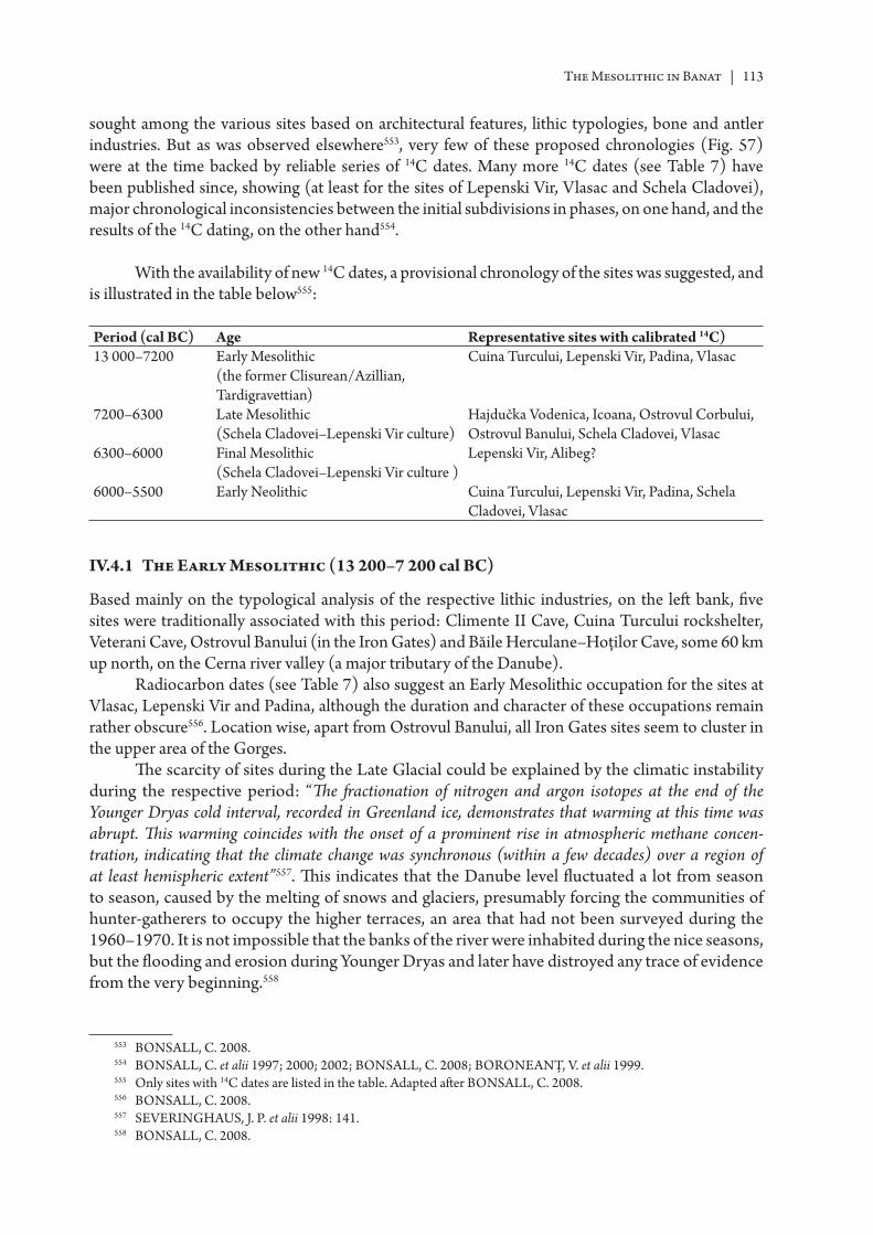
The Mesolithic in Banat | 113
sought among the various sites based on architectural features, lithic typologies, bone and antler industries. But as was observed elsewhere553, very few of these proposed chronologies (Fig. 57) were at the time backed by reliable series of 14C dates. Many more 14C dates (see Table 7) have been published since, showing (at least for the sites of Lepenski Vir, Vlasac and Schela Cladovei), major chronological inconsistencies between the initial subdivisions in phases, on one hand, and the results of the 14C dating, on the other hand554.
With the availability of new 14C dates, a provisional chronology of the sites was suggested, and is illustrated in the table below555:
Period (cal BC) Age Representative sites with calibrated 14C)13 000–7200 Early Mesolithic
(the former Clisurean/Azillian, Tardigravett ian)
Cuina Turcului, Lepenski Vir, Padina, Vlasac
7200–6300 Late Mesolithic (Schela Cladovei–Lepenski Vir culture)
Hajdučka Vodenica, Icoana, Ostrovul Corbului, Ostrovul Banului, Schela Cladovei, Vlasac
6300–6000 Final Mesolithic (Schela Cladovei–Lepenski Vir culture )
Lepenski Vir, Alibeg?
6000–5500 Early Neolithic Cuina Turcului, Lepenski Vir, Padina, Schela Cladovei, Vlasac
IV.4.1 The Early Mesolithic (13 200–7 200 cal BC)
Based mainly on the typological analysis of the respective lithic industries, on the left bank, fi ve sites were traditionally associated with this period: Climente II Cave, Cuina Turcului rockshelter, Veterani Cave, Ostrovul Banului (in the Iron Gates) and Băile Herculane–Hoţilor Cave, some 60 km up north, on the Cerna river valley (a major tributary of the Danube).
Radiocarbon dates (see Table 7) also suggest an Early Mesolithic occupation for the sites at Vlasac, Lepenski Vir and Padina, although the duration and character of these occupations remain rather obscure556. Location wise, apart from Ostrovul Banului, all Iron Gates sites seem to cluster in the upper area of the Gorges.
Th e scarcity of sites during the Late Glacial could be explained by the climatic instability during the respective period: “Th e fr actionation of nitrogen and argon isotopes at the end of the Younger Dryas cold interval, recorded in Greenland ice, demonstrates that warming at this time was abrupt. Th is warming coincides with the onset of a prominent rise in atmospheric methane concen-tration, indicating that the climate change was synchronous (within a few decades) over a region of at least hemispheric extent”557. Th is indicates that the Danube level fl uctuated a lot from season to season, caused by the melting of snows and glaciers, presumably forcing the communities of hunter-gatherers to occupy the higher terraces, an area that had not been surveyed during the 1960–1970. It is not impossible that the banks of the river were inhabited during the nice seasons, but the fl ooding and erosion during Younger Dryas and later have distroyed any trace of evidence from the very beginning.558
553 BONSALL, C. 2008.554 BONSALL, C. et alii 1997; 2000; 2002; BONSALL, C. 2008; BORONEANȚ, V. et alii 1999.555 Only sites with 14C dates are listed in the table. Adapted aft er BONSALL, C. 2008.556 BONSALL, C. 2008.557 SEVERINGHAUS, J. P. et alii 1998: 141.558 BONSALL, C. 2008.
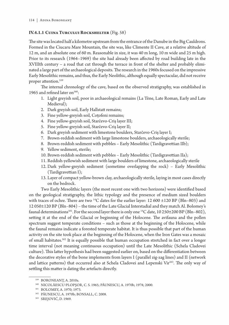
114 | Adina Boroneanţ
IV.4.1.1 Cuina Turcului Rockshelter (Fig. 58)
Th e site was located half a kilometre upstream from the entrance of the Danube in the Big Cauldrons. Formed in the Ciucaru Mare Mountain, the site was, like Climente II Cave, at a relative altitude of 12 m, and an absolute one of 60 m. Reasonable in size, it was 40 m long, 10 m wide and 25 m high. Prior to its research (1964–1969) the site had already been aff ected by road building late in the XVIIIth century – a road that cut through the terrace in front of the shelter and probably elimi-nated a large part of the archaeological deposits. Th e research in the 1960s focused on the impressive Early Mesolithic remains, and thus, the Early Neolithic, although equally spectacular, did not receive proper att ention.559
Th e internal chronology of the cave, based on the observed stratigraphy, was established in 1965 and refi ned later on560:
1. Light greyish soil, poor in archaeological remains (La Tène, Late Roman, Early and Late Medieval);
2. Dark greyish soil, Early Hallstatt remains;3. Fine yellow-greyish soil, Coţofeni remains;4. Fine yellow-greyish soil, Starčevo-Criş layer III;5. Fine yellow-greyish soil, Starčevo-Criş layer II;6. Dark greyish sediment with limestone boulders, Starčevo-Criş layer I;7. Brown-reddish sediment with large limestone boulders, archaeologically sterile;8. Brown-reddish sediment with pebbles – Early Mesolithic (Tardigravett ian IIb);9. Yellow sediment, sterile;10. Brown-reddish sediment with pebbles – Early Mesolithic (Tardigravett ian IIa);11. Reddish-yellowish sediment with large boulders of limestone, archaeologically sterile12. Dark yellow-greyish sediment (sometime overlapping the rock) – Early Mesolithic
(Tardigravett ian I);13. Layer of compact yellow-brown clay, archaeologically sterile, laying in most cases directly
on the bedrock.Two Early Mesolithic layers (the most recent one with two horizons) were identifi ed based
on the geological stratigraphy, the lithic typology and the presence of medium sized boulders with traces of ochre. Th ere are two 14C dates for the earlier layer: 12 600 ±120 BP (Bln–803) and 12 050±120 BP (Bln–804) – the time of the Late Glacial Interstadial and they match Al. Bolomey’s faunal determinations561. For the second layer there is only one 14C date, 10 250±200 BP (Bln–802), sett ing it at the end of the Glacial or beginning of the Holocene. Th e avifauna and the pollen spectrum suggest temperate conditions – such as those at the beginning of the Holocene, while the faunal remains indicate a forested temperate habitat. It is thus possible that part of the human activity on the site took place at the beginning of the Holocene, when the Iron Gates was a mosaic of small habitates.562 It is equally possible that human occupation stretched in fact over a longer time interval (not meaning continuous occupation) until the Late Mesolithic (Schela Cladovei culture). Th is latt er hypothesis had been suggested earlier on, based on the diff erentiation between the decorative styles of the bone implements from layers I (parallel zig-zag lines) and II (network and latt ice patt erns) that occurred also at Schela Cladovei and Lepenski Vir563. Th e only way of sett ling this matt er is dating the artefacts directly.
559 BORONEANŢ, A. 2010a.560 NICOLĂESCU-PLOPŞOR, C. S. 1965; PĂUNESCU, A. 1970b; 1978; 2000.561 BOLOMEY, A. 1970; 1973.562 PĂUNESCU, A. 1970b; BONSALL, C. 2008.563 SREJOVIĆ, D. 1969.
The Mesolithic in Banat | 115
Th e Mesolithic remains from the rockshelter consisted of hearths, human and faunal remains, lithics (fl int, jasper, quartzite and obsidian), bone and antler tools (some decorated), small fragments of ochre and graphite564.
As in all Palaeolithic/Epipalaeolithic research, the lithic industry (Fig. 66) was given the greatest care, with the development of a very detailed and rather thick typology, later on used for drawing parallels and establishing chronological correlations with other sites in the Gorges565. Th e predominant types were the endscrapers, followed by retouched blades, backed bladelets, and La Gravett e points. Geometric implements and burins were rather rare. A total of 72 614 lithics were reported from both layers, with some 3700 of them being tools or weapons. Over 96.80% of the assemblage was made of fl int, with obsidian holding 3%. Among the stone artefacts, plaques of siltstone with traces of ochre were mentioned.
A carved boulder (Fig. 68, 2a–2b), similar to those of Padina and Lepenski Vir, singled out Cuina Turcului among the sites on the Romanian bank. Unfortunately, this rather special fi nd seems to have occurred in a post-Neolithic pit. A second boulder, with a circular depression on one of the faces is also mentioned – found in the same archaeological context. It is diffi cult to argue for an Early Mesolithic context for the beautifully carved boulder – its occurrence at Cuina Turcului should be rather seen connected to a possible Final Mesolithic/Early Neolithic occupation of the shelter, hypothesis suggested also by the presence of the second type of boulder, a lot more common in the Late/Final Mesolithic on the left bank
Based on the typological lithic analysis, Cuina Turcului I was paralelled to Climente II and Băile Herculane566 while Cuina Turcului II showed analogies to Padina A1–A2 and Ostrovul Banului I and Băile Herculane567.
Bone and antler tools appeared in much larger numbers than in other Early Mesolithic sites. Among them awls, projectile points, chisels, a small harpoon fragment, presumably of the same type as the one from Climente II. Th ere was no typological distinction among the two layers. 15 pierced teeth (deer, wolf, wild boar, ruminants) used as pendants were recovered. Two pierced fi sh vertebras are also mentioned – although they look conspicuously similar to those in the Early Neolithic layers. A rectangular pendant, made of bone, showing traces of ochre, has good parallels at Lepenski Vir. Pierced snails and Mediterannean shells occurred in both layers, some possibly originating from the fossilized deposits in the area.
It is the number of decorated bone fragments (19) and the complexity of the patt erns on the decorated wild horse phalanx that also plead for Cuina Turcului as an Early Mesolithic site (Fig. 71). Decorations seem to have been a characteristic reserved for the bone, as only two antler fragments bear traces of decoration. Most of them are small incised irregular lines, isolated or in groups, hachures framed in between two parallel lines, wavy lines, meanders. Medium sized (15–20 cm in length) river boulders with a shallower or deeper depression were observed, a rather frequent occur-rence in all the sites in the area. Th ey were interpreted by Al. Păunescu as a strong argument for an earlier occupation on certain sites, and played a part on his determination of an Early Mesolithic horizon at Icoana, Răzvrata and Schela Cladovei568.
Th ere were 5 hearths att ributed to the fi rst Mesolithic layer, mostly oval in shape, and variable in size. Th e 6 hearths of the second layer were in a poorer state of preservation. All hearths lack detailed descriptions but for some of them the presence of ashes and fragments of charcoal was mentioned569.
564 PĂUNESCU, A. 2000.565 PĂUNESCU, A. 1970b; 1978; 2000.566 BORONEANŢ, V. 2000a; RA DOVANOVIĆ, I. 1996a.567 BORONEANŢ, V. 2000a; RA DOVANOVIĆ, I. 1996a.568 PĂUNESCU, A. 2000; BORONEANŢ, A. 2010a.569 PĂUNESCU, A. 1970b; 2000.
116 | Adina Boroneanţ
Among the faunal remains, in both strata were mentioned chamois, ibex, wild pig, bison, elk, roe deer, wild horse, wolf, fox, wild cat, brown bear, beaver, together with bird bones (grouse, jackdaw) and fi sh. Th e large number of fi sh bones recovered from the cave (bream, carp, pike, and Stizostedion lucioperca) suggest strong fi sh consumption by the inhabitants of the cave.570
Th e human remains from Cuina Turcului were never acknowledged as formal burials by the excavator. Th e fi rst Mesolithic layer contained two molars of an adult male, while in the second layer the remains of four individuals were found – three adults (among which a female? and a male? were identifi ed) and a foetus571. Still, from the anthropological report572, at least in three cases (male, female, foetus) the bone fragments found represented bone fragments from the entire skeleton, suggesting, the presence of the complete skeleton originally. And with the rather frequent of occupation of the cave (11 hearths) and no animal teeth marks on the bones, there’s a strong probability that those individuals were intentionally buried inside the rockshelter.
IV.4.1.2 Climente II Cave (Fig. 59)
Nowadays covered by the Danube, the cave was located in the Big Cauldrons area, at the feet of the Ciucarul Mare Mountain, approximately half a kilometre downstream from the entrance of the river into the straits. It was situated at a relative altitude of 12m and an absolute one of 60 m. Relatively small in size (47 m2), it off ered a sheltered environment, warm but rather humid. Daylight only penetrated to the front of the cave.
Explored in 1964 by C. S. Nicolăescu-Plopşor and V. Boroneanţ, archaeological excavations took place in 1968 and 1969, while previous speleological and faunal research was undertaken by Alexandrina and Ştefan Negrea in 1956 and 1957.573
A general stratigraphy of the cave was established based on the information gathered from all 8 excavated trenches. Th e thickness of the deposits rarely surpassed 1 m574.
1. Post-Palaeolithic depositions (Coţofeni, Hallstatt , III–IV centuries AD, Early and Late Medieval)
2. Layer rich in clastic material (sometimes overlapping the rock directly) – contained the Mesolithic remains; this layer was strongly disturbed by pits dug by the treasure hunters
3. Layer of gravel mixed with sand and faunal remains 4. Layer of sand overlapping the rocky fl oor of the cave, archaeologically sterile Th e Early Mesolithic fi nds were scatt ered within a layer 60–70 cm thick that was noticed only
in certain areas of the cave (trenches SI, SII, SIII, SVI, SVII)575. Th ey comprised a relatively large number of lithics, a few bone and antler tools (awls, needles, spatulas, projectile points, fragment of a harpoon, perforated pendants), small fragments of ochre and hematite, worked river boulders – some with traces of red ochre, faunal remains (beaver, fox, brown bear, wild boar, red deer, hedgehog, birds, fi sh) and two decorated bone fragments576 (Fig. 71).
No results were obtained from pollen analysis.Th e assignation to the Early Mesolithic was made based on the typological study of the lithics.
Although the two available studies off er diff erent percentages for similar typological categories, both archaeologists577 agree on the main features of the lithic assemblages: high percentages for the
570 BOLOMEY, A. 1970; BORONEANŢ, A. 2010a.571 PĂUNESCU, A. 1970b; 2000.572 NICOLĂESCU-PLOPŞOR, D. 1970.573 NEGREA, A. & NEGREA, ŞT. 1979.574 BORONEANŢ, V. 1978.575 BORONEANŢ, A. 2010a.576 BORONEANŢ, V. 1978; 2000a.577 BORONEANŢ, V. 2000a; PĂUNESCU, A. 2000.
The Mesolithic in Banat | 117
endscrapers, followed by backed bladelets, sidescrapers, points. Over 90% of the tools are micro-lithic. Th e predominant raw material is fl int of various textures and colours (brown, yellowish, grey, greenish) of local origin – the area of the Cauldrons and Şviniţa578. Radiolarite and quartzite occurred in much smaller percentages, with a very rare presence of rock crystal.
Based on typological analogies, the industry was paralleled to those of Cuina Turcului I and Tincova579, Băile Herculane, Veterani Cave580.
Early Mesolithic human occupation of the cave was also documented through the presence of a hearth, of approximately circular shape. It had been built around a natural depression in the cave fl oor and bordered with stones. Size: 90 cm in diametre and a depth of 10 cm.
Two human burials were also uncovered, an adult (Fig. 59b) and perhaps a child (in a very poor state of preservation)581. Th e adult skeleton was lying in a natural depression of the cave fl oor (1.60 × 0.80 m, 0.50 m deep), lying on its left side on a “bed of red ochre”, with the hands brought up towards the head. Legs were fl exed. Traces of red ochre were also noted on the bones. Th e skull, the cervical vertebras, the clavicles and scapulas had been carried away by a small torrent of water springing from the cave wall. Th e mandible was found nearby, together with a number of scatt ered teeth. Within the perimeter of the “grave” a fragment of an endscraper, two crescent shaped implements and a point were found, but it is diffi cult to say whether they were grave goods or part of the pit infi ll.
Th e child skeleton was found a few metres away. It was oriented E–W, probably lying on the back but the very poor state of bone preservation did not allow for for its prelevation582. Scatt ered human remains were also recovered from the very back of the cave583.
Although the fi rst skeleton has been sampled for 14C dating, the results are not yet available.
IV.4.1.3 Veterani Cave (Fig. 60)
Th e cave is located in the Ciucarul Mare Mountain, at the foot of the slope called Pânza Curii, 800 m east of Climente II Cave, at an absolute altitude of 73–75 m584.
Veterani Cave has been used during historical times for various purposes (even functioned as an Austrian garrison for a while), thus explaining the disturbed stratigraphy of the site. Archaeological excavations took place from 1964 to 1969 both inside the cave and in front of it. Poor illumination led to the abandonment of excavations in the central hall despite several att empts in the diff erent years. Some trenches going down to 4.20 m in depth were excavated to the left of the entrance and at the very back of the cave, revealing a very disturbed stratigraphy, with very mixed cultural fi nds. Eff orts concentrated in the trenches from the entrance gallery revealed the following cultural sequence585 (with the caveat that excavations never reached the cave bedrock:
• Finds from the XIX, XVII–XVIII, XIII–XVI centuries • Roman times (II–IV centuries)• Iron Age• Transition to Bronze Age (Coţofeni – Kostolac – Vučedol cultures)• Starčevo-Criş Early NeolithicTh e above-mentioned cultural sequence shows that a Mesolithic layer or Mesolithic features
were never identifi ed inside the cave. Still, some lithic implements (20–23 pieces) from excavations taking place both in front of, and inside the cave were typologically identifi ed as Early Mesolithic
578 RA DOVANOVIĆ, I. 1996a.579 BORONEANŢ, V. 2000a.580 RA DOVANOVIĆ, I. 1996a.581 BORONEANŢ, V. 1970a; 1978; BORONEANŢ, A. 2010a.582 BORONEANŢ, A. 2010a.583 BORONEANŢ, V. 1970a, 2000.584 BORONEANŢ, V. 1970a, 2000.585 BORONEANŢ, V. 2000a.
118 | Adina Boroneanţ
(Clisurean) and consequently published as such: circular endscrapers on blades, segments, retouched fl akes586. From the same collection, Al. Păunescu, selected some 146(?) lithic pieces (mostly micro-lithic) and att ributed them to the Mesolithic. It should mentioned that in both cases the artefacts came from various contexts, containing also “pott ery and other habitation remains”587, thus making their att ribution to the Early Mesolithic questionable.
IV.4.1.4 Băile Herculane–Hoţilor Cave (Caraş Severin county)
Th e Hoţilor Cave is located 0.5 km north of Băile Herculane, on the right bank of the Cerna river, at a relative altitude of 50 m and an absolute one of 257 m. Th e cave was studied starting with the late XIX century, with archaeological excavations in 1904, 1916, 1929, 1954–1955, 1960–1961, 1965, 1968–1970, 1972.588
Th e stratigraphy of the cave will not be discussed here as it has been presented in the chapter dealing with the Palaeolithic research.
Th e Mesolithic layer here was compared to Cuina Turcului I–II, based on the typology of lithic industry. Th ere is a 14C date589: Gr–16978, reading 11 490±75BP (11 559–11 215 Cal BC).
Th e main raw materials for the lithics were the local rocks: fl int (90%), radiolarite (9%), shales (1%). Th e lithic industry was microlithic (96%), with endscrapers, burins, geometric segments, backed bladelets and Azillian points. No bone or antler tools were recovered.
Faunal remains belonged to mammals (bear, deer, badger), micro-mammals and a smaller quantity of bird and fi sh bones.
Th e three archaeological features (“complexes” – usually meaning ‘habitation areas’) observed were described as oval patches of darker soil with traces of burning and ashes. A large number of lithics was collected from the surface of two of the features. Around them were noted many bone fragments, some calcined.
Th ere are two hearths mentioned in the fi eld reports – also surrounded by faunal remains. Th ere are no details about the possible links between the ‘complexes” and the hearths.
IV.4.1.5 Ostrovul Banului (Fig. 61)
Ostrovul Banului island is located approx. 1 km downstream from the present-day Iron Gates I dam. During the construction of the power station, research on the island was triggered more by the local exploitation of sand and gravels used for building the dam, than the threat of fl ooding. Th e Mesolithic site, located at the downstream end of the island, on the beach facing the mainland, was submerged, while the other sites on the island (Early Neolithic, Hallstatt , Byzantine, Medieval) were covered by tons of gravel.
Excavations started in 1965 at the Byzantine fortress, bringing to light Hallstatt and Early Neolithic remains (sectors A, B, C) with research on the Mesolithic site (sector D) commencing in 1966590.
In fact, very litt le is known on the excavations in sector D, other than brief summaries given by the author of the research591. Th e site appears to have stretched along the shore. Th e 8 trenches (four
586 BORONEANŢ, V. 2000a.587 PĂUNESCU, A. 2002.588 PĂUNESCU, A. 2002: 136–137.589 PĂUNESCU, A. 2002: 146.590 ROMAN, P. & BORONEANŢ, V. 1974.591 BORONEANŢ, V. 1970b; 1973; 2000.
The Mesolithic in Banat | 119
along the river bank on the northern side of the island and four towards the centre of the island) pointed to the following general stratigraphy:
1. Layer of brown soil containing Medieval remains (variable thickness of 0–0.85 m); 2. Layer of brown-yellow soil containing the Hallstatt remains (variable thickness of
0.90–1.4 m);3. Layer of light brown soil, containing remains of the Early Neolithic, variable thickness of
15–60 cm;4. Layer of alluvial sand containing horizon III, further subdivided in two sub-horizons: IIIa
(lower, greyish yellow, dark brown, variable thickness 20–90 cm) and IIIb (upper, reddish brown, variable thickness of 20–90 cm);
5. Alluvial sand (containing Mesolithic horizons I and II). In places the two horizons were separated by dark yellow clay;
6. Layer of dark yellow sandy clay, archaeologically sterile;7. Layer of gravel.Initially, V. Boroneanţ atributt ed the fi rst two horizons (I and II) to the Early Mesolithic
(Clisurean) while the third horizon (further divided into IIIa and IIIb) was att ributed to the Late Mesolithic (the Schela Cladovei culture)592. In his most recent work (2000) he assigned sub-horizon IIIa to the Early Mesolithic also, leaving only IIIb as part of the Late Mesolithic, but without further explanations. Th ere are no 14C dates to support the Early Mesolithic dating of these horizons.
Reported archaeological remains from the Early Mesolithic layers comprised a large number of lithics (their typology dictated the Early Mesolithic assignation – Fig. 66), very few bone tools and very litt le fauna. It is diffi cult to tell whether this is an accurate refl ection of the degree of occupation, as only a very small part (85 m2) of the site was excavated, partly because of the lack of time, partly because the largest part of it had already been covered/destroyed by waters at the time of the discovery.
Th e study of lithic industry593 (mainly on local fl int from Svineac and Vârtop hills in Șviniţa area, with rare occurrences of quarztite, radiolarite and obsidian) show diff erent typologies in the two diff erent studies, triggered by the diff erent methods of “separating” the lithics among the diff erent “cultural layers”. While the author of the excavation (V. Boroneanţ) analyzed lithics based on a contextual and stratigraphic criterion, Al. Păunescu, analyzed the lithic collection following particular tool types and raw materials. Still, both typologies saw endscrapers as diagnostic tools, followed by backed bladelets and splintered pieces.
Th us, it was said that the lithic typology links Ostrovul Banului I to Cuina Turcului I and Padina A1–A2594, while the second horizon shows similarities to Veterani Terrace595.
Apart from their rather rare occurrence, bone implements in Early Mesolithic layers do not bear any diff erences to those found in the Late Mesolithic contexts: bone points and awls, spatulas. Th ere seem to be no antler in horizons I or II and only one boar tusk piece596.
Decorated objects are few: a bone object ornamented with three small horizontal hollows and a bone spatula (anthropomorphic?). Th e presence of medium sized river boulders with traces of ochre was also noted in both horizons.
New analyzes of the faunal remains indicate as the main hunted wild species, deer, red deer, wild boar, badger, Bos primigenius and Equus hydruntinus. Dog was also noted597.
592 BORONEANŢ, V. 1970b; 1973a.593 PĂUNESCU, A. 2000; BORONEANŢ, V. 2000a.594 RA DOVANOVIĆ, I. 1996a.595 BORONEANŢ, V. 2000a.596 BORONEANŢ, V. 2000a.597 BORONEANŢ, A. 2010a.

120 | Adina Boroneanţ
Published information on habitation structures mentions a hut with a large boulder on its center and traces of burning and charcoal in the south-east corner. Th e large boulder was surrounded by quartz/quartzite and fl int blades, fl akes and chips, perhaps the remains of a knapping workshop. Among the lithics there were four endscrapers (one of obsidian) and two fl int points. Other remains included snail shell beads (pierced), a pierced mussel shell, animal teeth (badger, Canis) and many bone fl akes598.
Further study of the fi eld notes and the excavation plans showed that other archaeological complexes were also identifi ed, but lacking chronological landmarks, and also exhibiting features ressembling closer those of the Late Mesolithic, will be presented later on.
IV.4.1.6 The Early Mesolithic – a summary
Th e sites were located in the near vicinity of the Danube bank (or the Cerna river in the case of Băile Herculane), in caves and rockshelters. Lithic typology appears homogenous (endscrapers, backed bladelets, splintered fl akes) with a predominance of local fl int as the main raw material. Medium sized rock boulders, with small circular depressions and at times painted with red ochre were documented in most of the sites and were seen as a link to the Epipalaeolithic groups to the south, in the Italian peninsula. Th ey were also used at times as diagnostic fi nds when claiming proof for earlier occupations of certain sites. Th e bone industry is mainly represented by awls and projectile points, with very few occurrences of tusk and antler. Decorated pieces exhibited the “fi shnet” patt ern (crosshatching), parallel incisions and meanders.
Th e human population of the Early Mesolithic is well documented through burials and good 14C for sites on the right bank of the Danube (Padina, Vlasac, Lepenski Vir). Formal disposal areas occur within the sett lements. Position in the grave varies: extended on the back with arms and legs stretched, on one side with legs slightly fl exed, lying on the back with fl exed legs splayed on both sides and soles touching, or sitt ing in the Turkish position. Initially, based on ‘stratigraphic’ observa-tions, some of these burials had been att ributt ed to the Lepenski Vir – Schela Cladovei culture (Late and? Final Mesolithic) but the 14C dates showed diff erently.
As far as the left bank is concerned, burials were found at Climente II Cave and probably Cuina Turcului. Stratigraphic and contextual information was the decisive factor for their cultural determination but no 14C dates are yet available for the human remains.
It is even more diffi cult to talk in general terms about the architecture, as most such features are very poorly dated and documented – if at all, on both banks of the Danube. In most cases we still rely heavily on the initial local stratigraphies and suggested house/hearth-shape typologies. Apart from being largely subjective, these make incorporating new data from unpublished documen-tation rather diffi cult and raise questions over faunal and archeobotanical determinations, at times originating from unclear chronological contexts. Still, stable isotope studies for the sites of Vlasac, Lepenski Vir and Padina, suggest that at the beginning of the Holocene, local communities relied heavily on the resources of the river, but signifi cantly less than those of the Late Mesolithic, aft er 7200 cal BC. Diet analyses show that fi sh was eaten throughout the year, despite the fact that fi shing might have taken place on a seasonal basis. Th is also pointed to the existence of some means of preserving the fi sh for later consumption, indicating a certain degree of sedentarization of the Early Mesolithic communities.599
598 BORONEANŢ, V. 2000a, BORONEANŢ, A. 2010a.599 BONSALL, C. 2008.
The Mesolithic in Banat | 121
IV.4.2 The Late Mesolithic (7200–6300 cal BC)(the Schela Cladovei–Lepenski Vir culture)
Based on newer or older (recalibrated) 14C dates there are nine sites where human activities are documented during the Late Mesolithic: Hajdučka Vodenica, Lepenski Vir, Răzvrata, Icoana, Padina, Vlasac, Schela Cladovei, Ostrovul Banului, Ostrovul Corbului. Other two – Veterani Terasă (Veterani Terrace) and Ostrovul Mare, are likely candidates, when considering various architectural features similar to above listed ones.
IV.4.2.1 Veterani Terasă (Veterani Terrace) (Fig. 60b)
Th e site was discovered by V. Boroneanţ in 1968, and excavated the following year. Located on the dejection cone of a former rivulet at the foot of Ciucarul Mare mountain, Veterani Terrace site had already been aff ected by various factors, such as river erosion, construction of medieval fortifi cations (XVII–XVIII centuries) and road building (end of XVIII century)
Four trenches were cut, with the following general stratigraphy600:1. Fallen rock boulders;2. Discontinuous patches of soil, various structures and colours, in areas among the fallen rocks;3. Dark soil with Roman and Medieval remains;4. Yellowish-grey soil with Late Neolithic–Bronze Age remains (Sălcuţa – Coţofeni IV); 5. Yellowish soil, archaeologically sterile;6. Yellow sand, poor in Mesolithic remains (Schela Cladovei culture); 7. Late Mesolithic (Schela Cladovei culture) in two horizons: the lower one in a light brown
soil, the upper one in a dark brown one;8. River bed covered by alluvial sand or a mixture of alluvial sand and gravel.When studying the lithic material from Veterani Terrace, Al. Păunescu att ributed the
two horizons in the brown soil to the ‘Tardigravett ian’601, while the layer poorer in artefacts was att ributed to the Schela Cladovei culture. V. Boroneanţ saw in Veterani Terasă chronological parallels to Ostrovul Banului IIIa while others602 classifi ed it as Early Mesolithic, with parallels at Vlasac I, Ostrovul Banului IIIa, Răzvrata I, Icoana I, Schela Cladovei I and Veterani Cave.
Th e lithic industry at Veterani Terasă was diagnosed as earlier than those of other sites in the area, based on a higher percentage of fl int in the assemblage (37.70%), but still a lot lower when compared to those of the Early Mesolithic. Svineac and Vârtop hills (Şviniţa area) were considered the areas for fl int procurement. Among fl int tool-types were mentioned endscapers, burins, notched tools, segments, retouched blades and bladelets, microlithic fl akes fi nely retouched. A “workshop” for tool manufacturing was also uncovered603. Quartz holds 62.23% of the raw material, with tools such as endscrapers, borers, splintered pieces, and raclett es.604
Th e average-sized river boulders with a circular depression were also present. One had three such depressions, a second one was fi red and had traces of red ochre while a third one had only traces of ochre605.
Th e bone and antler tools displayed the usual array of types (bone: awls/daggers, spatulas; antler: adzes, hoes, awls), with the remark that they appear to show a high degree of use.606 Boar
600 BORONEANŢ, V. 2000a: 98.601 PĂUNESCU, A. 2000: 377.602 VOYTEK, B. & TRINGHAM, R. 1989.603 BORONEANŢ, A. 2010a.604 RA DOVANOVIĆ, I. 1996a.605 BORONEANŢ , V. 2000a: 187.606 BORONEANŢ, V. 2000a: 136.
122 | Adina Boroneanţ
tusks seemed to appear more frequently in horizon II. Also, the presence of some areas for manufac-turing tools was observed, consisting of bone/antler fl akes and debris but no fi nished implements.607
Th e only artistic manifestation at Veterani Terrace was a spatula ornamented with the ‘fi shnet’ patt ern combined with the triangle one (Fig. 72).
Th e site provided a large number of faunal remains but poorly preserved. Species identifi ed included Castor fi ber, Ursus arctos, Martes cf. martes, Sus scrofa, Alces alces, Cervus elaphus, Canis Lupus, Ovis sp., showing food consumption relying heavily on deer and wild boar. Fish bones are frequently mentioned in the fi eldnotes.608
According to A. Bolomey609 from the faunal point of view taken alone, the site of Veterani, did not present a special interest. But corroborating these results with those from Răzvrata and Icoana, the three faunal assemblages appear very similar. One cannot determine the habitation duration of the Veterani Terasă site (seen shorter than that at Icoana) or determine the size of the human community. Certain indications on the possible timing for site habitation are the deer remains pointing to the period of May–June610.
A sunken hut was uncovered in the lower Mesolithic horizon. It was oval in shape, with a rectangular hearth (partially destroyed) and three postholes. V. Boroneanţ thought the hut had two stages of occupation. On the fl oor of the hut, and mainly around the hearth were scatt ered bone and antler fragments, fl int tools, many fi sh bones, an average-sized boulder (used as a hammer?) with symmetrical circular depressions on opposite faces. Pits were noticed on the fl oor of the house and were interpreted as storage facilities for raw materials (they contained large fragments of deer antler, and some contained fl int). A human mandible was also collected from the fl oor of the hut611.
IV.4.2.2 Răzvrata (Fig. 62)
Th e site of Răzvrata was located in the Litt le Cauldrons, on the left side of the dejection cone of the Mraconia river. From there to Icoana is a distance of approximately 200 m. Discovered and excavated in 1967 (when it was already partly fl ooded) the time left allowed for excavating only 5 (rather small) trenches.612
A general stratigraphy of the site was published, with the reservation that no trench showed the complete stratigraphical sequence613:
1. Alluvial sand containing scatt ered Dacian remains2. Black-brownish soil3. Yellow-brown soil, archaeologically sterile4. Black-brownish soil, Early Neolithic remains5. Yellow-grey soil, Late Mesolithic (horizon Răzvrata I)6. Yellowish sandy soil, in its upper part with Late Mesolithic remains (horizon Răzvrata II) 7. Yellow-brownish soil, sterilAs in the case of Veterani Terasă, “based on the depths marked on the lithics but mainly on the
techno-typology of the lithic assemblage and the preference of diff erent communities for certain types of raw materials, and also on the size of the tools”614, Al. Păunescu saw Răzvrata’s earliest horizon (I) as Tardigravett ian while Răzvrata II (Schela Cladovei culture) was compared to Veterani Terrace II, Icoana II, Ostrovul Banului III, Schela Cladovei II, and Ostrovul Mare I–II.
607 BORONEANŢ, A. 2010a.608 BORONEANŢ, V. 2000a: 104; BORONEANŢ, A. 2010a.609 BORONEANŢ, A. 2010a quoting A. Bolomey, unpublished manuscript.610 BORONEANŢ, A. 2010a; BOLOMEY, A. 1973.611 BORONEANŢ, V. 2000a: 104; BORONEANŢ, A. 2010a.612 BORONEANŢ, V. 2000a: 99–100; 1973: 8; 1970b: 18.613 BORONEANŢ, V. 1973: 9; 2000a: 99.614 PĂUNESCU, A. 2000a: 393.
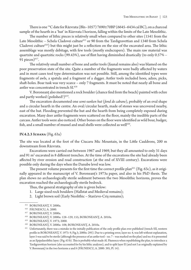
The Mesolithic in Banat | 123
Th ere is one 14C date for Răzvrata (Bln–1057) 7690±70BP (6645–6434 cal BC), on a charcoal sample of the hearth in a ‘hut’ in Răzvrata I horizon, falling within the limits of the Late Mesolithic.
Th e number of lithic pieces is relatively small when compared to other sites (1541 from the Late Mesolithic – Schela Cladovei culture615 or 90 from the Tardigravett ian and 1340 from Schela Cladovei culture616) but this might just be a refl ection on the size of the excavated area. Th e lithic assemblage was mostly debitage, with few tools (mostly endscrapers). Th e main raw material was quartzite and quartzitic rocks (99.43%), use of fl int having diminished drastically (to only 0.57% – 91 pieces)617.
Th e relatively small number of bone and antler tools (faunal remains also) was blamed on the poor preservation state of the site. Quite a number of the fragments were badly aff ected by waters and in most cases tool type determination was not possible. Still, among the identifi ed types were fragments of awls, a spatula and a fragment of a dagger. Antler tools included hoes, adzes, picks, shaft -holes. Boar tusk was very scarce – only 7 fragments. It must be noted that nearly all bone and antler was concentrated in trench SI.618
V. Boroneanţ also mentioned a rock boulder (chance fi nd from the beach) painted with ochre and partly worked (polished?)619.
Th e excavation documented one semi-sunken hut (fond de cabane), probably of an oval shape and a circular hearth in the centre. An oval/circular hearth, made of stones was uncovered nearby, east of the hut. Flooding prevented the hut and the hearth from being completely exposed during excavation. Many deer antler fragments were scatt ered on the fl oor, mainly the inedible parts of the carcass. Antler tools were also noticed. Other bones on the fl oor were identifi ed as wild boar, badger, fi sh, and a small number of mussel and snail shells were collected as well620.
IV.4.2.3 Icoana (Fig. 63a)
Th e site was located at the foot of the Ciucaru Mic Mountain, in the Litt le Cauldrons, 200 m downstream from Răzvrata.
Excavations were carried out between 1967 and 1969, but they all amounted to only 31 days and 91 m2 excavated in 8 diff erent trenches. At the time of the excavations the site had already been aff ected by river erosion and road construction (at the end of XVIII century). Excavations were possible only during the days when the Danube level was low.
Th e present volume presents for the fi rst time the correct profi le plan621 (Fig. 63c), as it origi-nally appeared in the manuscript of V. Boroneanţ’s 1973a paper, and also in his PhD thesis. Th e plan shows no archaeologically sterile sediment between the two Mesolithic horizons, proves the excavation reached the archaeologically sterile bedrock.
Th us, the general stratigraphy of site is given below:1. Large sized rock boulders (Hallstat and Medieval remains);2. Light brown soil (Early Neolithic – Starčevo-Criş remains);
615 BORONEANŢ, V. 2000a.616 PĂUNESCU, A. 2000.617 BORONEANŢ, V. 2000a.618 BORONEANŢ, V. 2000a: 128–129, 155; BORONEANŢ, A. 2010a.619 BORONEANŢ, V. 1973; 2000.620 BORONEANŢ, V. 2000a: 108; BORONEANŢ, A. 2010a.621 Unfortunately, there was a mistake in the initially publication of the only profi le plan ever published (trench SII, western
profi le in BORONEANŢ, V. 1973: 9, Fig.3; 2000a: 295). Due to a printing error, layer no. 4, was left without explanation, layer 5 was said to be sterile (although the presence of an antler tool – no. 7 – was marked on the plan) and no. 6 is presented as an Epipalaeolithic layer. (Fig. 63 b). Th is is probably what made Al. Păunescu when republishing the plan, to introduce a Tardigravett ian horizon (also accounted for by his lithic analyzes), and to split layer II (and not I as originally explained by V. Boroneanţ) in the two horizons a and b (PĂUNESCU, A. 2000: 395, Pl. 14).
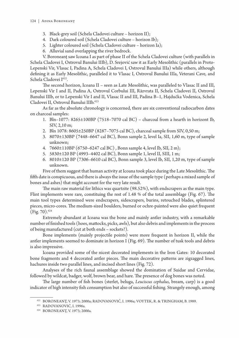
124 | Adina Boroneanţ
3. Black-grey soil (Schela Cladovei culture – horizon II);4. Dark coloured soil (Schela Cladovei culture – horizon Ib);5. Lighter coloured soil (Schela Cladovei culture – horizon Ia);6. Alluvial sand overlapping the river bedrock.V. Boroneanţ saw Icoana I as part of phase II of the Schela Cladovei culture (with parallels in
Schela Cladovei I, Ostrovul Banului IIIb), D. Srejović saw it as Early Mesolithic (parallels in Proto-Lepenski Vir, Vlasac I, Padina A, Schela Cladovei I, Ostrovul Banului IIIa) while others, although defi ning it as Early Mesolithic, paralleled it to Vlasac I, Ostrovul Banului IIIa, Veterani Cave, and Schela Cladovei I622.
Th e second horizon, Icoana II – seen as Late Mesolithic, was paralleled to Vlasac II and III, Lepenski Vir I and II, Padina A, Ostrovul Corbului III, Răzvrata II, Schela Cladovei II, Ostrovul Banului IIIb, or to Lepenski Vir I and II, Vlasac II and III, Padina B–1, Hajdučka Vodenica, Schela Cladovei II, Ostrovul Banului IIIb.623
As far as the absolute chronology is concerned, there are six conventional radiocarbon dates on charcoal samples:
1. Bln–1077: 8265±100BP (7518–7070 cal BC) – charcoal from a hearth in horizont Ib, SIV, 2,10 m;
2. Bln 1078: 8605±250BP (8287–7075 cal BC), charcoal sample from SIV, 0,50 m; 3. 8070±130BP (7448–6647 cal BC), Bonn sample 2, level Ia, SII, 1,60 m, type of sample
unknown;4. 7660±110BP (6750–6247 cal BC) , Bonn sample 4, level Ib, SII, 2 m);5. 5830±120 BP (4993–4402 cal BC), Bonn sample 1, level II, SIII, 1 m; 6. 8010±120 BP (7306–6610 cal BC), Bonn sample 3, level Ib, SII, 1,20 m, type of sample
unknown.Five of them suggest that human activity at Icoana took place during the Late Mesolithic. Th e
fi ft h date is conspicuous, and there is always the issue of the sample type (perhaps a mixed sample of bones and ashes) that might account for the very late result.
Th e main raw material for lithics was quartzite (98.52%), with endscrapers as the main type. Flint implements were rare, constituing the rest of 1.48 % of the total assemblage (Fig. 67). Th e main tool types determined were endscrapers, sidescrapers, burins, retouched blades, splintered pieces, micro-cores. Th e medium-sized boulders, burned or ochre-painted were also quiet frequent (Fig. 70).624
Extremely abundant at Icoana was the bone and mainly antler industry, with a remarkable number of fi nished tools (hoes, matt ocks, picks, awls), but also debris and implements in the process of being manufactured (cut at both ends – sockets?).
Bone implements (mainly projectile points) were more frequent in horizon II, while the antler implements seemed to dominate in horizon I (Fig. 69). Th e number of tusk tools and debris is also impressive.
Icoana provided some of the nicest decorated implements in the Iron Gates: 10 decorated bone fragments and 4 decorated antler pieces. Th e main decorative patt erns are zigzagged lines, hachures inside two parallel lines, and incised short lines (Fig. 72).
Analyses of the rich faunal assemblage showed the domination of Suidae and Cervidae, followed by wildcat, badger, wolf, brown bear, and hare. Th e presence of dog bones was noted.
Th e large number of fi sh bones (sterlet, beluga, Leuciscus cephalus, bream, carp) is a good indicator of high intensity fi sh consumption but also of successful fi shing. Strangely enough, among
622 BORONEANŢ, V. 1973; 2000a; RA DOVANOVIĆ, I. 1996a; VOYTEK, R. & TRINGHAM, B. 1989.623 RA DOVANOVIĆ, I. 1996a.624 BORONEANŢ, V. 1973; 2000a.
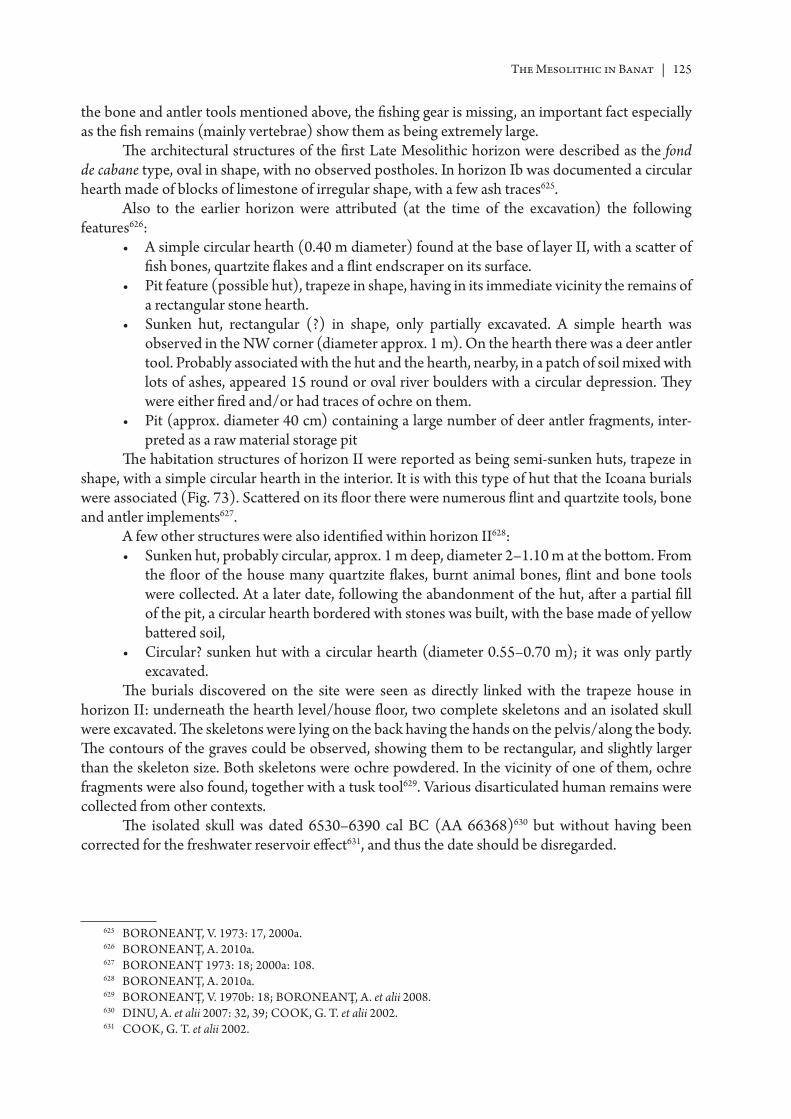
The Mesolithic in Banat | 125
the bone and antler tools mentioned above, the fi shing gear is missing, an important fact especially as the fi sh remains (mainly vertebrae) show them as being extremely large.
Th e architectural structures of the fi rst Late Mesolithic horizon were described as the fond de cabane type, oval in shape, with no observed postholes. In horizon Ib was documented a circular hearth made of blocks of limestone of irregular shape, with a few ash traces625.
Also to the earlier horizon were att ributed (at the time of the excavation) the following features626:
• A simple circular hearth (0.40 m diameter) found at the base of layer II, with a scatt er of fi sh bones, quartzite fl akes and a fl int endscraper on its surface.
• Pit feature (possible hut), trapeze in shape, having in its immediate vicinity the remains of a rectangular stone hearth.
• Sunken hut, rectangular (?) in shape, only partially excavated. A simple hearth was observed in the NW corner (diameter approx. 1 m). On the hearth there was a deer antler tool. Probably associated with the hut and the hearth, nearby, in a patch of soil mixed with lots of ashes, appeared 15 round or oval river boulders with a circular depression. Th ey were either fi red and/or had traces of ochre on them.
• Pit (approx. diameter 40 cm) containing a large number of deer antler fragments, inter-preted as a raw material storage pit
Th e habitation structures of horizon II were reported as being semi-sunken huts, trapeze in shape, with a simple circular hearth in the interior. It is with this type of hut that the Icoana burials were associated (Fig. 73). Scatt ered on its fl oor there were numerous fl int and quartzite tools, bone and antler implements627.
A few other structures were also identifi ed within horizon II628:• Sunken hut, probably circular, approx. 1 m deep, diameter 2–1.10 m at the bott om. From
the fl oor of the house many quartzite fl akes, burnt animal bones, fl int and bone tools were collected. At a later date, following the abandonment of the hut, aft er a partial fi ll of the pit, a circular hearth bordered with stones was built, with the base made of yellow batt ered soil,
• Circular? sunken hut with a circular hearth (diameter 0.55–0.70 m); it was only partly excavated.
Th e burials discovered on the site were seen as directly linked with the trapeze house in horizon II: underneath the hearth level/house fl oor, two complete skeletons and an isolated skull were excavated. Th e skeletons were lying on the back having the hands on the pelvis/along the body. Th e contours of the graves could be observed, showing them to be rectangular, and slightly larger than the skeleton size. Both skeletons were ochre powdered. In the vicinity of one of them, ochre fragments were also found, together with a tusk tool629. Various disarticulated human remains were collected from other contexts.
Th e isolated skull was dated 6530–6390 cal BC (AA 66368)630 but without having been corrected for the freshwater reservoir eff ect631, and thus the date should be disregarded.
625 BORONEANŢ, V. 1973: 17, 2000a.626 BORONEANŢ, A. 2010a.627 BORONEANŢ 1973: 18; 2000a: 108.628 BORONEANŢ, A. 2010a.629 BORONEANŢ, V. 1970b: 18; BORONEANŢ, A. et alii 2008.630 DINU, A. et alii 2007: 32, 39; COOK, G. T. et alii 2002.631 COOK, G. T. et alii 2002.
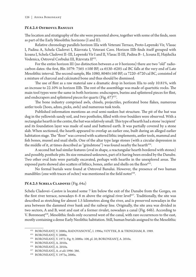
126 | Adina Boroneanţ
IV.4.2.4 Ostrovul Banului
Th e location and stratigraphy of the site were presented above, together with some of the fi nds, seen as part of the Early Mesolithic horizons (I and II).
Relative chronology parallels horizon IIIa with Veterani Terrace, Proto-Lepenski Vir, Vlasac I, Padina A, Schela Cladovei I, Răzvrata I, Veterani Cave. Horizon IIIb fi nds itself grouped with Icoana I, Schela Cladovei II–III, Lepenski Vir I and II, Vlasac II-III, Padina B–1, Icoana II, Hajdučka Vodenica, Ostrovul Corbului III, Răzvrata II632.
For the entire horizon III (no distinction between a or b horizons) there are two “old” radio-carbon dates: the fi rst, Bln 1079: 7565 ±100 BP, ca 6530–6285 cal BC falls at the very end of Late Mesolithic interval. Th e second sample, Bln 1080, 8040±160 BP, ca 7220–6720 cal BC, consisted of a mixture of charcoal and calcinated bone and thus should be dismissed.
Th e use of fl int as a raw material saw a dramatic drop in horizon IIIa to only 10.81%, with an increase to 22.10% in horizon IIIb. Th e rest of the assemblage was made of quartzitic rocks. Th e main tool types were the same in both horizons: endscrapers, burins and splintered pieces for fl int, and endscrapers and splintered pieces for quartz (Fig. 67)633.
Th e bone industry comprised awls, chisels, projectiles, perforated bone fl akes, numerous antler tools (hoes, adzes, picks, awls) and numerous tusk tools.
Published information mentions an oval semi-sunken hut structure. Th e pit of the hut was dug in the yellowish sandy soil, and two postholes, fi lled with river boulders were observed. With a rectangular hearth in the centre, the hut was relatively small. Th is type of hearth had a stone ‘recipient’ and its foundation layer was made of sand and batt ered earth. It was partially covered by a stone slab. When sectioned, the hearth appeared to overlap an earlier one, built during an alleged earlier habitation stage. Th e “fl oor” was covered with scatt ered lithic implements, antler tools, mammal and fi sh bones, mussel and snail shells. One of the altar type large stones (with a circular depression in the middle of it, at times described as “grindstone”) was found nearby the hearth634.
A second hut had similar features (oval in shape, a reactangular hearth bordered with stones) and possibly, posthole pits. Its size remained unknown, part of it having been eroded by the Danube. Two other oval huts were partially excavated, perhaps with hearths in the unexplored areas. Th e exposed parts showed also scatt ers of lithics, bones, antler and shells on the fl oor635.
No formal burials were found at Ostrovul Banului. However, the presence of two human mandibles (one with traces of ochre) was mentioned in the fi eld notes636.
IV.4.2.5 Schela Cladovei (Fig. 64a)
Schela Cladovei–Canton is located some 7 km below the exit of the Danube from the Gorges, on the fi rst river terrace, nowadays 6–8 m above the original river level637. Traditionally, the site was described as stretching for almost 1.5 kilometres along the river, and is preserved nowadays in the area between the dammed river bank and the railway line. Originally, the site area was divided in two sectors, A and B, west and east of a former rivulet, nowadays a canal (Fig. 64b). According to V. Boroneanţ638, Mesolithic fi nds only occurred west of the canal, with rare occurrences to the east, mostly containing a dense Early Neolithic habitation. Still, human burials assigned to the Mesolithic
632 BORONEANŢ, V. 2000a; RA DOVANOVIĆ, I. 1996a; VOYTEK, B. & TRINGHAM, R. 1989.633 BORONEANŢ, V. 2000a.634 BORONEANŢ, V. 1973: Fig. 9; 2000a: 108, pl. 20; BORONEANŢ, A. 2010a.635 BORONEANŢ, A. 2010a.636 BORONEANŢ, A. 2010a.637 BORONEANŢ, A. et alii 1996: 386.638 BORONEANŢ, V. 1973a, 2000a.
The Mesolithic in Banat | 127
had been recovered from the western side, unfortunately not during archaeological excavation but as chance fi nds, in the eroded bank of the Danube.
A possible location for a second Mesolithic site was identifi ed in 1967 in the area known as Schela Cladovei–Pichet/Karaula (Border police headquarters). During a fi eld survey various Mesolithic artefacts were collected, but there was no time for archaeological excavations prior to the fl ooding of the area639.
A third location, diffi cult to pin down nowadays, was said to have existed in the area of the old Byzantine port. It was covered by waters most of the time even prior to the fl ooding.
Excavations at Schela Cladovei–Canton started in 1965, were resumed in 1967–1868, and as the site was not threatened by fl ooding but rather by river erosion, litt le was done prior the construction of the Iron Gates II dam. Th is triggered the second stage of excavations starting in 1982. Th ey continued until 1991, when a joint Romanian-British project (co-directed by V. Boroneanţ and C. Bonsall) started, ending in 1996. Soundings were conducted in 2001 and 2002 by A. Boroneanţ, while a new Romanian–British project (A. Boroneanţ, C. Bonsall) started in 2006 and is continuing to this day.
Despite the fact that excavations extended over quite a number of years, few detailed fi eld reports were published, with a lot more known on the earlier excavations (1965, 1967–1968) than the later ones640.
Stratigraphy641
Danube’s fi rst terrace consists of silty early Holocene river alluvium (1.5–2 m thick), overlapping fl uvial gravels, deposited in a periglacial environment. Sedimentary stratigraphy is inexistent, and the soil has been decalcifi eld through leaching to a depth of 34–35 cm:
• To the surface, an Ap horizon, darker in colour and non-calcareous, aff ected by ploughing. It contains mixed archaeological artefacts
• An Ah2 horizon, anthropically overdeepened, equally dark coloured reaches a depth of 55–60 cm. It contains artefacts and features from modern times to Early Neolithic.
• Th e B horizon (Bk) has a prismatic structure and was strongly aff ected by the illuviation of calcium carbonate in the form of irregular tubular nodules. It contains the Mesolithic fi nds.
• Th e gravel is covered by a fi ne, humic dark lentil with a thickness of up to 3 cm. Th e gravel stops at a depth of 1.40–1.55 cm. Some of the Mesolithic or Early Neolithic features reached down into the gravel.
V. Boroneanţ identifi ed at Schela Cladovei three diff erent cultural stages, but in none of the excavated trenches were present all three. In most of the cases, two stages were noticed: the earliest one was characterized by the presence of fl int micro-cores together with small fl int and quartzite fl akes. Th e upper layer was characterized by cores with irregular fl ake debitage, as well as many quartz and quartzite implements642.
In his study of the site, Al. Păunescu, based on the typology of the lithic industry and the raw materials, selected a number of fl int implements that he assigned typologically to the Tardigravett ian643.
Th e results of the Romanian–British research (1992–1996, 2006–2010) confi rmed the existence of the Meolithic and Early Neolithic cultural horizons, but the stratigraphic data and
639 BORONEANŢ. V. 2000a; RA DOVANOVIĆ, I. 1996a; BORONEANŢ, A. 2010a.640 BORONEANŢ, A. & BORONEANŢ, V. 2009.641 BORONEANŢ, V. et alii 1996: 386–387.642 BORONEANŢ, V. 2000a.643 PĂUNESCU, A. 2000: 440.
128 | Adina Boroneanţ
the 45 14C dates (see Table 7) did not suggest the existence of a Tardigravett ian/Early Mesolithic occupation (the earliest date at Schela is OxA 9140: 8105±60 BP, 7312–6830 cal BC) or further sub-divisions of the Mesolithic occupation into chronologically discrete stages644.
Th e bone industry (Fig. 69) was represented by various types of awls and projectiles, while antler tools are represented by adzes, hoes, picks, awls, shaft -holes, fi sh bone awls, with rare occur-rences of tusk tools. Fauna included deer, Bos, boar, ovi-caprids, fox, turtle, dog, birds, and a large number of fi sh bones.
Quartz seems to be the preferred raw material for the lithics (95.82%) (splintered pieces, blades) while fl int tools are represented by endscrapers, burins, trapezes and splintered pieces (Fig. 67). Still, this information should be taken cautiously, as it refers mainly to the very early-excavations of the 1960s.
Rectangular or trapeze house ‘platforms’ were identifi ed, made not of plaster like the ones on the right bank but of a mixture of stones and bones. Hearths were documented both inside and outside the platforms: either circular, paved with stones, or rectangular in shape, bordered with stones and plastered in the interior with batt ered clay645.
Th e 1967–1968 ‘house’ was rectangular, of the semi-sunken type, with the bott om of the pit ‘paved’ with stones (Fig. 74). A trapeze-shaped hearth bordered with stones was located in its centre. No postholes were noticed. From the fl oor of the hut were collected a large number of animal bones (fi sh, deer, dog) and shells646.
To the north, east and west, the hearth was surrounded by burials (Fig. 75). Burials might have existed south of the house, but that area was been later disturbed by two Early Neolithic pits and a Dacian one. Th e house fl oor was ca 30 cm above the gravel layer while the graves had been dug into the latt er. On the other hand, some of the burials appear to have been located right under the house fl oor (the eastern side of it), but there were no signs of the house fl oor having been disturbed, pointing to the deposition of the dead in the area prior to the building of the ‘house’.
Out of the 13 burials, 12 were more or less complete skeletons. 10 were in extended position, head pointing to the Danube. Th e only infant burial was oriented with the head pointing in opposite direction. One skeleton was lying on the right side, hands and legs slightly fl exed and was somehow ‘singled-out’ on the northern side of the house. Ochre traces were noted on the chest and head areas of two skeletons lying in overlapping graves. One skeleton had fi ve arrow-points found on the chest area and an isolated skull lying on his pelvis. Quite a few other skeletons had arrowpoints either embedded in their bones or found inside the grave limits, having probably hit the soft tissue647.
Grave goods are generally diffi cult to discuss, as their position inside the grave is not always clear. In most cases they might have been part of the infi ll of the pit, especially when talking about fl int fl akes or shell fragments.
Th e house and burials described above has a parallel in Area III, excavated during the Romanian–British joint project (Fig. 76). Th e latt er was described as ‘a dense concentration of stones ca 2.5 m across with a “hearth” (trapezoidal sett ing of stones) reminescent of stone-lined hearths at Lepenski Vir and Vlasac. No postholes were observed. It was suggested that the stone concentration and hearth were lying in a pit. Skeletons were found to the north and south of the ‘house’.648 It must be observed that the area to the east of the house was never excavated while the area to the west of the house had been disturbed by two large pit-features. Red ochre occurred with the burials (two cases) while fragments
644 BONSALL, C. 2008; BORONEANŢ, A. 2010b.645 BORONEANŢ, V. 2000a: 110.646 BORONEANŢ, A. & BORONEANŢ, V. 2009.647 BORONEANŢ, A. & BORONEANŢ, V. 2009.648 BORONEANŢ, V. et alii 1996: 387.
The Mesolithic in Banat | 129
of (or complete) arrowheads were found with three skeletons. Grave goods could have been repre-sented by shells of freshwater molluscs (some with artifi cial perforation).649
During the research years approx. 100 burials were uncovered throughout the site but their study is not yet complete. Most of them were said to have occurred grouped around or under house platforms, but old plans also show isolated burials. It is diffi cult to discuss their distribution (or that of the house/hearths) within the site, mainly because all trenches (apart from the 2001–2001, 2006–2010) concentrated on a narrow 3–4 m strip along the edge of the river bank, in the eff ort of keeping up with the river erosion.650 Apart from the (more or less) complete graves, the occurrence of isolated mandibles, in some cases with traces of ochre, was noted.
Th e size of the Mesolithic community at Schela Cladovei is diffi cult to estimate only from the number of excavated burials. For example, Area III provided 8 articulated skeletons but over 25 individuals were determined in the bone assemblage651.
SummaryTh e Late Mesolithic hunter-gatherer communities in the Iron Gates were almost always
associated to sedentism, house building, intensive exploitation of the local resources, food storage, exchange and social complexity.652
It is clear that sites in the Iron Gates appear to be diverse and hard to classify. Part of the problem is the bias introduced by excavations themselves (size and intensity of excavation, excava-tions means, authors of the excavations, etc). A second factor might be site preservation issues limiting the research at the time (Ostrovul Banului was already partly under water, Icoana was covered by the Austrian road, river erosion was present almost everywhere) making diffi cult to tell how much of the sites was aff ected and how. In many cases, information on site size and organization is impossible to infer.
Chronology of the sites (see Table 7)Th ere are 45 date AMS 14C for Schela Cladovei, all from secure contexts. 36 of them span
between 8100–7450 BP (7100–6300 cal BC), and all dated burials (12) fall within this time frame. Vlasac also has a large number of AMS dates. In the light of these new dates, some of the features initially att ributed to the Mesolithic, fall within the chronology of the Early Neolithic. Moreover, there are new 14C dates sugesting (as seen above), the occupation of the site during the Early Mesolithic as well. Lepenski Vir, despite the fact that it has some 14C falling within the earlier occupation phases, seems to point mostly for an intense activity of the site aft er 6300 BC.653
Th e rest of the sites are poorly dated, making a ‘refi ned’ chronology of the area diffi cult. Th ere are fi ve dates for Icoana, two for Hajdučka Vodenica, one for Răzvrata and only two for Padina that fall within this time period. Ostrovul Corbului, on the left bank, has 5 dates, with four of them falling within the limits of Late Mesolithic.
ArchitectureFrom publications, houses were of the single room, semi-sunken hut type, oval or trapeze
shaped. Th e oval ones were noted at Veterani Terrace, Icoana, Ostrovul Banului. Th e trapeze shaped ones had the entrance on the large side and were dug at variable depths (0.32 m at Schela, 0.40 m at Icoana, 0.82 m at Vlasac)654. Th e fl oor of the ‘house’ was a scatt ered mixture of rocks, bone, antler
649 BORONEANŢ et alii 1996, 388.650 BORONEANŢ, A. & BORONEANŢ, V. 2010.651 BORONEANŢ, V. et alii 1999: 389.652 VOYTEK, B. & TRINGHAM, R. 1989; BONSALL, C. 2008.653 BONSALL, C. 2008.654 BONSALL, C. 2008.
130 | Adina Boroneanţ
(tools included), lithics, at times disarticulated human remains (mandibles – Veterani, Ostrovul Mare, Schela Cladovei).
Th e rectangular hearths, with the border made of worked stones appear less frequent on the left bank, and mainly on the lower part of the Gorges (Schela Cladovei, Ostrovul Banului, Ostrovul Mare, Ostrovul Corbului). Th e simple round hearths seem to be a lot more common, with examples in all sites. On the left bank, presence of the hearths inside the house was almost always documented. Sometimes they occurred outside houses, but no clear connection between the two could be established.
Postholes were observed at Vlasac, Veterani–Terasă, Ostrovul Banului. Small pits dug into the fl oor of the house/outside the house might have been used for the storage of raw materials (antler, fl int). In the exterior of the houses, similar small pits but containing a large number of fi sh bones – perhaps for storage purposes, were documented655.
At Vlasac, out of the 43 excavated houses, some fell chronologically into the time frame of the Early Neolithic (6000–5500 cal BC). Th ese are in fact the larger ‘houses’, with a trapeze shape and facing the Danube, with analogies at Lepenski Vir and Padina B.
BurialsAn impressive number of burials were assigned to this period at Lepenski Vir, Vlasac, Padina
on the right bank, and at Schela Cladovei on the left one. Burials were also documented at Icoana, Ostrovul Corbului, Kula656, but in much smaller numbers, with size of the excavation explaining perhaps the small number of skeletons.
In most cases the burial rite is inhumation, although claims for cremation have been made for Schela Cladovei and Vlasac657. Skeletons were generally found in extended position on their back, hands along the body or on the pelvis/chest. Lying on one side with arms and legs slightly fl exed was also reported. Th e presence of disarticulated bones was explained either as extraction of certain bones and their separate re-inhumation at an ulterior moment or as remains of disturbed burials.658
Both at Schela Cladovei and Vlasac skulls were found buried separately, as a group or as a single item.659 Again, this suggestes the extraction of the skull from the grave, aft er the soft tissue was gone, an argument also supported by the lack of cut-marks on the bones. Such practices were noted in the Natufi an sites in Levant, as a characteristic of the PPNA (c. 9500–8800 cal BC), in connection with worshipping of the ancestors and the preservation of the social memory of the community.660
It is debatable though whether the chronological overlapping of the funerary space and the living space is real. In most of the sites, fi eld reports talk about the dead being buried under the fl oor of houses or around hearths. In the case of the Schela Cladovei, within the fi rst group of burials presented, the skeletons appeared under the level of the fl oor, and around the hearth, but there is no indication that they were introduced aft er the “house” was built661. It is thus possible, that the living and the dead occupied indeed the same space but at diff erent times.662
In some cases the funerary space had been used for a rather long period of time: at Padina, the 12 skeletons found in the funerary chamber (and covered with stones), provided dates starting from the Early Mesolithic to the Late one663. Th e funerary practice of covering the body with stones, was
655 BONSALL, C. 2008; BORONEANŢ, A. & BORONEANŢ, V. 2009.656 BORONEANŢ, A. 2010; BORONEANŢ, A. & BORONEANŢ, V. 2009; RA DOVANOVIĆ, I. 1996a.657 BORONEANŢ, V. 2000a; BORIĆ, D. et alii 2009.658 BONSALL, C. 2008; BORONEANŢ, A. 2010a.659 BORONEANŢ, V. et alii 1999; BORONEANŢ, A. & BORONEANŢ, V. 2009.660 BONSALL, C. 2008.661 BORONEANŢ, A. & BORONEANŢ, V. 2009; BORONEANŢ, A. 2010a.662 BONSALL, C. 2007; 2008.663 BONSALL, C. 2008: 258; JOVANOVIĆ, B. 2008.
The Mesolithic in Banat | 131
also documented at Lepenski Vir, both during the Early and the Late Mesolithic.664 Th e practice of using stones to cover the skeletons was also noted on the left bank at Schela Cladovei and Ostrovul Corbului, but lack of 14C dates makes impossible to say when this practice started665.
Social status – although suggested by the presence in some graves of shell beads (at times in impressive numbers like at Ostrovul Banului and Schela Cladovei666) – is diffi cult to discuss. Traces of red ochre on skeletons were reported in most of the sites with burials. Other items reported as associated to burials were fl int and bone/antler implements – but in most cases it was impossible to tell whether they were part of the grave goods or part of the infi ll of the pit. Although a systematic study was never undertaken – most of the published data being fragmentary – there does not seem to exist a status diff erentiation based on sex or age.
Presence of the domestic dog in the area was documented from the Early Mesolithic (Cuina Turcului, Ostrovul Banului), but the Vlasac dog burial so far appears as a singular case, although it occurred in other parts of Europe.667
SubsistenceHunting has always been seen as one of the major sources for food and raw materials in the
Iron Gates. Hunted game included deer, roe, wild boar but perhaps also animals hunted for fur, such as brown bear, wolf, ott er, badger. Th e presence of bird bones explained their hunting both for meat and feathers. Large fi sh was caught, together with fresh water mussels and snail, completing the riverine diet. Th e large quantities of fi sh bone found, and their size mainly, raise the question of storage. With at least a semi-sedentary population, food storage was an important issue, and although the Iron Gates area was rich in resources, providing for food during winters must have been diffi cult. Fishing is abundant on the Danube during March/April and September/October. Catfi sh is less active in winter while sturgeon can be easily caught only during their migration period668.
Unfortunately, no features that could be safely associated with food storage have been reported. Still, it was suggested that the so called rectangular hearths (with no traces of burning on the inside) might have been used as storage recipients669. Small pits fi lled with fi sh bones were reported on the left bank at Schela Cladovei and Ostrovul Corbului.670 On the other hand, storage containers made of hide, tree bark, wood or other materials are likely not to have survived671.
Plant remains are rare in the archaeological record. Even at Schela Cladovei where fl otation was employed during 1992–1996 excavations, their presence was scarce672. Undoubtedly, although gathering fruit and berries would not have been diffi cult in a habitat such as the Iron Gates, it is rather a time and energy consuming activity, and needs a specialized gear. Analysis of the Mesolithic diet (on the Vlasac population) suggested that 60–80% of the food was of aquatic origin, probably mostly fi sh, considering the number and the size of the fi sh bones. As for the rest of 20–40% of food of terrestrial origin, it is impossible at this point to discern between the meat or plant/vegetable consumption.673
It was suggested that the living animals themselves were the means of storing food. A possible later Mesolithic occupation was sugested in the present paper for Cuina Turcului. Studying the faunal assemblage from this site, Al. Bolomey observed the unusually large number of dog remains,
664 RA DOVANOVIĆ, I. 1996: fi g. 4.2, 4.6.665 BORONEANŢ, A. & BORONEANŢ, V. 2009; MOGOŞANU, F. 1978a; BORONEANŢ, A. 2010.666 BORONEANŢ, V. 2000a.667 BORONEANŢ, A. 2010a; RA DOVANOVIĆ, I. 1996a; BONSALL, C. 2008.668 BONSALL, C. 2008.669 VOYTEK, B. & TRINGHAM, R. 1989.670 BONSALL, C. et alii 1997; BORONEANŢ, A. 2010a; BORONEANŢ, A. 2010b.671 BONSALL, C. 2008.672 MASON, S. et alii 1996.673 BONSALL, C. 2008.
132 | Adina Boroneanţ
pointing to dog consumption674. Dog bones are also very numerous at Vlasac (the second important animal (20%) aft er deer (68%), wild boar coming only to 12%). Th ey have high percentages at Schela Cladovei also.675 Th e number of broken and disarticulated bones, the breakage patt erns of the long bones and skull also might point to dogs as a possible food source.676 For Padina, A. T. Clason suggested the same thing677. Also, a change in the dog size for the Iron Gates sites from Mesolithic to Neolithic (larger in the former period and smaller in the second) could be an indicator of a change in the utilitarian use of the dog.678
Exchange perhaps occurred between the Iron Gates communities and other groups, as suggested by the presence of shells of Adriatic or Mediterannean origin679. Exchange implies contacts with other groups, and it is hard to believe they could only be of a trading nature. Aft er C. Bonsall680, such communties (of tens of individuals perhaps) would not have been viable unless they functioned within a larger social network, providing for an exchange of goods and information, religious ceremonies and even mating.
Such contacts might have been at times violent, as suggested by the number of trauma cases within the Schela Cladovei (15%) and Ostrovul Corbului population, causing in many cases the death of the individual.681 Such manifestions, although more seldom, occurred on the right bank of the river also.682
IV.4.3 The Final Mesolithic, 6300–6000 cal BC (Schela Cladovei–Lepenski Vir culture)
Th e only site that has a good series of radiocarbon dates for the 6300–6000 cal BC is Lepenski Vir. At Schela Cladovei and Vlasac a conspicuous gap in the radiocarbon list was noted (Fig. 56 b), suggesting either a decrease in the site activity or a major change in the nature of the activity of the site683.
During this time period, the west and central Europe knew a colder and wett er climate, possibly causing in the area of the Iron Gates frequent and severe fl oodings of the banks and leading to the relocation of the local communities on the higher terraces.684 Two or three sites from the left bank of Danube are possible candidates for human occupation during the Final Mesolithic, based on old 14C dates and some of their cultural features: Alibeg, Ostrovul Corbului and Ostrovul Mare. Only the fi rst one, falling within the limits of historical Banat, will be presented below in more detail.
IV.4.3.1 Alibeg (Fig. 65)
Th e site of Alibeg was located in the alluvial plain of the Danube, “at the foot of the hill upstream fr om the stream of Alibeg , at the entrance of the Upper Gorges”685. As it was the farthest site from the dam, it was the last to be excavated on the left bank (1971). When the site was fi rst located, various types of artefacts (animal bones, fl int and quarzite pieces, remains of a hearth) were already visible scatt ered on the beach. Because of the short time granted to, excavations never reached the sterile riverbed.
674 BORONEANŢ, A. 2010a.675 BONSALL, C. 2008.676 BÖKÖNY, S. 1975: 168.677 CLASON, A. T. 1978.678 BÖKÖNYI, S. 1975: 168; BONSALL, C. 2008.679 SREJOVIĆ, D. & LETICA, Z. 1978; BORONEANŢ, V. et alii 1999.680 BONSALL, C. 2008: 263.681 BONSALL, C. 2008; MOGOŞANU, F. 1978a.682 ROKSANDIĆ, M. 2000; 2008; BONSALL, C. 2008.683 BONSALL, C. 2008.684 BONSALL, C et alii 2002; MAGNY, M. et alii 2003; BONSALL, C. 2007, 2008.685 RA DOVANOVIĆ, I. 1996a: 316.
The Mesolithic in Banat | 133
General stratigraphy of the site686:1. Humus (archaeologically sterile);2. Yellow sandy soil with limestone concretions (archaeologically sterile);3. Black-brownish soil – Schela Cladovei culture, and scatt ered Early Neolithic artefacts in
its upper part;4. Yellow-brownish soil (archaeologically sterile).V. Boroneanţ (who saw Alibeg as the fi nal stage of the Schela Cladovei culture) suggested that
Alibeg illustrated best, for the left bank, the transition from the Mesolithic to the Early Neolithic: “together with the deer antler tools and the tusk, with quartzite and fl int knapping, there are also small axes-chisels, showing the same technique and typology as the Neolithic ones of Starčevo and Criş types. Th us, it is only this fi nal stage that comprises features specifi c to the Neolithic together with the Epipalaeolithic ones, which are still predominant”687.
Th e presence of pott ery fragments in the upper part of the black-brownish soil made Al. Păunescu, suggest the existence of a compact Starčevo-Criş layer also688. In his att empt to separate the Mesolithic material from the Neolithic one, he used the techno-typological criteria (for both the lithic and bone/antler industries), corroborating them with the depths marked on the artefacts. He claimed that “there are two culturally distinct layers, separated chronologically by at least a few hundred years”689.
Voytek and Tringham690 saw Alibeg as a transitional phase from the Late Mesolithic to the Early Neolithic, together with Ostrovul Mare III, Lepenski Vir IIIa and Padina B. D. Srejović also saw the site as one of transition, with parallels at Kula, Padina B2 and Ostrovul Mare.691
Alibeg has an old 14C date, on a charcoal sample from a hearth in trench SII, Bln 1193 7195±100BP (ca 6150–6000 cal BC). Th is would situate it at the limit between the Final Mesolithic and the Early Neolithic. While we still lack a series of new 14C dates, some evidence supports the hypothesis that part of the human occupation at Alibeg would fall within this time frame.
Th e lithic industry shows the same small percentages of fl int (5.15%) of the Final Mesolithic, with an overwhelming predominance of quartz and quartzite as the main raw materials. Together with this, from contexts associated to the Mesolithic, were recovered miniature chisel-axes, a small plaque of sandstone channelled on one side, probably polished on the other side692.
A semi-sunken hut (2.4 m × 1.5 m), oval in shape, dug in a relatively shallow pit and the entrace to the north was noticed in trenches SII–SIII. A fi replace was located in the centre of the hut, surrounded by six large boulders. Th e pit of the hearth was fi lled with lots of ashes, charcoal and fi sh bones693.
A second excavated structure was a semi-sunken hut, possibly rebuilt aft er a temporary abandoment (Fig. 77). Th e initial hut was oval in shape, with a rectangular hearth bordered by stone slabs. Postholes were observed at its extremities. It was suggested that the structure had been damaged by fi re and rebuilt. Th e shape of the rebuilt hut was trapeze, the remains of the ‘walls’ (?) were calcined and its interior yielded a large quantity of bones, many also calcinated. Th e hearth in the centre was restored to the same type as the fi rst one. Th e fl oor of the second hearth was made of a well-fi red mixture of sand and limy clay, having the composition of a mortar. Adjacent to it there were pott ery sherds and a couple of beads (raw material unknown – bone was suggested in the fi eld
686 BORONEANŢ , V. 1973: 11.687 BORONEANŢ, V. 2000a: 159.688 PĂUNESCU, A. 2000: 156.689 PĂUNESCU, A. 2000: 159.690 VOYTEK, B. & TRINGHAM, R. 1989.691 RA DOVANOVIĆ, I. 1996a: 317.692 RA DOVANOVIĆ, I. 1996a; BORONEANŢ, V. 2000a.693 BORONEANŢ, A. 2010a.
134 | Adina Boroneanţ
notes), together with fragments of bone, deer antler, tusk. To the western part of the hut some fi red slab stones – seen as fragments of the initial hearth- were discovered. On the hut fl oor, not far from the hearth, there were three large stone boulders, all worked. One of them had a circular depression on it while the side facing the ground was fl att ened and polished.694
Under the fl oor of the rebuilt hut, a small pit was observed, containing a fl int axe and two almost complete deer antlers695. A second pit contained an almost complete deer antler also. Both pits were seen by V. Boroneanţ as ‘raw material storage pits’696. Similar fi nds (deer antler fragments in pits) were reported on the left bank at Lepenski Vir and Vlasac697.
Th e presence of pott ery has been noted in other Mesolithic contexts in the Iron Gates also698.
* * *
Th e 6300–6000 cal BC period when the ‘gap’ in the 14C dates occurred on most sites is the time when Lepenski Vir site fl ourished and when houses with plastered fl oors and burials around the houses or under their fl oors are mostly documented on this particular site. Th e frequency of the decorated objects increased (among them the sculpted boulders – associated also to the Late Mesolithic but in smaller numbers), as well as the deposition of animal parts inside the houses.699 One explanation for the continuing occupation at Lepenski Vir might be the very special character of the site, perhaps a ritual centre.700
Despite the appearance of new elements (questionable pott ery fragments, polished stones) old traditions still persist. Th e type of burial does not change. Diet remains almost the same – as indicated by stable isotope analyzes: Lepenski Vir people had a diet similar to those of the Schela Cladovei and Vlasac people during the Late Mesolithic, with a heavy reliance on aquatic resources, perhaps even a bit more so during the Final Mesolithic.701
Th e most straightforward explanation for the gap observed in the 14C dates is the 8200 BP cooling event, the most dramatic climatic oscillation of the Holocene.702 For 3–400 years the whole Europe experienced a cooling of the climate of 2–3 °C compared to the previous period, with temperatures during the winter even lower than that, and major changes in the precipitation system. Mesolithic sites were aff ected, with sites probably being moved up the terrace. Th eir absence in the archaeological record during this period might be the result of the archaeological eff orts having concentrated on the fl oodable areas of the Danube valley during the building of the two dams and not on the higher terraces. It is rather unlikely that the communities left the river banks for good, given the fact the river was an excellent food source. At least fi shing camps must have existed on its banks.
IV.3.2 Final Mesolithic–Early Neolithic contacts?
Most Neolithic specialists accept nowadays the idea that Early Neolithic spread from the area of Th essaly and Marmara Sea up north, following the valleys of the main rivers. Th ere is a Blagotin (Morava valley) radiocarbon date of ca 6200 cal BC, thus situating Early Neolithic at this time only 125 km from the Danube.703 Early Neolithic dates from the Pannonian Plain, from southern Romania
694 BORONEANŢ, V. 2000a: 110; BORONEANŢ, A. 2010a.695 BORONEANŢ, A. 2010a.696 BORONEANŢ, A. 2010a.697 DIMITRIJEVIĆ, V. 2000; 2008.698 GARA ŠANIN, M. & RA DOVANOVIĆ, I. 2001; RA DOVANOVIĆ, I. 2008; BONSALL, C. 2008.699 BÖKÖNY, S. 1972; DIMITRIJEVIĆ, V. 2000; 2008; BONSALL, C. 2008.700 SREJOVIĆ, D. 1972; GIMBUTAS, M. 1991.701 BONSALL, C. 2008: 266.702 BONSALL, C. et alii 2002; MAGNY, M. et alii 2003; BONSALL, C. 2008.703 WHITT LE, A. et alii 2002; BONSALL, C. 2008.
The Mesolithic in Banat | 135
(Măgura) or southwestern Romania (Schela Cladovei), as well from Transylvania are statistically inseparable, situating the beginning of Neolithic in the area around 6000 cal BC704. Th e contact was thus possible. Was it also probable?
We chose to follow below some of the main points, as proposed by C. Bonsall705 when discussing the posibility of Mesolithic–Early Neolithic contacts, backed by more data from the sites on the left bank of the Danube:
Discrepancies of old stratigraphiesRecent research on the pott ery in problematic contexts706, showed that at least part of the
“unwanted” pott ery fragments associated to some of the houses really belonged there (contrary to the idea of D. Srejović). Th ey also seem to range between 7083±69BP (ca 5950 to 5700 cal BC)707.
At Padina, B. Jovanović708 observed that the trapeze houses associated (by. D. Srejović) to the Mesolithic, were frequently associated to Early Neolithic pott ery
At Alibeg, V. Boroneanţ observed the occurrence of pott ery fragments inside ‘Mesolithic’ huts while at Ostrovul Corbului, Fl. Mogoşanu also identifi ed some Early Neolithic pott ery in a burial considered ‘indubitably Epipalaeolithic”709.
Correlating the fi eld documentation with new 14C dates on contexts seen as secure, D. Borić and V. Dimitrijević710 suggested that in fact pott ery was present at Lepenski Vir around 6300 cal BC, thus, chronologically, during the Final Mesolithic. On the other hand, an att empt to seriate the trapeze shaped buildings based on their 14C – buildings seen as characteristic to the Late Mesolithic period – situated them at the earliest at 7083±73 uncal BP (ca 5950 cal BC) Consequently, a division for the trapeze houses time of use, in an earlier phase with no pott ery, and a later one when the pott ery was present, was advanced.711
At Vlasac, C. Bonsall and D. Borić712 observed a discrepancy between the new radiocarbon dates and the old chronology (Vlasac I(a, b), II, III) proposed by D. Srejović & Z. Letica713 based mainly on stratigraphic observations, stressing the fact that stratigraphic layers are useful when establishing a cultural succesion at a ‘feature’ or a trench level, but this should not be easily gener-alized to the entire site.
At Padina also, from the radiocarbon dates obtained on faunal remains, it was suggested that the trapeze houses associated with pott ery occurred earlier than 6000 cal BC714. Th e hypothesis was later contested by C. Bonsall who invoked the unsecure context of the samples.715
Infant burialsD. Borić and S. Stefanović suggested that the practice of burying neonates under the fl oor
of the buildings (occurring at Lepenski Vir) is an element that spread from the Epipalaeolithic and Neolithic sites in the Eastern Mediteranean, and thus a proof of contact between the two types of populations716. But, as observed717, none of these burials was dated, and thus their Late Mesolithic
704 ANDREESCU, R. & MIREA, P. 2008; WHITT LE, A. et alii 2002; BIAGI, P. et alii 2005; BONSALL, C. 2008.705 BONSALL, C. 2008.706 GARA ŠANIN, M. & RA DOVANOVIĆ, I. 2001.707 BONSALL, C. 2008: 270.708 JOVANOVIĆ B. 1987; 2008.709 BORONEANŢ, A. 2010a.710 BORIĆ, D. & DIMITRIJEVIĆ, V. 2007.711 BONSALL, C. 2007; 2008.712 BONSALL, C. et alii 1997; BORIĆ, D. 2008.713 SREJOVIĆ, D. & LETICA, Z. 1978.714 BORIĆ, D. & MIRA CLE, P. 2004.715 BONSALL, C. 2007: 58.716 BORIĆ, D. & STEFANOVIĆ, S. 2004.717 BONSALL, C. 2008.
136 | Adina Boroneanţ
date is doubtful. Th is specifi c type of burial could as well be another special feature of the Lepenski Vir site.
Diet studiesPresence of carbon and nitrogen isotopes in the human collagen allows the determination of
the diet type the individual of a certain community had. In the Lepenski Vir population from 6300 to 6000 cal BC (Final Mesolithic), two types of diets were noticed: a predominantly aquatic one (fi sh and shells, with high values of N15 and C13, present on other sites during the Late Mesolithic in the Iron Gates), and a second, showing a very important terrestrial component. Th is latt er diet was determined only in three individuals, making them perfect candidates for individuals of a Mesolithic community who lived their lives in a Neolithic community and were brought back to be buried in their place of origin718 or who were perhaps individuals with special diet requirements.
Other evidence also indicates that some Mesolithic traditions survived in the Iron Gates area aft er 6000 cal BC: buildings with a trapezoidal ground plan continued to be erected on sites such as Lepenski Vir, Padina and Vlasac, together with the deposition of the sculpted river boulders.
Other suggested arguments for a contact between the two types of populations were the appearance in Mesolithic contexts of ‘exotic’ goods – such as the Mediteranean mussel and snail shells occurring on some sites, as well as the pyrotechnology of the lime plaster fl oors, a technique unknown in the European Mesolithic, but present in the Early Neolithic of Greece.719
IV.4.4 Conclusions
Th e Mesolithic sites on the left bank of the Danube were presented in general lines within a proposed chronological framework. Th e short time allocated for excavations and the diffi cult working condi-tions had infl uenced the outcome of the excavations. Quite a number of fi eld surveys took place, with results still waiting for publication. When comparing sites, the quantity of the available infor-mation is highly variable, both between the right and the left bank, but also within the left bank itself. Variation is given not so much by the amount of published information but by the excavation methodology and professional interests on the part of the authors of the research. Lithic analyzes played the major part, as the main excavators of the Mesolithic sites (Fl. Mogoşanu, Al. Păunescu, V. Boroneanţ) were all specialists of the Palaeolithic. Less importance was given to architectural structures and burials, as indicators of change within human communities. On the other hand, Mesolithic and Early Neolithic in the Iron Gates were always studied separately, as two diff erent ages that had nothing in common. Each of them was ’diagnosed’ taking as a starting point the type of most common archaeological fi nds for the respective age, e.g. lithic industry for the Mesolithic and pott ery for the Early Neolithic.
With new available data, no longer relying just on stratigraphies and typologies, the image of the Iron Gates Mesolithic is starting to change, as we must distance ourselves from the tradi-tional view:
“Th e prevailing view of the Iron Gates Mesolithic, based on excavations conducted in the 1960s, is of a foraging society, which, in the course of its long development fr om the Late Glacial to the mid-Holocene, exhibited an increasing degree of social complexity and sedentism. In this scenario, there was an initial period of cave occupation when people followed a nomadic lifestyle based on hunting terrestrial herbi-vores. Th en, around 7600 cal BC, the foragers began to intensify their exploitation of aquatic resources, which made possible a reduction in residential mobility leading to the establishment of semipermanent or
718 BONSALL, C. 2007: 62, Fig. 5; BONSALL, C. 2008: 274.719 PERLES, C. 2001; BONSALL, C. 2008.
The Mesolithic in Banat | 137
permanent sett lements on the banks of the Danube. According to some archaeologists, so successful was this foraging adaptation that the Mesolithic inhabitants of the Iron Gates were able to resist the adoption of agriculture for centuries aft er it became established in the surrounding regions, even though they traded with neighbouring farmers for pott ery and other goods.”720
Although most of the sites are nowadays submerged, the old collections are a valuable source of information. Further fi eld research on the upper terraces of the Danube can bring new data on what the patt ern of the human occupations might have been at the beginning of the Holocene. Th e study of the faunal remains can yield information on seasonality, group mobility or function of a certain site. AMS dating and stable isotope analyzes already suggested some changes in the chronology of the area and in certain aspects of the Mesolithic–Neolithic transition, while tracking population movements in and out of the Gorges.
Some of the issues that have been addressed recently are still highly speculative: food storage, social complexity, long-distance exchanges. It has been said that it is not complexity that charac-terized these Iron Gates Mesolithic communities, but rather stability721. Between 9500–6300 cal BC there seemed to be very few changes in subsistence, architecture, lithic and bone/antler assem-bleges. It is only aft er 6300 cal BC that new features are seen in the Iron Gates: the carved boulders, burials under the fl oor of the houses, plastered fl oors, pott ery fragments (?), polished stone artefacts. Th is coincides with a cooling of the climate, triggering frequent and severe fl oodings of the Danube banks, forcing human communties to relocate their sett lements on the higher terrace of the Danube. As shown previously, these terraces never made the subject of research. It is also possible that this cooling event stopped the advance of Neolithic communities only approximately 100 km from the Iron Gates. And during this period (6300–6000 cal BC) the two types of communities came into contact – as the stable istope analyzes suggested for the site of Lepenski Vir. A contact that perhaps involved a change of population, goods and ideas.
If we have a look at the map in Fig. 53, along the Danube bank between Baziaş and the dam at Iron Gates II, there are at least 50 Mesolithic and/or Early Neolithic archaeological sites722. Mesolithic fi nds were reported in 17 of them, and in each one of these 17, an Early Neolithic occupation was also documented. Coincidence? In some of the remaining 33 Early Neolithic sites, Mesolithic presence was at times suspected. Either way, with all the rediscovered sites along the left river bank, the image of the Iron Gates area around 6000 cal BC looks a lot more dynamic than previously thought.
720 BONSALL, C. 2008: 275.721 BONSALL, C. 2008.722 BORONEANȚ, A. 2010a.
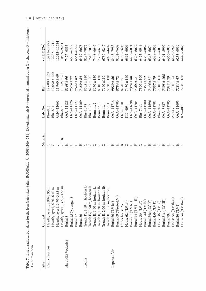
138 | Adina Boroneanţ
Site
Con
text
Mat
eria
lLa
b. N
o.BP
cal B
C (2
σ)C
uina
Tur
culu
iH
eart
h, la
yer 1
, 5.9
0–5.
95 m
CBl
n–80
312
,600
± 1
2013
221–
1227
5
Hea
rth,
laye
r I, 6
.20–
6.40
mC
Bln–
804
12,0
50 ±
120
1223
2–11
711
H
eart
h, la
yer I
, 5.7
0–5.
85 m
cG
rN–1
2665
11,9
60 ±
60
1202
3–11
754
H
eart
h, la
yer I
I, 3.
68–3
.85
mC
+ B
Bln–
802
10 1
25 ±
200
1063
9–92
51H
ajdu
čka V
oden
ica
Buria
l 8H
OxA
–111
2881
65 ±
90
7477
–683
3
Buria
l 15
(‘you
nger’)
HO
xA–1
1126
7524
± 7
765
03–6
227
Bu
rial 1
2H
OxA
–111
2775
22 ±
82
6561
–622
2
Buria
l 20
HO
xA–1
1109
7389
± 8
464
19–6
078
Icoa
naTr
ench
IV, 2
.10
m, h
orizo
n lb
CBl
n–10
7886
05 ±
250
8287
–707
5
Tren
ch IV
, 0.5
0 m
, hor
izon
laC
Bln–
1077
8265
±10
075
18–7
070
Tr
ench
II, 1
.60
m, h
orizo
n la
CBo
nn n
o. 2
8070
± 1
3074
48–6
647
Tr
ench
II, 1
.20
m, h
orizo
n lb
CBo
nn n
o. 3
8010
± 1
2073
06–6
610
Tr
ench
II, 2
.00
m, h
orizo
n lb
CBo
nn n
o. 4
7660
±11
067
50–6
247
Tr
ench
III,
1.00
m, h
orizo
n II
CBo
nn n
o. 1
5830
± 1
2049
93–4
402
Lepe
nski
Vir
Buria
l 60
(‘LV
Ic’)
HO
xA–1
1715
9020
± 8
084
45–7
953
Bu
rial 6
9 (‘P
roto
-LV
’)H
OxA
–117
0387
84 ±
72
8202
–760
9
Und
er h
ouse
23
BO
xA–8
610
8770
± 6
081
80–7
605
H
ouse
62
(‘LV
lb’)
CK
N–4
0574
30 ±
160
6592
–600
6
Buria
l 61
(‘LV
Ic’)
HO
xA–1
1698
7374
± 8
064
06–6
071
Bu
rial 1
4 (‘L
V I—
II’)
HO
xA–1
1704
7368
±75
6396
–607
2
Hou
se 3
6 (‘L
V la’
)C
Bln–
74ob
7360
± 1
0064
25–6
049
Bu
rial 5
4d (‘
LV lb
’)H
OxA
–117
0073
53 ±
72
6385
–606
7
Buria
l 54c
(‘LV
lb’)
HO
xA–1
1696
7346
±57
6365
–607
4
Buria
l 45b
(‘LV
I’)
HO
xA–1
1701
7337
± 7
963
88–6
053
H
ouse
36
(‘LV
la’)
CBl
n–74
0a73
10 ±
100
6392
–601
0
Buria
l 31a
(‘LV
III’)
HO
xA–5
827
7308
± 1
0864
01–5
997
Bu
rial 7
9aH
OxA
–117
0573
12 ±
79
6366
–602
9
Hou
se 5
4 (‘L
V Ib
-c’)
CZ
–143
7300
± 12
464
26–5
928
Bu
rial 2
6 (‘L
V I’)
HO
xA–1
1693
7284
± 4
762
33–6
056
H
ouse
54
(‘LV
Ib-c
’)C
KN
–407
7280
± 1
6064
45–5
845
Tabl
e 7.
List
of r
adio
carb
on d
ates
for t
he Ir
on G
ates
site
s (a
ft er
BON
SALL
, C. 2
008:
246
–251
). D
ated
mat
eria
l: B
= te
rres
tria
l mam
mal
bon
e; C
= ch
arco
al; F
= fi
sh b
one;
H
= h
uman
bon
e.

The Mesolithic in Banat | 139
Site
Con
text
Mat
eria
lLa
b. N
o.BP
cal B
C (2
σ)
Buria
l 54e
(‘LV
lb’)
HO
xA–1
1697
7250
±59
6227
–601
7
Hou
se 5
4 (‘L
V Ib
-c’)
CBl
n–73
872
25 ±
100
6354
–589
6
Buria
l 7/I
(‘LV
I’)
HO
xA–1
1692
7218
± 8
162
43–5
917
H
ouse
27
(‘LV
Id-e
’)C
KN
–406
7210
± 2
0064
45–5
720
R
ear o
f hou
se 5
1, u
nder
leve
l of h
ouse
XLI
VB
OxA
–861
872
00 ±
60
6217
–598
6
Buria
l 7/I
(‘LV
F’)
(rep
eat)
HO
xA–1
2979
7157
± 7
762
15–5
892
Bu
rial 4
4 (‘L
V II
I’)H
OxA
–583
071
52 ±
106
6233
–579
7
Buria
l 89a
(‘LV
IF)
HO
xA–1
1702
7133
± 7
562
08–5
845
Be
twee
n ho
uses
20
and
33 (‘
LV Ia
-b’)
FO
xA–8
725
7060
± 1
1462
07–5
721
H
ouse
54
(‘LV
Ib-c
’)C
Bln–
653
7040
± 1
0060
81–5
719
Bu
rial 3
2a (‘
LV II
I’)H
OxA
–582
870
36 ±
95
6066
–572
8
Hou
se 5
4 (‘L
V Ib
-c’)
CZ
–115
6984
± 9
460
28–5
676
Bu
rial 9
(‘LV
Illb
’)H
OxA
–116
9569
82 ±
50
5983
–574
7
Buria
l 88
(‘LV
III’)
HO
xA–5
831
6980
± 9
260
23–5
677
H
ouse
47
(‘LV
Id-e
’)C
UC
LA–1
407
6970
± 6
059
83–5
735
Bu
rial 8
(‘LV
III’)
HO
xA–1
1694
6942
± 4
759
72–5
729
H
ouse
37
(‘LV
Id’)
CBM
–379
6900
± 1
5060
55–5
544
H
ouse
37
(‘LV
Id’)
CBl
n–67
869
00 ±
100
5984
–563
6
Hou
se 1
(‘LV
Id’)
CBi
n–57
568
60 ±
100
5982
–557
2
Hou
se 9
(‘LV
Id’)
CBl
n–64
768
45 ±
100
5978
–556
5
Hou
se 1
6 (‘L
V Ie
’)C
Bln–
576
6820
± 1
0059
72–5
554
H
ouse
34/
43 (‘
LV I?
’)C
Bln–
650
6820
± 1
0059
72–5
554
H
ouse
32
(‘LV
Ie’)
CP–
1598
6814
±69
5867
–557
1
Hou
se 3
7 (‘L
V Id
’)C
Bln–
649
6800
± 1
0058
99–5
526
Bu
rial 3
5 (‘L
V II
I’)H
OxA
–582
967
18 ±
9357
77–5
48o
H
ouse
IX (X
V IF
)C
Bln–
654
6630
± 1
0057
23–5
378
H
ouse
51
(‘LV
Ie’)
CBl
n–65
266
20 ±
100
5718
–537
6
Hou
se X
XXI
I (‘L
V II
’)C
Bln–
655
6560
± 1
0056
57–5
324
Ost
rovu
Ban
ului
Tr
ench
IV, h
orizo
n II
I, he
arth
2C
Bln–
1080
8040
± 1
6074
55–6
593
Tr
ench
I, h
orizo
n II
I, he
arth
1C
Bin–
1079
7565
± 1
0066
06–6
227
Ost
rovu
Cor
bulu
i H
eart
h, le
vel I
, 4.5
0–4.
53 m
CSM
U–5
8780
93 ±
237
7567
–650
3
Hea
rth,
leve
l II,
4.02
–4.1
2 m
CSM
U–5
8878
27 ±
237
7350
–622
8
Hea
rth,
leve
l I, 4
.20–
4.38
mC
Bln–
2135
77i0
± 80
6692
–642
3
Hea
rth,
leve
l I, 4
.20–
4.38
mC
Bln–
2i35
a76
95 ±
80
6681
–642
1
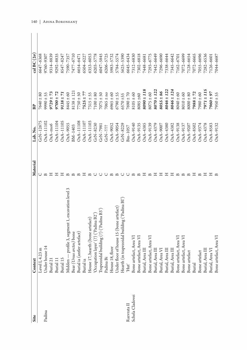
140 | Adina Boroneanţ
Site
Con
text
Mat
eria
lLa
b. N
o.BP
cal B
C (2
σ)
Leve
l I, 4
.23
mC
GrN
–126
7576
40 ±
80
6647
–636
8Pa
dina
U
nder
hou
se 1
4B
OxA
–111
0299
90 ±
55
9760
–930
7
Buria
l 21
HO
xA–m
o697
29 ±
73
9314
–883
9
Buria
l 11
HO
xA–1
1104
9700
± 7
292
92–8
835
Bu
rial 1
5H
OxA
–111
0591
38 ±
71
8547
–824
7
Mid
den
— p
rofi l
e 3, s
egm
ent 1
, exc
avat
ion
leve
l 3B
OxA
–905
584
45 ±
60
7590
–735
7
Bear
(Ursu
s arc
tos)
bon
eB
BM–1
403
8138
± 1
2174
77–6
710
Bu
rial i
a (an
tler a
rtef
act)
BO
xA–1
1108
7750
± 5
066
54–6
471
Bu
rial i
aH
OxA
–111
0775
25 ±
77
6504
–622
7
Hou
se 1
7, h
eart
h (b
one a
rtef
act)
BO
xA–1
1103
7315
± 5
563
53–6
053
'O
ccup
atio
n lay
er' (
?) (‘
Padi
na B
2’)
CG
rN–8
230
7100
± 8
062
03–5
778
Tr
apez
oida
l bui
ldin
g (?
) (‘P
adin
a B3’
)C
GrN
–798
170
75 ±
50
6047
–584
5
Padi
na B
iC
GrN
–???
?70
65 ±
no
6206
–572
5
Hou
se 1
8, fl
oor
BO
xA–9
052
6965
± 6
059
83–5
732
U
nder
fl oo
r of h
ouse
15
(bon
e art
efac
t)B
OxA
–905
467
90 ±
55
5784
–557
4
Hea
rth
(in tr
apez
oida
l bui
ldin
g (‘P
adin
a BI’)
CG
rN–8
229
6570
±55
5625
–539
0R
azvr
ata I
I 'H
ut'
CBi
n–10
5776
90 ±
70
6645
–643
4Sc
hela
Cla
dove
iBo
ne ar
tefa
ct, A
rea V
IB
OxA
–914
081
05 ±
60
7312
–683
0
Bone
arte
fact
, Are
a VI
BO
xA–9
135
8085
±60
7302
–681
8
Buria
l, Ar
ea II
IH
OxA
–438
580
90 ±
118
7448
–668
1
Bone
arte
fact
, Are
a VI
BO
xA–9
139
8075
± 6
072
93–6
775
Bu
rial,
Area
III
HO
xA–4
379
8070
± 1
2274
42–6
649
Bu
rial,
Area
VI
HO
xA–9
007
8055
± 8
672
96–6
690
Bu
rial,
Area
III
HO
xA–4
380
8046
± 1
2273
38–6
644
Bu
rial,
Area
III
HO
xA–4
382
8046
± 1
2473
45–6
642
Bo
ne ar
tefa
ct, A
rea V
IB
OxA
–913
880
40 ±
60
7162
–670
1
Bone
arte
fact
, Are
a VI
BO
xA–9
137
8010
± 6
070
72–6
699
Bo
ne ar
tefa
ctB
OxA
–920
780
00 ±
80
7128
–665
4
Buria
lH
OxA
–850
279
88 ±
72
7072
–666
5
Bone
arte
fact
BO
xA–9
374
7980
± 6
070
55–6
696
Bu
rial,
Area
III
HO
xA–4
378
7971
± 1
1572
82–6
536
Bu
rial,
Area
VI
HO
xA–8
583
7960
± 9
771
26–6
601
Bo
ne ar
tefa
ct, A
rea V
IB
OxA
–913
279
50 ±
55
7044
–668
7
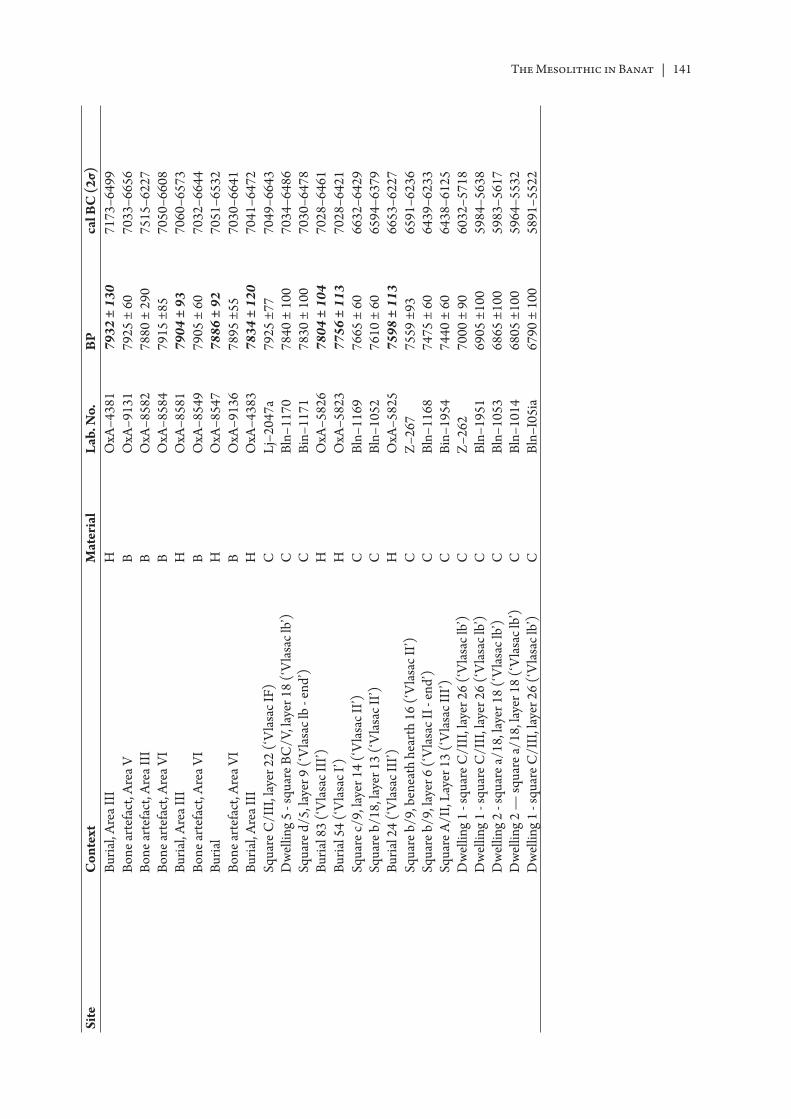
The Mesolithic in Banat | 141
Site
Con
text
Mat
eria
lLa
b. N
o.BP
cal B
C (2
σ)
Buria
l, Ar
ea II
IH
OxA
–438
179
32 ±
130
7173
–649
9
Bone
arte
fact
, Are
a VB
OxA
–913
179
25 ±
60
7033
–665
6
Bone
arte
fact
, Are
a III
BO
xA–8
582
7880
± 2
9075
15–6
227
Bo
ne ar
tefa
ct, A
rea V
IB
OxA
–858
479
15 ±
8570
50–6
608
Bu
rial,
Area
III
HO
xA–8
581
7904
± 9
370
60–6
573
Bo
ne ar
tefa
ct, A
rea V
IB
OxA
–854
979
05 ±
60
7032
–664
4
Buria
lH
OxA
–854
778
86 ±
92
7051
–653
2
Bone
arte
fact
, Are
a VI
BO
xA–9
136
7895
±55
7030
–664
1
Buria
l, Ar
ea II
IH
OxA
–438
378
34 ±
120
7041
–647
2
Squa
re C
/III
, lay
er 2
2 (‘
Vla
sac I
F)C
Lj–2
047a
7925
±77
7049
–664
3
Dw
ellin
g 5
- squ
are B
C/V
, lay
er 1
8 (‘
Vla
sac l
b’)
CBl
n–11
7078
40 ±
100
7034
–648
6
Squa
re d
/5, l
ayer
9 (‘
Vla
sac l
b - e
nd’)
CBi
n–11
7178
30 ±
100
7030
–647
8
Buria
l 83
(‘V
lasa
c III
’)H
OxA
–582
678
04 ±
104
7028
–646
1
Buria
l 54
(‘V
lasa
c I’)
HO
xA–5
823
7756
± 1
1370
28–6
421
Sq
uare
c/9,
laye
r 14
(‘V
lasa
c II’)
CBl
n–11
6976
65 ±
60
6632
–642
9
Squa
re b
/18,
laye
r 13
(‘V
lasa
c II’)
CBl
n–10
5276
10 ±
60
6594
–637
9
Buria
l 24
(‘V
lasa
c III
’)H
OxA
–582
575
98 ±
113
6653
–622
7
Squa
re b
/9, b
enea
th h
eart
h 16
(‘V
lasa
c II’)
CZ
–267
7559
±93
6591
–623
6
Squa
re b
/9, l
ayer
6 (‘
Vla
sac I
I - en
d’)
CBl
n–11
6874
75 ±
60
6439
–623
3
Squa
re A
/II,
Laye
r 13
(‘V
lasa
c III
’)C
Bin–
1954
7440
± 6
064
38–6
125
D
wel
ling
1 - s
quar
e C/I
II, l
ayer
26
(‘V
lasa
c lb’
)C
Z–2
6270
00 ±
90
6032
–571
8
Dw
ellin
g 1
- squ
are C
/III
, lay
er 2
6 (‘
Vla
sac l
b’)
CBl
n–19
5169
05 ±
100
5984
–563
8
Dw
ellin
g 2
- squ
are a
/18,
laye
r 18
(‘V
lasa
c lb’
)C
Bln–
1053
6865
±10
059
83–5
617
D
wel
ling
2 —
squa
re a/
18, l
ayer
18
(‘V
lasa
c lb’
)C
Bln–
1014
6805
±10
059
64–5
532
D
wel
ling
1 - s
quar
e C/I
II, l
ayer
26
(‘V
lasa
c lb’
)C
Bln–
I05i
a67
90 ±
100
5891
–552
2


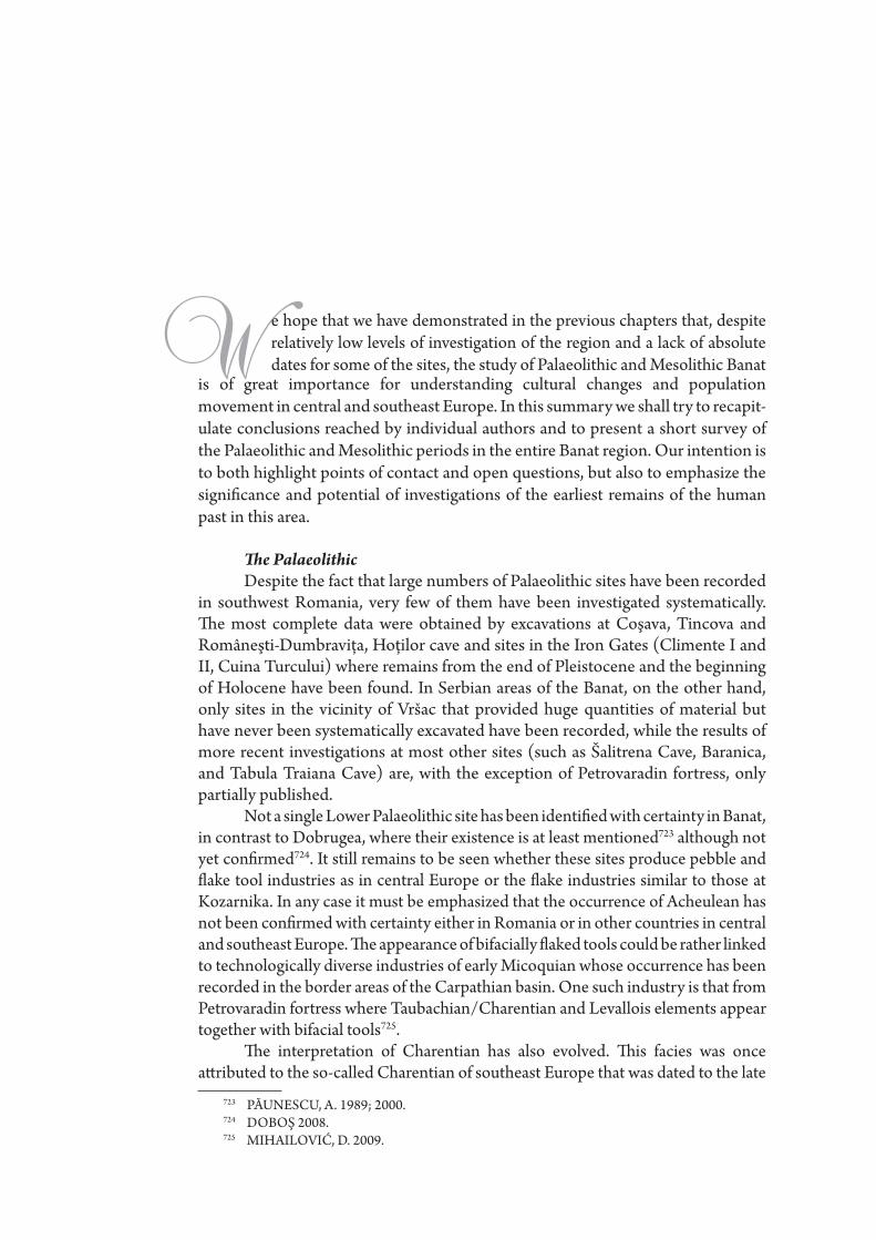
is of great importance for understanding cultural changes and population movement in central and southeast Europe. In this summary we shall try to recapit-ulate conclusions reached by individual authors and to present a short survey of the Palaeolithic and Mesolithic periods in the entire Banat region. Our intention is to both highlight points of contact and open questions, but also to emphasize the signifi cance and potential of investigations of the earliest remains of the human past in this area.
Th e PalaeolithicDespite the fact that large numbers of Palaeolithic sites have been recorded
in southwest Romania, very few of them have been investigated systematically. Th e most complete data were obtained by excavations at Coşava, Tincova and Româneşti-Dumbraviţa, Hoţilor cave and sites in the Iron Gates (Climente I and II, Cuina Turcului) where remains from the end of Pleistocene and the beginning of Holocene have been found. In Serbian areas of the Banat, on the other hand, only sites in the vicinity of Vršac that provided huge quantities of material but have never been systematically excavated have been recorded, while the results of more recent investigations at most other sites (such as Šalitrena Cave, Baranica, and Tabula Traiana Cave) are, with the exception of Petrovaradin fortress, only partially published.
Not a single Lower Palaeolithic site has been identifi ed with certainty in Banat, in contrast to Dobrugea, where their existence is at least mentioned723 although not yet confi rmed724. It still remains to be seen whether these sites produce pebble and fl ake tool industries as in central Europe or the fl ake industries similar to those at Kozarnika. In any case it must be emphasized that the occurrence of Acheulean has not been confi rmed with certainty either in Romania or in other countries in central and southeast Europe. Th e appearance of bifacially fl aked tools could be rather linked to technologically diverse industries of early Micoquian whose occurrence has been recorded in the border areas of the Carpathian basin. One such industry is that from Petrovaradin fortress where Taubachian/Charentian and Levallois elements appear together with bifacial tools725.
Th e interpretation of Charentian has also evolved. Th is facies was once att ributed to the so-called Charentian of southeast Europe that was dated to the late
723 PĂUNESCU, A. 1989; 2000.724 DOBOŞ 2008.725 MIHAILOVIĆ, D. 2009.
We hope that we have demonstrated in the previous chapters that, despite relatively low levels of investigation of the region and a lack of absolute dates for some of the sites, the study of Palaeolithic and Mesolithic Banat
146 | Continuity and future research
phase of the Middle Palaeolithic.726 Nevertheless, aft er re-dating the remains from Krapina and other recent investigations it is now clear that industries of this type appear in much earlier periods and that, at least in Serbia, they probably precede and perhaps partially coincide with the appearance of the Levallois technique in the Balkans.727 Th is confusion resulted, among other things, from the fact that this facies had been related to the late quartz/quartzite industries, which are confi rmed not only in southwest Romania (Eastern Charentian or Cave Mousterian) but also in Slovenia, Croatia and even Serbia.728 Authors of this book agree, however, that the quartz character of the industry should not be strictly connected to distinct Mousterian facies but perhaps rather refl ects the sett lement patt ern and technology of knapping the quartz pebbles.
Levallois artifacts have been found at many sites in Banat (Crvenka-At, Balata, Gornea, Romaneşti-Dumbraviţa). For the time being everything indicates a long and complex history of use of this technique, which appears in both early and late phases of the Middle Palaeolithic in various Mousterian facies. It is interesting that Middle Palaeolithic industries with leaf points (where the Levallois component is also very prominent) have not been confi rmed, but just single specimens of this tool type. Th is is rather surprising because industries of this type have been encountered at many sites in the Pannonian basin, in north Romania and north Bulgaria.
Early Upper Palaeolithic in western, central and eastern parts of the Carpathian basin is repre-sented by great numbers of sites and considerable variability in the ‘transitional’ industries, which are, however, oft en in uncertain stratigraphic position or poorly dated. Th ey roughly cover the lengthy time-span between 40-25ka BP (aft er 30ka BP) and comprise Mousterian-based units (Mitoc facies, Brynzenian, Szeletian, Prut culture and Corpaci facies), which contain diff erent frequencies of Levallois debitage and/or sidescrapers, denticulates and notches – and a tool in common, the bifacial leaf point.729 Still, some recent studies/results are in line with general arguments in the Romanian liter-ature suggesting the long coexistence of MP and EUP industries and their uniform evolution without rapid population replacement, which should be verifi ed by the application of new geoarchaeological methods and techniques, and by undertaking new analyses and especially fi eld investigations730.
Something that is not controversial is the fact that anatomically modern humans appeared in this area before ca. 36 ka. Th e 2002, 2003 and 2004 discoveries of early modern human remains in a paleontological context (but without archaeological evidence) in the Peştera cu Oase caves in the Banat Mountains (Caraş-Severin County), has provided a window on the biology of these earliest modern humans in Europe731. Th e initial discovery led to systematic study of Peştera cu Oase732, followed by diff erent analyses733 and have spurred several scientifi c projects: a palaeoanthropological project re-examining ‘forgott en’ human fossils from Romanian caves (old fossil discoveries) and their direct dating734 and new research in Banat,735 thus bringing the Romanian record into broader Afro-Eurasian discussions of the origins and dispersal of anatomical modern humans736.
Th e question of the bearers of early Upper Palaeolithic culture has, however, not yet been solved as human remains at the sites in Romanian caves have not been found in association with artifacts. Most authors think that the appearance of Homo sapiens could be related to the ‘Aurignacian
726 GÁBORI, V. 1976.727 SIMEK, J. F. & SMITH, F. H. 1997.728 OSOLE, F. 1971; PĂUNESCU, A. 1989; AHERN, J. C. M. et alii 2004.729 ANGHELINU, M. et alii 2011.730 HORVATH, I. 2009.731 TRINKA US, E et alii 2005.732 LAZAROVICI, G. et alii 2005; BĂLTEAN, I. C. et alii 2008.733 RICHARDS, M. P. et alii 2008.734 SOFICARU, A. et alii 2006; 2007; ALEXANDRESCU, E. et alii 2010.735 BĂLTEAN, I. C. et alii 2008.736 TRINKA US, E. et alii 2006.
Continuity and future research | 147
0’ or proto-Aurignacian industries within the wider region of the Carpathian basin. Th e earliest dated Aurignacian sites (Tabula Traiana Cave, Baranica) are dated to 36-35 ka but a very small quantity of fi nds has been discovered that do not allow drawing of wider conclusions737. A rich Aurignacian layer has been recently confi rmed in Šalitrena cave but absolute dates and results of the analyses of material have not yet been published738.
Many Aurignacian sites were encountered in the Romanian and Serbian part of Banat, the most important being Coşava, Tincova and Româneşti-Dumbraviţa in the Romanian Banat739 and Crvenka, At and Balata in the vicinity of Vršac740 in the Serbian Banat. Th ese sett lements probably belong to the same sett lement patt ern and the material found at them is very similar. Th e raw materials are identical, knapping technology is the same or similar and the structure and stylistic-typological characteristics of tools are almost identical. At most of the mentioned sites conical cores for bladelets, carinated, nosed and conical endscrapers, Aurignacian blades, dihedral burins, strangled blades and (at Romanian sites) Dufour bladelets and Font-Yves points were recorded. As a result these sites could be identifi ed as the Banat group of the Krems type Aurignacian.
Th e fi rst Aurignacian stage of the Romanian Banat (Coşava – lower layer, the single layer in Tincova) was att ributed to the last, Würm II–III, interstadial. Pollen-based geochronological estimations in Româneşti suggested a much later Tardiglacial chronology. Th e general typological structure of the toolkits (carinated, nosed end-scrapers, dihedral burins and burins on truncation, Aurignacian blades, as well as Dufour bladelets and Font-Yves points) suggested direct connection to Central Europe, especially Krems type Aurignacian. In a typical culture-historical vein, Mogoşanu viewed the Banat Aurignacian as a late echo of the Krems Aurignacian groups, retreating into the Banat refuge in favor of the Central European Gravett ian741. Its late survival and ‘degeneration’ explained the less and less characteristic toolkits from the upper layers in Coşava and Româneşti742.
In recent times, however, some Romanian sites such as Tincova have been related to the proto-Aurignacian743. Authors of this text, although not denying that possibility, agree that this assumption has yet to be confi rmed. Th e new comparative analyses of the lithic industries show many similarities and at the same time some diff erences (raw material exploitation, core compo-sition, debitage structure, blade production, toolkit structure) between the lithic assemblages from Coşava, Romaneşti-Dumbraviţa744 and Tincova745. In that light the re-evaluation of the Aurignacian in Banat requires more detailed technological and typological studies746.
As a consequence of these new results, the new approaches on the Palaeolithic in Romanian Banat are focused on:
a) re-evaluating the lithic assemblages from the old excavations at Tincova (studies in 2007–2008 )747, Româneşti-Dumbraviţa and Coşava (2009–2010); and
b) resuming excavations in all above mentioned Romanian sites, within the CRC project – “Our Way to Europe”, aiming for a detailed chronological framework748.
Th e three sites (Româneşti-Dumbrăviţa and Coşava in 2009 and Tincova in 2010) were selected for complete stratigraphical, chronological and archaeological re-evaluation. Th is was to
737 MIHAILOVIĆ, D. et alii 1997; BORIĆ 2008.738 MIHAILOVIĆ, D., MIHAILOVIĆ, D. 2009.739 MOGOŞANU, F. 1972; 1976; 1978; 1983; HAHN, J. 1970; 1977.740 MIHAILOVIĆ, D. 1992.741 SITLIVY, V. et alii 2011.742 MOGOŞANU, F. 1978; 1983.743 TEYSSANDIER, N. 2003; 2008; ZILHÃO, J. 2006.744 SITLIVY, V. et alii 2011.745 BĂLTEAN, I. C. 2011.746 BĂLTEAN, I. C. 2011.747 BĂLTEAN, I. C. 2011.748 Unpublished data/research in progress.
148 | Continuity and future research
include test pits, TL, OSL, pollen analyses, sedimentological and tephra sampling, all correlated to the study of both old and new archaeological collections. It should be noted that recent debates on the defi nition of the Banat Aurignacian usually involved Tincova and Oase Cave early modern human fossils.
In the current understanding, the re-evaluation of the old collections together with new results from the recent excavations (TL, OSL and tephra sampling, biology of the Early Modern Humans from Oase Cave) will off er us a new image on the signifi cance of the Middle and Upper Palaeolithic of the Banat region in a regional context – the Carpathian area and the Danube corridor749.
Th e richest and probably among the earliest Gravett ian sites in north Serbia and southwest Romania is Šalitrena Cave. A broad repertoire of technological and typological elements which relate this site to the central European Gravett ian, particularly to the Willendorfi an, has been encountered in the very rich industry from this site750. However there are also parallels with the industries from Temnata and Kozarnika (layer IVb) in Bulgaria751. It is still unclear whether the fi nds from this cave bear witness to the shift ing of Gravett ian communities from the Carpathian basin toward the south at the beginning of last glacial maximum. Early and middle phases of the Epigravett ian are characterized by uniform industries with straight-back bladelets and a rather restricted tool repertoire. Th e indus-tries of that type were confi rmed in the Climente I Cave and dated to the Last Glacial Maximum752.
Similar phenomena as in the fi nal Epigravett ian in the Mediterranean were confi rmed in the fi nal Epigravett ian in Banat, coinciding with the transition from the Pleistocene to the Holocene. Th e microlithization of artifacts took place in that period and thumbnail and circular endscrapers, geometric microliths (segments and triangles) and arched backed points also appeared. According to some authors these phenomena could indicate migration of the bearers of the Epigravett ian techno-complex from the Mediterranean zone toward the Balkan hinterland753. According to others, however, these elements could be instead related to technological changes and changes in the sett lement patt ern and economy that have been recorded in this period across a much larger area754. Th ere is, however, almost unanimous agreement that these changes had a decisive impact on the beginning of the evolution of the Mesolithic in the Iron Gates.
Th e MesolithicDespite the fact that the information presented in this volume on the Iron Gates Mesolithic is
somehow incomplete, lacking a detailed presentation of the sites on the right bank of the Danube and also of the two Romanian sites on the left bank located outside the boundaries of the historical Banat, the authors hope they have managed to off er a comprehensive overview of the main characteristics of the hunter-gatherer communities, and their possible interactions with the Early Neolithic ones.
Th e chronology proposed for the Iron Gates sites is a provisional one, based on the 14C dates available at the present moment: Early Mesolithic (13200–7200 cal BC), Late Mesolithic (7200–6300 cal BC), Final Mesolithic (6300–6000 cal BC).
Within the chronological limits of the Early Mesolithic fall 14C dates from sites in caves (Climente II, Veterani and Hoților), rockshelters (Cuina Turcului), islands (Ostrovul Banului) or open air sites (Vlasac, Lepenski Vir, Padina). Th e economy was based on hunting, but with an important fi shing component755. Th e fl int industry shows techno-typological characteristics similar to the Epigravett ian, while displaying a strong use of local raw materials, especially local fl int.
749 SITLIVY, V. et alii 2011; BĂLTEAN, I. C. 2011.750 MIHAILOVIĆ, D. 2008.751 DROBNIEWICZ 1992; TSANOVA, T. 2003.752 BORONEANŢ, V. 2000.753 BORONEANŢ, V. 2000.754 MIHAILOVIĆ, D. 2007.755 BONSALL, C. 2008.
Continuity and future research | 149
Presence of obsidian was noted on some sites. Bone artifacts appear a lot more oft en than their antler or tusk counterparts, with awls and projectile points among the most frequent types. Decorated bone tools (the fi shnet patt ern), pierced animal teeth and medium sized boulders with small circular depressions were seen by some archaeologists as the diagnostic tools of this period. Burials are documented, at times within formal disposal areas, mainly on the right bank of the Danube756.
Th e sites of the Late Mesolithic appear to have been established mainly in the open air: Răzvrata, Icoana, Veterani Terasă, Schela Cladovei, Vlasac, Lepenski Vir, Hajdučka Vodenica, and Kula. Architectural features become more numerous, with oval or trapezoid shaped habitations, circular or rectangular hearths made of stones, some of them worked. Th e largest quantity of fi nds in the sett lements dates from this period. Quartz started to prevail among the chipped stone artifacts particularly in the Lower Gorges while fl int use decreases dramatically on some of the sites and obsidian disappears. Bone assemblages are extremely abundant and diversifi ed. Antler becomes an important resource for tool manufacturing.
Judging by the faunal remains and isotopic analyses, aquatic food sources predominate over the terrestrial ones. Domestic dog remains (possibly domesticated during the earlier period) were encountered on most sites, with a suggestion of the dog itself being a possible food source. Food storage was possible, although defi nite evidence is still missing757. Opinions on the social complexity of the communities vary greatly758. Th e number of burials seems to have increased dramatically, still with a higher prevalence on the right bank759. Presence of art items was unevenly noticed among the sites, some with many beautifully decorated bone/antler/tusk artifacts (Icoana) whereas others yielded just a few pieces or none. Shells originating from the Adriatic and the Mediterranean areas suggest the existence of complex exchange networks760. Evidence of violent death and injuries is diffi cult to interpret at a large scale, given the fact they were observed in a signifi cant number of cases only at Schela Cladovei761.
It appears that with the time of ‘8.2 ka cold event’762 occupation came to an end at most sett le-ments of the Late Mesolithic. Th ere is ample evidence of continuation on the right bank at Lepenski Vir while on the left bank a possible candidate (but needing to be confi rmed by further research and 14C dates) is Alibeg, in the Upper Gorges. Archaeological evidence (types of habitations, hearths and burials763 – suggests Ostrovul Corbului and Ostrovul Mare as likely candidates too, but again, more 14C dates are needed.
Th e Final Mesolithic fl ourishes at Lepenski Vir, with its renowned trapezoid houses and sculptured boulders. Together with the burials between and underneath houses they point towards a distinct, probably sacred character of this particular sett lement764. Burial practices are similar to those of the Final Mesolithic but in the funerary rite, as well as in other aspects, new elements also appear (burying the dead lying on one side with legs and arms fl exed, the presence of pott ery and ground stone tools within the sett lements)765. Reliance on aquatic sources becomes even stronger766.
One of the directions to be followed in future research is that of Mesolithic-Early Neolithic contacts, as suggested by the presence of the above-mentioned Early Neolithic elements in Mesolithic
756 RA DOVANOVIĆ, I. 1996.757 BONSALL, C. 2008.758 VOYTEK, B. & TRINGHAM, R. 1989; RA DOVANOVIĆ, I. & VOYTEK, B. 1997; BONSALL, C. 2008.759 RA DOVANOVIĆ, I. 1996; BORONEANȚ, A. 2009; BORONEANȚ, A. & BORONEANȚ, V. 2010.760 SREJOVIĆ, D. & LETICA, Z. 1978; BORONEANȚ, V. et alii 1999.761 ROKSANDIĆ, M. 2000; 2008; BONSALL, C. 2008.762 MAGNY, M. et alii 2003.763 BORONEANȚ, A. 2010a; 2010b.764 SREJOVIĆ, D. 1969.765 GARA ŠANIN, M. & RA DOVANOVIĆ, I. 2001; RA DOVANOVIĆ, I. 2008; BONSALL, C. 2008.766 BONSALL, C. 2008.
150 | Continuity and future research
contexts. One possible method is through a thorough study of the existing collection of fi nds and fi eld documentation of the earlier excavations. Also, the past few years have seen excavation and publi-cation of interesting new data from recent fi eld research at Vlasac, Aria Babi, and Schela Cladovei. Other than excavations on the few sites that survived the fl ooding, fi eld surveys are necessary both on the higher terraces of the Danube (previously unexplored – at least on the left bank) and in the area further downstream of the Iron Gates II dam. Th ere is no reason that Mesolithic occupations of the river banks should have been confi ned only to the area suggested by the present state of the research.
* **
We hope that we have managed to show in this book that the importance of understanding the Banat far exceeds its regional limits, even though almost all we know about its early prehistory is based on the results of older excavations, and despite the fact that many essential elements for the reconstruction of cultural, social and economic change are still missing. We therefore hope that this book will encourage further regional as well as international collaboration in solving the many open questions remaining in the study of the Palaeolithic and Mesolithic cultures of this area.

VI.1. Bibliography
ALEXANDRESCU, E. 1997. O ipoteză despre evoluţia complexului cultural aurignacian din Câmpia Română. Timpul istoriei I: 11–36. Bucureşti.
ALEXANDRESCU, E. 1998a. Observaţii asupra industriei litice de la Giurgiu – Malu Roşu. Buletinul Muzeului “Teohari Antonescu” 2–4:13–57.
ALEXANDRESCU, E. 1998b. Şantierul arheologic Giurgiu – Malu Roşu. Campania 1998. Buletinul Muzeului “Teohari Antonescu” 2–4: 59–74.
ALEXANDRESCU, E. 2002. O nouă sinteză cu privire la epoca palaeolitică pe teritoriul României. Studii și Cercetări de Istorie Veche și Arheologie 51 (1–2) 2003: 103–115.
ALEX0ANDRESCU, E. & POPA, T. 2000. Şantierul arheologic Giurgiu – Malu Roşu. Campania 1999. Buletinul Muzeului “Teohari Antonescu” 5–6: 41–63.
ALEXANDRESCU, E., OLARIU, A., SKOG, G., STENSTRŐM, K, HELLBORG, R., 2010. Os fossils humains des grott es Muierii et Cioclovina, Roumanie. L’ Anthropologie, 114, 341–353.
ALLEN, J. R. L. 1974. Allen, Reaction, relaxation and lag in natural systems; general principles, exemples and lessons. Earth Science Reviews 10: 263–342.
ANASTASIU, N. 1988. Petrologie sedimentară. Bucureşti: Tehnică. ANASTASIU, N. 1999. Petro-Sed. Glosar de sedimentologie şi petrologie sedimentară.
Bucureşti: Universităţii. ANDRES, W., BOS, J. A. A., HOUBEN, P., KA LIS, A. J., NOLTE, S., RITT WEGER, H.
& WUNDERLICH, J. 2001. Environmental change and fl uvial activity during the Younger Dryas in Central Germany. Quaternary International 79: 89–100.
ANDREESCU, R. & MIREA, P. 2008. Teleorman Valley. Th e beginning of Neolithic in southern Romania: Acta Terrae Septemcastrensis 7: 56–71.
ANGHELINU, M. 2002. Conservatorism şi spontaneitate în tehnologia litică palaeolitică. Refl ecţii asupra unei industrii musteriene. Memoria Antiquitatis XXII: 333–349.
ANGHELINU, M., 2006. O paleontologie a “omului etern”: arheologia paleoliticului din România. Cercetări Arheologice, XIII, 135–158.
ANGHELINU, M., NIŢĂ, L., SITLIVY, V., UTHMEIER, T., BĂLTEAN, I. 2011. Th e mist around Peştera cu Oase: Th e beginning of Upper Palaeolithic in Romania, in press.
ANTONOVIĆ, D. 199 7. Use of Light White Stone in the Central Balkans Neolithic. Starinar N. S XLVIII: 33–39.
ATLASUL 1973. Atlasul Complex ‘Porţile de Fier’. Bucharest: Academia R.S.R.BANESZ, L. 1993. Contrubution au probleme de l’Aurignacien, in J. Pavúk (ed.), Actes du XIIe
Congrès International des Sciences Préhistoriques et Protohistoriques: 135–136. Bratislava.
154 | Bibliography
BASLER, Đ. 1975. Stariji litički periodu u Crvenoj stijeni, in Đ. Basler (ed.), Crvena stijena – zbornik radova. Zajednica kulturnih ustanova: 11–120. Nikšić.
BAZILE, F. 1996. La question de “L’ Aurignacien terminal” en Languedoc, in Th e Upper Palaeolithic vol. 6, Actes XIII CISPP: 55–67. Forli: A. B. A. C. O. Edizioni.
BĂLTEAN, I. PETRESCU, S. M. CINCĂ, A. NEGREI, D. & ZILHÃO, J. in press. Prezența umană și nivelurile ocupaționale identifi cate în sistemul carstic la Văii Minișului.
BĂRCĂCILĂ, A. 1924. Antiquites prè- et proto-historiques des environs de Turnu Severin, Dacia I: 280–296. BERCIU, D. 1939. Arheologia preistorică a Olteniei. Craiova.BERCIU, D. 1941. Repertoriu arheologic de staţiuni şi descoperiri preistorice în România. Revista Arhivelor
3: 4–16. BIAGI, P. &SPATARO, M. 2004. Noi datări cu radiocarbon în aşezările culturii Criş din Banat şi Transilvania
(România). Patrimonium Banaticum III: 7–20. BIAGI, P. SHENNAN, P. & SPATARO, M. 2005. Rapid rivers and slow seas? New data for the Radiocarbon
chronology of the Balkan peninsula, in L. Nikolova, J. Fritz & J. Higgins (eds.), Prehistoric Archaeology & Anthropological Th eory and Education. Reports of prehistoric research projects 6–7: 41–52.
BITIRI, M. 1959. Un nou tip de unealtă între microlitele de la Băile Herculane. Studii şi Cercetări de Istorie Veche 10, 2: 453–457.
BOËDA, E. 1994. Le concept Levallois: variabilité des méthodes, CRA -Monographie n° 9 Centre National de la Recherche Scientifi que. Paris.
BOËDA, E. 1995. Caractéristiques techniques des chaînes opératoires lithiques des niveaux micoquiens du Külna, in, Paleo suppl. 1, Actes du Colloque de Miskolc: 73–79.
BOLOMEY, A. 1970. Câteva observații asupra faunei de mamifere din straturile Romanello-Azilliene de la Cuina Turcului. Studii și Cercetări de Istorie Veche 21, 1: 37–39.
BOLOMEY, A. 1973. An outline of the late Epipalaeolithic economy at the Iron Gates: the evidence on bones. Dacia N. S. XVII: 41–52.
BONSALL, C. 2007. When was the Neolithic transition în the Iron Gates?, in M. Spataro& P. Biagi (eds.), A short walk through the Balkans: the fi rst farmers of the Carpathian Basin and the adjacent regions: 53–66. London: Oxbow Books.
BONSALL, C. 2008. Th e Mesolithic of the Iron Gates, in G. Bailey & P. Spikins (eds.), Mesolithic Europe: 238–279. Cambridge: University Press.
BONSALL, C., ROSEMARY, L., MCSWEENEY, K., CAROLINA, S., DOUGLAS, H., BORONEANŢ, V., BARTOSIEWICZ, L., ROBERT, P. &CHAPMAN, J. 1997. Mesolithic and Early Neolithic in the Iron Gates: A Paleodietary Perspective. Journal of European Archaeology 5: 50–92.
BONSALL, C., COOK, G., LENNON, R., HARKNESS, D., SCOTT , M., BARTOSIEWICZ, L. & MCSWEENEY, K. 2000. Stable isotopes, radiocarbon and the Mesolithic-Neolithic transition in the Iron Gates. Documenta Praehistorica 27: 119–132.
BONSALL, C., MACKLIN, M. G., PAYTON, R. & BORONEANȚ, A., 2002. Climate, fl oods and river gods: Environmental change and the Meso-Neolithic transition in south-east Europe, Before Farming. Th e Archaeology of Old World Hunter-Gatherers 3–4 (2): 1–15.
BOLUS, C. BOLUS, M. & CONARD, N. 2001. Th e late Middle Paleolitic and earliest Upper Palaeolithic in Central Europe and their relevance for the Out of Africa hypothesis. Quaternary International 75: 29–40.
BORDES, F. 1961. Typologie du Paleolithique Ancien et Moyen. Cahiers du Quaternaire 1, Centre National de la Recherche Scientifi que 2: 101. Bordeaux: Delmas.
BORIĆ, D. 2008. Kultura Lepenskog vira u svetlu novih istraživanja (Lepenski Vir Culture in the Light of New Research). Glasnik Srpskog arheološkog društva 24: 9–44.
BORIĆ, D. & DIMITRIJEVIĆ V. 2007. When did the Neolithic package reach Lepenski Vir?. Radiometric and faunal evidence. Documenta Praehistorica 35: 53–72.
BORIĆ, D. & MIRA CLE, P. 2004. Mesolithic and Neolithic (Dis)continuities în the Danube Gorges: New AMS Dates from Padina and Hajdučka Vodenica (Serbia). Oxford Journal of Archaeology 23, 4: 341–371.
BORIĆ, D. & STEFANOVIĆ, S. 2004. Birth and death: infant burials from Vlasac and Lepenski Vir. Antiquity 78: 526–546.
Bibliography | 155
BORIĆ, D., RA IČEVIĆ, J. & STEFANOVIĆ, S. 2009. Mesolithic cremations as elements of secondary mortuary rites at Vlasac (Serbia). Documenta Praehistorica 36: 247–282
BORIĆ, D. 2005. Forager-farmer Encounters in the Balkans: Spatial Distribution of the Lepenski Vir Culture (Serbia). McDonald Institute for Archaeological Research – Annual Report 2004–2005: 36.
BORIĆ, D. 2008. Palaeolithic Occupation of the Danube Gorges and its Hinterlands. McDonald Institute for Archaeological Research Annual Report 2007–2008, 22.
BORONEANŢ, A. 2010a. Perioada de trecere de la Mezolitic la neoliticul timpuriu la Porțile de Fier. Bucharest: Academia Română, unpublished PhD Th esis.
BORONEANŢ, A. 2010b. Ostrovul Corbului – o discuție asupra mormintelor mezolitice și neolitice timpurii. Buletinul Muzeului Județean Teleorman–Seria Arheologie 2: 5–28.
BORONEANȚ, A. & BORONEANȚ, V. 2009. Schela Cladovei 1965–1968. După 40 de ani. Studii de Preistorie 6: 6–24.
BORONEANȚ, A., BORONEANȚ, V., MIRIŢOIU, N. & SOFICARU, A. 2008. Th e Icoana burials revisited. Studii de preistorie 5, 2008: 24–41.
BORONEANŢ, V. 1969. Decouvertes d’objets d’art épipalaeolithiques dans la zone des Portes de Fer du Danube. Rivista di Scienze Preistoriche XXIV, 2: 283–298.
BORONEANŢ, V. 1970a. Un mormînt din perioada de trecere de la palaeoliticul superior la epipalaeolitic, (Une tombe de la période de transition du paléolithique à l’épipaléolithique). Studii și Cercetări de Istorie Veche 21, 1: 129–132.
BORONEANŢ, V. 1970b. La periode Epipalaeolithique sur la rive roumaine de Portes de Fer du Danube. Prehistorische Zeitschrift 45, 1: 1–25.
BORONEANŢ, V. 1972. Noi date despre cele mai vechi manifestări de artă plastică pe teritoriul României, (Nouvelles données sur les plus anciennes manifestations d’art plastique sur le territoire de la Roumanie). Studii și Cercetări de Istoria Artei 19, 1: 109–115.
BORONEANŢ, V. 1973. Recherches archeologiques sur la culture Schela Cladovei dans la zone des Portes de Fer. Dacia N. S. XVII: 5–39.
BORONEANŢ, V. 1979. Descoperiri arheologice în unele peşteri din Defi leul Dunării. Speologia. Grupul de cercetări complexe “Porţile de Fier”: 140–185. Bucureşti: Academiei.
BORONEANŢ, V. 1996. Th e Mesolithic habitation complexes in the Balkans and Danube basin, in Th e Mesolithic, Actes XIII CISPP: 7: 59–77. Forli: A. B. A. C. O. Edizioni.
BORONEANŢ, V. 2000a. Paleolithique superieur fi nal et Épipalaeolithique dans la zone des Portes de Fer. Bucharest: Silex.
BORONEANŢ, V. 2000b. Arheologia peşterilor şi minelor din România. Bucureşti: cIMeC. BORONEANŢ, V., BONSALL, C., MCSWEENEY, K., PAYTON, R. & MACKLIN, M. G. 1999. A
Mesolithic burial area at Schela Cladovei, Romania, in A. Th evenin (ed.), L’Europe des derniers chasseurs. Epipalaeolithique et Mesolithique, Actes du 5-e Colloque International UISPP (Commission 12), Grenoble, 18–23 September 1995: 385–390. Paris: Éditions du CTHS.
BORZIAC, I., CHIRICA, V., 2008. Periodisation culturelle, chronologie relative et radiometrique des facies du Paleolithique superieur de l’espace carpato-dniestreen, in: Chirica, V., Văleanu, M. C. (eds.), Etablissements et habitations préhistoriques. Structure, organisation, symbole: 7–50. Iaşi: Pim.
BOSINSKI, G. 1967. Die Mitt elpaläolithischen Funde im Westlichen Mitt eleuropa. Köln – Graz: Böhlau. BREZILLON, M.-N. 1981. La denomination des objets de pierre taillee: materiaux pour on vocabulaire
des prehistoriens de langue langue francaise. Paris: CNRS CNRS Centre National de la Recherche Scientifi que France.
BRODAR, S. 1955. Palaeolitik v Vršcu in njegovi okolici?. Arheološki Vestnik VI/2: 181–203. BRUDIU, M. 1971. Primele descoperiri tardenoasiene din sud-estul Moldovei. Studii și Cercetări de Istorie
Veche 22, 3: 361–375. BRUDIU, M. 1974. Paleoliticul superior şi epipalaeoliticul din Moldova. Biblioteca de Arheologie-Seria
complementară 2. București. BOSSELIN, F. & DJINDJIAN, F. 1997. L’ Aurignacien tardif: Un facies de transition du Gravett ien au
Solutreen, in Préhistoire Européenne 10: 107–125. Liège: Université de Liège.
156 | Bibliography
BÖKÖNY, S. 1972. Th e vertebrate fauna, in D. Srejović (ed.), Europe’s fi rst monumental sculpture, new discoveries at Lepenski Vir: 186–189. London: Th ames & Hudson.
BÖKÖNY, S. 1975. Vlasac: An early site of dog domestication, in A. T. CLASON (ed.), Archaeozoological studies. Papers at the archaeozoological conference 1974, held at the Biologisch–Archaeologisch Institut of State University of Groningen: 167–178. Amsterdam: North Holland Publishing Company.
BRODAR, S. 1971. Betalov Spodmol près de Postojna. Station Paléolithique, in Epoque préhistorique et protohistorique en Yougoslavie – Recherche et résultats, CISPP VIII: 201–203. Beograd.
BUCUR, I. I. 1997. Formaţiunile mezozoice din zona Reşiţa – Moldova Nouă (Munţii Aninei şi estul Munţilor Locvei). Cluj-Napoca: Presa Universitară Clujeană.
BUKUROV, B. 1975. Fizičko-geografski problemi Bačke. Srpska akademijanauka i umetnosti, Odeljenje prirodno-matematičkih nauka 43, Beograd: Srpska Akademija Nauka i Umetnosti.
BULL, W. B. 1991. Geomorphic responses to climatic change. New York: Oxford University Press. CAILLEUX, A. 1974. Les roches. Paris: Presses universitaires de France. CARA Ş 1981. *** Caraş–Severin. Monografi e. Bucureşti: Sport–Turism. CATT IN, M.–I. 1991. Un raccord entre deux sites magdaleniens, in Préhistoire Européenne 1 Liège: Université
de Liège. CÂRCIUMARU, M. & PĂUNESCU, A. 1975. Cronostratigrafi a şi palaeoclimatul tardenoasianului din
depresiunea Întorsura Buzăului. Studii şi Cercetări de Istorie Veche şi Araheologie 26, 3: 315–342. CÂRCIUMARU, M. 1978. Studiul palaeoclimatic şi geocronologic asupra unor staţiuni palaeolitice din
Banat, in F. Mogoşanu, Paleoliticul din Banat: 83–101. Bucureşti: Academiei. CÂRCIUMARU, M. 1980. Mediul geografi c în Pleistocenul superior şi culturile palaeolitice din România.
Bucureşti: Academiei. CÂRCIUMARU, M. 1985. La relation homme-environnement élément important de la dynamique de la
sociéte humaine au cours du paléolithique et l’épipaléolithique sur le territoire de la Roumanie. Dacia N. S. XXIX, 1–2: 7–34.
CÂRCIUMARU, M. 1987. L’environnement et géochronologie du paléolithique et l’épipaléolithique de la Roumanie, in V. Chirica (ed.), La genése et l’évolution des cultures paléolithiques sur le teritoire de la Roumanie, B. A. I. II:197–104.
CÂRCIUMARU, M. 1988. L’environnement et le cadre chronologique du Paléolithique Moyen en Roumanie, in Actes L’Homme de Neandertal, L’environnement 2: 45–54.
CÂRCIUMARU, M. 1993. Paleoenvironnements et chronostratigraphie du paléolithique moyen te supérieur en Roumanie, in J. Pavúk (ed.), Actes du XIIe Congrès International des Sciences Préhistoriques et Protohistoriques: 224–231. Bratislava: Institut Archéologique de l’Academie Slovaque des Sciences.
CÂRCIUMARU, M. 1995. La transition du Paléolithique Moyen au Paléolithique Supérieur en Roumanie: contexte palaeoclimatique et chronologique, in Actes du Colloque de Miskolc, Paleo suppl. 1: 101–104.
CÂRCIUMARU, M. 1999a. Evoluţia omului în Cuaternar. Târgovişte: Lumina Lex. CÂRCIUMARU, M. 1999b. Le Paléolithique en Roumanie. Grenoble: Jérôme Millon. CÂRCIUMARU, M., MONCEL, M,-H. & CÂRCIUMARU, R. 2000. Le Paléolithique moyen de la
grott e Cioarei-Boroşteni. Etude préliminaire de l’industrie lithique. La question des Moustériens sub-carpatiques et de l’occupation des Carpates. L’ Anthropologie 104, 2: 185–237.
CARCIUMARU, M. & ANGHELINU, M. 2000. Th e Carpatian Mousterian and the Transition from Middle to Upper Palaeolithic in Southern Roumania, in J. Orchiedt & G. C. Weinger (eds.), Neanderthals and Modern Humans – Discussing the Transition: 190–195. Mett mann Neanderthal Museum, Wissenschaft liche Schrift en 2.
CÂRCIUMARU, M., ANGHELINU, M., BITIRI-CIORTESCU, M., CÂRCIUMARU, D. D., CÂRCIUMARU, R., CHALINE, J., CÎRSTINA, A., COSAC, M., DINCĂ, R., DOBRESCU, R., GÁL, E., KESSLER, E., MĂRGĂRIT, D. I., MONCEL, M. H., OTT E, M., PAVEL, R., SANDU, M., ŞECLĂMAN, M., TERZEA, E., ULRIX-CLOSSET, M. & VASILESCU, P. 2000. Peştera Cioarei Boroşteni. Paleomediul, cronologia şi activităţile umane în Paleolitic. Târgovişte: Macarie.
Bibliography | 157
CHIRICA, V. & ENACHE, GH. 1984. Noi descoperiri palaeolitice şi epipalaeolitice în Podişul Moldovei. Acta Moldaviae Meridionalis 5–6: 15–29.
CHIRICA, V. 1995. Les pieces bifaciales et la transition du Paléolithique Moyen au Paléolithique Supérieur en Roumanie, in Actes du Colloque de Miskolc, Paleo suppl. 1: 105–109.
CHIRICA, V. 1996a. Le paléolithique supérieur ancien du Banat, in V. Chirica, I. Borziac, N. Chetraru (éds), Gisements du paléolithique supérieur ancien entre le Dniestre et la Tissa, B. A. I. V: 125–138. Iaşi: Helios.
CHIRICA, V. 1996b, La formation des complexes mesolithiques dans les Balkans et en Roumanie, in Th e Mesolithic7, Actes XIII CISPP: 79–90. Forli: A. B. A. C. O. Edizioni.
CHIRICA, V., 2001. Gisements paléolithiques de Mitoc. Iaşi: Helios.CHIRICA, V. & BORZIAK, V. 1996. L’Aurignacien tardif des Carpates à Dniestr, in Th e Upper Palaeolithic. 6,
Actes XIII CISPP: 99–121. Forli: A. B. A. C. O. Edizioni. CHURCHILL, S. E. & SMITH, F. H. 2000. Makers of the Early Aurignacian of Europe. Yearbook of Physical
Anthropology 43: 61–115. CLASON, A. T. 1978. Padina and Starčevo game, fi sh and catt le. Paleohistoria 20: 141–173. COHEN V. YU & STEPANCHUK, V. N. 1999. Late Middle and Early Upper Palaeolithic Evidence from the
East European Plain and Caucasus: A New Look at Variability, Interactions, and Transitions. Journal of World Prehistory 13/3: 265–319.
COLLINA-GIRA RD, J. 1997. Les outillages sommaires sur supports naturels tenances (quartz et quartzites). Technomorphologie et évolution psychique, in Préhistoire Anthropologie Méditerranéennes 6: 211–226.
COMŞA, E. 1971. Silexul de tip “bănăţean”. Apulum IX: 15–19. CONSTANTIN, E. 2003. Evoluţii palaeoclimatice în Cuaternar pe baza speleotemelor din carstul Munţilor
Banatului şi Mehedinţi, Univ. Bucureşti, unpublished PhD Th esis. COTEŢ, P. 1973. Geomorfologia României. Bucureşti: Tehnică. COMORI 1978. Comori arheologice din Regiunea Porțile de Fier, Bucharest. COOK, G. T., BONSALL, C., HEDGES, R. E. M., MCSWEENEY, K., BORONEANȚ, V.,
BARTOSIEWICZ, L. & PETT ITT , P. B. 2002. Problems of dating human bones from the Iron Gates. Antiquity 76: 77–85.
CVIJIĆ, Ј. 1891. Prekonoška pećina. Geološki anali Balkanskog poluostrva III: 272–299. ĆIRIĆ, B. 1996. Geologija Srbije: građa i razvoj zemljine kore. Geokarta. Beograd: Izdavač “Geokarta”. DIMITRIJEVIĆ, V. 1997. Pleistocenska sisarska fauna istočne Srbije, in M. Lazić (ed.), Arheologija istočne
Srbije, Centar za arheološka istraživanja Filozofskog fakulteta u Beogradu: 45–53. Beograd: Filozofski fakultet – Centar za arheološka istraživanja.
DIMITRIJEVIĆ, V. 2000. Th e Lepenski Vir fauna: bones in houses and between houses. Documenta Praehistorica 27: 101–117.
DIMITRIJEVIĆ, V. 2008. Lepenski Vir animal bones: what was left in the houses?, in C. Bonsall, V. Boroneanț & I. Radovanović (eds.), Iron Gates in Prehistory, BAR International 1893: 175–204.
DINU, A. SOFICARU, A. & MIRIȚOIU, N. 2007. Mesolithic at the Danube’s Iron Gates: new radiocarbon dates and old stratigraphies. Documenta Praehistorica XXXIV: 31–52.
DEMARS, P-Y. 1989. Les stratégies dans la recherche de matière première en Périgord au Paléolithique: contrainte du milieu ou choix culturel? Un état du probléme, in H. Laville (ed.), Variations des Paléomilieux et Peuplement Préhistorique Cahiers du Quaternaire. 13: 169–178. Paris: Centre National de la Recherche Scientifi que.
DE MOOR, G. I. HEYSE, I. & DE GROOTE, V. 1978. An outcrop of Eemian and Early Weichselian deposits at Beernem (N. W. Belgium). Bulletin Société Belge de Géologie 87: 27–36.
DIMITRIJEVIĆ, V. forthcoming. Late Pleistocene hyaena Crocuta crocuta spelaea (Goldfuss, 1823) from Baranica Cave (southeast Serbia): competition for a den site.
DJINDJIAN, F. 1993. Les Origines du peuplement aurignacien en Europe, in JURA J PAVÚK (éd.), Actes du XIIe Congrès International des Sciences Préhistoriques et Protohistoriques: 136–154. Bratislava: Institut Archéologique de l’Academie Slovaque des Sciences.
158 | Bibliography
DJINDJIAN, F. 1996. Les industries aurignacoides en Aquitaine entre 25000 B. P. et 15000 B. P., in Th e Upper Palaeolithic 6, Actes XIII CISPP: 41–54. Forli: A. B. A. C. O. Edizioni.
DJINDJIAN, F., KOZLOWSKI, J. & OTT E, M. 1999, Le Paléolithique supérieur en Europe. Paris: Armand Colin.
DJINDJIAN, F. 2000. Cârciumaru Marin. Le Paléolithique en Roumanie, collection “L’Home des origines”, série “Prehistoire d’Europe” no 7, Grenoble: Éditions Jérôme Million, 330 p., 100 fi g. Bulletin de la Société Préhistorique Française tome 97: 309–312.
DOBOŞ, A. 2008. Th e Lower Paleolithic of Romania: A Critical Review. PaleoAnthropology: 218–233.DOBOSI, V. 1991. La recherche du Paléolithique en Hongrie, in Le Paléolithique et le Néolithique de la
Roumanie en contexte Européen: 90–104. Iaşi: Bibliotheca Archaeologica Iassiensis IV. DROBNIEWICZ, B., GINTER, B., KA ZIOR, B. & KOZŁOWSKI, J. K. 2000a, “Transitional” industry from
layer VI, trench TD–II, in B. Ginter, J. K. Kozłowski, J-L. Guadelli, H. Laville (eds.), Temnata Cave: Excavations in Karlukovo Karst Area – Bulgaria 2, Part 1: 243–316. Kraków: Jagellonian University.
DROBNIEWICZ, B., GINTER, B., KA ZIOR, B. & KOZŁOWSKI, J. K. 2000b. Early Upper Palaeolithic assemblages from layer 4, trench TD–I, in B. Ginter, J. K. Kozłowski, J.-L. Guadelli, H. Laville (eds.), Temnata Cave: Excavations in Karlukovo Karst Area – Bulgaria 2, Part 1: 333–418. Kraków: Jagellonian University.
DROBNIEWICZ, B., GINTER, B. & KOZŁOWSKI, J. K. 1992. Th e Gravett ian sequence, in J. K. Kozłowski, H. Laville, B. Ginter (eds.), Temnata Cave – Excavations in Karlukovo Karst Area 1: 295–501. Kraków: Jagellonian University.
DUMITRESCU, V. 1971. Le début du néolithique au nord du Danube en Roumanie, in Actes du VIIIe Congrès International des Sciences Préhistoriques et Protohistoriques I: 85–96. Belgrade.
DUŞA, A. 1969. Stratigrafi a depozitelor Mezozoice şi Terţiare de la Căprioara – Coşteiu de Sus. Bucureşti: Academiei. d’ERRICO, F. ZILHÃO, J. JULIEN, M. BAFFER D. PELEGRIN, J. 1998. Neanderthal Acculturation in
Western Europe. Current Anthropology 39 (Suppl.): 1–43. GARA ŠANIN, M. & RA DOVANOVIĆ, I. 2001. A pot in house 54 at Lepenski Vir. Antiquity 75: 118–125. GAVELA, B. 1988. Paleolit Srbije. Muzej u Aranđelovcu i Centar za arheološka istraživanja Filozofskog
fakulteta u Beogradu, Aranđelovac-Beograd. GÁBORI-CSÁNK, V. 1968. La station du Paléolithique moyén d’Erd-Hongrie. Budapest: Akadémiai Kiadó. GEOG. ROM. 1983. *** Geografi a României I, Bucureşti: Academiei. GEOG. ROM. 1987. *** Geografi a României III, Bucureşti: Academiei. GEOGRA FIA 1969. Geografi a Văii Dunării Româneşti, Bucureşti: Academia R.S.R.GHINEA, D. 1997. Enciclopedia geografi că a României, II, Bucharest: Enciclopedică.GIBBARD, P. L., COOPE, G. R., HALL, A. R., PREECE, R. C. & ROBINSON, J. E. 1981. Middle Devensian
deposits beneath the Upper Floodplain Terrace of the River Th ames at Kempton Park, Sunbury, England. Proceedings Geologists Association 93: 275–289.
GIMBUTAS, M. 1991. Th e civilization of the Goddess, San Francisco: Harper. GORA N, C. 1982. Catalogul sistematic al peşterilor din România, Bucureşti.GRIDAN, T. 1981. Petrologia Semenicului de nord-est, Bucureşti: Academiei. GRIDAN, T. 1983. Petrologia – ştiinţă a rocilor, Bucureşti: Albatros. GRONENBORN, D. 2009. Climate fl uctuations and trajectories to complexity in the Neolithic: towards a
theory. Documenta Praehistorica 36: 97–110. HAESAERTS, P. ,BORZIAC, I., CHIRICA, V., DAMBLON, F., KOULAKOVSKA , L. & VAN DER
PLICHT, J. 2003. Th e East Carpathian Loess Record: A reference for the Late Pleniglacial Stratigraphi in Central Europe. Quaternaire 14, (3): 63–188.
HAHN, J. 1970. Recherches sur l’Aurignacien en Europe centrale et orientale. L’ Anthropologie (Paris) 74: 195–220.
HAMILTON, W. R. WOOLLEY, A. R. & BISHOP, A. C. 1976. Th e Hamlyn Guide to Minerals, Rocks and Fossils London: Hamlyn.
HARTA. GEOL. 24. *** Harta Geologică (1:200. 000): 24. Timişoara, Institutul Geologic, Bucureşti, 1968.
Bibliography | 159
HARTA. GEOL. 25. *** Harta Geologică (1:200. 000), 25. Deva, Institutul Geologic, Bucureşti, 1968. HARTA. GEOL. 31. *** Harta Geologică (1:200. 000), 31. Reşiţa, Institutul Geologic, Bucureşti, 1968. HARTA. GEOL. 32. *** Harta Geologică (1:200. 000), 32. Baia de Aramă, Institutul Geologic, Bucureşti, 1968. HARTA. GEOL. 40. *** Harta Geologică (1:200. 000), 40. Turnu Severin, Institutul Geologic, Bucureşti, 1967. HARTA. GEOL. 88B. *** Harta Geologică (1:50. 000), 88b. Luncani, Institutul Geologic, Bucureşti, 1972. HARTA. GEOL. 121B. *** Harta Geologică (1:50. 000), 121b. Reşiţa, Institutul de Geologie şi Geofi zică,
Bucureşti, 1985. HIGHAM T., BRONK RA MSEY C., KA RA VANIĆ I., SMITH F. H. & TRINKA US E. 2006. Revised direct
radiocarbon dating of the Vindija G1 Upper Palaeolithic Neandertals. Proceedings of the National Academy of Sciences 103/3: 553–557.
HONEA, K. 1991. Perspectives of the Romanian Palaeolithic, in Le Paléolithique et le Néolithique de la Roumanie en contexte Européen: 16–24. Iaşi: Bibliotheca Archaeologica Iassiensis IV.
HONEA, K. 1993. Southeast Charentian technocomplex in Roumania: Boroşteni – Cioarei Cave, Gorj County, Radiometric values, in J. Pavúk (ed.), Actes du XIIe Congrès International des Sciences Préhistoriques et Protohistoriques: 66–72. Bratislava: Institut Archéologique de l’Academie Slovaque des Sciences.
HORVATH, I., 2009. Th e Early Upper Palaeolithic in Romania: past and current research. In: Camps, M., Szmidt, C. (Eds.), Th e Mediterranean fr om 50 000 to 25 000 BP: Turning points and new directions: 137–162. Oxford: Oxbow Books.
HUIJZER, A. S. & VANDENBERGHE, J. 1998. Climatic reconstruction of the Weichselian Pleniglacial in North-Western and Central Europe. Journal of Quaternary Science 13: 391–418.
IANOVICI V., GIUŞCĂ, D., GHIŢULESCU, T. P., BORCOŞ, M., LUPU, M., BLEAHU, M. & SAVU, H. 1969. Evoluţia geologică a Munţilor Metaliferi. Bucureşti: Academiei.
IST. MIL. 1984. Istoria militară a poporului roman. Bucureşti: Militară.IVANOVA, S. 1979. Cultural Diff erentiation in the Middle Palaeolithic of Balkan Peninsula, in J. K. Kozłowski
(ed.), Middle and Early Upper Palaeolithic in Balkans: 13–33. Warszawa-Krakow: Zeszyty Naukowe Uniwersytetu Jagiellonskiego.
JANKOVIĆ, M. 1984. Vegetacija SR Srbije: istorija i opšte karakteristike, in M. Sarić (ed.), Vegetacija SR Srbije I: 1–189. Beograd: Srpska akademija nauka i umetnosti – Odeljenje prirodno-matematičkih nauka.
JOVANOVIĆ, B. 1972. Th e Autochtonous and the Migrational Components of the Early Neolithic of the Iron Gates. Balcanica 3: 49–58.
JOVANOVIĆ, B. 1973. Th e Early Neolithic architecture of Đerdap (Iron Gate), in Actes du VIII-e Congrès International des Sciences Prèhistoriques et Protohistoriques II: 290–293. Belgrade.
JOVANOVIĆ, B. 1974. Praistorija Gornjeg Djerdapa. Starinar N. S. XXII: 1–22. JOVANOVIĆ, B. 1987. Die Arhitektur und Keramik der Siedlung Padina am Eiserner Tor, Jugoslawien.
Germania 65, 1 : 1–16. JOVANOVIĆ, B. 2008. Micro-regions of the Lepenski–Vir culture: Padina in the Upper Gorge and Hajdučka
Vodenica in the Lower Gorge of the Danube. Documenta Praehistorica 35: 289–324. JUNGBERT, B. 1978. Repertoriul localităţilor cu descoperiri paleolitice din Transilvania (I). ActaMN XV:
1–17.JUNGBERT, B. 1979. Repertoriul localităţilor cu descoperiri paleolitice din Transilvania (II). ActaMN XVI:
389–410.JUNGBERT, B. 1982. Repertoriul localităţilor cu descoperiri paleolitice din Transilvania (III). ActaMN
XIX: 543–555.JUNGBERT, B. 1985–1986. Repertoriul localităţilor cu descoperiri paleolitice din Transilvania (IV).
ActaMN XXII–XXIII: 385–400. KA SSE, C. & BOHNCKE, S. 1992. Weichselian Upper Pleniglacial aeolian and ice-cored morphology in the
Southern Netherlands (Noord Brabant, Groote Peel), in Permafr ost and Periglacial Processes 3: 327–342. KA SSE, C., HUIJZER, A. S., KRZYSZKOWSKI, D., BOHNCKE, S. J. P. & COOPE, G. R. 1998. Weichselian
Late Pleniglacial and Late-glacial depositional environments, Coleoptera and periglacial climatic records from central Poland (Bechatów). Journal of Quaternary Science 13: 455–469.
160 | Bibliography
KA LUĐEROVIĆ, Z. 1991. Palaeolithic in Serbia in the light of the recent research. Starinar N. S. XLII: 1–8. KA LUĐEROVIĆ, Z. 1996. Sokobanjska kotlina – palaeolitska nalazišta. Starinar N. S. XLVII: 290–292. KA LUĐEROVIĆ, Z. & JEŽ, Ž. 1996. Paleolitsko nalazište Drenaićka pećina na Medvedniku kod Valjeva.
Glasnik Srpskog arheološkog društva 12: 49–54. KA RA VANIĆ, I. 2000. Olschewian and appearance of bone technology in Croatia and Slovenia, in J. Orchiedt
& G. C. Weinger (eds.), Neanderthals and Modern Humans – Discussing the Transition: 159–168. Mett mann: Neanderthal Museum.
KA RA VANIC, I. & SMITH, F. H. 2000. More on the Neanderthal problem: the Vindija case. Current Anthropology 41/5: 838–839.
KOZLOWSKI, J. 1996. Th e Latest Aurignacian and “Aurignacoid” elements in the Epigravett ian of the Carpathian Basin, in Th e Upper Palaeolithic 6, Actes XIII CISPP: 83–98. Forli: A. B. A. C. O. Edizioni.
KOZLOWSKI, J. & KOZLOWSKI, S. 1982. Lithic industries from the multi-layer Mesolithic site Vlasac in Yugoslavia, in Origin of the chipped stone industries of the early farming cultures in Balkans: 11–109. Krakow: Uniwersytetu Jagielloanskiego.
KOZLOWSKI, J. & KOZLOWSKI, S. 1983. Chipped Stone Industries from Lepenski Vir, Yugoslavia. Preistoria Alpina19: 259–294.
KOZŁOWSKI, J. K. 1992. Th e Balkans in the Middle and Upper Palaeolithic: the gate to Europe or a cul-de-sac?. Proceedings of the Prehistoric Society 58: 1–20.
KOZŁOWSKI, J. K. 1996. L’origine du Gravett ien dans le Sud-Est européen, in A. Palmadi Cesnola, A. Montet White & K. Valoch (eds.), Th e Colloquia of the XIII International Congress of Prehistoric and Protohistoric Sciences, Colloquium XI – Th e Late Aurignacian, Colloquium XII – Th e Origin of Gravett ian: 191–202. Forli: A. B. A. C. O. Edizioni.
KOZŁOWSKI, J. K. 1999. Gravett ian/Epigravett ian sequences in the Balkans: environment, technologies, hunting strategies and raw material procurement, in G. N. Bailey, E. Adam, E. Panagopoulou, C. Perles & K. Zachos (eds.), Th e Palaeolithic Archaeology of Greece and Adjacent Areas, British School at Athens Studies 3: 319–329.
KOZŁOWSKI, J. K. 2002. Th e Middle and the Early UpperPalaeolithic around the Black Sea, in T. Akazawa, K. AokI & O. Bar-Yosef (eds.), Neandertals and Modern Humans in Western Asia: 461–482. New York: Kluwer Academic Publishers.
KOZŁOWSKI, J. K., DAGNAN-GINTER, A., GATSOV, I. & SIRA KOVA, S. 1982. Upper Palaeolithic Assemblages, in J. K. Kozłowski (ed.), Excavation in the Bacho Kiro Cave (Bulgaria) – Final Report: 119–167. Warszawa: Panstwowe wydawnictwo naukowe.
KUKIN, A. 1984. Kratak prikaz geološke evolucije Panonske nizije. Praistorijske kulture Vojvodine: 5–6. Novi Sad.
LAUTRIDOU, J. P. 1986. Th e loess and other Pleistocene periglacial deposits of North-West Europe including their relationships with marine formations and features. Caen: Centre de Geomorphologie du CNRS.
LAZAROVICI, G. 1977. Gornea. Preistorie. Reşiţa: Caiete Banatica, seria arheologie 5. LAZAROVICI, G. 1979. Neoliticul Banatului. Cluj-Napoca: Bibliotheca Mvsei Napocensis 4. LAZAROVICI, G. 1984. Neoliticul timpuriu pe teritoriul României. ActaMP 8: 49–104. LAZAROVICI, G. 1998. About the neolithisation process of the second migration of the Early Neolithic, in
F. Draşovean (ed.), Th e Late Neolithic of the middle Danube Region: 7–37. Timişoara: Mirton. LAZAROVICI, G., MAXIM, Z., ŢEICU, D. & OPRINESCU, A. 1993. Şantierul arheologic Gornea.
Banatica 12/1: 295–319. LAZAROVICI, G. & MAXIM, Z. 1995. Gura Baciului. Monografi e arheologică. Cluj-Napoca. LAZAROVICI, G. 1974. Cu privire la neoliticul din Banat. Tibiscus 3: 45–63. LAZAROVICI, G. & BĂLTEAN, I. C., 2005. 209. Steierdorf (oraş Anina), jud. Caraş Severin, Punct: Peştera
Hoţilor (La Hoţu’). Cronica Cercetărilor Arheologice din România. Campania 2004: 355–498. București. LAZAROVICI, G. & BĂLTEAN I., C. 2006. 182. Steierdorf, oraş Anina, jud. Caraş Severin, Punct:
Peştera Hoţilor (La Hoţu’). Cronica Cercetărilor Arheologice din România. Campania 2005: 334–475. București.
Bibliography | 161
LETICA, Z. 1971. Vlasac – Nouvel habitat de la culture de Lepenski Vir a Đerdap. Archaeologia Iugoslavica X: 7–12.
MAGNY, M., BÉGEOTA, C., GUIOT, J. & PERONA, O. 2003. Contrasting patt erns of hydrological changes in Europe in response to Holocene climate cooling phases. Quaternary Science Reviews 22: 1589–1596.
MANGERUND, J. 1991. Th e Scandinavian Ice Sheet through the last interglacial/glacial cycle, in B. Frenzel (ed.), Klimageschichtlichte Probleme der letzten 130 000 Jahre: 307–330. Stutt gart: Paleoklimaforschung Volume 1.
MASON, S., BORONEANȚ, V. & BONSALL, C. 1996. Plant remains from Schela Cladovei, Romania. Mesolithic Miscellany 17, 2, 1996: 11–14.
MARKOVIĆ, J. Đ. 1970. Geografske oblasti Socijalističke Federativne Republike Jugoslavije. Zavod za udžbenike i nastavna sredstva. Beograd.
MARKOVIĆ, S. 2001. Paleozemljišta Srema, in R. Davidović (ed.), Zemljišta Srema: 133–155. Novi Sad: Univerzitet u Novom Sadu – Prirodno-matematički fakultet.
MARKOVIĆ, S. B., MIHAILOVIĆ, D., OCHES, E. A., JOVANOVIĆ, M. & GAUDENYI, T. 2004. Th e Last Glacial climate, environmet and the evidence of Palaeolithic occupation in Vojvodina province, Serbia: an overview. Antaeus 27, 147–152.
MEDELEŢ. F. 1997. Zona Porţilor de Fier ale Dunării. Istoricul cercetărilor arheologice dintre Baziaş şi Orşova pe malul românesc al Dunării. Analele Banatului V: 63–74.
MEDOVIĆ, P. 1970, Cigan–Irig – palaeolitski nalaz. Arheološki pregled 12: 11–12. MIHAILOVIĆ, B. 2008. Th e Gravett ian Site Šalitrena Pećina near Mionica (Western Serbia), in A. Darlas &
D. Mihailović (eds.), Th e Palaeolithic of the Balkans, BAR International series: 1819:101–106. Oxford: Archaeopress.
MIHAILOVIĆ, D. 1992a. Zbirka orinjasijenskih nalaza sa lokaliteta Balata kod Vršca. Glasnik Srpskog arheološkog društva 7: 92–98.
MIHAILOVIĆ, D. 1992b. Orinjasijenska kremena industrija sa lokaliteta Crvenka-At u blizini Vršca. Beograd: Filozofski fakultet – Centar za arheološka istraživanja, Knjiga11.
MIHAILOVIĆ, D. 2001. Technological Decline of the Early Holocene Chipped Stone Industries in South–East Europe, in R. Kertesz & J. Makkay (eds.), From the Mesolithic to the Neolithic: 339–347. Budapest:Archaeolingua.
MIHAILOVIĆ, D. 2008a. New data about the Middle Palaeolithic of Serbia, in A. Darlas& D. Mihailović (eds.), Th e Palaeolithic of the Balkans, BAR International series 1819: 93–100. Oxford: Archaeopress.
MIHAILOVIĆ, D. 2008b. Lithic technology and sett lement systems of the Final Palaeolithic and Early Mesolithic in the Iron Gates, in C. Bonsall, V. Boroneanţ& I. Radovanović (eds.), Th e Iron Gates in Prehistory – New Perspectives. BAR International Series 1893: 11–18. Oxford: Archaeopress.
MIHAILOVIĆ, D. 2009a. Pećinski kompleks Balanica i palaeolit Niške kotline u regionalnom kontekstu. Arhaika 2: 3–26.
MIHAILOVIĆ, D. 2009b. Middle Palaeolithic Sett lement at Petrovaradin Fortress. Novi Sad: Petrovaradin edition II, Th e City Museum of Novi Sad.
MIHAILOVIĆ, D., DURIČIĆ, L. & KA LUÐEROVIĆ, Z. 1997. Th e Palaeolithic research in East Serbia, in M. Lazić (ed.), Archaeology of Eastern Serbia: 33–44. Beograd.
MIHAILOVIĆ, D. & MIHAILOVIĆ, B. 2007. Considération sur le Gravett ien et l’Epigravett ien ancien aux Balkans de l’Ouest. Paleo 19, 115–129.
MIHAILOVIĆ, D. & MIHAILOVIĆ, B. 2009. Cultural Regionalization in the Palaeolithic of the Middle Danube Basine and Western Balkans, in F. Djindjan, J. Kozłowski& N. Bicho (eds.), Le concept de territoires dans le Paléolithique supérieur européen. BAR International Series 1938: 93–101. Oxford: Archaeopress.
MILLEKER, F. 1937. Vorgeschihte des Banats. Starinar XII: 71–79. MILOŠEVIĆ, N. 1985. Paleolitske stanice u Petničkoj i Visokoj pećini kod Valjeva i njihov antropološko-
arheološki značaj. Istraživanja II: 11–42.
162 | Bibliography
MISIĆ, V. 1981. Šumska vegetacjia Klisura i Kanjona Istočne Srbije. Beograd: Institut za Biološka Istraživanja Siniša Stanković.
MITHEN, S. J. 1994. Th e Mesolithic Age, in B. Cunliff e (ed.), Th e Oxford illustrated prehistory of Europe: 79–135. Oxford: University Press.
MOGOŞANU, F. 1960. Unele aspecte ale palaeoliticului de sfârşit din ţara noastră. Studii și cercetări de istorie veche 11, 1: 125–129.
MOGOŞANU, F. 1967a. Descoperirile palaeolitice ale Muzeului din Lugoj. Revista Muzeelor IV, 6: 555–559. MOGOŞANU, F. 1967b. Prezenţa lamelelor Dufour în aşezările acropalaeolitice din Banat. Studii şi Cercetări
de Istorie Veche 18, 1: 141–146. MOGOŞANU, F. 1968. Importanța descoperirilor arheologice din zona Porțile de Fier pentru înțelegerea
palaeoliticului din Banat. Comunicări VIII: Craiova. MOGOŞANU, F. 1968b. Din nou despre prezenţa lamelelor Dufour în Paleoliticul superior din Banat. Studii
şi Cercetări de Istorie Veche 19, 4: 643–647. MOGOŞANU, F. 1970. Descoperiri palaeolitice la Gornea (Porţile de Fier). Studii şi Cercetări de Istorie Veche
21, 4: 531–538. MOGOŞANU, F. 1971. Rezultatele ultimelor săpături arheologice din peştera Hoţilor de la Băile Herculane.
Studii şi Cercetări de Istorie Veche 22, 1: 3–14. MOGOŞANU, F. 1972. Information générale sur le paléolithique du Banat (sud-ouest de la Roumanie).
Dacia N. S. XVI: 5–27. MOGOŞANU, F. 1973. Date cu privire la palaeoliticul din judeţul Caraş-Severin. Banatica 2: 13–23. MOGOŞANU, F. 1978. Paleoliticul din Banat. Bucureşti: Academiei. MOGOŞANU, F. 1978a, Mezoliticul de la Ostrovul Corbului, o nouă aşezare de tip Schela Cladovei. Studii
şi Cercetări de Istorie Veche şi Arheologie 29, 3: 335–351. MOGOŞANU, F. 1983. L’ Aurignacien du Banat, in M. Ott e (ed.), Aurignacien et Gravett ien en Europe, fasc. I:
223–237. Liege: ERA UL 13.MOGOŞANU, F. & STRA TAN, I. 1966. Noi descoperiri palaeolitice în Banat. Studii şi Cercetari de Istorie
Veche 17, 2: 335–344. MOGOŞANU, F. & STRA TAN, I. 1969. Rezultatele ultimelor săpături arheologice privind palaeoliticul din
nordul Banatului. Revista Muzeelor 1: 84–90. MOL, J. 1997. Fluvial response to climate variations: the last glaciation in Eastern Germany, PhD Th esis, Vrije
Universitet Amsterdam. MOLDOVAN, O., MILOTA, S. BÂLGĂR, A. SARCINA, L. TRINKA US, E., BĂLTEAN, I., SOFICARU, A.
& RA JKA , G. 2004. Th e oldest modern humans in Europe. Th eoretical and Applied Karstology 16: 5–13. MONCEL M.-H. 2003. Tata (Hongrie). Un assemblage microlithique du début du Pléistocène supérieur en
Europe Centrale. L’ Anthropologie 107: 117–151. MOROŞAN, N. N. 1932. Asupra mezoliticului din Oltenia. Craiova: Institutul de Arheologie Olteană,
Memoriul VI, Muzeul Regional al Olteniei. MOROZ-POP, M. 1983. Contribuţii la repertoriul arheologic al localităţilor din judeţul Timiş din Paleolitic
până în Evul Mediu. Banatica VII: 469–489.MOURRE, V. 1996. Les industries en quartz au Paléolithique. Terminologie, méthodologie et technologie.
Paleo 8: 205–223. MOURRE, V. 1997. Industries en quartz: Précisions terminologiques dans les domaines de la pétrographie
et de la technologie. Préhistoire Anthropologie Méditerranéennes 6: 201–210. MUTIHAC, V. 1990. Structura geologică a teritoriului României. Bucureşti: Tehnică. MUTIHAC, V. & IONESI, L. 1974. Geologia României. Bucureşti: Tehnică. NEGREA, A. & NEGREA, ȘT. 1979. Peșterile din Defi leul Dunării și fauna terestră, in Grupul de Cercetări
Complexe Porțile de Fier. Speologia, seria monografi că: 30–75, Bucharest: Academiei.NICOLĂESCU-PLOPŞOR, C. S. 1929. Mezoliticul în România (Le mesolithique en Roumanie). Arhivele
Olteniei VIII: Craiova.
Bibliography | 163
NICOLĂESCU-PLOPŞOR, C. S. 1931. Les cultures mesolithiques en Oltenie. Communication faite au 15e Congrès internaţional d’antropologie et d’archéologie préhistorique. Portugal, 1931. Arhivele Olteniei X: Craiova.
NICOLĂESCU-PLOPŞOR, C. S. 1941. Industries microlithiques en Oltenie. Dacia VII–VIII: 1–12.NICOLĂESCU-PLOPŞOR, C. S. 1954. Introducere în problemele palaeoliticului în R. P. R. Probleme de
Antropologie 1: 59–71. NICOLĂESCU-PLOPŞOR, C. S. & COMȘA, E 1957. Microlitele de la Băile Herculane. Studii și Cercetări
de Istorie Veche 8, 1: 18–26. NICOLĂESCU-PLOPŞOR, C. S. 1965. Epipalaeolitic şi mezolitic. O problemă de terminologie, Studii și
Cercetări de Istorie Veche 16, 4: 765–773. NICOLĂESCU-PLOPŞOR, C. S. & PĂUNESCU, A. 1962. Azilianul de la Baile Herculane în lumina noilor
cercetari. Studii și Cercetări de Istorie Veche 12, 2: 204–210. NICOLĂESCU-PLOPŞOR, C. S., PETRESCU-DÂMBOVIȚA, M., TEODORU, D. G., ZAHARIA, E.,
FORESCU, A., FLORESCU, M. & DIACONU, GH., 1959. Şantierul arheologic Bicaz. Materiale și Cercetări Arheologice 6: 57–83.
NICOLĂESCU-PLOPŞOR, C. S., PĂUNESCU, A. & MOGOȘANU, F. 1966. Le palaeolithique de Ceahlău. Dacia, N. S. 10: 5–116.
NICOLAESCU-PLOPŞOR, C. S., BUJOR, E., BORONEANŢ, V., COMŞA, E., CONSTATINESCU, N., DIACONU, P., MORINTZ, S., PĂUNESCU, A., POPILIAN, G., ROMAN, P. & ROSETT I, D. V. 1968. Rezultatele arheologice din zona « Porţilor de Fier » (Academia Română. Centrul de Istorie, Filologie şi Etnografi e), Comunicări, Seria arheologică IV. Craiova.
NICOLĂESCU-PLOPŞOR, D. 1970. Expertiza antropologica asupra osemintelor umane descoperite în straturile Romanello-aziliene de la Cuina Turcului. Studii și Cercetări de Istorie Veche 21, 1: 35–36.
NICOLĂESCU-PLOPŞOR, C. S. & MATEESCU, C. 1955. Şantierul arheologic Cerna – Olt. Studii și Cercetări de Istorie Veche VI, 1–2: 129–149.
NICOLĂESCU-PLOPŞOR et alii 1957. NICOLĂESCU-PLOPŞOR, C. S., BOLOMEY, A., COMȘA, E., PĂUNESCU, A. Şantierul arheologic Băile Herculane. Materiale și cercetări arheologice III: 51–57.
NICOLĂESCU-PLOPŞOR, C. S. & COMŞA, E. 1957. Microlitele de la Băile Herculane. Studii și Cercetări de Istorie Veche VIII, 1–4: 17–25.
NICOLĂESCU-PLOPŞOR, C. S. & PĂUNESCU, A. 1962. Azilianul de la Băile Herculane în lumina noilor cercetări, in Studii și Cercetări de Istorie Veche XII, 2: 203–213.
NICOLĂESCU-PLOPŞOR, C. S. & STRA TAN, I. 1961. Săpăturile de la Tincova. Materiale VII: 29–31. OLIVA, M. 1991. L’Aurignacien morave dans son contexte géographique et culturel, in V. Chirica (éd.), La
genése et l’évolution des cultures paléolithiques sur le teritoire de la Roumanie, B. A. I. II: 105–162. OLIVA, M. 1996. Epiaurignacien en Moravie: le changement économique pendant le deuxieme
interpléniglaciaire wurmien, in Th e Upper Palaeolithic Actes XIII UISPP 6: 69–81. Forli: A. B. A. C. O. Edizioni.
ONCESCU, N. 1965. Geologia României. Bucureşti: Tehnică. OSOLE, F. 1971. Paléolithique et Mésolithique (Slovénie, Serbie et Macédonie), in Epoque préhistorique et
protohistorique en Yougoslavie – Recherche et résultats: 247–252. Beograd. OSOLE, F. 1991. Betalov spodmol, rezultati palaeolitskih iskopavanj S. Brodarja – II del, in Poročilo o
raziskovanju palaeolita, neolita in eneolita v Sloveniji XIX: 7–129. OTT E, M., NOIRET, P., CHIRICA, V. & BORZIAK, I. 1996. Rythme evolutif du Gravett ien oriental, in
A. Palmadi Cesnola, A. Montet White & K. Valoch (eds.), Th e Colloquia of the XIII International Congress of Prehistoric and Protohistoric Sciences, Colloquium XI – Th e Late Aurignacian, Colloquium XII – Th e Origin of Gravett ian: 213–226. Forli: A. B. A. C. O. Edizioni.
PASTY, J.-P. 2000. Le gisement Paléolithique moyen de Meillers (Allier): un exemple de la variabilité du débitage Discoïde. BSPF 97, 2: 165–190.
PAVELESCU, L. 1976. Petrologia rocilor eruptive şi metamorfi ce. Bucureşti: Facultatea de Geologie şi Geografi e, ediţia a III-a.
164 | Bibliography
PAVELESCU, L. 1980. Petrografi a rocilor magmatice şi metamorfi ce. Bucureşti: Tehnică. PĂUNESCU, A. 1966. Cercetări palaeolitice. A. Ţara Bârsei. Săpăturile de la Costanda-Lădăuţi (r. Tg. Secuiesc,
reg. Braşov). Studii și Cercetări de Istorie Veche 17, 2: 319–335. PĂUNESCU, A. 1970a. Evoluţia uneltelor şi armelor de piatră cioplită descoperite pe teritoriul României.
Bucureşti: Academiei. PĂUNESCU, A. 1970b. Epipalaeoliticul de la Cuina Turcului. Studii și Cercetări de Istorie Veche 21, 1: 3–47.PĂUNESCU, A. 1975. Cronostratigrafi a şi palaeoclimatul tardenoasianului din depresiunea Întorsura
Buzăului, Studii și Cercetări de Istorie Veche 26, 3: 315–342. PĂUNESCU, A. 1979. Cercetările arheologice de la Cuina Turcului-Dubova (jud. Mehedinţi). Tibiscus V:
11–56. PĂUNESCU, A. 1979a. Aşezarea tardenoasiană de la Icuşeni (com. Vorona, jud. Botoşani). Studii și Cercetări
de Istorie Veche 30, 2: 187–195. PĂUNESCU, A. 1979b. Tardenoazianul din sud-estul Romaniei și unele consideratii asupra perioadei
cuprinse între sfârșitul palaeoliticului și începuturile neoliticului în aceasta regiune. Studii și Cercetări de Istorie Veche şi Arheologie 30, 4: 507–526.
PĂUNESCU, A. 1980. Evoluţia istorică pe teritoriul României din palaeolitic până la începutul neoliticului. Studii și Cercetări de Istorie Veche şi Arheologie 31, 4: 519–545.
PĂUNESCU, A. 1984. Cronologia palaeoliticului şi mezoliticului din românia în contextul, palaeoliticului central-est şi sud european. Studii și Cercetări de Istorie Veche şi Arheologie 35, 3: 235–265.
PĂUNESCU, A. 1987. Exposé sur la recherches paléolithiques en Roumanie, in V. Chirica (ed.), La genése et l’évolution des cultures paléolithiques sur le teritoire de la Roumanie, B. A. I. II: 1–23.
PĂUNESCU, A. 1988. Chronologie du paléolithique moyen en Roumanie dans le contexte de celui de l’Europe Centre-Orientale et Meridionale, in L’Home de Neandertall. 1: 73–80.
PĂUNESCU, A. 1989. Le palaeolithique et mesolithique de Roumanie (Un bref aperçu). L’ Anthropologie 93, 1: 123–158.
PĂUNESCU, A. 1990. Locuirea mezolitică de tip Schela Cladovei de la Ostrovul Corbului (jud. Mehedenţi). Studii și Cercetări de Istorie Veche şi Arheologie 41, 2: 123–147.
PĂUNESCU, A. 1991. Paleoliticul din Peştera Gura Cheii-Râşnov şi unele consideraţii privind cronologia locuirilor palaeolitice din sud-estul Transilvaniei. Studii și Cercetări de Istorie Veche şi Arheologie 42, 1–2: 5–20.
PĂUNESCU, A. 1992. Scurtă privire asupra palaeoliticului din est – sud-estul Banatului. Symposia Th racologica 9: 2–7.
PĂUNESCU A. 1993. Ripiceni–Izvor. Paleolitic şi Mezolitic. Studiu monografi c. Bucureşti: Academiei. PĂUNESCU, A. 1996. Ostrovul Corbului. Locuirea mezolitică de tip Schela Cladovei, in Ostrovul Corbului,
vol. I. 1., X. Bucureşti: Academiei. PĂUNESCU, A. 1996. Ostrovul Corbului. Bucharest: Caro.PĂUNESCU, A. 1998. Paleoliticul şi epipalaeoliticul de pe teritoriul Moldovei cuprins între Carpaţi şi Siret. I/1,
Bucureşti: Satya Sai. PĂUNESCU, A. 1999. Paleoliticul şi mezoliticul de pe teritoriul Moldovei cuprins între Siret şi Prut. I/2, Bucureşti:
Satya Sai. PĂUNESCU, A. 2000. Paleoliticul şi mezoliticul din spaţiul cuprins între Carpaţi şi Dunăre. Bucharest: Agir.PĂUNESCU, A. 2000a. Peştera Cioarei de la Boroşteni (jud. Gorj). O peşteră mică, dar cu descoperiri de
“excepţie”. Buletinul Muzeului “Teohari Antonescu” 5–6: 279–292. PĂUNESCU, A. 2000b. Paleoliticul de la Vãdastra. Buletinul Muzeului “Teohari Antonescu 5–6: 23–39. PĂUNESCU, A. 2001. Paleoliticul şi mezoliticul din spaţiul cuprins între Carpaţi şi Dunăre. Bucureşti: Agir. PĂUNESCU, A. 2002. Paleoliticul şi mezoliticul din spaţiul transilvan. Bucureşti: Agir. PĂUNESCU, A. & ALEXANDRESCU, E. 1996. Giurgiu – Malu Roşu, campagnes 1992–1995, in Le
Paléolithique supérieur de Roumanie, ERA UL 76: 41–60. PĂUNESCU, A. & ALEXANDRESCU, E. 1997a. Rezultatele preliminare ale cercetărilor privind aşezarea
aurignaciană de la Giurgiu – Malu Roşu (campaniile 1992–1996). Culture et civilisation au Bas Danube X: 16–59.
Bibliography | 165
PĂUNESCU, A. & ALEXANDRESCU, E. 1997b. Săpăturile arheologice de la Giurgiu – Malu Roşu (campaniile 1992–1993). Cercetări arheologice X: 17–51.
PÂRVU, G. MOCANU, G. HIBOMVSCHI, C. & GRECESCU, A. 1977. Roci utile din România. Bucureşti: Tehnică.
PENDEA, F. 2005. Paleomediile geomorfologice ale Cuaternarului superior în Depresiunea Transilvaniei (Eemian-Weichselian-Holocen). Unpublished PhD Th essis. Cluj-Napoca: UBB.
PETRESCU, I. 1990. Perioadele glaciare ale Pământului. Bucureşti: Tehnică.PETRESCU, S. M. 2000. Locuirea umană a peşterilor din Banat până în epoca romană. BHAB XXVII.
Timişoara: Mirton. PERLÉS, C. 2001. Th e Early Neolithic in Greece, Cambridge: University Press. PETRESCU, I. 1990. Perioadele glaciare ale Pământului, Bucureşti: Tehnică.PETRESCU, S. M. & BĂLTEAN, I. 2007. Peştera “La Hoţu”. Cronica Cercetărilor Arheologice din România.
Campania 2006: 344–346. București. PETRESCU S. M. & BĂLTEAN I. 2008. Peştera Hoţu (La Hoţu), Peştera cu Abri. Cronica Cercetărilor
Arheologice din România. Campania 2007: 288–290. București. PETRESCU, S. M., BĂLTEAN, I. C., LAZAROVICI, GH., POLLARD, J., ZILHAO, J., CINCĂ, A.,
SOAMEȘ, D. & MOLDOVAN, O. 2009. Peștera Hoțu. Campania 2008. Cronica Cercetărilor Arheologice din România/Campania 2008. Valachica 21–22 (2008–2009): 202–204.
PETROVSZKY, R., POPESCU, O. & ROGOZEA, P. 1981. Peşteri din judeţul Caraş-Severin – Cercetări arheologice (II). Banatica 6: 429–462.
PETROVSZKY, R. 1975. Contribuţii la repertoriul arheologic al localităţilor judeţului Caraş-Severin din paleolitic până în secolul al V-lea î.e.n. Banatica III: 365–378.
PRINZ, B. 1987. Mesolithic adaptations on the Lower Danube: Vlasac and the Iron Gates Gorge. Oxford: BAR International Series 330.
RA DOVANOVIĆ, I. 1984. Paleolit i mezolit na tlu Vojvodine. Praistorijske kulture na tlu Vojvodine: 7–8. Novi Sad.
RA DOVANOVIĆ I. 1986a. Vršac-At, palaeolitsko nalazište. Arheološki pregled 25: 11–12. RA DOVANOVIĆ, I. 1986b. Novija istraživanja palaeolita i mezolita u Crnoj Gori. Glasnik Srpskog arheološkog
društva 3: 63–76. RA DOVANOVIĆ, I. 1996b, Mesolithic/Neolithic contacts: a case of the Iron Gates region, in Poročilo o
raziskovanju palaeolitika, neolitika in eneolitika v Slovenji XXIII: 39–48. RA DOVANOVIĆ, I. 1996a. Th e Iron Gates Mesolithic. Ann Arbor – Michigan:International Monographs in
Prehistory. RĂDULESCU, D. & ANASTASIU, N. 1979. Petrologia rocilor sedimentare. Bucureşti: Didactică şi Pedagogică. RICHARDS, M. P., PACHER, M., STILLER, M., QUILÈS, J., HOFREITER, M., CONSTANTIN, S.,
ZILHÃO, J. & TRINKA US, E. 2008. Isotopic evidence for omnivory among European cave bears: Late Pleistocene Ursus spelaeus from the Peştera cu Oase, Romania. Proceedings of the National Academy of Sciences 105, 2: 600–604.
RIGAUD, J.-P. & LUCAS, G. 2006. Th e fi rst Aurignacian technocomplexes in Europe: a revision of the Bachokirian, in O. Bar-Yosef & J. Zilhao (eds.), Towards a Defi nition of the Aurignacian: 277–286. Lisboa:American School of Prehistoric Research/Instituto Português de Arqueologia.
ROGOZEA, P. 1987. Cercetări arheologice în endocarstul din sud-vestul României. Banatica 9: 347–362. ROGOZEA, P. 1994. New archaeological fi nds in the cave from Româneşti, Timiş county, in Th e Early Hallstt att
period (1200–700 B.C.) in south-eastern Europe: 155–166. Alba Iulia: Bibliotheca Musei Apulensis I.ROKSANDIĆ, M., MIHAILOVIĆ, D., MERCIER, N., DIMITRIJEVIĆ, V., MORLEY, M., RA KOČEVIĆ,
Z., MIHAILOVIĆ, B., GUIBERT, P. & BABB, J., forthcoming. A human mandible (BH–1) from the Pleistocene deposits of the Mala Balanica cave (Sićevo Gorge, Niš, Serbia). Journal of Human Evolution.
ROKSANDIĆ, M. 2000. Between Foragers and Farmers in the Iron Gates Gorge: Physical Anthropological Perspective. Documenta Praehistorica 27: 1–100.
166 | Bibliography
ROKSANDIĆ, M. 2008. Th e Mesolithic-Neolithic in the Đerdap as evidenced by non-metrical anatomical variants, in C. Bonsall, V. Boroneanț & I. Radovanovic (ed.), Iron Gates in Prehistory: 55–76. Oxford: BAR International 1893.
ROMAN, P. & BORONEANȚ, V. 1974. Locuirea neolitică de la Ostrovul Golu. Drobeta I: 117–128. ROŞU, A. 1973. Geografi a fi zică a României. Bucureşti: Didactica și pedagogică. ROUGIER, H., MILOTA, S., RODRIGO, R., GHERA SE, M., SARCIN , L., MOLDOVAN, O.,
ZILHÃO, J., CONSTANTIN, S., FRA NCISCUS, R. G., ZOLLIKOFER, C. P. E., PONCE DE LEÓN, M. & TRINKA US, E. 2007. Peştera cu Oase 2 and the cranial morphology of early modern Europeans. Proceedings of the National Academy of Sciences: 104, 4: 1165–1170.
RUKA VINA, D. 1984. Arheološki lokaliteti Crvenka-At (Vršac) – geološki odnosi, unpublished report, Archive of the National Museum in Vršac.
SALAMANOV-KOROBAR, LJ. 2008. First Palaeolithic Researches in the R. Macedonia (FYROM): the Cave “Golema Pesht” Near Village Zdunje – Preliminary Results, in A. Darlas & D. Mihailović (eds.), Th e Palaeolithic of the Balkans: 83–92. Oxford: BAR International 1819.
SANDULESCU, M. 1984. Geotectonica României. Bucureşti: Tehnică. SENCU, V. 1979. Carstul din Defi leul Dunării, in Speologia. Grupul de cercetări complexe “Porţile de Fier”.
Bucureşti: Academiei:11–29. SEVERINGHAUS, J. P., SOWERS, T., BROOK, E. J., ALLEY, R. B. & BENDER, M. L. 1998. Timing of
abrupt climate change at the end of the Younger Dryas interval from thermally fractionated gases in polar ice. Nature 391: 141–146.
SIMEK, J. F. & SMITH, F. H. 1997. Chronological Changes in Stone Tool Assemblages from Krapina (Croatia). Journal of Human Evolution 32: 561–575.
SHACKLETON, N. J. FAIRBANKS, R. G. TZU-CHIEN CHIU & PARRENIN, F. 2004. Absolute calibration of the Greenlan time scale: implications for Antarctic time scales and for ∆14C. Quaternary Science Review 23: 1513–1522.
SOFICARU, ANDREI, DOBOS, ADRIAN, TRINKA US, ERIK, 2006. Early modern humans from the Pestera Muierii, Baia de Fier, Romania. Proceedings of the National Academy of Sciences 103, 17196–17201.
SOFICARU, A., PETREA, C., DOBOŞ, A., TRINKA US, E., 2007. Th e human cranium from the Peştera Cioclovina Uscată, Romania: Context, age, taphonomy, morphology, and paleopathology. Current Anthropology 48: 611–619.
SONNEVILLE-BORDES, D. & PERROT, J. 1954–1956. Lexique typologique du paléolithique supérieur. Bulletin de la Société Préhistorique Française, tome 51/1954, 52/1955, 53/1956.
SREJOVIĆ, D. 1996 (ed.) Prehistoric Sett lements in Caves and Rock-shelters of Serbia and Montenegro – fascicule I. Belgrade: Centre for Archaeological Research.
SREJOVIĆ D. KOZLOWSKI, J. & KOZLOWSKI, S. 1980. Les industries lithiques de Vlasac et de Lepenski Vir (Position taxonomique et corrélations), in Problèmes de la néolithisation dans certaines régions de l’Europe. Krakow: 195–205.
SREJOVIĆ, D. 1968. Lepenski Vir (Boljetin) – predneolitska i neolitska naselja. Arheološki Pregled 10: 85–87. SREJOVIĆ, D. 1969. Lepenski Vir: Nova Praistorijska Kultura u Podunavlju. Belgrade: Srpska Književna
Zadruga. SREJOVIĆ, D. 1970. Lepenski Vir, Boljetin – predneolitska i neolitska naselja i nekropole. Arheološki Pregled
12: 72–73. SREJOVIĆ, D. 1971. Th e roots of Lepenski Vir culture. Archaeologia Iugoslavica 10: 13–21. SREJOVIĆ, D. 1972. Europe’s First Monumental Sculpture: New Discoveries at Lepenski Vir. London: Th ames
& Hudson. SREJOVIĆ, D. 1979. Protoneoliti – kultura Lepenskog Vira, in Praistorija Jugoslavenskih Zemlja II: 33–76.
Sarajevo: Akademia nauka i umjetnosti Bosne i Hercegovine. SREJOVIĆ, D. 1988. Th e Neolithic of Serbia: A Review of Research, in D. Srejović (ed.), Th e Neolithic of
Serbia: 5–19. Belgrade: University of Belgrade.
Bibliography | 167
SREJOVIĆ, D. 1989. Th e Mesolithic of Serbia and Muntenegro, in C. Bonsall (ed.), Th e Mesolithic in Europe. Proceedings of the 3rd International Symposium: 481–491, Edinburgh: John Donald.
SREJOVIĆ, D. & LETICA, Z. 1978. Vlasac. A Mesolithic sett lement in the Iron Gates. Beograd: Serbian Academy of Sciences and Arts Monograph, DXII.
STOICOVICI, E. 1985–1986. Calcedoniile de la Gornea – Sicheviţa, jud. Caraş-Severin. ActaMN XXII–XXIII: 51–58.
STRA TAN, I. 1962. Şantierul Tincova. Materiale VIII: 123–125. STRA TAN, I. 1965. Aşezarea palaeolitică de la Coşava. Revista Muzeelor II: 412. STRA TAN, I. 1970. Contribuţii la cunoaşterea palaeoliticului din Banat. Tibiscus I: 7–18. ŠARIĆ, J. 1984. Prilog istraživanju najstarijih kultura na tlu Beograda. Godišnjak grada Beograda XXXI: 5–33. ŠARIĆ, J. 2009. Palaeolithic and Mesolithic fi nds from profi le of the Zemun loess. Starinar LVIII: 9–27. SITLIVY, V., CHABAI, V., ANGHELINU, M., UTHMEIER, T., KELS, H., NIŢĂ, L., BĂLTEAN,
I., VESSELSKY A. & ŢUŢU, C. 2011. Preliminary reassessment of the Aurignacian in Banat (Southwestern Romania), in press.
TERZEA, E. 1979. Mamiferele cuaternare din unele peşteri şi adăposturi sub stâncă din zona Porţilor de Fier, în Speologia. Grupul de cercetări complexe “Porţile de Fier”: 105–139. Bucureşti: Academiei.
TEYSSANDIER, N. 2003. Les débuts de l’Aurignacien en Europe. Discussion à partir des sites de Geissenkösterle, Wilendorf II, Krems-Hundssteig et Bacho Kiro. Th èse de doctorat, Université de Paris X-Nanterre.
TEYSSANDIER, N. 2008. Revolution or evolution: the emergence of the Upper Palaeolithic in Europe. World Archaeology 40: 493–519.
TĂTĂRÂM, N. 1984. Geologie stratigrafi că şi palaeogeografi e. Mesozoic şi Cainozoic. Bucureşti: Tehnică. TIMIŞ 1981. *** Timiş. Monografi e, Bucureşti: Sport – Turism. TRINKA US, E., MOLDOVAN, O., MILOTA, Ş., BÎLGĂR, A., SARCINA, L., ATHREYA, S., BAILEY, S.
E., RODRIGO, R., GHERA SE, M., HIGHAM, T., BRONK RA MSEY, C. & VAN DER PLICHT, J. 2003. An early modern human from the Peştera cu Oase, Romania. Proceedings of the National Academy of Sciences 100: 11231–11236.
TRINKA US, E., MILOTA, Ş., RODRIGO, R., GHERA SE, M. & MOLDOVAN, O. 2003a. Early modern human cranial remains from the Peştera cu Oase, Romania. Journal of Human Evolution 45, 200: 245–253.
TRINKA US, E., ZILHÃO, J., ROUGIER, H., RODRIGO, R., MILOTA, Ş., GHERA SE, M., SARCINA, L., MOLDOVAN, O., BĂLTEAN, I. ,CODREA, V., BAILEY, S. E., FRA NCISCUS, R. G., PONCE DE LEÓN, M. &. ZOLLIKOFER, C. P. E. 2005. Th e Peştera cu Oase and early modern humans in southeastern Europe, in N. J. Conard (ed.), Neanderthals and Modern Humans Meet?. Tübingen: Kerns Verlag (in press).
TRINKA US, E., BĂLTEAN, I. C., CONSTANTIN, S., GHERA SE, M., HOROI, V., MILOTA, Ş., MOLDOVAN, O., PETREA, C., QUILES, J., RODRIGO, R., ROUGIER, H., SARCINA, L. SOFICARU, A. & ZILHÃO, J. 2005. Asupra oamenilor moderni timpurii din Banat. Peștera cu Oase. Banatica 17: 9–27.
TRINKA US, E. 2005b. Early modern humans. Reviews in Advance May 2005: 207–230. TRINKA US, E. 2007. European early modern humans and the fate of the Neandertals. Proceedings of the
National Academy of Sciences: 18, vol. 104: 7367–7372. TUFFREAU, A. & MARCY, J. L. 1998. Les premiers habitants du Pas-de-Calais. Editions du Musée
départemental de Préhistoire du Pas-de-Calais, 1998. TSANOVA, T. 2003. Le Gravett ien en Bulgarie du Nord: Niveau IVb de la grott e Kozarnika, in T. Tsonev &
E. Montagnari Kokelj (eds.), Th e Humanized Mineral World: Towards Social and Symbolic Evaluation of Prehistoric Technologies in South Eastern Europe, ERA UL 103: 33–39. Liège –Sofi a.
TSANOVA, T. 2008. Les débuts du Paléolithique supérieur dans l’Est des Balkans. BAR International Series 1752. Oxford: Archaeopress.
TSANOVA, T. & BORDES, J.-G. 2003. Contribution au débat sur l’origine de l’Aurignacien: pricipaux résultats d’une étude technologique de l’industrie lithique de la couche 11 de Bacho Kiro, in T. Tsonev & E. Montagnari Kokelj (eds.), Th e Humanized Mineral World – Towards social and symbolic evaluation of prehistoric technologies in South Eastern Europe: ERA UL 103: 41–50. Liège-Sofi a.

168 | Bibliography
ŢEICU, D. & LAZAROVICI, G. 1996. Gornea. Din arheologia unui sat medieval din Clisura Dunării. Reşiţa: Banatica.
VALDE-NOWAK, P. 2009. Obłazowa and Hłomcza: Two Palaeolithic Sites in the North Carparthians Province of Southern Poland, in B. Adams & B. S. Blakes (eds.), Lithic Materials and Palaeolithic Societies: 196–207. Oxford: Blackwell Publishing Ltd.
VALOCH, K. 1996. L’ origine du Gravett ien de l’Europe Centrale, in A. Palma di Cesnola, A. Montet White & K. Valoch (eds.), Th e Colloquia of the XIII International Congress of Prehistoric and Protohistoric Sciences, Colloquium XI – Th e Late Aurignacian, Colloquium XII – Th e Origin of Gravett ian: 203–212. Forli: A. B. A. C. O. Edizioni.
VANDENBERGHE, J. 1992. Geomorphology and climate of the cool oxigen isotope stage 3 in comparison with the cold stages 2 and 4 in Th e Netherlands. Zeitschrift fur Geomorfologie 86: 65–75.
VANDENBERGHE, J. 1993. Changing fl uvial processes under changing periglacial conditions. Zeitschrift fur Geomorfologie 88: 17–28.
VANDENBERGHE, J., HUIJZER, S. B., MUCHER, H. & LAAN, W. 1998. Short climatic oscillations in a western European loess sequence (Keselt, Belgium). Journal of Quaternary Science 13 (5): 471–485.
VOYTEK, B. & TRINGHAM, R. 1989. Rethinking the Mesolithic: Th e Case of South-East Europe, in C. Bonsall (ed.), Th e Mesolithic of Europe: Proceedings of the 3rd International Symposium: 492–499, Edinburgh: John Donald.
WILLIS, K. & VAN ANDEL, H. 2004. Trees or no trees? Th e environments of central and eastern Europe during the Last Glaciation. Quaternary Science Reviews 23: 2369–2387.
ZEREMSKI, M. 1985. Geomorfologija Vršačkih planina. Novi Sad: Matica srpska – Odeljenje prirodnih nauka.
ZEREMSKI, M., MARUSZCZAK, X. & BUTRIM, J. 1991. Problemi hronostratigrafi je lesa Vojvodine. Zbornik radova Geografskog instituta “Jovan Cvijić“ SANU 53: 17–32.
ZEUNER, F. E. 1959. Th e Pleistocene Period. Its climate, chronology and faunal successions. London: Hutchinson Scientifi c & Technical.
ZILHAO, J. & D’ERRICO, F. 2000. La nouvelle «bataille aurignacienne». Une révision critique de la chronologie du Châtelperronien et de l’ Aurignacien ancien. L’ Anthropologie 104: 17–50.
ZILHAO, J. & D’ERRICO, F. (eds.) 2003. Th e Chronology of the Transitional Technocomplexes. Dating, Stratigraphies, Cultural Implications. Trabalhos de Arqueologia 33. Lisabona.
WHITT LE, A., BARTOSIEWICZ, L., BORIĆ, D. P. , PETT ITT , P. & RICHARDS, M. 2002. In the beginning: new radiocarbon dates for the Early Neolithic in northern Serbia and south-east Hungary. Antaeus 25: 63–117.
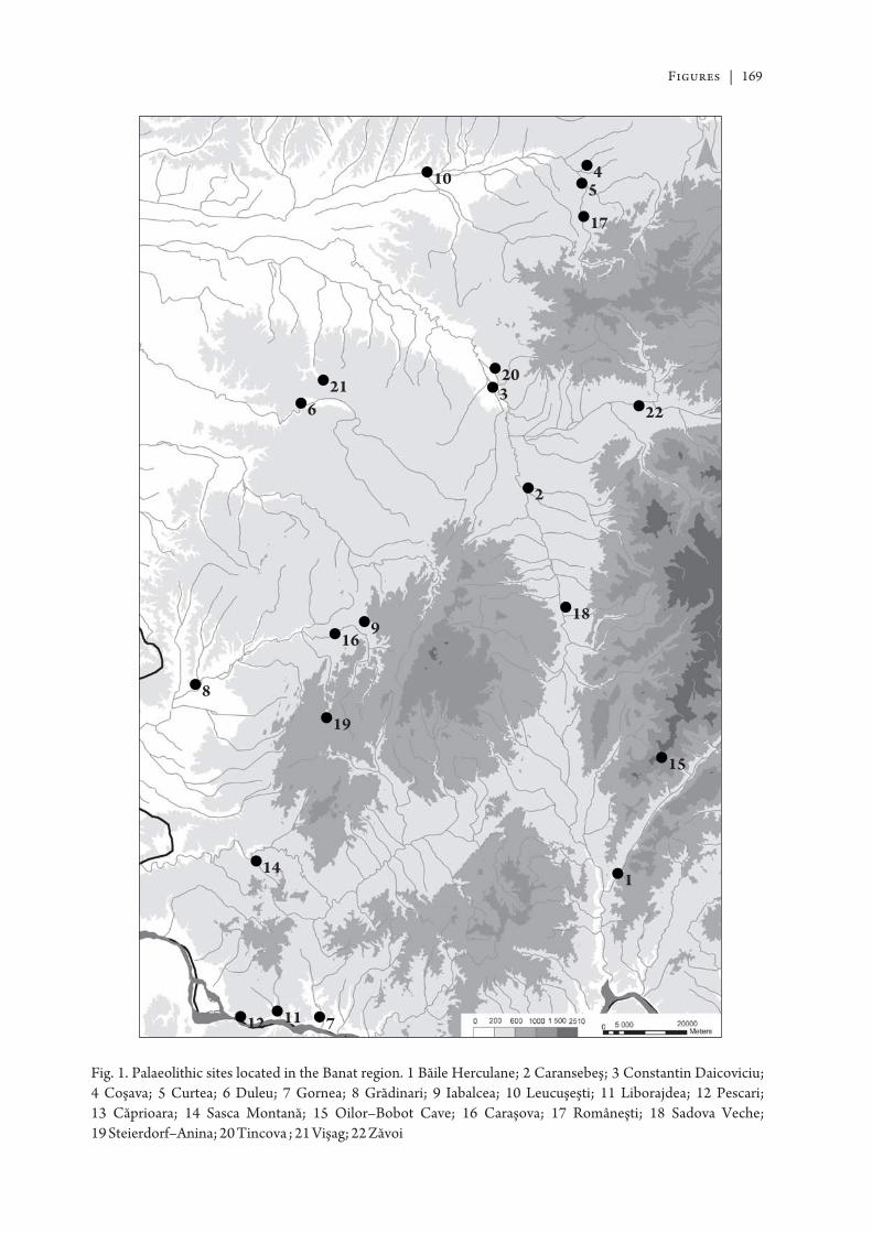
Figures | 169
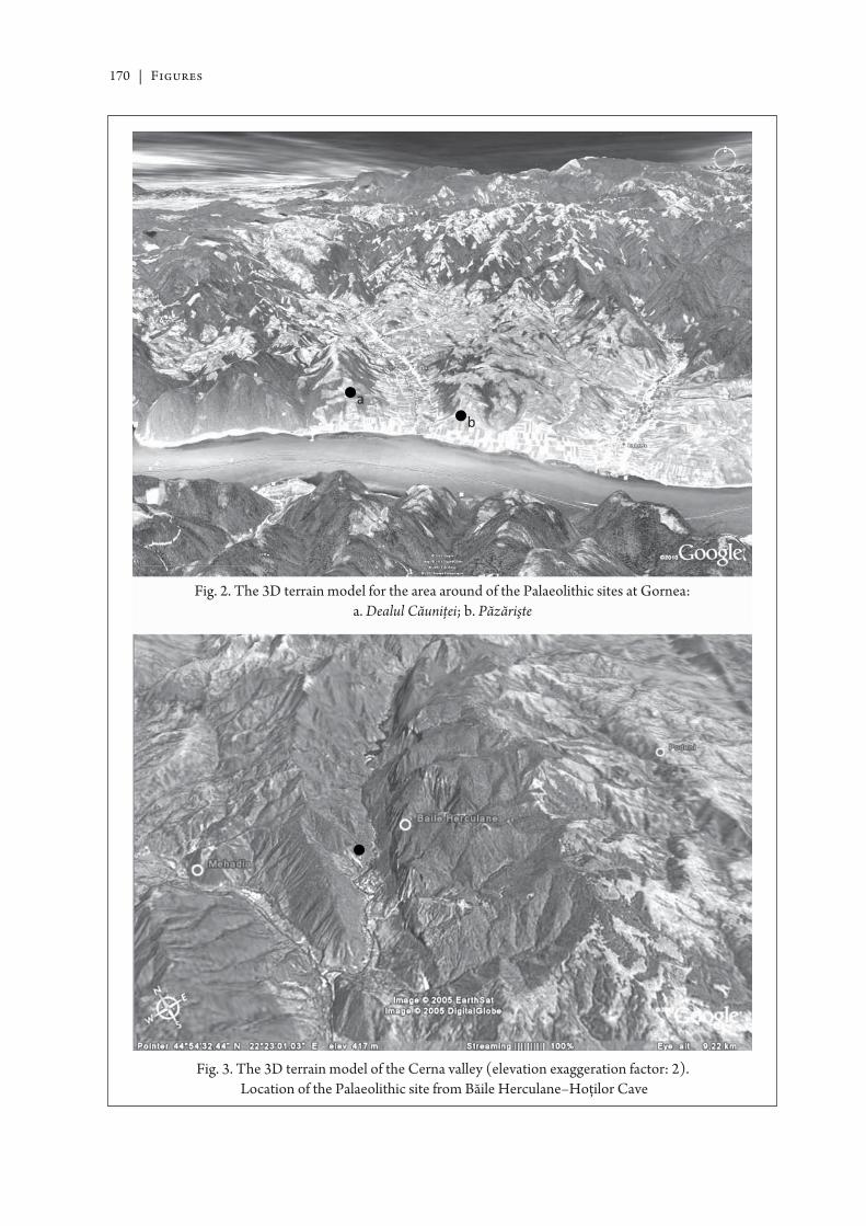
170 | Figures
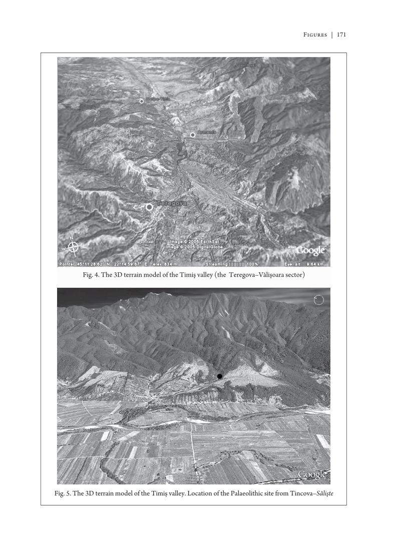
Figures | 171
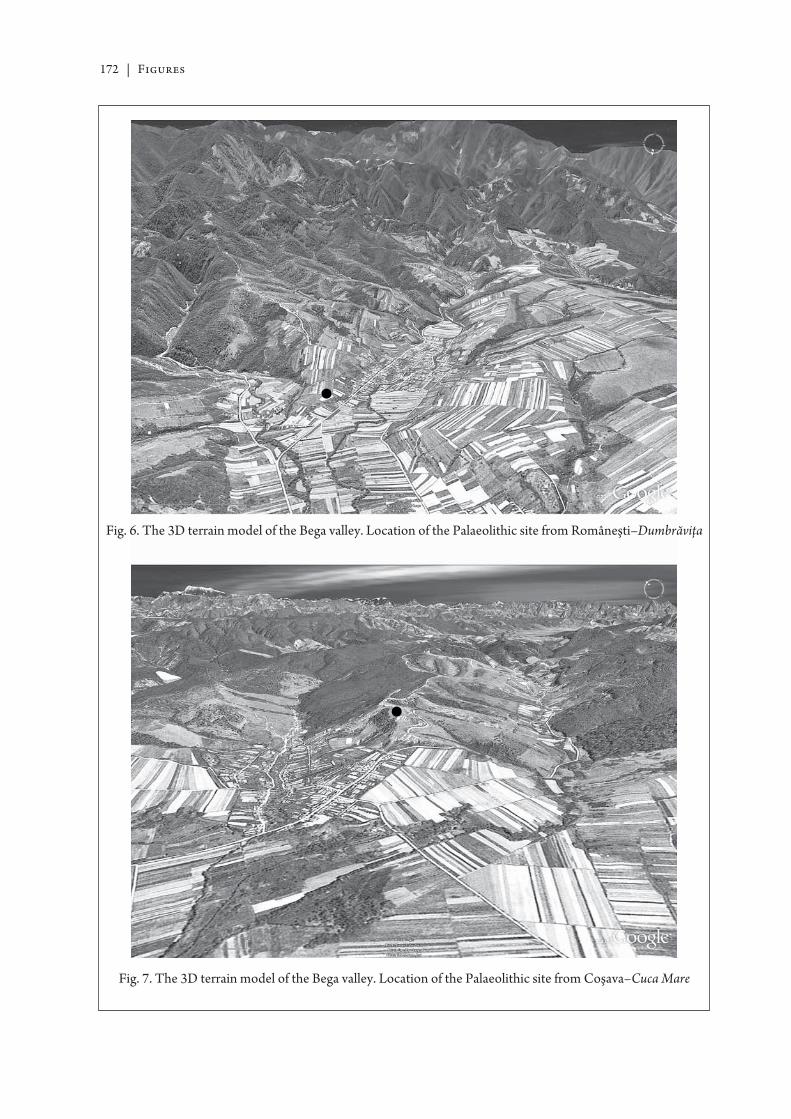
172 | Figures
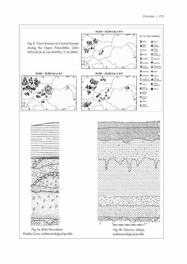
Figures | 173
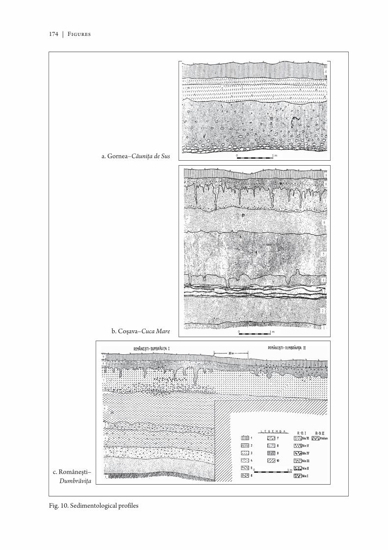
174 | Figures
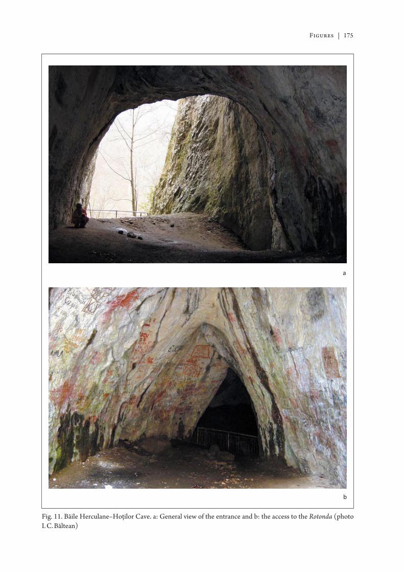
Figures | 175
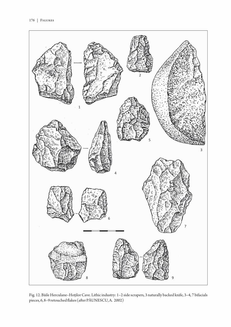
176 | Figures
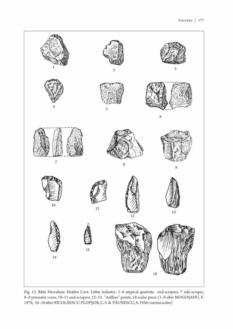
Figures | 177
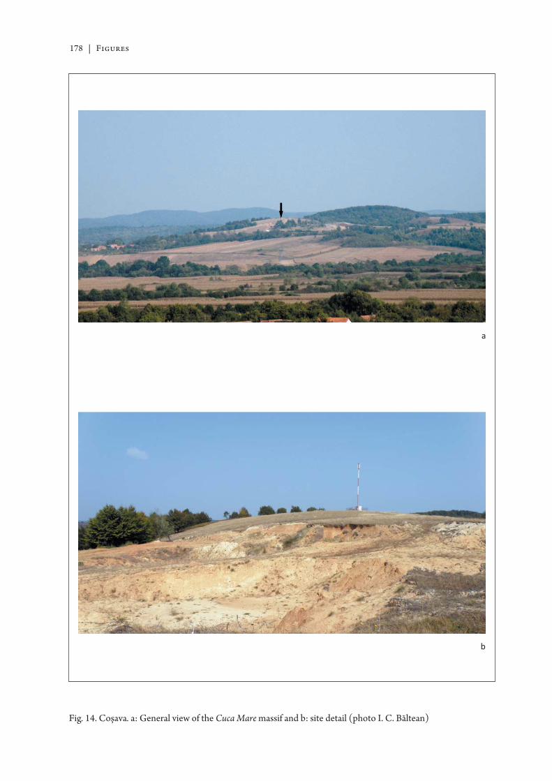
178 | Figures
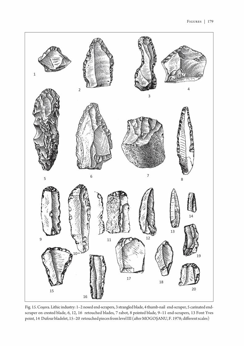
Figures | 179
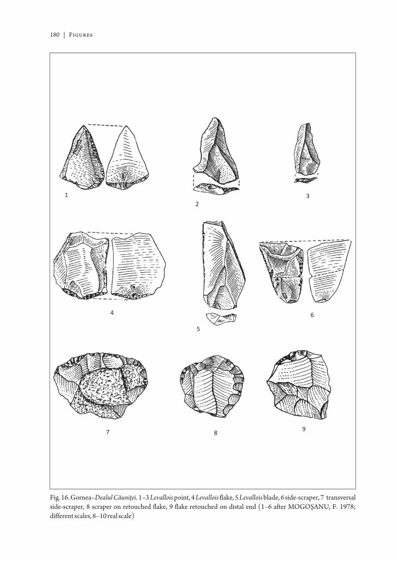
180 | Figures
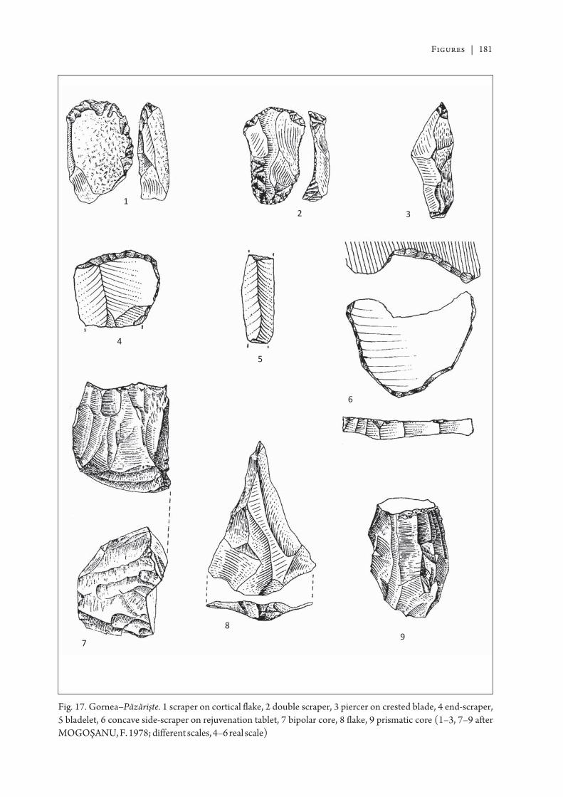
Figures | 181
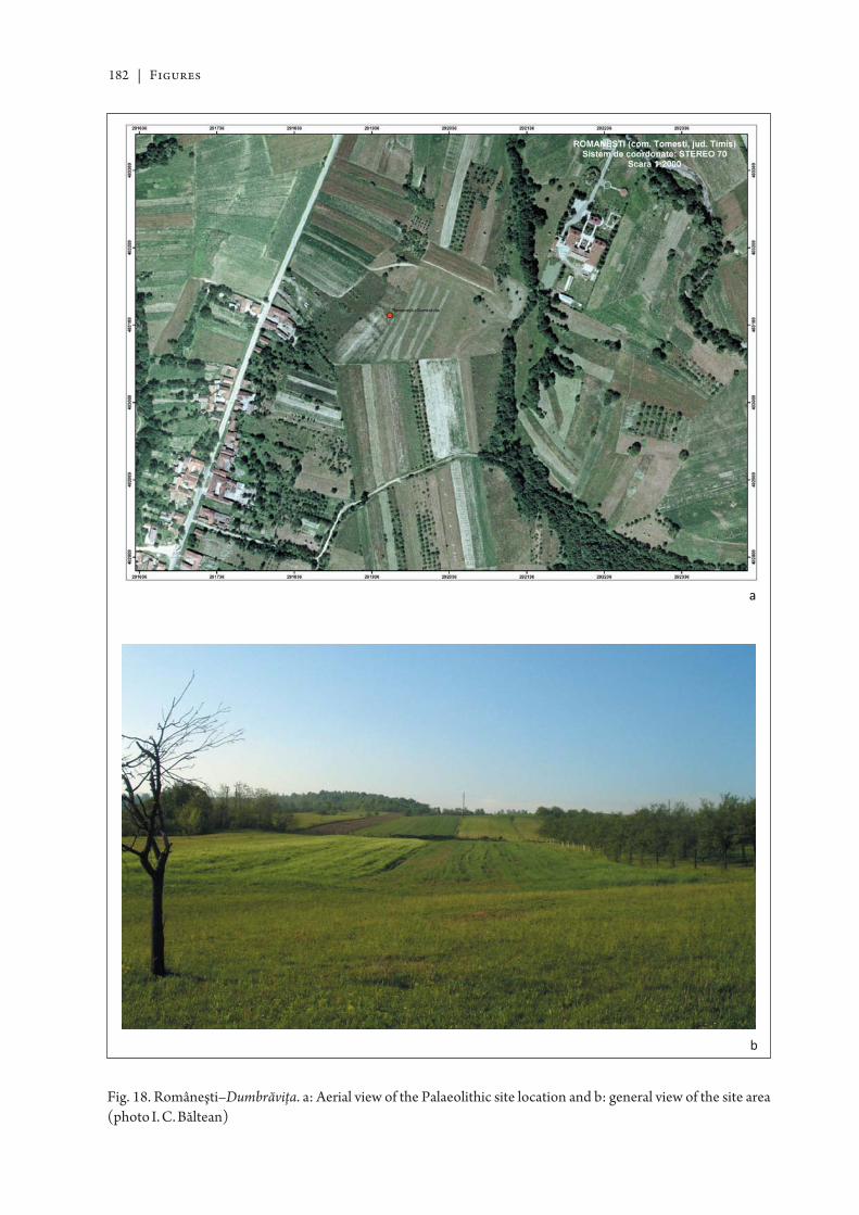
182 | Figures
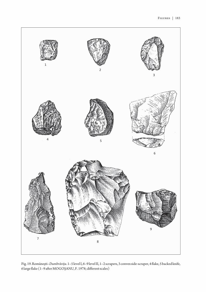
Figures | 183
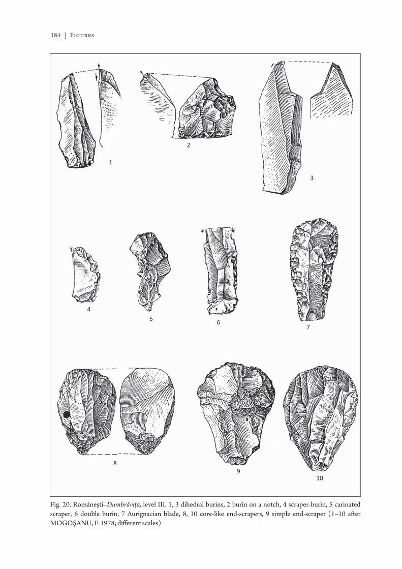
184 | Figures
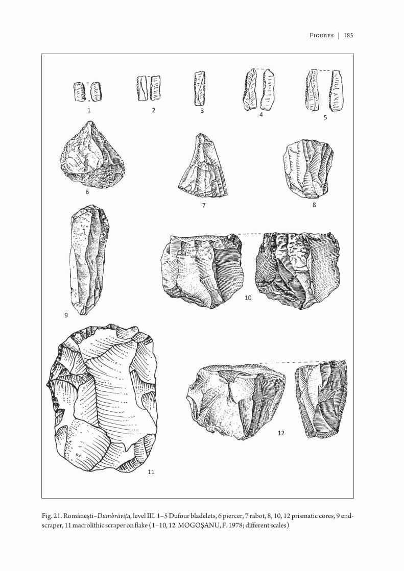
Figures | 185
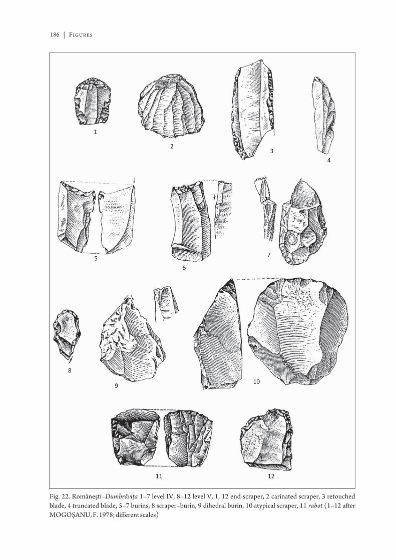
186 | Figures
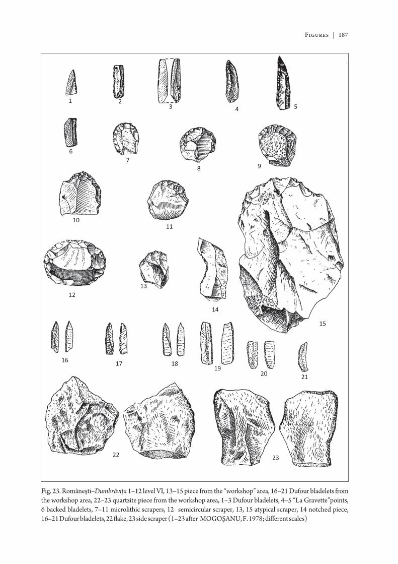
Figures | 187
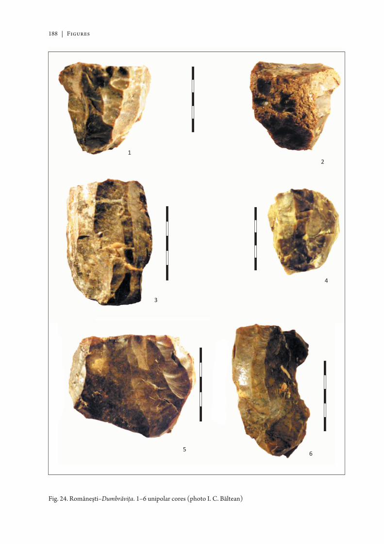
188 | Figures

Figures | 189
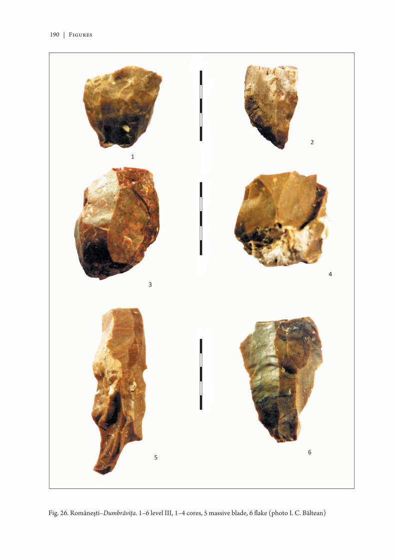
190 | Figures
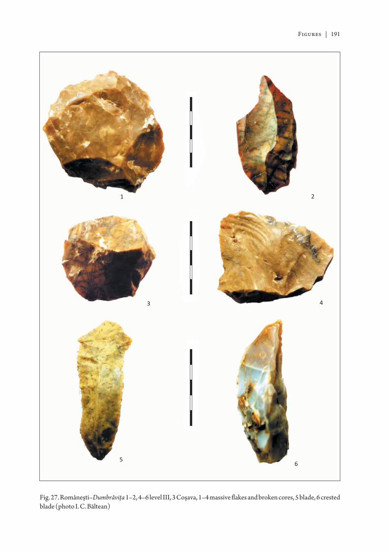
Figures | 191
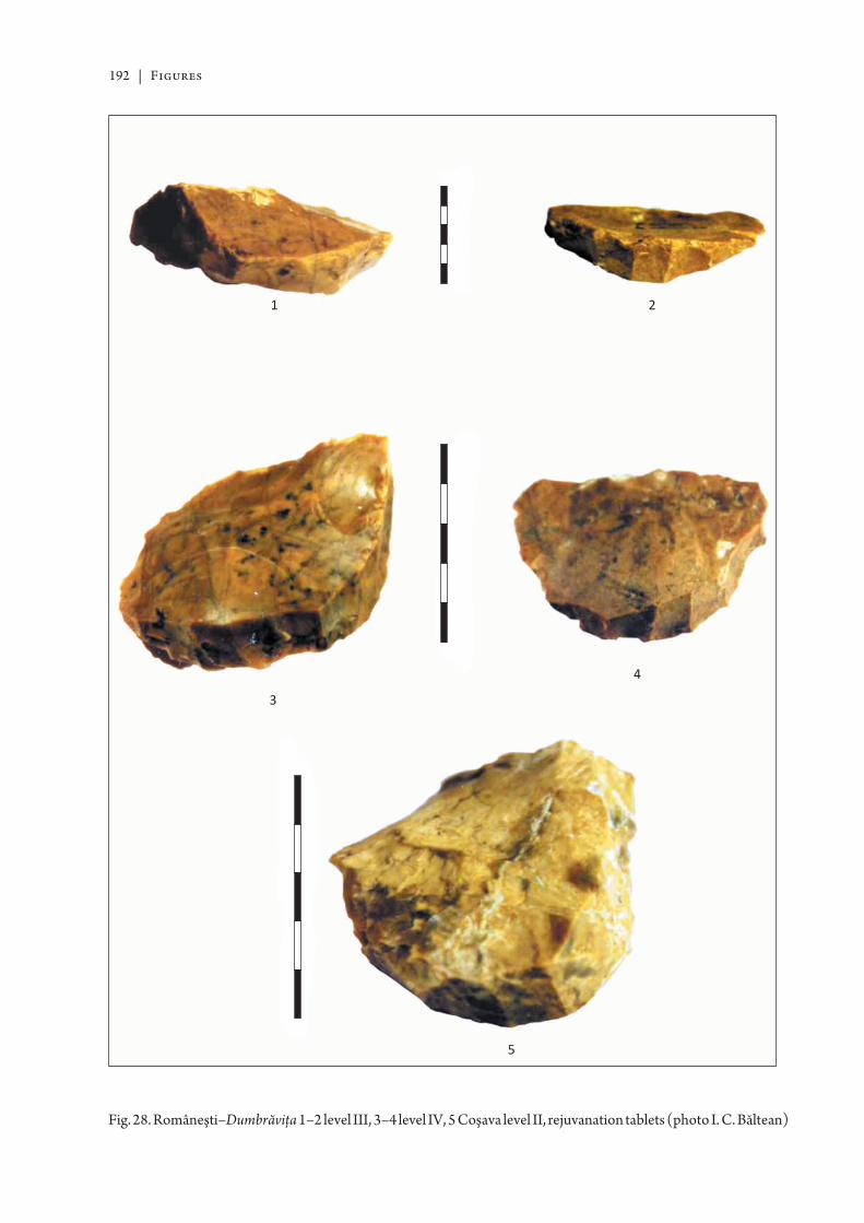
192 | Figures
Figures | 193
194 | Figures
Figures | 195
196 | Figures
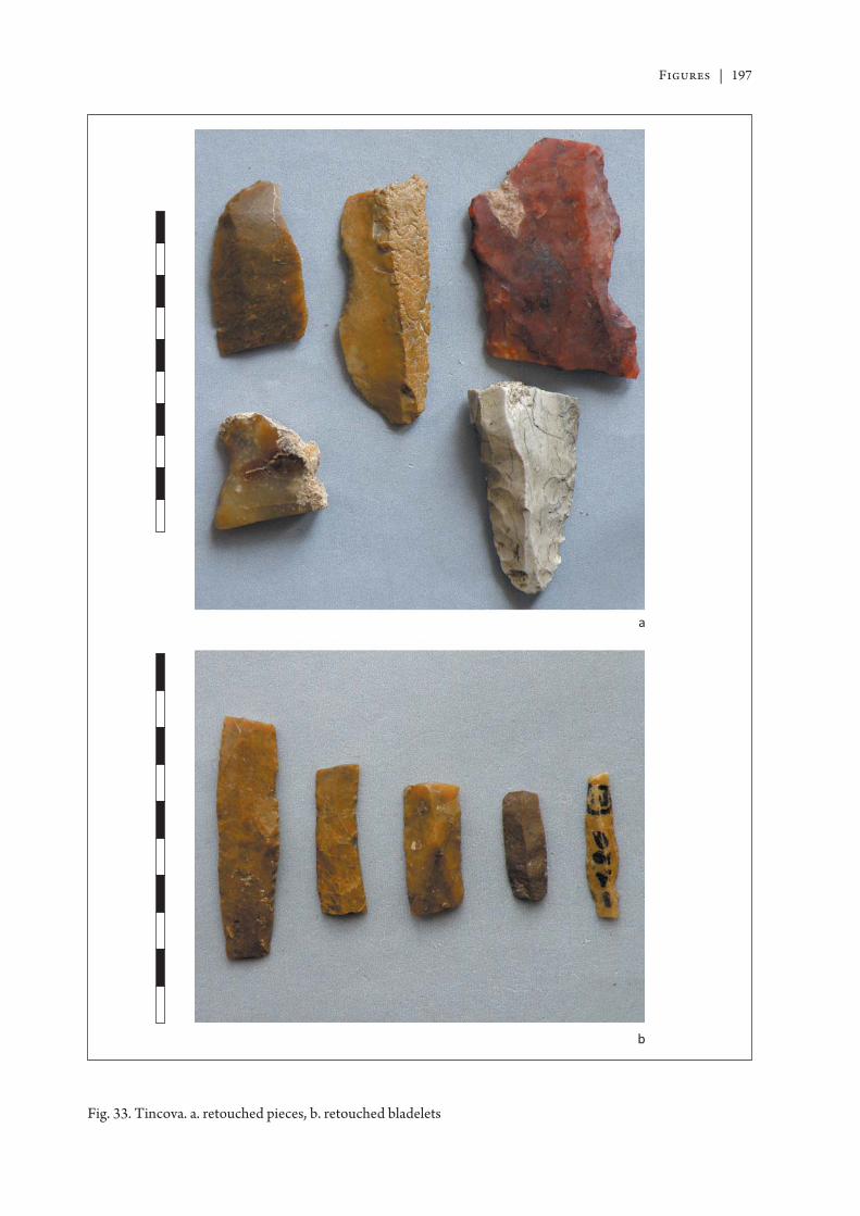
Figures | 197
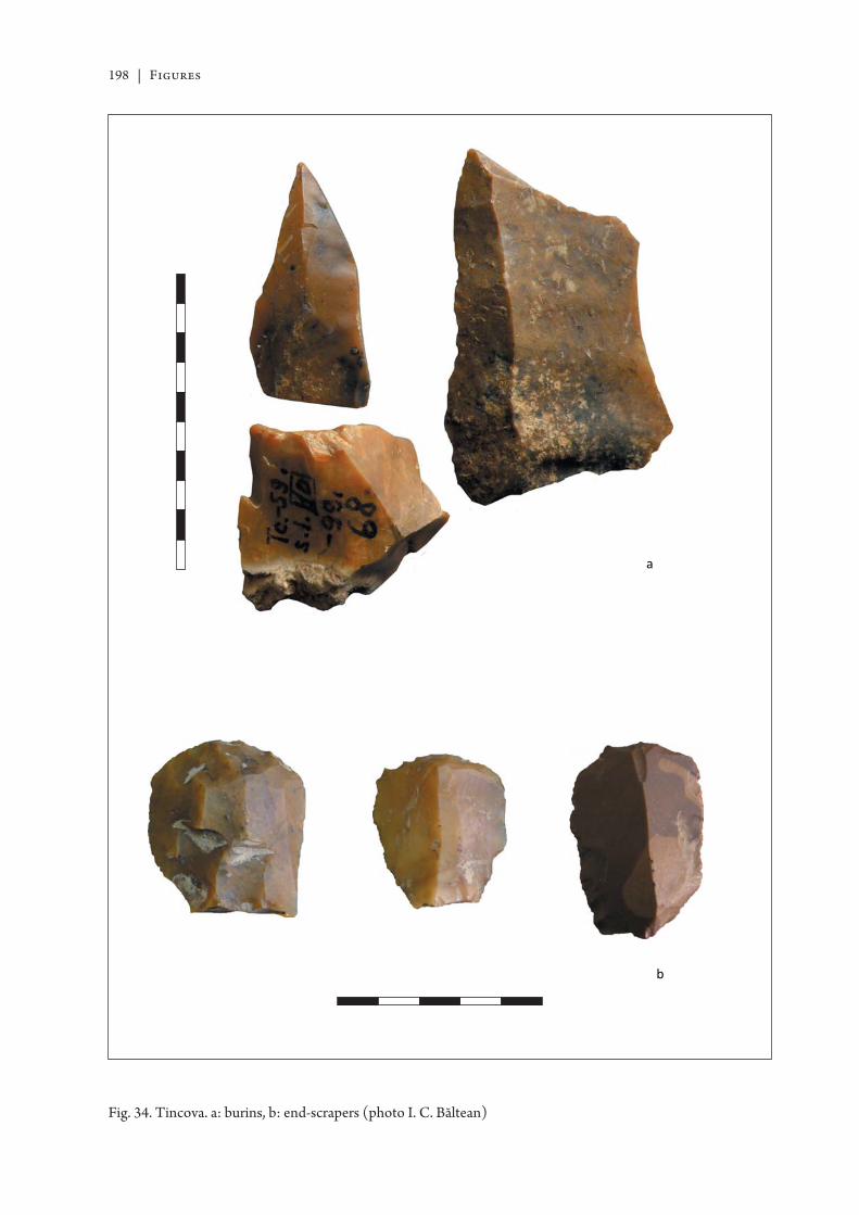
198 | Figures
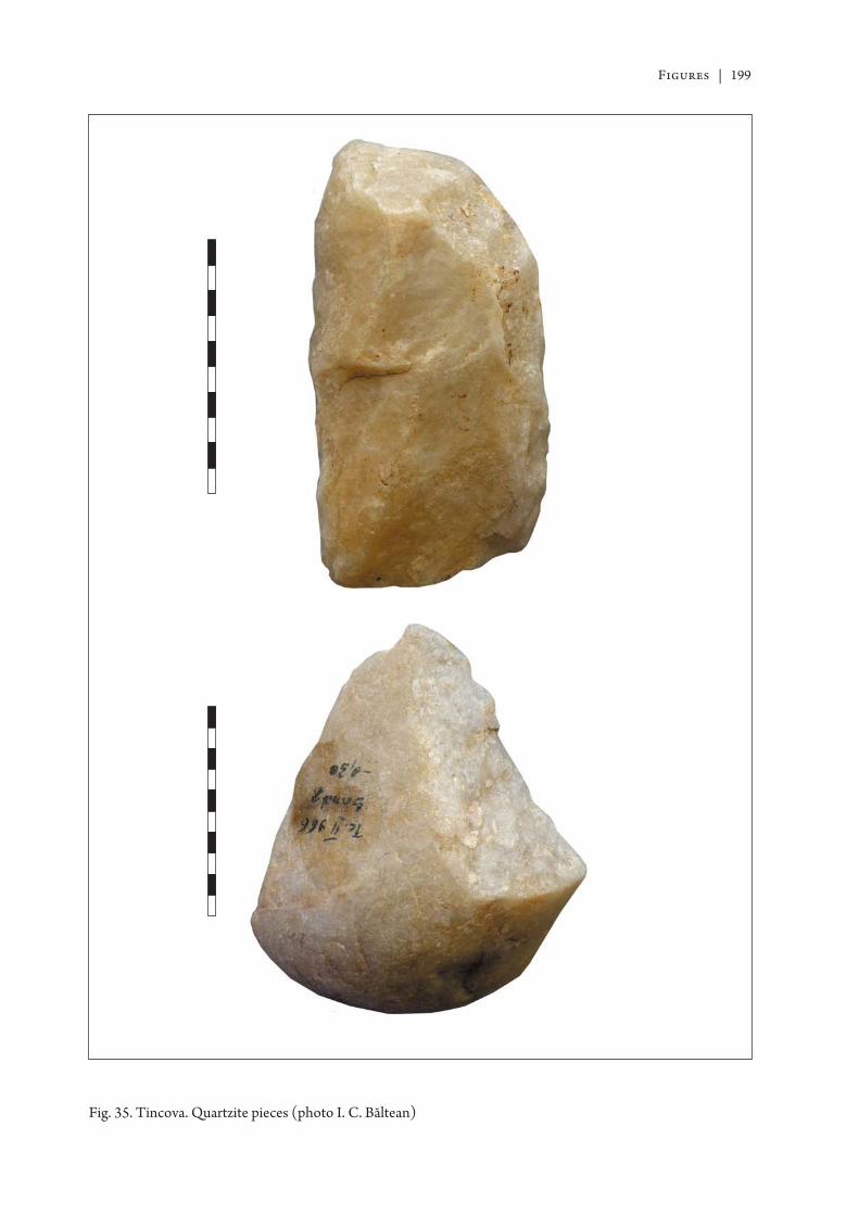
Figures | 199
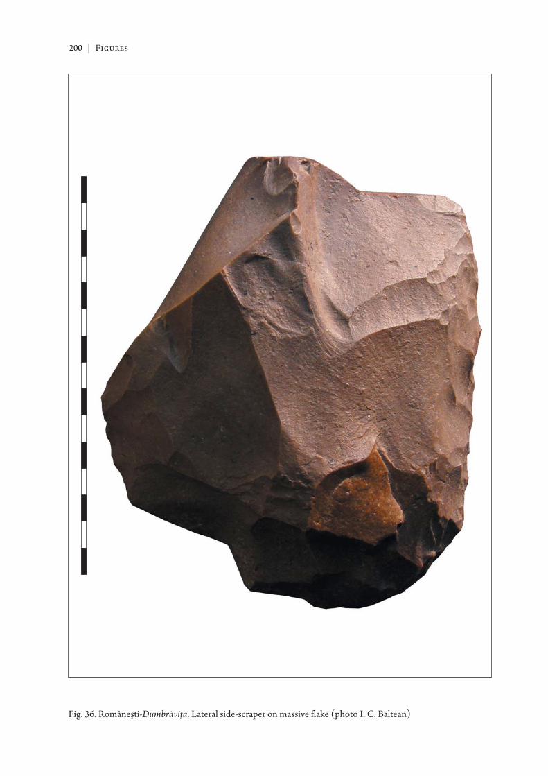
200 | Figures
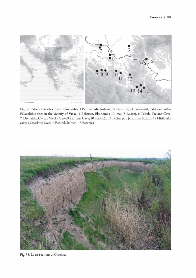
Figures | 201
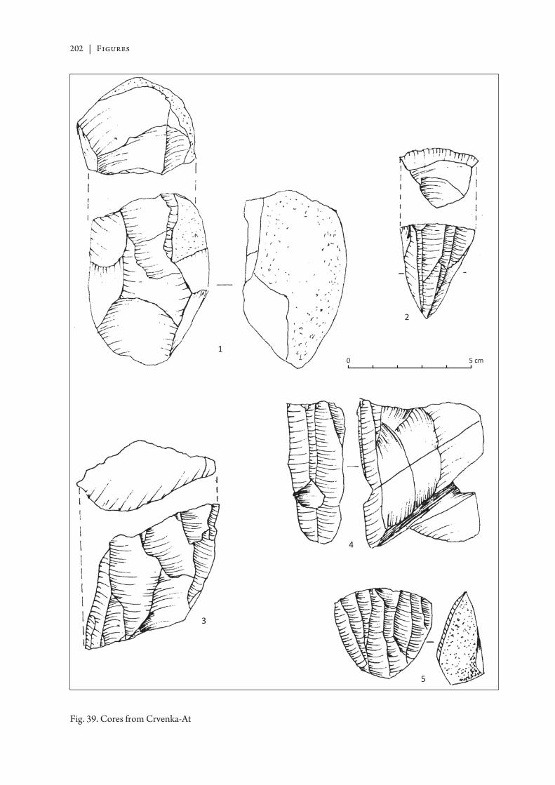
202 | Figures
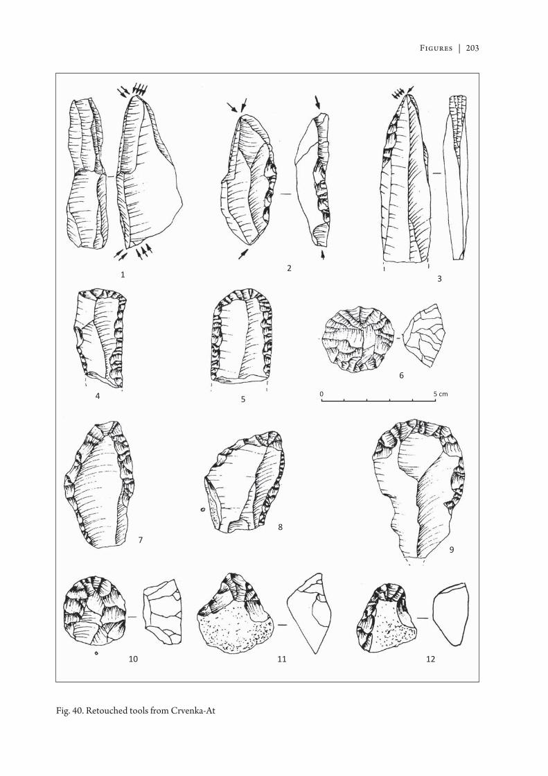
Figures | 203
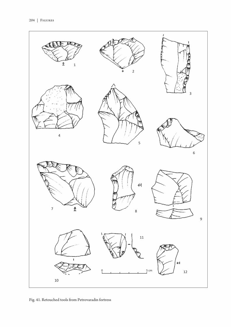
204 | Figures
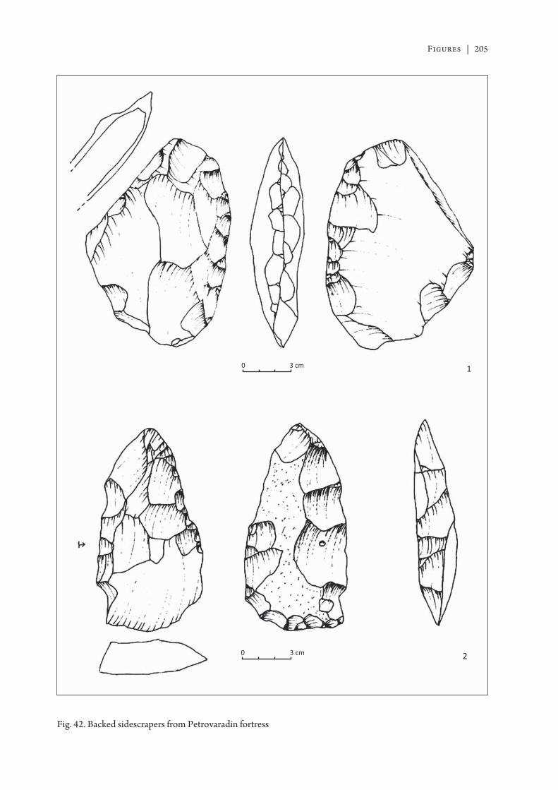
Figures | 205
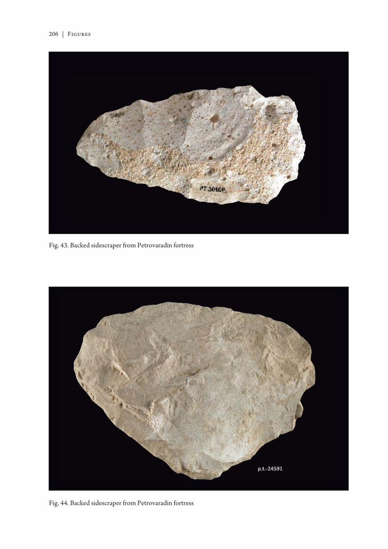
206 | Figures
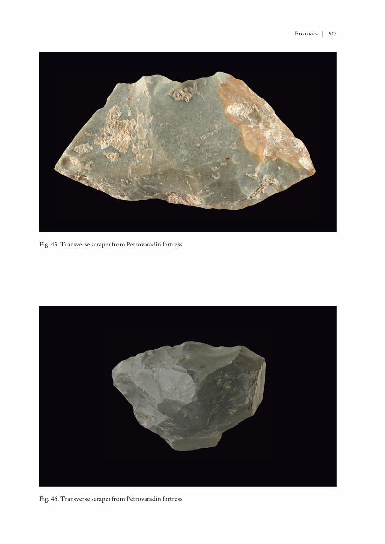
Figures | 207
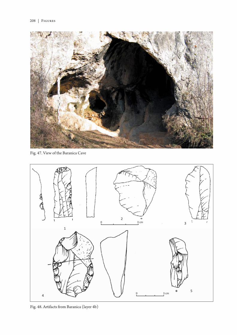
208 | Figures
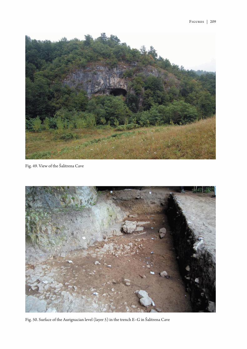
Figures | 209
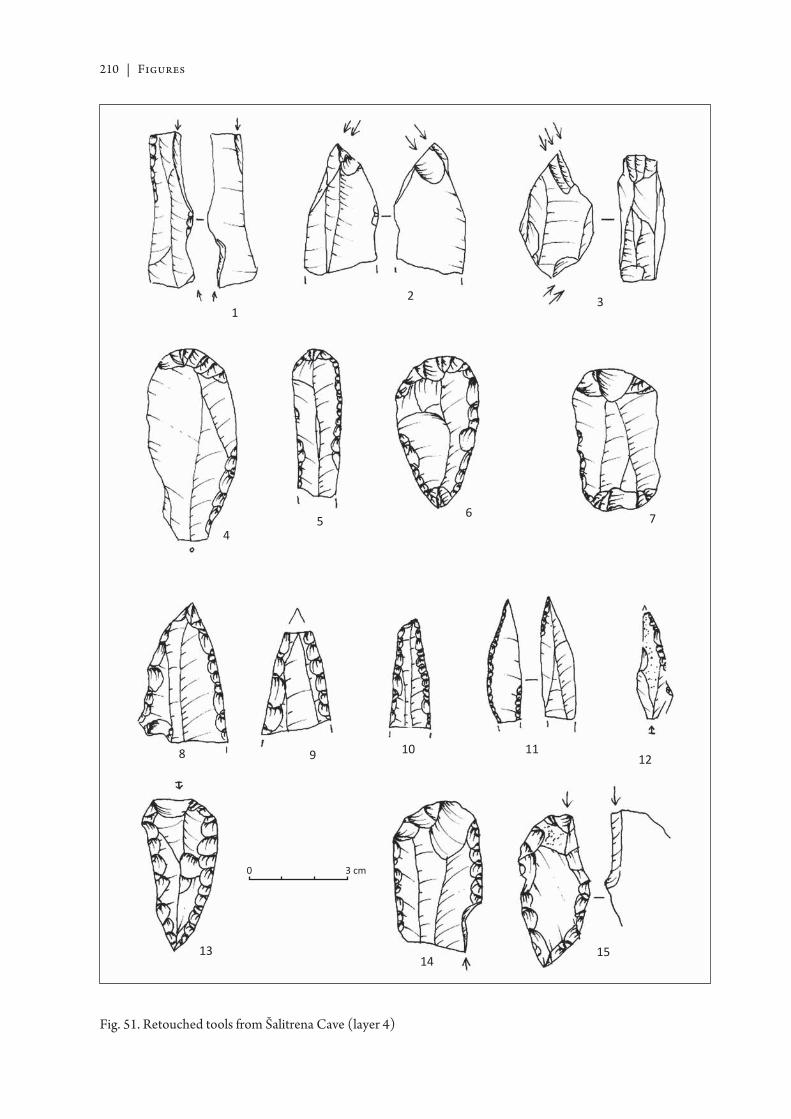
210 | Figures
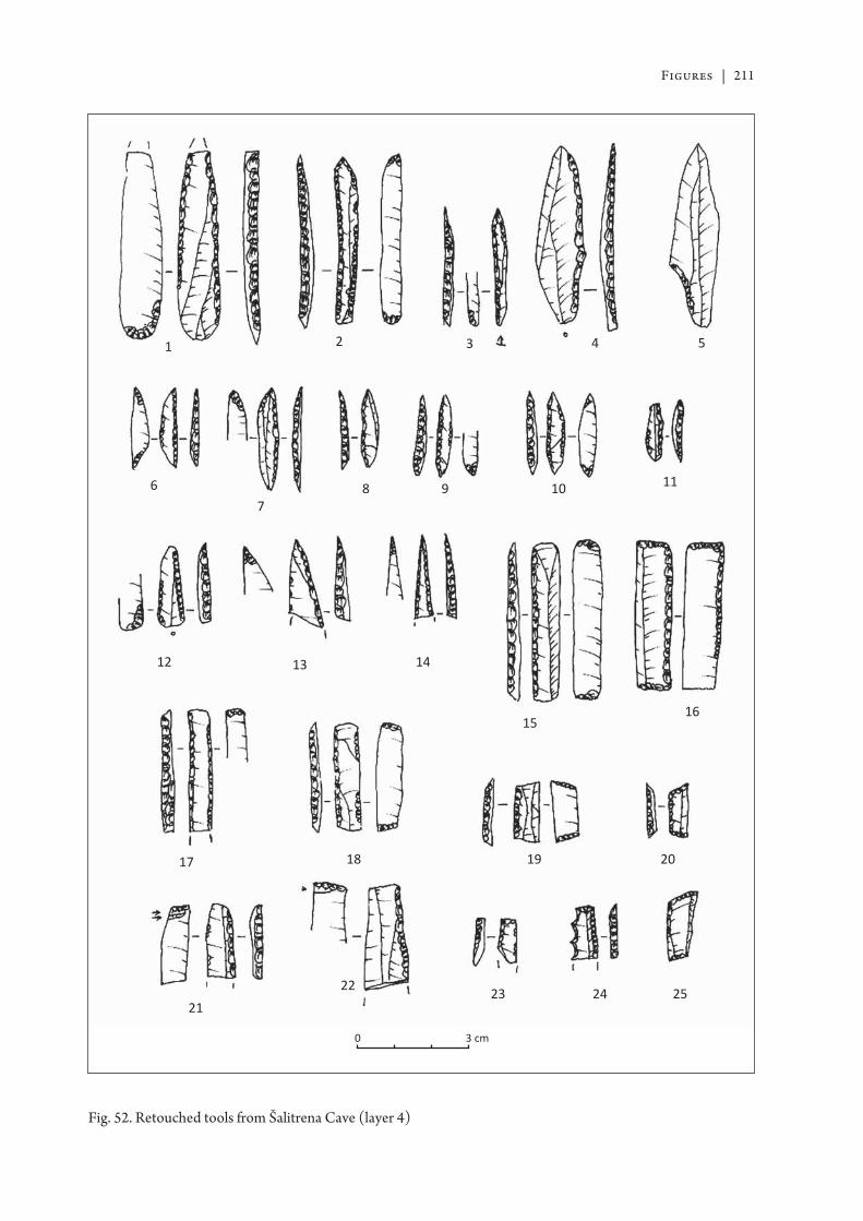
Figures | 211
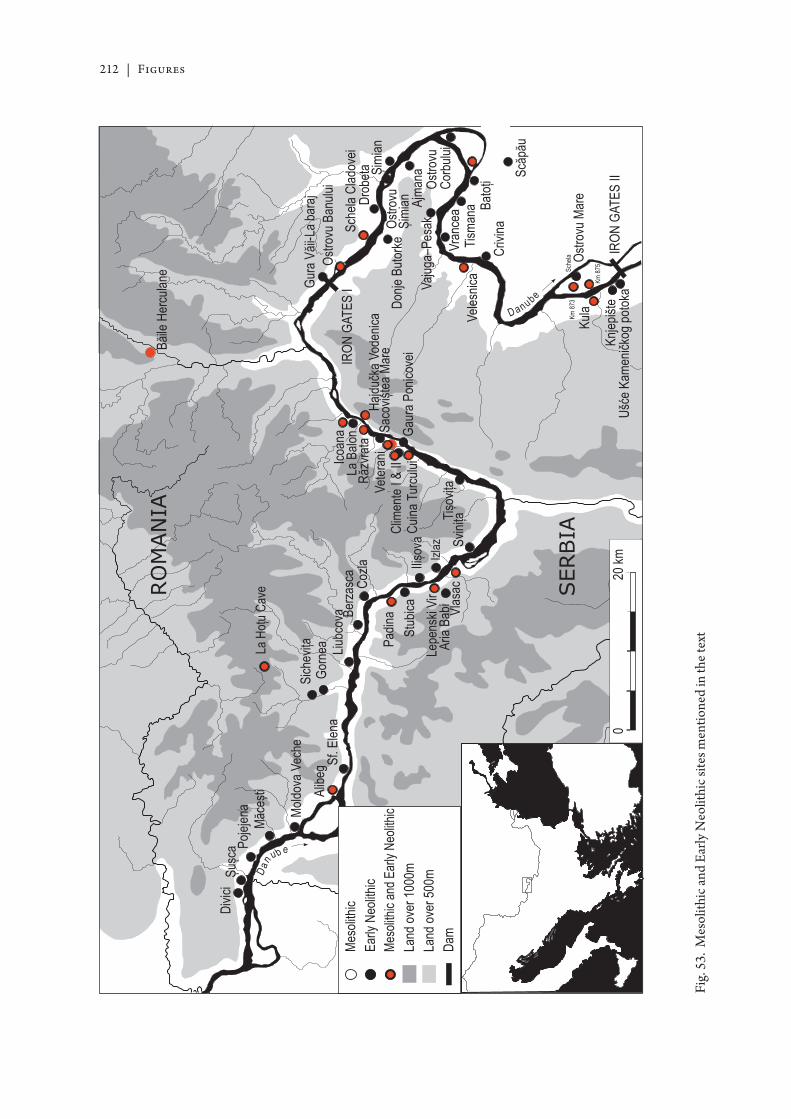
212 | Figures
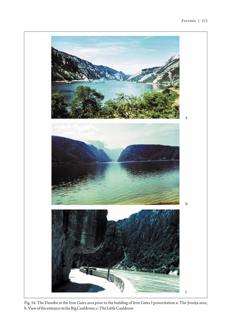
Figures | 213
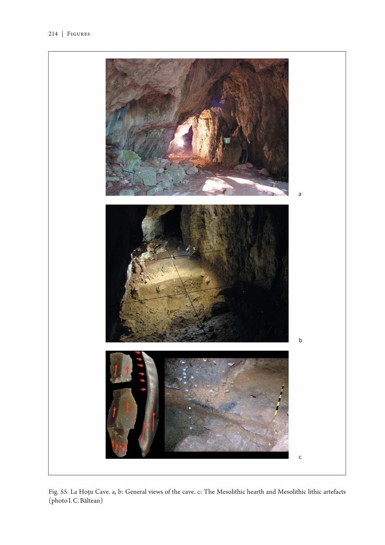
214 | Figures
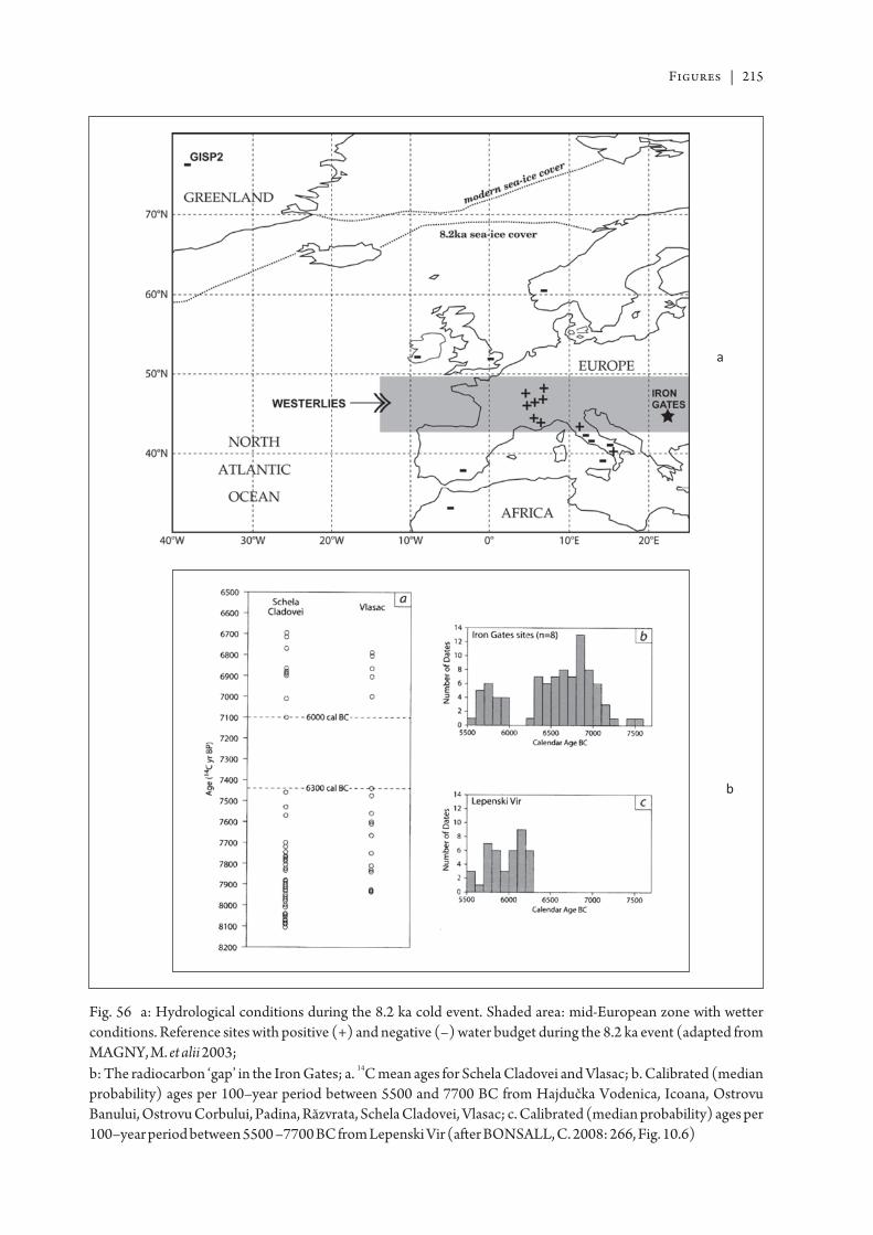
Figures | 215
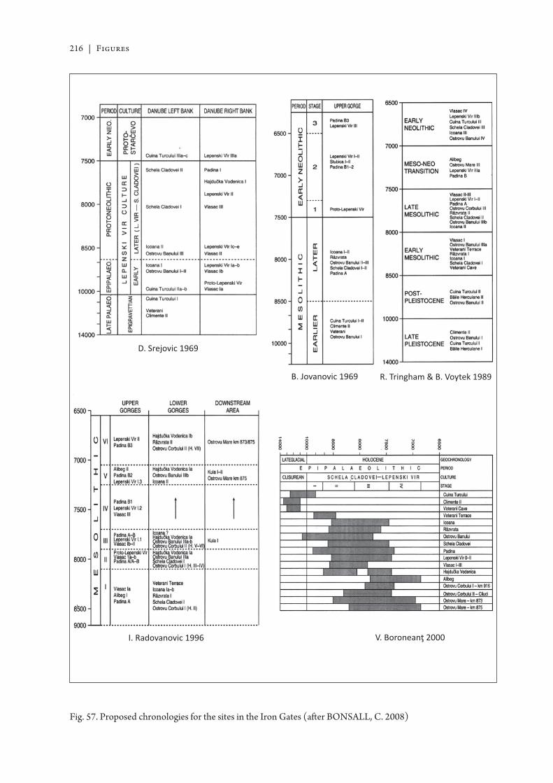
216 | Figures
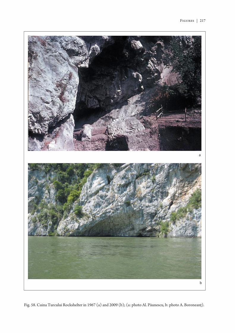
Figures | 217
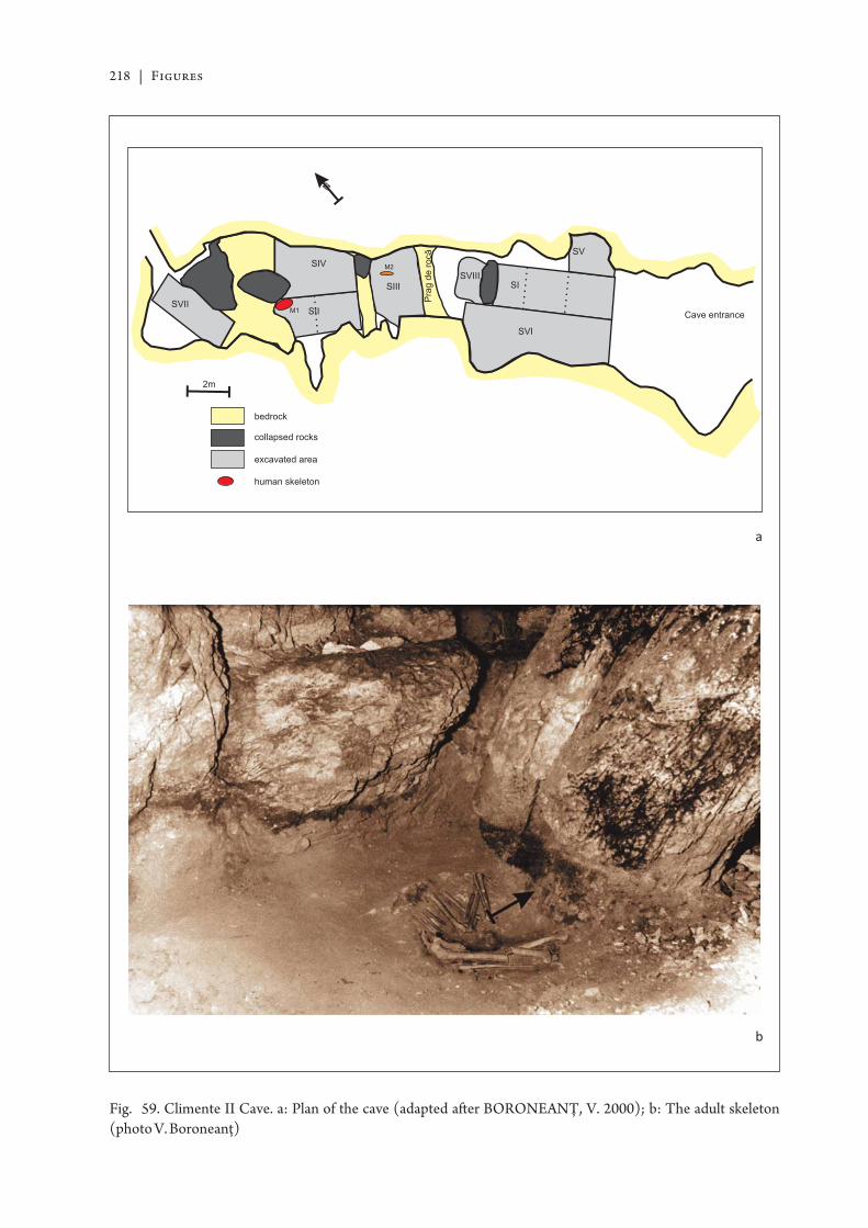
218 | Figures
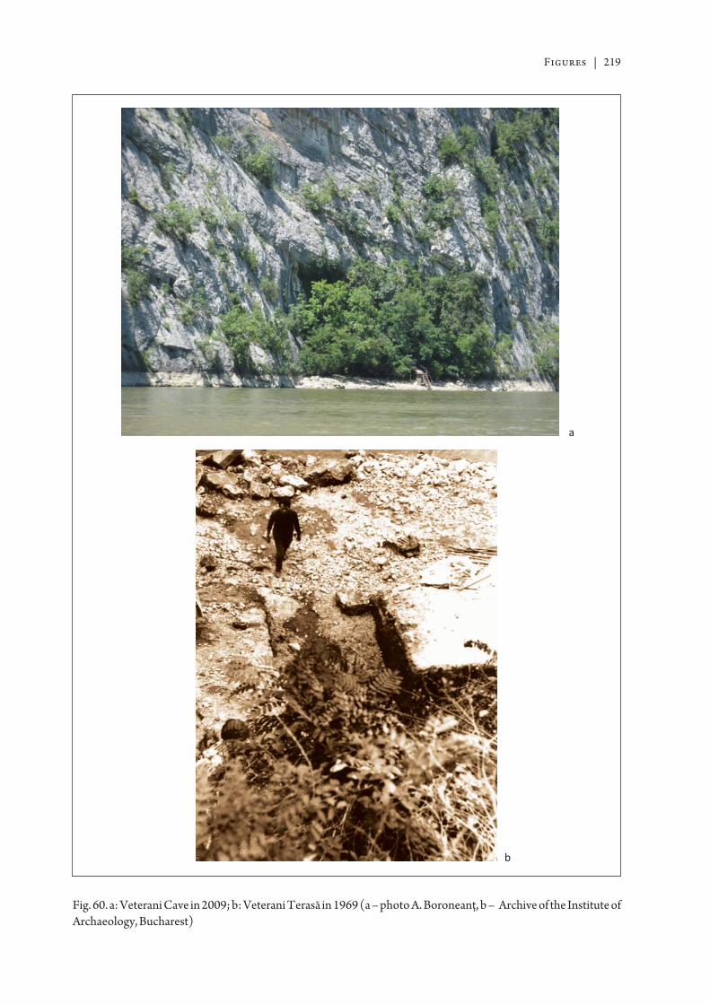
Figures | 219
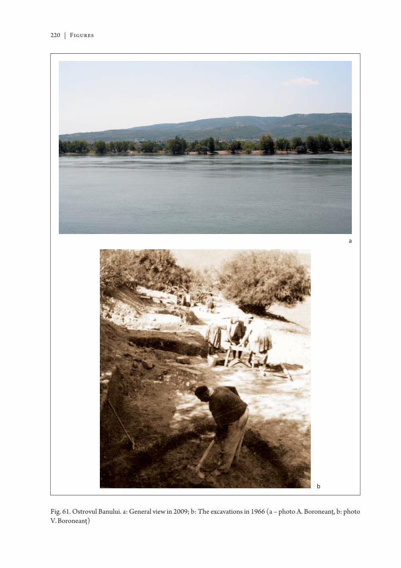
220 | Figures
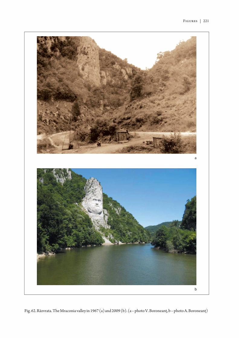
Figures | 221
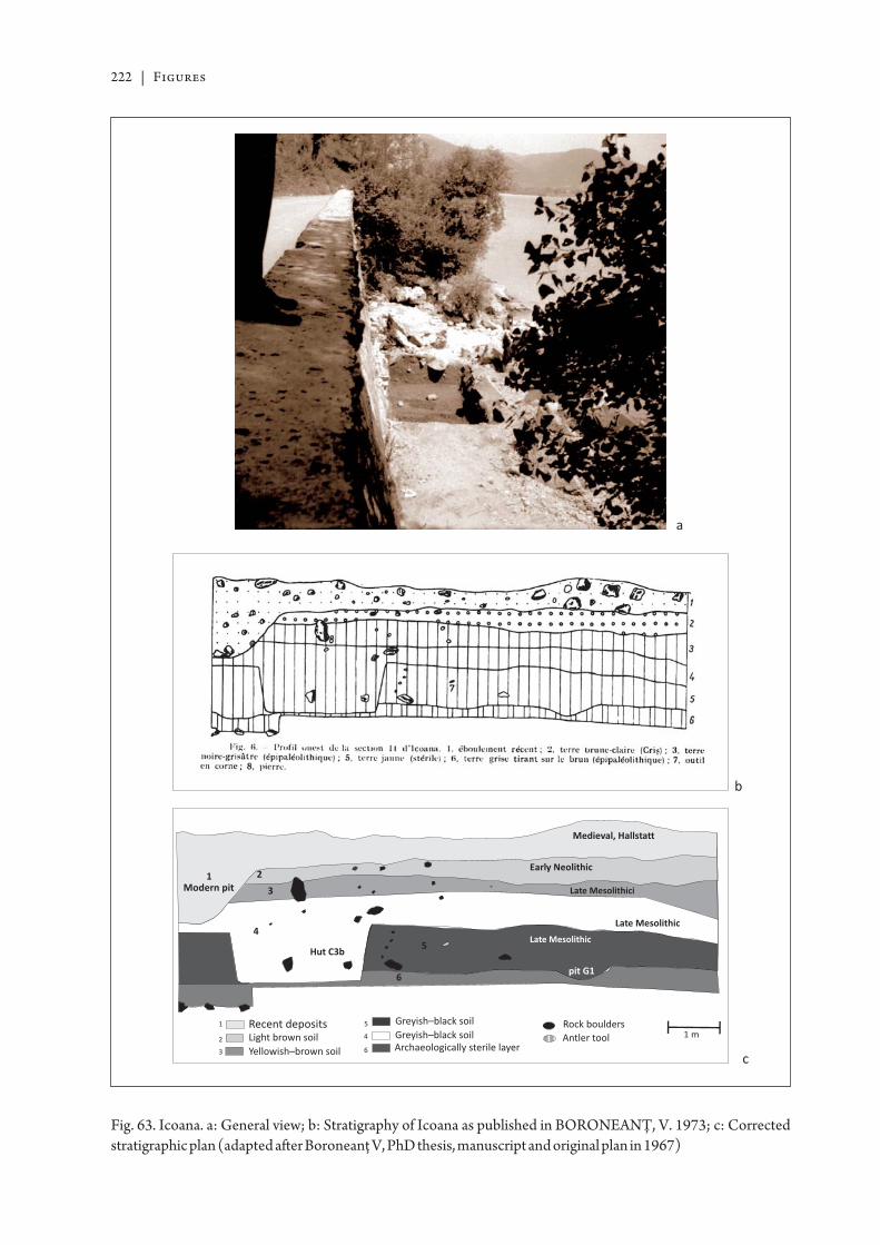
222 | Figures
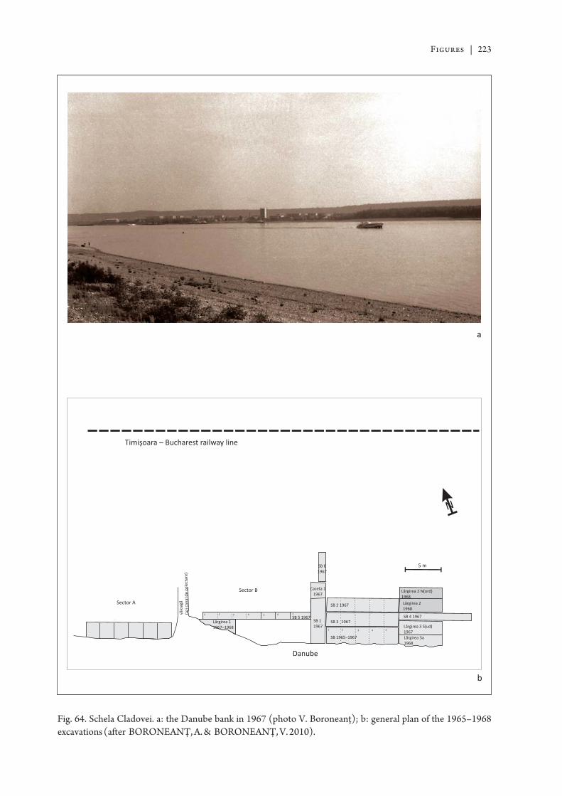
Figures | 223
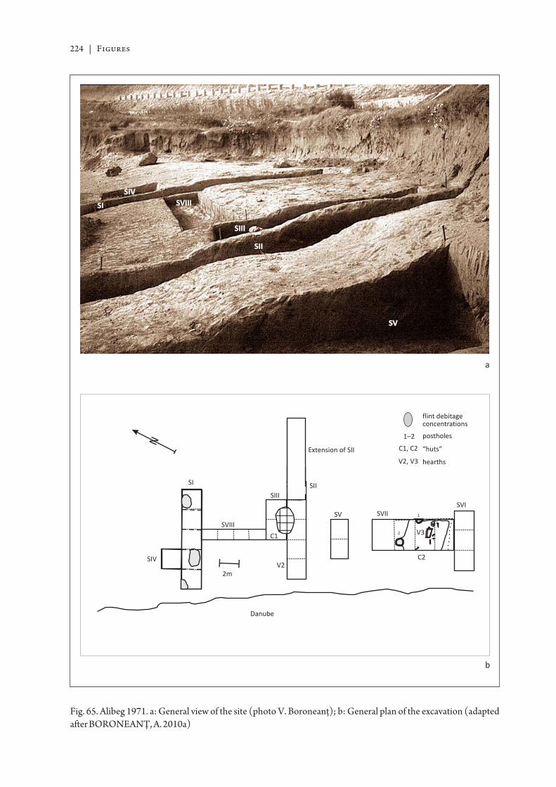
224 | Figures
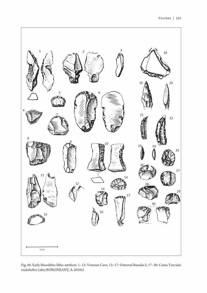
Figures | 225
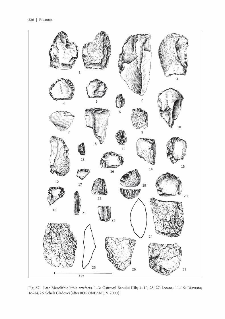
226 | Figures
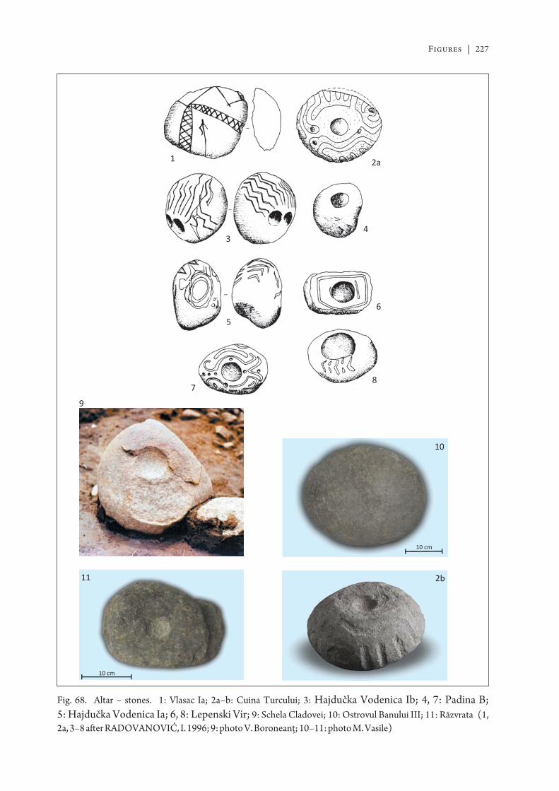
Figures | 227
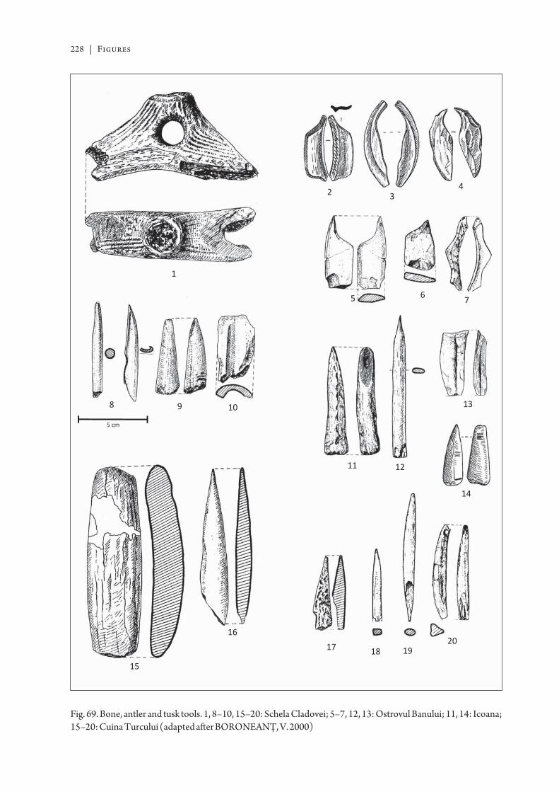
228 | Figures
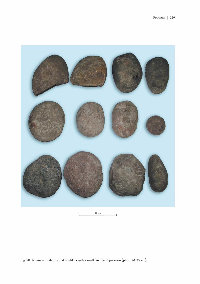
Figures | 229
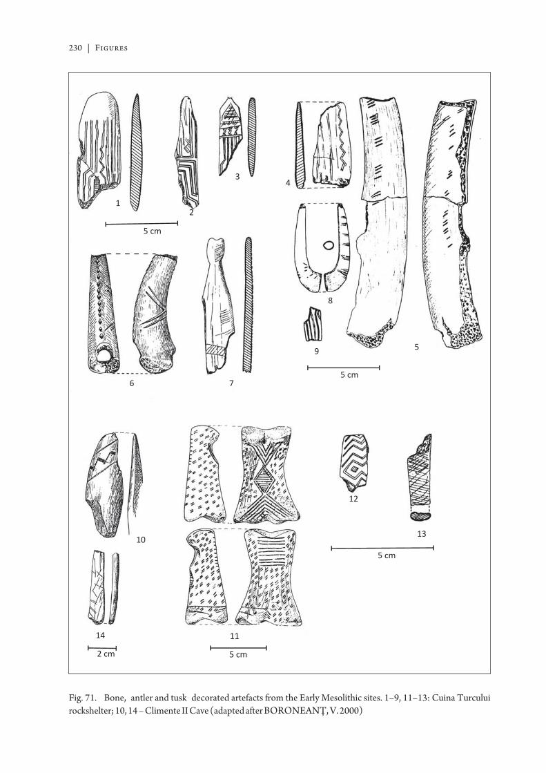
230 | Figures
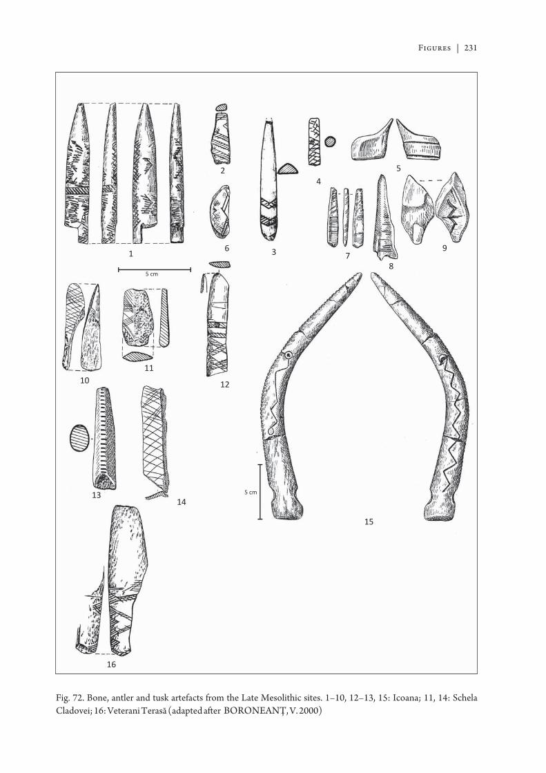
Figures | 231
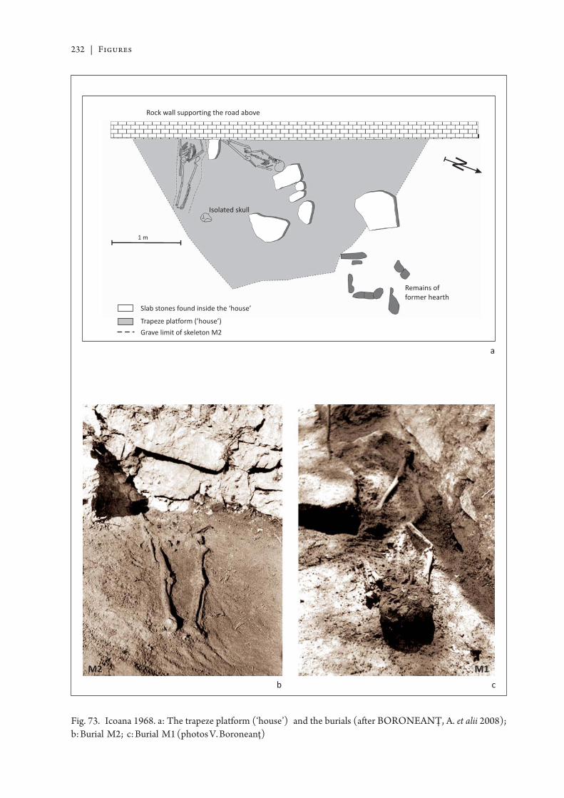
232 | Figures
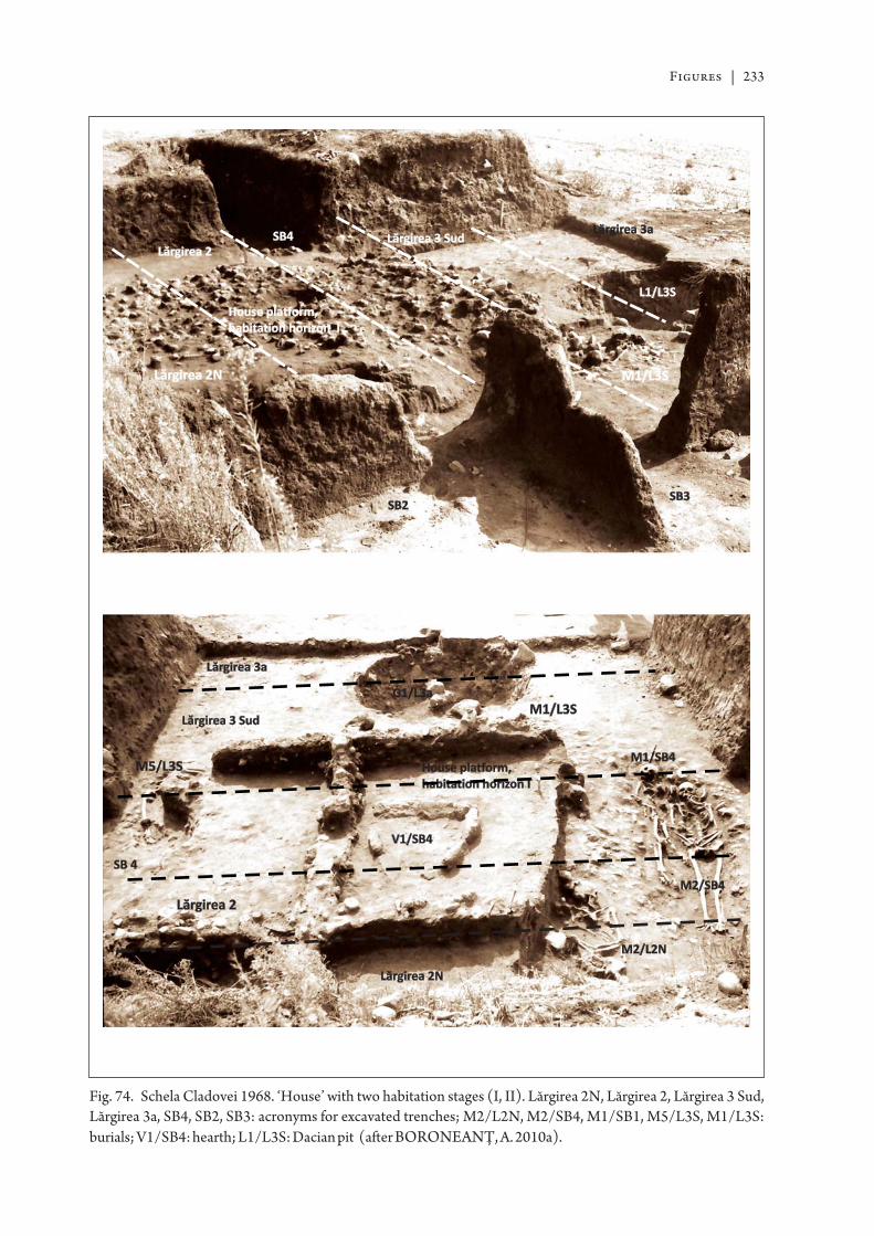
Figures | 233
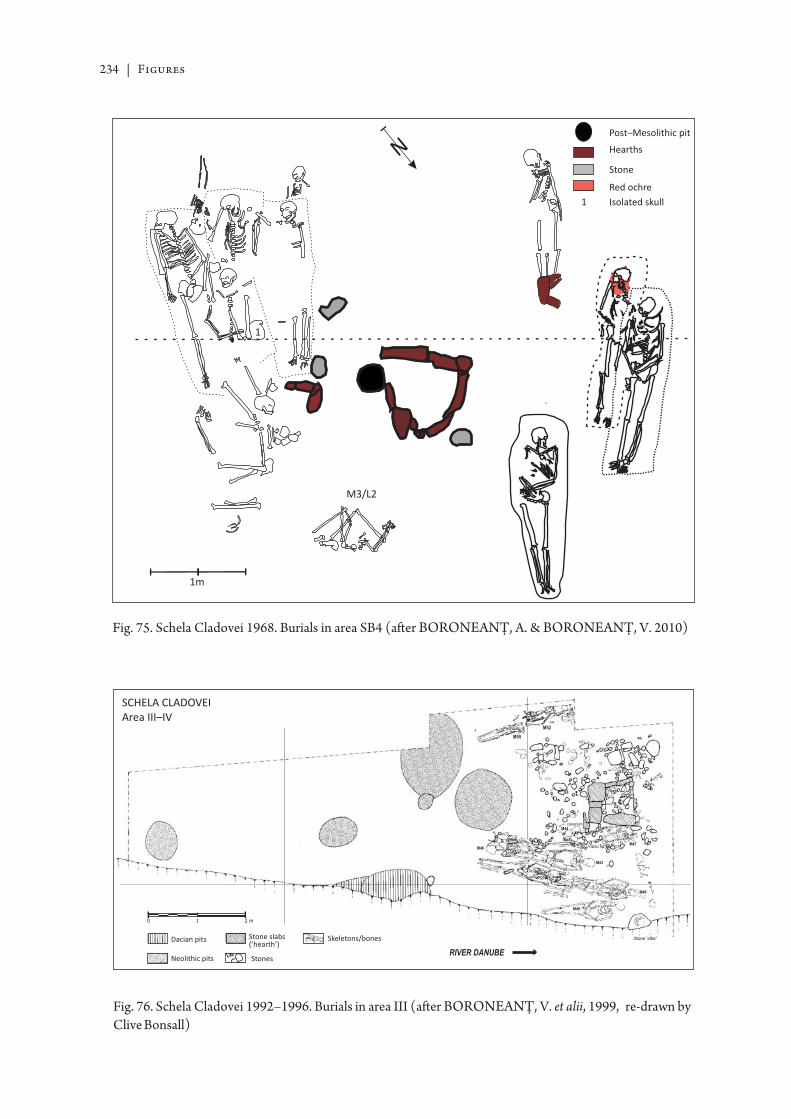
234 | Figures
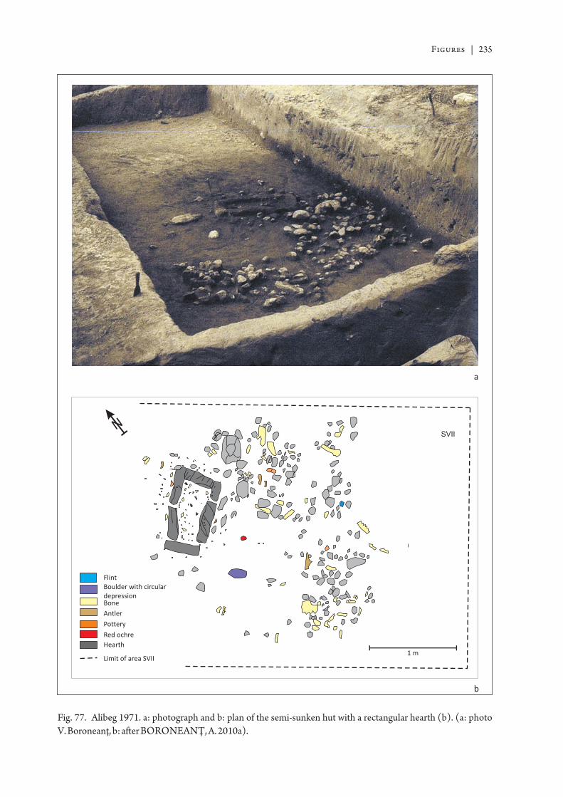
Figures | 235