Embed Size (px)
Citation preview
1
FOOD AND AGRICULTURE ORGANIZATION OF THE UNITED NATIONS
The Global Administrative Unit Layers GAUL 2015
Technical Aspects of the GAUL Distribution Set
GAUL/ Doc 01
19/12/2014
Statistics Division (ESS) - Economic and Social Development Department
GAUL 2015 – Technical Aspects of the GAUL Distribution Set
2
TABLE OF CONTENTS
OBJECTIVE..................................................................................................................................................... 3
GAUL OVERVIEW .......................................................................................................................................... 4
1. OVERALL METHODOLOGY ............................................................................................................... 5
2. GAUL LIFETIME AND PERIODICITY OF THE RELEASES ...................................................................... 5
3. FILENAMES OF THE GAUL SET ......................................................................................................... 5
STRUCTURE OF THE GAUL SET...................................................................................................................... 7
4. GEOGRAPHIC FEATURES .................................................................................................................. 7
5. ATTRIBUTE TABLE ............................................................................................................................ 8
5.1 CODING SYSTEM ..................................................................................................................... 9
5.2 OTHER INFORMATION INCLUDED IN THE ATTRIBUTE TABLE ............................................... 11
6. DATA ASSOCIATED TO THE GAUL SET ........................................................................................... 11
6.1 GROUPINGS .......................................................................................................................... 12
6.2 INTERNATIONAL COUNTRY CODES AND ATTRIBUTES .......................................................... 12
6.3 LAST UPDATE ........................................................................................................................ 13
6.4 ADMINISTRATIVE UNITS DENOMINATION ........................................................................... 13
6.5 SALB CODES (provisional matching) ..................................................................................... 13
6.6 OFFICIAL NAMES ................................................................................................................... 14
6.7 UNSETTLED TERRITORIES ...................................................................................................... 14
UPDATING PROTOCOL ................................................................................................................................ 15
7. UPDATES OF ADMINISTRATIVE UNITS NOT AFFECTING LOWER LEVELS ....................................... 15
7.1 CREATION OF A NEW ADMINISTRATIVE UNIT (SPLIT) .......................................................... 15
7.2 DELETION OF AN ADMINISTRATIVE UNIT (MERGE) .............................................................. 16
8. UPDATES OF ADMINISTRATIVE UNITS AFFECTING LOWER LEVELS ............................................... 16
8.1 Modified Coordinates of the Boundaries ............................................................................. 16
9. RENAMING OF ADMINISTRATIVE UNITS ....................................................................................... 17
10. UNSETTLED TERRITORIES .......................................................................................................... 18
11. PROCEDURES ............................................................................................................................ 19
11.1 IDENTIFICATION AND SELECTION OF DATA .......................................................................... 20
11.2 CREATION AND UPDATING OF GAUL SET ............................................................................. 20
GAUL CONTACTS ........................................................................................................................................ 21
GAUL 2015 – Technical Aspects of the GAUL Distribution Set
3
OBJECTIVE
The Global Administrative Unit Layers (GAUL) is an initiative implemented by FAO within the financial
support of the Bill & Melinda Gates Foundation, Agricultural Market Information System (AMIS) and
AfricaFertilizer.org. GAUL aims at compiling and disseminating the most reliable spatial information on
administrative units for all countries in the world. GAUL intends to a) overcome the fragmentation of
the global dataset occurring when administrative units layers are digitized on a country-by-country
basis, b) promote a unified coding system that reduces maintenance efforts and c) keep historical track
of changes occurring on the shapes and extent of the administrative units. The GAUL provides a
contribution to the standardization of the spatial dataset representing administrative units.
GAUL 2015 – Technical Aspects of the GAUL Distribution Set
4
GAUL OVERVIEW
GAUL aims at delivering global layers with a complete and up-to-date set of units for the first and
second administrative levels. GAUL distributes data of individual countries for more detailed
administrative levels, where available.
The coding system used to identify administrative units maintains vertical and horizontal uniqueness of
the codes: administrative unit codes are numeric and unique within the same level (i.e. communes -
vertical uniqueness) and across levels (i.e. between communes and provinces - horizontal uniqueness).
The main advantage of the GAUL coding system is the low maintenance effort required to synchronize
GAUL codes with external tables and datasets, when changes in administrative units occur. Codes
change when the shapes of the related administrative units are altered.
GAUL codes are unstructured and only used as identifiers of administrative units. Each code does not
include information about its parent administrative unit (i.e. a code of an administrative unit at the first
level does not include its country code a as subset of the number of digits forming the code).
GAUL keeps track of locations, features and names of administrative units changed or dismissed.
Obsolete administrative units are kept in the database and refer to the relevant time interval. As a
result, the database includes overlapping polygons where changes in the shape of the administrative
units occur.
Consequently, the GAUL product is not a single layer but a group of layers, named “GAUL Set”, in which
each layer represents the instance of the administrative units of the world that is valid until a
documented modification of these units has occurred. Each layer of the GAUL Set is associated to the
year in which a re-organization of the administrative units of one or more countries has been made. The
“Reference Year” of a layer of the GAUL Set is the year in which it is known that one or more
administrative unit(s) has been modified and for which older and newer boundaries are available.
Data might not be officially validated by authoritative national sources and can not be distributed to the
general public. A disclaimer should always accompany any use of the GAUL data.
Example:
An administrative unit has been modified in 1999; a new layer having the year 1999 as Reference Year can be added to the
GAUL Set.
GAUL 2015 – Technical Aspects of the GAUL Distribution Set
5
1. OVERALL METHODOLOGY
The implementation of the GAUL initiative is based on a collaborative work among international
agencies and national authorities generating and/or collecting spatial information on administrative
units. The role of FAO is to maintain active this network of collaborators, to evaluate and compile data
from available sources, to establish procedures for data integration, to generate the GAUL codes and to
periodically disseminate the GAUL Set. The overall methodology consists in:
a) collecting the best available data from most reliable sources,
b) establishing validation periods of the geographic features (when possible),
c) adding selected data to the global layer based on the international boundaries provided by the
UN Cartographic Unit,
d) generating codes using the GAUL Coding System and
e) distribute data to the users.
The procedures used to implement the above steps are described in next section. They provide a
description of the structure of the GAUL Set and a summary of the main criteria applied for the
compilation of the spatial features and for structuring the coding system.
2. GAUL LIFETIME AND PERIODICITY OF THE RELEASES
The GAUL Set is released once a year and the maximum temporal resolution of each layer of the GAUL
Set is 1 year. Changes of administrative units will be conventionally applied from the 1st
of January of the
year in which these changes have occurred, irrespectively to the effective dates in which changes were
made official.
A new GAUL Set is released when at least one of the following cases occur:
1. At least one administrative boundary segment is updated because more reliable and accurate
data is available. Changes are implemented in all layers of the GAUL Set containing the
corrected boundaries.
2. At least one administrative unit has expired and new and old boundaries are available. Changes
are implemented in all layers of the GAUL Set that refer to the interval of years in which these
boundaries were officially valid.
The lifetime of a layer of the GAUL Set starts from the 1st
of January of its reference year until the 31st
of
December of the Reference Year of the next released layer of the GAUL Set.
The GAUL project does not implement changes dated before 1990.
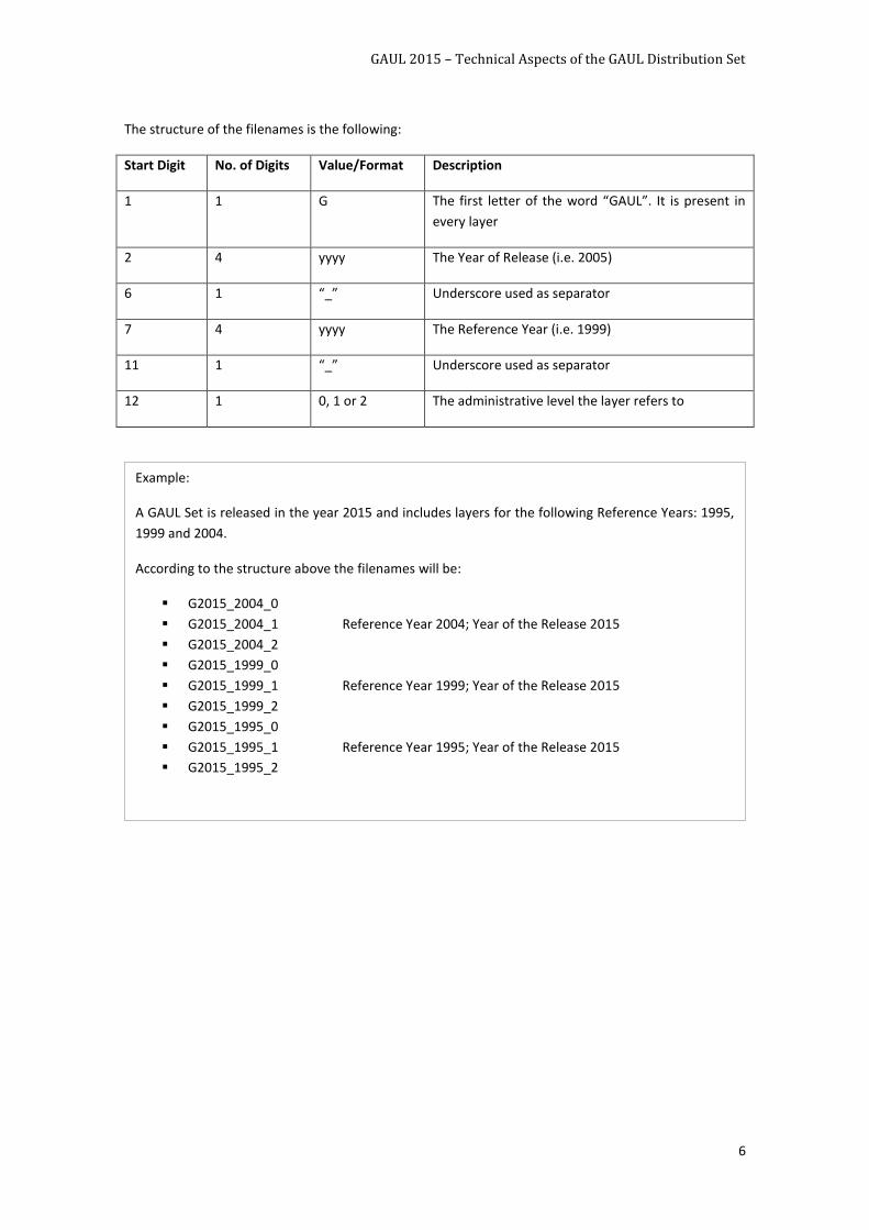
3. FILENAMES OF THE GAUL SET
Each release of the GAUL Set is identified by the Year of the Release; it includes groups of layers that
refer to the available Reference Years. Each group consists of three layers, one for each administrative
level:
A layer of country boundaries (Level 0)
A layer of first level administrative units (Level 1)
A layer of second level administrative units (Level 2)
Accordingly, the GAUL filenames are structured to include the above mentioned information to facilitate
the user in the identification of each individual layer.
GAUL 2015 – Technical Aspects of the GAUL Distribution Set
6
The structure of the filenames is the following:
Start Digit No. of Digits Value/Format Description
1 1 G The first letter of the word “GAUL”. It is present in
every layer
2 4 yyyy The Year of Release (i.e. 2005)
6 1 “_” Underscore used as separator
7 4 yyyy The Reference Year (i.e. 1999)
11 1 “_” Underscore used as separator
12 1 0, 1 or 2 The administrative level the layer refers to
Example:
A GAUL Set is released in the year 2015 and includes layers for the following Reference Years: 1995,
1999 and 2004.
According to the structure above the filenames will be:
G2015_2004_0
G2015_2004_1 Reference Year 2004; Year of the Release 2015
G2015_2004_2
G2015_1999_0
G2015_1999_1 Reference Year 1999; Year of the Release 2015
G2015_1999_2
G2015_1995_0
G2015_1995_1 Reference Year 1995; Year of the Release 2015
G2015_1995_2
GAUL 2015 – Technical Aspects of the GAUL Distribution Set
7
STRUCTURE OF THE GAUL SET
A GAUL Set is a spatial dataset representing locations and shapes of administrative units. It consists of
two types of information: geographic features and attribute data. The first type provides information on
the physical location of the units while the second type stores descriptive information associated to the
administrative units (i.e. administrative unit names). For convenience, geographic features and their
attributes are dealt with in separate paragraphs. The main characteristics of the data are:
GAUL relies on only one data source for international boundaries and unsettled territories: the
UN Cartographic Section (UNCS), who is the UN authority for international boundaries. The
GAUL data policy conforms to the one of the UNCS.
GAUL is a compilation of national and international sources for the internal administrative
boundaries and names. It also includes data from other UN projects that collects and compile
data on administrative boundaries like the Second Administrative Unit Boundaries (SALB)
managed by UN Statistics Division
GAUL data is not made available to the public, but it is only distributed to United Nations and
United Nations partners
The GAUL project maintains disputed areas in such a way to preserve national integrity for all disputing
countries.
4. GEOGRAPHIC FEATURES
In its current form, each layer of the GAUL Set includes three levels of administrative boundaries and
units:
Level 0 (ADM0): International or country boundaries. National boundaries as provided by the
UN Cartographic Unit (disputed area boundaries are also included). This is the highest level.
Level 1 (ADM1): First level administrative boundaries. These boundaries are entirely contained
within the Level 0, without exceptions
Level 2 (ADM2): Second level administrative boundaries. These boundaries are entirely
contained within the Level 1, without exceptions. This is the lowest level currently considered
under the GAUL project
In addition, when data is available, the GAUL provides layers on a country by country basis down to
third, fourth and lowers levels.
The GAUL Set must only include administrative boundaries. Any other feature not explicitly related to
such boundaries is excluded (i.e. water body shorelines and rivers are only retained when they coincide
with administrative boundaries).
The administrative boundaries are considered to be coincident with the centreline of a water stream
when the following situations occur at the same time:
The scale of representation allows to map both banks of the water stream as distinct vector
lines
Segments of water streams are known to coincide with the administrative boundaries, but the
exact location of these boundary lines is not specified in the source data
GAUL 2015 – Technical Aspects of the GAUL Distribution Set
8
First level administrative boundaries are arbitrarily extended inside water bodies and water streams if
their location is not explicitly reported in the source data. The boundaries inside water bodies and water
streams are extended by maintaining as much as possible the direction of the edge of the boundary. If
not available in the source data, the second level administrative boundaries and below (e.g. third,
fourth, etc.) are not extended inside water bodies; the shorelines are taken as limits of the units. In this
case, the polygons inside the water bodies do not represent the second level administrative units and
are coded as “Administrative unit not available”.
The GAUL Set reports the international, first level and second level administrative boundaries delimiting,
or falling within, the unsettled territories (e.g. disputed areas) in a way to enable the re-construction of
the administrative units as they are specified by the individual disputing countries.
Modifications of the boundaries’ locations are implemented in two different modes:
Correction mode: occurs when boundaries are modified in order to improve on their positional
accuracy. Boundaries might need to be corrected when more reliable data source or new sets
of control points are available. The correction mode implies a cascade modification of all the
boundaries of all layers of the GAUL Set that include the affected administrative units
Update mode: occurs when boundaries are modified in order to reflect political deliberations
on changes in the administrative units. The update mode implies a cascade modification of only
those layers of the GAUL Set whose lifetime coincides with the lifetime of the modified units.
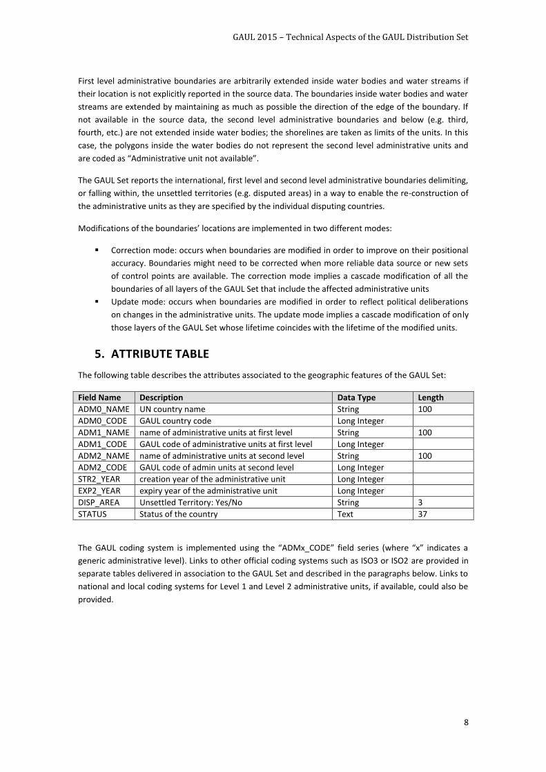
5. ATTRIBUTE TABLE
The following table describes the attributes associated to the geographic features of the GAUL Set:
Field Name Description Data Type Length
ADM0_NAME UN country name String 100
ADM0_CODE GAUL country code Long Integer
ADM1_NAME name of administrative units at first level String 100
ADM1_CODE GAUL code of administrative units at first level Long Integer
ADM2_NAME name of administrative units at second level String 100
ADM2_CODE GAUL code of admin units at second level Long Integer
STR2_YEAR creation year of the administrative unit Long Integer
EXP2_YEAR expiry year of the administrative unit Long Integer
DISP_AREA Unsettled Territory: Yes/No String 3
STATUS Status of the country Text 37
The GAUL coding system is implemented using the “ADMx_CODE” field series (where “x” indicates a
generic administrative level). Links to other official coding systems such as ISO3 or ISO2 are provided in
separate tables delivered in association to the GAUL Set and described in the paragraphs below. Links to
national and local coding systems for Level 1 and Level 2 administrative units, if available, could also be
provided.
GAUL 2015 – Technical Aspects of the GAUL Distribution Set
9
5.1 CODING SYSTEM
GAUL codes are numeric and unique for all administrative units at any of the administrative hierarchical
level.
Any GAUL code is independent from the codes of its higher levels (i.e. a code of a unit at Level 2 does
not include the code of the correspondent unit at Level 1)
GAUL codes assigned to administrative units of a given country are not necessarily sequential numbers.
A new code is a number created from the largest code occurring in the GAUL Set and incremented of 1
unit.
New_code = largest_GAUL_code + 1
A code that has been used within the GAUL Coding System can never be reused. Consequently, a code
belonging to an administrative unit that has expired (and therefore deleted from the relevant layers of
the GAUL Set) cannot be reassigned to another administrative unit.
The GAUL coding system does not accept NULL or “0” codes. GAUL codes are always consistently
assigned to the attributes ADM0_CODE, ADM1_CODE and ADM2_CODE. If information on
administrative units for a given administrative level is not available (i.e. boundaries of administrative
units at level 2 are missing; boundaries of administrative units at level 2 inside a lake are not available),
GAUL codes are assigned to its attribute (i.e. ADM2_CODE), but the value of the correspondent
ADMx_NAME will be: “Administrative unit not available”. If data for any of the missing administrative
units become available at a later stage, new GAUL codes are to be assigned to the newly included units
and the previous codes are to be dismissed.
The ADMx_NAME attributes of administrative units whose names are unknown, but whose boundaries
are available, are given the value of “Name Unknown”.
GAUL 2015 – Technical Aspects of the GAUL Distribution Set
10
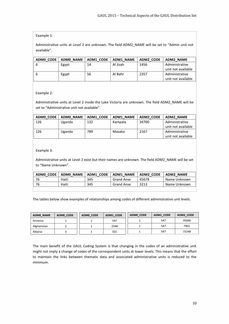
The tables below show examples of relationships among codes of different administrative unit levels.
The main benefit of the GAUL Coding System is that changing in the codes of an administrative unit
might not imply a change of codes of the correspondent units at lower levels. This means that the effort
to maintain the links between thematic data and associated administrative units is reduced to the
minimum.
ADM0_NAME ADM0_CODE
Armenia 1
Afghanistan 2
Albania 3
ADM0_CODE ADM1_CODE
1 547
1 2548
1 501
ADM0_CODE ADM1_CODE ADM2_CODE
1 547 35000
1 547 7901
1 547 15248
Example 1:
Administrative units at Level 2 are unknown. The field ADM2_NAME will be set to “Admin unit not
available”.
ADM0_CODE ADM0_NAME ADM1_CODE ADM1_NAME ADM2_CODE ADM2_NAME
6 Egypt 14 Al Jizah 1456 Administrative unit not available
6 Egypt 56 Al Bahr 2357 Administrative unit not available
Example 2:
Administrative units at Level 2 inside the Lake Victoria are unknown. The field ADM2_NAME will be
set to “Administrative unit not available”.
ADM0_CODE ADM0_NAME ADM1_CODE ADM1_NAME ADM2_CODE ADM2_NAME
126 Uganda 132 Kampala 34700 Administrative unit not available
126 Uganda 789 Masaka 2167 Administrative unit not available
Example 3:
Administrative units at Level 2 exist but their names are unknown. The field ADM2_NAME will be set
to “Name Unknown”.
ADM0_CODE ADM0_NAME ADM1_CODE ADM1_NAME ADM2_CODE ADM2_NAME
76 Haiti 345 Grand Anse 45678 Name Unknown
76 Haiti 345 Grand Anse 3213 Name Unknown
GAUL 2015 – Technical Aspects of the GAUL Distribution Set
11
5.2 OTHER INFORMATION INCLUDED IN THE ATTRIBUTE TABLE
Names of the administrative units: The fields “ADMx_NAME” store the names of the
administrative units. Names are provided in English.
Year of creation of the administrative units: The field “STRx_YEAR” store the reference year in
which the administrative units were established. When blank, the units are conventionally
assumed to exist before 1990.
Year of expiry of the administrative units: The field “EXPx_YEAR” store the reference year in
which the administrative units have been dismissed or changed. When blank, the units are
conventionally assumed to be still in existence.
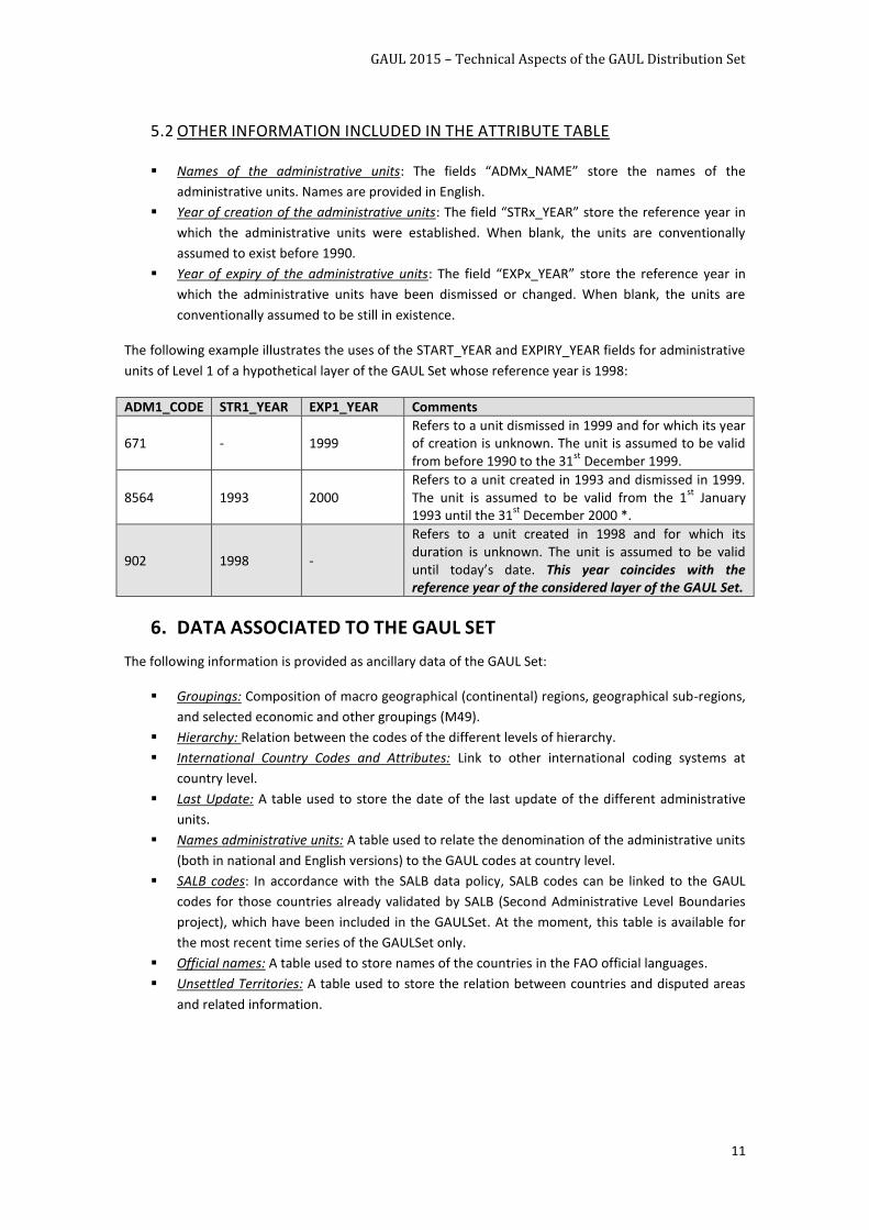
The following example illustrates the uses of the START_YEAR and EXPIRY_YEAR fields for administrative
units of Level 1 of a hypothetical layer of the GAUL Set whose reference year is 1998:
6. DATA ASSOCIATED TO THE GAUL SET
The following information is provided as ancillary data of the GAUL Set:
Groupings: Composition of macro geographical (continental) regions, geographical sub-regions,
and selected economic and other groupings (M49).
Hierarchy: Relation between the codes of the different levels of hierarchy.
International Country Codes and Attributes: Link to other international coding systems at
country level.
Last Update: A table used to store the date of the last update of the different administrative
units.
Names administrative units: A table used to relate the denomination of the administrative units
(both in national and English versions) to the GAUL codes at country level.
SALB codes: In accordance with the SALB data policy, SALB codes can be linked to the GAUL
codes for those countries already validated by SALB (Second Administrative Level Boundaries
project), which have been included in the GAULSet. At the moment, this table is available for
the most recent time series of the GAULSet only.
Official names: A table used to store names of the countries in the FAO official languages.
Unsettled Territories: A table used to store the relation between countries and disputed areas
and related information.
ADM1_CODE STR1_YEAR EXP1_YEAR Comments
671 - 1999 Refers to a unit dismissed in 1999 and for which its year of creation is unknown. The unit is assumed to be valid from before 1990 to the 31
st December 1999.
8564 1993 2000 Refers to a unit created in 1993 and dismissed in 1999. The unit is assumed to be valid from the 1
st January
1993 until the 31st
December 2000 *.
902 1998 -
Refers to a unit created in 1998 and for which its duration is unknown. The unit is assumed to be valid until today’s date. This year coincides with the reference year of the considered layer of the GAUL Set.
GAUL 2015 – Technical Aspects of the GAUL Distribution Set
12
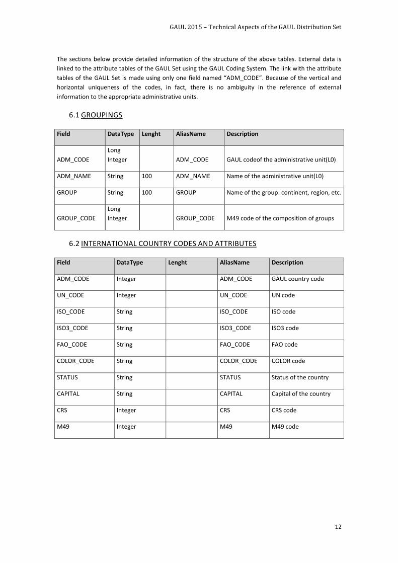
The sections below provide detailed information of the structure of the above tables. External data is
linked to the attribute tables of the GAUL Set using the GAUL Coding System. The link with the attribute
tables of the GAUL Set is made using only one field named “ADM_CODE”. Because of the vertical and
horizontal uniqueness of the codes, in fact, there is no ambiguity in the reference of external
information to the appropriate administrative units.
6.1 GROUPINGS
Field DataType Lenght AliasName Description
ADM_CODE
Long
Integer ADM_CODE GAUL codeof the administrative unit(L0)
ADM_NAME String 100 ADM_NAME Name of the administrative unit(L0)
GROUP String 100 GROUP Name of the group: continent, region, etc.
GROUP_CODE
Long
Integer GROUP_CODE M49 code of the composition of groups
6.2 INTERNATIONAL COUNTRY CODES AND ATTRIBUTES
Field DataType Lenght AliasName Description
ADM_CODE Integer ADM_CODE GAUL country code
UN_CODE Integer UN_CODE UN code
ISO_CODE String ISO_CODE ISO code
ISO3_CODE String ISO3_CODE ISO3 code
FAO_CODE String FAO_CODE FAO code
COLOR_CODE String COLOR_CODE COLOR code
STATUS String STATUS Status of the country
CAPITAL String CAPITAL Capital of the country
CRS Integer CRS CRS code
M49 Integer M49 M49 code
GAUL 2015 – Technical Aspects of the GAUL Distribution Set
13
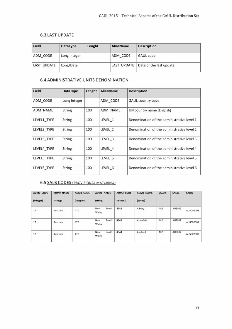
6.3 LAST UPDATE
Field DataType Lenght AliasName Description
ADM_CODE Long integer ADM_CODE GAUL code
LAST_UPDATE Long/Date LAST_UPDATE Date of the last update
6.4 ADMINISTRATIVE UNITS DENOMINATION
Field DataType Lenght AliasName Description
ADM_CODE Long Integer ADM_CODE GAUL country code
ADM_NAME String 100 ADM_NAME UN country name (English)
LEVEL1_TYPE String 100 LEVEL_1 Denomination of the administrative level 1
LEVEL2_TYPE String 100 LEVEL_2 Denomination of the administrative level 2
LEVEL3_TYPE String 100 LEVEL_3 Denomination of the administrative level 3
LEVEL4_TYPE String 100 LEVEL_4 Denomination of the administrative level 4
LEVEL5_TYPE String 100 LEVEL_5 Denomination of the administrative level 5
LEVEL6_TYPE String 100 LEVEL_6 Denomination of the administrative level 6
6.5 SALB CODES (PROVISIONAL MATCHING)
ADM0_CODE
(integer)
ADM0_NAME
(string)
ADM1_CODE
(integer)
ADM1_NAME
(string)
ADM2_CODE
(integer)
ADM2_NAME
(string)
SALB0 SALB1 SALB2
17 Australia 470 New South
Wales
4942 Albury AUS AUS002 AUS002001
17 Australia 470 New South
Wales
4943 Armidale AUS AUS002 AUS002002
17 Australia 470 New South
Wales
4944 Ashfield AUS AUS002 AUS002003
GAUL 2015 – Technical Aspects of the GAUL Distribution Set
14
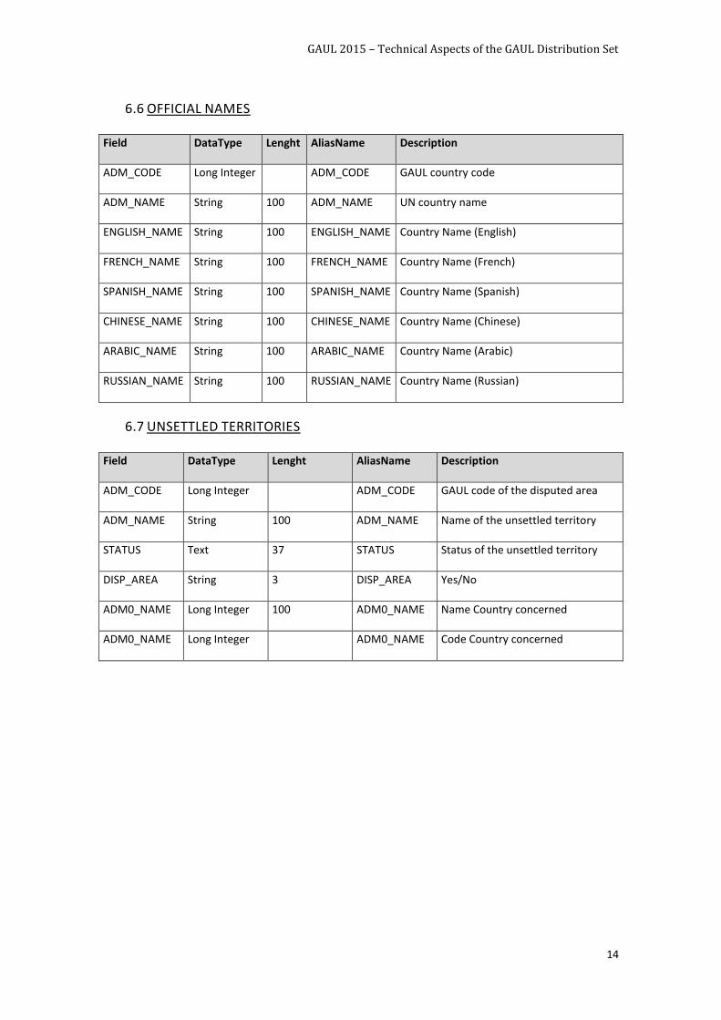
6.6 OFFICIAL NAMES
Field DataType Lenght AliasName Description
ADM_CODE Long Integer ADM_CODE GAUL country code
ADM_NAME String 100 ADM_NAME UN country name
ENGLISH_NAME String 100 ENGLISH_NAME Country Name (English)
FRENCH_NAME String 100 FRENCH_NAME Country Name (French)
SPANISH_NAME String 100 SPANISH_NAME Country Name (Spanish)
CHINESE_NAME String 100 CHINESE_NAME Country Name (Chinese)
ARABIC_NAME String 100 ARABIC_NAME Country Name (Arabic)
RUSSIAN_NAME String 100 RUSSIAN_NAME Country Name (Russian)
6.7 UNSETTLED TERRITORIES
Field DataType Lenght AliasName Description
ADM_CODE Long Integer ADM_CODE GAUL code of the disputed area
ADM_NAME String 100 ADM_NAME Name of the unsettled territory
STATUS Text 37 STATUS Status of the unsettled territory
DISP_AREA String 3 DISP_AREA Yes/No
ADM0_NAME Long Integer 100 ADM0_NAME Name Country concerned
ADM0_NAME Long Integer
ADM0_NAME Code Country concerned
GAUL 2015 – Technical Aspects of the GAUL Distribution Set
15
UPDATING PROTOCOL
Hereafter the method used to update and recode the administrative units which were subject to
changes is described. The basic criterion is that a unit is recoded only if a change in its shape occurs. This
can take place when a unit is a) split into more units, b) merged with other units or c) reshaped due to a
change of the location of its boundaries.
Updates occur in the following two cases:
1. When the shape of a unit is changed: changes may or may not affect the administrative units of
the level below (i.e. changes in Level 1 affect, or do not affect, the correspondent units in Level
2).
2. When an administrative unit is renamed
Special cases are the disputed areas for which a double coding is required in order to simultaneously
maintain the administrative units of all disputing countries.
7. UPDATES OF ADMINISTRATIVE UNITS NOT AFFECTING LOWER
LEVELS
The cases reported below refer to updates which do not affect shapes and codes of the corresponded
administrative units of the lower level(s).
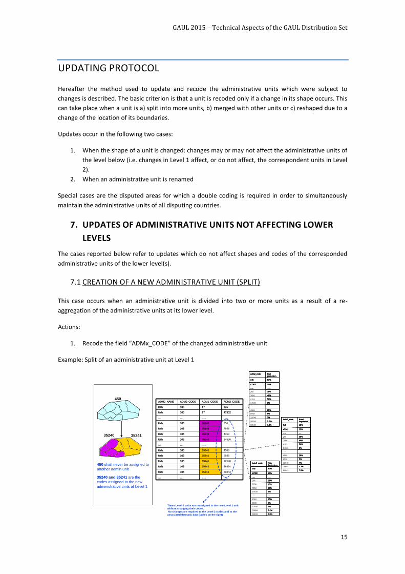
7.1 CREATION OF A NEW ADMINISTRATIVE UNIT (SPLIT)
This case occurs when an administrative unit is divided into two or more units as a result of a re-
aggregation of the administrative units at its lower level.
Actions:
1. Recode the field “ADMx_CODE” of the changed administrative unit
Example: Split of an administrative unit at Level 1
…..…..….…
1453635240106Italy
6984335241106Italy
2689435241106Italy
…..….…
415335240106Italy
785635240106Italy
4730217106Italy
…..…..….…
458935241106Italy
659835241106Italy
1254835241106Italy
Italy
Italy
ADM0_NAME
106
106
ADM0_CODE
25635240
74517
ADM2_CODEADM1_CODE
…..…..….…
1453635240106Italy
6984335241106Italy
2689435241106Italy
…..….…
415335240106Italy
785635240106Italy
4730217106Italy
…..…..….…
458935241106Italy
659835241106Italy
1254835241106Italy
Italy
Italy
ADM0_NAME
106
106
ADM0_CODE
25635240
74517
ADM2_CODEADM1_CODE450
35240 35241
450 shall never be assigned to
another admin unit
35240 and 35241 are the
codes assigned to the new
administrative units at Level 1
7.8%
3.2%
7%
5%
25%
...
3%
50%
40%
25%
25%
12%
Fish production
69843
26894
12548
6598
4589
14536
4153
7856
256
…..
47302
745
Adm2_code
7.8%
3.2%
7%
5%
25%
3%
50%
40%
25%
.......
25%
12%
Fish production
69843
26894
12548
6598
4589
14536
4153
7856
256
…..
47302
745
Adm2_code
7.8%
3.2%
7%
5%
25%
...
3%
50%
40%
25%
25%
12%
Fish production
69843
26894
12548
6598
4589
14536
4153
7856
256
…..
47302
745
Adm2_code
7.8%
3.2%
7%
5%
25%
3%
50%
40%
25%
.......
25%
12%
Fish production
69843
26894
12548
6598
4589
14536
4153
7856
256
…..
47302
745
Adm2_code
7.8%
3.2%
7%
5%
25%
...
3%
50%
40%
25%
....
25%
12%
Rural Population
69843
26894
12548
6598
4589
14536
4153
7856
256
…..
47302
745
Adm2_code
7.8%
3.2%
7%
5%
25%
3%
50%
40%
25%
25%
12%
Rural Population
69843
26894
12548
6598
4589
14536
4153
7856
256
…..
47302
745
Adm2_code
7.8%
3.2%
7%
5%
25%
...
3%
50%
40%
25%
....
25%
12%
Rural Population
69843
26894
12548
6598
4589
14536
4153
7856
256
…..
47302
745
Adm2_code
7.8%
3.2%
7%
5%
25%
3%
50%
40%
25%
25%
12%
Rural Population
69843
26894
12548
6598
4589
14536
4153
7856
256
…..
47302
745
Adm2_code
7.8%
3.2%
7%
5%
25%
....
3%
50%
40%
25%
25%
12%
Fish Production
69843
26894
12548
6598
4589
14536
4153
7856
256
…..
47302
745
Adm2_code
7.8%
3.2%
7%
5%
25%
3%
50%
....
25%
.....
25%
12%
Fish Production
69843
26894
12548
6598
4589
14536
4153
7856
256
…..
47302
745
Adm2_code
7.8%
3.2%
7%
5%
25%
....
3%
50%
40%
25%
25%
12%
Fish Production
69843
26894
12548
6598
4589
14536
4153
7856
256
…..
47302
745
Adm2_code
7.8%
3.2%
7%
5%
25%
3%
50%
....
25%
.....
25%
12%
Fish Production
69843
26894
12548
6598
4589
14536
4153
7856
256
…..
47302
745
Adm2_code
…
…
…
…
These Level 2 units are reassigned to the new Level 1 unit
without changing their codes.
No changes are required to the Level 2 codes and to the
associated thematic data (tables on the right)
GAUL 2015 – Technical Aspects of the GAUL Distribution Set
16
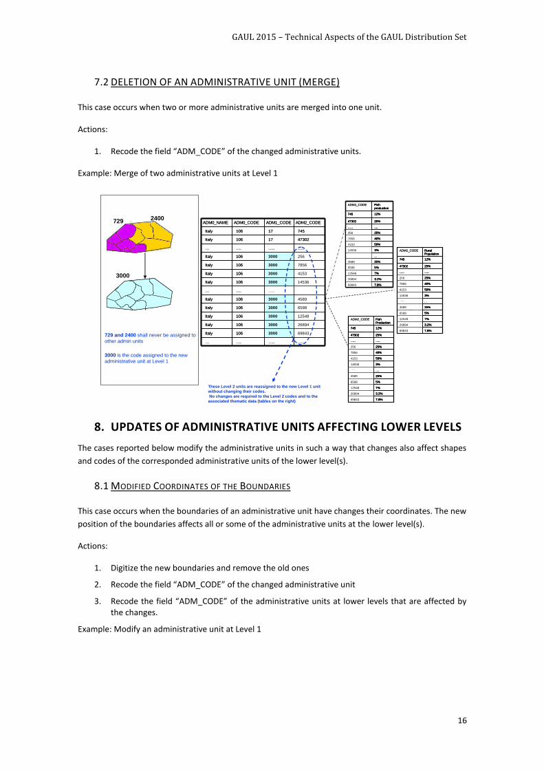
7.2 DELETION OF AN ADMINISTRATIVE UNIT (MERGE)
This case occurs when two or more administrative units are merged into one unit.
Actions:
1. Recode the field “ADM_CODE” of the changed administrative units.
Example: Merge of two administrative units at Level 1
8. UPDATES OF ADMINISTRATIVE UNITS AFFECTING LOWER LEVELS
The cases reported below modify the administrative units in such a way that changes also affect shapes
and codes of the corresponded administrative units of the lower level(s).
8.1 MODIFIED COORDINATES OF THE BOUNDARIES
This case occurs when the boundaries of an administrative unit have changes their coordinates. The new
position of the boundaries affects all or some of the administrative units at the lower level(s).
Actions:
1. Digitize the new boundaries and remove the old ones
2. Recode the field “ADM_CODE” of the changed administrative unit
3. Recode the field “ADM_CODE” of the administrative units at lower levels that are affected by the changes.
Example: Modify an administrative unit at Level 1
…..…..….…
145363000106Italy
698433000106Italy
268943000106Italy
…..….…
41533000106Italy
78563000106Italy
4730217106Italy
…..…..….…
45893000106Italy
65983000106Italy
125483000106Italy
Italy
Italy
ADM0_NAME
106
106
ADM0_CODE
2563000
74517
ADM2_CODEADM1_CODE
…..…..….…
145363000106Italy
698433000106Italy
268943000106Italy
…..….…
41533000106Italy
78563000106Italy
4730217106Italy
…..…..….…
45893000106Italy
65983000106Italy
125483000106Italy
Italy
Italy
ADM0_NAME
106
106
ADM0_CODE
2563000
74517
ADM2_CODEADM1_CODE
3000
729 and 2400 shall never be assigned to
other admin units
3000 is the code assigned to the new
administrative unit at Level 1
7.8%
3.2%
7%
5%
25%
...
3%
50%
40%
25%
....
25%
12%
Fish production
69843
26894
12548
6598
4589
14536
4153
7856
256
…..
47302
745
ADM2_CODE
7.8%
3.2%
7%
5%
25%
3%
50%
40%
25%
....
25%
12%
Fish production
69843
26894
12548
6598
4589
14536
4153
7856
256
…..
47302
745
7.8%
3.2%
7%
5%
25%
...
3%
50%
40%
25%
....
25%
12%
Fish production
69843
26894
12548
6598
4589
14536
4153
7856
256
…..
47302
745
ADM2_CODE
7.8%
3.2%
7%
5%
25%
3%
50%
40%
25%
....
25%
12%
Fish production
69843
26894
12548
6598
4589
14536
4153
7856
256
…..
47302
745
7.8%
3.2%
7%
5%
25%
...
3%
50%
40%
25%
.....
25%
12%
Rural Population
69843
26894
12548
6598
4589
14536
4153
7856
256
…..
47302
745
ADM2_CODE
7.8%
3.2%
7%
5%
25%
3%
50%
40%
25%
......
25%
12%
Rural Population
69843
26894
12548
6598
4589
14536
4153
7856
256
…..
47302
745
7.8%
3.2%
7%
5%
25%
...
3%
50%
40%
25%
.....
25%
12%
Rural Population
69843
26894
12548
6598
4589
14536
4153
7856
256
…..
47302
745
ADM2_CODE
7.8%
3.2%
7%
5%
25%
3%
50%
40%
25%
......
25%
12%
Rural Population
69843
26894
12548
6598
4589
14536
4153
7856
256
…..
47302
745
7.8%
3.2%
7%
5%
25%
....
3%
50%
40%
25%
.....
25%
12%
Fish Production
69843
26894
12548
6598
4589
14536
4153
7856
256
…..
47302
745
ADM2_CODE
7.8%
3.2%
7%
5%
25%
3%
50%
40%
25%
......
25%
12%
Fish Production
69843
26894
12548
6598
4589
14536
4153
7856
256
…..
47302
745
7.8%
3.2%
7%
5%
25%
....
3%
50%
40%
25%
.....
25%
12%
Fish Production
69843
26894
12548
6598
4589
14536
4153
7856
256
…..
47302
745
ADM2_CODE
7.8%
3.2%
7%
5%
25%
3%
50%
40%
25%
......
25%
12%
Fish Production
69843
26894
12548
6598
4589
14536
4153
7856
256
…..
47302
745
…
…
…
…
729 2400
These Level 2 units are reassigned to the new Level 1 unit
without changing their codes.
No changes are required to the Level 2 codes and to the
associated thematic data (tables on the right)
GAUL 2015 – Technical Aspects of the GAUL Distribution Set
17
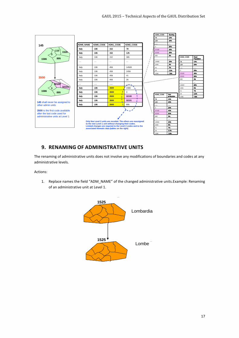
9. RENAMING OF ADMINISTRATIVE UNITS
The renaming of administrative units does not involve any modifications of boundaries and codes at any
administrative levels.
Actions:
1. Replace names the field “ADM_NAME” of the changed administrative units.Example: Renaming
of an administrative unit at Level 1.
3500
145
145 shall never be assigned to
other admin units
3500 is the first code available
after the last code used for
administrative units at Level 1
321013500106Italy
…………
365152106Italy
14569456106Italy
2456456106Italy
41456106Italy
26456106Italy
8953500106Italy
321003500106Italy
33500106Italy
125152106Italy
…..…..….…
Italy
Italy
ADM0_NAME
106
106
ADM0_CODE
15863500
78152
ADM2_CODEADM1_CODE
321013500106Italy
…………
365152106Italy
14569456106Italy
2456456106Italy
41456106Italy
26456106Italy
8953500106Italy
321003500106Italy
33500106Italy
125152106Italy
…..…..….…
Italy
Italy
ADM0_NAME
106
106
ADM0_CODE
15863500
78152
ADM2_CODEADM1_CODE
7.8%
3.2%
7%
5%
25%
...
3%
50%
40%
25%
.....
25%
12%
Stunting
ITA022005
ITA022004
ITA022003
ITA022002
ITA022001
…..
ITA021004
ITA021003
ITA021002
ITA021001
…..
ADM2_CODE
7.8%
3.2%
7%
5%
25%
3%
50%
40%
25%
;
25%
12%
Stunting
1586
26
41
2456
14569
…..
895
32101
32100
3
…..
125
78
7.8%
3.2%
7%
5%
25%
...
3%
50%
40%
25%
.....
25%
12%
Stunting
ITA022005
ITA022004
ITA022003
ITA022002
ITA022001
…..
ITA021004
ITA021003
ITA021002
ITA021001
…..
ADM2_CODE
7.8%
3.2%
7%
5%
25%
3%
50%
40%
25%
;
25%
12%
Stunting
1586
26
41
2456
14569
…..
895
32101
32100
3
…..
125
78
7.8%
3.2%
7%
5%
25%
....
3%
50%
40%
25%
......
25%
12%
Rural
Population
ITA022005
ITA022004
ITA022003
ITA022002
ITA022001
…..
ITA021004
ITA021003
ITA021002
ITA021001
…..
ADM2_CODE
7.8%
3.2%
7%
5%
25%
3%
50%
40%
25%
25%
12%
Rural
Population
1586
26
41
2456
14569
…..
895
32101
32100
3
…..
125
78
7.8%
3.2%
7%
5%
25%
....
3%
50%
40%
25%
......
25%
12%
Rural
Population
ITA022005
ITA022004
ITA022003
ITA022002
ITA022001
…..
ITA021004
ITA021003
ITA021002
ITA021001
…..
ADM2_CODE
7.8%
3.2%
7%
5%
25%
3%
50%
40%
25%
25%
12%
Rural
Population
1586
26
41
2456
14569
…..
895
32101
32100
3
…..
125
78
7.8%
3.2%
7%
5%
25%
.....
3%
50%
40%
25%
25%
12%
Fish
production
ITA022005
ITA022004
ITA022003
ITA022002
ITA022001
…..
ITA021004
ITA021003
ITA021002
ITA021001
…..
78
ADM2_CODE
7.8%
3.2%
7%
5%
25%
3%
50%
40%
25%
......
25%
12%
Fish
production
1586
26
41
2456
14569
…..
895
32101
32100
3
…..
125
7.8%
3.2%
7%
5%
25%
.....
3%
50%
40%
25%
25%
12%
Fish
production
ITA022005
ITA022004
ITA022003
ITA022002
ITA022001
…..
ITA021004
ITA021003
ITA021002
ITA021001
…..
78
ADM2_CODE
7.8%
3.2%
7%
5%
25%
3%
50%
40%
25%
......
25%
12%
Fish
production
1586
26
41
2456
14569
…..
895
32101
32100
3
…..
125
1101526
3
8951586
1586895
332101
32100
Only few Level 2 units are recoded. The others are reassigned
to the new Level 1 unit without changing their codes.
Limited changes are required to the Level 2 codes and to the
associated thematic data (tables on the right)
…
…
1525
Lombardia
1525
Lombe
GAUL 2015 – Technical Aspects of the GAUL Distribution Set
18
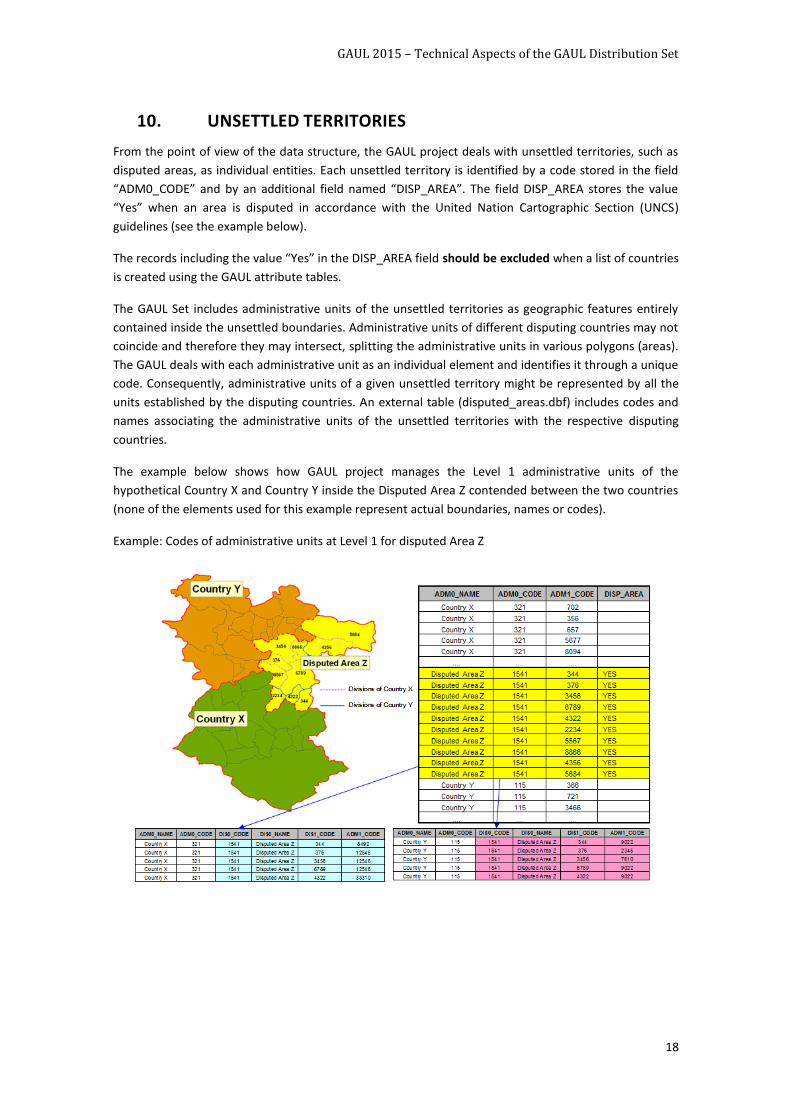
10. UNSETTLED TERRITORIES
From the point of view of the data structure, the GAUL project deals with unsettled territories, such as
disputed areas, as individual entities. Each unsettled territory is identified by a code stored in the field
“ADM0_CODE” and by an additional field named “DISP_AREA”. The field DISP_AREA stores the value
“Yes” when an area is disputed in accordance with the United Nation Cartographic Section (UNCS)
guidelines (see the example below).
The records including the value “Yes” in the DISP_AREA field should be excluded when a list of countries
is created using the GAUL attribute tables.
The GAUL Set includes administrative units of the unsettled territories as geographic features entirely
contained inside the unsettled boundaries. Administrative units of different disputing countries may not
coincide and therefore they may intersect, splitting the administrative units in various polygons (areas).
The GAUL deals with each administrative unit as an individual element and identifies it through a unique
code. Consequently, administrative units of a given unsettled territory might be represented by all the
units established by the disputing countries. An external table (disputed_areas.dbf) includes codes and
names associating the administrative units of the unsettled territories with the respective disputing
countries.
The example below shows how GAUL project manages the Level 1 administrative units of the
hypothetical Country X and Country Y inside the Disputed Area Z contended between the two countries
(none of the elements used for this example represent actual boundaries, names or codes).
Example: Codes of administrative units at Level 1 for disputed Area Z
GAUL 2015 – Technical Aspects of the GAUL Distribution Set
19
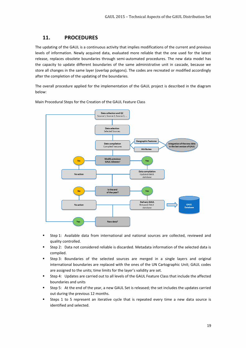
11. PROCEDURES
The updating of the GAUL is a continuous activity that implies modifications of the current and previous
levels of information. Newly acquired data, evaluated more reliable that the one used for the latest
release, replaces obsolete boundaries through semi-automated procedures. The new data model has
the capacity to update different boundaries of the same administrative unit in cascade, because we
store all changes in the same layer (overlap polygons). The codes are recreated or modified accordingly
after the completion of the updating of the boundaries.
The overall procedure applied for the implementation of the GAUL project is described in the diagram
below:
Main Procedural Steps for the Creation of the GAUL Feature Class
Step 1: Available data from international and national sources are collected, reviewed and
quality controlled.
Step 2: Data not considered reliable is discarded. Metadata information of the selected data is
compiled.
Step 3: Boundaries of the selected sources are merged in a single layers and original
international boundaries are replaced with the ones of the UN Cartographic Unit; GAUL codes
are assigned to the units; time limits for the layer’s validity are set.
Step 4: Updates are carried out to all levels of the GAUL Feature Class that include the affected
boundaries and units
Step 5: At the end of the year, a new GAUL Set is released; the set includes the updates carried
out during the previous 12 months.
Steps 1 to 5 represent an iterative cycle that is repeated every time a new data source is
identified and selected.
GAUL 2015 – Technical Aspects of the GAUL Distribution Set
20
11.1 IDENTIFICATION AND SELECTION OF DATA
Available data from international and national sources are collected and reviewed. The quality control
process involves a verification of the following parameters:
1. Quality of digitization
2. Availability of accurate reference system parameters
3. Completeness of the attribute tables (availability of administrative units’ names)
4. Authority of the source
5. Coherency with other data sources
It should be noted that sufficient information on the accuracy and reliability of the data is not always
available; in these cases, a thorough control of the accuracy of the boundaries can not be performed.
11.2 CREATION AND UPDATING OF GAUL SET
The updating of the GAUL Set is a continuous activity that implies modifications of the current and
previous datasets. Newly acquired data, evaluated more reliable that the one used for the latest release,
replaces obsolete boundaries through semi-automated procedures. The codes are recreated or modified
accordingly after the completion of the updating of the boundaries.
GAUL 2015 – Technical Aspects of the GAUL Distribution Set
21
GAUL CONTACTS
Please send any technical questions or comments on the GAUL Documentation you have via email to:
Fabio Grita Information Technology - Systems Support Officer ESS, FAO Tel: +39-06-57054262 Email: [email protected]