Embed Size (px)
Citation preview
Athens Journal of Tourism - Volume 3, Issue 1 – Pages 53-74
https://doi.org/10.30958/ajt.3-1-4 doi=10.30958/ajt.3-1-4
Territorial Development and Amazon
Integration: A New Management Perspective on
the Tri-border between Peru, Brazil and Bolivia
By Roberto Chiarella Quinhoes
Our study object is the tri-border Amazon territory that covers the Iñapari (Peru), Assis
Brasil (Brazil) and Bolpebra (Bolivia) urban centers. In the future, the explosive and
disordered urban growth will lead to a physical continuity between the three hamlets, due
to a clear trend towards the formation of an international conurbation. The problems of
the border towns will be exacerbated: environmental pollution, depletion of natural
resources, delinquency, prostitution, drugs trafficking, smuggling, etc. This will hinder the
territorial management of one of the worlds’ richest areas in biodiversity, affecting the
fragile environment and ecosystems of the Acre River basin. We intend to present a new
development perspective of this area of study. In this regard, it is necessary to adopt a
strategic approach that integrates territorial planning and management, crossing
international boundaries. We are talking about the constitution of a single institutional
structure for tri-border urban planning and management: an international city.
Keywords: Amazon, Borders, Urban/Territorial management.
The Context
The current international scenario related to territorial development is
shaped by various processes that enable a new perspective on the Amazon and
its projections of development in terms of planning and land management. On
one hand, the process of climate change that is affecting the planet manifests
itself in issues such as the melting of the poles, putting lives at risk in many
coastal cities; the melting of glaciers which impacts the hydro-biological cycle
and increases the risk of disasters and climate transformations, with higher
incidence of drought in some areas and rainfall in others, affecting the lives of
various species by destroying habitats and endangering endemic species and
biodiversity in general. The main causes of the phenomenon of climate change
are related to human activities, mainly industrial production and transport
based on non-renewable fossil fuels, the expansion of global the process of
urban growth, the destruction of forests, etc. As a result, the process threatens
human life. In the final analysis, it comes to implementing new ideas and
models of territorial management different from those of the past.
On the other hand, the process of globalization and fragmentation of
national spaces leads to an appreciation of the local level, which is functional
to the interests of the large international capital. In the South American context,
the role of border areas is redefined and revalued as a result of the integration
Associate Professor, Center for Research in Applied Geography, Pontifical Catholic
University of Peru (PUCP), Peru.
Vol. 3, No. 1 Quinhoes: Territorial Development and Amazon Integration...
54
process of the continent. Simultaneously, the countries of the region privilege
the political, administrative and economic decentralization, aiming to stimulate
the generation of development processes in territorial areas other than the
traditional national dynamic centers. In that sense, the role of urban centers is
essential for international integration, national development and environmental
conservation. In this evolution of situations the current South American
integration process arises. In this regard, the proposal for the Integration of
Infrastructure in South America (IIRSA 20141) aims to develop the region
through a joint program to promote physical integration, implementing
transport infrastructure, energy and telecommunications. Certainly, it came
from an experience of planning and in the pursuit for logistics efficiency in
Brazil. However, the proposal contains some imperfections that must be taken
into consideration to improve the integration mechanisms. One of the main
issues concerns the Indicative Territorial Planning Methodology, which does
not have a truly territorial approach because it disdains in its conception the
approach to the urban issue (Chiarella Quinhoes 2011).
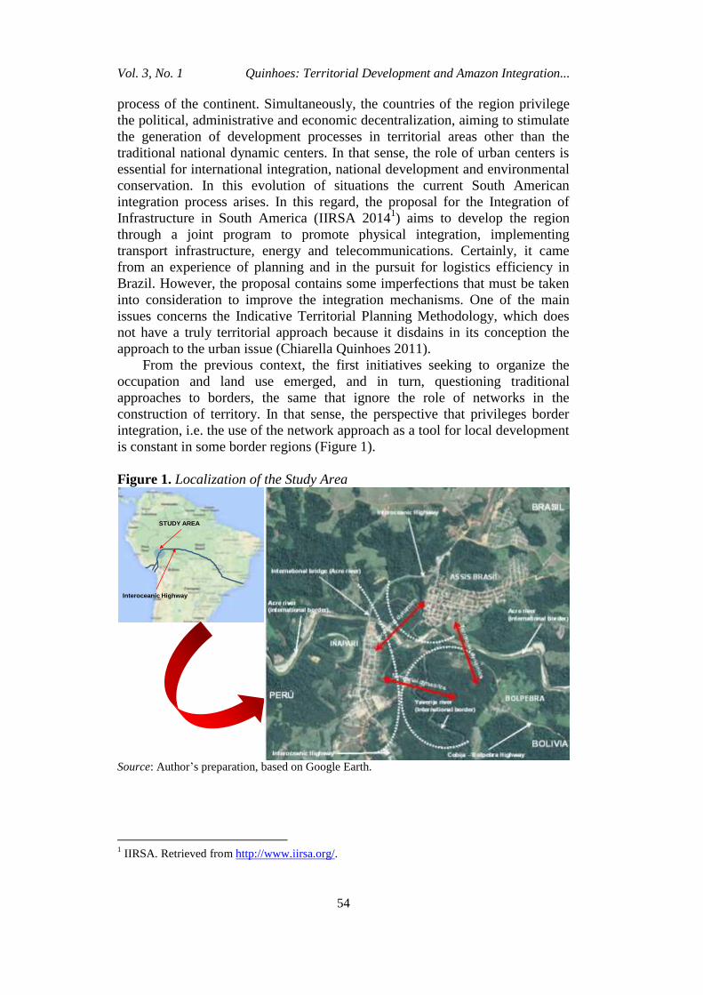
From the previous context, the first initiatives seeking to organize the
occupation and land use emerged, and in turn, questioning traditional
approaches to borders, the same that ignore the role of networks in the
construction of territory. In that sense, the perspective that privileges border
integration, i.e. the use of the network approach as a tool for local development
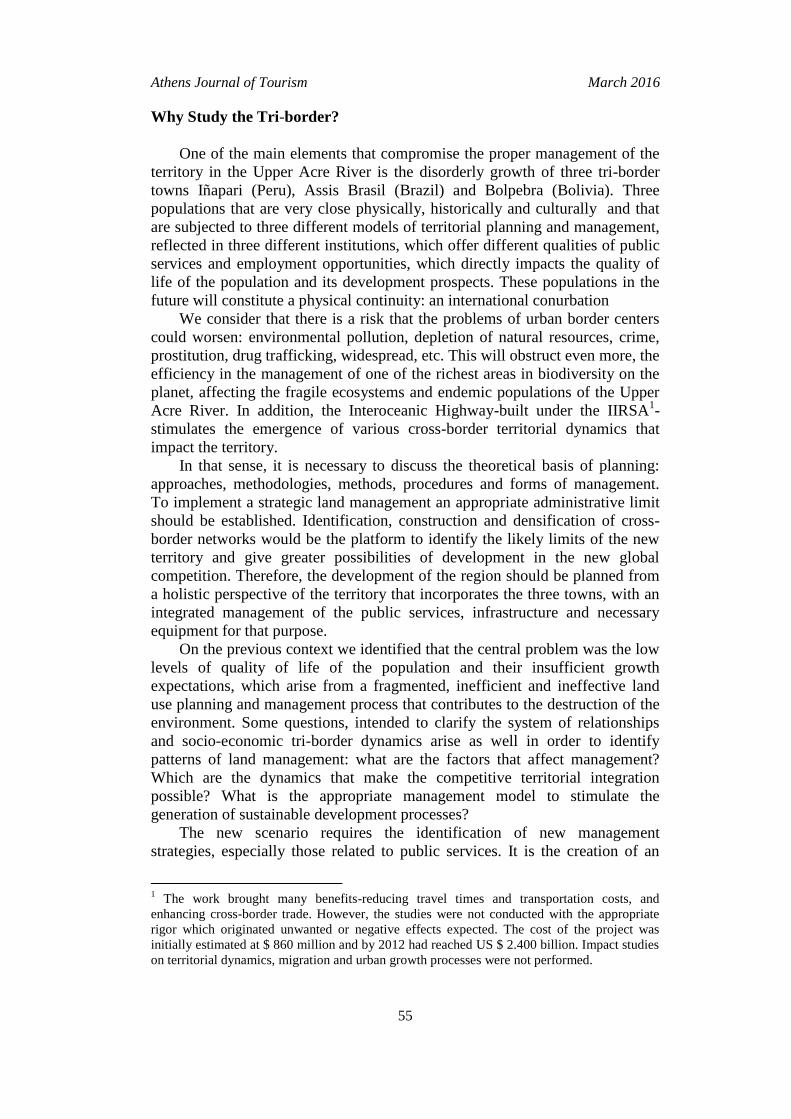
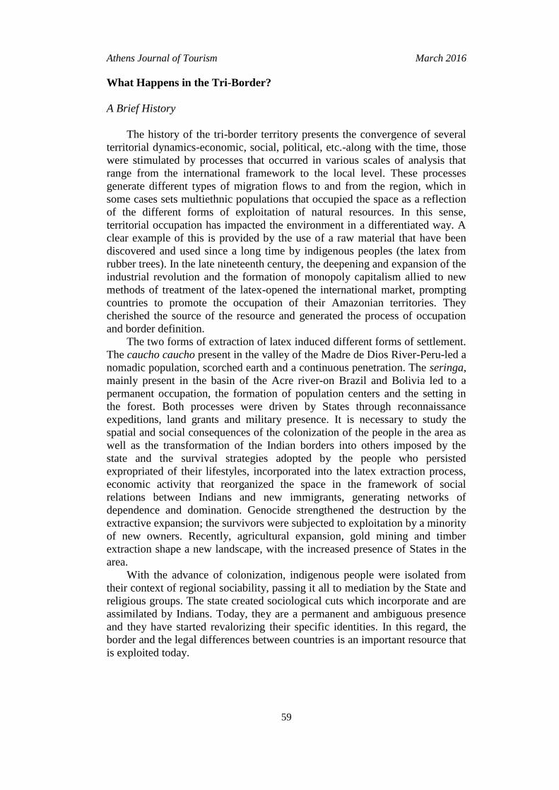
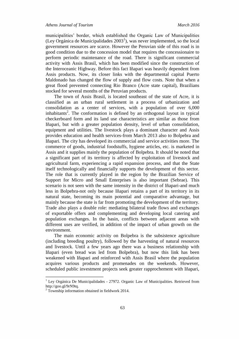
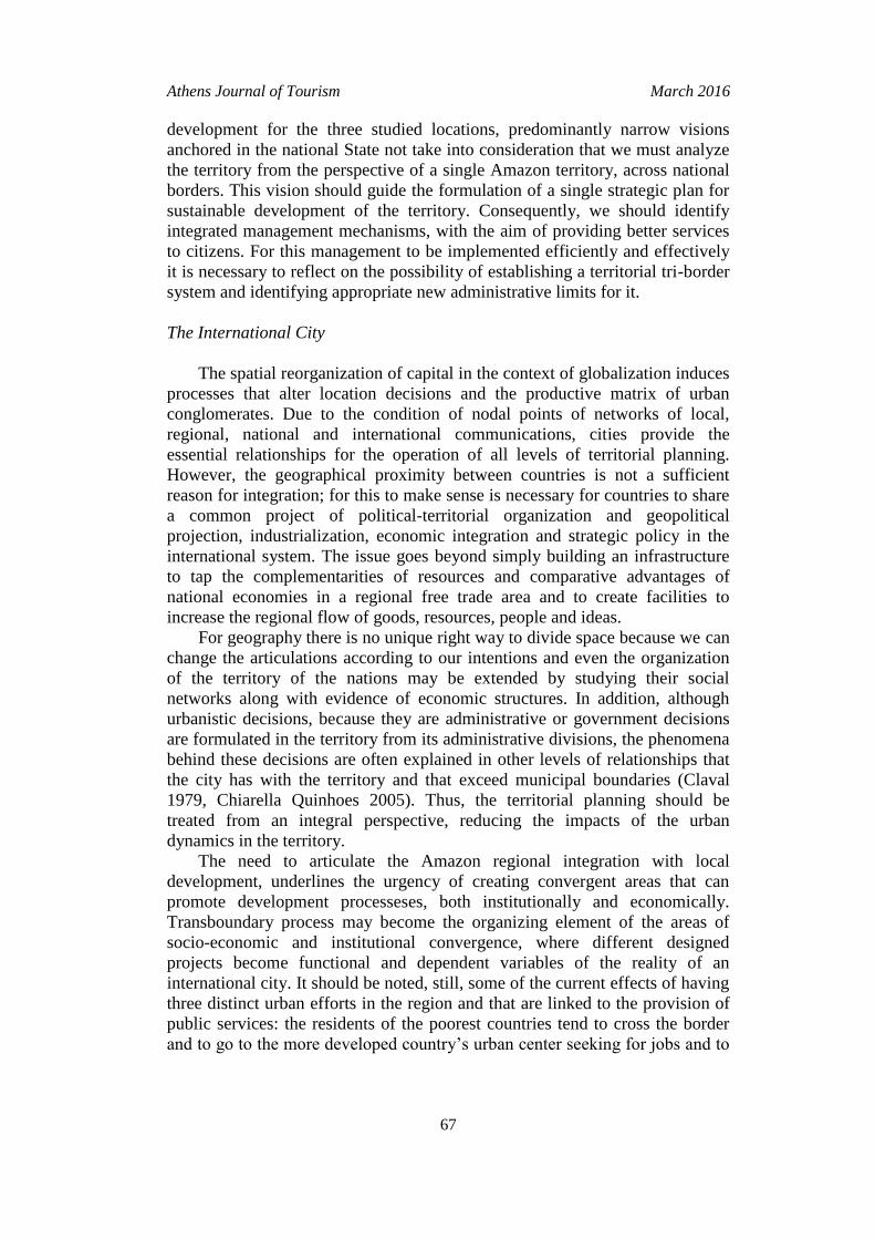
is constant in some border regions (Figure 1).
Figure 1. Localization of the Study Area
Interoceanic Highway
STUDY AREA
Source: Authorʼs preparation, based on Google Earth.
1 IIRSA. Retrieved from http://www.iirsa.org/.
Athens Journal of Tourism March 2016
55
Why Study the Tri-border?
One of the main elements that compromise the proper management of the
territory in the Upper Acre River is the disorderly growth of three tri-border
towns Iñapari (Peru), Assis Brasil (Brazil) and Bolpebra (Bolivia). Three
populations that are very close physically, historically and culturally and that
are subjected to three different models of territorial planning and management,
reflected in three different institutions, which offer different qualities of public
services and employment opportunities, which directly impacts the quality of
life of the population and its development prospects. These populations in the
future will constitute a physical continuity: an international conurbation
We consider that there is a risk that the problems of urban border centers
could worsen: environmental pollution, depletion of natural resources, crime,
prostitution, drug trafficking, widespread, etc. This will obstruct even more, the
efficiency in the management of one of the richest areas in biodiversity on the
planet, affecting the fragile ecosystems and endemic populations of the Upper
Acre River. In addition, the Interoceanic Highway-built under the IIRSA1-
stimulates the emergence of various cross-border territorial dynamics that
impact the territory.
In that sense, it is necessary to discuss the theoretical basis of planning:
approaches, methodologies, methods, procedures and forms of management.
To implement a strategic land management an appropriate administrative limit
should be established. Identification, construction and densification of cross-
border networks would be the platform to identify the likely limits of the new
territory and give greater possibilities of development in the new global
competition. Therefore, the development of the region should be planned from
a holistic perspective of the territory that incorporates the three towns, with an
integrated management of the public services, infrastructure and necessary
equipment for that purpose.
On the previous context we identified that the central problem was the low
levels of quality of life of the population and their insufficient growth
expectations, which arise from a fragmented, inefficient and ineffective land
use planning and management process that contributes to the destruction of the
environment. Some questions, intended to clarify the system of relationships
and socio-economic tri-border dynamics arise as well in order to identify
patterns of land management: what are the factors that affect management?
Which are the dynamics that make the competitive territorial integration
possible? What is the appropriate management model to stimulate the
generation of sustainable development processes?
The new scenario requires the identification of new management
strategies, especially those related to public services. It is the creation of an
1 The work brought many benefits-reducing travel times and transportation costs, and
enhancing cross-border trade. However, the studies were not conducted with the appropriate
rigor which originated unwanted or negative effects expected. The cost of the project was
initially estimated at $ 860 million and by 2012 had reached US $ 2.400 billion. Impact studies
on territorial dynamics, migration and urban growth processes were not performed.
Vol. 3, No. 1 Quinhoes: Territorial Development and Amazon Integration...
56
"International City"-with characteristics of an intermediate city-which would
allow a unified planning and land management approach. The perspective has
the preservation of the environment beyond borders as the central axis. We
must emphasize the fact that our object of study is based on: i) being a tri-
border area, ii) high biodiversity, iii) explosive urban growth, iv) future
impacts on the environment and its resources and v) a model of urban and
regional planning and fragmented management.
Consequently, our work is contained within the issue of territorial planning
and management in the tri-Amazon border, and their relationship with the
processes of integration for development. Its aim is the discussion of urban
growth processes of the three cities, evident cross-border territorial dynamics,
and its connection with the wider land management of the Amazon process. Its
objective is also to bring a new understanding of territorial planning and
management from the perspective of environmental conservation and
protection of ecosystems, in order to establish guidelines and strategies that
serve to develop a tri-border territorial management model that allows
encouraging the raising of the quality of life and improving the prospects of
development of the local populations (Chiarella Quinhoes 2014).
The methodology is aligned to the classic proposal of strategic planning,
rescuing the competitive aspects of the territory and the establishment of
tendential logic of scenarios. Our approach privileges aspects of environmental
conservation, land management and employment generation. The implemented
strategy is based on a comparative analysis of public policies, which are
addressed through different scales of territorial analysis: South American,
whose frame is IIRSA; national scales corresponding to each country; regional
scales, considering the Amazon; local scales, corresponding to the
municipalities in the tri-border and the territory over the political-
administrative borders.
Background on Integration
After reviewing some of the most significant initiatives regarding the
integration of border towns we came across that most of them arised from
informal and spontaneous processes formed from family, historical, cultural,
social and economic ties between different societies on both sides of the border
limit. Also, we found processes whose proposals have emerged from a more
formal and planned manner. In Europe, there are several examples, such as the
integration process between the city of Luxembourg and the Swiss cities of
Basel and Geneva, where the border-far from constituting an obstacle to
cooperation-offers opportunities to strengthen the comparative advantages
from strategies that articulate certain functions of the border using different
logics. It notes that the border can be mobilized as an economic resource or a
more symbolic level, as an object of recognition and affirmation of the
international character of a city (Sohn 2010). Another illustrative example of
integration is the one between the small Italian town of Gorizia and the
Athens Journal of Tourism March 2016
57
Slovenian city of New Gorica. On December 21st, 2007 after the entry of
Slovenia in the Schengen Agreement, the border controls between Gorizia and
Nova Gorica ended and free movement between the two parts of the city for
the first time was allowed in more than 60 years. However, we must add that
the opening of the border with Slovenia hurt Goriziaʼs financially chances of
development, because buying in Slovenia was cheaper when compared to the
Italian city. It is also important to mention the case of the city of Tornio in
Finland, which coexists with the Swedish town of Haparanda. Both cities have
a common history as the twin cities and are planning to merge under the name
EuroCity. They are currently building a new urban center in the border and
they already share many municipal services and a golf course located along the
border. The new center of the Ikea multinational corporation in Haparanda is
labeled in Finnish and Swedish and the prices are listed in the currencies of the
two countries.
In Minor Asia, we highlight the case of the city of Jerusalem, which is
divided into two: the east side is Arab and the west side is Jewish. In 1947 the
UN passed the Resolution N° 181 which established the partition of Palestine
into a Jewish and an Arab state. The city of Jerusalem had the status of an
international city-neither Jewish nor Arab-managed by the Trusteeship Council
of the UN, which would appoint a governor for the city. However, the non-
acceptance of the Arabs and the invasion of Israel, after its declaration as a
State, prevented the implementation of that resolution. West Jerusalem is the
commercial heart of the city, becoming the development center of the city. East
Jerusalem is the center of the Palestinian settlement around the Old City. After
falling under the Israeli control, a large number of Jewish neighborhoods were
created. It should be noted that the city failed to integrate it all, it is a place
physically, culturally and socially divided, where a lot of conflicts of religious
origin prevail.
In North America, there is the case of the cities of Tijuana (Mexico) and
San Diego (USA), where despite the restrictions caused by the difficulty of
border crossings and the security policy of the USA, there is a trend towards
economic integration. However, this still represents a challenge because half
the population of Tijuana cannot cross the border and most of the population of
San Diego does not want to cross, so that the interaction between the two
populations is low. Also, there are no integrated markets that form a single
space, and the prices, as well as the components that influence them are
different in each city. So, Tijuana and San Diego constitute an urban
continuum separated by an international border, which functions as two cities
(Alegría 2009). In a final analysis, we can say that this is an international
conurbation. In Central America there is an integration framework represented
by the Central American Integration System (SICA), in which the Open
Borders Project developed, focusing on the triple border areas, the Trifinio and
the Gulf of Fonseca. The Trifinio region, located between Guatemala,
Honduras and El Salvador, is an area in which the integrated and balanced
development of the region is driven by the joint and coordinated by
governments and actors (Conato 2009).
Vol. 3, No. 1 Quinhoes: Territorial Development and Amazon Integration...
58
In South America, there is the case of the cities of Chui (Brazil) and Chuy
(Uruguay), which form an urban system that has a high permeability through
the two nuclei, checkpoints and geographical barriers. They are formed by
small settlements that live off commerce and services, especially during the
summer when the region receives many tourists. The conurbation is small and
the urban sprawl consists of houses reflecting the low income of the population
intended to absorb the migrant rural population in both countries. The
conurbation is almost like one society, so it is difficult to perceive them
separately. Their level of symbiosis is really high, sharing a centrality, and
patterns of social and spatial segregation in every way. It should be considered
that in heterogeneous border areas and those where there is a spatial
organization it is necessary to formulate a suitable plan for each situation,
which seeks to reduce administrative burdens, facilitate communication,
encourage exchanges and create conditions for private investment. In that
sense, it is necessary to break the myth of rigid boundaries, give other
functions to the borders and seek peace in daily living (Valero 1998).
There are various studies, plans and development proposals for our area of
research. However, most studies do not consider a comprehensive perspective
of the three population centers, most of them are made from a fragmented
vision of the territory, ignoring the set of dynamics that characterize this
border. Other works focus on the relations between two countries, starting from
a particular nationality centered vision. We believe it is necessary to develop a
comprehensive perspective of territorial development that includes Iñapari,
Assis Brasil and Bolpebra as part of the same territory and the same urban
management. The important role played in the region by the MAP initiative
(Madre de Dios – Acre – Pando) should be noted. In 1999, due to the
transformations caused by global environmental change, representatives from
universities, research centers and development agencies met at the Federal
University of Acre, Rio Branco, where discussed about more effective
articulation of regional institutions forms. This meeting resulted in
recommendations that were used to develop the "Declaration of Rio Branco on
global changes" in 2000, and it was here that it was possible to initiate a
process of articulation and organization of tri-border actors and operators in
which the State was absent. The short history of trinational coordination in this
space reveals potentials that are worth attention by the States involved, as local
institutions, supported by NGOs, decided to jointly handle the problems and
opportunities their trilateral dimension. We emphasize the presence of the
Madre De Dios Consortium, created with the support of USAID, as part of the
conservation initiative in the Andean Amazon (ICAA). The CMDD seeks to
strengthen environmental management capabilities of local actors in the region,
through sensitization activities targeting citizens, adults, government
employees, authorities and leaders, as well as children, academics and
researchers.
Athens Journal of Tourism March 2016
59
What Happens in the Tri-Border?
A Brief History
The history of the tri-border territory presents the convergence of several
territorial dynamics-economic, social, political, etc.-along with the time, those
were stimulated by processes that occurred in various scales of analysis that
range from the international framework to the local level. These processes
generate different types of migration flows to and from the region, which in
some cases sets multiethnic populations that occupied the space as a reflection
of the different forms of exploitation of natural resources. In this sense,
territorial occupation has impacted the environment in a differentiated way. A
clear example of this is provided by the use of a raw material that have been
discovered and used since a long time by indigenous peoples (the latex from
rubber trees). In the late nineteenth century, the deepening and expansion of the
industrial revolution and the formation of monopoly capitalism allied to new
methods of treatment of the latex-opened the international market, prompting
countries to promote the occupation of their Amazonian territories. They
cherished the source of the resource and generated the process of occupation
and border definition.
The two forms of extraction of latex induced different forms of settlement.
The caucho caucho present in the valley of the Madre de Dios River-Peru-led a
nomadic population, scorched earth and a continuous penetration. The seringa,
mainly present in the basin of the Acre river-on Brazil and Bolivia led to a
permanent occupation, the formation of population centers and the setting in
the forest. Both processes were driven by States through reconnaissance
expeditions, land grants and military presence. It is necessary to study the
spatial and social consequences of the colonization of the people in the area as
well as the transformation of the Indian borders into others imposed by the
state and the survival strategies adopted by the people who persisted
expropriated of their lifestyles, incorporated into the latex extraction process,
economic activity that reorganized the space in the framework of social
relations between Indians and new immigrants, generating networks of
dependence and domination. Genocide strengthened the destruction by the
extractive expansion; the survivors were subjected to exploitation by a minority
of new owners. Recently, agricultural expansion, gold mining and timber
extraction shape a new landscape, with the increased presence of States in the
area.
With the advance of colonization, indigenous people were isolated from
their context of regional sociability, passing it all to mediation by the State and
religious groups. The state created sociological cuts which incorporate and are
assimilated by Indians. Today, they are a permanent and ambiguous presence
and they have started revalorizing their specific identities. In this regard, the
border and the legal differences between countries is an important resource that
is exploited today.
Vol. 3, No. 1 Quinhoes: Territorial Development and Amazon Integration...
60
The history of contact of the Indians with non-Indians is told by them in
different historical times. Before the arrival of the Brazilian Northeast people,
the remote time is called "ancient". The "time of the raids" began with the
extraction of rubber trees. After that time starts the "time of captivity," it was
when the Indians worked in the rubber plantations, as extractors, farmers, etc.
Then came the "time of rights" linked to the discovery of indigenous rights,
and the "time of cultural revival" (together with the previous), the rescue of
traditions. The reaffirmation of identity occurs through the claim of its territory
and the recognition of their culture that allows them a place in the world. We
must study the indigenous peoples, for whom the political border represents
multiple belongings and analyzes the relationships between political and social
borders from the practices and representations of its inhabitants, forged by
identity references, with which they define and are defined in classifications
that reproduced and deny limits and boundaries between groups (Manchineri
and Morais 2011, Arruda 2010, Simoes 2009).
In the tri-border there are commercial ties between the Manchineri and the
other natives of the region since the time of the Amazonian colonization. These
groups inhabited the region and had contacts with Andean societies. The
formation of the border caused serious problems for Manchineri, Piro/Yine and
Jaminawa groups, and other people who disappeared because of the rubber
expansion. The indigenous people are sometimes on either side of the border
and are bilingual because that movement requires speaking a language that is
different form their mother tongue (Arruda 2010).
General Overview
We must analyze the various forms of territorialization of the same space
by different actors, who live with the differences established by the political
and administrative border. This is a reality characterized by constant changes
that now is living a fact that is part of an overall process that impacts the
relationships between populations: the Interoceanic Highway, which adds
value to a space considered peripheral. In this sense, two hypotheses related to
the articulation of the tri-border system arise: a) the logical state does not
match the logic of the population, so that the official borders are faced with
other cultural boundaries generated from the interactions between the
populations, which reaffirm or deny the borders according to their interests and
b) the changes generated by the Interoceanic Highway and population
migration affect the relationship between society-nature.
Differentiated occupation of the territory has been driven by different
rhythims of growth and development of its various regions. In Brazil, the
colonization projects financed by the state in the 1970ʼs supported a
development based on the expansion of the agricultural frontier and the
modernization of agriculture. This conservative modernization allied big
capital to large estates, with the intention of developing the agricultural activity
and fill the empty spaces. The idea of the demographic vacuum and the belief
Athens Journal of Tourism March 2016
61
that it was a potential agricultural area were the basis of the policy that guided
the development model implemented in Brazil, Peru and Bolivia.
In the context of globalization we see that one of its main effects are
manifested in the evolution of the concept of border to levels at which
processes of "des frontierization" configure extended economically integrated
areas, surpassing border limits. In such areas there is the recognition of
historical, anthropological and sociological factors underlying feelings of
identity and belonging that were unknown to the political and administrative
limits imposed by the nation-state. The combination of processes of des
frontierization with feelings of identity and belonging, lead to the
establishment of regional border areas, cross-border scenes of territorial
dynamics that directly involve three countries, putting at risk, in practice, the
validity of concepts that support the nation-state, such as those relating to state,
territory and sovereignty with which it was intended to legitimize the
separation effect of the boundary.
There is a socio-economic system that integrates heterogeneous
populations, and which emergs from the existence of cultural boundaries and
cultures of borders. Local references of identity are central to the daily
interaction that allows people to differentiate between "Bolivian", "Peruvian"
and "Brazilian" and "Bolivian border", "Peruvian border" and "Brazilian
border". In this sense it is found that the state images failed diluting local
references. The state of Acre (Brazil) is a clear example of the processes
produced within the national state. The extraction process of latex attracted
thousands of people, mainly northeastern people who were fleeing from the
implacable desertification to the region, which influenced the subsequent
change of borders. Colonization was accompanied by population changes, the
rubber tappers expelled the indigenous, and in turn, the first ones were expelled
by ranchers and settlers. Border policy changed from a socio-economic
occupation of the territory.
In the department of Madre de Dios (Peru) the colonization of the forest
was, in part, similar to Acre. However, colonization responded to spontaneous
migration movements and others targeted with the intention of expanding the
agricultural frontier, mainly from the Andean population, whose relationship
with the land is different from the Amazon inhabitants. This, subsequently, was
also stimulated by government policies of the 70s’. Today the region is invaded
by thousands of illegal miners and loggers.
In the department of Pando (Bolivia) the process of occupation was similar
to Acre and Madre de Dios, in terms of the extraction of latex. However, the
election (and recent re-election) of Evo Morales not only changed the relations
with neighboring countries, but also the internal balance of power between
central government and local governments, with a more expressive impact on
territorial organization on border areas. The output pressure of Brazilian
immigrants and land owners, from a stretch of 50 km considered from the
border with Brazil, was accompanied by incentives for colonization given to
Bolivians. Investment in transportation infrastructure is seeking to reverse the
ancestral isolation of northern Bolivia in relation to the political center of the
Vol. 3, No. 1 Quinhoes: Territorial Development and Amazon Integration...
62
country. In this regard, the government is promoting the occupation of the
border region with the intention of strengthening the presence of the national
state.
The form of appropriation and occupation of the territory is made through
a process that we can call "fronts". The occupation in all three countries-
influenced by the occupation of Acre-is performed by three types of fronts: a)
the extraction front, mainly rubber tree, chestnut, wood and gold, b) the
indigenous front, when the Indians were expelled from their land and came to
occupy new areas and c) the agricultural front, which in many cases is even
encouraged by state policies (Machado et al. 2013).
Urban Characteristics
Iñapari and Assis Brasil generate a space of relationship and socio-
economic complementation that constitutes an international urban system, with
similar urban characteristics, not only in form but also in terms of their
activities, socio-cultural similarities and similar patterns of land occupation.
Physically both cities are divided by the Acre River that although is a natural
barrier, has not been a limitation to affirm economic and cultural relations
throughout time. Both cities workpartially as if they were a single population.
Affiliation ties and economic relations between the two locations are common;
this has allowed creating strong ties of friendship and shared development,
including Bolpebra, to a lesser extent.
The Iñapari district has experienced in recent years, an accelerated process
of urbanization, which has changed the composition of the population
occupation of its territory tending it to be located in the urban core. The
physical-spatial organization has been generated from the original nucleus
characterized by the central rectangular blocks where the Plaza de Armas and
its main institutions are located in a Spanish style. The main characteristic of
the city is predominantly residential and the service activity primes above the
other land uses. We can notice that the deficiencies in the system of garbage
collection and disposal of solid waste, generates an environmental problem that
is reflected in the existing of a garbage dump found next to sources of drinking
water catchment. There is no system of wastewater treatment and the public
drainage system is deficient because the pipes in its final section discharge the
wastewater without any prior treatment, contaminating nearby rivers, also
networks of drains on its way are fractured. In Iñapari economic activities are
of small scale, mainly related to forestry and tourism services. The production
potential is based on industry and is handmade to take advantage from the
forest resources and services related to tourism. The activities which mostly
employ labor correspond to the retail, restaurants and public services, either as
employees or self-employed workers. It should be noted that commercial
activity was more dependent to Assis Brasil before the construction of the
Interoceanic Highway. But the road does not leave resources for Iñapari local
government since the toll is for the concessionaire. On the other hand, several
State social programs do not reach the city and the special fund for the
Athens Journal of Tourism March 2016
63
municipalities’ border, which established the Organic Law of Municipalities
(Ley Orgánica de Municipalidades 20031), was never implemented, so the local
government resources are scarce. However the Peruvian side of this road is in
good condition due to the concession model that requires the concessionaire to
perform periodic maintenance of the road. There is significant commercial
activity with Assis Brasil, which has been modified since the construction of
the Interoceanic Highway. Before this fact Iñapari was heavily dependent from
Assis products. Now, its closer links with the departmental capital Puerto
Maldonado has changed the flow of supply and flow costs. Note that when a
great flood prevented connecting Rio Branco (Acre state capital), Brazilians
stocked for several months of the Peruvian products.
The town of Assis Brasil, is located southeast of the state of Acre, it is
classified as an urban rural settlement in a process of urbanization and
consolidation as a center of services, with a population of over 6,000
inhabitants2. The conformation is defined by an orthogonal layout in typical
checkerboard form and its land use characteristics are similar as those from
Iñapari, but with a greater population density, level of urban consolidation,
equipment and utilities. The livestock plays a dominant character and Assis
provides education and health services-from March 2013 also to Bolpebra and
Iñapari. The city has developed its commercial and service activities more. The
commerce of goods, industrial foodstuffs, hygiene articles, etc. is marketed in
Assis and it supplies mainly the population of Bolpebra. It should be noted that
a significant part of its territory is affected by exploitation of livestock and
agricultural farm, experiencing a rapid expansion process, and that the State
itself technologically and financially supports the development of this sector.
The role that is currently played in the region by the Brazilian Service of
Support for Micro and Small Enterprises is also important (Sebrae). This
scenario is not seen with the same intensity in the district of Iñapari-and much
less in Bolpebra-not only because Iñapari retains a part of its territory in its
natural state, becoming its main potential and comparative advantage, but
mainly because the state is far from promoting the development of the territory.
Trade also plays a double role: mediating bilateral trade flows and exchanges
of exportable offers and complementing and developing local catering and
population exchanges. In the basin, conflicts between adjacent areas with
different uses are verified, in addition of the impact of urban growth on the
environment.
The main economic activity on Bolpebra is the subsistence agriculture
(including breeding poultry), followed by the harvesting of natural resources
and livestock. Until a few years ago there was a business relationship with
Iñapari (even bread was led from Bolpebra), but now this link has been
weakened with Iñapari and reinforced with Assis Brasil where the population
acquires various products and promenades on the weekends. However,
scheduled public investment projects seek greater rapprochement with Iñapari,
1 Ley Orgánica De Municipalidades - 27972. Organic Law of Municipalities. Retrieved from
http://goo.gl/9rN9tq. 2 Township information obtained in fieldwork 2014.
Vol. 3, No. 1 Quinhoes: Territorial Development and Amazon Integration...
64
in addition to investments in transport infrastructure aimed at breaking the
historical isolation of the region. In this regard, there are completing the paving
of the road between Bolpebra with the capital of the departament of Pando,
Cobija. There are virtually no public services in Bolpebra; even the municipal
headquarters is located in Cobija. In the town there is a vision of territorial
development from tourism and trade.
The public authority intends to execute a project to connect Bolpebra with
Iñapari through a pedestrian bridge over the Yaverija River, and to build a
tourist lodge and a lookout and it counts with the necessary financial resources.
It should be added that recently (2014) the government of President Evo
Morales has allocated substantial resources to the region, which has allowed
the construction of about 40 houses and a school for basic education. The
homes also have electricity due to installing solar panels. The drainage system
considers the treatment of the drains by passing them through four filtration
pools and the subsequent channeling to a general network (under construction)
which derives a special wastewater treatment facility (in the future). There is
no garbage collection so people burn it at the door of their house. In addition,
the government has built a covered sports center for the practice of physical
activities and events of the population. Also, the opening of the foregoing was
done with the presence of the president. It is for these reasons that we have
noticed a positive perception of the president in the area.
Population Growth
Since the year 2000 approximately, population growth has intensified in
the tri-border introducing a very worrying future scenario. Iñapari district
experienced in recent years an accelerated process of urbanization that changed
the occupational composition of the population seeking to locate in the town
center, with an average annual growth rate of 7.5%, which would mean more
than 1,200 urban populations (2014). It is estimated that there are about 1,000
people of floating population, who work, study and trade in Iñapari, residing in
Iberia and Assis Brasil. It should be added that the people that works in the low
mountain go down to the city in the weekends for rest and recreation.
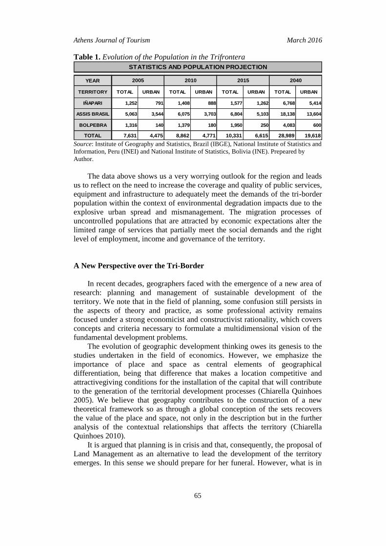
The results of our fieldwork and the use of official sources as the Brazilian
Institute of Geography and Stathistics (IBGE, Brazil)1, National Institute of
Statistics and Information (INEI, Peru)2, National Institute of Statistics (INE,
Bolivia)3 and the information collected directly from local governments, allows
us to project the population growth in the coming years (Table 1). In this sense,
we can say that the tri-border total population in 2010 would increase from
8,862 to over 28,000 in 2040.
1 IBGE: Instituto Brasileiro de Geografia e Estatística. Retreived from http://goo.gl/bjDi.
2 Instituto Nacional de Estadística e Informática-INEI: Retreived from http://www.inei.gob.pe/.
3 Instituto Nacional de Estadística. Retrieved from http://www.ine.gob.bo/.
Athens Journal of Tourism March 2016
65
Table 1. Evolution of the Population in the Trifrontera
YEAR
TERRITORY TOTAL URBAN TOTAL URBAN TOTAL URBAN TOTAL URBAN
IÑAPARI 1,252 791 1,408 888 1,577 1,262 6,768 5,414
ASSIS BRASIL 5,063 3,544 6,075 3,703 6,804 5,103 18,138 13,604
BOLPEBRA 1,316 140 1,379 180 1,950 250 4,083 600
TOTAL 7,631 4,475 8,862 4,771 10,331 6,615 28,989 19,618
STATISTICS AND POPULATION PROJECTION
2005 2010 2015 2040
Source: Institute of Geography and Statistics, Brazil (IBGE), National Institute of Statistics and
Information, Peru (INEI) and National Institute of Statistics, Bolivia (INE). Prepeared by
Author.
The data above shows us a very worrying outlook for the region and leads
us to reflect on the need to increase the coverage and quality of public services,
equipment and infrastructure to adequately meet the demands of the tri-border
population within the context of environmental degradation impacts due to the
explosive urban spread and mismanagement. The migration processes of
uncontrolled populations that are attracted by economic expectations alter the
limited range of services that partially meet the social demands and the right
level of employment, income and governance of the territory.
A New Perspective over the Tri-Border
In recent decades, geographers faced with the emergence of a new area of
research: planning and management of sustainable development of the
territory. We note that in the field of planning, some confusion still persists in
the aspects of theory and practice, as some professional activity remains
focused under a strong economicist and constructivist rationality, which covers
concepts and criteria necessary to formulate a multidimensional vision of the
fundamental development problems.
The evolution of geographic development thinking owes its genesis to the
studies undertaken in the field of economics. However, we emphasize the
importance of place and space as central elements of geographical
differentiation, being that difference that makes a location competitive and
attractivegiving conditions for the installation of the capital that will contribute
to the generation of the territorial development processes (Chiarella Quinhoes
2005). We believe that geography contributes to the construction of a new
theoretical framework so as through a global conception of the sets recovers
the value of the place and space, not only in the description but in the further
analysis of the contextual relationships that affects the territory (Chiarella
Quinhoes 2010).
It is argued that planning is in crisis and that, consequently, the proposal of
Land Management as an alternative to lead the development of the territory
emerges. In this sense we should prepare for her funeral. However, what is in
Vol. 3, No. 1 Quinhoes: Territorial Development and Amazon Integration...
66
terminal trance is the way we do planning as a collective project of social
engineering of enlightenment rationality, a situation that is typical of the wider
crisis of modernity. The discussion should focus on the type, form or
characteristics of planning. In the final analysis, we should be more consistent
and talk about territorial management (Boisier 1996). The planning that
considers only the physical limits of the city without analyzing their
relationship with the territory is a useless reductionism and sterile exercise. We
consider as a priority the construction of a vision concerning the territorial and
urban development in the tri-border that can guide the actions of the planner
and decision makers. In this sense, a privileged role to the geographer should
be assigned, as a professional who works from a holistic perspective with the
space categories: processes, structural elements, morphological and landscape
construction aspects; rescue lived space; issues related to the scales, networks,
and core flows; borders, etc.
We note that the conceptual division between town and country that is set
to the theme of territorial planning persists, specifically in urban planning. The
various published texts generally offer isolated studies that focus on rural areas
or in urban space, thus ignoring the multiple relationships, connections and
articulations between urban development and the development of the territory
of which it is part. Some works are based on merely technical issues, thereby
reducing the problem of planning to method studies, booklets, guides, etc.
Others are limited to meager budgets that do not even cover the needs of
planning itself, usually made from an economic perspective. Finally, other
texts exposed abstract and complicated theories on urban planning, from a
morphological, behavioral and perceptive view. So, at this time, arises a widely
debated issue in recent times among planners, the relationship between
processes and elements that structure urban space and those that do it in
territory. The problem of the relationship between these processes has two
different aspects. On one hand, the structure of both spaces is part of a unique
process of global capitalist development and on the other hand, the
consideration of the urban core is the key for territorial development. Both
presuppose the development of scientific research in planning as something
different from the plan.
The complexity of the requirements posed by territorial planning are
substantially increased in recent decades, requiring new methods of planning
different from traditional methods based on top-down planning or its opposite,
from the bottom up. Planning is an integrated set of an increasingly complex
unit, where different scales are related horizontally and feedback planning
systems. The identification of processes and structural elements of urban space
in a border town is enriched by the prospect of working with three cores. This
justifies the reaffirmation of the importance of the methodology for
development planning problem, it is not a purely morphological, economic,
social or environmental order.
The low quality of life of the population in the tri-border is directly linked
to the use of planning and management tools that are inadequate to the reality
of the territory. This originates from the absence of a shared vision of
Athens Journal of Tourism March 2016
67
development for the three studied locations, predominantly narrow visions
anchored in the national State not take into consideration that we must analyze
the territory from the perspective of a single Amazon territory, across national
borders. This vision should guide the formulation of a single strategic plan for
sustainable development of the territory. Consequently, we should identify
integrated management mechanisms, with the aim of providing better services
to citizens. For this management to be implemented efficiently and effectively
it is necessary to reflect on the possibility of establishing a territorial tri-border
system and identifying appropriate new administrative limits for it.
The International City
The spatial reorganization of capital in the context of globalization induces
processes that alter location decisions and the productive matrix of urban
conglomerates. Due to the condition of nodal points of networks of local,
regional, national and international communications, cities provide the
essential relationships for the operation of all levels of territorial planning.
However, the geographical proximity between countries is not a sufficient
reason for integration; for this to make sense is necessary for countries to share
a common project of political-territorial organization and geopolitical
projection, industrialization, economic integration and strategic policy in the
international system. The issue goes beyond simply building an infrastructure
to tap the complementarities of resources and comparative advantages of
national economies in a regional free trade area and to create facilities to
increase the regional flow of goods, resources, people and ideas.
For geography there is no unique right way to divide space because we can
change the articulations according to our intentions and even the organization
of the territory of the nations may be extended by studying their social
networks along with evidence of economic structures. In addition, although
urbanistic decisions, because they are administrative or government decisions
are formulated in the territory from its administrative divisions, the phenomena
behind these decisions are often explained in other levels of relationships that
the city has with the territory and that exceed municipal boundaries (Claval
1979, Chiarella Quinhoes 2005). Thus, the territorial planning should be
treated from an integral perspective, reducing the impacts of the urban
dynamics in the territory.
The need to articulate the Amazon regional integration with local
development, underlines the urgency of creating convergent areas that can
promote development processeses, both institutionally and economically.
Transboundary process may become the organizing element of the areas of
socio-economic and institutional convergence, where different designed
projects become functional and dependent variables of the reality of an
international city. It should be noted, still, some of the current effects of having
three distinct urban efforts in the region and that are linked to the provision of
public services: the residents of the poorest countries tend to cross the border
and to go to the more developed countryʼs urban center seeking for jobs and to
Vol. 3, No. 1 Quinhoes: Territorial Development and Amazon Integration...
68
get benefit from better services. Sometimes, they prefer that their children are
born in the most developed country so they can enjoy all the benefits of
citizenship such as health and education, among others. All this impacts the
demand for public resources to meet the needs of the more developed
population. Ultimately, it impacts on the quality level and in the cost of the
public service provided by the more developed country.
On the previous context, it is arised the idea that the most efficient way to
manage the tri-border territory is through an integrated planning and urban
management. This leads us to propose the creation of a city that includes the
three urban centers and institutions which allows such planning and
management. In this sense, this new perspective of the Amazonian territorial
development-passing over national borders would be the most appropriate
mechanism for urban management in terms of efficiency in the delivery of
urban services for the citizen, and at lower costs impacts on the environment
and its resources. This, ultimately, is related to a process of destruction of the
old regulations structure and mindsets to create a new model of urban
management in the Amazonian tri-border area (Chiarella Quinhoes 2014).
For the international cityʼs creation purposes, urban centers should be
prepared to meet the challenge of change processes, meet the new demands and
development contexts. In that sense, it is necessary to identify new functions
and processes of urban structure, imperious to host activities to ensure
employment, income, adequate governance and services that are compatible
with environmental conservation. Also, it should create an atmosphere of
agreements and commitments, at different levels, allowing synergies, resources
and tools to regulate and foresee the impact of the creation of an international
city, avoiding indiscriminate manipulations of the new demands for services,
income and employment, which endanger the capabilities of managing the
development of the city. It should empower urban support, consistent with new
features, new demands and expectations deriving from the process of
integration and tri national exchange. We believe that development must be
planned from the perspective of an international city, through integrated
planning and management of urban services, infrastructure and necessary
equipment for the assimilation, training and encouragement of the people on
the long road of integration for the development of the Amazon.
Final Reflections
One of the main effects of globalization is the transformation of the
concept of border to levels at which the process of des frontierization come to
configure extended economic areas and economically integrated over the
boundary lines. In these spaces the recognition of historical, anthropological
and sociological factors underlying feelings of identity and belonging that were
unknown to the political and administrative limits imposed by nation-states
occurs. The combination of processes of des frontierization with feelings of
identity and belonging, leads to the configuration of regional border areas,
Athens Journal of Tourism March 2016
69
stages of economic and social dynamics that directly involve three countries
calling into question, in practice, the validity of concepts that support the
nation-state, such as those relating to State, territory and sovereignty which
were intended to legitimize the separation of the boundary effect.
The core strategies that should guide the tri-border territorial management to
sustainably environmental exploitation should focus their impetus in sustainable
economic activities; strengthening food security strategies; environmental
protection related not only to the development and application of environmental
management instruments, but especially to the environmentally sustainable
production; strengthening institutions that lead the change; development of
scientific-technological base and infrastructure of social support for change.
In a conciliatory frame between development and environmental
conservation, water becomes a central element to reconcile different aspirations
through a cooperative and inclusive process for three countries that have social
and environmental similarities that approximate a common ideal: conservation
and territorial development of the Amazon. To sustainably use a territory, its
environmental offer must be used properly. Water management is one of the
central arguments in favor of an international city. In this regard, the
integration process should begin by a phase that plans the use, conservation,
and management of water in the area.
The geographical proximity between countries is not a sufficient reason for
integration, for this to make sense it is necessary that they share a common
project of political-territorial organization and geopolitical projection,
industrialization, economic and political integration into the international
system. The issue goes beyond simply building an infrastructure to take
advantage of resource complementarities and comparative advantages between
national economies and creates facilities to increase the regional flow of goods,
resources, people and ideas.
One of the most interesting paradoxes is related to the fact that in a
globalized economy whose productive infrastructure is composed of
information flows, cities and regions are, by an increased way, becoming
critical agents of development. In a globalized economy, national governments
do not have enough power to act on the functional processes that structure their
economies and societies, but the cities are more flexible at the time to act and
adapt to changing market conditions, technology and culture. Strictly speaking,
they have less power than national governments, but have a greater
responsiveness to generate development projects with specific objectives to
negotiate with multinationals to stimulate endogenous growth of small and
micro enterprises and to create conditions to attract new sources of wealth,
power and prestige (Castells 1995).
"There is no recipe that guarantees success in development. But if there
are at least two true statements: development is in our future, it will not be
with past ideas that we will reach; if the development is a product of the
community they will not be others but their own members who build it."
(Boisier 1992)
Vol. 3, No. 1 Quinhoes: Territorial Development and Amazon Integration...
70
Territorial Integrated Management of the Tri-Border
The articulated treatment of the potential available resources in the region
of the tri-border constitutes the basis for formulating strategies for sustainable
development. Its most concrete functional expression is oriented towards the
creation of competitive enterprises and cross-border supply chains, seeking to
exploit the complementarity of production structures. This generic answer must
respond operationally to environmental and social profiles for each local level
and scale of the border region as a part of a similar territorial typology. We
seek, also, to suggest a set of basic proposals (strategic guidelines and actions)
that value the potential of the resources available for the tri-border level to
move towards integrated development processes. That effort involves
identifying and enabling companies to install enterprises or competitive value
chains: skills, abilities, technical and managerial innovations, creativity and
willingness to invest. The key question is how to choose the potential of those
resources which have, in each place, the best comparative advantage to turn
them into competitive advantages over other investment initiatives. As a result
of our research work we officially deliver to the authorities of the tri-border on
April 15, 2015 a set of strategic directions.
Strategic Actions
As a result of the research work carried out, we have identified some strategic
actions to be implemented to ensure they serve as substrate for the formulation and
implementation of viable strategies for sustainable development:
Energy for the processing of raw materials: It is essential that the power
supply for industrial purposes is guaranteed, in order to enable
transformation processes of raw material with added value in the tri-
border territory. This action will also make possible cross-border supply
chains. However, this guarantee can only be realized through the
effective articulation of each local government with the state or with the
respective subregional government.
Efficient telecommunications: It is essential that the quality of
telecommunications, notably regargind telephone communications and
the Internet, in order to activate trade relations and reduce transaction
costs is guaranteed as well as improving the efficiency and effectiveness
of processes coordination, monitoring and the control of production
processes and chains of value. This action can only be realized through
the effective articulation of local governments with suppliers of
telephone service and data transmission-from a tri-border perspective.
Agreements for border cooperation: It is essential that the Agreement of
Related Border Cities-already approved by Peru is ratified by the
government of Brazil. This instrument will facilitate the coexistence in
the border areas of linked populations, because they will be also able to
work, study, have medical care and go shopping in the nearby town of
Athens Journal of Tourism March 2016
71
the other country on an equal footing, which will revitalize their
relatioships. On the other hand, the implementation of the Agreement of
the Free Movement of people, vehicles and cargo between Peru and
Brazil is necessary too. It must be ratified by Brazil. In both cases it is
necessary to perform actions of a political nature from local government
and civil society organizations to ensure such ratification in the shortest
time. Also, the implementation of a General Integration, Economic and
Social Cooperation Treat for the creation of a common market between
the Republic of Peru and the Republic of Bolivia is necessary. This
promotes, among other issues, the efforts to establish mechanisms and
projects of cooperation to facilitate trade and free movement of people,
vehicles and goods between Peru and Bolivia.
Strategic Axes
As a result of the research work carried out, we have identified 5 main
strategic lines of territorial tri-border development that are shown below along
with the main strategies:
Strageric Line 1-Economic Production
Strategy 1: Promote the development of eco-businesses and sustainable
activities with clean technologies.
Strategy 2: Develop a competitive and sustainable tourism, promoting
thematic tourism circuits in the tri-border as the route of the shiringa and
chestnut and others where natural elements are appreciated.
Strategy 3: Develop cross-border supply chains of wood and chestnut, shiringa
in special areas of production.
Strategy 4: Promote and strengthen micro and small enterprises (PYMES).
Strategy 5: Implement a system of research and technology transfer, valuing
traditional knowledge.
Strategy 6: Develop fishing from the coordination between local governments,
respecting the closed seasons regarding not to affect resource availability.
Strategy 7: Develop productivity from market demand and with a back focus
on chain building.
Stragetic Line 2-Inclusive Social Development
Strategy 1: Promote cultural identity with respect and appreciation of indigenous
knowledge considering multiculturalism and rights of indigenous peoples.
Strategy 2: Protect, enhance and promote the exercise of labor rights and access to
decent work for women.
Strategy 3: Promote cultural and artistic activities that strengthen the tri-border
culture.
Strategy 4: Strengthen citizen prticipation in the planning, management and
budget.
Vol. 3, No. 1 Quinhoes: Territorial Development and Amazon Integration...
72
Stragetic Line 3-Infrastructure and Urban Development
Strategy 1: Develop mechanisms for tri-border cooperation in infrastructure
construction and supply of integrated urban services.
Strategy 2: Identify and develop alternative energy supply sources.
Strategy 3: Improve the current state of local transport routes.
Strategy 4: Develop a public transport system with better quality.
Strategy 5: Improve the coverage and quality of basic services in the tri-
border.
Stragetic Line 4-Education, Health and Safety
Strategy 1: Incorporate the intercultural approach and bilingual education in
schools.
Strategy 2: Develop education for work in schools.
Strategy 3: Promote integrated disease prevention programs, sports and
recreation for a healthy life.
Strategy 4: Develop an integrated tri-border disaster risk prevention system.
Strategy 5: Develop an integrated tri-border public safety system.
Stragetic Line 5-Institutional Strengthening
Strategy 1: Develop of international agreements to expedite the free flow of
people, goods and vehicles.
Strategy 2: Strengthen the transparency in public administration and the right
of access to information
Strategy 3: Train and strengthen municipal technical staff in planning,
management and budget, with tri-border vision as well as for the formulation
of a competitiveness tri-border plan.
Strategy 4: Strengthen the capacity of territorial integrated resilience in the tri-
border.
Strategy 5: Train and strengthen the municipal technical staff in identifying,
formulating and financing public investment projects within the framework of
the Public Private Partnerships-PPPs.
Final Considerations
Mobilize the different resources available to transform them into
competitive business ventures (public or private), involves first defining the
subject of territory of a proposal (tri-border), to establish the possible scope of
supply of the goods or services that could be generated. In this regard, on one
hand, the sources of the inputs required by the production function or by the
production chain should be identified as clearly as possible, and on the other
hand, the destination of the product or service produced should be identified
Athens Journal of Tourism March 2016
73
(for export and/or domestic markets, applying the criteria of national, regional
and local food security).
The results obtained in the first instance should be systematically
discussed between all individual or associative stakeholders (unions, municipal
commonwealths, producer associations, etc.), for adjustment and social and
political validation. It should be noted that a more efficient economic
organization of the territory, from the desirable flows of trade and the rational
use of different natural resources, is enhanced with the establishment of
mechanisms to encourage public participation in the integrated process of
sustainable development.
Finally, the importance of relationships and social ties already established
is noted. We must create territorial tissues designed to support, encourage and
strengthen social bonds, favoring the interaction between people. Such
environments conduct to the balanced development of border communities
with a high sense of belonging and place. This feeling translates into territorial
identity and is fundamental to the sustainability of development processes. The
ability to achieve social peace is based precisely on the ties established
between neighboring segments along the time.
References
Alegría T (2009) Metropolis Transfronteriza. Revisión de la hipótesis y evidencias de
Tijuana [Tran frontier metropolis. Review of the hypotheses and evidence of
Tijuana, Mexico, and San Diego, United States]. Mexico: EURE 37(110): 163-
165.
Arruda RSV (2010) Fronteiras e identidades: os manchineri e os jaminawa na tríplice
fronteira Brasil-Bolívia-Perú [Borders and identities: the manchineri and
jaminawa in the triple border Brazil-Bolívia-Perú]. Goiás: Society and Culture
13(1): 25-37.
Boisier S (1996) Modernidad y territorio [Modernity and territory]. Santiago de
Chile: ILPES.
Boisier S (1992) El difícil arte de hacer región: las regiones como actores
territoriales del nuevo orden internacional (conceptos, problemas y métodos)
[The difficult art of doing region: regions as territorial actors of the new
international order (concepts, problems and methods)]. Cuzco: Centro de Estudio
Regionales Andinos Bartolomé de las Casas [Andean Regional Studies Center
Bartolomé de las Casas].
Castells M (1995) La ciudad informacional. Tecnologías de la información, re-
estructuración económica y el proceso urbano-regional [The informational city.
Information technology, economic re-structuring and the urban-regional
process]. Madrid, Spain: Alianza Editorial.
Chiarella Quinhoes R (2014) Planeamiento y gestión territorial. Análisis de las
dinámicas territoriales en la trifrontera entre Perú Brasil y Bolivia [Planning and
territorial management. Analysis of territorial dynamics in the tri-border
between Brazil, Bolivia and Peru]. Anais do I Congresso Brasileiro de Geografia
Política, Geopolítica e Gestão. Rio de Janeiro: REBRAGEO: 985-998.
Vol. 3, No. 1 Quinhoes: Territorial Development and Amazon Integration...
74
Chiarella Quinhoes R (2011) Redes y territorio: la iniciativa IIRSA en foco [Networks
and territory: the IIRSA initiative in focus]. Revista Espacio y Desarrollo [Space
and Development Magazine]. Lima: CIGA/PUCP 23: 5-29.
Chiarella Quinhoes R (2010) Planificación del desarrollo territorial. Algunas
precisiones. [Territorial development planning. Some precisions]. Revista
Espacio y Desarrollo [Space and Development Magazine]. Lima: CIGA/PUCP.
22: 77-102.
Chiarella Quinhoes R (2005) Conurbación o ciudad internacional? Gestión urbana e
impactos en el territorio. Iñapari-Assis Brasil-Bolpebra [Conurbation or
international city? Urban management and impacts in the territory. Asis Iñapari-
Assis Brasil-Bolpebra]. Revista Espacio y Desarrollo [Space and Development
Magazine]. Lima: CIGA/PUCP 17: 69-88.
Claval P (1979) La nueva geografía [The new geography]. Barcelona, Spain: OIKOS-
TAU.
Conato D (2009) Fronteras de tierra y de mar: de áreas conflictivas a espacios de
colaboración e integración centroamericana [Border land and sea: from areas of
conflict to areas of collaboration and Central American integration]. Roma,
Italy: CeSPI 103-138.
Machado LO, Riberio LP, do Rego Monteiro L (2013) Geopolítica fragmentada:
interaçõestransfronteiriças entre o Acre (BR), o Peru e a Bolívia [Fragmented
geopolitics: cross-border interactions between Acre (BR), Peru and Bolivia].
Cuadernos de Geografía. Revista Colombiana de Geografía-Bogotá [Notebooks
of Geography. Colombian Geography Magazine-Bogota] 23(2): 15-30.
Manchineri A, Morais M (2011) Povo manchineri: Mobilidade territorial e cultura
[Manchineri People: Territorial Mobility and Culture]. Revista Geográfica De
América Centra [Central America Geographic Magazine] 2(47).
Simoes M (2009) Historia e memoria das tres fronteiras: Brasil, Perú e Bolívia
[History and memory of the three borders: Brazil, Peru and Bolivia]. Sao Paulo:
EDUC/PUC/SP: 278.
Sohn C (2010) El papel ambivalente de las fronteras en la construcción de las
metrópolis transfronterizas en Europa. Los casos de Basilea, Ginebra y
Luxemburgo [The ambivalent role of borders in the construction of cross-border
metropolis in Europe. Cases of Basel, Geneva and Luxembourg]. Geographical
Analysis Documents 56(1): 167-184.
Valero M (1998) El suroeste de Venezuela: espacios de integración fronteriza
[Southwestern Venezuela: border integration spaces]. Anales de Geografía de la
Universidad Complutense [Annals of Geography at the Complutense University]
18: 139-158.