Embed Size (px)
Citation preview
Note: The information contained in this publicationwas accurate at printing but because GPS technologyis evolving rapidly, this information must be consid-ered perishable. This Safety Advisor refers to particu-lar GPS receivers. Some are no longer in productionand features of others may change from what is discussed here. Pilots are advised to refer to the manufacturer’s operating guide for information specific to their receivers. The Air Safety Foundationwill update this Safety Advisor on a regular basis.
How Is GPS Different from VOR?GPS is a navigational system that calculates your posi-tion from 24 satellites orbiting the earth. In airplanes,GPS course indicators show your position relative to aselected course in much the same way as VOR, soGPS provides the same information pilots have beenusing for years. But wait – there’s more. GPS can alsoshow your position on an electronic chart and, withadditional software and/or equipment, it can showyour altitude above terrain. The list of GPS features islong and growing but the principal differencesbetween GPS and VOR navigation are:1. GPS is a computer-based navigation system that
offers many features unavailable in VOR navigation. How these additional features are accessed and controlled by pilots depends on which make and model of GPS receiver you’re using.
• With additional features comes complexity. GPS receivers are more complex than VOR units and pilots must commit the time and resources necessary to thoroughly understand their operation.
2. VOR uses resolver course indicators. Some GPS installations do not.
• Pilots navigating with VOR know they can rotate the omni bearing selector (OBS) on their course indictors to “resolve” their relationship to a particularcourse. Resolverless GPS indicators act like an
GPS Technology
A O P A A i r S a f e t y F o u n d a t i o n
S A F E T Y A D V I S O R
Technology No. 1
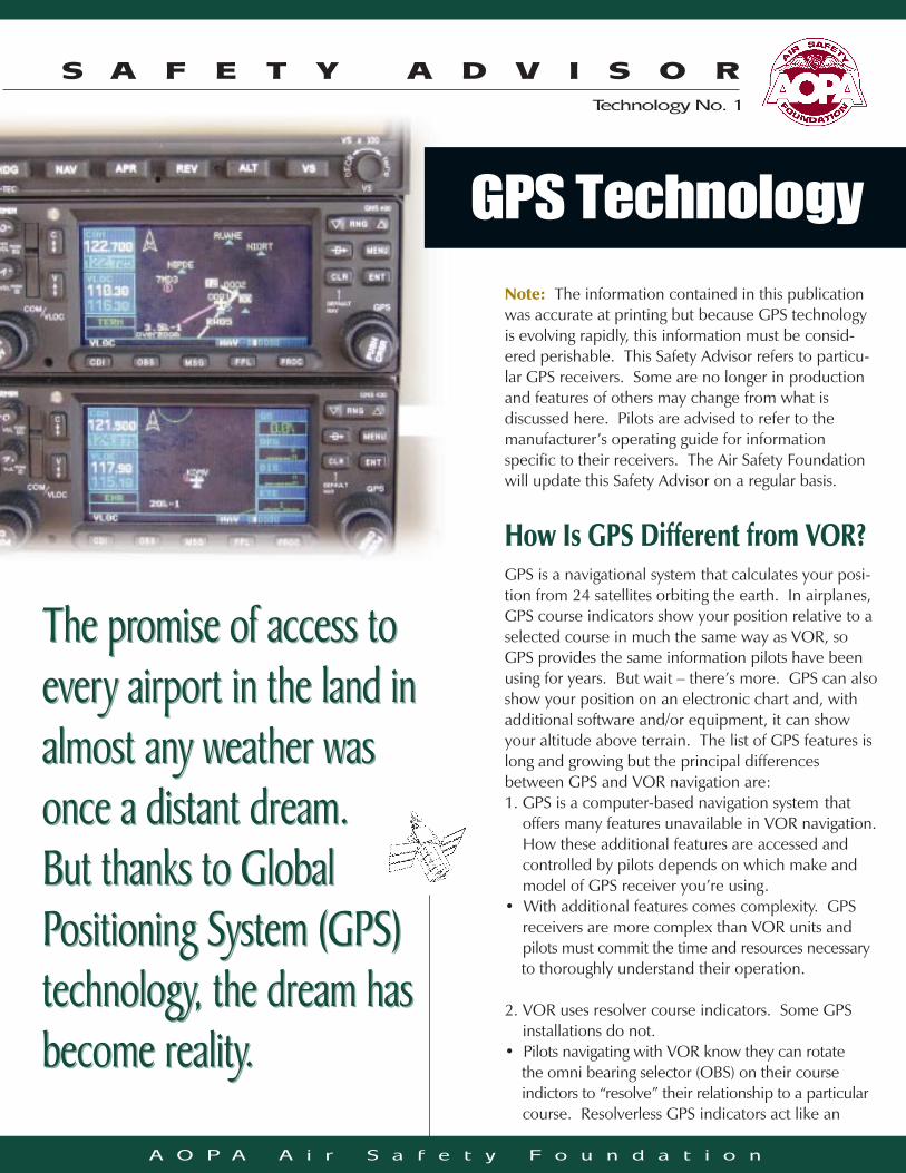
The promise of access toevery airport in the land inalmost any weather wasonce a distant dream. But thanks to Global Positioning System (GPS)technology, the dream hasbecome reality.
The promise of access toevery airport in the land inalmost any weather wasonce a distant dream. But thanks to Global Positioning System (GPS)technology, the dream hasbecome reality.
Safe Pilots. Safe Skies. • Pg. 2
ILS localizer. They indicate your relationship to a course regardless of the position of the OBS. Pilots of resolverless GPS installations must select the desired course on the GPS receiver itself.
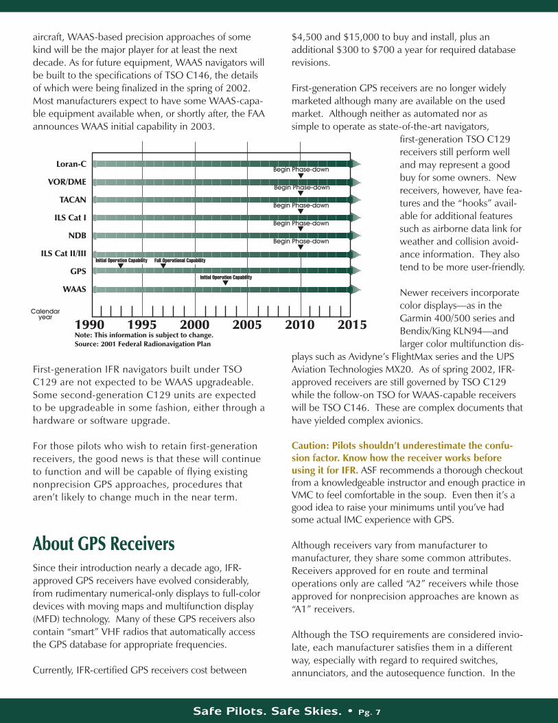
3. GPS receivers can store a sequence of locations (waypoints) and will provide navigation information to each waypoint in that sequence. As each waypoint is reached, the next waypoint in the sequence automatically becomes the active waypoint. This function is referred to as autosequencing and files of waypoints are called flight plans. A GPS approach is a sequence of waypoints leading from the initial approach fix (IAF) to the missed approach point (MAP) and from there to the missed approach holding point.
• If you don’t want to proceed to the next waypoint in a sequence, i.e., if you want to hold referencing a waypoint, you may or may not have to manually suspend the automatic sequencing function depending on which GPS receiver you’re using.
4. Instrument approaches designed for GPS are easy to fly but interrupting an approach, e.g., abandoning the approach and receiving vectors to final, can result in a high pilot work load close to the ground. GPS approaches that overlay traditional approach procedures can have a very high work load.
• Pilots must be thoroughly familiar with their GPS receiver before flying instrument approaches in IMC.
5. GPS receivers calculate magnetic course from true course information and display the information as a great circle track. There are several ways of doing this calculation and pilots should know that, although GPS may not always agree with VOR, the difference will be slight.
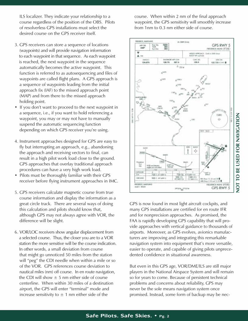
6. VOR/LOC receivers show angular displacement from a selected course. Thus, the closer you are to a VOR station the more sensitive will be the course indication. In other words, a small deviation from course that might go unnoticed 50 miles from the station will “peg” the CDI needle when within a mile or so of the VOR. GPS references course deviation to nautical miles (nm) off course. In en route navigation, the CDI will show ± 5 nm either side of course centerline. When within 30 miles of a destination airport, the GPS will enter “terminal” mode and increase sensitivity to ± 1 nm either side of the
course. When within 2 nm of the final approach waypoint, the GPS sensitivity will smoothly increase from 1nm to 0.3 nm either side of course.
GPS is now found in most light aircraft cockpits, andmany GPS installations are certified for en route IFRand for nonprecision approaches. As promised, theFAA is rapidly developing GPS capability that will pro-vide approaches with vertical guidance to thousands ofairports. Moreover, as GPS evolves, avionics manufac-turers are improving and integrating this remarkablenavigation system into equipment that’s more versatile,easier to operate, and capable of giving pilots unprece-dented confidence in situational awareness.
But even in this GPS age, VOR/DME/ILS are still majorplayers in the National Airspace System and will remainso for years to come. Because of persistent technicalproblems and concerns about reliability, GPS maynever be the sole means navigation system oncepromised. Instead, some form of backup may be nec-
NO
T TO
BE
USE
D F
OR
NAV
IGAT
ION
essary–probably a skeletal VOR system or even loran. Nonetheless, the FAA is proceeding with its ambitiousWide Area Augmentation System (WAAS) — technolo-gy that provides a correction factor to GPS receiversthat makes them more accurate and more reliable.WAAS, expected before the end of 2003, will alsomake vertical guidance possible on most GPSapproaches and initial WAAS precision approach mini-ma will be slightly higher than CAT I ILS minima. TheFAA is also investing significant resources in Local AreaAugmentation Systems (LAAS) that will eventuallyreplace ground-based Cat II/III instrument landing sys-tems. For the short term, these developments meanthat aircraft owners should expect to retain VOR andILS equipment in some form, but GPS will increasinglyshoulder the burden for en route navigation and forapproaches into outlying airports.
The pilot of a Cessna 172 experienced icing in IMC.Unable to maintain altitude, he descended below radarcoverage in mountainous terrain. Using a handheldGPS receiver and sectional charts, the pilot was able to land at a nontowered field that had no instrumentapproach. This pilot was extremely lucky and probablywished a better assessment of weather had been madebefore flight. Happily, GPS contributed to a way out ofwhat could have been a fatal situation.
GPS: How It BeganGPS owes its development to the strategic and tacticalneeds of the U.S. military. During the 1970s, theDepartment of Defense developed GPS primarily as anall-purpose navigation system to improve position find-ing for ships at sea, aircraft, and ground combat units.
The first GPS satellite was launched in 1978 andGPS was declared fully operational in 1995. TheGPS constellation is comprised of at least 24 satel-lites, but the total number is sometimes greater.Although the system was designed by and for themilitary, civilian GPS has been in use since thebeginning. Civil users were at first unable toreceive as precise a signal as the armed forces.They were provided a somewhat degraded signalreferred to as selective availability (SA). As civil useof GPS increased, Congress exerted pressure on theDepartment of Defense to provide more GPS accu-racy for civil applications. Consequently, SA wasturned off in 1999.
Safe Pilots. Safe Skies. • Pg. 3
The Road to IFRGPS didn’t spring fully formed into the world of navigation. In its early years, it was only sporadically available, due to a limited number of satellites. By the mid-1990s, the system had its full 24-satellite constella-tion in orbit. As satellites age they are replaced withnew models.
Tentatively beginning in 2003, at least one and proba-bly two new GPS frequencies will be made available.Dual frequency navigation will improve the accuracyand reliability of the basic GPS signal and significantlydecrease errors due to atmospheric effects. However,basic GPS is still not accurate enough for precisionapproaches, even with SA off. Precision approacheswill require wide area or local area augmentation.
A commercial pilot in a Cessna 182 experienced analternator failure in night IMC. Using a handheld GPSreceiver he navigated to a nontowered airport but wasunable to activate the pilot controlled lighting system.He landed next to the runway with minor damage tothe airplane and no injuries to the crew and passen-gers. Although regulations prohibit use of handheld GPSreceivers for instrument operations, this pilot exercisedhis PIC authority and successfully coped with the emergency.
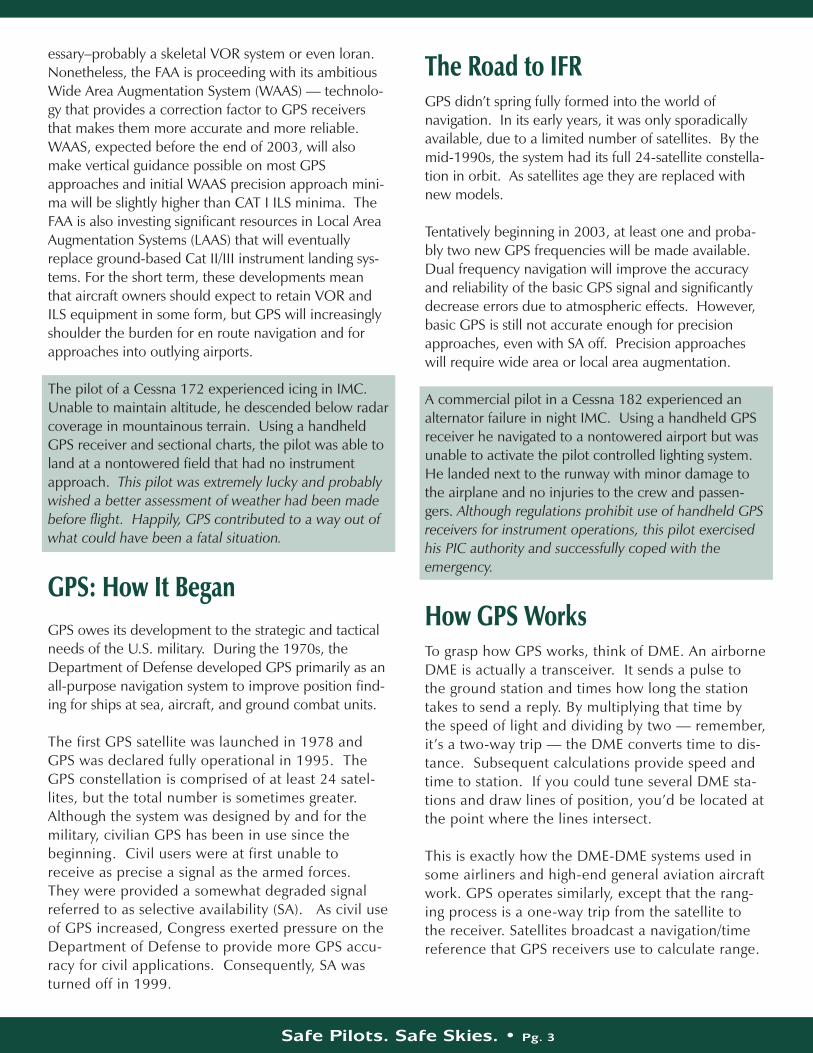
How GPS WorksTo grasp how GPS works, think of DME. An airborneDME is actually a transceiver. It sends a pulse tothe ground station and times how long the stationtakes to send a reply. By multiplying that time bythe speed of light and dividing by two — remember,it’s a two-way trip — the DME converts time to dis-tance. Subsequent calculations provide speed andtime to station. If you could tune several DME sta-tions and draw lines of position, you’d be located atthe point where the lines intersect.
This is exactly how the DME-DME systems used insome airliners and high-end general aviation aircraftwork. GPS operates similarly, except that the rang-ing process is a one-way trip from the satellite tothe receiver. Satellites broadcast a navigation/time reference that GPS receivers use to calculate range.
Safe Pilots. Safe Skies. • Pg. 4
Satellites Talk, Receivers ListenTo calculate range, the receiver has to know two things:exactly where a satellite is in space and exactly whenthe signal left the satellite. Satellites broadcast almanacdata to tell the receiver generally where all the satellitesare and ephemeris (precision celestial data) that pin-points each satellite's position in space. When a newGPS receiver is turned on, it must download thealmanac and ephemeris data before it can determineposition. This usually takes about 12 minutes.
The receiver establishes lines of position from at leastfour satellites, corrects for any timing errors, and dis-plays your position within a few hundred feet. At leastfour satellites are preferred but three will do in a pinchif the pilot provides a fourth line of position – altitude.
So How Accurate Is GPS?GPS accuracy is dependent on a number of factorsresulting in varied accuracy claims. Perhaps the bestway to look at accuracy is a worst-case scenario, i.e.,with selective availability on, unaugmented GPS will beaccurate to within 300 meters (993 feet) 99.99 percentof the time. Under the same conditions, GPS will be
accurate to within 100 meters (331 feet) 95 percent ofthe time. Since these figures consider a combination ofaccuracy degrading circumstances and conditions,pilots can expect to see significantly greater accuracy ineveryday navigation. With selective availability offand/or with differential correction GPS accuracyincreases.
Why Handhelds Won’t Do the Job for IFRBecause the GPS constellation provides good coverage,panel mount receivers with unrestricted antennas nearly always navigate in three dimensions. Handheldreceivers don’t always do as well. With their antennasshadowed by wings or other aircraft structures, theyoccasionally revert to two dimensions or lose coverageentirely. Because their antennas cannot be optimallylocated and because their power supplies cannot beguaranteed, handheld GPS units are not likely to becertified for IFR navigation.
Accuracy 330 – 990 feet
100–300 meters
30 – 100meters
7 meters
100 - 330feet
Betterthan 23feet
Under develop-ment butbetter thanWAAS
Condition SA On SA Off WAAS LAAS
GPS in a Nutshell
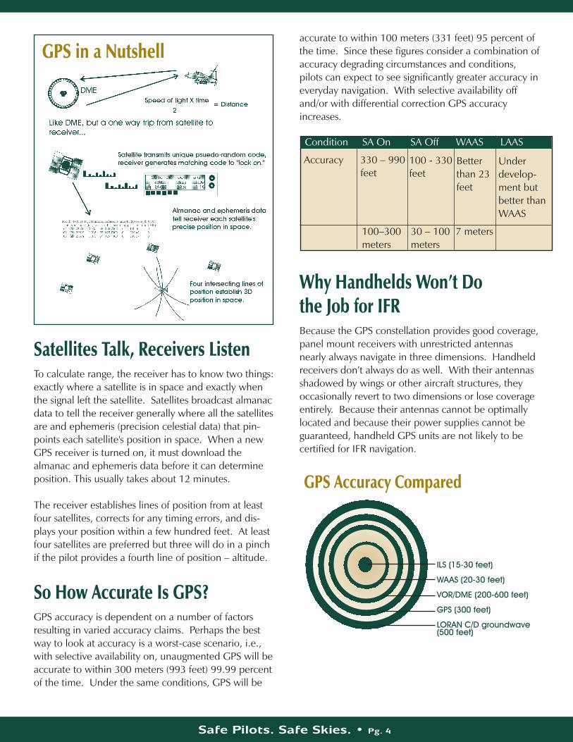
GPS Accuracy Compared
ILS (15-30 feet)
WAAS (20-30 feet)
VOR/DME (200-600 feet)
GPS (300 feet)
LORAN C/D groundwave(500 feet)
Safe Pilots. Safe Skies. • Pg. 5
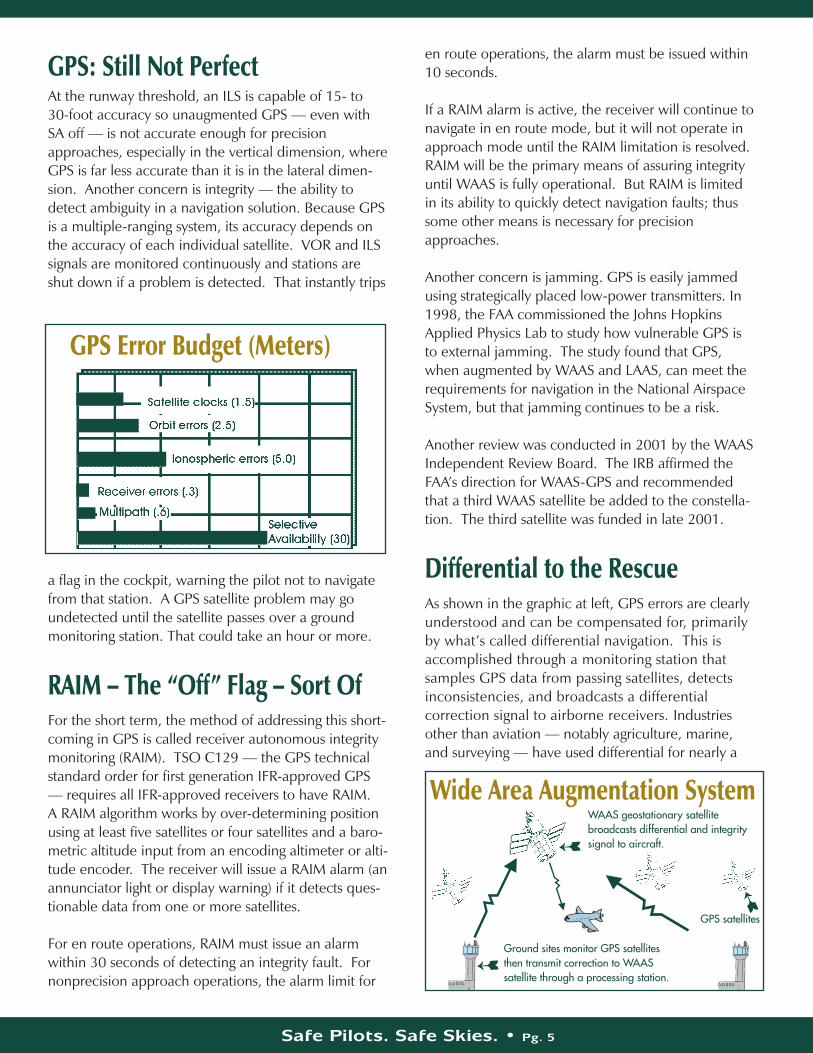
GPS: Still Not PerfectAt the runway threshold, an ILS is capable of 15- to 30-foot accuracy so unaugmented GPS — even withSA off — is not accurate enough for precisionapproaches, especially in the vertical dimension, whereGPS is far less accurate than it is in the lateral dimen-sion. Another concern is integrity — the ability todetect ambiguity in a navigation solution. Because GPSis a multiple-ranging system, its accuracy depends onthe accuracy of each individual satellite. VOR and ILSsignals are monitored continuously and stations areshut down if a problem is detected. That instantly trips
a flag in the cockpit, warning the pilot not to navigatefrom that station. A GPS satellite problem may goundetected until the satellite passes over a groundmonitoring station. That could take an hour or more.
RAIM – The “Off” Flag – Sort OfFor the short term, the method of addressing this short-coming in GPS is called receiver autonomous integritymonitoring (RAIM). TSO C129 — the GPS technicalstandard order for first generation IFR-approved GPS— requires all IFR-approved receivers to have RAIM. A RAIM algorithm works by over-determining positionusing at least five satellites or four satellites and a baro-metric altitude input from an encoding altimeter or alti-tude encoder. The receiver will issue a RAIM alarm (anannunciator light or display warning) if it detects ques-tionable data from one or more satellites.
For en route operations, RAIM must issue an alarmwithin 30 seconds of detecting an integrity fault. Fornonprecision approach operations, the alarm limit for
en route operations, the alarm must be issued within10 seconds.
If a RAIM alarm is active, the receiver will continue tonavigate in en route mode, but it will not operate inapproach mode until the RAIM limitation is resolved.RAIM will be the primary means of assuring integrityuntil WAAS is fully operational. But RAIM is limitedin its ability to quickly detect navigation faults; thussome other means is necessary for precisionapproaches.
Another concern is jamming. GPS is easily jammedusing strategically placed low-power transmitters. In1998, the FAA commissioned the Johns HopkinsApplied Physics Lab to study how vulnerable GPS isto external jamming. The study found that GPS,when augmented by WAAS and LAAS, can meet therequirements for navigation in the National AirspaceSystem, but that jamming continues to be a risk.
Another review was conducted in 2001 by the WAASIndependent Review Board. The IRB affirmed theFAA’s direction for WAAS-GPS and recommendedthat a third WAAS satellite be added to the constella-tion. The third satellite was funded in late 2001.
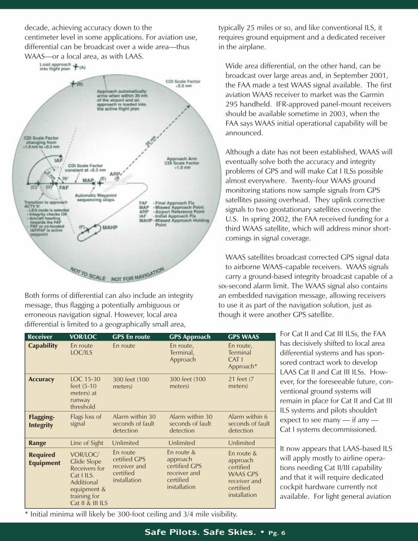
Differential to the RescueAs shown in the graphic at left, GPS errors are clearly understood and can be compensated for, primarily by what’s called differential navigation. This isaccomplished through a monitoring station that samples GPS data from passing satellites, detectsinconsistencies, and broadcasts a differential correction signal to airborne receivers. Industriesother than aviation — notably agriculture, marine,and surveying — have used differential for nearly a
GPS Error Budget (Meters)
Wide Area Augmentation SystemWAAS geostationary satellite broadcasts differential and integritysignal to aircraft.
Ground sites monitor GPS satellitesthen transmit correction to WAASsatellite through a processing station.
GPS satellites
Safe Pilots. Safe Skies. • Pg. 6
decade, achieving accuracy down to the centimeter level in some applications. For aviation use,differential can be broadcast over a wide area—thusWAAS—or a local area, as with LAAS.
Both forms of differential can also include an integritymessage, thus flagging a potentially ambiguous or erroneous navigation signal. However, local area differential is limited to a geographically small area,
typically 25 miles or so, and like conventional ILS, itrequires ground equipment and a dedicated receiver in the airplane.
Wide area differential, on the other hand, can bebroadcast over large areas and, in September 2001,the FAA made a test WAAS signal available. The firstaviation WAAS receiver to market was the Garmin295 handheld. IFR-approved panel-mount receiversshould be available sometime in 2003, when theFAA says WAAS initial operational capability will beannounced.
Although a date has not been established, WAAS willeventually solve both the accuracy and integrityproblems of GPS and will make Cat I ILSs possiblealmost everywhere. Twenty-four WAAS groundmonitoring stations now sample signals from GPSsatellites passing overhead. They uplink correctivesignals to two geostationary satellites covering theU.S. In spring 2002, the FAA received funding for athird WAAS satellite, which will address minor short-comings in signal coverage.
WAAS satellites broadcast corrected GPS signal datato airborne WAAS-capable receivers. WAAS signalscarry a ground-based integrity broadcast capable of a
six-second alarm limit. The WAAS signal also containsan embedded navigation message, allowing receiversto use it as part of the navigation solution, just asthough it were another GPS satellite.
For Cat II and Cat III ILSs, the FAAhas decisively shifted to local areadifferential systems and has spon-sored contract work to developLAAS Cat II and Cat III ILSs. How-ever, for the foreseeable future, con-ventional ground systems willremain in place for Cat II and Cat IIIILS systems and pilots shouldn'texpect to see many — if any — Cat I systems decommissioned.
It now appears that LAAS-based ILSwill apply mostly to airline opera-tions needing Cat II/III capabilityand that it will require dedicatedcockpit hardware currently notavailable. For light general aviation
Accuracy
Flagging-Integrity
Range
RequiredEquipment
Receiver VOR/LOC GPS En route GPS Approach GPS WAASEn routeLOC/ILS
LOC 15-30feet (5-10meters) atrunwaythreshold
VOR/LOC/Glide SlopeReceivers forCat I ILS. Additionalequipment &training for Cat II & III ILS
En route cetified GPSreceiver andcertified installation
En route &approachcertified GPSreceiver andcertifiedinstallation
En route &approachcertifiedWAAS GPSreceiver andcertifiedinstallation
Flags loss ofsignal
Alarm within 30seconds of faultdetection
Alarm within 30seconds of faultdetection
Alarm within 6seconds of faultdetection
300 feet (100meters)
300 feet (100meters)
21 feet (7meters)
En route
Line of Sight Unlimited Unlimited Unlimited
En route,Terminal,Approach
En route,TerminalCAT IApproach*
Capability
* Initial minima will likely be 300-foot ceiling and 3/4 mile visibility.
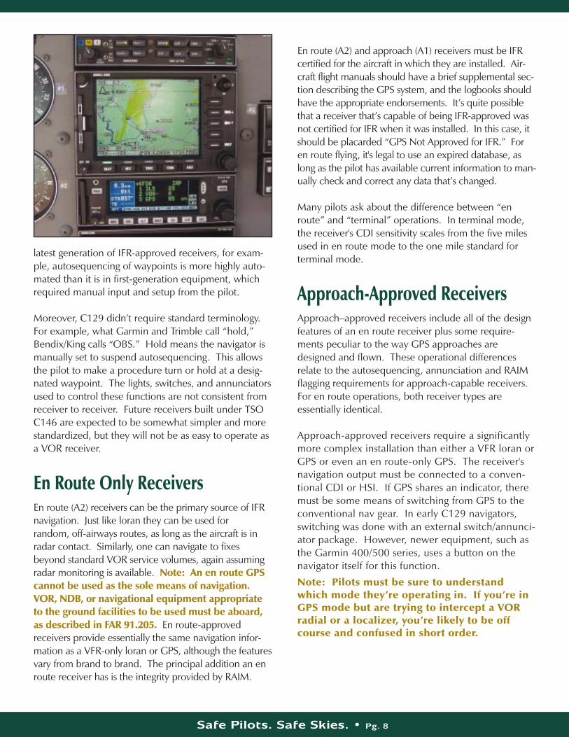
aircraft, WAAS-based precision approaches of somekind will be the major player for at least the nextdecade. As for future equipment, WAAS navigators willbe built to the specifications of TSO C146, the detailsof which were being finalized in the spring of 2002.Most manufacturers expect to have some WAAS-capa-ble equipment available when, or shortly after, the FAAannounces WAAS initial capability in 2003.
First-generation IFR navigators built under TSOC129 are not expected to be WAAS upgradeable.Some second-generation C129 units are expectedto be upgradeable in some fashion, either through a hardware or software upgrade.
For those pilots who wish to retain first-generationreceivers, the good news is that these will continueto function and will be capable of flying existingnonprecision GPS approaches, procedures thataren’t likely to change much in the near term.
About GPS Receivers Since their introduction nearly a decade ago, IFR-approved GPS receivers have evolved considerably,from rudimentary numerical-only displays to full-colordevices with moving maps and multifunction display(MFD) technology. Many of these GPS receivers alsocontain “smart” VHF radios that automatically accessthe GPS database for appropriate frequencies.
Currently, IFR-certified GPS receivers cost between
$4,500 and $15,000 to buy and install, plus an additional $300 to $700 a year for required databaserevisions.
First-generation GPS receivers are no longer widelymarketed although many are available on the usedmarket. Although neither as automated nor as simple to operate as state-of-the-art navigators,
first-generation TSO C129receivers still perform welland may represent a goodbuy for some owners. Newreceivers, however, have fea-tures and the “hooks” avail-able for additional featuressuch as airborne data link forweather and collision avoid-ance information. They alsotend to be more user-friendly.
Newer receivers incorporatecolor displays—as in theGarmin 400/500 series andBendix/King KLN94—andlarger color multifunction dis-
plays such as Avidyne’s FlightMax series and the UPSAviation Technologies MX20. As of spring 2002, IFR-approved receivers are still governed by TSO C129while the follow-on TSO for WAAS-capable receiverswill be TSO C146. These are complex documents thathave yielded complex avionics.
Caution: Pilots shouldn’t underestimate the confu-sion factor. Know how the receiver works beforeusing it for IFR. ASF recommends a thorough checkoutfrom a knowledgeable instructor and enough practice inVMC to feel comfortable in the soup. Even then it’s agood idea to raise your minimums until you’ve hadsome actual IMC experience with GPS.
Although receivers vary from manufacturer to manufacturer, they share some common attributes.Receivers approved for en route and terminal operations only are called “A2” receivers while thoseapproved for nonprecision approaches are known as“A1” receivers.
Although the TSO requirements are considered invio-late, each manufacturer satisfies them in a differentway, especially with regard to required switches,annunciators, and the autosequence function. In the
Safe Pilots. Safe Skies. • Pg. 7
1990 1995 2000 2005 2010 2015Note: This information is subject to change.Source: 2001 Federal Radionavigation Plan
Loran-C
VOR/DME
TACAN
ILS Cat I
NDB
ILS Cat II/III
GPS
WAAS
Begin Phase-down
Begin Phase-down
Begin Phase-down
Begin Phase-down
Begin Phase-down
s
Initial Operation Capabilitys
Initial Operation Capabilitys
Calendaryear
Full Operational Capabilitys
s
s
s
s
Safe Pilots. Safe Skies. • Pg. 8
latest generation of IFR-approved receivers, for exam-ple, autosequencing of waypoints is more highly auto-mated than it is in first-generation equipment, whichrequired manual input and setup from the pilot.
Moreover, C129 didn’t require standard terminology.For example, what Garmin and Trimble call “hold,”Bendix/King calls “OBS.” Hold means the navigator ismanually set to suspend autosequencing. This allowsthe pilot to make a procedure turn or hold at a desig-nated waypoint. The lights, switches, and annunciatorsused to control these functions are not consistent fromreceiver to receiver. Future receivers built under TSOC146 are expected to be somewhat simpler and morestandardized, but they will not be as easy to operate asa VOR receiver.
En Route Only ReceiversEn route (A2) receivers can be the primary source of IFRnavigation. Just like loran they can be used for random, off-airways routes, as long as the aircraft is inradar contact. Similarly, one can navigate to fixesbeyond standard VOR service volumes, again assumingradar monitoring is available. Note: An en route GPScannot be used as the sole means of navigation.VOR, NDB, or navigational equipment appropriateto the ground facilities to be used must be aboard,as described in FAR 91.205. En route-approvedreceivers provide essentially the same navigation infor-mation as a VFR-only loran or GPS, although the featuresvary from brand to brand. The principal addition an enroute receiver has is the integrity provided by RAIM.
En route (A2) and approach (A1) receivers must be IFRcertified for the aircraft in which they are installed. Air-craft flight manuals should have a brief supplemental sec-tion describing the GPS system, and the logbooks shouldhave the appropriate endorsements. It’s quite possiblethat a receiver that’s capable of being IFR-approved wasnot certified for IFR when it was installed. In this case, itshould be placarded “GPS Not Approved for IFR.” Foren route flying, it's legal to use an expired database, aslong as the pilot has available current information to man-ually check and correct any data that’s changed.
Many pilots ask about the difference between “enroute” and “terminal” operations. In terminal mode,the receiver's CDI sensitivity scales from the five milesused in en route mode to the one mile standard for terminal mode.
Approach-Approved ReceiversApproach–approved receivers include all of the designfeatures of an en route receiver plus some require-ments peculiar to the way GPS approaches aredesigned and flown. These operational differencesrelate to the autosequencing, annunciation and RAIMflagging requirements for approach-capable receivers.For en route operations, both receiver types are essentially identical.
Approach-approved receivers require a significantlymore complex installation than either a VFR loran orGPS or even an en route-only GPS. The receiver'snavigation output must be connected to a conven-tional CDI or HSI. If GPS shares an indicator, theremust be some means of switching from GPS to theconventional nav gear. In early C129 navigators,switching was done with an external switch/annunci-ator package. However, newer equipment, such asthe Garmin 400/500 series, uses a button on thenavigator itself for this function.
Note: Pilots must be sure to understandwhich mode they’re operating in. If you’re inGPS mode but are trying to intercept a VORradial or a localizer, you’re likely to be offcourse and confused in short order.
Safe Pilots. Safe Skies. • Pg. 9
All IFR GPS installations must indicate the followingannunciations: • When the GPS is connected to the HSI or CDI — a
waypoint alert annunciator to indicate turn anticipationand impending waypoint passage.
• When the receiver approach mode is armed and when it is active.
• When the GPS is autosequencing for the approach or when autosequencing is temporarily suspended to allow a procedure turn or a vector.
Annunciator design and labeling vary from receiver toreceiver and, occasionally, between the same brandsand models of receivers. Pilots are cautioned to readthe receiver manual carefully to clear up any ambigui-ties. IFR-certified installations usually require altitudedata, used by the RAIM function, from either anencoding altimeter or a blind encoder.
What’s a Resolver?All Garmin and Bendix/King installations (KLN 90B,KLN 89B, and KLN 94) use a resolver-type couplingbetween the receiver and the CDI/HSI. Trimble andNorthstar designs do not. Both of these units are nolonger in production but are nonetheless found inmany used aircraft. UPS Aviation Technology’s IFRnavigators—initially sold under the IIMorrow name—also use a resolverless indicator.
In the resolver-type design, the CDI/HSI needle reactsmuch as it does with conventional VOR. In otherwords, if the pilot selects a course on the receiver, theOBS must be set to the correct course in order toachieve proper sensing.
In the resolverless design, when the pilot selects acourse on the receiver, the OBS has no effect on nee-dle behavior. The needle will respond in the same wayas if a conventional nav/com were tuned to a localizer.The pilot selects a specific course on the receiver usingknobs or keys. The CDI needle will then display theaircraft’s position relative to the course selected on thereceiver.
Note: To avoid confusion, ASF recommends thatpilots always set the correct course on theircourse indicator(s).
IFR DatabasesTo be legal for IFR approaches, a receiver has to havea current database, revised to the 28-day cycle. Thereceiver will not lock out approaches if the data-base is expired. It’s up to the pilot to know thedatabase is current. Database media vary withreceivers. Some have a front-loading card similar to acomputer PCMCIA flash memory device while olderunits may have a rear-mounted cartridge. In the pastfew years, database availability has changed dramati-cally. It’s now possible to download current data fromWeb-based sources and then burn this into the receiver’s data card.
Database revision services vary widely in cost and for-mat, with the average yearly subscription for 28-dayservice costing about $600. One-shot revisions areavailable for all receivers and are legal for approach-es, providing they meet the current 28-day cycle.Having a current receiver database, however, stilldoesn’t obviate the recommendation that currentcharts also be aboard the aircraft. Although there’s nolegal requirement for current charts and plates forlight aircraft Part 91 general aviation operations, inthe event of an accident or incident the FAA wouldlikely cite the pilot for failure to have all availableinformation concerning the flight, per FAR91.103.
Flying Approaches: Old vs. NewGPS navigators are, by TSO requirement, designed tofly approaches as miniature routes. In other words,the waypoints must be flown in exactly the orderthey're stored in the database. When a full approachis to be flown — that is, via a nonradar feeder routeor a procedure turn — the pilot can choose which initial approach fix (IAF) to use, but thereafter, can-not alter the order of events. Each segment of theapproach is flown as a TO-TO leg, meaning when thereceiver reaches one waypoint in the approach, itautomatically sequences TO the next, until reachingthe missed approach point (MAP), at which pointautosequencing stops. If the pilot doesn’t initiate themissed approach segment, it’s assumed that the flightwill either land straight in or circle to land.

Safe Pilots. Safe Skies. • Pg. 10
Autosequencing is also required if the pilot is vectoredinto the approach. To keep the receiver from sequenc-ing before intercepting the final approach course, pilotsmust ensure the appropriate waypoint – usually thefinal approach fix – is the active waypoint, manuallysuspend autosequencing, then re-engage it once established on the final approach course.Note: ASF recommends a thorough make andmodel–specific GPS checkout and some IFR practice in VMC before using GPS for instrumentapproaches. Once qualified, pilots should practiceGPS navigation frequently to maintain proficiency.Be sure to use an instructor or a qualified safetypilot, coordinate with ATC for traffic advisories, andtry not to practice in high density airspace.
A Cessna 310 was involved in a gear-up landing inci-dent. The pilot indicated that he was busy working hisnew GPS and inadvertently forgot to lower the landinggear. Like any new technology, GPS can demand a lotof attention until operators become thoroughly familiarwith its use. Strict attention to the landing checklist or,better yet, an instructor or safety pilot on board couldhave averted a costly and embarrassing incident.
Early GPS receivers—many of which are still in ser-vice—required the pilot to select autosequencing or tosuspend autosequencing via a manual switch. Newermodels—the UPSAT GX series and the Garmin400/500 series— have largely automatic sequencingcontrol. Further, newer units also have a “vector-to-final” option, which allows the pilot to set the navigator
to automatically begin sequencing upon joining a finalapproach course via vector. If the pilot has selectedthe approach function, the receiver will automaticallyarm approach capability when the aircraft is within 30miles of the airport. At this point, the approach-armedannunciator will illuminate—if the receiver designrequires this, and some don’t—and the CDI scale willtransition from five miles to one mile (the terminalscale).
Once established on the intermediate segment twomiles outside the final approach fix (FAF), the receiverwill automatically switch to the approach-active modeand the CDI scale will transition from one mile to .3mile. The approach-active annunciator will illuminate.
Autosequencing vs. HoldOne of the more confusing aspects of GPS operation isthe hold function. The hold function tells the receiver,“wait a minute, don’t start sequencing yet. We need tocomplete the procedure turn first.” Or, “we’re beingvectored, don’t sequence until we’re on the finalapproach course, outside the FAF.”
Early Garmin and Bendix/King receivers used dedicatedannunciator/switches to perform this task. Garmin callsthe autosequencing mode “auto” and the hold mode“hold.” One of the annunciators is thus labeled GPSSEQ: AUTO/HOLD. Bendix/King calls the autose-quencing mode “LEG” and the hold mode “OBS” andhas an annunciator labeled just that way. (The KLN89B has a dedicated OBS button on the receiver itself.)
Flying the early Garmins or either of the Bendix/Kingreceivers, the pilot selects the hold or OBS mode insituations when a procedure turn is necessary orwhen being vectored to a point outside the FAF. Onceestablished on the inbound course, the pilot reverts toauto or leg mode and the receiver resumes autose-quencing. The Trimble 2000 Approach, NorthstarM3, and IIMorrow’s approach-capable GPS receiversincorporate an autohold feature. Based on ground-track, these receivers assume that a procedure turn isplanned if the course is greater than 70 degrees fromthe final approach course and automatically set holdmode. Once the aircraft is established on theinbound course, the pilot manually re-engagesautoseqencing.
Safe Pilots. Safe Skies. • Pg. 11
Although these three receiver brands work similarly inprinciple, they vary in detail. The Northstar M3, forexample, is fully automated, while the Trimble andIIMorrow products are better described as “semi-auto-mated.” The newer Garmin receivers follow thisdesign principle as well and thus require no externalmode switch for selecting autosequencing; all of thecontrols are on the box itself.
ASF recommends that pilots who are not well experi-enced with the make and model GPS being flownavoid overlay approaches or any approaches thatrequire a course reversal. GPS receivers perform best,and there is much less chance of confusion, when thereceiver can autosequence through the entireapproach. On overlay approaches, use conventionalnavaids as primary guidance and GPS as backup.
IAFs and Fix SelectionWhether vectored for the approach or cleared for thefull procedure, it’s up to the pilot to set up the receiverto navigate to the correct fix. When vectored, you’dnormally set the receiver to navigate to the FAF. This isdone by scrolling through the list of available approach-es and selecting the desired approach. Once theapproach has been selected, the receiver menu willprompt you to enter the desired approach fix.
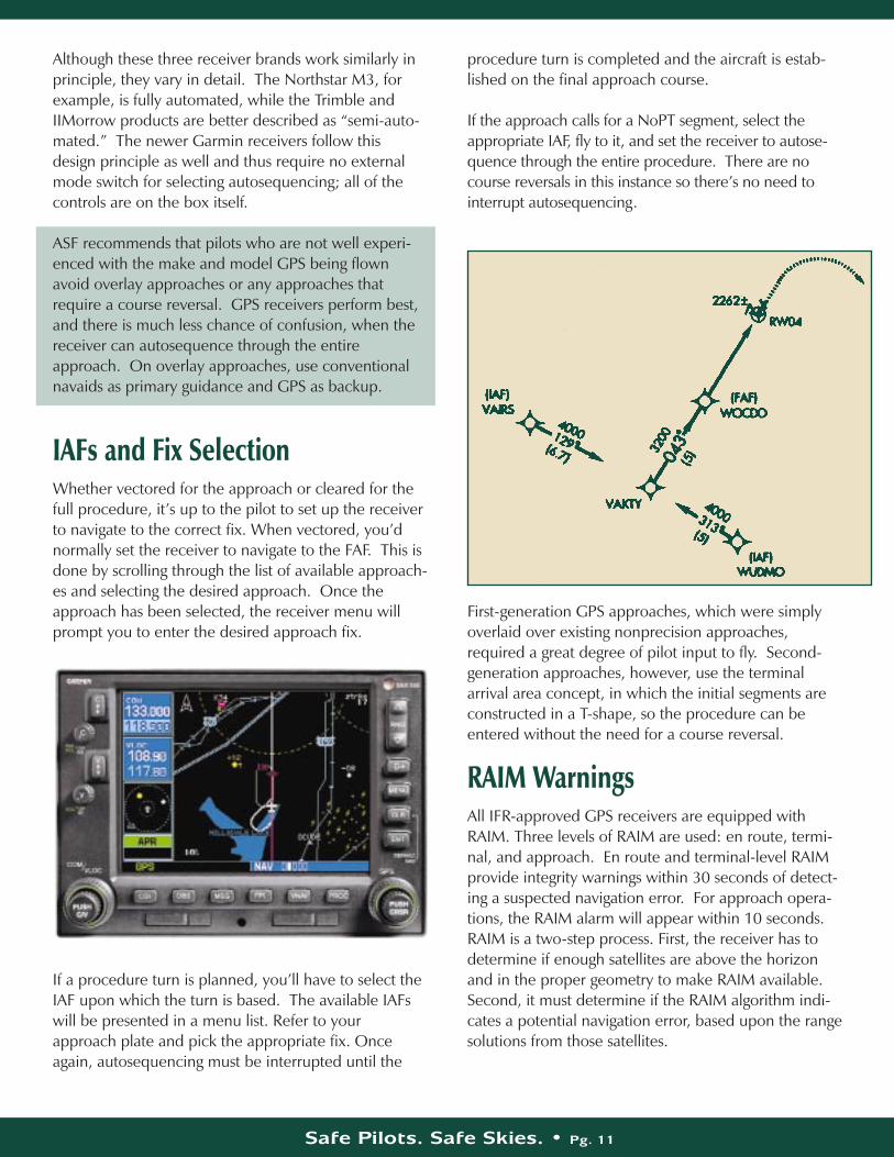
If a procedure turn is planned, you’ll have to select theIAF upon which the turn is based. The available IAFswill be presented in a menu list. Refer to yourapproach plate and pick the appropriate fix. Onceagain, autosequencing must be interrupted until the
procedure turn is completed and the aircraft is estab-lished on the final approach course.
If the approach calls for a NoPT segment, select theappropriate IAF, fly to it, and set the receiver to autose-quence through the entire procedure. There are nocourse reversals in this instance so there’s no need tointerrupt autosequencing.
First-generation GPS approaches, which were simplyoverlaid over existing nonprecision approaches,required a great degree of pilot input to fly. Second-generation approaches, however, use the terminalarrival area concept, in which the initial segments areconstructed in a T-shape, so the procedure can beentered without the need for a course reversal.
RAIM WarningsAll IFR-approved GPS receivers are equipped withRAIM. Three levels of RAIM are used: en route, termi-nal, and approach. En route and terminal-level RAIMprovide integrity warnings within 30 seconds of detect-ing a suspected navigation error. For approach opera-tions, the RAIM alarm will appear within 10 seconds.RAIM is a two-step process. First, the receiver has todetermine if enough satellites are above the horizonand in the proper geometry to make RAIM available.Second, it must determine if the RAIM algorithm indi-cates a potential navigation error, based upon the rangesolutions from those satellites.
There are two kinds of RAIM warnings. (1) When thereceiver produces a RAIM-not-available alarm, it’ssaying, “There could be something wrong with thenavigation solution, but I don’t have enough satelliteinformation to know for sure.” (2) If it indicates aRAIM error alarm, it’s saying, “I have enough satellitesavailable but there’s something wrong with one ofthem or the nav solution in general.”
While en route to the destination, predictive RAIMcomes into play. The receiver continually calculates anew ETA and calculates RAIM. It’s critical to under-stand that just because the receiver predicts RAIMwill be available at the destination, that doesn’tguarantee you’ll have sufficient satellite coveragewhen you arrive, only that the receiver expects tohave sufficient coverage to calculate RAIM. It’s possible, for example, that a satellite could becomeunhealthy while you’re en route or signals fromsatellites low on the horizon could be masked byterrain. The receiver's RAIM function has no way ofknowing about terrain masking.
If a RAIM warning occurs while en route, the receiverwill continue to function and provide navigation infor-mation, although it may or may not have degradedaccuracy. If either an “unavailable” or “accuracy”RAIM warning occurs prior to the FAF on an approach,the approach function will be disabled. However, thereceiver will continue to navigate in terminal or enroute mode. If the RAIM flag occurs after the FAF, thereceiver will continue to operate in approach mode forfive minutes, after which it will automatically revert toen route or terminal-only mode.
Safe Pilots. Safe Skies. • Pg. 12
Both FSS and DUAT provide GPS notams. To accessthem on DUAT, use “GPS” as the location identifier.GPS notams are primarily useful for planned outages.GPS receivers detect unusable satellites and automati-cally reject them from RAIM calculations. However,the receiver can’t know about a predicted future out-age unless you tell it. Some receivers have a way ofmanually deselecting a satellite. Some do not.
GPS Approaches: Currentand FutureThe first GPS nonprecision approaches were publishedin late 1993 as GPS overlays. The FAA has madesteady progress and by 2002 some 3,400 GPS stand-alone procedures were on the books—some to airportsthat previously had no approaches at all.
Helicopter-only GPS approaches have also been devel-oped. These are annotated “special crew qualificationrequired.” Both the missed approach and departuresegments — if approved — use a 20 to 1 obstacleclearance plane rather than the standard 40 to 1 plane.For this reason, it’s critical that helicopters not exceed70 knots during the missed approach and instrumentdeparture phases. Before flying a helicopter-only GPSprocedure, a pilot should obtain instruction from a CFIIfamiliar with the requirements for these procedures.
Although the initial overlay-type approaches are slowlybeing phased out, they will continue to exist at someairports for quite a while. Because GPS approaches aredesigned as a TO-TO system (meaning you navigate toone fix, cross it, and proceed to the next fix), overlays
RAIM Warnings
GPS Overlay Fix Examples
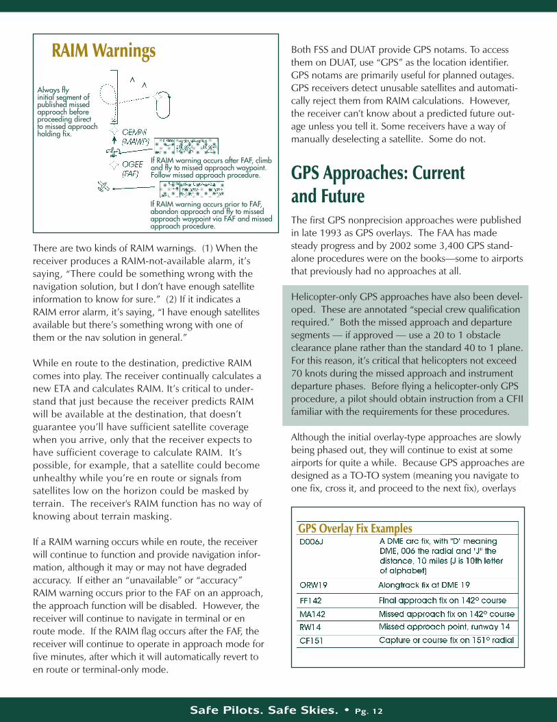
Always fly initial segment of published missedapproach beforeproceeding directto missed approachholding fix.
If RAIM warning occurs after FAF, climband fly to missed approach waypoint.Follow missed approach procedure.
If RAIM warning accurs prior to FAF,abandon approach and fly to missedapproach waypoint via FAF and missedapproach procedure.
Safe Pilots. Safe Skies. • Pg. 13
are not a perfect fit with the underlying procedure.Some conventional approaches, for example, have noFAFs, so a GPS would be unable to navigate to a fix,nor would it know when to switch CDI sensitivity fromthe one-mile terminal value to the .3 mile used on thefinal approach segments.
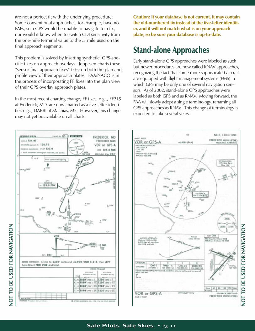
This problem is solved by inserting synthetic, GPS-spe-cific fixes on approach overlays. Jeppesen charts these“sensor final approach fixes” (FFs) on both the plan andprofile view of their approach plates. FAA/NACO is inthe process of incorporating FF fixes into the plan viewof their GPS overlay approach plates.
In the most recent charting change, FF fixes, e.g.., FF215at Frederick, MD, are now charted as a five-letter identi-fier, e.g.., DABBI at Machias, ME. However, this changemay not yet be available on all charts.
Caution: If your database is not current, it may containthe old-numbered fix instead of the five-letter identifi-er, and it will not match what is on your approachplate, so be sure your database is up-to-date.
Stand-alone ApproachesEarly stand-alone GPS approaches were labeled as suchbut newer procedures are now called RNAV approaches,recognizing the fact that some more sophisticated aircraftare equipped with flight management systems (FMS) inwhich GPS may be only one of several navigation sen-sors. As of 2002, stand-alone GPS approaches werelabeled as both GPS and as RNAV. Moving forward, theFAA will slowly adopt a single terminology, renaming allGPS approaches as RNAV. This change of terminology isexpected to take several years.
NO
T TO
BE
USE
D F
OR
NAV
IGAT
ION
NO
T TO
BE
USE
D F
OR
NAV
IGAT
ION
Safe Pilots. Safe Skies. • Pg. 14
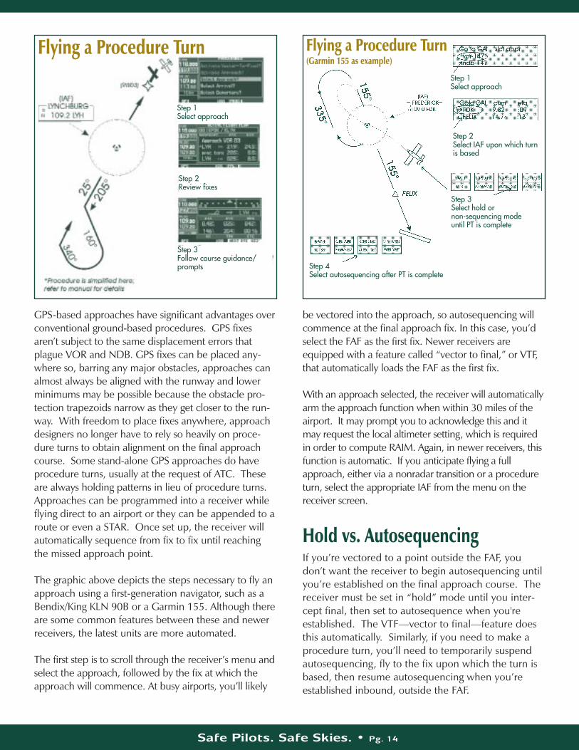
GPS-based approaches have significant advantages overconventional ground-based procedures. GPS fixesaren’t subject to the same displacement errors thatplague VOR and NDB. GPS fixes can be placed any-where so, barring any major obstacles, approaches canalmost always be aligned with the runway and lowerminimums may be possible because the obstacle pro-tection trapezoids narrow as they get closer to the run-way. With freedom to place fixes anywhere, approachdesigners no longer have to rely so heavily on proce-dure turns to obtain alignment on the final approachcourse. Some stand-alone GPS approaches do haveprocedure turns, usually at the request of ATC. Theseare always holding patterns in lieu of procedure turns.Approaches can be programmed into a receiver whileflying direct to an airport or they can be appended to aroute or even a STAR. Once set up, the receiver willautomatically sequence from fix to fix until reachingthe missed approach point.
The graphic above depicts the steps necessary to fly anapproach using a first-generation navigator, such as aBendix/King KLN 90B or a Garmin 155. Although thereare some common features between these and newerreceivers, the latest units are more automated.
The first step is to scroll through the receiver’s menu andselect the approach, followed by the fix at which theapproach will commence. At busy airports, you’ll likely
be vectored into the approach, so autosequencing willcommence at the final approach fix. In this case, you’dselect the FAF as the first fix. Newer receivers areequipped with a feature called “vector to final,” or VTF,that automatically loads the FAF as the first fix.
With an approach selected, the receiver will automaticallyarm the approach function when within 30 miles of theairport. It may prompt you to acknowledge this and itmay request the local altimeter setting, which is requiredin order to compute RAIM. Again, in newer receivers, thisfunction is automatic. If you anticipate flying a fullapproach, either via a nonradar transition or a procedureturn, select the appropriate IAF from the menu on thereceiver screen.
Hold vs. AutosequencingIf you’re vectored to a point outside the FAF, youdon’t want the receiver to begin autosequencing untilyou’re established on the final approach course. Thereceiver must be set in “hold” mode until you inter-cept final, then set to autosequence when you'reestablished. The VTF—vector to final—feature doesthis automatically. Similarly, if you need to make aprocedure turn, you’ll need to temporarily suspendautosequencing, fly to the fix upon which the turn isbased, then resume autosequencing when you’reestablished inbound, outside the FAF.
Flying a Procedure Turn Flying a Procedure Turn(Garmin 155 as example)
Step 1Select approach
Step 2Review fixes
Step 3Follow course guidance/prompts
Step 1Select approach
Step 2Select IAF upon which turnis based
Step 3Select hold or non-sequencing mode until PT is complete
Step 4Select autosequencing after PT is complete
Safe Pilots. Safe Skies. • Pg. 15
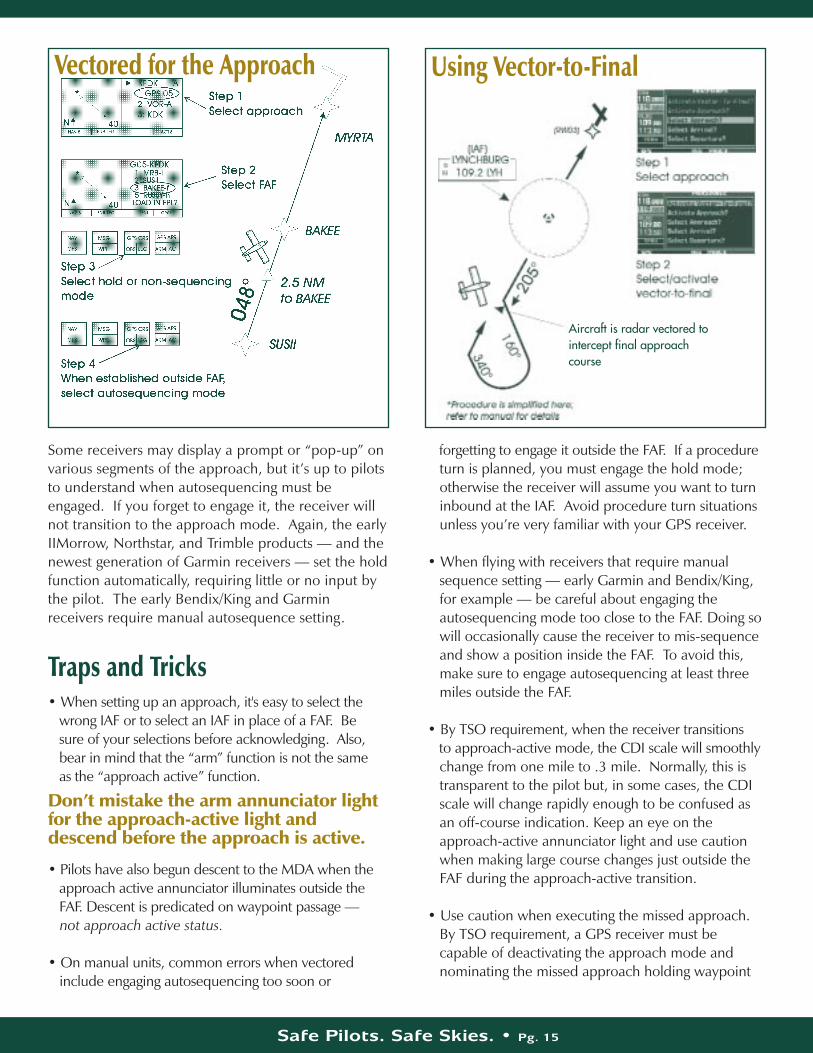
Some receivers may display a prompt or “pop-up” onvarious segments of the approach, but it’s up to pilotsto understand when autosequencing must beengaged. If you forget to engage it, the receiver willnot transition to the approach mode. Again, the earlyIIMorrow, Northstar, and Trimble products — and thenewest generation of Garmin receivers — set the holdfunction automatically, requiring little or no input bythe pilot. The early Bendix/King and Garminreceivers require manual autosequence setting.
Traps and Tricks• When setting up an approach, it's easy to select the
wrong IAF or to select an IAF in place of a FAF. Be sure of your selections before acknowledging. Also, bear in mind that the “arm” function is not the same as the “approach active” function.
Don’t mistake the arm annunciator lightfor the approach-active light anddescend before the approach is active.
• Pilots have also begun descent to the MDA when the approach active annunciator illuminates outside the FAF. Descent is predicated on waypoint passage — not approach active status.
• On manual units, common errors when vectored include engaging autosequencing too soon or
forgetting to engage it outside the FAF. If a procedure turn is planned, you must engage the hold mode; otherwise the receiver will assume you want to turn inbound at the IAF. Avoid procedure turn situations unless you’re very familiar with your GPS receiver.
• When flying with receivers that require manual sequence setting — early Garmin and Bendix/King, for example — be careful about engaging the autosequencing mode too close to the FAF. Doing so will occasionally cause the receiver to mis-sequence and show a position inside the FAF. To avoid this, make sure to engage autosequencing at least three miles outside the FAF.
• By TSO requirement, when the receiver transitions to approach-active mode, the CDI scale will smoothly change from one mile to .3 mile. Normally, this is transparent to the pilot but, in some cases, the CDI scale will change rapidly enough to be confused as an off-course indication. Keep an eye on the approach-active annunciator light and use caution when making large course changes just outside the FAF during the approach-active transition.
• Use caution when executing the missed approach. By TSO requirement, a GPS receiver must be capable of deactivating the approach mode and nominating the missed approach holding waypoint
Vectored for the Approach Using Vector-to-Final
vectoredAircraft is radar vectored tointercept final approachcourse
Safe Pilots. Safe Skies. • Pg. 16
(MAHWP) as the next active waypoint. If you push the direct-to key during the approach phase, the receiver will cancel approach mode and indicatea course direct to the missed approach holding fix, automatically centering the CDI needle. That may or may not correspond with the first segment of the missed approach. It certainly will not if the direct-to key is pushed before reaching the missed approach point. Check the chart before proceeding and fly the initial segment of the missed approach procedure before engaging the GPS direct-to function. Plan to contact ATC for further clearance as soon as possible.
DME and Countup/CountdownSince GPS can substitute for DME on approaches thatrequire DME, use care in identifying alongtrack step-down fixes. In recent years, databases include localizerantennas as named waypoints; thus on an ILS-DME,the GPS should exactly match the DME distance.However, if you haven’t selected the localizer as theactive waypoint, your GPS distance will be from anoth-er datum, perhaps the airport reference point.
In some cases, this will cause a “countup/countdown”indication that will be confusing for the pilot. In otherwords, GPS will always count down the distance to thenext fix. It would be easy for an unwary pilot to con-fuse GPS distance to a stepdown fix, e.g., three miles,with a stepdown fix that is three DME from the airportor MAWP. To avoid this, brief the profile section of theplate carefully before flying an overlay.
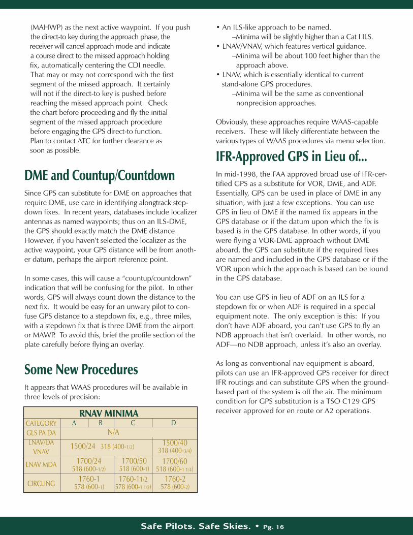
Some New ProceduresIt appears that WAAS procedures will be available inthree levels of precision:
• An ILS-like approach to be named.–Minima will be slightly higher than a Cat I ILS.
• LNAV/VNAV, which features vertical guidance. –Minima will be about 100 feet higher than the
approach above.• LNAV, which is essentially identical to current
stand-alone GPS procedures. –Minima will be the same as conventional
nonprecision approaches.
Obviously, these approaches require WAAS-capablereceivers. These will likely differentiate between thevarious types of WAAS procedures via menu selection.
IFR-Approved GPS in Lieu of...In mid-1998, the FAA approved broad use of IFR-cer-tified GPS as a substitute for VOR, DME, and ADF.Essentially, GPS can be used in place of DME in any situation, with just a few exceptions. You can useGPS in lieu of DME if the named fix appears in theGPS database or if the datum upon which the fix isbased is in the GPS database. In other words, if youwere flying a VOR-DME approach without DMEaboard, the GPS can substitute if the required fixesare named and included in the GPS database or if theVOR upon which the approach is based can be foundin the GPS database.
You can use GPS in lieu of ADF on an ILS for a stepdown fix or when ADF is required in a specialequipment note. The only exception is this: If youdon’t have ADF aboard, you can’t use GPS to fly anNDB approach that isn’t overlaid. In other words, noADF—no NDB approach, unless it’s also an overlay.
As long as conventional nav equipment is aboard,pilots can use an IFR-approved GPS receiver for directIFR routings and can substitute GPS when the ground-based part of the system is off the air. The minimumcondition for GPS substitution is a TSO C129 GPSreceiver approved for en route or A2 operations.
CATEGORYGLS PA DALNAV/DA
VNAV
LNAV MDA
CIRCLING
A B C DN/A
1500/24 318 (400-1/2) 1500/40318 (400-3/4)
1700/24518 (600-1/2)
1760-1578 (600-1)
1760-11/2578 (600-1 1/2)
1760-2578 (600-2)
1700/50518 (600-1)
1700/60518 (600-1 1/4)
RNAV MINIMA
Safe Pilots. Safe Skies. • Pg. 17
Common Questions About GPSI’ve noticed that first-generation C129GPS receivers are being sold at bargainprices. Are these receivers obsolete?
No. First-generation C129 GPS will function normallyfor the foreseeable future, including nonprecisionapproaches. However, most will not be upgradeableto WAAS standards and will thus not have the capabili-ty to serve as sole means of IFR navigation.
Should I be thinking about removingVOR or DME from my airplane?
DME perhaps. VOR no. As of spring 2002, the FAAwas far from certain that GPS will ever be approved asa sole means or primary system of navigation. Somebackup will almost certainly be necessary. Currently,VOR is still required for IFR operations but IFR-approved GPS can freely substitute for DME and ADF.If your current VOR and DME are relatively state-of-the-art and you have room in your panel, there's noparticular advantage in removing them.
If I equip my airplane with GPS, will Ineed two of them?
Not necessarily. Although it’s customary to have twonav/coms in most airplanes, there’s no regulatoryrequirement for this. Many owners are now installing aGPS nav/com but keeping one conventional nav/comin the panel. GPS receivers combine many functions,i.e., nav, com, moving map, in one unit. Without ade-quate redundancy, however, the loss of that unit couldcompromise safety.
I have an IFR loran. Now that loran hasbeen extended indefinitely, should Ikeep it in the panel or replace it withGPS?
Loran’s future is unknown. The FAA has fundedresearch to examine loran as a backup to GPS but it’sunlikely to ever be approved for approaches. Keep theloran if you have room in the panel and have use for itin your flying.
Will WAAS really allow sole means navigation with GPS?
The best guess now is no. The FAA and other agenciesstill have concerns about GPS’s reliability and integrity.The current sentiment is that backup of some kind willbe required. Operational experience may change thatview over the next decade.
Some approaches require ADF; canGPS substitute?
Yes. IFR-approved GPS can substitute for ADF on ADF-required approaches. It can also substitute for DME onDME-required approaches. As we mentioned before:be careful about what you’re counting up or down to.
GPS displays altitude. Why can't it beused for vertical guidance?
GPS altitude is expressed as a height above the surfaceof the GPS spheroid; it’s not the same as MSL altitudeor even AGL altitude, since the spheroid is an averagemathematical value, not an absolute value above thesurface. Further, GPS vertical accuracy is only about asixth of its horizontal accuracy. When WAAS comesonline, vertical accuracy will be greatly improved.
Can I use IFR-approved GPS to navigatealong airways?
Yes, if you can maintain the airway centerline, asdescribed in FAR 91.181. However, you cannot legallyuse GPS to operate at minimum obstacle clearance altitudes (MOCA) beyond 22 miles of a VOR unlessyou're in radar contact.
Can I use GPS to file direct to my destination?
Yes, but as with all random routings, you must be inradar contact while operating off airways. Be careful tocheck on special use airspace and minimum off routealtitudes (MORA).
Safe Pilots. Safe Skies. • Pg. 18
What if there’s no working VOR aboard,but I'm in radar contact; am I legal tooperate IFR?
Technically, no. GPS is still supplemental navigation.VOR is still required.
What regulation says that?
GPS hasn’t been committed to regulation yet. The guidance is currently found in Advisory Circular (AC) 90-94 and in the Aeronautical Information Manual.
Will I get busted for having an out-of-date database?
As of this writing there’s no enforcement history on GPS.In any event, you should have a current database beforeflying IFR. For en route operations, it’s legal to use cur-rent paper charts to check fixes in an expired GPS data-base. For approaches, you’ll need a current databaserevised to the 28-day cycle.
AppendixGPS History
GPS satellites were always considered consumables thatwould require periodic replacement. The original Block Isatellites—built by Rockwell—had a design life of five years,although many lasted longer. The current replacementNAVSTAR satellites—so-called Block IIRs—are made byLockheed Martin and launched as needed to maintain aminimum constellation of 24. The replacement satellites areimproved versions of the original designs that include betterclocks and power systems. They also have “180-day auton-omy”—the capability to provide navigation data withoutuploads from ground stations for as long as six months.
NAVSTAR sounds like a trade name, but it’s actually anacronym meaning NAVigation System by Timing AndRanging. Each satellite contains four very accurate clocks,navigation and communications transceivers, solar panelsand batteries, and a system of spinning reaction wheelsthat keep the satellite pointed at the earth. The clocks,essential to the accuracy of GPS, are accurate to ananosecond (a billionth of a second, or the amount of timeit takes light to travel one foot). GPS satellite clocks gain orlose only one second in 160,000 years.
GPS satellites orbit at an altitude of 10,898 miles for a 12-hour orbital period. It takes about one-eleventh of a sec-ond for the GPS signal to reach your receiver. Constella-tion GPS satellites are not geostationary; however, satellitesused in the WAAS program are, and orbit at about 24,000miles. The mid-altitude orbit of GPS NAVSTARs gives thebest combination of good coverage, constantly varyinggeometry, and ease of deployment.
How GPS WorksGPS receivers listen for satellite broadcasts that providealmanac and ephemeris data so the receiver will knowwhere the satellite is located in space, and a coded naviga-tion/timing message. This information is processed toestablish a line of position from the receiver to the satellite.Four intersecting lines of position allow the receiver todetermine its position. Each satellite broadcasts on thesame frequency, but each transmits a unique code calledpseudo-random code. The receiver generates matchingcode that it slews to lock on to the satellite’s navigation/timing message. Once locked on, the receivercan calculate a rough distance called a pseudo-range.
In order to eliminate pseudo-range errors, the receivermust synchronize its clock to the satellite clocks. It doesthis by determining the range to at least four satellites andthen adjusting the receiver clock until all four ranges orlines of position cross through the same point in space. Ifthe four lines of position don't pass through the same pointin space, the receiver assumes its clock is slightly inaccurateand adjusts the clock until all of the ranges agree. Thisprocess is known as “correcting the clock bias” and is thereason a GPS receiver has to see at least four satellites tocompute a three-dimensional position. It can computeposition with only three satellites, but the pilot has to pro-vide the receiver with one of the lines of position in theform of altitude.

EXPLORE ASF’S WEB PAGE AND
ONLINE PROGRAMS
EXPLORE ASF’S WEB PAGE AND
ONLINE PROGRAMSSkySpotter®
Join the thousands of pilots committedto improving the quality and quantityof pilot reports (pireps).
RunwaySafetyLearn how to avoid runway incursions.
OperationAirspaceView this presentation before you flyto learn about special airspace, TFR’s,and interception procedures.
IFR AdventureLearn about IFR regulations with thisinteractive program.
CFI RenewalRenew your certificate online. (Alsoavailable to non-CFIs at a reducedprice.)
SilentAuctionBid on unique aviation items, while benefitting ASF.
Airport TaxiDiagramsBecome familiar with the airport layout before you fly there.
ASF AccidentDatabaseSearch this database of general aviation accidents.
www.asf.orgThese ASF programs were made possible through contributions from pilots like you.

Safe Pilots. Safe Skies. • Pg. 20
EXPLORE ASF’S SAFETY PRODUCTS
EXPLORE ASF’S SAFETY PRODUCTS
Safety Advisors • Safety Highlights • Nall Report Videos • Seminar-in-a-Box® Program
421 Aviation Way • Frederick, MD 21701 • 800/638-3101 • www.asf.org • [email protected] ASF products were made possible through contributions from pilots like you.
and many more...
© Copyright 2002, AOPA Air Safety Foundation421 Aviation Way • Frederick, MD 21701 • Phone: 800/638-3101
Internet: www.asf.org • E-mail: [email protected]
Publisher: Bruce Landsberg Editors: John Steuernagle, Kathleen Roy, Marc Birckbichler
Writer: Paul Bertorelli
SA01-09/02