Embed Size (px)
Citation preview

StreetPro Thailand2015.03
Release NotesThis document contains information about 2015.03 Release. Complete documentation is located at our support site.
Contents:
Summary Workspace Changes What’s New? StreetPro Feature Count Statistics StreetPro Street Length StatisticsKnown IssuesFixes
a
2223444
Is this release mandatory? YES.
Pitney Bowes Pty Ltd, Asia-Pac HeadquartersSuite 1, Level 1, 68 Waterloo RoadMacquarie ParkNSW 2113 AustraliaTelephone: +61 2 9437 6255E-mail: [email protected]://www.pitneybowes.com.au/software/
© 2006 - 2015 TomTom. All rights reserved. This material is proprietaryand the subject of copyright protection, databaseright protection, and other intellectual propertyrights owned by TomTom or its suppliers. Theuse of this material is subject to the terms of aLicense Agreement. Any unauthorized copying ordisclosure of this material will lead to criminal andcivil liabilities.
Adobe Acrobat® is a registered trademark ofAdobe Systems.
2015 Pitney Bowes, Inc.

StreetPro® Thailand Release Notes 2015.03 2
Summary
The StreetPro suite of data products offers detailed and authoritative street-level vector maps, with over 40layers of information included. Worldwide coverage is available in a consistent specification and data model.
Workspace Changes
The *mipro12.5.wor workspaces make use of the enhanced rendering features in MapInfo Professional 12.5.
Caution: Any workspace file with "mipro12.5" in its name can only be used with MapInfo Professional .
What's New?
• Addition of 36 Built-up Areas and update to the boundaries of 161 Built-up Areas
• Update to the Postal Code Information of 48 Postal Districts
• About 390 English names for roads and ferries captured as Official Name with Language Code ‘THL’ arenow provided as Alternate Name (still with Language Code ‘THL’) and the actual Thai Latin name is providedas the Official Name with Language Code ‘THL’
• Addition of POIs type Golf Course (46), Hospital/Polyclinic (52), Park and Recreation Area (14), RailwayStation (89) and Toll Gate (1)
• Update of the road attributes Streetname, Route Number Information carried across entire country - along8385 km higher classified roads and along 4300 km lower classified roads

StreetPro® Thailand Release Notes 2015.03 3
StreetPro Thailand Feature Count Statistics
Table Description Local Names Count 2014.03 Count 2015.03
thaiA0 Administrative Level 0 Thailand *316 *315
thaiA1 Administrative Level 1 Changwat 77 77
thaiA2 Administrative Level 2 Amphoe 928 928
thaiA3 Administrative Level 3 Tambon 7,425 7,425
thaiA4 Administrative Level 4 NA NA NA
thaiA5 Administrative Level 5 NA NA NA
thaiAA Address Areas NA NA 1
thaiAP Airports NA 49 50
thaiB Business Locations NA 367,097 401,781
thaiCR Crossroads NA 121,883 145,184
thaiF Ferry Routes NA 321 316
thaiFI Freeway Interchanges NA 785 745
thaiFR Frontier Crossings NA 17 17
thaiG1 Gazetteer Level 1 NA 1 1
thaiG2 Gazetteer Level 2 NA 76 76
thaiG3 Gazetteer Level 3 NA 851 851
thaiG4 Gazetteer Level 4 NA 4,329 4,329
thaiG5 Gazetteer Level 5 NA 875 77,005
thaiG6 Gazetteer Level 6 NA 1,302 9
thaiGF Gazetteer Full NA 7,434 82,271
thaiLC Land Cover NA 4,784 4,796
thaiLU Land Use NA 4,749 4,747
thaiNF Natural Features NA 371 378
thaiOW Oneways NA 22,911 25,356
thaiP Parking NA 915 865
thaiPC Postcodes boundary NA 963 967
thaiPCP Postcode Points NA 1,205 1,312
thaiPU Public Locations NA 110,931 146,834
thaiR Railways NA 138 138
thaiRE Recreation Places NA 52,738 43,259
thaiST Stations NA 4,856 4,977
thaiU Urban Areas NA 7,382 7,381
thaiWM Water Major NA 128 128
thaiW Water NA 19,471 19,477
thaiX1 Addressed Streets NA 1,134,042 1,344,067
thaiX2 Street Names NA 175,843 214,381
thaiZL Additional Names NA 592,162 653,769
thaiZP Address detail for Points NA 537,155 598,345
* Administrative Layer 0 [A0] count represents gridded polygon counts. Actual count of A0 is 2 viz. 1 for land and 1 for Sea (if applicable).
StreetPro® Thailand Release Notes 2015.03 4
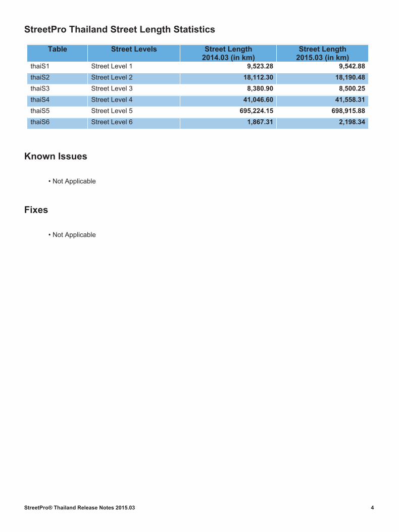
StreetPro Thailand Street Length Statistics
Table Street Levels Street Length 2014.03 (in km)
Street Length 2015.03 (in km)
thaiS1 Street Level 1 9,523.28 9,542.88
thaiS2 Street Level 2 18,112.30 18,190.48
thaiS3 Street Level 3 8,380.90 8,500.25
thaiS4 Street Level 4 41,046.60 41,558.31
thaiS5 Street Level 5 695,224.15 698,915.88
thaiS6 Street Level 6 1,867.31 2,198.34
Known Issues
• Not Applicable
Fixes
• Not Applicable