Embed Size (px)
Citation preview

StreetPro Hong KongVersion 2014.05
PRODUCT GUIDE

Information in this document is subject to change without notice and does not represent a commitment on the part of the vendor or its representatives. No part of this document may be reproduced or transmitted in any form or by any means, electronic or mechanical, including photocopying, without the written permission of Pitney Bowes Software Pty Ltd, Asia-Pac Headquarters, Suite 1, Level 1, 68 Waterloo Road, Macquarie Park, NSW 2113, Australia.
© 2014 Pitney Bowes Software Pty Ltd. All rights reserved. MapInfo®, MapInfo Professional®, and MapXtreme® are registered trademarks of Pitney Bowes Software Limited and/or its affiliates. Products named herein may be trademarks of their respective manufacturers and are hereby recognised. Trademarked names are used editorially, to the benefit of the trademark owner, with no intent to infringe on the trademark. Adobe Acrobat® is a registered trademark of Adobe Systems.
© 2006-2014 TomTom. All rights reserved. This material is proprietary and the subject of copyright protection, database right protection and other intellectual property rights owned by TomTom or its suppliers. The use of this material is subject to the terms of a license agreement. Any unauthorized copying or disclosure of this material will lead to criminal and civil liabilities.
LICENSE
The product is supplied under the terms and conditions specified in the separate Licence Agreement(s). Failure to comply with the terms and conditions may lead to the termination of the licence(s). Customers wishing to install or copy the Data onto more than one computer should apply for a Multi-user Licence. Customers wishing to provide a bureau service for others or to use the Data for the benefit of or on behalf of any others should apply for a Bureau Licence or a Special Licence.
Pitney Bowes Software is making Adobe Acrobat® Reader (the "Software") available to you as a convenience to allow you to easily view and print the documentation in .pdf file format. This should not be construed as an endorsement of Adobe Systems Incorporated or its products. Use of the Software is governed by the terms and conditions of the end user license agreement which is included in the Software. Pitney Bowes Software makes no representations or warranties, express or implied, with respect to the accuracy, reliability or completeness of the Software. The entire risk as to the use of the Software is assumed by you. In no event shall Pitney Bowes Software be liable to you or any other person, regardless of the cause, for the effectiveness or accuracy of the Software or for any special, indirect, incidental or consequential damages arising from or occasioned by your use of the Software, even if advised of the possibility of such damages.
Further InformationPitney Bowes Software Pty Ltd, Asia-Pac HeadquartersSuite 1, Level 1, 68 Waterloo RoadMacquarie ParkNSW 2113 AustraliaTelephone: +61 2 9437 6255 E-mail: [email protected]://www.pitneybowes.com.au/software/
April 2014

Table of Contents
Table of Contents
Chapter 1: Introduction . . . . . . . . . . . . . . . . . . . . . . . . . . . . . . . . . . . . . . . . . . . . . . .5
About StreetPro® . . . . . . . . . . . . . . . . . . . . . . . . . . . . . . . . . . . . . . . . . . . . . . . . . . . . . . . .6
StreetPro® Layer Tables . . . . . . . . . . . . . . . . . . . . . . . . . . . . . . . . . . . . . . . . . . . . . . . . . .6
StreetPro® Reference Tables . . . . . . . . . . . . . . . . . . . . . . . . . . . . . . . . . . . . . . . . . . . . . .7
StreetPro® Geocoding Tables . . . . . . . . . . . . . . . . . . . . . . . . . . . . . . . . . . . . . . . . . . . . .8
Workspaces . . . . . . . . . . . . . . . . . . . . . . . . . . . . . . . . . . . . . . . . . . . . . . . . . . . . . . . . . . . .8
International Workspace Example . . . . . . . . . . . . . . . . . . . . . . . . . . . . . . . . . . . . . . . . .9
Local Workspace Example . . . . . . . . . . . . . . . . . . . . . . . . . . . . . . . . . . . . . . . . . . . . . . .9
Chapter 2: StreetPro® Installation . . . . . . . . . . . . . . . . . . . . . . . . . . . . . . . . . . . . .11
Workspace File Names . . . . . . . . . . . . . . . . . . . . . . . . . . . . . . . . . . . . . . . . . . . . . . . . . .12
Uninstalling StreetPro® . . . . . . . . . . . . . . . . . . . . . . . . . . . . . . . . . . . . . . . . . . . . . . . . . .12
Chapter 3: Data Descriptions . . . . . . . . . . . . . . . . . . . . . . . . . . . . . . . . . . . . . . . . .13
Spatial Referencing . . . . . . . . . . . . . . . . . . . . . . . . . . . . . . . . . . . . . . . . . . . . . . . . . . . . .14
StreetPro Layer Tables . . . . . . . . . . . . . . . . . . . . . . . . . . . . . . . . . . . . . . . . . . . . . . . . . .14
Administrative Layers. . . . . . . . . . . . . . . . . . . . . . . . . . . . . . . . . . . . . . . . . . . . . . . . . . 14
Address Areas . . . . . . . . . . . . . . . . . . . . . . . . . . . . . . . . . . . . . . . . . . . . . . . . . . . . . . .16
Additional Details for Point Features . . . . . . . . . . . . . . . . . . . . . . . . . . . . . . . . . . . . . . .16
Additional Name . . . . . . . . . . . . . . . . . . . . . . . . . . . . . . . . . . . . . . . . . . . . . . . . . . . . . .18
Airports . . . . . . . . . . . . . . . . . . . . . . . . . . . . . . . . . . . . . . . . . . . . . . . . . . . . . . . . . . . . .19
Business Locations . . . . . . . . . . . . . . . . . . . . . . . . . . . . . . . . . . . . . . . . . . . . . . . . . . . .20
Cross Roads . . . . . . . . . . . . . . . . . . . . . . . . . . . . . . . . . . . . . . . . . . . . . . . . . . . . . . . . .22
Ferry Routes . . . . . . . . . . . . . . . . . . . . . . . . . . . . . . . . . . . . . . . . . . . . . . . . . . . . . . . . .22
Freeway Interchanges . . . . . . . . . . . . . . . . . . . . . . . . . . . . . . . . . . . . . . . . . . . . . . . . .23
Frontier Crossings . . . . . . . . . . . . . . . . . . . . . . . . . . . . . . . . . . . . . . . . . . . . . . . . . . . . .24
Gazetteer Layers . . . . . . . . . . . . . . . . . . . . . . . . . . . . . . . . . . . . . . . . . . . . . . . . . . . . .24
Land Cover . . . . . . . . . . . . . . . . . . . . . . . . . . . . . . . . . . . . . . . . . . . . . . . . . . . . . . . . . .26
Land Use . . . . . . . . . . . . . . . . . . . . . . . . . . . . . . . . . . . . . . . . . . . . . . . . . . . . . . . . . . . .27
Natural Features . . . . . . . . . . . . . . . . . . . . . . . . . . . . . . . . . . . . . . . . . . . . . . . . . . . . . .30
Oneways . . . . . . . . . . . . . . . . . . . . . . . . . . . . . . . . . . . . . . . . . . . . . . . . . . . . . . . . . . . .31
Parking . . . . . . . . . . . . . . . . . . . . . . . . . . . . . . . . . . . . . . . . . . . . . . . . . . . . . . . . . . . . .31
Public Locations . . . . . . . . . . . . . . . . . . . . . . . . . . . . . . . . . . . . . . . . . . . . . . . . . . . . . .32
Railways . . . . . . . . . . . . . . . . . . . . . . . . . . . . . . . . . . . . . . . . . . . . . . . . . . . . . . . . . . . .34
Recreation Places . . . . . . . . . . . . . . . . . . . . . . . . . . . . . . . . . . . . . . . . . . . . . . . . . . . . .35
Stations . . . . . . . . . . . . . . . . . . . . . . . . . . . . . . . . . . . . . . . . . . . . . . . . . . . . . . . . . . . . .37
Street Layers . . . . . . . . . . . . . . . . . . . . . . . . . . . . . . . . . . . . . . . . . . . . . . . . . . . . . . . . .38
Urban Areas . . . . . . . . . . . . . . . . . . . . . . . . . . . . . . . . . . . . . . . . . . . . . . . . . . . . . . . . .44
Product Guide 3

Table of Contents
Water Feature Layers . . . . . . . . . . . . . . . . . . . . . . . . . . . . . . . . . . . . . . . . . . . . . . . . . . 45
Chapter 4: Opening a Workspace . . . . . . . . . . . . . . . . . . . . . . . . . . . . . . . . . . . . . 47
Workspaces . . . . . . . . . . . . . . . . . . . . . . . . . . . . . . . . . . . . . . . . . . . . . . . . . . . . . . . . . . . 48
International Workspace . . . . . . . . . . . . . . . . . . . . . . . . . . . . . . . . . . . . . . . . . . . . . . . . 48
Local Workspace . . . . . . . . . . . . . . . . . . . . . . . . . . . . . . . . . . . . . . . . . . . . . . . . . . . . . 48
Opening a StreetPro International Workspace using MapInfo Professional . . . . . . . 48
Chapter 5: Language Settings and Special Characters . . . . . . . . . . . . . . . . . . . . 51
Displaying Special Characters in MapInfo Professional . . . . . . . . . . . . . . . . . . . . . . . 52
Language settings . . . . . . . . . . . . . . . . . . . . . . . . . . . . . . . . . . . . . . . . . . . . . . . . . . . . . 52
Font selection . . . . . . . . . . . . . . . . . . . . . . . . . . . . . . . . . . . . . . . . . . . . . . . . . . . . . . . .52
Appendix A: Understanding Metadata . . . . . . . . . . . . . . . . . . . . . . . . . . . . . . . . . . 53
What Is Metadata? . . . . . . . . . . . . . . . . . . . . . . . . . . . . . . . . . . . . . . . . . . . . . . . . . . . . . . 53
Purpose of Metadata . . . . . . . . . . . . . . . . . . . . . . . . . . . . . . . . . . . . . . . . . . . . . . . . . . . . 53
Metadata Sections . . . . . . . . . . . . . . . . . . . . . . . . . . . . . . . . . . . . . . . . . . . . . . . . . . . . . . 53
Viewing Metadata . . . . . . . . . . . . . . . . . . . . . . . . . . . . . . . . . . . . . . . . . . . . . . . . . . . . . . . 54
Product Level . . . . . . . . . . . . . . . . . . . . . . . . . . . . . . . . . . . . . . . . . . . . . . . . . . . . . . . . 54
Table Level . . . . . . . . . . . . . . . . . . . . . . . . . . . . . . . . . . . . . . . . . . . . . . . . . . . . . . . . . . 54
Appendix B: Extras Folder . . . . . . . . . . . . . . . . . . . . . . . . . . . . . . . . . . . . . . . . . . . 55
Language Table . . . . . . . . . . . . . . . . . . . . . . . . . . . . . . . . . . . . . . . . . . . . . . . . . . . . . . . . 56
micodemaster Table . . . . . . . . . . . . . . . . . . . . . . . . . . . . . . . . . . . . . . . . . . . . . . . . . . . . 56
Gazetteer Full . . . . . . . . . . . . . . . . . . . . . . . . . . . . . . . . . . . . . . . . . . . . . . . . . . . . . . . . . . 57
Postcode Boundary . . . . . . . . . . . . . . . . . . . . . . . . . . . . . . . . . . . . . . . . . . . . . . . . . . . . . 58
Postcode Points . . . . . . . . . . . . . . . . . . . . . . . . . . . . . . . . . . . . . . . . . . . . . . . . . . . . . . . . 59
Postcode and District Index Table . . . . . . . . . . . . . . . . . . . . . . . . . . . . . . . . . . . . . . . . . 59
Appendix C: Data Support and Feedback . . . . . . . . . . . . . . . . . . . . . . . . . . . . . . . 61
Feedback Process . . . . . . . . . . . . . . . . . . . . . . . . . . . . . . . . . . . . . . . . . . . . . . . . . . . . . . 61 Electronic Feedback Form . . . . . . . . . . . . . . . . . . . . . . . . . . . . . . . . . . . . . . . . . . . . . . . .62
4 StreetPro Hong Kong 2014.05

1
IntroductionPitney Bowes Software welcomes you to StreetPro®
Welcome to the StreetPro Product Guide. This document will assist you with gaining maximum benefit from StreetPro by describing installation procedures and providing a detailed insight to the datasets and associated files that make up the product.
Feedback
Pitney Bowes Software Pty Ltd strives to be responsive to the evolving and growing utility of this data product within numerous and wide-ranging types of organisations. We therefore encourage any feedback and suggestions (refer to Appendix C: Data Support and Feedback) that will assist us in developing the best possible dataset for your business requirements.
In this chapter:
About StreetPro® . . . . . . . . . . . . . . . . . . . . . . . . . . . . . . . . . . . . . . . .6 StreetPro® Layer Tables . . . . . . . . . . . . . . . . . . . . . . . . . . . . . . . . . .6 StreetPro® Reference Tables . . . . . . . . . . . . . . . . . . . . . . . . . . . . . .7 StreetPro® Geocoding Tables. . . . . . . . . . . . . . . . . . . . . . . . . . . . . .8 Workspaces . . . . . . . . . . . . . . . . . . . . . . . . . . . . . . . . . . . . . . . . . . . .8

Introduction
About StreetPro®
The StreetPro suite of data products offers up-to-date premium street-level vector maps, with over 40 layers of information. They provide the real-world display and detailed quality needed to provide a flexible multi-purpose foundation for critical business use.
The StreetPro suite consists of two related products:
• StreetPro is the full featured version of the product suite including detailed streets information, accurate street topology for basic routing purposes, rich feature information and administrative boundaries.
• Postcodes & Administrative Boundaries is a reduced version of StreetPro including Postcodes, Suburbs and Administrative boundaries.
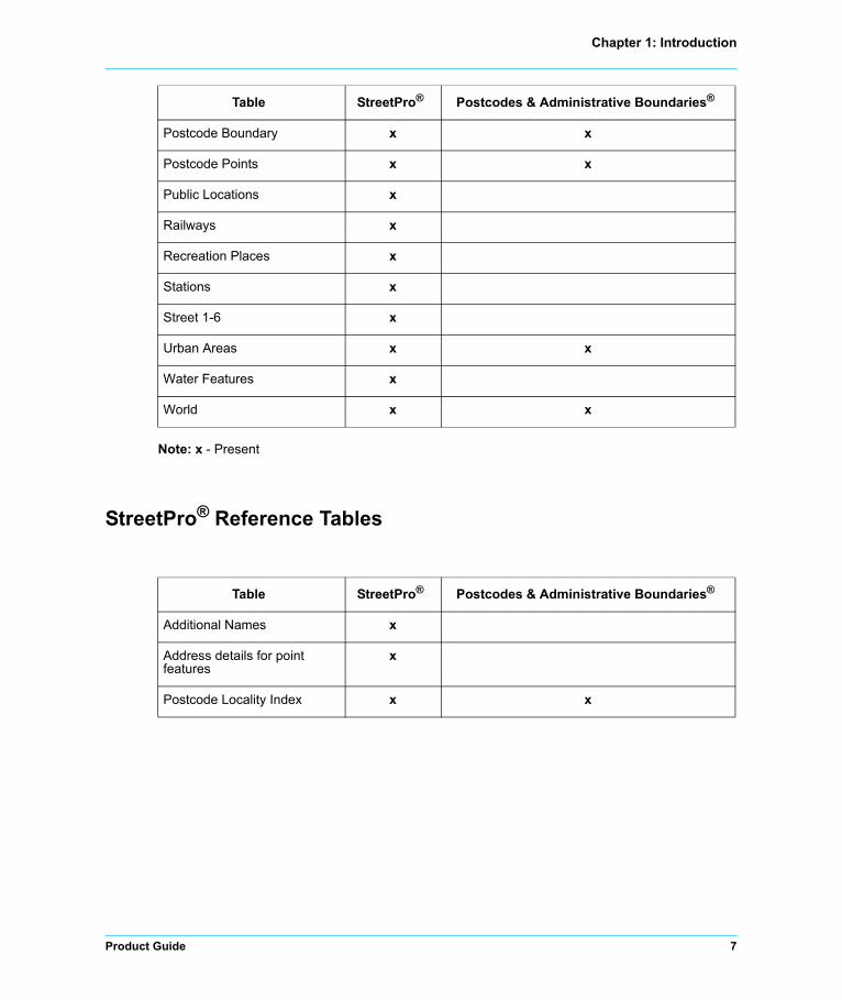
StreetPro® Layer Tables
Table StreetPro® Postcodes & Administrative Boundaries®
Address Areas x
Administrative Layers 0-5 x x
Airports x
Business Locations x
Ferry Routes x
Freeway Interchanges x
Frontier Crossings x
Gazetteer Levels 1-6 x
Gazetteer Full x x
Land Cover x
Land Use x
Natural Features x
Ocean x x
Oneways x
Parking x
6 StreetPro Hong Kong 2014.05
Chapter 1: Introduction
Note: x - Present
StreetPro® Reference Tables
Postcode Boundary x x
Postcode Points x x
Public Locations x
Railways x
Recreation Places x
Stations x
Street 1-6 x
Urban Areas x x
Water Features x
World x x
Table StreetPro® Postcodes & Administrative Boundaries®
Table StreetPro® Postcodes & Administrative Boundaries®
Additional Names x
Address details for point features
x
Postcode Locality Index x x
Product Guide 7

Introduction
StreetPro® Geocoding Tables
Workspaces
StreetPro makes available to all customers an international look-and-feel via its international workspace, whilst, in addition, providing an increasing number of countries with ‘localised’ workspaces, tailored to specific geographies.
Table StreetPro® Postcodes & Administrative Boundaries®
Address Ranges x
Street Names x
Street Intersections x
8 StreetPro Hong Kong 2014.05

Chapter 1: Introduction
International Workspace Example
Product Guide 9

Introduction
Local Workspace Example
10 StreetPro Hong Kong 2014.05

2
StreetPro® InstallationIn this chapter:
Workspace File Names . . . . . . . . . . . . . . . . . . . . . . . . . . . . . . . . . .12 Uninstalling StreetPro® . . . . . . . . . . . . . . . . . . . . . . . . . . . . . . . . . .12

StreetPro® Installation
Workspace File Names
StreetPro is supplied with two different types of workspace:
Note: For more information on workspaces, refer to Opening a Workspace.
Uninstalling StreetPro®
StreetPro data and workspaces for a country can be uninstalled by opening Add or Remove Programs from the Windows Control Panel, and then selecting the particular version of StreetPro Hong Kong, followed by Remove.
Confirming removal will delete all installed StreetPro files for the country from the system.
Warning: Any StreetPro tables or files that you have modified will not be removed during the uninstallation process.
TypeInternational Workspace
File NameLocal Workspace
File NameExample Mapping
Application
MWS hoko.mws MapXtreme WorkspaceManager
hoko_int.wor
hoko_int.mws
hoko.wor MapInfo Professional Mapinfo Professional Workspace
12 StreetPro Hong Kong 2014.05

3
Data DescriptionsThe reference and geocoding tables included with StreetPro are also documented here.
In This Chapter
Spatial Referencing . . . . . . . . . . . . . . . . . . . . . . . . . . . . . . . . . . . . .14 StreetPro Layer Tables. . . . . . . . . . . . . . . . . . . . . . . . . . . . . . . . . . .14

Data Descriptions
Spatial Referencing
StreetPro and Postcodes & Administrative Boundaries use the spatial referencing system defined in the table below for all international workspaces.
StreetPro Layer Tables
This section contains information about the display characteristics, micodes and the table structure of common feature layers in the international workspaces. The tables are listed in the alphabetical order of feature layer names. Within each layer, the features are listed in micode order.
Administrative Layers Hokoa0.* – Hokoa2.*
Hong Kong is a Special Administrative Region (SAR) of the People's Republic of China and the administrative boundary layers include two levels of boundaries:
• Territory Boundaries: Hong Kong comprises of Victoria (commonly known as Hong Kong Island), the Kowloon Peninsula, the “New Territories” and the 235 outlying islands.
• District Boundaries: Administratively, Hong Kong is sub-divided into 18 geographical districts, each represented by a district council whose role is to advise the government on local matters such as public facilities, community programmes, cultural activities and environmental improvements.
Projection Coordinate System Coordinate units
Longitude/Latitude Longitude/Latitude (WGS84) Decimal Degrees
micode Administrative Boundary StreetPro Nomenclature
50010101 Territory Hokoa1
50010102 District Hokoa2
14 StreetPro Hong Kong 2014.05

Chapter 3: Data Descriptions
Administrative 0 Hokoa0.*
micode and Display Characteristics
Administrative 1 Hokoa1.*
micode and Display Characteristics
Administrative 2 Hokoa2.*
micode and Display Characteristics
Table Structure
miCode Features Graphic Object Details
30040100 Sea Brush(2,11130623,16777215)
Pen(1,2,11130623)
50010100 Administrative 0 - National Boundary
Brush(2,16316906,16777215)
Pen (1, 2, 16316906)
miCode Features Graphic Object Details
50010101 Administrative 1 - Changwat boundaries
Brush(1,0,16777215)
Pen (2, 2, 10000002)
miCode Features Graphic Object Details
50010102 Administrative 2 - Amphoe boundaries
Brush(1,0,16777215)
Pen(1,2,10000002)
Field Description Type (width) Indexed
Name Name of administrative boundary Character (100) Yes
Name_Lng Language of administrative boundary name or "UND" for undefined
Character (3) No
Off_Code Official code for administrative boundary or "UND" for undefined
Character (3) – for A0
Character (11) – for other Admin
Yes
micode MapInfo global feature code Integer No
Product Guide 15

Data Descriptions
Address Areas Hokoaa.*
The Address Areas table contains address features that cannot be related to the name of the street that passes by or through the area.
Not available in this region
micode and Display Characteristics
Table Structure
Additional Details for Point Features Hokozp.*
The Address Details for Point Features table provides address and geocoding source information for the point features in the layers such as Business, Frontier Crossings, Public Locations, Parking, Recreation Places and Stations.
SmartLabel Same as Name with added carriage returns
Character (100) No
FeatureID Unique feature identifier within this country
Character (16) Yes
Field Description Type (width) Indexed
miCode Features Graphic Object Details
50040200 Address Areas Brush (2, 12632256, 16777215)
Pen (1, 2, 12632256)
Field Description Type (width) Indexed
Name Name of address area Character (100) Yes
Name_Lng Language of address area name or "UND" for undefined
Character (3) No
micode MapInfo global feature code Integer No
SmartLabel Same as Name with added carriage returns
Character (100) No
FeatureID Unique feature identifier within this country
Character (16) Yes
16 StreetPro Hong Kong 2014.05

Chapter 3: Data Descriptions
Table Structure
Field Description Type (width) Indexed
Table Name of the feature table that contains the feature for which the address details are provided
Character (6) Yes
Brand_Nm Brand name (available for car dealers, hotels, motels, petrol stations, car rental facilities, and restaurants only.)
Character (70) No
House_No House number Character (10) No
Street_Nm Street Name Character (100) No
Place_Nm Place Name Character (100) No
Postcode Postcode Character (10) No
Tel Telephone number Character (25) No
Fax Fax number Character (25) No
Email Email address Character (70) No
Internet Internet address Character (70) No
Product Guide 17
Data Descriptions
Additional Name Hokozl.*
The Additional Names table contains alternative names and names in different languages for some features.
PF_Loc_Src Indicator value representing method and information by which the point feature was positioned:
1 Location of point feature that has an entry point
2 Location of point feature without entry point (closest road segment established by algorithm), e.g. mountain peak
3 Location on a predefined place on the transportation network
11 Exact location of the entrance of the point feature
12 Nearest location on the transportation network with the correct address (point feature location is known)
13 Interpolated location part way along the correct side of the road segment along which the point feature is located
14 Location on the correct side of the correct road segment along which the point feature is located
15 Location on the correct road segment along which the point feature is located
16 Location on the correct road along which the point feature is located
17 Location on the corresponding gazetteer point
18 Location on other corresponding service
99 No geocoding source information
Character (2) No
FeatureID Unique feature identifier within this country
Character (16) Yes
Field Description Type (width) Indexed
18 StreetPro Hong Kong 2014.05

Chapter 3: Data Descriptions
Table Structure
Airports Hokoap.*
The Airports table contains airports.
micode and Display Characteristics
Field Description Type (width) Indexed
Table Name of the table that contains the feature for which the additional name is provided
Character (6) Yes
Name Name Character (150) No
Name_Lng Language Character (3) No
FeatureID Unique feature identifier within this country
Character (16) Yes
miCode Features Graphic Object Details
10310000 Airport, undefined Symbol(87,167,16,"MapInfo Transportation",256,0)
10310010 Check-in/check-out facility at airport, undefined
Symbol(34,167,7,"MapInfo Cartographic",256,0)
10310011 Check-in facility at airport, departures
Symbol(34,167,7,"MapInfo Cartographic",256,0)
10310012 Check-out facility at airport, arrivals
Symbol(34,167,7,"MapInfo Cartographic",256,0)
10310013 Check-in/check-out facility at airport, departures and arrivals
Symbol(34,167,7,"MapInfo Cartographic",256,0)
10310100 Airport, civil Symbol(72,13697024,12,"MapInfo Real Estate",257,0)
10310200 Airport, military Symbol(72,5263360,12,"MapInfo Real Estate",257,0)
Product Guide 19

Data Descriptions
Table Structure
Business Locations Hokob.*
The Business Locations table contains business locations, such as hotels, motels, restaurants, petrol stations, car dealers, car repair facilities, car rental offices, cash dispensers, companies, pharmacies, shops, factory outlets, wineries, and shopping centres.
micode and Display Characteristics
Field Description Type (width) Indexed
Name Name of airport Character (100) Yes
Name_Lng Language of airport name or "UND" for undefined
Character (3) No
micode MapInfo global feature code Integer No
SmartLabel Same as Name with added carriage returns Character (100) No
FeatureID Unique feature identifier within this country Character (16) Yes
miCode Features Graphic Object Details
10010000 Commercial building Symbol(57,0,12,"MapInfo Real Estate",256,0)
10010100 Shop Symbol(57,24672,12,"MapInfo Real Estate",256,0)
10010205 Drive-through bottleshop Symbol(57,10506240,12,"MapInfo Real Estate",256,0)
10010400 Car dealer, undefined Symbol(70,8388608,18,"MapInfo Transportation",256,0)
10010401 Car dealer, sales facility Symbol(70,8388608,18,"MapInfo Transportation",256,0)
10010402 Car dealer, repair facility Symbol(70,8388608,18,"MapInfo Transportation",256,0)
10010403 Car dealer, sales and repair facility
Symbol(70,8388608,18,"MapInfo Transportation",256,0)
10010404 Car repair facility Symbol(70,8388608,18,"MapInfo Transportation",256,0)
10010405 Car rental office Symbol(73,167,18,"MapInfo Transportation",256,0)
10010500 Petrol station Symbol(42,13697024,12,"MapInfo Transportation",256,0)
20 StreetPro Hong Kong 2014.05

Chapter 3: Data Descriptions
Table Structure
10011000 Shopping centre Symbol(57,24672,12,"MapInfo Real Estate",256,0)
10020000 Restaurant Symbol(54,11556864,10,"MapInfo Real Estate",256,0)
10020700 Café/Pub Symbol(54,11556864,10,"MapInfo Real Estate",256,0)
10020800 Area of high concentration of restaurants
Symbol(54,11556864,10,"MapInfo Real Estate",256,0)
10030000 Company Symbol(55,0,16,"MapInfo Real Estate",256,0)
10030310 Bank Symbol (49,0,14,"MapInfo Real Estate",256,0)
10030311 Cash dispenser Symbol(40,0,12,"MapInfo Cartographic",1,0)
10030600 Business facility Symbol (34,0,18,"MapInfo Real Estate",256,0)
10060000 Industrial building Symbol (37,0,16,"MapInfo Real Estate",256,0)
10070200 Hotel/motel* Symbol(64,13697024,16,"MapInfo Real Estate",256,0)
10110601 Winery Symbol(60,7340256,16,"MapInfo Real Estate",256,0)
10230030 Pharmacy Symbol(70,40960,10,"MapInfo Cartographic",256,0)
Field Description Type (width) Indexed
Name Name of business location Character (100) Yes
Name_Lng Language of business location name or "UND" for undefined
Character (3) No
micode MapInfo global feature code Integer No
miCode Features Graphic Object Details
Product Guide 21

Data Descriptions
Cross Roads Hokocr.*
The crossroad layer contains street intersection point objects.
Table Structure
Ferry Routes Hokof.*
The Ferry Routes table contains ferry connections classified by mode of operation.
micode and Display Characteristics
SmartLabel Same as Name with added carriage returns
Character (100) No
FeatureID Unique feature identifier within this country
Character (16) Yes
Field Description Type (width) Indexed
Field Description Type (width) Indexed
ID ID of features Character (16) No
Street1 Street name of 1st logical street that makes up intersection
Character (150) No
Street2 Street name of 1st logical street that makes up intersection
Character (150) No
Street4 Street name of 3rd logical street that makes up intersection
Character (150) No
Street4 (optional) Street name of 4th logical street that makes up intersection
Character (150) No
Street5 (optional) Street name of 5th logical street that makes up intersection
Character (150) No
miCode Features Graphic Object Details
70010100 Ferry, operated by ship/hovercraft
Pen (1,9,4227327)
70020100 Ferry, operated by train Pen (1,9,0)
22 StreetPro Hong Kong 2014.05

Chapter 3: Data Descriptions
Table Structure
Freeway Interchanges Hokofi.*
The Freeway Interchanges table contains interchanges on all road classes.
micode and Display Characteristics
Table Structure
Field Description Type (width) Indexed
Name Name of ferry route Character (100) Yes
Name_Lng Language of ferry route name or "UND" for undefined
Character (3) No
micode MapInfo global feature code Integer No
FeatureID Unique feature identifier within this country Character (16) Yes
miCode Features Graphic Object Details
10340100 Motorway exit/access Symbol(59,16750640,8)
10340200 Motorway interchange Symbol(59,16711680,8)
10340300 Freeway interchange, other Symbol(59,8421504,8)
10340500 Toll gate Symbol(34,0,7,"MapInfo Symbols",256,0)
Field Description Type (width) Indexed
Name Name of freeway interchange Character (100) Yes
Name_Lng Language of freeway interchange name or "UND" for undefined
Character (3) No
micode MapInfo global feature code Integer No
FeatureID Unique feature identifier within this country Character (16) Yes
Product Guide 23

Data Descriptions
Frontier Crossings Hokofr.*
The Frontier Crossings table contains points at which international borders may be crossed.
micode and Display Characteristics
Table Structure
Gazetteer Layers Hokog1.* – Hokog6.*
The gazetteer layers contain points for country capitals through to small settlements.
Gazetteer Level 1 Hokog1.*
micode and Display Characteristics
Gazetteer Level 2 Hokog2.*
micode and Display Characteristics
miCode Features Graphic Object Details
10240104 Frontier crossing Symbol(61,13697024,9,"MapInfo Transportation",256,0)
Field Description Type (width) Indexed
Name Name of Frontier crossings Character (100) Yes
Name_Lng Language of frontier crossings name or "UND" for undefined
Character (3) No
micode MapInfo global feature code Integer No
SmartLabel Same as Name with added carriage returns Character (100) No
FeatureID Unique feature identifier within this country Character (16) Yes
miCode Features Graphic Object Details
80010200 National capital Symbol(61,13697024,10,"MapInfo Cartographic",256,0)
miCode Features Graphic Object Details
80010101 Major City Symbol (47,0,10,”MapInfo Cartographic”,256,0)
24 StreetPro Hong Kong 2014.05

Chapter 3: Data Descriptions
Gazetteer Level 3 Hokog3.*
micode and Display Characteristics
Gazetteer Level 4 Hokog4.*
micode and Display Characteristics
Gazetteer Level 5 Hokog5.*
micode and Display Characteristics
Gazetteer Level 6 Hokog6.*
micode and Display Characteristics
Table Structure
miCode Features Graphic Object Details
80010102 City or major town Symbol (46,0,8,”MapInfo Cartographic”,256,0)
miCode Features Graphic Object Details
80010103 Town Symbol (34,16777215,8)
miCode Features Graphic Object Details
80010104 Small Town Symbol (34,16777215,6)
miCode Features Graphic Object Details
80010105 Other Settlement Symbol (41,8421504,5,”MapInfo Cartographic”,256,0)
Field Description Type (width) Indexed
Name Name of settlement Character (100) Yes
Name_Lng Language of settlement name or "UND" for undefined
Character (3) No
Alt_Name Alternative name of settlement Character (150) No
Product Guide 25

Data Descriptions
Land Cover Hokolc.*
The Land Cover table contains region objects representing beaches, dunes, moorlands, heathlands, and woodlands.
micode and Display Characteristics
Table Structure
Alt_Nm_Lng Language of alternative name of settlement or "UND" for undefined
Character (3) No
Category Population category code Character (3) Yes
micode MapInfo global feature code Integer No
SmartLabel Same as Name with added carriage returns Character (100) No
FeatureID Unique feature identifier within this country Character (16) Yes
Field Description Type (width) Indexed
miCode Features Graphic Object Details
60020100 Forest/Sanctuary Brush(2,13364181,16777215)
Pen(1,2, 13364181)
60020300 Beach/dune Brush(49,16760832,16777215)
Pen(1,3,16764992)
60020400 Moor/heathland Brush(16,12560301,16777215)
Pen(1,3, 12560301)
Field Description Type (width) Indexed
Name Name of land cover area Character (100) Yes
Name_Lng Language of land cover area name or "UND" for undefined
Character (3) No
micode MapInfo global feature code Integer No
SmartLabel Same as Name with added carriage returns Character (100) No
FeatureID Unique feature identifier within this country Character (16) Yes
26 StreetPro Hong Kong 2014.05

Chapter 3: Data Descriptions
Land Use Hokolu.*
The Land Use table contains region objects representing city parks, national and regional parks, industrial areas, industrial harbour areas, cemetery ground, military territory, building grounds and building footprints.
micode and Display Characteristics
miCode Features Graphic Object Details
60010110 Regional park Brush(2,11592127,16777215)
Pen(1,2, 11592127)
60010111 National park Brush(2,11592127,16777215)
Pen(1,2, 11592127)
60010112 State or province park Brush(2,11592127,16777215)
Pen(1,2, 11592127)
60010113 County park Brush(2,11592127,16777215)
Pen(1,2, 11592127)
60010114 City park Brush(2,11592127,16777215)
Pen(1,2, 11592127)
60010120 National/regional marine park
Brush(2,11592127,16777215)
Pen(1,2, 11592127)
60010140 Lighthouse ground Brush(2,16767650,16777215)
Pen(1,1, 0)
60010150 Rest area ground Brush(2,16767650,16777215)
Pen(1,1, 0)
60010200 Industrial area Brush(2,15132387,16777215)
Pen(1,1, 0)
60010210 Company ground Brush(2,16770513,16777215)
Pen(1,1, 0)
60010220 Industrial harbour area Brush(2,15132387,16777215)
Pen(1,1, 0)
60010230 Institutions Brush(2,16770513,16777215)
Pen(1,1, 0)
60010240 Water mill ground Brush(2,16770513,16777215)
Pen(1,1, 0)
60010250 Windmill ground Brush(2,16770513,16777215)
Pen(1,1, 0)
Product Guide 27

Data Descriptions
60010300 Recreational area ground Brush(2,13696976,16777215)
Pen(1,1, 0)
60010311 Amusement park ground Brush(2,13696976,16777215)
Pen(1,1, 0)
60010312 Zoo ground Brush(2,13696976,16777215)
Pen(1,1, 0)
60010313 Golf course ground Brush(2,13429701,16777215)
Pen(1,1, 0)
60010314 Stadium ground Brush(2,16767650,16777215)
Pen(1,1, 0)
60010321 Castle (not to visit) ground Brush(2,16770033,16777215)
Pen(1,1, 0)
60010322 Castle (to visit) ground Brush(2,16770033,16777215)
Pen(1,1, 0)
60010323 Place of interest ground Brush(2,16770033,16777215)
Pen(1,1, 0)
60010324 Sports hall ground Brush(2,16770033,16777215)
Pen(1,1, 0)
60010331 Arts centre ground Brush(2,16770033,16777215)
Pen(1,1, 0)
60010332 Theatre ground Brush(2,16770033,16777215)
Pen(1,1, 0)
60010333 Museum ground Brush(2,16770033,16777215)
Pen(1,1, 0)
60010400 Cemetery Ground Brush(2,15654399,16777215)
Pen(1,1, 0)
60010511 University ground Brush(2,16495801,16777215)
Pen(1,1, 0)
60010512 Library ground Brush(2,16495801,16777215)
Pen(1,1, 0)
60010521 Church ground Brush(2,15654399,16777215)
Pen(1,1, 0)
miCode Features Graphic Object Details
28 StreetPro Hong Kong 2014.05

Chapter 3: Data Descriptions
60010522 Monastery ground Brush(2,15654399,16777215)
Pen(1,1, 0)
60010523 Abbey ground Brush(2,15654399,16777215)
Pen(1,1, 0)
60010601 Hospital ground Brush(2,16748688,16777215)
Pen(1,1, 0)
60010611 Prison ground Brush(2,9474192,16777215)
Pen(1,1, 0)
60010700 Government building ground
Brush(2,16767650,16777215)
Pen(1,1, 0)
60010710 City hall ground Brush(2,16760960,16777215)
Pen(1,1, 0)
60010711 Courthouse ground Brush(2,16760960,16777215)
Pen(1,1, 0)
60010712 Fire station ground Brush(2,16760960,16777215)
Pen(1,1, 0)
60010713 Police office ground Brush(2,16760960,16777215)
Pen(1,1, 0)
60010714 State police office ground Brush(2,16760960,16777215)
Pen(1,1, 0)
60010715 Post office ground Brush(2,16760960,16777215)
Pen(1,1, 0)
60010720 Military Territory Brush(2,15790320,16777215)
Pen(1,1, 0)
60010726 Fortress ground Brush(2,16770033,16777215)
Pen (1,1,0)
60010801 Shopping centre ground Brush(2,16767650,16777215)
Pen(1,1, 0)
60010802 Airport ground/ School Grounds
Brush(2,11579568,16777215)
Pen(1,1, 0)
60010803 Runway ground Brush(2,9474192,16777215)
Pen(1,1, 0)
miCode Features Graphic Object Details
Product Guide 29

Data Descriptions
Table Structure
Natural Features Hokonf.*
The Natural Features table contains beaches, mountain passes, mountain peaks, forest area points and scenic and panoramic views.
micode and Display Characteristics
60010804 Railway station ground Brush(2,10526880,16777215)
Pen(1,1, 0)
60010900 Building footprint Brush(2,12632256,16777215)
Pen(1,1, 0)
60010920 Parking area ground Brush(2,16767650,16777215)
Pen(1,1, 0)
Field Description Type (width) Indexed
Name Name of land use area Character (100) Yes
Name_Lng Language of land use area name or "UND" for undefined
Character (3) No
micode MapInfo global feature code Integer No
SmartLabel Same as Name with added carriage returns Character (100) No
FeatureID Unique feature identifier within this country Character (16) Yes
miCode Features Graphic Object Details
miCode Features Graphic Object Details
10110401 Scenic/panoramic view Symbol (50,8388608,12,"MapInfo Miscellaneous",256,0)
10110402 Beach, represented by a point
Symbol (140,8388608,16,"MapInfo Miscellaneous",256,0)
10110403 Mountain peak Symbol (95,8388608,12,"MapInfo Cartographic",256,0)
10110405 Mountain pass Symbol (74,8388608,12,"MapInfo Cartographic",257,0)
10110406 Forest area, represented by a point
Symbol (64,32896,16,"MapInfo Miscellaneous",256,0)
30 StreetPro Hong Kong 2014.05

Chapter 3: Data Descriptions
Table Structure
Oneways Hokoow.*
The Oneway table contains arrows indicating the direction of travel on one-way streets. The table does not contain one-way arrows for roundabouts, slip roads, motorways or dual carriageways. These road classes are assumed to be one-way by default. This table is meant for display only and therefore may not contain a point for every one-way street.
Table Structure
Parking Hokop.*
The Parking table contains parking areas, parking garages, and rent-a-car parking areas.
micode and Display Characteristics
Field Description Type (width) Indexed
Name Name of natural feature Character (100) Yes
Name_Lng Language of natural feature name or "UND" for undefined
Character (3) No
micode MapInfo global feature code Integer No
SmartLabel Same as Name with added carriage returns Character (100) No
FeatureID Unique feature identifier within this country Character (16) Yes
Field Description Type (width) Indexed
Obj_rotation Rotation value of the point in degrees Float No
micode MapInfo Standard Feature Code Integer No
miCode Features Graphic Object Details
10330200 Open parking area Symbol(44,13697024,12,"MapInfo Transportation",257,0)
10330300 Rent-a-car parking Symbol(62,13697024,12,"MapInfo Transportation",257,0)
10330100 Parking garage Symbol(43,13697024,12,"MapInfo Transportation",257,0)
Product Guide 31

Data Descriptions
Table Structure
Public Locations Hokopu.*
The Public Locations table contains public buildings such as post offices, hospitals, colleges, universities, convention and exhibition centres, courthouses, doctors, embassies, libraries, places of worship, tourist attractions, and government buildings.
micode and Display Characteristics
Field Description Type (width) Indexed
Name Name of parking area Character (100) Yes
Name_Lng Language of parking area name or "UND" for undefined
Character (3) No
micode MapInfo global feature code Integer No
SmartLabel Same as Name with added carriage returns Character (100) No
FeatureID Unique feature identifier within this country Character (16) Yes
miCode Features Graphic Object Details
10110100 Tourist attraction, undefined Symbol(58,8388608,10,"MapInfo Cartographic",256,0)
10110200 Tourist attraction, building Symbol(48,8388608,16,"MapInfo Real Estate",0,0)
10110300 Tourist attraction, monument Symbol(117,8388608,12,"MapInfo Miscellaneous",256,0)
10110400 Tourist attraction, natural attraction
Symbol(95,40960,12,"MapInfo Cartographic",256,0)
10110700 Tourist information centre Symbol(47,8388608,12,"MapInfo Transportation",256,0)
10110800 Rest area Symbol(68,8388608,12,"MapInfo Miscellaneous",257,0)
10130300 Convention centre Symbol(51,32896,16,"MapInfo Real Estate",256,0)
10130301 Exhibition centre Symbol(51,32896,16,"MapInfo Real Estate",256,0)
10210300 College/university Symbol(39,13697024,16,"MapInfo Real Estate",256,0)
10210600 Library Symbol(41,0,12,"MapInfo Miscellaneous",256,0)
32 StreetPro Hong Kong 2014.05

Chapter 3: Data Descriptions
10220000 Place of worship, undefined Symbol(41,0,12,"MapInfo Real Estate",257,0)
10220100 Place of worship, church Symbol(41,0,12,"MapInfo Real Estate",256,0)
10220200 Place of worship, mosque Symbol(42,0,16,"MapInfo Real Estate",256,0)
10220300 Place of worship, synagogue Symbol(43,0,16,"MapInfo Real Estate",256,0)
10220600 Place of worship, other Symbol(66,0,12,"MapInfo Symbols",256,0)
10230100 Hospital/polyclinic Symbol(70,14680064,12,"MapInfo Cartographic",256,0)
10230300 Doctor Symbol(70,128,10,"MapInfo Cartographic",256,0)
10230400 Dentist Symbol(70,16777215,10,"MapInfo Cartographic",16,0)
10230700 Vet Symbol(89,0,16,"MapInfo Miscellaneous",256,0)
10240100 Government office Symbol(59,0,12,"MapInfo Real Estate",256,0)
10240102 Courthouse Symbol(59,0,12,"MapInfo Real Estate",256,0)
10240103 Embassy Symbol(59,13697024,12,"MapInfo Real Estate",256,0)
10240300 Police station Symbol(61,255,12,"MapInfo Cartographic",0,0)
10090121 Fire station Symbol (78,16711680,18,"MapInfo Transportation",0,0)
10240400 School Symbol (38,255,12,"MapInfo Real Estate",0,0)
10240500 Post office, undefined Symbol(45,128,12,"MapInfo Miscellaneous",257,0)
10240501 Post office, main Symbol(45,128,12,"MapInfo Miscellaneous",257,0)
miCode Features Graphic Object Details
Product Guide 33

Data Descriptions
Table Structure
Railways Hokor.*
The Railways table contains railway lines.
micode and Display Characteristics
Table Structure
10240502 Post office, minor Symbol(45,8421504,12,"MapInfo Miscellaneous",257,0)
10240800 Cemetery Symbol(67,5263440,10,"MapInfo Real Estate",257,0)
Field Description Type (width) Indexed
Name Name of public facility Character (100) Yes
Name_Lng Language of public facility name or "UND" for undefined
Character (3) No
micode MapInfo global feature code Integer No
SmartLabel Same as Name with added carriage returns Character (100) No
FeatureID Unique feature identifier within this country Character (16) Yes
miCode Features Graphic Object Details
miCode Features Graphic Object Details
40010100 Railway Line Pen (1, 27, 8421504)
Field Description Type (width) Indexed
Name Name of Railway Character (200) Yes
Name_Lng Language of Name or "UND" for undefined Character (3) No
micode MapInfo global feature code Integer No
34 StreetPro Hong Kong 2014.05
Chapter 3: Data Descriptions
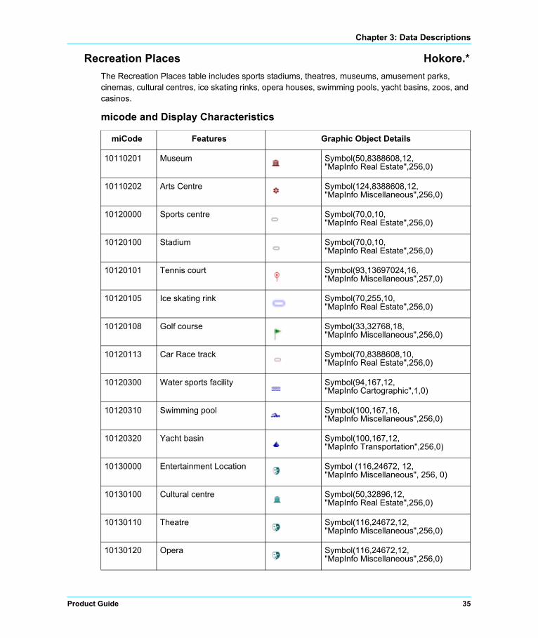
Recreation Places Hokore.*
The Recreation Places table includes sports stadiums, theatres, museums, amusement parks, cinemas, cultural centres, ice skating rinks, opera houses, swimming pools, yacht basins, zoos, and casinos.
micode and Display Characteristics
miCode Features Graphic Object Details
10110201 Museum Symbol(50,8388608,12,"MapInfo Real Estate",256,0)
10110202 Arts Centre Symbol(124,8388608,12,"MapInfo Miscellaneous",256,0)
10120000 Sports centre Symbol(70,0,10,"MapInfo Real Estate",256,0)
10120100 Stadium Symbol(70,0,10,"MapInfo Real Estate",256,0)
10120101 Tennis court Symbol(93,13697024,16,"MapInfo Miscellaneous",257,0)
10120105 Ice skating rink Symbol(70,255,10,"MapInfo Real Estate",256,0)
10120108 Golf course Symbol(33,32768,18,"MapInfo Miscellaneous",256,0)
10120113 Car Race track Symbol(70,8388608,10,"MapInfo Real Estate",256,0)
10120300 Water sports facility Symbol(94,167,12,"MapInfo Cartographic",1,0)
10120310 Swimming pool Symbol(100,167,16,"MapInfo Miscellaneous",256,0)
10120320 Yacht basin Symbol(100,167,12,"MapInfo Transportation",256,0)
10130000 Entertainment Location Symbol (116,24672, 12, "MapInfo Miscellaneous", 256, 0)
10130100 Cultural centre Symbol(50,32896,12,"MapInfo Real Estate",256,0)
10130110 Theatre Symbol(116,24672,12,"MapInfo Miscellaneous",256,0)
10130120 Opera Symbol(116,24672,12,"MapInfo Miscellaneous",256,0)
Product Guide 35

Data Descriptions
Table Structure
10130130 Concert hall Symbol(50,32896,12,"MapInfo Real Estate",256,0)
10130140 Music centre Symbol(50,32896,12,"MapInfo Real Estate",256,0)
10130150 Cinema Symbol(102,32896,16,"MapInfo Miscellaneous",256,0)
10130200 Leisure centre Symbol(40,32896,16,"MapInfo Real Estate",256,0)
10130210 Park and recreation area, represented by a point
Symbol(64,32896,16,"MapInfo Miscellaneous",256,0)
10130220 Zoo Symbol(137,32896,12,"MapInfo Miscellaneous",256,0)
10130230 Amusement park Symbol(133,24672,16,"MapInfo Miscellaneous",256,0)
10130240 Camping ground Symbol(66,32896,16,"MapInfo Miscellaneous",256,0)
10130260 Nightlife Symbol(65,32896,16,"MapInfo Real Estate",256,0)
10130270 Casino Symbol(94,32896,16,"MapInfo Miscellaneous",256,0)
10130400 Residential Accommodation
Symbol (35,8388608,12,"MapInfo Real Estate",0,0)
Field Description Type (width) Indexed
Name Name of recreational facility Character (100) Yes
Name_Lng Language of recreational facility name or "UND" for undefined
Character (3) No
micode MapInfo global feature code Integer No
SmartLabel Same as Name with added carriage returns Character (100) No
FeatureID Unique feature identifier within this country Character (16) Yes
miCode Features Graphic Object Details
36 StreetPro Hong Kong 2014.05

Chapter 3: Data Descriptions
Stations Hokost.*
The Stations table is a point file of bus stations, railway stations and ferry terminals.
micode and Display Characteristics
Table Structure
miCode Features Graphic Object Details
10320102 Ferry terminal, train Symbol(109,167,16,"MapInfo Transportation",256,0)
10320203 Railway station, national Symbol(110,0,18,"MapInfo Transportation",256,0)
10320201 Railway station, underground/metro
Symbol(64,16742656,10,"MapInfo Transportation",256,0)
10320202 Railway station, international
Symbol(110,6316128,18,"MapInfo Transportation",256,0)
10320200 Railway station, undefined Symbol(110,6316128,18,"MapInfo Transportation",256,0)
10320204 Railway station, (sub) urban
Symbol(110,6316128,18,|"MapInfo Transportation",256,0)
10320300 Bus station Symbol(111,0,18,"MapInfo Transportation",256,0)
10320205 Railway station, light rail Symbol(110,9437184,16,"MapInfo Transportation",256,0)
10320101 Ferry terminal, ship/hovercraft
Symbol(98,22015,14,"MapInfo Transportation",256,0)
Field Description Type (width) Indexed
Name Name of station or terminal Character (100) Yes
Name_Lng Language of station or terminal name or "UND" for undefined
Character (3) No
micode MapInfo global feature code Integer No
SmartLabel Same as Name with added carriage returns Character (100) No
FeatureID Unique feature identifier within this country Character (16) Yes
Product Guide 37

Data Descriptions
Street Layers Hokos1.* – Hokos6.*
The street layers contain motorways, major, minor and local roads, paths and trails. Roads of major network importance are held in the Street 1 layer, with subsequent layers containing streets in decreasing order of importance.
micode and Display Characteristics
miCode Features Graphic Object Details
20010100 Motorway, part of a motorway, non toll
Pen(40,130,13777980)
20010100 Motorway, part of a multi-carriageway not a motorway, non toll
Pen(40,130,13777980)
20010200 Motorway, single carriageway, non toll
Pen(40,130,13777980)
20010300 Motorway, part of a roundabout, non toll
Pen(40,130,13777980)
20010301 Motorway, special traffic figure, non toll
Pen(40,130,13777980)
20010400 Motorway, part of a slip road, non toll
Pen(30,130,13777980)
20010410 Motorway, part of a slip road, toll
Pen(30,130,13777980)
20020100 Major road, part of a multi-carriageway not a motorway, non toll
Pen(40,130,7116418)
20020110 Major road, part of a multi-carriageway not a motorway, toll
Pen(40,130,7116418)
20020200 Major road, single carriageway, non toll
Pen(40,130,7116418)
20020210 Major road, single carriageway, toll
Pen(40,130,7116418)
20020300 Major road, part of a roundabout, non toll
Pen(40,130,7116418)
20020301 Major road, special traffic figure, non toll
Pen(40,130,7116418)
38 StreetPro Hong Kong 2014.05

Chapter 3: Data Descriptions
20020310 Major road, part of a roundabout, toll
Pen(40,130,7116418)
20020400 Major road, part of a slip road, non toll
Pen(30,130,7116418)
20020410 Major road, part of a slip road, toll
Pen(30,130,7116418)
20020500 Major road, part of a service road, non toll
Pen(30,130,7116418)
20020700 Major road, part of a pedestrian zone, non toll
Pen (1, 4, 14401683)
20030100 Other major road, part of a multi-carriageway not a motorway, non toll
Pen(40,130,7116418)
20030110 Other major road, part of a multi-carriageway not a motorway, toll
Pen(40,130,7116418)
20030200 Other major road, single carriageway, non toll
Pen(40,130,7116418)
20030210 Other major road, single carriageway, toll
Pen(40,130,7116418)
20030300 Other major road, part of a roundabout, non toll
Pen(40,130,7116418)
20030301 Other major road, special traffic figure, non toll
Pen(40,130,7116418)
20030310 Other major road, part of a roundabout, toll
Pen(40,130,7116418)
20030400 Other major road, part of a slip road, non toll
Pen(30,130,7116418)
20030401 Other major road, part of an enclosed traffic area, non toll
Pen(30,130,7116418)
20030410 Other major road, part of a slip road, toll
Pen(30,130,7116418)
20030500 Other major road, part of a service road, non toll
Pen(30,130,7116418)
miCode Features Graphic Object Details
Product Guide 39

Data Descriptions
20030700 Other major road, part of a pedestrian zone, non toll
Pen (1, 4, 14401683)
20040100 Secondary road, part of a multi-carriageway not a motorway, non toll
Pen(30,2,8762781)
20040110 Secondary road, part of a multi-carriageway not a motorway, toll
Pen(30,2,8762781)
20040200 Secondary road, single carriageway, non toll
Pen(30,2,8762781)
20040210 Secondary road, single carriageway, toll
Pen(30,2,8762781)
20040300 Secondary road, part of a roundabout, non toll
Pen(30,2,8762781)
20040301 Secondary road, special traffic figure, non toll
Pen(30,2,8762781)
20040311 Secondary road, special traffic figure, toll
Pen(30,2,8762781)
20040400 Secondary road, part of a slip road, non toll
Pen(30,2,8762781)
20040401 Secondary road, part of an enclosed traffic area, non toll
Pen(30,2,8762781)
20040410 Secondary road, part of a slip road, toll
Pen(30,2,8762781)
20040500 Secondary road, part of a service road, non toll
Pen(30,2,8762781)
20040600 Secondary road, entrance to or exit from a car park, non toll
Pen(30,2,8762781)
20040610 Secondary road, entrance to or exit from a car park, toll
Pen(30,2,8762781)
20040700 Secondary road, part of a pedestrian zone, non toll
Pen (1, 4, 14401683)
20050100 Local/connecting road, part of a multi-carriageway not a motorway, non toll
Pen(30,130,14401683)
miCode Features Graphic Object Details
40 StreetPro Hong Kong 2014.05

Chapter 3: Data Descriptions
20050110 Local/connecting road, part of a multi-carriageway not a motorway, toll
Pen(30,130,14401683)
20050200 Local/connecting road, single carriageway, non toll
Pen(30,130,14401683)
20050210 Local/connecting road, single carriageway, toll
Pen(30,130,14401683)
20050300 Local/connecting road, part of a roundabout, non toll
Pen(30,130,14401683)
20050301 Local/connecting road, special traffic figure, non toll
Pen(30,130,14401683)
20050310 Local/connecting road, part of a roundabout, toll
Pen(30,130,14401683)
20050400 Local/connecting road, part of a slip road, non toll
Pen(30,130,14401683)
20050401 Local/connecting road, part of an enclosed traffic area, non toll
Pen(30,130,14401683)
20050410 Local/connecting road, part of a slip road, toll
Pen(30,130,14401683)
20050500 Local/connecting road, part of a service road, non toll
Pen(30,130,14401683)
20050510 Local/connecting road, part of a service road, toll
Pen(30,130,14401683)
20050600 Local/connecting road, entrance to or exit from a car park, non toll
Pen(30,130,14401683)
20050700 Local/connecting road, part of a pedestrian zone, non toll
Pen(1,4,14401683)
20060100 Local road/high importance, part of a multi-carriageway not a motorway, non toll
Pen(1,2,14401683)
20060110 Local road/high importance, part of a multi-carriageway not a motorway, toll
Pen(1,2,14401683)
miCode Features Graphic Object Details
Product Guide 41
Data Descriptions
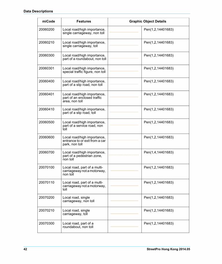
20060200 Local road/high importance, single carriageway, non toll
Pen(1,2,14401683)
20060210 Local road/high importance, single carriageway, toll
Pen(1,2,14401683)
20060300 Local road/high importance, part of a roundabout, non toll
Pen(1,2,14401683)
20060301 Local road/high importance, special traffic figure, non toll
Pen(1,2,14401683)
20060400 Local road/high importance, part of a slip road, non toll
Pen(1,2,14401683)
20060401 Local road/high importance, part of an enclosed traffic area, non toll
Pen(1,2,14401683)
20060410 Local road/high importance, part of a slip road, toll
Pen(1,2,14401683)
20060500 Local road/high importance, part of a service road, non toll
Pen(1,2,14401683)
20060600 Local road/high importance, entrance to or exit from a car park, non toll
Pen(1,2,14401683)
20060700 Local road/high importance, part of a pedestrian zone, non toll
Pen(1,4,14401683)
20070100 Local road, part of a multi-carriageway not a motorway, non toll
Pen(1,2,14401683)
20070110 Local road, part of a multi-carriageway not a motorway, toll
Pen(1,2,14401683)
20070200 Local road, single carriageway, non toll
Pen(1,2,14401683)
20070210 Local road, single carriageway, toll
Pen(1,2,14401683)
20070300 Local road, part of a roundabout, non toll
Pen(1,2,14401683)
miCode Features Graphic Object Details
42 StreetPro Hong Kong 2014.05

Chapter 3: Data Descriptions
20070301 Local road, special traffic figure, non toll
Pen(1,2,14401683)
20070311 Local road, special traffic figure, toll
Pen(1,2,14401683)
20070400 Local road, part of a slip road, non toll
Pen(1,2,14401683)
20070401 Local road, part of an enclosed traffic area, non toll
Pen(1,2,14401683)
20070410 Local road, part of a slip road, toll
Pen(1,2,14401683)
20070500 Local road, part of a service road, non toll
Pen(1,2,14401683)
20070500 Local road, road for authorities, non toll
Pen(1,2,14401683)
20070510 Local road, part of a service road, toll
Pen(1,2,14401683)
20070600 Local road, entrance to or exit from a car park, non toll
Pen(1,2,14401683)
20070610 Local road/minor importance, entrance to or exit from a car park, toll
Pen(1,2,14401683)
miCode Features Graphic Object Details
Product Guide 43

Data Descriptions
Table Structure
‡ Label field for street layers 1–2; ‡‡Label field for street layers 2–6.
Urban Areas Hokou.*
The Urban Areas table contains region objects that represent built-up areas.
micode and Display Characteristics
Table Structure
Field Description Type (width) Indexed
Road No‡ Road number Character (15) Yes
Alt_Road_No Alternative road number Character (50) No
E_Road_No European road number Character (15) No
Road_Name‡‡ Road name Character (100) Yes
Road_Nm_Lng Language of road name or "UND" for undefined Character (3) No
Alt_Road_Nm Alternative road name Character (100) No
Alt_Nm_Lng Language of alternative road name or "UND" for undefined
Character (3) No
micode MapInfo global feature code Integer No
miCode Features Graphic Object Details
50040200 Built-up area Brush (2, 16378307, 16777215)Pen (1, 2, 16378307)
Field Description Type (width) Indexed
Name Name of urban area Character (100) Yes
Name_Lng Language of urban area name or "UND" for undefined
Character (3) No
micode MapInfo global feature code Integer No
SmartLabel Same as Name with added carriage returns Character (100) No
FeatureID Unique feature identifier within this country Character (16) Yes
44 StreetPro Hong Kong 2014.05

Chapter 3: Data Descriptions
Water Feature Layers Hokow.* and Hokowm.*
Water Hokow.*
The Water Features table contains region objects and lines that represent water bodies such as lakes, rivers, and canals.
Water Major Hokowm.*
The Water Features Major table is for small scale use. It contains water features based upon a scale of 1:2,500,000 and smaller.
micode and Display Characteristics
Table Structure
miCode Features Graphic Object Details
30030100 Water feature, lake Brush(2,11130623,16777215)
Pen(1,2,11130623)
30040100 Water feature, ocean or sea Brush(2,11130623,16777215)
Pen(1,2,11130623)
30050800 Water feature, undefined Brush(2,11130623,16777215)
Pen(1,2,11130623)
Field Description Type (width) Indexed
Name Name of water feature Character (100) Yes
Name_Lng Language of water feature name or "UND" for undefined
Character (3) No
micode MapInfo global feature code Integer No
SmartLabel Same as Name with added carriage returns Character (100) No
FeatureID Unique feature identifier within this country Character (16) Yes
Product Guide 45

Data Descriptions
46 StreetPro Hong Kong 2014.05

4
Opening a WorkspaceIn this chapter:
Workspaces . . . . . . . . . . . . . . . . . . . . . . . . . . . . . . . . . . . . . . . . . . .48 Opening a StreetPro International Workspace using MapInfo
Professional . . . . . . . . . . . . . . . . . . . . . . . . . . . . . . . . . . . . . . . . . . . 48
This chapter covers workspaces and the opening of a StreetPro international workspace using MapInfo Professional.

Opening a Workspace
Workspaces
A workspace is a collection of layers that can be opened together in a mapping application. It constitutes a list of all the relevant tables, windows, and settings, stored in a file with the extension .wor. Workspaces offer a convenient means of returning to a previously created map without having to open each table file individually.
The selected workspace keeps track of the following elements:
• Map, Browser, Graph, 3DMap, and Layout windows, including their size and position
• Query tables created from base tables using either the Select or SQL Select statements
• Graphs
• Thematic maps
• Legend windows
• Cosmetic objects
• Labels
• Styles for fonts, symbols, lines, and fill patterns used to display objects
Caution: When you save a workspace, you cannot save any references to selections or queries made by the Selection tools or Query options.
Note: You can use the Workspace Packager tool to create a copy of your current workspace in a new folder, and copy all the data referenced by the workspace in the same folder. Using this tool, the workspace looks to these internal references to find the data and .TAB file, so you can open this workspace no matter where you have moved or copied that folder, even if you move it to a different computer. Select this tool using Tools > Tool Manager, and then select Tools > Workspace Packager > Package Current Workspace.
International Workspace
The international workspace provides a common set of display settings for all StreetPro countries.
Local Workspace
Local workspaces have been designed to display maps in a cartographic style that is more particularly related to a group of countries or an individual country.
Opening a StreetPro International Workspace using MapInfo Professional
If you have not already done so, launch MapInfo Professional from the Windows Start menu. If the program was already running, select File > Close All to shut everything down and so avoid cluttering up your screen with unnecessary windows.
48 StreetPro Hong Kong 2014.05

Chapter 4: Opening a Workspace
If the program was not already running, the Quick Start dialog box is displayed as soon as you start the program. This gives you the option of restoring the previous session or workspace, or opening a new workspace or table.
To open a workspace:
1. Either:
a. In the Quick Start dialog box, click Open a Workspace and then Open.
Or
b. From the MapInfo Professional main menu, select File > Open and then choose Workspace (*.wor) from the Files of type drop-down list.
2. Browse to the workspace you wish to open, and then click Open.Note: Open the *_int_mipro115.wor file for the required country if you are using MapInfo Professional 11.5, or the *_int.wor file if you are using an earlier version of MapInfo Professional.
3. Once the workspace is displayed, as per the International Workspace Example, then you can proceed as required.
When you exit MapInfo Professional, the last session is stored (unless you have set your preferences so that it will not be, using Options > Preferences > Startup). If there are files that you do not wish to be added to your workspace, close them before exiting.
Product Guide 49

Opening a Workspace
50 StreetPro Hong Kong 2014.05

5
Language Settings and Special CharactersThis chapter covers information about language setting and displaying special characters in StreetPro using MapInfo Professional:.
In this chapter:
Displaying Special Characters in MapInfo Professional . . . . . . .52

Language Settings and Special Characters
Displaying Special Characters in MapInfo Professional
If you are using an edition of StreetPro for which the country character set is not Latin-1, you must change a number of system settings before special characters can be displayed correctly.
Language settings
In the Windows Start menu, open the Control Panel and then the Regional and Language Options dialog. Click the Advanced tab and change the language in the drop-down menu to that of the language for which you wish to view special characters (e.g. Russian for Cyrillic characters).
Note: The computer will need to be restarted before changes become visible. The settings must be set back to English once you are finished using the StreetPro tables, as other applications may be affected.
Font selection
The second change that may have to be made in order for the characters to be displayed correctly is to change the font within MapInfo Professional. As each browser is opened, change the font of the browser using either the Text Style button on the Drawing toolbar, or by clicking Options > Text
style… to open the font change dialog. You can also use the shortcut key [F8] to open this dialog.
Tahoma is the recommended style, as it supports many special characters and associated diacritics.
The default label style can be changed by clicking Options > Preferences… then the Styles... button. The Text style can then be set to the appropriate font.
Country Windows Char Set Display Font
Hong Kong WindowsTradChinese Tahoma
Macau WindowsTradChinese Tahoma
Philippines WindowsLatin1 Tahoma
Taiwan WindowsTradChinese Tahoma
Thailand WindowsThai Tahoma
Viet Nam WindowsLatin1 Tahoma
52 StreetPro Hong Kong 2014.05

A
Appendix A: Understanding MetadataWhat Is Metadata?
Metadata, in its simplest definition, is data about data. Metadata describes the content, source, history, structure and support that may exist for a data product or entity. Pitney Bowes Software metadata exists in two forms:
• Metadata for the complete product is included in the StreetPro_Hong Kong_2014_05.xml’ file in the Data\Metadata folder on the installation disk.
• Metadata as keyword and value pairs can be found within each MapInfo format table (.TAB file).
Our metadata is designed to be compliant with the 2003 ISO Geospatial metadata standard. As such, this enables the data products from Pitney Bowes Software to be available for data cataloguing within any system that uses ISO metadata standards.
Purpose of Metadata
The main purposes of metadata is to provide a mechanism for you to identify the data product unambiguously, list all legal restrictions, and provide copyright information and contact information. This is important information for knowing the currency of the data, and to ensure that the correct and/or most recent version is being used. It is also the information required for identifying the correct data product when contacting Technical Support.
Metadata Sections
The following metadata sections are included at both product and table level:
• Metadata overview: Including language, character set and metadata standards.
• Contact and distribution information.

Understanding Metadata
• Data Description: product name and version.
• Extent: north and south bounding latitudes, east and west binding longitudes.
• Resource Constraints: The Pitney Bowes Software mapping software solutions that can be used with this product.
• Abstract: brief description of the product/table.
• Data Lineage: data source, provider and vintage.
• Spatial Reference System: projection, ellipsoid and datum.
Additional sections at product level:
• Keywords: layers in the product, plus country and national capital.
• Further Information.
Additional section at table level:
• Object information: number of points or regions.
Viewing Metadata
Product Level
An xslt stylesheet is provided to facilitate reading product level metadata.
Table Level
Open the .TAB file in Notepad:
Alternatively, if you have MapInfo Professional installed, you can use the Table Manager tool to view and edit your metadata.
54 StreetPro Hong Kong 2014.05

B
Appendix B: Extras FolderThis section contains information about the additional tables included in the StreetPro product. The additional tables included are -
• Language Table (LNG.*)
• micodemaster Table (micodemaster.*)
• Hong Kong Gazetteer Full Table (hokoGF.*)
• Hong Kong Postcodes Boundary Table (hokoPC.*)
• Hong Kong Postcodes Points Table (hokoPCP.*)
• Hong Kong Postcode Boundaries and District Index Table (HokoPC_District_INDEX.*)

Extras Folder
Language Table (LNG.*)
The languages that are used in StreetPro with their abbreviations are included in the file LNG*.
Table Structure
micodemaster Table (micodemaster.*)
StreetPro releases to date have incorporated feature type coding that is consistent but not necessarily related to a recognised standard. Pitney Bowes Software Pty Ltd, with an objective to align to recognised standards and add more 'depth' and 'intelligence' to its coding has developed a coding system that is progressively being applied to its range of data products globally - the micode schema.
This schema is a variation of the feature-coding schema in "Defence Mapping Agency (now NIMA) standard, Mapping, Charting & Geodesy Glossary of Feature and Attribute Definitions, MIL-STD-2408, April 1995". The schema has been modified to be an eight-digit/three-part schema with its own definitions for the use of values within each part. The eight-digit code is made up of a two-digit Category code, followed by a two-digit Sub-category code, and then a four-digit Sub-feature code.
For example: Category + Subcategory + Sub-feature
10+07+0200 (This micode refers to POIs category with sub category of Business Locations and sub-features as Hotel/Motel)
A MapInfo format micode lookup table is supplied with StreetPro.
Field Description Type (width) Indexed
Language Languages used in StreetPro Character (25) No
Abbrev Language Abbreviation Character (3) No
56 StreetPro Hong Kong 2014.05

Appendix B: Extras Folder
Table Structure
Gazetteer Full Hokogf.*
For analysis purposes, the full gazetteer table (hokogf.*), consolidating all the gazetteer layers, is included in the Extra folder.
micode and Display Characteristics
Field Description Type (width) Indexed
Table_ID Letter code assigned to layer Character (6) No
Table Layer category names Character (25) No
Description Details of sub-features falling under category Character (100) No
micode MapInfo global feature code Integer No
FCode Feature Code provided by data provider Character (8) No
Style Display characteristics details Character (60) No
miCode Features Graphic Object Details
80010200 National capital Symbol(61,13697024,10,"MapInfo Cartographic",256,0)
80010101 Major City Symbol (47,0,10,”MapInfo Cartographic”,256,0)
80010102 City or major town Symbol (46,0,8,”MapInfo Cartographic”,256,0)
80010103 Town Symbol (34,16777215,8)
80010104 Small Town Symbol (34,16777215,6)
80010105 Other Settlement Symbol (41,8421504,5,”MapInfo Cartographic”,256,0)
Product Guide 57

Extras Folder
Table Structure
Postcode Boundary Hokopc.*
The Postcodes boundary layer comprises polygons representing the boundaries of unique postcode values in Hong Kong. This layer is suitable for refining address searching and geocoding processes when used in conjunction with the Hong Kong Street centreline data.
Not available in this region
micode and Display Characteristics
Table Structure
Field Description Type (width) Indexed
Name Name of settlement Character (100) No
Name_Lng Language of settlement name or "UND" for undefined
Character (3) No
IndexName Name of settlement tagged with admin boundary Character (150) Yes
Alt_Name Alternative name of settlement Character (100) No
Alt_Nm_Lng Language of alternative name of settlement or "UND" for undefined
Character (3) No
Category Population category code Character (3) Yes
micode MapInfo global feature code Integer No
SmartLabel Same as Name with added carriage returns Character (100) No
FeatureID Unique feature identifier within this country Character (16) Yes
miCode Features Graphic Object Details
- Postcode Brush (1, 0, 16777215)Pen (1, 2, 65535)
Field Description Type (width) Indexed
Postcode Postcode values Character (5) Yes
Territory Admin level 1 Character (40) No
58 StreetPro Hong Kong 2014.05

Appendix B: Extras Folder
Postcode Points Hokopcp.*
The Postcodes Point layer contains the locations of local post offices in Hong Kong. There are occurrences of multiple post offices being assigned the same postcode values.
micode and Display Characteristics
Table Structure
Postcode and District Index Table HokoPC_District_INDEX.*
The multiple Postcodes Point s are being assigned the same postcode values. Postcode points have been tagged with lower admin boundary (District) to segregate multiple post offices with same postcode value to create HokoPC_District_INDEX.* table.
Not available in this region
District Admin level 3 Character (40) No
FeatureID Unique feature identifier within this country Character (16) No
Field Description Type (width) Indexed
miCode Features Graphic Object Details
10240500 Post office Symbol (34,128,10,"MapInfo 3.0 Compatible",0,0)
Field Description Type (width) Indexed
Name Name of post office Character (200) Yes
Name_Lng Language of post office name or "UND" for undefined
Character (3) No
Postcode Postcode value Character (5) No
micode MapInfo global feature code Integer No
FeatureID Unique feature identifier within this country Character (16) Yes
Product Guide 59

Extras Folder
Table Structure
Field Description Type (width) Indexed
POSTCODE Postcode value Character (30) Yes
District_INDEX District in which the post office lies Character (100) Yes
60 StreetPro Hong Kong 2014.05

C
Appendix C: Data Support and FeedbackPitney Bowes Software Pty Ltd continues to enhance the data support and feedback facilities available to our clients. An infrastructure has been developed to streamline the handling of customer feedback regarding data products and to ensure that appropriate responses are provided, with corrective action being taken where appropriate. For the various types of possible feedback, and their submission, refer to the form on the next page.
Feedback Process
The process is as follows:
1. Completion of Feedback Form by Client: The electronic form on the following page has a Send button that you can use to send the AsiaPac Data Production Team general comments concerning any of our data products.You can also email comments (and associated screenshots) directly to the following email address: [email protected]
2. Handling: All customers are sent confirmation of receipt of email feedback, and then subsequently notified of the type and timetable of the corrective action (where appropriate). Dependent on the type of feedback, the report may be actioned immediately or scheduled for routine maintenance action as part of the next scheduled release. The Feedback Database keeps track of progress on each item. Follow-up action and advice are provided wherever necessary.

Appendix C: Data Support and Feedback
Electronic Feedback Form
You can send us feedback on any of the data products supplied by Pitney Bowes Software, by completing the information below and clicking Send in the lower-right corner of the page. This generates an e-mail to which you can attach any screenshots that you feel would help illustrate your feedback.
Feedback can be in the form of correction advice, notification of changes, requests for enhancements/ features, or requests for information. All feedback is valued by the Data Production Team and contributes to product improvements and enhanced value to users.
Your feedback will be emailed directly to the AsiaPac Data Production Team at [email protected], who will review and action it as soon as is practicable.
Contact Preferences
May we contact you if we have questions about your comments?
Yes No
Contact Information
Name:
Email:
Phone:
Best time to contact:
Data/Software Versions
Please complete the following information (as applicable):
Name of Data Product:
Version of Data Product:
Software used to load Data:
Version of Software used:
Your Comments
Enter your comments below. If you wish to report any problems, please feel free to do so but be as specific as possible, giving the relevant codes and tables. Thank you in advance.
If you reported any problems above, please indicate the severity of their impact by clicking the appropriate button:
Could not carry on working Inconvenient, but able to continue Cosmetic only, no real impact
Not applicable