Embed Size (px)
Citation preview
Article
Straight Streets in a CurvaceousCrescent: Colonial UrbanPlanning and Its Impacton Modern New Orleans
Richard Campanella1
AbstractNew Orleans is justly famous for its vast inventory of historical architecture, representing scores ofstylistic influences dating to the French and Spanish colonial eras. Less appreciated is the fact that theCrescent City also retains nearly original colonial urban designs. Two downtown neighborhoods,the French Quarter and Central Business District, are entirely undergirded by colonial-era planning,and dozens of other neighborhoods followed suit even after Americanization. New Orleanians whoreside in these areas negotiate these colonial planning decisions in nearly every movement theymake, and they reside in a state with as many colonial-era land surveying systems as can be foundthroughout the United States. This article explains how those patterns fell in place.
KeywordsNew Orleans, Louisiana, cadastral systems, colonial planning, planning eras/approaches, FrenchQuarter, surveying systems, French long lots
Origins
Men under the command of Jean-Baptiste Le Moyne, Sieur de Bienville began clearing vegetation
for La Nouvelle-Orleans in the early spring of 1718. Their proximate motivation was to establish a
counter-office for the Company of the West, to which a monopoly charter had been granted by
Philippe, the Duc d’Orleans and Regent of France, for the creation of an enslaved tobacco plantation
economy. The ultimate motivation for the foundation of New Orleans was to create a French
bulwark near the mouth of the Mississippi River to control access to France’s 1682 claim of the
vast interior valley, while preventing the Spanish and English from doing the same.1
Where exactly to locate New Orleans had vexed French colonials. Bienville’s selection of what is
now the French Quarter site had plenty of detractors, on account of its soft deltaic soils, flood-prone
banks and backswamps, and hundred miles of shoal-prone river separating it from Gulf waters. But
1 School of Architecture, Tulane University, New Orleans, LA, USA
Corresponding Author:
Richard Campanella, School of Architecture, Tulane University, Richardson Memorial Hall, New Orleans, LA 70118, USA.
Email: [email protected]
Journal of Planning History1-16ª 2018 The Author(s)Article reuse guidelines:sagepub.com/journals-permissionsDOI: 10.1177/1538513218800478journals.sagepub.com/home/jph
Bienville’s site had a convenient alternative route to the Gulf, via a bayou named St. John and a bay
named Lake Pontchartrain, while its fertile soils and defensive riverside perch made it superior to coastal
options.
Superior, perhaps, but only in a relative sense. The terrain itself, fluid with mud and water,
precluded urbanization as French colonials understood it. Their response was to impose rigidity upon
that fluidity, in the form of river-restraining levees, runoff-draining canals, rational urban grids,
delineated parcels, and defendable ramparts. These engineering tactics enabled the birthing of a city
on a fluvial delta, even as they would, over time, disrupt the hydrological processes that created the
deltaic landscape in the first place. Common to all these tactics was the one geometric shape utterly
absent in nature, particularly in fluvial deltas: the straight line. From the colonial standpoint, Euclidean
geometry—straight lines and ninety-degree angles—introduced order to disorder, civilization to wild-
erness, godliness to the heathen, and the power of the Crown to the cowering native.
The surveying of straight lines arrived to the toolbox of colonialism via ancient architectural
sources and contemporary military engineering. Hippodamus of Miletus is credited for the first
conscientious planning of cities; his gridded street system, which appeared in Piraeus in the fifth
century BC and subsequently spread, became a fundamental concept of urban planning. Centuries
later, Roman authorities deployed the grid model throughout their empire, aligning new street axes
to cardinal directions and placing forums at the town nuclei. It was during this era that Marcus
Vitruvius Pollio scribed his magisterial De architectura, which did for buildings what Hippodamus
had done earlier for cities.
Vitruvius’s tome disappeared after Rome’s fall—a loss that can be viewed as symbolic because
progressive thought on urban design in the West subsequently waned. The Dark Ages “can be
regarded as a period of stagnation in European urban development,” wrote Thomas Hall. “Little
change was made in existing urban structures and major foundations or expansions were rare.”2
The Renaissance reinvigorated European thinking about cities, and in the late 1400s, Vitruvius’s
De architectura fortuitously reappeared. The opus taught a new generation that buildings should be
firmitas, utilitas, and venustas—strong, useful, and beautiful. So too should cities: Vitruvius articu-
lated the values of ordinatio (measured and incremented order), symmetria, and eurythmia (graceful
adaptiveness) in urban design, manifested by central plazas and orthogonal street networks and
paying homage, ultimately, to the human body. Leonardo de Vinci’s famous sketch of the Vitruvian
Man, his outstretched limbs inscribed within a circle and square, venerated humanity’s “canon of
proportions:” the circle represented nature, heaven, and the divine; the square, with its straight lines
and ninety-degree angles, represented earthly rationality.3
Vitruvian ideas resonated with imperialism. Throughout their New World colonization, Spanish
colonials produced hundreds of urban grids with central plazas fronted by institutions of church
and state. Similar designs appeared in European cities during the 1600s–1700s, taking “hold
among the French at the very moment that the Bourbon monarchy was expanding its imperial
domain on the Continent.”4
Louisiana arrived into Bourbon France’s imperial docket at roughly the same time that Sebastien
Le Prestre, Seigneur de Vauban emerged as the Crown’s premier military engineer. Vauban inte-
grated principles of military defense with Vitruvian and Hippodamian notions of symmetrical urban
order. He designed plats with narrow streets (to funnel invading troops), which ran in straight lines
(to muster local militias) and set them within fortifications angled to expose attackers from any
approaches to maximum fire power. Vauban’s field manual New Method of Fortification educated
generations of engineers in the geometry of forts and fortified cities, with instructions on “How to
describe any Polygon within a given Circle . . . . How to make the Draught of a Square . . . . The
Structure of a Hexagon . . . . To make the Streets in a Fortress . . . . Of the principal Angles of a
Fortress . . . . Of the Streets, Places of Arms, Corps de Garde, and Magazines . . . . Of the Advantages
and Disadvantages of a Place situated [by a] great River . . . .”5
2 Journal of Planning History XX(X)
The concept of neatly fortified cities appealed to the Crown’s absolutist aspirations. Eager to
inscribe his power into the landscape, King Louis XIV deployed engineers trained by Vauban and
his successor, the Marquis d’Asfeld, across the French countryside to redesign towns’ irregular
warrens with orthogonal grids set within stellar-shaped ramparts. Villages that were once largely
organic, autonomous, and vulnerable now became part of “a national project” and dependent on the
Crown for protection.6 Likewise, French claims in the New World were sized up for a similar
imperial envelopment. Urban planning worked hand in hand with national expansion; in the words
of historical anthropologist Shannon Lee Dawdy, it represented “a conscious conviction that spatial
control yielded political control.”7
The Bienville–Pailloux Baseline
Spatial control did not come immediately to Bienville’s New Orleans. Conditions in early 1718 were
a bit too uncertain, and the task at hand too overwhelming, for a full plat to be laid out promptly.
Bienville did not, however, concede to disorder. Probably with the collaboration of Jacques Barbi-
zon de Pailloux, the engineer who in 1711 laid out Mobile in present-day Alabama, Bienville plotted
a perfectly straight baseline running behind the crest of the natural levee about 700 feet from the
river. Angled by thirty-seven degrees (southwest to northeast, rather than along a cardinal direction),
the baseline fronted a sharp meander of the river, such that it faced approaching ships. The baseline
suggested that Bienville expected a fully articulated urban grid to be forthcoming, and its rotation
angle indicated he had military defensive on his mind. The Bienville–Pailloux line would later drive
the orientation of the entire city.8
This initial attempt at urban planning, however, failed to prevent desultory development. The
disarray may have arisen from a sense that Bienville’s project could not withstand flood threats from
the Mississippi (it inundated in 1719) and that it would get relocated to safer sites at Mobile,
Manchac, or Natchez. It did not help that the Company of the West’s land-development
scheme—“built on speculation, deception, and inflation”9—collapsed in 1720, instigating riots in
Europe and further tainting Louisiana’s already unsavory reputation. Although the Company sur-
vived the crash, prospects did not bode well for its New Orleans project. One observer described the
isolated settlement as comprising “about a hundred forty barracks, disposed with no great regularity,
[with] a few inconsiderable houses, scattered up and down, without any order or regularity . . . . New
Orleans, in 1720, made a very contemptible figure . . . ”10
What further affronted the beleaguered outpost was the recent decision by the reconstituted
Company to designate Biloxi, a hundred miles to the west in present-day Mississippi, as capital
of the Louisiana colony. Chief Engineer Louis-Pierre Le Blond de La Tour proceeded to design
plans for the new coastal capital, and having served under Marquis d’Asfeld, Vauban’s successor in
the Corps of Engineers, he sketched a star-shaped fort design surrounding a symmetrical street grid
with a place d’armes and church.11
La Tour soon fell ill and dispatched his assistant, Adrien de Pauger, also a protege of d’Asfeld and
Vauban, to New Orleans to bring order to that “contemptible” outpost. Pauger arrived on March 21,
1721, with La Tour’s Biloxi plans in his baggage and proceeded to survey the terrain and its
relationship to the river. He then got to work.
Pauger’s Grid
Pauger’s progress may be reconstructed from his communiques with superiors. He sent a letter to
Paris on April 14 in which he enclosed “the plan of the city projected at New Orleans.” He sent
another copy to La Tour on the same day, in which he explained “the changes I have been obliged to
make because of the situation of the terrain[,] being higher on the river bank.” He then announced an
Campanella 3
important decision: “I have brought the town site . . . closer to the river, so as to profit from the
proximity of the landing place as well as to have more air from the breezes that come from it.”12
Had Pauger not shifted his grid (by 700 feet, as it turned out) toward the river from Bienville’s
baseline, the city would have sat two feet lower in elevation—not much in an absolute sense but
nearly 20 percent of the entire vertical range of the local landscape. That additional verticality would
enable New Orleans to evade high water rising from the backswamp, the likes of which flooded the
city in 1816, 1849, 1871, and 2005. Pauger’s savvy intervention also proved wise economically and
climatologically: the riverfront would indeed bustle with shipping activity, and the river provided
the only reliable source of cooling breezes during blazing subtropical summers.
The April 1721 sketches have been lost, but another one, dated August 9, probably resembled
them, given that its title read Plan de la Ville de la Nouvelle Orleans projettee en Mars 1721. This
crude drawing, which covers only the riverfront blocks, represents the earliest surviving depiction of
today’s street grid as well as three of its extant street names.13 What this map did not show was the
smattering of huts, sheds, gardens, and paths paying no heed to Pauger’s orderly vision. Worse yet,
villagers continued building willy-nilly as they had since 1718 and reacted indignantly when the
lordly newcomer told them otherwise. A city census had enumerated 519 residents, including 171
black slaves and 21 Indian slaves, so there were plenty of potential conflicts to resolve.14 Pauger was
not pleased. He huffed at the insolence of one man who “wanted to build as he saw fit, without
regularity and without plan” and went so far as to produce a map documenting the infractions. (It is
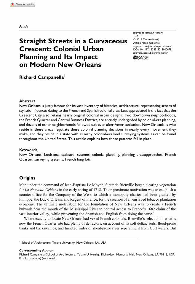
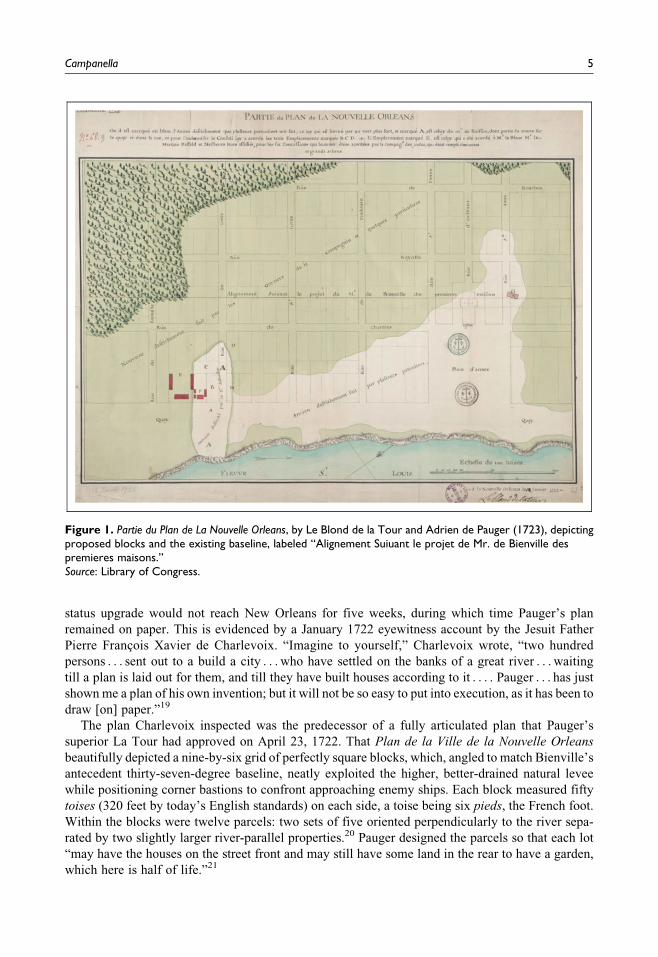
Figure 1 that shows the Bienville–Pailloux baseline, which it labeled Alignement Suiuant le projet de
Mr. de Bienville des premieres maisons.)
The engineer later nearly suffered blows from an enraged housewife—and narrowly escaped a
duel with her husband—when Pauger’s straight streets intersected her crooked garden. A clash
indeed ensued after Pauger had a man’s house demolished because it “was not in alignment of the
street (having built it before the plan was proposed).” The angry citizen sought indemnification
from the Superior Council, but Pauger’s authority prevailed: “Mr. Pauger sent to find him and,
after having regaled him with a volley of blows with a stick, had him put in prison, with irons on
his feet . . . ”15
We might view this incident with hilarity today, but it attests to the sober fact that early New
Orleans was a monarchical and totalitarian society. Urban planning decisions, like all other expres-
sions of power, flowed from the top-down with little regard for the concerns of citizens—to say
nothing of the lives of indigenous peoples, whose displacement went hand in glove with imperial-
ism, nor of the lives of the enslaved, upon which the entire colonial project rested.
The arrival of Pauger’s plans in Paris may have triggered a key decision for the destiny of New
Orleans.16 The Crown at that time found itself in the throes of economic chaos, after the collapse of
the Company’s Louisiana scheme, known infamously as the “Mississippi Bubble” and sometimes
described as history’s first major real estate scam. Officials had been concurrently contemplating
which site should serve as the colony’s capital and Company headquarters, but distracted as they
were by the fiscal turmoil, that question ranked a distant second on their list of priorities. Into this
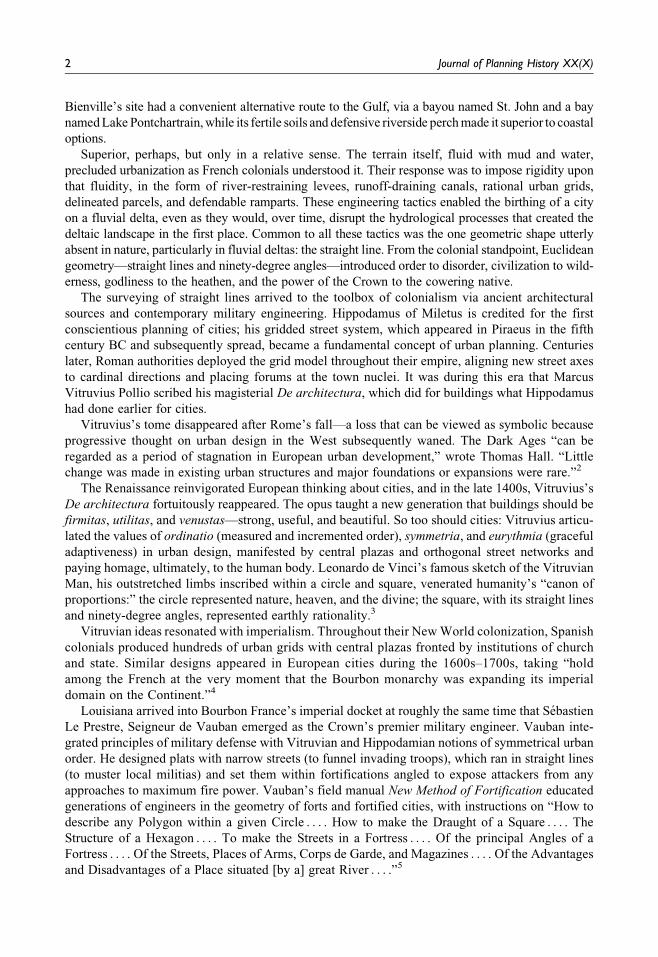
messy moment arrived Pauger’s beautiful, orderly plans for New Orleans (Figure 2). According to
Historian Marc de Villiers du Terrage, the appearance of Pauger’s map in Paris probably “had
weight in the Company’s final decision, since the regent [Philippe, Duc d’Orleans], god-father to
the new capital, was necessarily flattered to see the project put into effect,”17 particularly after
enduring three years of bad news about his namesake’s fortunes. Momentum started to build for
Bienville’s site. “The year 1721 had been generally favourable to New Orleans,” wrote Villiers du
Terrage. “From a military post, a sales-counter, and a camping-ground for travellers, it had become,
in November, a small town, and the number of its irreconcilable enemies began to decrease.”18
On December 23, 1721, four weeks after the arrival of Pauger’s plans, the Company officially
decided to transfer the general management of Louisiana from Biloxi to New Orleans. Word of the
4 Journal of Planning History XX(X)
status upgrade would not reach New Orleans for five weeks, during which time Pauger’s plan
remained on paper. This is evidenced by a January 1722 eyewitness account by the Jesuit Father
Pierre Francois Xavier de Charlevoix. “Imagine to yourself,” Charlevoix wrote, “two hundred
persons . . . sent out to a build a city . . . who have settled on the banks of a great river . . . waiting
till a plan is laid out for them, and till they have built houses according to it . . . . Pauger . . . has just
shown me a plan of his own invention; but it will not be so easy to put into execution, as it has been to
draw [on] paper.”19
The plan Charlevoix inspected was the predecessor of a fully articulated plan that Pauger’s
superior La Tour had approved on April 23, 1722. That Plan de la Ville de la Nouvelle Orleans
beautifully depicted a nine-by-six grid of perfectly square blocks, which, angled to match Bienville’s
antecedent thirty-seven-degree baseline, neatly exploited the higher, better-drained natural levee
while positioning corner bastions to confront approaching enemy ships. Each block measured fifty
toises (320 feet by today’s English standards) on each side, a toise being six pieds, the French foot.
Within the blocks were twelve parcels: two sets of five oriented perpendicularly to the river sepa-
rated by two slightly larger river-parallel properties.20 Pauger designed the parcels so that each lot
“may have the houses on the street front and may still have some land in the rear to have a garden,
which here is half of life.”21
Figure 1. Partie du Plan de La Nouvelle Orleans, by Le Blond de la Tour and Adrien de Pauger (1723), depictingproposed blocks and the existing baseline, labeled “Alignement Suiuant le projet de Mr. de Bienville despremieres maisons.”Source: Library of Congress.
Campanella 5
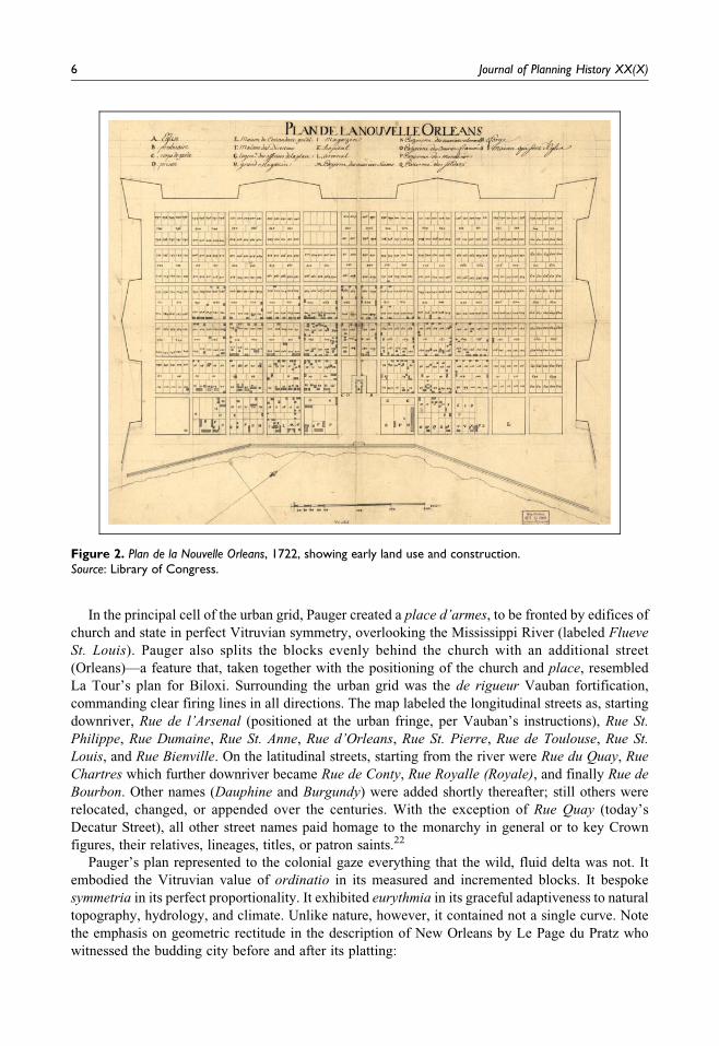
In the principal cell of the urban grid, Pauger created a place d’armes, to be fronted by edifices of
church and state in perfect Vitruvian symmetry, overlooking the Mississippi River (labeled Flueve
St. Louis). Pauger also splits the blocks evenly behind the church with an additional street
(Orleans)—a feature that, taken together with the positioning of the church and place, resembled
La Tour’s plan for Biloxi. Surrounding the urban grid was the de rigueur Vauban fortification,
commanding clear firing lines in all directions. The map labeled the longitudinal streets as, starting
downriver, Rue de l’Arsenal (positioned at the urban fringe, per Vauban’s instructions), Rue St.
Philippe, Rue Dumaine, Rue St. Anne, Rue d’Orleans, Rue St. Pierre, Rue de Toulouse, Rue St.
Louis, and Rue Bienville. On the latitudinal streets, starting from the river were Rue du Quay, Rue
Chartres which further downriver became Rue de Conty, Rue Royalle (Royale), and finally Rue de
Bourbon. Other names (Dauphine and Burgundy) were added shortly thereafter; still others were
relocated, changed, or appended over the centuries. With the exception of Rue Quay (today’s
Decatur Street), all other street names paid homage to the monarchy in general or to key Crown
figures, their relatives, lineages, titles, or patron saints.22
Pauger’s plan represented to the colonial gaze everything that the wild, fluid delta was not. It
embodied the Vitruvian value of ordinatio in its measured and incremented blocks. It bespoke
symmetria in its perfect proportionality. It exhibited eurythmia in its graceful adaptiveness to natural
topography, hydrology, and climate. Unlike nature, however, it contained not a single curve. Note
the emphasis on geometric rectitude in the description of New Orleans by Le Page du Pratz who
witnessed the budding city before and after its platting:
Figure 2. Plan de la Nouvelle Orleans, 1722, showing early land use and construction.Source: Library of Congress.
6 Journal of Planning History XX(X)
All the streets are laid out both in length and breadth by the line, and intersect and cross each other at
right angles. The streets divide the town in to fifty-five isles; eleven along the river lengthwise . . . .
[E]ach of those isles is fifty square toises, and each again divided into twelve emplacements, or compart-
ments, for lodging as many families.23
An updated plan under the same title, Plan de la Ville de la Nouvelle Orleans, appeared later in
1722, in which the nine-by-six grid grew by two additional streets, yielding a total of sixty-six
blocks with full parcel delineation and enumeration, an expanded fortification, and proposed
locations for sixteen city features.24
On May 26, 1722, word of the Company’s decision to designate New Orleans as capital reached
Biloxi. “His Royal Highness having thought it advisable to make the principal establishment of the
colony at New Orleans on the Mississippi River,” beamed a contented Bienville to the Council,
“we have accordingly transported here all the goods that were at Biloxi.” Bienville then lavished
praise on his superiors: “It appears to me that a better decision could not have been made in view of
the good quality of the soil along the river [and the] considerable advantage for . . . the unloading
of the vessels.”25 Of course, Bienville knew this all along. He was flattering his bosses while
congratulating himself.
A splendid new urban plan, new people, new resources, capital-city status: the winds of fortune
finally seemed to be blowing New Orleans’ way—but for the existing hodgepodge still impeding
Pauger’s execution of the plan. Surely he eventually would have mustered enough official force to
clear away those first four years of indiscriminate development. But nature beat him to it.
Disaster as Opportunity
At 9 a.m. on September 11, 1722, “a great wind” swept the settlement, “followed an hour later by
the most terrible tempest,” wrote Pauger.26 “With this impetuous wind came such torrents of rain,”
recalled the colonist Dumont, “that you could not step out a moment without risk of being
drowned[;] it rooted up the largest trees, and the birds, unable to keep up, fell in the streets.”27
Not until 4 a.m. on September 13 did the gusts abate, at which time “they set to work to repair the
damage done.”28
New Orleans’ first hurricane caused much destruction, but it also gave the engineers exactly the
tabula rasa they wanted. Wrote La Tour, “all these buildings were temporary and old, not a single
one was in the alignment of the new town, and they were to have been pulled down. Little harm
would have been done . . . .”29 Dumont described the activities that followed: La Tour “cleared a
pretty long and wide strip [present-day Decatur Street] along the river, to put in execution the plan he
[and Pauger] had projected.” They
traced on the ground the streets and quarters which were to form the new town, and notified all who
wished building sites to present their petitions to the council. To each settler . . . they gave a plot ten
fathoms front by twenty deep [sixty by one-hundred-twenty English feet] . . . . Those who obtained these
plots [must] inclose them with palisades, and leave all around a strip at least three feet wide, at the foot of
which a ditch was to be dug, to serve as a drain for the river water.30
Clearing and draining the right-of-ways permanently transformed early New Orleans from a natural
to a humanized space. A built environment subsequently arose within the cells of Pauger’s grid: the
provisional wooden “palisade cabins” were replaced with houses build of “brick, or half-brick and
half-wood,” and institutions of imperial and ecclesiastic authority were erected by the place d’armes.
“New Orleans,” wrote Dumont of this era, “began to assume the appearance of a city.”31
Campanella 7
Colonial Cadastral Systems
Today’s French Quarter ranks among the nation’s best-preserved colonial urban designs, its main
streets still as they were laid out in 1722 and most retaining their original French nomenclature,
albeit anglicized. The colonial imprint in New Orleans, however, was not limited to the city’s
original neighborhood; it spread as the city’s population grew, and it did so into adjacent planta-
tions delineated according to the French colonial cadastral philosophy known as the “long-lot” or
arpent system.
In form, the long-lot system appeared in north central Europe around the end of the first
millennium and may date as far back as Babylonian times.32 It spread to present-day Belgium
and northern France in later centuries, where the system was called variously en arete de poisson
(herringbone), village-route (street-village), or hameau-allonge (string town).33 Whether this land
division pattern derived from tillage practices or from an organized effort of settlement and tenure,
the resulting parcels were consistently shaped as elongated lots, or long lots, with depth-to-width
ratios from 3:1 to 10:1 or more.
It was primarily the French who transferred long-lot surveying to the New World, starting in
Quebec, where the lots were called rotures, and eventually “everywhere in North America
where there was the least bit of French influence, from the St. Lawrence Valley westward to
Michilimackinac and to the Detroit region . . . . Green Bay and Prairie du Chien . . . to the Red
River . . . to the Illinois Country (including St. Louis) and to Lower Louisiana . . . .”34 The logic
behind long lots is compelling: given (1) a valued resource at one end (usually a waterway or
road), (2) unproductive land at the other end (marshes or mountains), and (3) a swath of well-
drained, fertile land in between (the natural levee in the case of New Orleans; flat valley
bottoms elsewhere), then the ideal subdivision method would be to delineate long narrow strips
so that a maximum number of farms would enjoy access to the valued resource.35 In the case of
lower Louisiana, long lots were an optimal allocation of two scarce resources: river access and
fertile land.
The unit used to survey long lots was the arpent de Paris, measuring 180 French feet or 192
English feet. That size reflected the amount of land one farmer can till in one day, as does the
manzana in Latin America and the acre in Anglo-influenced areas. Unlike those units, however, the
arpent may be used as a linear or areal measurement.36
The Louisiana Long Lot
The initial years of French imperialism in the Mississippi region were characterized by a weak,
distant governing authority and a plethora of land; hence, only rudimentary attempts were made
to standardize and document land distribution. This era has been described by the late geo-
grapher Milton B. Newton, Jr., as the time in which land apportionment was conducted by
concessions, large grants aimed to develop a plantation economy so that raw materials and
commodities may flow back to the metropole in the standard mercantilist model. It was
understood by all imperial powers that land conceded to empowered subjects would quite
literally lay the groundwork for wealth production. Early concessions in Louisiana, imprecise
as they were, nonetheless had key long-lot morphologies: they were oriented perpendicularly to
the river, they extended backward toward the cipriere (cypress swamps), and they were usually
deeper than they were wide.37
Some concessionaires used their holdings not for agriculture but for timber and real estate sales,
“entirely contrary to the establishment of the colony.”38 When the Crown learned of these abuses,
it issued the Edict of October 12, 1716, to provide for the return of certain lands to the public
domain for their redistribution “in the proportion of two to four arpents front by forty to sixty in
8 Journal of Planning History XX(X)
depth.”39 This clause was only partially enforced, but its stipulation “that the concessions be
cultivated in accordance with the same pattern of long, narrow fields that prevailed in the country
along the St. Lawrence River [and] Cape Breton Island . . . would henceforth be the rule for all
lands in the colony.”40
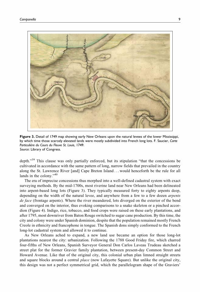
The era of imprecise concessions thus morphed into a well-defined cadastral system with exact
surveying methods. By the mid-1700s, most riverine land near New Orleans had been delineated
into arpent-based long lots (Figure 3). They typically measured forty to eighty arpents deep,
depending on the width of the natural levee, and anywhere from a few to a few dozen arpents
de face (frontage arpents). Where the river meandered, lots diverged on the exterior of the bend
and converged on the interior, thus evoking comparisons to a snake skeleton or a pinched accor-
dion (Figure 4). Indigo, rice, tobacco, and food crops were raised on these early plantations, and
after 1795, most downriver from Baton Rouge switched to sugar cane production. By this time, the
city and colony were under Spanish dominion, despite that the population remained mostly French
Creole in ethnicity and francophone in tongue. The Spanish dons simply conformed to the French
long-lot cadastral system and allowed it to continue.
As New Orleans ached to expand, a new land use became an option for those long-lot
plantations nearest the city: urbanization. Following the 1788 Good Friday fire, which charred
four-fifths of New Orleans, Spanish Surveyor General Don Carlos Laveau Trudeau sketched a
street plat for the former Gravier family plantation, between present-day Common Street and
Howard Avenue. Like that of the original city, this colonial urban plan limned straight streets
and square blocks around a central place (now Lafayette Square). But unlike the original city,
this design was not a perfect symmetrical grid, which the parallelogram shape of the Graviers’
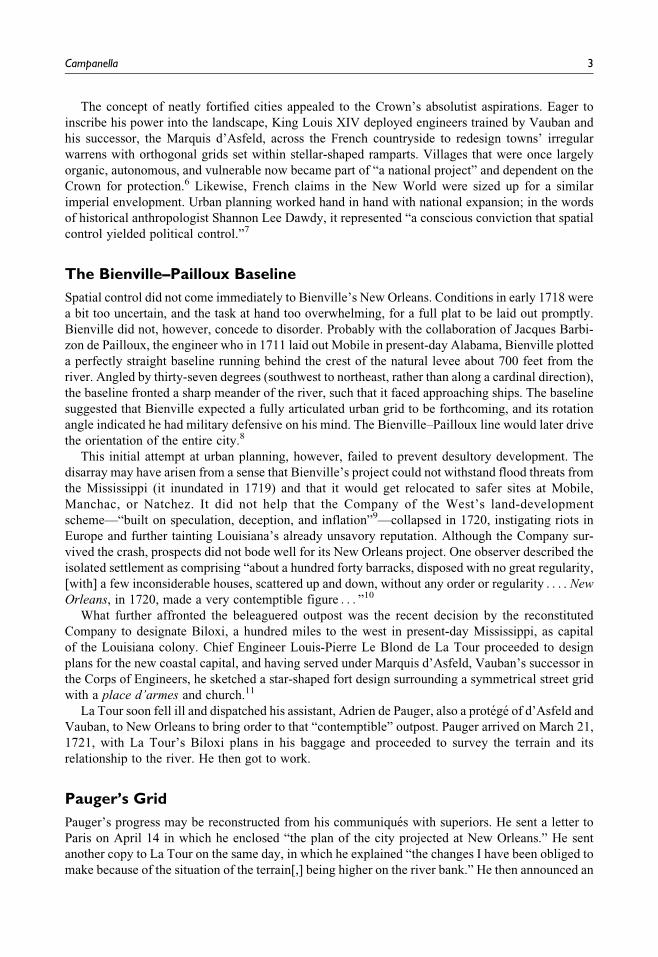
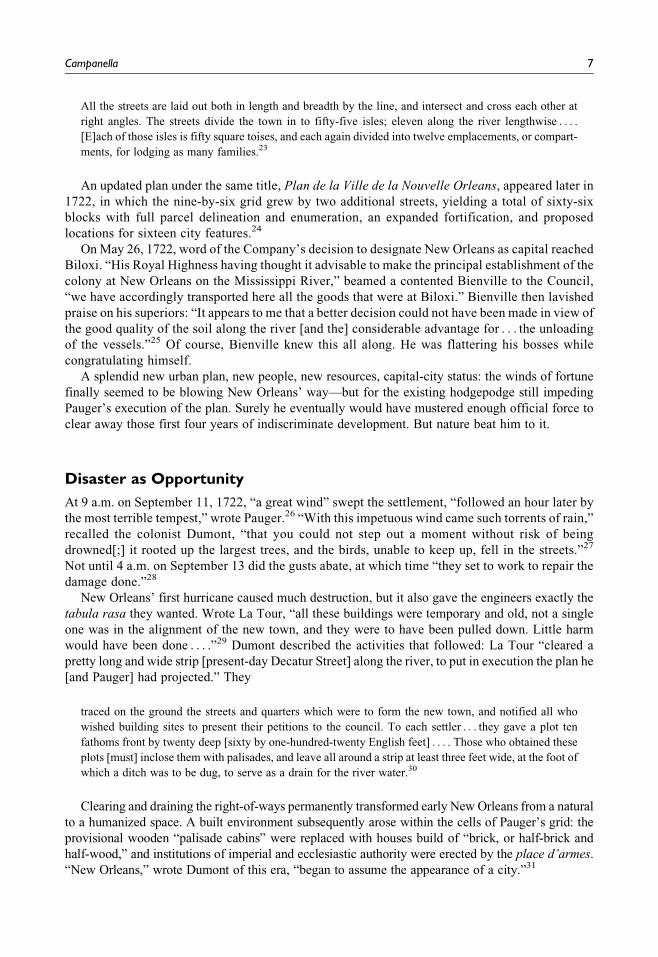
Figure 3. Detail of 1749 map showing early New Orleans upon the natural levees of the lower Mississippi,by which time those scarcely elevated lands were mostly subdivided into French long lots. F. Saucier, CarteParticuliere du Cours du Fleuve St. Louis, 1749.Source: Library of Congress.
Campanella 9
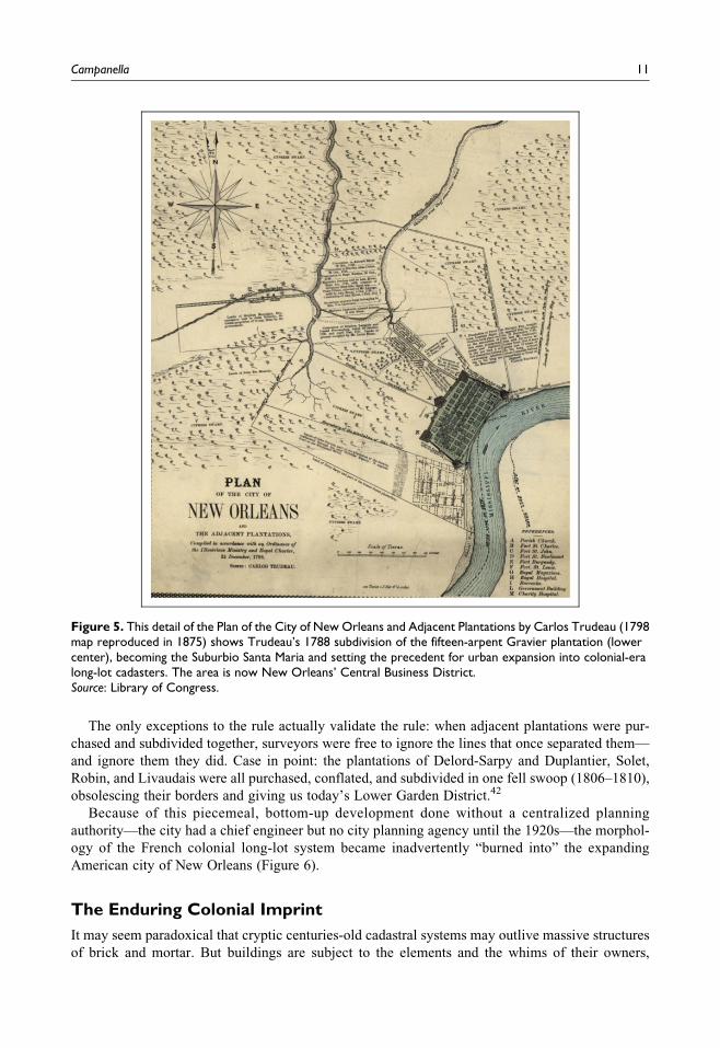
long lot and the curvaceous riverfront disallowed. So Trudeau contorted his lines to fit a
reasonably rectilinear array of streets and blocks into the slanted quadrilateral, forming what
he named “Suburbio Santa Maria” (Figure 5). Francophone Creoles called it “Faubourg St.
Marie”; Anglophone Americans would call it “St. Mary,” and today we call it the Central
Business District.41
Colonial Long-lot Plantations Become Urban Neighborhoods
Faubourg St. Marie set a precedent for other families who owned other long lots near New Orleans:
if they sensed more money could be made by getting out of agriculture and getting into the real estate
business, they need only hire a surveyor to lay out blocks and sell off the parcels to speculators and
homebuilders. One by one throughout what is now Uptown New Orleans, from 1805 to 1854, planter
families made that decision and hired engineers and surveyors to execute it. Those professionals had
no choice but to confine their plats to within the limits of their client’s property; the upper and lower
limits of the long lot thus became the edges of the new faubourg (suburb), the middle was usually
reserved for a grand avenue, and all other spaces became interior blocks. Where the river ran
straight, like in the lower banlieue (outskirts, now Bywater and the Lower Ninth Ward), surveyors
had no problems fitting orthogonal street networks snugly into the rectangular long lots. But where
the river meandered broadly, such as the upper banlieue (Uptown), surveyors had to squeeze their
grids into wedge-shaped properties. This yielded slivers and trapezoids, and odd street “jogs”
occurred whenever one surveyor attempted (or resisted) to align his plat to that which a colleague
had previously laid out in an adjacent long lot. This explains why Prytania Street jogs at the Joseph
Street intersection, why St. Charles angles at Felicity Street, why Maple Street doesn’t quite align
with itself on either side of Lowerline, and why Lowerline and Upperline are so named, as they were
“lower” and “upper” boundaries of two different plantations.
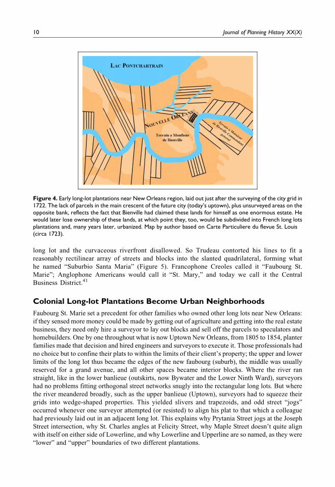
Figure 4. Early long-lot plantations near New Orleans region, laid out just after the surveying of the city grid in1722. The lack of parcels in the main crescent of the future city (today’s uptown), plus unsurveyed areas on theopposite bank, reflects the fact that Bienville had claimed these lands for himself as one enormous estate. Hewould later lose ownership of these lands, at which point they, too, would be subdivided into French long lotsplantations and, many years later, urbanized. Map by author based on Carte Particuliere du flevue St. Louis(circa 1723).
10 Journal of Planning History XX(X)
The only exceptions to the rule actually validate the rule: when adjacent plantations were pur-
chased and subdivided together, surveyors were free to ignore the lines that once separated them—
and ignore them they did. Case in point: the plantations of Delord-Sarpy and Duplantier, Solet,
Robin, and Livaudais were all purchased, conflated, and subdivided in one fell swoop (1806–1810),
obsolescing their borders and giving us today’s Lower Garden District.42
Because of this piecemeal, bottom-up development done without a centralized planning
authority—the city had a chief engineer but no city planning agency until the 1920s—the morphol-
ogy of the French colonial long-lot system became inadvertently “burned into” the expanding
American city of New Orleans (Figure 6).
The Enduring Colonial Imprint
It may seem paradoxical that cryptic centuries-old cadastral systems may outlive massive structures
of brick and mortar. But buildings are subject to the elements and the whims of their owners,
Figure 5. This detail of the Plan of the City of New Orleans and Adjacent Plantations by Carlos Trudeau (1798map reproduced in 1875) shows Trudeau’s 1788 subdivision of the fifteen-arpent Gravier plantation (lowercenter), becoming the Suburbio Santa Maria and setting the precedent for urban expansion into colonial-eralong-lot cadasters. The area is now New Orleans’ Central Business District.Source: Library of Congress.
Campanella 11

whereas cadastral systems are inscribed in legal and political realms with deep roots in fundamental
national philosophies. In a free-market capitalist economy such as that of the United States, for
example, privately owned land is the provenance of wealth, securing all subsequent financial
commitments and forming the original valuation to which all future value is added. In a system
where wealth begets wealth, the begetting begins with land, the land demarcation begins with the
cadastral system, and the gravitas by which that system is stewarded becomes paramount to the
functioning of the whole economy. Excepting revolutionary changes of government, cadastral
patterns usually endure under new administrations and continue their imprint upon the landscape.
In the case of Louisiana, the French colonial arpent system persisted even when Spanish replaced the
French and the Americans replaced the colonials. Throughout the state today, we find extensive
regions still reflecting French long lots, as well as irregular British metes and bounds in the “Florida
parishes” once occupied by the English, Spanish sitios in the southwestern corner of the state once
under Spanish and Mexican control, and ample acreage surveyed by the orderly Jeffersonian inven-
tion known as the American Township-and-Range Public Land Survey.43
Colonial cadasters and urban plats affect the daily lives of Louisianans in nearly every movement
they make (Figure 7), from driving to work in the morning to stopping at the grocery store at night.
For those few thousand who live in the French Quarter, even more direct are the influences of
colonial-era design thinking. Case in point: on the 1300 block of Royal Street, between Barracks
Street and Esplanade Avenue, there is a short driveway usually occupied by a parked sedan—all
perfectly ordinary and mundane. But upon closer inspection, it becomes clear that the driveway
narrows slightly and that the adjacent walls are similarly off-plumb. The slants are a spatial artifact
of the Sebastien Vauban-inspired angled fortification system set within Pauger’s orthogonal grid,
now nearly 300 years old. It speaks of order, rationality, and an ultimately successful project called
New Orleans, even as it also whispers of imperialism, exploitation, and a deteriorating fluvial delta,
starved of water and sediment amid all these rigid straight lines.44
Figure 6. Colonial and antebellum-era long-lot plantations overlaid on satellite image of New Orleans, showingnear-perfect relationship between geometry of old French colonial cadastral system and piecemeal expansionof New Orleans over the course of the nineteenth century. Names in yellow font indicate planter family at thetime of the parcel’s subdivision; present-day streets appear in blue font. Map and interpretation by author basedon various historical maps and data; aerial photography courtesy US Geological Survey.
12 Journal of Planning History XX(X)
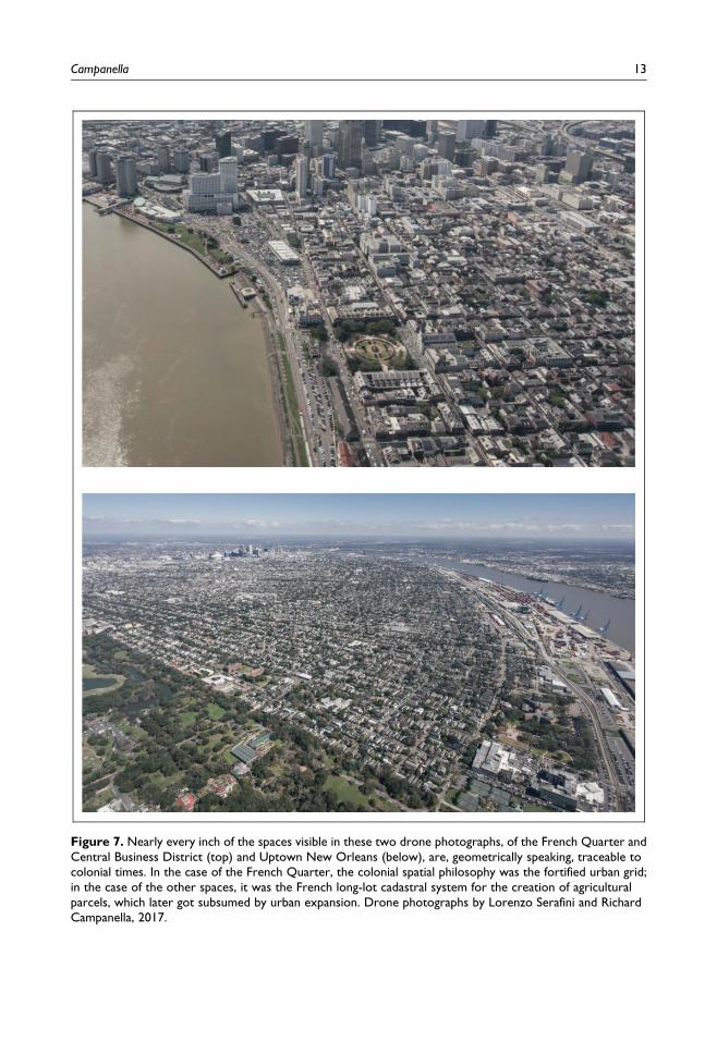
Figure 7. Nearly every inch of the spaces visible in these two drone photographs, of the French Quarter andCentral Business District (top) and Uptown New Orleans (below), are, geometrically speaking, traceable tocolonial times. In the case of the French Quarter, the colonial spatial philosophy was the fortified urban grid;in the case of the other spaces, it was the French long-lot cadastral system for the creation of agriculturalparcels, which later got subsumed by urban expansion. Drone photographs by Lorenzo Serafini and RichardCampanella, 2017.
Campanella 13
Declaration of Conflicting Interests
The author(s) declared no potential conflicts of interest with respect to the research, authorship, and/
or publication of this article.
Funding
The author(s) received no financial support for the research, authorship, and/or publication of this
article.
Notes
1. This article draws from the author’s prior research published in two books and two articles over the past
fifteen years. The books, both by Richard Campanella, are Bourbon Street: A History (Baton Rouge:
Louisiana State University Press, 2014) and Time and Place in New Orleans: Past Geographies in the
Present Day (Gretna, Louisiana: Pelican Publishing Company, 2002). The articles, also by Campanella,
include “Arpents, Ligas, and Acres: Cultural Fingerprints on Louisiana’s Landscape,” Louisiana Cultural
Vistas, Spring 2016, “Why Prytania Jogs at Joseph,” Preservation in Print Magazine, October 2013, and
“Grandeur on Government Street: Baroque Urban Planning in Louisiana’s Capital,” Louisiana Cultural
Vistas, forthcoming Winter 2018.
2. Thomas Hall, Planning Europe’s Capital Cities: Aspects of Nineteenth Century Urban Development
(Oxford, UK: Alexandrine Press, 1997), 9–15.
3. Thomas Gordon Smith, Vitruvius on Architecture (New York: The Montecelli Press, 2003), 9–25; Toby
Lester, Da Vinci’s Ghost: Genius, Obsession, and How Leonardo Created the World in His Own Image
(New York: Free Press, 2011).
4. Shannon Lee Dawdy, Building the Devil’s Empire: French Colonial New Orleans (Chicago, IL: The
University of Chicago Press, 2008), 68.
5. Sebastien Le Prestre and Seigneur de Vauban, The New Method of Fortification, as Practices by Monsieur
de Vauban, Engineer General of France, with an Explication of All Terms Appertaining to that Art
(London, UK: Abell Swall, 1693), topics culled from table of contents of second edition.
6. Dawdy, Building the Devil’s Empire, 72.
7. Ibid., 66.
8. This line appears on Le Blond de La Tour’s January 12, 1723, map, Partie du Plan de la Nouvelle Orleans
(Paris, France: French National Archives), drawn in red and labeled, “Alignement Suiuant le projet de Mr.
de Bienville des premieres maisons.” See also Samuel Wilson Jr., The Vieux Carre, New Orleans: Its Plan,
Its Growth, Its Architecture (New Orleans, LA: Bureau of Governmental Research, 1968), 4.
9. Alfred E. Lemmon, “La Louisiane/La Luisiana: A Bourbon Colony,” in Charting Louisiana: Five Hundred
Years of Maps, eds. Alfred E. Lemmon, John T. Magill, and Jason R. Wiese (New Orleans, LA: The
Historic New Orleans Collection, 2003), 46.
10. Thomas Jefferys, The Natural and Civil History of the French Dominions in North and South America
(London, UK: Thomas Jefferys, 1760), 148–49.
11. Le Blond de La Tour, Plan des ouvrages projettes pour le nouveau establissement du Nouveau Biloxy,
January 8, 1721, French National Archives.
12. As quoted in Wilson, The Vieux Carre, New Orleans, 11.
13. Adrien de Pauger, Plan de la Ville de la Nouvelle Orleans projettee en Mars 1721 (Paris, France: French
National Archives, 1721), as reproduced in Wilson, The Vieux Carre, New Orleans, 6.
14. Charles R. Maduell, Jr., The Census Tables for the French Colony of Louisiana from 1699 to 1732
(Baltimore, MD: Clearfield, 1972), 16–22 and 81.
15. As quoted by Baron Marc de Villiers du Terrage, “A History of the Foundation of New Orleans (1717-
1722),” The Louisiana Historical Quarterly 3, no. 2 (April 1920), 226.
14 Journal of Planning History XX(X)
16. Letter, “Company of the Indies to the Council of Louisiana, undated (circa 1710s),” in Mississippi Pro-
vincial Archives 1701-1729: French Dominion, Volume II, eds. Dunbar Rowland and Albert Godfrey
Sanders (Jackson, MS: Press of the Mississippi Department of Archives and History, 1929), 253.
17. du Terrage, “A History of the Foundation,” 222–223.
18. Ibid., 229.
19. Pierre Francois Xavier de Charlevoix, Journal of a Voyage to North-America Undertaken by Order of the
French King, Volume II (London, UK: James Dodsley, 1761), 275–76.
20. Marcel Giraud, A History of French Louisiana, Volume Five: The Company of the Indies, 1723-1731
(Baton Rouge: Louisiana University Press, 1987), 498–99; de La Tour, Partie du Plan de la Nouvelle
Orleans, January 12, 1723.
21. As quoted in Wilson, The Vieux Carre, New Orleans, 12.
22. Le Blond de La Tour, Plan de la Ville de la Nouvelle Orleans, April 23, 1722, as reproduced in Wilson, The
Vieux Carre, New Orleans, 12.
23. Le Page du Pratz, The History of Louisiana, ed. Joseph G. Tregle, Jr. (Baton Rouge: Louisiana University
Press, 1976 reprint of 1758 original), 54.
24. Plan de la Nouvelle Orleans (circa 1722), as reproduced in Lemmon, “La Louisiane/La Luisiana,” 309.
25. Letter, “Bienville to the Council, February 1, 1723,” in Mississippi Provincial Archives 1704-1743: French
Dominion, Volume III, eds. Dunbar Rowland and Albert Godfrey Sanders (Jackson, MS: Press of the
Mississippi Department of Archives and History, 1932), 343–44.
26. Adrien de Pauger, as quoted by Wilson, The Vieux Carre, New Orleans, 13. A footnote in Dumont’s
journal, as well as a number of tertiary sources, date this hurricane to September 11, 1721, but 1722 is the
more likely year.
27. M. Dumont, “History of Louisiana, Translated from the Historical Memoirs of M. Dumont,” in Historical
Memoirs of Louisiana, From the First Settlement of the Colony to the Departure of Governor O’Reilly in
1770, ed. B. F. French (New York: Lamport, Blakeman & Law, 1853), 24.
28. Baron Marc de Villiers, “A History of the Foundation of New Orleans (1717-1722),” The Louisiana
Historical Quarterly 3, no. 2 (April 1920), 235–36.
29. De La Tour, as quoted by de Villiers, “A History of the Foundation,” 236. Similar words have been
attributed to Pauger.
30. Dumont, “History of Louisiana,” 23–24.
31. Ibid, 41.
32. John Whitling Hall, Louisiana Survey Systems: Their Antecedents, Distribution, and Characteristics (Doc-
toral diss., Louisiana State University Department of Geography and Anthropology, 1970), 25–32, and
William B. Knipmeyer, Settlement Succession in Eastern French Louisiana (Master’s thesis, Louisiana
State University Department of Geography and Anthropology, 1956), 32–34.
33. Carl J. Ekberg, French Roots in the Illinois Country (Chicago: University of Illinois Press, 1998), 6.
34. Ibid., 5–6, 9, and 12.
35. An elongated lot also minimized the number of times a farmer had to retrack to the next row and
accommodated the farm implements of the day, namely ploughs. Long lots also offered proximity to
neighbors, access to fishing resources, a diversity of flora and soil types, and were easy to survey. Ekberg,
French Roots, 11.
36. Other variations of the arpent used by the French and Spanish demonstrate the wide range of the unit’s size:
the arpent d’ordonnance, the arpent comun, and the arpent belgique measured 1.26 acres, 1.04 acres, and
4.17 acres, respectively. Jack D. L. Holmes, “The Value of the Arpent in Spanish Louisiana and West
Florida,” Louisiana History 24, no. 3 (Summer 1983), 314–20.
37. Milton B. Newton, Jr., Louisiana: A Geographical Portrait (Baton Rouge, LA: Geoforensics, 1987), 210–
12, and Hall, Louisiana Survey Systems, 33.
38. Edict of October 12, 1716, translated by Dart, Henry P., “The First Law Regulating Land Grants in French
Colonial Louisiana.” The Louisiana Historical Quarterly 14, no. 3 (July 1931), 346.
Campanella 15
39. Ibid., 347.
40. Marcel Giraud, A History of French Louisiana, Volume Two: Years of Transition, 1715-1717 (Baton
Rouge: Louisiana University Press, 1958), 136. (This quote is from the historian Marcel Giraud regarding
the Edict of 1716, not from the edict itself.)
41. Meloncy C. Soniat, “The Faubourgs Forming the Upper Section of the City of New Orleans,” The Louisi-
ana Historical Quarterly 20 (January–October 1937), 192–211; Samuel Wilson Jr.,“Early History of
Faubourg St. Mary.” in New Orleans Architecture, Volume II: The American Sector (Friends of the Cabildo
series) edited by Mary Louise Christovich, Roulhac Toledano, Betsy Swanson, and Pat Holden. (Gretna,
LA: Pelican, 1972), 3–40.
42. Soniat, “The Faubourgs Forming the Upper Section,” 1937; Samuel Wilson Jr., “Early History of the
Lower Garden District.” in New Orleans Architecture, Vol. I: The Lower Garden District (Friends of the
Cabildo Series) edited by Mary Louise Christovich, Roulhac Toledano, and Betsy Swanson. (Gretna, LA:
Pelican, 1971), 7–12.
43. Richard Campanella, “Arpents, Ligas, and Acres: Cultural Fingerprints on Louisiana’s Landscape,” Louisi-
ana Cultural Vistas 27, no. 1 (Spring 2016), 56–57; Richard Campanella, “Why Prytania Jogs at Joseph,”
Preservation in Print Magazine 40, no. 7 (October 2013), 18–19.
44. Richard Campanella, “New Orleans ‘Fort-prints’: Odd angled properties are relics of city’s fortified past,”
New Orleans Times-Picayune, May 12, 2017, H6–H7.
Author Biography
Richard Campanella, a Geographer with the Tulane School of Architecture, is the author of ten books and over
200 articles on the geography of greater New Orleans. The only two-time winner of the Louisiana Endowment
for the Humanities Book of the Year Award, he has also received the Louisiana Literary Award, the Williams
Prize, and the Malcolm Heard Award for excellence in teaching. In 2016, the Government of France named
Campanella a Knight in the Order of the Academic Palms.
16 Journal of Planning History XX(X)