Embed Size (px)
Citation preview
Standard Title Page - Report on State Project Report No.
Report Date
No. Pages
Type Report: Final
Project No. 77862
VTRC 06-CR4 June 2006 11 Period Covered: July 2005 – June 2006
Contract No.
Title: Development of Bilateral Data Transferability in the Virginia Department of Transportation’s Geotechnical Database Management System Framework
Key Words: Geotechnical database, file upload, BDT, GDBMS, Internet-based.
Authors: Jaewan Yoon, Ph.D.
Performing Organization Name and Address: Virginia Transportation Research Council 530 Edgemont Road Charlottesville, VA 22903
Sponsoring Agencies’ Name and Address Virginia Department of Transportation 1401 E. Broad Street Richmond, VA 23219
Supplementary Notes
Abstract An Internet-based, spatiotemporal Geotechnical Database Management System (GDBMS) Framework was designed, developed, and implemented at the Virginia Department of Transportation (VDOT) in 2002 to retrieve, manage, archive, and analyze geotechnical data using a distributed Geographical Information System methodology.
As the use rate of the GDBMS Framework grew, VDOT engineers recognized that additional engineering analysis and design functionalities could be incorporated. In response, five geotechnical engineering applications (DRIVEN, RSS, LPILE Plus, SHAFT, and GALENA) that are used to calculate slope stability, pile, and shaft capacity were identified. An Analysis and Design Module (ADM) for these five applications was developed and implemented in 2004.
In 2005, additional automated file upload capability (Bilateral Data Transferability, BDT) was developed and
implemented to allow VDOT engineers and geologists to upload completed geotechnical data files, with a pre-screening and QA/QC check prior to the final posting on the GDBMS server. This BDT module was implemented based on the latest gINT geotechnical data template and library used at VDOT. In addition, a new functionality to export dynamically generated fence diagrams into MicroStation in a DXF format was developed and implemented in GDBMS.
FINAL CONTRACT REPORT
DEVELOPMENT OF BILATERAL DATA TRANSFERABILITY IN THE VIRGINIA DEPARTMENT OF TRANSPORTATION’S GEOTECHNICAL DATABASE
MANAGEMENT SYSTEM FRAMEWORK
Jaewan Yoon, Ph.D. Associate Professor
Department of Civil and Environmental Engineering Batten College of Engineering and Technology
Old Dominion University
Project Manager Edward J. Hoppe, Ph.D., P.E., Virginia Transportation Research Council
Contract Research Sponsored by the Virginia Transportation Research Council
Virginia Transportation Research Council (A partnership of the Virginia Department of Transportation
and the University of Virginia since 1948)
Charlottesville, Virginia
June 2006 VTRC 06-CR4
ii
NOTICE
The project that is the subject of this report was done under contract for the Virginia Department of Transportation, Virginia Transportation Research Council. The contents of this report reflect the views of the authors, who are responsible for the facts and the accuracy of the data presented herein. The contents do not necessarily reflect the official views or policies of the Virginia Department of Transportation, the Commonwealth Transportation Board, or the Federal Highway Administration. This report does not constitute a standard, specification, or regulation. Each contract report is peer reviewed and accepted for publication by Research Council staff with expertise in related technical areas. Final editing and proofreading of the report are performed by the contractor.
Copyright 2006 by the Commonwealth of Virginia.
iii
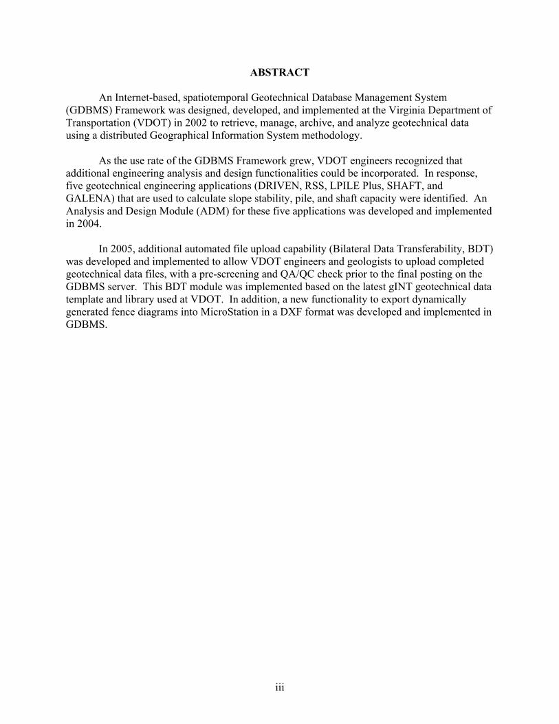
ABSTRACT An Internet-based, spatiotemporal Geotechnical Database Management System (GDBMS) Framework was designed, developed, and implemented at the Virginia Department of Transportation (VDOT) in 2002 to retrieve, manage, archive, and analyze geotechnical data using a distributed Geographical Information System methodology.
As the use rate of the GDBMS Framework grew, VDOT engineers recognized that additional engineering analysis and design functionalities could be incorporated. In response, five geotechnical engineering applications (DRIVEN, RSS, LPILE Plus, SHAFT, and GALENA) that are used to calculate slope stability, pile, and shaft capacity were identified. An Analysis and Design Module (ADM) for these five applications was developed and implemented in 2004.
In 2005, additional automated file upload capability (Bilateral Data Transferability, BDT)
was developed and implemented to allow VDOT engineers and geologists to upload completed geotechnical data files, with a pre-screening and QA/QC check prior to the final posting on the GDBMS server. This BDT module was implemented based on the latest gINT geotechnical data template and library used at VDOT. In addition, a new functionality to export dynamically generated fence diagrams into MicroStation in a DXF format was developed and implemented in GDBMS.
FINAL CONTRACT REPORT
DEVELOPMENT OF BILATERAL DATA TRANSFERABILITY IN THE VIRGINIA DEPARTMENT OF TRANSPORTATION’S GEOTECHNICAL DATABASE
MANAGEMENT SYSTEM FRAMEWORK
Jaewan Yoon, Ph.D. Associate Professor
Department of Civil and Environmental Engineering Batten College of Engineering and Technology
Old Dominion University
INTRODUCTION
In 2001, the Geotechnical Research Advisory Committee (GRAC) of the Virginia Transportation Research Council (VTRC) identified a need to implement an Internet-based, spatiotemporal Geotechnical Database Management System (GDBMS) Framework using a distributed Geographical Information System (GIS) methodology for data management, archiving, retrieval, and analysis. Subsequently, a feasibility study was conducted by Ishibashi and Yoon to identify a number of GDBMS implementation alternatives.1 The GIS-based approach was recommended as the most viable implementation model in terms of ease of use, cost-effectiveness, flexibility, and future expandability.
After the initial feasibility study, a demonstration pilot of the GDBMS Framework
implementation was carried out for the Third Hampton Roads Crossing Project (HR3X). The main goal of the HR3X pilot study was to design, develop, and implement a practical Internet-based GDBMS Framework for accessing and utilizing geotechnical data. In 2003, the GDBMS Framework was further developed and scaled up to facilitate a statewide model, and subsequently the Woodrow Wilson Bridge and Route 1 Interchange site was added as a second project module.2 Implemented statewide, the Internet-accessible, GIS-based GDBMS Framework has been actively used and recognized by VDOT engineers as an effective and efficient tool to manage geotechnical data.
Initial conceptualization of the GDBMS Framework was to facilitate geotechnical data
archival, access, and retrieval. As the rate of utilization of the GDBMS Framework grew, VDOT engineers recognized that additional analysis and design functionalities could be incorporated. In response, five geotechnical engineering software applications (DRIVEN, RSS, LPILE Plus, SHAFT and GALENA) that are frequently used to calculate slope stability, shaft, and pile capacity were identified. Analysis and Design Module (ADM) functionality for these five applications was designed, developed, and implemented to the GDBMS Framework in 2004.3
ADM was designed to automatically extract, filter, translate, and generate input data sets
inside the GDBMS Framework when a borehole site is selected. Thus, ADM allows VDOT engineers to perform specific analysis and design calculations by automatically generating input
2
data sets. In addition to the ADM module development, a powerful data search algorithm, GDBMS Borehole Search Rabbit, was implemented. This new search algorithm provides hierarchical and partial search capabilities based on GDBMS site module, VDOT project number, source-level gINT project file, and borehole designation. Once a borehole data search is completed, VDOT engineers can directly access particular site data in various formats, such as the original legacy data format, translated standard data format, gINT and Excel files of translated standard data format, and borehole data log and laboratory results.
In 2005, additional automated file upload capability (Bilateral Data Transferability, BDT)
functionality was developed and implemented to allow VDOT geologists to upload completed geotechnical gINT data files to the GDBMS server, with a pre-screening and QA/QC validity check prior to the final posting. This BDT module was implemented based on the latest geotechnical gINT data template and library used by VDOT. In addition, new functionality to export dynamically generated fence diagrams into MicroStation in a DXF format was developed and implemented.
PURPOSE AND SCOPE
The purpose of this project was to develop and implement an automated upload capability in the existing GDBMS Framework. In addition to designing the required mechanism of uploading geotechnical data files, special attention was given to providing several layers of data verification and final data certification as a means of QA/QC when the data were uploaded by an engineer or a geologist in a VDOT district office.
Three key implementation issues were targeted during this project. (1) development of an automated upload capability (BDT) for gINT project files, with a
pre-screening and QA/QC check prior to the final posting to the statewide GDBMS Framework
(2) development and update of the GDBMS Framework with the mainstream gINT
library that VDOT geologists and consultants are currently using (3) development of functionality to export a dynamically generated fence diagram into
MicroStation in a DXF format.
METHODS
VDOT GDBMS Framework source codes were revised and updated to add the Bilateral Data Transferability Module based on an adaptive translative engine for the VDOT gINT data template and library. Separate source codes were developed and implemented to facilitate translation and creation of a dynamically generated fence diagram into MicroStation in a DXF format.
3
The key conceptualization of the BDT Module was to provide VDOT engineers and geologists a fully functional, user-friendly, rugged, flexible yet expandable data upload tool. In addition to designing the required mechanism of uploading geotechnical data files, special attention was given to providing several layers of data verification and final data certification as a means of QA/QC when the data were uploaded by an engineer or a geologist in a VDOT district office.
The quality and value of any data are solely judged by their correctness and accuracy. It
is equally true that once any incorrect and inaccurate data are introduced to a database management system, the data quality and accuracy on the whole will suffer greatly. It will also be extremely difficult to remove the data.
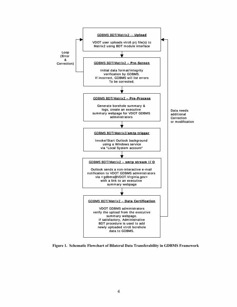
The initial screening and verification of data in the form of QA/QC is a critical issue
when any kind of user data upload functionality is provided to a system. The BDT implementation carried out in this study addressed critical QA/QC issues during the upload process. Components of the BDT QA/QC fully use the adaptive translative filter implementation in the GDBMS Framework. The schematic flowchart of BDT processes is shown in Figure 1.
RESULTS
The Internet-based, spatiotemporal Geotechnical Database with the BDT Module can be accessed at http://matrix2/website/index.html inside VDOT. The entire database is mirrored for outside access at http://gis.virginiadot.org/ (GDBMS Framework). For security reasons, BDT functionality is available only on the internal VDOT network.
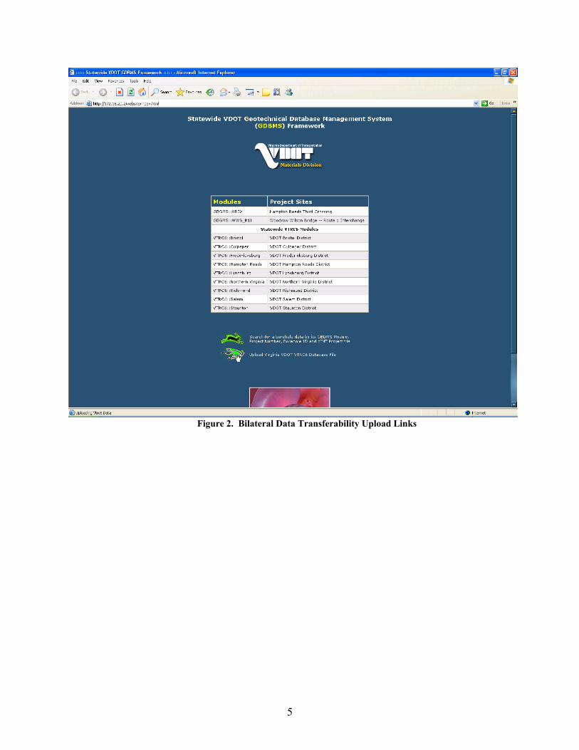
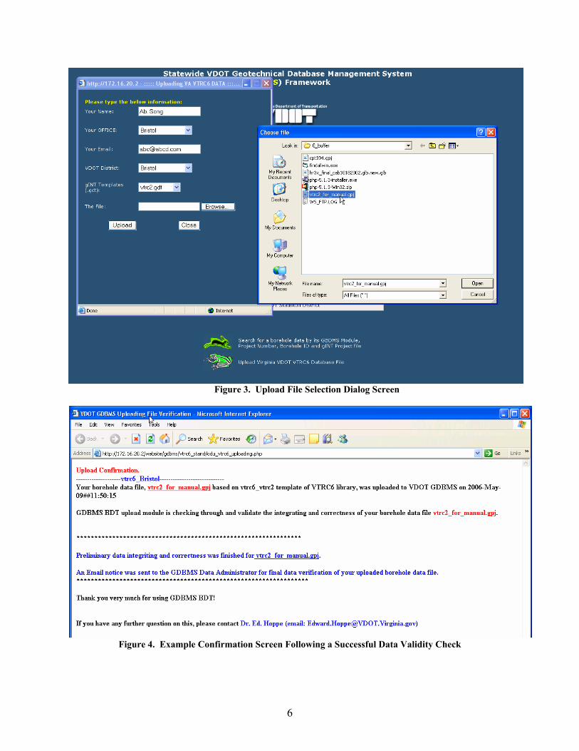
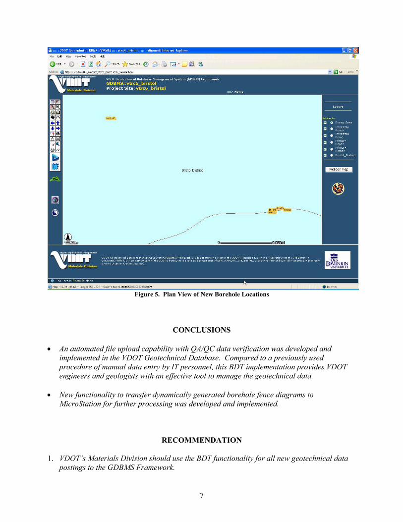
Key components of the BDT implementation in the GDBMS Framework environment
are shown in Figures 2 through 5.
4
GDBMS BDT/Matrix2 -- Upload
VDOT user uploads vtrc6 prj file(s) toMatrix2 using BDT module interface
GDBMS BDT/Matrix2 – Pre-Process
Generate borehole summary & logs, create an executive
summary webpage for VDOT GDBMS administrators
GDBMS BDT/Matrix2/smtp trigger
Invoke/Start Outlook background using a Windows service
via “Local System account”
GDBMS BDT/Matrix2 – smtp stream I/O
Outlook sends a non-interactive e-mail notification to VDOT GDBMS administrators
via <[email protected]>with a link to an executive
summary webpage
GDBMS BDT/Matrix2 – Data Certification
VDOT GDBMS administratorsverify the upload from the executive
summary webpage.If satisfactory, Administrative BDT procedure is used to add newly uploaded vtrc6 borehole
data to GDBMS.
GDBMS BDT/Matrix2 – Pre-Screen
Initial data format/integrityverification by GDBMS.
If incorrect, GDBMS will list errorsTo be corrected.
Loop(Error
&Correction)
Data needs additional Correction or modification
Figure 1. Schematic Flowchart of Bilateral Data Transferability in GDBMS Framework
5
Figure 2. Bilateral Data Transferability Upload Links
6
Figure 3. Upload File Selection Dialog Screen
Figure 4. Example Confirmation Screen Following a Successful Data Validity Check
7
Figure 5. Plan View of New Borehole Locations
CONCLUSIONS
• An automated file upload capability with QA/QC data verification was developed and implemented in the VDOT Geotechnical Database. Compared to a previously used procedure of manual data entry by IT personnel, this BDT implementation provides VDOT engineers and geologists with an effective tool to manage the geotechnical data.
• New functionality to transfer dynamically generated borehole fence diagrams to MicroStation for further processing was developed and implemented.
RECOMMENDATION 1. VDOT’s Materials Division should use the BDT functionality for all new geotechnical data
postings to the GDBMS Framework.
8
BENEFITS AND COSTS ASSESSMENT
The BDT implementation will result in more efficient and streamlined geotechnical data management at VDOT. Manual tasks, previously delegated to the IT support personnel, have now been automated. It is estimated that 2 hours of labor will be saved per each new borehole data element that needs to be verified, added, and incorporated in the GDBMS Framework. A typical construction project includes approximately 10 boreholes.
ACKNOWLEDGMENTS
This project was funded and managed by the Virginia Transportation Research Council
and the Virginia Department of Transportation. Invaluable comments and constructive suggestions from Mr. Derek Whitehouse of VDOT’s Materials Division and Dr. Edward Hoppe of VTRC are acknowledged.
REFERENCES
1. Ishibashi, I., and Yoon, J. (2003). Feasibility Study of VDOT’s Geotechnical Database Management System. Project No. 532051. Old Dominion University Research Foundation, Norfolk.
2. Yoon, J. (2004). Procedures for Implementing VDOT Statewide Geotechnical Database
Management System (GDBMS) Framework. Project No. 534671. Old Dominion University Research Foundation, Norfolk
3. Yoon, J. (2005). Development of Geotechnical Analysis and Design Modules for the
Virginia Department of Transportation Geotechnical Database. VTRC 05-CR23. Virginia Transportation Research Council, Charlottesville.