Embed Size (px)
Citation preview
AMENDED AND RESTATED AGREEMENT FOR CHARITABLE CONTRIBUTION
SPORTS PARK DONATION PROPERTY
THIS AGREEMENT is made and entered by and between Flycatcher Enterprises, LLC, a Florida
limited liability company ("Flycatcher Donor" or "Donor" herein), and Pasco County, Florida ("County"),
a political subdivision of the State of Florida, hereinafter also referred to as "Donee."
Recitals
WHEREAS, the County issued a Request for Proposals (RFP SS-11-075) to Develop and Operate a
Multi-Purpose Event Facility in the Wesley Chapel area of the County for the purpose of securing an
operator to assist the County in the development and management of a multi-purpose sports event
complex and related facilities and infrastructure (the "Sports Park Complex"), anticipated to be of a first
class, top quality nature, and for the purpose of attracting daily, overnight and extended stay out-of-
County and out-of-state visitors to the County and providing enhanced public recreational opportunities
to County residents with the goals of significantly increasing overall tourism throughout the County, and
enhancing the economic benefits from increased tourism to the County; and
WHEREAS, the County has committed available funds in an amount not to exceed $14 million in
tourist tax funds and bond proceeds for the purpose of developing the Sports Park Complex; and
WHEREAS, the facilities and amenities at the Sports Park Complex are anticipated to include
multi-purpose fields to accommodate soccer, lacrosse, field hockey and/or football (including at least 1
championship field); youth size baseball/softball sized fields to accommodate adult softball and Little
League (including at least 1 championship field with bleachers); concession and restroom buildings and
facilities; parking facilities and other related infrastructure; and
WHEREAS, although it has not secured an operator to date, the County is stil l interested in moving forward on a public project involving the design and construction of the Sports Park Complex;
and the Flycatcher Donor, in turn, in recognition of the potential benefits to the Wiregrass Ranch
development and in reliance on the County's commitment of funds for the development of the Sports Park Complex and by entering into this Agreement, is interested in donating property to the County
suitable for use as a location for a Sports Park Complex; and
WHEREAS, pursuant to a Charitable Contribution Agreement between the Parties, the County
had previously received 24 gross acres m.o.1. from Wiregrass Ranch, Inc. (the "Tennis Center Parcel") as
described in Exhibit "A-1" hereto and, as further provided under Section 5.0(2)(b) of the Wiregrass DRI
Development Order, is entitled to receive from Wiregrass Ranch, Inc., or i t s assignee, an additional 16
upland, developable acres for a Community Park adjacent to the Tennis Center Parcel or in the
alternative, to exchange the Tennis Center Parcel and relocate the Community park parcel to another 40
acre site at a mutually agreeable location within the Wiregrass DRI; and
WHEREAS, the County has determined that the Tennis Center Parcel is not conducive for use as
a park site or for other public use due to the limited access to the property; and
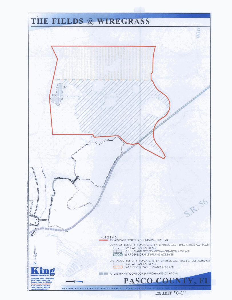
WHEREAS, the Flycatcher Donor has agreed to convey to the County 46.4 gross acres, m.o.l., of
real property, as described in Exhibit "8-1" as "EXCHANGE PROPERTY (FLYCATCHER)" (the "Exchange
Property" herein), of which at least 40 acres m.o.l., is developable upland as graphically depicted in
Exhibit "C-1", in return for the County's transfer of the Tennis Center Parcel to the Flycatcher Donor,
subject to the terms and conditions set forth in this Agreement and compliance with Section 125.37, Fla.
Stat., relating to the exchange of County property; and
WHEREAS, the Flycatcher Donor is also the owner of 91.7 additional gross acres, m.o.l., of real
property adjacent to the Exchange Property, as described in Exhibit "B-1" as "DONATED PROPERTY
(FLYCATCHER) REVISED" (the "Donated Property" herein), which it believes together with the Exchange
Property would serve as a suitable site for the County's proposed public use as a Sports Park Complex
and/or for active or passive public park and public recreation purposes; and
WHEREAS, the Exchange Property and the Donated Property together comprise the "Sports Park
Property", a total of 138.1 gross acres, m.o.l., as described in Exhibit "B-1" as "OVERALL PROPERTY
REVISED", of which 99.7 acres, m.o.l., is developable upland as graphically depicted in Exhibit "C-1", and
the County's intended use of the Sports Park Property is for the Sports Park Complex and other active or
passive public park and public recreation purposes (the "Intended Use");
WHEREAS, Flycatcher Donor is willing to donate, as charitable contributions pursuant to
applicable Internal Revenue Code Regulations, the Exchange Property and the Donated Property to the
County, as Donee, and in i ts capacity as a governmental entity for public purposes pursuant to the
terms and conditions hereof:
NOW, THEREFORE, the parties agree as follows:
Recitals. Each of the Recitals set forth above is true and correct and is hereby incorporated herein by reference and made a part of this Agreement.
Exchange of Property.
a. The County agrees to convey to Flycatcher Donor, and Flycatcher Donor agrees to accept from the County, by fee simple title, that certain unimproved land in Pasco County, Florida as described in Exhibit "A-l", containing 24 gross acres m.o.1. comprising the Tennis Center Parcel, free and clear of all encumbrances and liens.
b. In return for conveyance of the Tennis Center Parcel, the Flycatcher Donor agrees to convey by fee simple title to the County and the County agrees to accept, upon the terms and conditions set forth herein, and subject to the restrictions and covenants specified in this Agreement, that certain unimproved land in Pasco County, Florida as described in Exhibit "9- l''- as "EXCHANGE PROPERTY (FLYCATCHER)" containing at least 40 upland developable acres m.o.1. comprising the Exchange Property, free and clear of all encumbrances or liens, except restrictions and matters appearing on the deed and/or common public utility easements of record and except as otherwise provided in this Agreement. Flycatcher Donor represents that there are no Category I wetlands shown to be impacted on the Exchange Property, other than impacts by proposed trails, by the development depicted on 'The Fields @ Wiregrass" conceptual site plan, attached hereto as Exhibit "E-1".
c. Access Roads. The "reverse frontage roads" identified as Reverse Frontage Roads "C" and "D", as depicted in Exhibit "F" are intended to be and shall be the future access to the Exchange Property. Under the "Three-Party Economic Development Agreement" (the "EDA"), approved by the County on September 20, 2011, the County and the State are obligated to fund the construction of Reverse Frontage Roads "C" and "D". Notwithstanding any provisions of the EDA to the contrary or the availability or timing of any State grant funds for the same, the County shall reimburse Donor, Wiregrass, Ranch, Inc., Locust Branch, LLC, or their successors and assigns identified in the EDA (as amended), for the costs incurred in the design, permitting, and construction of Reverse Frontage Roads "C" and "D", the Wiregrass Ranch Boulevard Extension and the Wiregrass Ranch Boulevard Intersection and landscaping improvements along such roadways, from funds legally available to Pasco County other than ad valorem tax revenues; provided, however, the County's reimbursement for such costs shall continue to be governed by the limitations and conditions in the EDA, except for those in Section IX. (Project Milestones) and Section XI (Conditions Precedent). The County's obligation to fund the construction of the Reverse Frontage Road "A" Intersection, Reverse Frontage Road "A", Reverse Frontage Road "B" and the Eastern Entrance at Wiregrass Ranch Boulevard, and landscaping improvements along such roadways, shall be governed solely by the EDA (and any amendment thereto) and not by this Agreement.
3. Donation of Property. Flycatcher Donor agrees to donate to the County, and County agrees to
accept from Flycatcher Donor, upon the terms and conditions set forth herein, and subject to all restrictions and covenants herein, that certain unimproved land in Pasco County, Florida, as
described in hereto Exhibit "B-1" as "DONATED PROPERTY (FLYCATCHER) REVISED", containing
91.7 gross acres, m.o.l., at least 59.7 acres m.o.1. of which is upland, developable property.
4. Restrictions in the Deed(s1. The deed(s) for the Exchange Property and the Donated Property
shall contain the following covenants and restrictions limiting the use of the Exchange Property
and the Donated Property:
a. The Exchange Property and the Donated Property are restri cted t o use as a Sports Park Complex, and/or for active or passive public park and public recreation purposes.
b. Any use of the Sports Park Property, including, but not limited to, its use for a Sports Park
Complex, shall be in conformance with its primary principal public use for active or passive public
park and public recreation purposes, and all secondary uses, including, but not limited to, related facilities and infrastructure for a Sports Park Complex, shall be clearly incidental and accessory to
such primary principal public uses.
5. Special Provisions. This Agreement shall be conditioned upon the following, additional
covenants and obligations between and among the parties, which shall survive closing and
delivery of the deed(s) contemplated herein for the Sports Park Property, and which shall run
with the land:
a. The County shall maintain the Sports Park Property at a level not less than those standards
applicable to the County's other parks.
b. The name of the Sport Park Property, and the overall complex located thereon, shall include
the words "Pasco County" and "Wiregrass".
c. The County shall grant to Flycatcher Donor, its successors and assigns, and Flycatcher Donor
hereby reserves unto itself, its successors and assigns, the right to modify existing
development plans, permits and approvals; the right to obtain new development plans,
permits and approvals; and easements for construction, operation, and maintenance, of each
of the following:
II.
iii.
Upland, wetland or other mitigation and preservation under, over, upon, across
and through the areas designated "Future Upland Preservation/Mitigation" as
depicted on Exhibit "D-1";
Stormwater retention, wetland or other mitigation, and floodplain compensation
under, over, upon, across and through the areas designated "Future Reverse
Frontage Roads-Ponds/MitigationU as depicted on Exhibit "D-1";
Utilities, including but not limited to sanitary sewer, water, and reclaimed water,
under, over, upon, across and through the Sports Park Property areas designated
"Future Force Main Line (Approximate Location)", "Future Gravity Sewer Line
(Approximate Location)", and "Approved Future Pump Station" as generally
depicted on Exhibit "D-1", or those areas of the Sports Park Property based on the
final location of said utilities as the County may relocate the same consistent with
the final design of the Sports Park Complex or for an active or passive public park
and public recreation purposes . Should such final design require amendment to
the Master Utility Plans, the Donor and/or the Master Developer of the Wiregrass
Ranch DRI shall not object to such amendment(s) provided the amendments,
which may include changing the point of service connections to the parcels, do
not adversely affect the ability of the Donor and/or Master Developer of the
Wiregrass Ranch DRI to cost-effectively provide utility service to the existing and
future development on Parcel M21 and other parcels within the Wiregrass Ranch
DRI outside of the Sports Park Property. Nothing herein shall require the County
4
iv.
to upsize any of these facilities to accommodate the Donor's and/or the Master
Developer of the Wiregrass Ranch DRl's development unless a mutually acceptable agreement is reached prior to installation. However, in the event that
the County has not constructed within the easement utilities which provide
adequate capacity and depth to serve existing and future development on Parcel
M21, and in the event the County has not come to a mutually acceptable
oversizing agreement with the Donor or the Master Developer of the Wiregrass
Ranch DRI, then the Master Developer of the Wiregrass Ranch DRI may amend
the Master Utility Plans to provide a cost-effective alternative configuration to
adequately serve the remainder of Parcel M21 and other parcels within Wiregrass
Ranch DRI. The County agrees that it will not object to such amendments to the
Master Utility Plans provided the amendments do not adversely affect the ability of the County to serve the Sports Park Property and are consistent with the
County's Utility Ordinance;
Ingress, egress and access under, over, upon, across and through the Sports Park
Property on and to each of the above easements areas described in (i) through (iii)
herein. Flycatcher Donor shall be responsible for any losses, damages or claims
incurred as a result of the Flycatcher Donor, it employees, agents and assigns'
ingress, egress and access under, over, upon, across and through the Sports Park
Property for the purposes as defined in this subsection c. and for the costs
involved relating to such losses, damages or claims.
Flycatcher Donor shall be solely responsible for all costs of maintenance, design,
construction or environmental impact caused by the Flycatcher Donor, i ts
employees, agents and assigns' use or modification(s) of the easement areas
described in (i) above. The County shall be solely responsible for all costs of
maintenance, design construction or environmental impact caused by the County,
i t s employees, agents and assigns' use or modification(s) of the easement areas lying within the boundaries of the Sports Park Property and described in (ii) and
(iii) above.
Such easements shall be in a form reasonably acceptable to Flycatcher Donor and the County.
d. In addition to the easements set forth in Section 5.c. herein, the County shall grant to
Flycatcher Donor, i t s successors and assigns, and Flycatcher Donor hereby reserves unto itself,
i ts successor and assigns, each of the following easements:
i. Temporary construction and access easements for road construction and
construction related purposes for the Reverse Frontage Roads over, upon, across
and through the areas designated "Temporary Reverse Frontage Road Construction"
as generally depicted on Exhibit "D-1", until such time as the Reverse Frontage
Roads have been completed and accepted by the County; and
ii. For ingress, egress and access from Reverse Frontage Road "C", to and from the
Lakes Area Property depicted on Exhibit "D-1", over, upon, across and through the
areas designated "Lakes Area Access Road", as also generally depicted on Exhibit "D-
l" . -
Such easements shall be in a form reasonably acceptable to Flycatcher Donor and the
County.
e. Easements Granted to County. Flycatcher Donor or its assigns shall grant the following
easements in such forms reasonably acceptable to Flycatcher Donor and the County:
i. A temporary construction and access easement(s) to the County for access to the
Exchange Property and Donated Property over, upon, across and through Donor's
adjacent property, and the adjacent property of Donor's related entities, for
construction and construction related purposes (the "County Temporary Access
Easement"), as graphically depicted on Exhibit G-1, and as specifically described in
Exhibits "H", "I", and "J", until such time as the County has alternative access to the
Sports Park Property.
ii. A temporary construction and access easement(s) to the County for accessing and
removing any fill dirt made available by Flycatcher Donor or its assignee over, upon,
across and through the property(s) so designated by Flycatcher Donor or its
assignee as fill locations.
iii. A 20' m.o.l., wide pedestrian trail easement on an agreed upon area of the Lakes
Area Property as generally depicted on Exhibit G-1, having no adverse impacts upon
the Lakes Area Property or any permits related to the Lakes Area Property, subject
to terms and conditions mutually acceptable to the County and Donor.
f. Flycatcher Donor hereby reserves unto itself, its successors and assigns, a 100' wide right-of-
way corridor for any and all transportation and utility purposes under, over, upon, across and through the area designated "Future Transit Corridor (Approximate Location)" as generally
depicted on Exhibit "C-1". The specific location of this right-of-way reservation shall be based on the future designation and dedication of the Transit Corridor contemplated herein.
g. Fill Dirt. Flycatcher Donor or its assignee shall make available to the County 100,000 cubic
yards of clean fill dirt suitable for site development of the Sports Park Property for a Sports
Park Complex, from a location or locations designated by Flycatcher Donor, within the
Wiregrass Ranch DRI, to be used for site development for a Sports Park Complex on the Sports
Park Property. Flycatcher Donor shall designate the location(s) of available fill dirt pursuant to
this provision within 60 days of receiving a site plan from the County for a Sports Park
Complex on the Sports Park Property. The County shall utilize best practices for the efficient
design of the Sports Park Complex to maximize the amount of available fill generated from the
6
Sports Park Property. If the final design of the Sports Park Complex that is utilized by the
County requires more than 100,000 cubic yards of fill, Donor may make additional fill available
to the County on terms mutually agreeable to the parties. The County, through its County
Administrator, will execute one or more IRS Forms 8283 acknowledging the fair market value
of fill dirt acquired pursuant to this provision, upon the County's extraction of the same.
Should the Flycatcher Donor or i ts Assignee fail to comply with this provision, the County
reserves the right to pursue all remedies at law or equity available to it, up to and including
specific performance.
h. The County shall, acting in good faith, use its best efforts to enter into any agreements for the
operation and maintenance of the Sports Park Complex, deemed necessary by the County and
to have the Sports Complex designed as determined by the County for the Intended Use as
stated herein within twenty four (24) months of the date of conveyance of the Sports Park
Property.
i. The County shall be responsible for all on site mitigation and utilities necessary to serve the
Sports Park Property. The County acknowledges and agrees that neither Flycatcher Donor,
nor any of i t s affiliated or related entities, or its designated developer(s) within Wiregrass
Ranch, shall have any obligation to mitigate any transportation, environmental, or other
development impacts whatsoever that may be related in any way to the Sports Park Property
or i ts future use, except as provided herein. Nothing in this Agreement shall relieve the
Donor, or its affiliated or related entities, of the obligation to also comply with the condition
in Section 5.0(5) of the Wiregrass DRI Development Order to provide all off-site infrastructure,
including but not limited to, access roads, intersection improvements, stormwater drainage
and utilities (including but not limited to water, sewer, electric, cable and telephone) to the
proposed entrance to the Sports Park Complex and to ensure that all such connections shall
be brought to the physical boundaries of the Sports Park Property such that no additional jack
and bore work will be required under any access roads.
j. The County acknowledges and agrees that the donation of the Sports Park Property satisfies
any and all requirements of the Pasco County Comprehensive Plan and Land Development
Code, and any state and regional requirements, for any and all community and district park obligations of the Wiregrass Ranch DRI, for up to 12,026 residential units. Nothing in this
Agreement, however, shall negate the Donor's, or i ts affiliated or related entities' obligation
to pay applicable parks and recreation impact fees related to the Wiregrass Ranch DRI, and to
remain obligated to comply with applicable LDC requirements for neighborhood parks, as such
requirements have been modified pursuant to previously approved variance requests, except
that if Flycatcher Donor does not donate the Sports Park Property as a charitable contribution
to the County, then Flycatcher Donor will receive parks and recreation impact fee (land)
credits for the donation of the Sports Park Property at a value consistent with the impact fee
ordinance in effect at the time of closing.
k. The County shall, at i t s sole costs and expense, have the right to have the Sports Park Property
removed from the boundaries of any CDD on the Wiregrass property, and Donor agrees not to
object to any such removal, provided that the County is otherwise in compliance with the
specific County obligations set forth in this Agreement.
I. The County shall comply with the conditions contained in all development orders and
governmental or regulatory approvals, permits, restrictions, and regulations that affect or are
applicable to the Sports Park Property, or that may be imposed on the Sports Park Property by
any regulatory or governmental agency or entity possessing jurisdiction over the Sports Park
Property, including, without limitation, the Comprehensive Plan, the DRI Development Order,
the Master Planned Unit Development ("MPUD") zoning conditions, the Master Roadway Plan
("MRP"), the Master Drainage Plan, the Master Utilities Plan, the Utilities Service Agreement,
the Master Park Plan, Neighborhood Parks Variance, the Development Agreement pursuant to
the DRI Development Order, and the Land Development Code; provided, however, the County
reserves the right to exempt the Sports Park Property from any such requirements that are
imposed or enforced solely by the County, and that are not expressly required by the terms of
this Agreement. Unless expressly assumed by Flycatcher Donor in this Agreement, all
conditions, financial obligations, and compliance with all applicable laws, rules, regulations,
ordinances, orders, permits, and other government approvals that are or may be imposed
with respect to the development of the Sports Park Property are the obligation of the
County; provided, however, the County reserves the right to exempt the Sports Park Property
from any such requirements that are imposed or enforced solely by the County, and that are
not expressly required by the terms of this Agreement. Accordingly, the County agrees that it
shall bear all expenses, charges, obligations, fees and assessments that are or may be imposed
by any governmental or regulatory agency or entity in connection with or related to the
development and use of the Sports Park Property, including, without limitation, any and all
municipal service taxing units ("MSTUs"), municipal service benefit units ("MSBUs"), timing
and phasing requirements, proportionate share, exactions, impact fees, mobility fees, sewer
and water connection fees, transportation impact/mitigation fees and/or assessments;
provided, however, the County reserves the right to exempt the Sports Park Property from
any such expenses, charges, obligations, fees, and assessments that are imposed or enforced
solely by the County. Furthermore, the County shall not have any obligation to pay any
expenses, charges, obligations, fees or assessments for which it is entitled to an exemption under applicable law. All permits and approvals sought, applied for, or obtained by the
County, all permit and approval applications submitted by the County, and all development of
the Sports Park Property shall be consistent with, and shall not adversely affect any existing,
previously issued, or pending permits or approvals or plans within Wiregrass Ranch DRI or any
property within Wiregrass Ranch DRI, unless Flycatcher Donor has been provided with
reasonable advance notice and explanation that such inconsistencies or adverse effects are
necessary to comply with the requirements imposed by Donor as set forth in this Agreement
and Flycatcher Donor within thirty days of such notice refuses to waive such requirements or
provide acceptable alternatives, or unless such inconsistencies are approved in writing by
8
Flycatcher Donor. The County shall not take any action, apply for, obtain, or seek to obtain
any permit or approval for the Sports Park Property that would cause a violation of or a
modification to any existing, previously issued, or pending governmental or regulatory permits
and approvals for any property within Wiregrass Ranch DRI, unless the County obtains prior
written consent from Flycatcher Donor, or unless Flycatcher Donor has been provided with
reasonable advance notice and explanation that such actions, permits or approvals are
necessary to comply with the requirements imposed by Donor as set forth in this Agreement
and Flycatcher Donor within thirty days of such notice refuses to waive such requirements or
provide acceptable alternatives. The foregoing notwithstanding, the Sports Park Property shall
not be subject to any assessments levied by a Community Development District or any
homeownersl/property owners' association for so long as it is used for a Sports Complex
and/or active and/or passive public park and public recreation purposes.
m. The County acknowledges and agrees that the donation of the Sports Park Property pursuant
to this Agreement moves the parks to M21 as generally depicted on the Conceptual Master
Parks Plan, thereby meeting the condition stated in Section 2(b)(i) of the "Wiregrass Ranch
DRIIMPUD Master Roadway Plan Conditions of Approval", and as a result, there is no
requirement to construct the M22/M21 public, east-west subdivision collector road beginning
at S.R. 581 approximately 1,600 feet south of Chancey Road, east to Wiregrass Ranch Blvd
approximately 3,600 feet south of Chancey Road.
n. The covenants and restrictions required by this Agreement shall survive this Agreement and
the closing and delivery of the deed(s) contemplated herein and shall run with the land, and
both parties acknowledge that the other party enters into this Agreement in reliance upon
the covenants, restrictions, terms and conditions set forth in this Agreement, which either
party shall be entitled to enforce pursuant to any and all remedies at law or in equity,
including, but not limited to specific performance, injunctive relief, and damages.
6. The restrictions, covenants and obligations in this Agreement, and the easements or the deed(s)
contemplated herein, may be modified only by an instrument in writing signed by all parties.
Agreed Value. The parties acknowledge that the fair market value of the Exchange Property and
the Donated Property are subject to independent appraisals to be procured by ~lycatcher
Donor. Flycatcher Donor has agreed to donate the Exchange Property and the Donated
Property as charitable contributions to the County as a public governmental entity for public
purposes, as specified herein. At Closing, the County, through its County Administrator, will
execute IRS Forms 8283 acknowledging the fair market values of the Exchange Property and the
Donated Property for charitable contribution purposes in favor of Flycatcher Donor, which shall
be based upon the independent appraisals secured by Flycatcher Donor.
8. Deed(sl. The Flycatcher Donor shall convey fee simple title to the Exchange Property and the
Donated Property to the County by special warranty deedsfree and clear of all liens and
9
encumbrances except real estate taxes, assessments, if any, for the then current year, zoning,
land use and all other requirements and restrictions of governmental authorities, the terms,
conditions and restrictions required pursuant to this Agreement, and the specific items
identified by Flycatcher Donor as "Permitted Exceptions" which Flycatcher Donor shall provide
to Donee prior to the closing.
9. Title Insurance. The Flycatcher Donor, at County's expense (not to exceed $46,325.00), agrees to
deliver to County written commitments issued by lcard Merrill, as agent for Attorney's Title
lnsurance Fund, binding that company to insure marketable titles to the Exchange Property and
the Donated Property by its A.L.T.A. Form 0, Owner's Title lnsurance Policy, upon recording of
the deed(s) for the Exchange Property and the Donated Property. Such policies, when issued,
shall be subject only to those matters set forth in paragraph 8 of this Agreement. The title
policies shall be in the full amount of the appraised donation value for the Exchange Property
and for the Donated Property.
10. Survey. The County at its own expense shall prepare or have prepared boundary surveys of the
Exchange Property and Donated Property respectively, which descriptions shall calculate the
gross acreage thereof to the nearest one-hundredth (.01) acre, and which legal descriptions
shall be used for the title commitments, title policies, and deed(s). The title agent shall then
issue the title commitments to the County within 10 days after receipt of the surveys. The
County may reject one or both of the title commitments if they are not consistent with the
requirements of paragraph 9 above.
11. Closing Costs. The closing costs for the Exchange Property and Donated Property shall be paid
by the parties as follows:
a. The County shall pay for the cost of the surveys and owner's title insurance policies to be
issued to the County for both the Exchange Property and the Donated Property, and all
documentary stamps due on the deed(s), if any, and the cost of recording the deed(s).
b. The Donor shall be responsible for all real estate taxes due for the Exchange Property and the
Donated Property for the then current year prorated as of the Closing Date along with any
recorded assessments.
c. Flycatcher Donor shall pay for the cost of recording the easements contemplated in Sections
5.c. and 5.d. The County shall pay for the cost of recording the easements contemplated in
Section 5.e.
Property to be Donated "As Is." County shall have no recourse against the Flycatcher Donor with respect to any matter regarding the Exchange Property or the Donated Property (other than the warranties contained in the warranty deed(s) to be delivered at closing), and Flycatcher Donor makes no other warranty or representation (implied or otherwise) with respect to the
Exchange Property or the Donated Property or either of these transactions. Without limiting the generality of the foregoing, the County acknowledges that it will conduct, prior to closing, its own due diligence investigation on the Exchange Property and on the Donated Property to determine each Properties' suitability for the lntended Use. In addition to the respective warranty of marketable title provided by the Flycatcher Donor in the warranty deed(s), the Flycatcher Donor, represents and warrants to Donee that it has no actual knowledge, without the duty of inquiry, of any hazardous wastes on either the Exchange Property or Donated Property. This paragraph shall survive the closing of the transaction contemplated herein.
Due Diligence Period. The County has completed its due diligence with respect to the Exchange Property and the Donated Property, and has determined that the Exchange Property and the Donated Property are suitable for the lntended Use. The County has conducted a Phase 1 Environmental Assessment, survey and other investigations (including relating to all the Exhibits referenced in this Agreement) that the County deemed necessary to confirm the suitability of the Exchange Property and the Donated Property for the lntended Use. The County hereby notifies Flycatcher Donor that the Exchange Property and the Donated Property are acceptable to the County and suitable for the County's lntended Use in their "as is" condition. With respect to the Exchange Property, the County has also satisfied the advertising requirements under Section 125.37, Fla. Stat. and adopted the necessary resolution by i t s Board of County Commissioners authorizing the exchange of parcels contemplated under this Agreement.
Closinn Date. Closing on the Exchange Property and the Donated Property shall take place at the Office of the Pasco County Attorney on or before May 7, 2013. The Closing Date may be extended in writing by the mutual consent of Donor and Donee.
Brokerage. Each party warrants and represents to the other that no broker has been involved in this transaction. Each party further agrees to indemnify and hold harmless the other party from and against any and all claims or demands with respect to any brokerage fees or agent's commissions or other compensation asserted by any person, firm or corporation, arising from the acts of the indemnifying party in conjunction with this Agreement or the transaction contemplated herein. This paragraph shall survive the closing of the transaction contemplated herein.
Notices. Any notice required to be given by the terms of this Agreement or under any applicable law by either party shall be in writing and shall be either hand delivered or sent by U.S. certified mail, postage prepaid, return receipt requested. Such written notice shall be addressed as follows:
As to Donor:
With a Copy to:
Flycatcher Enterprises, LLC
Attn: J. Michael Gramling, Manager 201 N. Franklin Street, Suite 2000 Tampa, FL 33602
William W. Merrill, Ill, Esquire
Icard, Merrill, Cullis, Timm, Furen & Ginsburg, P.A. 2033 Main Street, Suite 600
Sarasota, FL 34247

As to County:
With a Copy to:
Pasco County
Attn: John J. Gallagher, County Administrator
West Pasco Government Center, Suite 340
8731 Citizens Drive
New Port Richey, FL 34654
Jeffrey N. Steinsnyder, County Attorney
Pasco County Attorney's Office
West Pasco Government Center, Suite 340
8731 Citizens Drive
New Port Richey, FL 34654
Either party may, by subsequent written notice, designate a different address or parties for
receiving notice.
17. Assignment. This Agreement may not be assigned by County without the express written
consent of Donor, which consent shall be in Donor's sole and absolute discretion.
18. Miscellaneous. This Agreement, together with the exhibits attached hereto, constitutes the
entire Agreement between the parties and no representation, warranty, promise or inducement
not included in this Agreement shall be binding upon any party hereto and specifically
supersedes and replaces the Agreement entered into by the parties on November 7, 2012 and
the First Amendment to the Agreement. This Agreement may be modified only by an instrument in writing signed by both parties. This Agreement shall be binding upon and inure to
the benefit of the parties hereto, their respective successors and assigns (where assignment is
permitted). This Agreement shall be interpreted and construed in accordance with the laws of
the State of Florida. Venue for any action brought under this Agreement shall be in Pasco
County, FL. Time is of the essence of this Agreement. Headings to paragraphs used in this Agreement have been provided for convenience only and shall not affect the interpretation
hereof. Whenever used herein, the singular form shall include the plural and vice versa, and the
use of any gender shall include all genders, as appropriate. Neither this Agreement, nor the
deed(s) contemplated herein shall be deemed to confer in favor of any third parties any rights
whatsoever as third-party beneficiaries, and the parties hereto intend by the provisions hereof
to confer no such benefits or status unless otherwise expressly provided in this Agreement. The
parties agree at any time hereafter and from time to time, that they shall take any and all steps
necessary to execute, acknowledge and deliver to the other any and all further instruments and
assurances that the other may reasonably require for the purposes of giving full force and effect
to the provisions of this Agreement. The parties have both participated substantially in the
drafting of this Agreement, with advice from counsel and no inference in favor of or against any
party shall be drawn from the fact that such party has drafted any part of this Agreement.
Radon Gas. Radon is naturally occurring radioactive gas that, when it has accumulated in a
building in sufficient quantities, may present health risks to persons who are exposed to it over
time. Levels of radon that exceed federal and state guidelines have been found in buildings in
Florida. Additional information regarding radon testing may be obtained from your county
public health unit.
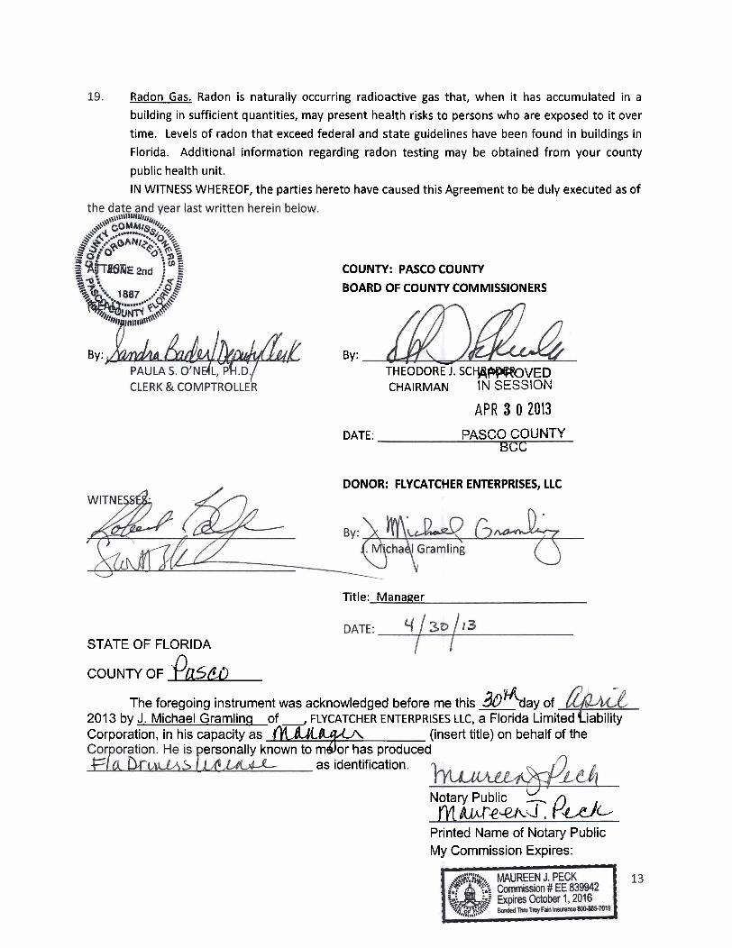
IN WITNESS WHEREOF, the parties hereto have caused this Agreement to be duly executed as of
By:
COUNTY: PASCO COUNTY
BOARD OF COUNTY COMMISSIONERS
By: THEODORE. S C w m V E D CHAIRMAN SESSION
APR 3 0 2013 DATE: PASCO COUNTY
BGC
DONOR: FLYCATCHER ENTERPRISES, LLC
STATE OF FLORIDA
COUNTY OF k
Title: Manager
&'%ay of The foregoing instrument was acknowledged before me this 2013 by J. Michael Gramlinq of, FLYCATCHER ENTERPRISES LLC, a Florida Limited iability Corporation, in his capacity as .- (insert title) on behalf of the
ersonally known to mdor has produced as identification.
V Notarv Public - A yMh.fe~~d. I-.g_-e/~
Printed Name of Notary Public My Commission Expires:
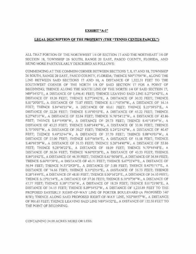
EXHIBIT "A-1"
LEGAL DESCRIPTION OF THE PROPERTY (THE "TENNIS CENTER PARCEL")
ALL THAT PORTION OF THE NORTHWEST 114 OF SECTION 17 AND THE NORTHEAST 114 OF SECTION 18, TOWNSHIP 26 SOUTH, RANGE 20 EAST, PASCO COUNTY, FLORIDA, AND BEING MORE PARTICULARLY DESCRIBED AS FOLLOWS:
COMMENCING AT THE COMMON CORNER BETWEEN SECTIONS 7,8,17 AND 18, TOWNSHIP 26 SOUTH, RANGE 20 EAST, PASCO COUNTY, FLORIDA; THENCE S00°17'04"W., ALONG THE LINE BETWEEN SAID SECTIONS 17 AND 18, A DISTANCE OF 1,322.31 FEET TO THE SOUTHWEST CORNER OF THE NORTH 114 OF SAID SECTION 17 FOR A POINT OF BEGINNING; THENCE ALONG THE SOUTH LINE OF THE NORTH 114 OF SAID SECTION 17, N89'54'52"E., A DISTANCE OF 1,496.41 FEET; THENCE LEAVING SAID LINE S.27O24'42"E., A DISTANCE OF 19.26 FEET; THENCE S.27"24'42"E., A DISTANCE OF 30.32 FEET; THENCE S.81°20'00"E., A DISTANCE OF 73.87 FEET; THENCE S.l 1°10'34"W., A DISTANCE OF 16.14 FEET; THENCE S.84O40'35"W., A DISTANCE OF 60.61 FEET; THENCE S.25"30t52"E., A DISTANCE OF 22.26 FEET; THENCE S.l8"00'53"E., A DISTANCE OF 45.22 FEET; THENCE S.27°45'10"W., A DISTANCE OF 52.04 FEET; THENCE N.76O54'12"W., A DISTANCE OF 43.86 FEET; THENCE S.8I019'08"W., A DISTANCE OF 29.73 FEET; THENCE S.41°18'54"W., A DISTANCE OF 43.25 FEET; THENCE S.66°14'45"W., A DISTANCE OF 33.96 FEET; THENCE S.70°30'07"W., A DISTANCE OF 30.27 FEET; THENCE S.24"21t42"W., A DISTANCE OF 40.47 FEET; THENCE S.49"32'44"W., A DISTANCE OF 37.70 FEET; THENCE S.88°45'05"W., A DISTANCE OF 27.00 FEET; THENCE S.O7"56'04"E., A DISTANCE OF 51.58 FEET; THENCE S.46°01'59"W., A DISTANCE OF 51.53 FEET; THENCE S.26°14'40"W., A DISTANCE OF 55.86 FEET; THENCE S.28"06'22"E., A DISTANCE OF 18.09 FEET; THENCE N.70°44'48"E., A DISTANCE OF 50.36 FEET; THENCE N.66O03'28"E., A DISTANCE OF 43.33 FEET; THENCE S.84O10'42"E., A DISTANCE OF 46.39 FEET; THENCE S.61°50'08"E., A DISTANCE OF 36.84 FEET; THENCE S.66O07'39"E., A DISTANCE OF 43.71 FEET; THENCE S.67"22'47"E., A DISTANCE OF 56.94 FEET; THENCE N.53"29'29"E., A DISTANCE OF 3.88 FEET; THENCE S.42°01'17"E., A DISTANCE OF 74.66 FEET; THENCE S.35O23'51"E., A DISTANCE OF 35.73 FEET; THENCE S.28"14'49"E., A DISTANCE OF 48.81 FEET; THENCE S.00°16'25"E., A DISTANCE OF 34.10 FEET; THENCE S.15°01'14"E., A DISTANCE OF 37.26 FEET; THENCE S.10°07'36"W., A DISTANCE OF 47.77 FEET; THENCE S.58°17'36"W., A DISTANCE OF 18.29 FEET; THENCE S.01°21'00"E., A DISTANCE OF 34.15 FEET; THENCE S.89"54'52"W., A DISTANCE OF 1,235.69 FEET TO THE PROPOSED EASTERLY RIGHT-OF-WAY LINE OF PORTER BOULEVARD (A PROPOSED 140' RIW); THENCE ALONG SAID PROPOSED RIGHT-OF-WAY LINE, N32"00t57"W., A DISTANCE OF 901.62 FEET; THENCE LEAVING SAID LINE N89"54'52"E., A DISTANCE OF 122.50 FEET TO THE POINT OF BEGNING.
CONTAINING 24.00 ACRES MORE OR LESS.
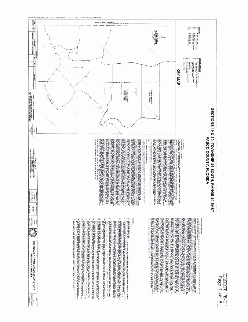

.2-IT "-1" Page 2 of 8
SECTIONS 19 8 30, TOWNSHIP 26 SOUTH, RANGE 20 EAST
I*-*- IIuIoI*.IIn.uc -.- A-
nn a42 m m1
EXCHANGE PROPERTY 46.435 ACRES*
I C I C ~ ~ O O D D nmmm mmmn uc
Turn s M M U I W Y P
DONATED PROPERTY MI---
(FLYCATCHER) REUSED 91.749 ACRES*
x-ae-- nmoa maars uc s
L U U m W W
-----
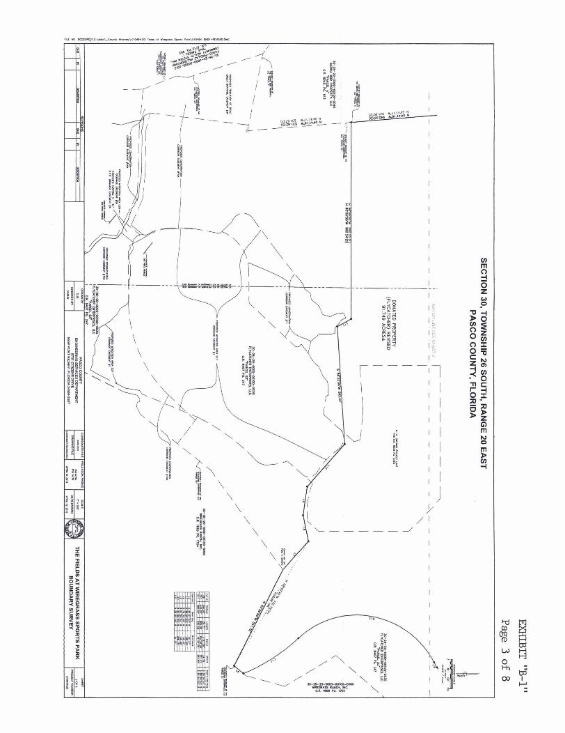

EXHIBIT "B-1" Page 4 of 8
LEGAL DESCRIPTION - WIREGRASS EXCHANGE PROPERTY (FLYCATCHER)
A PARCEL OF LAND LOCATED WITHIN SECTION 19, TOWNSHIP 26 SOUTH, RANGE 2 0 EAST, PASCO COUNTY, FLORIDA, BEING MORE PARTICULARLY DESCRIBED AS FOLLOWS:
COMMENCE AT THE SOUTHWEST CORNER OF SAID SECTION 19; THENCE ALONG THE SOUTH BOUNDARY OF THE SOUTHWEST 114 OF SAID SECTION 19, SOUTH 8g053'34" EAST, A DISTANCE OF 1,797.70 FEET TO THE EASTERLY BOUNDARY OF THE SIERRA BBD PROPERTY, LLC 'PARCEL A" AS DESCRIBED I N OFFICIAL RECORDS BOOK 8242, PAGE 613 OF THE PUBLIC RECORDS OF PASCO COUNTY, FLORIDA, THE SAME BEING THE WESTERLY BOUNDARY OF THE FLYCATCHER ENTERPRISES, LLC "PARCEL S3" AS DESCRIBED I N OFFICIAL RECORDS BOOK 8407, PAGE 247 OF THE PUBLIC RECORDS OF PASCO COUNTY, FLORIDA; THENCE ALONG THE EASTERLY BOUNDARY OF SAID SIERRA BBD PROPERTY, LLC PARCEL AND THE WESTERLY BOUNDARY OF SAID FLYCATCHER ENTERPRISES, LLC PARCEL S3, NORTH 12°09'05" EAST, A DISTANCE OF 395.61 FEET FOR A POINT OF BEGINNING; THENCE CONTINUE ALONG THE EASTERLY BOUNDARY OF SAID SIERRA BBD PROPERTY, LLC PARCEL AND THE WESTERLY BOUNDARY OF SAID FLYCATCHER ENTERPRISES, LLC PARCEL S3 THE FOLLOWING TWO (2) COURSES AND DISTANCES: 1) NORTH 12°09'05" EAST, 528.09 FEET; 2) NORTH 25°15'11" WEST, 354.10 FEET; THENCE NORTH 90°00'00" EAST, A DISTANCE OF 2,564.74 FEET; THENCE SOUTH 13°11'14" WEST, A DISTANCE OF 87.62 FEET TO A POINT ON A CURVE TO THE LEFT; THENCE SOUTHERLY 351.00 FEET ALONG THE ARC OF SAID CURVE, HAVING A RADIUS OF 1,525.00 FEET, A CENTRAL ANGLE OF 13°11'14", AND A CHORD BEARING AND DISTANCE OF SOUTH 06O35'37" WEST 350.22 FEET; THENCE SOUTH 00°00'00" EAST, A DISTANCE OF 168.35 FEET TO A POINT ON A CURVE TO THE RIGHT; THENCE SOUTHWESTERLY 95.35 FEET ALONG THE ARC OF SAID CURVE, HAVING A RADIUS OF 95.00 FEET, A CENTRAL ANGLE OF 57°30'34", AND A CHORD BEARING AND DISTANCE OF SOUTH 28O45'17" WEST 91.40 FEET; THENCE SOUTH 00°00'00" EAST, A DISTANCE OF 147.78 FEET TO THE POINT ON A NON-TANGENT CURVE TO THE RIGHT; THENCE SOUTHEASTERLY 12.47 FEET ALONG THE ARC OF SAID CURVE, HAVING A RADIUS OF 145.00 FEET, A CENTRAL ANGLE OF 04°55'46", AND A CHORD BEARING AND DISTANCE OF SOUTH 55O37'39" EAST 12.47 FEET; THENCE SOUTH 90°00'00" WEST, A DISTANCE OF 2,430.95 FEET TO THE P O I N T OF BEGINNING.
THE ABOVE DESCRIBED PARCEL CONTAINS 46.435 ACRES, MORE OR LESS.

EXHIBIT "B-1 " Page 5 of 8
LEGAL DESCRIPTION - WIREGRASS DONATED PROPERTY (FLYCATCHER) REVISED
A PARCEL OF LAND LOCATED WlTHIN SECTIONS 1 9 AND 30, TOWNSHIP 26 SOUTH, RANGE 20 EAST, PASCO COUNTY, FLORIDA, BEING MORE PARTICULARLY DESCRIBED AS FOLLOWS:
COMMENCE AT THE SOUTHWEST CORNER OF SAID SECTION 19; THENCE ALONG THE SOUTH BOUNDARY OF THE SOUTHWEST 114 OF SAID SECTION 19, SOUTH 89'53'34" EAST, A DISTANCE OF 1,797.70 FEET TO THE EASTERLY BOUNDARY OF THE SIERRA BBD PROPERTY, LLC 'PARCEL A" AS DESCRIBED I N OFFICIAL RECORDS BOOK 8242, PAGE 613 OF THE PUBLIC RECORDS OF PASCO COUNTY, FLORIDA, THE SAME BEING THE WESTERLY BOUNDARY OF THE FLYCATCHER ENTERPRISES, LLC "PARCEL 53" AS DESCRIBED I N OFFICIAL RECORDS BOOK 8407, PAGE 247 OF THE PUBLIC RECORDS OF PASCO COUNTY, FLORIDA, FOR A P O I N T OF BEGINNING; THENCE ALONG THE EASTERLY BOUNDARY OF SAID SIERRA BBD PROPERTY, LLC "PARCEL A" AND THE WESTERLY BOUNDARY OF SAID FLYCATCHER ENTERPRISES, LLC "PARCEL S3", NORTH 12°09'05" EAST, A DISTANCE OF 395.61 FEET; THENCE NORTH 90°00'00" EAST, A DISTANCE OF 2,430.95 FEET TO THE POINT ON A NON- TANGENT CURVE TO THE RIGHT; THENCE SOUTHEASTERLY 84.66 FEET ALONG THE ARC OF SAID CURVE, HAVING A RADIUS OF 145.00 FEET, A CENTRAL ANGLE OF 33°27'12", AND A CHORD BEARING AND DISTANCE OF SOUTH 36O26'11" EAST 83.46 FEET TO A POINT OF REVERSE CURVE TO THE LEFT; THENCE SOUTHEASTERLY 262.40 FEET ALONG THE ARC OF SAID CURVE, HAVING A RADIUS OF 442.00 FEET, A CENTRAL ANGLE OF 34°00'51", AND A CHORD BEARING AND DISTANCE OF SOUTH 36°43'00" EAST 258.56 FEET; THENCE SOUTH 53O43'25" EAST, A DISTANCE OF 139.99 FEET TO A POINT ON A CURVE TO THE RIGHT; THENCE SOUTHERLY 485.91 FEET ALONG THE ARC OF SAID CURVE, HAVING A RADIUS OF 333.00 FEET, A CENTRAL ANGLE OF 83°36'20", AND A CHORD BEARING AND DISTANCE OF SOUTH 11°55'16" EAST 443.93 FEET; THENCE SOUTH 2g052'54" WEST, A DISTANCE OF 44.99 FEET TO A POINT ON A CURVE TO THE RIGHT; THENCE SOUTHWESTERLY 118.22 FEET ALONG THE ARC OF SAID CURVE, HAVING A RADIUS OF 246.50 FEET, A CENTRAL ANGLE OF 27O28'45", AND A CHORD BEARING AND DISTANCE OF SOUTH 43O37'17" WEST 117.09 FEET TO A POINT OF COMPOUND CURVE TO THE RIGHT; THENCE SOUTHWESTERLY 29.77 FEET ALONG THE ARC OF SAID CURVE, HAVING A RADIUS OF 344.00 FEET, A CENTRAL ANGLE OF 04°57'28", AND A CHORD BEARING AND DISTANCE OF SOUTH 59°50'23" WEST 29.76 FEET TO A POINT OF REVERSE CURVE TO THE LEFT; THENCE SOUTHERLY 809.06 FEET ALONG THE ARC OF SAID CURVE, HAVING A RADIUS OF 443.00 FEET, A CENTRAL ANGLE OF 104°38'24", AND A CHORD BEARING AND DISTANCE OF SOUTH 09O59'55" WEST 701.21 FEET TO A POINT OF REVERSE CURVE TO THE RIGHT; THENCE SOUTHEASTERLY 335.56 FEET ALONG THE ARC OF SAID CURVE TO THE SOUTHERLY BOUNDARY OF SAID FLYCATCHER ENTERPRISES, LLC "PARCEL S3", HAVING A RADIUS OF 969.00 FEET, A CENTRAL ANGLE OF 19°50'29", AND A CHORD BEARING AND DISTANCE OF SOUTH 32O24'02" EAST 333.89 FEET; THENCE ALONG THE SOUTHERLY BOUNDARY OF SAID FLYCATCHER ENTERPRISES, LLC "PARCEL S3" THE FOLLOWING TWO (2) COURSES AND DISTANCES: 1) SOUTH 3g057'54" WEST, 62.47 FEET; 2) NORTH 62O29'00" WEST, 541.78 FEET; THENCE NORTH 48O04'52" WEST, A DISTANCE OF 195.54 FEET; THENCE SOUTH 78O33'46" WEST, A DISTANCE OF 135.87 FEET; THENCE NORTH 81°54'02" WEST, A DISTANCE OF 146.99 FEET; THENCE NORTH 47O55'49" WEST, A DISTANCE OF 288.70 FEET; THENCE SOUTH 86O22'06" WEST, A DISTANCE OF 592.44 FEET; THENCE NORTH 28O23'38" WEST, A DISTANCE OF 81.07 FEET; THENCE NORTH 90°00'00" WEST, A DISTANCE OF 990.24

EXHIBIT "B-1 " Page 6 of 8
FEET TO THE WESTERLY BOUNDARY OF SAID FLYCATCHER ENTERPRISES, LLC "PARCEL S3" AND THE EASTERLY BOUNDARY OF SAID SIERRA BBD PROPERTY, LLC 'PARCEL A"; THENCE ALONG THE EASTERLY BOUNDARY OF SAID SIERRA BBD PROPERTY, LLC "PARCEL A" AND THE WESTERLY BOUNDARY OF SAID FLYCATCHER ENTERPRISES, LLC "PARCEL S3" THE FOLLOWING TWO (2) COURSES AND DISTANCES: 1) NORTH 04°4111611 WEST, 942.03 FEET; 2) NORTH 12°09'051' EAST, 23.63 FEET TO THE POINT OF BEGINNING.
THE ABOVE DESCRIBED PARCEL CONTAINS 91.749 ACRES, MORE OR LESS.
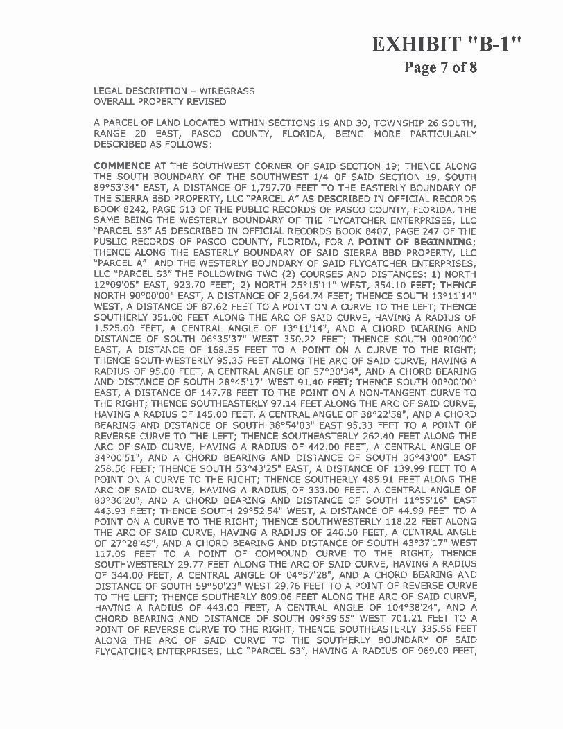
EXHIBIT "B-1 " Page 7 of 8
LEGAL DESCRIPTION - WIREGRASS OVERALL PROPERTY REVISED
A PARCEL OF LAND LOCATED WITHIN SECTIONS 19 AND 30, TOWNSHIP 26 SOUTH, RANGE 20 EAST, PASCO COUNTY, FLORIDA, BEING MORE PARTICULARLY DESCRIBED AS FOLLOWS:
COMMENCE AT THE SOUTHWEST CORNER OF SAID SECTION 19; THENCE ALONG THE SOUTH BOUNDARY OF THE SOUTHWEST 114 OF SAID SECTION 19, SOUTH 89'53'34" EAST, A DISTANCE OF 1,797.70 FEET TO THE EASTERLY BOUNDARY OF THE SIERRA BBD PROPERTY, LLC 'PARCEL A" AS DESCRIBED I N OFFICIAL RECORDS BOOK 8242, PAGE 613 OF THE PUBLIC RECORDS OF PASCO COUNTY, FLORIDA, THE SAME BEING THE WESTERLY BOUNDARY OF THE FLYCATCHER ENTERPRISES, LLC "PARCEL S3" AS DESCRIBED I N OFFICIAL RECORDS BOOK 8407, PAGE 247 OF THE PUBLIC RECORDS OF PASCO COUNTY, FLORIDA, FOR A P O I N T OF BEGINNING; THENCE ALONG THE EASTERLY BOUNDARY OF SAID SIERRA BBD PROPERTY, LLC "PARCEL A" AND THE WESTERLY BOUNDARY OF SAID FLYCATCHER ENTERPRISES, LLC "PARCEL S3" THE FOLLOWING TWO (2) COURSES AND DISTANCES: 1) NORTH 12°09'05" EAST, 923.70 FEET; 2) NORTH 25°15'11" WEST, 354.10 FEET; THENCE NORTH 90°00'00" EAST, A DISTANCE OF 2,564.74 FEET; THENCE SOUTH 13°11'14" WEST, A DISTANCE OF 87.62 FEET TO A POINT ON A CURVE TO THE LEFT; THENCE SOUTHERLY 351.00 FEET ALONG THE ARC OF SAID CURVE, HAVING A RADIUS OF 1,525.00 FEET, A CENTRAL ANGLE OF 13°11'14", AND A CHORD BEARING AND DISTANCE OF SOUTH 06O35'37" WEST 350.22 FEET; THENCE SOUTH 00°00'00" EAST, A DISTANCE OF 168.35 FEET TO A POINT ON A CURVE TO THE RIGHT; THENCE SOUTHWESTERLY 95.35 FEET ALONG THE ARC OF SAID CURVE, HAVING A RADIUS OF 95.00 FEET, A CENTRAL ANGLE OF 57030f34", AND A CHORD BEARING AND DISTANCE OF SOUTH 28O45'17" WEST 91.40 FEET; THENCE SOUTH 00°00'00" EAST, A DISTANCE OF 147.78 FEET TO THE POINT ON A NON-TANGENT CURVE TO THE RIGHT; THENCE SOUTHEASTERLY 97.14 FEET ALONG THE ARC OF SAID CURVE, HAVING A RADIUS OF 145.00 FEET, A CENTRAL ANGLE OF 38O22'58", AND A CHORD BEARING AND DISTANCE OF SOUTH 38O54'03" EAST 95.33 FEET TO A POINT OF REVERSE CURVE TO THE LEFT; THENCE SOUTHEASTERLY 262.40 FEET ALONG THE ARC OF SAID CURVE, HAVING A RADIUS OF 442.00 FEET, A CENTRAL ANGLE OF 34°00'51", AND A CHORD BEARING AND DISTANCE OF SOUTH 36°43'00" EAST 258.56 FEET; THENCE SOUTH 53O43'25" EAST, A DISTANCE OF 139.99 FEET TO A POINT ON A CURVE TO THE RIGHT; THENCE SOUTHERLY 485.91 FEET ALONG THE ARC OF SAID CURVE, HAVING A RADIUS OF 333.00 FEET, A CENTRAL ANGLE OF 83°36'20", AND A CHORD BEARING AND DISTANCE OF SOUTH 11°55'16" EAST 443.93 FEET; THENCE SOUTH 2g052'54" WEST, A DISTANCE OF 44.99 FEET TO A POINT ON A CURVE TO THE RIGHT; THENCE SOUTHWESTERLY 118.22 FEET ALONG THE ARC OF SAID CURVE, HAVING A RADIUS OF 246.50 FEET, A CENTRAL ANGLE OF 27O28'45", AND A CHORD BEARING AND DISTANCE OF SOUTH 43O37'17" WEST 117.09 FEET TO A POINT OF COMPOUND CURVE TO THE RIGHT; THENCE SOUTHWESTERLY 29.77 FEET ALONG THE ARC OF SAID CURVE, HAVING A RADIUS OF 344.00 FEET, A CENTRAL ANGLE OF 04O57'28", AND A CHORD BEARING AND DISTANCE OF SOUTH 59O50'23" WEST 29.76 FEET TO A POINT OF REVERSE CURVE TO THE LEFT; THENCE SOUTHERLY 809.06 FEET ALONG THE ARC OF SAID CURVE, HAVING A RADIUS OF 443.00 FEET, A CENTRAL ANGLE OF 104°38'24", AND A CHORD BEARING AND DISTANCE OF SOUTH 09O59'55" WEST 701.21 FEET TO A POINT OF REVERSE CURVE TO THE RIGHT; THENCE SOUTHEASTERLY 335.56 FEET ALONG THE ARC OF SAID CURVE TO THE SOUTHERLY BOUNDARY OF SAID FLYCATCHER ENTERPRISES, LLC "PARCEL S3", HAVING A RADIUS OF 969.00 FEET,

EXHIBIT "B-1" Page 8 of 8
A CENTRAL ANGLE OF 19°50'2911, AND A CHORD BEARING AND DISTANCE OF SOUTH 32O24'02" EAST 333.89 FEET; THENCE ALONG THE SOUTHERLY BOUNDARY OF SAID FLYCATCHER ENTERPRISES, LLC "PARCEL S3" THE FOLLOWING TWO (2) COURSES AND DISTANCES: 1) SOUTH 3g057'54" WEST, 62.47 FEET; 2) NORTH 62O29'00" WEST, 541.78 FEET; THENCE NORTH 48O04'52" WEST, A DISTANCE OF 195.54 FEET; THENCE SOUTH 78033'4611 WEST, A DISTANCE OF 135.87 FEET; THENCE NORTH 81°54'02" WEST, A DISTANCE OF 146.99 FEET; THENCE NORTH 47O55'49" WEST, A DISTANCE OF 288.70 FEET; THENCE SOUTH 86°22'061' WEST, A DISTANCE OF 592.44 FEET; THENCE NORTH 28O23'38" WEST, A DISTANCE OF 81.07 FEET; THENCE NORTH 90°00'00" WEST, A DISTANCE OF 990.24 FEET TO THE WESTERLY BOUNDARY OF SAID FLYCATCHER ENTERPRISES, LLC 'PARCEL S3" AND THE EASTERLY BOUNDARY OF SAID SIERRA BBD PROPERTY, LLC 'PARCEL A"; THENCE ALONG THE EASTERLY BOUNDARY OF SAID SIERRA BBD PROPERTY, LLC "PARCEL A" AND THE WESTERLY BOUNDARY OF SAID FLYCATCHER ENTERPRISES, LLC "PARCEL S3" THE FOLLOWING TWO (2) COURSES AND DISTANCES: 1) NORTH 04°41'16" WEST, 942.03 FEET; 2) NORTH 12°09'05" EAST, 23.63 FEET TO THE POINT OF BEGINNING.
THE ABOVE DESCRIBED PARCEL CONTAINS 138.184 ACRES, MORE OR LESS.
ENlERPRISfA, UC. - e1.7 CROS3 ACREAGE
W A ~ F V M I W A ~ ~ Q W ACREAGE ABLE UPLAND ACREAGE
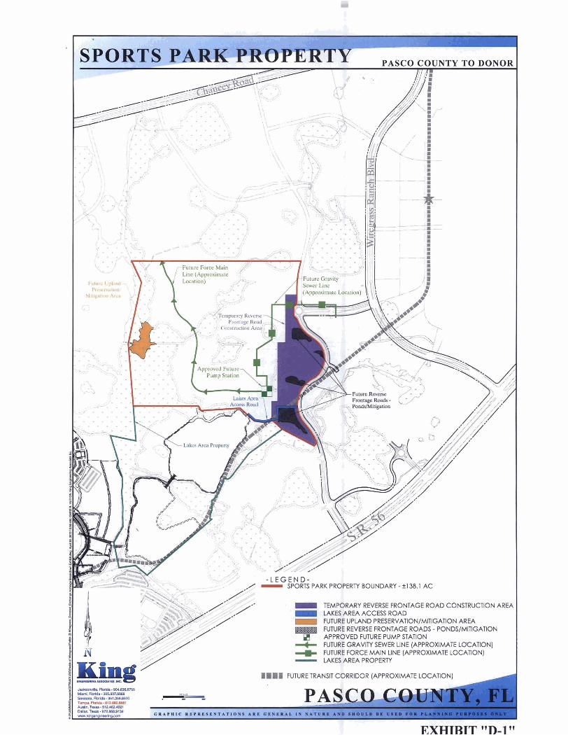
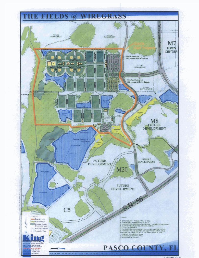

EXHIBIT 'IP]Ett
PUBUC PARK

---7 Uunl--sosm?dQ S M l s L ~ - O l l . z a E a T-- -8 lUIOI I aR-fl-
PAS- - - mT. I - - * J I -- ~ U A P H I C I I ~ P R L I L \ T A T I O I C A R L C I \ ~ Y A L ~h ~ A T U R O A N D snc

EXHIBIT "H" I THIS IS NOT A SURVEY SECTIONS 19 & 20, TOWNSHIP 26 SOUTH, RANGE 20 EAST, PASCO COUNTY, FLORIDA I
0 500' 1000'
OWNER: FLYCATCHER ENTERPRI
rnGEND @ = INDICATES SECTION DESIGNATION
O.R. BOOK = OFflClAL RECORDS BOOK
P PG. = PAGE ; VJ SURVEYOR'S NOTES: 0 1. NO INSTRUMENTS OF RECORD REFLECTlNG
0 - EASEMENTS. RIGHTS-OF-WAY. AND OR OWNERSHIP
Q WERE FURNISHED TO OR PURSUED BY THE 0 UNDERSIGNED. CL 2. UNLESS IT BEARS THE SIGNATURE AND M E W ORIGINAL RAISED SEAL OF A FLORIDA LICENSED a SURVEYOR AND MAPPER THIS DRAWING. SKETCH. 5 P U T OR MAP IS FOR INFORMATIONAL PURPOSES
6 ONLY AND IS NOT VALID. 3. THIS IS A SKETCH AND LEGAL DESCRIPTION E ONLY, NOT A flELD SURVEY.
w 4. DISTANCES SHOWN HEREON ARE IN FEET. v, CL
5. BASIS OF BEARINGS IS M E EASTERLY LINE OF W COUNTY ROAD 581 AS BEING NORTH 00'29'34' 2 Z 1 a u 9 4i I 2 W Y CERTIFIED AS TO SKETCH AND LEGAL DESCRIPTION
Y 6 S k e t c h and L e g a l Desc r i p t i on not val id w i t hou t I h e o stgnature and the or ig ina l r a i s e d sea l o f a F l o r i d a & l icensed S u r v e y o r and Mapper .
4821 LIWCWL H W A Y RKWE 613- 61)0-&5dl W E UDlWYL ENTER. SWE Ya FAX 613.680 - WE2 TALIP*. RORIM 356% E - W L Y n g Q ~ ~ . c o m
JOHN D. WEIGLE PROFESSIONAL SURVEYOR AND MAPPER
STATE OF FLORIDA # L .S.5246 CERTIFICATE OF AUTHORIZATION No. LB 2610
3 Sheet 1 of -
THIS IS NOT A SURVEY
PARCEL DESCRIPTION ALL THAT PORTION OF SECTIONS 19 & 20, TOWNSHIP 26 SOUTH, RANGE 2 0 EAST, PASCO COUMY, FLORIDA, BEING MORE PARTICULARLY DESCRIBED AS FOLLOWS:
COMMENCING AT THE SOUTHWEST CORNER OF THE SOUTHWEST 1/4 OF SECTION 30, TOWNSHIP 2 6 SOUTH, RANGE 2 0 EAST, PASCO COUNTY, FLORIDA; THENCE SOUTH 89'58'40" EAST, ALONG M E SOUTH LlNE OF THE SOUTHWEST 1/4 OF SAlD SECTION 30, A DISTANCE OF 99.24 FEET TO THE EASTERLY RIGHT-OF-WAY LlNE OF COUNTY ROAD 581 (BRUCE B. DOWNS BOULEVARD - A 200' R/W); THENCE NORTH 00'29'34" EAST, A DISTANCE OF 8,431.21 FEET TO A POlNT OF CURVATURE AT THE INTERSECTION OF THE PROPOSED SOUTHERLY RIGHT-OF-WAY LlNE OF CHANCEY ROAD (A 140' R/W); THENCE ALONG SAID PROPOSED RIGHT-OF-WAY LlNE THE FOLLOWING SEEN (7) COURSES; (1) THENCE 78.54 FEET ALONG THE ARC OF SAlD CURVE, HAVING A RADIUS OF 50.00 FEET, A CENTRAL ANGLE OF 90'00'00". AND A CHORD BEARING AND DISTANCE OF NORTH 45'29'34" EAST 70.71 FEU, (2) THENCE SOUTH 89'30'26" EAST, A DISTANCE OF 367.20 FEET TO A POlNT ON A CURVE TO THE LEFT; (3) THENCE EASTERLY 647.04 FEET ALONG THE ARC OF SAlD CURVE, HAVING A RADIUS OF 2,570.00 FEET, A CENTRAL ANGLE OF 14'25'30m, AND A CHORD BEARING AND DISTANCE OF NORTH 83'16'49" EAST 645.33 FEET; (4) THENCE NORTH 76'04'04" EAST, A DISTANCE OF 3,186.32 FEET TO A POlNT ON A CURVE TO THE RIGHT; ( 5 ) THENCE EASTERLY 635.80 FEET ALONG THE ARC OF SAlD CURVE, HAVING A RADIUS OF 7,930.00 FEET, A CENTRAL ANGLE OF 0435'38". AND A CHORD BEARING AND DISTANCE OF NORTH 78'21'53" EAST 635.63 FEET; (6) THENCE NORTH 80'39'41" EAST, A DISTANCE OF 1,260.27 FEET TO A POlNT ON A CURVE TO THE RIGHT; (7) THENCE SOUTHEASTERLY 91.63 FEET ALONG THE ARC OF SAlD CURVE. HAVING A RADIUS OF 50.00 FEET, A CENTRAL ANGLE OF 105'00'00", AND A CHORD BEARING AND DISTANCE OF SOUTH 46'50'19" EAST 79.34 FEET TO THE INTERSECTION OF THE PROPOSED WESTERLY RIGHT-OF-WAY LINE OF WIREGRASS RANCH BOULEVARD (A 140' R/W); THENCE ALONG SAlD PROPOSED WESTERLY RIGHT-OF-WAY THE FOLLOWING SIX (6) COURSES; (1) THENCE SOUTH 05'39'41" WEST, A DISTANCE OF 105.07 FEET TO A POlNT ON A CURVE TO THE RIGHT; (2) THENCE SOUTHWESTERLY 647.13 FEET ALONG THE ARC OF SAlD CURVE, HAVING A RADIUS OF 980.00 FEET, A CENTRAL ANGLE OF 37'50104', AND A CHORD BEARING AND DISTANCE OF SOUTH 24'34'43" WEST 635.43 FEET; (3) THENCE SOUTH 4529'45" WEST, A DISTANCE OF 336.99 FEET TO A POlNT ON A CURVE TO THE LEFT; (4) THENCE SOUTHERLY 844.62 FEET ALONG THE ARC OF SAlD CURVE, HAVING A RADIUS OF 1,120.00 FEET, A CENTRAL ANGLE OF 4512'29". AND A CHORD BEARING AND DISTANCE OF SOUTH 21'53'30" WEST 824.75 FEET TO THE WEST LlNE OF SECTION 20; (5) THENCE SOUTH 00'17'16" WEST, ALONG SAlD WEST LINE OF SECTION 20, A DISTANCE OF 1.655.13 FEET TO A POlNT ON A CURVE TO THE LEFT; (6) THENCE SOUTHERLY 298.55 FEET ALONG THE ARC OF SAlD CURVE. HAVING A RADIUS OF 1,270.00 FEU, A CENTRAL ANGLE OF 1528'09", AND A CHORD BEARING AND DISTANCE OF SOUTH 06'26'49" EAST 297.87 FEET TO A POlNT ON A CURVE TO THE LEFr AND THE POlNT OF BEGINNING;
F 3 4 V)
C3
n 6 0 E
W C3 u I- Z 0 [1Z. LL
W In
I W
2 -J
< C3
3 4 L e W Y
9 6 z b
b
? Y tY 2
9
Sheet 2 of 3
SKETCH & LEGAL COUNTY TEMPORARY CONSTRUCTION ACCESS (REVERSE FRONTAGE ROAD)
PREPARED FOR FLYCATCHER ENTERPRISE, L C .
m--L EN(31NEERtNG ASSOCIATES. INC. 402t YOlQIYY hiUfmY RKNK 8 3 3 - M O . M l WE YDLlRUL CO(TVI. M 300 FAX 113. - 0 . M 2 T U l P h MRlM 336% E - W
M I S IS NOT A SURVEY
SKETCH & LEGAL COUNTY TEMPORARY CONSTRUCTlON ACCESS (REVERSE FRONTAGE ROAD)
PREPARED FOR FLYCATCHER ENTERPRISE, L C .
PARCEL DESCRIPTION (Cont.)
THENCE SOUTHERLY 228.33 FEET ALONG M E ARC OF SAID CURVE. HAVING A RADIUS OF 1,270.00 FEET, A CENTRAL ANGLE OF i ~ 1 a ~ o 4 ~ , AND A CHORD BEARING AND DISTANCE OF SOUTH 18'19'55" EAST 228.02 FEET TO THE POlNT ON A NON-TANGENT CURVE TO THE L E m THENCE NORTHWESTERLY 73.91 FEET ALONG THE ARC OF SAlD CURVE, HAVING A RADIUS OF 50.00 FEET, A CENTRAL ANGLE OF 8441'30n, AND A CHORD BEARING AND DISTANCE OF NORTH 6549'42" WEST 67.36 FEET; THENCE SOUTH 71'49'33" WEST, A DISTANCE OF 107.14 FE!T TO A POlNT ON A CURVE TO THE RIGHT; THENCE WESTERLY 339.40 FEET ALONG THE ARC OF SAlD CURVE, HAVING A RADIUS OF 1.070.00 FEET, A CENTRAL ANGLE OF 18'1 0'27", AND A CHORD BEARING AND DISTANCE OF SOUTH 80'54'46" WEST 337.98 FEm, THENCE SOUTH 90'00'00" WEST, A DISTANCE OF 523.69 FEET TO A POlNT ON A CURVE TO THE L E m THENCE SOUTHWESTERLY 46.66 FEET ALONG THE ARC OF SAlD CURVE, HAVING A RADIUS OF 25.00 FEET, A CEMRAL ANGLE OF 106'56'12". AND A CHORD BEARING AND DISTANCE OF SOUTH 36'31'54" WEST 40.18 FEET TO A POlNT OF COMPOUND CURVE TO THE LEFT; THENCE SOUTHERLY 16.99 FEET ALONG THE ARC OF SAID CURVE, HAVING A RADIUS OF 351.00 FEET, A CENTRAL ANGLE OF 02'46'23", AND A CHORD BEARING AND DISTANCE OF SOUTH 18'19'23" EAST 16.99 FEU, THENCE SOUTH 70'17'25" WEST. A DISTANCE OF 91.00 FEET TO THE POlNT ON A NON-TANGENT CURVE TO THE LEFT; THENCE NORTHWESTERLY 97.14 FEET ALONG THE ARC OF SAlD CURVE. HAVING A RADIUS OF 145.00 FEET, A CENTRAL ANGLE OF 38'22'58", AND A CHORD BEARING AND DISTANCE OF NORTH 38'54'04" WEST 95.33 FEET; THENCE NORTH 00'00'00" EAST. A DISTANCE OF 147.78 FEET TO THE POlNT ON A NON-TANGENT CURVE TO THE LEFT; THENCE NORTHEASTERLY 95.35 FEET ALONG THE ARC OF SAlD CURVE, HAVING A RADIUS OF 95.00 FEET, A CENTRAL ANGLE OF 5730'34", AND A CHORD BEARING AND DISTANCE OF NORTH 28'45'17" EAST 91.40 F E m THENCE NORTH 00'00'00" EAST, A DISTANCE OF 1.88 FEET; THENCE NORTH 90'00'00" EAST, A DISTANCE OF 70.00 FEET; THENCE SOUTH 00'00'00" EAST, A DISTANCE OF 13.88 FEET TO A POlNT ON A CURVE TO THE LEFT; THENCE SOUTHEASTERLY 11 6.24 FEET ALONG M E ARC OF SAID CURVE, HAVING A RADIUS OF 74.00 FEET, A CENTRAL ANGLE OF 90'00'00n, AND A CHORD BEARING AND DISTANCE OF SOUTH 45'00'00" EAST 104.65 FEET; THENCE NORTH 90'00'00" EAST, A DISTANCE OF 499.83 FEET TO A POlNT ON A CURVE TO THE LEFT; THENCE EASTERLY 295.95 FEET ALONG THE ARC OF SAID CURVE. HAVING A RADIUS OF 933.00 FEET, A CENTRAL ANGLE OF 18'10127", AND A CHORD BEARING AND DISTANCE OF NORM 80'54'46" EAST 294.71 F E m THENCE NORTH 71'49'33" EAST, A DISTANCE OF 106.49 FEET TO A POlNT ON A CURVE TO M E LEFT; THENCE NORTHEASTERLY 74.18 FEET ALONG THE ARC OF SAID CURVE, HAVING A RADIUS OF 50.00 FEET, A CENTRAL ANGLE OF 8500'26", AND A CHORD BEARING AND DISTANCE OF NORTH 29'19'20" EAST 67.56 FEET TO THE POINT OF BEGINNING.
CONTAlNlNG 4.028 ACRES.
G l N E E R t N G ASSOCIATES. INC. 4 1 2 1 UWoKVL W A Y PHONE 813- 800. ME1 ONE U- CMER. SUlE Y)O FAX 113. 800. ME2 TMlPh RORlDL 336% E - U U - w . e u u
I Sheet 3 of 3
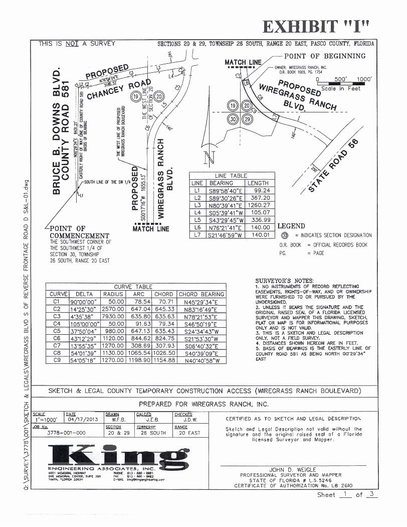
EXHIBIT "I" I THIS IS A SURVEY SECTIONS 20 & 29, TOWNSHIP 26 SOUTH, RANGE 20 EAST, PASCO COUNTY, FLORIDA I
SURVEYOR'S NOTES: 1. NO INSTRUMENTS OF RECORD REFLECTING EASEMENTS. RIGHTS-OF-WAY, AND OR OWNERSHIP WERE FURNISHED TO OR PURSUED BY THE UNDERSIGNED. 2. UNLESS TT BEARS THE SIGNATURE AND THE ORIGINAL RAISED SEAL OF A FLORIDA LICENSED SURVWOR AND MAPPER THIS DRAWING, SKDCH, PLAT OR MAP IS FOR INFORMATIONAL PURPOSES ONLY AND IS NOT VALID. 3. THlS IS A SKETCH AND LEGAL DESCRIPTION ONLY, NOT A flECD SURVEY. 4. DISTANCES SHOWN HEREON ARE IN FEET. 5. BASIS OF BEARINGS IS M E EAmRLY UNE OF COUNTY ROAD 581 AS BEING NORTH O(r29'34" EAST
SKETCH & LEGAL COUNTY TEMPORARY CONSTRUCTION ACCESS (WIREGRASS RANCH BOULEVARD)
c ; > I PREPARED FOR WIREGRASS RANCH, INC. I z- 0
d
3 Sheet 1 of -
6- aBIE w cAL!xR CHECKED
- b b
3
CC 3
Y ti
l1.'=lO0O' ~~ 3778-001-000
'7 - 4 b
I.
1021 UE- HIGIWAY E N G I N E E R I N G A S S O C I A T E S , INC. 1
PHONE 813 BW .EM1
b MIE ~YHWIW cmlm. ~ W T C XX) FAX n 1 a . m . w z T W P ~ FU)RD* 3.36s E-WL lirgounp.rginr.mp.com
04/17/2013
l icensed Surveyor and Mapper.
xCI!QN 2 0 & 29
JOHN 0. WEIGLE PROFESSIONAL SURVEYOR AND MAPPER
STATE OF FLORIDA # L.S.5246 CERTIFICATE OF AUTHORIZATION No. LB 2610
W.F.B.
~ o w ~ s ~ l p 26 SOUTH
J.E.B.
RANGE 2 0 EAST
Ske lch and Leg01 Descr ip l ion not valid w i lhou l I h e signature ond the original ra ised seal o f o F l o r i d a
J.D.W. CERTIFIED AS TO SKETCH AND LEGAL DESCRIPTION

PARCEL DESCRIPTION ALL THAT PORTION OF SECTIONS 2 0 & 29, TOWNSHIP 2 6 SOUTH, RANGE 20 EAST. PASCO COUNM, FLORIDA, BEING MORE PARTICULARLY DESCRIBED AS FOLLOWS:
COMMENCING AT THE SOUTHWEST CORNER OF THE SOUTHWEST 1/4 OF SECTION 30, TOWNSHIP 2 6 SOUTH, RANGE 20 EAST, PASCO COUNTY, FLORIDA; THENCE SOUTH 89'58'40" EAST, ALONG THE SOUTH LlNE OF THE SOUTHWEST 1/4 OF SAlD SECTION 30, A DISTANCE OF 99.24 FEET TO THE EASTERLY RIGHT-OF-WAY LINE OF COUNTY ROAD 581 (BRUCE 6. DOWNS BOULEVARD - A 200' R/W); THENCE NORTH 00'29'34" EAST, A DISTANCE OF 8,431.21 FEET TO A POlNT OF CURVATURE AT THE INTERSECTION OF THE PROPOSED SOUTHERLY RIGHT-OF-WAY LlNE OF CHANCEY ROAD (A 140' R/W); THENCE ALONG SAID PROPOSED RIGHT-OF-WAY LlNE THE FOLLOWING SEVEN (7) COURSES; (1) THENCE 78.54 FEET ALONG THE ARC OF SAlD CURVE, HAVING A RADIUS OF 50.00 FEET, A CENTRAL ANGLE OF 9(r00'00", AND A CHORD BEARING AND DISTANCE OF NORTH 45'29'34" EAST 70.71 FEET; (2) THENCE SOUTH 89'30'26" EAST, A DISTANCE OF 367.20 FEET TO A POINT ON A CURVE TO THE LEFT; (3) THENCE EASTERLY 647.04 FEET ALONG THE ARC OF SAlD CURVE. HAVING A RADIUS OF 2.570.00 FEET, A CENTRAL ANGLE OF 14'25'30M, AND A CHORD BEARING AND DISTANCE OF NORTH 83'16'49" EAST 645.33 FEET; (4) THENCE NORTH 76'04'04" EAST, A DISTANCE OF 3,186.32 FEET TO A POlNT ON A CURVE TO THE RIGHT; (5) THENCE EASTERLY 635.80 FEET ALONG THE ARC OF SAlD CURVE, HAVING A RADIUS OF 7.930.00 FEET, A CENTRAL ANGLE OF 04'35'38", AND A CHORD BEARING AND DISTANCE OF NORTH 78'21'53" EAST 635.63 F E m (6) THENCE NORTH 80'39'41" EAST, A DISTANCE OF 1,260.27 FEET TO A POlNT ON A CURVE TO THE RIGHT; (7) THENCE SOUTHEASTERLY 91.63 FEET ALONG THE ARC OF SAlD CURVE. HAVING A RADIUS OF 50.00 FEET, A CENTRAL ANGLE OF 10S00'00". AND A CHORD BEARING AND DISTANCE OF SOUTH 46'50'19" EAST 79.34 FEET TO THE INTERSECTION OF THE PROPOSED WESTERLY RIGHT-OF-WAY LlNE OF WIREGRASS RANCH BOULEVARD (A 140' R/W); THENCE ALONG SAlD PROPOSED WESTERLY RIGHT-OF-WAY THE FOLLOWING SIX (6) COURSES; (1) THENCE SOUTH 05'39'41" WEST, A DISTANCE OF 105.07 FEET TO A POlNT ON A CURVE TO THE RIGHT, (2) THENCE SOUTHWESTERLY 647.13 FEET ALONG THE ARC OF SAID CURVE, HAVING A RADIUS OF 980.00 FEET, A CENTRAL ANGLE OF 3T50104", AND A CHORD BEARING AND DISTANCE OF SOUTH 24'34'43" WEST 635.43 FEET, (3) THENCE SOUTH 4529'45" WEST, A DISTANCE OF 336.99 FEET TO A POlNT ON A CURVE TO THE LEFT, (4) THENCE SOUTHERLY 844.62 FEET ALONG THE ARC OF SAID CURVE, HAVING A RADIUS OF 1,120.00 FEET, A CENTRAL ANGLE OF 4512'29", AND A CHORD BEARING AND DISTANCE OF SOUTH 21'53'30" WEST 824.75 FEET TO THE WEST LlNE OF SECTION 20; (5) THENCE SOUTH 00'17'16" WEST, ALONG SAID WEST LlNE OF SECTION 20, A DISTANCE OF 1.655.13 FEET TO A POlNT ON A CURVE TO THE LEFT; (6) THENCE SOUTHERLY 308.69 FEET ALONG THE ARC OF SAlD CURVE, HAVING A RADIUS OF 1,270.00 FEn, A CENTRAL ANGLE OF 13'55'35", AND A CHORD BEARING AND DISTANCE OF SOUTH 06'40'32" EAST 307.93 FEET TO THE POINT OF BEGINNING;
-
Sheet 2 of 3
F 9 Ei I
d V)
C3
9 0 IY
W C3
2 5 [Y. LL
W v, [Y.
Y W IY LL 0
V)
n 3 m V) V) a IY C3 W [Y.
5 # : E 1
al I e W Y m / 6
2 b r-
? Y LT 3
53. . . 0.
THIS IS NOT A SURVEY
SKETCH & LEGAL COUNTY TEMPORARY CONSTRUCTION ACCESS (WIREGRASS RANCH BOULEVARD)
PREPARED FOR WIREGRASS RANCH, INC. - E N 4911 lrDlORLu lwmlAY PHONE IIt3.BM1.88(11 ONE UD1ORlU CENXR. S V m 3W FAX 1113 880 - 8882 TAUPA. MRIOL. XW-4 E-UIL UngOWyl.ngln.r!+g.com

PARCEL DESCRIPTION (Cont.)
THENCE NORTH 76'21'41" EAST, A DISTANCE OF 140.00 FEET TO FEET TO THE EASTERLY RIGHT-OF-WAY OF SAlD PROPOSED WIREGRASS RANCH BOULEVARD AND TO A POINT ON A NON-TANGENT CURVE TO THE LEFT; THENCE SOUTHEASTERLY 1,065.54 FEET ALONG THE ARC OF SAlD CURVE. HAVING A RADIUS OF 1,130.00 FEET, A CENTRAL ANGLE OF 54'01139", AND A CHORD BEARING AND DISTANCE OF SOUTH 40'39'09" EAST 1,026.50 FEET; THENCE SOUTH 21'46'59" WEST, A DISTANCE OF 140.01 FEET TO THE POINT ON A NON-TANGENT CURVE TO THE RIGHT; THENCE NORTHWESTERLY 1,198.90 FEET ALONG THE ARC OF SAlD CURVE, HAVING A RADIUS OF 1,270.00 FEET, A CENTRAL ANGLE OF 54'05'18", AND A CHORD BEARING AND DISTANCE OF NORTH 40'40'58" WEST 1,154.88 FEET TO THE POINT OF BEGINNING.
CONTAINING 3.639 ACRES.
SKETCH & LEGAL COUNTY TEMPORARY CONSTRUCTION ACCESS (WIREGRASS RANCH BOULEVARD)
PREPARED FOR WIREGRASS RANCH, INC.
E 1 1 n g ENGINEERING A S S O C I A T E S . INC.
I
Sheet 3 of 3

EXHIBIT " J" I THIS IS NOT A SURVEY SECTION 29, TOWNSHIP 26 SOUTH, RANGE 20 EAST, PASCO C O W , FU)RIDA I
POINT OF COWNCEMENT M E SWMWEST CORNER OF M E S W M K S T 1/4 OF SECTION 30, TOWNSHIP
.mmC&.
MATCH LlNE
MATCH LlNE .I=-.
26 SOUM, RANGE 20 EAST
LlNE TABLE LINE BEARING LENGTH L1 S89'58'40"E 99.24 L2 S89'30'26"E 367.20 L3 N80'39'41 "E 1260.27 L4 S05'39'41 "W 105.07 L5 S43'29'45"W 336.99
LEGEND @ = INDICATES SECTION DESIGNATION
O.R. BOOK = OFFICIAL RECORDS BOOK
L6 L7 L8 L9
PG. = PAGE
SURVEYOR'S NOTES: 1. NO IN!STRUMENT!S OF RECORD REFLECTING EASEMENTS. RIGHTr-OF-WAY, AND OR OWNERSHIP WERE FURNISHED TO OR PURSUED BY THE
N21'46'5gWE S757 6'49"E s41 *27'0gww N7Y16'4gnW
UNDERSIGNED. 2. UNLESS IT BEARS THE SIGNATURE AND THE ORIGINAL RAISED SEAL OF A FLORIDA LICENSED SURVEYOR AND MAPPER THlS DRAWING, SKETCH, PLAT OR MAP IS FOR INFORMATIONAL PURPOSES ONLY AND IS NOT VALID. 3. THlS IS A SKnCH AND LEGAL DESCRIPTION ONLY. NOT A REUI SURVEY. 4. DISTANCES SHOWN HEREON ARE IN FED. 5. BASIS OF BEARINGS IS THE EASTERLY LlNE OF
140.01 134.1 7 240.07 134.17
C O U W ROAD 581 AS BEING NORTH 00'29'34' EAST
1 . . SKETCH & LEGAL COUNTY TEMPORARY CONSTRUCTION ACCESS (WIREGRASS RANCH BOULEVARD) I PREPARED FOR SOLLY BRANCH HOLDINGS, LLC.
-1 UEWWlYL HIGHWAY PHOWE 813. 880.8881 ONE UEYaRUL CENlER. SUTC Y)O FAX 1113 - MO . EM2 T U P * . M l m * 3 X U ) E - Y U binpOtinp.nphutlng.- . .
F .
0 d
JOHN D. WEIGLE PROFESSIONAL SURVEYOR AND MAPPER
STATE OF FLORIDA # L.S.5246 CERTIFICATE OF AUTHORIZATION No. LB 2610
3 Sheet 1 of -
MI€ -1000' 1 04/17/2013
-+lh 3778-001 -000
l icensed Surveyor ond Mopper.
w W.F.B.
.sEUlQN 29
! x u R J.E.B.
ToWNsnlP 26 SOUTH
GmKm J.D.W.
EM!X 2 0 EAST
CERTIFIED AS TO SKETCH AND LEGAL DESCRIPTION
Sketch ond Legal Descr ip l ion not vol id wi thoul the signofure ond the original ra ised seol o f o F lo r ido

PARCEL DESCRIPTION ALL THAT PORTION OF SECTION 29, TOWNSHIP 2 6 SOUTH, RANGE 20 EAST, PASCO COUNT/, FLORIDA, BEING MORE PARTICULARLY DESCRIBED AS FOLLOWS:
COMMENCING AT THE SOUTHWEST CORNER OF THE SOUTHWEST 1 /4 OF SECTION 30, TOWNSHIP 2 6 SOUTH, RANGE 2 0 EAST, PASCO COUNTY, FLORIDA; THENCE SOUTH 89'58'40" EAST, ALONG THE SOUTH LINE OF THE SOUTHWEST 1 /4 OF SAlD SECTION 30, A DISTANCE OF 99.24 FEET TO THE EASTERLY RIGHT-OF-WAY LlNE OF COUNM ROAD 5 8 1 (BRUCE B. DOWNS BOULEVARD - A 200' R/W); THENCE NORTH 00'29'34" EAST, A DISTANCE OF 8,431.21 FEET TO A POlNT OF CURVATURE AT THE INTERSECTION OF THE PROPOSED SOUTHERLY RIGHT-OF-WAY LlNE OF CHANCEY ROAD (A 140 ' R/W); THENCE ALONG SAlD PROPOSED RIGHT-OF-WAY LlNE THE FOLLOWING SEVEN (7) COURSES; (1) THENCE 78.54 FEET ALONG THE ARC OF SAlD CURVE, HAVING A RADIUS OF 50.00 FEET, A CENTRAL ANGLE OF 90'00'00". AND A CHORD BEARING AND DISTANCE OF NORTH 45'29'34" EAST 70.71 F E m (2) THENCE SOUTH 89'30'26" EAST, A DISTANCE OF 367.20 FEET TO A POlNT ON A CURVE TO THE LEW, (3) THENCE EASTERLY 647.04 FEET ALONG THE ARC OF SAlD CURVE, HAVING A RADIUS OF 2,570.00 FEET, A CENTRAL ANGLE OF 14'25'30n, AND A CHORD BEARING AND DISTANCE OF NORTH 8 5 1 6 ' 4 9 " EAST 645.33 FEET; (4) THENCE NORTH 76'04'04" EAST, A DISTANCE OF 3,186.32 FEET TO A POlNT ON A CURVE TO THE RIGHT; (5) THENCE EASTERLY 635.80 FEET ALONG THE ARC OF SAlD CURVE, HAVING A RADIUS OF 7,930.00 FEET, A CENTRAL ANGLE OF 04'35'38", AND A CHORD BEARING AND DISTANCE OF NORTH 78'21'53" EAST 635.63 FEm (6) THENCE NORTH 80'39'41" EAST, A DISTANCE OF 1,260.27 FEET TO A POlNT ON A CURVE TO M E RIGHT; (7) THENCE SOUTHEASTERLY 91.63 FEET ALONG THE ARC OF SAlD CURVE, HAVING A RADIUS OF 50.00 FEET, A CENTRAL ANGLE OF 105'00'00". AND A CHORD BEARING AND DISTANCE OF SOUTH 46'50'19" EAST 79.34 FEET TO THE INTERSECTION OF THE PROPOSED WESTERLY RIGHT-OF-WAY LlNE OF WIREGRASS RANCH BOULEVARD (A 140 ' R/W); THENCE ALONG SAlD PROPOSED WESTERLY RIGHT-OF-WAY THE FOLLOWING SIX (6) COURSES; (1) THENCE SOUTH 05'39'41" WEST, A DISTANCE OF 105.07 FEET TO A POlNT ON A CURVE TO THE RIGHT; (2) THENCE SOUTHWESTERLY 647.13 FEET ALONG THE ARC OF SAlD CURVE, HAVING A RADIUS OF 980.00 FEET, A CENTRAL ANGLE OF 37'50'04". AND A CHORD BEARING AN0 DISTANCE OF SOUTH 24'34'43' WEST 635.43 F E m (3) MENCE SOUTH 43'29'45" WEST, A DISTANCE OF 336.99 FEET TO A POlNT ON A CURVE TO THE LEFT; (4) THENCE SOUTHERLY 844.62 FEET ALONG THE ARC OF SAlD CURVE, HAVING A RADIUS OF 1,120.00 FEET, A CENTRAL ANGLE OF 43'12'29", AND A CHORD BEARING AND DISTANCE OF SOUTH 21'53'30" WEST 824.75 F E m TO THE WEST LlNE OF SECTION 20; (5) THENCE SOUTH 00'17'16" WEST, ALONG SAlD WEST LlNE OF SECTION 20, A DISTANCE OF 1,655.13 FEET TO A POlNT ON A CURVE TO THE LEFT; (6) THENCE SOUTHERLY 1507.59 FEET ALONG THE ARC OF SAlD CURVE, HAVING A RADIUS OF 1,270.00 FEET, A CENTRAL ANGLE OF 68'00852", AND A CHORD BEARING AND DISTANCE OF SOUTH 33'43'10" EAST 1420.62 FEET TO THE POlNT OF BEGINNING;
SKETCH & LEGAL COUNTY TEMPORARY CONSTRUCTION ACCESS (WIREGRASS RANCH BOULEVARD) I PREPARED FOR SOLLY BRANCH HOLDINGS, LLC. I
EL . . j A S S O C I A T E S , INC. *-- 4921 UNXIRIU WUWAY PHONE 813. 880 . 8881 ONE HNORUL CENTER. W E SM F U 813 . 680 . 8882 TAUPb. FLMIm 33634 E - U M I n g O W n g ~ n ~ g . c m
I
3 Sheet 2 of -
PARCEL DESCRIPTION (Cont.)
THENCE NORTH 21'46'59" EAST, A DISTANCE OF 140.01 FEET TO THE EASTERLY RIGHT-OF-WAY OF SAlD PROPOSED WIREGRASS RANCH BOULEVARD AND TO A POlNT ON A NON-TANGENT CURVE TO THE LEFT, THENCE SOUTHEASTERLY 150.17 FEET ALONG THE ARC OF SAlD CURVE, HAVING A RADIUS OF 1,130.00 FEET, A CENTRAL ANGLE OF 07 '36 '5 lW, AND A CHORD BEARING AND DISTANCE OF SOUTH 71'28'24" EAST 150.06 F E n , THENCE SOUTH 75'16'49" EAST, A DISTANCE OF 134.17 FEET TO A POlNT ON A CURVE TO THE RIGHT; THENCE SOUTHEASTERLY 963.59 FEET ALONG THE ARC OF SAlD CURVE, HAVING A RADIUS OF 2,170.00 FEET, A CENTRAL ANGLE OF 25'26'32", AND A CHORD BEARING AND DISTANCE OF SOUTH 62'33'33" EAST 955.70 FEET TO A POlNT OF REVERSE CURVE TO THE LEFT; THENCE EASTERLY 77.41 F E m ALONG THE ARC OF SAlD CURVE, HAVING A RADIUS OF 50.00 FEET, A CENTRAL ANGLE OF 88'42'34", AND A CHORD BEARING AND DISTANCE OF NORTH 85'48'26" EAST 69.91 FE€T TO THE NORTH RIGHT-OF-WAY OF STATE ROAD NO. 56; THENCE SOUTH 41'27'09" WEST, ALONG SAlD RIGHT-OF-WAY OF STATE ROAD NO. 56, A DISTANCE OF 240.07 FEET TO THE POlNT ON A NON-TANGENT CURVE TO THE LEFT; THENCE NORTHERLY 79.80 FEET ALONG THE ARC OF SAlD CURVE, HAVING A RADIUS OF 50.00 FEET, A CENTRAL ANGLE OF 9 lS26 '49" , AND A CHORD BEARING AND DISTANCE OF NORTH 04'1 6'15" WEST 71.60 FEET TO A POlNT OF COMPOUND CURVE TO THE LEFT; THENCE NORTHWESTERLY 895.88 F E m ALONG THE ARC OF SAlD CURVE, HAVING A RADIUS OF 2,030.00 FEET, A CENTRAL ANGLE OF 25'17'09", AND A CHORD BEARING AND DISTANCE OF NORTH 62'38'1 4" WEST 888.63 FEET; THENCE NORTH 75'1 6'49" WEST, A DISTANCE OF 134.1 7 FEET TO A POlNT ON A CURVE TO THE RIGHT; THENCE NORTHWESTERLY 167.43 F E n ALONG THE ARC OF SAlD CURVE, HAVING A RADIUS OF 1.270.00 FEET, A CENTRAL ANGLE OF 07'33'12", AND A CHORD BEARING AND DISTANCE OF NORTH 71'30'13" WEST 167.31 FEET TO THE POlNT OF BEGINNING.
CONTAINING 4.1 1 5 ACRES.
PREPARED FOR SOLLY BRANCH HOLDINGS, LLC. I
rn h m
E N C l N E E R l N C ASSOCIATES, INC. --! 4021 WY)RUL W A Y PHONE 813. 8(14 . 8681 ONE U U M I U L C M E R . SUITE JM) FU: 813 8110 . W82 TWP*. FLM)1IU 3 M 4 E-u* l UtqOkinpsnglne~rlnp.com
I
Sheet 3 of 3