Embed Size (px)
Citation preview
HAL Id: hal-01615897https://hal.archives-ouvertes.fr/hal-01615897
Submitted on 12 Oct 2017
HAL is a multi-disciplinary open accessarchive for the deposit and dissemination of sci-entific research documents, whether they are pub-lished or not. The documents may come fromteaching and research institutions in France orabroad, or from public or private research centers.
L’archive ouverte pluridisciplinaire HAL, estdestinée au dépôt et à la diffusion de documentsscientifiques de niveau recherche, publiés ou non,émanant des établissements d’enseignement et derecherche français ou étrangers, des laboratoirespublics ou privés.
Simultaneous Localization And Mapping: A Survey ofCurrent Trends in Autonomous Driving
Guillaume Bresson, Zayed Alsayed, Li Yu, Sébastien Glaser
To cite this version:Guillaume Bresson, Zayed Alsayed, Li Yu, Sébastien Glaser. Simultaneous Localization And Mapping:A Survey of Current Trends in Autonomous Driving. IEEE Transactions on Intelligent Vehicles,Institute of Electrical and Electronics Engineers, 2017, XX, pp.1. 10.1109/TIV.2017.2749181. hal-01615897
IEEE TRANSACTIONS ON INTELLIGENT VEHICLES, VOL. XX, NO. X, XX 201X 1
Simultaneous Localization And Mapping: A Surveyof Current Trends in Autonomous Driving
Guillaume Bresson, Zayed Alsayed, Li Yu and Sebastien Glaser
Abstract—In this article, we propose a survey of the Simul-taneous Localization And Mapping field when considering therecent evolution of autonomous driving. The growing interest re-garding self-driving cars has given new directions to localizationand mapping techniques. In this survey, we give an overview ofthe different branches of SLAM before going into the detailsof specific trends that are of interest when considered withautonomous applications in mind. We first present the limitsof classical approaches for autonomous driving and discuss thecriteria that are essential for this kind of application. We thenreview the methods where the identified challenges are tackled.We mostly focus on approaches building and reusing long-termmaps in various conditions (weather, season, etc.). We also gothrough the emerging domain of multi-vehicle SLAM and itslink with self-driving cars. We survey the different paradigms ofthat field (centralized and distributed) and the existing solutions.Finally, we conclude by giving an overview of the various large-scale experiments that have been carried out until now anddiscuss the remaining challenges and future orientations.
Index Terms—SLAM, localization, mapping, autonomous ve-hicle, drift, place recognition, multi-vehicle, survey.
I. INTRODUCTION
S IMULTANEOUS Localization And Mapping (SLAM) hasbeen a hugely popular topic among the mobile robotics
community for more than 25 years now. The success of thisfield is tightly bound to the fact that “solving” the SLAMproblem, that is localizing a robot thanks to a map of thesurroundings built incrementally, has numerous applicationsranging from spatial exploration to autonomous driving. Therecent spotlight put on intelligent vehicles has pushed furtherthe research effort with the contribution of car manufacturers.
One could think of GNSS (Global Navigation SatelliteSystem) as a solution to this localization problem but ithas quickly been showed that it was not sufficient by itself.Even though accuracy limits of classical GNSS solutions arelifted when perfectly positioned base stations are used (Real-Time Kinematic GNSS), availability remains an issue. Satellitesignals are affected by atmospheric conditions that are difficultto predict. Moreover, the infrastructure can block the directreception of signals and generate multipath interference ornon-line-of-sight reception which has disastrous consequenceson the provided localization. This kind of signal degradationis difficult to detect and usually causes a loss of integrityfrom which recovering can be tricky. These problems are morecommon in dense urban areas where tall buildings can masksatellites. On open roads, GNSS’s usually perform better.
All authors are with Institut VEDECOM, Versailles, France, e-mail:[email protected]. Zayed Alsayed is also with Inria Paris-Rocquencourt. Li Yu is also with Mines ParisTech. Sebastien Glaser is alsowith IFSTTAR.
Another classic approach to localization is to take advan-tage of the road infrastructure (road markings or roadwaydetection) in order to guide a vehicle in a lane. AdvancedDriver-Assistance Systems (ADAS) are already integratinglane marking detection in commercialized cars. While this kindof approach mostly constrains the lateral position of a vehicle,it is sufficient for environments where the roadway is easilyidentifiable such as highways for instance. On the other hand,more complex environments (urban mostly, with intersections,curved roads, etc.) do not always provide enough road infor-mation to localize a vehicle. Moreover, the position accuracyneeded along the longitudinal axis is more important than instraight, highway-like environments. Anyhow, redundancy isneeded in order to build a safe system and ensure a consistentbehavior on the road. As such, different localization meansshould be considered.
In a general manner, localizing a vehicle, be it in a globalor a local frame, is an essential functionality to performany other perception or planification tasks. Predicting theevolution of other obstacles on the road and choosing whichmaneuver is the most appropriate require to know exactlywhere the ego-vehicle is located and how it will evolve inthe coming seconds. The SLAM framework gives an answerto this problematic while still being general enough to allowthe use of any sensor or estimation technique that suits theprerequisite of estimating both the localization of the vehicleand the map at the same time. The map is of prime interestwhen autonomous driving is considered as a whole as it offersa first level of perception that is needed in order to makeappropriate decisions.
The SLAM problem is considered as one of the keystowards truly autonomous robots, and as such is an essen-tial aspect of self-driving cars. However, many issues arestill preventing the use of SLAM algorithms with vehiclesthat should be able to drive for hundreds of kilometers invery different conditions. This last statement encompasses thetwo main problems arising when dealing with SLAM forautonomous vehicles: localization tends to drift over time andmaps are not necessarily viable in every driving condition.The former problem is well-known in the SLAM community.The local and incremental positioning estimation that is givenby SLAM algorithms tends to diverge from the true trajectoryas the traveled distance increases. Without prior knowledgeor absolute information, it thus becomes almost impossible toensure a proper localization for several kilometers. This leadsto the second problem, namely having maps that are sufficientfor the localization task no matter the conditions. The mappingaspect has gained a lot of attention lately with the objective
IEEE TRANSACTIONS ON INTELLIGENT VEHICLES, VOL. XX, NO. X, XX 201X 2
of providing the necessary information to locate a vehiclein different seasons, weathers or traffic conditions. Manysolutions have been envisaged to solve these two problemslike building a map with a careful selection of distinctiveinformation with the objective of reusing it later or takingadvantage of new communication systems in order to shareand enhance the maps built by other road users for instance.
SLAM is a broad field and involves many topics rangingfrom sensor extraction to state estimation. In this article, wepropose a survey focusing on the current trends in the SLAMcommunity regarding the emergence of the autonomous vehi-cle market. To be clear, throughout this paper, we will referto SLAM as approaches that are composed of at least anodometry and a mapping module in order to cover all thetechniques that are of interest for autonomous driving. Wewill first give a general introduction to SLAM by reviewingthe most commonly used estimation techniques, discuss thedifferent existing benchmarks and data sets and point to therelevant surveys covering aspects that are not reviewed in thisarticle. This will be the object of Section II. Then, Section IIIwill concern the limits of classical methods for autonomousdriving and more especially the impact of the drift. Theproblem will first be stated and we will then focus on thesolutions proposed to avoid or correct this drift and on thegeneral reliability of the exploited information. We will endthis section by discussing the criteria that should be respectedfor a SLAM approach to be viable for autonomous driving.Section IV will concern the techniques that tackle some of thechallenges of SLAM for autonomous cars, namely buildingand exploiting long-term maps. A survey of the methodsthat take advantage of previous knowledge, coming from theSLAM algorithm itself or from another resource (GeographicInformation Systems for instance), will be proposed as it isa key aspect to achieve true autonomy for self-driving cars.Section V will give an overview of multi-vehicle SLAMsystems. This field offers a solution to both the problemsmentioned earlier: constraining drift and enhancing maps. Thedifferent design choices of such applications will be exposedand motivated with the related state of the art. Finally, SectionVI will expose the large-scale experiments that have beencarried out so far with relation to the localization means used.It will serve as a basis to discuss the future orientations andthe remaining challenges in Section VII.
II. THE SLAM PROBLEM
Initiated by Smith and Cheeseman [1] in 1986, the SLAMtopic got popular during the 1990s with many structuringworks like [2] or [3]. Through the years, new methodshave appeared using different sensors (camera, laser, radar,etc.), creating new data representations and consequently newtypes of maps. Similarly, various estimation techniques haveemerged inside the SLAM field. A quick panorama has beenmade 10 years ago in [4] and [5]. Readers looking for aninitiation to the global SLAM problem can also refer to [6]and [7] for a comprehensive introduction to the topic and to[8] for an extensive up-to-date review of the current challengesin SLAM.
SLAM methods require a wide panel of algorithms toensure the robustness of the provided localization. As such,sensor data extraction, primitive search [9], data association[10] or map storage and updates [11] are part of the topicswhich concern SLAM as well. However, in this literaturereview, we will first focus on the main estimation methodsthat exist before going through the current trends in theautonomous vehicle application field.
The SLAM problem is usually formalized in a probabilisticfashion. The whole objective is to be able to estimate at thesame time the state of the vehicle and the map being built.The vehicle state can be defined differently depending onthe application: 2D position and orientation, 6D pose, speed,acceleration, etc. We denote xk the vehicle pose estimation atthe time k and m the map of the environment. To estimatethese variables, it is possible to take advantage of what wecall control inputs uk and which represent an estimation ofthe motion between k − 1 and k. They usually come fromwheel encoders or any sensor able to give a first idea of thedisplacement. The particularity of SLAM approaches is to takeinto consideration measurements coming from sensor readingsand denoted zk. They help to build and improve the map andindirectly, to estimate the vehicle pose.
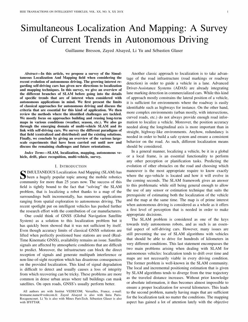
The SLAM problem can be formulated in two ways. Inthe first one, the goal is to estimate the whole trajectory ofthe vehicle and the map given all the control inputs and allthe measurements. A graphical representation can be seen inFigure 1. This problem, known as full SLAM, computes thejoint posterior over all the poses and the map based on theentirety of sensor data:
bel(x0:k,m) = p(x0:k,m | z0:k,u0:k) (1)
Fig. 1: Graphical representation of the full SLAM problem
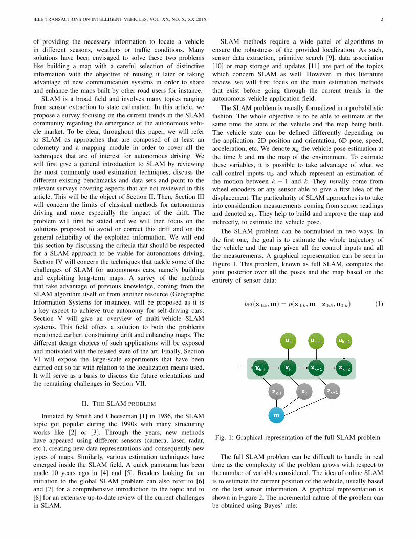
The full SLAM problem can be difficult to handle in realtime as the complexity of the problem grows with respect tothe number of variables considered. The idea of online SLAMis to estimate the current position of the vehicle, usually basedon the last sensor information. A graphical representation isshown in Figure 2. The incremental nature of the problem canbe obtained using Bayes’ rule:
IEEE TRANSACTIONS ON INTELLIGENT VEHICLES, VOL. XX, NO. X, XX 201X 3
bel(xk,m) = p(xk,m | z0:k,u0:k)
∝ p(zk | xk,m)∫xk−1
p(xk | xk−1,uk)bel(xk−1,m)dxk−1
(2)
Fig. 2: Graphical representation of the online SLAM problemat time k + 2
The estimation techniques can be separated into two maincategories: filter-based approaches and optimization-basedmethods. The former corresponds to iterative processes that arethus suited to online SLAM and the latter regroups methodsperforming batch treatments and, as such, are usually appliedto solve the full SLAM problem even if this trend has changedduring the last ten years.
A. Filter-based SLAM
Filter-based methods derive from Bayesian filtering andwork as two-step iterative processes. In the first step, aprediction of the vehicle and the map states is made usingan evolution model and the control inputs uk. In the secondstep, the current observation, zk, coming from sensor data, ismatched against the map in order to provide a correction ofthe previously predicted state. The model that put in relationthe observation with the map is called an observation model.These two steps iterate and so incrementally integrate sensordata to estimate the vehicle pose and the map.
1) Extended Kalman Filter: The first branch of the filter-based methods concerns derivatives of the Kalman Filter (KF)[12]. KFs assume that data are affected by Gaussian noiseswhich is not necessarily true in our case. At its basic form,KFs are designed to handle linear systems and while theyhave great convergence properties [13][14], they are rarelyused for SLAM. On the other hand, the Extended KalmanFilter (EKF) [15] is a common tool in non-linear filteringand as such in SLAM. The EKF adds a linearization stepfor non-linear models. The linearization is performed aroundthe current estimate by a first order Taylor expansion. Theoptimality of the EKF has been demonstrated as long as thelinearization is made around the true value of the state vector.In practice, it is the value to estimate and is thus not available.
This can cause consistency issues: the true value can be outsideof the estimated uncertainty [16][17].
However, estimates are most of the time sufficiently closeto the truth to allow the use of the EKF. Sensors like laserscanners for instance, that provide a range information, areparticularly adapted [18][19]. Sonars were among the first EKFSLAM approaches for underwater applications [20][21]. Bothsensors have been combined in an EKF SLAM approach in[22]. A coupling of vision and laser has also been proposedin [23]. Monocular approaches have also largely been studied.In [24], the landmarks composing the map are inserted inthe EKF only when sufficiently accurate. In [25], a specificlandmark parametrization is proposed. In [26], the authorsstudied the impact of the Kalman gain on an update in orderto constrain linearization errors.
The continuously growing map size makes the EKF unableto support large-scale SLAM as the update time depends, in aquadratic way, on the size of the state vector. To overcome thisissue, the notion of submaps has been created. Each time a mapbecomes too large (various criteria can be used to decide so), anew blank map replaces the old one. A higher-level map keepstrack of the links between the submaps not to lose information.Among the first submap-based approaches, we can cite [27]with the Constrained Relative Submap Filter where submapsare decorrelated from one another but where loop closure (driftcorrection based on the recognition of a previously visitedplace) is difficult to perform. The constant-time SLAM [28]and the Network Coupled Features Maps [29] work in a similarfashion except that landmarks common between submapsare kept to ease the change from one to another but thesemethods ignore correlated data. The Atlas framework [30]takes advantage of a graph structure where nodes are submapsand vertices the transformation between two submaps. Loopclosures can only be applied offline. Estrada et al. solve thisproblem by maintaining two high-level maps [31] but stilluse landmarks in multiple submaps. Conditionally independentsubmaps were proposed in [32] as a solution to this issue. Theidea is to marginalize the information that is not commonto two submaps in order to make them independent giventhe common part. A different approach is chosen in [33]. Adivide and conquer method is proposed to join the local mapscreated so as to recover an exact global map. New criteria todecide when to create submaps have also been proposed likethe number of simultaneously observable landmarks in [34] orthe correlation between landmarks in [35]. An alternative tosubmaps, the Compressed EKF SLAM, has been presented in[19]. In this work, the state vector is divided into an active(and updated) part and another one which is compressed intoa light auxiliary coefficient matrix.
2) Unscented Kalman Filter: To compensate the weak-nesses of the EKF with highly non-linear systems, Julier etal. introduced the Unscented Kalman Filter (UKF) [36] whichavoids the computation of the Jacobians. The idea is to sampleparticles, called sigma points, which are pondered around theexpected value thanks to a likelihood function. These sigmapoints are then passed to the non-linear function and theestimate is recomputed. The major drawback of this methodis its computational time. Most of the works using the UKF
IEEE TRANSACTIONS ON INTELLIGENT VEHICLES, VOL. XX, NO. X, XX 201X 4
took place at the beginning of the 2000s [37][38]. A real-timeapplication to a monocular context has been demonstrated in[39].
3) Information Filter: Another variant of the Kalman Filteris the Information Filter (IF) [40] which is the inverse form ofthe Kalman Filter. Its particularity is to define the informationmatrix as the inverse of the covariance matrix. One mainadvantage is that the update step becomes additive and is notdependent on the order in which the observations are integrated[41]. It is also possible to make the information matrix sparserby breaking the weak links between data [42] which ensuresa near constant-time update [43]. The IF is not as popular asthe EKF in mono-vehicle SLAM despite some applications in[44][45][46] because it is necessary to convert every measurein its inverse form which can be costly. However, the IF hasbeen more exploited for multi-vehicle SLAM (see Section V).
4) Particle Filter: The second major branch in filteringSLAM algorithms is based on Particle Filters (PF). Theirprinciple is the following: the state is sampled with a set ofparticles according to its probability density. Then, as withevery filter, a prediction of the displacement of each particleis accomplished and an update, depending on the observation,is performed. In the update phase, particles are weightedaccording to their likelihood regarding the measures. The mostlikely particles are kept, the others are eliminated and new onesare generated [3]. The direct application of this method to theSLAM is difficult to tract because it requires a set of particlesper landmark. Variations of PFs have then appeared, likethe Distributed Particle approaches DP-SLAM [47] and DP-SLAM 2.0 [48] which proposed to use a minimal ancestry treeas a data storage structure. It enables fast updates by guidingthe PF while reducing the number of iterations of the latter.However, the most famous PF algorithm is FastSLAM [49]which has been greatly influenced by previous works [50][51]on the subject. Each landmark is estimated with an EKF andparticles are only used for the trajectory. FastSLAM has beenapplied in real-time in [52]. The major advantage of PFs isthat they do not require a Gaussian noise assumption andcan accommodate with any distribution. Nevertheless, PFs alsosuffer from long-term inconsistency [53]. In [54], this problemwas tackled by combining FastSLAM to an IF but the resultis computationally heavy. In [55], FastSLAM was applied tolaser data where the matching gives an odometry measurewhich is then used to weight particles in the resamplingphase. Still regarding FastSLAM, its Bayesian foundationswere extended to the Transferable Belief Model framework(TBM) in [56] thus allowing the representation of conflict inthe employed grid map.
Filter-based approaches tend to now rely on 3D pointswhen it comes to vision sensors [24] and 2D occupancygrids with laser data. The latter, introduced in [57] and [58],are particularly suited to SLAM as the discretization of thespace due to the grid itself allows for a finite number ofposition candidates to test during the update step. Landmarkuncertainties are represented by the occupancy probability ofthe cell which makes updates on map parts possible. Duringthe update step, the classical approach is to maximize the simi-larity between the measurement and the map like in [59] in the
Bayes formalism or in [60] in the TBM context. Not mentionedyet, the use of RADARs for SLAM has been demonstratedwith filter-based approaches in [61][62][63]. However, theiruse remains limited in large-scale experiments due to the noisynature of the signal. They are usually employed for obstacledetection.
B. Optimization-based SLAM
Optimization-oriented SLAM approaches generally consistof two subsystems, as in filter-based SLAM. The first oneidentifies the constraints of the problem based on sensor databy finding a correspondence between new observations and themap. The second subsystem computes or refines the vehiclepose (and past poses) and the map given the constraints so asto have a coherent whole. As for filters, we can divide thesemethods into two main branches: bundle adjustment and graphSLAM.
1) Bundle Adjustment: Bundle adjustment is a vision tech-nique that jointly optimizes a 3D structure and the cameraparameters (pose). Most of the early works focused on 3Dreconstruction [64] but it has since then been applied toSLAM. The main idea is to optimize, usually using theLevenberg-Marquardt algorithm [65], an objective function.The latter minimizes the reprojection error (distance betweenobservations in the image and reprojected past features) givingthe best camera and landmark positions. However, the corebundle adjustment algorithm can be computationally heavy asit considers all the variables at once to optimize over.
Since then, many approaches have been proposed to per-form local optimizations. In [66][67], a hierarchical methodworking on smaller chunks is presented. The partial 3D modelsobtained are then merged in a hierarchical fashion. To reducethe complexity, two virtual key frames are chosen or createdamong all the frames to represent a given portion. This lessensthe number of variables to optimize. A similar method hasbeen applied to autonomous driving in [68] with accuratelocalization results but an offline map building.
In [69], an incremental method optimizing only over thenew information is proposed. In the worst case, it is equivalentto a full bundle adjustment. In [70], the authors use a slidingwindow over key frames triplets to locally minimize thereprojection errors. Points common between two views areconsidered in the optimization phase. The principle of a tripletof images is common in the bundle adjustment community. Aswith every optimization technique, bundle adjustment workswell when a good rough estimate is given. In that sense itis important to filter outliers. Nister et al. [71] proposed aselection method based on a preemptive RANSAC [72]. Eventhough it allows for a real-time application (13 Hz), results areless accurate than in [68]. A local bundle adjustment has beenproposed in [11]. The objective is to locally optimize the last ncamera positions based on the 2D reprojections of the points inthe last N frames (N ≥ n). These parameters can be tuned toobtain a real-time approach with good results. An integrationof inertial measures has been proposed in [73]. A bi-objectivefunction (vision and inertial objective functions) is weighedwith coefficients set thanks to a machine learning approach.
IEEE TRANSACTIONS ON INTELLIGENT VEHICLES, VOL. XX, NO. X, XX 201X 5
Another alternative is to optimize only a set of frames in orderto solve loop closing problems. This is the idea presented in[74] where the authors keep skeleton frames and marginalizeout most of the features and frames in the process. This methodis very close to graph SLAM techniques.
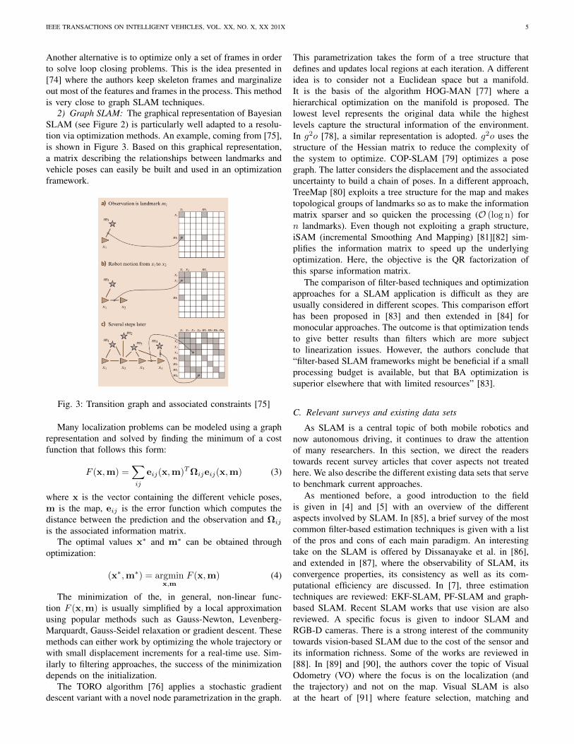
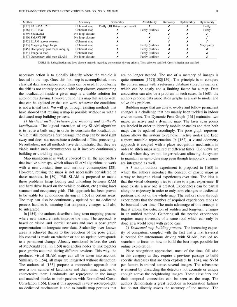
2) Graph SLAM: The graphical representation of BayesianSLAM (see Figure 2) is particularly well adapted to a resolu-tion via optimization methods. An example, coming from [75],is shown in Figure 3. Based on this graphical representation,a matrix describing the relationships between landmarks andvehicle poses can easily be built and used in an optimizationframework.
Fig. 3: Transition graph and associated constraints [75]
Many localization problems can be modeled using a graphrepresentation and solved by finding the minimum of a costfunction that follows this form:
F (x,m) =∑ij
eij(x,m)TΩijeij(x,m) (3)
where x is the vector containing the different vehicle poses,m is the map, eij is the error function which computes thedistance between the prediction and the observation and Ωij
is the associated information matrix.The optimal values x∗ and m∗ can be obtained through
optimization:
(x∗,m∗) = argminx,m
F (x,m) (4)
The minimization of the, in general, non-linear func-tion F (x,m) is usually simplified by a local approximationusing popular methods such as Gauss-Newton, Levenberg-Marquardt, Gauss-Seidel relaxation or gradient descent. Thesemethods can either work by optimizing the whole trajectory orwith small displacement increments for a real-time use. Sim-ilarly to filtering approaches, the success of the minimizationdepends on the initialization.
The TORO algorithm [76] applies a stochastic gradientdescent variant with a novel node parametrization in the graph.
This parametrization takes the form of a tree structure thatdefines and updates local regions at each iteration. A differentidea is to consider not a Euclidean space but a manifold.It is the basis of the algorithm HOG-MAN [77] where ahierarchical optimization on the manifold is proposed. Thelowest level represents the original data while the highestlevels capture the structural information of the environment.In g2o [78], a similar representation is adopted. g2o uses thestructure of the Hessian matrix to reduce the complexity ofthe system to optimize. COP-SLAM [79] optimizes a posegraph. The latter considers the displacement and the associateduncertainty to build a chain of poses. In a different approach,TreeMap [80] exploits a tree structure for the map and makestopological groups of landmarks so as to make the informationmatrix sparser and so quicken the processing (O (log n) forn landmarks). Even though not exploiting a graph structure,iSAM (incremental Smoothing And Mapping) [81][82] sim-plifies the information matrix to speed up the underlyingoptimization. Here, the objective is the QR factorization ofthis sparse information matrix.
The comparison of filter-based techniques and optimizationapproaches for a SLAM application is difficult as they areusually considered in different scopes. This comparison efforthas been proposed in [83] and then extended in [84] formonocular approaches. The outcome is that optimization tendsto give better results than filters which are more subjectto linearization issues. However, the authors conclude that“filter-based SLAM frameworks might be beneficial if a smallprocessing budget is available, but that BA optimization issuperior elsewhere that with limited resources” [83].
C. Relevant surveys and existing data sets
As SLAM is a central topic of both mobile robotics andnow autonomous driving, it continues to draw the attentionof many researchers. In this section, we direct the readerstowards recent survey articles that cover aspects not treatedhere. We also describe the different existing data sets that serveto benchmark current approaches.
As mentioned before, a good introduction to the fieldis given in [4] and [5] with an overview of the differentaspects involved by SLAM. In [85], a brief survey of the mostcommon filter-based estimation techniques is given with a listof the pros and cons of each main paradigm. An interestingtake on the SLAM is offered by Dissanayake et al. in [86],and extended in [87], where the observability of SLAM, itsconvergence properties, its consistency as well as its com-putational efficiency are discussed. In [7], three estimationtechniques are reviewed: EKF-SLAM, PF-SLAM and graph-based SLAM. Recent SLAM works that use vision are alsoreviewed. A specific focus is given to indoor SLAM andRGB-D cameras. There is a strong interest of the communitytowards vision-based SLAM due to the cost of the sensor andits information richness. Some of the works are reviewed in[88]. In [89] and [90], the authors cover the topic of VisualOdometry (VO) where the focus is on the localization (andthe trajectory) and not on the map. Visual SLAM is alsoat the heart of [91] where feature selection, matching and
IEEE TRANSACTIONS ON INTELLIGENT VEHICLES, VOL. XX, NO. X, XX 201X 6
map representation are addressed. Recently, Ros et al., in[92], present the challenges of Visual SLAM for driverlesscars: building long-life maps, how to share maps betweenvehicles and the necessity to work on high-level features toease recognition. A very complete survey on visual placerecognition has also been published lately [93]. The authorsgo through the different modules that are essential in this field:image processing (descriptors, etc.), maps (representation) andthe estimation part called belief generation. While this surveywill also explore place recognition as it is an important aspectof SLAM, we will focus on its application to autonomousvehicle and on the maturity of existing approaches. Alreadymentioned before is the considerable work of Cadena et al.in [8] where the SLAM topic is reviewed as a whole. Someaspects, not necessarily applicable yet in autonomous driving,will not be covered here (active SLAM, for instance). Onceagain, we will insist on the key topics with regards to self-driving cars and the experimental results of current state-of-the-art approaches. Finally, in [94], the authors reviewmultiple-robot SLAM approaches with a description of theunderlying mathematical formulation. In our dedicated section,we will complete this survey with cloud-based approaches andalso give some insights about the current results in this fieldand the expected future directions in autonomous driving.
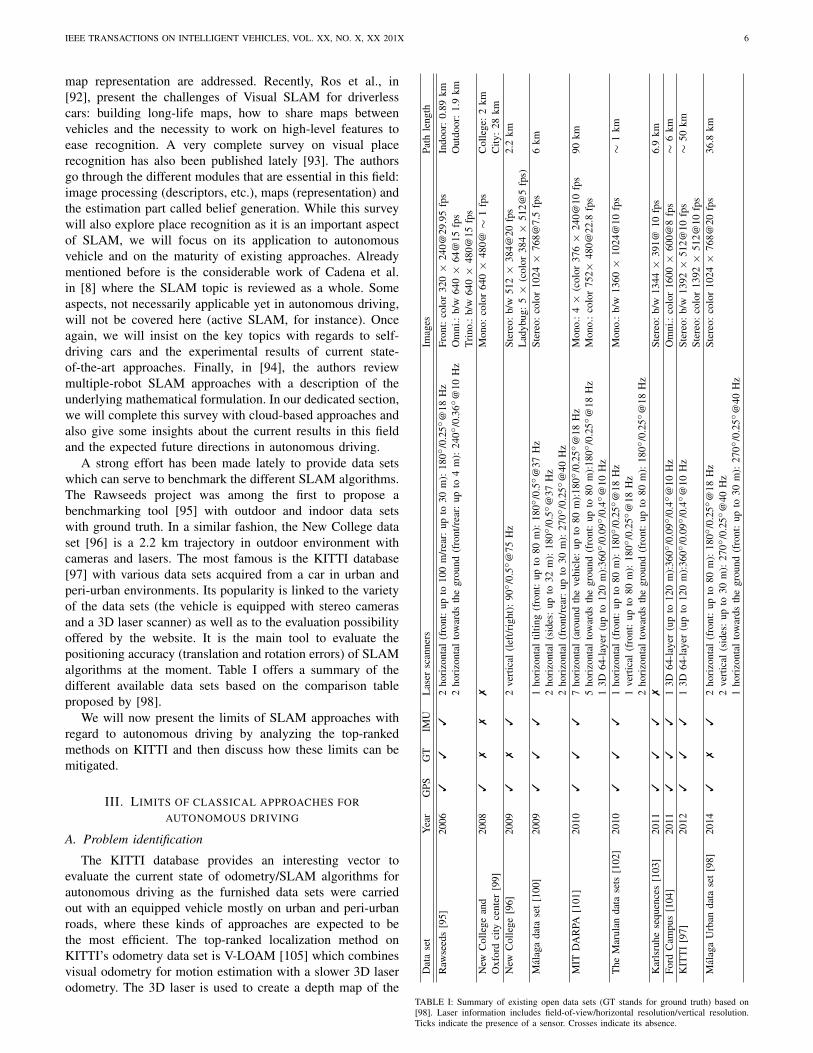
A strong effort has been made lately to provide data setswhich can serve to benchmark the different SLAM algorithms.The Rawseeds project was among the first to propose abenchmarking tool [95] with outdoor and indoor data setswith ground truth. In a similar fashion, the New College dataset [96] is a 2.2 km trajectory in outdoor environment withcameras and lasers. The most famous is the KITTI database[97] with various data sets acquired from a car in urban andperi-urban environments. Its popularity is linked to the varietyof the data sets (the vehicle is equipped with stereo camerasand a 3D laser scanner) as well as to the evaluation possibilityoffered by the website. It is the main tool to evaluate thepositioning accuracy (translation and rotation errors) of SLAMalgorithms at the moment. Table I offers a summary of thedifferent available data sets based on the comparison tableproposed by [98].
We will now present the limits of SLAM approaches withregard to autonomous driving by analyzing the top-rankedmethods on KITTI and then discuss how these limits can bemitigated.
III. LIMITS OF CLASSICAL APPROACHES FORAUTONOMOUS DRIVING
A. Problem identification
The KITTI database provides an interesting vector toevaluate the current state of odometry/SLAM algorithms forautonomous driving as the furnished data sets were carriedout with an equipped vehicle mostly on urban and peri-urbanroads, where these kinds of approaches are expected to bethe most efficient. The top-ranked localization method onKITTI’s odometry data set is V-LOAM [105] which combinesvisual odometry for motion estimation with a slower 3D laserodometry. The 3D laser is used to create a depth map of the
Dat
ase
tY
ear
GPS
GT
IMU
Las
ersc
anne
rsIm
ages
Path
leng
th
Raw
seed
s[9
5]20
063
33
2ho
rizo
ntal
(fro
nt:
upto
100
m/r
ear:
upto
30m
):18
0/0
.25
@18
Hz
Fron
t:co
lor
320×
240@
29.9
5fp
sIn
door
:0.
89km
2ho
rizo
ntal
tow
ards
the
grou
nd(f
ront
/rea
r:up
to4
m):
240
/0.3
6@
10H
zO
mni
.:b/
w64
0×
64@
15fp
sO
utdo
or:
1.9
kmTr
ino.
:b/
w64
0×
480@
15fp
sN
ewC
olle
gean
d20
083
77
7M
ono:
colo
r64
0×
480@
∼1
fps
Col
lege
:2
kmO
xfor
dci
tyce
nter
[99]
City
:28
kmN
ewC
olle
ge[9
6]20
093
73
2ve
rtic
al(l
eft/r
ight
):90
/0
.5
@75
Hz
Ster
eo:
b/w
512×
384@
20fp
s2.
2km
Lad
ybug
:5×
(col
or38
4×
512@
5fp
s)M
alag
ada
tase
t[1
00]
2009
33
31
hori
zont
altil
ting
(fro
nt:
upto
80m
):18
0/0
.5
@37
Hz
Ster
eo:
colo
r10
24×
768@
7.5
fps
6km
2ho
rizo
ntal
(sid
es:
upto
32m
):18
0/0
.5
@37
Hz
2ho
rizo
ntal
(fro
nt/r
ear:
upto
30m
):27
0/0
.25
@40
Hz
MIT
DA
RPA
[101
]20
103
33
7ho
rizo
ntal
(aro
und
the
vehi
cle:
upto
80m
):18
0/0
.25
@18
Hz
Mon
o.:
4×
(col
or37
6×
240@
10fp
s90
km5
hori
zont
alto
war
dsth
egr
ound
(fro
nt:
upto
80m
):18
0/0
.25
@18
Hz
Mon
o.:
colo
r75
2×48
0@22
.8fp
s1
3D64
-lay
er(u
pto
120
m):
360
/0.0
9/0
.4
@10
Hz
The
Mar
ulan
data
sets
[102
]20
103
33
1ho
rizo
ntal
(fro
nt:
upto
80m
):18
0/0
.25
@18
Hz
Mon
o.:
b/w
1360
×10
24@
10fp
s∼
1km
1ve
rtic
al(f
ront
:up
to80
m):
180
/0.2
5@
18H
z2
hori
zont
alto
war
dsth
egr
ound
(fro
nt:
upto
80m
):18
0/0
.25
@18
Hz
Kar
lsru
hese
quen
ces
[103
]20
113
33
7St
ereo
:b/
w13
44×
391@
10fp
s6.
9km
Ford
Cam
pus
[104
]20
113
33
13D
64-l
ayer
(up
to12
0m
):36
0/0
.09
/0.4
@10
Hz
Om
ni.:
colo
r16
00×
600@
8fp
s∼
6km
KIT
TI
[97]
2012
33
31
3D64
-lay
er(u
pto
120
m):
360
/0.0
9/0
.4
@10
Hz
Ster
eo:
b/w
1392
×51
2@10
fps
∼50
kmSt
ereo
:co
lor
1392
×51
2@10
fps
Mal
aga
Urb
anda
tase
t[9
8]20
143
73
2ho
rizo
ntal
(fro
nt:
upto
80m
):18
0/0
.25
@18
Hz
Ster
eo:
colo
r10
24×
768@
20fp
s36
.8km
2ve
rtic
al(s
ides
:up
to30
m):
270
/0.2
5@
40H
z1
hori
zont
alto
war
dsth
egr
ound
(fro
nt:
upto
30m
):27
0/0
.25
@40
Hz
TABLE I: Summary of existing open data sets (GT stands for ground truth) based on[98]. Laser information includes field-of-view/horizontal resolution/vertical resolution.Ticks indicate the presence of a sensor. Crosses indicate its absence.
IEEE TRANSACTIONS ON INTELLIGENT VEHICLES, VOL. XX, NO. X, XX 201X 7
visual features and also to extract geometric feature points(edge points and planar points) that are matched with theprevious 3D scan. The obtained transformation serves for theinitialization of an ICP matching with the map. This approachis able to reach a 0.68 % translation error and a 0.0016deg.m−1 rotation error on the KITTI benchmark. The beststereo approach on KITTI is a visual odometry named SOFT[106]. This algorithm is based on a careful feature selectionand tracking. Corner-like features are extracted in both images.Correspondences are sought through SAD (Sum of AbsoluteDifferences) over small windows. These features must bematched in two consecutive images to be viable. A NormalizedCross Correlation (NCC) test is performed to remove the lastoutliers. The frame-to-frame motion is estimated separately forrotation and translation with different algorithms. A similarfocus is chosen in [107]. An outlier removal scheme, basedon an analysis of landmark reprojection errors, serves to definea criterion to reject outliers. Another interesting approach isdescribed in [108]. The authors use state-of-the-art monoculartechniques but applied to a stereo system. This again impliesa strong focus on inliers identification and tracking. Theperformance of these visual methods reaches around 1 % forthe translation error and a rotation error below 0.003 deg.m−1.
These four approaches are among the better ranked onKITTI. Even though the results are impressive, the drift thataffects them makes their use over long distances impossible.For example, a 1 % translation drift alone (without rotationerror) implies that after 100 meters, the vehicle is one meteraway from its real, absolute localization. Ways to constrain,correct or avoid this long-term drift must thus be takeninto consideration. The large-scale environments involved byautonomous driving are an important concern as a decimetricaccuracy must be maintained during several kilometers (atwenty-centimeter accuracy is often recommended [109]). It isthus of vital importance to find a solution, be it under the formof absolute constraints or by studying how the drift occurs andcan be modeled.
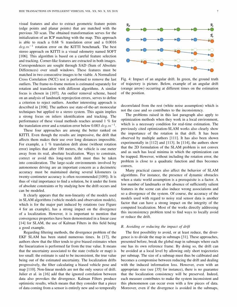
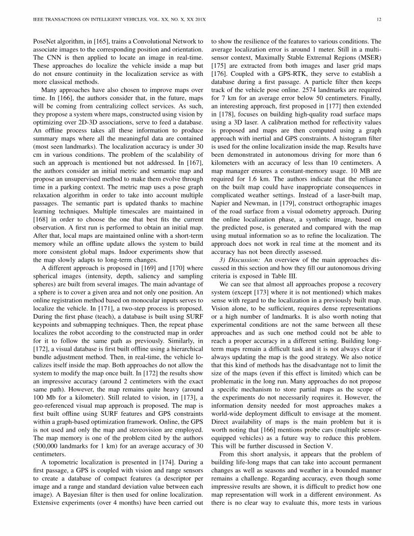
It clearly appears that the non-linearity of the models usedin SLAM algorithms (vehicle models and observation models),which is for the major part induced by rotations (see Figure4 for an example), has a strong impact on the divergenceof a localization. However, it is important to mention thatconvergence properties have been demonstrated in a linear case[14] for SLAM, the use of Kalman Filters in this field beinga good example.
Regarding filtering methods, the divergence problem of theEKF SLAM has been stated numerous times. In [17], theauthors show that the filter tends to give biased estimates whenthe linearization is performed far from the true value. It meansthat the uncertainty associated to the state (vehicle or map) istoo small: the estimate is said to be inconsistent, the true valuebeing out of the estimated uncertainty. The localization driftsprogressively, the filter calculating a biased vehicle pose andmap [110]. Non-linear models are not the only source of drift.Julier et al. in [16] add that the ignored correlation betweendata also provokes the divergence. Kalman Filters produceoptimistic results, which means that they consider that a pieceof data coming from a sensor is entirely new and so temporally
Fig. 4: Impact of an angular drift. In green, the ground truthof trajectory is picture. Below, example of an angular drift(orange arrow) occurring at different times on the estimationof the position.
decorrelated from the rest (white noise assumption) which isnot the case and so contributes to the inconsistency.
The problems raised in this last paragraph also apply tooptimization methods when they work in a local environment,which is a necessary condition for real-time estimation. Thepreviously cited optimization-SLAM works also clearly showthe importance of the rotation in that drift. It has beenobserved by multiple authors [111]. It has also been shownexperimentally in [112] and [113]. In [114], the authors showthat the 2D formulation of the SLAM problem is not convexand as such has local minima in which the optimization canbe trapped. However, without including the rotation error, theproblem is close to a quadratic function and thus becomesconvex.
Many practical causes also affect the behavior of SLAMalgorithms. For instance, the presence of dynamic obstacleswhen a static world assumption is a prerequisite is a factor. Alow number of landmarks or the absence of sufficiently salientfeatures in the scene can also induce wrong associations andso a divergence of the system. Of course, the accuracy of themodels used with regard to noisy real sensor data is anotherfactor that can have a strong impact on the integrity of thecomputed localization. Most of the works directly addressingthis inconsistency problem tend to find ways to locally avoidor reduce the drift.
B. Avoiding or reducing the impact of drift
The first possibility to avoid, or at least reduce, the diver-gence is to divide the map in submaps [31]. These approaches,presented before, break the global map in submaps where eachone has its own reference frame. By doing so, the drift canbe avoided at a local level by allowing only short trajectoriesper submap. The size of a submap must thus be calibrated andbecomes a compromise between reducing the drift and dealingwith the induced information loss. However, even with anappropriate size (see [35] for instance), there is no guaranteethat the localization consistency will be preserved. Indeed,each measure contributes to make the system inconsistent andthis phenomenon can occur even with a few pieces of data.Moreover, even if the divergence is avoided in the submaps,
IEEE TRANSACTIONS ON INTELLIGENT VEHICLES, VOL. XX, NO. X, XX 201X 8
it is not the case in the global map that keeps track of howthe submaps are connected. It is thus more of a local solutionto the problem.
In a similar fashion, robot-centered approaches greatlyreduce the divergence [115]. Instead of having a fixed worldframe, the estimates are always given with relation to thevehicle position. Inconsistency problems are less frequentbecause they do not accumulate like it is usually the case. Theestimation in this frame allows for a better consistency than inclassical EKF SLAM [116]. Nevertheless, as with submaps,the divergence is not entirely resolved as landmarks candiverge with only several measures. A few SLAM approacheshave used a robot-centered frame with success [117][118].Landmarks are forgotten as soon as they are not visible whichrelates these methods to visual odometry and is as such totallyappropriate.
Other practical causes can create drift and inconsistencysuch as the presence of mobile obstacles when a static worldis expected. This problem has been tackled in SLAMMOT(Mobile Object Tracking) or SLAM-DATMO (Detection AndTracking of Moving Objects) approaches [119][120][121]. Theidea is to take advantage of the map building process todirectly detect and track obstacles by analyzing observationswhich are not coherent with the vehicle displacement. Alterna-tively, credibilist approaches [60], which represent ambiguousinformation, can indirectly deal with dynamic obstacles. Theydo not detect or track these obstacles but instead treat themas conflicts which allows the algorithm to affect a very lowweight to these observations when estimating the vehicledisplacement.
More generally, the quality and number of selected land-marks in the SLAM process have a clear impact on how thesystem behaves. Ambiguities can cause matching errors andso the inconsistency of the produced estimates. Related tothis problematic, Fault Detection and Isolation (FDI) systemspropose to exploit information redundancy to measure the co-herence of different sources (sensors, models, etc.) and detecterrors or failures of one of the sources. By doing so, it becomespossible to know if the system is in a situation prone to errorsand so reject spurious measures to avoid drift. In [122], theauthors propose to analyze the residuals of a bank of KalmanFilters using thresholds to determine if one filter is diverging.A similar approach is described in [123] but the decision partis given to a Neural Network. Sundvall and Jensfelt, in [124],add a coherence measure between different estimations. In[125], Fault Detection is applied to GPS using the NormalizedInnovation Squared (NIS) test. Neural Networks are used in[126] to detect sensor failures by making measure predictionsusing approximators. In [127], the authors propose a visualodometry where photometric camera calibration is taken intoaccount in the minimization step in order to reduce the driftinduced by effects like lens attenuation, gamma correction,etc. The quality of the observations is increased compared tosimpler camera model.
An aspect that has often been considered to counter drift inSLAM algorithms is the use and fusion of multiple sources.Conversely to the previously described FDI methods, theidea is not to reject spurious measurements but for various
sensors to compensate each other. According to Luo et al.[128], three levels of information fusion can be identified:low-level with raw data, mid-level with features and high-level with objects. In [129], the authors propose to couplelaser with camera data. The fusion is done at a landmarklevel (laser estimation followed by camera refinement). In[130], camera, laser and GPS are fused based on informationcoherency. Already discussed before, the method described in[105] combines vision and 3D laser data to produce a low-drift algorithm. However, even if coupling information canbenefit the accuracy and consistency of an algorithm, it doesnot ensure that it will not drift. It only partially corrects thedrift induced by one sensor.
Even if these methods have been proven to reduce orpartially avoid the drift, it does not allow for a drift-freeestimation during long periods of time. Correcting the driftin a reliable manner involves that constraints about wherea vehicle is with relation to a previously known, local orabsolute, reference should be regularly taken into account.
C. Evaluation criteria for SLAM in autonomous driving
While the previously described approaches can be success-fully applied for autonomous indoor mobile robots with adedicated exploration scheme, it is not sufficient for the large-scale environments of the autonomous driving setting. It meansthat it is necessary to rely on previous knowledge (absolute orlocal information) or to be able to improve the built map overtime until it is accurate enough (loop closing, for instance). Assuch, the mapping aspect is central in self-driving vehicles andraises important challenges about how to build or use compact,relevant, reliable and evolutive maps.
We have identified 6 criteria that we think must be fulfilledby a SLAM approach to be viable for autonomous driving.They are described below:
• Accuracy: refers to how accurate the vehicle localizationis, be it in world coordinates or with relation to anexisting map. Ideally, the accuracy should be below athreshold (usually around 20 centimeters [109]) at alltimes. Of course, in straight lines, the longitudinal local-ization can be less accurate without major consequences.
• Scalability: refers to the capacity of the vehicle to handlelarge-scale autonomous driving. The SLAM algorithmshould be able to work in constant time and with aconstant memory usage. It implies the use of a mapmanager to load data when needed. The second aspect isthat the map built and/or used has to be light (or storedon a distant server and retrieved on the fly) so as for theapproach to be easily generalizable over long distances.
• Availability: refers to the immediate possibility for aSLAM algorithm to provide an adequate localizationthat could be used right away for autonomous driving ifsufficiently accurate. In other words, no first passage ofthe algorithm is needed to build a map of the environmentand it implies that the approach is able to leverageexisting map resources (or integrate absolute informationmore generally). This criterion is particularly importantnot to restrain where a self-driving vehicle can operate
IEEE TRANSACTIONS ON INTELLIGENT VEHICLES, VOL. XX, NO. X, XX 201X 9
(a world-wide mapping process is costly and requiresdedicated means).
• Recovery: refers to the ability to localize the vehicleinside a large-scale map. Initially, the vehicle does notknow where it is and a dedicated process is, most of thetime, needed to have a rough idea of its position in a map.It is also a way to recover from a failure (kidnapped robotproblem).
• Updatability: refers to the identification of permanentchanges between the map and the current observation. Italso includes the update policy that is needed to integratethese lasting changes and not the temporary ones. Long-term autonomous driving requires the automation of mapupdates.
• Dynamicity: refers to how the SLAM approach is able tohandle dynamic environments and changes. This includesdynamic obstacles that can distort the localization estima-tion. It also integrates weather conditions that can vary aswell as seasonal changes (trees losing leaves, etc.). One ofthe challenges of long-term SLAM is to find sufficientlydiscriminative features or methods in order to be robustagainst those changes.
We will now go through existing methods for both singleand multi-vehicle SLAM and compare them with regard tothe previously defined criteria so as to have a panorama onthe maturity of SLAM approaches for autonomous driving.
IV. SINGLE-VEHICLE SLAM
All the challenges that appear from the criteria detailedabove point at the necessity to build better maps and so atenvironment representation and recognition both at a metricand topological level. To cover this broad topic, we dividethe works in three categories which reflect how the SLAMcommunity usually considers their contributions. The first oneconcerns loop closure (recognizing a previously mapped place)which is an essential part of SLAM as it allows correctingmaps and making them coherent. An interesting aspect isthat these algorithms are usually applicable to relocalize avehicle inside its environment and so provide an answerto the recovery criterion. The second category deals withthe localization inside a previously built map. As previouslydiscussed, it is a direct way to constrain the drift. Theoretically,every SLAM approach could be reusing its map but we willfocus here on the articles that explicitly do so and on thosewhich address the long-term challenges of reusing maps. Athird part focuses on localization approaches that leverageexisting data so as to avoid the first passage of a specificallyequipped vehicle. For each part of this section, we will providea synthesis of the discussed approaches, how they respondto the previously established criteria and briefly discuss theremaining challenges.
A. Relocalization and loop closure
Recognizing a previously mapped place, and thus reducingthe drift induced by SLAM algorithms, is considered as anessential part of SLAM. The main difficulty comes from thefact that the estimation process is inconsistent and cannot be
trusted to find those loops. It means that, most of the time,this problem is solved by a dedicated algorithm that runsat all times, independently from the estimation process. Thisdedicated algorithm is also often used to relocalize the vehicleinside a previously built map (kidnapped robot problem) whichis of prime interest when considering autonomous vehicles.
Most of the approaches use cameras to find loops becauseof the richness of the visual information. Williams et al. [131]have identified 3 categories in which these algorithms can beseparated:
• Image-to-image methods [132]• Map-to-map methods [133]• Image-to-map methods [134]1) Image-to-image methods: In image-to-image methods,
the loop detection takes place in the sensor space. Bag-of-words approaches based on visual clues [132][135] belong tothis category. The idea is to build a dictionary where each wordrepresents similar descriptors. SIFT [136] is often used to finddescriptors and compare them due to its good robustness toscale, rotation or viewpoint changes in images. Many visualdescriptors can be considered in a redundant fashion (SURF,CenSurE, etc.) so as to have the largest database possible anda representative dictionary. Once the latter is built, it can beused to check if some images can be described with the samewords and thus be qualified as representing the same place.
Algorithms like FAB-MAP (Fast Appearance Based Map)[99] (and its extension FAB-MAP 2.0 [137]) and PIRF-Nav(Position Invariant Robust Feature Navigation) [138] are twoexamples of SLAM solutions based on landmark appearancefor loop closures. In the first one, information having a strongdependency is extracted so as to avoid false recognitions whichoften affect loop closing algorithms. The approach has beenevaluated on a 1000-km outdoor data set and shows that, usinga dictionary built offline, the algorithm can provide propertopological loop closures and make maps more coherent (thegain in accuracy is not evaluated). In [138], the objective isthe same but features allowing to be robust against dynamicchanges are favored (PIRF). A major difference with FAB-MAP is that the whole process is online and incremental.However, it does not scale well (quadratic complexity forimage retrieval) and as thus has not been applied to vehiclescontrary to FAB-MAP.
Still to reduce the number of false positives, SeqSLAM[139] proposes to be less discriminative on single imagesbut to analyze over sequences in order to ensure a propermatching. Results on a 22 and 8-km data sets demonstratethe ability of SeqSLAM to handle day/night matching in realtime (even though the computing time scales linearly with thesize of the data set) with different weather conditions underwhich FAB-MAP is unable to properly operate. SeqSLAMis demonstrated as a pure place recognition approach anddoes not apply loop closure to correct previous measurementseven though it is possible. SeqSLAM has even been extendedto integrate motion estimation between matching by using agraph structure representing the potential roads and a particlefilter to maintain the consistency of the positioning [140]. Thisapproach, SMART PF, shows better results than SeqSLAM.Another interesting approach is shown in [141] where the
IEEE TRANSACTIONS ON INTELLIGENT VEHICLES, VOL. XX, NO. X, XX 201X 10
algorithm is tested to find loop closures across differentseasons. To do so, the problem is also solved by using imagesequences. A flow network is built (a directed graph with startand end-of-traversal nodes) and is used to formulate the imagematching as a minimum cost flow problem. On the proposeddata set (summer/winter matching), the approach outperformsSeqSLAM. It requires a few seconds to process each image.An evolution of this method has been presented in [142]. Theauthors replaced the HOG features used to represent imageswith a global image feature map from a Deep ConvolutionalNeural Networks. They are able to obtain better performances.The found loops are taken into account in a graph-basedapproach (g2o [78]) with odometry constraints without givinginsights about the reached accuracy. The approach runs on aGPU and is thus faster than the previous implementation (realtime with a data set of 48,000 images) even though its speedstill depends on the data set size.
2) Map-to-map methods: Map-to-map methods are solelybased on information contained in the map. It is the caseof the GCBB algorithm (Geometric Constraint Branch andBound) proposed in [143]. The principle is to define geometricconstraints between landmark pairs in the map and the currentobservation. An association tree is established so to as tofind the most likely association hypothesis that respects thegeometric organization of the landmarks in the map. It hasbeen applied successfully in [133] with a hierarchical approachin outdoor experiments even if the accuracy of the resultingmap is not measured.
Li et al., in [144] and [145], proposed to merge occupancygrids by using a genetic algorithm to find the best alignmentpossible. A low-cost GPS is used to constrain the search spaceto smaller regions. Similarly to the previous example, theconsistency of the map is drastically improved but its accuracyis not measured. In the case that the drift can be approximatelyestimated, the JCBB algorithm (Joint Compatibility Branchand Bound) [146] selects compatible landmarks according totheir uncertainty.
Map-to-map methods are difficult to apply without any hintof where to look for loops as maps are either too sparse tobe sufficiently distinctive (monocular SLAM for instance) ortoo complex for a complete exploration in real-time. In suchcases, the use of a GPS, like in [145], makes sense as it allowsthe system to considerably reduce the exploration space.
3) Image-to-map methods: The last category, called image-to-map (or more generally sensor-to-map), extracts informa-tion from the sensor space and compares it directly with themap. The approach described in [134] is based on classifierstrained on the detected landmarks. The loop closing stageuses these classifiers on the image to check if there is amatch. Then, a RANSAC algorithm takes the corresponding3D positions to compute the new pose of the vehicle. Resultswith a single camera show that the map becomes coherent inan outdoor scenario.
Another possibility to close the loop or relocalize a vehicleis to use hierarchical techniques to speed up the processing. Alow-resolution map first serves to identify a rough positioningof the vehicle which is then refined as the map resolutionincreases. These methods are particularly suited to occupancy
grids and have been applied successfully to automated vehicleswith laser sensors in [147]. In this example, a coarse-to-fineapproach is used to relocalize the vehicle inside a map and notto perform loop closure. Experiments show that the methodworks well but that the size of the map is a crucial aspect.
4) Discussion: We have focused on how loop closure isapplied in SLAM algorithms. The recent years have seen aclear focus on how to deal with seasonal or weather changesand we refer our readers to this survey [93] for a detailed viewof this field, independently of loop closure.
Even it may seem like image-to-image methods are favored,recent approaches tend to couple different methods to ensurethat a place has been properly recognized. As an example,an application of FAB-MAP with a visual odometry can befound in [148]. The authors rely on dense stereo mappingand use FAB-MAP to indicate loop closures. Their metricintegration is done within a graph formulation and is calculatedusing the Iterative Closest Point (ICP) algorithm [149] betweenthe observation and the previously built map. Even if theaccuracy is not directly measured, the built map indicatesa consistent mapping. In [150], a bag-of-words method isfirst employed to generate candidates that are then checkedusing Conditional Random Fields (CRF) in which a constraintensures a geometric consistency between the landmarks. Thewhole approach is applied in a visual SLAM framework. InTable II, we give a brief overview of the principal methodsthat have been described here with relation to the autonomousdriving problematic.
Based on the established criteria, we can see that these ap-proaches propose a solution to the recovery problem. However,loop closure was initially seen as a way to correct drift. Whileit produces more coherent maps, the articles cited here donot clearly expose the gain in accuracy. In [151], the authorsexplain that closing the loop can counter the drift inside theloop but that the result will always be overconfident. Anotherapproach was proposed in [152] where errors are redistributedin a probabilistic fashion around the past trajectory when aloop is identified. It avoids the previously mentioned overcon-fidence problem but does not guarantee the consistency of thelocalization.
It also explains why the community does not necessarilyfocus on improving the accuracy but on addressing difficultconditions and building consistent maps. Even if the results areimpressive, especially with seasonal changes and sunny/rainconditions, the approaches cited here, when considered forautonomous driving, can be seen as a better GPS but withina given zone. As such, it gives two main challenges for thefuture: can these approaches be generalized by using alreadyavailable information (maps, images, etc.) to avoid the zonerestriction? Can these methods be extended and integrated intoSLAM frameworks to give very resilient approaches that couldbe viable for autonomous driving?
B. Localization in a previously built map
The localization of a vehicle in a previously built mapis tightly linked to the methods presented in the previoussection about loop closing and relocalization. Indeed, the first
IEEE TRANSACTIONS ON INTELLIGENT VEHICLES, VOL. XX, NO. X, XX 201X 11
Method Accuracy Scalability Availability Recovery Updatability Dynamicity[137] FAB-MAP 2.0 Coherent map Partly (1000-km experiment) 7 3 7 Partly[138] PIRF-Nav Coherent map 7 Partly (online) 3 7 Partly[139] SeqSLAM No loop closure 7 7 3 7 3
[140] SMART PF No loop closure 7 7 3 7 3
[142] SLAM across seasons Coherent map 7 7 3 7 3
[133] Mapping large loops Coherent map 3 Partly (online) 7 7 Very partly[145] Occupancy grid maps merging Coherent map 7 Partly (online) 7 7 7
[134] Image-to-map Coherent map 7 Partly (online) 3 7 7
[147] Occupancy grid map SLAM No loop closure 7 Partly (online) 3 7 7
TABLE II: Relocalization and loop closure methods regarding autonomous driving criteria. Tick: criterion satisfied. Cross: criterion not satisfied.
necessary action is to globally identify where the vehicle islocated in the map. Once this first step is accomplished, moreclassical data association algorithms can be used. If counteringthe drift is not entirely possible with loop closure, constrainingthe localization inside a given map is a viable solution forautonomous driving. However, building a map that scales well,that can be updated or that can work whatever the conditionsis not a trivial task. We will go through existing methods thathave showed that reusing a map is possible without or with adedicated map building process.
1) Identical method between first mapping and on-the-flylocalization: The logical extension of any SLAM algorithmis to reuse a built map in order to constrain the localization.While it still requires a first passage, the map can be used rightaway and does not necessitate a dedicated offline processing.Nevertheless, not all methods have demonstrated that they areviable under such circumstances as it involves continuouslybuilding or enriching maps.
Map management is widely covered by all the approachesthat involve submaps, which allows SLAM algorithms to workwith a near-constant time and memory consumption [28].However, reusing the maps is not necessarily considered inthese methods. In [59], PML-SLAM is proposed to tacklethese problems (map loading and unloading between RAMand hard drive based on the vehicle position, etc.) using laserscanners and occupancy grids. This approach has been provento be viable for autonomous driving in [153] in certain areas.The map can also be continuously updated but no dedicatedprocess handles it, meaning that temporary changes will alsobe integrated.
In [154], the authors describe a long-term mapping processwhere new measurements improve the map. The approach isbased on vision and inertial sensors and uses a pose graphrepresentation to integrate new data. Scalability over knownareas is achieved thanks to the reduction of the pose graph.No control is made on whether or not an update correspondsto a permanent change. Already mentioned before, the workof McDonald et al. in [150] uses anchor nodes to link togetherpose graphs acquired during different sessions. This way, theproduced visual SLAM maps can all be taken into account.Similarly to [154], all maps are integrated without distinction.The authors of [155] propose a monocular approach thatuses a low number of landmarks and their visual patches tocharacterize them. Landmarks are reprojected in the imageand matched thanks to their patches with Normalized Cross-Correlation [156]. Even if this approach is very resource-light,no dedicated mechanism is able to handle map portions that
are no longer needed. The use of a memory of images isquite common [157][158][159]. The principle is to comparethe current image with a reference database stored in memory,which can be costly and a limiting factor for a map. Dataassociation can also be a problem in such cases. In [160], theauthors propose data association graphs as a way to model andsolve this problem.
Building maps that are able to evolve and follow permanentchanges is a challenge that has mainly been tackled in indoorenvironments. The Dynamic Pose Graph [161] maintains twomaps: an active and a dynamic map. The laser scan pointsare labeled in order to identify mobile obstacles and then bothmaps can be updated accordingly. The pose graph represen-tation allows the system to remove inactive nodes and keepa more tractable representation. In [162], a visual odometryapproach is coupled with a place recognition mechanism inorder to stitch maps acquired at different times. Old views aredeleted when they are not longer relevant allowing the systemto maintain an up-to-date map even though temporary changesare integrated as well.
A 3-month outdoor experiment is proposed in [163] inwhich the authors introduce the concept of plastic maps asa way to integrate visual experiences over time. The idea isthat the visual odometry tries to relate to a past experience. Ifnone exists, a new one is created. Experiences can be partialalong the trajectory in order to only store changes on dedicatedportions and not on the whole map. The authors show throughexperiments that the number of required experiences tends tobe bounded over time. The main advantage of this concept isthat it allows the detection of sudden and long-term changesin an unified method. Gathering all the needed experiencesrequires many traversals of a same road which can only bedone at a world level with probe cars.
2) Dedicated map-building process: The increasing capac-ity of computers, coupled with the fact that a first traversalis needed for autonomous driving with SLAM, has led re-searchers to focus on how to build the best maps possible foronline exploitation.
Place recognition approaches, most of the time, fall alsoin this category as they require a previous passage to buildspecific databases that are then exploited. In [164], one SVMper feature is trained across several images. The robustnessis ensured by discarding the detectors not accurate or uniqueenough across the neighboring images. These classifiers andtheir temporal connection can be seen as the map. Theauthors demonstrate a great reduction in localization failuresbut do not directly assess the accuracy of the method. The
IEEE TRANSACTIONS ON INTELLIGENT VEHICLES, VOL. XX, NO. X, XX 201X 12
PoseNet algorithm, in [165], trains a Convolutional Network toassociate images to the corresponding position and orientation.The CNN is then applied to locate an image in real-time.These approaches do localize the vehicle inside a map butdo not ensure continuity in the localization service as withmore classical methods.
Many approaches have also chosen to improve maps overtime. In [166], the authors consider that, in the future, mapswill be coming from centralizing collect services. As such,they propose a system where maps, constructed using vision byoptimizing over 2D-3D associations, serve to feed a database.An offline process takes all these information to producesummary maps where all the meaningful data are contained(most seen landmarks). The localization accuracy is under 30cm in various conditions. The problem of the scalability ofsuch an approach is mentioned but not addressed. In [167],the authors consider an initial metric and semantic map andpropose an unsupervised method to make them evolve throughtime in a parking context. The metric map uses a pose graphrelaxation algorithm in order to take into account multiplepassages. The semantic part is updated thanks to machinelearning techniques. Multiple timescales are maintained in[168] in order to choose the one that best fits the currentobservation. A first run is performed to obtain an initial map.After that, local maps are maintained online with a short-termmemory while an offline update allows the system to buildmore consistent global maps. Indoor experiments show thatthe map slowly adapts to long-term changes.
A different approach is proposed in [169] and [170] wherespherical images (intensity, depth, saliency and samplingspheres) are built from several images. The main advantage ofa sphere is to cover a given area and not only one position. Anonline registration method based on monocular inputs serves tolocalize the vehicle. In [171], a two-step process is proposed.During the first phase (teach), a database is built using SURFkeypoints and submapping techniques. Then, the repeat phaselocalizes the robot according to the constructed map in orderfor it to follow the same path as previously. Similarly, in[172], a visual database is first built offline using a hierarchicalbundle adjustment method. Then, in real-time, the vehicle lo-calizes itself inside the map. Both approaches do not allow thesystem to modify the map once built. In [172] the results showan impressive accuracy (around 2 centimeters with the exactsame path). However, the map remains quite heavy (around100 Mb for a kilometer). Still related to vision, in [173], ageo-referenced visual map approach is proposed. The map isfirst built offline using SURF features and GPS constraintswithin a graph-based optimization framework. Online, the GPSis not used and only the map and stereovision are employed.The map memory is one of the problem cited by the authors(500,000 landmarks for 1 km) for an average accuracy of 30centimeters.
A topometric localization is presented in [174]. During afirst passage, a GPS is coupled with vision and range sensorsto create a database of compact features (a descriptor perimage and a range and standard deviation value between eachimage). A Bayesian filter is then used for online localization.Extensive experiments (over 4 months) have been carried out
to show the resilience of the features to various conditions. Theaverage localization error is around 1 meter. Still in a multi-sensor context, Maximally Stable Extremal Regions (MSER)[175] are extracted from both images and laser grid maps[176]. Coupled with a GPS-RTK, they serve to establish adatabase during a first passage. A particle filter then keepstrack of the vehicle pose online. 2574 landmarks are requiredfor 7 km for an average error below 50 centimeters. Finally,an interesting approach, first proposed in [177] then extendedin [178], focuses on building high-quality road surface mapsusing a 3D laser. A calibration method for reflectivity valuesis proposed and maps are then computed using a graphapproach with inertial and GPS constraints. A histogram filteris used for the online localization inside the map. Results havebeen demonstrated in autonomous driving for more than 6kilometers with an accuracy of less than 10 centimeters. Amap manager ensures a constant-memory usage. 10 MB arerequired for 1.6 km. The authors indicate that the relianceon the built map could have inappropriate consequences incomplicated weather settings. Instead of a laser-built map,Napier and Newman, in [179], construct orthographic imagesof the road surface from a visual odometry approach. Duringthe online localization phase, a synthetic image, based onthe predicted pose, is generated and compared with the mapusing mutual information so as to refine the localization. Theapproach does not work in real time at the moment and itsaccuracy has not been directly assessed.
3) Discussion: An overview of the main approaches dis-cussed in this section and how they fill our autonomous drivingcriteria is exposed in Table III.
We can see that almost all approaches propose a recoverysystem (except [173] where it is not mentioned) which makessense with regard to the localization in a previously built map.Vision alone, to be sufficient, requires dense representationsor a high number of landmarks. It is also worth noting thatexperimental conditions are not the same between all theseapproaches and as such one method could not be able toreach a proper accuracy in a different setting. Building long-term maps remain a difficult task and it is not always clear ifalways updating the map is the good strategy. We also noticethat this kind of methods has the disadvantage not to limit thesize of the maps (even if this effect is limited) which can beproblematic in the long run. Many approaches do not proposea specific mechanism to store partial maps as the scope ofthe experiments do not necessarily requires it. However, theinformation density needed for most approaches makes aworld-wide deployment difficult to envisage at the moment.Direct availability of maps is the main problem but it isworth noting that [166] mentions probe cars (multiple sensor-equipped vehicles) as a future way to reduce this problem.This will be further discussed in Section V.
From this short analysis, it appears that the problem ofbuilding life-long maps that can take into account permanentchanges as well as seasons and weather in a bounded mannerremains a challenge. Regarding accuracy, even though someimpressive results are shown, it is difficult to predict how onemap representation will work in a different environment. Asthere is no clear way to evaluate this, more tests in various
IEEE TRANSACTIONS ON INTELLIGENT VEHICLES, VOL. XX, NO. X, XX 201X 13
Method Accuracy Scalability Availability Recovery Updatability Dynamicity[59] PML-SLAM 3 3 Partly (online) 3 7 7
[154] Reduced pose graph Indoor Partly (not bounded) Partly (online) 3 Partly 7
[161] Dynamic Pose Graph Indoor Partly (not bounded) Partly (online) 3 Partly Very partly[163] Plastic maps Not measured Partly (not bounded) Partly (online) 3 3 3
[165] PoseNet 7 7 7 3 7 Partly[166] Summary maps 3 Partly (not bounded) 7 3 3 3
[168] Multiple timescales Indoor Partly (manual bound) 7 3 3 Partly[170] Sphere map 3 3 7 3 7 Very partly[172] Hierarchical Bundle Adjustment 3 7 7 3 7 Very partly[173] City GPS Not always sufficient 7 7 7 7 Very partly[174] Topometric localization 7 7 7 3 7 3
[176] MSER map Not always sufficient 7 7 3 7 7
[178] Road surface maps 3 3 7 3 7 Very partly
TABLE III: Localization in a previously built map methods regarding autonomous driving criteria. Tick: criterion satisfied. Cross: criterion not satisfied.
conditions are needed. The final, bigger problem is how canthe creation of these maps be generalized at a world level? Atthe moment, it is not clear if it will happen as world-wide rawsensor data may never be available.
C. Localization in existing maps
Even without world-wide raw sensor data, there exists manydifferent sources already furnishing large-scale information.In the prospect of facilitating the deployment of autonomousvehicles, many researchers have proposed approaches to lever-age these geographic information sources. In this part, we willfirst focus on new map (or potentially new) formats and theirapplications as it could drive how information are collectedin the near future. Then, we will discuss localization methodsthat already integrate existing widely available data to buildprior maps.
1) Building and using future maps: In the recent years,researchers have proposed custom map formats in order torespond to the need of a prior knowledge for autonomousdriving. Some have considered the practical challenges ofbuilding world-wide maps in an automatic way.
In [180], the authors propose a custom format, Emap(enhanced map), usable for a lane-level localization. Lanesare represented as a series of straight lines, circles or clothoidsbased on GNSS and dead reckoning measurements. This mapformat has been utilized in [181] in a 30-minute experimentwhere lane accuracy was achieved (error below 1 meter mostof the time). An extension of the Route Network DefinitionFile format (RNDF), initially specified by DARPA, is dis-cussed in [182]. This new format, RNDFGraph, overcomessome of the limitations of the original definition by includinglane relationships and lane change information. This is madepossible by using a graph representation. Splines are alsogenerated based on waypoints in order to ensure a smoothtrajectory. This format has been used in German highwaysfor path planning but not directly for localization purposes.Accurate lane-level map generation is also the objective pur-sued in [183]. Here, the authors combine line-segment featuresextracted from a 3D laser and a graph SLAM approach withan OpenStreet Map map. A particle filter is used to obtaina lane estimation that is then integrated inside the map. Theauthors show that they are able to reach an average accuracyof 5 cm. The map utilization inside a localization algorithm
is not proposed in the article. Still regarding automatic lane-level map generation, Guo et al. in [184] (and extended in[185]) propose a low-cost approach based on an OSM map,an INS, a GPS and orthographic images generated from acamera. The idea is that such a system could be used by probecars and could generalize the map-building process. First, theINS and GNSS measurements are optimized together to obtainthe vehicle localization. A second optimization using visualodometry is performed. The image is then aligned according tolocal map segment extracted from OSM. The lanes are finallyextracted from the orthographic image. Still centered on a pathplanning use, lanelets have been proposed in [186]. The formatis proposed with tools to manually create maps from satelliteviews. This map representation has been used in [109] butdedicated maps for localization were built as well. Finally, in[187], a system based on a high precision GNSS, a 3D laserand a cameras pointing downwards is proposed to build maps.Bird eye view images are generated and localized according tothe GNSS. Lane markings and curbs are then extracted fromthem and are manually reviewed. A localization application,LaneLoc, is proposed where the map is reprojected in theimages (no laser is used in the localization phase) using theestimated vehicle position. It eases the subsequent extractionof the lane markings and of the curbs. The localization is ableto reach the map accuracy (around 10 centimeters) most ofthe time.
All the previously cited methods bring geometric informa-tion to, for now, topologic-only maps. As such, approachesmaking use of this kind of prior information might be viable inthe near future. A map-aided localization is proposed in [188]that takes advantage of prior knowledge about lanes and stoplines. A vision system that detects these lanes and comparesthem with the map is implemented inside a particle filter thatalso integrates IMU and GPS measurements. This light systemis able to reach a 50-cm accuracy. In [189], the authors useonly road segments and integrate them inside FastSLAM. Theidea of this road constrained approach is to limit the lateraldeviation as well as angular errors by matching them with theexpected value computed from the map. The latter is builtusing a Differential GPS. A lane-accuracy is reached withan average error of 1.4 m. Similarly, an accurate digital mapof the lane markings is built and used in [190]. Fused withGPS and proprioceptive information, the lane detection allows
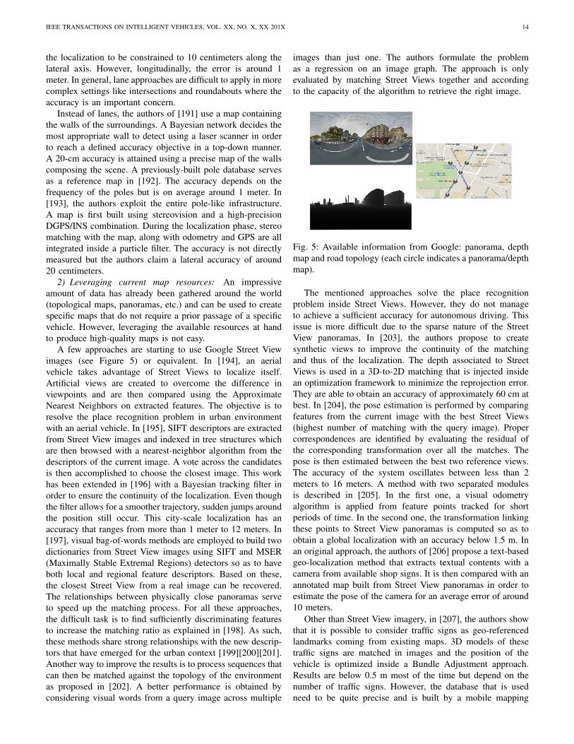
IEEE TRANSACTIONS ON INTELLIGENT VEHICLES, VOL. XX, NO. X, XX 201X 14
the localization to be constrained to 10 centimeters along thelateral axis. However, longitudinally, the error is around 1meter. In general, lane approaches are difficult to apply in morecomplex settings like intersections and roundabouts where theaccuracy is an important concern.
Instead of lanes, the authors of [191] use a map containingthe walls of the surroundings. A Bayesian network decides themost appropriate wall to detect using a laser scanner in orderto reach a defined accuracy objective in a top-down manner.A 20-cm accuracy is attained using a precise map of the wallscomposing the scene. A previously-built pole database servesas a reference map in [192]. The accuracy depends on thefrequency of the poles but is on average around 1 meter. In[193], the authors exploit the entire pole-like infrastructure.A map is first built using stereovision and a high-precisionDGPS/INS combination. During the localization phase, stereomatching with the map, along with odometry and GPS are allintegrated inside a particle filter. The accuracy is not directlymeasured but the authors claim a lateral accuracy of around20 centimeters.
2) Leveraging current map resources: An impressiveamount of data has already been gathered around the world(topological maps, panoramas, etc.) and can be used to createspecific maps that do not require a prior passage of a specificvehicle. However, leveraging the available resources at handto produce high-quality maps is not easy.
A few approaches are starting to use Google Street Viewimages (see Figure 5) or equivalent. In [194], an aerialvehicle takes advantage of Street Views to localize itself.Artificial views are created to overcome the difference inviewpoints and are then compared using the ApproximateNearest Neighbors on extracted features. The objective is toresolve the place recognition problem in urban environmentwith an aerial vehicle. In [195], SIFT descriptors are extractedfrom Street View images and indexed in tree structures whichare then browsed with a nearest-neighbor algorithm from thedescriptors of the current image. A vote across the candidatesis then accomplished to choose the closest image. This workhas been extended in [196] with a Bayesian tracking filter inorder to ensure the continuity of the localization. Even thoughthe filter allows for a smoother trajectory, sudden jumps aroundthe position still occur. This city-scale localization has anaccuracy that ranges from more than 1 meter to 12 meters. In[197], visual bag-of-words methods are employed to build twodictionaries from Street View images using SIFT and MSER(Maximally Stable Extremal Regions) detectors so as to haveboth local and regional feature descriptors. Based on these,the closest Street View from a real image can be recovered.The relationships between physically close panoramas serveto speed up the matching process. For all these approaches,the difficult task is to find sufficiently discriminating featuresto increase the matching ratio as explained in [198]. As such,these methods share strong relationships with the new descrip-tors that have emerged for the urban context [199][200][201].Another way to improve the results is to process sequences thatcan then be matched against the topology of the environmentas proposed in [202]. A better performance is obtained byconsidering visual words from a query image across multiple
images than just one. The authors formulate the problemas a regression on an image graph. The approach is onlyevaluated by matching Street Views together and accordingto the capacity of the algorithm to retrieve the right image.
Fig. 5: Available information from Google: panorama, depthmap and road topology (each circle indicates a panorama/depthmap).
The mentioned approaches solve the place recognitionproblem inside Street Views. However, they do not manageto achieve a sufficient accuracy for autonomous driving. Thisissue is more difficult due to the sparse nature of the StreetView panoramas. In [203], the authors propose to createsynthetic views to improve the continuity of the matchingand thus of the localization. The depth associated to StreetViews is used in a 3D-to-2D matching that is injected insidean optimization framework to minimize the reprojection error.They are able to obtain an accuracy of approximately 60 cm atbest. In [204], the pose estimation is performed by comparingfeatures from the current image with the best Street Views(highest number of matching with the query image). Propercorrespondences are identified by evaluating the residual ofthe corresponding transformation over all the matches. Thepose is then estimated between the best two reference views.The accuracy of the system oscillates between less than 2meters to 16 meters. A method with two separated modulesis described in [205]. In the first one, a visual odometryalgorithm is applied from feature points tracked for shortperiods of time. In the second one, the transformation linkingthese points to Street View panoramas is computed so as toobtain a global localization with an accuracy below 1.5 m. Inan original approach, the authors of [206] propose a text-basedgeo-localization method that extracts textual contents with acamera from available shop signs. It is then compared with anannotated map built from Street View panoramas in order toestimate the pose of the camera for an average error of around10 meters.
Other than Street View imagery, in [207], the authors showthat it is possible to consider traffic signs as geo-referencedlandmarks coming from existing maps. 3D models of thesetraffic signs are matched in images and the position of thevehicle is optimized inside a Bundle Adjustment approach.Results are below 0.5 m most of the time but depend on thenumber of traffic signs. However, the database that is usedneed to be quite precise and is built by a mobile mapping
IEEE TRANSACTIONS ON INTELLIGENT VEHICLES, VOL. XX, NO. X, XX 201X 15
system. With a more traditional traffic sign database, theauthors of [208] are able to reach a 5-meter accuracy bycombining vision, GPS and an INS inside a Bayes filter. Thestructure of the road graph can also serve to roughly localize avehicle as proposed in [209]. In this paper, a particle filter, onlyfed by odometric information, progressively converges towardthe true location of the vehicle by matching the trajectoryfollowed against the map. The result is an average error of 5.8m in a large network. The authors of [210] combine a visualodometry system along with features (lane markings) extractedfrom satellite imagery. The aerial images are pre-processedoffline using a SVM and a clustering algorithm to identifyroad markings. The latter are then used online to constrain thelocalization. The accuracy of the system is not measured butthe authors show that they are able to align satellite imagefeatures with the current image.
3) Discussion: We provide a synthesis of the main ap-proaches covered here in Table IV with relation to the estab-lished criteria.
The current state of localization methods based on existingmaps show that they are not yet viable for autonomous driving.The accuracy is not sufficient or requires more precise mapsthat the ones currently available. An interesting observationis that even the algorithms that utilize more precise lanemaps (built manually) do not reach the critical accuracy(around 20 cm [109]) for automated driving. Of course, thingscould evolve in the near future depending on the informationavailable in the upcoming high-precision maps. Nevertheless,leveraging current databases is an evolving trend that canbe an interesting prospect. However, even if scalability cantheoretically be achieved with these methods, it will requirededicated pre-processing algorithms to transform data in theright format (for instance, creating bag of words accordingto zones). All of the methods depicted in Table IV are ableto recover their pose inside the map, most the time using astandard GNSS which might prove to be more difficult indense urban environments.
The main challenge for the localization methods presentedin this part is how to improve the accuracy by building morerelevant, accurate maps. One solution might come naturallywith new world-wide sources (new maps, etc.). A key aspectremains the information density of the sources. Street Views,even though interesting, are, for now, too physically spaced tobe viable alone. This is why generating synthetic data mightbe a possible answer. Authors tend to focus on a specific kindof data and finding a framework and an estimation methodthat take advantage of all the available resources at oncemight be an interesting prospect. Knowing in advance whatwill be the map elements that must be sought should alsobe considered in order for a vehicle to evaluate beforehand,without having directly experienced it, if, with regard to itscapacity, a sufficient accuracy can be reached for autonomousdriving. The approaches mentioned in this Section do notconsider the update of these shared resources. While it is nota trivial task to update inaccurate maps with an approximatevehicle position, it would clearly contribute to progressivelyimprove these maps until they are viable for autonomousdriving.
V. MULTI-VEHICLE SLAM
The complexity of creating or exploiting maps for local-ization purposes at a world scale indicates that cooperationbetween vehicles might be needed in order to improve existingmaps or ease the large-scale collection of data for appropriatemap construction. However, doing so is not trivial as thecollaboration of several vehicles has an impact on how todesign an effective approach. One important initial distinctionconcerns how the cooperation is handled. Two systems exist:the centralized approaches and the decentralized ones. In thefirst case, communications are all directed towards one entitythat agglomerates and fuses all data before sending the resultback to the vehicles. Decentralized systems assume that eachvehicle is capable of building its own decentralized map whilecommunicating with the other vehicles of the fleet. It meansthat information flows must be controlled to avoid bandwidthexplosions and estimation problems which typically happen insuch cases (double counting a measurement, for instance). Itis worth noting that this field is still fairly recent and concernsmostly mobile robotics for now. We will discuss both systems(centralized and decentralized) and how they can be appliedto autonomous driving.
A. Centralized SLAM
Centralized SLAM may seem like a natural extension ofsingle-vehicle SLAM algorithms where parts of the compu-tation are offloaded to a distant server. However, there aremany ways to share the SLAM task in a centralized approachdepending on the objective. The main distinction that can bemade is whether or not the centralized part should be runningin real-time or in an offline manner.
1) Online centralized SLAM: This organization makes theextension of SLAM algorithms quite immediate. One of thefirst works on the subject was presented by Fenwick et al.in [211]. An Extended Kalman filter is utilized to integratethe state vectors (pose and landmarks) of all the vehicles.The paper covers more the theoretical aspects and only showssimulation results. In [212], submaps are built individually byrobots using cylindrical object features detected by a laserscanner. All these submaps are fused in a centralized fashionfrom a nearby server. The relative locations of the robotsmust be known. The approach is demonstrated with a verysimple experiment with two robots. The work presented in[213] was the first, to our knowledge, to propose a multi-robotvisual SLAM. Observations and visual descriptors are sent to acentral agent which builds a map shared among all the robots.The initial positions of the vehicles must be approximatelyknown so as to localize everyone in this common map.The estimation of the different trajectories within this uniquemap is performed by a Rao-Blackwellized particle filter. Theapproach has only been tested in simulation and the resultsshow that the processing power needed to compute a propermap and the localization of the vehicles is not enough to meetreal-time constraints.
A recent trend has moved this processing from one vehicleor close entity to the cloud in order to take advantage of theavailable processing power. One well-known example can be
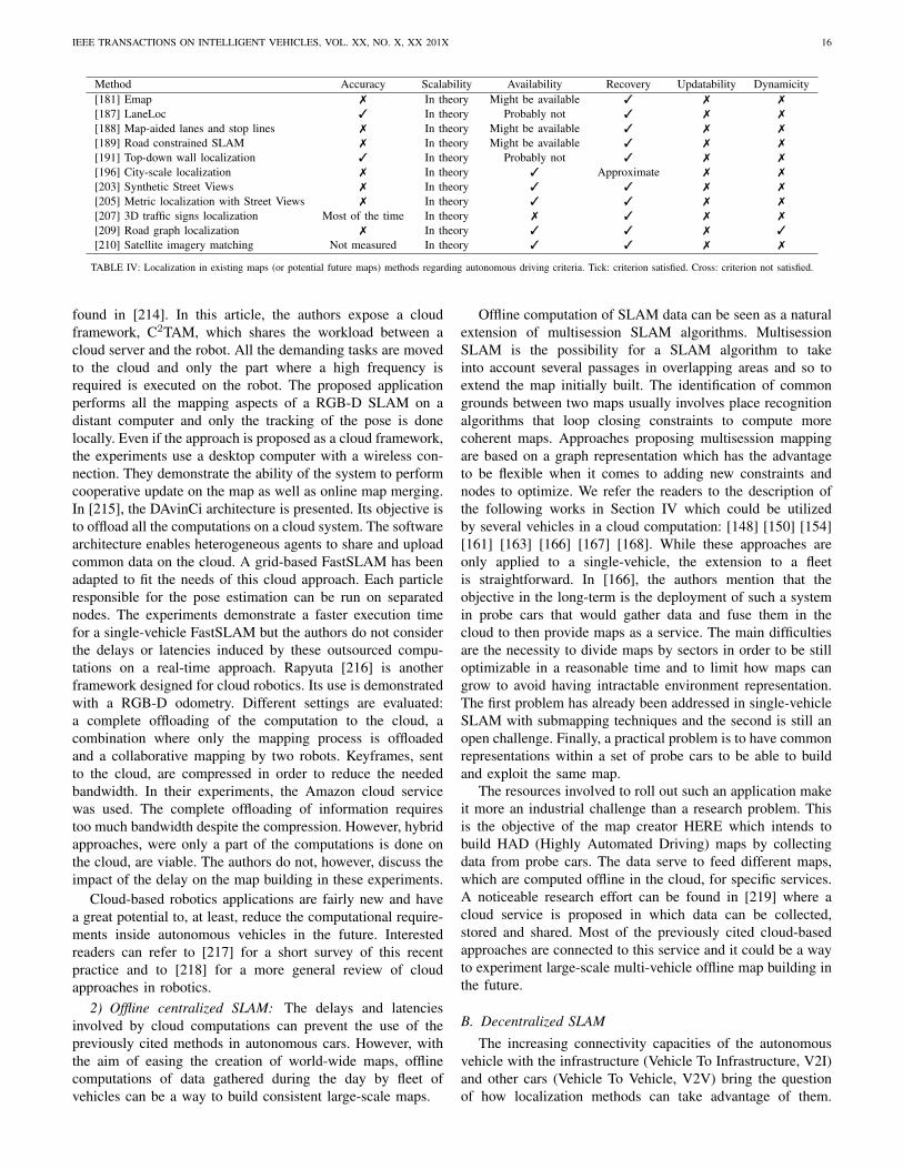
IEEE TRANSACTIONS ON INTELLIGENT VEHICLES, VOL. XX, NO. X, XX 201X 16
Method Accuracy Scalability Availability Recovery Updatability Dynamicity[181] Emap 7 In theory Might be available 3 7 7
[187] LaneLoc 3 In theory Probably not 3 7 7
[188] Map-aided lanes and stop lines 7 In theory Might be available 3 7 7
[189] Road constrained SLAM 7 In theory Might be available 3 7 7
[191] Top-down wall localization 3 In theory Probably not 3 7 7
[196] City-scale localization 7 In theory 3 Approximate 7 7
[203] Synthetic Street Views 7 In theory 3 3 7 7
[205] Metric localization with Street Views 7 In theory 3 3 7 7
[207] 3D traffic signs localization Most of the time In theory 7 3 7 7
[209] Road graph localization 7 In theory 3 3 7 3
[210] Satellite imagery matching Not measured In theory 3 3 7 7
TABLE IV: Localization in existing maps (or potential future maps) methods regarding autonomous driving criteria. Tick: criterion satisfied. Cross: criterion not satisfied.
found in [214]. In this article, the authors expose a cloudframework, C2TAM, which shares the workload between acloud server and the robot. All the demanding tasks are movedto the cloud and only the part where a high frequency isrequired is executed on the robot. The proposed applicationperforms all the mapping aspects of a RGB-D SLAM on adistant computer and only the tracking of the pose is donelocally. Even if the approach is proposed as a cloud framework,the experiments use a desktop computer with a wireless con-nection. They demonstrate the ability of the system to performcooperative update on the map as well as online map merging.In [215], the DAvinCi architecture is presented. Its objective isto offload all the computations on a cloud system. The softwarearchitecture enables heterogeneous agents to share and uploadcommon data on the cloud. A grid-based FastSLAM has beenadapted to fit the needs of this cloud approach. Each particleresponsible for the pose estimation can be run on separatednodes. The experiments demonstrate a faster execution timefor a single-vehicle FastSLAM but the authors do not considerthe delays or latencies induced by these outsourced compu-tations on a real-time approach. Rapyuta [216] is anotherframework designed for cloud robotics. Its use is demonstratedwith a RGB-D odometry. Different settings are evaluated:a complete offloading of the computation to the cloud, acombination where only the mapping process is offloadedand a collaborative mapping by two robots. Keyframes, sentto the cloud, are compressed in order to reduce the neededbandwidth. In their experiments, the Amazon cloud servicewas used. The complete offloading of information requirestoo much bandwidth despite the compression. However, hybridapproaches, were only a part of the computations is done onthe cloud, are viable. The authors do not, however, discuss theimpact of the delay on the map building in these experiments.
Cloud-based robotics applications are fairly new and havea great potential to, at least, reduce the computational require-ments inside autonomous vehicles in the future. Interestedreaders can refer to [217] for a short survey of this recentpractice and to [218] for a more general review of cloudapproaches in robotics.
2) Offline centralized SLAM: The delays and latenciesinvolved by cloud computations can prevent the use of thepreviously cited methods in autonomous cars. However, withthe aim of easing the creation of world-wide maps, offlinecomputations of data gathered during the day by fleet ofvehicles can be a way to build consistent large-scale maps.
Offline computation of SLAM data can be seen as a naturalextension of multisession SLAM algorithms. MultisessionSLAM is the possibility for a SLAM algorithm to takeinto account several passages in overlapping areas and so toextend the map initially built. The identification of commongrounds between two maps usually involves place recognitionalgorithms that loop closing constraints to compute morecoherent maps. Approaches proposing multisession mappingare based on a graph representation which has the advantageto be flexible when it comes to adding new constraints andnodes to optimize. We refer the readers to the description ofthe following works in Section IV which could be utilizedby several vehicles in a cloud computation: [148] [150] [154][161] [163] [166] [167] [168]. While these approaches areonly applied to a single-vehicle, the extension to a fleetis straightforward. In [166], the authors mention that theobjective in the long-term is the deployment of such a systemin probe cars that would gather data and fuse them in thecloud to then provide maps as a service. The main difficultiesare the necessity to divide maps by sectors in order to be stilloptimizable in a reasonable time and to limit how maps cangrow to avoid having intractable environment representation.The first problem has already been addressed in single-vehicleSLAM with submapping techniques and the second is still anopen challenge. Finally, a practical problem is to have commonrepresentations within a set of probe cars to be able to buildand exploit the same map.
The resources involved to roll out such an application makeit more an industrial challenge than a research problem. Thisis the objective of the map creator HERE which intends tobuild HAD (Highly Automated Driving) maps by collectingdata from probe cars. The data serve to feed different maps,which are computed offline in the cloud, for specific services.A noticeable research effort can be found in [219] where acloud service is proposed in which data can be collected,stored and shared. Most of the previously cited cloud-basedapproaches are connected to this service and it could be a wayto experiment large-scale multi-vehicle offline map building inthe future.
B. Decentralized SLAM
The increasing connectivity capacities of the autonomousvehicle with the infrastructure (Vehicle To Infrastructure, V2I)and other cars (Vehicle To Vehicle, V2V) bring the questionof how localization methods can take advantage of them.
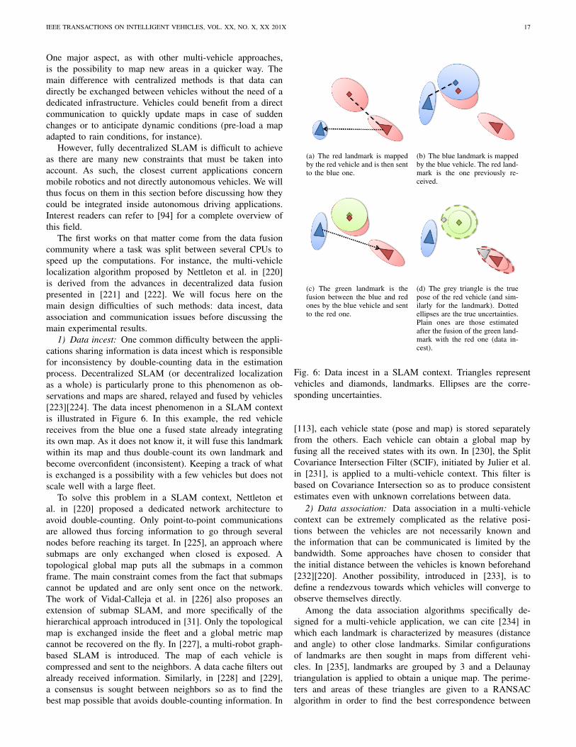
IEEE TRANSACTIONS ON INTELLIGENT VEHICLES, VOL. XX, NO. X, XX 201X 17
One major aspect, as with other multi-vehicle approaches,is the possibility to map new areas in a quicker way. Themain difference with centralized methods is that data candirectly be exchanged between vehicles without the need of adedicated infrastructure. Vehicles could benefit from a directcommunication to quickly update maps in case of suddenchanges or to anticipate dynamic conditions (pre-load a mapadapted to rain conditions, for instance).
However, fully decentralized SLAM is difficult to achieveas there are many new constraints that must be taken intoaccount. As such, the closest current applications concernmobile robotics and not directly autonomous vehicles. We willthus focus on them in this section before discussing how theycould be integrated inside autonomous driving applications.Interest readers can refer to [94] for a complete overview ofthis field.
The first works on that matter come from the data fusioncommunity where a task was split between several CPUs tospeed up the computations. For instance, the multi-vehiclelocalization algorithm proposed by Nettleton et al. in [220]is derived from the advances in decentralized data fusionpresented in [221] and [222]. We will focus here on themain design difficulties of such methods: data incest, dataassociation and communication issues before discussing themain experimental results.
1) Data incest: One common difficulty between the appli-cations sharing information is data incest which is responsiblefor inconsistency by double-counting data in the estimationprocess. Decentralized SLAM (or decentralized localizationas a whole) is particularly prone to this phenomenon as ob-servations and maps are shared, relayed and fused by vehicles[223][224]. The data incest phenomenon in a SLAM contextis illustrated in Figure 6. In this example, the red vehiclereceives from the blue one a fused state already integratingits own map. As it does not know it, it will fuse this landmarkwithin its map and thus double-count its own landmark andbecome overconfident (inconsistent). Keeping a track of whatis exchanged is a possibility with a few vehicles but does notscale well with a large fleet.
To solve this problem in a SLAM context, Nettleton etal. in [220] proposed a dedicated network architecture toavoid double-counting. Only point-to-point communicationsare allowed thus forcing information to go through severalnodes before reaching its target. In [225], an approach wheresubmaps are only exchanged when closed is exposed. Atopological global map puts all the submaps in a commonframe. The main constraint comes from the fact that submapscannot be updated and are only sent once on the network.The work of Vidal-Calleja et al. in [226] also proposes anextension of submap SLAM, and more specifically of thehierarchical approach introduced in [31]. Only the topologicalmap is exchanged inside the fleet and a global metric mapcannot be recovered on the fly. In [227], a multi-robot graph-based SLAM is introduced. The map of each vehicle iscompressed and sent to the neighbors. A data cache filters outalready received information. Similarly, in [228] and [229],a consensus is sought between neighbors so as to find thebest map possible that avoids double-counting information. In
(a) The red landmark is mappedby the red vehicle and is then sentto the blue one.
(b) The blue landmark is mappedby the blue vehicle. The red land-mark is the one previously re-ceived.
(c) The green landmark is thefusion between the blue and redones by the blue vehicle and sentto the red one.
(d) The grey triangle is the truepose of the red vehicle (and sim-ilarly for the landmark). Dottedellipses are the true uncertainties.Plain ones are those estimatedafter the fusion of the green land-mark with the red one (data in-cest).
Fig. 6: Data incest in a SLAM context. Triangles representvehicles and diamonds, landmarks. Ellipses are the corre-sponding uncertainties.
[113], each vehicle state (pose and map) is stored separatelyfrom the others. Each vehicle can obtain a global map byfusing all the received states with its own. In [230], the SplitCovariance Intersection Filter (SCIF), initiated by Julier et al.in [231], is applied to a multi-vehicle context. This filter isbased on Covariance Intersection so as to produce consistentestimates even with unknown correlations between data.
2) Data association: Data association in a multi-vehiclecontext can be extremely complicated as the relative posi-tions between the vehicles are not necessarily known andthe information that can be communicated is limited by thebandwidth. Some approaches have chosen to consider thatthe initial distance between the vehicles is known beforehand[232][220]. Another possibility, introduced in [233], is todefine a rendezvous towards which vehicles will converge toobserve themselves directly.
Among the data association algorithms specifically de-signed for a multi-vehicle application, we can cite [234] inwhich each landmark is characterized by measures (distanceand angle) to other close landmarks. Similar configurationsof landmarks are then sought in maps from different vehi-cles. In [235], landmarks are grouped by 3 and a Delaunaytriangulation is applied to obtain a unique map. The perime-ters and areas of these triangles are given to a RANSACalgorithm in order to find the best correspondence between
IEEE TRANSACTIONS ON INTELLIGENT VEHICLES, VOL. XX, NO. X, XX 201X 18
two map pieces coming from two different vehicles. In [236],the authors analyze the distribution of potential multi-vehiclecorrespondences. Inliers are assumed to produce the sametransformation between two vehicles conversely to outliers. Aclustering algorithm is used to find initial candidates that canthen be further analyzed with more classical methods. Theworks of Li et al. [144][145] solve the initial alignment ofthe maps from different vehicles using a low-cost GPS and agenetic algorithm in the restrained search space
3) Communication issues: The bandwidth needs are oftenneglected in decentralized SLAM. For instance, in [225],submaps are directly sent. In [237], graphs (nodes compriseraw data) are exchanged, which is only suitable for smallvehicle fleets. In [238], the authors propose to exchangemaps only when vehicles can detect each other, which meansthat big amount of data will be sent punctually. Methodscommunicating only topological maps, like in [226] and [227],avoid this problem by providing very light maps.
The exchange strategy should also be able to cope withpotential losses and delays. When not considered, a temporarysaturation or failure can lead to information definitively lost[237][225]. The algorithms built around interactions withneighbors are usually capable of identifying and asking formissing data [227]. Another possibility, described in [239], isthe Lazy Belief Propagation which integrates observations ina Particle Filter that does not depend on the temporal orderin which data are added to the filter. Thus, missing or lateinformation can still be integrated later without a problem.However, it is necessary to be able to identify missing values.More generally, all the approaches based on the inverse formof the Kalman Filter, namely the Information Filter, handledelay natively. Indeed, the update becomes additive and doesnot depend on any temporal order. It has become a commonchoice in the multi-vehicle community [234][240][241].
4) Experimental results: The experiments carried out inthe previously cited articles give a clear visibility on thepotential deployment of such methods for autonomous driving.Indeed, most methods are only demonstrated in simulated ex-periments [220][225][227][235][239][240]. The main reasonis that addressing all the issues mentioned in this sectionin order to conduct real data experiments can be difficult asthey are not all directly connected to the estimation problem.Some approaches have been demonstrated indoor in real time[242][233]. In [226], the authors demonstrate an air/groundcooperation in outdoor environment. The map is built in acooperative fashion with vision landmarks. The accuracy hasnot been measured. In [113], outdoor experiments with twoor three vehicles are performed. The method relies on theexchange of visual landmarks. The accuracy oscillates between50 cm and a few meters depending on the capacity of thevehicle to identify common landmarks. Finally, in [145], 2vehicles equipped with laser merge their maps together in anoutdoor experiment. The method is able to reach a 3-metererror on average.
This short survey of recent results shows that we arestill far from generalizing the use of decentralized SLAMfor autonomous driving. However, the communication meansthemselves continue to improve and bandwidth limitations
might be less of a problem in the coming years. Still,large-scale demonstrations of the capabilities of decentralizedSLAM are yet to be proven and applying the previouslydescribed approaches to autonomous driving is one of theupcoming challenges of SLAM.
C. Discussion
This overview of multi-robot SLAM approaches hasshowed that the maturity of such methods for autonomousdriving differs vastly depending on the way data are handled(in a centralized or decentralized fashion). Online central-ized SLAM systems have been demonstrated on small-scaleexperiments with either a classic computer that serves as ahub to collect observations or with cloud processing. Theextension from mobile robots to driverless cars raises thequestion of the bandwidth capacity that will be available intomorrow’s cars but most importantly of the availability ofan Internet connection in the vehicle. Completely offloadingcritical processing onto the cloud will probably not be safeenough. However, delegating the task of updating maps gath-ered from several vehicles in a reasonable amount of time isan interesting prospect. Real-time updates for map portionsthat might have changed could help driverless cars to adapt ina quicker way. Moreover, environmental conditions that havea low dynamicity could be alerted beforehand in order forthe vehicle to anticipate by choosing more adapted features,etc. To attain this goal, large-scale experiments, involving arealistic number of vehicles, are necessary. It also means thata major prospect remains the design of software architecturesable to cope with data flows and to properly segment updates.One key element to make online cloud-based methods viableis the choice of a map representation able to integrate allincoming information.
In that sense, fully decentralized methods share similargoals. The main difference comes from the fact that, byreceiving the information from nearby cars, the ego-vehiclecan select which information to integrate in its map. Aninteresting challenge thus becomes to establish criteria in orderto evaluate the information gain that can bring maps comingfrom different vehicles with relation to the goal of the ego-vehicle (destination, energetic constraints, etc.). However, allthe practical implications of decentralized methods are thefirst challenge to tackle. Contrary to cloud approaches, whereprocessing power is less of a limit, the tractability of the finalsolution will also be an important factor to consider. Large-scale experiments are also an important milestone to reach inorder to clearly exhibit the benefits of decentralized SLAMfor autonomous vehicles.
Offline centralized methods might be the most mature forautonomous driving mainly because this challenge is veryclose to multisession SLAM. While future HAD maps maynot provide all the needed information to reliably localize avehicle in various conditions, probe cars might be a way toquickly gather enough data to build such maps. It is also aninteresting perspective regarding the capacity of vehicles todetect long-term changes. Indeed, the agglomeration of differ-ent viewpoints on a situation should ease this process. Being
IEEE TRANSACTIONS ON INTELLIGENT VEHICLES, VOL. XX, NO. X, XX 201X 19
able to limit the growth of these maps remains a blockingpoint. Finally, a considerable challenge is to build sufficientlyrobust software architectures to integrate and process all thesedata. The cost of such an infrastructure directs large-scaleexperiments with such methods towards industrial companiesrather than small research teams.
VI. LARGE-SCALE EXPERIMENTS FOR AUTONOMOUSVEHICLES
During the recent years, the scope of the experimentsused to validate localization algorithms has broadened withthe availability of large-scale data sets. Moreover, many re-search teams now have a dedicated platform to test, duringmany kilometers, their algorithms. In this section, we givean overview of the large-scale experiments that have involvedfully autonomous vehicles. We will, of course, focus on thelocalization algorithms and the context in which they havebeen used.
The first large-scale experiments took place at the beginningof the 90’s and were mostly on highways [243][244]. In bothapproaches, localization was performed using lane detectionwith vision sensors to laterally position the vehicle on the road.Lane detection algorithms have been the default localizationsystem in autonomous driving demonstration for a long timeas it is totally appropriate in a highway context. The DARPAGrand Challenge [245] with its 244-km race across the desertchanged things with a new setting. In [246], a GPS is coupledwith elevation maps built using laser scanners and a road-finding algorithm in order to avoid cliffs, rocks and the like.A similar approach is chosen by the winner of the challenge[247]. The GPS is coupled with an IMU and an algorithm todetect the road. In [248], a terrain reconstruction with laserswas also used. In mostly empty territories, the use of a GPSalone was sufficient for navigation. Obstacles and the difficultterrain added the necessity to build maps that can provide asafe corridor in which vehicles could evolve.
The DARPA Urban Challenge that followed focused onurban environments with a 97-km autonomy test in a city-liketraffic [249]. It has to be noted that the environment was stillsufficiently open for a Differential GPS to operate properly.The reliance on maps was more important this time. TheRoute Network Definition File (RNDF) format was speciallydesigned for this challenge in order to furnish the topology andgeometry of the road. Junior, the vehicle proposed by Stanford[250], used a GPS and the RNDF map to position the vehicle.The accuracy was improved with a laser system performinglane and curb detection. In [251], a visual lane detectionalgorithm combined with the RNDF was responsible for thevehicle localization. The authors pointed out the difficulty tohave a reliable localization with a vision-only system becauseof environmental conditions like shadows, etc. The winner ofthis challenge [252] combined a GPS along with an IMU andthe RNDF map. Localization was improved with a laser-basedlane detection. The authors mention the necessity of prior roadmodels for an efficient localization. Semantic information isalso referred to as an important point in order to disambiguatesituations.
Another interesting challenge conducted in 2011 is theGrand Cooperative Driving Challenge (GCDC) [253]. The ideawas to evaluate how collaboration in platooning can help toreduce congestion. The winner of the GCDC challenge in 2011[254] used a previously built map in which received positionsof the other fleet members were matched and coupled withon-board radar detection. This showed that sharing simplelocalization information can still benefit autonomous drivingby agreeing on speed or anticipating maneuvers.
A very large-scale experiment has been conducted bythe VisLab team [255] with a 13,000-km trip from Italy toChina. Technical details about the embedded technologies canbe found in [256]. The localization was performed using alane keeping algorithm (stereo and monocular) and a leaderfollowing system. A laser terrain mapping algorithm wasalso implemented for off-road driving but not used in thisexperiment. The leader following is an interesting possibilityfor autonomous driving if vehicles agree on their destination(or at least, a part of the trip). It still implies that one vehicleshould be able to have a full localization system. For instance,cars with less expensive sensors could use platooning-likeformations.
Automatic guidance of a vehicle was demonstrated in [257]for the Stadpilot project. This work can be seen as an updateof the results of the Urban Challenge [249]. During a 15-km experiment on open roads, a combination of DGPS, IMUand lane keeping algorithm was used. Prior digital maps werealso employed. Based on their experience in DARPA, theauthors clearly indicate that GPS and IMU are not sufficientfor autonomous driving in urban environments. An evolutionof [255] was presented in [258]. In a 13-km experiment indifferent environments and real traffic, VisLab demonstratedthe possibility of using lane or leader following based onvision, IMU and DGPS. An interesting aspect is that a map ofthe environment was used to trigger the appropriate perceptionmodule.
The V-Charge project aims at providing automated valetparking with close-to-market sensors. In [259], the authorsevaluate their localization approach in a real-world scenario.First, the map is built using SURF keypoints extraction fromfisheye cameras. Loop closures are defined manually and themap is optimized using global Bundle Adjustment. Localiza-tion is then performed against the known map still using SURFfeatures. The algorithm is evaluated 0, 1 and 2 months after themap creation with a sufficient accuracy. However, the authorsstate that map update is needed over long periods of timeto reflect changes. Another open question raised here but notaddressed is the map portability between different vehicles.Still in the V-Charge project, [260] completed this system withheight maps built from stereovision. A semantic map and aroad graph were also needed to identify parking places andhow to navigate between them.
Large-scale outdoor experiments with mobile robots havealso been carried out in real-world environments. In [261],a robot traveled 20 km in crowded streets. The map wasbuilt beforehand with a graph-based laser SLAM. The on-the-fly localization was based on a particle filter and a GPS forinitialization. The system was able to perform reinitialization
IEEE TRANSACTIONS ON INTELLIGENT VEHICLES, VOL. XX, NO. X, XX 201X 20
when lost. The authors indicate that mobile obstacles maskingthe map were a source of localization losses. In [262], arobot traveled several times at different periods of the yeara 1-km road. The map was built beforehand as well and thelocalization was based on road boundaries detected by laserand integrated inside an EKF. One of the problems cited bythe authors is the recovery when the robot is lost and theGPS is not available. Also appearance changes, like leaveson the ground, proved to be difficult to handle. In [263],a 6-km experiment in pedestrian walkways is discussed. A3D laser map of edges was built beforehand with 2D lasers.The localization system compared the map with the currentobservation to weight the particles of a particle filter. Animportant difficulty faced by the authors is the presence ofglass windows that disturbed the localization system based onlaser. They conclude by saying that 2D lasers are not sufficientfor this kind of experiments.
Shuttle demonstrations in cities are also becoming morefrequent as the mapping is confined to a dedicated area. In[264], the authors discuss the lessons learned after 1,500 km ofa vision-guided shuttle in a private site. The experiments tookplace over 3 months and the localization was performed usinga hierarchical Bundle Adjustment method over a previouslybuilt map. This approach could be used with either a frontor a back camera. The main difficulties were the lightningconditions despite the use of front and back cameras. Thedynamic range of vision sensors was not sufficient to handleday-time changes that were qualified by the authors as havinga greater impact on the localization than the 3-month gap. TheCityMobil2 project has cumulated 26,000 km in various citiesfor several months [265]. The localization differed dependingon the experiments but was based on pre-built maps with laseror vision and GPS. The weather and the general reliability ofthe software had a significant impact on the results.
Already discussed before, Levinson et al. showed an updateof the Stanford’s vehicle from the Urban Challenge in [266].Ground maps were generated using precise GPS, IMU and a64-layer 3D laser from multiple passages in an offline manner.The localization inside this map was then performed in real-time with a 2D histogram filter for a 10-cm accuracy onmany kilometers. The approach of Ulm University is exposedin [267]. A map, composed of MSER features coming fromvision and of a laser grid, is built beforehand and geo-referenced using a RTK-GPS. This map representation is lightand allowed for a 10-cm accuracy on average during the 5-kmtest. Using both sensors for localization improved the resultsbut the need of a highly-precise built-in-advance map is seenas a problem by the authors.
BMW, in [268], gives an interesting overview of their expe-rience with autonomous driving over thousands of kilometerson public roads (highways). Their approach relies on lanemarking using vision and laser, as well as odometry and aDGPS. Road boundaries were also detected using laser andradar. A high-precision map is needed for a proper localization.Their map integrates semantic and geometric information (lanemodels, connectivity, etc.) as well as localization data (lanemarking and road boundary positions) with different layers.The difficulties presented by the authors were the necessity to
remap from time to time the environment for a proper onlineexploitation. This process should be automated according tothe authors. Large-scale maps are also a concern and theyshould be broken down in submaps. The standardization ofthese maps is also an important aspect that needs to beaddressed to be able to use probe cars and crowd-source therequired information for digital maps.
Daimler experimented with their autonomous vehicle over103 km in mixed environments (urban, highways, etc.) withclose-to-market sensors [109]. Their system is a combinationof vision, radar and accurate digital maps. The localizationfuses lane detection with feature-based localization for a 20-cm accuracy on average. All the lanes and features wereacquired during a first passage and fused in a UKF. Amongthe topics of importance cited by the authors, the scalabilityof the maps is crucial. Two other major aspects that need tobe addressed for a commercial use are the reliance on an up-to-date digital map as well as its accuracy. For the authors, thesensor setup should be improved in order to be less dependentof the map.
Among the industrial works in autonomous driving, Waymo(formerly Google Car project) was a pioneer. The projectstarted following the DARPA Urban Challenge on the foun-dation of the winner [252]. While the algorithms are notspecifically known, the localization relies on dedicated 3Dmaps built beforehand and corrected by hand. The capacityof Google makes that solution viable and more than 40,000km per week are said to be driven by Waymo. Even with theseimpressive results, the disengagements reports published eachyear [269] [270] indicate that drivers must occasionally takeback the wheel due to software failures and in a more frequentmanner in urban environments. Conversely to Google, Tesla’sstrategy is to collect data from their own vehicles in order toimprove the capabilities of their vehicles [271]. This methodoffers, by definition, less control on the quality of the producedoutputs. Anyway the role of this philosophy on the localizationis not known.
VII. DISCUSSION AND CONCLUSION
In this survey, we have focused on the individual challengesthat should be considered depending on the approach chosen.To conclude this paper, we will now discuss how some moregeneral aspects could have an impact on the localization ofautonomous vehicles.
During the 23rd ITS World Congress, a localization com-petition was proposed. Based on low-resolution voxel mapsof above-the-ground objects and lanes furnished by HERE,participants were asked to propose an accurate localization al-gorithm. The competition ended with no winner as the targetedaccuracy was not reached. It is not yet clear if HAD maps,that are going to be available in the coming years, will providea strong enough prior knowledge for localization algorithms.Depending on the outcome, the community will surely adaptwhat kind of prior knowledge is used in SLAM. These mapsare also intended to be used as part of the Local Dynamic Map(LDM) that gathers static and dynamic information to whichSLAM could contribute. As such, standardization is needed[272].
IEEE TRANSACTIONS ON INTELLIGENT VEHICLES, VOL. XX, NO. X, XX 201X 21
An aspect that is not often discussed is sensor placement.It can have a tremendous impact on the performance of alocalization system. For instance, a laser on the car roof isgoing to have a clear view on the infrastructure and avoid mostof the mobile obstacles while one in the undercarriage mightbe affected by masked information. Similarly, the minimal setof sensors necessary for localization is not clearly definedyet (even if lasers and cameras seem to be favored). Sucha definition should be made conjointly with the map represen-tation that is going to serve as prior knowledge. Of course, thisaspect is also tightly linked to the cost of those sensors. Aninteresting perspective in that sense is multi-modality where amap could be built by an expensive 3D laser but then exploitedby a simple camera as proposed in [273]. Another interestingchallenge is to build flexible architectures in which a decisionsystem can choose what are the sensors, detectors or maps tofavor depending on the context.
Context by itself is an important part of autonomous drivingand its understanding would help place recognition algorithmsor could even be directly integrated to make SLAM morerobust. For now, most of the works carried out have concernedindoor localization. They have been initiated by Chatila etal. in [274] where semantic (object) maps are used for high-level decision-making. SLAM methods have since then beenfrequently considered for semantic map building. In [275] and[276], the authors take advantage of a 3D laser to identifythe ceiling, the floor and objects. In [277], a conceptualspace representation is proposed based on three differentmaps: metric (from a SLAM system), navigation (free space)and topological (connections between door-separated areas).The conceptual map allows the robot to have a semanticrepresentation for rooms and objects that helps the interactionswith users. In [278], the authors integrate well known objectsinside a monocular SLAM. A similar approach is followed inSLAM++ [279] where objects are detected and optimized ina common localization framework. In these last two works,context and relations between objects are not directly usedto reason upon. In that sense, semantic SLAM in outdoorenvironments is still a challenge that needs to be tackled.
However, semantic mapping from images alone is a fieldthat has grown lately [280][281]. Deep Convolutional NeuralNetworks have largely contributed to this trend and methodslike SegNet [281] show impressive results. Their applicationin localization methods remains an open challenge but a directuse would be to remove moving, or temporally static, obstaclesthat can disturb the proper behavior of a SLAM algorithm.More generally, CNNs could change how place recognition isperformed by using feature maps coming from these networksas in [142]. The impact and the use of CNNs for localizationin autonomous driving will surely evolve in the coming years.A recent example like [282] shows that localization mightnot even be needed. In this paper, Nvidia demonstrates thepossibility to directly learn the steering angle that should beapplied from camera clues. Nevertheless, the scalability ofsuch methods has yet to be demonstrated.
In the recent years, experiments have broadened their scopeand autonomous driving for several kilometers and over longperiods of time is more common. Shuttle experiments are also
starting in various cities. Even though, in that case, SLAMapproaches can use a previously built map without scalabilityissues, it is a good way to test them over long periods oftime and confront them to the environment variability. In mostroadmaps [283], the automation of transit systems is actuallyforeseen at a shorter term than other vehicles as it has theadvantage to restrain the covered area.
Finally, the safety of localization algorithms is an importantissue to consider. Multiple sources should be envisaged andstrategies to safely switch among them must be designed.Taking into account the failures and their impacts on the lo-calization system could help in creating degraded localizationmodes that ensure that a vehicle can reach a stopping spotsafely.
REFERENCES
[1] R. Smith and P. Cheeseman, “On the Representation and Estimation ofSpatial Uncertainty,” The International Journal of Robotics Research,vol. 5, no. 4, pp. 56–68, 1986.
[2] J. J. Leonard and H. Durrant-Whyte, “Simultaneous Map Buildingand Localization for an Autonomous Mobile Robot,” in IEEE/RSJInternational Conference on Intelligent Robots and Systems, 1991, pp.1442–1447.
[3] F. Dellaert, D. Fox, W. Burgard, and S. Thrun, “Monte Carlo Local-ization for Mobile Robots,” in IEEE Internationational Conference onRobotics and Automation, vol. 2, 1999, pp. 1322–1328.
[4] T. Bailey and H. Durrant-Whyte, “Simultaneous Localization andMapping (SLAM): Part II,” IEEE Robotics and Automation Magazine,vol. 13, no. 3, pp. 108–117, 2006.
[5] H. Durrant-Whyte and T. Bailey, “Simultaneous Localization andMapping: Part I,” IEEE Robotics and Automation Magazine, vol. 13,no. 2, pp. 99–110, 2006.
[6] S. Thrun, W. Burgard, and D. Fox, Probabilistic Robotics. MIT PressCambridge, 2005, ch. 3, pp. 279–484.
[7] C. Stachniss, J. J. Leonard, and S. Thrun, Springer Handbook ofRobotics. Springer International Publishing, 2016, ch. 46, pp. 1153–1176.
[8] C. Cadena, L. Carlone, H. Carrillo, Y. Latif, D. Scaramuzza, J. Neira,I. Reid, and J. J. Leonard, “Past, Present, and Future of SimultaneousLocalization and Mapping: Toward the Robust-Perception Age,” IEEETransactions on Robotics, vol. 32, no. 6, pp. 1309–1332, 2016.
[9] C. Schmid, R. Mohr, and C. Bauckhage, “Evaluation of Interest PointDetectors,” International Journal of Computer Vision, vol. 37, no. 2,pp. 151–172, 2000.
[10] J. Civera, O. G. Grasa, A. J. Davison, and J. M. M. Montiel, “1-PointRANSAC for EKF Filtering. Application to Real-Time Structure fromMotion and Visual Odometry,” Journal of Fields Robotics, vol. 27,no. 5, pp. 609–631, 2010.
[11] E. Mouragnon, M. Lhuillier, M. Dhome, F. Dekeyser, and P. Sayd,“Real Time Localization and 3D Reconstruction,” in IEEE ComputerSociety Conference on Computer Vision and Pattern Recognition, 2006,pp. 363–370.
[12] R. E. Kalman, “A New Approach to Linear Filtering and PredictionProblems,” Journal of Basic Engineering, vol. 82, no. 1, pp. 35–45,1960.
[13] M. W. M. G. Dissanayake, P. Newman, H. F. Durrant-Whyte, S. Clark,and M. Csorba, “An Experimental and Theoretical Investigation intoSimultaneous Localization and Map Building,” in The Sixth Interna-tional Symposium on Experimental Robotics VI, 2000, pp. 265–274.
[14] ——, “A Solution to the Simultaneous Localization and Map Building(SLAM) Problem,” IEEE Transactions on Robotics and Automation,vol. 17, no. 3, pp. 229–241, 2001.
[15] R. E. Kalman and R. S. Bucy, “New Results in Linear Filtering andPrediction Theory,” Journal of Basic Engineering, vol. 83, no. 3, pp.95–108, 1961.
[16] S. J. Julier and J. K. Uhlmann, “A Counter Example to the Theory ofSimultaneous Localization and Map Building,” in IEEE InternationalConference on Robotics and Automation, 2001, pp. 4238–4243.
[17] Y. Bar-Shalom, X. R. Li, and T. Kirubarajan, Estimation with Appli-cations to Tracking and Navigation. Wiley-Interscience, 2001.

IEEE TRANSACTIONS ON INTELLIGENT VEHICLES, VOL. XX, NO. X, XX 201X 22
[18] J. Guivant, E. Nebot, and S. Baiker, “Autonomous Navigation and MapBuilding Using Laser Range Sensors in Outdoor Applications,” Journalof Robotic Systems, vol. 17, no. 10, pp. 565–583, 2000.
[19] J. Guivant and E. Nebot, “Optimization of the Simultaneous Local-ization and Map Building Algorithm for Real-Time Implementation,”IEEE Transactions on Robotics and Automation, vol. 17, no. 3, pp.242–257, 2001.
[20] J. J. Leonard and H. J. S. Feder, “A Computationally Efficient Methodfor Large-Scale Concurrent Mapping and Localization,” in Interna-tional Symposium on Robotics Research, vol. 9, 2000, pp. 169–178.
[21] P. Newman and J. J. Leonard, “Pure Range-Only Sub-Sea SLAM,” inIEEE International Conference on Robotics and Automation, vol. 2,2003, pp. 1921–1926.
[22] P. Newman, J. Leonard, J. D. Tardos, and J. Neira, “Explore andReturn: Experimental Validation of Real-Time Concurrent Mappingand Localization,” in IEEE International Conference on Robotics andAutomation, vol. 2, 2002, pp. 1802–1809.
[23] P. Newman, D. Cole, and K. Ho, “Outdoor SLAM Using VisualAppearance and Laser Ranging,” in IEEE International Conferenceon Robotics and Automation, 2006, pp. 1180–1187.
[24] A. J. Davison, “Real-Time Simultaneous Localisation and Mappingwith a Single Camera,” in IEEE International Conference on ComputerVision, 2003, pp. 1403–1410.
[25] J. Montiel, J. Civera, and A. J. Davison, “Unified Inverse DepthParametrization for Monocular SLAM,” in Robotics: Science andSystems, 2006.
[26] G. Bresson, T. Feraud, R. Aufrere, P. Checchin, and R. Chapuis, “RealTime Monocular SLAM with Low Memory Requirements,” IEEETransactions on Intelligent Transportation Systems, 2015.
[27] S. B. Williams, G. Dissanayake, and H. Durrant-Whyte, “An EfficientApproach to the Simultaneous Localisation and Mapping Problem,” inIEEE International Conference on Robotics and Automation, 2002, pp.406–411.
[28] J. J. Leonard and P. Newman, “Consistent, Convergent and Constant-Time SLAM,” in International Joint Conferences on Artificial Intelli-gence, 2003, pp. 1143–1150.
[29] T. Bailey, “Mobile Robot Localisation and Mapping in ExtensiveOutdoor Environments,” Ph.D. dissertation, Australian Centre for FieldRobotics - The University of Sydney, 2002.
[30] M. Bosse, P. Newman, J. Leonard, M. Soika, W. Feiten, and S. Teller,“An Atlas Framework for Scalable Mapping,” in IEEE InternationalConference on Robotics and Automation, vol. 2, 2003, pp. 1899–1906.
[31] C. Estrada, J. Neira, and J. D. Tardos, “Hierarchical SLAM: real-time accurate mapping of large environments,” IEEE Transactions onRobotics, vol. 21, no. 4, pp. 588–596, 2005.
[32] P. Pinies and J. D. Tardos, “Large Scale SLAM Building ConditionallyIndependent Local Maps: Application to Monocular Vision,” IEEETransactions on Robotics, vol. 24, no. 5, pp. 1094–1106, 2008.
[33] L. M. Paz, J. D. Tardos, and J. Neira, “Divide and Conquer: EKFSLAM in O(n),” IEEE Transactions on Robotics, vol. 24, no. 5, pp.1107–1120, 2008.
[34] J. L. Blanco, J. Gonzalez, and J.-A. Fernandez-Madrigal, “SubjectiveLocal Maps for Hybrid Metric-Topological SLAM,” Robotics andAutonomous Systems, vol. 57, no. 1, pp. 64–74, 2009.
[35] M. Chli and A. J. Davison, “Automatically and Efficiently Inferringthe Hierarchical Structure of Visual Maps,” in IEEE InternationalConference on Robotics and Automation, 2009, pp. 387–394.
[36] S. J. Julier and J. K. Uhlmann, “New Extension of the Kalman Filterto Nonlinear Systems,” in AeroSense’97, 1997, pp. 182–193.
[37] E. A. Wan and R. V. D. Merwe, “The Unscented Kalman Filter forNonlinear Estimation,” in Adaptive Systems for Signal Processing,Communications and Control Symposium, 2000, pp. 153–158.
[38] S. J. Julier and J. K. Uhlmann, “Unscented Filtering and NonlinearEstimation,” Proceedings of the IEEE, vol. 92, no. 3, pp. 401–422,2004.
[39] D. Checklov, M. Pupilli, W. Mayol-Cuevas, and A. Calway, “Real-Time and Robust Monocular SLAM using Predictive Multi-ResolutionDescriptors,” Advances in Visual Computing, vol. 4292, pp. 276–285,2006.
[40] P. S. Maybeck, Stochastic Models, Estimation and Control. Elsevier,1982.
[41] Y. Liu and S. Thrun, “Results for Outdoor-SLAM Using SparseExtended Information Filters,” in IEEE International Conference onRobotics and Automation, vol. 1, 2003, pp. 1227–1233.
[42] S. Thrun, Y. Liu, D. Koller, A. Y. Ng, Z. Ghahramani, and H. Durrant-Whyte, “Simultaneous Localization and Mapping with Sparse Extended
Information Filters,” The International Journal of Robotics Research,vol. 23, no. 7-8, pp. 693–716, 2004.
[43] R. Eustice, M. Walter, and J. J. Leonard, “Sparse Extended Informa-tion Filters: Insights Into Sparsification,” in IEEE/RSJ InternationalConference on Intelligent Robots and Systems, 2005, pp. 3281–3288.
[44] I. Mahon, S. B. Williams, O. Pizarro, and M. Johnson-Roberson,“Efficient View-Based SLAM Using Visual Loop Closures,” IEEETransactions on Robotics, vol. 24, no. 5, pp. 1002–1014, 2008.
[45] M. R. Walter, R. M. Eustice, and J. J. Leonard, “Exactly SparseExtended Information Filters for Feature-Based SLAM,” The Inter-national Journal of Robotics Research, vol. 26, no. 4, pp. 335–359,2007.
[46] J.-S. Gutmann, E. E. nad Philip Fong, and M. E. Munich, “A Constant-Time Algorithm for Vector Field SLAM Using an Exactly SparseExtended Information Filter,” in Robotics: Science and Systems, 2010.
[47] A. Eliazar and R. Parr, “DP-SLAM: Fast, robust simultaneous localiza-tion and mapping without predetermined landmarks,” in InternationalJoint Conference on Artificial Intelligence, vol. 3, 2003, pp. 1135–1142.
[48] ——, “DP-SLAM 2.0,” in IEEE International Conference on Roboticsand Automation, 2004, pp. 1314–1320.
[49] M. Montemerlo, S. Thrun, D. Koller, and B. Wegbreit, “FastSLAM:A Factored Solution to the Simultaneous Localization And MappingProblem,” in AAAI/IAAI, 2002, pp. 593–598.
[50] K. P. Murphy, “Bayesian Map Learning in Dynamic Environments,” inNeural Information Processing Systems, 1999, pp. 1015–1021.
[51] S. Thrun, W. Burgard, and D. Fox, “A Real-Time Algorithm for MobileRobot Mapping With Applications to Multi-Robot and 3D Mapping,”in IEEE International Conference on Robotics and Automation, vol. 1,2000, pp. 321–328.
[52] E. Eade and T. Drummond, “Scalable Monocular SLAM,” in IEEEComputer Society Conference on Computer Vision and Pattern Recog-nition, vol. 1, 2006, pp. 469–476.
[53] T. Bailey, J. Nieto, and E. Nebot, “Consistency of the FastSLAM Algo-rithm,” in IEEE International Conference on Robotics and Automation,2006, pp. 424–429.
[54] M. Mohan and K. K. Madhava, “Mapping Large Scale Environmentsby Combining Particle Filter and Information Filter,” in InternationalConference on Control, Automation, Robotics and Vision, 2010, pp.1000–1005.
[55] D. Hahnel, W. Burgard, D. Fox, and S. Thrun, “An efficient FastSLAMalgorithm for generating maps of large-scale cyclic environments fromraw laser range measurements,” in IEEE/RSJ International Conferenceon Intelligent Robots and Systems, vol. 1, 2003, pp. 206–211.
[56] T. Reineking and J. Clemens, “Evidential FastSLAM for Grid Map-ping,” in 16th International Conference on Information Fusion, 2013,pp. 789–796.
[57] H. P. Moravec, “Sensor Fusion in Certainty Grids for Mobile Robots,”AI Magazine, vol. 9, no. 2, p. 61, 1988.
[58] A. Elfes, “Using Occupancy Grids for Mobile Robot Perception andNavigation,” Computer, vol. 6, no. 22, pp. 46–57, 1989.
[59] Z. Alsayed, G. Bresson, F. Nashashibi, and A. Verroust-Blondet, “PML-SLAM: a solution for localization in large-scale urban environments,”in IEEE/RSJ International Conference on Intelligent Robots and Sys-tems Workshop on Perception and Navigation for Autonomous Vehiclesin Human Environment, 2015.
[60] G. Trehard, Z. Alsayed, E. Pollard, B. Bradai, and F. Nashashibi,“Credibilist Simultaneous Localization and Mapping with a LIDAR,” inIEEE/RSJ International Conference on Intelligent Robots and Systems,2014, pp. 2699–2706.
[61] R. Rouveure, P. Faure, and M. Monod, “Radar-based SLAM withoutodometric sensor,” in ROBOTICS 2010: International workshop ofMobile Robotics for environment/agriculture, 2010.
[62] D. Vivet, P. Checchin, and R. Chapuis, “Localization and MappingUsing Only a Rotating FMCW Radar Sensor ,” Sensors, pp. 4527–4552, 2013.
[63] E. Jose and M. D. Adams, “An Augmented State SLAM formulationfor Multiple Line-of-Sight Features with Millimetre Wave RADAR,” inIEEE/RSJ International Conference on Intelligent Robots and Systems,2005, pp. 3087–3092.
[64] B. Triggs, P. F. McLauchlan, R. I. Hartley, and A. W. Fitzgibbon,“Bundle Adjustment - A Modern Synthesis,” in Vision Algorithms:Theory and Practice. Springer, 2000, pp. 298–372.
[65] W. Press, S. Keukolsky, W. Vettering, and B. Flannery, “Levenberg-Marquardt Method,” Numerical Recipes in C: The Art of ScientificComputation, pp. 542–547, 1992.
IEEE TRANSACTIONS ON INTELLIGENT VEHICLES, VOL. XX, NO. X, XX 201X 23
[66] H.-Y. Shum, Q. Ke, and Z. Zhang, “Efficient Bundle Adjustment withVirtual Key Frames: A Hierarchical Approach to Multi-frame Structurefrom Motion,” in IEEE Computer Society Conference on ComputerVision and Pattern Recognition, 1999.
[67] R. Hartley and A. Zisserman, Multiple View Geometry in ComputerVision. Cambridge Univ Press, 2000, ch. 18, pp. 434–457.
[68] E. Royer, M. Lhuillier, M. Dhome, and T. Chateau, “Localization inUrban Environments: Monocular Vision Compared to a DifferentialGPS Sensor,” in IEEE Computer Society Conference on ComputerVision and Pattern Recognition, 2005, pp. 114–121.
[69] D. Steedly and I. Essa, “Propagation of Innovative Information in Non-Linear Least-Squres Structure from Motion,” in IEEE InternationalConference on Computer Vision, 2001, pp. 223–229.
[70] Z. Zhang and Y. Shan, “Incremental Motion Estimation throughModified Bundle Adjustment,” in International Conference on ImageProcessing, 2003, pp. 343–346.
[71] D. Nister, O. Naroditsky, and J. Bergen, “Visual Odometry for GroundVehicle Applications,” Journal of Fields Robotics, vol. 23, no. 1, pp.3–20, 2006.
[72] M. A. Fischler and R. C. Bolles, “Random Sample Consensus: AParadigm for Model Fitting with Applications to Image Analysis andAutomated Cartography,” Communications of the ACM, vol. 24, no. 6,pp. 381–395, 1981.
[73] J. Michot, A. Bartoli, and F. Gaspard, “Bi-Objective Bundle Adjust-ment With Application to Multi-Sensor SLAM,” in 5th InternationalSymposium on 3D Data Processing, Visualization and Transmission,2010.
[74] K. Konolige and M. Agrawal, “FrameSLAM: from Bundle Adjustmentto RealReal Visual Mapping,” IEEE Transactions on Robotics, pp.1066–1077, 2008.
[75] S. Thrun and J. J. Leonard, “Simultaneous Localization And Mapping,”in Springer Handbook of Robotics. Springer, 2008, pp. 871–889.
[76] G. Grisetti, S. Grzonka, C. Stachniss, P. Pfaff, and W. Burgard, “Ef-ficient Estimation of Accurate Maximum Likelihood Maps in 3D,” inIEEE/RSJ International Conference on Intelligent Robots and Systems,2007, pp. 3472–3478.
[77] G. Grisetti, R. Kummerle, C. Stachniss, U. Frese, and C. Hertzberg,“Hierarchical Optimization on Manifolds for Online 2D and 3D Map-ping,” in IEEE International Conference on Robotics and Automation,2010, pp. 273–278.
[78] R. Kummerle, G. Grisetti, H. Strasdat, K. Konolige, and W. Burgard,“g2o: A General Framework for Graph Optimization,” in IEEE Interna-tional Conference on Robotics and Automation, 2011, pp. 3607–3613.
[79] G. Dubbelman and B. Browning, “Closed-form Online Pose-chainSLAM,” in IEEE International Conference on Robotics and Automa-tion, 2013, pp. 5190–5197.
[80] U. Frese and L. Schroder, “Closing a Million-Landmarks Loop,” inIEEE/RSJ International Conference on Intelligent Robots and Systems,2006, pp. 5032–5039.
[81] M. Kaess, A. Ranganathan, and F. Dellaert, “iSAM: IncrementalSmoothing and Mapping,” IEEE Transactions on Robotics, vol. 24,no. 6, pp. 1365–1378, 2008.
[82] M. Kaess and F. Dellaert, “Covariance Recovery from a Square RootInformation Matrix for Data Association,” Robotics and AutonomousSystems, vol. 57, no. 12, pp. 1198–1210, 2009.
[83] H. Strasdat, J. M. M. Montiel, and A. J. Davison, “Real-time MonocularSLAM: Why Filter?” in IEEE International Conference on Roboticsand Automation, 2010, pp. 2657–2664.
[84] ——, “Visual SLAM: Why Filter?” Image and Vision Computing,vol. 30, no. 2, pp. 65–77, 2012.
[85] J. Aulinas, Y. Petillot, J. Salvi, and X. Llado, “The SLAM problem: asurvey,” in 11th International Conference of the Catalan Associationfor Artificial Intelligence, 2008, pp. 363–371.
[86] G. Dissanayake, S. Huang, Z. Wang, and R. Ranasinghe, “A Reviewof Recent Developments in Simultaneous Localization and Mapping,”in IEEE 6th International Conference on Industrial and InformationSystems, 2011, pp. 477–482.
[87] S. Huang and G. Dissanayake, “A critique of current developmentsin simultaneous localization and mapping,” International Journal ofAdvanced Robotic Systems, vol. 13, no. 5, pp. 1–13, 2016.
[88] Z. Chen, J. Samarabandu, and R. Rodrigo, “Recent advances insimultaneous localization and map-building using computer vision,”Advanced Robotics, vol. 21, no. 3-4, pp. 233–265, 2007.
[89] D. Scaramuzza and F. Fraundorfer, “Visual Odometry: Part I: The First30 Years and Fundamentals,” IEEE Robotics & Automation Magazine,vol. 18, no. 4, pp. 80–92, 2011.
[90] F. Fraundorfer and D. Scaramuzza, “Visual Odometry: Part II: Match-ing, RobuRobust, Optimization, and Applications,” IEEE Robotics &Automation Magazine, vol. 19, no. 2, pp. 78–90, 2012.
[91] J. Fuentes-Pacheco, J. Ruiz-Ascencio, and J. M. Rendon-Mancha,“Visual simultaneous localization and mapping: a survey,” ArtificialIntelligence Review, vol. 43, no. 1, pp. 55–81, 2012.
[92] G. Ros, A. D. Sappa, D. Ponsa, and A. M. Lopez, “Visual SLAMfor Driverless Cars: A Brief Survey,” in IEEE Intelligent VehiclesSymposium Workshops, 2012.
[93] S. Lowry, N. Sunderhauf, P. Newman, J. J. Leonard, D. Cox, P. Corke,and M. J. Milford, “Visual Place Recognition: A Survey,” IEEETransactions on Robotics, vol. 32, no. 1, pp. 1–19, 2016.
[94] S. Saeedi, M. Trentini, M. Seto, and H. Li, “Multiple-robot Simultane-ous Localization and Mapping - A Review,” Journal of Field Robotics,vol. 33, no. 1, pp. 3–46, 2016.
[95] A. Bonarini, W. Burgard, G. Fontana, M. Matteucci, D. G. Sorrenti,and J. D. Tardos, “RAWSEEDS: Robotics Advancement throughWeb-publishing of Sensorial and Elaborated Extensive Data Sets,” inIEEE/RSJ International Conference on Intelligent Robots and SystemsWorkshop on Benchmarks in Robotics Research, 2006.
[96] M. Smith, I. Baldwin, W. Churchill, R. Paul, and P. Newman, “TheNew College Vision and Laser Data Set,” The International Journal ofRobotics Research, vol. 28, no. 5, pp. 595–599, 2009.
[97] A. Geiger, P. Lenz, and R. Urtasun, “Are we ready for AutonomousDriving? The KITTI Vision Benchmark Suite,” in IEEE Conference onComputer Vision and Pattern Recognition, 2012, pp. 3354–3361.
[98] J.-L. Blanco-Claraco, F.-A. Moreno-Duenas, and J. Gonzalez-Jimenez,“The Malaga Urban Dataset: High-rate Stereo and Lidars in a realisticurban scenario,” The International Journal of Robotics Research,vol. 33, no. 2, pp. 207–214, 2014.
[99] M. Cummins and P. Newman, “FAB-MAP: Probabilistic Localizationand Mapping in the Space of Appearance,” The International Journalof Robotics Research, vol. 27, no. 6, pp. 647–665, 2008.
[100] J.-L. Blanco, F.-A. Moreno, and J. Gonzalez, “A Collection of OutdoorRobotic Datasets with centimeter-accuracy Ground Truth,” AutonomousRobots, vol. 27, no. 4, pp. 327–351, 2009.
[101] A. S. Huang, M. Antone, E. Olson, L. Fletcher, D. Moore, S. Teller,and J. Leonard, “A high-rate, heterogeneous data set from the DARPAUrban Challenge ,” The International Journal of Robotics Research,vol. 29, no. 13, pp. 1595–1601, 2010.
[102] T. Peynot, S. Scheding, and S. Terho, “The Marulan Data Sets:Multi-Sensor Perception in Natural Environment with ChallengingConditions,” The International Journal of Robotics Research, vol. 29,no. 13, pp. 1602–1607, 2010.
[103] A. Geiger, J. Ziegler, and C. Stiller, “StereoScan: Dense 3d Recon-struction in Real-time,” in IEEE Intelligent Vehicle Symposium, 2011,pp. 963–968.
[104] G. Pandey, J. R. McBride, and R. M. Eustice, “Ford Campus Visionand Lidar Data Set,” The International Journal of Robotics Research,vol. 30, no. 13, pp. 1543–1552, 2011.
[105] J. Zhang and S. Singh, “Visual-lidar Odometry and Mapping: Low-drift, Robust, and Fast,” in IEEE International Conference on Roboticsand Automation, 2015.
[106] I. Cvisic and I. Petrovic, “Stereo odometry based on careful featureselection and tracking,” in 2015 European Conference on MobileRobotics, 2015, pp. 1–6.
[107] M. Buczko and V. Willert, “How to distinguish inliers from outliersin visual odometry for high-speed automotive applications,” in IEEEIntelligent Vehicle Symposium, 2016, pp. 478–483.
[108] M. Persson, T. Piccini, M. Felsberg, and R. Mester, “Robust stereovisual odometry from monocular techniques,” in IEEE IntelligentVehicle Symposium, 2015, pp. 686–691.
[109] J. Ziegler, P. Bender, M. Scheriber, H. Lategahn, T. Strauss, C. Stiller,T. Dang, U. Franke, N. Appenrodt, C. G. Keller, E. Kaus, R. G. Her-rtwich, C. Rabe, D. Pfeiffer, F. Lindner, F. Stein, F. Erbs, M. Enzweiler,C. Knoppel, J. Hipp, M. Haueis, M. Trepte, C. Brenk, A. Tamke,M. Ghanaat, M. Braun, A. Joos, H. Fritz, H. Mock, M. Hein, andE. Zeeb, “Making Bertha DriveAn Autonomous Journey on a HistoricRoute,” IEEE Intelligent Transportation Systems Magazine, vol. 6,no. 2, 2014.
[110] S. Huang and G. Dissanayake, “Convergence and Consistency Analysisfor Extended Kalman Filter Based SLAM,” IEEE Transactions onRobotics, vol. 23, no. 5, pp. 1036–1049, 2007.
[111] T. Bailey, J. Nieto, J. Guivant, M. Stevens, and E. Nebot, “Consistencyof the EKF-SLAM Algorithm,” in IEEE/RSJ International Conferenceon Intelligent Robots and Systems, 2006, pp. 3562–3568.
IEEE TRANSACTIONS ON INTELLIGENT VEHICLES, VOL. XX, NO. X, XX 201X 24
[112] U. Frese, “A Discussion of Simultaneous Localization and Mapping,”Autonomous Robots, vol. 20, no. 1, pp. 25–42, 2006.
[113] G. Bresson, R. Aufrere, and R. Chapuis, “A General ConsistentDecentralized SLAM Solution,” Robotics and Autonomous Systems,no. 74, pp. 128–147, 2015.
[114] S. Huang, Y. Lai, U. Frese, and G. Dissanayake, “How far is SLAMfrom a linear least squares problem?” in IEEE/RSJ InternationalConference on Intelligent Robots and Systems, 2010, pp. 3011–3016.
[115] J. A. Castellanos, J. Neira, and J. D. Tardos, “Limits to the Consis-tency of EKF-Based SLAM,” in 5th IFAC Symposium on IntelligentAutonomous Vehicles, 2004.
[116] J. A. Castellanos, R. Martinez-Cantin, J. D. Tardos, and J. Neira,“Robocentric Map Joining: Improving the Consistency of EKF-SLAM,” Robotics and Autonomous Systems, vol. 55, no. 1, pp. 21–29,2007.
[117] J. Civera, O. G. Grasa, A. J. Davison, and J. M. M. Montiel, “1-Point RANSAC for EKF-Based Structure from Motion,” in IEEE/RSJInternational Conference on Intelligent Robot and Systems, 2009, pp.3498–3504.
[118] B. P. Williams and I. D. Reid, “On Combining Visual SLAM andVisual Odometry,” in IEEE International Conference on Robotics andAutomation, 2010, pp. 3494–3500.
[119] T.-D. Vu, “Vehicle perception: Localization, mapping with detection,classification and tracking of moving objects,” Ph.D. dissertation,Institut National Polytechnique de Grenoble-INPG, 2009.
[120] C.-C. Wang, C. Thorpe, and A. Suppe, “Ladar-based detection andtracking of moving objects from a ground vehicle at high speeds,” inIEEE Intelligent Vehicles Symposium, 2003, pp. 416–421.
[121] C.-C. Wang, C. Thorpe, and S. Thrun, “Online simultaneous local-ization and mapping with detection and tracking of moving objects:Theory and results from a ground vehicle in crowded urban areas,” inIEEE International Conference on Robotics and Automation, 2003, pp.842–849.
[122] S. I. Roumeliotis, G. S. Sukhatme, and G. A. Bekey, “Sensor fault de-tection and identification in a mobile robot,” in IEEE/RSJ InternationalConference on Intelligent Robots and Systems, 1998, pp. 1383–1388.
[123] P. Goel, G. Dedeoglu, S. I. Roumeliotis, and G. S. Sukhatme, “Faultdetection and identification in a mobile robot using multiple modelestimation and neural network,” in IEEE International Conference onRobotics and Automation, 2000, pp. 2302–2309.
[124] P. Sundvall and P. Jensfelt, “Fault detection for mobile robots usingredundant positioning systems,” in IEEE International Conference onRobotics and Automation, 2006, pp. 3781–3786.
[125] Y. Morales, E. Takeuchi, and T. Tsubouchi, “Vehicle localization inoutdoor woodland environments with sensor fault detection,” in IEEEInternational Conference on Robotics and Automation, 2008, pp. 449–454.
[126] A. Jabbari, R. Jedermann, and W. Lang, “Application of computationalintelligence for sensor fault detection and isolation,” World academyof science, engineering and technology, vol. 33, pp. 265–270, 2007.
[127] J. Engel, V. Koltun, and D. Cremers, “Direct Sparse Odometry,” IEEETransactions on Pattern Analysis and Machine Intelligence, 2017.
[128] R. C. Luo, C.-C. Yih, and K. L. Su, “Multisensor fusion and integration:approaches, applications, and future research directions,” IEEE SensorsJournal, vol. 2, no. 2, pp. 107–119, 2002.
[129] J. A. Castellanos, J. Neira, and J. D. Tardos, “Multisensor fusion forsimultaneous localization and map building,” IEEE Transactions onRobotics and Automation, vol. 17, no. 6, pp. 908–914, 2001.
[130] L. Wei, C. Cappelle, and Y. Ruichek, “Camera/laser/GPS fusion methodfor vehicle positioning under extended NIS-based sensor validation,”IEEE Transactions on Instrumentation and Measurement, vol. 62,no. 11, pp. 3110–3122, 2013.
[131] B. Williams, M. Cummins, J. Neira, P. Newman, I. Reid, and J. Tardos,“A comparison of loop closing techniques in monocular SLAM,”Robotics and Autonomous Systems, vol. 57, no. 12, pp. 1188–1197,2009.
[132] E. Eade and T. Drummond, “Unified Loop Closing and Recovery forReal Time Monocular SLAM,” in British Machine Vision Conference,2008.
[133] L. A. Clemente, A. J. Davison, I. D. Reid, J. Neira, and J. D. Tardos,“Mapping Large Loops with a Single Hand-Held Camera,” in Robotics:Science and Systems, 2007.
[134] B. Williams, M. Cummins, J. Neira, P. Newman, I. Reid, and J. Tardos,“An image-to-map Loop Closing Method for Monocular SLAM,” inIEEE/RSJ International Conference on Intelligent Robots and Systems,2008, pp. 2053–2059.
[135] J. Sivic and A. Zisserman, “Efficient Visual Search of Videos Cast asText Retrieval,” IEEE Transactions on Pattern Analysis and MachineIntelligence, vol. 31, no. 4, pp. 591–606, 2009.
[136] D. G. Lowe, “Distinctive Image Features from Scale-Invariant Key-points,” International Journal of Computer Vision, vol. 60, no. 2, pp.91–110, 2004.
[137] M. Cummins and P. Newman, “Appearance-only SLAM at large scalewith FAB-MAP 2.0,” The International Journal of Robotics Research,vol. 30, no. 9, pp. 1100–1123, 2011.
[138] A. Kawewong, N. Tongprasit, S. Tangruamsub, and O. Hasegawa,“Online and Incremental Appearance-Based SLAM in Highly Dy-namic Environments,” The International Journal of Robotics Research,vol. 30, no. 1, pp. 33–55, 2010.
[139] M. J. Milford and G. F. Wyeth, “SeqSLAM: Visual Route-BasedNavigation for Sunny Summer Days and Stormy Winter Nights,” inIEEE International Conference on Robotics and Automation, 2012, pp.1643–1649.
[140] E. Pepperell, P. Corke, and M. Milford, “Routed roads: Probabilisticvision-based place recognition for changing conditions, split street andvaried viewpoints,” The International Journal of Robotics Research,2016.
[141] T. Naseer, L. Spinello, W. Burgard, and C. Stachniss, “Robust VisualRobot Localization Across Seasons Using Network Flows,” in AAAIConference on Artificial Intelligence, 2014, pp. 2564–2570.
[142] T. Naseer, M. Ruhnke, C. Stachniss, L. Spinello, and W. Burgard,“Robust Visual SLAM Across Seasons,” in IEEE/RSJ InternationalConference on Intelligent Robots and Systems, 2015, pp. 2529–2535.
[143] J. Neira, J. D. Tardos, and J. A. Castellanos, “Linear time vehiclerelocation in SLAM,” in IEEE International Conference on Roboticsand Automation, vol. 1, 2003, pp. 427–433.
[144] H. Li and F. Nashashibi, “A new method for occupancy grid mapsmerging: Application to multi-vehicle cooperative local mapping andmoving object detection in outdoor environment,” in InternationalConference on Control, Automation, Robotics and Vision, 2012, pp.632–637.
[145] ——, “Multi-vehicle cooperative localization using indirect vehicle-to-vehicle relative pose estimation,” in IEEE International Conference onVehicular Electronics and Safety, 2012, pp. 267–272.
[146] J. Neira and J. D. Tardos, “Data Association in Stochastic MappingUsing the Joint Compatibility Test,” IEEE Transactions on Roboticsand Automation, vol. 17, no. 6, pp. 890–897, 2002.
[147] J. Xie, F. Nashashibi, M. Parent, and O. G. Favrot, “A Real-TimeRobust Global Localization for Autonomous Mobile Robots in LargeEnvironments,” in International Conference on Control, Automation,Robotics and Vision, 2010, pp. 1397–1402.
[148] P. Newman, G. Sibley, M. Smith, M. Cummins, A. Harrison, C. Mei,I. Posner, R. Shade, D. Schroeter, D. Cole, and I. Reid, “Navigating,Recognising and Describing Urban Spaces With Vision and Laser,”The International Journal of Robotics Research, vol. 28, no. 11-12,pp. 1406–1433, 2009.
[149] P. Besl and N. McKay, “Method for registration of 3-D shapes,” IEEETransactions on Pattern Analysis and Machine Intelligence, vol. 14,no. 2, pp. 239–256, 2002.
[150] J. McDonald, M. Kaess, C. Cadena, J. Neira, and J. J. Leonard, “6-DOF Multi-session Visual SLAM using Anchor Nodes,” in EuropeanConference on Mobile Robotics, 2011, pp. 69–76.
[151] A. Martinelli, N. Tomatis, and R. Siegwart, “Some Results on SLAMand the Closing the Loop Problem,” in IEEE/RSJ International Con-ference on Intelligent Robots and Systems, 2005, pp. 2917–2922.
[152] D. M. Cole and P. M. Newman, “Using Laser Range Data for 3DSLAM in Outdoor Environments,” in IEEE International Conferenceon Robotics and Automation, 2006, pp. 1556–1563.
[153] G. Bresson, M.-C. Rahal, D. Gruyer, M. Revilloud, and Z. Alsayed, “ACooperative Fusion Architecture for Robust Localization: Applicationto Autonomous Driving,” in IEEE 19th International Conference onIntelligent Transportation Systems, 2016.
[154] H. Johannsson, M. Kaess, M. Fallon, and J. J. Leonard, “Temporallyscalable visual SLAM using a reduced pose graph,” in IEEE Interna-tional Conference on Robotics and Automation, 2013, pp. 54–61.
[155] T. Feraud, P. Checchin, R. Aufrere, and R. Chapuis, “CommunicatingVehicles in Convoy and Monocular Vision-based Localization,” in 7thSymposium on Intelligent Autonomous Vehicles, vol. 7, 2010.
[156] J. P. Lewis, “Fast Normalized Cross-Correlation,” in Vision Interface,1995, pp. 120–123.
[157] E. Menegatti, T. Maeda, and H. Ishiguro, “Image-based memory forrobot navigation using properties of omnidirectional images,” Roboticsand Autonomous Systems, vol. 47, no. 4, pp. 251–267, 2004.
IEEE TRANSACTIONS ON INTELLIGENT VEHICLES, VOL. XX, NO. X, XX 201X 25
[158] A. Remazeilles, F. Chaumette, and P. Gros, “Robot motion control froma visual memory,” in IEEE International Conference on Robotics andAutomation, 2004, pp. 4695–4700.
[159] M. Jogan and A. Leonardis, “Robust localization using panoramicview-based recognition,” in 15th International Conference on PatternRecognition, 2000, pp. 136–139.
[160] O. Vysotka and C. Stachniss, “Lazy Data Association for ImageSequences Matching Under Substantial Appearance Change,” IEEERobotics and Automation Letters, vol. 1, no. 1, pp. 213–220, 2016.
[161] A. Walcott-Bryant, M. Kaess, H. Johannsson, and J. J. Leonard,“Dynamic Pose Graph SLAM: Long-term Mapping in Low DynamicEnvironments,” in IEEE/RSJ International Conference on IntelligentRobots and Systems, 2012, pp. 1871–1878.
[162] K. Konolige and J. Bowman, “Towards lifelong visual maps,” inIEEE/RSJ International Conference on Intelligent Robots and Systems,2009, pp. 1156–1163.
[163] W. Churchill and P. Newman, “Practice makes perfect? managingand leveraging visual experiences for lifelong navigation,” in IEEEInternational Conference on Robotics and Automation, 2012, pp. 4525–4532.
[164] C. Linegar, W. Churchill, and P. Newman, “Made to Measure: BespokeLandmarks for 24-Hour, All-Weather Localisation with a Camera,” inIEEE International Conference on Robotics and Automation, 2016, pp.787–794.
[165] A. Kendall, M. Grimes, and R. Cipolla, “PoseNet: A convolutionalnetwork for real-time 6-DOF camera relocalization,” in IEEE Interna-tional Conference on Computer Vision, 2015, pp. 2938–2946.
[166] P. Muhlfellner, M. Brki, M. Bosse, W. Derendarz, R. Philippsen, andP. Furgale, “Summary Maps for Lifelong Visual Localization,” Journalof Field Robotics, vol. 33, no. 5, pp. 561–590, 2015.
[167] H. Grimmett, M. Buerki, L. Paz, P. Pinies, P. Furgale, I. Posner, andP. Newman, “Integrating Metric and Semantic Maps for Vision-OnlyAutomated Parking,” in IEEE International Conference on Roboticsand Automation, 2015, pp. 2159–2166.
[168] P. Biber and T. Duckett, “Experimental analysis of sample-based mapsfor long-term SLAM,” The International Journal of Robotics Research,vol. 28, no. 1, pp. 20–33, 2009.
[169] A. I. Comport, M. Meilland, and P. Rives, “An asymmetric real-timedense visual localisation and mapping system,” in IEEE InternationalConference on Computer Vision Workshops, 2011, pp. 700–703.
[170] M. Meilland, A. I. Comport, and P. Rives, “Dense visual mappingof large scale environments for real-time localisation,” in IEEE/RSJInternational Conference on Intelligent Robots and Systems, 2011, pp.4242–4248.
[171] P. Furgale and T. D. Barfoot, “Visual Teach and Repeat for Long-Range Rover Autonomy,” Journal of Field Robotics, vol. 27, no. 5,pp. 537–560, 2010.
[172] E. Royer, M. Lhuillier, M. Dhome, and J.-M. Lavest, “Monocularvision for mobile robot localization and autonomous navigation,”International Journal of Computer Vision, vol. 74, no. 3, pp. 237–260,2007.
[173] H. Lategahn and C. Stiller, “City GPS using Stereo Vision,” in IEEEInternational Conference on Vehicular Electronics and Safety, 2012,pp. 1–6.
[174] H. Badino, D. Huber, and T. Kanade, “Real-Time Topometric Localiza-tion,” in IEEE International Conference on Robotics and Automation,2012, pp. 1635–1642.
[175] J. Matas, O. Chum, M. Urban, and T. Pajdla, “Robust wide-baselinestereo from maximally stable extremal regions,” Image and VisionComputing, vol. 22, no. 10, pp. 761–767, 2004.
[176] H. Deusch, J. Wiest, S. Reuter, D. Nuss, M. Fritzsche, and K. Di-etmayer, “Multi-Sensor Self-Localization based on Maximally StableExtremal Regions,” in IEEE Intelligent Vehicles Symposium, 2014, pp.555–560.
[177] J. Levinson, M. Montemerlo, and S. Thrun, “Map-Based PrecisionVehicle Localization in Urban Environments,” in Robotics: Science andSystems, vol. 4, 2007.
[178] J. Levinson and S. Thrun, “Robust Vehicle Localization in Urban Envi-ronments Using Probabilistic Maps,” in IEEE International Conferenceon Robotics and Automation, 2010, pp. 4372–4378.
[179] A. Napier and P. Newman, “Generation and exploitation of localorthographic imagery for road vehicle localisation,” in IEEE IntelligentVehicles Symposium, 2012, pp. 590–596.
[180] D. Betaille and R. Toledo-Moreo, “Creating enhanced maps for lane-level vehicle navigation,” IEEE Transactions on Intelligent Transporta-tion Systems, vol. 11, no. 4, pp. 786–798, 2010.
[181] R. Toledo-Moreo, D. Betaille, and F. Peyret, “Lane-level integrity pro-vision for navigation and map matching with GNSS, dead reckoning,and enhanced maps,” IEEE Transactions on Intelligent TransportationSystems, vol. 11, no. 1, pp. 100–112, 2010.
[182] P. Czerwionka, M. Wang, and F. Wiesel, “Optimized route networkgraph as map reference for autonomous cars operating on Germanautobahn,” in IEEE 5th International Conference on Automation,Robotics and Applications, 2011, pp. 78–83.
[183] A. Joshi and M. R. James, “Generation of accurate lane-level mapsfrom coarse prior maps and lidar,” IEEE Intelligent TransportationSystems Magazine, vol. 7, no. 1, pp. 19–29, 2015.
[184] C. Guo, J.-i. Meguro, Y. Kojima, and T. Naito, “Automatic lane-level map generation for advanced driver assistance systems usinglow-cost sensors,” in IEEE International Conference on Robotics andAutomation, 2014, pp. 3975–3982.
[185] C. Guo, K. Kidono, J. Meguro, Y. Kokima, M. Ogawa, and T. Naito,“A Low-Cost Solution for Automatic Lane-Level Map GenerationUsing Conventional In-Car Sensors,” IEEE Transactions on IntelligentTransportation Systems, vol. 17, no. 8, pp. 2355–2366, 2016.
[186] P. Bender, J. Ziegler, and C. Stiller, “Lanelets: Efficient map representa-tion for autonomous driving,” in IEEE Intelligent Vehicles Symposium,2014, pp. 420–425.
[187] M. Schreiber, C. Knoppel, and U. Franke, “LaneLoc: Lane Markingbased Localization using Highly Accurate Maps,” in IEEE IntelligentVehicles Symposium, 2013, pp. 449–454.
[188] I. Miller, M. Campbell, and D. Huttenlocher, “Map-aided localization insparse global positioning system environments using vision and particlefiltering,” Journal of Field Robotics, vol. 28, no. 5, pp. 619–643, 2011.
[189] K. K. Lee, S. Wijesoma, and J. Ibanez-Guzman, “A constrained SLAMapproach to robust and accurate localisation of autonomous groundvehicles,” Robotics and Autonomous Systems, vol. 55, no. 7, pp. 527–540, 2007.
[190] Z. Tao, P. Bonnifait, V. Fremont, and J. Ibanez-Guzman, “Mapping andlocalization using GPS, lane markings and proprioceptive sensors,” inIEEE/RSJ International Conference on Intelligent Robots and Systems,2013, pp. 406–412.
[191] L. Delobel, C. Aynaud, R. Aufrere, R. Chapuis, T. Chateau, andC. Bernay-Angeletti, “Robust localization using a top-down approachwith several LIDAR sensors,” in IEEE International Conference onRobotics and Biomimetics, 2015, pp. 2374–2376.
[192] C. Brenner, “Vehicle Localization Using Landmarks Obtained by aLIDAR Mobile Mapping System,” The International Archives of thePhotogrammetry, Remote Sensing and Spatial Information Sciences,vol. 38, pp. 139–144, 2010.
[193] R. Spangenberg, D. Goehring, and R. Rojas, “Pole-based localizationfor autonomous vehicles in urban scenarios,” in IEEE/RSJ InternationalConference on Intelligent Robots and Systems, 2016, pp. 2161–2166.
[194] A. Majdik, Y. Albers-Schoenberg, and D. Scaramuzza, “MAV UrbanLocalization from Google Street View Data,” in IEEE/RSJ InternationalConference on Intelligent Robots and Systems, 2013, pp. 3979–3986.
[195] A. R. Zamir and M. Shah, “Accurate image localization based ongoogle maps street view,” in 11th European Conference on ComputerVision, 2010, pp. 255–268.
[196] G. Vaca-Castano, A. R. Zamir, and M. Shah, “City scale geo-spatialtrajectory estimation of a moving camera,” in IEEE Conference onComputer Vision and Pattern Recognition, 2012, pp. 1186–1193.
[197] L. Yu, C. Joly, G. Bresson, and F. Moutarde, “Monocular UrbanLocalization using Street View,” in The 14th International Conferenceon Control, Automation, Robotics and Vision, 2016.
[198] G. Schindler, M. Brown, and R. Szeliski, “City-scale location recog-nition,” in IEEE Conference on Computer Vision and Pattern Recog-nition, 2007, pp. 1–7.
[199] G. Baatz, K. Koser, D. Chen, R. Grzeszczuk, and M. Pollefeys,“Leveraging 3D city models for rotation invariant place-of-interestrecognition,” International Journal of Computer Vision, vol. 96, no. 3,pp. 315–334, 2012.
[200] T. Yeh, K. Tollmar, and T. Darrell, “Searching the web with mobileimages for location recognition,” in IEEE Conference on ComputerVision and Pattern Recognition, vol. 2, 2004, pp. II–76.
[201] G. Fritz, C. Seifert, M. Kumar, and L. Paletta, “Building detectionfrom mobile imagery using informative SIFT descriptors,” in ImageAnalysis. Springer, 2005, pp. 629–638.
[202] A. Torii, J. Sivic, and T. Pajdla, “Visual localization by linear com-bination of image descriptors,” in IEEE International Conference onComputer Vision Workshops, 2011, pp. 102–109.
[203] L. Yu, C. Joly, G. Bresson, and F. Moutarde, “Improving Robustness ofMonocular Urban Localization using Augmented Street View,” in IEEE
IEEE TRANSACTIONS ON INTELLIGENT VEHICLES, VOL. XX, NO. X, XX 201X 26
19th International Conference on Intelligent Transportation Systems,2016.
[204] W. Zhang and J. Kosecka, “Image based localization in urban envi-ronments,” in Third International Symposium on 3D Data Processing,Visualization, and Transmission, 2006, pp. 33–40.
[205] P. Agarwal, W. Burgard, and L. Spinello, “Metric Localization usingGoogle Street View,” Computing Research Repository (CoRR), 2015.
[206] N. Radwan, G. D. Tipaldi, L. Spinello, and W. Burgard, “Do you seethe Bakery? Leveraging Geo-Referenced Texts for Global Localizationin Public Maps,” in IEEE International Conference on Robotics andAutomation, 2016, pp. 4837–4842.
[207] X. Qu, B. Soheilian, and N. Paparoditis, “Vehicle localization usingmono-camera and geo-referenced traffic signs,” in IEEE IntelligentVehicles Symposium, 2015, pp. 605–610.
[208] A. Welzel, P. Reisdorf, and G. Wanielik, “Improving Urban VehicleLocalization with Traffic Sign Recognition,” in IEEE InternationalConference on Intelligent Transportation Systems, 2015, pp. 2728–2732.
[209] P. Merriaux, Y. Dupuis, P. Vasseur, and X. Savatier, “Fast and robustvehicle positioning on graph-based representation of drivable maps,”in IEEE International Conference on Robotics and Automation, 2015,pp. 2787–2793.
[210] O. Pink, F. Moosmann, and A. Bachmann, “Visual features for vehiclelocalization and ego-motion estimation,” in IEEE Intelligent VehiclesSymposium, 2009, pp. 254–260.
[211] J. W. Fenwick, P. M. Newman, and J. J. Leonard, “Cooperative Con-current Mapping and Localization,” in IEEE International Conferenceon Robotics and Automation, vol. 2, 2002, pp. 1810–1817.
[212] T. Tao, Y. Huang, J. Yuan, F. Sun, and X. Wu, “Cooperative Si-multaneous Localization and Mapping for Multi-robot: Approach &Experimental Validation,” in 8th World Congress on Intelligent Controland Automation, 2010, pp. 2888–2893.
[213] A. Gil, O. Reinoso, M. Ballesta, and M. Julia, “Multi-robot visualSLAM using a Rao-Blackwellized particle filter,” Robotics and Au-tonomous Systems, vol. 58, no. 1, pp. 68–80, 2010.
[214] L. Riazuelo, J. Civera, and J. M. M. Montiel, “C2TAM: A Cloud frame-work for cooperative tracking and mapping,” Robotics and AutonomousSystems, vol. 62, no. 4, pp. 401–413, 2014.
[215] R. Arumugam, V. R. Enti, L. Bingbing, W. Xiaojun, K. Baskaran, F. F.Kong, A. S. Kumar, K. D. Meng, and G. W. Kit, “DAvinCi: A CloudComputing Framework for Service Robots,” in IEEE InternationalConference on Robotics and Automation, 2010, pp. 3084–3089.
[216] G. Mohanarajah, D. Hunziker, R. D’Andrea, and M. Waibel, “Rapyuta:A Cloud Robotics Platform,” IEEE Transactions on Automation Scienceand Engineering, vol. 12, no. 2, pp. 481–493, 2015.
[217] R. Doriya, P. Sao, V. Payal, V. Anand, and P. Chakraborty, “AReview on Cloud Robotics Based Frameworks to Solve SimultaneousLocalization and Mapping (SLAM) Problem,” International Journalof Advances in Computer Science and Cloud Computing, vol. 3, pp.40–45, 2015.
[218] B. Kehoe, S. Patil, P. Abbeel, and K. Goldberg, “A Survey of Researchon Cloud Robotics and Automation,” IEEE Transactions on AutomationScience and Engineering, vol. 12, no. 2, pp. 398–409, 2015.
[219] M. Waibel, M. Beetz, J. Civera, R. DAndrea, J. Elfring, D. Galvez-Lopez, K. Haussermann, R. Janssen, J. Montiel, A. Perzylo,B. Schieble, M. Tenorth, O. Zweigle, and R. van de Molengraft,“RoboEarth,” IEEE Robotics and Automation Magazine, vol. 18, no. 2,pp. 69–82, 2011.
[220] E. Nettleton, S. Thrun, H. Durrant-Whyte, and S. Sukkarieh, “De-centralised SLAM with Low-Bandwidth Communication for Teams ofVehicles,” in Field and Service Robotics, 2006, pp. 179–188.
[221] E. Nettleton, H. Durrant-Whyte, and S. Sukkarieh, “A Robust Archi-tecture for Decentralised Data Fusion,” in International Conference onAdvanced Robotics, 2003.
[222] H. Durrant-Whyte, “A Beginner’s Guide to Decentralised Data Fusion,”Australian Centre for Field Robotics, The University of Sydney,Australia, Tech. Rep., 2000.
[223] S. P. McLaughlin, R. J. Evans, and B. Krishnamurthy, “Data Incest Re-moval in Survivable Estimation Fusion Architecture,” in InternationalConference on Information Fusion, vol. 1, 2003, pp. 229–236.
[224] M. Hua, T. Bailey, P. Thompson, and H. Durrant-Whyte, “DecentralisedSolutions to the Cooperative Multi-Platform Navigation Problem,”IEEE Transactions on Aerospace and Electronic Systems, 2010.
[225] S. B. Williams, G. Dissanayake, and H. Durrant-Whyte, “TowardsMulti-Vehicle Simultaneous Localisation and Mapping,” in IEEE In-ternational Conference on Robotics and Automation, 2002, pp. 2743–2748.
[226] T. A. Vidal-Calleja, C. Berger, J. Sola, and S. Lacroix, “Large ScaleMultiple Robot Visual Mapping with Heterogeneous Landmarks inSemi-structured Terrain,” Robotics and Autonomous Systems, vol. 59,no. 9, pp. 654–674, 2011.
[227] A. Cunningham, M. Paluri, and F. Dellaert, “DDF-SAM: Fully Dis-tributed SLAM using Constrained Factor Graphs,” in IEEE/RSJ Inter-national Conference on Intelligent Robots and Systems, 2010.
[228] R. Aragues, J. Cortes, and C. Sagues, “Dynamic Consensus forMerging Visual Maps under Limited Communications,” in IEEE In-ternational Conference on Robotics and Automation, 2010, pp. 3032–3037.
[229] R. Aragues, E. Montijano, and C. Sagues, “Consistent Data Associationin Multi-Robot Systems with Limited Communications,” in Robotics:Science and Systems, 2010, pp. 51–58.
[230] H. Li and F. Nashashibi, “Cooperative multi-vehicle localization usingsplit covariance intersection filter,” IEEE Intelligent TransportationSystems Magazine, vol. 5, no. 2, pp. 33–44, 2013.
[231] S. Julier and J. Uhlmann, General Decentralized Data Fusion withCovariance Intersection, D. Hall and J. Llinas, Eds. CRC Press,2001, chapter 12.
[232] W. Burgard, M. Moors, C. Stachniss, and F. Schneider, “CoordinatedMulti-Robot Exploration,” IEEE Transactions on Robotics, vol. 21,no. 3, pp. 376–386, 2005.
[233] X. S. Zhou and S. I. Roumeliotis, “Multi-robot SLAM with UnknownInitial Correspondence: The Robot Rendezvous Case,” in IEEE/RSJInternational Conference on Intelligent Robots and Systems, 2006, pp.1785–1792.
[234] S. Thrun and Y. Liu, “Multi-Robot SLAM With Sparse ExtendedInformation Filters,” in 11th International Symposium of RoboticsResearch, 2003, pp. 254–266.
[235] A. Cunningham and F. Dellaert, “Large Scale Experimental Design forDecentralized SLAM,” in Unmanned Systems Technology XIV, 2012.
[236] V. Indelman, E. Nelson, N. Michael, and F. Dellaert, “Multi-RobotPose Graph Localization and Data Association from Unknown InitialRelative Poses via Expectation Maximization,” in IEEE InternationalConference on Robotics and Automation, 2014, pp. 593–600.
[237] M. Pfingsthorn, B. Slamet, and A. Visser, “A Scalable Hybrid Multi-Robot SLAM Method for Highly Detailed Maps,” in RoboCup 2007:Robot Soccer World Cup XI, 2007, pp. 457–464.
[238] H. J. Chang, C. S. G. Lee, Y. C. Hu, and Y.-H. Lu, “Multi-Robot SLAMwith Topological/Metric Maps,” in IEEE/RSJ International Conferenceon Intelligent Robots and Systems, 2007, pp. 1467–1472.
[239] A. Martin and M. R. Emami, “Just-in-time Cooperative SimultaneousLocalization and Mapping,” in International Conference on Control,Automation, Robotics and Vision, 2010, pp. 479–484.
[240] J. V. Diosdado and I. T. Ruiz, “Decentralised Simultaneous Localisationand Mapping for AUVs,” in 2nd SEAS DTC Technical Conference,2007, p. A14.
[241] R. H. Deaves, D. Nicholson, D. W. Gough, L. A. Binns, P. Vangasse,and P. Greenway, “Multiple Robot System for Decentralized SLAMInvestigations,” in Sensor Fusion and Decentralized Control in RoboticSystems III, vol. 4196, 2000, pp. 360–369.
[242] H. S. Lee and K. M. Lee, “Multi-Robot SLAM Using Ceiling Vision,”in IEEE/RSJ International Conference on Intelligent Robots and Sys-tems, 2009, pp. 912–917.
[243] E. D. Dickmanns, B. Mysliwetz, and T. Christians, “An IntegratedSpatio-Temporal Approach to Automatic Visual Guidance of Au-tonomous Vehicles,” IEEE Transactions on Systems, Man, and Cyber-netics, vol. 20, no. 6, pp. 1273–1284, 1990.
[244] D. Pomerleau and T. Jochem, “Rapidly Adapting Machine Vision forAutomated Vehicle Steering,” IEEE Expert, vol. 11, no. 2, pp. 19–27,1996.
[245] G. Seetharaman, A. Lakhotia, and E. P. Blasch, “Unmanned VehiclesCome of Age: The DARPA Grand Challenge,” Computer, vol. 39,no. 12, pp. 26–29, 2006.
[246] L. B. Cremean, T. B. Foote, J. H. Gillula, G. H. Hines, D. Kogan, K. L.Kriechbaum, J. C. Lamb, J. Leibs, L. Lindzey, C. E. Rasmussen, A. D.Stewart, J. W. Burdick, and R. M. Murray, “Alice: An Information-Rich Autonomous Vehicle for High-Speed Desert Navigation,” Journalof Field Robotics, vol. 23, no. 9, pp. 777–810, 2006.
[247] S. Thrun, M. Montemerlo, H. Dahlkamp, D. Stavens, A. Aron,J. Diebel, P. Fong, J. Gale, M. Halpenny, G. Hoffmann, K. Lau,C. Oakley, M. Palatucci, V. Pratt, P. Stang, S. Strohband, C. Dupont,L.-E. Jendrossek, C. Koelen, C. Markey, C. Rummel, J. van Niek-erk, E. Jensen, P. Alessandrini, G. Bradski, B. Davies, S. Ettinger,A. Kaehler, A. Nefian, and P. Mahoney, “Stanley: The Robot that Won
IEEE TRANSACTIONS ON INTELLIGENT VEHICLES, VOL. XX, NO. X, XX 201X 27
the DARPA Grand Challenge,” Journal of Field Robotics, vol. 23, no. 9,pp. 661–692, 2006.
[248] C. Urmson, C. Ragusa, D. Ray, J. Anhalt, D. Bartz, T. Galatali,A. Gutierrez, J. Johnston, S. Harbaugh, H. Y. Kato, W. Messner,N. Miller, K. Peterson, B. Smith, J. Snider, S. Spiker, J. Z. W. R.Whittaker, M. Clark, P. Koon, A. Mosher, and J. Struble, “A RobustApproach to High-Speed Navigation for Unrehearsed Desert Terrain,”Journal of Field Robotics, vol. 23, no. 8, pp. 467–508, 2006.
[249] M. Buehler, K. Iagnemma, and S. Singh, The DARPA Urban Challenge:Autonomous Vehicles in City Traffic . Springer, 2009, vol. 56.
[250] M. Montemerlo, J. Becker, S. Bhat, H. Dahlkamp, D. Dolgov, S. Et-tinger, D. Haehnel, T. Hilden, G. Hoffmann, B. Huhnke, D. Johnston,S. Klumpp, D. Langer, A. Levandowski, J. Levinson, J. Marcil,D. Orenstein, J. Paefgen, I. Penny, A. Petrovskaya, M. Pflueger,G. Stanek, D. Stavens, A. Vogt, and S. Thrun1, “Junior: The StanfordEntry in the Urban Challenge,” Journal of Field Robotics, vol. 25,no. 9, pp. 569–597, 2008.
[251] F. W. Rauskolb, K. Berger, C. Lipski, M. Magnor, K. Cornelsen,J. Effertz, T. Form, F. Graefe, S. Ohl, W. Schumacher, J.-M. Wille,P. Hecker, T. Nothdurft, M. Doering, K. Homeier, J. Morgenroth,L. Wolf, C. Basarke, C. Berger, T. Gulke, F. Klose, and B. Rumpe,“Caroline: An Autonomously Driving Vehicle for Urban Environments,” Journal of Field Robotics, vol. 25, no. 9, pp. 674–724, 2008.
[252] C. Urmson, J. Anhalt, D. Bagnell, C. Baker, R. Bittner, J. D.M. N. Clark, D. Duggins, T. Galatali, C. Geyer, M. Gittleman, S. Har-baugh, M. Hebert, T. M. Howard, S. Kolski, A. Kelly, M. Likhachev,M. McNaughton, N. Miller, K. Peterson, B. Pilnick, R. Rajkumar,P. Rybski, B. Salesky, Y.-W. Seo, S. Singh, J. Snider, A. Stentz, W. R.Whittaker, Z. Wolkowicki, J. Ziglar, H. Bae, T. Brown, D. Demitrish,B. Litkouhi, J. Nickolaou, V. Sadekar, W. Zhang, J. Struble, M. Taylor,M. Darms, and D. Ferguson, “Autonomous Driving in Urban Envi-ronments: Boss and the Urban Challenge,” Journal of Field Robotics,vol. 25, no. 8, pp. 425–466, 2008.
[253] J. Ploeg, S. Shladover, H. Nijmeijer, and N. van de Wouw, “Introductionto the Special Issue on the 2011 Grand Cooperative Driving Challenge,”IEEE Transactions on Intelligent Transportation Systems, vol. 13, no. 3,pp. 989–993, 2012.
[254] A. Geiger, M. Lauer, F. Moosmann, B. Ranft, H. Rapp, C. Stiller, andJ. Ziegler, “Team AnnieWAYs entry to the Grand Cooperative DrivingChallenge 2011,” IEEE Transactions on Intelligent TransportationSystems, vol. 13, no. 3, pp. 1008–1017, 2012.
[255] M. Bertozzi, L. Bombini, A. Broggi, M. Buzzoni, E. Cardarelli,S. Cattani, P. Cerri, A. Coati, S. Debattisti, A. Falzoni, R. I. Fedriga,M. Felisa, L. Gatti, A. Giacomazzo, P. Grisleri, M. C. Laghi, L. Mazzei,P. Medici, M. Panciroli, P. P. Porta, P. Zani, and P. Versari, “VIAC: anOut of Ordinary Experiment,” in IEEE Intelligent Vehicles Symposium,2011, pp. 175–180.
[256] A. Broggi, M. Buzzoni, S. Debattisti, P. Grisleri, M. C. Laghi,P. Medici, and P. Versari, “Extensive Tests of Autonomous DrivingTechnologies,” IEEE Transactions on Intelligent Transportation Sys-tems, vol. 14, no. 3, pp. 1403–1415, 2013.
[257] F. Saust, J. M. Wille, B. Lichte, and M. Maurer, “Autonomous VehicleGuidance on Braunschweigs Inner Ring Road within the StadtpilotProject,” in IEEE Intelligent Vehicles Symposium, 2011, pp. 169–174.
[258] A. Broggi, P. Cerri, S. Debattisti, M. C. Laghi, P. Medici, M. Panciroli,and A. Prioletti, “PROUDPublic ROad Urban Driverless test: Architec-ture and Results,” in IEEE Intelligent Vehicles Symposium, 2014, pp.648–654.
[259] P. Muehlfellner, P. Furgale, W. Derendarz, and R. Philippsen, “Evalu-ation of Fisheye-Camera Based Visual Multi-Session Localization in aReal-World Scenario,” in IEEE Intelligent Vehicles Symposium, 2013,pp. 57–62.
[260] P. Furgale, U. Schwesinger, M. Rufli, W. Derendarz, H. Grimmett,P. Muhlfellner, S. Wonneberger, J. Timpner, S. Rottmann, B. Li,B. Schmidt, T. N. Nguyen, E. Cardarelli, S. Cattani, S. Bruning,S. Horstmann, M. Stellmacher, H. Mielenz, K. Koser, M. Beermann,C. Hane, L. Heng, G. H. Lee, F. Fraundorfer, R. Iser, R. Triebel,I. Posner, P. Newman, L. Wolf, M. Pollefeys, S. Brosig, J. Effertz,C. Pradalier, and R. Siegwart, “Toward automated driving in citiesusing close-to-market sensors: An overview of the V-Charge Project,”in IEEE Intelligent Vehicles Symposium, 2013, pp. 809–816.
[261] R. Kummerle, M. Ruhnke, B. Steder, C. Stachniss, and W. Bur-gard, “Autonomous Robot Navigation in Highly Populated PedestrianZones,” Journal of Field Robotics, vol. 32, no. 4, pp. 565–589, 2015.
[262] Y. Morales, A. Carballo, E. Takeuchi, A. Aburadani, and T. Tsubouchi,“Autonomous robot navigation in outdoor pedestrian walkways,” Jour-nal of Field Robotics, vol. 26, no. 8, pp. 609–635, 2009.
[263] E. Trulls, A. Corominas Murtra, J. Perez-Ibarz, G. Ferrer, D. Vasquez,J. M. Mirats-Tur, and A. Sanfeliu, “Autonomous Navigation for MobileService Robots in Urban Pedestrian Environments,” Journal of FieldRobotics, vol. 28, no. 3, pp. 329–354, 2011.
[264] E. Royer, F. Marmoiton, S. Alizon, D. Ramadasan, M. Slade, A. Nizard,M. Dhome, B. Thuilot, and F. Bonjean, “Lessons learned after morethan 1000 km in an autonomous shuttle guided by vision,” in IEEEInternational Conference on Intelligent Transportation Systems, 2016,pp. 2248–2253.
[265] C. project, “Citymobil2 experience and recommendations,” 2016.[266] J. Levinson, J. Askeland, J. Becker, J. Dolson, D. Held, S. Kammel,
J. Z. Kolter, D. Langer, O. Pink, V. Pratt, M. Sokolsky, G. Stanek,D. Stavens, A. Teichman, M. Werling, and S. Thrun, “Towards FullyAutonomous Driving: Systems and Algorithms,” in IEEE IntelligentVehicles Symposium, 2011, pp. 163–168.
[267] F. Kunz, D. Nuss, J. Wiest, H. Deusch, S. Reuter, F. Gritschneder,A. Scheel, M. Stubler, M. Bach, P. Hatzelmann, C. Wild, and K. Diet-mayer, “Autonomous Driving at Ulm University: A Modular, Robust,and Sensor-Independent Fusion Approach,” in IEEE Intelligent VehiclesSymposium, 2015, pp. 666–673.
[268] M. Aeberhard, S. Rauch, M. Bahram, G. Tanzmeister, J. Thomas,Y. Pilat, F. Homm, W. Huber, and N. Kaempchen, “Experience,Results and Lessons Learned from Automated Driving on GermanysHighways,” IEEE Intelligent Transportation Systems Magazine, vol. 7,no. 1, pp. 42–57, 2015.
[269] DMV, “Autonomous vehicle disengagement reports2015,” 2015. [Online]. Available: https://www.dmv.ca.gov/portal/wcm/connect/dff67186-70dd-4042-bc8c-d7b2a9904665/GoogleDisengagementReport2014-15.pdf?MOD=AJPERES
[270] ——, “Autonomous vehicle disengagement reports 2016,” 2016.[Online]. Available: https://www.dmv.ca.gov/portal/wcm/connect/946b3502-c959-4e3b-b119-91319c27788f/GoogleAutoWaymodisengage report 2016.pdf?MOD=AJPERES
[271] S. Coast, “Tesla maps and the exploding future of map data,”October 2015. [Online]. Available: http://stevecoast.com/2015/10/15/tesla-maps-and-the-exploding-future-of-map-data/
[272] ETSI, “102 863 V1. 1.1 Local Dynamic Map (LDM)-Rational forand guidance on standardization,” ETSI, Tech. Rep., 2011. [Online].Available: http://www.etsi.org/deliver/etsi tr/102800 102899/102863/01.01.01 60/tr 102863v010101p.pdf
[273] R. W. Wolcott and R. M. Eustice, “Visual Localization within LIDARMaps for Automated Urban Driving,” in IEEE/RSJ International Con-ference on Intelligent Robots and Systems, 2014, pp. 176–183.
[274] R. Chatila and J.-P. Laumond, “Position referencing and consistentworld modeling for mobile robots,” in IEEE International Conferenceon Robotics and Automation, 1985, pp. 138–145.
[275] A. Nuchter, O. Wulf, K. Lingemann, J. Hertzberg, B. Wagner, andH. Surmann, “3D mapping with semantic knowledge,” in RoboCup2005: Robot Soccer World Cup IX. Springer, 2006, pp. 335–346.
[276] A. Nuchter and J. Hertzberg, “Towards semantic maps for mobilerobots,” Robotics and Autonomous Systems, vol. 56, no. 11, pp. 915–926, 2008.
[277] H. Zender, O. Martınez Mozos, P. Jensfelt, G.-J. Kruijff, and W. Bur-gard, “Conceptual spatial representations for indoor mobile robots,”Robotics and Autonomous Systems, vol. 56, no. 6, pp. 493–502, 2008.
[278] J. Civera, D. Galvez-Lopez, L. Riazuelo, J. D. Tardos, and J. M. M.Montiel, “Towards Semantic SLAM using a Monocular Camera,” inIEEE/RSJ Intelligent Conference on Robots and Systems, 2011, pp.1277–1284.
[279] R. F. Salas-Moreno, R. A. Newcombe, H. Strasdat, P. H. J. Kelly, andA. J. Davison, “SLAM++: Simultaneous Localisation and Mapping atthe Level of Objects,” in IEEE Conference on Computer Vision andPattern Recognition, 2013, pp. 1352–1359.
[280] F. Bernuy and J. R. del Solar, “Semantic Mapping of Large-Scale Out-door Scenes for Autonomous Off-Road Driving,” in IEEE InternationalConference on Computer Vision Workshop, 2015, pp. 124–130.
[281] V. Badrinarayanan, A. Kendall, and R. Cipolla, “SegNet: A DeepConvolutional Encoder-Decoder Architecture for Image Segmentation,”CoRR, 2015.
[282] M. Bojarski, D. D. Testa, D. Dworakowski, B. Firner, B. Flepp,P. Goyal, L. D. Jackel, M. Monfort, U. Muller, J. Zhang, X. Zhang,J. Zhao, and K. Zieba, “End to End Learning for Self-Driving Cars,”CoRR, 2016.
[283] ERTRAC, “Automated driving roadmap,” ERTRAC - Task Force Con-nectivity and Automated Driving, Tech. Rep., 07 2015.
IEEE TRANSACTIONS ON INTELLIGENT VEHICLES, VOL. XX, NO. X, XX 201X 28
Guillaume Bresson received his PhD in mo-bile robotics from Universite Blaise Pascal (UBP),France in 2014. He received his Dipl. Ing. degreein computer science in 2010 from ISIMA, UBP,France and his MSc degree in robotics from UBP,France, in 2010. He has been a postdoctoral fellow atInria Paris-Rocquencourt in the RITS team in 2014and 2015. Since then, he has been leading activitiesin the Localization and Mapping team inside theautonomous driving project at Institut VEDECOM,France. His current research interests revolve around
autonomous vehicles, SLAM and map building.
Zayed Alsayed is currently a Ph.D. student at theVEDECOM Institute in collaboration with the RITSresearch team at Inria. He has been working onlocalization techniques such as SLAM, data fusionfor localization and mapping dedicated to automatedground vehicles. He has two Masters degrees: anMSc in Advanced Systems and Robotics, from thePierre and Marie Curie University (Paris VI), and anMSc in Electronics from the University of Scienceand Technology of Algiers.
Li Yu received the B.S. degree in aerodynamicsengineering from Northwestern Polytechnical Uni-versity, Xian, China, in 2012, and the M.S. degreein computer science engineering from Universit deTechnologie de Compigne, Compigne, France, in2014. He is currently working toward the Ph.D. de-gree with the Centre of Robotics, MINES ParisTech,PSL Research University, Paris, France. His researchinterests include autonomous vehicle, SLAM, urbanlocalization and deep learning.
Sebastien Glaser received the Dipl.-Ing. Degreefrom the Ecole Nationale des Travaux Publics delEtat, Vaulx en Velin, France, in 2000, the M.S.degree in image analysis and synthesis from theUniversite Jean Monnet, Saint Etienne, France, andthe Ph.D. degree in automatic control, with emphasison the vehicle dynamic analysis, from the Universited’Evry, Evry, France, in 2004. He obtained his Ha-bilitation, from the Universite d’Evry, Evry, France,in 2011. Since 2015, he has been a Project Managerat VEDECOM, leading a team on the development
of embedded intelligence in the vehicle. He was previously the director ofthe LIVIC a research unit of the IFSTTAR, Versailles, France. He works ondriving-assistance design and on driver studies. He is currently involved inseveral European Union initiatives (Automate, ADAS&Me) and was leadinga French initiative on low-speed automation (ANR-ABV).


![Long-Term Simultaneous Localization and Mapping …robots.engin.umich.edu/publications/ncarlevaris-2013b.pdfGraph-based simultaneous localization and mapping (SLAM) [1]–[7] has been](https://img.pdfslide.us/doc/110x75/5f4f36e99f96d02d0d627705/long-term-simultaneous-localization-and-mapping-graph-based-simultaneous-localization.jpg)