Embed Size (px)
Citation preview
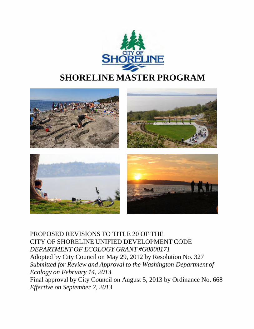
SHORELINE MASTER PROGRAM
PROPOSED REVISIONS TO TITLE 20 OF THE
CITY OF SHORELINE UNIFIED DEVELOPMENT CODE
DEPARTMENT OF ECOLOGY GRANT #G0800171
Adopted by City Council on May 29, 2012 by Resolution No. 327
Submitted for Review and Approval to the Washington Department of
Ecology on February 14, 2013
Final approval by City Council on August 5, 2013 by Ordinance No. 668
Effective on September 2, 2013
Acknowledgements
Shoreline City Council
Keith McGlashan, Mayor
Chris Eggen, Deputy Mayor
Will Hall
Doris McConnell
Christopher Roberts
Shari Winstead
Jesse Salomon
Terry Scott *
* Term ended prior to City Council adoption.
Shoreline Planning Commission
Michelle Linders Wagner, Chair
Ben Perkowski, Vice Chair
Donna Moss
Cynthia Esselman
John Behrens
Michael Broili
Easton Craft
Janne Kaje *
* Term ended prior to Planning Commission recommendation.
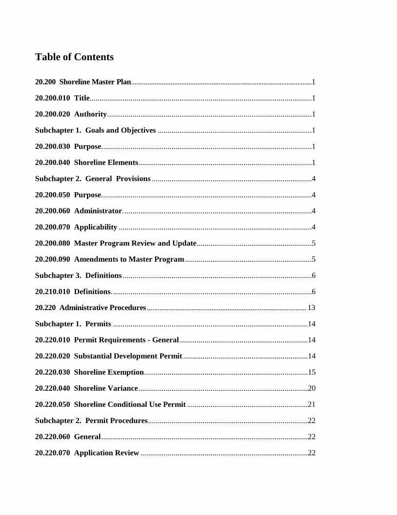
Table of Contents 20.200 Shoreline Master Plan.....................................................................................................1
20.200.010 Title..................................................................................................................1
20.200.020 Authority.........................................................................................................1 Subchapter 1. Goals and Objectives ...............................................................................1
20.200.030 Purpose............................................................................................................1
20.200.040 Shoreline Elements.........................................................................................1 Subchapter 2. General Provisions ..................................................................................4
20.200.050 Purpose............................................................................................................4
20.200.060 Administrator. ................................................................................................4 20.200.070 Applicability ...................................................................................................4
20.200.080 Master Program Review and Update...........................................................5
20.200.090 Amendments to Master Program .................................................................5 Subchapter 3. Definitions .................................................................................................6
20.210.010 Definitions. ......................................................................................................6
20.220 Administrative Procedures ......................................................................................... 13 Subchapter 1. Permits ....................................................................................................14
20.220.010 Permit Requirements - General..................................................................14 20.220.020 Substantial Development Permit ................................................................14
20.220.030 Shoreline Exemption....................................................................................15
20.220.040 Shoreline Variance.......................................................................................20 20.220.050 Shoreline Conditional Use Permit ..............................................................21
Subchapter 2. Permit Procedures..................................................................................22
20.220.060 General..........................................................................................................22 20.220.070 Application Review ......................................................................................22
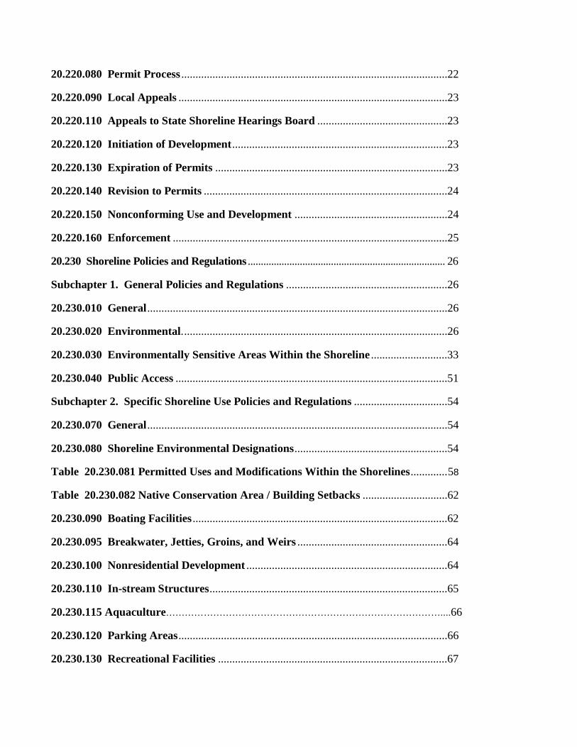
20.220.080 Permit Process ..............................................................................................22
20.220.090 Local Appeals ...............................................................................................23
20.220.110 Appeals to State Shoreline Hearings Board ..............................................23 20.220.120 Initiation of Development ............................................................................23
20.220.130 Expiration of Permits ..................................................................................23
20.220.140 Revision to Permits ......................................................................................24 20.220.150 Nonconforming Use and Development ......................................................24
20.220.160 Enforcement .................................................................................................25
20.230 Shoreline Policies and Regulations ............................................................................ 26 Subchapter 1. General Policies and Regulations .........................................................26
20.230.010 General..........................................................................................................26
20.230.020 Environmental..............................................................................................26 20.230.030 Environmentally Sensitive Areas Within the Shoreline ...........................33
20.230.040 Public Access ................................................................................................51
Subchapter 2. Specific Shoreline Use Policies and Regulations .................................54 20.230.070 General..........................................................................................................54
20.230.080 Shoreline Environmental Designations......................................................54
Table 20.230.081 Permitted Uses and Modifications Within the Shorelines.............58
Table 20.230.082 Native Conservation Area / Building Setbacks ..............................62
20.230.090 Boating Facilities ..........................................................................................62 20.230.095 Breakwater, Jetties, Groins, and Weirs .....................................................64
20.230.100 Nonresidential Development .......................................................................64
20.230.110 In-stream Structures....................................................................................65 20.230.115 Aquaculture……………………………………………………………………………....66
20.230.120 Parking Areas...............................................................................................66
20.230.130 Recreational Facilities .................................................................................67
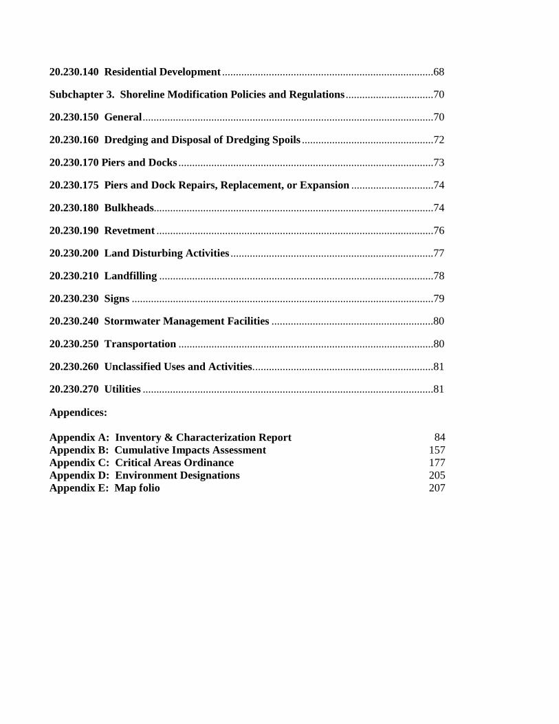
20.230.140 Residential Development .............................................................................68
Subchapter 3. Shoreline Modification Policies and Regulations ................................70
20.230.150 General..........................................................................................................70
20.230.160 Dredging and Disposal of Dredging Spoils ................................................72
20.230.170 Piers and Docks .............................................................................................73
20.230.175 Piers and Dock Repairs, Replacement, or Expansion ..............................74
20.230.180 Bulkheads......................................................................................................74
20.230.190 Revetment .....................................................................................................76
20.230.200 Land Disturbing Activities ..........................................................................77
20.230.210 Landfilling ....................................................................................................78
20.230.230 Signs ..............................................................................................................79
20.230.240 Stormwater Management Facilities ...........................................................80
20.230.250 Transportation .............................................................................................80
20.230.260 Unclassified Uses and Activities..................................................................81
20.230.270 Utilities ..........................................................................................................81
Appendices:
Appendix A:
Inventory & Characterization Report
84
Appendix B: Cumulative Impacts Assessment 157
Appendix C: Critical Areas Ordinance 177
Appendix D: Environment Designations 205
Appendix E: Map folio 207
This Page Intentionally Blank
Attachment A
City of Shoreline – Shoreline Master Program Development Code Regulations
1
20.200 Shoreline Master Plan
20.200.010 Title This chapter shall be known as the City‟s Shoreline Master Program, hereafter referred to as the Master Program.
20.200.020 Authority The Master Program is adopted in accordance with the Shoreline Management Act (Chapter 90.58 RCW) and the state shoreline guidelines (Chapter 173-26 WAC).
Where these regulations require that public access be provided, the requirement shall be
construed to be limited to the extent of the lawful and constitutional authority of the City to
require public access or to require the easement, fee ownership or interest requested.
Subchapter 1. Goals and Objectives
20.200.030 Purpose The purpose of this Master Program is to:
• Promote the public health, safety, and general welfare of the community;
• Manage shorelines in a positive, effective, and equitable manner;
• Achieve no net loss to the ecological functions of the City‟s shorelines;
• Assume and carry out the responsibilities established by the Shoreline Management Act
(SMA);
• Adopt and foster the policies contained in the Revised Code of Washington (RCW) 90.58,
the State Shoreline Management Act, for shorelines of the State; and
• Assure that proposed regulatory or administrative actions do not unconstitutionally infringe
upon private property rights.
20.200.040 Shoreline Elements The following elements have been considered in the preparation of this Master Program for the City of Shoreline. The goals and objectives established for these elements provide the basis for
policies and regulations included under the general use requirements of this Master Program.
ECONOMIC DEVELOPMENT ELEMENT
Goal Provide for economically productive uses that are particularly dependent on their
shoreline location or use.
Objective Plan for economic activity that is water-dependent, water-related, or that provides an
opportunity for a substantial number of people to enjoy the shoreline and water.
PUBLIC ACCESS ELEMENT
Goal Increase public access to publicly-owned areas of the shoreline.
Objective Provide for public access to publicly owned shoreline areas, except where deemed
inappropriate due to safety hazards, inherent security problems, environmental impacts,
or conflicts with adjacent uses.
Attachment A
City of Shoreline – Shoreline Master Program Development Code Regulations
2
RECREATIONAL ELEMENT
Goal Develop public and private recreation opportunities that are compatible with adjacent
uses and that protect the shoreline environments.
Objective Provide for the preservation and enlargement of public and private recreational
opportunities and recreational facilities along the shoreline, including but not limited to,
parks and recreational areas, wherever appropriate.
CIRCULATION ELEMENT
Goal Provide inter-connected, efficient, and safe transportation networks to and around the
shoreline to accommodate vehicles, transit, pedestrians, and cyclists.
Objective Provide for a safe and adequate circulation system, including existing and proposed
major thoroughfares, transportation routes, terminals, and other public utilities and
facilities within the shoreline jurisdiction that benefit permitted uses without degrading
the environment or aesthetic values of the area.
SHORELINE USE ELEMENT
Goal Regulate land use patterns to locate activity and development in areas of the shoreline
that will be compatible with adjacent uses and will be sensitive to existing shoreline
environments, habitat, and ecological systems.
Objective Include protections for the natural environment and adjacent uses in the Shoreline
Development Code, Point Wells Subarea Plan, Saltwater Park master planning efforts,
and other regulatory framework for development along the shoreline.
CONSERVATION ELEMENT
Goal Conserve and protect the natural resources of the shoreline including, but not limited to
scenic vistas, aesthetics, and vital estuarine areas for fisheries and wildlife protection.
Objective Through the use of best available science, develop and implement siting criteria, design
standards, and best management practices that promote the long term enhancement of
unique shoreline features, natural resources, and fish and wildlife habitat.
HISTORICAL/CULTURAL ELEMENT
Goal Identify, preserve, protect, and restore shoreline areas, buildings, and sites having
historical, cultural, educational, or scientific values.
Objective Educate citizens on historical, cultural, and scientific significance of shoreline structures,
amenities, and functions.
FLOOD HAZARD MANAGEMENT
Goal Protect the City of Shoreline and other property owners from losses and damage created
by flooding along the coast and sea-level rise.
Attachment A
City of Shoreline – Shoreline Master Program Development Code Regulations
3
Objective Seek regional solutions to flooding problems through coordinated planning with state and
federal agencies, other appropriate interests, and the public.
Objective Develop a plan to mitigate and adapt to potentially altered environmental conditions
along the coastline resulting from climate change.
RESTORATION ELEMENT
Goal Improve water quality, reduce the impacts of flooding events; and restore natural areas,
vegetation, and habitat functions.
Objective Seek funding for restoration projects within the shoreline jurisdiction and require
development proposals to address habitat restoration and water quality.
Objective Engage in discussions with other municipalities that border the Puget Sound and BNSF
railroad regarding efforts to benefit fish passage and nutrient transfer.
Attachment A
City of Shoreline – Shoreline Master Program Development Code Regulations
4
Subchapter 2. General Provisions
20.200.050 Purpose This chapter defines requirements for implementation of the Master Program and sets an orderly process for project review and permitting. The development regulations in the Master Program
are intended to make shoreline development responsive to specific design needs and
opportunities along the City's shorelines, and to protect the public's interest in the shorelines'
recreational and aesthetic values.
20.200.060 Administrator The Planning and Community Development Director or designee is the Shoreline Administrator, herein after known as the Director, and is vested with authority to:
• Administer the Master Program;
• Approve, approve with conditions, or deny Shoreline Substantial Development Permits;
• Grant exemptions from Shoreline Substantial Development Permits;
• Determine compliance with RCW43.21C, the State Environmental Policy Act; and
• Adopt rules that are necessary and appropriate to carry out the provisions of this chapter.
The Director‟s duties and responsibilities include:
• Making administrative decisions and interpretations of the policies and regulations of this
program and the Shoreline Management Act;
• Developing and proposing amendments to this Master Program to more effectively and
equitably achieve its goals and policies;
• Seeking remedies for violations of this Master Program, the provisions of the Shoreline
Management Act, or the conditions of Substantial Development Permits issued by the City;
and
• Forwarding shoreline permits to Washington State Department of Ecology for Ecology
action.
20.200.070 Applicability A. The regulations of this Title apply to all shorelines of Statewide Significance and their
associated wetlands within the City and to the waters and underlying land of the Puget Sound
extending to the middle of Puget Sound adjacent to Kitsap County, between the northern and
southern limits of the City and 200 feet landward of the Ordinary High Water Mark
(OHWM).
B. These standards provide a preference for permit issuance for measures to protect single
family residences occupied prior to January 1, 1992. Nothing in this Master Program shall
constitute authority for requiring or ordering the removal of any structures, improvements,
docks, fills, or developments placed in navigable waters prior to December 4, 1969, and the
consent and authorization of the state of Washington to the impairment of public rights of
navigation, and corollary rights incidental thereto, caused by the retention and maintenance
of said structures, improvements, docks, fills or developments are hereby granted:
PROVIDED, That the consent herein given shall not relate to any structures, improvements,
docks, fills, or developments placed on tidelands, shorelands, or beds underlying said waters
which are in trespass or in violation of state statutes.
Attachment A
City of Shoreline – Shoreline Master Program Development Code Regulations
5
C. Regulation of private property to implement Program goals such as public access and
protection of ecological functions and processes must be consistent with all relevant
constitutional and other legal limitations. These include, but are not limited to civil rights
guaranteed by the U.S. and State constitutions, recent federal and state case law, and state
statutes, such as RCW 34.05.328, 43.21C.060, and 82.02.
D. All proposed uses and development, as defined in this chapter, occurring within the shoreline
jurisdiction shall comply with this Master Program and RCW 90.58.
E. Uses and development regulated by this Program are subject to applicable provisions of the
SMC, the Comprehensive Plan, the Washington State Shoreline Management Act (RCW
90.58), Growth Management Act (RCW 36.70), Environmental Policy Act (RCW 43.21C
and WAC 197-11), and other local, state and federal laws. Project proponents are
responsible for complying with all applicable laws prior to commencing any use,
development, or activity.
F. The Master Program policies and regulations shall apply in addition to other city regulations.
Where the regulations of the Master Program conflict with other regulations, the regulations
that provide more shoreland and shoreline protection shall apply.
G. Non-conforming uses and improvements within the shoreline jurisdiction shall be subject to
this Program and SMC 20.220.150.
H. The City‟s Critical Areas Ordinance SMC 20.80, which was passed on February 27, 2006 by
Ordinance No. 398, is adopted as a part of the Master Program. The provisions of SMC 20.80
shall apply to any use, alteration or development within the shoreline jurisdiction whether or
not a shoreline permit or written statement of exemption is required.
I. Uses and developments within the shoreline jurisdiction that meet the Reasonable Use
Exception provisions of SMC 20.30.336 require a Shoreline Variance in accordance with this
chapter.
J. The exemptions and partial exemptions listed in sections SMC 20.80.030 and 20.80.040 shall
not apply within the shoreline jurisdiction. Such activities may require a Shoreline
Substantial Development Permit, Shoreline Variance, or Shoreline Conditional Use Permit
unless the Master Program and RCW 90.58.030(3)(e) specifically indicates the activity is
exempt from the Shoreline Substantial Development Permit requirements.
20.200.080 Master Program Review and Update This Master Program shall be periodically reviewed as necessary to reflect changing local circumstances, new information or improved data, and changes in State statutes and regulations.
20.200.090 Amendments to Master Program Any of the provisions of this Master Program may be amended as provided for in RCW 90.58.120 and .200 and Chapter 173.26 WAC. Amendments to the Master Program do not
become effective until approved by the Department of Ecology.
Proposals for shoreline environment redesignation, for example amendments to the shoreline
maps and descriptions, must demonstrate consistency with the criteria set forth in WAC 173-16-
040 (4).
Attachment A
City of Shoreline – Shoreline Master Program Development Code Regulations
6
Subchapter 3. Definitions
20.210.010 Definitions The Master Program shall be implemented according to the definitions contained in SMC chapter 20.20, RCW 90.58, and WAC 173-26-020. Where definitions contained in SMC chapter
20.20 conflict or differ from definitions contained in the Shoreline Management Act the
definitions in the RCW and WAC shall prevail.
Accretion. May be either natural or artificial. Natural accretion is the buildup of land, solely by
the action of the forces of nature, on a beach by deposition of water- or airborne material.
Artificial accretion is a similar buildup of land by reason of an act of man, such as the accretion
formed by a groin, breakwater, or beach fill deposited by mechanical means.
Activity. An occurrence associated with a use; the use of energy toward a specific action or
pursuit. Examples of shoreline activities include, but are not limited to, fishing, swimming,
boating, dredging, fish spawning, or wildlife nesting.
Adjacent Lands. Lands adjacent to the lands within the shoreline jurisdiction. The SMA
directs local governments to develop land use controls (i.e., zoning, comprehensive planning) for
such lands consistent with the policies of the SMA, related rules and the local shoreline master
program (Refer to RCW 90.58.340).
Agricultural Uses. (a) "Agricultural activities" means agricultural uses and practices including,
but not limited to: Producing, breeding, or increasing agricultural products; rotating and
changing agricultural crops; allowing land used for agricultural activities to lie fallow in which it
is plowed and tilled but left unseeded; allowing land used for agricultural activities to lie
dormant as a result of adverse agricultural market conditions; allowing land used for agricultural
activities to lie dormant because the land is enrolled in a local, state, or federal conservation
program, or the land is subject to a conservation easement; conducting agricultural operations;
maintaining, repairing, and replacing agricultural equipment; maintaining, repairing, and
replacing agricultural facilities, provided that the replacement facility is no closer to the shoreline
than the original facility; and maintaining agricultural lands under production or cultivation; (b)
"Agricultural products" includes but is not limited to horticultural, viticultural, floricultural,
vegetable, fruit, berry, grain, hops, hay, straw, turf, sod, seed, and apiary products; feed or forage
for livestock; Christmas trees; hybrid cottonwood and similar hardwood trees grown as crops and
harvested within twenty years of planting; and livestock including both the animals themselves
and animal products including but not limited to meat, upland finfish, poultry and poultry
products, and dairy products; (c) "Agricultural equipment" and "agricultural facilities"
includes, but is not limited to: (i) The following used in agricultural operations: Equipment;
machinery; constructed shelters, buildings, and ponds; fences; upland finfish rearing facilities;
water diversion, withdrawal, conveyance, and use equipment and facilities including but not
limited to pumps, pipes, tapes, canals, ditches, and drains; (ii) corridors and facilities for
transporting personnel, livestock, and equipment to, from, and within agricultural lands; (iii)
farm residences and associated equipment, lands, and facilities; and (iv) roadside stands and on-
farm markets for marketing fruit or vegetables; and (d) "Agricultural land" means those
specific land areas on which agriculture activities are conducted as of the date of adoption of a
Attachment A
City of Shoreline – Shoreline Master Program Development Code Regulations
7
local master program pursuant to these guidelines as evidenced by aerial photography or other
documentation. After the effective date of the master program land converted to agricultural use
is subject to compliance with the requirements of the master program.
Anadromous fish. Fish born in fresh water, which spend most of their lives in the sea and
return to fresh water to spawn. Salmon, smelt, shad, striped bass, and sturgeon are common
examples.
Associated Wetlands. Those wetlands that are in proximity to and either influence, or are
influenced by tidal waters or a lake or stream subject to the Shoreline Management Act. Refer to
WAC 173-22-030(1).
Aquaculture. The culture or farming of fish, shellfish, or other aquatic plants and animals.
Aquaculture does not include the harvest of wild geoduck associated with the state managed
wildstock geoduck fishery and upland finfish.
Aquaculture Activity. Actions directly pertaining to growing, handling, or harvesting of
aquaculture produce including, but not limited to propagation, stocking, feeding, disease
treatment, waste disposal, water use, development of habitat and structures. Excluded from this
definition are related upland commercial or industrial uses such as wholesale and retail sales,
sorting, staging, hatcheries, tank farms, and final processing and freezing.
Backfill. The placement of earth material or other approved material behind a retaining wall or
structure.
Boat Launch or Ramp. Graded slopes, slabs, pads, planks, or rails used for launching boats by
means of a trailer, hand, or mechanical device.
Breakwaters. Structures constructed on coasts as part of coastal defense to protect an anchorage
from the effects of weather and longshore drift.
Building Setback. The building setback shall be equal to the depth of the required native
vegetation conservation area.
Bulkheads. A vertical or nearly vertical structure placed parallel to the shoreline at or near the
ordinary high water mark (OHWM) for the purposing of armoring the shoreline and protecting
structures from the effects of erosion caused by wind or waves. Bulkheads generally consist of
concrete, timber, steel, rock, or other material resistant to erosion. Bulkheads are used to protect
banks by retaining soil at the toe of the slope, or by protecting the toe of the bank from erosion
and undercutting.
Community Pier or Dock. Moorage for pleasure craft and/or landing for water sports for use in
common by four or more residential units of a certain subdivision or community within the
shoreline jurisdiction.
Attachment A
City of Shoreline – Shoreline Master Program Development Code Regulations
8
Community Boat Launching Ramp. An inclined slab, set of pads, rails, planks, or graded
slope used for launching boats with trailers or by hand for use in common by shoreline residents
of a certain subdivision or community within shoreline jurisdiction.
Conditional Use, Shoreline. A use, development, or substantial development that is classified
as a conditional use or is not classified within the Master Program. Refer to WAC 173-27-
030(4).
Development, Shoreline. Development means a use consisting of the construction or exterior
alteration of structures; dredging; drilling; dumping; filling; removal of any sand, gravel, or
minerals; bulkheading; driving of piling; placing of obstructions; or any project of a permanent
or temporary nature which interferes with the normal public use of the surface of the waters
overlying lands subject to this chapter at any state of water level. RCW 90.58-030 3(d).
Dredging. The removal or displacement of earth such as gravel, sand, mud, or silt from lands
covered by water. Lands covered by water include stream beds and wetlands. Dredging is
normally done for specific purposes or uses such as maintaining navigation channels,
constructing bridge footings, or laying submarine pipelines or cable.
Dredge Spoil. The material removed by dredging.
Dredge Spoil Disposal. The depositing of dredged materials on land or into water bodies for the
purpose of either creating new or additional lands or for disposing of the material in an
acceptable manner.
Ecological Functions, Shoreline or Shoreline Functions. The work performed or the role
played by the physical, chemical, and biological processes that contribute to the maintenance of
the aquatic and terrestrial environments that constitute the shoreline‟s natural ecosystem. See
WAC 173-26-201(c).
Enhancement. Alteration of an existing resource to improve or increase its characteristics and
processes without degrading other existing functions. Enhancements are to be distinguished
from resource creation or restoration projects.
Exemption. Certain specific developments as listed in WAC 173-27-040 are exempt from the
definition of substantial developments, and are therefore exempt from the Substantial
Development Permit process of the SMA.
Fair Market Value. The open market bid price for conducting the work, using the equipment
and facilities, and purchase of the goods, services and materials necessary to accomplish a
development. This would normally equate to the cost of hiring a contractor to undertake the
development from start to finish, including the cost of labor, materials, equipment and facility
usage, transportation and contractor overhead and profit. The fair market value of the
development shall include the fair market value of any donated, contributed or found labor,
equipment, or materials.
Attachment A
City of Shoreline – Shoreline Master Program Development Code Regulations
9
Feasible. An action, such as a development project, mitigation, or preservation requirement,
shall meet all of the following conditions: (a) The action can be accomplished with technologies
and methods that have been used in the past in similar circumstances, or studies or tests have
demonstrated in similar circumstances that such approaches are currently available and likely to
achieve the intended results; (b) The action provides a reasonable likelihood of achieving its
intended purpose; and (c) The action does not physically preclude achieving the project's primary
intended legal use. In cases where these guidelines require certain actions unless they are
infeasible, the burden of proving infeasibility is on the applicant. In determining an action's
infeasibility, the reviewing agency may weigh the action's relative public costs and public
benefits, considered in the short- and long-term time frames.
Flood Control. Any undertaking for the conveyance, control, and dispersal of floodwaters
caused by abnormally high direct precipitation or stream overflow.
Gabions. Cages, cylinders, or boxes filled with soil or sand that are used in civil engineering,
road building, and military applications, primarily for erosion control and building dams and
retaining walls.
Geotechnical Report or Analysis. A scientific study or evaluation conducted by a qualified
expert that includes a description of the ground and surface hydrology and geology, the affected
land form and its susceptibility to mass wasting, erosion, and other geologic hazards or
processes, conclusions and recommendations regarding the effect of the proposed development
on geologic conditions, the adequacy of the site to be developed, the impacts of the proposed
development, alternative approaches to the proposed development, and measures to mitigate
potential site-specific and cumulative geological and hydrological impacts of the proposed
development, including the potential adverse impacts to adjacent and down-current properties.
Geotechnical reports shall conform to accepted technical standards and must be prepared by
qualified professional engineers or geologists who have professional expertise about the regional
and local shoreline geology and processes.
Groin. A rigid structure built out from a shore to protect the shore from erosion, to trap sand, or
to direct a current for scouring a channel.
Grading. The movement or redistribution of the soil, sand, rock, gravel, sediment, or other
material on a site in a manner that alters the natural contour of the land.
Groundwater recharge. A hydrologic process where water moves downward from surface
water to groundwater. Recharge occurs both naturally (through the water cycle) and
anthropologically (i.e., "artificial groundwater recharge"), where rainwater and or reclaimed
water is routed to the subsurface.
Jetty. Any of a variety of structures used in river, dock, and maritime works that are generally
carried out in pairs from river banks, or in continuation of river channels at their outlets into deep
water; or out into docks, and outside their entrances; or for forming basins along the sea-coast for
ports in tideless seas.
Attachment A
City of Shoreline – Shoreline Master Program Development Code Regulations
10
Joint-Use. Moorage for pleasure craft and/or landing for water sports for use in common by 2 or
more residential units of a certain subdivision or community within shoreline jurisdiction.
Hydric Soil. Soil that formed under conditions of saturation, flooding, or ponding long enough
during the growing season to develop anaerobic conditions in the upper soil horizon(s).
Land Disturbing Activities. Any activity resulting in a movement of earth, or a change in the
existing soil cover, both vegetative and non-vegetative, or the existing topography excluding the
addition of soil, sand, rock, gravel, sediment, earth retaining structure, or other material to an area
waterward of the OHWM, in wetlands, or on shorelands in a manner that raises the elevation or
creates dry land. Land disturbing activities include, but are not limited to clearing, grading, filling,
excavation, or addition of new or the replacement of impervious surface. Compaction, excluding hot
asphalt mix, which is associated with stabilization of structures and road construction, shall also be
considered a land disturbing activity.
Landfilling. The addition of soil, sand, rock, gravel, sediment, earth retaining structure, or other
material to an area waterward of the OHWM, in wetlands, or on shorelands in a manner that creates
dry land.
Native Vegetation. Vegetation comprised of plant species, other than noxious weeds, that are
indigenous to the coastal region of the Pacific Northwest and which reasonably could have been
expected to naturally occur on the site. Examples include trees such as madrona, douglas fir,
western hemlock, western red cedar, alder, big-leaf maple, and vine maple; shrubs such as
willow, elderberry, salmonberry, and salal; and herbaceous plants such as sword fern, foam
flower, and fireweed.
Native Vegetation Conservation Area. Vegetated area between the Native Vegetation Setback
Line and the Ordinary High Water Mark.
Native Vegetation Setback Line. Unless otherwise indicated within this Master Program, the
line that establishes the limits of all buildings, fencing and impervious surfaces along the
shoreline.
Nonconforming Use and Development. A shoreline use or development that was lawfully
constructed or established prior to the effective date of the act or the applicable master program,
or amendments thereto, but which does not conform to present regulations or standards of the
program.
Nonwater-oriented Uses. Those uses that are not water-dependent, water-related, or water-
enjoyment.
Normal Maintenance. Usual acts to prevent a decline, lapse, or cessation from a lawfully
established condition.
Nor mal Repair . To restore a development to a state comparable to its original condition,
including but not limited to its size, shape, configuration, location and external appearance,
Attachment A
City of Shoreline – Shoreline Master Program Development Code Regulations
11
within a reasonable period after decay or partial destruction, except where repair causes
substantial adverse effects to shoreline resource or environment. Replacement of a structure or
development may be authorized as repair where such replacement is the common method of
repair for the type of structure or development and the replacement structure or development is
comparable to the original structure or development including but not limited to its size, shape,
configuration, location and external appearance and the replacement does not cause substantial
adverse effects to shoreline resources or environment.
Ordinary High Water Mark (OHWM). OHWM on all lakes, streams, and tidal water is that
mark that will be found by examining the bed and banks and ascertaining where the presence and
action of waters are so common and usual, and so long continued in all ordinary years, as to
mark upon the soil a character distinct from that of the abutting upland, in respect to vegetation
as that condition exists on June 1, 1971, as it may naturally change thereafter, or as it may
change thereafter in accordance with permits issued by a local government or the department,
provided that in any area where the ordinary high water mark cannot be found, the ordinary high
water mark adjoining salt water shall be the line of mean higher high tide and the ordinary high
water mark adjoining fresh water shall be the line of mean high water.
Public Access. Public access is the ability of the general public to reach, touch, and enjoy the
water's edge, to travel on the waters of the state, and to view the water and the shoreline from
adjacent locations. Refer to WAC 173-26-221(4).
Public Pier or Dock. Moorage for pleasure craft and/or landing for water sports for use by the
general public.
Public Boat Launching Ramp. An inclined slab, set of pads, rails, planks, or graded slope used
for launching boats with trailers or by hand for use by the general public.
Restoration. The reestablishment or upgrading of impaired ecological processes or functions.
This may be accomplished through measures including but not limited to re-vegetation, removal
of intrusive structures, toxic materials, or invasive or non-native plants. Restoration does not
imply a requirement for returning the area to pre-European settlement conditions.
Revetment. A sloped wall constructed of riprap or other suitable material placed on stream
banks or other shorelines to retard bank erosion and minimize lateral stream movement. A
revetment typically slopes away from the water and has a rough or jagged face. These features
differentiate it from a bulkhead, which is a vertical structure. Revetments are a facing of stone,
concrete, etc., built to protect a scarp, embankment, or shore structure against erosion by waves
or currents. The principal features of a revetment are: 1) heavy armor layer, 2) filter layer, and
3) toe protection.
Riparian. The characteristic of relating to or living or located on the bank of a natural
watercourse (as a river) or sometimes of a lake or a tidewater.
Sediment. The fine-grained material deposited by water or wind.
Attachment A
City of Shoreline – Shoreline Master Program Development Code Regulations
12
Shorelands or Shoreland Areas. Those lands extending landward for two hundred feet in all
directions as measured on a horizontal plane from the ordinary high water mark; contiguous
floodplain areas landward two hundred feet; and all wetlands and deltas associated with the
streams, lakes, and tidal waters that are subject to the provisions of this chapter; the same to be
designated as to location by the Department of Ecology.
Shoreline Jurisdiction. All "shorelines of the state" and "shorelands" as defined in RCW
90.58.030.
Shoreline Master Program or Master Program. The comprehensive plan for the use of a
described area, and the regulations for use of the area including maps, diagrams, charts, or other
descriptive material and text, a statement of desired goals, and standards developed in
accordance with the policies enunciated in RCW 90.58.020. As provided in RCW 36.70A.480,
the goals and policies of a shoreline master program for a county or city approved under chapter
90.58 RCW shall be considered an element of the county or city's Comprehensive Plan. All
other portions of the Shoreline Master Program for a county or city adopted under chapter 90.58
RCW, including use regulations, shall be considered a part of the county or city's development
regulations.
Shoreline Modifications. Those actions that modify the physical configuration or qualities of
the shoreline area, usually through the construction of a physical element such as a dike,
breakwater, pier, weir, dredged basin, fill, bulkhead, or other shoreline structure. They can
include other actions, such as clearing, grading, or application of chemicals.
Shorelines. All of the water areas of the state, including reservoirs, and their associated
shorelands, together with the lands underlying them; except (i) shorelines of statewide
significance; and (ii) shorelines on lakes less than twenty acres in size and wetlands associated
with such small lakes.
Shorelines of Statewide Significance. “Shorelines of the State” that meet the criteria for
“Shorelines of Statewide Significance” contained in RCW 90.58.030(f). As it applies to the City
of Shoreline, shorelines of statewide significance include those areas of Puget Sound and
adjacent salt waters between the ordinary high water mark and the line of extreme low tide.
Shorelines of the State. This term includes both “shorelines” and “shorelines of statewide
significance.”
Substantial Development. Any development with a total cost or fair market value of five-
thousand seven hundred and eighteen dollars ($5,718.00) or more that requires a Shoreline
Substantial Development Permit. The threshold total cost or fair market value of $5,718.00 is set
by the State Office of Financial Management and may be adjusted in the future pursuant to the
SMA requirements, as defined in RCW 90.58.030(3)(e) as now or hereafter amended.
Water-dependent Use. A use or portion of a use which cannot exist in a location that is not
adjacent to the water, but is dependent on the water by reason of the intrinsic nature of its
operations.
Attachment A
City of Shoreline – Shoreline Master Program Development Code Regulations
13
Water-enjoyment Use. A recreational or other use that facilitates public access to the shoreline
as a primary characteristic of the use; or a use that provides for recreational use or aesthetic
enjoyment of the shoreline for a substantial number of people as a general characteristic of the
use and which through location, design, and operation ensures the public's ability to enjoy the
physical and aesthetic qualities of the shoreline. In order to qualify as a water-enjoyment use,
the use must be open to the general public and the shoreline-oriented space within the project
must be devoted to the specific aspects of the use that fosters shoreline enjoyment.
Water-oriented Use. A use that is water-dependent, water-related, or water-enjoyment, or a
combination of such uses.
Water Quality. The physical characteristics of water within shoreline jurisdiction, including
water quantity, hydrological, physical, chemical, aesthetic, recreation-related, and biological
characteristics. Where used in this chapter, the term "water quantity" refers only to development
and uses regulated under this chapter and affecting water quantity, such as impermeable surfaces
and storm water handling practices. Water quantity, for purposes of this chapter, does not mean
the withdrawal of ground water or diversion of surface water pursuant to RCW 90.03.250
through RCW 90.03.340.
Water-related Use. A use or portion of a use that is not intrinsically dependent on a waterfront
location, but whose economic viability is dependent upon a waterfront location because: (a) The
use has a functional requirement for a waterfront location such as the arrival or shipment of
materials by water or the need for large quantities of water; or (b) The use provides a necessary
service supportive of the water-dependent uses and the proximity of the use to its customers
makes its services less expensive and/or more convenient.
Wave Return. A structure added on top of, or part of an existing bulkhead or hard-armoring which
redirects wave action back waterward and helps prevent water from splashing landward, thereby
protecting the armoring itself, and landward items such as natural ecology and other structures.
Weir. A dam in a watercourse, usually a stream or river, to raise the water level or divert its flow.
Wetlands. Areas that are inundated or saturated by surface water or groundwater at a frequency and
duration sufficient to support, and that under normal circumstances do support, a prevalence of
vegetation typically adapted for life in saturated soil conditions. Wetlands generally include swamps,
marshes, bogs, and similar areas. Wetlands do not include those artificial wetlands intentionally
created from nonwetland sites, including, but not limited to, irrigation and drainage ditches, grass-
lined swales, canals, detention facilities, wastewater treatment facilities, farm ponds, and landscape
amenities, or those wetlands created after July 1, 1990, that were unintentionally created as a result of
the construction of a road, street, or highway. Wetlands may include those artificial wetlands
intentionally created from nonwetland areas to mitigate the conversion of wetlands
Wetland delineation. A technical procedure performed by a wetland specialist to determine the area
of a wetland, ascertaining the wetland‟s classification, function, and value, and to define the boundary
between a wetland and adjacent uplands. Identification of wetlands and delineation of their
boundaries pursuant to this Chapter shall be done in accordance with the approved federal wetland
delineation manual and applicable regional supplements. All areas within the City meeting the
wetland designation criteria in that procedure are hereby designated critical areas and are subject to
the provisions of this Program.
Attachment A
City of Shoreline – Shoreline Master Program Development Code Regulations
14
20.220 Administrative Procedures
Subchapter 1. Permits
20.220.010 Permit Requirements - General A. Based on the provisions of this Master Program, the Director shall determine if a Substantial
Development Permit, a Shoreline Conditional Use Permit and/or a Shoreline Variance is
required.
B. A permit is required for substantial development as defined in RCW 90.58.030(3)(e) within
the shoreline jurisdiction.
C. A Substantial Development Permit is not required for exempt development. An exempt
development requires a statement of exemption pursuant to 20.220.030 and may require a
Shoreline Variance from Master Program provisions and/or a Shoreline Conditional Use
Permit.
D. All uses and development shall be carried out in a manner consistent with the SMC and the
Master Program regardless of whether a Substantial Development Permit, Statement of
Exemption, Shoreline Variance, or Shoreline Conditional Use Permit is required.
E. When a development or use is proposed that does not comply with the bulk, dimensional
and/or performance standards of this Program, such development or use may only be
authorized by approval of a Shoreline Variance, even if the development or use does not
require a Substantial Development Permit.
F. A development or use listed as a Shoreline Conditional Use pursuant to this chapter, or any
unlisted use, must obtain a Shoreline Conditional Use Permit even if the development or use
does not require a Substantial Development Permit.
G. Issuance of a Statement of Exemption, Shoreline Substantial Development Permit, Shoreline
Variance, or Shoreline Conditional Use Permit does not constitute approval of any other
City, state, or federal laws or regulations.
H. All shoreline permits or statements of exemption issued for development or use within the
shoreline jurisdiction shall include written findings prepared by the Director, documenting
compliance with bulk and dimensional policies and regulations of the Master Program. The
Director may attach conditions to the approval as necessary to assure consistency with the
Master Program and RCW 90.58. The conditions may include a requirement to post a
performance financial guarantee assuring compliance with permit requirements, terms and
conditions.
20.220.020 Substantial Development Permit A. Substantial development as defined by RCW 90.58.030 shall not be undertaken by any
person on the shorelines of the state without first obtaining a Substantial Development Permit
from the Director, unless the use or development is specifically identified as exempt.
B. A Substantial Development Permit shall only be granted by the Director when the
development proposed is consistent with the policies and procedures of RCW.90.58; the
provisions of WAC 173-27; and the Master Program.
C. An exemption from the Substantial Development Permit requirements does not constitute an
exemption from the policies and use regulations of the Shoreline Management Act, the
provisions of this Master Program or other applicable city, state, or federal requirements. A
formal Statement of Shoreline Exemption is required pursuant to 20.220.030.
Attachment A
City of Shoreline – Shoreline Master Program Development Code Regulations
15
20.220.030 Shoreline Exemption A. The Director is hereby authorized to approve or deny requests for statements of exemption
from the Shoreline Substantial Development Permit requirement for uses and developments
within shorelines that are specifically listed in RCW 90.58.030 and WAC 173-27-040. The
statement shall be in writing and shall indicate the specific exemption of the Master Program
that is being applied to the development, and shall provide a summary of the Director‟s
analysis of the consistency of the project with this Master Program and the Act. WAC
173.27.040 delineates exemptions and is included below.
Exempt developments include:
1. Any development of which the total cost or fair market value, whichever is higher, does not
exceed five thousand dollars, if such development does not materially interfere with the
normal public use of the water or shorelines of the state. The dollar threshold established in
this subsection must be adjusted for inflation by the office of financial management every
five years, beginning July 1, 2007, based upon changes in the consumer price index during
that time period. "Consumer price index" means, for any calendar year, that year's annual
average consumer price index, Seattle, Washington area, for urban wage earners and clerical
workers, all items, compiled by the Bureau of Labor and Statistics, United States Department
of Labor. The office of financial management must calculate the new dollar threshold and
transmit it to the office of the code reviser for publication in the Washington State Register
at least one month before the new dollar threshold is to take effect. For purposes of
determining whether or not a permit is required, the total cost or fair market value shall be
based on the value of development that is occurring on shorelines of the state as defined in
RCW 90.58.030 (2)(c). The total cost or fair market value of the development shall include
the fair market value of any donated, contributed or found labor, equipment or materials.
2. Normal maintenance or repair of existing structures or developments, including damage by
accident, fire or elements. "Normal maintenance" includes those usual acts to prevent a
decline, lapse, or cessation from a lawfully established condition. "Normal repair" means to
restore a development to a state comparable to its original condition, including but not
limited to its size, shape, configuration, location and external appearance, within a reasonable
period after decay or partial destruction, except where repair causes substantial adverse
effects to shoreline resource or environment. Replacement of a structure or development may
be authorized as repair where such replacement is the common method of repair for the type
of structure or development and the replacement structure or development is comparable to
the original structure or development including but not limited to its size, shape,
configuration, location and external appearance and the replacement does not cause
substantial adverse effects to shoreline resources or environment.
3. Construction of the normal protective bulkhead common to single-family residences. A
"normal protective" bulkhead includes those structural and nonstructural developments
installed at or near, and parallel to, the ordinary high water mark for the sole purpose of
protecting an existing single-family residence and appurtenant structures from loss or
damage by erosion. A normal protective bulkhead is not exempt if constructed for the
purpose of creating dry land. When a vertical or near vertical wall is being constructed or
reconstructed, not more than one cubic yard of fill per one foot of wall may be used as
backfill. When an existing bulkhead is being repaired by construction of a vertical wall
fronting the existing wall, it shall be constructed no further waterward of the existing
Attachment A
City of Shoreline – Shoreline Master Program Development Code Regulations
16
bulkhead than is necessary for construction of new footings. When a bulkhead has
deteriorated such that an ordinary high water mark has been established by the presence and
action of water landward of the bulkhead then the replacement bulkhead must be located at
or near the actual ordinary high water mark. Beach nourishment and bioengineered erosion
control projects may be considered a normal protective bulkhead when any structural
elements are consistent with the above requirements and when the project has been approved
by the department of fish and wildlife.
4. Emergency construction necessary to protect property from damage by the elements. An
"emergency" is an unanticipated and imminent threat to public health, safety, or the
environment which requires immediate action within a time too short to allow full
compliance with this chapter. Emergency construction does not include development of new
permanent protective structures where none previously existed. Where new protective
structures are deemed by the administrator to be the appropriate means to address the
emergency situation, upon abatement of the emergency situation the new structure shall be
removed or any permit which would have been required, absent an emergency, pursuant to
chapter 90.58 RCW, these regulations, or the local master program, obtained. All emergency
construction shall be consistent with the policies of chapter 90.58 RCW and the local master
program. As a general matter, flooding or other seasonal events that can be anticipated and
may occur but that are not imminent are not an emergency.
5. Construction and practices normal or necessary for farming, irrigation, and ranching
activities, including agricultural service roads and utilities on shorelands, construction of a
barn or similar agricultural structure, and the construction and maintenance of irrigation
structures including but not limited to head gates, pumping facilities, and irrigation channels:
Provided, That a feedlot of any size, all processing plants, other activities of a commercial
nature, alteration of the contour of the shorelands by leveling or filling other than that which
results from normal cultivation, shall not be considered normal or necessary farming or
ranching activities. A feedlot shall be an enclosure or facility used or capable of being used
for feeding livestock hay, grain, silage, or other livestock feed, but shall not include land for
growing crops or vegetation for livestock feeding and/or grazing, nor shall it include normal
livestock wintering operations.
6. Construction or modification of navigational aids such as channel markers and anchor buoys.
7. Construction on shorelands by an owner, lessee or contract purchaser of a single-family
residence for their own use or for the use of their family, which residence does not exceed a
height of thirty-five feet above average grade level and which meets all requirements of the
state agency or local government having jurisdiction thereof, other than requirements
imposed pursuant to chapter 90.58 RCW. "Single-family residence" means a detached
dwelling designed for and occupied by one family including those structures and
developments within a contiguous ownership which are a normal appurtenance. An
"appurtenance" is necessarily connected to the use and enjoyment of a single-family
residence and is located landward of the ordinary high water mark and the perimeter of a
wetland. On a statewide basis, normal appurtenances include a garage; deck; driveway;
utilities; fences; installation of a septic tank and drainfield and grading which does not
exceed two hundred fifty cubic yards and which does not involve placement of fill in any
wetland or waterward of the ordinary high water mark. Local circumstances may dictate
additional interpretations of normal appurtenances which shall be set forth and regulated
Attachment A
City of Shoreline – Shoreline Master Program Development Code Regulations
17
within the applicable master program. Construction authorized under this exemption shall be
located landward of the ordinary high water mark.
8. Construction of a dock, including a community dock, designed for pleasure craft only, for the
private noncommercial use of the owner, lessee, or contract purchaser of single-family and
multiple-family residences. A dock is a landing and moorage facility for watercraft and does
not include recreational decks, storage facilities or other appurtenances. This exception
applies if either:
a. In salt waters, the fair market value of the dock does not exceed two thousand five
hundred dollars; or
b. In fresh waters the fair market value of the dock does not exceed ten thousand dollars,
but if subsequent construction having a fair market value exceeding two thousand five
hundred dollars occurs within five years of completion of the prior construction, the
subsequent construction shall be considered a substantial development for the purpose
of this chapter.
c. For purposes of this section salt water shall include the tidally influenced marine and
estuarine water areas of the state including the Pacific Ocean, Strait of Juan de Fuca,
Strait of Georgia and Puget Sound and all bays and inlets associated with any of the
above.
9. Operation, maintenance, or construction of canals, waterways, drains, reservoirs, or other
facilities that now exist or are hereafter created or developed as a part of an irrigation system
for the primary purpose of making use of system waters, including return flow and artificially
stored groundwater from the irrigation of lands.
10. The marking of property lines or corners on state-owned lands, when such marking does not
significantly interfere with normal public use of the surface of the water.
11. Operation and maintenance of any system of dikes, ditches, drains, or other facilities existing
on September 8, 1975, which were created, developed or utilized primarily as a part of an
agricultural drainage or diking system.
12. Any project with a certification from the governor pursuant to chapter 80.50 RCW.
13. Site exploration and investigation activities that are prerequisite to preparation of an
application for development authorization under this chapter, if:
a. The activity does not interfere with the normal public use of the surface waters;
b. The activity will have no significant adverse impact on the environment including but
not limited to fish, wildlife, fish or wildlife habitat, water quality, and aesthetic
values;
c. The activity does not involve the installation of any structure, and upon completion of
the activity the vegetation and land configuration of the site are restored to conditions
existing before the activity;
d. A private entity seeking development authorization under this section first posts a
performance bond or provides other evidence of financial responsibility to the local
jurisdiction to ensure that the site is restored to preexisting conditions; and
e. The activity is not subject to the permit requirements of RCW 90.58.550;
The process of removing or controlling aquatic noxious weeds, as defined in RCW
17.26.020, through the use of an herbicide or other treatment methods applicable to
weed control that are recommended by a final environmental impact statement
Attachment A
City of Shoreline – Shoreline Master Program Development Code Regulations
18
published by the department of agriculture or the department of ecology jointly with
other state agencies under chapter 43.21C RCW.
14. Watershed restoration projects as defined herein. Local government shall review the projects
for consistency with the shoreline master program in an expeditious manner and shall issue
its decision along with any conditions within forty-five days of receiving all materials
necessary to review the request for exemption from the applicant. No fee may be charged for
accepting and processing requests for exemption for watershed restoration projects as used in
this section.
"Watershed restoration project" means a public or private project authorized by the sponsor
of a watershed restoration plan that implements the plan or a part of the plan and consists of
one or more of the following activities:
a. A project that involves less than ten miles of streamreach, in which less than twenty-
five cubic yards of sand, gravel, or soil is removed, imported, disturbed or discharged,
and in which no existing vegetation is removed except as minimally necessary to
facilitate additional plantings;
b. A project for the restoration of an eroded or unstable stream bank that employs the
principles of bioengineering, including limited use of rock as a stabilization only at
the toe of the bank, and with primary emphasis on using native vegetation to control
the erosive forces of flowing water; or
c. A project primarily designed to improve fish and wildlife habitat, remove or reduce
impediments to migration of fish, or enhance the fishery resource available for use by
all of the citizens of the state, provided that any structure, other than a bridge or
culvert or instream habitat enhancement structure associated with the project, is less
than two hundred square feet in floor area and is located above the ordinary high
water mark of the stream.
d. "Watershed restoration plan" means a plan, developed or sponsored by the
department of fish and wildlife, the department of ecology, the department of natural
resources, the department of transportation, a federally recognized Indian tribe acting
within and pursuant to its authority, a city, a county, or a conservation district that
provides a general program and implementation measures or actions for the
preservation, restoration, re-creation, or enhancement of the natural resources,
character, and ecology of a stream, stream segment, drainage area, or watershed for
which agency and public review has been conducted pursuant to chapter 43.21C
RCW, the State Environmental Policy Act;
15. A public or private project that is designed to improve fish or wildlife habitat or fish
passage, when all of the following apply:
a. The project has been approved in writing by the department of fish and wildlife;
b. The project has received hydraulic project approval by the department of fish and
wildlife pursuant to chapter 77.55 RCW; and
c. The local government has determined that the project is substantially consistent with
the local shoreline master program. The local government shall make such
determination in a timely manner and provide it by letter to the project proponent.
Fish habitat enhancement projects that conform to the provisions of RCW 77.55.181
are determined to be consistent with local shoreline master programs, as follows:
Attachment A
City of Shoreline – Shoreline Master Program Development Code Regulations
19
i. In order to receive the permit review and approval process created in this
section, a fish habitat enhancement project must meet the criteria under
15(c)(i)(I) and (II) of this subsection:
I. A fish habitat enhancement project must be a project to accomplish
one or more of the following tasks:
• Elimination of human-made fish passage barriers, including culvert
repair and replacement;
• Restoration of an eroded or unstable streambank employing the
principle of bioengineering, including limited use of rock as a
stabilization only at the toe of the bank, and with primary emphasis on
using native vegetation to control the erosive forces of flowing water;
or
• Placement of woody debris or other instream structures that benefit
naturally reproducing fish stocks.
The department of fish and wildlife shall develop size or scale
threshold tests to determine if projects accomplishing any of these
tasks should be evaluated under the process created in this section or
under other project review and approval processes. A project proposal
shall not be reviewed under the process created in this section if the
department determines that the scale of the project raises concerns
regarding public health and safety; and
II. A fish habitat enhancement project must be approved in one of the
following ways:
• By the department of fish and wildlife pursuant to chapter 77.95 or
77.100 RCW;
• By the sponsor of a watershed restoration plan as provided in
chapter 89.08 RCW;
• By the department as a department of fish and wildlife-sponsored
fish habitat enhancement or restoration project;
• Through the review and approval process for the jobs for the
environment program;
• Through the review and approval process for conservation district-
sponsored projects, where the project complies with design standards
established by the conservation commission through interagency
agreement with the United States Fish and Wildlife Service and the
natural resource conservation service;
• Through a formal grant program established by the legislature or the
department of fish and wildlife for fish habitat enhancement or
restoration; and
• Through other formal review and approval processes established by
the legislature.
ii. Fish habitat enhancement projects meeting the criteria of 15(c)(i) of this
subsection are expected to result in beneficial impacts to the environment.
Decisions pertaining to fish habitat enhancement projects meeting the criteria
of 15(c)(i) of this subsection and being reviewed and approved according to
Attachment A
City of Shoreline – Shoreline Master Program Development Code Regulations
20
the provisions of this section are not subject to the requirements of RCW
43.21C.030 (2)(c).
I. A hydraulic project approval permit is required for projects that meet
the criteria of 15(c)(i) of this subsection and are being reviewed and
approved under this section. An applicant shall use a joint aquatic
resource permit application form developed by the office of regulatory
assistance to apply for approval under this chapter. On the same day,
the applicant shall provide copies of the completed application form to
the department of fish and wildlife and to each appropriate local
government. Local governments shall accept the application as notice
of the proposed project. The department of fish and wildlife shall
provide a fifteen-day comment period during which it will receive
comments regarding environmental impacts. Within forty-five days,
the department shall either issue a permit, with or without conditions,
deny approval, or make a determination that the review and approval
process created by this section is not appropriate for the proposed
project. The department shall base this determination on identification
during the comment period of adverse impacts that cannot be mitigated
by the conditioning of a permit. If the department determines that the
review and approval process created by this section is not appropriate
for the proposed project, the department shall notify the applicant and
the appropriate local governments of its determination. The applicant
may reapply for approval of the project under other review and
approval processes.
II. Any person aggrieved by the approval, denial, conditioning, or
modification of a permit under this section may formally appeal the
decision to the hydraulic appeals board pursuant to the provisions of
this chapter.
iii. No local government may require permits or charge fees for fish habitat
enhancement projects that meet the criteria of 15(c)(i) of this subsection and
that are reviewed and approved according to the provisions of this section.
16. Before issuing a Shoreline Exemption, the Director shall review the Master Program to
determine if the proposed development requires a Shoreline Variance and/or a Shoreline
Conditional Use Permit.
20.220.040 Shoreline Variance The purpose of a variance is to grant relief to specific bulk or dimensional requirements set forth in the Master Program where there are extraordinary or unique circumstances relating to the
property such that the strict implementation of this Program would impose unnecessary
hardships on the applicant or diminish the policies set forth in RCW 90.58.020.
A. The Director is authorized to approve a Shoreline Variance from the performance standards
of this Master Program only when all of the criteria enumerated in WAC 173-27-170 are met.
B. A Shoreline Variance should be granted in circumstances where denial of the permit would
thwart the policies enumerated in RCW 90.58.020.
Attachment A
City of Shoreline – Shoreline Master Program Development Code Regulations
21
C. In all instances, the applicant must demonstrate that extraordinary circumstances exist and
the public interest will not suffer substantial detrimental effect.
D. The applicant for a Shoreline Variance must demonstrate that the variance meets the criteria
in WAC 173-27-170.
E. Proposals that require a Critical Area Reasonable Use Permit pursuant to SMC 20.30.336
shall also require a Shoreline Variance.
F. Prior to approval of any Shoreline Variance, the Director shall consider the cumulative
environmental impacts of previous, existing, and possible future requests for like actions in
the area. The total effects of approved Shoreline Variances should remain consistent with the
policies of RCW 90.58.020 and shall not produce significant adverse effects to the shoreline
ecological functions, processes, or other users.
G. Before making a determination to approve a Shoreline Variance, the Director shall consider
issues related to the conservation of valuable natural resources and the protection of views
from public lands.
H. Shoreline Variance requests based on the applicant's/proponent‟s desire to enhance the view
from the subject development may be granted where there are no likely detrimental effects to
existing or future users, views from public lands, critical areas, other features or shoreline
ecological functions and/or processes, and where reasonable alternatives of equal or greater
consistency with this Program are not available.
I. A Shoreline Variance shall not be granted when it would allow a greater height or lesser
shoreline setback than what is typical for the area immediately surrounding the development
site.
J. A variance issued per SMC 20.30.310 shall not be construed to mean approval of a Shoreline
Variance from Shoreline Master Program use regulations.
K. An issued Shoreline Variance does not provide relief from the variance requirements under
SMC 20.30.310.
20.220.050 Shoreline Conditional Use Permit The purpose of a Shoreline Conditional Use Permit is to allow greater flexibility in the application of the use regulations of the Master Program in a manner consistent with the policies of RCW
90.58.020.
A. The Director is authorized to issue Shoreline Conditional Use Permits only when all the
criteria enumerated in WAC 173-27-160 are met.
B. Shoreline Conditional Use Permits should be granted in a circumstance where denial of the
permit would result in a conflict with the policies enumerated in RCW 90.58.020.
C. In authorizing a Shoreline Conditional Use, special conditions may be attached to the permit by
the Director or by the Department of Ecology to minimize the effects of the proposed use. Uses
that are specifically prohibited by the Master Program may not be authorized with the approval
of a Shoreline Conditional Use Permit.
D. Proposals that require a Critical Area Reasonable Use Permit pursuant to SMC 20.30.336
shall also require a Shoreline Variance.
Attachment A
City of Shoreline – Shoreline Master Program Development Code Regulations
22
Subchapter 2. SMP Permit Procedures
20.220.060 General A. Permits required under this chapter shall be processed consistent with the provisions of
chapter 20.30 SMC and the criteria in this subchapter.
B. No permit shall be approved unless the proposed development is consistent with the
provisions of this Master Program, the Shoreline Management Act of 1971, and the rules and
regulations adopted by the Department of Ecology.
C. Applications for shoreline permits shall also demonstrate compliance with the provisions of
this subchapter.
20.220.070 Application Review A. Applications for shoreline permits shall comply with the submittal requirements developed
pursuant to 20.30.100 and shall provide all information the Director determines necessary for
an application to be complete.
B. Burden of Proof. It is the applicant‟s responsibility to provide proof that the proposed
development is consistent with the permit criteria requirements.
C. Approval. The Director may approve, or approve with conditions, any application that complies
with criteria imposed by the Master Program and the Shoreline Management Act.
D. Conditions. The Director may attach to a permit any suitable and reasonable terms or
conditions necessary to ensure the purpose and objectives of this Master Program and the
Shoreline Management Act.
E. Denial. The Director may deny any application that does now comply with criteria imposed by
the Master Program or the Shoreline Management Act.
F. Financial Guarantees. The Director may require a financial guarantee to assure full compliance
with the terms and conditions of any Substantial Development Permit, Shoreline Variance or
Shoreline Conditional Use. The guarantee shall be in an amount to reasonably assure the City
that permitted improvements will be completed within the time stipulated.
20.220.080 Permit Process A. Application submittal. Complete applications for a Substantial Development Permit,
Shoreline Variance, and a Shoreline Conditional Use Permit are Type B actions. The
applications will be processed pursuant to the procedures identified in this subchapter and
SMC 20.30.010 through 20.30.270 and Table 20.30.050.
B. Decision. The Director shall provide Notice of Final Decision per SMC 20.30.150. Pursuant to
RCW 90.58.140(6) the Director shall send the final decision, including findings and
conclusions to the following State agencies:
1. Department of Ecology.
2. Attorney General.
C. Department of Ecology Review of permits.
1. After the Director has approved a Shoreline Variance or Shoreline Conditional Use Permit,
the Director shall file the permit with the Department of Ecology for its approval, approval
with conditions, or denial.
2. When a Substantial Development Permit, a Shoreline Variance, or a Shoreline Conditional
Use Permit are required for a development, the local government's ruling on the permit shall
be filed simultaneously with Ecology.
Attachment A
City of Shoreline – Shoreline Master Program Development Code Regulations
23
3. The Department of Ecology will issue its decision on a Shoreline Variance or Shoreline
Conditional Use Permit within thirty (30) days of filing.
4. Upon receipt of the Department of Ecology's decision, the Director shall notify those
interested parties having requested notification of such decision.
20.220.090 Local Appeals. There are no administrative appeals for shoreline permit decisions made by the Director.
20.220.110 Appeals to State Shoreline Hearings Board A. Appeals of the final decision of the City with regard to shoreline management shall be
governed by the provisions of RCW 90.58.180.
B. Appeals to the Shoreline Hearings Board of a decision on a Shoreline Substantial
Development Permit, Shoreline Variance or Shoreline Conditional Use Permit may be filed
by the applicant/proponent or any aggrieved party pursuant to RCW 90.58.180.
C. The effective date of the City‟s decision shall be the date of filing with the Department of
Ecology as defined in RCW 90.58.140.
20.220.120 Initiation of Development A. Development pursuant to a Shoreline Substantial Development Permit shall not be authorized
until twenty one (21) days after the "date of filing" of the Director‟s decision with the
Department of Ecology;
B. Development for which a Shoreline Variance or Shoreline Conditional Use is required shall
not begin and shall not be authorized until twenty one (21) days after the "date of filing" of
the Department of Ecology‟s decision with the Director; or
C. All appeal proceedings before the Washington State Shoreline Hearings Board have
terminated.
20.220.130 Expiration of Permits The City of Shoreline may specify the length of time a shoreline permit will be effective based on the specific requirements of the development proposal. If a permit does not specify an
expiration date, the following requirements apply, consistent with WAC 173-14-060:
A. Time Limit for Substantial Progress. Construction, or substantial progress toward
completion, must begin within two (2) years after approval of the permits.
B. Extension for Substantial Progress. The City of Shoreline may at its discretion, with prior
notice to parties of record and the Department of Ecology, extend the two-year time period
for the substantial progress for a reasonable time up to one year based on factors, including
the inability to expeditiously obtain other governmental permits that are required prior to the
commencement of construction.
C. Five-Year Permit Authorization. If construction has not been completed within five (5)
years of approval by the City of Shoreline, the City will review the permit and, upon showing
of good cause, either extend the permit for one year, or terminate the permit.
D. Prior to the City authorizing any permit extensions, it shall notify any parties of record and
the Department of Ecology. Note: Only one extension is permitted.
Attachment A
City of Shoreline – Shoreline Master Program Development Code Regulations
24
20.220.140 Revision to Permits A. A permit revision is required whenever the applicant proposes substantive changes to the
design, terms or conditions of a project from that which is approved in the permit. Changes
are substantive if they materially alter the project in a manner that relates to its conformance
to the terms and conditions of the permit, this Program or the Act. Changes that are not
substantive in effect do not require a permit revision.
B. An application for a revision to a shoreline permit shall be submitted to the Director. The
application shall include detailed plans and text describing the proposed changes. The City
shall review and process the request in accordance with the requirements of WAC 173-27-
100.
20.220.150 Nonconforming Use and Development A. Nonconforming Structures
1. Structures that were legally established and are used for a conforming use, but which are
nonconforming with regard to setbacks, buffers or yards, area, bulk, height, or density
may be maintained and repaired, and may be enlarged or expanded provided that said
enlargement does not increase the extent of nonconformity by further encroaching upon
or extending into areas where construction or use would not be allowed for new
development or uses. Such normal appurtenances are by definition located landward of
the ordinary high water mark.
2. A structure for which a Shoreline Variance has been issued shall be considered a legal
nonconforming structure, and the requirements of this section shall apply as they apply to
preexisting nonconformities.
3. A structure that is being or has been utilized for a nonconforming use may be used for a
different nonconforming use only upon the approval of a Shoreline Conditional Use
permit. A Shoreline Conditional Use permit may be approved only upon a finding that:
a. No reasonable alternative conforming use is practical;
b. The proposed use will be at least as consistent with the policies and provisions of the
act and Master Program, and as compatible with the uses in the area as the preexisting
use; and
c. Conditions may be attached to the permit as are deemed necessary to assure
compliance with the above findings, the requirements of the Master Program and the
Shoreline Management Act, and to ensure that the use will not become a nuisance or
a hazard.
4. Any structure nonconforming as to height or setback standards that becomes damaged
may be repaired or reconstructed, provided that:
a. The extent of the previously existing nonconformance is not increased; and
b. The building permit application for repair or reconstruction is submitted within 12
months of the occurrence of damage or destruction.
B. Nonconforming Uses
1. Uses that were legally established and are nonconforming with regard to the use
regulations of the Master Program may continue as legal nonconforming uses. Such uses
shall not be enlarged or expanded, without an approved conditional use permit, except
that nonconforming single-family residences that are located landward of the ordinary
high water mark may be enlarged or expanded in conformance with applicable bulk and
Attachment A
City of Shoreline – Shoreline Master Program Development Code Regulations
25
dimensional standards by the addition of space to the main structure or by the addition of
normal appurtenances as defined in WAC 173-27-040 (2)(g).
2. A use which is listed as a conditional use but existed prior to adoption of the Master
Program or any relevant amendment, and for which a conditional use permit has not been
obtained, shall be considered a nonconforming use.
3. A use which is listed as a conditional use in table 20.230.081 but existed prior to the
applicability of the Master Program to the site, and for which a Shoreline Conditional
Use permit has not been obtained, shall be considered a nonconforming use.
4. If a nonconforming use is abandoned for twelve consecutive months, or for twelve
months during any two-year period, the nonconforming rights shall expire and any
subsequent use shall be made conforming. A use authorized pursuant to subsection
20.220.150(E) shall be considered a conforming use for purposes of this section.
C. Nonconforming Lots
An undeveloped lot, tract, parcel, site, or division of land located landward of the ordinary
high water mark which was established in accordance with SMC 20.30, subchapter 7, and
state subdivision requirements prior to the effective date of the act or the applicable Master
Program that does not conform to the present lot size standards may be developed if
permitted by other land use regulations of the local government, as long as such development
conforms to all other requirements of the applicable master program and the act.
20.220.160 Enforcement A. The Director is authorized to enforce the provisions of this chapter and any rules and
regulations promulgated hereunder pursuant to the enforcement and penalty provisions of
WAC 173-27.
B. This Program will be enforced by the means and procedures set forth in SMC 20.30,
Subchapter 9.
Attachment A
City of Shoreline – Shoreline Master Program Development Code Regulations
26
20.230 Shoreline Policies and Regulations
Subchapter 1. General Policies and Regulations
20.230.010 General The General Policies and Regulations apply to all uses and activities that may occur within the City‟s shoreline jurisdiction regardless of the Shoreline Master Program environment
designation. These policies and regulations provide the overall framework for the management
of the shoreline. Use these general regulations in conjunction with 20.230, subchapter 2,
Specific Use and Modification Policies and Regulations.
20.230.020 Environmental The Shoreline Management Act (SMA) is concerned with the environmental impacts that development, use, or activity may have on the fragile shorelines of the state. Development and
certain uses or activities within the regulated shoreline may degrade the shoreline and its waters,
and may damage or inhibit important species and their habitat.
A. General Environmental Policies and Regulations
Policies
1. The adverse impacts of shoreline developments and activities on the natural environment, critical areas and habitats for proposed, threatened, and endangered species should be
minimized during all phases of development (e.g., design, construction, operation, and
management).
2. Shoreline developments that protect and/or contribute to the long-term restoration of
habitat for proposed, threatened, and endangered species are consistent with the
fundamental goals of this Master Program. Shoreline developments that propose to
enhance critical areas, other natural characteristics, resources of the shoreline, and/or
provide public access and recreational opportunities to the shoreline are also consistent
with the fundamental goals of this Master Program, and should be encouraged.
Regulations
1. All shoreline development and activity shall be located, designed, constructed, and managed in a manner that mitigates adverse impacts to the environment. When applying mitigation to
avoid or minimize significant adverse effects and significant ecological impacts, the City will
apply the following sequence of steps in order of priority, with (a) being top priority:
a. Avoiding the impact altogether by not taking a certain action or parts of an action;
b. Minimizing impacts by limiting the degree or magnitude of the action and its
implementation by using appropriate technology or by taking affirmative steps to avoid
or reduce impacts;
c. Rectifying the impact by repairing, rehabilitating, or restoring the affected environment;
d. Reducing or eliminating the impact over time by preservation and maintenance
operations;
e. Compensating for the impact by replacing, enhancing or providing substitute resources or
environments; or
Attachment A
City of Shoreline – Shoreline Master Program Development Code Regulations
27
f. Monitoring the impact and the compensation projects (from subsection e. above) and
taking appropriate corrective measures.
Efforts to avoid and minimize impacts must be documented in a manner acceptable to the
Director prior to the approval of mitigation and/or compensation actions.
2. All shoreline development and activity shall be located, designed, constructed, and
managed in a manner that assures no net loss of shoreline ecological function.
3. All shoreline development shall be located, designed, constructed, and managed to
protect the functions and values of critical areas consistent with the Shoreline Critical
Area Regulations (Appendix A).
4. All shoreline development shall be located and designed to avoid or minimize the need
for shoreline stabilization measures and flood protection works, such as bulkheads,
revetments, dikes, levees, or substantial site regrading and dredging. Where measures
and works are demonstrated to be necessary, biostabilization techniques shall be the
preferred design option unless demonstrated to be infeasible, or when other alternatives
will have less impact on the shoreline environment.
5. All shoreline development and activity shall be located, designed, constructed, operated,
and managed to minimize interference with beneficial natural shoreline processes, such
as water circulation, sand and gravel movement, erosion, and accretion to ensure no net
loss of shoreline ecological function.
6. In approving shoreline developments, the Director shall ensure that the development will
maintain, enhance, or restore desirable shoreline features, as well as ensure no net loss of
ecological functions. To this end, the Director may adjust and/or prescribe project
dimensions, location of project components on the site, intensity of use, screening, and
mitigation as deemed appropriate. Mitigation shall be required of developments that would
otherwise result in net loss of ecological functions.
7. In approving shoreline developments, the Director shall consider short and long term
adverse environmental impacts. In addition, the Director shall consider the cumulative
adverse impacts of the development, particularly the precedence effect of allowing one
development, which could generate or attract additional development. Identified significant
short term, long term, and cumulative adverse environmental impacts lacking appropriate
mitigation shall be sufficient reason for permit denial.
8. As a condition of approval, the Director may require periodic monitoring for up to ten years
from the date of completed development to ensure the success of required mitigation.
Mitigation plans shall include at a minimum:
a. Inventory of the existing shoreline environment including the physical, chemical,
and biological elements, and provide an assessment of each element‟s condition;
b. A discussion of the project‟s impacts and their effect on the ecological functions
necessary to support existing shoreline resources;
c. A discussion of any federal, state, or local special management recommendations
that have been developed for wetlands, species, or habitats located on the site;
d. An assessment of habitat recommendations proposed by resource agencies and
their applicability to the proposal;
e. A discussion of measures to preserve existing habitats and opportunities to restore
habitats that were degraded prior to the proposed land use activity. Mitigation
Attachment A
City of Shoreline – Shoreline Master Program Development Code Regulations
28
plans shall include at a minimum: planting and soil specifications (in the case of
mitigation planting projects), success standards, and contingency plans;
f. A discussion of proposed measures that mitigate the impacts of the project and
establish success criteria;
g. An evaluation of the anticipated effectiveness of the proposed mitigation
measures;
h. A discussion of proposed management practices that will protect fish and wildlife
habitat after the project site has been fully developed, including proposed
monitoring and maintenance programs;
i. A monitoring plan, including scientific procedures to be used to establish success
or failure of the project, sampling points, success criteria, and a monitoring
schedule; and
j. Any additional information necessary to determine the impacts of a proposal and
appropriate mitigation.
9. Shoreline development shall not be permitted if it significantly impacts the natural
character of the shoreline, natural resources, or public recreational use of the shoreline.
"Significant" is defined in State Environmental Policy Act (SEPA) in WAC 197-11-794.
10. Where provisions of this Master Program conflict with each other, or with other laws,
ordinances or programs, the most restrictive provisions shall apply.
B. Earth
Policies
1. Beaches are valued for recreation and may provide fish spawning substrate. Development that could disrupt these shoreforms may be allowed:
a. When such disruption would not reduce shoreline ecological function;
b. Where there is a demonstrated public benefit; and/or
c. Where the Department of Fish and Wildlife determines there would be no significant
impact to the fisheries resource.
Regulations
1. Developments that alter the shoreline topography may be approved if: a. Flood events will not increase in frequency or severity resulting from the alteration;
and/or
b. The alteration would not impact natural habitat forming processes and would not
reduce ecological functions. Mitigation is required for projects that would reduce
ecological functions to ensure no net loss of function
2. The applicant shall incorporate all known, available, and reasonable methods of
prevention, control, and treatment measures into stormwater pollution prevention during
and post construction.
3. All debris and other waste materials from construction shall be disposed of in such a
manner as to prevent their entry into the water body.
4. All disposal sites for soils and materials resulting from the shoreline development shall
be identified and approved before permit issuance.
Attachment A
City of Shoreline – Shoreline Master Program Development Code Regulations
29
C. Water
Policies
1. Shoreline development and activities shall result in no net loss of ecological functions. 2. Development and regulated activities shall minimize impacts to hydrogeologic processes,
surface water drainage, and groundwater recharge.
3. Measures shall be incorporated into the development, use, or activity to protect water
bodies and wetlands from all sources of pollution including, but not limited to sediment
and silt, petrochemicals, and wastes and dredge spoils.
4. Adequate provisions to prevent water runoff from contaminating surface and
groundwater shall be included in development design. The Director may specify the
method of surface water control and maintenance programs. Surface water control must
comply with the adopted storm-water manual.
5. All measures for the treatment of surface water runoff for the purpose of maintaining
and/or enhancing water quality shall be conducted onsite. Off-site treatment facilities
may be considered if onsite treatment is not feasible.
6. Point and non-point source pollution should be managed on a basin-wide basis to protect
water quality and support the efforts of shoreline property owners to maintain shoreline
ecological functions.
Regulations
1. Pesticides, herbicides and fertilizers that have been identified by State or Federal agencies as harmful to humans, wildlife, or fish shall not be used on City owned-property
within the shoreline jurisdiction or for development or uses approved under a Substantial
Development Permit, Shoreline Conditional Use Permit or Shoreline Variance, except as
allowed by the Director for the following circumstances:
a. When use of pesticides, herbicides and fertilizers are consistent with the Best
Management Practices (BMPs) for the project or use proposed;
b. When the Director determines that an emergency situation exists where there is a
serious threat to public safety, health or the environment and that an otherwise
prohibited application must be used as a last resort;
Where chemical fertilizer, herbicide, or pesticide use is necessary to protect existing
natural vegetation or establish new vegetation as part of an erosion control or
mitigation plan, the use of time release fertilizer and herbicides shall be preferred
over liquid or concentrate application, except as used in targeted hand applications.
2. The release of oil, chemical, or hazardous materials onto or into the water is prohibited.
Equipment for the transportation, storage, handling, or application of such materials shall
be maintained in a safe and leak-proof condition. If there is evidence of leakage, the
further use of such equipment shall be suspended until the deficiency has been
satisfactorily corrected. During construction, vehicle refueling and vehicle maintenance
shall occur outside of regulated shoreline areas.
3. The bulk storage of oil, fuel, chemical, or hazardous materials, on either a temporary or a
permanent basis, is prohibited, except for uses allowed by the zoning classification. For
the purpose of this section, heating oil, small boat fuel, yard maintenance, equipment
fuel, propane, sewage sumps, and similar items common to single family residential uses
are not included in this definition.
Attachment A
City of Shoreline – Shoreline Master Program Development Code Regulations
30
D. Plants and Animals
Policies
1. In general, this Master Program shall strive to protect and restore anadromous fish resources in the Puget Sound and its tributaries within the City of Shoreline.
2. Shoreline development, uses, and activities shall be:
a. Located and conducted in a manner that minimizes impacts to existing ecological
values and natural resources of the area, conserves properly functioning conditions,
and ensures no net loss of shoreline ecological functions;
b. Scheduled to protect biological productivity and to minimize interference with fish
resources including anadromous fish migration, spawning, and rearing activity;
c. Designed to avoid the removal of trees in shorelines wherever practicable, and to
minimize the removal of other woody vegetation. Where riparian vegetation is
removed, measures to mitigate the loss of vegetation shall be implemented to ensure
no net loss; and
d. Designed to minimize impacts to the natural character of the shoreline as much as
possible.
Regulations
1. Mitigation shall be required of the applicant for the loss of fish and wildlife resources, and natural systems, including riparian vegetation, wetlands, and sensitive areas. The
mitigation required shall be commensurate to the value and type of resource or system
impacted by development and activity in the shoreline. On-site compensatory mitigation
shall be the preferred mitigation option, except where off-site mitigation can be
demonstrated to be more beneficial to fish and wildlife resources, and natural systems,
including riparian vegetation, wetlands, and sensitive areas. If on-site compensatory
mitigation is not feasible or if off-site mitigation is demonstrated to be more beneficial to
the shoreline environment, the applicant shall provide funding for a publicly-sponsored
restoration or enhancement program in the City of Shoreline.
2. Enhancement, restoration, and/or creation of coniferous riparian forest or forested
riparian wetland shall be the preferred mitigation for impacts to riparian vegetation and
wetlands when avoidance is not possible. Preference will be based on site-specific
recommendation of qualified professional. Alterations to fish and wildlife habitat
conservation areas should be avoided. If they cannot be avoided, mitigation is required,
and a Habitat Management Plan shall be prepared as required in SMC 20.80.290-
20.80.300.
3. Habitat management plans shall be forwarded by the applicant to the appropriate state
and/or federal resource agencies for review and comment. The City will provide the
applicant with a list of addressees for this purpose.
4. Based on the habitat management plan, and comments from other agencies, the Director
may require mitigating measures to reduce the impacts of the proposal on the wildlife
habitat conservation areas. Mitigating measures may include, but are not limited to:
a. Increased or enhanced buffers;
b. Setbacks for permanent and temporary structures;
c. Reduced project scope;
Attachment A
City of Shoreline – Shoreline Master Program Development Code Regulations
31
d. Limitations on construction hours;
e. Limitations on hours of operation; and/or
f. Relocation of access.
5. Mitigation activities shall be monitored to determine effectiveness of the habitat
mitigation plan. Monitoring shall be accomplished by a third party, subject to the
approval by the Director, and shall have the concurrence of the U.S. Fish and Wildlife
Service, NOAA Fisheries, Washington Department of Fish and Wildlife, and where
applicable, the Washington Department of Ecology. Monitoring shall occur for up to ten
(10) years following implementation of the plan. Results of the monitoring shall be
publicly available and reported to the U.S. Fish and Wildlife Service and National Marine
Fisheries Service. Reports shall contain the following information:
a. A list and map of parcels subject to this requirement;
b. The implementation status of the habitat management plans;
c. Status of the improvements (e.g., updates if success standards are being met, what
types of remedial actions have been implemented); and
d. Recommendations for corrective measures if necessary.
6. If proposed mitigation is found to be inadequate, or if adequate mitigation is determined
to be impossible, the application shall be denied.
7. Timing of in-water construction, development, or activity shall be determined by
Washington Department of Fish and Wildlife.
8. Properties that are located in the Urban Conservancy Shoreline Environment Designation
shall retain trees that are 12 inches or more in diameter. Trees determined by a certified
arborist to be hazardous or diseased may be removed upon approval by the City. If
healthy or non-hazardous trees are removed, each removed tree must be replaced with at
least three (3) six-foot tall trees, one (1) 18-foot tall tree, or one (1) 12-foot plus one (1)
six-foot tall tree. Trees must be of the same species removed, or equivalent native tree
species.
E. Noise
Policy
1. Noise levels shall not interfere with the quiet enjoyment of the shoreline.
Regulations
1. Any noise emanating from a shoreline use or activity shall be muffled so as to not interfere with the designated use of adjoining properties. This determination shall take
into consideration ambient noise levels, intermittent beat, frequency, and shrillness.
2. Ambient noise levels shall be a factor in evaluating a shoreline permit application.
Shoreline developments that would increase noise levels to the extent that the designated
use of the shoreline would be disrupted shall be prohibited. Specific maximum
environment noise levels can be found in WAC 173-60-040.
F. Public Health
Policy
Attachment A
City of Shoreline – Shoreline Master Program Development Code Regulations
32
1. All development within the regulated shoreline shall be located, constructed, and
operated so as not to be a hazard to public health and safety.
Regulations
1. Development shall be designed to conform to the codes and ordinances adopted by the City.
G. Land Use
Policy 1. The size of the shoreline development and the intensity of the use shall be compatible
with the surrounding environment and uses. The City of Shoreline may prescribe
operation intensity, landscaping, and screening standards to ensure compatibility with the
character and features of the surrounding area.
2. Shoreline developments shall minimize land use conflicts to properties adjacent to,
upstream, and downstream of the proposed site.
Regulations
1. In reviewing permit applications, the City shall consider current and potential public use of the shoreline, total water surface reduction, and restriction to navigation.
2. Development within the designated shoreline shall comply with the development and
uses standards for the underlying zoning.
H. Aesthetics
Policy
1. Development should be designed to minimize the negative aesthetic impact structures have on the shoreline by avoiding placement of service areas, parking lots, and/or view-
blocking structures adjacent to the shoreline.
Regulations
1. Development shall be designed to comply with the code standards required in the underlying zone.
2. If the zoning and use require landscaping, or if planting is required for mitigation by the
Director, the property owner shall provide a landscape plan that provides suitable
screening that does not block public views.
3. Development on or over the water shall be constructed as far landward as possible to
avoid interference with views from surrounding properties and adjoining waters.
4. Development on the water shall be constructed of non-reflective materials that are
compatible in terms of color and texture with the surrounding area.
5. Lighting shall be properly directed and shielded to avoid impacts to fish and off-site
glare.
I. Historical/Cultural
Policy
Attachment A
City of Shoreline – Shoreline Master Program Development Code Regulations
33
1. Development should strive to preserve historic or culturally significant resources.
Regulations
1. Developments that propose to alter historic or culturally significant resources identified by the National Trust for Historic Preservation, the State Department of Archeology and
Historic Preservation, the King County Historic Preservation Program, or the City of
Shoreline Historic Resource Inventory, or resources that could potentially be designated
as historically or culturally significant, shall follow the applicable Federal, State, County,
or local review process(es).
2. All shoreline permits issued by the City require immediate work stoppage and City
notification when any item of archaeological interest is uncovered during excavation.
The applicant or project owner shall notify the State Department of Archeology and
Historic Preservation Office, affected Indian tribes, and the City.
3. Where archaeological or historic sites have been identified, and it is determined that
public access to the site will not damage or reduce the cultural value of the site, access
may be required consistent with section 20.230.040.
20.230.030 Environmentally Sensitive Areas Within the Shoreline
A. Critical Areas
General Policy
1. Preserve and protect unique, rare, and fragile natural and man-made features and wildlife habitats.
2. Enhance the diversity of aquatic life, wildlife, and habitat within the shoreline.
3. Conserve and maintain designated open spaces for ecological, educational, and
recreational purposes.
4. Recognize that the interest and concern of the public is essential to the improvement of
the environment, and sponsor and support public information programs.
5. The level of public access should be appropriate to the degree of uniqueness or fragility
of the geological and biological characteristics of the shoreline (e.g., wetlands, spawning
areas).
6. Discourage intensive development of shoreline areas that are identified as hazardous or
environmentally sensitive.
General Regulations
1. Critical areas in shoreline jurisdiction are regulated by the Critical Areas regulations (which
was adopted on February 27, 2006 by Ordinance No. 398) codified under Chapter 20.80
SMC, which is herein incorporated into this SMP with the exceptions of the following:
a. 20.80.030
b. 20.80.040
c. Subchapter 4. Wetlands
d. 20.80.310
e. 20.80.320
f. 20.80.330
Attachment A
City of Shoreline – Shoreline Master Program Development Code Regulations
34
g. 20.80.340
h. 20.80.350
2. The provisions of Chapter 20.80, Critical Areas must be factored into decisions regarding
development within the regulated shoreline and associated critical areas.
3. All shoreline uses and activities shall be located, designed, constructed, and managed to
protect or at least not adversely affect those natural features which are valuable, fragile,
or unique in the region. They should also facilitate the appropriate intensity of human
use of such features, including but not limited to:
a. Wetlands, including but not limited to marshes, bogs, and swamps; b. Fish and wildlife habitats, including streams and wetlands, nesting areas and
migratory routes, spawning areas, and the presence of proposed or listed species;
c. Natural or man-made vistas or features;
d. Flood hazard areas; and/or
e. Geologically hazardous areas, including erosion, landslide, and seismic hazard areas.
4. The standards of the City of Shoreline‟s Critical Area Regulations shall apply within the
shoreline jurisdiction, where critical areas are present. If there are any conflicts or
unclear distinctions between the Master Program and the City‟s Critical Areas
Regulations, the most restrictive requirements apply as determined by the City.
B. Floodplain Management
The following policies and regulations must be factored into decisions regarding all flood
management planning and development within that portion of the 100-year floodplain that
falls within Shoreline's shoreline jurisdiction (within 200 feet of OHWM).
Floodplain management involves actions taken with the primary purpose of preventing or
mitigating damage due to flooding. Floodplain management can involve planning and
zoning to control development, either to reduce risks to human life and property, or to
prevent development from contributing to the severity of flooding. Floodplain management
can also address the design of developments to reduce flood damage and the construction of
flood controls, such as dikes, dams, engineered floodways, and bioengineering.
Policy
1. Flood management planning should be undertaken in a coordinated manner among affected property owners and public agencies and should consider the entire coastal
system. This planning should consider off-site impacts such as erosion, accretion, and/or
flood damage that might occur if shore protection structures are constructed.
2. Non-structural control solutions are preferred over structural flood control devices, and
should be used wherever possible when control devices are needed. Non-structural
controls include such actions as prohibiting or limiting development in areas that are
historically flooded or limiting increases in peak flow runoff from new upland
development. Structural solutions to reduce shoreline damage should be allowed only
after it is demonstrated that non-structural solutions would not be able to reduce the
damage.
3. Substantial stream channel modification, realignment, and straightening should be
discouraged as a means of flood protection.
4. Where possible, public access should be integrated into the design of publicly financed
flood management facilities.
Attachment A
City of Shoreline – Shoreline Master Program Development Code Regulations
35
5. The City supports the protection and preservation of the aquatic environment and the
habitats it provides, and advocates balancing these interests with the City‟s intention to
ensure protection of life and property from damage caused by flooding.
6. Development should avoid potential channel migration impacts.
Regulations
1. The City shall require and utilize the following information as appropriate during its review of shoreline flood management projects and programs:
a. Stream channel hydraulics and floodway characteristics, up and downstream from the
project area;
b. Existing shoreline stabilization and flood protection works within the area;
c. Physical, geological, and soil characteristics of the area;
d. Biological resources and predicted impact to coastal ecology, including fish,
vegetation, and animal habitat;
e. Predicted impact upon area, shore, and hydraulic processes, adjacent properties, and
shoreline and water uses; and/or
f. Analysis of alternative flood protection measures, both non-structural and structural.
2. The City shall require engineered design of flood protection works where such projects
may cause interference with normal geohydraulic processes, off-site impacts, or adverse
effects to shoreline resources and uses. Non-structural methods of flood protection shall
be preferred over structural solutions when the relocation of existing shoreline
development is not feasible.
C. Wetlands
Presently, the wetlands within the City‟s shoreline jurisdiction have not been delineated and
rated using current state standards. As the wetland category combined with the habitat functions
rating defines the required buffers using current state standards, the requirements of this section
apply to any new development application in the vicinity of an associated wetland. At that time,
the wetland and its buffers would need to be categorized and delineated and the activities would
be regulated using the following standards.
Policy
1. Wetland ecosystems serve many important ecological and environmental functions, which are beneficial to the public welfare. Such functions include, but are not limited to,
providing food, breeding, nesting and/or rearing habitat for fish and wildlife; recharging
and discharging ground water; contributing to stream flow during low flow periods;
stabilizing stream banks and shorelines; storing storm and flood waters to reduce flooding
and erosion; and improving water quality through biofiltration, adsorption, and retention
and transformation of sediments, nutrients, and toxicants; as well as education and
scientific research.
2. Wetland areas should be identified according to established identification and delineation
procedures and provided appropriate protection consistent with the policies and
regulations of this Master Program .
3. The greatest protection should be provided to wetlands of exceptional resource value,
which are defined as those wetlands that include rare, sensitive, or irreplaceable systems
such as:
Attachment A
City of Shoreline – Shoreline Master Program Development Code Regulations
36
a. Documented or potential habitat for an endangered, threatened, or sensitive species;
b. High quality native wetland systems as determined by the Washington State Natural
Heritage Program;
c. Significant habitat for fish or aquatic species as determined by the appropriate state
resource agency;
d. Diverse wetlands exhibiting a high mixture of wetland classes and subclasses as
defined in the US Fish and Wildlife Service classification system;
e. Mature forested swamp communities; and/or
f. Sphagnum bogs or fens.
4. A wetland buffer of adequate width should be maintained between a wetland and the
adjacent development to protect the functions and integrity of the wetland.
5. The width of the established buffer zone should be based upon the functions and
sensitivity of the wetland, the characteristics of the existing buffer, and the potential
impacts associated with the adjacent land use.
6. All activities that could potentially affect wetland ecosystems should be controlled both
within the wetland and the buffer zone to prevent adverse impacts to the wetland
functions.
7. No wetland alteration should be authorized unless it can be shown that the impact is both
unavoidable and necessary, and that resultant impacts are offset through the deliberate
restoration, creation, or enhancement of wetlands.
8. Wetland restoration, creation, and enhancement projects should result in no net loss of
wetland acreage and functions. Where feasible, wetland quality should be improved.
9. Wetlands that are impacted by activities of a temporary nature should be restored
immediately upon project completion.
10. In-kind replacement of functional wetland values is preferred. Where in-kind
replacement is not feasible or practical due to the characteristics of the existing wetland,
substitute ecological resources of equal or greater value should be provided.
11. On-site replacement of wetlands is preferred. Where on-site replacement of a wetland is
not feasible or practical due to characteristics of the existing location, replacement should
occur within the same watershed and in as close proximity to the original wetland as
possible.
12. Where possible, wetland restoration, creation, and enhancement projects should be
completed prior to wetland alteration. In all other cases, replacement should be
completed prior to use or occupancy of the activity or development.
13. Applicants should develop comprehensive mitigation plans to ensure long-term success
of the wetland restoration, creation, or enhancement project. Such plans should provide
for sufficient monitoring and contingencies to ensure wetland persistence.
14. Applicants should demonstrate sufficient scientific expertise, supervisory capability, and
financial resources to complete and monitor the mitigation project.
15. Proposals for restoration, creation, or enhancement should be coordinated with
appropriate resource agencies to ensure adequate design and consistency with other
regulatory requirements.
16. Activities should be prevented in wetland buffer zones except where such activities have
no adverse impacts on wetland ecosystem functions.
17. Wetland buffer zones should be retained in their natural condition unless revegetation is
necessary to improve or restore the buffer.
Attachment A
City of Shoreline – Shoreline Master Program Development Code Regulations
37
18. Land use should be regulated to avoid adverse effects on wetlands and maintain the
functions and values of wetlands throughout Shoreline, and review procedures should be
established for development proposals in and adjacent to wetlands.
Regulations
A. Identification and Delineation. Identification of wetlands and delineation of their boundaries
pursuant to this Chapter shall be done in accordance with the approved federal wetland
delineation manual and applicable regional supplements. All areas within the City meeting the
wetland designation criteria in that procedure are hereby designated critical areas and are subject
to the provisions of this Chapter. Wetland delineations are valid for five years; after such date the
City shall determine whether a revision or additional assessment is necessary.
B. Rating. Wetlands shall be rated according to the Washington Department of Ecology wetland
rating system, as set forth in the Washington State Wetland Rating System for Western
Washington (Ecology Publication #04-06-025, or as revised and Wetlands Guidance for Small
Cities Western approved by Ecology), which contains the definitions and methods for
determining whether the criteria below are met.
1. Category I. Category I wetlands are: (1) relatively undisturbed estuarine wetlands larger
than 1 acre; (2) wetlands that are identified by scientists of the Washington Natural Heritage
Program/DNR as high-quality wetlands; (3) bogs; (4) mature and old-growth forested
wetlands larger than 1 acre; (5) wetlands in undisturbed coastal lagoons; and (6) wetlands
that perform many functions well (scoring 70 points or more). These wetlands: (1) represent
unique or rare wetland types; (2) are more sensitive to disturbance than most wetlands; (3)
are relatively undisturbed and contain ecological attributes that are impossible to replace
within a human lifetime; or (4) provide a high level of functions.
2. Category II. Category II wetlands are: (1) estuarine wetlands smaller than 1 acre, or
disturbed estuarine wetlands larger than 1 acre; (2) interdunal wetlands larger than 1 acre; (3)
disturbed coastal lagoons or (4) wetlands with a moderately high level of functions (scoring
between 51 and 69 points).
3. Category III. Category III wetlands are: (1) wetlands with a moderate level of functions
(scoring between 30 and 50 points); and (2) interdunal wetlands between 0.1 and 1 acre.
Wetlands scoring between 30 and 50 points generally have been disturbed in some ways and
are often less diverse or more isolated from other natural resources in the landscape than
Category II wetlands.
4. Category IV. Category IV wetlands have the lowest levels of functions (scoring fewer
than 30 points) and are often heavily disturbed. These are wetlands that we should be able to
replace, or in some cases to improve. However, experience has shown that replacement
cannot be guaranteed in any specific case. These wetlands may provide some important
functions, and should be protected to some degree.
Attachment A
City of Shoreline – Shoreline Master Program Development Code Regulations
38
C. Illegal modifications. Wetland rating categories shall not change due to illegal modifications
made by the applicant or with the applicant‟s knowledge.
Regulated Activities A. For any regulated activity, a critical areas report (see SMC 20.80.110) may be required to
support the requested activity.
B. The following activities are regulated if they occur in a regulated wetland or its buffer:
1. The removal, excavation, grading, or dredging of soil, sand, gravel, minerals, organic
matter, or material of any kind;
2. The dumping of, discharging of, or filling with any material;
3. The draining, flooding, or disturbing of the water level or water table;
4. Pile driving;
5. The placing of obstructions;
6. The construction, reconstruction, demolition, or expansion of any structure;
7. The destruction or alteration of wetland vegetation through clearing, harvesting, shading,
intentional burning, or planting of vegetation that would alter the character of a regulated
wetland;
8. "Class IV - General Forest Practices" under the authority of the "1992 Washington State
Forest Practices Act Rules and Regulations," WAC 222-12-030, or as thereafter
amended; and/or
9. Activities that result in:
a. A significant change of water temperature;
b. A significant change of physical or chemical characteristics of the sources of
water to the wetland;
c. A significant change in the quantity, timing, or duration of the water entering the
wetland; and/or
d. The introduction of pollutants.
C. Subdivisions. The subdivision and/or short subdivision of land in wetlands and associated
buffers are subject to the following:
1. Land that is located wholly within a wetland or its buffer may not be subdivided; and
2. Land that is located partially within a wetland or its buffer may be subdivided provided
that an accessible and contiguous portion of each new lot is:
a. Located outside of the wetland and its buffer; and
b. Meets the minimum lot size requirements of SMC Table 20.50.020(1).
D. Activities Allowed in Wetlands. The activities listed below are allowed in wetlands. These
activities do not require submission of a critical area report, except where such activities
result in a loss of the functions and values of a wetland or wetland buffer. These activities
include:
1. Those activities and uses conducted pursuant to the Washington State Forest Practices
Act and its rules and regulations, WAC 222-12-030, where state law specifically exempts
local authority, except those developments requiring local approval for Class 4 – General
Forest Practice Permits (conversions) as defined in RCW 76.09 and WAC 222-12.
2. Conservation or preservation of soil, water, vegetation, fish, shellfish, and/or other
wildlife that does not entail changing the structure or functions of the existing wetland.
3. The harvesting of wild crops in a manner that is not injurious to natural reproduction of
such crops and provided the harvesting does not require tilling of soil, planting of crops,
Attachment A
City of Shoreline – Shoreline Master Program Development Code Regulations
39
chemical applications, or alteration of the wetland by changing existing topography,
water conditions, or water sources.
4. Drilling for utilities/utility corridors under a wetland, with entrance/exit portals located
completely outside of the wetland buffer, provided that the drilling does not interrupt the
ground water connection to the wetland or percolation of surface water down through the
soil column. Specific studies by a hydrologist are necessary to determine whether the
ground water connection to the wetland or percolation of surface water down through the
soil column will be disturbed.
5. Enhancement of a wetland through the removal of non-native invasive plant species.
Removal of invasive plant species shall be restricted to hand removal unless permits from
the appropriate regulatory agencies have been obtained for approved biological or
chemical treatments. All removed plant material shall be taken away from the site and
disposed of appropriately. Plants that appear on the Washington State Noxious Weed
Control Board list of noxious weeds must be handled and disposed of according to a
noxious weed control plan appropriate to that species. Re-vegetation with appropriate
native species at natural densities is allowed in conjunction with removal of invasive
plant species.
6. Educational and scientific research activities.
7. Normal and routine maintenance and repair of any existing public or private facilities
within an existing right-of-way, provided that the maintenance or repair does not expand
the footprint of the facility or right-of-way.
Wetland Buffers A. Buffer Requirements. The standard buffer widths in Table 20.230.031 have been established
in accordance with the best available science. They are based on the category of wetland and
the habitat score as determined by a qualified wetland professional using the Washington
state wetland rating system for western Washington.
1. The use of the standard buffer widths requires the implementation of the measures in
Table 20.230.032, where applicable, to minimize the impacts of the adjacent land
uses.
2. If an applicant chooses not to apply the mitigation measures in Table 20.230.032,
then a 33% increase in the width of all buffers is required. For example, a 75-foot
buffer with the mitigation measures would be a 100-foot buffer without them.
3. The standard buffer widths assume that the buffer is vegetated with a native plant
community appropriate for the ecoregion. If the existing buffer is unvegetated,
sparsely vegetated, or vegetated with invasive species that do not perform needed
functions, the buffer should either be planted to create the appropriate plant
community or the buffer should be widened to ensure that adequate functions of the
buffer are provided.
4. Additional buffer widths are added to the standard buffer widths. For example, a
Category I wetland scoring 32 points for habitat function would require a buffer of
225 feet (75 + 150).
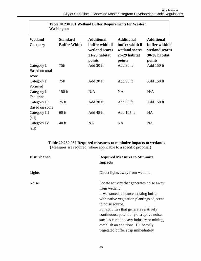
Attachment A
City of Shoreline – Shoreline Master Program Development Code Regulations
40
Table 20.230.031 Wetland Buffer Requirements for Western
Washington
Wetland
Category
Standard
Buffer Width
Additional
buffer width if
wetland scores
21-25 habitat
points
Additional
buffer width if
wetland scores
26-29 habitat
points
Additional
buffer width if
wetland scores
30-36 habitat
points
Category I:
Based on total
score
75ft Add 30 ft Add 90 ft Add 150 ft
Category I:
Forested
75ft Add 30 ft Add 90 ft Add 150 ft
Category I:
Estuarine
150 ft N/A NA N/A
Category II:
Based on score
75 ft Add 30 ft Add 90 ft Add 150 ft
Category III
(all)
60 ft Add 45 ft Add 105 ft NA
Category IV
(all)
40 ft NA NA NA
Table 20.230.032 Required measures to minimize impacts to wetlands
(Measures are required, where applicable to a specific proposal)
Disturbance Required Measures to Minimize
Impacts
Lights
Direct lights away from wetland.
Noise
Locate activity that generates noise away
from wetland.
If warranted, enhance existing buffer
with native vegetation plantings adjacent
to noise source.
For activities that generate relatively
continuous, potentially disruptive noise,
such as certain heavy industry or mining,
establish an additional 10‟ heavily
vegetated buffer strip immediately
Attachment A
City of Shoreline – Shoreline Master Program Development Code Regulations
41
adjacent to the outer wetland buffer.
Toxic runoff Route all new, untreated runoff away
from wetland while ensuring wetland is
not dewatered.
Establish covenants limiting use of
pesticides within 150 ft of wetland.
Apply integrated pest management.
Stormwater runoff Retrofit stormwater detention and
treatment for roads and existing adjacent
development.
Prevent channelized flow from lawns that
directly enters the buffer.
Use Low Intensity Development
techniques (per PSAT publication on LID
techniques).
Change in water regime Infiltrate or treat, detain, and disperse
into buffer new runoff from impervious
surfaces and new lawns.
Pets and human disturbance Use privacy fencing OR plant dense
vegetation to delineate buffer edge and to
discourage disturbance using vegetation
appropriate for the ecoregion.
Place wetland and its buffer in a separate
tract or protect with a conservation
easement.
Dust Use best management practices to control
dust.
Disruption of corridors or connections Maintain connections to offsite areas that
are undisturbed.
Restore corridors.
5. Increased Wetland Buffer Area Width. Buffer widths shall be increased on a case-by-
case basis as determined by the Administrator when a larger buffer is necessary to protect
Attachment A
City of Shoreline – Shoreline Master Program Development Code Regulations
42
wetland functions and values. This determination shall be supported by appropriate
documentation showing that it is reasonably related to protection of the functions and
values of the wetland. The documentation must include, but not be limited to the
following criteria:
a. The wetland is used by a plant or animal species listed by the federal government or
the state as endangered, threatened, candidate, sensitive, monitored or documented
priority species or habitats, or essential or outstanding habitat for those species or has
unusual nesting or resting sites such as heron rookeries or raptor nesting trees; or
b. The adjacent land is susceptible to severe erosion, and erosion-control measures will
not effectively prevent adverse wetland impacts; or
c. The adjacent land has minimal vegetative cover or slopes greater than 30 percent.
6. Buffer averaging to improve wetland protection may be permitted when all of the
following conditions are met:
a. The wetland has significant differences in characteristics that affect its habitat
functions, such as a wetland with a forested component adjacent to a degraded
emergent component or a “dual-rated” wetland with a Category I area adjacent to a
lower-rated area;
b. The buffer is increased adjacent to the higher-functioning area of habitat or more-
sensitive portion of the wetland and decreased adjacent to the lower-functioning or
less-sensitive portion as demonstrated by a critical areas report from a qualified
wetland professional;
c. The total area of the buffer after averaging is equal to the area required without
averaging; and
d. The buffer at its narrowest point is never less than either ¾ of the required width or
75 feet for Category I and II, 50 feet for Category III, and 25 feet for Category IV,
whichever is greater.
7. Averaging through a shoreline variance may be permitted when all of the following are
met:
a. There are no feasible alternatives to the site design that could be accomplished
without buffer averaging;
b. The averaged buffer will not result in degradation of the wetland‟s functions and
values as demonstrated by a critical areas report from a qualified wetland
professional;
c. The total buffer area after averaging is equal to the area required without averaging;
and
d. The buffer at its narrowest point is never less than either ¾ of the required width or
75 feet for Category I and II, 50 feet for Category III and 25 feet for Category IV,
whichever is greater.
B. To facilitate long-range planning using a landscape approach, the Administrator may identify
and pre-assess wetlands using the rating system and establish appropriate wetland buffer widths
for such wetlands. The Administrator will prepare maps of wetlands that have been pre-assessed
in this manner.
C. Measurement of Wetland Buffers. All buffers shall be measured perpendicular from the
wetland boundary as surveyed in the field. The buffer for a wetland created, restored, or
Attachment A
City of Shoreline – Shoreline Master Program Development Code Regulations
43
enhanced as compensation for approved wetland alterations shall be the same as the buffer
required for the category of the created, restored, or enhanced wetland. Only fully vegetated
buffers will be considered. Lawns, walkways, driveways, and other mowed or paved areas will
not be considered buffers or included in buffer area calculations.
D. Buffers on Mitigation Sites. All mitigation sites shall have buffers consistent with the buffer
requirements of this Chapter. Buffers shall be based on the expected or target category of the
proposed wetland mitigation site.
E. Buffer Maintenance. Except as otherwise specified or allowed in accordance with this
Chapter, wetland buffers shall be retained in an undisturbed or enhanced condition. In the case
of compensatory mitigation sites, removal of invasive non-native weeds is required for the
duration of the mitigation bond (Section 20.230.070.H.2.a.viii).
F. Impacts to Buffers. Requirements for the compensation for impacts to buffers are outlined in
Section 20.230.070 of this Chapter.
G. Overlapping Critical Area Buffers. If buffers for two contiguous critical areas overlap (such
as buffers for a stream and a wetland), the wider buffer applies.
H. Allowed Buffer Uses. The following uses may be allowed within a wetland buffer in
accordance with the review procedures of this Chapter, provided they are not prohibited by any
other applicable law and they are conducted in a manner so as to minimize impacts to the buffer
and adjacent wetland:
1. Conservation and Restoration Activities. Conservation or restoration activities aimed at
protecting the soil, water, vegetation, or wildlife.
2. Passive recreation. Passive recreation facilities designed and in accordance with an
approved critical area report, including:
a. Walkways and trails, provided that those pathways are limited to minor crossings
having no adverse impact on water quality. They should be generally parallel to
the perimeter of the wetland, located only in the outer twenty-five percent (25%)
of the wetland buffer area, and located to avoid removal of significant trees. They
should be limited to pervious surfaces no more than five (5) feet in width for
pedestrian use only. Raised boardwalks utilizing non-treated pilings may be
acceptable; and/or
b. Wildlife-viewing structures.
3. Educational and scientific research activities.
4. Normal and routine maintenance and repair of any existing public or private facilities
within an existing right-of-way, provided that the maintenance or repair does not increase
the footprint or use of the facility or right-of-way.
5. The harvesting of wild crops in a manner that is not injurious to natural reproduction of
such crops, and provided the harvesting does not require tilling of soil, planting of crops,
chemical applications, or alteration of the wetland by changing existing topography,
water conditions, or water sources.
6. Drilling for utilities/utility corridors under a buffer, with entrance/exit portals located
completely outside of the wetland buffer boundary, provided that the drilling does not
Attachment A
City of Shoreline – Shoreline Master Program Development Code Regulations
44
interrupt the ground water connection to the wetland or percolation of surface water
down through the soil column. Specific studies by a hydrologist are necessary to
determine whether the ground water connection to the wetland or percolation of surface
water down through the soil column is disturbed.
7. Enhancement of a wetland buffer through the removal of non-native invasive plant
species. Removal of invasive plant species shall be restricted to hand removal. All
removed plant material shall be taken away from the site and disposed of appropriately.
Plants that appear on the Washington State Noxious Weed Control Board list of noxious
weeds must be handled and disposed of according to a noxious weed control plan
appropriate to that species. Revegetation with appropriate native species at natural
densities is allowed in conjunction with removal of invasive plant species.
8. Stormwater management facilities. Stormwater management facilities are limited to
stormwater dispersion outfalls and bioswales. They may be allowed within the outer
twenty-five percent (25%) of the buffer of Category III or IV wetlands only, provided
that:
a. No other location is feasible;
b. The location of such facilities will not degrade the functions or values of the
wetland; and
c. Stormwater management facilities are not allowed in buffers of Category I or II
wetlands.
9. Non-Conforming Uses. Repair and maintenance of non-conforming uses or structures,
where legally established within the buffer, provided they do not increase the degree of
nonconformity.
I. Signs and Fencing of Wetlands and Buffers:
1. Temporary markers. The outer perimeter of the wetland buffer and the clearing limits
identified by an approved permit or authorization shall be marked in the field with
temporary “clearing limits” fencing in such a way as to ensure that no unauthorized
intrusion will occur. The marking is subject to inspection by the Administrator prior to
the commencement of permitted activities. This temporary marking shall be maintained
throughout construction and shall not be removed until permanent signs, if required, are
in place.
2. Permanent signs. As a condition of any permit or authorization issued pursuant to this
Chapter, the Administrator may require the applicant to install permanent signs along the
boundary of a wetland or buffer.
a. Permanent signs shall be made of an enamel-coated metal face and attached to a
metal post or another non-treated material of equal durability. Signs must be
posted at an interval of one (1) per lot or every fifty (50) feet, whichever is less,
and must be maintained by the property owner in perpetuity. The signs shall be
worded as follows or with alternative language approved by the Administrator:
Protected Wetland Area Do Not Disturb
Contact the City of Shoreline Regarding Uses, Restrictions, and Opportunities for Stewardship b. The provisions of Subsection (a) may be modified as necessary to assure
protection of sensitive features.
3. Fencing
Attachment A
City of Shoreline – Shoreline Master Program Development Code Regulations
45
a. Fencing installed as part of a proposed activity or as required in this Subsection
shall be designed so as to not interfere with species migration, including fish runs,
and shall be constructed in a manner that minimizes impacts to the wetland and
associated habitat.
Critical Area Report for Wetlands A. If the Administrator determines that the site of a proposed development includes, is likely to
include, or is adjacent to a wetland, a wetland report, prepared by a qualified professional,
shall be required. The expense of preparing the wetland report shall be borne by the
applicant.
B. Minimum Standards for Wetland Reports. The written report and the accompanying plan
sheets shall contain the following information, at a minimum:
1. The name and contact information of the applicant; the name, qualifications, and
contact information for the primary author(s) of the wetland critical area report; a
description of the proposal; identification of all the local, state, and/or federal
wetland-related permit(s) required for the project; and a vicinity map for the project.
2. A statement specifying the accuracy of the report and all assumptions made and relied
upon.
3. Documentation of any fieldwork performed on the site, including field data sheets for
delineations, rating system forms, baseline hydrologic data, etc.
4. A description of the methodologies used to conduct the wetland delineations, rating
system forms, or impact analyses including references.
5. Identification and characterization of all critical areas, wetlands, water bodies,
shorelines, floodplains, and buffers on or adjacent to the proposed project area. For
areas off site of the project site, estimate conditions within 300 feet of the project
boundaries using the best available information.
6. For each wetland identified on site and within 300 feet of the project site provide: the
wetland rating, including a description of and score for each function, per Wetland
Ratings (Section 20.230.020.B) of this Chapter; required buffers; hydrogeomorphic
classification; wetland acreage based on a professional survey from the field
delineation (acreages for on-site portion and entire wetland area including off-site
portions); Cowardin classification of vegetation communities; habitat elements; soil
conditions based on site assessment and/or soil survey information; and to the extent
possible, hydrologic information such as location and condition of inlet/outlets (if
they can be legally accessed), estimated water depths within the wetland, and
estimated hydroperiod patterns based on visual cues (e.g., algal mats, drift lines, flood
debris, etc.). Provide acreage estimates, classifications, and ratings based on entire
wetland complexes, not only the portion present on the proposed project site.
7. A description of the proposed actions, including an estimation of acreages of impacts
to wetlands and buffers based on the field delineation and survey and an analysis of
site development alternatives, including a no-development alternative.
8. An assessment of the probable cumulative impacts to the wetlands and buffers
resulting from the proposed development.
9. A description of reasonable efforts made to apply mitigation sequencing pursuant to
Mitigation Sequencing (Chapter 20.230.020) to avoid, minimize, and mitigate
impacts to critical areas.
Attachment A
City of Shoreline – Shoreline Master Program Development Code Regulations
46
10. A discussion of measures, including avoidance, minimization, and compensation,
proposed to preserve existing wetlands and restore any wetlands that were degraded
prior to the current proposed land-use activity.
11. A conservation strategy for habitat and native vegetation that addresses methods to
protect and enhance on-site habitat and wetland functions.
C. An evaluation of the functions of the wetland and adjacent buffer. Include reference for the
method used and data sheets.
D. A copy of the site plan sheet(s) for the project must be included with the written report and
must include, at a minimum:
1. Maps (to scale) depicting delineated and surveyed wetland and required buffers on
site, including buffers for off-site critical areas that extend onto the project site; the
development proposal; other critical areas; grading and clearing limits; areas of
proposed impacts to wetlands and/or buffers (include square footage estimates);
2. A depiction of the proposed stormwater management facilities and outlets (to scale)
for the development, including estimated areas of intrusion into the buffers of any
critical areas. The written report shall contain a discussion of the potential impacts to
the wetland(s) associated with anticipated hydroperiod alterations from the project;
and
3. A depiction of the proposed stormwater management facilities and outlets (to scale)
for the development, including estimated areas of intrusion into the buffers of any
critical areas. The written report shall contain a discussion of the potential impacts to
the wetland(s) associated with anticipated hydroperiod alterations from the project.
Compensatory Mitigation
A. Mitigation Sequencing. Before impacting any wetland or its buffer, an applicant shall demonstrate that the following actions have been taken. Actions are listed in the order of
preference:
1. Avoid the impact altogether by not taking a certain action or parts of an action.
2. Minimize impacts by limiting the degree or magnitude of the action and its
implementation, by using appropriate technology, or by taking affirmative steps to
avoid or reduce impacts.
3. Rectify the impact by repairing, rehabilitating, or restoring the affected environment.
4. Reduce or eliminate the impact over time by preservation and maintenance
operations.
5. Compensate for the impact by replacing, enhancing, or providing substitute resources
or environments.
6. Monitor the required compensation and take remedial or corrective measures when
necessary.
B. Requirements for Compensatory Mitigation:
1. Compensatory mitigation for alterations to wetlands shall be used only for impacts
that cannot be avoided or minimized and shall achieve equivalent or greater biologic
functions. Compensatory mitigation plans shall be consistent with Wetland Mitigation
in Washington State – Part 2: Developing Mitigation Plans (Version 1), Ecology
Publication #06-06-011b, Olympia, WA, March 2006 or as revised.
2. Mitigation ratios shall be consistent with Subsection G of this Chapter.
Attachment A
City of Shoreline – Shoreline Master Program Development Code Regulations
47
3. Mitigation requirements may also be determined using the credit/debit tool described
in “Calculating Credits and Debits for Compensatory Mitigation in Wetlands of
Western Washington: Operational Draft” (Ecology Publication #10-06-011, February
2011, or as revised) consistent with subsection H of this Chapter.
C. Compensating for Lost or Affected Functions. Compensatory mitigation shall address the
functions affected by the proposed project, with an intention to achieve functional equivalency or
improvement of functions. The goal shall be for the compensatory mitigation to provide similar
wetland functions as those lost, except when either:
1. The lost wetland provides minimal functions, and the proposed compensatory
mitigation action(s) will provide equal or greater functions or will provide functions
shown to be limiting within a watershed through a formal Washington state watershed
assessment plan or protocol; or
2. Out-of-kind replacement of wetland type or functions will best meet watershed goals
formally identified by the City, such as replacement of historically diminished
wetland types.
D. Preference of Mitigation Actions. Methods to achieve compensation for wetland functions shall
be approached in the following order of preference:
1. Restoration (re-establishment and rehabilitation) of wetlands.
2. Creation (establishment) of wetlands on disturbed upland sites such as those with
vegetative cover consisting primarily of non-native species. This should be attempted
only when there is an adequate source of water and it can be shown that the surface
and subsurface hydrologic regime is conducive to the wetland community that is
anticipated in the design.
3. Enhancement of significantly degraded wetlands in combination with restoration or
creation. Enhancement alone will result in a loss of wetland acreage and is less
effective at replacing the functions lost. Enhancement should be part of a mitigation
package that includes replacing the impacted area and meeting appropriate ratio
requirements.
4. Preservation. Preservation of high-quality, at-risk wetlands as compensation is
generally acceptable when done in combination with restoration, creation, or
enhancement, provided that a minimum of 1:1 acreage replacement is provided by re-
establishment or creation. Preservation of high-quality, at risk wetlands and habitat
may be considered as the sole means of compensation for wetland impacts when the
following criteria are met:
a. Wetland impacts will not have a significant adverse impact on habitat for listed
fish, or other ESA listed species;
b. There is no net loss of habitat functions within the watershed or basin;
c. Mitigation ratios for preservation as the sole means of mitigation shall generally
start at 20:1. Specific ratios should depend upon the significance of the
preservation project and the quality of the wetland resources lost; and
d. The impact area is small (generally <½acre) and/or impacts are occurring to a
low-functioning system (Category III or IV wetland).
All preservation sites shall include buffer areas adequate to protect the habitat and its
functions from encroachment and degradation.
E. Type and Location of Compensatory Mitigation. Unless it is demonstrated that a higher level of
ecological functioning would result from an alternative approach, compensatory mitigation for
Attachment A
City of Shoreline – Shoreline Master Program Development Code Regulations
48
ecological functions shall be either in kind and on site, or in kind and within the same stream
reach, sub-basin, or drift cell (if estuarine wetlands are impacted). Compensatory mitigation
actions shall be conducted within the same sub-drainage basin and on the site of the alteration
except when all of the following apply:
1. There are no reasonable opportunities on site or within the sub-drainage basin (e.g., on-
site options would require elimination of high-functioning upland habitat), or
opportunities on site or within the sub-drainage basin do not have a high likelihood of
success based on a determination of the capacity of the site to compensate for the
impacts. Considerations should include: anticipated replacement ratios for wetland
mitigation, buffer conditions and proposed widths, available water to maintain anticipated
hydrogeomorphic classes of wetlands when restored, proposed flood storage capacity,
and potential to mitigate riparian fish and wildlife impacts (such as connectivity);
2. Off-site mitigation has a greater likelihood of providing equal or improved wetland
functions than the impacted wetland; and
3. Off-site locations shall be in the same sub-drainage basin unless:
a. Established watershed goals for water quality, flood storage or conveyance,
habitat, or other wetland functions have been established by the city and strongly
justify location of mitigation at another site; or
b. Credits from a state-certified wetland mitigation bank are used as compensation,
and the use of credits is consistent with the terms of the bank‟s certification.
4. The design for the compensatory mitigation project needs to be appropriate for its
location (i.e., position in the landscape). Therefore, compensatory mitigation should not
result in the creation, restoration, or enhancement of an atypical wetland. An atypical
wetland refers to a compensation wetland (e.g., created or enhanced) that does not match
the type of existing wetland that would be found in the geomorphic setting of the site
(i.e., the water source(s) and hydroperiod proposed for the mitigation site are not typical
for the geomorphic setting). Likewise, it should not provide exaggerated morphology or
require a berm or other engineered structures to hold back water. For example,
excavating a permanently inundated pond in an existing seasonally saturated or inundated
wetland is one example of an enhancement project that could result in an atypical
wetland. Another example would be excavating depressions in an existing wetland on a
slope, which would require the construction of berms to hold the water.
F. Timing of Compensatory Mitigation. It is preferred that compensatory mitigation projects be
completed prior to activities that will disturb wetlands. At the least, compensatory mitigation
shall be completed immediately following disturbance and prior to use or occupancy of the
action or development. Construction of mitigation projects shall be timed to reduce impacts to
existing fisheries, wildlife, and flora.
1. The Administrator may authorize a one-time temporary delay in completing construction
or installation of the compensatory mitigation when the applicant provides a written
explanation from a qualified wetland professional as to the rationale for the delay. An
appropriate rationale would include identification of the environmental conditions that
could produce a high probability of failure or significant construction difficulties (e.g.,
project delay lapses past a fisheries window, or installing plants should be delayed until
the dormant season to ensure greater survival of installed materials). The delay shall not
create or perpetuate hazardous conditions or environmental damage or degradation, and
the delay shall not be injurious to the health, safety, or general welfare of the public. The
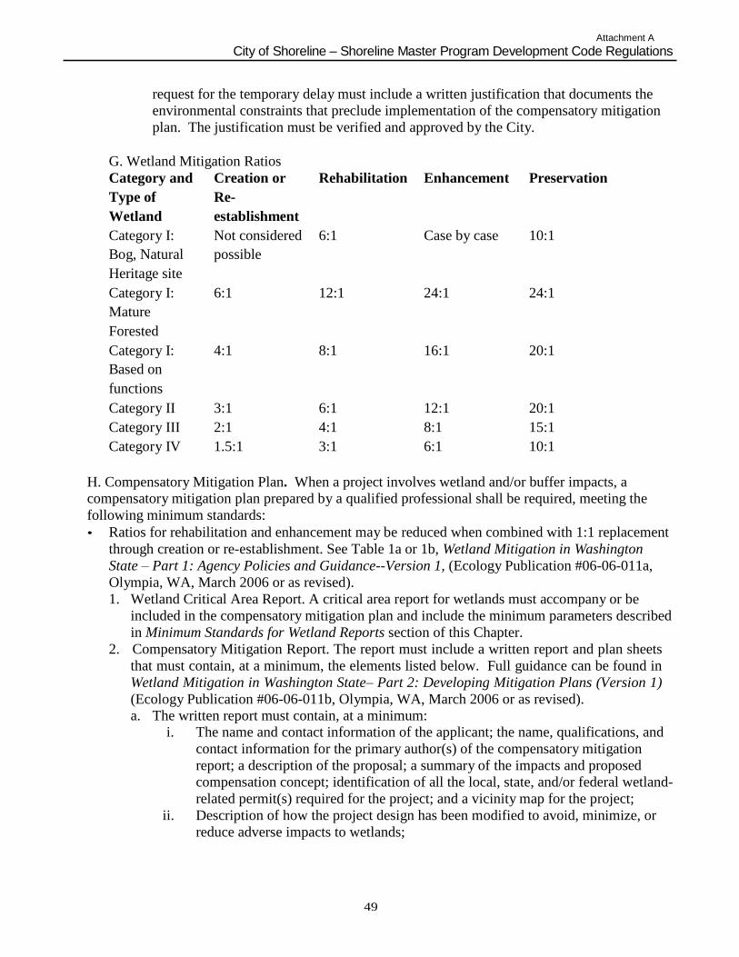
Attachment A
City of Shoreline – Shoreline Master Program Development Code Regulations
49
request for the temporary delay must include a written justification that documents the
environmental constraints that preclude implementation of the compensatory mitigation
plan. The justification must be verified and approved by the City.
G. Wetland Mitigation Ratios
Category and
Type of
Wetland
Creation or
Re-
establishment
Rehabilitation Enhancement Preservation
Category I:
Bog, Natural
Heritage site
Not considered
possible
6:1 Case by case 10:1
Category I:
Mature
Forested
6:1 12:1 24:1 24:1
Category I:
Based on
functions
4:1 8:1 16:1 20:1
Category II 3:1 6:1 12:1 20:1
Category III 2:1 4:1 8:1 15:1
Category IV 1.5:1 3:1 6:1 10:1
H. Compensatory Mitigation Plan. When a project involves wetland and/or buffer impacts, a
compensatory mitigation plan prepared by a qualified professional shall be required, meeting the
following minimum standards:
• Ratios for rehabilitation and enhancement may be reduced when combined with 1:1 replacement
through creation or re-establishment. See Table 1a or 1b, Wetland Mitigation in Washington
State – Part 1: Agency Policies and Guidance--Version 1, (Ecology Publication #06-06-011a,
Olympia, WA, March 2006 or as revised).
1. Wetland Critical Area Report. A critical area report for wetlands must accompany or be
included in the compensatory mitigation plan and include the minimum parameters described
in Minimum Standards for Wetland Reports section of this Chapter.
2. Compensatory Mitigation Report. The report must include a written report and plan sheets
that must contain, at a minimum, the elements listed below. Full guidance can be found in
Wetland Mitigation in Washington State– Part 2: Developing Mitigation Plans (Version 1)
(Ecology Publication #06-06-011b, Olympia, WA, March 2006 or as revised).
a. The written report must contain, at a minimum: i. The name and contact information of the applicant; the name, qualifications, and
contact information for the primary author(s) of the compensatory mitigation
report; a description of the proposal; a summary of the impacts and proposed
compensation concept; identification of all the local, state, and/or federal wetland-
related permit(s) required for the project; and a vicinity map for the project;
ii. Description of how the project design has been modified to avoid, minimize, or
reduce adverse impacts to wetlands;
Attachment A
City of Shoreline – Shoreline Master Program Development Code Regulations
50
iii. Description of the existing wetland and buffer areas proposed to be impacted.
Include acreage (or square footage), water regime, vegetation, soils, landscape
position, surrounding lands uses, and functions. Also describe impacts in terms of
acreage by Cowardin classification, hydrogeomorphic classification, and wetland
rating, based on Wetland Ratings (Section 20.230.020.B) of this Chapter;
iv. Description of the compensatory mitigation site, including location and rationale
for selection. Include an assessment of existing conditions: acreage (or square
footage) of wetlands and uplands, water regime, sources of water, vegetation,
soils, landscape position, surrounding land uses, and functions. Estimate future
conditions in this location if the compensation actions are NOT undertaken (i.e.,
how would this site progress through natural succession?);
v. A description of the proposed actions for compensation of wetland and upland
areas affected by the project. Include overall goals of the proposed mitigation,
including a description of the targeted functions, hydrogeomorphic classification,
and categories of wetlands;
vi. A description of the proposed mitigation construction activities and timing of
activities;
vii. A discussion of ongoing management practices that will protect wetlands after the
project site has been developed, including proposed monitoring and maintenance
programs (for remaining wetlands and compensatory mitigation wetlands);
viii. A bond estimate for the entire compensatory mitigation project, including the
following elements: site preparation, plant materials, construction materials,
installation oversight, maintenance twice per year for up to five (5) years, annual
monitoring field work and reporting, and contingency actions for a maximum of
the total required number of years for monitoring; and
ix. Proof of establishment of Notice on Title for the wetlands and buffers on the
project site, including the compensatory mitigation areas.
b. The scaled plan sheets for the compensatory mitigation must contain, at a minimum:
i. Surveyed edges of the existing wetland and buffers, proposed areas of wetland
and/or buffer impacts, location of proposed wetland and/or buffer compensation
actions;
ii. Existing topography, ground-proofed, at two-foot contour intervals in the zone of
the proposed compensation actions if any grading activity is proposed to create
the compensation area(s). Also existing cross-sections of on-site wetland areas
that are proposed to be impacted, and cross-section(s) (estimated one-foot
intervals) for the proposed areas of wetland or buffer compensation;
iii. Surface and subsurface hydrologic conditions, including an analysis of existing
and proposed hydrologic regimes for enhanced, created, or restored compensatory
mitigation areas. Also, illustrations of how data for existing hydrologic
conditions were used to determine the estimates of future hydrologic conditions;
iv. Conditions expected from the proposed actions on site, including future
hydrogeomorphic types, vegetation community types by dominant species
(wetland and upland), and future water regimes;
v. Required wetland buffers for existing wetlands and proposed compensation areas.
Also, identify any zones where buffers are proposed to be reduced or enlarged
outside of the standards identified in this Chapter;
Attachment A
City of Shoreline – Shoreline Master Program Development Code Regulations
51
vi. A plant schedule for the compensation area, including all species by proposed
community type and water regime, size and type of plant material to be installed,
spacing of plants, typical clustering patterns, total number of each species by
community type, timing of installation; and
vii. Performance standards (measurable standards reflective of years post-installation)
for upland and wetland communities, monitoring schedule, and maintenance
schedule and actions by each biennium.
I. Buffer Mitigation Ratios. Impacts to buffers shall be mitigated at a 1:1 ratio. Compensatory
buffer mitigation shall replace those buffer functions lost from development.
20.230.040 Public Access Public access to the shoreline is the physical ability of the general public to reach and touch the water's edge and/or the ability to have a view of the water and the shoreline from upland
locations. There are a variety of types of public access, such as picnic areas, pathways and trails,
promenades, bridges, street ends, ingress and egress, and parking.
A. Public Access Policies
1. Public access provisions should be incorporated into all private and public developments.
Exceptions may be considered for the following types of uses:
a. A single family residence;
b. An individual multi-family structure containing more than four (4) dwelling units;
and/or
c. Where deemed inappropriate by the Director.
2. Development uses and activities on or near the shoreline should not impair or detract
from the public's visual or physical access to the water.
3. Public access to the shoreline should be sensitive to the unique characteristics of the
shoreline and should preserve the natural character and quality of the environment and
adjacent wetlands, public access should assure no net loss of ecological functions.
4. Where appropriate, water-oriented public access should be provided as close as possible
to the water's edge without adversely affecting a sensitive environment.
5. Except for access to the water, the preferred location for placement of public access trails
is as close to the furthest landward edge of the native vegetation zone as practical. Public
access facilities should provide auxiliary facilities, such as parking and sanitation, when
appropriate, and shall be designed for accessibility by people with disabilities. Publicly
owned shorelines should be limited to water-dependent or public recreation uses,
otherwise such shorelines should remain protected open space.
6. Public access afforded by public right of way street ends adjacent to the shoreline should
be preserved, maintained, and enhanced.
7. Public access should be designed to provide for public safety and to minimize potential
impacts to private property and individual privacy. This may include providing a
physical separation to reinforce the distinction between public and private space,
providing adequate space, through screening with landscape planting or fences, or other
means.
8. Public views from the shoreline upland areas should be enhanced and preserved.
Enhancement of views should not be construed to mean excess removal of vegetation that
partially impairs views.
Attachment A
City of Shoreline – Shoreline Master Program Development Code Regulations
52
9. Public access facilities should be constructed of environmentally friendly materials and
support healthy natural processes, whenever financially feasible and possible.
10. Public access facilities should be maintained to provide a clean, safe experience, and to
protect the environment.
B. Public Access Regulations
1. Public access shall be required for all shoreline development and uses, except for a
single-family residence or residential projects containing four (4) or less dwelling units.
2. Requirement of public access to shorelines does not confer the right to enter upon or
cross private property, except for dedicated and marked public easements.
3. A shoreline development or use that does not provide public access may be authorized
provided the applicant demonstrates and the Director determines that one or more of the
following provisions apply:
a. Unavoidable health or safety hazards to the public exist that cannot be prevented by
any feasible means;
b. Security requirements cannot be satisfied through the application of alternative design
features or other solutions;
c. The cost of providing the access, easement, or an alternative amenity is unreasonably
disproportionate to the total long-term cost of the proposed development;
d. Unacceptable environmental harm, such as damage to fish spawning areas will result
from the public access that cannot be mitigated; and/or
e. Significant conflict between the proposed access and adjacent uses would occur and
cannot be mitigated.
4. The applicant must also demonstrate that all reasonable means to public access have been
exhausted, including but not limited to:
a. Regulating access by such means as limiting use to daylight hours;
b. Designing separation of uses and activities with such means as fences, terracing,
hedges, or landscaping; and/or
c. Providing access that is physically separated from the proposal, such as a nearby
street end, an offsite viewpoint, or a trail system.
5. Public access sites shall be made barrier free for people with disabilities.
6. Public access sites shall be connected directly to the nearest public street.
7. Required public access sites shall be fully developed and available for public use at the
time of occupancy or use of the development or activity.
8. Public access easements and permit conditions shall be recorded on the deed where
applicable or on the face of a plat or short plat as a condition running with the land. Said
recording with the King County Recorder‟s office shall occur at the time of permit
approval (RCW 58.17.110).
9. The standard state approved logo and other approved signs that indicate the public's right
of access and hour of access shall be constructed, installed, and maintained by the
applicant in conspicuous locations at public access sites. Signs controlling or restricting
public access may be approved as a condition of permit approval.
10. Development on or over the water shall be constructed as far landward as possible to
avoid interference with views from surrounding properties to the shoreline and adjoining
waters.
53
Attachment A
City of Shoreline- Shoreline Master Program Development Code Regulations
11. Physical public access shall be designed to prevent significant impacts to natural systems
by employing Low Impact Development techniques.
54
Attachment A
City of Shoreline – Shoreline Master Program Development Code Regulations
Subchapter 2. Specific Shoreline Use Policies and Regulations
20.230.070 General Specific shoreline use provisions are more detailed than those listed in General Policies and Regulations. These use policies and regulations apply to the identified use categories and
provide a greater level of detail for uses and their impacts. The policies establish the shoreline
management principles that apply to each use category and serve as a bridge between the various
elements listed in section 20.200.020 of this Master Program and the use regulations that follow.
This subchapter also includes those activities that modify the configuration or qualities of the
shoreline area. Shoreline modification activities are, by definition, undertaken in support of or in
preparation for a permitted shoreline use. Typically, shoreline modification activities relate to
construction of a physical element such as a breakwater, dredged basins, landfilling, etc., but
they can include other actions such as clearing, grading, application of chemicals, etc.
Shoreline modification policies and regulations are intended to prevent, reduce, and mitigate the
negative environmental impacts of proposed shoreline modifications consistent with the goals of
the Shoreline Management Act. A proposed development must meet all of the regulations for
both applicable uses and activities as well as the general and environment designation
regulations.
The following policies and regulations apply to specific types of development that may be
proposed in the shoreline jurisdiction of the City. A proposal can consist of more than one type
of development. In addition, all specific shoreline development must be consistent with the
following Shoreline Environmental Designations; the goals and objectives of SMC 20.200,
subchapter 1; and the general policies and regulations contained in SMC 20.230, subchapter 1.
20.230.080 Shoreline Environmental Designations- Map included in Appendix D, page 205
Aquatic Environment (A). Encompasses all submerged lands from OHWM to the middle of Puget
Sound. The purpose of this designation is to protect, restore, and manage the unique characteristics
and resources of the areas waterward of the ordinary high-water mark. New overwater structures are
allowed only for water-dependent uses, public access, or ecological restoration and must be limited
to the minimum necessary to support the structure‟s intended use.
Urban Conservancy Environment (UC). The purpose of this designation is to protect and
restore relatively undeveloped or unaltered shorelines to maintain open space, floodplains, or
habitat, while allowing a variety of compatible uses. This designation shall apply to shorelines
that retain important ecological functions, even if partially altered. These shorelines are suitable
for low intensity development, uses that are a combination of water related or water-enjoyment
uses, or uses that allow substantial numbers of people access to the shoreline. Any undesignated
shorelines are automatically assigned an urban conservancy designation.
Shoreline Residential Environment (SR). The purpose of this designation is to accommodate
residential development and accessory structures that are consistent with this Shoreline Master
Program. This designation shall apply to shorelines that do not meet the criteria for Urban
55
Attachment A
City of Shoreline – Shoreline Master Program Development Code Regulations
Conservancy and that are characterized by single-family or multifamily residential development
or are planned and platted for residential development.
Waterfront Residential Environment (WR). The purpose of this designation is to distinguish
between residential portions of the coastline where natural and manmade features preclude
building within the shoreline jurisdiction and the section along 27th Avenue NW where
residential properties directly abut the Puget Sound.
Characteristics of 27th Avenue NW include:
• Only fully established residential property in the City of Shoreline directly abutting the Puget
Sound;
• Substantial number of legally existing nonconforming lots and nonconforming structures;
• Exposure to high energy wind and wave action;
• Fully armored shoreline prior to December 4, 1969 and residences occupied prior to January
1, 1992; and
• Failure of an individual bulkhead would cause adverse effect on subject property as well as
neighboring properties.
These unique circumstances and considerations warrant different regulations for 27th Avenue
NW as compared to existing residential property that is cut off from the shoreline by bluffs and
railroad tracks (UC and SR), and potential new residential properties in the Point Wells
designations (PW and PWC).
Point Wells Urban Environment (PW). The purpose of this designation is to accommodate
higher density uses while protecting existing ecological functions and restoring ecological
functions that have been degraded.
Point Wells Urban Conservancy Environment (PWC). The purpose of this designation is to
distinguish between differing levels of potential and existing ecological function within the Point
Wells environment, and regulate uses and public access requirements appropriately.
56
Attachment A
City of Shoreline – Shoreline Master Program Development Code Regulations
Table 20.230.081 Permitted Uses and Modifications Within the Shorelines Uses that are allowed in tables 20.40.120 through 20.40.150 are permitted uses in accordance with the underlying zone, this chapter, and the provisions of the Shoreline Master Program.
P = Permitted - Permitted uses may require Shoreline Substantial Development Permits and
any other permits required by the Shoreline Municipal Code and/or other regulatory
agencies.
C = Conditional Use - Conditional uses require Shoreline Conditional Use Permit and may
require other permits required by the Shoreline Municipal Code and/or other regulatory
agencies.
X = Prohibited
57
Attachment A
City of Shoreline – Shoreline Master Program Development Code Regulations
This Page Intentionally Blank

Attachment A
City of Shoreline – Shoreline Master Program Development Code Regulations
58
Table 20.230.081 Permitted Uses and Modifications Within the Shorelines
Shoreline Environments
Shoreline Use
Aquatic Urban
Conservancy
Shoreline
Residential
Waterfront
Residential
PW Urban
Conservancy
PW Urban
Agriculture X X X X X X
Aquaculture C X X X X X
Boating Facilities
(boat hoists and
launching ramps)
P1
P: Boat launching
ramps open to
the public
P: Joint-use
boat launching
ramps
P: Joint-use boat
launching ramps
X
P: Boat launching
ramps open
to the public
Nonresidential
Development
X
X
X
X
P
P
Forest Practices X X X X X X
Industrial
Development
X
X
X
X
P: Existing P: Existing
C: Expansion
In-stream Structures
P1
P: Part of a
fish habitat
enhancement
or a watershed
restoration
project
P: Part of a fish
habitat
enhancement
or a watershed
restoration
project
P: Part of a fish
habitat
enhancement or
a watershed
restoration
project
P: Part of a fish habitat
enhancement
or a
watershed
restoration
project
P: Part of a fish habitat
enhancement
or a
watershed
restoration
project
Mining X X X X X X
Mooring P X X X X X
Recreation Use
(water-related)
C: Water-
dependent
only
P
P
P
P: Limit to low intensity
uses, passive
uses
P
Recreation Facilities
C9
P
P
P
P: Limit to low intensity
uses, passive
uses
P
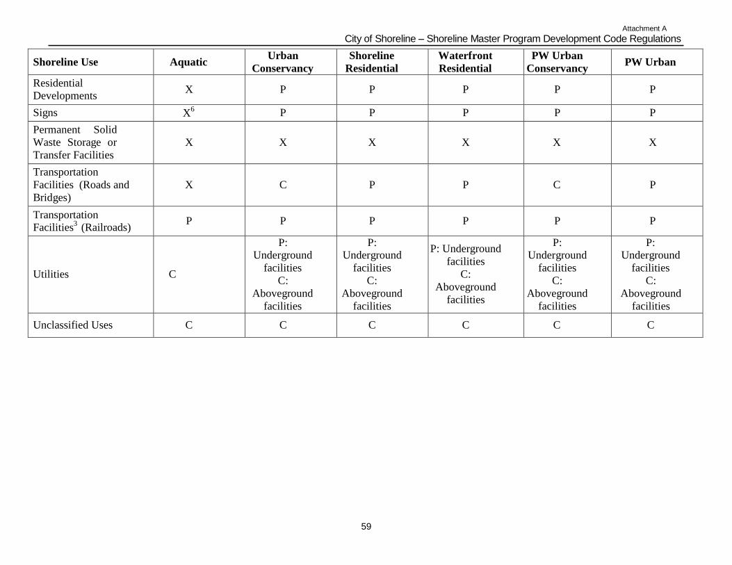
Attachment A
City of Shoreline – Shoreline Master Program Development Code Regulations
59
Shoreline Use
Aquatic Urban
Conservancy
Shoreline
Residential
Waterfront
Residential
PW Urban
Conservancy
PW Urban
Residential
Developments
X
P
P
P
P
P
Signs X6
P P P P P
Permanent Solid
Waste Storage or
Transfer Facilities
X
X
X
X
X
X
Transportation
Facilities (Roads and
Bridges)
X
C
P
P
C
P
Transportation
Facilities3
(Railroads)
P
P
P
P
P
P
Utilities
C
P: Underground
facilities
C:
Aboveground
facilities
P: Underground
facilities
C:
Aboveground
facilities
P: Underground
facilities
C:
Aboveground
facilities
P: Underground
facilities
C:
Aboveground
facilities
P: Underground
facilities
C:
Aboveground
facilities
Unclassified Uses
C
C
C
C
C
C
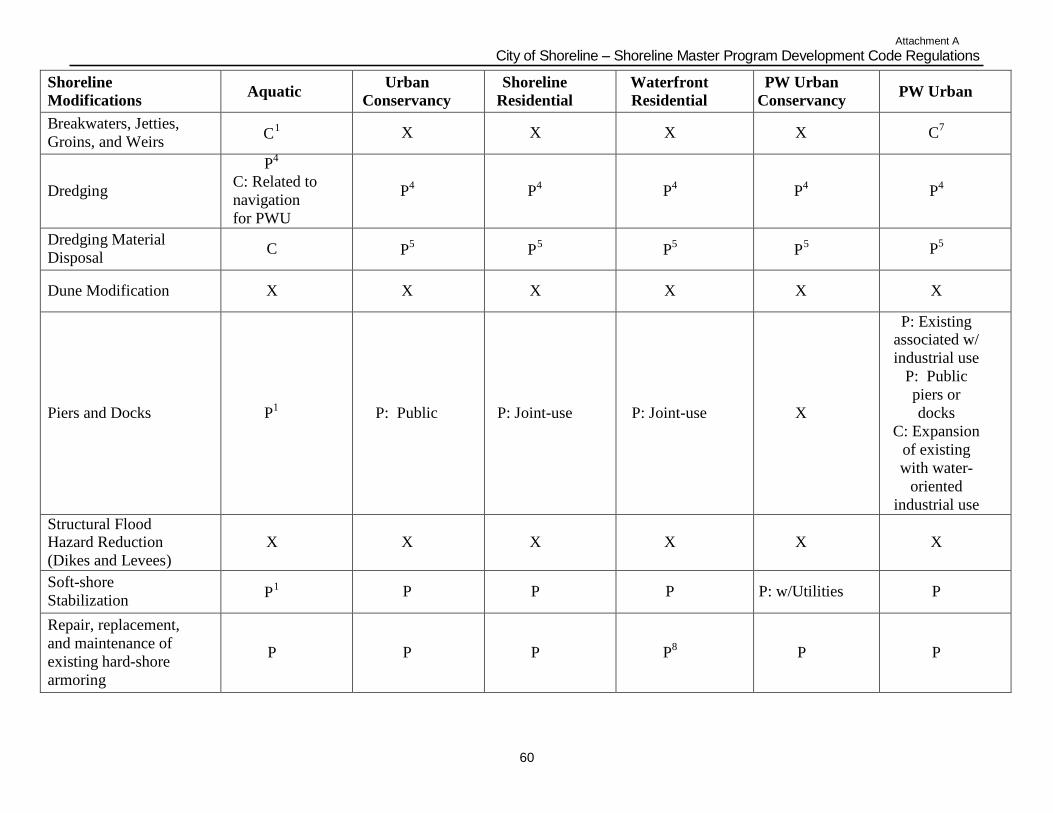
Attachment A
City of Shoreline – Shoreline Master Program Development Code Regulations
60
Shoreline
Modifications
Aquatic Urban
Conservancy
Shoreline
Residential
Waterfront
Residential
PW Urban
Conservancy
PW Urban
Breakwaters, Jetties,
Groins, and Weirs
1 C
X
X
X
X
C7
Dredging
P4
C: Related to
navigation
for PWU
P4
P4
P4
P4
P4
Dredging Material
Disposal
C
5 P
5 P
5 P
5 P
P5
Dune Modification
X
X
X
X
X
X
Piers and Docks
P1
P: Public
P: Joint-use
P: Joint-use
X
P: Existing associated w/
industrial use
P: Public
piers or
docks
C: Expansion
of existing
with water-
oriented
industrial use
Structural Flood Hazard Reduction
(Dikes and Levees)
X
X
X
X
X
X
Soft-shore
Stabilization
1 P
P
P
P
P: w/Utilities
P
Repair, replacement,
and maintenance of
existing hard-shore
armoring
P
P
P
P8
P
P
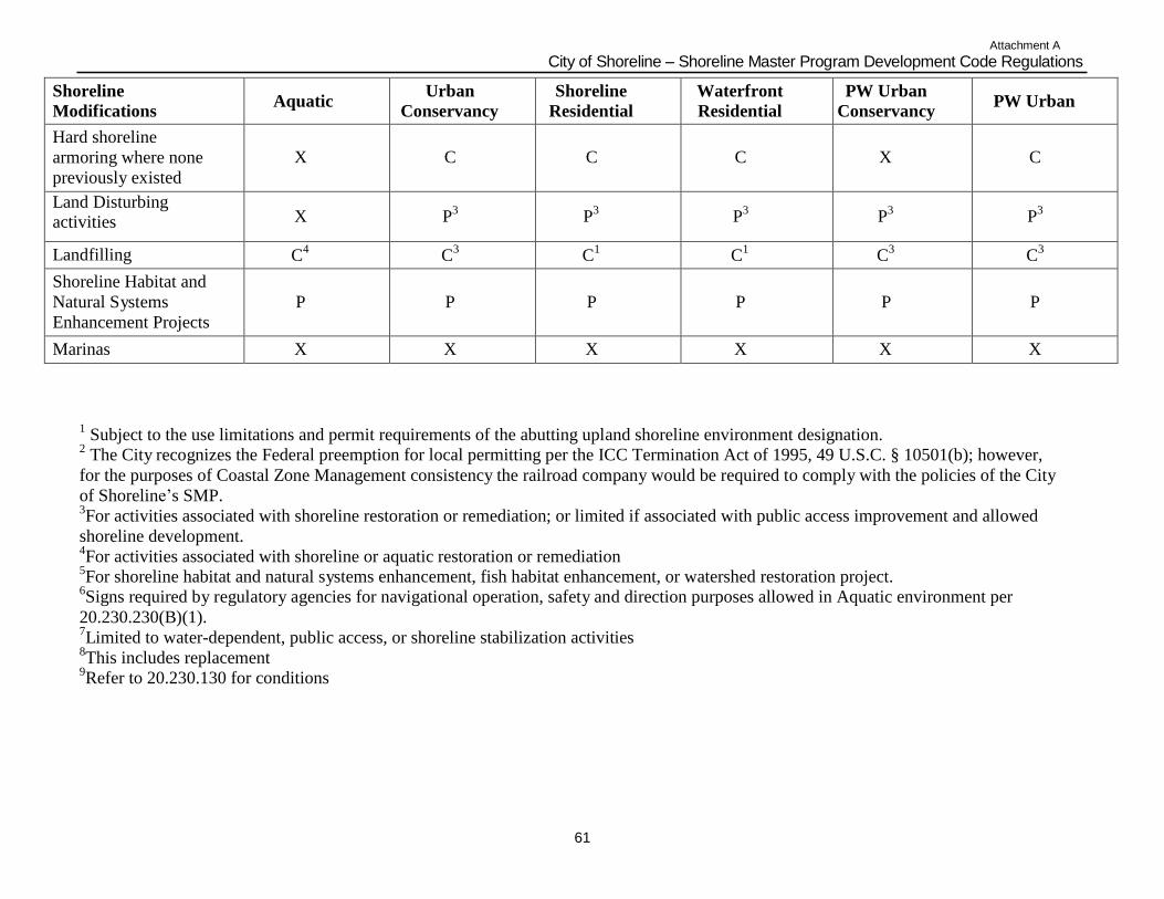
Attachment A
City of Shoreline – Shoreline Master Program Development Code Regulations
61
Shoreline
Modifications
Aquatic Urban
Conservancy
Shoreline
Residential
Waterfront
Residential
PW Urban
Conservancy
PW Urban
Hard shoreline
armoring where none
previously existed
X
C
C
C
X
C
Land Disturbing activities
X
P3
P3
P3
P3
P3
Landfilling C4 C
3 C
1 C
1 C
3 C
3
Shoreline Habitat and
Natural Systems
Enhancement Projects
P
P
P
P
P
P
Marinas X X X X X X
1 Subject to the use limitations and permit requirements of the abutting upland shoreline environment designation.
2 The City recognizes the Federal preemption for local permitting per the ICC Termination Act of 1995, 49 U.S.C. § 10501(b); however,
for the purposes of Coastal Zone Management consistency the railroad company would be required to comply with the policies of the City
of Shoreline‟s SMP. 3For activities associated with shoreline restoration or remediation; or limited if associated with public access improvement and allowed
shoreline development. 4For activities associated with shoreline or aquatic restoration or remediation
5For shoreline habitat and natural systems enhancement, fish habitat enhancement, or watershed restoration project.
6Signs required by regulatory agencies for navigational operation, safety and direction purposes allowed in Aquatic environment per
20.230.230(B)(1). 7Limited to water-dependent, public access, or shoreline stabilization activities
8This includes replacement
9Refer to 20.230.130 for conditions
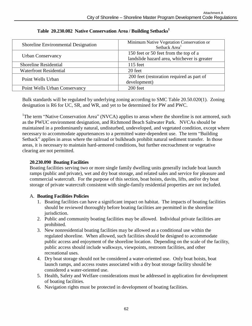
Attachment A
City of Shoreline – Shoreline Master Program Development Code Regulations
62
Table 20.230.082 Native Conservation Area / Building Setbacks1
Shoreline Environmental Designation Minimum Native Vegetation Conservation or
Setback Area1
Urban Conservancy 150 feet or 50 feet from the top of a landslide hazard area, whichever is greater
Shoreline Residential 115 feet
Waterfront Residential 20 feet
Point Wells Urban 200 feet (restoration required as part of
development)
Point Wells Urban Conservancy 200 feet
Bulk standards will be regulated by underlying zoning according to SMC Table 20.50.020(1). Zoning
designation is R6 for UC, SR, and WR, and yet to be determined for PW and PWC.
1The term “Native Conservation Area” (NVCA) applies to areas where the shoreline is not armored, such
as the PWUC environment designation, and Richmond Beach Saltwater Park. NVCAs should be
maintained in a predominantly natural, undisturbed, undeveloped, and vegetated condition, except where
necessary to accommodate appurtenances to a permitted water-dependent use. The term “Building
Setback” applies in areas where the railroad or bulkheads prohibit natural sediment transfer. In those
areas, it is necessary to maintain hard-armored conditions, but further encroachment or vegetative
clearing are not permitted.
20.230.090 Boating Facilities Boating facilities serving two or more single family dwelling units generally include boat launch ramps (public and private), wet and dry boat storage, and related sales and service for pleasure and
commercial watercraft. For the purpose of this section, boat hoists, davits, lifts, and/or dry boat
storage of private watercraft consistent with single-family residential properties are not included.
A. Boating Facilities Policies
1. Boating facilities can have a significant impact on habitat. The impacts of boating facilities
should be reviewed thoroughly before boating facilities are permitted in the shoreline
jurisdiction.
2. Public and community boating facilities may be allowed. Individual private facilities are
prohibited.
3. New nonresidential boating facilities may be allowed as a conditional use within the
regulated shoreline. When allowed, such facilities should be designed to accommodate
public access and enjoyment of the shoreline location. Depending on the scale of the facility,
public access should include walkways, viewpoints, restroom facilities, and other
recreational uses.
4. Dry boat storage should not be considered a water-oriented use. Only boat hoists, boat
launch ramps, and access routes associated with a dry boat storage facility should be
considered a water-oriented use.
5. Health, Safety and Welfare considerations must be addressed in application for development
of boating facilities.
6. Navigation rights must be protected in development of boating facilities.
Attachment A
City of Shoreline – Shoreline Master Program Development Code Regulations
63
7. Extended moorage on waters of the state without a lease or permission is restricted and
mitigation of impacts to navigation and access is required.
B. Boating Facilities Regulations
1. Boating facilities may be permitted only if: a. It can be demonstrated that the facility will not adversely impact fish or wildlife habitat
areas or associated wetlands; and
b. Adequate mitigation measures ensure that there is no net loss of the functions or values of
the shoreline and habitat as a result of the facility.
2. Boating facilities shall not be permitted within the following marine shoreline habitats
because of their scarcity, biological productivity and sensitivity unless no alternative location
is feasible, the project would result in a net enhancement of shoreline ecological functions,
and the proposal is otherwise consistent with this Program:
a. Critical saltwater habitats; and
b. Marshes, estuaries and other wetlands.
3. Preferred ramp designs, in order of priority, are:
a. Open grid designs with minimum coverage of beach substrate;
b. Seasonal ramps that can be removed and stored upland; and
c. Structures with segmented pads and flexible connections that leave space for natural
beach substrate and can adapt to changes in beach profile.
4. Ramps shall be placed and maintained near flush with the foreshore slope.
5. Boat launches shall be designed and constructed using methods/technology that have been
recognized and approved by state and federal resource agencies as the best currently
available. Rail and track systems shall be preferred over concrete ramps or similar facilities.
6. Launch access for non-motorized watercraft shall use gravel or other permeable material.
Removal of vegetation for launch access should be limited to eight (8) feet in width.
7. Before granting approval of a permit to allow a boat launch ramp, the proponent must
satisfactorily demonstrate that:
a. Adequate facilities for the efficient handling of sewage and litter will be provided;
b. The boating facilities will be designed so that structures are aesthetically compatible
with, or enhance shoreline features and uses; and
c. The boating facilities will be designed so that existing or potential public access along
beaches is not blocked or made unsafe, and so that public use of the surface waters is not
unduly impaired.
C. Boat Launch Ramps
1. Boat launch ramps shall be located on stable shorelines where water depths are adequate to
eliminate or minimize the need for channel maintenance activities.
2. Boat launch ramps may be permitted on accretion shoreforms provided any necessary
grading is not harmful to affected resources.
3. Where boat ramps are permitted, parking, and shuttle areas shall not be located on accretion
shoreforms.
4. Boat launch ramps may be permitted on stable, non-eroding banks where the need for shore
stabilization structures is minimized.
5. Ramp structures shall be placed near flush with the foreshore slope to minimize the
interruption of geohydraulic processes.
6. Boat launch sites that are open to the public shall have adequate restroom facilities operated
and maintained in compliance with King County Health District regulations.
Attachment A
City of Shoreline – Shoreline Master Program Development Code Regulations
64
D. Dry Boat Storage
1. Dry boat storage shall not be considered a water-oriented use and must comply with the
required shoreline environment setback.
2. Only water-dependent aspects of dry-boat storage, such as boat hoists and boat launch ramps
may be permitted within shoreline environment setbacks.
3. Boat launch ramps associated with dry boat storage shall be consistent with applicable
requirements in this section.
20.230.095 Breakwaters, Jetties, Groins, and Weirs
A. Breakwaters, Jetties, Groins and Weirs Policies
1. Breakwaters, jetties, groins, and weirs should be permitted only for water-dependent uses and
only where mitigated to provide no net loss of shoreline ecological functions and processes.
B. Breakwaters, Jetties, Groins and Weirs Regulations
1. Groins are prohibited except as a component of a professionally designed public beach
management program that encompasses an entire drift sector or reach for which alternatives
are infeasible, or where installed to protect or restore shoreline ecological functions or
processes.
2. Jetties and breakwaters are prohibited except as an integral component of a professionally
designed harbor, or port. Where permitted, floating, portable or submerged breakwater
structures, or smaller discontinuous structures are preferred where physical conditions make
such alternatives with less impact feasible. Defense works that substantially reduce or block
littoral drift and cause erosion of downdrift shores, shall not be allowed unless an adequate
long term professionally engineered beach nourishment program is established and
maintained.
20.230.100 Nonresidential Development
A. Nonresidential Development Policies
1. Priority of any nonresidential development should be given to water-dependent and water-
enjoyment uses. Allowed uses include restaurants that provide a view of the sound to
customers, motels and hotels that provide walking areas for the public along the shoreline,
office buildings, and retail sales buildings that have a waterfront theme with public access to
the beach or water views.
2. Over-the-water nonresidential development shall be prohibited.
3. Nonresidential development should be required to provide on-site physical or visual access to
the shoreline, or offer other opportunities for the public to enjoy shorelines of statewide
significance. If on-site access cannot be provided, offsite access should be required. Off site
access could be procured through the purchase of land or an easement at a location
appropriate to provide the access deemed necessary. Nonresidential developments should
include multiple use concepts such as open space and recreation.
4. Nonresidential development in the shoreline jurisdiction should include landscaping to
enhance the shoreline area.
Attachment A
City of Shoreline – Shoreline Master Program Development Code Regulations
65
B. Nonresidential Development Regulations
1. Over-water construction of nonresidential uses is prohibited, with the exception of boat
facilities necessary for the operation of an associated nonresidential use.
2. All nonresidential development within the shoreline area shall provide for visual and/or
physical access to the shoreline by the public. Where on-site public access is feasible,
nonresidential development shall dedicate, improve, and provide maintenance for a
pedestrian easement that provides area sufficient to ensure usable access to and along the
shoreline for the general public. Public access easements shall be a minimum of 25 feet in
width and shall comply with the public access standards contained in the Public Access
section of this Shoreline Master Program and the Shoreline Development Code.
3. All nonresidential loading and service areas shall be located on the upland side of the
nonresidential activity or provisions shall screen the loading and service areas from the
shoreline.
4. All nonresidential development within shoreline jurisdiction shall assure no net loss of
shoreline ecological functions.
5. A shoreline setback is not required to be maintained for water-dependant nonresidential
development.
6. Water-dependent, nonresidential development shall maintain a shoreline setback of either 25
feet from the OHWM or 10 feet from the edge of the base flood elevation, whichever is
greater. If public access is provided to the shoreline, the setback may be reduced to 10 feet
from the OHWM or the edge of the base flood elevation, whichever is greater.
7. Nonwater-dependent nonresidential development shall maintain a minimum setback from the
OHWM consistent with Table 20.230.082.
20.230.110 In-stream Structures.
A. In-stream Structures Policies
1. In-stream structures should provide for the protection and preservation, of ecosystem-wide
processes, ecological functions, and cultural resources including, but not limited to fish and
fish passage, wildlife and water resources, shoreline critical areas, hydrogeological processes,
and natural scenic vistas. The location and planning of in-stream structures should give due
consideration to the full range of public interests, watershed functions and processes, and
environmental concerns, with special emphasis on protecting and restoring priority habitats
and species.
2. Non-structural and non-regulatory methods to protect, enhance, and restore shoreline
ecological functions and processes and other shoreline resources should be encouraged as an
alternative to structural in-stream structures.
B. In-stream Structures Regulations
1. Natural instream features such as snags, uprooted trees, or stumps should be left in place
unless it can be demonstrated that they are actually causing bank erosion or higher flood
stages.
2. Instream structures shall allow for normal ground water movement and surface runoff.
3. In-stream structures shall not impede upstream or downstream migration of anadromous fish.
4. All debris, overburden and other waste materials from construction shall be disposed of in
such a manner that prevents their entry into a water body.
Attachment A
City of Shoreline – Shoreline Master Program Development Code Regulations
66
20.230.115 Aquaculture.
A. Aquaculture Policies
1. Potential locations for aquaculture are relatively restricted due to specific requirements for water quality, temperature, flows, oxygen content, adjacent land uses, wind protection, commercial
navigation, and, in marine waters, salinity. The technology associated with some forms of present-
day aquaculture is still in its formative stages and experimental. Therefore, the City recognizes the
necessity for some latitude in the development of this use as well as its potential impact on existing
uses and natural systems.
2. Aquaculture should not be permitted in areas where it would result in a net loss of ecological
functions, adversely impact eelgrass and macroalgae, or significantly conflict with navigation and
other water-dependent uses. Aquacultural facilities should be designed and located so as not to
spread disease to native aquatic life, establish new nonnative species which cause significant
ecological impacts, or significantly impact the aesthetic qualities of the shoreline. Impacts to
ecological functions shall be mitigated according to the mitigation sequence described in SMC
20.230.020.
B. Aquaculture Regulations
1. Aquaculture is allowed as a conditional use in the Aquatic environment where it can be located,
designed, constructed, and managed to avoid a net loss of ecological functions, not spread diseases
to native aquatic life, not adversely impact native eelgrasses and macroalgae species or not
significantly conflict with navigation.
2. The supporting infrastructure for aquaculture may be located landward of the aquaculture
operation subject to the City‟s land use code.
3. Aquaculture facilities are required to develop best management practices to minimize impacts
from the construction and management of the facilities.
4. New aquatic species that are not previously cultivated in Washington state shall not be
introduced into Shoreline‟s saltwaters or freshwaters without prior written approval of the Director
of the Washington Department of Fish and Wildlife and the Director of the Washington Department
of Health. This prohibition does not apply to: Pacific, Olympia, Kumomoto, Belon or Virginica
oysters; Manila, Butter, or Littleneck clams; or Geoduck clams.
5. No aquacultural processing, except for the sorting or culling of the cultured organism and the
washing or removal of surface materials or organisms, shall be permitted waterward of the ordinary
high water mark unless fully contained within a tending boat or barge.
6. Aquaculture wastes shall be disposed of in a manner that will ensure compliance with all
applicable governmental waste disposal standards, including but not limited to, the Federal Clean
Water Act, Section 401, and chapter 90.48 RCW, Water Pollution Control. No garbage, wastes, or
debris shall be allowed to accumulate at the site of any aquaculture operation.
20.230.120 Parking Areas.
A. Parking Area Policies
1. Parking in shoreline areas should be minimized. 2. Parking within shoreline areas should directly serve a permitted use on the property.
3. Parking in shoreline areas should be located and designed to minimize adverse impacts
including those related to stormwater runoff, water quality, visual qualities, public access,
and vegetation and habitat maintenance.
Attachment A
City of Shoreline – Shoreline Master Program Development Code Regulations
67
4. Landscaping should consist of native vegetation in order to enhance the habitat opportunities
within the shorelines area.
B. Parking Regulations
Parking for specific land use activities within the City of Shoreline is subject to the requirements and
standards set forth in SMC 20.50 Subchapter 6. Parking, Access, and Circulation. In addition, the
following parking requirements shall apply to all developments within shorelands.
1. The location of parking areas in or near shoreland areas shall be located outside of the
minimum setbacks listed in Table 20.230.082 for the shoreline designation.
2. Parking in the shorelands must directly serve an approved shoreline use. 3. Parking shall be located on the landward side of the development unless parking is contained
within a permitted structure. Where there is no available land area on the landward side of
the development, parking shall extend no closer to the shoreline than a permitted structure.
4. Landscape screening is required between the parking area and all adjacent shorelines and
properties.
5. The landscape screening for parking areas located within the shoreline areas shall consist of
native vegetation, planted prior to final approval of project, which provides effective
screening two (2) years after planting. Adequate screening or landscaping for parking lots
shall consist of one or more of the following:
a. A strip five (5) feet wide landscaped with trees, shrubs, and/or groundcover;
b. A building or enclosed structure; and/or
c. A strip of land not less than two and a half (2.5) feet in width that is occupied by a
continuous wall, fence, plant material, or combination of both; which shall be at least
three and a half (3.5) feet high at time of installation. The plant material shall be
evergreen and spaced not more than one and a half (1.5) feet on center if pyramidal in
shape, or not more than three (3) feet if wider in branching habit. If the plant material is
used in conjunction with a wall or fence meeting the minimum height requirements then
said material may be of any kind and spacing. More restrictive screening may be
required 20.50 SMC, Subchapters 6 and 7. Required parking area screening may be
incorporated into general landscaping requirements under SMC Subchapters 6 and 7.
6. The requirement for screening may be waived by the Director, where screening would
obstruct a significant view from public property or public roadway.
7. Parking areas shall not be permitted over the water.
8. Parking as a primary use shall be prohibited within all shoreline environments.
9. Parking or storage of recreational vehicles or travel trailers as a primary use shall be
prohibited in all shoreline environments.
20.230.130 Recreational Facilities. Recreational development provides for low impact activities, such as hiking, photography, kayaking, viewing, and fishing, or more intensive uses such as parks. This section applies to both publicly and
privately-owned shoreline facilities.
A. Recreational Facilities Policies
1. The coordination of local, state, and federal recreation planning should be encouraged so as
to mutually satisfy recreational needs. Shoreline recreational developments should be
consistent with all adopted parks, recreation, and open space plans.
2. Parks, recreation areas, and public access points, such as hiking paths, bicycle paths, and
scenic drives should be linked.

Attachment A
City of Shoreline – Shoreline Master Program Development Code Regulations
68
3. Recreational developments should be located and designed to preserve, enhance, or create
scenic views and vistas.
4. The use of jet-skis and similar recreational equipment should be restricted to special areas.
This type of activity should be allowed only where no conflict exists with other uses and
wildlife habitat.
5. All recreational developments should make adequate provisions for:
a. Vehicular and pedestrian access, both on-site and off-site;
b. Proper water, solid waste, and sewage disposal methods;
c. Security and fire protection for the use itself and for any use-related impacts to adjacent
private property;
d. The prevention of overflow and trespass onto adjacent properties; and
e. Buffering of such development from adjacent private property or natural areas.
B. Recreational Facilities Regulations
1. Valuable shoreline resources and fragile or unique areas, such as wetlands and accretion
shore forms, shall be used only for low impact and nonstructural recreation activities.
2. For recreation developments that require the use of fertilizers, pesticides, or other chemicals,
the property owner shall submit plans demonstrating the methods to be used to prevent these
chemical applications and resultant leachate from entering adjacent water bodies. The
property owner shall be required to maintain a chemical-free swath at least one hundred
(100) feet in depth adjacent to water bodies.
3. Recreational facilities shall make adequate provisions, such as screening, buffer strips,
fences, and signs, to mitigate nuisance to nearby private properties.
4. No recreational buildings or structures shall be built waterward of the OHWM, except water-
dependent and/or water-enjoyment structures such as bridges and viewing platforms. Such
uses may be permitted as a Shoreline Conditional Use.
5. Proposals for recreational development shall include adequate facilities for water supply,
sewage, and garbage disposal.
20.230.140 Residential Development.
1. Residential development does not include hotels, motels, or any other type of overnight or transient housing or camping facilities.
2. A Shoreline Substantial Development Permit is not required for construction of a single
family residence by an owner, lessee, or contract purchaser for their own use or the use of
their family. Single family residential construction and accessory structures must otherwise
conform to this Shoreline Master Program.
3. A Shoreline Variance or Shoreline Conditional Use Permit may be required for residential
development for situations specified in the Shoreline Master Program.
4. Uses and facilities associated with residential development, which are identified as separate
use activities in this Shoreline Master Program, such as land disturbing activities, are subject
to the regulations established for those uses in this section.
A. Residential Policies
1. In accordance with the Public Access requirements in 20.230.040, residential developments
of more than four (4) dwelling units should provide dedicated and improved public access
to the shoreline.
2. Residential development and accessory uses should be prohibited over the water.
Attachment A
City of Shoreline – Shoreline Master Program Development Code Regulations
69
3. New subdivisions should be encouraged to cluster dwelling units in order to preserve natural
features, minimize physical impacts, and provide for public access to the shoreline.
4. In all new subdivisions and detached single family development with four (4) dwelling units,
joint-use shoreline facilities should be encouraged.
5. Accessory uses and structures should be designed and located to blend into the site as much
as possible. Accessory uses and structures should be located landward of the principal
residence when feasible.
B. Residential Regulations
1. Residential development is prohibited waterward of the OHWM and within setbacks defined
for each shoreline environment designation.
2. Residential development shall assure no net loss of shoreline ecological functions.
3. Residential development shall not be approved if geotechnical analysis demonstrates that
flood control or shoreline protection measures are necessary to create a residential lot or site
area. Residential development shall be located and designed to avoid the need for structural
shore defense and flood protection works.
4. If wetlands or other critical areas are located on the development site, clustering of
residential units shall be required in order to avoid impacts to these areas.
5. Storm drainage facilities shall include provisions to prevent the direct entry of uncontrolled
and untreated surface water runoff into receiving waters as specified in the Stormwater
Manual.
6. Subdivisions and planned unit developments of four (4) waterfront lots/units shall dedicate,
improve, and provide maintenance provisions for a pedestrian easement that provides area
sufficient to ensure usable access to and along the shoreline for all residents of the
development and the general public. When required, public access easements shall be a
minimum of 25 feet in width and shall comply with the Public Access standards in
20.230.060. The design shall conform to the standards in the Engineering Development
Manual.
7. Single family residential development shall maintain a minimum setback from the OHWM
consistent with Table 20.230.082.
8. Multifamily residential development shall maintain a minimum setback from the OHWM
consistent with Table 20.230.082.
9. One (1) accessory structure to the residence may be placed within the required shoreline
setback provided:
a. No accessory structure shall cover more than 200 square feet.
Attachment A
City of Shoreline – Shoreline Master Program Development Code Regulations
70
Subchapter 3. Shoreline Modification Policies and Regulations
20.230.150 General Shoreline modification involves developments that provide bank stabilization or flood control. The purpose of the modification is to reduce adverse impacts caused by natural processes, such as
current, flood, tides, wind, or wave action. Shoreline modification includes all structural and
nonstructural means to reduce flooding and/or erosion of banks.
Nonstructural methods include setbacks of permanent and temporary structures, relocation of the
structure to be protected, ground water management, planning, bioengineering or “soft” engineered
solutions, and regulatory measures to avoid the need for structural stabilization.
"Hard" structural stabilization measures refer to those with solid, hard surfaces, such as concrete
bulkheads, while "soft" structural measures rely on natural materials such as biotechnical vegetation
or beach enhancement. Generally, the harder the construction measure, the greater the impact on
shoreline processes, including sediment transport, geomorphology, and biological functions. New
structural shoreline stabilization also often results in vegetation removal, as well as damage to
nearshore habitat and shoreline corridors. There are a range of measures varying from soft to hard
that include:
• Vegetation enhancement
• Upland drainage control
• Biotechnical measures
• Beach enhancement
• Anchor trees
• Gravel placement
• Rock revetments
• Gabions
• Concrete groins
• Retaining walls and bluff walls
• Bulkheads
A. Shoreline Modification Policies - General
1. Biostabilization and other bank stabilization measures should be located, designed, and
constructed primarily to prevent damage to the existing primary structure.
2. All new development should be located and designed to prevent or minimize the need for
shoreline stabilization measures and flood protection works. New development requiring
shoreline stabilization shall be discouraged in areas where no preexisting shoreline
stabilization is present.
3. Shoreline modifications are only allowed for mitigation or enhancement purposes, or when
and where there is a demonstrated necessity to support or protect an existing primary
structure or legally existing shoreline use that is otherwise in danger of loss or substantial
damage.
4. Proposals for shoreline modifications should be designed to protect life and property without
impacting shoreline resources.
5. Shoreline modifications that are natural in appearance, compatible with ongoing shoreline
processes, and provide flexibility for long term management, such as protective berms or
Attachment A
City of Shoreline – Shoreline Master Program Development Code Regulations
71
vegetative stabilization, should be encouraged over structural means such as concrete
bulkheads or extensive revetments, where feasible.
6. Structural solutions to reduce shoreline damage should be allowed only after it is
demonstrated that nonstructural solutions would not be able to withstand the erosive forces of
the current and waves.
7. The design of bank stabilization or protection works should provide for the long–term,
multiple-use of shoreline resources and public access to public shorelines.
8. In the design of publicly financed or subsidized works, consideration should be given to
providing pedestrian access to shorelines for low impact outdoor recreation.
9. All flood protection measures should be placed landward of the natural flood boundary,
including wetlands that are directly interrelated and inter-dependent with water bodies.
10. If through construction and/or maintenance of shoreline modification developments, the loss
of vegetation and wildlife habitat will occur, mitigation should be required.
B. Shoreline Modification Regulations - General
1. All new development, uses or activities within the shoreline area shall be located and
designed to prevent or minimize the need for bank stabilization and flood protection works.
2. Permitted and Shoreline Conditional Use requirements for bulkheads and revetments are
specified in this chapter. All other forms of shoreline modification, except soft shore must be
approved as a Shoreline Conditional Use within all shoreline environments.
3. All shoreline stabilization proposals require a geotechnical analysis.
4. All shoreline development and activity shall be located, designed, constructed, and managed
in a manner that mitigates impacts to the environment. The preferred mitigation sequence
(avoid, minimize, mitigate, compensate) shall follow that listed in WAC 173-26-201 (2)(e).
5. New nonwater-dependent development, including single-family residences, that includes
structural shoreline stabilization shall not be allowed unless all of the conditions below apply,
otherwise new stabilization measures are limited to protecting only existing developments:
a. The need to protect the development from destruction due to erosion caused by natural
processes, such as currents and waves, is demonstrated through a geotechnical/hydro-
geological report prepared by a City-approved qualified professional.
b. The erosion is not caused by upland conditions, such as the loss of vegetation and/or
drainage issues.
c. There will be no net loss of shoreline ecological functions or impacts to adjacent or
down-current properties.
d. Nonstructural measures, such as placing the development further from the shoreline,
planting vegetation, or installing on-site drainage improvements and soft structural
solutions such as bioengineering, are not feasible or not sufficient.
e. The structure will not cause adverse impacts to the functions and values of critical areas
or properly functioning conditions for proposed, threatened, and endangered species.
f. Other mitigation/restoration measures are included in the proposal.
6. Upon project completion, all disturbed shoreline areas shall be restored to as near pre-project
configuration as possible and replanted with appropriate vegetation. All losses in riparian
vegetation or wildlife habitat shall be mitigated at a ratio of 1:1.25 (habitat lost to habitat
replaced).
7. Shoreline stabilization and flood protection works are prohibited in wetlands and on point
and channel bars. They are also prohibited in fish spawning areas.
8. Developments shall not reduce the volume and storage capacity of streams and adjacent
wetlands or flood plains.
Attachment A
City of Shoreline – Shoreline Master Program Development Code Regulations
72
9. Use of refuse for the stabilization of shorelines is prohibited.
20.230.160 Dredging and Disposal of Dredging Spoils
A. Dredging and Dredge Spoil Policies
1. Dredging waterward of the ordinary high water mark for the primary purpose of obtaining fill
material is prohibited.
2. Dredging operations should be planned and conducted to minimize interference with
navigation; avoid creating adverse impacts on other shoreline uses, properties, and ecological
shoreline functions and values; and avoid adverse impacts to habitat areas and fish species.
3. Dredge spoil disposal in water bodies shall be prohibited except for habitat improvement.
4. Dredge spoil disposal on land should occur in areas where environmental impacts will not be
significant.
B. Dredging and Dredge Spoil Regulations
1. Dredging and dredge spoil disposal shall be permitted only where it is demonstrated that the
proposed actions will not:
a. Result in significant damage to water quality, fish, and other essential biological
elements;
b. Adversely alter natural drainage and circulation patterns, currents, or reduce floodwater
capacities;
c. Adversely impact properly functioning conditions for proposed, threatened, or
endangered species; or
d. Adversely alter functions and values of the shoreline and associated critical areas.
2. Proposals for dredging and dredge spoil disposal shall include all feasible mitigating
measures to protect habitats and to minimize adverse impacts such as turbidity; release of
nutrients, heavy metals, sulfides, organic materials, or toxic substances; depletion of oxygen;
disruption of food chains; loss of benthic productivity; and disturbance of fish runs and/or
important localized biological communities.
3. Dredging and dredge spoil disposal shall not occur in wetlands unless for approved
maintenance or enhancement associated with a restoration project.
4. Dredging within the shorelines shall be permitted only:
a. For navigational purposes; or
b. For activities associated with shoreline or aquatic restoration or remediation.
5. When dredging is permitted, the dredging shall be the minimum necessary to accommodate
the proposed use.
6. Dredging shall utilize techniques that cause minimum dispersal and broadcast of bottom
material; hydraulic dredging shall be used wherever feasible in preference to agitation
dredging.
7. Dredge material disposal shall be permitted in shoreline jurisdiction only as part of an
approved shoreline habitat and natural systems enhancement, fish habitat enhancement or
watershed restoration project.
8. Dredged spoil material may be disposed at approved upland sites. If these upland sites are
dry lands and fall within shoreline jurisdiction, the disposal of dredge spoils shall be
considered landfilling and must be consistent with all applicable provisions of the Master
Program. Depositing dredge spoils within the Puget Sound shall be allowed only by
Shoreline Conditional Use for one of the following reasons:
a. For wildlife habitat improvements; or
Attachment A
City of Shoreline – Shoreline Master Program Development Code Regulations
73
b. To correct problems of material distribution that are adversely affecting fish resources.
9. If suitable alternatives for land disposal are not available or are infeasible, water disposal
sites may be permitted by appropriate agencies, provided the sites are determined by the
Director to be consistent with the following criteria:
a. Disposal will not interfere with geohydraulic processes;
b. The dredge spoil has been analyzed by a qualified professional and found to be minimally
or non-polluting;
c. Aquatic life will not be adversely affected; and
d. The site and method of disposal meets all requirements of applicable regulatory agencies.
10. Disposal of dredge material shall be done in accordance with the Washington State DNR
Dredge Material Management Program. DNR manages disposal sites through a Site Use
Authorization (SUA); all other required permits must be provided to DNR prior to the DNR
issuing a SUA for dredge disposal.
11. The City may impose reasonable limitations on dredge spoil disposal operating periods and
hours, and may require buffer strips at land disposal sites.
20.230.170 Piers and Docks Piers and Docks may be allowed in accordance with Table 20.230.081 only when the following conditions are met:
1. The public's need for piers and docks is clearly demonstrated, and the proposal is consistent
with protection of the public trust, as embodied in RCW 90.58.020.
2. Avoidance of impacts to critical saltwater habitats by an alternative alignment or location is
not feasible, or would result in unreasonable and disproportionate cost to accomplish the
same general purpose.
3. The project, including any required mitigation, will result in no net loss of ecological
functions associated with critical saltwater habitat.
4. The project is consistent with the state's interest in resource protection and species recovery.
5. Private, noncommercial docks for joint or community use may be authorized provided that:
a. Avoidance of impacts to critical saltwater habitats by an alternative alignment or location
is not feasible; and
b. The project, including any required mitigation, will result in no net loss of ecological
functions associated with critical saltwater habitat.
6. An inventory of the site and adjacent beach sections to assess the presence of critical
saltwater habitats and functions is required. The methods and extent of the inventory shall be
consistent with accepted research methodology. Proposals will be evaluated using
Department of Ecology technical assistance materials for guidance.
7. Community moorage to serve new development shall be limited to the amount of moorage
needed to serve lots with water frontage; provided that a limited number of upland lots may
also be accommodated. Applications for shared moorage shall demonstrate that mooring
buoys are not feasible prior to approval of dock moorage.
8. Piers and docks shall be constructed of materials that will not adversely affect water quality
or aquatic plants and animals over the long term. Materials used for submerged portions of a
pier or dock, decking, and other components that may come in contact with water shall be
approved by applicable state agencies for use in water to avoid discharge of pollutants from
wave splash, rain, or runoff. At a minimum, piles, floats, or other structural members in
direct contact with the water shall be constructed of concrete or steel in accordance with
BMP‟s published by the Washington Department of Fish and Wildlife (WDFW) and the
Attachment A
City of Shoreline – Shoreline Master Program Development Code Regulations
74
United States Army Corps of Engineers (USACE), and they shall not be treated or coated
with herbicides, fungicides, paint, or pentachlorophenol. Use of arsenate compounds or
creosote is prohibited.
9. Pilings used in piers or docks shall have a minimum clearance of two feet above extreme
high tide and a maximum clearance of five feet above the OHWM. Floats shall not rest on
the substrate.
10. To minimize adverse effects on nearshore habitats and species caused by overwater
structures that reduce ambient light levels, the following shall apply:
a. The width of docks, piers, floats, and lifts shall be the minimum necessary, and shall not
be wider than six (6) feet;
b. The length of docks and piers shall be the minimum necessary to prevent the grounding
of floats and boats on the substrate during low tide;
c. Docks floats or floating docks shall include stops that serve to keep the float bottom off
tidelands at low tide;
d. The length and location of docks, piers, floats, and lifts pilings shall be designed using
the BMP‟s as conditioned in the permitting documents approved by WDFW and USACE;
and
e. The size of shared docks or piers is limited to 700 square feet for two lots and 1,000
square feet for 3 or more lots.
11. All new piers or docks must be fully grated. Grating to allow light passage or reflective
panels to increase light refraction into the water shall be used on piers, docks, floats and
gangways in nearshore areas. Decking shall have a minimum open space of 40% and after
installation at least 60% ambient light beneath the structure shall be maintained.
20.230.175 Pier and Dock Repair, Replacement, or Expansion 1. Existing over-water structures may be repaired and/or replaced in the same location as the existing
structure.
2. Repair or replacement of 50% or more of an existing over-water deck structure shall include the
replacement of the entire decking with grated material to achieve a minimum open space of 40%
and shall result in at least 60% ambient light beneath the structure.
3. Repair or replacement of less than 50% of the over-water deck structure shall use grated decking in
the area to be replaced. If the cumulative repair in any three year period exceeds 50%, the entire
decking shall be replaced to achieve a minimum open space of 40% and shall result in at least 60%
ambient light beneath the structure.
4. Repair or replacement of structural members in contact with the water shall be constructed of
concrete or steel in accordance with BMP‟s published by WDFW and USACE and they shall not
be treated or coated with herbicides, fungicides, paint, or pentachlorophenol. Use of arsenate
compounds or creosote is prohibited.
5. Expansion of existing over-water structures is prohibited.
6. Other repairs not described in this section to existing legally established are considered minor
and may be permitted consistent with all applicable regulations.
20.230.180 Bulkheads Bulkheads are walls usually constructed parallel to the shore, whose primary purpose is to contain and prevent the loss of soil by erosion, wave, or current action. Bulkheads are typically constructed
of poured-in-place concrete; steel or aluminum sheet piling; wood; or wood and structural steel
combinations.
Attachment A
City of Shoreline – Shoreline Master Program Development Code Regulations
75
The Washington State Shoreline Management Act only exempts the construction of a normal
protective bulkhead associated with an existing single family residence from the Shoreline
Substantial Development Permit requirement. However, these structures are required to comply
with all the policies and development standards of this Shoreline Master Program.
A. Bulkhead Policies
1. Bulkheads constructed from natural materials, such as protective berms, beach enhancement,
or vegetative stabilization are strongly preferred over structural bulkheads constructed from
materials such as steel, wood, or concrete. Proposals for bulkheads should demonstrate that
natural methods are unworkable.
2. Bulkheads should be located, designed, and constructed primarily to prevent damage to the
existing primary structure. New development that requires bulkheads is not permitted except
as specifically provided under this Master Program.
3. Shoreline uses should be located in a manner so that a bulkhead is not likely to become
necessary in the future.
4. Bulkheads should not be approved as a solution to geo-physical problems such as mass slope
failure, sloughing, or landslides. Bulkheads should only be approved for the purposes of
preventing bank erosion by the Puget Sound.
B. Bulkhead Regulations
1. New bulkheads may be allowed only when evidence is presented which demonstrates that
one of the following conditions exist:
a. Serious erosion threatens an established use or existing primary structure on upland
property.
b. Bulkheads are necessary to the operation and location of water-dependent, water-related,
or water-enjoyment activities consistent with this Shoreline Master Program, provided
that all other alternative methods of shore protection have proven infeasible; and/or
c. A bulkhead is necessary to retain landfilling that has been approved consistent with the
provisions of the Master Program.
2. Proposals for bulkheads must first demonstrate through a geotechnical analysis that use of
natural materials and processes and non-structural or soft structural solutions to bank
stabilization are not feasible.
3. The construction of a bulkhead for the primary purpose of retaining landfilling shall be
allowed only in conjunction with:
a. A water-dependent use;
b. A bridge or navigational structure for which there is a demonstrated public need and
where no feasible upland sites, design solutions, or routes exist; and/or
c. A wildlife or fish enhancement project.
4. Bulkheads shall not be located on shorelines where valuable geo-hydraulic or biological
processes are sensitive to interference. Examples of such areas include wetlands and
accretion landforms.
5. Bulkheads are to be permitted only where local physical conditions, such as foundation
bearing materials, and surface and subsurface drainage, are suitable for such alterations.
6. If possible, bulkheads shall be located landward of the OHWM and generally parallel to the
natural shoreline. In addition:
a. Where no other bulkheads are adjacent, the construction of a bulkhead shall be as close to
the eroding bank as possible and in no case shall it be more than three (3) feet from the
toe of the bank;
Attachment A
City of Shoreline – Shoreline Master Program Development Code Regulations
76
b. A bulkhead for permitted landfilling shall be located at the toe of the fill; and
c. Where permitted a bulkhead must tie in flush with existing bulkheads on adjoining
properties, except where the adjoining bulkheads extend waterward of the base flood
elevation, the requirements set forth in this section shall apply.
7. Replacement bulkheads may be located immediately waterward of the bulkhead to be
replaced such that the two (2) bulkheads will share a common surface, except where the
existing bulkhead has not been backfilled or has been abandoned and is in serious disrepair.
In such cases, the replacement bulkhead shall not encroach waterward of the OHWM or
existing structure unless the residence was occupied prior to January 1, 1992 and there are
overriding safety or environmental concerns.
8. All bulkheads proposals require a geotechnical report prepared by a qualified professional.
Bulkheads shall be sited and designed as recommended in approved geotechnical reports.
For the Waterfront Residential environment designation, one geotechnical report could be
prepared for multiple properties.
9. When a bulkhead is required at a public access site, provision for safe access to the water
shall be incorporated into bulkhead design.
10. Bulkheads shall be designed for the minimum dimensions necessary to adequately protect the
development.
11. Stairs or other permitted structures may be built into a bulkhead but shall not extend
waterward of the bulkhead, unless they are retractable or removable.
12. Bulkheads shall be designed to permit the passage of surface or groundwater without causing
ponding or saturation of retained soil/materials.
13. Adequate toe protection consisting of proper footings, a fine retention mesh, etc., shall be
provided to ensure bulkhead stability without relying on additional riprap.
14. Materials used in bulkhead construction shall meet the following standards:
a. Bulkheads shall utilize stable, non-erodible, homogeneous materials such as concrete,
wood, and rock that are consistent with the preservation and protection of the ecological
habitat;
b. Dredge spoils shall not be used for fill behind bulkheads, except clean dredge spoil from
a permitted off-site dredge and fill operation; and
c. Backfill and wave returns to stabilize bulkheads are permitted.
20.230.190 Revetment A revetment is a sloped shoreline structure built to protect an existing eroding shoreline or newly placed fill against currents. Revetments are most commonly built of randomly placed boulders
(riprap) but may also be built of sand cement bags, paving or building blocks, gabions (rock filled
wire baskets), or other systems and materials. The principal features of a revetment, regardless of
type is a heavy armor layer, a filter layer, and toe protection.
A. Revetment Policies
1. The use of armored structural revetments should be limited to situations where it is
determined that nonstructural solutions such as bioengineering, setbacks, buffers or any
combination thereof, will not provide sufficient shoreline stabilization.
2. Revetments should be designed, improved, and maintained to provide public access
whenever possible.
B. Revetment Regulation
1. The proposed revetment shall be designed by a qualified professional engineer.
Attachment A
City of Shoreline – Shoreline Master Program Development Code Regulations
77
2. Design of revetments shall include and provide improved access to public shorelines
whenever possible.
3. When permitted, the location and design of revetments shall be determined using engineering
principles, including guidelines of the U.S. Soil Conservation Service and the U.S. Army
Corps of Engineers.
4. Armored revetment design shall meet the following design criteria:
a. The size and quantity of the material shall be limited to only that necessary to withstand
the estimated energy intensity of the hydraulic system;
b. Filter fabric must be used to aid drainage and help prevent settling;
c. The toe reinforcement or protection must be adequate to prevent a collapse of the system
from scouring or wave action; and
d. Fish habitat components, such as large boulders, logs, and stumps shall be considered in
the design subject to a Hydraulic Project Approval by the Washington Department of
Fish and Wildlife.
20.230.200 Land Disturbing Activities.
A. Land Disturbing Activity Policies
1. Land disturbing activities should only be allowed in association with a permitted
shoreline development.
2. Land disturbing activities should be limited to the minimum necessary to accommodate
the shoreline development or a landscape plan developed in conjunction with the
shoreline development.
3. Erosion shall be prevented and sediment shall not enter waters of the state.
B. Land Disturbing Activity Regulations
1. All land disturbing activities shall only be allowed in association with a permitted
shoreline development.
2. All land disturbing activities shall be limited to the minimum necessary for the intended
development, including any clearing and grading approved as part of a landscape plan.
Clearing invasive, non-native shoreline vegetation listed on the King County Noxious
Weed List is permitted in the shoreline area with an approved clearing and grading permit
provided best management practices are used as recommended by a qualified
professional, and native vegetation is promptly reestablished in the disturbed area.
3. Tree and vegetation removal shall be prohibited in required Native Vegetation
Conservation Areas, except as necessary to restore, mitigate or enhance the native
vegetation by approved permit as required in these areas.
4. All significant trees in the Native Vegetation Conservation Areas shall be designated as
protected trees consistent with SMC 20.50.340 and removal of hazard trees must be
consistent with SMC 20.50.310(A)(1).
5. All shoreline development and activities shall use measures identified in the Stormwater
Manual. Stabilization of exposed surfaces subject to erosion along shorelines shall,
whenever feasible, utilize soil bioengineering techniques.
6. For extensive land disturbing activities that require a permit, a plan addressing species
removal, revegetation, irrigation, erosion and sedimentation control, and other methods of
shoreline protection should be required.
Attachment A
City of Shoreline – Shoreline Master Program Development Code Regulations
78
20.230.210 Landfilling
A. Landfilling Policies
1. The perimeter of landfilling should be designed to avoid or eliminate erosion and
sedimentation impacts, during both initial landfilling activities and over time.
2. Where permitted, landfilling should be the minimum necessary to provide for the
proposed use and should be permitted only when conducted in conjunction with a
specific development proposal that is permitted by the Shoreline Master Program.
Speculative landfilling activity should be prohibited.
B. Landfilling Regulations
1. Landfilling activities shall only be permitted in conjunction with a specific development.
Landfilling may be permitted as a Shoreline Conditional Use for any of the following:
a. In conjunction with a water-dependent use permitted under this Shoreline Master
Program; and/or
b. In conjunction with a bridge, utility, or navigational structure for which there is a
demonstrated public need and where no feasible upland sites, design solutions, or
routes exist;
2. Pier or pile supports shall be utilized in preference to landfilling. Landfilling for approved
road development in floodways or wetlands shall be permitted only if pile or pier supports
are proven structurally infeasible.
3. Landfilling shall be permitted only where it is demonstrated that the proposed action will
not:
a. Result in significant damage to water quality, fish, and/or wildlife habitat; or
b. Adversely alter natural drainage and current patterns or significantly reduce
floodwater capacities.
4. Where landfilling activities are permitted, the landfilling shall be the minimum necessary
to accommodate the proposed use.
5. Landfilling from dredging and dredge material disposal shall be done in a manner that
avoids or minimizes significant ecological impacts. Impacts that cannot be avoided shall
be mitigated in a manner that assures no net loss of shoreline ecological functions.
6. Dredging waterward of the OHWM for the primary purpose of obtaining fill material
shall not be allowed, except when the material is necessary for the restoration of
shoreline ecological functions. When allowed, the site where the fill is to be placed must
be located waterward of the OHWM.
7. Landfilling shall be designed, constructed, and maintained to prevent, minimize, and
control all material movement, erosion, and sedimentation from the affected area.
Landfilling perimeters shall be designed and constructed with silt curtains, vegetation,
retaining walls, or other mechanisms to prevent material movement. In addition, the
sides of the landfilling shall be appropriately sloped to prevent erosion and
sedimentation, during both the landfilling activities and afterwards.
8. Fill materials shall be clean sand, gravel, soil, rock, or similar material. Use of polluted
dredge spoils and sanitary landfilling materials are prohibited. The property owner shall
provide evidence that the material has been obtained from a clean source prior to fill
placement.
9. Landfilling shall be designed to allow surface water penetration into aquifers, if such
conditions existed prior to the fill.
Attachment A
City of Shoreline – Shoreline Master Program Development Code Regulations
79
20.230.230 Signs
A. Sign Policies
Signs should be designed and placed so that they are compatible with the natural quality of the
shoreline environment and adjacent land and water uses.
B. Sign Regulations
Signs within the City, including the shoreline area, are subject to the requirements and standards
specified in SMC 20.50 Subchapter 8. Signs are based on the underlying zoning. In addition,
the following sign requirements shall apply to signs within shoreline areas.
1. Signs shall only be allowed in or over water for navigation purposes; at road or railroad
crossings as necessary for operation, safety and direction; or as related and necessary to a
water dependent use.
2. Signs are permitted in all shoreline environments upland of the OHWM. Theses sign
standards supplement the provisions of SMC 20.50.530 to 20.50.610. Where there is a
conflict, the provisions herein shall apply.
C. Prohibited signs.
1. All prohibited signs per SMC 20.50.550.
2. Balloons, any inflatable signs, or inflatable objects used to aid in promoting the sale of
products, goods, services, events, or to identify a building.
3. Searchlights and beacons.
4. Electronic reader boards or changing message signs.
5. Neon signs.
6. Pole Signs.
7. Backlit awnings used as signs.
8. Internally illuminated signs, except as allowed in 20.230.230(D)(1).
9. Signs that impair visual access from public viewpoints in view corridors are prohibited in
all shoreline environments.
D. Illumination of Signs
1. Illumination of signs is only allowed as permitted by the underlying zoning.
2. Internal illumination of signs is only allowed with light provided by LED or other Energy
Star rated luminaries, and is limited to:
a. Opaque cabinet signs where light only shines through the letters, not including
symbols, images, or background; or
b. Shadow lighting, where letters are backlit, but light only shines through the edges of
the letters.
3. All externally illuminated signs shall shield nearby properties from direct lighting. Light
source must be within a maximum of 6 feet from the sign display, and limited to LED or
other Energy Star rated luminaries.
4. No commercial sign shall be illuminated after 11:00 p.m. unless the commercial
enterprise is open for business, and then may remain on only as long as the business is
open.
5. The light from any illuminated sign shall be shaded, shielded or directed so that the light
intensity or brightness shall not adversely affect:
a. Surrounding or facing premises;
Attachment A
City of Shoreline – Shoreline Master Program Development Code Regulations
80
b. Safe vision of operators of vehicles on public or private roads, highways, or parking
areas; or
c. Safe vision of pedestrians on a public right-of-way.
6. Light from any sign shall not shine on, nor directly reflect into, residential structures, lots,
or the water.
7. These provisions shall not apply to:
a. Lighting systems owned or controlled by any public agency for the purpose of
directing or controlling navigation, traffic, and highway or street illumination;
b. Aircraft warning lights;
c. Temporary lighting used for repair or construction as required by governmental
agencies; or
d. Temporary use of lights or decorations relating to religious or patriotic festivities.
20.230.240 Stormwater Management Facilities
A. Stormwater Management Facilities Policies
1. Stormwater facilities located in the shoreland area should be maintained only to the
degree necessary to ensure the capacity and function of the facility, including the removal
of non-native, invasive plant species.
2. The stormwater facility should be planted with native vegetation.
B. Stormwater Management Facility Regulations
1. New stormwater facilities shall be located so as not to require any shoreline protection
works.
2. Stormwater facility development shall include public access to the shoreline, trail
systems, and other forms of recreation, providing such uses will not unduly interfere with
stormwater facility operations, endanger the public health, safety, and welfare, or create a
significant and disproportionate liability for the owner.
3. Construction of stormwater facilities in shoreland areas shall be timed to avoid fish
and/or wildlife migratory and spawning periods.
20.230.250 Transportation. Transportation facilities are those structures and developments that aid in land and water surface movement of people, goods, and services. They include roads and highways, bridges and
causeways, bikeways, trails, railroad facilities, and boat and floatplane terminals.
A. Transportation Policies
1. New roads within the shoreline area should be minimized.
2. Roads and railroad locations should be planned to fit the topographical characteristics of
the shoreline such that alternation of natural conditions is minimized.
3. Pedestrian and bicycle trails should be encouraged.
4. When existing transportation corridors are abandoned they should be reused for water-
dependent use or public access.
5. Alternatives to new roads or road expansion in the shoreline area should be considered as
a first option.
6. Joint use of transportation corridors within shoreline jurisdiction for roads, utilities, and
motorized forms of transportation should be encouraged.
7. New roads should be designed to accommodate bicyclists, pedestrians and transit, where
feasible.
Attachment A
City of Shoreline – Shoreline Master Program Development Code Regulations
81
B. Transportation Regulations
1. Transportation facilities and services shall utilize existing transportation corridors
wherever possible, provided the shoreline is not adversely impacted and the development
is otherwise consistent with this Shoreline Master Program.
2. Transportation and primary utilities shall jointly use rights-of-way.
3. Landfilling activities for transportation facility development are prohibited in wetlands
and on accretion beaches, except when all structural and upland alternatives have proven
infeasible, and the transportation facilities are necessary to support uses consistent with
this Shoreline Master Program.
4. Major new roads and railways shall avoid being located in the shoreline jurisdiction to
the extent practical. These roads shall cross shoreline areas by the shortest, most direct
route, unless this route would cause more damage to the environment.
5. New transportation facilities shall be located and designed to minimize or prevent the
need for shoreline modification.
6. All bridges must be built high enough to allow the passage of debris, and provide 3 feet
of clearance above the base flood elevation.
7. Shoreline transportation facilities shall be located and designed to avoid steep or unstable
areas and fit the existing topography in order to minimize cuts and fills.
8. Bridge abutments and necessary approach fills shall be located landward of the OHWM,
except bridge piers may be permitted in a water body as a Shoreline Conditional Use.
20.230.260 Unclassified Uses and Activities In the event that a proposed shoreline use or activity is not identified or classified in this Shoreline Master Program, the following regulation shall apply.
A. Regulations
1. All uses and activities proposed in the shoreline area that are not classified by provisions
in this Shoreline Master Program shall require a Shoreline Conditional Use Permit.
20.230.270 Utilities Primary utilities include substations, pump stations, treatment plants, sanitary sewer outfalls, electrical transmission lines greater than 55,000 volts, water, sewer or storm drainage mains
greater than eight (8) inches in diameter, gas and petroleum transmission lines, and submarine
telecommunications cables. Accessory utilities include local public water, electric, natural gas
distribution, public sewer collection, cable and telephone service, and appurtenances.
A. Utility Policies
1. Utilities should utilize existing transportation and utility sites, rights-of-way, and
corridors whenever possible. Joint use of rights-of-way and corridors should be
encouraged.
2. Unless no other feasible alternative exists, utilities should be prohibited in the shoreline
jurisdiction, wetlands, and other critical areas. There shall be no net loss of ecological
functions or significant impacts to other shoreline resources or values.
3. New utility facilities should be located so as not to require extensive shoreline
modifications.
4. Whenever possible, utilities should be placed underground or alongside or under bridges.
5. Solid waste disposal activities and facilities should be prohibited in shoreline areas.
Attachment A
City of Shoreline – Shoreline Master Program Development Code Regulations
82
B. Utility Regulations
1. Utility development shall provide for compatible, multiple-use of sites and rights-of-way
when practical.
2. Utility development shall include public access to the shoreline, trail systems, and other
forms of recreation, providing such uses will not unduly interfere with utility operations,
endanger the public health, safety, and welfare, or create a significant and
disproportionate liability for the owner.
3. The following primary utilities, which are not essentially water-dependent, may be
permitted as a Shoreline Conditional Use if it can be shown that no reasonable alternative
exists:
a. Water system treatment plants;
b. Sewage system lines, interceptors, pump stations, and treatment plants;
c. Electrical energy generating plants, substations, lines, and cables; or
d. Petroleum and gas pipelines.
4. New solid waste disposal sites and facilities are prohibited.
5. New utility lines including electricity, communications, and fuel lines shall be located
underground, except where the presence of bedrock or other obstructions make such
placement infeasible.
6. Transmission and distribution facilities shall cross shoreline areas by the shortest most
direct route feasible, unless such route would cause increased environmental damage.
7. Utilities requiring withdrawal of water shall be located only where minimum flows as
established by the Washington State Department of Fish and Wildlife can be maintained.
8. Utilities shall be located and designated so as to avoid the use of any structural or
artificial shoreline modification.
9. All underwater pipelines are prohibited. If no other alternative exists a Shoreline
Conditional Use Permit is required.
Attachment A
City of Shoreline – Shoreline Master Program Development Code Regulations
83
This Page Intentionally Blank
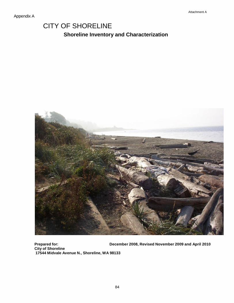
Attachment A
84
Appendix A
CITY OF SHORELINE
Shoreline Inventory and Characterization
Prepared for: December 2008, Revised November 2009 and April 2010 City of Shoreline 17544 Midvale Avenue N., Shoreline, WA 98133
85
Attachment A
City of Shoreline – Shoreline Inventory and Characterization
TABLE OF CONTENTS
1. ............... INTRODUCTION 89
1.1 Background and Purpose 89
1.2 Shoreline Jurisdiction and Study Area Boundary 89
1.3 Shoreline Planning Segments 90
2. CURRENT REGULATORY FRAMEWORK SUMMARY 945
2.1 City of Shoreline Regulations 95
2.1.1 Current Shoreline Management Act Compliance 95
2.1.2 Comprehensive Plan, Zoning and Other City Regulations 96
2.2 State and Federal Regulations 97
3. WATERSHED AND DRAINAGE BASINS 97
4. LAND USE PATTERNS 98
4.1 Historical Land Use 99
4.2 Existing Land Use 99
4.2.1 Residential Land Use 99
4.2.2 Commercial and Industrial Land Uses 100
4.2.3 Private and Public Utility Land Uses 100
4.2.4 Parks, Open Space and Vacant Land Uses 101
4.3 Comprehensive Plan / Zoning Designations 101
4.3.1 Comprehensive Plan 101
4.3.2 Zoning Designations 101
4.4 Impervious Surface 102
4.5 Existing and Planned Public Access Sites ............................................................. 105
4.6 Roads and Transportation Facilities ............................................................................ 106
4.7 Wastewater and Stormwater Utilities .......................................................................... 107
4.8 Historical/Cultural Resources ...................................................................................... 108
4.9 Site Contamination ...................................................................................................... 109
5. NEARSHORE PHYSICAL CHARACTERIZATION ................................................. 109
5.1 Nearshore Processes .................................................................................................... 109
Attachment A
City of Shoreline – Shoreline Inventory and Characterization
86
Source: Johannessen et al. 2005 ............................................................................ . 112
5.2 Geologic Units .................................................................................... . 112
5.3 Soils .................................................................................................... . 112
5.4 Seismic Hazard Areas......................................................................... . 113
5.5 Landslide Hazard Areas...................................................................... . 113
5.6 Erosion and Sedimentation Hazard Areas ........................................... 114
5.7 Aquifer Recharge Areas ...................................................................... 115
5.8 Streams ............................................................................................... . 115
5.9 Flood Hazard Areas ............................................................................ . 117
5.10 Shoreline Modifications ...................................................................... 117
5.10.1 Shoreline Armoring.................................................................... 118
5.10.2 Docks, Piers, and Over-Water Structures................................... 119
6. NEARSHORE BIOLOGICAL CHARACTERIZATION ................ 119
6.1 Wetlands ............................................................................................. . 119
6.2 Critical Fish and Wildlife Areas .......................................................... 119
6.2.1 Marine Riparian Zones............................................................... 120
6.2.2 Banks and Bluffs ....................................................................... . 120
6.2.3 Beaches and Backshore.............................................................. 120
6.2.4 Flats........................................................................................... . 121
6.2.5 Eelgrass Meadows...................................................................... 122
6.2.6 Kelp Forests .............................................................................. . 122
6.2.7 Priority Habitats and Species ..................................................... 123
7. ASSESSMENT OF SHORELINE FUNCTIONS AND OPPORTUNITY AREAS 127
7.1 Shoreline Ecological Functions ........................................................... 127
7.2 Programmatic Restoration Opportunities ............................................ 136
7.3 Site-Specific Restoration Opportunities .............................................. 139
7.3.1 Segment A................................................................................. . 141
7.3.2 Segment B ................................................................................. . 142
7.3.3 Segment C ................................................................................. . 142
7.3.4 Segment D................................................................................. . 142
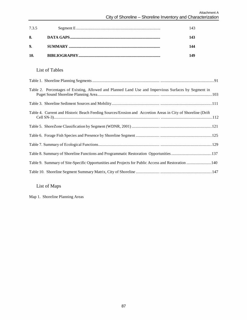
Attachment A
City of Shoreline – Shoreline Inventory and Characterization
87
7.3.5 Segment E .................................................................................. 143
8.
DATA GAPS.................................................................................................
143
9. SUMMARY .................................................................................................. 144
10. BIBLIOGRAPHY........................................................................................ 149
List of Tables
Table 1. Shoreline Planning Segments .................................................................. ....................................................91
Table 2. Percentages of Existing, Allowed and Planned Land Use and Impervious Surfaces by Segment in
Puget Sound Shoreline Planning Area............................................................. ..................................................103
Table 3. Shoreline Sediment Sources and Mobility............................................... ..................................................111
Table 4. Current and Historic Beach Feeding Sources/Erosion and Accretion Areas in City of Shoreline (Drift
Cell SN-3)....................................................................................................... . ..................................................112
Table 5. ShoreZone Classification by Segment (WDNR, 2001) ........................... ..................................................121
Table 6. Forage Fish Species and Presence by Shoreline Segment ....................... ..................................................125
Table 7. Summary of Ecological Functions............................................................ ..................................................129
Table 8. Summary of Shoreline Functions and Programmatic Restoration Opportunities .......................................137
Table 9. Summary of Site-Specific Opportunities and Projects for Public Access and Restoration ........................140
Table 10. Shoreline Segment Summary Matrix, City of Shoreline ....................... ..................................................147
List of Maps
Map 1. Shoreline Planning Areas

Attachment A
Attachment A
City of Shoreline – Shoreline Inventory and Characterization
89
INTRODUCTION
Background and Purpose The City of Shoreline (City), Washington is undertaking a comprehensive update to its Shoreline Master Program (SMP) as required by the implementing guidelines in the
Washington Administrative Code (WAC). To support this effort, the City applied for and
received a grant issued by the Washington State Department of Ecology (Ecology)
(G0800171). This shoreline inventory and characterization study supports the SMP update
process by providing a baseline inventory of existing conditions within the shoreline
jurisdiction of the City.
In 2003, the Washington State Legislature passed Substitute Senate Bill (SSB) 6012,
which established timelines for all cities and counties to amend their local shoreline
master programs (SMPs) consistent with the Shoreline Management Act (SMA), RCW
90.58 and its updated implementing guidelines, Washington Administrative Code (WAC)
173-26. The City of Shoreline is required to prepare an update to its SMP by the end of
2009. The City prepared the first draft of this shoreline inventory and characterization
report in 2004; however, the report was not formally adopted or finalized. The City‟s first
step towards a comprehensive SMP update involves revising the 2004 draft report to
update technical information that has changed or been made available since 2004, and to
be consistent with the current state shoreline guidelines. This report provides:
• Analysis and characterization of ecosystem-wide processes that affect the City‟s
shoreline;
• Analysis and characterization of shoreline functions; and
• Opportunities for protection, restoration, public access and shoreline use.
The inventory and characterization documents current shoreline conditions and provides a
basis for updating the City‟s SMP goals, policies and regulations. This report will help the
City establish a baseline of conditions, evaluate functions and values of resources in its
shoreline jurisdiction, and explore opportunities for conservation and restoration of
ecological functions.
This inventory and characterization report also includes a map folio, located at the end of
the document. All figures referenced in the document are found in the map folio.
Shoreline Jurisdiction and Study Area Boundary
Under the SMA, the shoreline jurisdiction includes all submerged lands waterward of the ordinary high water mark (OHWM) of waters that have been designated as “shorelines of
statewide significance” or “shorelines of the state,” as well as those areas that are 200 feet
landward of the OHWM of these same waters. The shoreline jurisdiction criteria were
established in 1972, and are described in Washington Administrative Code (WAC) 173-
18. Generally, “shorelines of statewide significance” include portions of Puget Sound and
other marine water bodies, rivers west of the Cascade Range that have a mean annual flow
of 1,000 cubic feet per second (cfs) or greater, rivers east of the Cascade Range that have a
mean annual flow of 200 cfs or greater, and freshwater lakes with a surface area of 1,000
Attachment A
City of Shoreline – Shoreline Inventory and Characterization
90
acres or more. “Shorelines of the state” are generally described as all marine shorelines
and shorelines of all other streams or rivers having a mean annual flow of 20 cfs or greater
and lakes with a surface area greater than 20 acres.
The City‟s shoreline jurisdiction includes the Puget Sound shore within both the city
limits and its potential annexation area (PAA). The portion of Puget Sound seaward from
the line of extreme low tide is considered a “shoreline of statewide significance” per
RCW 90.58.030(2)(e). The remainder of the Puget Sound landward of the extreme low
tide mark is considered a “shoreline of the state.” The City therefore includes
approximately four miles of Puget Sound coastline. There are no rivers, streams or lakes
in the City meeting the definition of “shorelines of the state.”
Under the SMA, the shoreline area to be regulated by the City‟s Shoreline Master
Program must include all shorelines of statewide significance, shorelines of the state, and
their adjacent shorelands, which are defined as the upland area within 200 feet of the
OHWM, as well as any associated wetlands (RCW 90.58.030) within its municipal
jurisdiction. Since the SMP is in part a long-range planning document, this
characterization report includes those marine shorelines within the city limits as well as
the PAA. One-half mile of the Puget Sound is located in the City‟s PAA. The City‟s
PAA is known as Point Wells, located directly north of the city in unincorporated
Snohomish County (Maps 1 and 1-A).
The City‟s shoreline jurisdiction extends to the landward edge of associated wetlands.
“Associated wetlands” means those wetlands that are in proximity to and either influence
or are influenced by tidal waters or a lake or stream subject to the SMA (WAC 173-22-
030 [1]). These are typically identified as wetlands that physically extend into the
shoreline jurisdiction, or wetlands that are functionally related to the shoreline
jurisdiction through surface water connection and/or other factors. The specific language
from the RCW describes the limits of shoreline jurisdiction as follows:
―those lands extending landward for two hundred feet in all directions as measured on a
horizontal plane from the ordinary high water mark; floodways and contiguous floodplain
areas landward two hundred feet from such floodways; and all associated wetlands and
river deltas‖ (RCW 90.58.030[2][f]).
Wetlands associated with SMA regulated waters are limited to intertidal wetlands, mapped
throughout the city limits along Puget Sound, and smaller wetlands associated with the
lower reaches and mouths of Barnacle and Coyote (also known as Innis Arden South)
Creeks.
Shoreline Planning Segments
For the purposes of this study, the City‟s shoreline jurisdiction was organized into five distinct segments (A through E) based broadly on the physical distinction along the
shoreline, the level of ecological functions provided by each segment, as well as existing
land uses and zoning designations. Shoreline Planning Segments are described in Table 1
and depicted on Map 1.
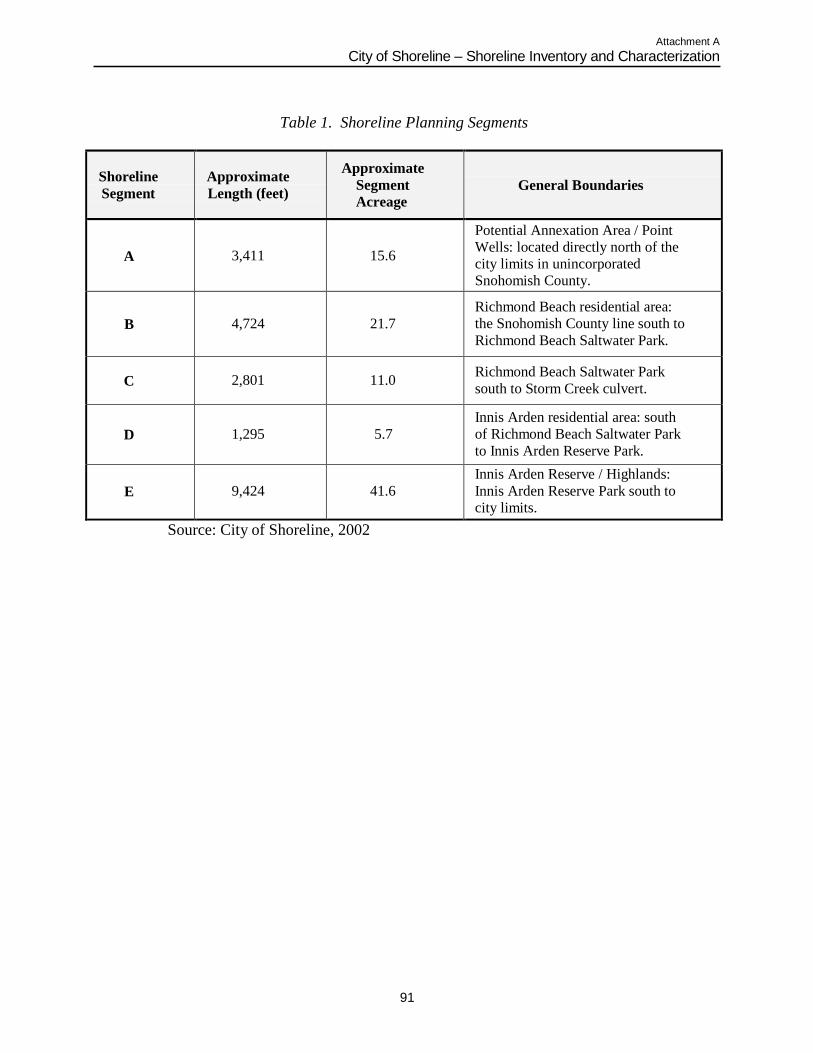
Attachment A
City of Shoreline – Shoreline Inventory and Characterization
91
Table 1. Shoreline Planning Segments
Shoreline
Segment
Approximate
Length (feet)
Approximate
Segment
Acreage
General Boundaries
A
3,411
15.6
Potential Annexation Area / Point
Wells: located directly north of the
city limits in unincorporated
Snohomish County.
B
4,724
21.7
Richmond Beach residential area:
the Snohomish County line south to
Richmond Beach Saltwater Park.
C
2,801
11.0
Richmond Beach Saltwater Park
south to Storm Creek culvert.
D
1,295
5.7
Innis Arden residential area: south
of Richmond Beach Saltwater Park
to Innis Arden Reserve Park.
E
9,424
41.6
Innis Arden Reserve / Highlands:
Innis Arden Reserve Park south to
city limits.
Source: City of Shoreline, 2002
Attachment A
City of Shoreline – Shoreline Inventory and Characterization
92
This Page Intentionally Blank
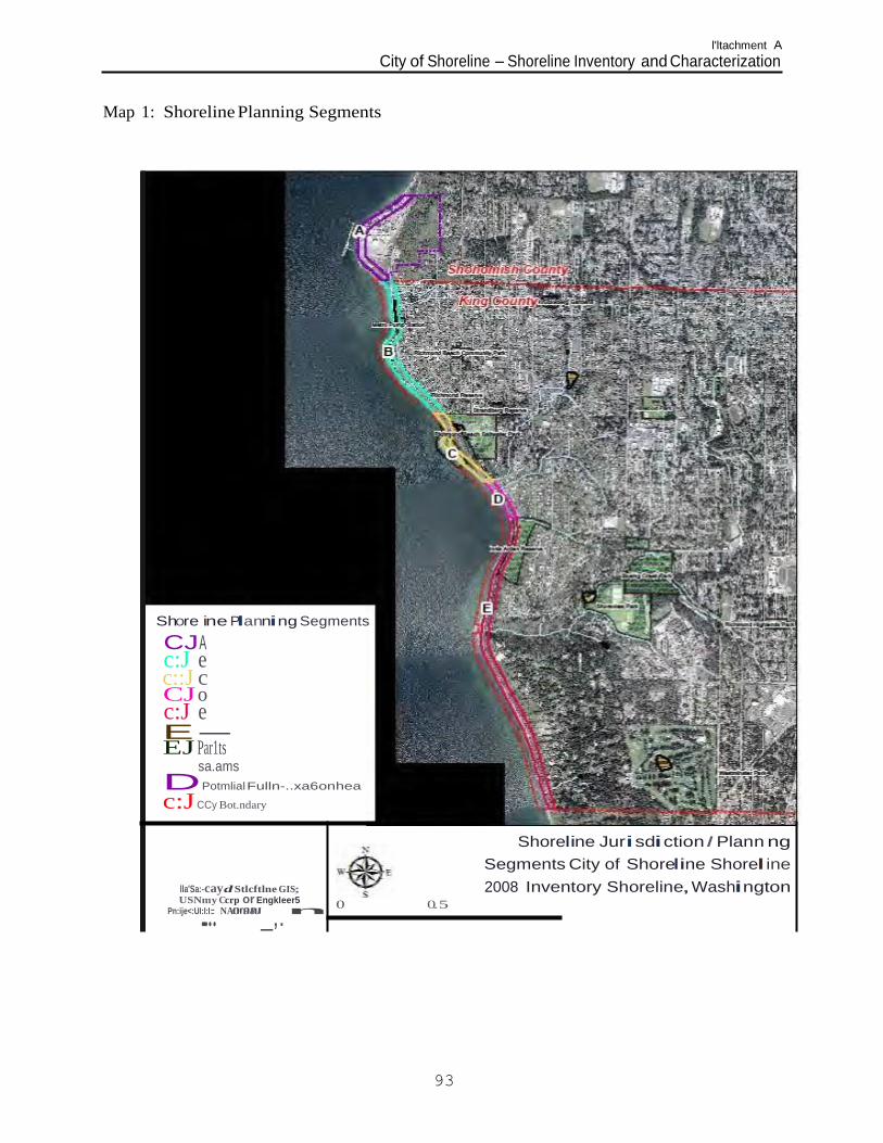
l'ltachment A
City of Shoreline - Shoreline Inventory and Characterization
.....
Map 1: Shoreline Planning Segments
Shore ine Planning Segments
CJA c:J e c::J c CJ o c:J e E- EJ Par1ts
sa.ams
DPotmlial Fulln-..xa6onhea
c:J CCy Bot.ndary
lla'Sa:-cayd Stlcftlne GIS; USNmy Ccrp or Engkleer5
Pn:ije<:UI:I:I: NA"O"'9"8"J_,. n
Shoreline Juri sdi ction I Plann ng
Segments City of Shoreline Shorel ine
2008 Inventory Shoreline, Washington 0 0.5
93
Attachment A
City of Shoreline – Shoreline Inventory and Characterization
94
This Page Intentionally Blank
Attachment A
City of Shoreline – Shoreline Inventory and Characterization
95
CURRENT REGULATORY FRAMEWORK SUMMARY1
City of Shoreline Regulations
Current Shoreline Management Act Compliance
The Shoreline Management Act is implemented through the development of local Shoreline Master Programs (SMPs). Local SMPs establish a system to classify shoreline
areas into specific “environment designations.” The purpose of shoreline environment
designations is to provide a uniform basis for applying policies and use regulations within
distinctly different shoreline areas. In a regulatory context, shoreline environment
designations provide the governing policy and regulations that apply to land within the
SMP jurisdiction. Portions of individual parcels that are outside SMP jurisdiction are
governed by zoning and other applicable land use regulations. Generally, environment
designations should be based on existing and planned development patterns, biological
and physical capabilities and limitations of the shoreline, and a community‟s vision or
objectives for its future development.
When the City of Shoreline incorporated in 1995, it adopted regulations outlined in Title
25 (Shoreline Management Plan) of the King County Code as the interim shoreline
management code (Shoreline Municipal Code [SMC] 16.10). Shoreline properties within
the City‟s PAA are regulated under the Snohomish County SMP, until such properties are
annexed and the City‟s SMP is amended. During development of the City of Shoreline‟s
first comprehensive plan in 1998, the City evaluated the natural and built characteristics of
its shoreline jurisdiction and developed five preliminary shoreline environment
designations:
Urban Railroad (for developed portions of the Burlington Northern Santa Fe [BNSF]
Railway throughout the City‟s shoreline jurisdiction),
• Urban - High Intensity,
Suburban - High Residential,
• Suburban - Low Residential, and
Conservation.
These preliminary shoreline environment designations have not been approved by
Ecology, since they were not part of a comprehensive update to the City‟s SMP.
Therefore, they are not being implemented as part of Shoreline‟s interim shoreline
management code.
1 The discussion of regulatory requirements included herein is not intended to be a complete list of all permits or
approvals necessary for work within the City‟s shoreline jurisdiction or other areas within the city or PAA. Other
portions of local code and state and federal regulations may apply to development projects within the city. The
permits and approvals necessary for construction may vary from parcel to parcel regardless of shoreline
jurisdiction and may vary depending on the type and intensity of the work proposed. Prior to any construction
within city limits, an applicant should contact the City and the applicable state and federal agencies to determine
actual permit requirements. For development of parcels in the PAA outside of the city limits, an applicant should
contact Snohomish County and the applicable state and federal agencies to determine actual permit requirements.
Attachment A
City of Shoreline – Shoreline Inventory and Characterization
96
Comprehensive Plan, Zoning and Other City Regulations
• City of Shoreline Comprehensive Plan – The City‟s existing
Comprehensive Plan was adopted in 2001. The Comprehensive Plan
establishes goals and policies that define the community‟s vision for the
physical, economic, and social development of the City for the next 20
years. The Comprehensive Plan land use designations in the Puget
Sound shoreline planning area include Mixed Use (Point Wells), Low
Density Residential, Public Facilities (e.g., the BNSF Railway right-of-
way), Public Open Space, and Private Open Space (City of Shoreline,
2001). City land use designations are relevant to this shoreline
inventory and characterization report as they establish the general land
use patterns and vision of growth the City has adopted for areas both
inside and outside the shoreline jurisdiction. The City‟s SMP goals and
policies are one element of the Comprehensive Plan (included as an
appendix). During this update process, the City will update its SMP
element goals and policies and integrate them with the GMA
comprehensive plan requirements for administrative and regulatory
reform.
• City of Shoreline Municipal Code, Chapter 20.40: Zoning – Chapter
20.40 of the SMC (Zoning and Use Provisions) establishes zoning
designations. Zoning designations in the Puget Sound shoreline
planning area include: Residential 4 units/acre (R-4) and Residential 6
units/acre (R-6) (City of Shoreline, 2006). Point Wells, located in the
City‟s PAA, is zoned Heavy Industrial (HI) by the Snohomish County
Zoning Code (Snohomish County website, 2008).
• City of Shoreline Municipal Code, Chapter 20.80: Critical Areas –
Chapter 20.80 of the SMC (Critical Areas) establishes development
standards, construction techniques, and permitted uses in critical areas
and their buffers (i.e., geologic hazard areas, fish and wildlife habitat
conservation areas, wetlands, flood hazard areas, aquifer recharge areas,
and stream areas) to protect these areas from adverse impacts.
Designated critical areas are found throughout the City‟s shoreline
planning area, particularly wetlands and streams, flood hazard areas,
and geologic hazard areas (City of Shoreline, 2007a).
• City of Shoreline Surface Water Master Plan – The City‟s Surface
Water Master Plan was adopted in 2005. The plan identifies surface
water problems, prioritizes needs, and provides long-term solutions that
reflect the community‟s priorities and can be funded by the City. The
Plan includes an analysis of vegetation and wildlife habitat and water
resources in relation to the control and treatment of stormwater (City of
Shoreline, 2005b).
Attachment A
City of Shoreline – Shoreline Inventory and Characterization
97
State and Federal Regulations
A number of state and federal agencies may have jurisdiction over land or natural
elements in the City‟s shoreline jurisdiction. Local development proposals most
commonly trigger requirements for state or federal permits when they impact wetlands or
streams; potentially affect fish and wildlife listed under the federal Endangered Species
Act (ESA); result in over one acre of clearing and grading; or affect the floodplain or
floodway. As with local requirements, state and federal regulations may apply
throughout the City, but regulated resources are common within the City‟s shoreline
jurisdiction. The state and federal regulations affecting shoreline-related resources
include, but are not limited to:
• Endangered Species Act: The federal ESA addresses the protection and
recovery of federally listed species. The ESA is jointly administered by
the National Oceanic and Atmospheric Administration (NOAA)
Fisheries (formerly referred to as the National Marine Fisheries
Service), and the United States Fish and Wildlife Service (USFWS).
• Clean Water Act (CWA): The federal CWA requires states to set
standards for the protection of water quality for various parameters, and
it regulates excavation and dredging in waters of the U.S., including
wetlands. Certain activities affecting wetlands in the City‟s shoreline
jurisdiction or work in the adjacent rivers may require a permit from the
U.S. Army Corps of Engineers and/or Washington State Department of
Ecology under Section 404 and Section 401 of the CWA, respectively.
• Hydraulic Project Approval (HPA): The Washington Department of
Fish and Wildlife (WDFW) regulates activities that use, divert,
obstruct, or change the natural flow of the beds or banks of waters of
the state and may affect fish habitat. Projects in the shoreline
jurisdiction requiring construction below the OHWM of Puget Sound or
streams in the city could require an HPA from WDFW. Projects
creating new impervious surface that could substantially increase
stormwater runoff to waters of the state may also require approval.
• National Pollutant Discharge Elimination System (NPDES): Ecology
regulates activities that result in wastewater discharges to surface water
from industrial facilities or municipal wastewater treatment plants.
NPDES permits are also required for stormwater discharges from
industrial facilities, construction sites of one or more acres, and
municipal stormwater systems that serve populations of 100,000 or
more.
•
WATERSHED AND DRAINAGE BASINS
Water flow drives many ecological processes; therefore a useful characterization study
area is the watershed. In Washington State, watersheds at a large scale are organized into
Water Resource Inventory Areas (WRIAs). The City of Shoreline is located within the
Attachment A
City of Shoreline – Shoreline Inventory and Characterization
98
Lake Washington/ Cedar/ Sammamish Watershed (WRIA 8). The City is located the
northwest portion of the watershed and includes two subareas: the Nearshore Subarea,
which includes the 4 miles of shoreline in the City of Shoreline and another twenty miles
north and south of the City, and the Lake Washington Subarea.
Surface water drainage basins in the City include portions of the McAleer Creek, Lyons
Creek, West Lake Washington, Thornton Creek, Seattle Golf Course, Bitter Lake and two
Middle Puget Sound drainage basins, and most of the Boeing Creek drainage basin (see
Map 2 in Appendix C). McAleer, Lyons, West Lake Washington, and Thornton Creeks
drain to Lake Washington. Boeing Creek, Seattle Golf Course, Bitter Lake and the
Middle Puget Sound basins drain to Puget Sound (City of Shoreline, 2005b). The features
of the basins that drain to Puget Sound are discussed in more detail below:
Boeing Creek Basin: Boeing Creek is partially piped from its origin and discharges into
Puget Sound, passing through the City‟s shoreline planning area.
Seattle Golf Course Basin: This 138 acre basin is located in the southwest portion of the
city, with a small portion located in the City of Seattle. The runoff from the Seattle Golf
Course Basin used to be collected in a wetland and infiltrated into the groundwater. The
basin now discharges into Highlands Creek which then discharges into Puget Sound.
Bitter Lake Basin: Only 54 acres of this basin is located in the city, in its southwest
portion. None of the basin‟s major watercourses are located within the city.
Middle Puget Sound Basins: The North and South basins enter Puget Sound through
dozens of small creeks and storm drainage systems. The seven major drainage courses
include: Highlands Creek, Blue Heron Creek (also known as Innis Arden North Creek),
Coyote Creek (also known as Innis Arden South Creek), Storm Creek, Upper Barnacle
Creek (also known as Upper Puget Sound North) and Lower Barnacle Creek (also known
as South), Barnacle Creek, and Lost Creek. All the creeks originate from wetlands, urban
runoff or hillside seeps, except that the headwaters of Upper and Lower Barnacle Creeks
and Lost Creek are located to the north in Snohomish County.
Just two drainage basins drain to the shoreline planning area: Boeing Creek Basin and
Middle Puget Sound Basin (see Map 4 in Appendix C). There are numerous surface
water features conveyed through culverts into Puget Sound in addition to the creeks
mentioned above. Drainages and streams are discussed in more detail in Section 5.8
Streams and include Lost Creek, Upper and Lower Barnacle Creeks, Barnacle Creek,
Storm Creek, Blue Heron Creek, Coyote Creek, Boeing Creek, and Highlands Creek.
LAND USE PATTERNS
Land use in the City of Shoreline is largely influenced by the city‟s central geographical
location and proximity to Puget Sound. The City is generally bounded by the City of
Lake Forest Park to the east, the City of Seattle to the south, the Puget Sound shoreline to
the west, and Snohomish County to the north, which includes the Cities of Edmonds and
Mountlake Terrace, and the Town of Woodway. The City‟s shoreline jurisdiction is
composed of a variety of natural and man-made characteristics that include natural
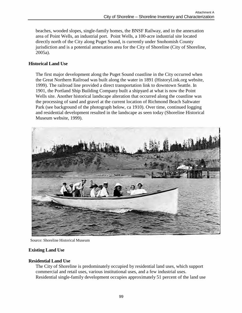
Attachment A
City of Shoreline – Shoreline Inventory and Characterization
99
beaches, wooded slopes, single-family homes, the BNSF Railway, and in the annexation
area of Point Wells, an industrial port. Point Wells, a 100-acre industrial site located
directly north of the City along Puget Sound, is currently under Snohomish County
jurisdiction and is a potential annexation area for the City of Shoreline (City of Shoreline,
2005a).
Historical Land Use
The first major development along the Puget Sound coastline in the City occurred when
the Great Northern Railroad was built along the water in 1891 (HistoryLink.org website,
1999). The railroad line provided a direct transportation link to downtown Seattle. In
1901, the Portland Ship Building Company built a shipyard at what is now the Point
Wells site. Another historical landscape alteration that occurred along the coastline was
the processing of sand and gravel at the current location of Richmond Beach Saltwater
Park (see background of the photograph below, ca 1910). Over time, continued logging
and residential development resulted in the landscape as seen today (Shoreline Historical
Museum website, 1999).
Source: Shoreline Historical Museum
Existing Land Use
Residential Land Use
The City of Shoreline is predominately occupied by residential land uses, which support commercial and retail uses, various institutional uses, and a few industrial uses.
Residential single-family development occupies approximately 51 percent of the land use
Attachment A
City of Shoreline – Shoreline Inventory and Characterization
100
in the community. Multi-family residential development occupies 4 percent and is
primarily located near commercial areas along State Route 99 (also known as Aurora
Avenue North) and in neighborhood centers (i.e., Richmond Beach, Echo Lake, North
City, and Ballinger) (City of Shoreline, 2005a).
Several neighborhoods are located near the Puget Sound shoreline within the City.
Neighborhoods include Richmond Beach (a portion of which is located immediately
adjacent to the Puget Sound), Innis Arden, and the Highlands (City of Shoreline, 2005a).
Residential development in the Puget Sound shoreline planning area is characterized by
single-family properties, which occupy approximately 19 percent of the total shoreline
planning area. Single-family residential uses which are located immediately adjacent to
the Puget Sound abut the City‟s shoreline for a length of 1,886 linear feet. That is
approximately 9 percent of the total linear length of the City‟s Puget Sound shoreline,
including the PAA (King County, 2007). With the exception of residential properties in
Segment B, the extensive bluff system along Puget Sound (Photo E-3 in Appendix B)
precludes extensive development within the City‟s shoreline jurisdiction.
Commercial and Industrial Land Uses
Commercial and industrial developments occupy approximately 4 percent of the land use within the City (City of Shoreline, 2005a). Point Wells is the only industrial property
located along the Puget Sound shoreline and occupies approximately 20 percent of the
total shoreline planning area (Photo A-1 in Appendix B). The Point Wells industrial
facility abuts the City‟s Puget Sound shoreline for a length of 3,411 linear feet. That is
approximately 16 percent of the total linear length of the City‟s Puget Sound shoreline
(Snohomish County, 2007b). The City‟s 1998 Comprehensive Plan, adopted prior to the
current 2005 Comprehensive Plan, indicated that the Point Wells property served as a
petroleum product (gasoline and diesel fuel) marketing and distribution center for
approximately 60 years or more (City of Shoreline, 1998b). The petroleum distribution
center discontinued operation in 1994. An asphalt plant was operated at the site on a
seasonal basis by the Chevron Corporation (Sound Transit, 1999b). The property was
sold to Paramount of Washington in 2005 and is now used for petroleum products
storage, processing and distribution. Soil and groundwater contamination are
documented at the Point Wells facility (Snohomish County, 2007a).
Private and Public Utility Land Uses
Public facilities, institutions and right-of-way uses occupy approximately 29 percent of the City (City of Shoreline, 2005a). The BNSF Railway right-of-way extends in a north-
south direction along the entire length of the city‟s shoreline planning area. It is the most
dominant land use in the shoreline, occupying 48 percent of the total shoreline planning
area. The BNSF Railway right-of-way abuts the City‟s Puget Sound shoreline (including
the PAA) for a length of 15,398 linear feet. That is approximately 70 percent of the total
linear length of the City‟s Puget Sound shoreline, including the PAA (King County,
2007).
There are two public facilities in the City‟s shoreline planning area, both of which are
owned by King County. The first is right-of-way property located at the Point Wells site
in Segment A. A conveyance system and marine outfall will be constructed on the
Attachment A
City of Shoreline – Shoreline Inventory and Characterization
101
property to serve the regional King County Brightwater Treatment Plant currently being
constructed. The second property is located in Segment B which houses a King County
wastewater pump station, known as the Richmond Beach Pump Station. A recreation
easement has been obtained by the City to develop a park on this property, as described
in more detail in Section 7.3.2 Richmond Beach Pump Station Park Project (City of
Shoreline website, 2008).
Parks, Open Space and Vacant Land Uses
Only 1 percent of the City of Shoreline is undeveloped land. Parks, recreation, and open space (including lakes) occupy approximately 10 percent of the City (City of Shoreline,
2005a). Within the Puget Sound shoreline planning area, 8 percent of the land is occupied
by parks and open space including the Richmond Beach Saltwater Park in Segment C and
the Innis Arden Reserve in Segment E (Photos C-2 and E-1 in Appendix B; Map 11 in
Appendix C). Four percent (960 lineal feet) of the properties that abut the City‟s Puget
Sound shoreline (including the PAA) are occupied by park and reserve. Vacant properties
occupy 2 percent of the total shoreline planning area and are located in Segments B and
E. (King County, 2007).
Comprehensive Plan / Zoning Designations
Comprehensive Plan
According to the City of Shoreline Comprehensive Plan Map (2001), the City‟s shoreline planning area is largely comprised of properties designated as Low Density Residential
and Public Facilities (i.e., the BNSF Railway right-of-way). Public Open Space and
Private Open Space designations occupy the remainder of the shoreline planning area. In
addition, the annexation area currently occupied by the Paramount of Washington facility
in unincorporated Snohomish County is discussed in the Comprehensive Plan (2005a)
and is currently designated as Mixed Use (see Map 9a in Appendix C) (City of Shoreline,
2001). Snohomish County designates Point Wells as Urban Industrial (Snohomish
County website, 2008). The property owner has petitioned the County to change the
Comprehensive Plan designation to Urban Center (Snohomish County, 2007a).
General goals and policies established in the 2005 Comprehensive Plan related to the
protection of natural features encourage the protection and improvement of the natural
environment and environmentally critical areas, construction of surface water facilities
that promote water quality and enhance and preserve natural habitat, identification and
protection of wildlife corridors, and preservation of wetlands, aquatic and riparian
habitats and Puget Sound buffers (City of Shoreline, 2005a).
The general goals and policies of the City‟s 1998 Shoreline Master Program are included
in the 2005 Comprehensive Plan as an appendix. Water-oriented uses are encouraged but
must be balanced with the protection of Puget Sound shoreline‟s natural resources (City
of Shoreline, 2005a).
Zoning Designations
Zoning designations in the City of Shoreline generally follow land use designations as discussed above. There are only two zones within the City‟s Puget Sound shoreline
Attachment A
City of Shoreline – Shoreline Inventory and Characterization
102
planning area; Residential 4 units/acre (R-4) and Residential 6 units/acre (R-6). The
zones encompass the BNSF Railway right-of-way, parks, open space, and public facilities
(see Map 8 in Appendix C) (City of Shoreline, 2002). Point Wells is zoned as Heavy
Industrial (HI) in the Snohomish County Permit, Planning, and Zoning Map (Snohomish
County website, 2008). The property owner has petitioned the County to change the
zoning to Planned Community Business (Snohomish County, 2007a).
Table 2 identifies the relative percentage of existing land uses in each planning segment
based on 2007 King County and Snohomish County Assessor land use records. Table 2
also includes the Comprehensive Plan land use and zoning designations for each
segment.
Impervious Surface
Impervious areas in the City were analyzed based on the King County
Impervious/Impacted Surface Interpretation dataset (see Map 14 in Appendix C) (King
County, 2004). The dataset is based on high-resolution multispectral imagery from 2000.
It includes mostly surfaces with high to complete impermeability, such as concrete,
asphalt, roofing materials and other sealed surfaces that prevent the natural penetration of
water into soil. Examples of impervious surfaces identified in this imagery include:
building roof tops regardless of composition or construction; roadways, highways and
parking lots constructed of concrete or asphalt; parking areas with a high density of
parked vehicles as represented by the imagery; sidewalks, pedestrian walkways and malls
constructed of concrete, asphalt or brick; and, other prepared surfaces such as bicycle
paths, tennis courts and running paths.
Impervious surfaces reduce the potential for stormwater infiltration and increase
stormwater runoff, including the rate of runoff and timing of peak flows. In general,
higher percentages of impervious area are an indicator of development density and
intensity which is tied to an increase in stormwater runoff. Impervious surfaces may
contain pollutants that are harmful to water quality. Pollutants originating in the shoreline
planning area likely originate from landscaped areas (e.g., parks and residential yards),
BNSF Railway (e.g., creosote railroad ties and railroad cars), industrial facilities (e.g.,
overwater structures), and, to a lesser extent, vehicles and roadways. The approximate
impervious area has been determined based on a qualitative assessment of the 2004 King
County dataset and 2002 aerial photography, and from coordination with City staff in
2003. Impervious surface at the Point Wells facility in Segment A was estimated visually
based on 2002 aerial photography of the site. Table 2 includes the approximate amount of
impervious area within each shoreline planning segment. Overall, approximately 20
percent of the City‟s shoreline planning area is impervious due to concrete, asphalt,
roofing surfaces or other sealed surfaces. The PAA contains the highest impervious area
due to historic heavy industrial uses. Segment B contains 25 to 30 percent impervious
area due to residential development near the shoreline. Segment E, which comprises
nearly half of the shoreline planning area (43.5%) has fairly low impervious surface
(approximately 5 to 15 percent). Thus, stormwater runoff and infiltration rates are not as
altered in Segment E in comparison to Segments B and D.
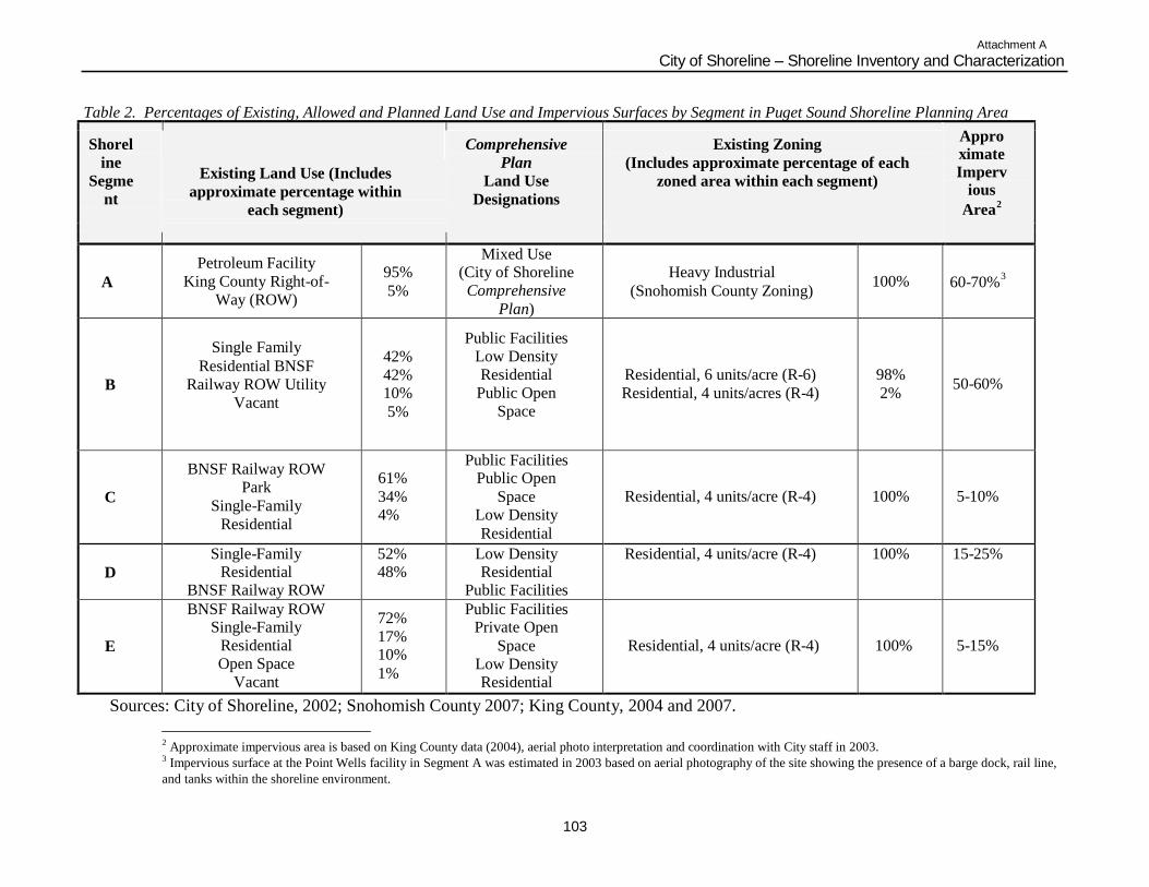
Attachment A
City of Shoreline – Shoreline Inventory and Characterization
103
Table 2. Percentages of Existing, Allowed and Planned Land Use and Impervious Surfaces by Segment in Puget Sound Shoreline Planning Area
Appro
ximate
Imperv ious
Area2
Shorel
ine
Segme
nt
Comprehensive
Plan
Land Use
Designations
Existing Zoning
(Includes approximate percentage of each
zoned area within each segment) Existing Land Use (Includes
approximate percentage within
each segment)
A
Petroleum Facility
King County Right-of-
Way (ROW)
95%
5%
Mixed Use (City of Shoreline
Comprehensive
Plan)
Heavy Industrial
(Snohomish County Zoning)
100%
3
60-70%
B
Single Family
Residential BNSF
Railway ROW Utility
Vacant
42%
42% 10%
5%
Public Facilities
Low Density
Residential
Public Open
Space
Residential, 6 units/acre (R-6)
Residential, 4 units/acres (R-4)
98%
2%
50-60%
C
BNSF Railway ROW
Park
Single-Family
Residential
61%
34% 4%
Public Facilities Public Open
Space Low Density
Residential
Residential, 4 units/acre (R-4)
100%
5-10%
D
Single-Family Residential
BNSF Railway ROW
52% 48%
Low Density Residential
Public Facilities
Residential, 4 units/acre (R-4) 100% 15-25%
E
BNSF Railway ROW Single-Family
Residential
Open Space
Vacant
72%
17% 10%
1%
Public Facilities Private Open
Space
Low Density Residential
Residential, 4 units/acre (R-4)
100%
5-15%
Sources: City of Shoreline, 2002; Snohomish County 2007; King County, 2004 and 2007.
2 Approximate impervious area is based on King County data (2004), aerial photo interpretation and coordination with City staff in 2003. 3 Impervious surface at the Point Wells facility in Segment A was estimated in 2003 based on aerial photography of the site showing the presence of a barge dock, rail line,
and tanks within the shoreline environment.
Attachment A
City of Shoreline – Shoreline Inventory and Characterization
104
This Page Intentionally Blank
Attachment A
City of Shoreline - Shoreline Inventory and Characterization
105
Existing and Planned Public Access Sites
Public access to the Puget Sound shoreline in the City of Shoreline is restricted to existing parks. Rugged terrain characterized by steep bluffs occurs throughout most of
the shoreline planning area, which limit physical access to the water. Further, the BNSF
railroad tracks parallel the entire shoreline within city limits. Public access to the railroad
right-of-way is prohibited. Waterward public access is restricted in some areas by
privately owned tidelands (including BNSF, residential and industrial property owners).
Existing parks and open space areas in the City‟s shoreline planning area include (see
Map 11 in Appendix C) (City of Shoreline, 2005c):
Richmond Beach Saltwater Park (Public) – This regional 40-acre park located in Segment
C provides active and passive uses including picnic areas, shelter buildings, a playground
area, observation areas, trails, and Puget Sound shoreline beach access (Photos C-2 and
C-3 in Appendix B). Park users occasionally use the shoreline access for swimming in
Puget Sound during favorable weather conditions.
Blue Heron Reserve (Private) – This private tract is preserved as a natural area and is
associated with Blue Heron Creek. It is located in the southern portion of Segment C. No
public shoreline access is permitted along the tract.
Coyote Reserve (Private) – This private tract is preserved as a natural area and is
associated with Coyote Creek. It is located in the northern portion of Segment D. No
public shoreline access is permitted along the tract.
Innis Arden Reserve (Public) – This 23-acre natural open space area/greenway passive-
use park is located in the northern area of Segment E along the bluffs overlooking Puget
Sound. Hiking/walking trails represent the main activity of this passive-use reserve.
Although trails eventually lead to the shoreline, the public has to cross the BNSF railroad
tracks and riprap to reach the Puget Sound shoreline beach (Photo E-1 in Appendix B).
Boeing Creek Reserve (Private) – Four acres of natural area associated with Boeing
Creek along the Puget Sound shoreline in the center portion of Segment E is preserved as
private open space. No publicshoreline access is permitted from this reserve along the
bluff (Photo E-2 in Appendix B).
Improvements and enhancements to existing park and open space resources along Puget
Sound identified in the City‟s Parks, Recreation and Open Space Plan (2005c) include:
Richmond Beach Saltwater Park - As outlined in the Plan, a Community Attitude and
Interest Survey was conducted to establish priorities for the future development of parks
and recreation facilities, programs and services within the city. The City surveyed 575
residents in the community. Thirty-one percent of the respondents selected upgrading
Richmond Beach Saltwater Park as one of the four most important actions the City
should take4. Largely in response to the survey, the City is currently in the process of
adding viewpoints and interpretive signage, and improving trails (see Section 7.3.3
Richmond Beach Saltwater Park Project for more details). Additional improvements and
enhancements identified by the Plan that would be implemented at a later date include
developing an underwater marine park, a pier, and a trail along Puget Sound to connect
the park to Innis Arden Reserve.
4 The other three actions were to upgrade existing neighborhood parks and play grounds (38%), upgrade natural areas and nature
trails (30%), and improve shoreline and beach access (29%).
Attachment A
City of Shoreline - Shoreline Inventory and Characterization
106
Innis Arden Reserve - Improving trail system, developing overlook viewpoints and
interpretive signage, stabilizing slopes, enhancing vegetation and developing safe access
to Puget Sound across the BNSF Railway right-of-way.
As part of King County mitigation for impacts from the Brightwater Treatment Plant
project, a new park will be installed at the King County Richmond Beach Pump Station.
Improvements to the site will include construction of a small parking area, restroom,
interpretive watchtower overlooking the BNSF railroad and Puget Sound, and play areas.
No shoreline access west of the BNSF railroad is proposed (see Section 7.3.2 Richmond
Beach Pump Station Park Project for more details) (City of Shoreline website, 2008).
The City of Shoreline‟s Comprehensive Plan provides a list of funded and unfunded
parks, recreation, open space and city facility capital improvements. Opportunities for
enhancing public access to the shoreline under consideration include development of a
trail system along Puget Sound between Richmond Beach Saltwater Park and Innis Arden
Reserve, amenity enhancements and development of overlooks, viewpoints, and
interpretive signage, and habitat and native plant restoration at Innis Arden Reserve,
construction of a pedestrian crossing from Richmond Beach Pump Station park site to the
beach, and providing beach access at the Boeing Creek Reserve (City of Shoreline, 2004;
City of Shoreline, 2005a).
Roads and Transportation Facilities
The BNSF railroad runs the length of the Puget Sound shoreline in the city abutting the shoreline for a length of 15,398 linear feet. That is approximately 70 percent of the total
linear length of the City‟s Puget Sound shoreline, including the PAA (King County,
2007). The developed and undeveloped portions of the BNSF Railway right-of-way
occupy approximately 48 percent of the City‟s shoreline planning area (King County,
2007), varying in width from 100 feet to greater than 300 feet. The rail line provides
freight movement and intercity passenger rail. The rail line serves as the region‟s
primary rail freight connection to the north, as well as a major connection to the east, and
is an important link in the multimodal system supporting the Ports of Everett, Seattle, and
Tacoma. An average of 36 freight trains, six Amtrak passenger trains and six Sound
Transit Sounder passenger trains use the railway each day (Herrera Environmental
Consultants, 2005). Unattached engines also traverse between cities along the rail line.
The Sounder is operated by Sound Transit, the Central Puget Sound Regional Transit
Authority. It is a commuter rail service located along a 35-mile corridor between Everett
and Seattle that uses the existing BNSF Railway right-of-way. Amtrak trains use the
existing right-of-way between Vancouver, BC and Portland, Oregon. (Sound Transit,
1999a; Sound Transit website, 2008; Amtrak website, 2008).
BNSF Railway is proposing to install a train traffic signal, utility bungalow, and retaining
wall south of Richmond Beach Saltwater Park in Segment C. This would involve filling a
minimal amount (less than ½ an acre) of freshwater wetland. BNSF Railway is also
proposing to install train traffic signals, a utility bungalow, a train-switching mechanism,
retaining wall, and a new access road north of Boeing Creek in Segment E. The
improvements will involve filling 0.25 acres of freshwater wetland. BNSF Railway will
Attachment A
City of Shoreline - Shoreline Inventory and Characterization
107
also be installing improvements in other locations along the BNSF rail line between
Everett and Seattle outside of Shoreline city limits. Sound Transit will pay for the
improvements in order to meet conditions established in a joint agreement between BNSF
and Sound Transit. These conditions are required of Sound Transit in order to run a third
daily Sounder commuter train between Everett and Seattle. Mitigation for the wetland fill
and impacts from these improvements will occur off-site at the Qwuloolt restoration site
in Marysville and Meadowdale Marina in Edmonds. Construction is expected to begin in
2009 (Herrera, 2005).
Due to the topography of the Puget Sound shoreline and the private ownership of the
BNSF Railway along the extent of the shoreline, the only major roadway that falls within
the City‟s shoreline planning area is Richmond Beach Drive NW (see Map 10 in
Appendix C). Richmond Beach Drive NW is the primary roadway that allows access to
thirty-two residences along the shoreline in the northwestern portion of the city. The
residences span a total of 1,886 linear feet along the shoreline (King County, 2007). The
homes are accessed from Richmond Beach Drive NW via the Richmond Beach
Overcrossing Bridge which passes over the BNSF railroad tracks. The Bridge connects to
27th Avenue NW, a local road located behind the residences that runs parallel to the
Puget Sound shoreline. 27th Avenue NW is also the only motor vehicle access west of
the BNSF Railway right-of-way in the city via the Bridge (see Map 1B in Appendix C).
The timber bridge was originally built in 1923 and rebuilt in 1956. The City is planning
to replace it with a reinforced concrete bridge. Once the City finalizes negotiations with
BNSF Railway on a temporary construction easement, project cost sharing and
construction issues, construction will begin (City of Shoreline website, 2008).
Wastewater and Stormwater Utilities
The Ronald Wastewater District (RWD), formerly known as the Shoreline Wastewater Management District (SWMD), provides wastewater service to a majority of the City of
Shoreline and includes the Point Wells property. Highlands Sewer District serves the
Highlands Neighborhood in the southwest portion of the City. Wastewater collected
from RWD is treated at two facilities under contract arrangements: King County
Wastewater Treatment Division‟s (WTD) West Point Treatment Plant in Discovery Park,
Seattle, and the City of Edmonds Wastewater Treatment Plant. Wastewater from the
Highlands Sewer District is conveyed to RWD facilities (City of Shoreline, 2005b). Two
RWD customers currently operate septic systems in the Richmond Beach Neighborhood;
however, none of the properties fall within the City‟s shoreline planning area (Newman,
personal communication, 2003).
Four RWD lift stations are located within the Puget Sound shoreline planning area. The
King County Richmond Beach Pump Station is located in Segment B (King County,
2007). King County maintains a 30-inch diameter emergency overflow outfall pipe
associated with the pump station. The outfall pipe is located in Segment B. King County
also maintains an emergency overflow outfall pipe in Segment E. The pipe is associated
with the Hidden Lake Pump Station located outside of shoreline planning area near
Boeing Creek Shoreline Park (see Map 10 in Appendix C).
Attachment A
City of Shoreline - Shoreline Inventory and Characterization
108
Upon the City‟s incorporation in 1995, the City of Shoreline inherited and assumed
jurisdiction over the storm and surface water management system located in the roadways
within the city limits. As of 1998, facilities located outside the roadways are under the
City of Shoreline jurisdiction as well. Stormwater utilities generally consist of a mix of
open ditches and channels, pipes, vaults and open retention/detention facilities.
Historical/Cultural Resources
Historic and cultural resources are documented through a variety of sources. Official
registers include the National Register of Historic Places and the Washington State
Heritage Register. In 1995, the City of Shoreline adopted Chapter 15.20 of the municipal
code (Landmark Preservation) to provide for the designation, preservation, protection,
enhancement, and perpetuation of designated historic resources within the boundaries of
the City. The Landmark Preservation chapter adopts by reference several sections of the
King County Code Chapter 20.62 (Protection and Preservation of Landmarks, Landmark
Sites and Districts). None of the properties designated as landmarks in the City of
Shoreline are located within the shoreline planning area (see Map 13 in Appendix C).
The Historical/Cultural Element of the 1998 Shoreline Master Program provides general
goals and policies to ensure important archaeological, historical, and cultural sites located
within the shoreline jurisdiction are identified, protected, preserved, and restored for
educational and scientific purposes. It also aims to adopt standards that ensure the
protection and preservation of historic and cultural sites (City of Shoreline, 1998b).
Historic preservation is also addressed in the Community Design Element of the 2005
Shoreline Comprehensive Plan.
In 1996, the King County Historic Preservation Program conducted an inventory of
historic resources in the City of Shoreline. It did not include an inventory of
archaeological sites, traditional cultural properties, or historic landscapes. However, an
analysis of documented research revealed Native American peoples traveled along the
Puget Sound shoreline and stream drainages to collect resources such as tobacco at
Richmond Beach. No buildings directly associated with railroad development in
Richmond Beach, lumber production, agricultural production, or the interurban railroad
remain today (Copass, 1996).
In 2001, Larson Anthropological Archaeological Services (LAAS) conducted a study of
six potential wastewater treatment plant sites in Snohomish County as part of King
County‟s Brightwater Treatment Plant project. The inventory included the Point Wells
site. No archaeological sites or historic structures are recorded within 0.25 miles from
the Point Wells industrial site. However, LAAS determined Point Wells has a high
probability for hunter-fisher-gatherer archaeological resources based on the existence of a
former sandspit and lagoon buried in fill in the western half of Point Wells beneath the
steep bluffs along the shoreline. Further archaeological investigation is recommended to
determine if archaeological deposits associated with the former sandspit and lagoon exist
beneath fill (LAAS, 2001).
Attachment A
City of Shoreline - Shoreline Inventory and Characterization
109
Sound Transit performed an inventory of historic, cultural, and archaeological resources
along the commuter route between Seattle and Everett in a Final Environmental Impact
Statement (EIS) for the Commuter Rail Project (1999). The inventory was based on
existing documents, coordination, including contact with Native American tribal
organizations, and the National Register of Historic Places. At the time the EIS was
written, Sound Transit was considering developing a station near the City of Shoreline.
Two station alternatives were considered in the EIS, Point Wells and Richmond Beach
Saltwater Park. Sound Transit determined that no known historic, cultural, or
archaeological resources areas were listed in, or eligible for, the National Register. While
construction work at these two areas could affect undiscovered prehistoric or historic
archaeological deposits, native soils have been previously disturbed; suggesting
questionable integrity of any archaeological remains (Sound Transit, 1999a).
Site Contamination
According to Department of Ecology‟s Facility Site database, there is one known contaminated site in the shoreline planning area (Ecology website, 2008). The Point Wells
site is listed on the Department of Ecology‟s Suspected and Confirmed Contaminated
Sites List for soil, groundwater and surface water contamination associated with previous
petroleum production. In 1999, documentation prepared for the King County Brightwater
Treatment Plant examined potential soil and groundwater contamination at several sites
under consideration at that time for a treatment facility, including Point Wells. When the
Brightwater document was prepared, the long-term soil and groundwater remediation
plans by Chevron, the property owner at that time, were unknown (CH2MHill and
Associated Firms, 2001). However, as part of the Brightwater Treatment Plant
conveyance project, a portion of Point Wells is undergoing a voluntary cleanup program
with Ecology for suspected and confirmed soil and groundwater contamination.
NEARSHORE PHYSICAL CHARACTERIZATION
Nearshore Processes
The Puget Sound nearshore is defined as the area of marine and estuarine shoreline extending from the top of shoreline bluffs to the depth offshore where light penetrates the
water thereby supporting plant growth (King County Department of Natural Resources
and Parks [KCDNRP], 2001). The nearshore also includes estuaries and tidal rivers to
the head of tidal influence. Landforms found in the Puget Sound nearshore environment
include bluffs, beaches, mudflats, kelp and eelgrass beds, salt marshes, spits, and
estuaries.
The processes occurring within the Puget Sound nearshore area are critical for
maintaining habitats and health of the nearshore shoreline environment. Changes in the
physical processes within the nearshore can negatively affect habitats by limiting food
and nutrient sources for marine life, deteriorating beach sediment movement, accelerating
erosion, and altering the flows of surface and groundwater. Nearshore processes are those
actions which occur as a result of wind, tidal influence, waves, and surface and
groundwater flow that result in sediment movement and affect habitat formation.
Attachment A
City of Shoreline - Shoreline Inventory and Characterization
110
The City of Shoreline beaches are typical of Puget Sound and can be characterized by
two distinct foreshore components: a high-tide beach and a low-tide terrace (Downing,
1983). The high-tide beach consists of a relatively steep beachface with coarse sediment
and an abrupt break in slope at its waterward extent. Low wave energy beaches, such as
those along the City‟s shoreline, have a high-tide beach composed of poorly sorted
sediment, with intermittent intertidal vegetation and a relatively narrow backshore.
Extending seaward from the break in slope, the low-tide terrace typically consists of a
gently sloping accumulation of poorly sorted fine-grained sediment (Komar, 1976;
Keuler, 1979). Considerable amounts of sand in a mixed sand and gravel beach are
typically winnowed from the high-tide beach by waves and deposited on the low-tide
terrace (Chu, 1985). The amount and composition of beach sediment generally follows a
seasonal cycle. Under normal seasonal weather patterns, the stronger, wind-driven waves
that occur in winter remove material from the beachface, while more gentle, summer
wind-driven waves move sediment back onshore (Masselink and Hughes, 2003).
Puget Sound beach morphology and composition is dependent upon three main
influences; wave energy, sediment sources, and relative position of the beach within a
littoral cell. Wave energy is controlled by fetch; the open water over which winds blow
without any interference from land. Wind-generated wave action gradually erodes
beaches and the toe of coastal bluffs, leading to landslides. These coastal bluffs are the
primary source of sediment for most Puget Sound beaches. In the City, coastal bluffs are
separated from the shoreline by the BNSF railroad, thus completely removing bluff
sediment sources. Fluvial sources of sediment are typically of only local significance in
comparison to bluff sediment sources, which reportedly account for roughly 90% of
beach material (Keuler 1988, Downing, 1983). Bluff composition and wave energy
influence the composition of beach sediment. Waves sort coarse and fine sediment and
large waves can transport cobbles that small waves cannot.
Wind-generated waves typically approach the shore at an angle, creating beach drift and
longshore currents and transporting sediment by a process called littoral drift. Net shore-
drift refers to the long-term, net result of littoral drift. Net shore-drift cells represent a
sediment transport sector from source to deposition along a portion of coast. Each drift
cell acts as a system consisting of three components: a sediment source (erosive feature)
and origin of a drift cell; a transport zone where materials are moved alongshore by wave
action with minimal sediment input; and an area of deposition (accretion area) that acts as
the drift cell terminus (Jacobson and Schwartz, 1981). Deposition of sediment occurs
where wave energy is no longer sufficient to transport the sediment in the drift cell. Drift
cells in the Puget Sound region range in length from 46 feet to just under 19 miles, with
the average drift cell just under 1.5 miles long (Schwartz, 1991).The Washington Coastal
Atlas (Ecology website, 2008) maps net-shore drift direction, or the prominent drift
direction, including divergence zones and areas of “no appreciable drift” (which include
highly modified, protected harbor shorelines). Based on the wave regime, extensive
fetch, and coastal geomorphology the net drift direction of all the shoreline planning
segments is south to north (Schwartz, 1991). Divergence zones are present at the north
end of Point Wells and south of the City boundary in the City of Seattle, but the City‟s
shoreline is within a single drift cell.
Attachment A
City of Shoreline - Shoreline Inventory and Characterization
111
The Washington Department of Natural Resources (WDNR) ShoreZone Inventory (2001)
documents shoreline sediment stability as stable, erosional, or accretional, and sediment
sources as fluvial, alongshore, and backshore (see Table 3). The City‟s shoreline is
homogeneous in terms of the sediment stability and source because of the BNSF railroad.
The railroad results in a stable sediment characterization throughout the shoreline, with
the exception of the shoreline adjacent to Innis Arden Reserve. Construction of the
railroad buried much of upper foreshore beach, thereby locking up coarse sand and gravel
in the littoral system. This limits or precludes longshore transport of sediment. Sediment
sources in the City are limited and are characterized by the ShoreZone data as alongshore
with the exception of some fluvial sediment released from Boeing Creek. As discussed
previously, the railroad interrupts historic sediment supply from eroding bluffs.
The width of intertidal beach in the City‟s shoreline is also relatively constant throughout
the shoreline length, averaging 20 to 40 feet wide. The exception is within Segment B
where some wider intertidal beaches are present near residential development along the
shoreline. Additional details of ShoreZone data are contained in Appendix A. Table A-1
includes more detailed information within each of the planning segments. Map 2 in
Appendix A depicts the individual ShoreZone segments.
Table 3. Shoreline Sediment Sources and Mobility
Shoreline
Segment
Approximate
Intertidal
Width
Estimated
Sediment
Source
Sediment
Stability
Net shore
Drift
Direction
A
20 - 37 feet Alongshore (all
of segment)
Stable
North
B
30 - 105 feet Alongshore (all
of segment)
Stable
North
C
27 - 36 feet Alongshore (all
of segment)
Stable
North
D
36 feet Alongshore (all
of segment)
Stable
North
E
21 - 46 feet
Alongshore
(most of
segment);
Fluvial in
relation to
Boeing Creek
Stable (most of
segment);
Erosional from
north end of
segment (646.7
feet to south)
North
Source: WDNR, 2001; Schwartz, 1991.
Johannessen et al. (2005) inventoried current and historic shoreline erosion and accretion
areas in the City of Shoreline. Drift cell “SN-3” generally corresponds with the shoreline
within the City, beginning 1.5 miles south of Boeing Creek and extending north to Point
Wells. Historically, this drift cell was comprised of 45% feeder bluff, 18% feeder bluff
exceptional, and an additional 4% as potential feeder bluff. The remaining 67% of the
shoreline was comprised of four scattered accretion areas. These accretion areas were
characterized by delta lagoons, longshore lagoons and stream mouths. Along the Point
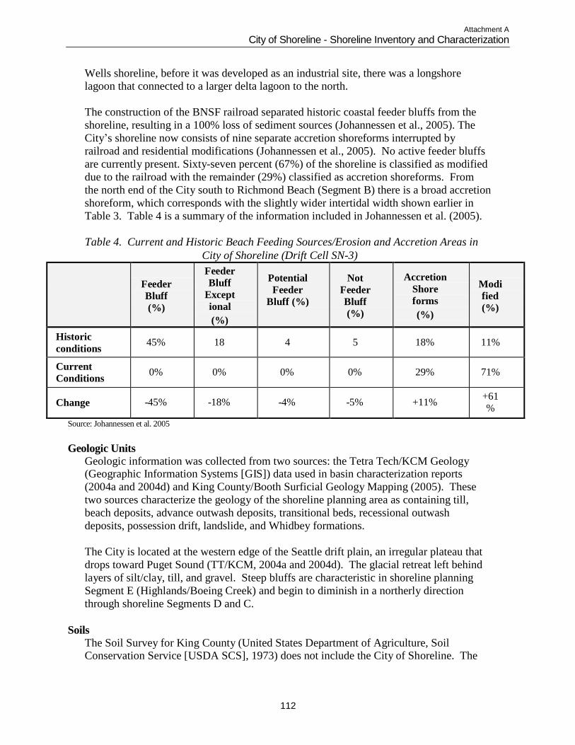
Attachment A
City of Shoreline - Shoreline Inventory and Characterization
112
Wells shoreline, before it was developed as an industrial site, there was a longshore
lagoon that connected to a larger delta lagoon to the north.
The construction of the BNSF railroad separated historic coastal feeder bluffs from the
shoreline, resulting in a 100% loss of sediment sources (Johannessen et al., 2005). The
City‟s shoreline now consists of nine separate accretion shoreforms interrupted by
railroad and residential modifications (Johannessen et al., 2005). No active feeder bluffs
are currently present. Sixty-seven percent (67%) of the shoreline is classified as modified
due to the railroad with the remainder (29%) classified as accretion shoreforms. From
the north end of the City south to Richmond Beach (Segment B) there is a broad accretion
shoreform, which corresponds with the slightly wider intertidal width shown earlier in
Table 3. Table 4 is a summary of the information included in Johannessen et al. (2005).
Table 4. Current and Historic Beach Feeding Sources/Erosion and Accretion Areas in
City of Shoreline (Drift Cell SN-3)
Feeder
Bluff
(%)
Feeder
Bluff
Except
ional
(%)
Potential
Feeder
Bluff (%)
Not
Feeder
Bluff
(%)
Accretion
Shore
forms
(%)
Modi
fied
(%)
Historic
conditions
45%
18
4
5
18%
11%
Current
Conditions
0%
0%
0%
0%
29%
71%
Change
-45%
-18%
-4%
-5%
+11% +61
%
Source: Johannessen et al. 2005
Geologic Units
Geologic information was collected from two sources: the Tetra Tech/KCM Geology (Geographic Information Systems [GIS]) data used in basin characterization reports
(2004a and 2004d) and King County/Booth Surficial Geology Mapping (2005). These
two sources characterize the geology of the shoreline planning area as containing till,
beach deposits, advance outwash deposits, transitional beds, recessional outwash
deposits, possession drift, landslide, and Whidbey formations.
The City is located at the western edge of the Seattle drift plain, an irregular plateau that
drops toward Puget Sound (TT/KCM, 2004a and 2004d). The glacial retreat left behind
layers of silt/clay, till, and gravel. Steep bluffs are characteristic in shoreline planning
Segment E (Highlands/Boeing Creek) and begin to diminish in a northerly direction
through shoreline Segments D and C.
Soils
The Soil Survey for King County (United States Department of Agriculture, Soil Conservation Service [USDA SCS], 1973) does not include the City of Shoreline. The
Attachment A
City of Shoreline - Shoreline Inventory and Characterization
113
Soil Survey for Snohomish County (USDA Natural Resources Conservation Service
[NRCS], 1983) maps Point Wells (Segment A) as “Urban Land.” Soil information from
a 1952 survey by the US SCS was reviewed for soil type by basin (TT/KCM, 2004a and
2004d). The survey indicates that the predominant soil type in the Middle Puget Sound
South Basin is Everett gravelly sandy loam (75 percent) with the remainder being
Alderwood gravelly sandy loam. The majority of the Boeing Creek Basin is Alderwood
gravelly sandy loam. The predominant soil type in the Middle Puget Sound North Basin
is split between the two major soil types already mentioned. The rest of the soils
represent less than four percent of the total area in the City, including Carbondale muck,
coastal beach and Norma fine sandy loam.
The Geotechnical Assessment Report prepared for the Sound Transit Everett to Seattle
Commuter Rail Project (HWA GeoSciences, Inc., 1998) describes the typical soils and
slope profile found along the waterfront from Everett to Seattle. In general, the area is
dominated by Pleistocene aged glacial soils associated with the Vashon Drift and
consisting of recessional outwash deposits, glacial till, advance outwash and glacial
lacustrine. Recent soil deposits include beach and colluvial deposits, some of which are
associated with landslides. Where major landscape modifications have occurred, such as
Point Wells, fill soils are typically present (HWA GeoSciences, Inc., 1998).
The waterfront bluffs found along the City‟s shoreline (Segments B through E) are
typically composed of a cap of very dense gravelly sand with scattered cobbles and
boulders in a clay/silt matrix (glacial till), overlaying dense sand and gravel (glacial
advance outwash), which overlies hard clay (glacial lacustrine). The thicknesses of these
layers can vary substantially. However, the till cap is generally at the top of the bluffs,
sometimes overlain by deposits of medium dense sand and gravel (glacial recessional
outwash). The hard clays are typically at or near sea level. Streams draining the uplands
dissect bluffs and flow into Puget Sound, depositing fine sand and silt in alluvial fans.
Littoral drift, which is the accumulation or movement of foreshore sediments along the
shore by littoral currents and oblique waves, reworks some of this material and becomes
beach deposits (HWA GeoSciences, Inc., 1998).
Seismic Hazard Areas
Seismic hazard areas are defined in Chapter 20.80.220 of the SMC as “lands that, due to a combination of soil and ground water conditions, are subject to severe risk of ground
shaking, subsidence or liquefaction of soils during earthquakes. These areas are typically
underlain by soft or loose saturated soils (such as alluvium) and have a shallow ground
water table.”
There are mapped liquefaction susceptibility areas along Segments A, B, C, D and a
portion of E. All are mapped as having high liquefaction susceptibility (City of Shoreline,
2002).
Landslide Hazard Areas
The west-facing slopes along Puget Sound within the City have experienced recent and historical landslide activity. The contact zone between the hard clay layer and the
Attachment A
City of Shoreline - Shoreline Inventory and Characterization
114
overlying sand layer is the source of many landslides along the coast of Puget Sound,
which commonly occur after major storm events. In general, slope stability in the City‟s
shoreline planning area is more stable in the northern portion, though containing some
isolated unstable areas, and unstable in the southern portion (Segment E).
Baum et al. (2000) conducted an inventory of recent landslides that included the City of
Shoreline. Significant storm events during 1996 and 1997 resulted in several major
landslide episodes. The most common types of landslides were shallow earth slides and
debris flows, some of which blocked culverts and overtopped the BNSF railroad track
(locations are shown on Map 7). These landslides range in volume from 300 cubic yards
to 40,000 cubic yards. The largest one occurred in Segment E north of Highlands Creek
(Baum et al. 2000).
The seawall and stone revetments of the BNSF railroad protect the base of the bluff from
wave erosion and have probably increased the stability of the bluff. Baum et al. (2000)
suggests that the bluff retreat during the winters of 1995-96 and 1996-97 might have been
greater had the seawall and embankment not been present.
In the City, regulated landslide hazard areas are classified in SMC Chapter 20.80.220.
Hazard areas are based on percent slope, soil composition, and the presence of emergent
water. Three categories are used and defined as:
Moderate Hazard: Areas with slopes between 15 percent and 40 percent and that are
underlain by soils that consist largely of sand, gravel or glacial till.
High Hazard: Areas with slopes between 15 percent and 40 percent that are underlain by
soils consisting largely of silt and clay.
Very High Hazard: Areas with slopes steeper than 15 percent with zones of emergent
water (e.g., springs or ground water seepage), areas of landslide deposits regardless of
slope, and all steep slope hazard areas sloping 40 percent or steeper.”
No landslide hazard areas are identified in Segment A (Point Wells). The extreme north
and south portions of Segments B and C contain landslide hazard areas in the extreme
north and south portions of both segments. Landslide hazard areas exist throughout all of
Segments D and E (King County iMAP, 1991). See Map 7 in Appendix C for landslide
hazard area locations.
Erosion and Sedimentation Hazard Areas
Erosion hazard areas are defined in Chapter 20.80.220 of the SMC as “lands or areas underlain by soils identified by the U.S. Department of Agriculture Natural Resources
Conservation Service (formerly the Soil Conservation Service) as having „severe‟ or
„very severe‟ erosion hazards. This includes, but is not limited to, the following group of
soils when they occur on slopes of 15 percent or greater: Alderwood-Kitsap (AkF),
Alderwood gravelly sandy loam (AgD), Kitsap silt loam (KpD), Everett (EvD) and
Indianola (InD).”
No erosion hazards currently exist within the City‟s shoreline planning area; however,
erosion hazard areas are identified east of Segment E primarily in the upper Boeing Creek
Basin (see Map 7 in Appendix C) (City of Shoreline, 2002).
Attachment A
City of Shoreline - Shoreline Inventory and Characterization
115
Aquifer Recharge Areas
Within the City of Shoreline, including the Puget Sound shoreline planning area, there are no known critical aquifer recharge areas that supply potable water. Almost all the
City‟s potable water comes from surface sources originating in the Cascade Mountains
and is either operated by the Shoreline Water District or the City of Seattle. The City‟s
lakes and wetlands may contribute to aquifer recharge (City of Shoreline, 2005a).
Streams
Streams provide valuable wildlife corridors, a source of fluvial sediments to the marine shoreline (moved along the shoreline by currents), and support a range of fish species.
The City of Shoreline is located in Water Resource Inventory Area (WRIA) 8, the Cedar-
Sammamish Watershed. Information on stream conditions was drawn in particular from
the following documents: City of Shoreline Surface Water Master Plan (City of
Shoreline, 2005b), Salmonid Habitat Limiting Factors, Water Resource Inventory Area 8
Final Report (Kerwin, 2001), Boeing Creek Basin Draft Characterization Report and
Middle Puget Sound Basin Characterization Report (TT/KCM, 2004a, 2004d), and the
City of Shoreline Stream Inventory and Assessment (TT/KCM, 2004b). Streams are
depicted on Map 4 and Map 10 in Appendix C. A total of seven streams have been
identified to flow into the Puget Sound within the PAA and the City limits. In general,
the western portion of the City ultimately drains to Puget Sound through the following
streams: 1) Lost Creek, 2) Barnacle Creek, 3) Storm Creek, 4) Blue Heron Creek, 5)
Coyote Creek, 6) Boeing Creek, and 7) Highlands Creek.
Segment A has an unnamed tributary of Barnacle Creek that is located east of the BNSF
railroad and south of Point Wells. It travels south where it connects to Barnacle Creek in
Segment B. Lost Creek is located north of the city limits in the Town of Woodway. It
flows southwest both in piped and open water sections towards Puget Sound. It appears
to connect to Barnacle Creek before discharging into Puget Sound in Segment B.
Barnacle Creek is formed by the confluence of Upper Barnacle Creek and Lower
Barnacle Creek and discharges to Puget Sound in Segment B. The stream includes piped
and open water sections along the BNSF railroad and flows through a wetland area
downstream of Richmond Beach Drive NW (see Photo B-2 in Appendix B). The creek
has three outlets to Puget Sound (including one near Lost Creek) via culverts beneath the
BNSF railroad. The lower section of Barnacle Creek is tidally influenced upstream for a
distance of about 20 feet (Photo B-6 in Appendix B). A stream evaluation letter was
submitted to the City as part of a development permit for a residential property located
near the intersection of Richmond Beach Drive NW and NW 196th
Street. According to
the letter, the portion of Barnacle Creek from NW 196th
Street south to where it
discharges to the Puget Sound may not meet the City‟s definition of a stream per SMC
20.80 (Critical Areas) (The Watershed Company, 2008). However, the findings of the
letter were not verified by WDFW. Furthermore, WDFW has indicated to the City that
they will defer to the City‟s stream inventory (see City of Shoreline Stream Inventory and
Assessment) even when presented with a more recent report which concludes that a
stream does not qualify as a stream per the City‟s regulations (Nammi, 2009).
Attachment A
City of Shoreline - Shoreline Inventory and Characterization
116
Storm Creek, which begins upstream of NW 195th
Street and includes several unnamed
tributaries, is located at the very south end of Segment C. South of NW 191st
Street,
Storm Creek continues southwest for 3,000 feet through the privately owned Eagle
Reserve in Innis Arden before entering Puget Sound. The stream is confined within a
very steep ravine between the mouth and 17th
Place NW. Severe erosion occurs in the
lower sections of Storm Creek through the Eagle Reserve (Photo D-3 in Appendix B).
Bank hardening and several weirs have been constructed to protect private property, a
pump station, and a sewer line crossing Storm Creek (City of Shoreline, 2005b).
Blue Heron Creek and Coyote Creek discharge to Puget Sound (Photo D-1 in Appendix
B) and are located within Segment D and E respectively. Blue Heron Creek begins as
two tributaries that join near NW 185th
Street. Much of the stream flows through the
private Blue Heron Reserve. Coyote Creek begins as three or more branches that extend
into ravines with relatively steep side slopes. These branches come together on private
property near NW 175th Street. Below the confluence of these branches, the creek flows
another 1,700 feet before entering Puget Sound. The lower portion of the creek flows
through a private tract called the Coyote Reserve and through Innis Arden Reserve. In
comparison, Blue Heron Creek drains a larger area than Coyote Creek and experiences
larger flows.
Boeing Creek and Highlands Creek discharge to Puget Sound and are located within
Segment E. There are also several short unnamed tributaries that occur within the Innis
Arden Reserve and flow to Puget Sound (see Map 4). Boeing Creek begins as two large
tributaries that are mostly contained within pipes and occur in developed commercial
areas. From the confluence of the two tributaries, the main stem descends through
forested ravines to Hidden Lake, a small, constructed lake that the City regulates as a
storm detention facility. Downstream from Hidden Lake, the stream has steep gradients
and incised channels with moderate-to severe erosion of the channel beds and banks. A
steel-pile dam is present approximately 2,300 feet from the mouth, which acts as a barrier
to upstream fish. Many sections below the dam have experienced slope failure, and the
substrate is generally embedded having been filled in with sediment, providing poor
spawning habitat for salmonids (King County 1994). Boeing Creek enters Puget Sound
through a large box culvert under the BNSF railroad. The lower portion of the stream is
tidally influenced at high tides.
Highlands Creek is located within the Highlands development near the southern City
boundary. The stream flows west through private property and is mostly contained
within a piped system. The approximate length of the watercourse is 1,200 feet, of which
850 feet is piped.
None of the streams are currently listed on the state Department of Ecology‟s 2004
303(d) list, which lists streams that do not meet water quality standards for one or more
parameters (Ecology website, 2008). However, many small streams, such as those found
within the City‟s shoreline planning area, may potentially be at risk for exceeding several
water quality parameters.
Attachment A
City of Shoreline - Shoreline Inventory and Characterization
117
As stated above, many of the streams discharge directly into Puget Sound through
culverts. Culverts that are undersized and/or have a steep slope may increase water
velocity, which may cause downstream scouring of nearshore areas during periods of
significant water runoff (Parker, 2000).
Flood Hazard Areas
Flood hazard areas are defined in the Shoreline Comprehensive Plan as “those areas within the floodplain subject to a one percent or greater chance of flooding in any given
year” (City of Shoreline, 2005a). These areas are typically identified on the Federal
Emergency Management Agency (FEMA) flood insurance rate maps (FIRM) as the 100-
year floodplain. The 100-year floodplain is regulated by two chapters of the SMC:
Chapter 16.12, Flood Damage Prevention, and Chapter 20.80.380-410 of the CAO.
Portions of the shoreline in Segment B, C, D, and E are mapped as a 100-year floodplain
on the King County FIRM series, Panels 20, 40, 310, and 330 (FEMA, 1995). Flood
hazards for Segment A (Point Wells) are mapped on Snohomish County FIRM series and
include panels 1294 and 1292 (FEMA, 1999). The stream corridor of Boeing Creek
(Segment E) is also mapped as a 100-year floodplain (FEMA, 1995), but the stream is not
large enough itself to be a shoreline of the state and only the mouth of the stream is
located within the marine shoreline. The King County Sensitive Area Map Folio (King
County iMAP, 1991) shows only the Boeing Creek stream corridor within Segment E as
being a potential flood hazard area (see Map 4 in Appendix C). Typically, the areas south
of stream mouths and the marine shoreline below the OHWM are indicated as flood
hazard areas. Following the recommendations made in the Snohomish County FIRM
series, Base Flood Elevation for shoreline in all Segments (A, B, C, D, and E) will be 10
feet National Geodetic Vertical Datum (NGVD).
Several existing houses are within the shoreline of Puget Sound along 27th
Avenue NE in
Segment B (see Map 4 in Appendix C). Most of the homes are protected by bulkheads,
with the exception of those on the south end, which, based on a conversation in March
2006 between Juniper Nammi (City of Shoreline Planner) and Chuck Steele (Ecology
Floodplain Specialist), were reported to have had flooding in the past (Chuck Steele,
personal communication, 2008). The existing lots within the flood hazard areas along 27th
Avenue NE are fully developed, therefore flood regulations in the SMC would be applied
primarily to remodel and rebuilding on these sites.
Industrial facilities and a large dock associated with Point Wells exist within the
shoreline of Puget Sound in Segment A. Portions of these facilities are within the mapped
flood hazard area (see Map 4 in Appendix C). Flood regulations in the SMC would be
applied to replacement or rebuilding of industrial facilities and to shoreline restoration
projects. If the property were to be rezoned in the future, flood regulations in the SMC
would be applied to platting, subdivision, and new construction on the site.
Shoreline Modifications
Three white papers prepared in recent years summarize the current knowledge and technology pertaining to marine and estuarine shoreline modifications in the Puget
Attachment A
City of Shoreline - Shoreline Inventory and Characterization
118
Sound. These papers are: Overwater Structures: Marine Issues (Nightingale and
Simenstad, 2001); Marine and Estuarine Shoreline Modification Issues (Williams and
Thom, in King County Department of Natural Resources and Parks [KCDNRP], 2001);
and Beaches and Bluffs of Puget Sound (Johannessen and MacLennan, 2007). These
documents, along with Reconnaissance Assessment of the State of the Nearshore Report:
Including Vashon and Maury Islands (WRIAs 8 and 9) (KCDNR, 2001) and the
Washington Department of Natural Resources ShoreZone Inventory (2001) were
summarized and incorporated into this section. A field visit in September 2003 verified
modifications along portions of the shoreline providing public access. Table A-2,
Appendix A contains additional information regarding shoreline modifications within the
planning segments.
Shoreline modifications refer to structural alterations of the shoreline‟s natural bank,
including levees, dikes, floodwalls, riprap, bulkheads, docks, piers or other in-water
structures. Such modifications are typically used to stabilize the shoreline and prevent
erosion. Shoreline armoring (i.e. riprap, bulkheads, and other shore parallel structures) is
the most common type of shoreline modification. Shoreline armoring impedes sediment
supply to nearshore habitats, and this sediment starvation can lead to changes in
nearshore substrates from sand or mud to coarse sand, gravel, and finally hardpan. This
may, in turn, decrease eelgrass and increase kelp abundance, as well as forage fish
spawning habitats. Armoring also alters natural process dynamics by blocking or
delaying the erosion of upland areas and bluffs that replenish the spawning substrate.
Beach narrowing and lowering and decreased driftwood abundance also result from
shoreline armoring (Johannessen and MacLennan, 2007).
Construction of shoreline armoring may cover or destroy eelgrass meadows, and
overwater structures may deprive eelgrass of light. Dredging can excavate eelgrass or
cause excessive turbidity and permanent filling of eelgrass meadows (KCDNR, 2001).
Bulkheads and piers may also affect fish life by diverting juvenile salmonids away from
shallow shorelines into deeper water, thereby increasing their potential for predation
(Nightingale and Simenstad, 2001). Piers also alter wave energy and current patterns and
obstruct littoral drift and longshore sediment transport (Williams and Thom, 2001).
Sewer outfalls introduce nutrients and pollutants to the nearshore area altering current
cycles and food web interactions.
Shoreline Armoring
Approximately 97 percent of the City‟s shoreline adjacent to Puget Sound is modified with riprap and bulkheads (WDNR, 2001). The majority of this armoring is associated
with the BNSF railroad bed (Map 12 in Appendix C). The WDNR ShoreZone Inventory
(2001) indicates that approximately 23 percent of Segment A (approximately 796 feet;
the southern portion of Point Wells) is unmodified beach. The remaining portion of Point
Wells (approximately 2,694 feet) is highly modified with riprap and sheet pile, as well as
a large barge dock. Segment B is entirely modified with riprap. A portion of Segment B
(approximately 1,845 feet) is modified with concrete and wooden bulkheads along a
residential area adjacent to Puget Sound (Photo B-2 in Appendix B). Approximately 73
Attachment A
City of Shoreline - Shoreline Inventory and Characterization
119
percent of Segment C is unmodified, at Richmond Beach Saltwater Park where beach
extends waterward of the railroad right-of-way. The north and south ends of Segment C
are modified with riprap. All of Segments D and E (along the entire length of the City‟s
shoreline south of Richmond Beach Saltwater Park) are modified with riprap (WDNR,
2001).
Docks, Piers, and Over-Water Structures
There are no docks, piers, or over-water structures along Puget Sound within the City limits (Segments B through E) (Map 12 in Appendix C). However, within the PAA,
Point Wells (Segment A) contains a large industrial dock originally used for loading oil
when the site was operated as a bulk fuel terminal (Photo A-1 in Appendix B). The dock
is currently used for both import and export of materials to and from the facility.
NEARSHORE BIOLOGICAL CHARACTERIZATION
Wetlands
Wetlands near the Puget Sound shoreline typically include tidal marshes and tidally influenced estuaries. Tidal marshes may contain both salt and freshwater habitats that
experience tidal inundation (KCDNR, 2001). Several wetlands have been mapped by
various sources in the City‟s shoreline planning area. According to the 1987 National
Wetlands Inventory (NWI), the entire area of the City‟s shoreline planning area in the
City limits and UGA boundary is designated as an “estuarine intertidal aquatic
bed/unconsolidated shore” (E2AB/USN) wetland (US Department of the Interior [USDI],
1987a and 1987b). The King County Sensitive Areas Map Folio (King County, 1990)
also identifies intertidal wetlands encompassing all segments within the City‟s shoreline
planning area. Although mapped as wetland at a landscape level, many of these areas in
the City are unvegetated beach or mudflat and therefore would not meet the state
definition of wetland as per City code requirements.
The Stream and Wetland Inventory and Assessment conducted by Tetra Tech/KCM in
2004 for the City documented one non-tidal wetland within Segment B within the City‟s
shoreline planning area (Map 4 in Appendix C). This palustrine forested wetland is less
than one acre in size and is associated with Barnacle Creek. Priority Habitats and Species
(PHS) data indicate that a small (less than one acre) scrub/shrub wetland is located at the
northernmost extent of Segment E and is associated with Coyote Creek within the
shoreline planning area (WDFW, 2008).
Critical Fish and Wildlife Areas
Critical fish and wildlife habitat areas are those areas identified as being of critical importance in the maintenance and preservation of fish, wildlife and natural vegetation.
Critical fish and wildlife habitat areas are defined in SMC Chapter 20.80.260 as follows:
Fish and wildlife habitat conservation areas include nesting and breeding grounds for
State and Federal threatened, endangered or priority species as identified by the
Washington State Department of Fish and Wildlife, including corridors which connect
priority habitat, and those areas which provide habitat for species of local significance
which have been or may be identified in the City of Shoreline Comprehensive Plan.
Attachment A
City of Shoreline - Shoreline Inventory and Characterization
120
Critical fish and wildlife habitats in the City‟s shoreline planning area are characterized
in the following sections.
Marine Riparian Zones
Marine riparian vegetation is defined as vegetation overhanging the intertidal zone (KCDNR, 2001). Marine riparian zones function by protecting water quality; providing
wildlife habitat; regulating microclimate; providing shade, nutrient and prey; stabilizing
banks; and providing large woody debris (Anchor Environmental and People for Puget
Sound, 2002).
The existing railroad bed, land clearing, and shoreline armoring have impacted the marine
riparian zones of all the City‟s shoreline segments. Marine riparian zones are not located
within any of the shoreline planning segments (WDNR, 2001) (Table A-3 in Appendix
A). The only marine riparian vegetation that occurs west of the BNSF railroad is located
at Richmond Beach Saltwater Park (see Photo C-2 in Appendix B).
Banks and Bluffs
Banks and bluffs are part of the marine riparian zone and can be a source of sediment to adjacent beaches, providing habitat to bluff-dwelling animals, rooting area for riparian
vegetation, and a source of groundwater seepage to marine waters (KCDNR, 2001).
Shoreline development and armoring, vegetation clearing, and changes in hydrology,
among others, can adversely impact the natural functions of bluffs.
The ShoreZone Inventory (WDNR, 2001) maps moderate height, inclined cliffs
composed of fines/mud and sand in Segments B and C (Tables A-4 in Appendix A).
These are described as erosional features, providing sediments to the beach.
Beaches and Backshore
Beaches are composed of generally loose, unconsolidated sediment that extends landward from the low water line (Johannessen and MacLennan, 2007). Backshore areas are
immediately landward of beaches and are zones inundated by storm-driven tides. Beaches
and backshores provide habitat for numerous organisms, including cutthroat trout,
piscivorous birds (grebes, herons, and mergansers), and shorebirds (Dethier, 1990). A
typical profile of an undisturbed shoreline in Central Puget Sound would include an
upper backshore or storm berm area that collects logs, algae, and other debris during
storms (Photo B-3 in Appendix B). The intertidal portion of the beach is typically
relatively steep and composed of a mixture of cobbles and gravel in a sand matrix
(KCDNR, 2001).
Sediment abundance throughout the shoreline segments is characterized predominantly as
“moderate” (some mobile sediment, but not likely to rapidly move) (Table A-1 in
Appendix A). Erosional areas are described in Segment E. Beach sediments in shoreline
planning area are characterized in Table A-1 and A-4 in Appendix A.
The WDNR ShoreZone Inventory utilized the British Columbia ShoreZone Mapping
System, which classifies the shoreline into homogeneous stretches (or units) based on key
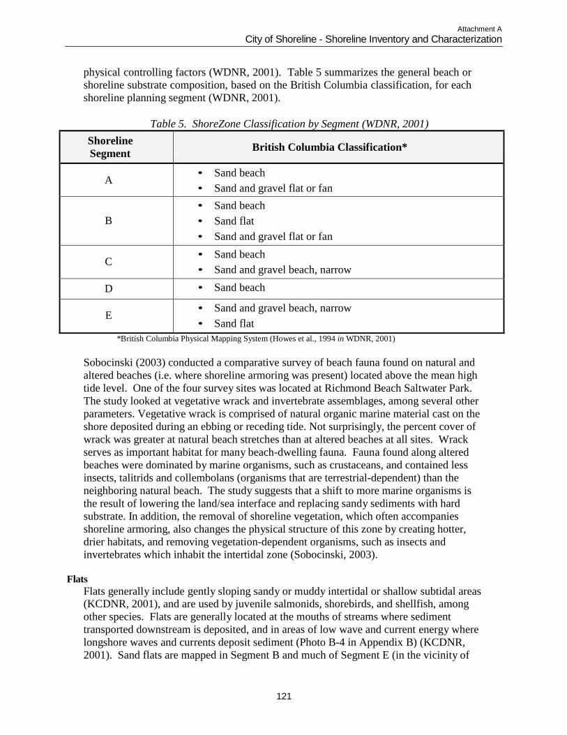
Attachment A
City of Shoreline - Shoreline Inventory and Characterization
121
physical controlling factors (WDNR, 2001). Table 5 summarizes the general beach or
shoreline substrate composition, based on the British Columbia classification, for each
shoreline planning segment (WDNR, 2001).
Table 5. ShoreZone Classification by Segment (WDNR, 2001)
Shoreline
Segment
British Columbia Classification*
A • Sand beach
• Sand and gravel flat or fan
B
• Sand beach
• Sand flat
• Sand and gravel flat or fan
C • Sand beach
• Sand and gravel beach, narrow
D • Sand beach
E • Sand and gravel beach, narrow
• Sand flat
*British Columbia Physical Mapping System (Howes et al., 1994 in WDNR, 2001)
Sobocinski (2003) conducted a comparative survey of beach fauna found on natural and
altered beaches (i.e. where shoreline armoring was present) located above the mean high
tide level. One of the four survey sites was located at Richmond Beach Saltwater Park.
The study looked at vegetative wrack and invertebrate assemblages, among several other
parameters. Vegetative wrack is comprised of natural organic marine material cast on the
shore deposited during an ebbing or receding tide. Not surprisingly, the percent cover of
wrack was greater at natural beach stretches than at altered beaches at all sites. Wrack
serves as important habitat for many beach-dwelling fauna. Fauna found along altered
beaches were dominated by marine organisms, such as crustaceans, and contained less
insects, talitrids and collembolans (organisms that are terrestrial-dependent) than the
neighboring natural beach. The study suggests that a shift to more marine organisms is
the result of lowering the land/sea interface and replacing sandy sediments with hard
substrate. In addition, the removal of shoreline vegetation, which often accompanies
shoreline armoring, also changes the physical structure of this zone by creating hotter,
drier habitats, and removing vegetation-dependent organisms, such as insects and
invertebrates which inhabit the intertidal zone (Sobocinski, 2003).
Flats
Flats generally include gently sloping sandy or muddy intertidal or shallow subtidal areas (KCDNR, 2001), and are used by juvenile salmonids, shorebirds, and shellfish, among
other species. Flats are generally located at the mouths of streams where sediment
transported downstream is deposited, and in areas of low wave and current energy where
longshore waves and currents deposit sediment (Photo B-4 in Appendix B) (KCDNR,
2001). Sand flats are mapped in Segment B and much of Segment E (in the vicinity of
Attachment A
City of Shoreline - Shoreline Inventory and Characterization
122
the Barnacle and Boeing Creek outlets). Sand and gravel flats are mapped in Segments A
and B. No mud flats are present in the City‟s shoreline.
Shoreline activities that may impact tidal flats (KCDNR, 2001) include:
Unnatural erosion or deposition of sediment;
Harvesting of shellfish and other marine life;
Fecal and chemical contamination;
Physical disturbances from shoreline armoring, marina construction, and upland
development practices;
Shading from overwater structures; and
Loss of emergent and riparian vegetation.
Eelgrass Meadows
Eelgrass is a perennial, marine aquatic vascular plant that is rooted in the substrate and can spread horizontally to produce new plants. Eelgrass requires fine-grained substrates
and is particularly associated with low to moderate high-energy intertidal and shallow
subtidal mud/sand substrates. The plants need sufficient light during summer to support
growth and for nutrient storage over winter. Typically, eelgrass beds form between about
two meters above mean lower low water (MLLW) to almost nine meters below MLLW
depending on water quality. However, other factors such as extreme low or high nutrient
levels, substrate composition, presence of other species, and toxic pollutants can affect
eelgrass abundance and distribution.
The importance of eelgrass has been described in various sources, including the
Reconnaissance Assessment of the State of the Nearshore Environment (KCDNR, 2001)
and more recently in Kelp and Eelgrass in Puget Sound (Mumford, 2007). Eelgrass
plants are important primary producers, fixing carbon that enters nearshore food webs
and generating nutrients and substrate that form the base of the food chain. Eelgrass
meadows provide refuge and foraging habitat for many salmonid species, other fish,
invertebrates, birds and aquatic organisms.
Eelgrass beds have been documented in Puget Sound in the City‟s shoreline planning
area including Point Wells (Woodruff et al., 2001 and WDNR, 2001). The occurrence of
eelgrass is most dense in Segments D and E, north and south of the mouth of Boeing
Creek (Table A-5, Appendix A).
Shoreline activities that may impact eelgrass (KCDNR, 2001) include:
Clam harvesting and other direct alteration by humans;
Propeller scour and wash;
Physical disturbances from shoreline armoring;
Shading from overwater structures; and
Physical disturbances from dredging and filling.
Kelp Forests There are 23 species of kelp in Puget Sound, with only two species of floating kelp and 21 that are considered prostrate, or not-floating. The prostrate species are limited to
shallower portions of the nearshore zone and comprise the majority of marine vegetation
biomass in some areas (Mumford, 2007). Kelps are held to the substrate by holdfasts,
Attachment A
City of Shoreline - Shoreline Inventory and Characterization
123
which unlike roots do not penetrate the bottom or carry nutrients. Unlike eelgrass, kelps
are not rooted and must obtain nutrients directly from the water and require a hard
substrate. They favor areas with high ambient light and low temperatures, which result in
nutrient-rich waters, and moderate wave energy to circulate the nutrients.
Kelp provides habitat for many fish species, including rockfish and salmonids, potential
spawning substrate for herring, and buffers shorelines from waves and currents, among
other functions (KCDNR, 2001). A change in kelp distribution may indicate the
coarsening of shallow subtidal sediments (such as that caused by erosion related to a
seawall) or an increase in nutrient loading (such as from sewage effluent).
Kelp is found in all shoreline planning segments with the exception of Segment D. Kelp
beds are sporadic throughout and limited in their lateral extent (Table A-5 in Appendix
A) (Woodruff et al., 2001; KCDNR, 2001).
Shoreline activities that may impact kelp densities (KCDNR, 2001) include:
Physical disturbances from shoreline armoring, marina construction, and harvesting;
Shading from overwater structures;
Beach nourishment; and
Nutrient loading.
Priority Habitats and Species The Washington Department of Fish and Wildlife (WDFW) maintain priority habitat and species information for Washington State, including the status of species as threatened or
endangered. The City of Shoreline occurs within the WDFW Region 4. Priority habitats
within Region 4 include consolidated marine/estuarine shorelines, cliffs, caves, snags,
riparian areas, old-growth/mature forests, and urban open spaces. These habitats may
contain up to 13 species of invertebrates, 62 species of vertebrates, and 20 species of
mammals (City of Shoreline, 1998a). The following sections discuss some of the priority
species and species of local importance that occur within the City‟s shoreline planning
area.
Shellfish Geoduck clams are documented in subtidal areas adjacent to shoreline Segments A, B, C, and E and Dungeness crabs are also documented in subtidal areas adjacent to Segment E
(WDFW, 2008). The King County 1996/1997 Beach Assessment (KCDNR Website,
2003) performed at Point Wells Beach in Segment A and Richmond Beach Park in
Segment C documented shellfish use of these beach areas. Assessments of the Point
Wells shoreline (Segment A) resulted in the identification of 31 species of invertebrates,
including littleneck, butter, horse, and sand clams; purple shore crabs, pygmy rock crabs,
red rock crabs, and graceful crabs; California green shrimp, and hairy hermit crabs
(KCDNR, 2003). Littleneck and butter clams dominated the clam populations by number
and biomass. Assessments of the Richmond Beach Park shoreline (Segment C) resulted
in the identification of 37 species of invertebrates including cockle, softshell, horse, and
bay mussels; black-clawed crab, graceful decorator crab, and red rock crab. Horse clams
were the dominant species of clams at Richmond Beach Park.
Attachment A
City of Shoreline - Shoreline Inventory and Characterization
124
The Washington State Department of Health has closed Richmond Beach in Segment C
to recreational shellfish harvesting (Washington State Department of Health Website,
2008) due to the presence of biotoxins. None of the City‟s shoreline is currently used for
commercial shellfish harvesting.
Salmonids The Salmonid Habitat Limiting Factors: Water Resources Inventory Area (WRIA) 8 Final Report (Kerwin, 2001) identifies the known presence of salmon in local streams.
Boeing Creek (Segment E) has documented salmonid use including Chinook (listed as
threatened under the ESA), coho (Federal species of concern), chum salmon, searun
cutthroat trout, and resident cutthroat trout. It is likely that many of the fish are products
of the “Fish in the Classroom” program (Daley, 2004). Coho are listed by the WRIA 8 as
occurring in Boeing Creek. Highlands Creek contains no salmonids. All other streams are
likely to contain resident cutthroat trout in some portions of the stream (TT/KCM 2004b,
and Daley, 2003).
The City of Shoreline Stream Inventory (TT/KCM, 2004b) notes that the flume under the
BNSF railroad in the lowest reach of Boeing Creek likely prevents fish passage
seasonally during low flows. The primary detriment to habitat quality in this reach is the
significant amount of sediment from landslides in the ravine. The sediment fills in pools
within the stream, clogging gravels with sand and/or silt thus reducing spawning
suitability.
Nearshore habitat is an important environment for juvenile salmonids, where the shallow
water depth obstructs the presence of larger, predator species (Kerwin, 2001). Juvenile
salmon rely on the nearshore and estuarine marine habitats for food, migration corridors,
protection from predators, and a transitional environment that supports the physiological
changes that occur as they transition from a freshwater to a marine environment (Fresh,
2006). Spawn and migration timing, and the use of different marine habitats vary widely
between salmonid species as well as stocks or subpopulations of the same species.
All shoreline segments within the City‟s shoreline planning area are known or expected
to contain juvenile salmonids including bull trout (federally listed), Chinook, chum, coho,
cutthroat, pink, sockeye, based on the knowledge of species life histories (KCDNR,
2001).
Forage Fish Forage fish are key components of the marine food web and have important commercial and recreational value. They are generally characterized as small, schooling fish that prey
upon zooplankton and are in turn preyed upon by larger predatory fish, birds and marine
mammals (Penttila, 2007). The five forage fish species most likely to occur in the City‟s
shoreline planning area include surf smelt, sand lance, Pacific herring, longfin smelt, and
eulachon (Kerwin, 2001 and King County DNR, 2001). Different species utilize different
parts of the intertidal and subtidal zones, with sand lance and surf smelt spawning
primarily in the substrate of the upper intertidal zone, and Pacific herring spawning
primarily on intertidal or subtidal vegetation (Lemberg et al., 1997; Penttila,
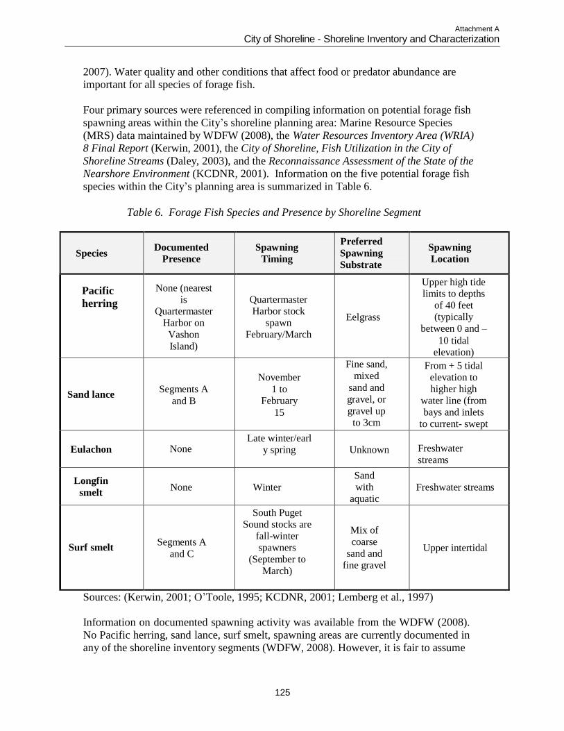
Attachment A
City of Shoreline - Shoreline Inventory and Characterization
125
2007). Water quality and other conditions that affect food or predator abundance are
important for all species of forage fish.
Four primary sources were referenced in compiling information on potential forage fish
spawning areas within the City‟s shoreline planning area: Marine Resource Species
(MRS) data maintained by WDFW (2008), the Water Resources Inventory Area (WRIA)
8 Final Report (Kerwin, 2001), the City of Shoreline, Fish Utilization in the City of
Shoreline Streams (Daley, 2003), and the Reconnaissance Assessment of the State of the
Nearshore Environment (KCDNR, 2001). Information on the five potential forage fish
species within the City‟s planning area is summarized in Table 6.
Table 6. Forage Fish Species and Presence by Shoreline Segment
Species
Documented
Presence
Spawning
Timing
Preferred
Spawning
Substrate
Spawning
Location
Pacific
herring
None (nearest
is
Quartermaster
Harbor on
Vashon
Island)
Quartermaster
Harbor stock
spawn
February/March
Eelgrass
Upper high tide limits to depths
of 40 feet
(typically
between 0 and –
10 tidal
elevation)
Sand lance
Segments A
and B
November
1 to February
15
Fine sand,
mixed
sand and
gravel, or
gravel up
to 3cm
From + 5 tidal
elevation to
higher high
water line (from
bays and inlets
to current- swept beaches)
Eulachon
None
Late winter/earl
y spring
Unknown
Freshwater
streams
Longfin
smelt
None
Winter
Sand
with
aquatic
vegetatio
n
Freshwater streams
Surf smelt
Segments A
and C
South Puget
Sound stocks are
fall-winter
spawners
(September to
March)
Mix of
coarse
sand and
fine gravel
Upper intertidal
Sources: (Kerwin, 2001; O‟Toole, 1995; KCDNR, 2001; Lemberg et al., 1997)
Information on documented spawning activity was available from the WDFW (2008).
No Pacific herring, sand lance, surf smelt, spawning areas are currently documented in
any of the shoreline inventory segments (WDFW, 2008). However, it is fair to assume
Attachment A
City of Shoreline - Shoreline Inventory and Characterization
126
that they all utilize the nearshore areas for feeding and migration. Both King County
DNR (2001) and Kerwin (2001) document surf smelt spawning areas in Segment C,
along Richmond Beach Park (Photo C-2 in Appendix B). A sand lance spawning area is
mapped along the shoreline within the City of Shoreline, in the southern portion of
Segment A (Photo A-1 in Appendix B) (Kerwin, 2001) and just north of Barnacle Creek
in Segment B (KCDNR, 2001). Both sources cite the documented presence of surf smelt
in planning Segment A (Point Wells). In addition, the mouth of Boeing Creek (Segment
E) has been identified as an important area for the feeding, migration, and spawning and
rearing of all the forage fish mentioned above (Daley, 2004).
Nearshore modifications impact potential forage fish habitat in the following ways:
Development impacts the shoreline, particularly marinas and boat ramps, which introduce
the potential for repeated disturbance and potentially alter nearshore hydrology;
Sewer outfalls introduce pollutants and nutrients to the nearshore;
Overwater structures shade intertidal vegetation and may alter nearshore hydrology; and
Riprap revetments and vertical bulkheads alter nearshore hydrology and may increase
wave energy on intertidal areas.
The sand lance‟s habit of spawning in the upper intertidal zone of protected sand-gravel
beaches throughout the increasingly populated Puget Sound basin makes it vulnerable to
the cumulative effects of various types of shoreline development. The WAC Hydraulic
Code Rules for the control and permitting of in-water construction activities in
Washington State include consideration of sand lance spawning habitat protection.
Shorebirds and Upland Birds
A variety of waterfowl and shorebirds utilize the nearshore environment for wintering and breeding. Waterfowl and seaduck species include Canada goose, mallard, wigeon,
shoveler, scaup, goldeneye, long-tailed duck, northern pintail, bufflehead, and
mergansers. Diving birds such as loons, grebes, scoter, guilemot and cormorants use
intertidal habitats for foraging. Approximately seventy-five species of birds are
associated with marine nearshore environments in Washington (O‟Neil et al., 2001).
Adjacent to the open waters of Puget Sound, the upland terrestrial environment provides
habitat for birds, amphibians, reptiles, and insects. The WDFW PHS maps indicate the
presence of purple martin nest structures on pilings at the mouth of Boeing Creek from
2000 to 2004. It is unknown whether martin are currently using the structures. Bald
eagles use the shoreline and large trees for perching. No nests are currently documented
within the City. Marbled murrelet (federal and state listed as threatened species) has also
been documented in the shoreline vicinity, but no seabird colonies or waterfowl
concentrations are documented within the City. Adolfson Associates (1999) also
documented the use of interior uplands by two priority species including the pileated
woodpecker and the band-tailed pigeon.
Attachment A
City of Shoreline - Shoreline Inventory and Characterization
127
ASSESSMENT OF SHORELINE FUNCTIONS AND OPPORTUNITY
AREAS
This section summarizes key findings concerning how functions of the Puget Sound
shoreline have been impaired within the City of Shoreline, both by land use activities and
alterations occurring at an ecosystem-wide scale, and by activities within the City, its
PAA, and its shoreline planning area. This section also identifies opportunities for the
protection or enhancement of areas where shoreline ecological functions are intact, and
opportunities for restoration of impaired shoreline functions, at both a programmatic (i.e.,
City-wide) and site specific level. Opportunities for enhanced or expanded public access
to the shoreline are also discussed.
Shoreline Ecological Functions
Shoreline ecological functions of the City of Shoreline planning segments are summarized in Table 7. The table is organized around Ecology‟s list of processes and
functions for shorelines using the landscape analysis methodology. It also provides a
qualitative assessment of the function performance provided by each reach as Low,
Medium or High. Due to the similarity of shoreline functions provided by Segments D
and E, these segments are combined in this analysis.

Attachment A
City of Shoreline - Shoreline Inventory and Characterization
128
This Page Intentionally Blank
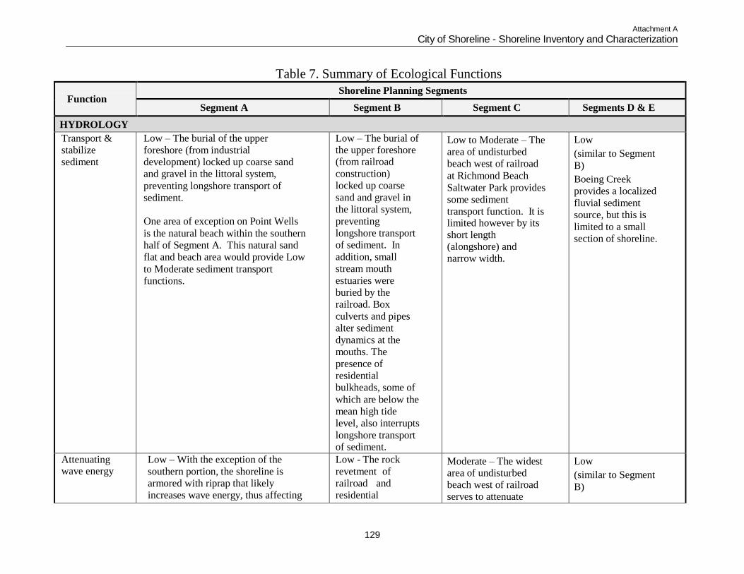
Attachment A
City of Shoreline - Shoreline Inventory and Characterization
129
Table 7. Summary of Ecological Functions
Function Shoreline Planning Segments
Segment A Segment B Segment C Segments D & E
HYDROLOGY
Transport &
stabilize
sediment
Low – The burial of the upper
foreshore (from industrial
development) locked up coarse sand
and gravel in the littoral system,
preventing longshore transport of
sediment.
One area of exception on Point Wells
is the natural beach within the southern
half of Segment A. This natural sand
flat and beach area would provide Low
to Moderate sediment transport
functions.
Low – The burial of the upper foreshore (from railroad
construction)
locked up coarse
sand and gravel in
the littoral system,
preventing
longshore transport
of sediment. In
addition, small
stream mouth
estuaries were
buried by the
railroad. Box
culverts and pipes
alter sediment
dynamics at the
mouths. The
presence of
residential
bulkheads, some of
which are below the
mean high tide
level, also interrupts
longshore transport of sediment.
Low to Moderate – The
area of undisturbed
beach west of railroad
at Richmond Beach
Saltwater Park provides
some sediment
transport function. It is limited however by its
short length
(alongshore) and
narrow width.
Low
(similar to Segment
B)
Boeing Creek
provides a localized
fluvial sediment
source, but this is
limited to a small
section of shoreline.
Attenuating wave energy
Low – With the exception of the
southern portion, the shoreline is
armored with riprap that likely
increases wave energy, thus affecting
Low - The rock
revetment of
railroad and
residential
Moderate – The widest area of undisturbed
beach west of railroad
serves to attenuate
Low
(similar to Segment
B)
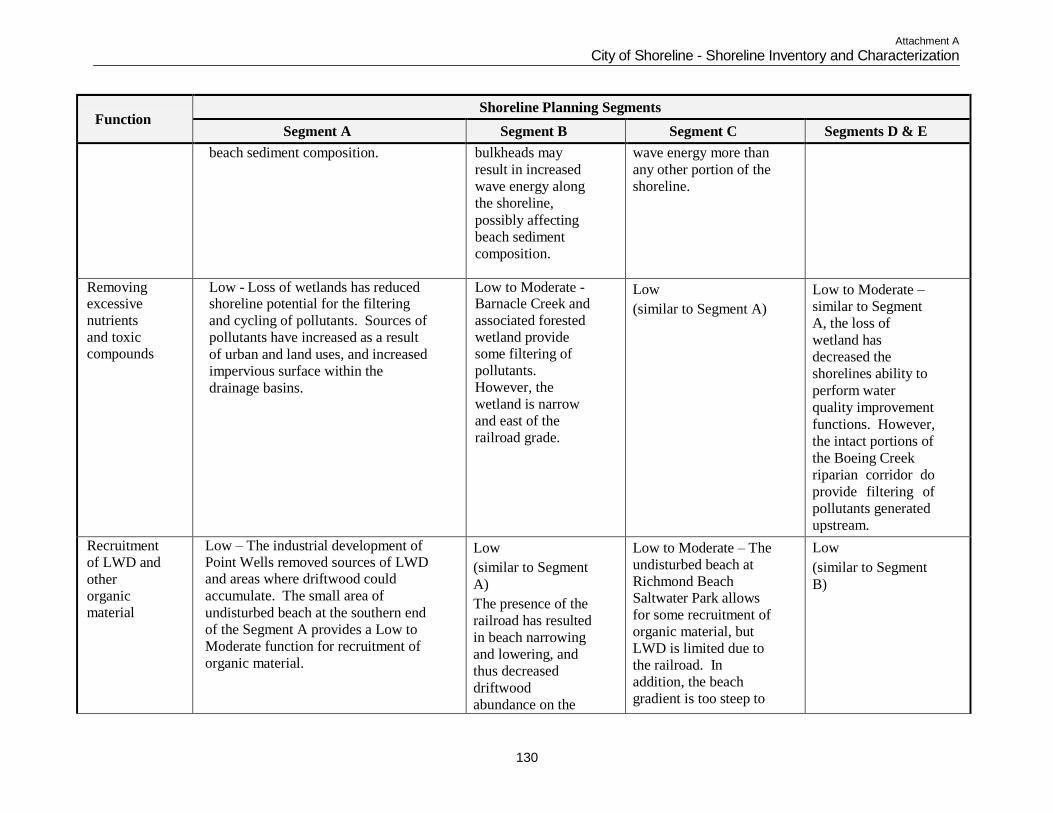
Attachment A
City of Shoreline - Shoreline Inventory and Characterization
130
Function
Shoreline Planning Segments
Segment A Segment B Segment C Segments D & E
beach sediment composition. bulkheads may
result in increased
wave energy along
the shoreline,
possibly affecting
beach sediment
composition.
wave energy more than
any other portion of the
shoreline.
Removing excessive
nutrients
and toxic compounds
Low - Loss of wetlands has reduced shoreline potential for the filtering
and cycling of pollutants. Sources of
pollutants have increased as a result
of urban and land uses, and increased
impervious surface within the
drainage basins.
Low to Moderate - Barnacle Creek and
associated forested
wetland provide some filtering of
pollutants.
However, the
wetland is narrow
and east of the
railroad grade.
Low
(similar to Segment A)
Low to Moderate –
similar to Segment
A, the loss of
wetland has
decreased the
shorelines ability to
perform water
quality improvement
functions. However,
the intact portions of
the Boeing Creek
riparian corridor do
provide filtering of
pollutants generated
upstream.
Recruitment
of LWD and
other organic material
Low – The industrial development of Point Wells removed sources of LWD and areas where driftwood could
accumulate. The small area of
undisturbed beach at the southern end
of the Segment A provides a Low to
Moderate function for recruitment of
organic material.
Low
(similar to Segment
A)
The presence of the
railroad has resulted
in beach narrowing
and lowering, and
thus decreased
driftwood
abundance on the
Low to Moderate – The
undisturbed beach at
Richmond Beach Saltwater Park allows
for some recruitment of
organic material, but
LWD is limited due to
the railroad. In
addition, the beach
gradient is too steep to
Low
(similar to Segment
B)
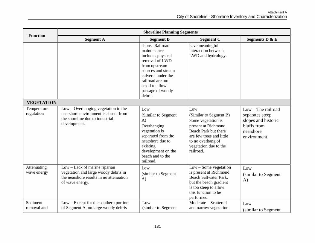
Attachment A
City of Shoreline - Shoreline Inventory and Characterization
131
Function
Shoreline Planning Segments
Segment A Segment B Segment C Segments D & E
shore. Railroad
maintenance
includes physical
removal of LWD from upstream sources and stream
culverts under the
railroad are too
small to allow
passage of woody
debris.
have meaningful
interaction between LWD and hydrology.
VEGETATION
Temperature regulation
Low – Overhanging vegetation in the
nearshore environment is absent from
the shoreline due to industrial
development.
Low
(Similar to Segment
A)
Overhanging
vegetation is
separated from the
nearshore due to
existing
development on the
beach and to the
railroad.
Low
(Similar to Segment B)
Some vegetation is
present at Richmond
Beach Park but there are few trees and little
to no overhang of
vegetation due to the
railroad.
Low – The railroad
separates steep
slopes and historic
bluffs from
nearshore
environment.
Attenuating wave energy
Low – Lack of marine riparian
vegetation and large woody debris in
the nearshore results in no attenuation
of wave energy.
Low
(similar to Segment
A)
Low – Some vegetation is present at Richmond
Beach Saltwater Park,
but the beach gradient
is too steep to allow
this function to be
performed.
Low
(similar to Segment
A)
Sediment removal and
Low – Except for the southern portion of Segment A, no large woody debris
Low (similar to Segment
Moderate – Scattered and narrow vegetation
Low
(similar to Segment
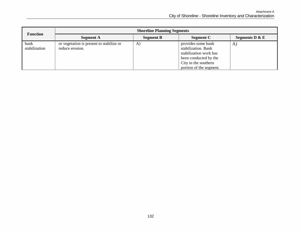
Attachment A
City of Shoreline - Shoreline Inventory and Characterization
132
Function
Shoreline Planning Segments
Segment A Segment B Segment C Segments D & E
bank
stabilization
or vegetation is present to stabilize or
reduce erosion.
A) provides some bank
stabilization. Bank
stabilization work has
been conducted by the
City in the southern
portion of the segment.
A)
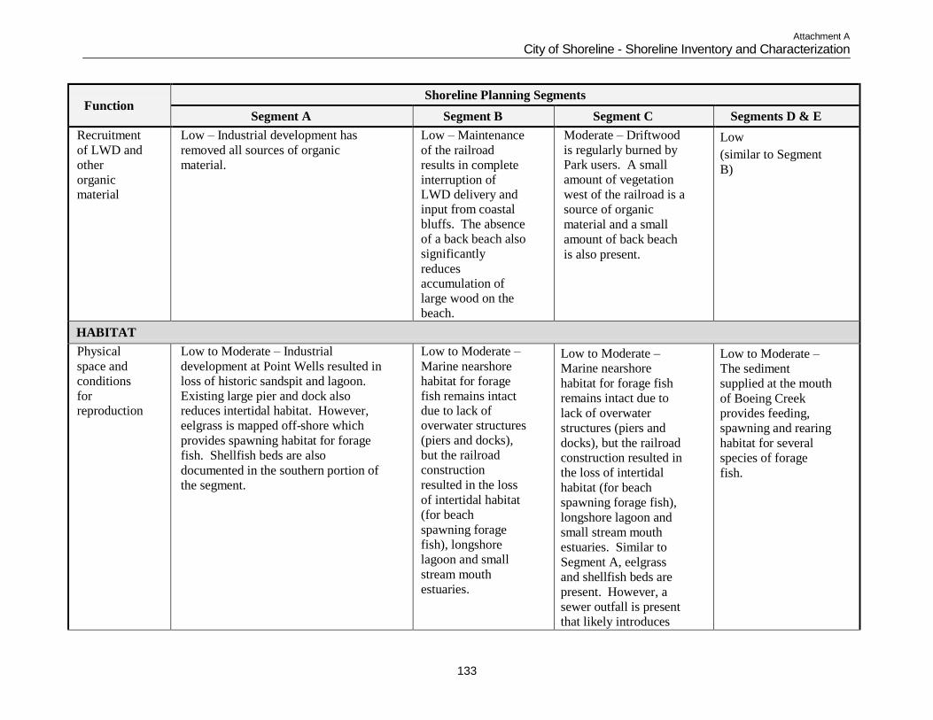
Attachment A
City of Shoreline - Shoreline Inventory and Characterization
133
Function
Shoreline Planning Segments
Segment A Segment B Segment C Segments D & E
Recruitment
of LWD and
other
organic material
Low – Industrial development has
removed all sources of organic
material.
Low – Maintenance
of the railroad
results in complete
interruption of LWD delivery and input from coastal
bluffs. The absence
of a back beach also
significantly
reduces accumulation of
large wood on the
beach.
Moderate – Driftwood
is regularly burned by Park users. A small
amount of vegetation
west of the railroad is a
source of organic
material and a small
amount of back beach
is also present.
Low
(similar to Segment
B)
HABITAT
Physical
space and
conditions
for reproduction
Low to Moderate – Industrial
development at Point Wells resulted in
loss of historic sandspit and lagoon.
Existing large pier and dock also reduces intertidal habitat. However,
eelgrass is mapped off-shore which
provides spawning habitat for forage
fish. Shellfish beds are also
documented in the southern portion of
the segment.
Low to Moderate –
Marine nearshore
habitat for forage
fish remains intact due to lack of overwater structures
(piers and docks),
but the railroad
construction
resulted in the loss
of intertidal habitat
(for beach
spawning forage
fish), longshore
lagoon and small
stream mouth
estuaries.
Low to Moderate –
Marine nearshore
habitat for forage fish
remains intact due to
lack of overwater
structures (piers and
docks), but the railroad
construction resulted in
the loss of intertidal
habitat (for beach
spawning forage fish),
longshore lagoon and
small stream mouth
estuaries. Similar to
Segment A, eelgrass
and shellfish beds are
present. However, a
sewer outfall is present
that likely introduces
Low to Moderate –
The sediment
supplied at the mouth
of Boeing Creek
provides feeding,
spawning and rearing
habitat for several
species of forage
fish.
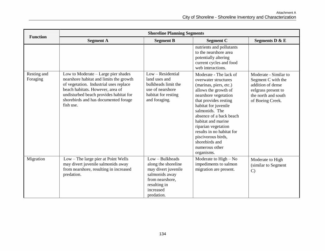
Attachment A
City of Shoreline - Shoreline Inventory and Characterization
134
Function
Shoreline Planning Segments
Segment A Segment B Segment C Segments D & E
nutrients and pollutants
to the nearshore area
potentially altering
current cycles and food web interactions.
Resting and Foraging
Low to Moderate – Large pier shades
nearshore habitat and limits the growth
of vegetation. Industrial uses replace
beach habitats. However, area of
undisturbed beach provides habitat for
shorebirds and has documented forage
fish use.
Low – Residential
land uses and
bulkheads limit the
use of nearshore
habitat for resting
and foraging.
Moderate - The lack of overwater structures
(marinas, piers, etc.)
allows the growth of
nearshore vegetation
that provides resting
habitat for juvenile
salmonids. The
absence of a back beach
habitat and marine
riparian vegetation
results in no habitat for
piscivorous birds,
shorebirds and
numerous other
organisms.
Moderate - Similar to Segment C with the
addition of dense
eelgrass present to
the north and south
of Boeing Creek.
Migration Low – The large pier at Point Wells
may divert juvenile salmonids away
from nearshore, resulting in increased
predation.
Low – Bulkheads
along the shoreline
may divert juvenile
salmonids away from nearshore, resulting in
increased
predation.
Moderate to High – No
impediments to salmon
migration are present.
Moderate to High
(similar to Segment
C)
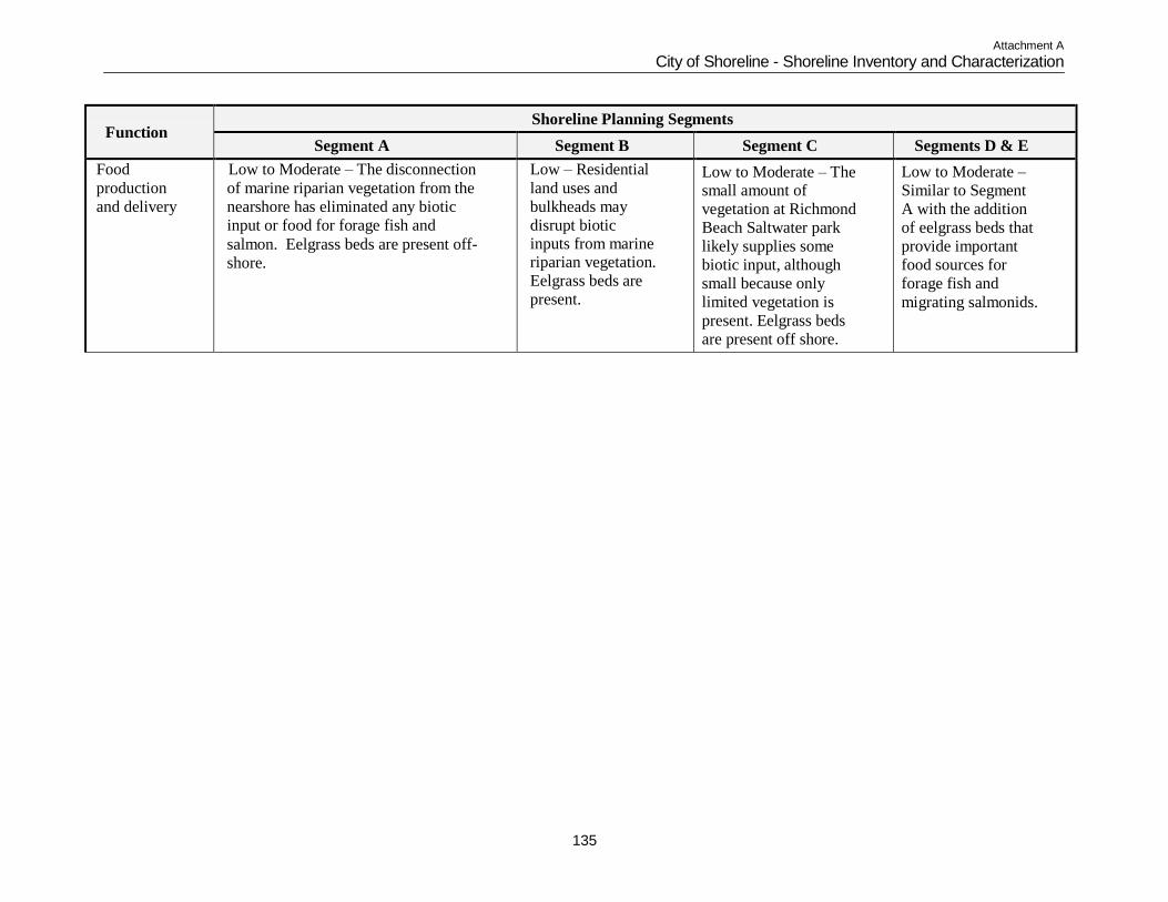
Attachment A
City of Shoreline - Shoreline Inventory and Characterization
135
Function
Shoreline Planning Segments
Segment A Segment B Segment C Segments D & E
Food
production
and delivery
Low to Moderate – The disconnection
of marine riparian vegetation from the
nearshore has eliminated any biotic
input or food for forage fish and
salmon. Eelgrass beds are present off-
shore.
Low – Residential
land uses and
bulkheads may
disrupt biotic inputs from marine riparian vegetation.
Eelgrass beds are
present.
Low to Moderate – The small amount of
vegetation at Richmond
Beach Saltwater park
likely supplies some
biotic input, although
small because only
limited vegetation is
present. Eelgrass beds
are present off shore.
Low to Moderate –
Similar to Segment
A with the addition
of eelgrass beds that
provide important
food sources for
forage fish and
migrating salmonids.
Attachment A
City of Shoreline - Shoreline Inventory and Characterization
136
Programmatic Restoration Opportunities Table 8 provides a summary of shoreline ecological functions for the Coastal/Nearshore Environment. Causes of impairment and the relative scale at which impairments are occurring (e.g., watershed, shoreline segment scale, or multiple scales) are
identified. General or programmatic restoration opportunities to address impairments are described. Individual residential
bulkheads and railroad riprap constitute existing and necessary protection from wave energy and therefore are not included in
any Programmatic Restoration Opportunities.
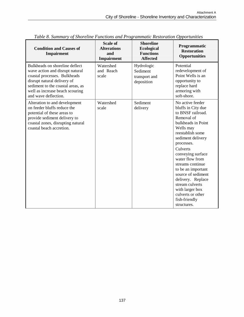
Attachment A
City of Shoreline - Shoreline Inventory and Characterization
137
Table 8. Summary of Shoreline Functions and Programmatic Restoration Opportunities
Condition and Causes of
Impairment
Scale of
Alterations
and
Impairment
Shoreline
Ecological
Functions
Affected
Programmatic
Restoration
Opportunities
Bulkheads on shoreline deflect wave action and disrupt natural
coastal processes. Bulkheads
disrupt natural delivery of
sediment to the coastal areas, as
well as increase beach scouring
and wave deflection.
Watershed
and Reach
scale
Hydrologic
Sediment
transport and
deposition
Potential redevelopment of
Point Wells is an
opportunity to
replace hard
armoring with
soft-shore.
Alteration to and development
on feeder bluffs reduce the
potential of these areas to
provide sediment delivery to
coastal zones, disrupting natural
coastal beach accretion.
Watershed
scale
Sediment
delivery
No active feeder
bluffs in City due
to BNSF railroad.
Removal of
bulkheads in Point
Wells may
reestablish some
sediment delivery
processes.
Culverts
conveying surface
water flow from
streams continue
to be an important
source of sediment
delivery. Replace
stream culverts with larger box culverts or other
fish-friendly
structures.
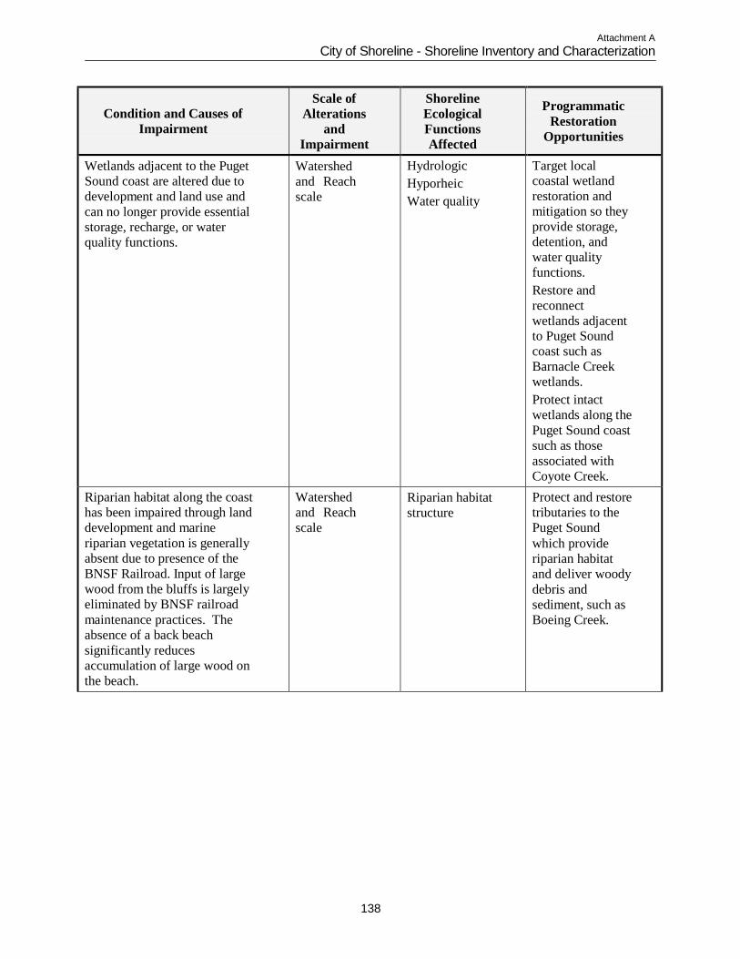
Attachment A
City of Shoreline - Shoreline Inventory and Characterization
138
Condition and Causes of
Impairment
Scale of
Alterations
and
Impairment
Shoreline
Ecological
Functions
Affected
Programmatic
Restoration
Opportunities
Wetlands adjacent to the Puget
Sound coast are altered due to
development and land use and
can no longer provide essential
storage, recharge, or water
quality functions.
Watershed
and Reach
scale
Hydrologic
Hyporheic
Water quality
Target local coastal wetland
restoration and
mitigation so they
provide storage,
detention, and
water quality
functions.
Restore and
reconnect
wetlands adjacent to Puget Sound
coast such as
Barnacle Creek
wetlands.
Protect intact
wetlands along the
Puget Sound coast
such as those
associated with
Coyote Creek.
Riparian habitat along the coast
has been impaired through land
development and marine
riparian vegetation is generally
absent due to presence of the
BNSF Railroad. Input of large
wood from the bluffs is largely
eliminated by BNSF railroad
maintenance practices. The
absence of a back beach
significantly reduces
accumulation of large wood on
the beach.
Watershed
and Reach
scale
Riparian habitat
structure
Protect and restore
tributaries to the
Puget Sound
which provide
riparian habitat
and deliver woody
debris and
sediment, such as
Boeing Creek.
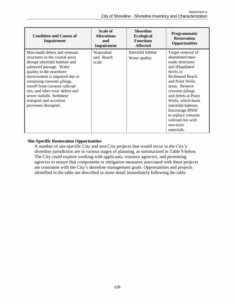
Attachment A
City of Shoreline - Shoreline Inventory and Characterization
139
Condition and Causes of
Impairment
Scale of
Alterations
and
Impairment
Shoreline
Ecological
Functions
Affected
Programmatic
Restoration
Opportunities
Man-made debris and remnant structures in the coastal areas
disrupt intertidal habitats and
salmonid passage. Water
quality in the nearshore
environment is impaired due to
remaining creosote pilings,
runoff from creosote railroad ties, and other toxic debris and
sewer outfalls. Sediment
transport and accretion
processes disrupted.
Watershed
and Reach
scale
Intertidal habitat
Water quality
Target removal of abandoned man-
made structures
and dilapidated
docks in
Richmond Beach
and Point Wells
areas. Remove
creosote pilings
and debris at Point Wells, which harm
intertidal habitats.
Encourage BNSF
to replace creosote
railroad ties with
non-toxic
materials.
Site-Specific Restoration Opportunities
A number of site-specific City and non-City projects that would occur in the City‟s shoreline jurisdiction are in various stages of planning, as summarized in Table 9 below.
The City could explore working with applicants, resource agencies, and permitting
agencies to ensure that components or mitigation measures associated with these projects
are consistent with the City‟s shoreline management goals. Opportunities and projects
identified in the table are described in more detail immediately following the table.
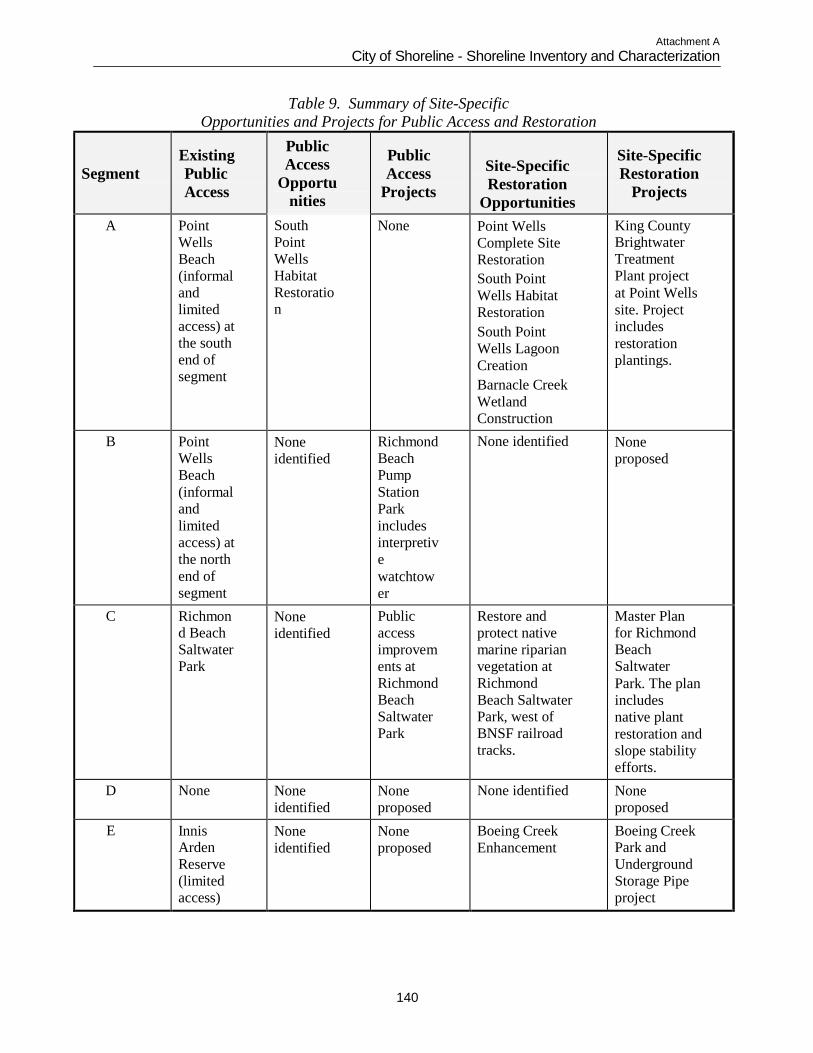
Attachment A
City of Shoreline - Shoreline Inventory and Characterization
140
Table 9. Summary of Site-Specific
Opportunities and Projects for Public Access and Restoration
Segment
Existing
Public
Access
Public
Access
Opportu
nities
Public
Access
Projects
Site-Specific
Restoration
Opportunities
Site-Specific
Restoration
Projects
A Point
Wells
Beach
(informal
and
limited
access) at
the south
end of
segment
South
Point
Wells
Habitat
Restoratio n
None Point Wells
Complete Site
Restoration
South Point
Wells Habitat
Restoration
South Point
Wells Lagoon
Creation
Barnacle Creek
Wetland
Construction
King County Brightwater
Treatment
Plant project
at Point Wells
site. Project
includes
restoration
plantings.
B Point
Wells
Beach
(informal
and
limited
access) at
the north
end of
segment
None
identified
Richmond
Beach
Pump
Station
Park
includes
interpretiv
e
watchtow
er
None identified None
proposed
C Richmon d Beach
Saltwater
Park
None
identified
Public
access
improvem
ents at
Richmond
Beach
Saltwater
Park
Restore and
protect native
marine riparian
vegetation at
Richmond
Beach Saltwater Park, west of
BNSF railroad
tracks.
Master Plan for Richmond
Beach
Saltwater
Park. The plan
includes
native plant
restoration and
slope stability
efforts.
D None None
identified
None
proposed
None identified None
proposed
E Innis Arden
Reserve
(limited
access)
None
identified
None
proposed
Boeing Creek
Enhancement
Boeing Creek Park and
Underground
Storage Pipe
project
Attachment A
City of Shoreline - Shoreline Inventory and Characterization
141
Segment A
Point Wells Restoration Opportunities The Lake Washington/Cedar/Sammamish Watershed (WRIA 8) Chinook Salmon Conservation Plan Volume II (WRIA, 2005) identifies many potential restoration and
protection projects as part of their Tier 1 Initial Habitat Project List for nearshore/estuary
Reaches 8-12 and Sub-reaches. Three specific projects were identified at Point Wells, which
is within Reach 10.
Point Wells Complete Site Restoration: Restore the entire Point Wells site by completely
removing the sea wall, riprap dike, and fill. Regrade the site and reconnect local
freshwater sources to re-create a tidal lagoon system with an opening at the north end of
the point, which was probably the original mouth of the tidal lagoon system. Reestablish
native riparian and backshore vegetation. Project categorized as “high” for benefits to
Chinook and “low” for feasibility.
South Point Wells Habitat Restoration: Enhance the south shoreline by removing riprap
dike, eliminating invasive plants, and reestablishing native riparian and backshore
vegetation. The south shoreline is approximately 800 feet long, has sandy substrate,
supports some beach grass and other herbaceous vegetation, and includes a fair amount of
large woody debris. The south shoreline, with its proximity to nearby residential areas,
has potential value for public access. Project categorized as “high/medium” for benefits
to Chinook and “medium/low” for feasibility.
South Point Wells Lagoon Creation: Creation of a three acre inter-tidal lagoon at the
south end of the Point Wells site that may have historically been a marsh (before it was
filled). The south shoreline is approximately 800 feet long, has sandy substrate, supports
some beach grass and other herbaceous vegetation, and includes a fair amount of large
woody debris. Project categorized as “high/medium” for benefits to Chinook and
“medium/low” for feasibility.
Barnacle Creek Wetland Construction Opportunity The Lake Washington/Cedar/Sammamish Watershed (WRIA 8) Chinook Salmon Conservation Plan Volume II (WRIA, 2005) also identifies one specific project within the
Barnacle Creek drainage. The project involves creation of tidally influenced wetland habitat
on the east side of the BNSF railroad tracks at Barnacle Creek. Project categorized as “low”
for both benefits to Chinook and feasibility.
Brightwater Treatment Plant Project at Point Wells
The KCDNRP WTD is currently constructing a regional wastewater treatment plant called Brightwater in unincorporated Snohomish County. A conveyance line from the
treatment plant to the Point Wells site is currently being built in order to convey treated
wastewater to Puget Sound. A marine outfall will be installed offshore of the Point Wells
site, extending approximately one mile along the sea bottom of Puget Sound. Following
construction, King County will landscape a portion of the Point Wells site with Puget
Sound coastal grasses and enhance the shoreline buffer. Eelgrass removed from the
Attachment A
City of Shoreline - Shoreline Inventory and Characterization
142
outfall construction site will be replanted and monitored until 2019 to ensure effective
recovery. The project is anticipated to be complete by the year 2010 (KCDNRP, WTD
website, 2008).
Segment B
Richmond Beach Pump Station Park Project A new park site is located in the Richmond Beach neighborhood at Richmond Beach Drive NW and NW 198th Street. The City obtained a 50-year recreation easement on a
2.3-acre parcel of land from King County as mitigation for impacts from the Brightwater
Treatment Plant project. In the mitigation agreement between the City of Shoreline and
King County, it was agreed that the County would provide $750,000 of mitigation
funding for City of Shoreline community improvements. Most of the mitigation funding
has been designated for the creation of a new City park at the pump station site. This park
is currently being called Richmond Beach Pump Station Park until it receives a new name
following City and County naming policies. A 2005 Master Plan for the park includes a
small parking area, restroom, interpretive watchtower overlooking the BNSF railroad and
Puget Sound, and play areas. No shoreline access west of the BNSF railroad is proposed
(City of Shoreline website, 2008).
Segment C
Richmond Beach Saltwater Park Project The City‟s Master Plan for Richmond Beach Saltwater Park (City of Shoreline, 2007b) includes improvement of the park entrance and road; pedestrian sidewalks, stairs and
trails; bridge access and safety; a new beach wash-down area; a new overlook parking
area across from the caretaker‟s residence; a new mid-level terrace area with parking,
picnic area and gathering space; and new entry, way-finding and interpretive educational
signage. In addition, the plan includes selective site improvements and a program of
restoration ecology to control erosion and eliminate invasive plant species in the Park and
nearshore areas. Phase I improvements include slope stability efforts in specific areas
that showed evidence of unstable soil conditions or erosion during geotechnical
investigation. Improvements include controlling public access away from steep slope
areas, improving access across steep slopes by constructing raised stairs and boardwalks
in selected locations, and by implementing a community participation program of
removing invasive plants and replacing them with native plant species tolerant of dry,
sandy and gravelly soils. Future phases of the master plan propose beach and dune
restoration.
Segment D
No site-specific projects or opportunities have been identified to provide public access or
restore shoreline functions and processes. Opportunities in this segment are limited
because properties along the shoreline are privately owned. There are also hazards along
the shoreline including unstable slopes and landslide hazards.
Attachment A
City of Shoreline - Shoreline Inventory and Characterization
143
Segment E
Boeing Creek Park and Underground Storage Pipe Project
In October 2007, King County completed construction of a new 500,000-gallon underground storage pipe in Boeing Creek Park to temporarily store wastewater during
large storms and help reduce overflows to Puget Sound. The pipe replaced an existing
24-inch sewer in Boeing Creek Park owned by the Ronald Wastewater District. The new
sewer is 12 feet in diameter and about 640 feet long. The new underground storage pipe
is conveying normal wastewater flows toward the Hidden Lake Pump Station. At the
request of the City of Shoreline, King County also graded the existing stormwater facility
in Boeing Creek Park. The County grading increased the capacity of the facility and
stabilized the area. The City then followed with their own park improvement project in
2008. Improvements to the park include new on street parking, ADA pathway
improvements, new picnic areas, benches, stormwater detention pond upgrades including
a cascading stone water feature, irrigation, native plant landscaping, and trail
improvements including improvements to the lower log crossing. The suspension foot
bridge will not be part of these improvements as the December storm caused erosion
damage to the creek banks including the proposed site for the bridge (City of Shoreline
website, 2008).
Boeing Creek Enhancement
The City of Shoreline Stream Inventory (TT/KCM, 2004b) notes that the foremost option for recovery within the City is enhancement of the lowest reach of Boeing Creek. The
key habitat enhancement activity is to reduce stormwater runoff from developed areas
adjacent to Boeing Creek. By reducing stormwater runoff, landslides will occur at more
natural levels and sediment loading in the stream will be reduced.
DATA GAPS
This shoreline inventory and characterization report relies on data described in each
technical section. In some cases, data identified as needed for the analysis and
characterization were not available for incorporation in this report. The 2003 Ecology
Guidelines require that data gaps or missing information be identified during the
preparation of the shoreline inventory and analysis. The following are considered data
gaps at this time:
Aerial photographs used in this analysis are dated 2002. More recent aerial photographs
are not currently available or have not been purchased by the City.
Impervious surface information used in this report has been approximated using aerial
photographs. Additional information may exist that needs to be explored.
Data related to impacts to shoreline resources from the operation and maintenance of the
BNSF railroad tracks is not available. Coordination with BNSF Railway is desired to
achieve cooperation between City activities in the shoreline jurisdiction and BNSF
operation and maintenance activities.
Tribal information on fisheries or other marine shoreline resources is currently lacking.
Attachment A
City of Shoreline - Shoreline Inventory and Characterization
144
Location of archaeological resources is unknown. Coordination with Native American
tribal organizations would help to identify the probability or likelihood that intact
archaeological resources may be present in the shoreline planning area.
SUMMARY
The City‟s shoreline jurisdiction includes approximately 4 miles of Puget Sound coastline
within the city limits and in its PAA. Similar to other cities along the Puget Sound,
existing development and infrastructure has affected the shoreline environment within the
City of Shoreline. Ecosystem-wide processes and ecological functions that have been
altered in the marine shoreline include sediment processes, large woody and organic
debris recruitment and transport, water quality, riparian vegetation and habitat conditions.
Shoreline armoring to protect the BNSF railroad has most severely altered sediment
processes in the City. Sediment delivery is limited to several streams that deliver
sediment via culverts under the railroad right-of-way. Forage fish spawning still occurs
at these limited points of sediment input (e.g. Boeing Creek) (Daley, 2004). In the
Richmond Beach neighborhood, sediment processes have been altered by armoring to
protect residential development in several areas, but still provide important habitat and
sediment functions.
Clearing of riparian vegetation along the marine shoreline for the BNSF Railway
construction and maintenance, and other shoreline armoring has resulted in a lack of large
woody and organic debris available for recruitment to the system. The lack of debris in
turn affects the stability of the beaches as the presence of beach logs and debris can
reduce erosion by dissipating wave energy and trapping sediment.
Restoration and preservation activities that could improve ecological functions and eco-
system wide processes in the marine shoreline include: reduction of stormwater runoff to
landslide-prone areas; revegetation of riparian areas to provide shade to cool water
temperatures, filter run-off and to provide a source of large woody debris and organic
materials; limiting shoreline armoring to allow for continued sediment delivery and to
protect nearshore habitat; and improvements to water quality in adjacent upland areas.
Table 10 below summarizes the shoreline characterization for each planning segment.
The segments are shown on Map 1. Overall, the Puget Sound shoreline in the City of
Shoreline is uniform in its development pattern and biological diversity. The BNSF
railroad extends the length of the shoreline. Segment breaks were primarily associated
with changes in land use. Point Wells, located in the city‟s PAA, is the only industrial
facility along the shoreline, contrasting with the residential nature of the city‟s shoreline.
South of Point Wells, land use breaks along segment boundaries are primarily associated
with varying densities of residential development, and parks and open space resources
such as Richmond Beach Saltwater Park and Innis Arden Reserve. While Richmond
Beach Saltwater Park provides recreational facilities and access to the Puget Sound
shoreline, access at other open space and park resources are limited. Shoreline
modifications associated with the railroad and residential development are found
Attachment A
City of Shoreline - Shoreline Inventory and Characterization
145
throughout the majority the city‟s shoreline planning area, with the largest contiguous
unmodified portion occurring at Richmond Beach Saltwater Park.
Biological resources and potential habitat areas along the Puget Sound shoreline are
largely uniform throughout the city. Less developed areas along the shoreline such as
Innis Arden Reserve and Boeing Creek Reserve offer greater habitat potential for
wildlife. Areas regulated as critical areas are found throughout the shoreline planning
area, primarily comprised of inter-tidal wetlands, streams discharging to Puget Sound,
seismic hazards, flood hazards and landslide hazard areas associated with bluffs. Critical
areas are listed in Table 10 under Hazard Areas and Habitat / Habitat Potential. Streams
discharging to Puget Sound, many of which pass through culverts under the railroad, are
listed under Stormwater Outfalls / Stream Discharges.
Attachment A
City of Shoreline - Shoreline Inventory and Characterization
146
This Page Intentionally Blank
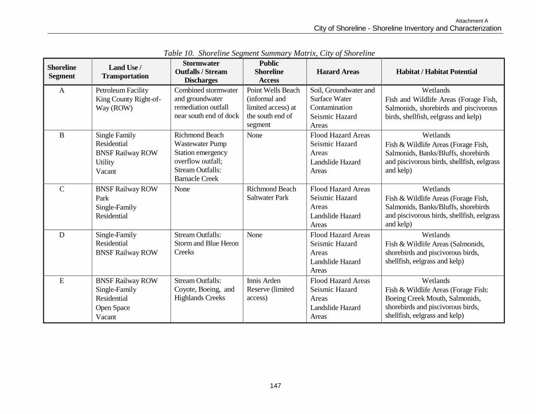
Attachment A
City of Shoreline - Shoreline Inventory and Characterization
147
Table 10. Shoreline Segment Summary Matrix, City of Shoreline
Shoreline
Segment
Land Use /
Transportation
Stormwater Outfalls / Stream
Discharges
Public Shoreline
Access
Hazard Areas
Habitat / Habitat Potential
A Petroleum Facility
King County Right-of-
Way (ROW)
Combined stormwater
and groundwater
remediation outfall
near south end of dock
Point Wells Beach
(informal and
limited access) at
the south end of
segment
Soil, Groundwater and
Surface Water
Contamination
Seismic Hazard
Areas
Wetlands
Fish and Wildlife Areas (Forage Fish,
Salmonids, shorebirds and piscivorous
birds, shellfish, eelgrass and kelp)
B Single Family
Residential
BNSF Railway ROW
Utility
Vacant
Richmond Beach
Wastewater Pump
Station emergency
overflow outfall;
Stream Outfalls:
Barnacle Creek
None Flood Hazard Areas
Seismic Hazard
Areas
Landslide Hazard
Areas
Wetlands
Fish & Wildlife Areas (Forage Fish,
Salmonids, Banks/Bluffs, shorebirds
and piscivorous birds, shellfish, eelgrass
and kelp)
C BNSF Railway ROW
Park
Single-Family
Residential
None Richmond Beach
Saltwater Park
Flood Hazard Areas
Seismic Hazard
Areas
Landslide Hazard
Areas
Wetlands
Fish & Wildlife Areas (Forage Fish,
Salmonids, Banks/Bluffs, shorebirds
and piscivorous birds, shellfish, eelgrass
and kelp)
D Single-Family
Residential
BNSF Railway ROW
Stream Outfalls:
Storm and Blue Heron
Creeks
None Flood Hazard Areas
Seismic Hazard
Areas
Landslide Hazard
Areas
Wetlands
Fish & Wildlife Areas (Salmonids,
shorebirds and piscivorous birds,
shellfish, eelgrass and kelp)
E BNSF Railway ROW
Single-Family
Residential
Open Space
Vacant
Stream Outfalls:
Coyote, Boeing, and
Highlands Creeks
Innis Arden
Reserve (limited
access)
Flood Hazard Areas
Seismic Hazard
Areas
Landslide Hazard
Areas
Wetlands
Fish & Wildlife Areas (Forage Fish:
Boeing Creek Mouth, Salmonids,
shorebirds and piscivorous birds,
shellfish, eelgrass and kelp)
Attachment A
City of Shoreline - Shoreline Inventory and Characterization
148
This Page Intentionally Blank
Attachment A
City of Shoreline - Shoreline Inventory and Characterization
149
BIBLIOGRAPHY
Adolfson Associates. 1999. Final Environmental Impact Statement Volumes 1 and 2: Shoreview
Park Capital Project. Prepared for the City of Shoreline. Anchor Environmental, L.L.C. and People for Puget Sound. 2002. Final Report Northwest
Straits Nearshore Habitat Evaluation. Prepared for Northwest Straits Commission
(NWSC). Mount Vernon, WA. Baum, R.L., E.L. Harp, and W.A. Hultman. 2000. Map showing recent and historical landslide
activity on coastal bluffs of Puget Sound between Shilshole Bay and Everett,
Washington. Miscellaneous Field Studies Map MF-2346, U.S. Geological Survey. Booth, Derek B., Troost, Kathy Goetz, and Shimel, Scott A. 2005. Geologic Map of
Northwestern Seattle (part of the Seattle North 7.5' x 15' quadrangle), King County,
Washington: U.S. Geological Survey Scientific Investigations Map 2903, 1:12,000
Available from The Pacific Northwest Center for Geologic Mapping Studies
(GeoMapNW) and at http://geomapnw.ess.washington.edu/index.php. CH2MHill and Associated Firms. 2001. Brightwater Siting Project – Phase 2 Technical
Documentation. Prepared for the King County Department of Natural Resources,
Wastewater Treatment Division. September 2001. City of Shoreline. 1998a. Final Environmental Impact Statement – Draft Comprehensive Plan.
November 2, 1998. Shoreline, Washington. City of Shoreline. 1998b. Final Shoreline Comprehensive Plan. Adopted November 23, 1998.
Shoreline, Washington. City of Shoreline. 2001. Comprehensive Plan: Representation of Official Comprehensive Plan
Land Use Map Adopted by City Ordinance No. 292. Shows amendments through August
1, 2006. Shoreline, Washington. City of Shoreline. 2002. City of Shoreline Geographic Information System (GIS) Data.
City of Shoreline. 2004. DRAFT Parks Inventory. Prepared under Comprehensive Plan Update
project. City of Shoreline. 2005a. City of Shoreline Comprehensive Plan. Adopted by Ordinance No.
388, June 13, 2005. Shoreline, Washington. City of Shoreline. 2005b. City of Shoreline Surface Water Master Plan. Prepared by R.W.
Beck, Inc. Adopted July 11, 2005. Shoreline, Washington. City of Shoreline. 2005c. City of Shoreline Parks, Recreation and Open Space Plan. Adopted
May 23, 2005, Resolution 231. Shoreline, Washington.
Attachment A
City of Shoreline - Shoreline Inventory and Characterization
150
City of Shoreline. 2006. Zoning: Representation of Official Zoning Map Adopted by City
Ordinance No. 292. Shows amendments through August 1, 2006. Shoreline,
Washington. City of Shoreline. 2007a. Shoreline Municipal Code. Current through Ordinance 475, passed
July 9, 2007. Shoreline, Washington. City of Shoreline. 2007b. Richmond Beach Saltwater Park Master Plan. Prepared by Hewitt
Architects. March 2007. Shoreline, Washington. Chu, Y.H.. 1985. Beach erosion and protection: a case study at Lincoln Park, Seattle, WA. Shore
and Beach (53): 26-32. Copass. 1996. Historic Resources Survey and Inventory Update for the City of Shoreline.
Prepared for the City of Shoreline and the King County Historic Preservation Program.
September 1996. Daley Design. 2004. Fish Utilization in City of Shoreline Streams, Appendix C to City of
Shoreline Stream and Wetland Inventory and Assessment. Prepared for Tetra Tech/KCM,
Inc., by Daley Design, Bainbridge, WA. Dethier, M. N. 1990. A marine and estuarine habitat classification system for Washington State.
Washington Natural Heritage Program, Department of Natural Resources, Olympia,
Washington. 56 pp. Downing, J. 1983. The Coast of Puget Sound. Its Processes and Development. University of
Washington Press, Seattle, WA, 126 p. Federal Emergency Management Agency (FEMA). 1995. Q3 Flood Data, depicting Flood
Insurance Rate Map, King County, Washington. Fresh, K.L. 2006. Juvenile Pacific Salmon in Puget Sound. Puget Sound Nearshore Partnership
Report No. 2006-06. Published by Seattle District, U.S. Army Corps of Engineers,
Seattle, Washington. Herrera Environmental Consultants. 2005. Joint Aquatic Resource Application - Permit
Application.- Everett to Seattle Commuter Rail Project Third Easement. Prepared for
BNSF Railway Company and Sound Transit. HWA GeoSciences, Inc. 1998. Everett-to-Seattle Commuter Rail Geotechnical Assessment
Report. Seattle, Washington. Jacobson, E. and M.L. Schwartz. 1981. The use of geomorphic indicators to determine the
direction of net shore-drift. Shore and Beach 49:38-42. Johannessen, J.W. and A. MacLennan. 2007. Beaches and Bluffs of Puget Sound. Puget Sound
Nearshore Partnership Report No 2007-4. Published by Seattle District, U.S. Army
Corps of Engineers, Seattle, Washington.
Attachment A
City of Shoreline - Shoreline Inventory and Characterization
151
Johannessen, J.W., MacLennan, A., and McBride, A. 2005. Inventory and Assessment of Current
and Historic Beach Feeding Sources/Erosion and Accretion Areas for the Marine
Shorelines of Water Resource Inventory Areas 8 & 9. Prepared by Coastal Geologic
Services, Prepared for King County Department of Natural Resources and Parks, Seattle,
WA. Johannessen, J.W. 1992. Net shore-drift in San Juan County and parts of Jeffereson, Island and
Snohomish counties, Washington: final report. Western Washington Universtity, for
Shorelands and Coastal Zone Management Program, Washington Department of
Ecology, Olympia, 58 p., 25 maps. Kerwin, J. 2001. Salmonid habitat limiting factors: Water Resources Inventory Area (WRIA) 8
Final Report. Washington State Conservation Commission. Olympia, WA. Keuler, R.F. 1979. Coastal zone processes and geomorphology of Skagit County, Washington.
Master‟s thesis, Western Washington University, Bellingham, WA. 123 p.
King County. 2007. GIS Data. Seattle, WA..
King County. 2004. King County Impervious/Impacted Surface Interpretation based on 2000
Imagery Dataset. Seattle, WA.
King County. 1990. King County Sensitive Areas Map Folio. Seattle, WA. King County Department of Natural Resources (KCDNR). 2001. Reconnaissance Assessment
of the State of the Nearshore Report: Including Vashon and Maury Islands (WRIAs 8 and
9). Seattle, WA. King County iMAP. 1991. iMAP Sensitive Areas. Available at:
http://www5.metrokc.gov/iMAP/viewer.htm?mapset=kcproperty . Komar, P.D. 1976. Beach processes and sedimentation. Englewood Cliffs, NJ. Prentice-Hall.
429 p. Larson Anthropological Archaeological Services Limited (LAAS). 2001. North Plant
(Brightwater) Treatment Facility Siting Cultural Resources Site Screening. Snohomish
County, Washington. Prepared for: King County Wastewater Treatment Division. June
1, 2001. Lemberg, N.A., M.F. O‟Toole, D.E. Penttila, and K.C. Stick. 1997. Washington State
Department of Fish and Wildlife, 1996 Forage Fish Stock Status Report. Stock Status
Report No. 98-1. Washington State Department of Fish and Wildlife, Olympia. Masselink, G., and M.G. Hughes. 2003. Introduction to Coastal Processes & Geomorphology.
Hodder Education. London.
Attachment A
City of Shoreline - Shoreline Inventory and Characterization
152
Mumford, T.F. 2007. Kelp and Eelgrass in Puget Sound. Puget Sound Nearshore Partnership
Report No. 2007-05. Published by Seattle District, U.S. Army Corps of Engineers,
Seattle, Washington. Nammi, Juniper. 2009. City of Shoreline. Personal communication with R. Shakra, ESA
Adolfson. November 2009. Newman, Mark. 2003. Ronald Wastewater District. Personal communication, telephone
conversation with D. Lozano, Adolfson Associates, Inc. October 2003. Nightingale, B. and C. Simenstad. 2001. Overwater structures: Marine issues. Prepared for
Washington Department of Fish and Wildlife, Washington Department of Ecology, and
Washington Department of Transportation. University of Washington. Seattle, WA. O'Neil, T. A., D. H. Johnson, C. Barrett, M. Trevithick, K. A. Bettinger, C. Kiilsgaard, M.
Vander Heyden, E. L. Greda, D. Stinson, B. G. Marcot, P. J. Doran, S. Tank, and L.
Wunder. Matrixes for Wildlife-Habitat Relationship in Oregon and Washington.
Northwest Habitat Institute. 2001. In D. H. Johnson and T. A. O'Neil (Manag. Dirs.)
Wildlife-Habitat Relationships in Oregon and Washington. Oregon State University
Press, Corvallis, Oregon, USA. 2001. O‟Toole, M. 1995. Puget Sound Herring: A Review. In Proceedings of Puget Sound Research.
1995. pp. 849-854. Puget Sound Water Quality Authority, Seattle, WA. Parker, M.A. 2000. Fish Passage—Culvert Inspection Procedures. Watershed Restoration
Technical Circular No. 11. British Columbia Ministry of Environment, Lands and Parks,
Williams Lake, B.C. Penttila, D. 2007. Marine Forage Fishes in Puget Sound. Puget Sound Nearshore Partnership
Report No. 2007-03. Published by Seattle District, U.S. Army Corps of Engineers,
Seattle, Washington. Schwartz, M.L. 1991. Net shore-drift in Washington State: Volume 3, Central Puget Sound.
Shorelands and Coastal Zone Management Program, Washington State Department of
Ecology, Olympia, WA. Snohomish County. 2007. Docket XII Initial Review and Evaluation of Docketing Proposals.
Prepared by Planning and Development Services.
Sobocinski, K.L. 2003. The Impact of Shoreline Armoring on Supratidal Beach Fauna of
Central Puget Sound. Unpublished masters thesis. University of Washington School of
Aquatic and Fishery Sciences. Seattle, WA.
Sound Transit. 1999a. Everett – Seattle Final Environmental Impact Statement, Commuter Rail
Project, Volume 1. December 1999. Sound Transit. 1999b. Everett – Seattle Final Environmental Impact Statement, Commuter Rail
Project, Volume 3. December 1999.
Attachment A
City of Shoreline - Shoreline Inventory and Characterization
153
Steele, Chuck L. 2008. Washington State Department of Ecology. Personal communication
with M. Muscari, ESA Adolfson. December 2008. Tetra Tech/KCM, Inc (TT/KCM). 2004a. Boeing Creek Basin Characterization Report.
Prepared for the City of Shoreline, WA. Tetra Tech/KCM, Inc (TT/KCM). 2004b. City of Shoreline Stream Inventory and Assessment.
Prepared for the City of Shoreline, WA. Tetra Tech/KCM, Inc (TT/KCM). 2004c. City of Shoreline Wetland Inventory and Assessment.
Prepared for the City of Shoreline, WA. Tetra Tech/KCM, Inc (TT/KCM). 2004d. Middle Puget Sound Basin Characterization Report.
Prepared for the City of Shoreline, WA. United States Department of Agriculture, Soil Conservation Service (USDA SCS). 1973. King
County Soil Survey. United States Department of Agriculture, Natural Resources Conservation Service (USDA
NRCS). 1983. Snohomish County Soil Survey. United States Department of the Interior (USDI). 1987a. National Wetlands Inventory,
Edmonds West, Washington 7.5-minute USGS Quadrangle. United States Department of the Interior (USDI). 1987b. National Wetlands Inventory, Seattle
North, West, Washington 7.5-minute USGS Quadrangle. Washington State Department of Ecology (Ecology). 2004. Shoreline Slope Stability in Coastal
Zone Atlas. Washington State Department of Ecology, Shorelands and Coastal Zone
Management Program. Olympia, WA. Washington State Department of Fish and Wildlife (WDFW). 2008. Priority Habitats and
Species, ―StreamNet‖, and Marine Resources Species databases. Olympia, WA. Washington State Department of Natural Resources (WDNR). 2001. Washington State
ShoreZone Inventory. Nearshore Habitat Program, Washington State Department of
Natural Resources. Olympia, WA.
The Watershed Company. 2008. Stream Evaluation Study for parcel #7278100690, 19542
Richmond Beach Drive NW TWC Ref# 070410.8. Letter prepared by Nell Lund on
July 22, 2008.
Williams, G. D. and R. M. Thom. 2001. Marine and estuarine shoreline modification
issues. Prepared for the Washington State Department of Transportation, (Draft). Woodruff, D. L., P. J. Farley, A. B. Borde, J. S. Southard, and R. M. Thom. 2001. King County
Nearshore Habitat Mapping Data Report: Picnic Point to Shilshole Bay Marina.
Prepared for King County Department of Natural Resources. Seattle, Washington.
Attachment A
City of Shoreline - Shoreline Inventory and Characterization
154
WRIA 8 Steering Committee. 2005. Final Lake Washington/Cedar/Sammamish (WRIA 8)
Chinook Salmon Conservation Plan. Prepared by the WRIA 8 service provider team
on behalf of the WRIA 8 Steering Committee. Available at
http://www.govlinlcorg/watersheds/8/pIanning/chinook-conservation-pian. aspx .
Attachment A
City of Shoreline - Shoreline Inventory and Characterization
155
WEBSITES:
Amtrak website. 2008. Schedules. Accessed August 14, 2008. Available at:
http://www.amtrak.com/servlet/ContentServer?pagename=Amtrak/Schedules_Page. City of Shoreline website. 2008. Accessed August 18, 2008. Available at:
http://www.cityofshoreline.com. King County Department of Natural Resources and Parks (KCDNRP website). 2003. Beach
Assessment Program. Available online at:
http://dnr.metrokc.gov/wlr/waterres/beaches/bmain.htm (accessed September 2003). King County Department of Natural Resources and Parks (KCDNRP), Wastewater Treatment
Division website. 2008. Available at:
http://dnr.metrokc.gov/WTD/brightwater/pointwells/index.htm. Accessed on September
4, 2008. Sound Transit website. 2008. Sounder Commuter Rail Schedules. Accessed August 14, 2008.
Available at: http://www.soundtransit.org/x71.xml. Snohomish County. 2008. Snohomish County Permit, Planning, and Zoning Map. Accessed on
August 20, 2008. Available at: http://gis.co.snohomish.wa.us/maps/permits/viewer.htm. HistoryLink.org. 1999. Shoreline Thumbnail History. Article written by Alan J. Stein.
Accessed November 24, 2009. Available at:
http://www.historylink.org/index.cfm?DisplayPage=output.cfm&file_id=958. Washington State Department of Ecology (Ecology website). 2008. Integrated Site Information
System Confirmed and Suspected Contaminated Sites List. Accessed September 3, 2008.
Available online at: https://fortress.wa.gov/ecy/tcpwebreporting/reports.aspx. Washington State Department of Ecology (Ecology website). 2008. Digital Coastal Atlas
(2008). Shoreline Photos taken 2000. Available online at:
http://www.ecy.wa.gov/programs/sea/SMA/atlas_home.html (accessed August 2008). Washington Department of Ecology (Ecology website). 2008. Final 2004 Section 303(d) List –
WRIA 8. Available online at: http://www.ecy.wa.gov/programs/wq/303d/index.html
(accessed August 2008).
Washington State Department of Health Website. 2008. Recreational Shellfish Beach
Closures. Available online at: http://www.doh.wa.gov/ (accessed August 2008).
Washington State Department of Ecology (Ecology website). 2003. Digital Coastal Zone
Atlas. Available online at
Attachment A
City of Shoreline - Shoreline Inventory and Characterization
156
http://www.ecy. wa.gov/programs/sea/SMA/atlas_home.html (accessed September
2008).
157
Attachment A
Appendix B
APPENDIX B: CUMULATIVE IMPACTS ASSESSMENT
5309 Shilshole Avenue NW
Suite 200
Seattle, WA 98107
206.789.9658 phone
206.789.9684 fax
www.adolfson.com
memorandum
date February 22, 2012, revised March 1, 2012
to Miranda Redinger, City of Shoreline
from Reema Shakra and Teresa Vanderburg, ESA
subject City of Shoreline, Shoreline Master Program Update –Draft Cumulative Impacts Analysis
The purpose of this memo is to assess the cumulative impacts of reasonably foreseeable future development in the
shoreline that would result from development and activities over time under the proposed City of Shoreline SMP
required by WAC 173-26-186(8)(d). This memorandum was first prepared in November 2010 based on the
October 2010 Draft SMP. In February 2012, the memorandum was updated to reflect the changes since made to
the SMP, and is based upon the February 2012 SMP (received by ESA on February 21, 2012). Minor revisions
were made on March 1, 2012. This memorandum is intended to support the environmental review of the proposed
SMP amendments under the State Environmental Policy Act (SEPA).
For the City of Shoreline, shorelines of the state in the city limits and potential annexation area (PAA) include
approximately 5 miles of the Puget Sound shoreline.
The purpose of evaluating cumulative impacts is to insure that, when implemented over time, the proposed SMP
goals, policies and regulations will achieve no net loss of shoreline ecological functions from current “baseline”
conditions. Baseline conditions are identified and described in the City of Shoreline Inventory and
Characterization Report (ESA Adolfson, 2008). The proposed Shoreline SMP provides standards and procedures
to evaluate individual uses or developments for their potential to impact shoreline resources on a case-by-case
basis through the permitting process. The purpose of this memorandum is to determine if impacts to shoreline
ecological functions are likely to result from the aggregate of activities and developments in the shoreline that
take place over time under the updated SMP.
The guidelines state that, “to ensure no net loss of ecological functions and protection of other shoreline functions
and/or uses, master programs shall contain policies, programs, and regulations that address adverse cumulative
impacts and fairly allocate the burden of addressing cumulative impacts among development opportunities.
Evaluation of such cumulative impacts should consider:
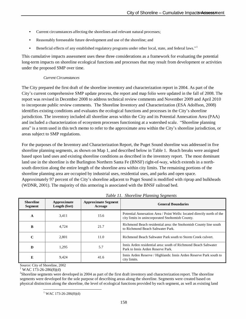
158
City of Shoreline – Cumulative ImpactsAttAacshsmeesnst mA ent
• Current circumstances affecting the shorelines and relevant natural processes;
• Reasonably foreseeable future development and use of the shoreline; and
• Beneficial effects of any established regulatory programs under other local, state, and federal laws.” 1
This cumulative impacts assessment uses these three considerations as a framework for evaluating the potential
long-term impacts on shoreline ecological functions and processes that may result from development or activities
under the proposed SMP over time.
Current Circumstances
The City prepared the first draft of the shoreline inventory and characterization report in 2004. As part of the
City‟s current comprehensive SMP update process, the report and map folio were updated in the fall of 2008. The
report was revised in December 2008 to address technical review comments and November 2009 and April 2010
to incorporate public review comments. The Shoreline Inventory and Characterization (ESA Adolfson, 2008)
identifies existing conditions and evaluates the ecological functions and processes in the City‟s shoreline
jurisdiction. The inventory included all shoreline areas within the City and its Potential Annexation Area (PAA)
and included a characterization of ecosystem processes functioning at a watershed scale. “Shoreline planning
area” is a term used in this tech memo to refer to the approximate area within the City‟s shoreline jurisdiction, or
areas subject to SMP regulations.
For the purposes of the Inventory and Characterization Report, the Puget Sound shoreline was addressed in five
shoreline planning segments, as shown on Map 1, and described below in Table 1. Reach breaks were assigned
based upon land uses and existing shoreline conditions as described in the inventory report. The most dominant
land use in the shoreline is the Burlington Northern Santa Fe (BNSF) right-of-way, which extends in a north-
south direction along the entire length of the shoreline area within city limits. The remaining portions of the
shoreline planning area are occupied by industrial uses, residential uses, and parks and open space.
Approximately 97 percent of the City‟s shoreline adjacent to Puget Sound is modified with riprap and bulkheads
(WDNR, 2001). The majority of this armoring is associated with the BNSF railroad bed.
Table 11. Shoreline Planning Segments
Shoreline Segment
Approximate Length (feet)
Approximate Segment Acreage
General Boundaries
A
3,411
15.6
Potential Annexation Area / Point Wells: located directly north of the city limits in unincorporated Snohomish County.
B
4,724
21.7 Richmond Beach residential area: the Snohomish County line south
to Richmond Beach Saltwater Park.
C
2,801
11.0
Richmond Beach Saltwater Park south to Storm Creek culvert.
D
1,295
5.7 Innis Arden residential area: south of Richmond Beach Saltwater
Park to Innis Arden Reserve Park.
E
9,424
41.6 Innis Arden Reserve / Highlands: Innis Arden Reserve Park south to city limits.
Source: City of Shoreline, 2002 1 WAC 173-26-286(8)(d) 2Shoreline segments were developed in 2004 as part of the first draft inventory and characterization report. The shoreline
segments were developed for the sole purpose of describing areas along the shoreline. Segments were created based on
physical distinction along the shoreline, the level of ecological functions provided by each segment, as well as existing land
1 WAC 173-26-286(8)(d)
159
City of Shoreline – Cumulative ImpactsAttAacshsmeesnst mA ent
uses and zoning. Shoreline segments should not be confused with shoreline environment designations. Shoreline environment
designations were developed after the inventory and characterization report was completed. Environment designations are
analogous to zoning designations and are incorporated directly into the City‟s Draft Shoreline Master Program. In the City‟s
Draft Shoreline Master Program, there are 6 environment designations and each one has a distinct purpose statement and
specific uses and modifications that are permitted, conditionally permitted or prohibited. Regulations specific to each
environment designation are included as well.
The following sections further summarize baseline conditions, or current circumstances, with regard to the City‟s Puget Sound
shoreline.
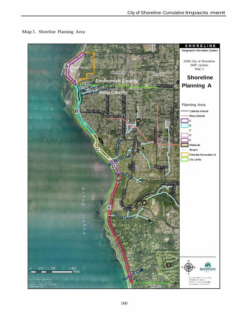
160
City of Shoreline- Cumulative lmpacts ment
Map 1. Shoreline Planning Area
2008 City of Shoreline
SMP Update
Map 1
Shoreline
Planning A
Planning Area
No warranti es or any sort, including accuracy,
fitness. or merchantability,
accompany ttlis prOduct
161
City of Shoreline – Cumulative ImpactsAttAacshsmeesnst mA ent
Physical and Coastal Processes
Puget Sound beach morphology and composition is dependent upon three main influences: wave energy,
sediment sources, and relative position of the beach within a littoral cell. Wave energy is controlled by fetch,
the open water over which winds blow without any interference from land. Wind-generated wave action
gradually erodes beaches and the toe of coastal bluffs, leading to landslides. These coastal bluffs are the primary
source of sediment for most Puget Sound beaches. In the city, coastal bluffs are separated from the shoreline by
the BNSF Railway, thus completely removing bluff sediment sources. Although riparian vegetation is located
along portions of the shoreline, the shore modifications associated with the BNSF Railway and BNSF
maintenance activities prevent recruitment of large woody debris to the shoreline. These shore modifications
also preclude net shore-drift along the Puget Sound. A small amount of sediment is delivered by fluvial sources
(streams) in the city, although this process is also impaired by culvert systems and the BNSF Railway.
Construction of the railroad buried much of upper foreshore beach, thereby locking up coarse sand and gravel in
the littoral system. This limits or precludes longshore transport of sediment.
Shoreline Modifications
Approximately 97 percent of the City‟s shoreline adjacent to Puget Sound is modified with riprap and bulkheads
(WDNR, 2001). The majority of this armoring is associated with the BNSF railroad bed. As a result, sediment
delivery from upslope sources is limited to several streams that deliver sediment via culverts under the railroad
ROW. Forage fish spawning still occurs at these limited points of sediment input.
There are no docks, piers, or over-water structures along Puget Sound within the City limits. However, within
the PAA, Point Wells contains a large industrial dock used for both import and export of materials to and from
the facility. Construction of the King County Wastewater Treatment Brightwater Conveyance pipeline and
marine outfall project is currently underway at the Point Wells site.
Clearing of riparian vegetation along the marine shoreline for the BNSF Railway construction and maintenance,
residential uses, bulkheads and other shoreline armoring has resulted in a lack of large woody and organic
debris available for recruitment to the marine system. The lack of debris in turn affects the stability of the
beaches as the presence of beach logs and debris can reduce erosion by dissipating wave energy and trapping
sediment. Large woody debris also provides thermoregulation of sediment for spawning forage fish and detritus
recruitment.
Habitat and Species
The Puget Sound nearshore environment is a highly productive zone that provides habitat for a variety of
aquatic and terrestrial species. The “nearshore” is generally considered to be an area extending from a point
underwater where light penetrates to the bottom (the “littoral zone”), across the intertidal zone and beach, up to
the top of marine bluffs. Important documented features of the nearshore that provide habitat include:
• Banks, bluffs, beaches and backshore (sediment sources, substrate, and storm berms);
• Tidal flats (intertidal or shallow subtidal areas used by juvenile salmonids, shorebirds, and shellfish);
• Eelgrass meadows and kelp forests (feeding and rearing habitat for wide variety of marine organisms); and
• Stream mouths and pocket estuaries (fish and wildlife corridors and source of fluvial sediment to nearshore).
Within the City‟s shoreline planning area, there are seven streams that feed into the Puget Sound. Segment A
has an unnamed tributary of Barnacle Creek that is located east of the BNSF railroad and south of Point Wells.
It travels south where it connects to Barnacle Creek in Segment B. Lost Creek is located north of the city limits
162
City of Shoreline – Cumulative ImpactsAttAacshsmeesnst mA ent
in the Town of Woodway. It flows southwest both in piped and open water sections towards Puget Sound. It
appears to connect to Barnacle Creek before discharging into Puget Sound in Segment B. Barnacle Creek is
formed by the confluence of Upper Barnacle Creek and Lower Barnacle Creek and discharges to Puget Sound
in Segment B. A palustrine forested wetland, less than one acre in size, is associated with Barnacle Creek.
Storm Creek and Blue Heron Creek discharge to Puget Sound in Segment D. Coyote Creek, Boeing Creek, and
Highlands Creek discharge to Puget Sound in Segment E. A scrub/shrub wetland is associated with Coyote
Creek.
Aquatic and terrestrial species found in or near the City of Shoreline that utilize the nearshore or deep waters of
Puget Sound include:
• Shellfish (clams, mussels, and crab);
• Salmonids (including listed species such as Chinook and bull trout);
• Forage fish (surf smelt, sand lance, and Pacific herring); and
• Shorebirds and waterbirds.
Land Use and Public Access
The BNSF Railway right-of-way (ROW) extends in a north-south direction along the entire length of the City‟s
shoreline planning area. It is the most dominant land use in the shoreline, occupying 48 percent of the total
shoreline planning area. Residential development occupies approximately 19 percent of the total shoreline
planning area while Point Wells (in the PAA), the only industrial property located along the Puget Sound
shoreline, occupies approximately 20 percent. The remaining land uses are parks and open space (8 percent) and
vacant properties (2 percent).
Public access opportunity is provided at Richmond Beach Saltwater Park in Segment C. It is a regional 40-acre
park that provides active and passive uses including picnic areas, shelter buildings, a playground area,
observation areas, trails, and Puget Sound shoreline access. Kayu Kayu Ac Park, in Segment B, is a 2-acre city
park recently opened near Richmond Beach Pump Station; this provides shoreline views. Innis Arden Reserve is
a 23-acre natural open space area/greenway passive-use park located in Segment E along the bluffs overlooking
Puget Sound. Hiking/walking trails represent the main activity of this passive-use reserve. Although trails
eventually lead to the shoreline, the public has to cross the BNSF railroad tracks and riprap to reach the Puget
Sound shoreline. Blue Heron Reserve (Segment C) and Coyote Reserve (Segment D) are privately owned tracts
that are associated with Blue Heron Creek and Coyote Creek, respectively. No public shoreline access is
permitted along these tracts. Boeing Creek Reserve is a private 4-acre natural area associated with Boeing
Creek located along the Puget Sound shoreline in Segment E. It is preserved as private open space. No public
shoreline access is permitted from this reserve along the bluff.
163
City of Shoreline – Cumulative ImpactsAttAacshsmeesnst mA ent
Reasonably Foreseeable Future Development and Use
Substantial development or redevelopment within the City‟s shoreline planning area is unlikely. However,
limited development may occur on vacant parcels, residential parcels with potential for redevelopment and
residential parcels that can be subdivided. Such parcels occupy 16.5 acres (17 percent) of the City‟s shoreline
planning area. A majority of these properties is located in Segments B and E and is discussed in more detail
below. Houses on existing single-family lots are also expected to grow larger through additions up to the
maximum allowed building envelope under the zoning, SMP and CAO regulations and contingent upon
receiving required City permit approvals. However, existing residential development along 27th
Avenue NW are
constrained by zoning and CAO regulations, making expansion of existing building footprints less likely.
Point Wells is the only commercial property that may have a major redevelopment. It is unknown if the
redevelopment would take place under Snohomish County‟s, Woodway‟s or Shoreline‟s jurisdiction.
There are several factors which will inhibit major new development along the Puget Sound shoreline. One is the
BNSF Railway which occupies 48 percent of the city‟s shoreline planning area, extending in a north-south
direction along the entire length of the shoreline. This limits development potential because vehicular access
across the BNSF tracks is limited. The City has received no indication that BNSF would sell their ROW
property or provide new road crossings of the tracks. A second factor that contributes to limiting development is
steep slopes and landslide hazard areas located throughout portions of Segments B - E.
Vacant Parcels
In order to evaluate the potential for shoreline development in the reasonably foreseeable future, King County
Assessor records (2007) were examined to identify parcels classified as “vacant” that are located within the
shoreline jurisdiction. While the term “vacant” may not always accurately reflect current conditions (such as
protected open space, steep slopes, wetlands, or other lands with development restrictions), the classification
generally indicates that no structural improvements have been made or assessed for taxes on the property.
Depending on the land use and zoning designations, these areas may be subject to new development in the
future.
Vacant parcels occupy only 2 percent of the City‟s shoreline planning area (including the PAA) and account for
a total of 1.5 acres. The vacant properties are located in Segments B and E. This percentage value does not
include BNSF property or City-owned right-of-way. Development of vacant lands is therefore not anticipated
to cause a significant change in the existing condition of the City‟s shorelines.
Redevelopment Potential
In addition to the potential for development on vacant parcels, there is potential for underutilized lots along the
Puget Sound to redevelop. For the purposes of this Cumulative Impacts Assessment, we based redevelopment
potential on the assumption that parcels in a single-family zone (R-4 and R-6) with a land value assessed by
King County at 50% or higher than building value are likely to redevelop some time in the future. Based on this
assumption, 22 parcels of the City‟s shoreline planning area have the potential to redevelop. All 22 parcels are
located in Segment B and account for a total of 3 acres or 3 percent of the City‟s shoreline planning area.
The only major commercial property that is likely to redevelop is Point Wells. Snohomish County, in response to
a petition from the Point Wells property owner, changed the Comprehensive Plan designation and zoning
designation of Point Wells from Urban Industrial to Urban Center. Urban Center allows for a mix of high-
density residential, office and retail uses. The City of Shoreline has a Comprehensive Plan designation of Mixed
Use, which is intended to encourage the development of pedestrian oriented places, with architectural interest,
164
City of Shoreline – Cumulative ImpactsAttAacshsmeesnst mA ent
that integrate a wide variety of retail, office and service uses with residential uses. It seems likely that the
property would redevelop based on the recent changes to the County‟s designations. However, the property
would need to be remediated to address soil and groundwater contamination. Vehicular access to the property is
severly limited and poses considerable challenges to developing high-intensity land uses.
Subdivision Potential
A third approach to determining potential development along the Puget Sound was to determine whether there
are residential parcels that have the potential for subdividing. We based subdivision potential on the assumption
that parcels in single-family zone (R-4 and R-6) that are at least 2 times larger than the minimum lot size allowed
in the zone are likely to subdivide sometime in the future. Fifty-three parcels have the potential to subdivide, 9
of which are located in Segment B, 5 in Segment C, 12 in Segment D, and 27 in Segment E. The total acreage
amount within the City‟s shoreline planning area is 12 acres or 12 percent of the City‟s shoreline planning area.
Changes to Shoreline Environment Designations
SMPs establish a system of “shoreline environment designations” that provide a uniform basis for applying
policies and use regulations within distinctly different shoreline areas. Shoreline environment designations
function like zoning overlays. That is, they do not replace the underlying zoning regulations for density, setbacks,
etc., but they may impose additional development standards or regulations for portions of property within the
shoreline jurisdiction. Generally, environment designations are based on existing and planned development
patterns, biological and physical capabilities and limitations of the shoreline, and a community‟s vision or
objectives for its future development.
When the City of Shoreline incorporated in 1995, it adopted regulations outlined in Title 25 (Shoreline
Management Plan) of the King County Code as the interim shoreline management code (Shoreline Municipal
Code [SMC] 16.10). Three shoreline environment designations are established in the King County Shoreline
Management Master Program and were applied to the City‟s shorelines:
1. Urban,
2. Rural, and
3. Conservancy
Since the City‟s Potential Annexation Area is located in Snohomish County, the shoreline environment
designation that currently applies to Point Wells is Urban.
The proposed SMP environment designations per the October 2010 Draft SMP include the following:
• “Point Wells Urban” environment to accommodate higher density uses while protecting existing
ecological functions and restoring ecological functions that have been degraded.
• “Point Wells Urban Conservancy” environment to provide a specific designation unique to an industrial
use or mix of uses that can be developed.
• “Urban Conservancy” environment to protect and restore relatively undeveloped or unaltered shorelines
to maintain open space, floodplains or habitat, while allowing a variety of compatible uses.
• “Waterfront Residential” environment to distinguish between the residential portions of the coastline
where natural and manmade features preclude building within the shoreline jurisdiction and the section
165
City of Shoreline – Cumulative ImpactsAttAacshsmeesnst mA ent
along 27th Avenue NW where residential structures lie westerly of the BNSF railroad ROW and directly
abut the Puget Sound.
• “Shoreline Residential” environment to accommodate residential development and accessory structures
that are consistent with the City‟s Shoreline Master Program.
• “Aquatic” environment to protect, restore, and manage the unique characteristics and resources of the
areas waterward of the ordinary high-water mark.
The proposed environment designations are consistent with both the existing land use pattern and Comprehensive
Plan future land use designations.
Changes to Development Standards and Use Regulations
The proposed SMP offers several changes to the development regulations that encourage shoreline conservation
and prohibit activities that would cause adverse impact to shoreline functions and processes. Many of these
changes deal with shoreline modification such as bulkheads and riprap revetments along much of the City‟s
shoreline. These shoreline modifications have significantly altered the natural net-shore drift direction and the
availability and local distribution of beach sediment. Other changes related to specific uses in the shoreline are
also designed to protect shoreline ecological functions and processes, while continuing to allow legal uses, public
access, and appropriate development.
This section describes in general terms how the proposed SMP protects shoreline functions and processes to
achieve no net loss. Appendix A cites specific provisions in the proposed SMP (City of Shoreline, 2010) and
Draft Restoration Plan (ESA Adolfson, 2009) that serve to protect and enhance shoreline ecological functions. For
each proposed shoreline environment designation, Appendix A provides the current conditions, likely future
changes, potentially impacted shoreline processes and functions, effects of proposed SMP provisions, existing
regulatory controls, and an assessment of expected future performance.
The proposed SMP offers several changes to the development regulations that encourage shoreline conservation
and prohibit activities that would cause adverse impact to shoreline functions and processes. One of the most
significant changes is the application of a vegetation conservation area on the Puget Sound and accompanying
requirements for vegetation enhancement. Most of the City‟s Puget Sound shoreline was developed under King
County development standards prior to city incorporation. Puget Sound is not considered a critical area under the
City‟s Critical Areas Ordinance (Shoreline Municipal Code Chapter 20.80) and did not have buffer standards or
requirements. Current King County standards require a 25-foot setback from the ordinary high water mark
(OHWM) for single-family development in Urban and Rural environments and a 50-foot setback from the
OHWM in the Conservancy environment. The proposed SMP standards and regulations would establish a 20-150
foot vegetation conservation area. Only 9 percent of the total linear length of the City‟s Puget Sound shoreline
would be regulated with a 20-foot vegetation conservation area. The northern portion of the PAA would be
regulated with a 50-foot vegetation conservation area (with accompanying restoration). The remainder of the
City‟s shoreline will be classified as Shoreline Residential and Urban Conservancy with a 115 to 150 foot
vegetation conservation area. Extensive land disturbing activities that require a permit are required to implement a
plan that involves revegetation (See 20.230.200.B.4 of Draft SMP).
Regulation of shoreline modifications, such as bulkheads and riprap revetments, will be updated as well. New
development and land divisions would be required to be located and designed to avoid the need for shoreline
stabilization measures. Further, the conservation of shoreline vegetation has been emphasized in the new
shoreline regulations for the City to further stabilize shorelands and increase habitat functions. Updated policies
166
City of Shoreline – Cumulative ImpactsAttAacshsmeesnst mA ent
and development standards establish a preference for alternative “soft-shore” erosion control or stabilization
designs. In most cases, project applicants would be required to demonstrate why a “soft-shore” design would not
provide adequate protection of existing development. Over time these changes will likely have a net beneficial
effect on shoreline ecological processes as properties are redeveloped.
The proposed changes to development standards and use regulations are, in general, more protective than the
existing SMP. New development would be required to meet standards contained in the CAO and meet the policy
intent and development standards of the SMP. As redevelopment occurs, the policies and regulations in the SMP
require that development be located and designed in a manner that avoids impacts to ecological functions and/or
enhances functions where they have been degraded. For example, the vegetation conservation measures may
require that, as part of a redevelopment proposal, non-native or invasive species be replaced with native
vegetation.
Changes to the Treatment of Non-conforming Uses
Much of the development in the City of Shoreline along the Puget Sound predates incorporation of the City in
1995. Several properties and developments in the City‟s shoreline do not conform to current zoning or SMP
regulations. The proposed SMP includes regulations that are designed to increase protection of shoreline
resources over time by prohibiting redevelopment that would result in a greater degree of non-conformity for
existing development.
Under the proposed SMP the following standards apply:
• Structures that were legally established and are used for a conforming use, but which now do not conform
with regard to setbacks, buffers or yards, area, bulk, height, or density may continue as long as they do
not increase the extent of non-conformity by further encroaching upon or extending into areas where
construction or use would not be allowed for new development or uses.
• Uses and developments that were legally established and are nonconforming with regard to the use
regulations of the SMP may continue as legal nonconforming uses. Such uses cannot be enlarged or
expanded without an approved conditional use permit, except that nonconforming single-family
residences that are located landward of the OHWM may be enlarged or expanded in conformance with
applicable bulk and dimensional standards by the addition of space to the main structure or by the
addition of normal appurtenances.
• Structures that are or have been used for non-conforming uses may be used for a different non-
conforming use but only upon the approval of a Shoreline Conditional Use permit.
• If a non-conforming use is discontinued or abandoned for twelve (12) consecutive months the non-
conforming rights expire and any subsequent use must comply with the SMP.
Restoration Planning
The draft SMP Restoration Plan (ESA Adolfson, 2009) represents the shoreline restoration element of the SMP.
The plan identifies opportunities for restoration activities or efforts that include programmatic opportunities (e.g.,
investigate a beach nourishment program; reduce overwater structures; protect remaining riparian marine
vegetation), site-specific opportunities (such as replacing Boeing Creek culvert with a larger box culvert),
regional plans and policies for Puget Sound restoration, and potential funding and partnership opportunities. The
SMP‟s restoration planning is focused on areas where shoreline functions have been degraded by past
development activities. The areas with impaired functions were identified in the City‟s Shoreline Inventory and
Characterization. Recognizing that much impairment to shoreline processes and functions are the result of the
167
City of Shoreline – Cumulative ImpactsAttAacshsmeesnst mA ent
railroad tracks along the coast and armoring associated with single-family residences along 27th
Avenue NW
(both of which are assumed to remain), the implementation of the Restoration Plan will improve shoreline
ecological functions incrementally over time.
Beneficial Effects of Any Established Regulatory Programs Under Other Local, State, and Federal Laws
A variety of other regulatory programs, plans, and policies work in concert with the City‟s SMP to manage
shoreline resources and regulate development near the shoreline. The City‟s Comprehensive Plan establishes the
general land use pattern and vision of growth and development the City has adopted for areas both inside and
outside the shoreline jurisdiction. Various sections of the Shoreline Municipal Code (SMC) are relevant to
shoreline management, such as zoning (SMC Chapter 20.40), stormwater management (SMC Chapter 13.10), and
flood damage prevention (SMC 16.12). The City‟s development standards and use regulations for
environmentally critical areas (SMC Chapter 20.80) are particularly relevant to the City‟s SMP. Designated
environmentally critical areas are found throughout the City‟s shoreline jurisdiction, including geologic hazard
areas, wetlands, flood hazard areas, and streams areas. Standards and regulations in the critical areas regulations
have been adopted by reference in the proposed SMP.
A number of state and federal agencies may have jurisdiction over land or natural elements in the City‟s
shoreline jurisdiction. Local development proposals most commonly trigger requirements for state or federal
permits when they impact wetlands or streams; potentially affect fish and wildlife listed under the federal
Endangered Species Act (ESA); result in over one acre of clearing and grading; or affect the floodplain or
floodway. As with local requirements, state and federal regulations may apply throughout the city, but
regulated resources are common within the City‟s shoreline jurisdiction. The state and federal regulations
affecting shoreline-related resources include, but are not limited to:
Endangered Species Act (ESA): The federal ESA addresses the protection and recovery of federally listed
species. The ESA is jointly administered by the National Oceanic and Atmospheric Administration (NOAA)
Fisheries (formerly referred to as the National Marine Fisheries Service), and the United States Fish and
Wildlife Service (USFWS).
Clean Water Act (CWA): The federal CWA requires states to set standards for the protection of water quality for
various parameters, and it regulates excavation and dredging in waters of the U.S., including wetlands. Certain
activities (i.e., fill or dredge) affecting wetlands in the City‟s shoreline jurisdiction or work waterward of the
ordinary high water mark in the Puget Sound or streams may require a permit from the U.S. Army Corps of
Engineers and/or Washington State Department of Ecology under Section 404 and Section 401 of the CWA,
respectively.
Hydraulic Project Approval (HPA): The Washington Department of Fish and Wildlife (WDFW) regulates
activities that use, divert, obstruct, or change the natural flow of the beds or banks of waters of the state and
may affect fish habitat. Projects in the shoreline jurisdiction requiring construction below the ordinary high
water mark of Puget Sound or streams in the city could require an HPA from WDFW. Projects creating new
impervious surface that could substantially increase stormwater runoff to waters of the state may also require
approval.
National Pollutant Discharge Elimination System (NPDES): Ecology regulates activities that result in wastewater
discharges to surface water from industrial facilities or municipal wastewater treatment plants. NPDES permits
are also required for stormwater discharges from industrial facilities, construction sites of one or more acres, and
168
City of Shoreline – Cumulative ImpactsAttAacshsmeesnst mA ent
municipal stormwater systems that serve census-defined Urbanized Areas, which include any urbanized areas
with more than 50,000 people and densities greater than 1,000 people per square mile.
Conclusion
This draft cumulative impacts analysis is based upon the Draft Shoreline SMP dated February 2012 (received by
ESA on February 21, 2012). The City of Shoreline‟s Puget Sound coastline is largely developed. There are
nearly no major opportunities for new development within the shoreline jurisdiction in the City limits. Therefore,
change within the shoreline will primarily be the result of redevelopment activities with the Point Wells site
expected to be the most extensive. The system of shoreline environment designations and use regulations in the
proposed SMP is consistent with the established land use pattern, as well as the land use vision planned for in the
City‟s comprehensive plan, zoning, and other long-range planning documents. Based on this consistency, it is
unlikely that substantial changes in shoreline land uses will occur within the City limits in the future. However,
should the Point Wells site be annexed into the City of Shoreline, substantial changes in shoreline land use could
occur on this specific site.
The proposed SMP provides a new system of shoreline environment designations that establishes more uniform
management of the City‟s shoreline. The updated development standards and regulation of shoreline
modifications provides more protection for shoreline processes. The updated standards and regulations are more
restrictive of activities that would result in adverse impacts to the shoreline environment. The restoration
planning effort outlined in the proposed SMP provides the City with opportunities to improve or restore
ecological functions that have been impaired as a result of past development activities. In addition, the proposed
SMP is meant to compliment several city, state and federal efforts to protect shoreline functions and values.
The cumulative actions taken over time in accordance with the City of Shoreline‟s proposed SMP are not likely to
result in a net loss of shoreline ecological functions from existing baseline conditions. This conclusion is based
on an assessment of the three factors identified in the Ecology guidelines for evaluating cumulative impacts:
• Current circumstances affecting the shorelines and relevant natural processes;
• Reasonably foreseeable future development and use of the shoreline; and
• Beneficial effects of any established regulatory programs under other local, state, and federal laws.
Changes in subsequent drafts of the SMP may result in a need for revisions to the cumulative impact analysis.
169
City of Shoreline – Cumulative ImpactsAttAacshsmeesnst mA ent
References
City of Shoreline. 2002. City of Shoreline Geographic Information System (GIS) Data.
City of Shoreline. 2012. Shoreline Master Program. February 2012 Draft.
ESA Adolfson. 2009. City of Shoreline, Shoreline Master Program Update, Draft Restoration Plan. Last
Updated April 2010. Prepared for City of Shoreline. Seattle, WA.
ESA Adolfson. 2008. City of Shoreline, Shoreline Inventory and Characterization. Last updated April 2010.
Prepared for City of Shoreline. Seattle, WA.
King County Assessors. 2007. GIS Data. Seattle, WA.
Washington State Department of Natural Resources (WDNR). 2001. Washington State ShoreZone Inventory.
Nearshore Habitat Program, Washington State Department of Natural Resources. Olympia, WA.
170
City of Shoreline – Cumulative ImpactsAttAacshsmeesnst mA ent
This Page Intentionally Blank
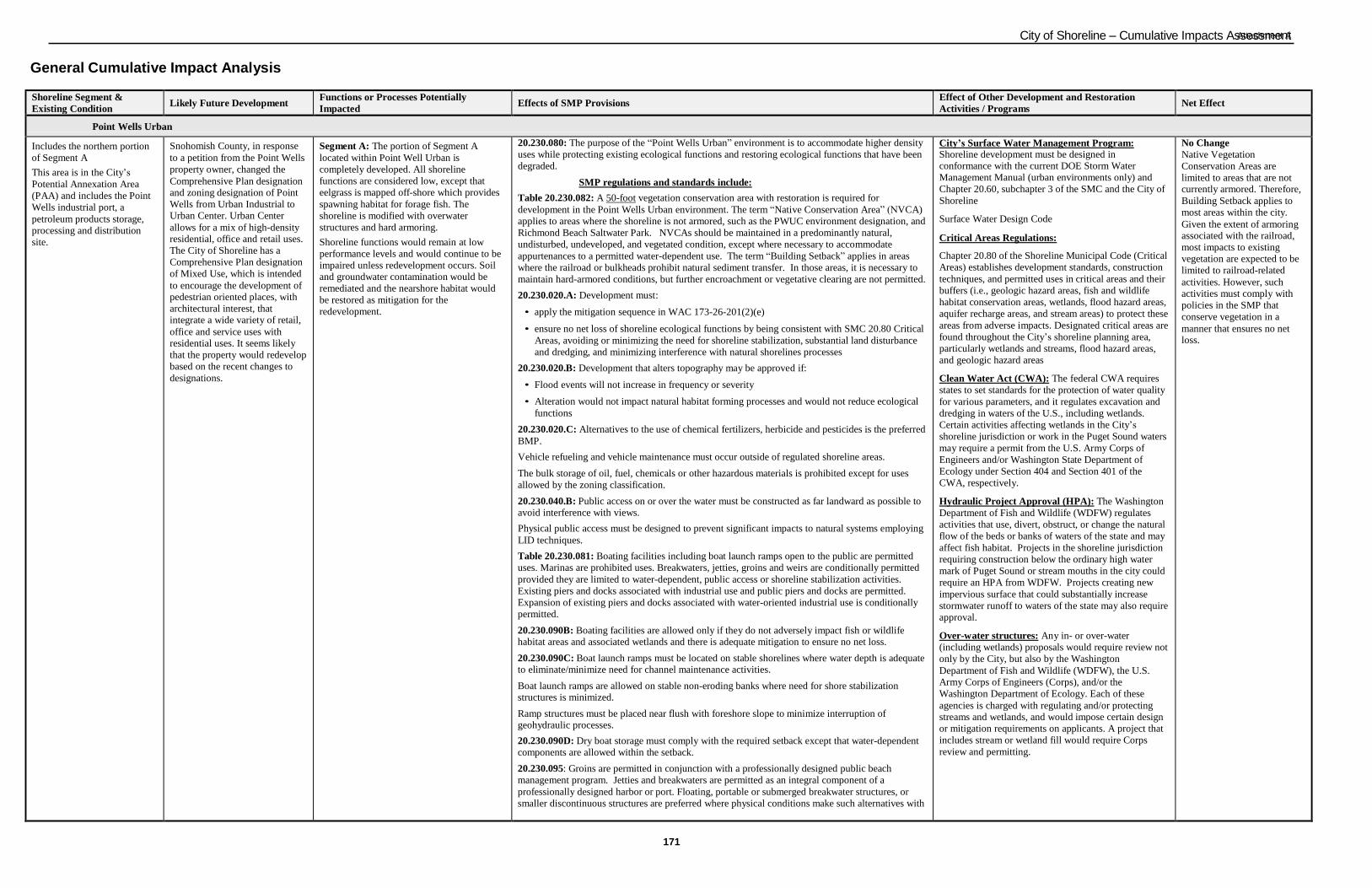
City of Shoreline – Cumulative Impacts AsAstteaschsmmeentnAt
171
General Cumulative Impact Analysis
Shoreline Segment &
Existing Condition Likely Future Development
Functions or Processes Potentially
Impacted Effects of SMP Provisions
Effect of Other Development and Restoration
Activities / Programs Net Effect
Point Wells Urban
Includes the northern portion
of Segment A
This area is in the City‟s
Potential Annexation Area
(PAA) and includes the Point
Wells industrial port, a
petroleum products storage,
processing and distribution
site.
Snohomish County, in response
to a petition from the Point Wells
property owner, changed the
Comprehensive Plan designation and zoning designation of Point
Wells from Urban Industrial to Urban Center. Urban Center
allows for a mix of high-density residential, office and retail uses.
The City of Shoreline has a
Comprehensive Plan designation
of Mixed Use, which is intended
to encourage the development of
pedestrian oriented places, with
architectural interest, that integrate a wide variety of retail,
office and service uses with residential uses. It seems likely
that the property would redevelop
based on the recent changes to
designations.
Segment A: The portion of Segment A
located within Point Well Urban is
completely developed. All shoreline
functions are considered low, except that
eelgrass is mapped off-shore which provides
spawning habitat for forage fish. The
shoreline is modified with overwater
structures and hard armoring.
Shoreline functions would remain at low
performance levels and would continue to be
impaired unless redevelopment occurs. Soil and groundwater contamination would be
remediated and the nearshore habitat would
be restored as mitigation for the
redevelopment.
20.230.080: The purpose of the “Point Wells Urban” environment is to accommodate higher density
uses while protecting existing ecological functions and restoring ecological functions that have been
degraded.
SMP regulations and standards include:
Table 20.230.082: A 50-foot vegetation conservation area with restoration is required for
development in the Point Wells Urban environment. The term “Native Conservation Area” (NVCA)
applies to areas where the shoreline is not armored, such as the PWUC environment designation, and
Richmond Beach Saltwater Park. NVCAs should be maintained in a predominantly natural,
undisturbed, undeveloped, and vegetated condition, except where necessary to accommodate
appurtenances to a permitted water-dependent use. The term “Building Setback” applies in areas
where the railroad or bulkheads prohibit natural sediment transfer. In those areas, it is necessary to
maintain hard-armored conditions, but further encroachment or vegetative clearing are not permitted.
20.230.020.A: Development must:
• apply the mitigation sequence in WAC 173-26-201(2)(e)
• ensure no net loss of shoreline ecological functions by being consistent with SMC 20.80 Critical
Areas, avoiding or minimizing the need for shoreline stabilization, substantial land disturbance
and dredging, and minimizing interference with natural shorelines processes
20.230.020.B: Development that alters topography may be approved if:
• Flood events will not increase in frequency or severity
• Alteration would not impact natural habitat forming processes and would not reduce ecological
functions
20.230.020.C: Alternatives to the use of chemical fertilizers, herbicide and pesticides is the preferred
BMP.
Vehicle refueling and vehicle maintenance must occur outside of regulated shoreline areas.
The bulk storage of oil, fuel, chemicals or other hazardous materials is prohibited except for uses
allowed by the zoning classification.
20.230.040.B: Public access on or over the water must be constructed as far landward as possible to avoid interference with views.
Physical public access must be designed to prevent significant impacts to natural systems employing
LID techniques.
Table 20.230.081: Boating facilities including boat launch ramps open to the public are permitted
uses. Marinas are prohibited uses. Breakwaters, jetties, groins and weirs are conditionally permitted
provided they are limited to water-dependent, public access or shoreline stabilization activities.
Existing piers and docks associated with industrial use and public piers and docks are permitted.
Expansion of existing piers and docks associated with water-oriented industrial use is conditionally
permitted.
20.230.090B: Boating facilities are allowed only if they do not adversely impact fish or wildlife habitat areas and associated wetlands and there is adequate mitigation to ensure no net loss.
20.230.090C: Boat launch ramps must be located on stable shorelines where water depth is adequate to eliminate/minimize need for channel maintenance activities.
Boat launch ramps are allowed on stable non-eroding banks where need for shore stabilization structures is minimized.
Ramp structures must be placed near flush with foreshore slope to minimize interruption of geohydraulic processes.
20.230.090D: Dry boat storage must comply with the required setback except that water-dependent
components are allowed within the setback.
20.230.095: Groins are permitted in conjunction with a professionally designed public beach
management program. Jetties and breakwaters are permitted as an integral component of a
professionally designed harbor or port. Floating, portable or submerged breakwater structures, or
smaller discontinuous structures are preferred where physical conditions make such alternatives with
City’s Surface Water Management Program:
Shoreline development must be designed in conformance with the current DOE Storm Water
Management Manual (urban environments only) and
Chapter 20.60, subchapter 3 of the SMC and the City of
Shoreline
Surface Water Design Code
Critical Areas Regulations:
Chapter 20.80 of the Shoreline Municipal Code (Critical
Areas) establishes development standards, construction
techniques, and permitted uses in critical areas and their
buffers (i.e., geologic hazard areas, fish and wildlife
habitat conservation areas, wetlands, flood hazard areas,
aquifer recharge areas, and stream areas) to protect these
areas from adverse impacts. Designated critical areas are
found throughout the City‟s shoreline planning area,
particularly wetlands and streams, flood hazard areas,
and geologic hazard areas
Clean Water Act (CWA): The federal CWA requires
states to set standards for the protection of water quality
for various parameters, and it regulates excavation and
dredging in waters of the U.S., including wetlands.
Certain activities affecting wetlands in the City‟s
shoreline jurisdiction or work in the Puget Sound waters
may require a permit from the U.S. Army Corps of
Engineers and/or Washington State Department of
Ecology under Section 404 and Section 401 of the
CWA, respectively.
Hydraulic Project Approval (HPA): The Washington
Department of Fish and Wildlife (WDFW) regulates
activities that use, divert, obstruct, or change the natural
flow of the beds or banks of waters of the state and may
affect fish habitat. Projects in the shoreline jurisdiction
requiring construction below the ordinary high water
mark of Puget Sound or stream mouths in the city could
require an HPA from WDFW. Projects creating new
impervious surface that could substantially increase
stormwater runoff to waters of the state may also require
approval.
Over-water structures: Any in- or over-water
(including wetlands) proposals would require review not
only by the City, but also by the Washington
Department of Fish and Wildlife (WDFW), the U.S.
Army Corps of Engineers (Corps), and/or the
Washington Department of Ecology. Each of these
agencies is charged with regulating and/or protecting streams and wetlands, and would impose certain design
or mitigation requirements on applicants. A project that
includes stream or wetland fill would require Corps
review and permitting.
No Change
Native Vegetation
Conservation Areas are
limited to areas that are not currently armored. Therefore,
Building Setback applies to
most areas within the city.
Given the extent of armoring associated with the railroad,
most impacts to existing vegetation are expected to be
limited to railroad-related
activities. However, such
activities must comply with
policies in the SMP that
conserve vegetation in a
manner that ensures no net loss.
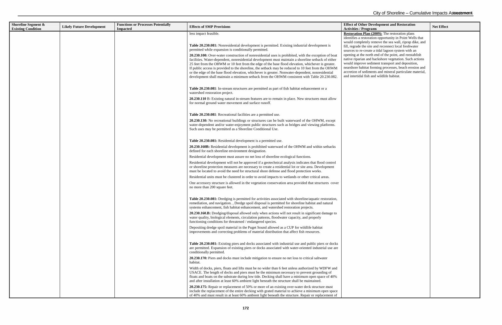
City of Shoreline – Cumulative Impacts AsAstteaschsmmeentnAt
172
Shoreline Segment &
Existing Condition
Likely Future Development Functions or Processes Potentially
Impacted
Effects of SMP Provisions Effect of Other Development and Restoration
Activities / Programs
Net Effect
less impact feasible.
Table 20.230.081: Nonresidential development is permitted. Existing industrial development is
permitted while expansion is conditionally permitted.
20.230.100: Over-water construction of nonresidential uses is prohibited, with the exception of boat
facilities. Water-dependent, nonresidential development must maintain a shoreline setback of either
25 feet from the OHWM or 10 feet from the edge of the base flood elevation, whichever is greater. If public access is provided to the shoreline, the setback may be reduced to 10 feet from the OHWM
or the edge of the base flood elevation, whichever is greater. Nonwater-dependent, nonresidential
development shall maintain a minimum setback from the OHWM consistent with Table 20.230.082.
Table 20.230.081: In-stream structures are permitted as part of fish habitat enhancement or a
watershed restoration project.
20.230.110 B: Existing natural in-stream features are to remain in place. New structures must allow for normal ground water movement and surface runoff.
Table 20.230.081: Recreational facilities are a permitted use.
20.230.130: No recreational buildings or structures can be built waterward of the OHWM, except
water-dependent and/or water-enjoyment public structures such as bridges and viewing platforms.
Such uses may be permitted as a Shoreline Conditional Use.
Table 20.230.081: Residential development is a permitted use.
20.230.160B: Residential development is prohibited waterward of the OHWM and within setbacks
defined for each shoreline environment designation.
Residential development must assure no net loss of shoreline ecological functions.
Residential development will not be approved if a geotechnical analysis indicates that flood control
or shoreline protection measures are necessary to create a residential lot or site area. Development
must be located to avoid the need for structural shore defense and flood protection works.
Residential units must be clustered in order to avoid impacts to wetlands or other critical areas.
One accessory structure is allowed in the vegetation conservation area provided that structures cover
no more than 200 square feet.
Table 20.230.081: Dredging is permitted for activities associated with shoreline/aquatic restoration,
remediation, and navigation. , Dredge spoil disposal is permitted for shoreline habitat and natural
systems enhancement, fish habitat enhancement, and watershed restoration projects.
20.230.160.B: Dredging/disposal allowed only when actions will not result in significant damage to
water quality, biological elements, circulation patterns, floodwater capacity, and properly
functioning conditions for threatened / endangered species.
Depositing dredge spoil material in the Puget Sound allowed as a CUP for wildlife habitat
improvements and correcting problems of material distribution that affect fish resources.
Table 20.230.081: Existing piers and docks associated with industrial use and public piers or docks
are permitted. Expansion of existing piers or docks associated with water-oriented industrial use are
conditionally permitted.
20.230.170: Piers and docks must include mitigation to ensure no net loss to critical saltwater habitat.
Width of docks, piers, floats and lifts must be no wider than 6 feet unless authorized by WDFW and USACE. The length of docks and piers must be the minimum necessary to prevent grounding of floats and boats on the substrate during low tide. Decking shall have a minimum open space of 40%
and after installation at least 60% ambient light beneath the structure shall be maintained.
20.230.175: Repair or replacement of 50% or more of an existing over-water deck structure must include the replacement of the entire decking with grated material to achieve a minimum open space
of 40% and must result in at least 60% ambient light beneath the structure. Repair or replacement of
Restoration Plan (2009): The restoration plans
identifies a restoration opportunity in Point Wells that
would completely remove the sea wall, riprap dike, and
fill, regrade the site and reconnect local freshwater
sources to re-create a tidal lagoon system with an
opening at the north end of the point, and reestablish
native riparian and backshore vegetation. Such actions
would improve sediment transport and deposition,
nearshore habitat forming processes, beach erosion and
accretion of sediments and mineral particulate material,
and intertidal fish and wildlife habitat.
City of Shoreline – Cumulative Impacts AsAstteaschsmmeentnAt
173
Shoreline Segment &
Existing Condition
Likely Future Development Functions or Processes Potentially
Impacted
Effects of SMP Provisions Effect of Other Development and Restoration
Activities / Programs
Net Effect
less than 50% of the over-water deck structure must use grated decking in the area to be replaced.
Table 20.230.081: New hard shoreline armoring is conditionally permitted. Soft-shore stabilization
and maintenance of existing is permitted.
20.230.180B: New bulkheads allowed when there is serious erosion threatening an established use or
existing primary use or when they are necessary for the operation and location of a water-oriented
use. A new bulkhead can be constructed to retain landfill in conjunction with a water-dependent use,
bridge/navigational structure, or for a wildlife/fish enhancement project.
Bulkheads must use stable, nonerodable, homogeneous materials such as concrete, wood, and rock
that are consistent with the preservation and protection of ecological habitat.
Table 20.230.081: Land Disturbing activities and landfill are permitted for activities associated with
restoration or remediation, public access improvement, and allowed shoreline development.
Landfilling waterward of the OHWM is conditionally permitted for activities associated with
shoreline/aquatic restoration or remediation.
20.230.200.B: Land disturbing activities limited to minimum necessary for intended development.
Tree and vegetation removal in required Native Vegetation Conservation Areas is prohibited. All
significant trees in the Native Vegetation Conservation Areas shall be designated as protected trees
consistent with existing development code standards (SMC 20.50.340) and removal of hazard trees
is regulated pursuant to SMC 20.50.310(A)(1).
Extensive land clearing that requires a permit must revegetate, irrigate, and establish erosion and
sedimentation control.
20.230.210.B: Landfill is allowed as a CUP for:
• Water-dependent use
• Bridge/utility/navigational structure
Landfill perimeters must be designed with silt curtains, vegetation retaining walls or other methods
to prevent material movement.
Point Wells Urban Conservancy
Includes the southern portion
of Segment A
This area is in the City‟s
Potential Annexation Area
(PAA) and includes the Point
Wells industrial port, a
petroleum products storage,
processing and distribution site.
As described under Point Wells
Urban, the Point Wells property
owner has indicated interest in
redevelopment by petitioning a
change to the Snohomish County
Comprehensive Plan and zoning
designations. However, this
portion of segment A retains its
Urban Industrial designation.
Similar to conditions described under Point
Wells Urban, this property has been
extensively modified. However, due to the
lack of overwater structures, the presence of
Lost Creek, and no hard armoring, some
shoreline functions are present. The shoreline
contains eelgrass meadows and kelp forests,
forage fish spawning area, 31 species of
shellfish, a sand and gravel flat, and habitat
for shorebirds. Lost Creek provides for
pocket estuary habitat.
No change in shoreline functions is expected
unless redevelopment occurs. Soil and
groundwater contamination would be
remediated and the nearshore habitat would
be restored as mitigation for the
redevelopment. A change to a higher land-use
intensity and increased public access would likely disrupt wildlife and shore bird habitat.
20.230.080: The purpose of the “Point Wells Urban Conservancy” environment is to distinguish
between differing levels of potential and existing ecological function within the Point Wells
environment, and regulate uses and public access requirements appropriately.
SMP regulations and standards include:
Table 20.230.082: A 115-foot vegetation conservation area is required for development in the Point
Wells Urban Conservancy environment. The term “Native Conservation Area” (NVCA) applies to
areas where the shoreline is not armored, such as the PWUC environment designation, and
Richmond Beach Saltwater Park. NVCAs should be maintained in a predominantly natural,
undisturbed, undeveloped, and vegetated condition, except where necessary to accommodate
appurtenances to a permitted water-dependent use. The term “Building Setback” applies in areas
where the railroad or bulkheads prohibit natural sediment transfer. In those areas, it is necessary to
maintain hard-armored conditions, but further encroachment or vegetative clearing are not permitted.
The same regulations under 20.230.020, 20.230.030, and 20.230.040 for Point Wells Urban apply to
Point Wells Urban Conservancy as well.
Table 20.230.081: In addition to uses and modifications prohibited in Point Wells Urban, boating
facilities, breakwaters, jetties, groins and weirs, piers and docks, and new hard shoreline armoring,
are also prohibited.
20.230.090-20.230.270:
The regulations for nonresidential development, in-stream structures, recreational facilities,
residential development, dredging, dredge material disposal, land disturbing activities, and
landfilling for Point Wells Urban apply to Point Wells Urban Conservancy as well with the
exception that recreational facilities are limited to low-intensity uses and passive uses and soft-shore
stabilization is limited to those associated with utilities .
Same as items above in Point Wells Urban.
Restoration Plan (2009): The restoration plans
identifies a restoration opportunity in Point Wells that
would enhance the shoreline by removing riprap dike,
eliminate invasive plants, reestablish native riparian and
backshore vegetation, and create a three acre intertidal
lagoon. Similar to the restoration opportunity for Point
Wells Urban, such actions would improve sediment
transport and deposition, nearshore habitat forming
processes, beach erosion and accretion of sediments and
mineral particulate material, and intertidal fish and
wildlife habitat.
No Change
Native Vegetation
Conservation Areas are
limited to areas that are not currently armored. Therefore,
Building Setback applies to
most areas within the city.
Given the extent of armoring associated with the railroad,
most impacts to existing
vegetation are expected to be
limited to railroad-related activities. However, such
activities must comply with
policies in the SMP that
conserve vegetation in a
manner that ensures no net
loss.
City of Shoreline – Cumulative Impacts AsAstteaschsmmeentnAt
174
Shoreline Segment &
Existing Condition
Likely Future Development Functions or Processes Potentially
Impacted
Effects of SMP Provisions Effect of Other Development and Restoration
Activities / Programs
Net Effect
Urban Conservancy
Includes the northern portion
of Segment B, portion of
Segment C that is Richmond
Beach Saltwater Park, and
Segment E.
This area is characterized by
several parks, public and
private greenways, the
Highlands residential
neighborhood, and the
Burlington Northern Santa Fe
(BNSF) railroad right-of-way
(ROW).
Future development would likely
be limited to redevelopment of
existing single-family homes, few
new residences, and park
development. Development is
inhibited by the presence of the
BNSF ROW, landslide hazard
areas, and streams and their
associated greenways.
Shoreline functions within this area are low to moderate, with the following functions
moderately intact:
Northern portion of Segment B has
eelgrass meadows and kelp forests, a sand
flat, forage fish spawning area, and a forested wetland at Barnacle Creek. The
wetland provides some filtering of
pollutants; however, it is narrow and east
of the railroad grade.
Richmond Beach Saltwater Park in
Segment C provides some sediment
transport function, attenuates wave energy
although it is limited due to its length
(alongshore) and narrow width, has some
potential for large woody debris
recruitment, and some vegetation,
although it does not overhang the intertidal
zone. Eelgrass meadows and kelp forests,
forage fish spawning area, and 37 species of shellfish are present.
Segment E contains eelgrass meadows and
kelp forests, a sand flat, and the Boeing
Creek outlet which serves as an important
area for feeding, migration, spawning, and
rearing of forage fish. Although the
shoreline is modified by the BNSF
railroad tracks, riparian vegetation is
prevalent upslope of the tracks throughout
the entire length of Segment E. This
segment is also characterized by landslide
hazard areas and has recently seen
numerous slide activities.
Because no significant new development is
anticipated, new impacts are anticipated to be
limited.
20.230.080: The purpose of the “Urban Conservancy” environment is to protect, restore and manage relatively undeveloped or unaltered shorelines to maintain open space, floodplains or habitat, while
allowing a variety of compatible uses.
SMP regulations and standards include:
Table 20.230.082: A 150-foot or 50-foot from the top of a landslide hazard area, whichever is
greater, vegetation conservation area is required for development in the Urban Conservancy
environment. The term “Native Conservation Area” (NVCA) applies to areas where the shoreline is
not armored, such as the PWUC environment designation, and Richmond Beach Saltwater Park.
NVCAs should be maintained in a predominantly natural, undisturbed, undeveloped, and vegetated
condition, except where necessary to accommodate appurtenances to a permitted water-dependent
use. The term “Building Setback” applies in areas where the railroad or bulkheads prohibit natural
sediment transfer. In those areas, it is necessary to maintain hard-armored conditions, but further
encroachment or vegetative clearing are not permitted.
The same regulations under 20.230.020, 20.230.030 and 20.230.040 for Point Wells Urban apply to
Urban Conservancy as well.
In addition, 20.230.020D requires properties located in the UC designation to retain trees that are 12
inches or more in diameter. Trees determined by a certified arborist to be hazardous or diseased may
be removed. When healthy or non-hazardous trees are removed, each removed tree must be replaced
with at least three (3) six-foot tall trees, one (1) 18-foot tall tree, or one (1) 12-foot plus one (1) six-
foot tall tree. Trees must be of the same species removed, or equivalent native tree species.
Table 20.230.081:In addition to uses and modifications prohibited in Point Wells Urban,
breakwaters, jetties, groins and weirs, nonresidential development, and industrial development are also prohibited.
20.230.090-20.230.270:
The regulations for boat launching ramps, in-stream structures, recreational facilities, residential
development, dredging, dredge material disposal, piers and docks, bulkheads, land disturbing
activities, and landfilling for Point Wells Urban apply to Urban Conservancy as well, with the
exception that only public piers and docks are allowed in Urban Conservancy.
Same as items above in Point Wells Urban.
Restoration Plan (2009): The restoration plan identifies
a restoration opportunity that would replace all stream
culverts with larger box culverts or other fish-friendly
structures to allow fish access during low flows and
allow opportunity for more sediment to reach the
nearshore. Such actions would improve nearshore
habitat forming processes and intertidal fish and wildlife
habitat.
A second restoration opportunity would be to create
tidally influenced wetland or restore wetland habitat on the east side of the BNSF railroad tracks NW of the
pump station. Such actions would improve nearshore
habitat forming processes, intertidal fish and wildlife
habitat, and hydrologic, hyporheic and water quality
functions.
A third restoration opportunity would be to implement
the Richmond Beach Saltwater Park Vegetation Management Plan to remove non-native invasive plants
and reestablish native plant communities within
wetlands east of railroad and on beach area west of
railroad. Such actions would improve freshwater
wetland and intertidal wildlife habitat and stabilize
beach substrates.
A fourth restoration opportunity would be to protect intact wetlands and their associated uplands adjacent to
Puget Sound and develop and implement a vegetation
management plan for the Innis Arden Reserve. Such
actions would improve nearshore habitat forming
processes, hydrologic, hyporheic and water quality
functions, riparian habitat structure and function, and
fish and wildlife habitat.
A fifth restoration opportunity would be to reduce
stormwater flow down steep slopes along Boeing Creek
to stabilize banks and control sediment loading of the
stream and extend recommendations of Vegetation
Management Plan for Boeing Creek Park to include
entire stream corridor downslope to Puget Sound. Such
actions would improve exchange of aquatic organisms,
sediment delivery to nearshore from fluvial sources,
source of detritus and particulate organic matter, riparian
habitat structure and function, freshwater input, and fish
and wildlife habitat.
A sixth restoration opportunity would be to protect
intact uplands and native vegetation communities
adjacent to Puget Sound along Boeing Creek Reserve.
Such actions would improve source of detritus and
particulate organic matter, riparian habitat structure and
function, and fish and wildlife habitat.
No Change Native Vegetation Conservation Areas are
limited to areas that are not
currently armored. Therefore, Building Setback applies to
most areas within the city.
Given the extent of armoring
associated with the railroad, most impacts to existing
vegetation are expected to be
limited to railroad-related
activities. However, such activities must comply with
policies in the SMP that conserve vegetation in a
manner that ensures no net loss.
City of Shoreline – Cumulative Impacts AsAstteaschsmmeentnAt
175
Shoreline Segment &
Existing Condition
Likely Future Development Functions or Processes Potentially
Impacted
Effects of SMP Provisions Effect of Other Development and Restoration
Activities / Programs
Net Effect
Waterfront Residential
Includes the southern portion
of Segment B, where the
Richmond Beach residential
neighborhood is located
waterward of the BNSF ROW.
Future development would likely
be limited to redevelopment of
existing single-family homes and
one or two new residences.
Development is inhibited by
shallow lots and limited vehicular
access. Bulkheads likely to be
maintained and replaced due to
severe weather storms.
Shoreline functions are low in this portion of
the Segment B. The bulkheads, some of which are below the mean high tide level,
interrupt longshore transport of sediment,
increase wave energy, and preclude the use of nearshore habitat for resting and foraging.
Vegetation is limited to ornamental
landscaping, including lawn areas.
Because no significant new
development is anticipated,
new impacts are anticipated to
be limited.
20.230.080: The purpose of the “Waterfront Residential” environment is to distinguish between the
residential portions of the coastline where natural and manmade features preclude building within the shoreline jurisdiction and the section along 27th Avenue NW where residential properties
directly abut the Puget Sound.
SMP regulations and standards include:
Table 20.230.082: A 20-foot vegetation conservation area is required for development in the
Waterfront Residential environment. The term “Native Conservation Area” (NVCA) applies to areas
where the shoreline is not armored, such as the PWUC environment designation, and Richmond
Beach Saltwater Park. NVCAs should be maintained in a predominantly natural, undisturbed,
undeveloped, and vegetated condition, except where necessary to accommodate appurtenances to a
permitted water-dependent use. The term “Building Setback” applies in areas where the railroad or
bulkheads prohibit natural sediment transfer. In those areas, it is necessary to maintain hard-armored
conditions, but further encroachment or vegetative clearing are not permitted.
The same regulations under 20.230.020, 20.230.030 and 20.230.040 for Point Wells Urban apply to
Waterfront Residential as well.
Table 20.230.081: In addition to uses and modifications prohibited in Point Wells Urban,
nonresidential development, industrial development, and breakwaters, jetties, groins and weirs are
prohibited.
20.230.090-20.230.270:
The regulations for boat launching ramps, in-stream structures, recreational facilities, residential
development, dredging, dredge material disposal, piers and docks, bulkheads, land disturbing
activities, and landfilling for Point Wells Urban apply to Waterfront Residential as well, with the
following exceptions:
• only joint-use boat launching ramps and joint-use piers and docks are allowed in Waterfront
Residential; and
• landfill in Waterfront Residential does not have to be limited to activities associated with
restoration or remediation or public access improvement, but must still be associated with
allowed shoreline development per 20.230.210B.
Same as items above in Point Wells Urban.
Restoration Plan (2009): The restoration plans
identifies restoration opportunities that while residences
are present, would protect intertidal area by limiting
additional traditional bulkheads or overwater structures
and reduce impact of shore armoring through
replacement of existing traditional bulkheads with soft-
shore alternatives, except where they are necessary to
protect property from high energy systems. Such actions
would improve sediment transport and deposition,
nearshore habitat forming processes, beach erosion and
accretion of sediments and mineral particulate material,
and intertidal fish and wildlife habitat.
No Change Native Vegetation
Conservation Areas are limited to areas that are not
currently armored. Therefore, Building Setback applies to
most areas within the city.
Given the extent of armoring
associated with the railroad, most impacts to existing
vegetation are expected to be limited to railroad-related
activities. However, such activities must comply with
policies in the SMP that
conserve vegetation in a
manner that ensures no net loss.
Shoreline Residential
Includes the southern portion
of Segment B, where the
Richmond Beach residential
neighborhood is located
landward of the BNSF ROW.
Future development would likely
be limited to redevelopment of
existing single-family homes and
few new residences.
Development is inhibited by the presence of the BNSF ROW.
Shoreline functions are low in this portion of
the segment due to the presence of the BNSF
ROW and limited upland vegetation.
Because no significant new development is
anticipated, new impacts are anticipated to be
limited.
20.230.080: The purpose of the “Shoreline Residential” environment is to accommodate residential
development and accessory structures that are consistent with this Shoreline Master Program.
SMP regulations and standards include:
Table 20.230.082: A 115-foot vegetation conservation area is required for development in the
Shoreline Residential environment. The term “Native Conservation Area” (NVCA) applies to areas
where the shoreline is not armored, such as the PWUC environment designation, and Richmond
Beach Saltwater Park. NVCAs should be maintained in a predominantly natural, undisturbed,
undeveloped, and vegetated condition, except where necessary to accommodate appurtenances to a
permitted water-dependent use. The term “Building Setback” applies in areas where the railroad or
bulkheads prohibit natural sediment transfer. In those areas, it is necessary to maintain hard-armored
conditions, but further encroachment or vegetative clearing are not permitted.
The same regulations under 20.230.020, 20.230.030 and 20.230.040 for Point Wells Urban apply to
Shoreline Residential as well.
Table 20.230.081: In addition to uses and modifications prohibited in Point Wells Urban,
nonresidential development, industrial development, and breakwaters, jetties, groins and weirs are
prohibited.
20.230.090-20.230.270:
The regulations for boat launching ramps, in-stream structures, recreational facilities, residential
development, dredging, dredge material disposal, piers and docks, bulkheads, land disturbing
activities, and landfilling for Point Wells Urban apply to Shoreline Residential as well, with the
following exceptions:
• only joint-use launching ramps and joint-use piers and docks are allowed in Waterfront
Residential; and
• landfill in Shoreline Residential does not have to be limited to activities associated with
restoration or remediation or but must still be associated with allowed shoreline development
Same as items above in Point Wells Urban.
Restoration Plan (2009): The restoration plan identifies
restoration opportunities that would replace all stream
culverts with larger box culverts or other fish-friendly
structures to allow fish access during low flows and
allow opportunity for more sediment to reach the
nearshore. Such actions would improve nearshore
habitat forming processes and intertidal fish and wildlife
habitat.
No Change
Native Vegetation
Conservation Areas are
limited to areas that are not
currently armored. Therefore,
Building Setback applies to
most areas within the city.
Given the extent of armoring
associated with the railroad,
most impacts to existing
vegetation are expected to be limited to railroad-related activities. However, such
activities must comply with
policies in the SMP that
conserve vegetation in a
manner that ensures no net loss.

City of Shoreline – Cumulative Impacts AsAstteaschsmmeentnAt
176
Shoreline Segment &
Existing Condition
Likely Future Development Functions or Processes Potentially
Impacted
Effects of SMP Provisions Effect of Other Development and Restoration
Activities / Programs
Net Effect
per 20.230.210B.
Aquatic
Includes all lands waterward
of the marine ordinary high-
water mark in the City of
Shoreline.
Areas designated Aquatic in
the City of Shoreline are all
areas within the tidal waters
and open waters of the Puget
Sound. The only area that has
overwater structures is in
Segment A, associated with
the Point Wells development.
Hard armoring is expected to be
maintained for the BNSF railroad
ROW and the residential
bulkheads located along
Richmond Beach. New hard
armoring could occur in Segment
A although soft-shore
stabilization methods would
likely be utilized as mitigation for redevelopment.
New overwater structures may
occur at publicly owned
properties, such as Richmond
Beach Saltwater Park or in
Segment A as part of
redevelopment.
Dredging may occur in Segment
A but only as part of shoreline or
aquatic restoration or
remediation.
Existing functions and processes have been
characterized above.
Impacts are anticipated to be limited since no
new significant development is anticipated.
Any impacts would have to be mitigated.
20.230.080: The purpose of the “Aquatic” environment is to protect, restore, and manage the unique
characteristics and resources of the areas waterward of the ordinary high-water mark.
SMP regulations and standards include:
The same provisions under 20.230.020, 20.230.030 and 20.230.040 for Point Wells Urban apply to
Aquatic as well.
Table 20.230.081: Most allowed uses and modifications in this environment must meet the use and
permit limitations of the upland designation. In addition to uses and modifications prohibited in
Point Wells Urban, nonresidential development, industrial development, residential development,
hard shoreline armoring, and land disturbing activities are prohibited.
20.230.090-20.230.270:
The regulations for boating facilities, breakwaters, jetties, groins and weirs, in-stream structures,
recreational facilities, dredging, dredge material disposal, piers and docks and landfilling for Point
Wells Urban apply to Aquatic as well, with the following exceptions:
• recreational facilities are limited to water-dependent and water-enjoyment and are conditionally
permitted;
• landfilling is limited to activities associated with shoreline or aquatic restoration or remediation
and is conditionally permitted; and
• piers and docks are only limited to the extent of the use and permit requirements of the upland
designation.
Table 20.230.081: Transportation facilities (railroads) are allowed.
20.230.250: Bridge abutments and necessary approach fills must be located landward of the OHWM,
except bridge piers may be permitted in a water body as a Shoreline Conditional Use. Landfilling
activities for transportation facilities are prohibited in wetlands and on accretion beaches, except
when all structural and upland alternatives have proven infeasible. Shoreline transportation facilities
shall be located and designed to avoid steep or unstable areas and fit the existing topography in order
to minimize cuts and fills.
Table 20.230.081: Aquaculture is a conditionally permitted use.
20.230.115: Aquaculture is limited to geoduck harvesting within DNR tracts or for recovery of
native aquatic population in accordance with a government and/or tribal approved plan.
Same as items above in Point Wells Urban.
Restoration Plan (2009): The restoration plans
identifies a restoration opportunity in Point Wells
(Segment A) that would remove creosote pilings and in-
water debris. Such actions would improve water and
sediment quality and intertidal fish and wildlife habitat.
A second restoration opportunity would be to protect
forage fish spawning, rearing, migration, and feeding
areas and protect eelgrass beds and kelp beds. Such
actions would improve food web support and intertidal
fish and wildlife habitat.
A third restoration opportunity would be to explore the
potential to restore the connection between feeder bluffs
and nearshore areas. Such actions would improve
sediment delivery to the nearshore.
No Change or Potential Improvement
Substantial development is
currently limited to Segment
A in the aquatic environment.
Any future in-water work
would likely be associated
with the Richmond Beach
Saltwater Park and Point
Wells. Any of these
developments would have to
mitigate impacts to ecological
functions and achieve project-
specific no net loss.
Redevelopment would require
replacement with improved
materials, and compliance
with Critical Areas and Stormwater Regulations,
HPA, and federal CWA.
Improved stormwater
management and bulkhead
removal / improvement
projects would also improve
functions overtime.
Attachment A
177
Appendix C
Chapter 20.80
Critical Areas Sections:
Subchapter 1. Critical Areas – General Provisions
20.80.010 Purpose.
20.80.020 Critical areas maps.
20.80.025 Applicability.
20.80.030 Exemptions.
20.80.040 Partial exemptions.
20.80.045 Relationship to other regulations.
20.80.050 Notice to title.
20.80.060 Permanent field marking.
20.80.070 Alteration of critical areas.
20.80.080 Alteration or development of critical areas – Standards and criteria.
20.80.085 Pesticides, herbicides and fertilizers on City-owned property.
20.80.090 Buffer areas.
20.80.100 Classification and rating of critical areas.
20.80.110 Critical areas reports required.
Subchapter 2. Geologic Hazard Areas
20.80.210 Designation and purpose. 20.80.220 Classification.
20.80.230 Required buffer areas.
20.80.240 Alteration.
20.80.250 Mitigation performance standards and requirements.
Subchapter 3. Fish and Wildlife Habitat Conservation Areas
20.80.260 Designation and purpose. 20.80.270 Classification.
20.80.280 Required buffer areas.
20.80.290 Alteration.
20.80.300 Mitigation performance standards and requirements.
20.80.310 Designation and purpose.
20.80.320 Classification.
20.80.330 Required buffer areas.
20.80.340 Alteration.
Subchapter 4. Wetlands
20.80.350 Mitigation performance standards and requirements.
Subchapter 5. Flood Hazard Areas
20.80.360 Description and purpose. 20.80.370 Classification.
20.80.380 Flood fringe – Development standards and permitted alterations.
20.80.390 Zero-rise floodway – Development standards and permitted alterations.
20.80.400 FEMA floodway – Development standards and permitted alterations.
20.80.410 Flood hazard areas – Certification by engineer or surveyor.
178
Attachment A
City of Shoreline – Critical Areas Ordinance
Subchapter 6. Aquifer Recharge Areas 20.80.420 Description and purpose. 20.80.430 Classification.
20.80.440 Alteration.
20.80.450 Performance standards and requirements.
20.80.460 Designation and purpose.
20.80.470 Streams.
20.80.480 Required buffer areas.
20.80.490 Alteration.
Subchapter 7. Stream Areas
20.80.500 Mitigation performance standards and requirements.
20.80.010 Purpose. A. The purpose of this chapter is to establish supplemental standards for the protection of critical
areas in compliance with the provisions of the Washington Growth Management Act of 1990
(Chapter 36.70A RCW) and consistent with the goals and policies of the Shoreline Comprehensive
Plan in accordance with the procedures of Chapter 20.30 SMC.
B. By identifying and regulating development and alterations to critical areas and their buffers, it is
the intent of this chapter to:
1.Protect the public from injury, loss of life, property damage or financial losses due to flooding,
erosion, landslide, seismic events, soils subsidence or steep slope failure;
2.Protect unique, fragile and valuable elements of the environment;
3.Reduce cumulative adverse environmental impacts to water quality, wetlands, streams and other
aquatic resources, fish and wildlife habitat, steep slopes and geologically unstable features;
4.Meet the requirements of the National Flood Insurance Program and maintain the City of
Shoreline as an eligible community for Federal flood insurance benefits;
5.Ensure the long-term protection of ground and surface water quality;
6.Alert members of the public, including appraisers, assessors, owners, potential buyers, or lessees,
to the development limitations of critical areas and their required buffers;
7.Serve as a basis for exercise of the City‟s substantive authority under the State Environmental
Policy Act (SEPA) and the City‟s Environmental Procedures (Chapter 20.30 SMC, Subchapter
8); and comply with the requirements of the Growth Management Act (Chapter 36.70A RCW)
and its implementing rules;
8.Establish standards and procedures that are intended to protect environmentally critical areas
while accommodating the rights of property owners to use their property in a reasonable manner;
and
9.Provide for the management of critical areas to maintain their functions and values and to restore
degraded ecosystems. (Ord. 398 § 1, 2006; Ord. 324 § 1, 2003; Ord. 238 Ch. VIII § 1(A), 2000).
20.80.020 Critical areas maps. A. The approximate location and extent of identified critical areas within the City‟s planning area are
shown on the critical areas maps adopted as part of this chapter. These maps shall be used for
informational purposes only to assist property owners and other interested parties. Boundaries and
locations indicated on the maps are generalized. Critical areas and their buffers may occur within the
City which have not previously been mapped.
179
Attachment A
City of Shoreline – Critical Areas Ordinance
B. The actual presence or absence, type, extent, boundaries, and classification of critical areas shall be
identified in the field by a qualified professional, and determined by the City, according to the
procedures, definitions and criteria established by this chapter. In the event of any conflict between
the critical area location or designation shown on the City‟s maps and the criteria or standards of this
chapter, the criteria and standards shall prevail.
C. The critical areas maps shall be periodically updated by the City and shall reflect any permit activity,
results of special studies and reports reviewed and approved by the City, amendments to the
Comprehensive Plan Environmental Element and Department identified errors and corrections. (Ord.
398 § 1, 2006; Ord. 324 § 1, 2003; Ord. 238 Ch. VIII § 1(D), 2000. Formerly 20.80.040.).
20.80.025 Applicability. A. Unless explicitly exempted, the provisions of this chapter shall apply to all land uses and within all
zoning designations in the City of Shoreline. All persons within the City shall comply with the
requirements of this chapter.
B. The City shall not approve any permit or otherwise issue any authorization to alter the condition of
any land, water or vegetation or to construct or alter any structure or improvement without first
assuring compliance with the requirements of this chapter.
C. Approval of a development proposal pursuant to the provisions of this chapter does not discharge the
obligation of the applicant to comply with the provisions of this chapter.
D. The provisions of this chapter shall apply to any forest practices over which the City has jurisdiction
pursuant to Chapter 76.09 RCW and WAC Title 222. (Ord. 398 § 1, 2006; Ord. 324 § 1, 2003; Ord.
238 Ch. VIII § 1(E), 2000. Formerly 20.80.050.).
20.80.030 Exemptions. The following activities shall be exempt from the provisions of this chapter: A. Alterations in response to emergencies which threaten the public health, safety and welfare or which
pose an imminent risk of damage to private property as long as any alteration undertaken pursuant to
this subsection is reported to the City as soon as possible. Only the minimum intervention necessary
to reduce the risk to public health, safety, or welfare and/or the imminent risk of damage to private
property shall be authorized by this exemption. The City shall confirm that an emergency exists and
determine what, if any, additional applications and/or measures shall be required to protect the
environment consistent with the provisions of this chapter, and to repair any damage to a preexisting
resource;
B. Public water, electric and natural gas distribution, public sewer collection, cable communications,
telephone, utility and related activities undertaken pursuant to City-approved best management
practices, and best available science with regard to protection of threatened and endangered species,
as follows:
1. Normal and routine maintenance or repair of existing utility structures or rights-of-way;
2. Relocation of electric facilities, lines, equipment or appurtenances, not including substations,
with an associated voltage of 55,000 volts or less, only when required by the City of Shoreline,
which approves the new location of the facilities;
3. Replacement, operation, repair, modification or installation or construction in an improved City
road right-of-way or City-authorized private roadway of all electric facilities, lines, equipment or
appurtenances, not including substations, with an associated voltage of 55,000 volts or less;
4. Relocation of public sewer local collection, public water local distribution, natural gas, cable
communication or telephone facilities, lines, pipes, mains, equipment or appurtenances, only
when required by the City of Shoreline, which approves the new location of the facilities; and
180
Attachment A
City of Shoreline – Critical Areas Ordinance
5. Replacement, operation, repair, modification, relocation, installation or construction of public
sewer local collection, public water local distribution, natural gas, cable communication or
telephone facilities, lines, pipes, mains, equipment or appurtenances when such facilities are
located within an improved public right-of-way or City-authorized private roadway;
C. Maintenance, operation, repair, modification or replacement of publicly improved roadways and
associated stormwater drainage systems as long as any such alteration does not involve the
expansion of roadways or related improvements into previously unimproved rights-of-way or
portions of rights-of-way;
D. Maintenance, operation or repair of publicly improved recreation areas as long as any such activity
does not involve the expansion of uses and/or facilities into a previously unimproved portion of a
preexisting area. Maintenance, operation and repair of publicly improved recreation areas within
designated fish and wildlife habitat areas shall be permitted if all activities are performed consistent
with the development standards of this chapter, best available science or adaptive management plans
as recognized by the City;
E. Activities affecting isolated Type IV wetlands which are individually smaller than 1,000 square feet;
F. Activities occurring in areas which may be considered small steep slopes (areas of 40 percent slope
or greater with a vertical elevation change of up to, but not greater than 20 feet), such as berms,
retaining walls, excavations and small natural slopes, and activities on steep slopes created through
prior legal grading activity may be exempted based upon City review of a soils report prepared by a
qualified geologist or geotechnical engineer which demonstrates that no adverse impact will result
from the exemption;
G. Minor conservation and enhancement of critical areas that does not alter the location, dimensions or
size of the critical area or buffer, and results in improvement of the critical area functions;
H. Removal of hazardous trees in accordance with SMC 20.50.310(A)(1);
I. Site investigative work and studies necessary for preparing land use applications, including soils
tests, water quality studies, wildlife studies and similar tests and investigations; provided, that any
disturbance of the critical area shall be the minimum necessary to carry out the work or studies;
J. When it can be demonstrated that there will be no undue adverse effect, the following activities may
be allowed within critical areas and their buffers: educational activities, scientific research, and
outdoor recreational activities, including but not limited to interpretive field trips, bird watching,
public beach access including water recreation-related activities, bicycling and hiking, that will not
have an undue adverse effect on the critical area;
K. Normal and routine maintenance and operation of existing landscaping and gardens, provided they
comply with all other regulations in this chapter;
L. Minor activities not mentioned above and determined by the City to have minimal impacts to a
critical area;
M. Notwithstanding the exemptions provided by this section, any otherwise exempt activities occurring
in or near a critical area should meet the purpose and intent of SMC 20.80.010 and should consider
on-site alternatives that avoid or minimize impacts; and
N. Mitigation projects related to utilities construction in critical areas or their buffers. (Ord. 398 § 1,
2006; Ord. 324 § 1, 2003; Ord. 238 Ch. VIII § 1(G), 2000. Formerly 20.80.070.).
20.80.040 Partial exemptions. A. The following are exempt from the provisions of this chapter except for the notice to title provisions
and the flood hazard area provisions, if applicable.
1. Structural modification of, addition to, or replacement of structures, except single detached
residences, in existence before November 27, 1990, which do not meet the building setback or
buffer requirements for wetlands, streams or steep slope hazard areas if the modification,
181
Attachment A
City of Shoreline – Critical Areas Ordinance
addition, replacement or related activity does not increase the existing building footprint of the
structure lying within the above-described building setback area, sensitive area or buffer;
2. Structural modification of, addition to, or replacement of single detached residences in existence
before November 27, 1990, which do not meet the building setback or buffer requirements for
wetlands, streams or steep slope hazard areas if the modification, addition, replacement or related
activity does not increase the existing footprint of the residence lying within the above-described
buffer or building setback area by more than 750 square feet over that existing before November
27, 1990, and no portion of the modification, addition or replacement is located closer to the
critical area or, if the existing residence is within the critical area, extend farther into the critical
area; and
3. Maintenance or repair of structures which do not meet the development standards of this chapter
for landslide or seismic areas if the maintenance or repair does not increase the footprint of the
structure and there is no increased risk to life or property as a result of the proposed maintenance
or repair.
B. A permit or approval sought as part of a development proposal for which multiple permits are
required is exempt from the provisions of this chapter, except for the notice to title provisions, as
applicable if:
1. The City of Shoreline has previously reviewed all critical areas on the site; and
2. There is no material change in the development proposal since the prior review; and
3. There is no new information available which may alter previous critical area review of the site or
a particular critical area; and
4. The permit or approval under which the prior review was conducted has not expired or, if no
expiration date, no more than five years have lapsed since the issuance of that permit or
approval; and
5. The prior permit or approval, including any conditions, has been complied with. (Ord. 398 § 1,
2006; Ord. 324 § 1, 2003; Ord. 238 Ch. VIII § 1(H), 2000. Formerly 20.80.080.).
20.80.045 Relationship to other regulations. A. These critical area regulations shall apply as an overlay and in addition to zoning, land use and other
regulations established by the City of Shoreline. In the event of any conflict between these
regulations and any other regulations of the City, the regulations which provide greater protection to
the environmentally critical areas shall apply.
B. Areas characterized by particular critical areas may also be subject to other regulations established
by this chapter due to the overlap or multiple functions of some critical areas. Wetlands, for
example, may be defined and regulated according to the provisions for fish and wildlife habitat
conservation areas contained in this chapter, as well as provisions regulating wetlands. In the event
of any conflict between regulations for particular critical areas in this chapter, the regulations which
provide greater protection to environmentally critical areas shall apply. (Ord. 398 § 1, 2006; Ord.
324 § 1, 2003; Ord. 238 Ch. VIII § 1(K), 2000. Formerly 20.80.110.).
20.80.050 Notice to title. A. To inform subsequent purchasers of real property of the existence of critical areas, when
development is permitted in an identified critical area or its associated buffer, a notice to title
applicable to the property shall be filed with the King County Department of Records. The notice
shall state that critical areas or buffers have been identified on the property and the fact that
limitations on actions in or affecting the critical area or buffer may exist. The notice shall run with
the land. This notice shall not be required for development by a public agency or public or private
utility when:
182
Attachment A
City of Shoreline – Critical Areas Ordinance
1. Within a recorded easement or right-of-way; or
2. On the site of a permanent public facility.
B. Subdivisions, short subdivisions, development agreements, and binding site plans shall establish a
separate tract (a critical areas tract) as a permanent protective measure for wetlands, streams, fish
and wildlife habitat, landslide hazard areas and their buffers. The plat or binding site plan for the
project shall clearly depict the critical areas tract, and shall include all of the subject critical area and
any required buffer, as well as additional lands, as determined by the developer. Restrictions to
development within the critical area tract shall be clearly noted on the plat or plan. Restrictions shall
be consistent with this chapter for the entire critical area tract, including any additional areas
included voluntarily by the developer. Should the critical area tract include several types of critical
areas, the developer may wish to establish separate critical areas tracts. (Ord. 398 § 1, 2006; Ord.
324 § 1, 2003; Ord. 238 Ch. VIII § 1(M), 2000. Formerly 20.80.130.).
20.80.060 Permanent field marking. A. All critical areas tracts, easements or dedications shall be clearly marked on the site using permanent
markings, placed every 300 feet, which include the following text:
• This area has been identified as a <<INSERT TYPE OF CRITICAL AREA>> by the City of
Shoreline. Activities, including clearing and grading, removal of vegetation, pruning, cutting of trees
or shrubs, planting of nonnative species, and other alterations may be prohibited. Please contact the
City of Shoreline Department of Development (206) 546-1811 for further information.
B. It is the responsibility of the landowner to maintain and replace if necessary all permanent field
markings. (Ord. 398 § 1, 2006; Ord. 324 § 1, 2003; Ord. 238 Ch. VIII § 1(N), 2000. Formerly
20.80.140.).
20.80.070 Alteration of critical areas. Alteration of critical areas, including their established buffers, may only be permitted subject to the criteria in this chapter, and compliance with any Federal and/or State permits required. (Ord. 398 § 1,
2006; Ord. 324 § 1, 2003; Ord. 238 Ch. VIII § 2(A), 2000. Formerly 20.80.160.).
20.80.080 Alteration or development of critical areas – Standards and criteria. This section applies to mitigation required with all critical areas reviews, approvals and enforcement pursuant to this chapter. This section is supplemented with specific measures under subchapters for
particular critical areas. The proponent for a project involving critical areas shall avoid, minimize and
mitigate the impacts to the critical areas through actions that occur in the following sequence:
A. Avoiding the impact altogether by not taking a certain action or parts of actions;
B. Minimizing impacts by limiting the degree or magnitude of the action and its implementation;
C. Rectifying the impact by repairing, rehabilitating, or restoring the affected environment;
D. Reducing or eliminating the impact over time through preservation and maintenance operations
during the life of the action;
E. Compensating for the impact by replacing or providing substitute resources or environments; and/or
F. Monitoring, measuring and reporting the impact to the Planning Director and taking appropriate
corrective measures. (Ord. 398 § 1, 2006; Ord. 324 § 1, 2003; Ord. 238 Ch. VIII § 2(B), 2000.
Formerly 20.80.170.).
20.80.085 Pesticides, herbicides and fertilizers on City-owned property. Pesticides, herbicides and fertilizers which have been identified by State or Federal agencies as harmful to humans, wildlife, or fish, shall not be used in a City-owned riparian corridor, shoreline habitat or its
buffer, wetland or its buffer, except as allowed by the Director for the following circumstances:
183
Attachment A
City of Shoreline – Critical Areas Ordinance
A. When the Director determines that an emergency situation exists where there is a serious threat to
public safety, health, or the environment and that an otherwise prohibited application must be used
as a last resort.
B. Compost or fertilizer may be used for native plant revegetation projects in any location. (Ord. 398
§ 1, 2006)
20.80.090 Buffer areas. The establishment of buffer areas shall be required for all development proposals and activities in or adjacent to critical areas. In all cases the standard buffer (i.e., the maximum buffer required by the City)
shall apply unless the Director determines that no net loss of functions and values will occur. The
purpose of the buffer shall be to protect the integrity, function, value and resource of the subject critical
area, and/or to protect life, property and resources from risks associated with development on unstable
or critical lands. Buffers shall consist of an undisturbed area of native vegetation established to achieve
the purpose of the buffer. If the buffer area has previously been disturbed, it shall be revegetated
pursuant to an approved planting plan. Buffers shall be protected during construction by placement of a
temporary barricade if determined necessary by the City, on-site notice for construction crews of the
presence of the critical area, and implementation of appropriate erosion and sedimentation controls.
Restrictive covenants or conservation easements may be required to preserve and protect buffer areas.
(Ord. 398 § 1, 2006; Ord. 324 § 1, 2003; Ord. 238 Ch. VIII § 2(C), 2000. Formerly 20.80.180.).
20.80.100 Classification and rating of critical areas. To promote consistent application of the standards and requirements of this chapter, critical areas within the City of Shoreline shall be rated or classified according to their characteristics, function and value,
and/or their sensitivity to disturbance. Classification of critical areas shall be determined by the City
using the following tools:
A. Application of the criteria contained in these regulations;
B. Consideration of the technical reports submitted by qualified professionals in connection with
applications subject to these regulations; and
C. Review of maps adopted pursuant to this chapter. (Ord. 398 § 1, 2006; Ord. 324 § 1, 2003; Ord. 238
Ch. VIII § 2(E), 2000. Formerly 20.80.200.).
20.80.110 Critical areas reports required. If uses, activities or developments are proposed within critical areas or their buffers, an applicant shall provide site-specific information and analysis as determined by the City. The site-specific information
must be obtained by expert investigation and analysis. This provision is not intended to expand or limit
an applicant‟s other obligations under WAC 197-11-100. Such site-specific reviews shall be performed
by qualified professionals, as defined by SMC 20.20.042, who are approved by the City or under
contract to the City. (Ord. 581 § 1 (Exh. 1), 2010; Ord. 515 § 1, 2008; Ord. 406 § 1, 2006; Ord. 398 § 1,
2006).
20.80.210 Designation and purpose. A. Geologic hazard areas are those lands that are affected by natural processes that make them
susceptible to geologic events, such as landslides, seismic activity and severe erosion, especially
bluff and ravine areas and steep slopes. Areas susceptible to one or more of the following types of
hazards shall be designated as geologically hazardous areas:
1. Erosion hazard;
2. Landslide hazard;
3. Seismic hazard.
184
Attachment A
City of Shoreline – Critical Areas Ordinance
B. The primary purpose of geologic hazard area regulations is to avoid and minimize potential impacts
to life and property from geologic hazards, conserve soil resources, and minimize structural damage
relating to seismic hazards. This purpose shall be accomplished through appropriate levels of study
and analysis, application of sound engineering principles, and regulation or limitation of land uses,
including maintenance of existing native vegetation, regulation of clearing and grading activities,
and control of stormwater. (Ord. 398 § 1, 2006; Ord. 238 Ch. VIII § 3(A), 2000).
20.80.220 Classification. Geologic hazard areas shall be classified according to the criteria in this section as follows: A. Landslide Hazard Areas. Landslide hazard areas are classified as follows:
1. Moderate Hazard: Areas with slopes between 15 percent and 40 percent and that are underlain
by soils that consist largely of sand, gravel or glacial till.
2. High Hazard: Areas with slopes between 15 percent and 40 percent that are underlain by soils
consisting largely of silt and clay.
3. Very High Hazard: Areas with slopes steeper than 15 percent with zones of emergent water
(e.g., springs or ground water seepage), areas of landslide deposits regardless of slope, and all
steep slope hazard areas sloping 40 percent or steeper.
B. Seismic Hazard Areas. Seismic hazard areas are lands that, due to a combination of soil and ground
water conditions, are subject to severe risk of ground shaking, subsidence or liquefaction of soils
during earthquakes. These areas are typically underlain by soft or loose saturated soils (such as
alluvium) and have a shallow ground water table.
C. Erosion and Sedimentation Hazards. Erosion hazard areas are lands or areas underlain by soils
identified by the U.S. Department of Agriculture Natural Resources Conservation Service (formerly
the Soil Conservation Service) as having “severe” or “very severe” erosion hazards. This includes,
but is not limited to, the following group of soils when they occur on slopes of 15 percent or greater:
Alderwood-Kitsap (AkF), Alderwood gravelly sandy loam (AgD), Kitsap silt loam (KpD), Everett
(EvD) and Indianola (InD). (Ord. 398 § 1, 2006; Ord. 238 Ch. VIII § 3(B), 2000).
20.80.230 Required buffer areas. A. Required buffer widths for geologic hazard areas shall reflect the sensitivity of the hazard area and
the risks associated with development and, in those circumstances permitted by these regulations, the
type and intensity of human activity and site design proposed to be conducted on or near the area.
B. In determining the appropriate buffer width, the City shall consider the recommendations contained
in a geotechnical report required by these regulations and prepared by a qualified consultant.
C. For landslide hazard areas, the standard buffer shall be 50 feet from all edges of the landslide hazard
area. Larger buffers may be required as needed to eliminate or minimize the risk to people and
property based on a geotechnical report prepared by a qualified professional.
D. Landslide hazard area buffers may be reduced to a minimum of 15 feet when technical studies
demonstrate that the reduction will not increase the risk of the hazard to people or property on- or
off-site.
E. Landslide hazard areas and their associated buffers shall be placed either in a separate tract on which
development is prohibited, protected by execution of an easement, dedicated to a conservation
organization or land trust, or similarly preserved through a permanent protective mechanism
acceptable to the City. The location and limitations associated with the critical landslide hazard and
its buffer shall be shown on the face of the deed or plat applicable to the property and shall be
recorded with the King County Department of Records and Elections. (Ord. 398 § 1, 2006; Ord. 238
Ch. VIII § 3(C), 2000).
185
Attachment A
City of Shoreline – Critical Areas Ordinance
20.80.240 Alteration. A. The City shall approve, condition or deny proposals in a geologic hazard area as appropriate based
upon the effective mitigation of risks posed to property, health and safety. The objective of
mitigation measures shall be to render a site containing a geologic hazard as safe as one not
containing such hazard. Conditions may include limitations of proposed uses, modification of
density, alteration of site layout and other appropriate changes to the proposal. Where potential
impacts cannot be effectively mitigated to eliminate a significant risk to public health, safety and
property, or important natural resources, the proposal shall be denied.
B. Very High Landslide Hazard Areas. Development shall be prohibited in very high landslide hazards
areas or their buffers except as granted by a critical areas special use permit or a critical areas
reasonable use permit.
C. Moderate and High Landslide Hazards. Alterations proposed to moderate and high landslide hazards
or their buffers shall be evaluated by a qualified professional through the preparation of the
geotechnical report. However, for proposals that include no development, construction, or
impervious surfaces, the City, in its sole discretion, may waive the requirement for a geotechnical
report. The recommendations contained within the geotechnical report shall be incorporated into the
alteration of the landslide hazard area or their buffers.
The geotechnical engineer and/or geologist preparing the report shall provide assurances that the risk
of damage from the proposal, both on-site and off-site, are minimal subject to the conditions set forth
in the report, that the proposal will not increase the risk of occurrence of the potential landslide
hazard, and that measures to eliminate or reduce risks have been incorporated into the report‟s
recommendations.
D. Seismic Hazard Areas.
1. For one-story and two-story residential structures, a qualified professional shall conduct an
evaluation of site response and liquefaction potential based on the performance of similar
structures with similar foundation conditions; or
2. For all other proposals, the applicant shall conduct an evaluation of site response and
liquefaction potential including sufficient subsurface exploration to determine the site
coefficient for use in the static lateral force procedure described in the Uniform Building Code.
E. Erosion Hazard Areas.
1. Up to 1,500 square feet may be cleared on any lot in an erosion hazard area without a permit,
unless the site also contains another type of critical area or any other threshold contained in
SMC 20.50.320 would be exceeded.
2. All development proposals on sites containing erosion hazard areas shall include a temporary
erosion and sediment control plan consistent with the requirements of the adopted surface water
design manual and a revegetation plan to ensure permanent stabilization of the site. Specific
requirements for revegetation plans shall be determined on a case-by-case basis during permit
review and administrative guidelines shall be developed by the Department. Critical area
revegetation plans may be combined with required landscape, tree retention, and/or other
critical area mitigation plans as appropriate.
3. All subdivisions, short subdivisions or binding site plans on sites with erosion hazard areas shall
comply with the following additional requirements:
a. Except as provided in this section, existing vegetation shall be retained on all lots until
building permits are approved for development on individual lots;
b. If any vegetation on the lots is damaged or removed during construction of the subdivision
infrastructure, the applicant shall be required to implement the revegetation plan in those
areas that have been impacted prior to final inspection of the site development permit or the
issuance of any building permit for the subject property;
186
Attachment A
City of Shoreline – Critical Areas Ordinance
c. Clearing of vegetation on individual lots may be allowed prior to building permit approval if
the City of Shoreline determines that:
i. Such clearing is a necessary part of a large scale grading plan,
ii. It is not feasible to perform such grading on an individual lot basis, and
iii. Drainage from the graded area will meet water quality standards to be established by
administrative rules.
4. Where the City of Shoreline determines that erosion from a development site poses a significant
risk of damage to downstream receiving water, the applicant shall be required to provide regular
monitoring of surface water discharge from the site. If the project does not meet water quality
standards established by law or administrative rules, the City may suspend further development
work on the site until such standards are met.
5. The City may require additional mitigation measures in erosion hazard areas, including, but not
limited to, the restriction of major soil-disturbing activities associated with site development
between October 15th and April 15th to meet the stated purpose contained in SMC 20.80.010
and 20.80.210.
6. The use of hazardous substances, pesticides and fertilizers in erosion hazard areas may be
prohibited by the City of Shoreline. (Ord. 398 § 1, 2006; Ord. 352 § 1, 2004; Ord. 324 § 1,
2003; Ord. 299 § 1, 2002; Ord. 238 Ch. VIII § 3(D), 2000).
20.80.250 Mitigation performance standards and requirements. The following performance standards shall apply to any mitigations for development proposed within geologic hazard areas located within the City:
A. Relevant performance standards from SMC 20.80.080, 20.80.300, 20.80.350 and 20.80.500 as
determined by the City, shall be incorporated into mitigation plans.
B. The following additional performance standards shall be reflected in proposals within geologic
hazard areas:
1. Geotechnical studies shall be prepared by a qualified consultant to identify and evaluate potential
hazards and to formulate mitigation measures.
2. Construction methods will reduce or not adversely affect geologic hazards.
3. Site planning should minimize disruption of existing topography and natural vegetation.
4. Impervious surface coverage should be minimized.
5. Disturbed areas should be replanted as soon as feasible pursuant to an approved landscape plan.
6. Clearing and grading regulations as set forth by the City shall be followed.
7. The use of retaining walls that allow maintenance of existing natural slope areas are preferred
over graded slopes.
8. Temporary erosion and sedimentation controls, pursuant to an approved plan, shall be
implemented during construction.
9. Undevelopable geologic hazard areas larger than one-half acre shall be placed in a separate tract,
provided this requirement does not make the lot nonconforming.
10. A monitoring program shall be prepared for construction activities permitted in geologic hazard
areas.
11. A bond, guarantee or other assurance device approved by the City shall be posted to cover the
cost of monitoring, maintenance and any necessary corrective actions.
12. Development shall not increase instability or create a hazard to the site or adjacent properties, or
result in a significant increase in sedimentation or erosion. (Ord. 398 § 1, 2006; Ord. 238 Ch.
VIII § 3(E), 2000).
20.80.260 Designation and purpose.
187
Attachment A
City of Shoreline – Critical Areas Ordinance
A. Fish and wildlife habitat conservation areas include nesting and breeding grounds for State and
Federal threatened, endangered, critical or priority species listed by the Washington State
Department of Fish and Wildlife, including corridors which connect priority habitat, and those areas
which provide habitat for species of local significance which have been or may be identified in the
City of Shoreline Comprehensive Plan.
B. The purpose of fish and wildlife habitat conservation areas shall be to provide opportunities for food,
cover, nesting, breeding and movement for fish and wildlife within the City; maintain and promote
diversity of species and habitat within the City; coordinate habitat protection with elements of the
City‟s established open space corridors wherever possible; help to maintain air and water quality;
control erosion; provide areas for recreation, education and scientific study and aesthetic
appreciation; and contribute to the established character of the City.
C. The City of Shoreline has given special consideration to the identification and regulation of fish and
wildlife habitat conservation areas that support anadromous fisheries in order to preserve and
enhance species which are or may be listed as endangered, threatened or priority species by State
and Federal agencies. (Ord. 398 § 1, 2006; Ord. 238 Ch. VIII § 4(A), 2000).
20.80.270 Classification. A. Fish and wildlife habitat conservation areas are those areas designated by the City based on review
of the best available science; input from Washington Department of Fish and Wildlife, Washington
Department of Ecology, and other agencies; and any of the following criteria:
1. The presence of species proposed or listed by the Federal government or the State of
Washington as endangered, threatened, critical, or priority; or
2. The presence of heron rookeries or raptor nesting trees; or
3. Streams and wetlands and their associated buffers that provide significant habitat for fish and
wildlife.
B. The City designates the following fish and wildlife habitat conservation areas that meet the above
criteria, and this designation does not preclude designation of additional areas as provided in
subsection (A) of this section:
1. All regulated streams and wetlands and their associated buffers as determined by a qualified
specialist.
2. The waters, bed and shoreline of Puget Sound up to the ordinary high water mark. (Ord. 398
§ 1, 2006; Ord. 238 Ch. VIII § 4(B), 2000).
20.80.280 Required buffer areas. A. Buffer widths for fish and wildlife habitat areas shall be based on consideration of the following
factors: species-specific recommendations of the Washington State Department of Fish and Wildlife;
recommendations contained in a habitat management plan submitted by a qualified consultant; and
the nature and intensity of land uses and activities occurring on the land adjacent to the site.
B. Low impact uses and activities which are consistent with the purpose and function of the habitat
buffer and do not detract from its integrity may be permitted within the buffer depending on the
sensitivity of the habitat area. Examples of uses and activities which may be permitted in appropriate
cases include trails that are pervious, viewing platforms, stormwater management facilities such as
bio-swales, utility easements and other similar uses and activities; provided, that any impacts to the
buffer resulting from such permitted facilities shall be fully mitigated.
C. Fish and wildlife habitat conservation areas and their associated buffers shall be placed either in a
separate tract on which development is prohibited, protected by execution of an easement, dedicated
to a conservation organization or land trust, or similarly preserved through a permanent protective
mechanism acceptable to the City. The location and limitations associated with the critical habitat
188
Attachment A
City of Shoreline – Critical Areas Ordinance
and its buffer shall be shown on the face of the deed or plat applicable to the property and shall be
recorded with the King County Department of Records and Elections. (Ord. 398 § 1, 2006; Ord. 238
Ch. VIII § 4(C), 2000).
20.80.290 Alteration. A. Alterations of fish and wildlife habitat conservation areas shall be avoided, subject to the reasonable
use provision section (SMC 20.30.336) or special use permit section (SMC 20.30.333).
B. Any proposed alterations permitted, consistent with special use or reasonable use review, to fish and
wildlife habitat conservation area shall require the preparation of a habitat management plan,
consistent with the requirements of the Washington State Department of Fish and Wildlife Priority
Habitat Program. The habitat management plan shall be prepared by a qualified consultant and
reviewed and approved by the City. (Ord. 398 § 1, 2006; Ord. 238 Ch. VIII § 4(D), 2000).
20.80.300 Mitigation performance standards and requirements. A. Relevant performance standards for other critical areas (such as wetlands and streams) that may be
located within the fish and wildlife habitat conservation area, as determined by the City, shall be
incorporated into mitigation plans.
B. The following additional mitigation measures shall be reflected in fish and wildlife habitat
conservation area mitigation planning:
1. The maintenance and protection of habitat values shall be considered a priority in site planning
and design.
2. Buildings and structures shall be located in a manner that preserves and minimizes adverse
impacts to important habitat areas. This may include clustering buildings and locating fences
outside of habitat areas.
3. Retained habitat shall be integrated into open space and landscaping.
4. Where possible, habitat and vegetated open space shall be consolidated in contiguous blocks.
5. Habitat shall be located contiguous to other habitat areas, open space or landscaped areas both
on- and off-site to contribute to a continuous system or corridor that provides connections to
adjacent habitat areas.
6. Native species shall be used in any landscaping of disturbed or undeveloped areas and in any
enhancement of habitat or buffers.
7. The heterogeneity and structural diversity of vegetation shall be emphasized in landscaping.
8. Significant trees, preferably in groups, shall be preserved, consistent with the requirements of
Chapter 20.50 SMC, Subchapter 5, Tree Conservation, Land Clearing and Site Grading, and
with the objectives found in these standards. (Ord. 398 § 1, 2006; Ord. 238 Ch. VIII § 4(E),
2000).
20.80.310 Designation and purpose. A. Wetlands are those areas that are inundated or saturated by surface or ground water at a frequency
and duration sufficient to support, and that under normal circumstances do support, a prevalence of
vegetation typically adapted for life in saturated soil conditions, as defined by the Washington State
Wetlands Identification and Delineation Manual (Department of Ecology Publication No. 96-94).
Wetlands generally include swamps, marshes, bogs, and similar areas.
Wetlands do not include those artificial wetlands intentionally created from nonwetland sites,
including, but not limited to, irrigation and drainage ditches, bio-swales, canals, detention facilities,
wastewater treatment facilities, farm ponds, and landscape amenities, or those wetlands created after
July 1, 1990, that were unintentionally created as a result of the construction of a road, street, or
189
Attachment A
City of Shoreline – Critical Areas Ordinance
highway. Wetlands may include those artificial wetlands intentionally created from nonwetland
areas to mitigate the conversion of wetlands.
B. Wetlands help to maintain water quality; store and convey stormwater and floodwater; recharge
ground water; provide important fish and wildlife habitat; and serve as areas for recreation,
education, scientific study and aesthetic appreciation.
C. The City‟s overall goal shall be to achieve no net loss of wetlands. This goal shall be implemented
through retention of the function, value and acreage of wetlands within the City. Wetland buffers
serve to moderate runoff volume and flow rates; reduce sediment, chemical nutrient and toxic
pollutants; provide shading to maintain desirable water temperatures; provide habitat for wildlife;
protect wetland resources from harmful intrusion; and generally preserve the ecological integrity of
the wetland area.
D. The primary purpose of the wetland regulations is to avoid detrimental wetland impacts and achieve
a goal of no net loss of wetland function, value and acreage; and where possible enhance and restore
wetlands. (Ord. 398 § 1, 2006; Ord. 238 Ch. VIII § 5(A), 2000).
20.80.320 Classification. Wetlands, as defined by this section, shall be classified according to the following criteria: A. “Type I wetlands” are those wetlands which meet any of the following criteria:
1. The presence of species proposed or listed by the Federal government or State of Washington as
endangered, threatened, critical or priority, or the presence of critical or outstanding actual or
potential habitat for those species; or
2. Wetlands having 40 percent to 60 percent open water in dispersed patches with two or more
wetland subclasses of vegetation; or
3. High quality examples of a native wetland listed in the terrestrial and/or aquatic ecosystem
elements of the Washington Natural Heritage Plan that are presently identified as such or are
determined to be of heritage quality by the Department of Natural Resources; or
4. The presence of plant associations of infrequent occurrence. These include, but are not limited
to, plant associations found in bogs and in wetlands with a coniferous forested wetland class or
subclass occurring on organic soils.
B. “Type II wetlands” are those wetlands which are not Type I wetlands and meet any of the following
criteria:
1. Wetlands greater than one acre (43,560 sq. ft.) in size;
2. Wetlands equal to or less than one acre (43,560 sq. ft.) but greater than one-half acre (21,780
sq.ft.) in size and have three or more wetland classes; or
3. Wetlands equal to or less than one acre (43,560 sq. ft.) but greater than one-half acre (21,780
sq.ft.) in size, and have a forested wetland class or subclasses.
C. “Type III wetlands” are those wetlands that are equal to or less than one acre in size and that have
one or two wetland classes and are not rated as Type IV wetlands, or wetlands less than one-half
acre in size having either three wetlands classes or a forested wetland class or subclass.
D. “Type IV wetlands” are those wetlands that are equal to or less than 2,500 square feet,
hydrologically isolated and have only one, unforested, wetland class. (Ord. 398 § 1, 2006; Ord. 238
Ch. VIII § 5(B), 2000).
20.80.330 Required buffer areas. A. Required wetland buffer widths shall reflect the sensitivity of the area and resource or the risks
associated with development and, in those circumstances permitted by these regulations, the type
and intensity of human activity and site design proposed to be conducted on or near the critical area.
Wetland buffers shall be measured from the wetland edge as delineated and marked in the field using
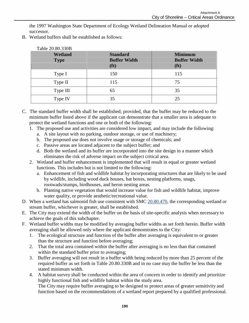
190
Attachment A
City of Shoreline – Critical Areas Ordinance
the 1997 Washington State Department of Ecology Wetland Delineation Manual or adopted
successor.
B. Wetland buffers shall be established as follows:
Table 20.80.330B
Wetland
Type
Standard
Buffer Width
(ft)
Minimum
Buffer Width
(ft)
Type I 150 115
Type II 115 75
Type III 65 35
Type IV 35 25
C. The standard buffer width shall be established; provided, that the buffer may be reduced to the
minimum buffer listed above if the applicant can demonstrate that a smaller area is adequate to
protect the wetland functions and one or both of the following:
1. The proposed use and activities are considered low impact, and may include the following:
a. A site layout with no parking, outdoor storage, or use of machinery;
b. The proposed use does not involve usage or storage of chemicals; and
c. Passive areas are located adjacent to the subject buffer; and
d. Both the wetland and its buffer are incorporated into the site design in a manner which
eliminates the risk of adverse impact on the subject critical area.
2. Wetland and buffer enhancement is implemented that will result in equal or greater wetland
functions. This includes but is not limited to the following:
a. Enhancement of fish and wildlife habitat by incorporating structures that are likely to be used
by wildlife, including wood duck houses, bat boxes, nesting platforms, snags,
rootwads/stumps, birdhouses, and heron nesting areas.
b. Planting native vegetation that would increase value for fish and wildlife habitat, improve
water quality, or provide aesthetic/recreational value.
D. When a wetland has salmonid fish use consistent with SMC 20.80.470, the corresponding wetland or
stream buffer, whichever is greater, shall be established.
E. The City may extend the width of the buffer on the basis of site-specific analysis when necessary to
achieve the goals of this subchapter.
F. Wetland buffer widths may be modified by averaging buffer widths as set forth herein. Buffer width
averaging shall be allowed only where the applicant demonstrates to the City:
1. The ecological structure and function of the buffer after averaging is equivalent to or greater
than the structure and function before averaging;
2. That the total area contained within the buffer after averaging is no less than that contained
within the standard buffer prior to averaging;
3. Buffer averaging will not result in a buffer width being reduced by more than 25 percent of the
required buffer as set forth in Table 20.80.330B and in no case may the buffer be less than the
stated minimum width.
4. A habitat survey shall be conducted within the area of concern in order to identify and prioritize
highly functional fish and wildlife habitat within the study area.
The City may require buffer averaging to be designed to protect areas of greater sensitivity and
function based on the recommendations of a wetland report prepared by a qualified professional.
191
Attachment A
City of Shoreline – Critical Areas Ordinance
G. Low impact uses and activities which are consistent with the purpose and function of the wetland
buffer and do not detract from its integrity may be permitted within the buffer depending on the
sensitivity of the wetland. Examples of uses and activities which may be permitted in appropriate
cases include trails constructed in a manner to reduce impervious surfaces, viewing platforms, and
utility easements; provided, that any impacts to the buffer resulting from such permitted activities
are fully mitigated. Uses permitted within the buffer shall be located as far from the wetland as
possible.
H. Stormwater management facilities, such as bio-swales, may not be located within the minimum
buffer area as set forth in Table 20.80.330B unless it is determined that the location of the facility
will enhance the buffer area, and protect the wetland.
I. A regulated wetland and its associated buffer shall either be placed in a separate tract on which
development is prohibited, protected by execution of an easement, dedicated to a conservation
organization or land trust, or similarly preserved through a permanent protective mechanism
acceptable to the City. The location and limitations associated with the wetland and its buffer shall
be shown on the face of the deed or plat applicable to the property and shall be recorded with the
King County Department of Records. (Ord. 469 § 1, 2007; Ord. 398 § 1, 2006; Ord. 238 Ch. VIII
§ 5(C), 2000).
20.80.340 Alteration. A. Type I Wetlands. Alterations of Type I wetlands shall be prohibited subject to the reasonable use
provisions and special use permit provision of this title.
B. Type II, III and IV Wetlands.
1. Any proposed alteration and mitigation shall comply with the mitigation performance standards
and requirements of these regulations; and
2. No net loss of wetland function and value may occur; and
3. Where enhancement or replacement is proposed, ratios shall comply with the requirements of
this subchapter. (Ord. 398 § 1, 2006; Ord. 238 Ch. VIII § 5(D), 2000).
20.80.350 Mitigation performance standards and requirements. A. Appropriate Wetland Mitigation Sequence and Actions. Where impacts cannot be avoided, and the
applicant has exhausted feasible design alternatives, the applicant or property owner shall seek to
implement other appropriate mitigation actions in compliance with the intent, standards and criteria
of this section. In an individual case, these actions may include consideration of alternative site plans
and layouts, reductions in the density or scope of the proposal, and/or implementation of the
performance standards listed in this subchapter.
B. Impacts to wetland functions and values shall be mitigated. Mitigation actions shall be implemented
in the preferred sequence: Avoidance, minimization, restoration and replacement. Proposals which
include less preferred and/or compensatory mitigation shall demonstrate that:
1. All feasible and reasonable measures will be taken to reduce impacts and losses to the critical
area, or to avoid impacts where avoidance is required by these regulations; and
2. The restored, created or enhanced critical area or buffer will be as available and persistent as the
critical area or buffer area it replaces; and
3. In the case of wetlands and streams, no overall net loss will occur in wetland or stream functions
and values.
C. Location and Timing of Wetland Mitigation.
1. Wetland mitigation shall be provided on-site, unless on-site mitigation is not scientifically
feasible due to the physical features of the property. The burden of proof shall be on the
applicant to demonstrate that mitigation cannot be provided on-site.
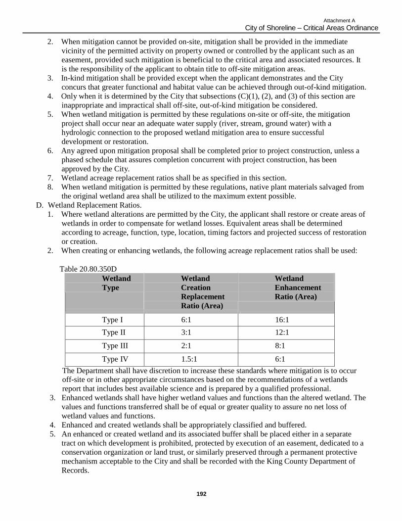
192
Attachment A
City of Shoreline – Critical Areas Ordinance
2. When mitigation cannot be provided on-site, mitigation shall be provided in the immediate
vicinity of the permitted activity on property owned or controlled by the applicant such as an
easement, provided such mitigation is beneficial to the critical area and associated resources. It
is the responsibility of the applicant to obtain title to off-site mitigation areas.
3. In-kind mitigation shall be provided except when the applicant demonstrates and the City
concurs that greater functional and habitat value can be achieved through out-of-kind mitigation.
4. Only when it is determined by the City that subsections (C)(1), (2), and (3) of this section are
inappropriate and impractical shall off-site, out-of-kind mitigation be considered.
5. When wetland mitigation is permitted by these regulations on-site or off-site, the mitigation
project shall occur near an adequate water supply (river, stream, ground water) with a
hydrologic connection to the proposed wetland mitigation area to ensure successful
development or restoration.
6. Any agreed upon mitigation proposal shall be completed prior to project construction, unless a
phased schedule that assures completion concurrent with project construction, has been
approved by the City.
7. Wetland acreage replacement ratios shall be as specified in this section.
8. When wetland mitigation is permitted by these regulations, native plant materials salvaged from
the original wetland area shall be utilized to the maximum extent possible.
D. Wetland Replacement Ratios.
1. Where wetland alterations are permitted by the City, the applicant shall restore or create areas of
wetlands in order to compensate for wetland losses. Equivalent areas shall be determined
according to acreage, function, type, location, timing factors and projected success of restoration
or creation.
2. When creating or enhancing wetlands, the following acreage replacement ratios shall be used:
Table 20.80.350D
Wetland
Type
Wetland
Creation
Replacement
Ratio (Area)
Wetland
Enhancement
Ratio (Area)
Type I 6:1 16:1
Type II 3:1 12:1
Type III 2:1 8:1
Type IV 1.5:1 6:1
The Department shall have discretion to increase these standards where mitigation is to occur off-site or in other appropriate circumstances based on the recommendations of a wetlands
report that includes best available science and is prepared by a qualified professional.
3. Enhanced wetlands shall have higher wetland values and functions than the altered wetland. The
values and functions transferred shall be of equal or greater quality to assure no net loss of
wetland values and functions.
4. Enhanced and created wetlands shall be appropriately classified and buffered.
5. An enhanced or created wetland and its associated buffer shall be placed either in a separate
tract on which development is prohibited, protected by execution of an easement, dedicated to a
conservation organization or land trust, or similarly preserved through a permanent protective
mechanism acceptable to the City and shall be recorded with the King County Department of
Records.
193
Attachment A
City of Shoreline – Critical Areas Ordinance
A. Wetlands Performance Standards. The performance standards in this section shall be incorporated
into mitigation plans submitted to the City for impacts to critical areas. In addition, the City may
prepare a technical manual which includes guidelines and requirements for report preparation. The
following performance standards shall apply to any mitigations proposed within Type I, Type II,
Type III and Type IV wetlands and their buffers.
1. Plants indigenous to the region (not introduced or foreign species) shall be used.
2. Plant selection shall be consistent with the existing or projected hydrologic regime, including
base water levels and stormwater event fluctuations.
3. Plants should be commercially available or available from local sources.
4. Plant species high in food and cover value for fish and wildlife shall be used.
5. Mostly perennial species should be planted.
6. Committing significant areas of the site to species that have questionable potential for successful
establishment shall be avoided.
7. Plant selection must be approved by a qualified consultant.
8. The following standards shall apply to wetland design and construction:
a. Water depth shall not exceed six and one-half feet (two meters).
b. The grade or slope that water flows through the wetland shall not exceed six percent.
c. Slopes within the wetland basin and the buffer zone shall not be steeper than 3:1 (horizontal
to vertical).
d. The wetland (excluding the buffer area) should not contain more than 60 percent open water
as measured at the seasonal high water mark.
9. Substrate should consist of a minimum of one foot, in depth, of clean (uncontaminated with
chemicals or solid/hazardous wastes) inorganic/organic materials.
10. Planting densities and placement of plants should be determined by a qualified consultant and
shown on the design plans.
11. The planting plan shall be approved by the City.
12. Stockpiling should be confined to upland areas and contract specifications should limit
stockpiling of earthen materials to durations in accordance with City clearing and grading
standards, unless otherwise approved by the City.
13. Planting instructions shall be submitted which describe proper placement, diversity, and spacing
of seeds, tubers, bulbs, rhizomes, sprigs, plugs, and transplanted stock.
14. Controlled release fertilizer shall be applied (if required) at the time of planting and afterward
only as plant conditions warrant (determined during the monitoring process).
15. An irrigation system shall be installed, if necessary, for the initial establishment period.
16. All construction specifications and methods shall be approved by a qualified consultant and the
City.
17. Construction management shall be provided by a qualified consultant. Ongoing work on-site
shall be inspected by the City.
F. Approved Wetland Mitigation Projects – Signature. On completion of construction, any approved
mitigation project shall be signed off by the applicant‟s qualified consultant and approved by the
City. Signature of the qualified consultant and approval by the City will indicate that the
construction has been completed as planned.
G. Monitoring Program and Contingency Plan.
1. A monitoring program shall be implemented by the applicant to determine the success of the
mitigation project and any necessary corrective actions. This program shall determine if the
original goals and objectives are being met.
2. A contingency plan shall be established for indemnity in the event that the mitigation project is
inadequate or fails. A performance and maintenance bond or other acceptable financial
194
Attachment A
City of Shoreline – Critical Areas Ordinance
guarantee is required to ensure the applicant‟s compliance with the terms of the mitigation
agreement. The amount of the performance and maintenance bond shall equal 125 percent of the
cost of the mitigation project in addition to the cost for monitoring for a minimum of five years.
The bond may be reduced in proportion to work successfully completed over the period of the
bond. The bonding period shall coincide with the monitoring period.
3. Monitoring programs prepared to comply with this section shall reflect the following guidelines:
a. Scientific procedures shall be used to establish the success or failure of the project.
b. For vegetation determinations, permanent sampling points shall be established.
c. Vegetative success shall, at a minimum, equal 80 percent survival of planted trees and
shrubs and 80 percent cover of desirable understory or emergent plant species at the end of
the required monitoring period. Additional standards for vegetative success, including (but
not limited to) minimum survival standards following the first growing season, may be
required after consideration of a report prepared by a qualified consultant.
d. Monitoring reports on the current status of the mitigation project shall be submitted to the
City. The reports are to be prepared by a qualified consultant and reviewed by the City or a
consultant retained by the City and should include monitoring information on wildlife,
vegetation, water quality, water flow, stormwater storage and conveyance, and existing or
potential degradation, as applicable, and shall be produced on the following schedule: at the
time of construction; 30 days after planting; early in the growing season of the first year; at
the end of the growing season of the first year; twice during the second year; and annually
thereafter.
e. Monitoring programs shall be established for a minimum of five years.
f. If necessary, failures in the mitigation project shall be corrected.
g. Dead or undesirable vegetation shall be replaced with appropriate plantings.
h. Damage caused by erosion, settling, or other geomorphological processes shall be repaired.
i. The mitigation project shall be redesigned (if necessary) and the new design shall be
implemented and monitored, as in subsection (G)(3)(d) of this section.
j. Correction procedures shall be approved by a qualified consultant and the City. (Ord. 581
§ 1 (Exh. 1), 2010; Ord. 398 § 1, 2006; Ord. 238 Ch. VIII § 5(E), 2000).
20.80.360 Description and purpose. A. A flood hazard area consists of the following components: floodplain; flood fringe; zero-rise
floodway; and Federal Emergency Management Agency (FEMA) floodway.
B. It is the purpose of these regulations to ensure that the City of Shoreline meets the requirements of
the National Flood Insurance Program and maintains the City as an eligible community for Federal
flood insurance benefits.
C. A tsunami hazard area may be designated as a flood hazard area by the Federal or State government.
(Ord. 398 § 1, 2006; Ord. 238 Ch. VIII § 6(A), 2000).
20.80.370 Classification. Flood hazard areas shall be determined after obtaining, reviewing and utilizing base flood elevations and available floodway data for a flood having a one percent chance of being equaled or exceeded in any
given year, often referred to as the “100-year flood.” The base flood is determined for existing
conditions, and is shown on Flood Insurance Rate Maps for King County (FIRM) and incorporated
areas, current version; or mapped on the King County Sensitive Areas Folio, unless a more complete
basin plan including projected flows under future developed conditions has been completed and adopted
by the City of Shoreline, in which case these future flow projections shall be used. In areas where the
195
Attachment A
City of Shoreline – Critical Areas Ordinance
flood insurance study for the City includes detailed base flood calculations, those calculations may be
used. (Ord. 398 § 1, 2006; Ord. 238 Ch. VIII § 6(B), 2000).
20.80.380 Flood fringe – Development standards and permitted alterations. A. Development proposals shall not reduce the effective base flood storage volume of the floodplain.
Grading or other activity which would reduce the effective storage volume shall be mitigated by
creating compensatory storage on the site or off the site if legal arrangements can be made to assure
that the effective compensatory storage volume will be preserved over time.
B. No structure shall be allowed which would be at risk due to stream bank destabilization including,
but not limited to, that associated with channel relocation or meandering.
C. All elevated construction shall be designed and certified by a professional structural engineer
licensed by the State of Washington and the design shall be approved by the City prior to
construction.
D. Subdivisions, short subdivisions, lot line adjustments and binding site plans shall meet the following
requirements:
1. New building lots shall contain no less than 5,000 square feet of buildable land outside the zero-
rise floodway, and building setback areas shall be shown on the face of the plat to restrict
permanent structures to this buildable area;
2. All utilities and facilities such as stormwater facilities, sewer, gas, electrical and water systems
shall be located and constructed consistent with the standards and requirements of this section;
3. Base flood data and flood hazard notes shall be shown on the face of the recorded subdivision,
short subdivision, lot line adjustment or binding site plan including, but not limited to, the base
flood elevation, required flood protection elevations and the boundaries of the floodplain and
the zero-rise floodway, if determined; and
4. The following notice shall also be shown on the face of the recorded subdivision, short
subdivision, lot line adjustment or binding site plan for all affected lots:
NOTICE
Lots and structures located within Flood Hazard Areas may be inaccessible by emergency vehicles
during flood events. Residents and property owners should take appropriate advance precautions.
E. New residential structures and improvements that include the creation of new impervious surfaces
associated with existing residential structures shall meet the following requirements:
1. The lowest floor shall be elevated to the flood protection elevation;
2. Portions of a structure which are below the lowest floor area shall not be fully enclosed. The
areas and rooms below the lowest floor shall be designed to automatically equalize hydrostatic
and hydrodynamic flood forces on exterior walls by allowing for the entry and exit of
floodwaters. Designs for satisfying this requirement shall meet or exceed the following
requirements:
a. A minimum of two openings on opposite walls having a total open area of not less than one
square inch for every square foot of enclosed area subject to flooding shall be provided;
b. The bottom of all openings shall be no higher than one foot above grade; and
c. Openings may be equipped with screens, louvers or other coverings or devices if they permit
the unrestricted entry and exit of floodwaters;
3. Materials and methods which are resistant to and minimize flood damage shall be used; and
4. All electrical, heating, ventilation, plumbing, air conditioning equipment and other utility and
service facilities shall be floodproofed to or elevated above the flood protection elevation.
F. New nonresidential structures and substantial improvements of existing nonresidential structures
shall meet the following requirements:
196
Attachment A
City of Shoreline – Critical Areas Ordinance
1. Elevation.
a. Requirements for residential structures contained in subsection (E)(1) of this section shall be
met; or
b. The structure shall be floodproofed to the flood protection elevation and shall meet the
following requirements:
i. The applicant shall provide certification by a professional civil or structural engineer
licensed by the State of Washington that the floodproofing methods are adequate to
withstand the flood depths, pressures, velocities, impacts, uplift forces and other
factors associated with the base flood. After construction, the engineer shall certify
that the permitted work conforms with the approved plans and specifications; and
ii. Approved building permits for floodproofed nonresidential structures shall contain a
statement notifying applicants that flood insurance premiums shall be based upon
rates for structures which are one foot below the floodproofed level;
2. Materials and methods which are resistant to and minimize flood damage shall be used; and
3. All electrical, heating, ventilation, plumbing, air conditioning equipment and other utility and
service facilities shall be floodproofed to or elevated above the flood protection elevation.
G. All new construction shall be anchored to prevent flotation, collapse or lateral movement of the
structure.
H. Utilities shall meet the following requirements:
1. New and replacement utilities including, but not limited to, sewage treatment facilities shall be
floodproofed to or elevated above the flood protection elevation;
2. Aboveground utility transmission lines, other than electric transmission lines, shall only be
allowed for the transport of nonhazardous substances; and
3. Buried utility transmission lines transporting hazardous substances shall be installed at a
minimum depth of four feet below the maximum depth of scour for the base flood, as predicted
by a professional civil engineer licensed by the State of Washington, and shall achieve sufficient
negative buoyancy so that any potential for flotation or upward migration is eliminated.
I. Critical facilities may be allowed within the flood fringe of the floodplain, but only when no feasible
alternative site is available. Critical facilities shall be evaluated through the conditional or special
use permit process. Critical facilities constructed within the flood fringe shall have the lowest floor
elevated to three or more feet above the base flood elevation. Floodproofing and sealing measures
shall be taken to ensure that hazardous substances will not be displaced by or released into
floodwaters. Access routes elevated to or above the base flood elevation shall be provided to all
critical facilities from the nearest maintained public street or roadway.
J. Prior to approving any permit for alterations in the flood fringe, the City shall determine that all
permits required by State or Federal law have been obtained. (Ord. 398 § 1, 2006; Ord. 238 Ch. VIII
§ 6(C), 2000).
20.80.390 Zero-rise floodway – Development standards and permitted alterations. A. The requirements which apply to the flood fringe shall also apply to the zero-rise floodway. The
more restrictive requirements shall apply where there is a conflict.
B. A development proposal including, but not limited to, new or reconstructed structures shall not cause
any increase in the base flood elevation unless the following requirements are met:
1. Amendments to the flood insurance rate map are adopted by FEMA, in accordance with 44 CFR
70, to incorporate the increase in the base flood elevation; and
2. Appropriate legal documents are prepared in which all property owners affected by the
increased flood elevations consent to the impacts on their property. These documents shall be
filed with the title of record for the affected properties.
197
Attachment A
City of Shoreline – Critical Areas Ordinance
C. The following are presumed to produce no increase in base flood elevation and shall not require a
special study to establish this fact:
1. New residential structures outside the FEMA floodway on lots in existence before November
27, 1990, which contain less than 5,000 square feet of buildable land outside the zero-rise
floodway and which have a total building footprint of all proposed structures on the lot of less
than 2,000 square feet;
2. Substantial improvements of existing residential structures in the zero-rise floodway, but outside
the FEMA floodway, where the footprint is not increased; or
3. Substantial improvements of existing residential structures meeting the requirements for new
residential structures in this title.
D. Post or piling construction techniques which permit water flow beneath a structure shall be used.
E. All temporary structures or substances hazardous to public health, safety and welfare, except for
hazardous household substances or consumer products containing hazardous substances, shall be
removed from the zero-rise floodway during the flood season from September 30th to May 1st.
F. New residential structures or any structure accessory to a residential use shall meet the following
requirements:
1. The structures shall be outside the FEMA floodway; or
2. The structures shall be on lots in existence before November 27, 1990, which contain less than
5,000 square feet of buildable land outside the zero-rise floodway. Structures shall be designed
and situated to minimize encroachment into the zero-rise floodway.
G. Utilities may be allowed within the zero-rise floodway if the City determines that no feasible
alternative site is available, subject to the requirements of this section. Construction of sewage
treatment facilities shall be prohibited.
H. Critical facilities shall not be allowed within the zero-rise floodway except as provided in subsection
(I) of this section.
I. Structures and installations which are dependent upon the floodway may be located in the floodway
if the development proposal is approved by all agencies with jurisdiction. Such structures include,
but are not limited to:
1. Dams or diversions for water supply, flood control, or fisheries enhancement;
2. Flood damage reduction facilities, such as levees and pumping stations;
3. Stream bank stabilization structures where no feasible alternative exists for protecting public or
private property;
4. Stormwater conveyance facilities subject to the development standards for streams and wetlands
and the surface water design manual;
5. Boat launches and related recreation structures;
6. Bridge piers and abutments; and
7. Other fisheries enhancement or stream restoration projects. (Ord. 398 § 1, 2006; Ord. 238 Ch.
VIII § 6(D), 2000).
20.80.400 FEMA floodway – Development standards and permitted alterations. A. The requirements which apply to the zero-rise floodway shall also apply to the FEMA floodway.
The more restrictive requirements shall apply where there is a conflict.
B. A development proposal including, but not limited to, new or reconstructed structures shall not cause
any increase in the base flood elevation.
C. New residential or nonresidential structures shall be prohibited within the FEMA floodway.
D. Substantial improvements of existing residential structures in the FEMA floodway, meeting the
requirements of WAC 173-158-070, as amended, are presumed to produce no increase in base flood
198
Attachment A
City of Shoreline – Critical Areas Ordinance
elevation and shall not require a special study to establish this fact. (Ord. 398 § 1, 2006; Ord. 238
Ch. VIII § 6(E), 2000).
20.80.410 Flood hazard areas – Certification by engineer or surveyor. A. For all new structures or substantial improvements in a flood hazard area, the applicant shall provide
certification by a professional civil engineer or land surveyor licensed by the State of Washington of:
1. The actual as-built elevation of the lowest floor, including basement; and
2. The actual as-built elevation to which the structure is floodproofed, if applicable.
B. The engineer or surveyor shall indicate if the structure has a basement.
C. The City shall maintain the certifications required by this section for public inspection. (Ord. 398
§ 1, 2006; Ord. 238 Ch. VIII § 6(F), 2000).
20.80.420 Description and purpose. A. Aquifer recharge areas provide a source of potable water and contribute to stream discharge during
periods of low flow. Urban-type pollutants may enter watercourse supplies through potential
infiltration of pollutants through the soil to ground water aquifers.
B. The primary purpose of aquifer recharge area regulations is to protect aquifer recharge areas by
providing for regulation of land use activities that pose a risk of potential aquifer contamination and
to minimize impacts through the application of strict performance standards. (Ord. 398 § 1, 2006;
Ord. 238 Ch. VIII § 7(A), 2000).
20.80.430 Classification. Aquifer recharge areas shall be classified based on the soil and ground water conditions and risks to surface water during periods of low hydrology. Classification depends on the combined effects of
hydrogeological susceptibility to contamination and contaminant loading potential, and includes upland
areas underlain by soils consisting largely of silt, clay or glacial till, upland areas underlain by soils
consisting largely of sand and gravel, and wellhead protection areas and areas underlain by soils
consisting largely of sand and gravel in which there is a predominantly downward or lateral component
to ground water flow. (Ord. 398 § 1, 2006; Ord. 238 Ch. VIII § 7(B), 2000).
20.80.440 Alteration. The following land uses and activities shall require implementation of Best Management Practices (BMPs) as established by the Department of Ecology:
A. Land uses and activities that involve the use, storage, transport or disposal of significant quantities of
chemicals, substances or materials that are toxic, dangerous or hazardous, as those terms are defined
by State and Federal regulations.
B. On-site community sewage disposal systems.
C. Underground storage of chemicals.
D. Petroleum pipelines.
E. Solid waste landfills. (Ord. 398 § 1, 2006; Ord. 238 Ch. VIII § 7(C), 2000).
20.80.450 Performance standards and requirements. Any uses or activities located in an aquifer recharge area, as defined within this subchapter, that involve the use, storage, transport or disposal of significant quantities of chemicals, substances, or materials that
are toxic, dangerous or hazardous, as those terms are defined by State and Federal regulations, shall
comply with the following additional standards:
A. Underground storage of chemicals, substances or materials that are toxic, hazardous or dangerous is
discouraged.
199
Attachment A
City of Shoreline – Critical Areas Ordinance
B. Any chemicals, substances or materials that are toxic, hazardous or dangerous shall be segregated
and stored in receptacles or containers that meet State and Federal standards.
C. Storage containers shall be located in a designated, secured area that is paved and able to contain
leaks and spills, and shall be surrounded by a containment dike.
D. Secondary containment devices shall be constructed around storage areas to retard the spread of any
spills and a monitoring system should be implemented.
E. A written operations plan shall be developed, including procedures for loading/unloading liquids and
for training of employees in proper materials handling.
F. An emergency response/spill clean-up plan shall be prepared and employees properly trained to react
to accidental spills.
G. Any aboveground storage tanks shall be located within a diked containment area on an impervious
surface. The tanks shall include overfill protection systems and positive controls on outlets to
prevent uncontrolled discharges.
H. Development should be clustered and impervious surfaces limited where possible.
I. No waste liquids or chemicals of any kind shall be discharged to storm sewers.
J. All development shall implement Best Management Practices (BMPs) for water quality, as approved
by the City, including the standards contained within the City of Shoreline Stormwater Design
Manual, such as biofiltration swales and use of oil-water separators, and BMPs appropriate to the
particular use proposed. (Ord. 398 § 1, 2006; Ord. 238 Ch. VIII § 7(D), 2000).
20.80.460 Designation and purpose. A. Streams are those areas where surface waters produce a defined channel or bed, not including
irrigation ditches, canals, storm or surface water runoff devices or other entirely artificial
watercourses, unless they are used by salmonids or are used to convey streams naturally occurring
prior to construction. A channel or bed need not contain water year-round; provided, that there is
evidence of at least intermittent flow during years of normal rainfall.
B. Stream areas and their associated buffers provide important fish and wildlife habitat and corridors;
help to maintain water quality; store and convey stormwater and floodwater; recharge groundwater;
and serve as areas for recreation, education and scientific study and aesthetic appreciation.
C. The primary purpose of the stream area regulations is to avoid impacts to streams and associated
riparian corridors and where possible, provide for stream enhancement and rehabilitation. (Ord. 398
§ 1, 2006; Ord. 238 Ch. VIII § 8(A), 2000).
20.80.470 Streams. A. “Type I streams” are those streams identified as “Shorelines of the State” under the City Shoreline
Master Program.
B. “Type II streams” are those streams that are not Type I streams and are either perennial or
intermittent and have one of the following characteristics:
1. Salmonid fish use; or
2. Demonstrated salmonid habitat value as determined by a qualified professional.
C. “Type III streams” are those streams which are not Type I or Type II streams with perennial (year-
round) or intermittent flow with channel width of two feet or more taken at the ordinary high water
mark and are not used by salmonid fish.
D. “Type IV streams,” which are not Type I, Type II, or Type III, are those streams with perennial or
intermittent flow with channel width less than two feet taken at the ordinary high water mark that are
not used by salmonid fish.
E. “Piped stream segments” are those segments of streams, regardless of their type, that are fully
enclosed in an underground pipe or culvert.
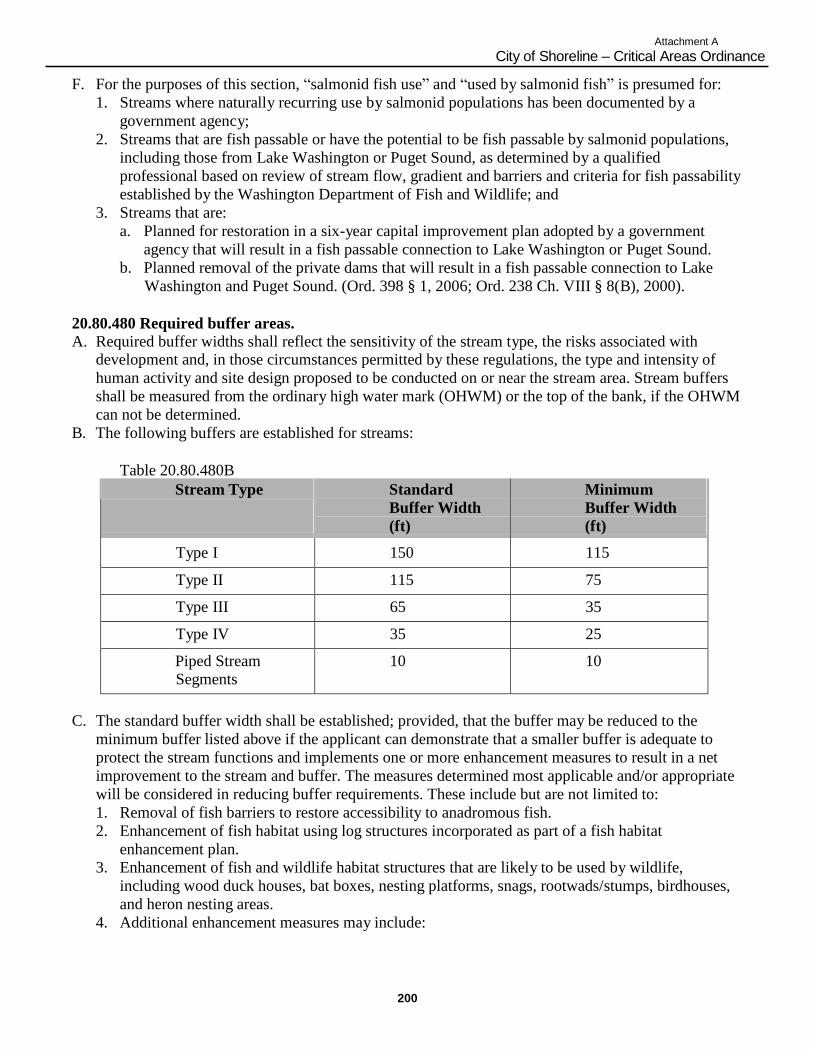
200
Attachment A
City of Shoreline – Critical Areas Ordinance
F. For the purposes of this section, “salmonid fish use” and “used by salmonid fish” is presumed for:
1. Streams where naturally recurring use by salmonid populations has been documented by a
government agency;
2. Streams that are fish passable or have the potential to be fish passable by salmonid populations,
including those from Lake Washington or Puget Sound, as determined by a qualified
professional based on review of stream flow, gradient and barriers and criteria for fish passability
established by the Washington Department of Fish and Wildlife; and
3. Streams that are:
a. Planned for restoration in a six-year capital improvement plan adopted by a government
agency that will result in a fish passable connection to Lake Washington or Puget Sound.
b. Planned removal of the private dams that will result in a fish passable connection to Lake
Washington and Puget Sound. (Ord. 398 § 1, 2006; Ord. 238 Ch. VIII § 8(B), 2000).
20.80.480 Required buffer areas. A. Required buffer widths shall reflect the sensitivity of the stream type, the risks associated with
development and, in those circumstances permitted by these regulations, the type and intensity of
human activity and site design proposed to be conducted on or near the stream area. Stream buffers
shall be measured from the ordinary high water mark (OHWM) or the top of the bank, if the OHWM
can not be determined.
B. The following buffers are established for streams:
Table 20.80.480B
Stream Type Standard
Buffer Width
(ft)
Minimum
Buffer Width
(ft)
Type I 150 115
Type II 115 75
Type III 65 35
Type IV 35 25
Piped Stream
Segments
10 10
C. The standard buffer width shall be established; provided, that the buffer may be reduced to the
minimum buffer listed above if the applicant can demonstrate that a smaller buffer is adequate to
protect the stream functions and implements one or more enhancement measures to result in a net
improvement to the stream and buffer. The measures determined most applicable and/or appropriate
will be considered in reducing buffer requirements. These include but are not limited to:
1. Removal of fish barriers to restore accessibility to anadromous fish.
2. Enhancement of fish habitat using log structures incorporated as part of a fish habitat
enhancement plan.
3. Enhancement of fish and wildlife habitat structures that are likely to be used by wildlife,
including wood duck houses, bat boxes, nesting platforms, snags, rootwads/stumps, birdhouses,
and heron nesting areas.
4. Additional enhancement measures may include:
201
Attachment A
City of Shoreline – Critical Areas Ordinance
a. Planting native vegetation within the buffer area, especially vegetation that would increase
value for fish and wildlife, increase stream bank or slope stability, improve water quality, or
provide aesthetic/recreational value; or
b. Creation of a surface channel where a stream was previously underground, in a culvert or
pipe. Surface channels which are “daylighted” shall be located within a buffer area and shall
be designed with energy dissipating functions such as meanders to reduce future erosion;
c. Removal or modification of existing stream culverts (such as at road crossings) to improve
fish passage and flow capabilities; or
d. Upgrading of retention/detention facilities or other drainage facilities beyond required levels.
D. No structures or improvements shall be permitted within the stream buffer area, including buildings,
decks, docks, except as otherwise permitted or required under the City‟s adopted Shoreline Master
Program, or under one of the following circumstances:
1. When the improvements are part of an approved rehabilitation or mitigation plan; or
2. For the construction of new roads and utilities, and accessory structures, when no feasible
alternative location exists; or
3. The construction of trails over and in the buffer of piped stream segments, and the construction
of trails near other stream segments consistent with the following criteria:
a. Trails should be constructed of permeable materials;
b. Trails shall be designed in a manner that minimizes impact on the stream system;
c. Trails shall have a maximum trail corridor width of 10 feet; and
d. Trails should be located within the outer half of the buffer, i.e., that portion of the buffer that
is farther away from the stream; or
4. The construction of footbridges; or
5. The construction and placement of informational signs or educational demonstration facilities
limited to no more than one square yard surface area and four feet high, provided there is no
permanent infringement on stream flow; or
6. The establishment of stormwater management facilities, such as bio-swales, over and in the
buffer of piped stream segments and when located outside of the minimum buffer area for other
stream segments as set forth in the Table 20.80.480B.
E. The City may extend the width of the buffer on the basis of site-specific analysis when necessary to
comply with an adopted basin plan in accordance with City, County, State or Federal plans to
preserve endangered or threatened species.
F. Stream buffer widths may be modified by averaging buffer widths as set forth herein. Buffer width
averaging shall be allowed only where the applicant demonstrates to the City:
1. The ecological structure and function of the buffer after averaging is equivalent to or greater than
the structure and function before averaging;
2. That the total area contained within the buffer after averaging is no less than that contained
within the standard buffer prior to averaging;
3. Buffer averaging shall not result in the buffer width being reduced by more than 25 percent of
the required buffer as set forth in the table in subsection (B) of this section and in no case may
the buffer be less than the stated minimum width.
4. A habitat survey shall be conducted within the area of concern in order to identify and prioritize
highly functional fish and wildlife habitate within the study area.
The City may require buffer averaging to be designed to protect areas of greater sensitivity and
function based on the recommendations of a stream report prepared by a qualified professional.
G. Relocation of a Type I, II, or III shall be allowed only when the proposed relocation is part of an
approved mitigation or rehabilitation plan, will result in equal or better habitat and water quality, and
will not diminish the flow capacity of the stream. Relocation of a Type IV stream shall be allowed
202
Attachment A
City of Shoreline – Critical Areas Ordinance
only when the proposed relocation will result in equal or better habitat and water quality and will not
diminish the flow capacity of the stream.
H. Restoring Piped Watercourses.
1. The City allows the voluntary opening of previously channelized/culverted streams and the
rehabilitation and restoration of streams, especially on public property or when a property owner
is a proponent in conjunction with new development.
2. When piped watercourse sections are restored, a protective buffer shall be required of the stream
section. The buffer distance shall be based on an approved restoration plan, regardless of stream
classification, and shall be a minimum of 10 to 25 feet, at the discretion of the Director, to allow
for restoration and maintenance. The stream and buffer area shall include habitat improvements
and measures to prevent erosion, landslide and water quality impacts. Opened channels shall be
designed to support fish access, unless determine to be unfeasible by the City.
3. Removal of pipes conveying streams shall only occur when the City determines that the proposal
will result in a new improvement of water quality and ecological functions and will not
significantly increase the threat of erosion, flooding, slope stability or other hazards.
4. Where the buffer of the restored stream would extend beyond a required setback on an adjacent
property, the applicant shall obtain a written agreement from the affected neighboring property
owner. (Ord. 398 § 1, 2006; Ord. 299 § 1, 2002; Ord. 238 Ch. VIII § 8(C), 2000).
20.80.490 Alteration. A. Bridges shall be used to cross Type I streams. Culverted crossings and other obstructive means of
crossing Type I streams shall be prohibited.
B. Culverts are allowable only under the following circumstances:
1. Crossing of Type II, III, and IV streams;
2. When fish passage will not be impaired;
3. When the following design criteria are met:
a. Oversized culverts will be installed;
b. Culverts will include gradient controls and creation of pools within the culvert for Type II
streams where appropriate; and
c. Gravel substrate will be placed in the bottom of the culvert to a minimum depth of one foot
for Type II streams;
4. The applicant or successors shall, at all times, keep any culvert free of debris and sediment to
allow free passage of water and, if applicable, fish.
C. The City may require that a culvert be removed from a stream as a condition of approval, unless it is
demonstrated conclusively that the culvert is not detrimental to fish habitat or water quality, or
removal would be detrimental to fish or wildlife habitat or water quality. (Ord. 398 § 1, 2006; Ord.
238 Ch. VIII § 8(D), 2000).
20.80.500 Mitigation performance standards and requirements. A. Appropriate Stream Mitigation Sequence and Actions. Where impacts cannot be avoided, and the
applicant has exhausted feasible design alternatives, the applicant or property owner shall seek to
implement other appropriate mitigation actions in compliance with the intent, standards and criteria
of this section. In an individual case, these actions may include consideration of alternative site plans
and layouts, reductions in the density or scope of the proposal, and/or implementation of the
performance standards listed in this section.
B. Significant adverse impacts to stream area functions and values shall be mitigated. Mitigation
actions shall be implemented in the preferred sequence: Avoidance, minimization, restoration and
203
Attachment A
City of Shoreline – Critical Areas Ordinance
replacement. Proposals which include less preferred and/or compensatory mitigation shall
demonstrate that:
1. All feasible and reasonable measures will be taken to reduce impacts and losses to the stream, or
to avoid impacts where avoidance is required by these regulations; and
2. The restored, created or enhanced stream area or buffer will be available and persistent as the
stream or buffer area it replaces; and
3. No overall net loss will occur in stream functions and values.
C. Location and Timing of Stream Mitigation.
1. Mitigation shall be provided on-site, unless on-site mitigation is not scientifically feasible due to
the physical features of the property. The burden of proof shall be on the applicant to
demonstrate that mitigation cannot be provided on-site.
2. When mitigation cannot be provided on-site, mitigation shall be provided in the immediate
vicinity of the permitted activity on property owned or controlled by the applicant such as an
easement, provided such mitigation is beneficial to the critical area and associated resources. It is
the responsibility of the applicant to obtain title to off-site mitigation areas.
3. In-kind mitigation shall be provided except when the applicant demonstrates and the City
concurs that greater functional and habitat value can be achieved through out-of-kind mitigation.
4. Only when it is determined by the City that subsections (B)(1), (2), and (3) of this section are
inappropriate and impractical shall off-site, out-of-kind mitigation be considered.
5. When stream mitigation is permitted by these regulations on-site or off-site, the mitigation
project shall occur near an adequate water supply (river, stream, groundwater) with a hydrologic
connection to the mitigation area to ensure successful development or restoration.
6. Any agreed upon mitigation proposal shall be completed prior to project construction, unless a
phased schedule, that assures completion concurrent with project construction, has been
approved by the City.
7. Restored or created streams, where permitted by these regulations, shall be an equivalent or
higher stream value or function than the altered stream.
D. The performance standards in this section and the relevant performance standards located within the
wetland standards of SMC 20.80.350(E)(1) through (17) shall be incorporated into mitigation plans
submitted to the City for impacts to critical areas. In addition, the City may prepare a technical
manual which includes guidelines and requirements for report preparation. The performance
standards shall apply to any mitigations proposed within Type I, Type II or Type III streams within
the City.
E. On completion of construction, any approved mitigation project must be signed off by the
applicant‟s qualified consultant and approved by the City. Signature of the qualified consultant and
approval by the City will indicate that the construction has been completed as planned.
F. Monitoring Program and Contingency Plan. A monitoring program shall be implemented by the
applicant to determine the success of the mitigation project and any necessary corrective actions.
This program shall determine if the original goals and objectives are being met. The monitoring
program will be established consistent with the guidelines contained in SMC 20.80.350(G). (Ord.
398 § 1, 2006; Ord. 238 Ch. VIII § 8(E), 2000).

Attachment A
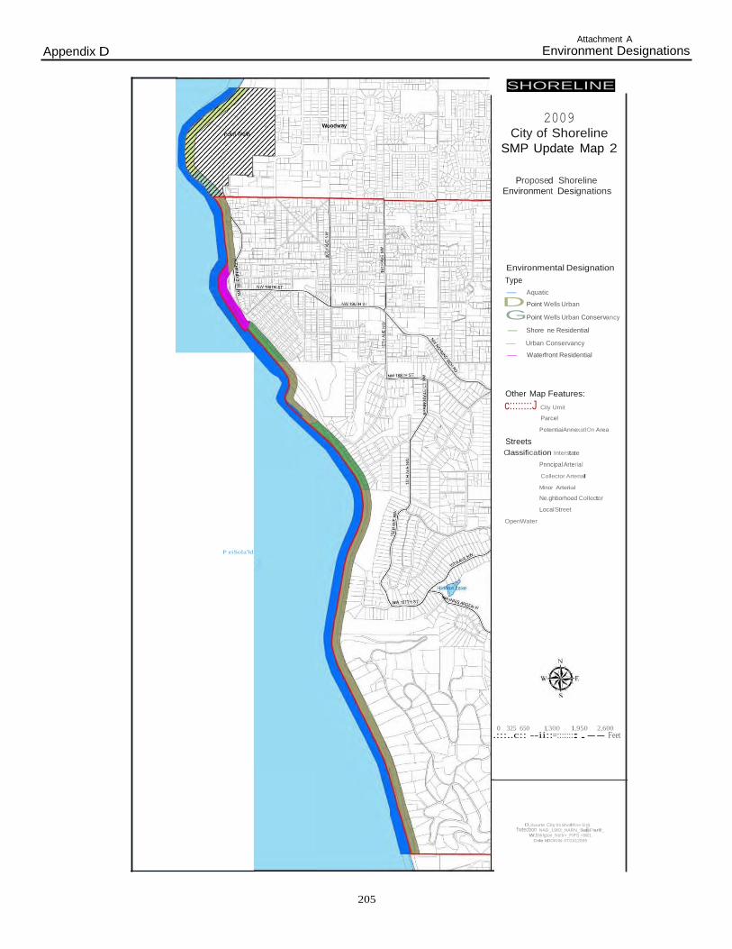
Attachment A
205
Appendix D Environment Designations
SHORELINE
2009
City of Shoreline
SMP Update Map 2
Proposed Shoreline
Environment Designations
Environmental Designation
Type
- Aquatic
DPoint Wells Urban
GPoint Wells Urban Conservancy
- Shore ne Residential
- Urban Conservancy
- Waterfront Residential
Other Map Features:
c::::::::J City Umit
Parcel
Streets
PotentiaiAnnexatlOn Area
Classification Interstate
Pnncipal Arterial
Collector Arterial
OpenWater
Minor Arterial
Ne.ghborhood Collector
LocalStreet
P eiSola'ld
0 325 650 1,300 1,950 2,600
.:::..c:: --ii::=::::::::.-- Feet
0.Sourte City 01Shofl!'llne GIS
f'wtecbon NAD_1983_HARN_SiatePiarll!_
W.5hlrlgton_No!tr>_FIPS_<6601 Dele MOOKIIId 07/2412009

Attachment A
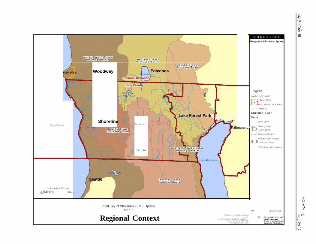
D
-6' "'0 (I)
a:::::l.
x· m
Woodway
Legend
Puge1Sound
'(1/
Shoreline
l?Oti.Ibaotlf
:Ot'i'; Jd\
r=Jopenwater
F] Pcint Wells
I::JKing County C1ty Limits
-- Streams
Drainage Basin
Name
- 131tter Lake
.,.nrnnr.,.l - Boe1ng Creek
Lyons Creek
c::::J McAleer Creek
- Middle Puget Sound
0Thornton Creek
- '/Vest Lake Washington
1 inchequals 4.957 reet
o._lllloilll2i::5:0.I5i 1M,Ies
2008 City of Shoreline- SMP Update
Map 2
Regional Context
T>t.laSwn...- Cilro.lfSh..nlnK"GlS .'c.FI IA
Pr\jt"'ion:N.AD_l9SJ_HARN_&utPitttt_ \\'ahiu lllt _N'(ll'th f1PS 460J
O•t Modlf!Crl:fiSI1112008
Wl! SHOREUNE
s
;!;: c.r g. 3 <D :::J
s::>: Q)
"'0
0' cr
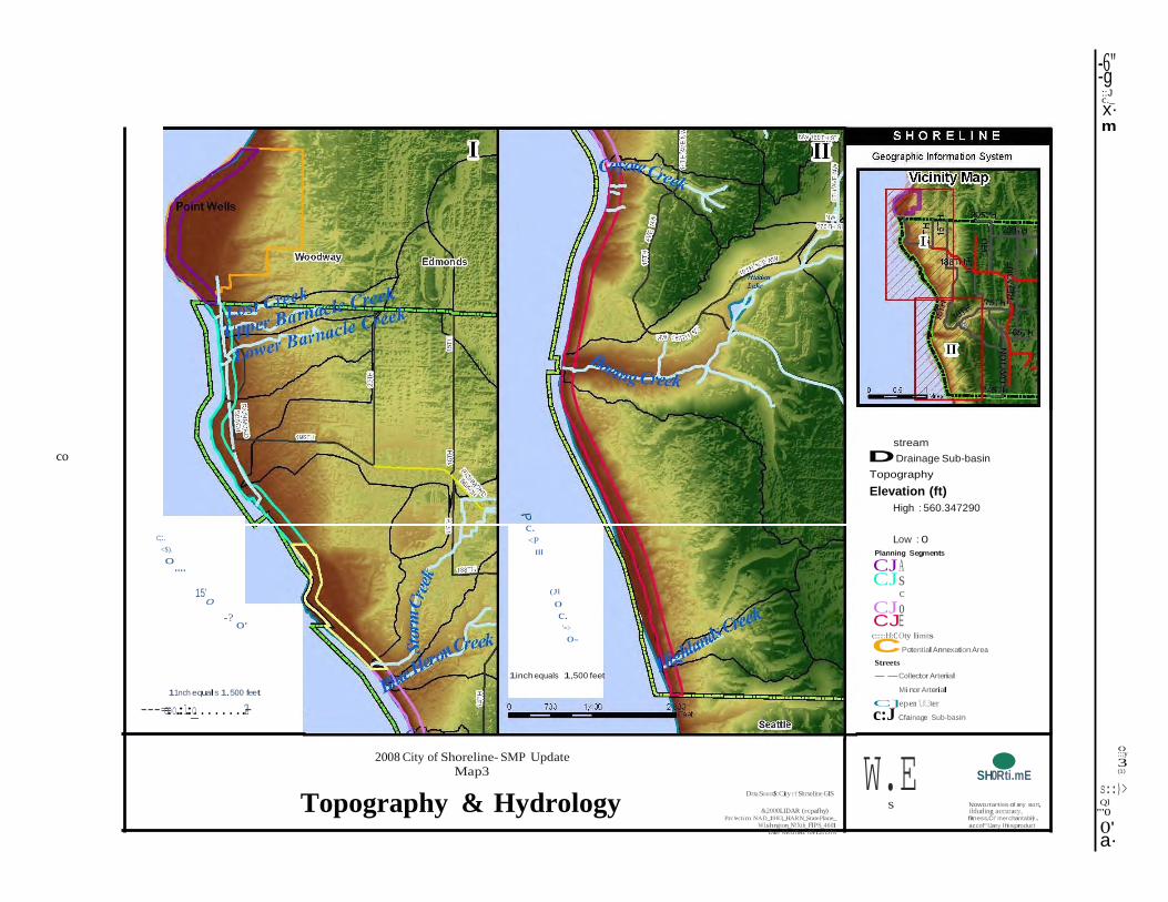
s
-6" -g ::J c._
x· m
co
c;:. <$).
0....
15'
0
-? 0'
c. <P
Ill
(Jl
0
c. '=>
0-
stream
DDrainage Sub-basin
Topography
Elevation (ft)
High : 560.347290
Low : 0
Planning Segments
CJA CJs
c
CJ o CJE c::::::I:I:C Oty limits
CPotential Annexation Area
Streets
11nch equals 1.500 feet
---=o.=oo.:.1:._o........2.-4
1inch equals 1,500 feet
2008 City of Shoreline- SMP Update
Map3
Topography & Hydrology D:tta.Soucc$:City r:f Shrxeline GIS
--Collector Arterial
Minor Arterial
C]epen 'l,.ff.,3ter
c:J Cfainage Sub-basin
W.E
SH•0Rti.mE
()
:::y
3 (1)
s::)> Ql
&2000LIDAR (rcpafhy) Prc!ecti m NAD_1983_HARN_StatePlane_
Wl.shngton_N!Xth_FIPS_4601 D ate Mcdfied: 05/121DJ8
Nowo.rranties of any sort, ilduding accuracy, fitness,CI' merchantabiyl .
accof"'lJany lhisproduct
"'0
0' a·
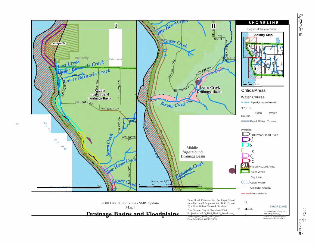
•
s
-6" -g ::J cx·.
m
Edmonds
c..
CD <P
<S,>...
<S'
0
..,
0' Middle
fuget iSound Dt·ainage Basin
CriticalAreas
Water Course
=•== Piped,Unconfirmed
TYPE
- Open Water Course
=== Piped Water Course
- Wetland
D100 Year Flood Plain
DA Ds C_ c
Do DE f?JJI Flood Hazard Area
Point Wells
1 1nch equals 1.500 feet
950 1.ron
2008 City of Shoreline - SMP Update
Map4
Base Flood Elevaion for the Puget Sound
shoreline in all Segments (A, B, C, D, and
E) will be 10 feet National Geodetic
City Limit
c::J Open Water
--Collector Arterial --Minor Arterial
N
S HO..R.. EUNE
Drainage Basins and Floodplains Data Source:City of Shoreline GIS &
W E
Projection: NAD_1983_HARN_StatePlane_ Washington_North_FIPS_4601
Date Modified:05/12/2008
------:::;
No warranties of any sort, indudni g accuracy, fitness,or merchantabiil ty, accompany this product.
()
:::y
3 (1)
s::)> Ql
""0
0' a·
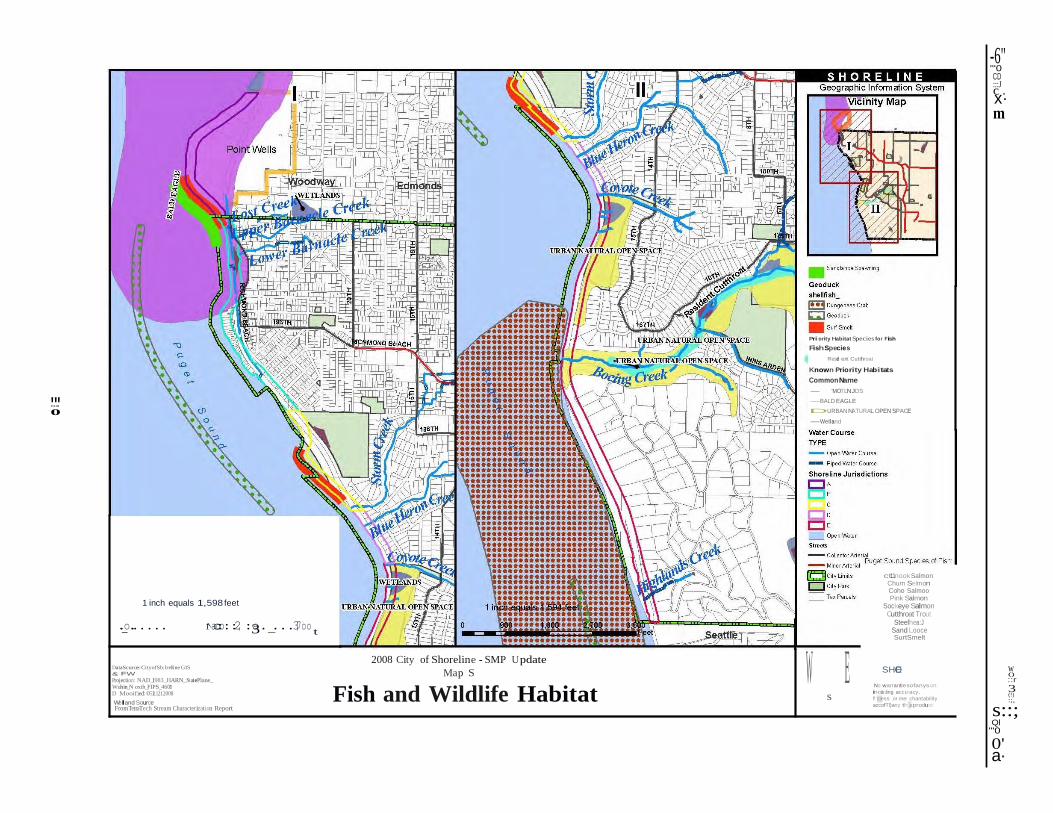
.
0
W E s
-6" "'0 CD
c:::J
. x· m
".....'.
Priority Habitat Species for Fish
FishSpecie s
Resdi ent Cutthroat
Known Priority Habitats
Common Name
- 'MOTLNJDS
-BALD EAGLE
DURBAN NATURAL OPEN SPACE
-Wetland
1 inch equals 1,598 feet
.-o...... 1•••aco:o::2, :3a._...3,7oo t
DataScurce:CityofSb:lreline GIS
& FW
Projection: NAD_1983_HARN_StatePlane_ Wuhin_N oxth_FIPS_4601 D Mooified: 0511212008
Welt and Source FromTetraTech Stream Characterization Report
2008 City of Shoreline - SMP U pdate
Map S
Fish and Wildlife Habitat
ct11nook Salmon Chum Selmon Coho Salmoo Pink Salmon
Sockeye Salmon Cutthroat Trout
Steelhea:J Sand Looce SurtSmelt
SHOE
No warrantiesofanys ort,
incul ding accuracy,
fitness,or mer chantability,
accofTl)any thisproduct
w ()
::r
3 (!) :;,
s::; Ql
"'0
0' a·
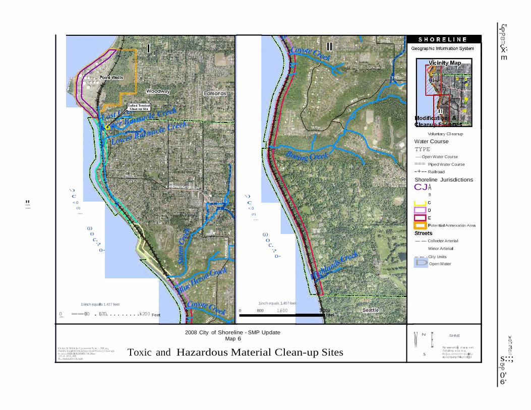
"'
-6" "'0 CD
c:::J.
x· m
...... ......
\)
c <.0
(I)
......
(j)
0
c. ?
o-
\)
c <.0
(I)
......
(j)
0
c. ?
o-
Voluntary Cleanup
Water Course
TYPE
-Open Water Course
=== Piped Water Course
-+-- Railroad
Shoreline Jurisdictions
CJA B
Potential Annexation Area
-- Collector Arterial
Minor Arterial
-·- · City Lmi its
DOpen Water
0_ ==
1inch equals 1.427 feet
080 .16,00.........3...200 Feet
1inch equals 1.467 feet
0 800 1,600
O.to.S:WASt..lo O..p;ortmenlof N,w,-.JR.o, (Nodific.tiau)&WASt.ie Depo<tmontcfEo:oloc;y{Cleor.up)
Px:;eotioa:NADJS13UIARN.J W.Plwo _ \l.N-:d..Jlf'Z_-4601
o...Modiliod:05J11/nll
2008 City of Shoreline - SMP Update Map 6
Toxic and Hazardous Material Clean-up Sites W
N
E s
SHNE
No warranlies of any sort,
i'lduding accuracy,
fit ness,ormerch<in abii ty, accompany this product
w ()
::r
3 (!) :;,
s::; Ql
"'0
0' 6'
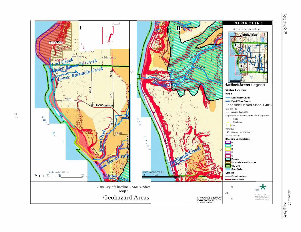
\ '
"'
* s
I '
L-. \ :_
I'
/......_J---
J I ('
-6" 1:1 CD :c::.J..
x· m
,L. \
Critical Areas Legend
......
"'
c
"('I>,...
U"
0
0'
c <P
(I>
(j)
0
c ?
0-
Landslide Hazard Slope > 40% C]0 - 40
- greater than 40%
Liquefacti on SusceptibilPi reliminary 2003
- High
- Moderate
I::] Low
Very tow
e Recent Land Slides
--strea ms
1inch equals 1,389 feet
"•-c::=750--=='·i5i0ii0i 3,0 ., 2008 City of Shoreline - SMPUpdate
Map7
Geohazard Areas
N
SH WE
No l••lfnlnliesof !llly sorl:, ilclldi ng!Knl"tJCII,
fitness,(.(merctwtat«ty, accompany this odo.d:.
w ()
::r
3 (!) :;,
s::; Ql
1:1
0' a·
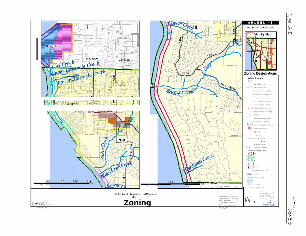
.
E W. ..,. tt.e
Water Course TYPE
- Open W9!erC()(Ille
==:: Piped WMer Course
R-4;Re:sictern.4 o..rll:slacre
R-6;Res'rerti ei , 6 tntstacre
R..S;Re:siderti ei.So..nt:slacre
R-12;Re:siderti ei, 12o.ri:si!ICI'e
. R-18; Resi0erti llll , 18lrislacre
IIII R-24; Residefii!lll , 24 o..Otslacre
-6" "'0 CD
c:::J
. x· m
. R-48;Re:9dertillll , 48 o..nt:slacre
. 0;01ioe
NB; NeighbofhoodEA Sness
CB; Commll1ity Elwliress
IZ'ZJNcaO: NorthCyl11riness0&i rict
IIIIIRB; RegiOOI!II Business
. l;lndu&ritll
. Cl; Cortract
SnohaTi5h COJnty Znnng
a
HI;Hesvylndustriell
a R-9,600; Re ial
Shoret nePianning Se{Jnel1s
CJ·
8: r:l CJ·
IPotentiN Ame>3iCI"' Area
Q; c yUmh
--colec'torMerial
410
tc.S....:o:Cilfoilknb.:IS lk ilb.CGti h jo<ti:nN.'X>)9Et3_HA1Ul'_S...Pk>t_
410 820
2008 City of Shoreline - SMP Update
Map 8
Zoning
Represertatim ct OITicial ComJ.)'"ehensiYe La1dUse M AdoJ1:ed By CityOrcin<rce No. 292.
IE:)Open W<tter
c=JP rcel 8ou'ld.Yy
N o w.or rnbos of ..,.,..rt including OCI.W.cy. ftMn.or mor ohMII.ollilit,'. ocomp• p r o ct
U4 SHeilfuNE
w ()
::r
3 (!)
4601 Shows amendments through s Julv 26,2001
:;,
s::; Ql
"'0
0' a·
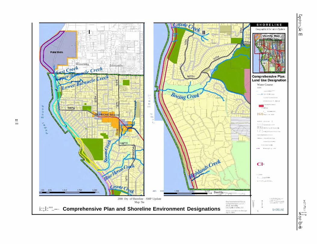
.
"'
[£2]
W E
......
"'"
1::>
<::
0"' (/)
., 01
::>
c...
Water Course lYPf
-
-oponlllhrC""
--I Pipl>dW•ItCouru
LwoDo'l!'ityResidtnliil
loll>d iiJmDonst,-R. .. doont.al
. Higt.DensitJ Res iderCi i
. lo!b<ed Uu
'·· """''""' Rogio...t e...ina•
Sinl;ll of ...,lnst o.tion
!::::::::::1
-6" "'0 CD
c:::J
. x· m
415 830
Spmol stuci\<Aro•
lS':S;) B•li'loer Spoi•I SiudyAru
l.Z:]Bri•rcrosl Spoei.ol Study Aru
NorthCityB1irleosDiolrict
P•r•mo...,ISpe•IStudy'Aru
PrioroloOponSp•co
. PublioOponSp•uo
a API:onn;ngS..g,...nls
Cl• C ty Unit<
L_j oponW•t•r
c=J r,.cti B(>IJnc»,.,.
2008 Oty of Shoreline - SMP Update
Map 9a
i:;l:'"...-- Comprehensive Plan and Shoreline Environment Designations
Rep"esentationct 0'1\cial Comprehensive Lard U".." Ad tedBy City Qdinart:e No. 292
Shows amendments through s Jly 26,2001
N o W<rr•n hstnysott
rotud .oc<u" "' tintH , Oi mtiCh•J<I•bility, .-coomp•n)'lhi< r:-od uct
SHORELINE
w ()
::r
3 (!) :;,
s::; Ql
"'0
0' a·
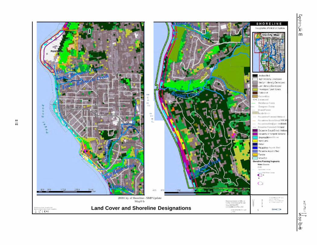
.
"'
W E
"c: Pastureklay
0Grassland
-6" "'0 CD
c:::J
. x· m
...... 01
0"' U)
"0'1
"c'..
435
870
- Deciduous Forest
- Evergreen Fo rest
- Mixed Forest
IIIIISc;n1h/Shn1h
- Palustrine Forested Wetland
- Palustrine Scrub/Shrub
- Palustrine Emergent Wetland
- Estuarine Forested'v'lktland
Unconsolidated Shore
Palustrine Aquatic Bed
Water Course
lYPE
- Open water course
=:::= Pl:led Wiiter Course
·C•
Co g'E!fnW
tyUemr"
DuScuu:Cil nX Shxtlh GIS kojtction:NA D_1983_HARN_StattPIIN _
; :,':t•rol
2008 City of Shoreline - SMPUpdate
Map9 b
Land Cover and Shoreline Designations
Representation r:J Official C:mp-ehensiVe La"lduse Map Ad'4tedEli c ty Qdirooce No. 292
amendments through s ,2001
Now.orrMIIiaof •"''sort, ineb:linQ HC\Uo,',
f•neu,or morch MII.otoi ltv
i o:>n'lpMI)' t.il p!e>d w\
SHO
w ()
::r
3 (!) :;,
s::; Ql
"'0
0' a·
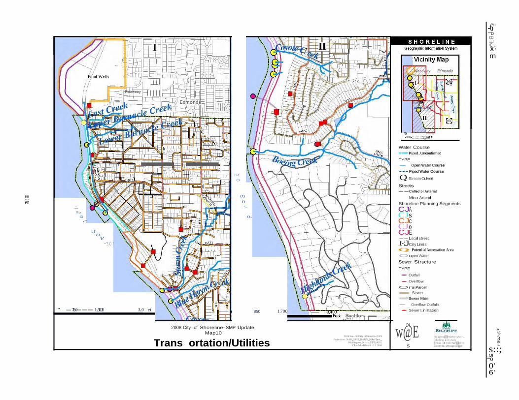
.
"'
--
N
s
-6" "'0 CD
c:::J
. x· m
...... en
.;:.
!!:> G
.-
U'
0v -?0'
lQ
(l)
(f)
0
<;:.
0-
0 -==-::::::::1i1es
Water Course
=== Piped, Unconfirmed
TYPE
- Open Water Course
••• Piped Water Course
Q Stream Culvert
Streets
--Collector Arterial
Minor Arterai l
Shoreline Planning Segments
CJA CJs CJc CJo CJE -- Local street
.t-:JCity Limit s
Q Potenl ial Annexation Area
Oopen Water
Sewer Structure
TYPE
• Outfall
• Overflow
OraxParcel
= Sewer
=Sewer Main
- Overflow Outfalls
" - 715::0=== 1:,511010 3,0 et 850 1.700 • Sewer Lin station
2008 City of Shoreline- SMP Update
Map10
Dii.& Sou-ce:City ciShoreline GIS w@E
No warranit esofanysort,
w ()
::r
3
Trans ortation/Utilities ProJection: NAD_1983_HARN_StJtePlme_
Wa:ihington_Nath_FIPS_4601
Dl.te Modified0 /1212008
flduding a ocu raq. lf tness,or merchantabil:ty,
accotTllanvthisproduct
(l)
:;,
s::; Ql
"'0
0' 6'
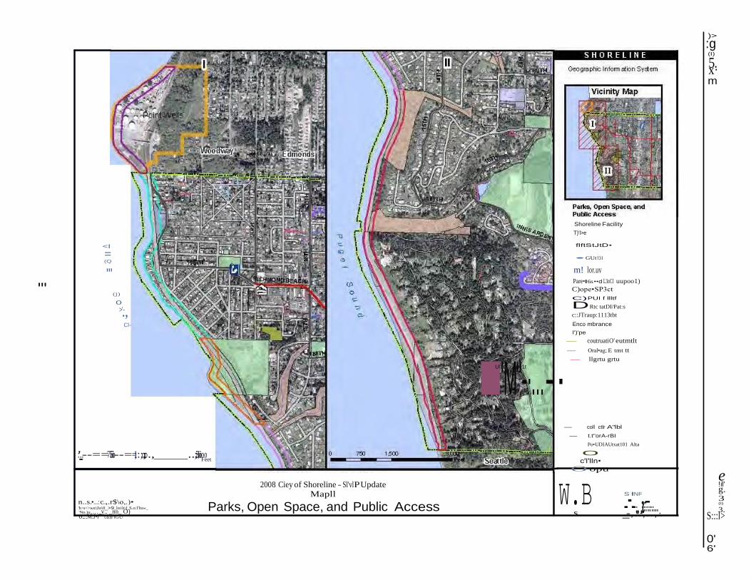
s -S--
f
..:r.-
e
)>
:g (I)
5x·.
m
Shoreline Facility
T)'l>e
<I
= (Q
"' "' (j)
0
>.', Cl-
flftStJtD•
• GUt'l31
m! lor.uv
Pare•I6s ••d L3nCI uupoo1)
C)ope•SP3ct
C) PUI f llltf
DRtc tatDI/Pat:s
c::JTraup:1113tbt
Enco mbrance
l')'pe
- coutruatiO' eutmtlt
- Oral•ag; E tmt tt
IUll
'llt
M( fast
"me
-1t
·...-· - llgrtu grtu
:'..--==75ioi--==1;:;o;;o., ..;3ii,ioioo • Feet
- coll ctlr A"lbl
- t.t"orA-rBI
Po•UDIAUtxat101 Alta
O c'l'lln•
O opu
n..s.•...: c..,.r$\o,.)• 'h>s<>wn:\Jo\0_>9_lto\lt\J_S.o:l'lto«_
'No.)u.,..._v.. _nn_ O) o...M.J•r"'' G$J)l'lGU
2008 Ciey of Shoreline - Sl'vlP Update Mapll
Parks, Open Space, and Public Access W.B
INF
.. ....... _..-,..-.-,".".'",.'.·...
!il' g. 3 (I)
3. S:::l> 0' 6'
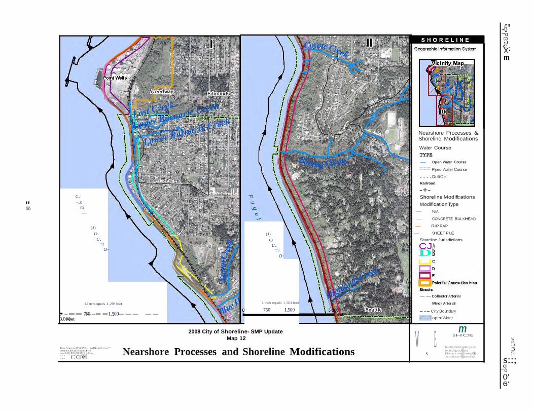
"'
W E
-6" "'0 CD
c:::J.
x· m
...... (X)
c. <.0
ro .....
(J)
0
c. '";:)
o-
(J)
0
c. '";:)
o-
Nearshore Processes & Shoreline Modifications
Water Course
TYPE
- Open Water Course
=== Piped Water Course
....DriftCell
Railroad
-+- Shoreline Modifications
Modification Type
- N/A
- CONCRETE BULKHEAD
- RIP RAP
- SHEET PILE
Shoreline Jurisdictions
CJA DB
1inch equals 1,297 feet 1 inch equals 1,301feet
750 1,500
-- Collector Arterial
Minor Arterial
-·- City Boundary •0_ -== 7=5-0--= =1,5.00--- --3,00F0eet
2008 City of Shoreline- SMP Update
CJopenWater
m
D.u.Sruroo:WASW.. ntof N.o.uliiiR.oorur"'
(Modifr.o.&m.)&Sclm;ort:, l<nl tion:NAD_l983_HARN_St..toP\ono _
;;: r:cre4o9Jl
Map 12
Nearshore Processes and Shoreline Modifications
SHOE
No warran1esofanysort,
includilgaccuracy ,
s flness, or merchantability, accompany this product
w ()
::r
3 (!) :;,
s::; Ql
"'0
0' 6'
"' b
)>
:g (I)
5x·.
m
"m'
'l
(Q
"'
til 0
"' ""
ShoreJirn Fhnnirg Segments
n \l c::J A
c:J e
Open Water
Ta><Parcel
i"---7•5e:o===1·5:;o•o------•3.ooFoeet
2008 Cjjyof Shoreline- SMP Update
M"P 13
sJ/1
_,.i"op<-IJ-.,......
eor g.
S:::l>
Known Archaeological and Historic Sites s ....-...... 3.
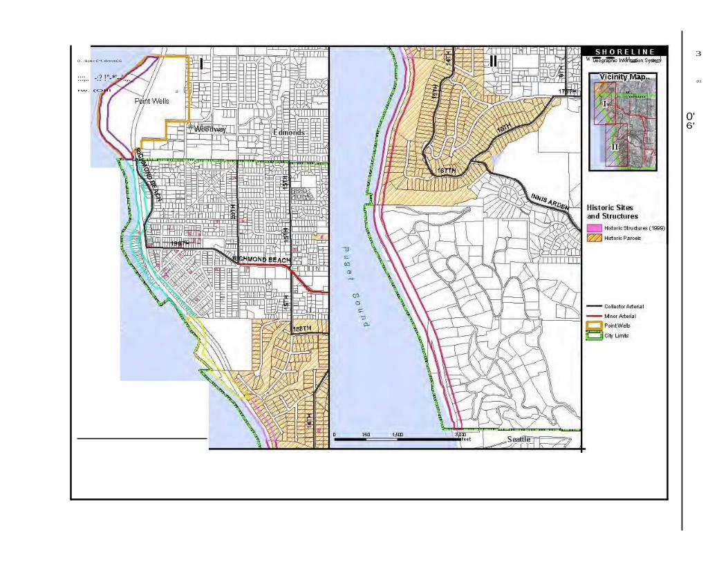
O...:llioH<:C"'f..rll<t<mCG w•• ,._ ..,._\ 3
:::;.. -:? !"-*'--'..,._ ....... (I)
rw. (OIII
"........
0' 6'
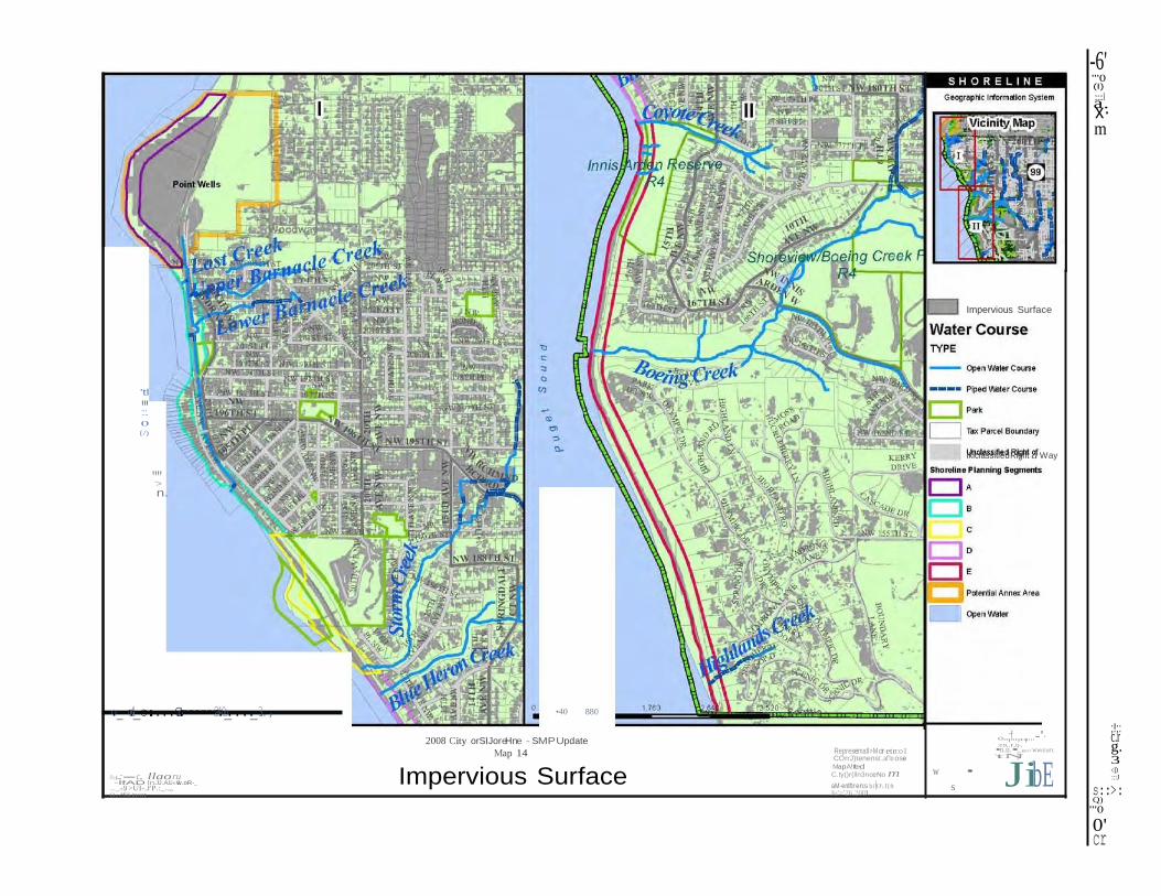
-6' "'0 (I)
a:::::l.
x· m
Impervious Surface
'tl
":::'. 0
{/)
"':">
n.
lklclassitled Rlght d Way
.o_-o.=4o_-c.:....C..o.:======2=4.0_o...._.3.., •40 880
2008 City orSIJoreHne - SMP Update
Map 14 Represematl>M or etrco1 COrrJ)tenenst..af'lo ose MapA!Ited
0..,;f..,..,....-'· .co,.r ,q-, •n.u.• .ec«<'WWtUbll'f,
'tN
w • JibE
;!;: c.r g. 3 <D
o-.-..:-c. llaoru -lfAD lnJJ.AJU«.Sw.oR-_
..._.-..9. >UI-.J'P.:_..,, O...HOS.1n:ot
Impervious Surface C.ty()r(lln3nceNo m aM-entftr-en:s bi!O\.I{ft s Ju'>'26.2001
:::J
s::>: Q)
"'0
0' cr


![Shoreline Master Program Update First Review of Preliminary Draft Shoreline Master Program [Entity] [Month Day, 2009] 1](https://img.pdfslide.us/doc/110x75/56649e5d5503460f94b55840/shoreline-master-program-update-first-review-of-preliminary-draft-shoreline.jpg)