Embed Size (px)
Citation preview
54378 June 2016
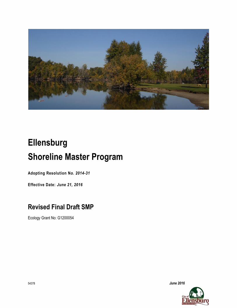
Ellensburg
Shoreline Master Program
Adopting Resolution No. 2014-31
Effective Date: June 21, 2016
Revised Final Draft SMP
Ecology Grant No: G1200054
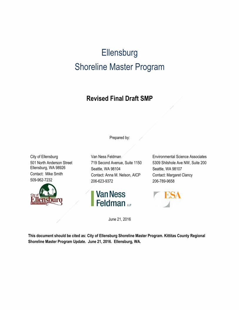
Ellensburg
Shoreline Master Program
Revised Final Draft SMP
Prepared by:
City of Ellensburg
501 North Anderson Street Ellensburg, WA 98926
Contact: Mike Smith
509-962-7232
Van Ness Feldman
719 Second Avenue, Suite 1150
Seattle, WA 98104
Contact: Anna M. Nelson, AICP
206-623-9372
Environmental Science Associates
5309 Shilshole Ave NW, Suite 200
Seattle, WA 98107
Contact: Margaret Clancy
206-789-9658
June 21, 2016
This document should be cited as: City of Ellensburg Shoreline Master Program. Kittitas County Regional
Shoreline Master Program Update. June 21, 2016. Ellensburg, WA.
Table of Contents – Final Draft i June 2016
Ellensburg
Shoreline Master Program
Table of Contents
1. Framework, purpose, principles and applicability ........................................ 1
1.1 The Shoreline Management Act ...................................................................... 1
1.2 Scope and jurisdiction of the Shoreline Master Program ................................ 1
1.3 Purpose and intent .......................................................................................... 3
1.4 Title and reference .......................................................................................... 4
1.5 Public involvement process, advisory committee and agency coordination .... 4
1.6 Relationship to other plans .............................................................................. 6
1.7 Applicability ..................................................................................................... 7
1.8 Governing principles ....................................................................................... 8
1.9 Severability ...................................................................................................... 9
1.10 Effective date .................................................................................................. 9
2. Goals and objectives ............................................................................... 10
2.1 Conservation element ................................................................................... 10
2.2 Shoreline use element .................................................................................. 11
2.3 Economic development element ................................................................... 11
2.4 Public access element .................................................................................. 12
2.5 Recreation element ....................................................................................... 13
2.6 Circulation element ....................................................................................... 13
2.7 Historical/cultural element ............................................................................. 14
2.8 Flood hazard prevention element .................................................................. 14
3. Environment designations and management policies ................................ 16
3.1 Purpose and intent ........................................................................................ 16
Table of Contents – Final Draft ii June 2016
3.2 Evaluation ..................................................................................................... 16
3.3 Environment designations ............................................................................. 16
3.4 Urban conservancy environment ................................................................... 16
3.5 Aquatic environment ..................................................................................... 18
3.6 Shoreline use and modification table ............................................................ 18
4. General policies and regulations .............................................................. 23
4.1 Archaeological and historical resources ........................................................ 23
4.2 Environmental protection and critical areas................................................... 25
4.3 Flood hazard reduction ................................................................................. 66
4.4 Public access ................................................................................................ 69
4.5 Shoreline buffers and vegetation conservation ............................................. 73
4.6 Water quality, stormwater, and nonpoint pollution ......................................... 77
5. Shoreline use and modification policies and regulations ............................ 79
5.1 General shoreline use policies ...................................................................... 79
5.2 General shoreline modification policies ......................................................... 80
5.3 Agriculture ..................................................................................................... 80
5.4 Aquaculture ................................................................................................... 81
5.5 Boating facilities ............................................................................................ 82
5.6 Commercial development.............................................................................. 85
5.7 Dredging and dredge material disposal ......................................................... 86
5.8 Filling, grading, and excavation ..................................................................... 88
5.9 Forest practices ............................................................................................. 90
5.10 Industrial and port development .................................................................... 92
5.11 In-stream structures ...................................................................................... 93
5.12 Mining ........................................................................................................... 95
5.13 Recreation ..................................................................................................... 97
Table of Contents – Final Draft iii June 2016
5.14 Residential development ............................................................................... 99
5.15 Shoreline stabilization ................................................................................. 101
5.16 Shoreline restoration and habitat enhancement .......................................... 106
5.17 Signs ........................................................................................................... 108
5.18 Transportation ............................................................................................. 108
5.19 Utilities......................................................................................................... 110
5.20 Shoreline bulk and dimensional standards .................................................. 112
5.21 Shoreline Use and Dimensional Standards Table ....................................... 116
6. Administration and Procedures ................................................................ 117
6.1 Purpose ....................................................................................................... 117
6.2 Applicability ................................................................................................. 117
6.3 Permit Exemptions ...................................................................................... 119
6.4 Types of permits .......................................................................................... 127
6.5 Review authority .......................................................................................... 128
6.6 Review Criteria ............................................................................................ 129
6.7 Review Procedures ..................................................................................... 131
6.8 Appeals ....................................................................................................... 134
6.9 Timing ......................................................................................................... 134
6.10 Revisions..................................................................................................... 135
6.11 Liberal construction ..................................................................................... 136
6.12 Enforcement ................................................................................................ 136
6.13 Amendments to Master Program ................................................................ 138
7. Definitions and Acronym List ................................................................... 140
Appendices
Table of Contents – Final Draft iv June 2016
Appendix A: Shoreline Environment Designation Map [Attached Separately]
Appendix B: Shoreline Environment Designation Descriptions [Attached Separately]
List of Tables
Table 3.7-1. Shoreline Use and Modification Table
Table 4.2-1. Wetland Buffers for Wetlands in Shoreline Jurisdiction
Table 4.2-2. Wetland Mitigation Ratios for Unavoidable Wetland Impacts in Shoreline Jurisdiction
Table 4.2-3. Aquatic Habitat Conservation Area Buffers for Type F, Np, and Ns Waters
Table 4.5-1. Standard Shoreline Buffers (Type S Waters)
Table 5.21-1. Shoreline Use and Dimensional Standards
Code Revisions
To facilitate implementation of this Shoreline Master Program (SMP), the City of Ellensburg has proposed amendments to Ellensburg City Code (ECC) Chapter 13.64,
Enforcement. Those amendments are available as a separate document.
Supporting Documents
Community Visioning Report October 2012
Inventory and Characterization Report May 2013
Cumulative Impacts Analysis January 2014
Restoration Plan April 2014
No Net Loss Report June 2014
Ellensburg Shoreline Master Program
Chapter 1 – Final Draft 1 June 2016
1. Framework, purpose, principles and applicability
Sections: 1.1 The Shoreline Management Act 1.2 Scope and jurisdiction of the Shoreline Master Program 1.3 Purpose and intent of the Shoreline Master Program 1.4 Title and reference 1.5 Public involvement process, advisory committee and agency coordination 1.6 Relationship to other plans 1.7 Applicability 1.8 Governing principles 1.9 Severability 1.10 Effective date 1.1 The Shoreline Management Act
The Washington State Shoreline Management Act (also referred to in this document as SMA or the Act) was passed by the legislature in 1971 and adopted by a vote of Washington’s citizens in a 1972 referendum (RCW 90.58). The goal of the Shoreline Management Act is “to prevent the inherent harm in an uncoordinated and piecemeal development of the state’s shorelines.” The Act also recognizes that “shorelines are among the most valuable and fragile” of the state’s resources.
The Act provides for the management and protection of the state’s shoreline resources by requiring planning for their reasonable and appropriate use. The area regulated under the Act includes lands within two hundred (200) feet of designated shorelines as well as certain wetlands, river deltas, floodways and floodplains associated with such shorelines.
The SMA establishes a balance of authority between local and state governments. Cities and counties have the primary review responsibility for development along their shorelines, and the state (through the Washington State Department of Ecology; also referred to as Ecology in this document) has authority to review local master programs and local shoreline development permit decisions.
1.2 Scope and jurisdiction of the Shoreline Master Program
The Shoreline Management Act (SMA) applies to all 39 counties and more than 200 cities in Washington State that have "shorelines of the state" (RCW 90.58.030(2)) within their jurisdictional boundaries. Shorelines of the state include:
All marine waters;
Streams with greater than twenty cubic feet per second (20 cfs) mean annual flow;
Lakes twenty (20) acres or larger;
Ellensburg Shoreline Master Program
Chapter 1 - Final Draft 2 June 2016
Upland areas called shorelands that extend two hundred (200) feet landward, in all directions on a horizontal plane, from the edge of the ordinary high water mark (OHWM) of these waters; and
The following areas when they are associated with one of the above: o Wetlands and river deltas; and o Floodways and contiguous floodplain areas landward two hundred (200)
feet from such floodways.
The Act recognizes that certain waters are so important to citizens that they necessitate a special status for classification and protection. These are “shorelines of statewide significance.” The Act lists the following criteria for defining “shorelines of statewide significance” in Eastern Washington:
Any [natural rivers or segments thereof] east of the crest of the Cascade range downstream of a point where the annual flow is measured at two hundred cubic feet per second or more, or those portions of rivers east of the crest of the Cascade range downstream from the first three hundred square miles of drainage area, whichever is longer. (RCW 90.58.030(2)(f)(v)(B))
Shoreline jurisdiction areas for Yakima River, a shoreline of statewide significance, fall within the City of Ellensburg (also referred to as City or Ellensburg in this document).
In Ellensburg, the shoreline jurisdiction includes: all shorelines of the state; upland areas (shorelands) within two hundred (200) feet of the ordinary high water mark of those waters; associated wetlands and river deltas; and floodways and contiguous floodplain areas landward two hundred (200) feet from such floodways. A shoreline environment designation map depicting the updated jurisdictional areas is included as Appendix A to this SMP. Shoreline environment designation descriptions are included in Appendix B. Depictions of the shoreline jurisdiction boundaries are for information purposes only and need to be confirmed in the field.
Ellensburg Shoreline Master Program
Chapter 1 - Final Draft 3 June 2016
1.3 Purpose and intent
The purpose and intent of this SMP is to:
1. To promote the public health, safety and general welfare of the community by providing long range, comprehensive policies and effective, reasonable regulations for development and use of shorelines within Ellensburg;
2. To manage shorelines in a positive, effective and equitable manner;
3. To assume and carry out the City’s responsibilities established by the Act; and
4. To implement RCW 90.58.020 for shorelines of the state:
It is the policy of the state to provide for the management of the shorelines of the state by planning for and fostering all reasonable and appropriate uses. This policy is designed to insure the development of these shorelines in a manner which, while allowing for limited reduction of rights of the public in the navigable waters, will promote and enhance the public interest. This policy contemplates protecting against adverse effects to the public health, the land and its vegetation and wildlife, and the waters of the state and their aquatic life, while protecting generally public rights of navigation and corollary rights incidental thereto.
The legislature declares that the interest of all of the people shall be paramount in the management of shorelines of statewide significance. The department, in adopting guidelines for shorelines of statewide significance, and local government, in developing master programs for shorelines of statewide significance, shall give preference to uses in the following order of preference which:
(1) Recognize and protect the statewide interest over local interest; (2) Preserve the natural character of the shoreline; (3) Result in long term over short term benefit; (4) Protect the resources and ecology of the shoreline; (5) Increase public access to publicly owned areas of the shorelines; (6) Increase recreational opportunities for the public in the shoreline; (7) Provide for any other element as defined in RCW 90.58.100 deemed
appropriate or necessary.
In the implementation of this policy the public's opportunity to enjoy the physical and aesthetic qualities of natural shorelines of the state shall be preserved to the greatest extent feasible consistent with the overall best interest of the state and the people generally. To this end uses shall be preferred which are consistent with control of pollution and prevention of damage to the natural environment or are unique to or dependent upon use of the state's shoreline. Alterations of the natural condition of the shorelines of
Ellensburg Shoreline Master Program
Chapter 1 - Final Draft 4 June 2016
the state, in those limited instances when authorized, shall be given priority for single family residences, ports, shoreline recreational uses including but not limited to parks, marinas, piers, and other improvements facilitating public access to shorelines of the state, industrial and commercial developments which are particularly dependent on their location on or use of the shorelines of the state, and other development that will provide an opportunity for substantial numbers of the people to enjoy the shorelines of the state.
Permitted uses in the shorelines of the state shall be designed and conducted in a manner to minimize, insofar as practical, any resultant damage to the ecology and environment of the shoreline area and any interference with the public's use the water.
1.4 Title and reference
This Document shall be known and may be cited as the “City of Ellensburg Shoreline Master Program.” This document may be referred to herein as the “Program,” “Master Program,” “Shoreline Master Program,” or “SMP.”
1.5 Public involvement process, advisory committee and agency coordination 1. Public information and outreach
This SMP was updated as part of a multi-jurisdictional update process with Kittitas County serving as project lead. The participating jurisdictions were Kittitas County, the City of Ellensburg, the City of Cle Elum, and the Town of South Cle Elum. The participating jurisdictions involved the public throughout the update effort consistent with the Shoreline Management Act (see RCW 90.58.130) and the SMP Guidelines (WAC 173-26-090). As project lead, Kittitas County prepared a public participation plan that identified specific objectives, key stakeholders, and timelines for public participation activities.
2. Multi-jurisdictional SMP update coordination
The SMP update process was closely coordinated among the participating jurisdictions. An interlocal agreement was adopted to define the responsibilities of each jurisdiction and allocate resources from a Washington State Department of Ecology grant.
Kittitas County provided the primary professional and clerical support and was responsible for project management and contracting. Staff assigned by the Cities and Town coordinated local efforts on shorelines within their respective municipal boundaries.
The County coordinated the SMP update process with Washington State Department of Ecology (Ecology), Washington State Department of Fish and Wildlife (WDFW), tribal governments and other state agencies as required in the SMP update guidelines. In addition, the County consulted with other entities for scientific, technical or cultural information including federal agencies, watershed planning units, conservation districts,
Ellensburg Shoreline Master Program
Chapter 1 - Final Draft 5 June 2016
public utility districts, and other institutions as needed.
All participating jurisdictions were responsible for reviewing and commenting on recommended shoreline environment designations and the goals, policies, and use regulations associated with those designations as well as the various supporting documents including but not limited to: inventory characterization reports, restoration plans and cumulative impact analysis. Each jurisdiction was responsible for approving the final SMP through local adoption processes.
3. Shoreline visioning process
To kick-off the process of developing the regional SMP, community-wide visioning sessions were held in Ellensburg and Cle Elum to gather input on how the shoreline areas should look five (5) to ten (10) years from now. Community visioning questionnaires were also distributed widely throughout the County to solicit feedback. Community members provided input on topics such as public access, water-related and water-dependent uses, recreation, restoration activities and more. A summary of the community visioning process can be found in the Community Visioning Report dated October 2012.
4. Regional Shoreline Master Program website
A web page was developed and hosted on the Kittitas County website to share information about the regional SMP update process and to provide opportunities for the public to submit comments and input.
The webpage contained a range of information and documentation related to the development of the SMP update process including:
- background materials - public participation plan and process timeline - frequently asked questions - information on how to participate in the process - community visioning questionnaire - information on advisory committees - meeting materials and summaries - key contacts
The webpage was kept current and maintained throughout the duration of the update.
5. Technical Advisory Committee
Kittitas County, with input from the Cities and Town invited a group of representatives within the scientific community from statewide agencies, the Yakama Nation, the private sector, and academia to participate on the Technical Advisory Committee (TAC). The purpose of the TAC was to help focus technical discussions and identify key technical
Ellensburg Shoreline Master Program
Chapter 1 - Final Draft 6 June 2016
and policy issues associated with the SMP update process. The TAC provided input on data inventory and materials collection, shoreline characterization, shoreline analysis, shoreline designations, shoreline restoration, and monitoring and enforcement efforts. The TAC met monthly between April 2012 and August 2012. Meetings were open to the public.
6. Open public forums and public meeting events
Open public forums (i.e., public meetings, open houses, workshops) were used throughout the regional SMP update process. They were deployed as an early action strategy to improve public knowledge and investment in the regional SMP update process. Later in the update process, open public forums provided opportunities for the jurisdictions to present draft goals, policies, and regulations, as well as a place for citizens to provide comments and input on the draft goals, policies and regulations. Open public forums were held in July 2012 (two open houses), September 2012 (community visioning workshop), and November 2012 (open house) and January 2014 (open house). Additional targeted outreach was conducted by County staff by attending a regular meeting or meeting with individuals of the following groups: Central Washington Homebuilders Association, Kiwanis of Ellensburg and Cle Elum, the Kittitas Field and Stream Club, the Kittitas County Farm Bureau, and the Washington Cattlemen’s Association.
7. Citizen Advisory Committee
The Citizen Advisory Committee (CAC) was established to finalize recommendations on environment designations, goals, policies, and use regulations. Representatives were selected by each of the four participating jurisdictions. The jurisdictions coordinated their selections to achieve a diverse mix of interests including agriculture, recreation, power generation, real estate/development, environment, sporting and conservation. Invitations to participate were also extended to the Washington State Departments of Ecology, Natural Resources, and Fish and Wildlife, and the Yakama Indian Nation. The committee began meeting in October 2012 and continued through December 2013.
1.6 Relationship to other plans
The Growth Management Act (GMA) defines shoreline master program policies as a part of the local comprehensive plan:
For shorelines of the state, the goals and policies of the shoreline management act as set forth in RCW 90.58.020 are added as one of the goals of this chapter as set forth in RCW 36.70A 020. . . . The goals and policies of a shoreline master program for a county or city approved under RCW Chapter 90.58 shall be considered an element of the county or city's comprehensive plan. All other portions of the shoreline master program for a county or city adopted under RCW Chapter 90.58, including use regulations, shall be considered a part of the
Ellensburg Shoreline Master Program
Chapter 1 - Final Draft 7 June 2016
county or city's development regulations. (RCW 36. 70A.480 (1))
Counties and cities that plan under the GMA are required, under RCW 36.70A, to ensure that there is internal consistency between the comprehensive plan elements, future land use plan, and implementing development regulations (including master programs.
The GMA also calls for coordination and consistency of comprehensive plans among local jurisdictions:
The comprehensive plan of each county or city that is adopted pursuant to RCW 36.70A.040 shall be coordinated with, and consistent with, the comprehensive plans adopted pursuant to RCW 36.70A.040 of other counties or cities with which the county or city has, in part, common borders or related regional issues. (RCW 36.70A.100)
This regional SMP update has been developed to comply with the GMA requirements for internal consistency with each jurisdiction’s comprehensive plan and implementing regulations as well as to ensure coordination and consistency between the County, Cities and Town.
1.7 Applicability
1. Unless specifically exempted below, all proposed uses and development occurring within shoreline jurisdiction must conform to the intent and requirements of RCW Chapter 90.58, the Shoreline Management Act, and this Program whether or not a permit or other form of authorization is required. See Section 1.2 for the definition of shoreline jurisdiction; Chapter 6 for permit procedures; and Chapter 7 for definitions of uses, activities, and development.
2. The following activities are not considered “development” for the purpose of this SMP:
a. Interior building improvements that do not change the use or occupancy; b. Exterior building maintenance activities, including painting and roofing, that do
not expand the existing footprint of the structure; c. Routine landscape maintenance of established, ornamental landscaping, such as
lawn mowing, pruning and weeding; and d. Maintenance of the following existing facilities that does not expand the affected
area: septic tanks (routine cleaning), wells, and individual utility service connections.
3. Development on non-federal land is subject to this SMP and must obtain a shoreline permit, even if it is leased, rented, etc. to the federal government, unless the state has ceded regulatory authority by statute.
Ellensburg Shoreline Master Program
Chapter 1 - Final Draft 8 June 2016
4. Federal lands include, but are not limited to, national forests, national parks, national wilderness areas, and lands owned by the Federal Bureau of Land Management (BLM). The following subsections shall guide the determination of SMP applicability on federal lands:
a. Federal development on federally owned land is not required to obtain a shoreline permit, unless otherwise required by law, but shall be consistent to the
maximum extent practicable with this master program; b. Non-federal activities, uses and development on federally owned land are subject
to this SMP and must obtain a shoreline permit;
5. As recognized by RCW 90.58.350, the provisions of this SMP shall not affect treaty rights of Indian Nations or tribes.
1.8 Governing principles
The following principles, in conjunction with the policy statements of RCW 90.58.020, establish the foundation for the goals, policies and regulations of this Program:
1. Any inconsistencies between this Program and the Act must be resolved in accordance with the Act.
2. The policies of this Program may be achieved by diverse means including, but not limited to: regulation of development; acquisition of lands and/or easements by purchase or gift; public facility and park planning; watershed planning; voluntary salmon recovery projects; and incentive programs.
3. Regulation of private property to implement Program goals must be consistent with all relevant constitutional and other legal limitations including, but not limited to: civil rights guaranteed by the U.S. and state constitutions, recent federal and state case law, and state statutes.
4. Regulatory or administrative actions contained herein must not unconstitutionally infringe on private property rights or result in an unconstitutional taking of private property.
5. The waters of the state are owned by the citizens of the state. The property rights accrued to the citizens of the state must not be infringed upon by activities that denigrate the value of this ownership interest.
6. The regulatory provisions of this Program are limited to shorelines of the state, whereas the planning functions of this Program may extend beyond the designated shoreline boundaries.
7. The policies and regulations established by the Regional Shoreline Master Program must be integrated and coordinated with those policies and rules of the
Ellensburg Shoreline Master Program
Chapter 1 - Final Draft 9 June 2016
comprehensive plans and development regulations adopted by the participating jurisdictions under the GMA.
8. Protecting the shoreline environment is an essential statewide policy goal, consistent with other policy goals. Permitted and/or exempt development, actions taken prior to the Act’s adoption, and/or unregulated activities can impair shoreline ecological processes and functions. This Program protects the shoreline ecology from such impairments in the following ways:
a. By using a process that identifies, inventories, and ensures meaningful understanding of current and potential ecological functions provided by affected shorelines.
b. By including policies, regulations, and incentives designed to ensure all development, including permit-exempt development, will not cause a net loss of shoreline ecological function.
c. By including regulations and incentives designed to restore impaired ecological functions where such functions have been identified, consistent with the Restoration Plan dated April 2014.
d. By including policies and regulations to address cumulative impacts, including the cumulative effect of exempt development, and by fairly allocating the burden of addressing such impacts among development opportunities.
e. By including policies and regulations that coordinate shoreline management while protecting private property rights, consistent with the public interest.
9. In light of other relevant local, state, and federal regulatory and non-regulatory programs, the City will balance the policy goals of this Program to the extent consistent with the policies of the Act and these governing principles, and modify this Program to reflect changing circumstances.
1.9 Severability
Shall any chapter, section, subsection, paragraph, sentence, clause or phrase of this Program be declared unconstitutional or invalid for any reason, such decision shall not affect the validity of the remaining portions of this Program.
1.10 Effective date
This Program and all amendments thereto shall become effective 14 days after final approval by Ecology.
Ellensburg Shoreline Master Program
Chapter 2 – Final Draft 10 June 2016
2. Goals and objectives
Sections: 2.1 Conservation element 2.2 Shoreline use element 2.3 Economic development element 2.4 Public access element 2.5 Recreation element 2.6 Circulation element 2.7 Historical/cultural element 2.8 Flood hazard prevention element 2.1 Conservation element
A. Goals
1. Develop and implement management practices that will conserve and sustain shoreline resources and important natural features.
2. Protect the ecological functions and values of the shoreline areas to ensure no net loss.
3. Protect fragile natural areas and resources.
4. Promote restoration of shoreline ecological functions and processes.
B. Objectives
1. Preserve unique, rare, and fragile natural features, habitats and native shoreline vegetation.
2. Avoid and minimize adverse impacts to natural systems and quality of the shoreline environment.
3. Preserve the scenic and aesthetic quality of shorelines and vistas to the greatest extent feasible.
4. Locate and design new uses and development to avoid impacts to shoreline resources. Where there is no feasible alternative, require that adverse impacts be mitigated to achieve no net loss of shoreline ecological functions.
5. Follow best management practices (BMPs) that protect water quality.
6. Integrate critical area standards in the Shoreline Master Program with the policies and regulations of the local jurisdiction.
Ellensburg Shoreline Master Program
Chapter 2 – Final Draft 11 June 2016
2.2 Shoreline use element A. Goals
1. Consider the use and development of shorelines and adjacent land areas for public and private land uses in relation to the natural environment.
2. Ensure no net loss of ecological function.
B. Objectives
1. Give shoreline use preference to single-family residential uses, ports, shoreline recreational uses, and water-dependent commercial or industrial developments that are consistent with preservation of shoreline ecological functions and processes.
2. Give secondary preference to water-related and water-enjoyment uses.
3. Allow non-water-oriented uses only when substantial public benefit is provided with respect to the goals of the Act for public access and ecological restoration.
4. Locate, design, and manage shoreline uses to prevent a net loss of shoreline ecological functions and processes over time. Where adverse impacts are unavoidable, require mitigation to ensure no net loss of shoreline ecological functions.
5. Ensure proposed residential developments are compatible with or enhance the aesthetic quality of the shoreline area.
6. Design and locate residential development to preserve the natural landscape and shoreline ecology and minimize conflicts with present and planned land uses.
7. Encourage mixed use developments that include and support water-oriented uses and provide a substantial public benefit consistent with the public access and ecological restoration goals and policies of the Act.
8. Locate new high intensity uses in areas that are not susceptible to erosion and flooding and where impacts to ecological functions can be avoided.
9. Plan for and control stormwater runoff from new developments and redevelopment projects. When required, provide treatment consistent with state and local standards.
2.3 Economic development element A. Goals
1. Recognize the role of shorelines, recreational opportunities, agriculture, and forest products industry in attracting people to the region as residents, business owners, tourists, and second home owners.
Ellensburg Shoreline Master Program
Chapter 2 – Final Draft 12 June 2016
2. Support uses that contribute to the region’s economy while maintaining the qualities and functions of the shorelines, flood prone areas and channel migration zones.
B. Objectives
1. Protect existing agricultural and commercial forest land uses and provide for new environmentally sensitive resource-based development.
2. Develop the recreational industry along shorelines in a manner that will enhance public enjoyment of the shorelines and provide an economic benefit to the community.
3. Ensure that any economic activity taking place in the shoreline environment operates in a manner that protects shoreline ecological functions and processes. Minimize and mitigate unavoidable impacts.
4. Encourage appropriate new water-dependent, water-related, or water-enjoyment activities along shorelines not prone to flooding.
2.4 Public access element
A. Goals
1. Develop and maintain a network of safe, convenient and diversified access opportunities for the public to enjoy the physical and aesthetic qualities of the shorelines of Ellensburg.
2. Recognize the rights of private property owners.
B. Objectives
1. Promote and enhance the public interest with regard to rights to access waters held in public trust by the state, while protecting private property rights and public safety.
2. Encourage incorporation of shoreline access into private and public shoreline use and development proposals. Allow private access developed for residential development to be limited to owners within that development.
3. Encourage the acquisition of suitable upland shoreline properties to provide public access to publicly-owned shorelines. Prioritize shoreline reaches with limited access opportunities, where public access is compatible with the shoreline environment.
4. Encourage the development of additional public access to the shoreline on lands owned by the city, state, and federal government and through public easements.
5. Consider the diverse needs of residents and visitors in acquisition and design of public access facilities.
Ellensburg Shoreline Master Program
Chapter 2 – Final Draft 13 June 2016
6. Locate, design, develop, manage and maintain public access in a manner that protects shoreline ecological functions and processes and minimizes impacts to surrounding properties.
7. Provide, protect, and enhance physical and visual access to shorelines.
8. Design and maintain public access so that negative impacts to surrounding properties (e.g., trespass and litter) are eliminated or reduced.
2.5 Recreation element A. Goal
1. Provide opportunities and space for diverse forms of water-oriented recreation.
B. Objectives
1. Prioritize water-oriented shoreline recreational development that is primarily related to access, enjoyment, and use of the water and shorelines of the state.
2. Locate, design, develop, manage, and maintain recreational areas in a manner that protects shoreline ecological functions and processes.
3. Recognize and protect the public interest by providing increased recreational opportunities within shorelines of statewide significance.
4. Provide diverse choices of regional water-oriented public recreational opportunities.
5. Consider measures necessary to establish a high level of compatibility with other uses and activities and avoid negative impacts to the shoreline environment when locating, designing and operating recreational developments.
6. Encourage private investment in water-oriented recreational facilities that are open to the public.
7. Encourage federal, state, and local governments to develop existing sites and evaluate opportunities to acquire additional shoreline property for public recreational use.
8. Encourage development of non-motorized multi-use trails that provide recreation and transportation opportunities where compatible with shoreline ecological functions.
2.6 Circulation element
A. Goal
1. Create and maintain a comprehensive circulation system which provides for the
Ellensburg Shoreline Master Program
Chapter 2 – Final Draft 14 June 2016
safe, convenient, economic, and diversified movement of people, goods, and services, with minimum disruption to the shoreline area and environment.
B. Objectives
1. Locate and design new circulation systems for alternative modes of transportation where the natural landscape can be preserved, ecological function maintained, and land use conflicts minimized.
2. Locate, design, develop, manage, and maintain transportation systems in a manner that protects shoreline ecological functions and processes. Minimize and mitigate unavoidable impacts.
3. Encourage the use of waterborne transportation for recreational uses.
4. Locate new road corridors for motorized vehicles outside of shoreline jurisdiction unless there is no reasonably feasible location.
2.7 Historical/cultural element
A. Goal
1. Identify, protect, preserve, and restore sites, objects, structures, buildings, and districts that have historical, cultural, educational, and scientific value and/or significance.
B. Objectives
1. Protect cultural and historic sites in collaboration with appropriate tribal, state, federal, and local governments.
2. Encourage cooperation between public agencies and private parties in the identification, protection, and management of cultural resources.
3. Preserve, protect, or restore unique educational, historical, or culturally significant features to further enhance the value of the shorelines.
4. Provide access to sites in a manner that does not degrade the cultural or historical resource or impact the quality of the environment.
5. Incorporate opportunities for education related to archaeological, historical, and cultural features into public and private programs and development where appropriate.
2.8 Flood hazard prevention element
A. Goal
Ellensburg Shoreline Master Program
Chapter 2 – Final Draft 15 June 2016
1. Prevent and minimize flood damage potential.
B. Objectives
1. Comply with the requirements of the National Flood Insurance Program.
2. Ensure conformance with applicable flood prevention codes and hazard management and mitigation plans.
3. Design, locate, and maintain flood hazard reduction measures to avoid a net loss of shoreline ecological functions.
4. Encourage bio-stabilization methods for erosion damage repair whenever possible.
5. Recognize that flooding is a natural process and that floodplains are integral to functioning river ecosystems.
Ellensburg Shoreline Master Program
Chapter 3 – Final Draft 16 June 2016
3. Environment designations and management policies
Sections: 3.1 Purpose and intent 3.2 Evaluation 3.3 Environment designations 3.4 Urban conservancy environment 3.5 Aquatic environment 3.6 Shoreline use and modification table 3.1 Purpose and intent
This chapter is intended to meet the requirements in WAC 173-26-211(2)(a), which states:
Master programs shall contain a system to classify shoreline areas into specific environment designations. This classification system shall be based on the existing use pattern, the biological and physical character of the shoreline, and the goals and aspirations of the community as expressed through comprehensive plans as well as the criteria in this Section. Each master program's classification system shall be consistent with that described in WAC 173-26-211 (4) and (5) unless the alternative proposed provides equal or better implementation of the act.
3.2 Evaluation
Environment designations were created by evaluating the existing use patterns, biological and physical characteristics, zoning designations, and comprehensive plan designations. The inventory and characterization data, depicted on maps and described in text, was used to determine the extent of shoreline alterations.
3.3 Environment designations
The shoreline environment designation system includes two (2) environments: urban conservancy and aquatic. Each environment designation contains a purpose statement, management policies and designation criteria.
For all areas not specifically designated, the environment designation will be urban conservancy.
3.4 Urban conservancy environment
A. Purpose
The purpose of the urban conservancy environment is to protect and restore ecological functions of open space, floodplain and other sensitive lands where they exist in urban
Ellensburg Shoreline Master Program
Chapter 3 – Final Draft 17 June 2016
and developed settings, while allowing a variety of compatible uses.
B. Management policies
Shoreline use and development within this designation must be consistent with the following policies:
1. Allow primarily uses that preserve the natural character of the area or promote preservation of open space, floodplain or sensitive lands either directly or over the long-term. Allow uses that result in restoration of ecological functions if the use is otherwise compatible with the purpose of the environment and the setting.
2. Establish standards for shoreline stabilization measures, vegetation conservation, water quality, and shoreline modifications to ensure that new uses and/or development does not result in a net loss of shoreline ecological functions or further degrade other shoreline values.
3. Public access and public recreation objectives should be preferred uses and implemented whenever feasible if significant ecological impacts can be mitigated.
4. Encourage uses to include restoration of ecological functions in the design of project components.
5. Prioritize water-oriented uses over non-water-oriented uses. For shoreline areas adjacent to commercially navigable waters, water-dependent uses should be given highest priority.
6. Recognize mining is a unique use that may be an appropriate use within the urban conservancy environment when conducted in a manner consistent with the environment policies and the provisions of WAC 173-26-241(3)(h) and located consistent with mineral resource lands designation criteria.
C. Designation criteria
1. Assign an urban conservancy environment designation to shoreline areas appropriate and planned for development that is compatible with maintaining or restoring the ecological functions of the area, that are not generally suitable for water-dependent uses and that lie in incorporated municipalities, urban growth areas, or commercial or industrial "limited areas of more intense development" if any of the following characteristics apply:
a. They are suitable for water-related or water-enjoyment uses; b. They are open space, floodplain or other sensitive areas that should not be more
intensively developed; c. They have potential for ecological restoration; d. They retain important ecological functions, even though partially developed; or e. They have the potential for development that is compatible with ecological
restoration.
Ellensburg Shoreline Master Program
Chapter 3 – Final Draft 18 June 2016
3.5 Aquatic environment
A. Purpose
The purpose of the aquatic environment is to protect, restore, and manage the unique characteristics and resources of the areas waterward of the OHWM.
B. Management policies
Shoreline use and development within this designation must be consistent with the following policies:
1. Allow new over-water structures only for water-dependent uses, public access, or ecological restoration.
2. Limit the size of new over-water structures to the minimum necessary to support the structure's intended use.
3. Encourage multiple use of over-water facilities.
4. Locate and design all uses and developments on navigable waters or their beds to:
a. Minimize interference with surface navigation; b. Consider impacts to public views; and c. Allow for the safe, unobstructed passage of fish and wildlife, particularly those
species dependent on migration.
5. Prohibit uses that adversely impact the ecological functions of critical freshwater habitats except where necessary to achieve the objectives of RCW 90.58.020, and then only when their impacts are mitigated according to the sequence described in Section 4.2.B.2 to assure no net loss of ecological functions.
6. Design and manage shoreline uses and modifications to prevent degradation of water quality and alteration of natural hydrographic conditions.
C. Designation criteria
Assign an aquatic environment designation to lands waterward of the OHWM.
3.6 Shoreline use and modification table Shoreline use and modification shall be classified by the Administrator and regulated under one or more of the following applicable sections of this Program.
Table 3.7-1: Shoreline Use and Modification Table
Legend
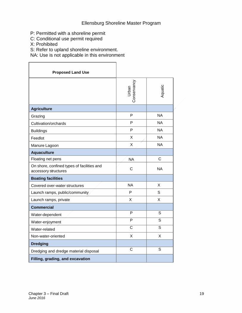
Ellensburg Shoreline Master Program
Chapter 3 – Final Draft 19 June 2016
P: Permitted with a shoreline permit C: Conditional use permit required X: Prohibited S: Refer to upland shoreline environment. NA: Use is not applicable in this environment
Proposed Land Use
Urb
an
Co
nse
rva
ncy
Aq
ua
tic
Agriculture
Grazing P NA
Cultivation/orchards P NA
Buildings P NA
Feedlot X NA
Manure Lagoon X NA
Aquaculture
Floating net pens
NA C
On shore, confined types of facilities and
accessory structures C NA
Boating facilities
Covered over-water structures NA X
Launch ramps, public/community P S
Launch ramps, private X X
Commercial
Water-dependent P S
Water-enjoyment P S
Water-related C S
Non-water-oriented X X
Dredging
Dredging and dredge material disposal C S
Filling, grading, and excavation
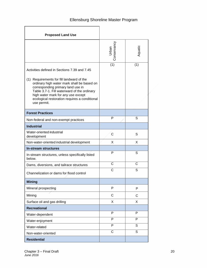
Ellensburg Shoreline Master Program
Chapter 3 – Final Draft 20 June 2016
Proposed Land Use
Urb
an
Co
nse
rva
ncy
Aq
ua
tic
Activities defined in Sections 7.39 and 7.45
(1) Requirements for fill landward of the ordinary high water mark shall be based on corresponding primary land use in Table 3.7-1. Fill waterward of the ordinary high water mark for any use except ecological restoration requires a conditional use permit.
(1) (1)
Forest Practices
Non-federal and non-exempt practices P S
Industrial
Water-oriented industrial
development C S
Non-water-oriented industrial development X X
In-stream structures
In-stream structures, unless specifically listed below.
P S
Dams, diversions, and tailrace structures C C
Channelization or dams for flood control C S
Mining
Mineral prospecting P P
Mining C C
Surface oil and gas drilling X X
Recreational
Water-dependent P P
Water-enjoyment P P
Water-related P S
Non-water-oriented C S
Residential
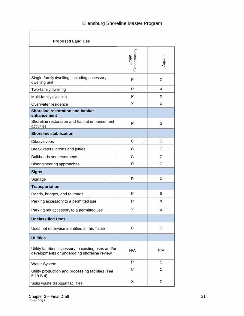
Ellensburg Shoreline Master Program
Chapter 3 – Final Draft 21 June 2016
Proposed Land Use
Urb
an
Co
nse
rva
ncy
Aq
ua
tic
Single-family dwelling, including accessory dwelling unit
P X
Two-family dwelling P X
Multi-family dwelling P X
Overwater residence X X
Shoreline restoration and habitat enhancement
Shoreline restoration and habitat enhancement activities
P S
Shoreline stabilization
Dikes/levees C C
Breakwaters, groins and jetties C C
Bulkheads and revetments C C
Bioengineering approaches P C
Signs
Signage P X
Transportation
Roads, bridges, and railroads P S
Parking accessory to a permitted use P X
Parking not accessory to a permitted use X X
Unclassified Uses
Uses not otherwise identified in this Table C C
Utilities
Utility facilities accessory to existing uses and/or developments or undergoing shoreline review
N/A N/A
Water System P S
Utility production and processing facilities (see 5.19.B.4)
C C
Solid waste disposal facilities X X
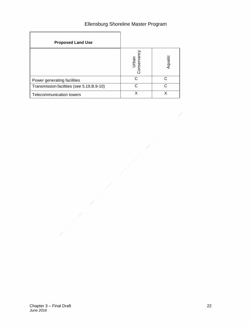
Ellensburg Shoreline Master Program
Chapter 3 – Final Draft 22 June 2016
Proposed Land Use
Urb
an
Co
nse
rva
ncy
Aq
ua
tic
Power generating facilities C C
Transmission facilities (see 5.19.B.9-10)
C C
Telecommunication towers X X
Ellensburg Shoreline Master Program
Chapter 4 – Final Draft 23 June 2016
4. General policies and regulations
Sections: 4.1 Archaeological and historical resources 4.2 Environmental Protection and Critical areas
A. Policies
B. Regulations – General regulations for environmental protection
C. Regulations – General regulations for all critical areas
D. Regulations – General mitigation requirements for all critical areas
E. Regulations – General mitigation plan contents for all critical areas
F. Regulations – Wetland designation, mapping, delineation, and categorization
G. Regulations – Wetland buffers
H. Regulations – Wetland reporting
I. Regulations – Wetland compensatory mitigation
J. Regulations – Aquatic habitat conservation area designation and mapping
K. Regulations – Aquatic habitat conservation area buffers
L. Regulations – Aquatic habitat conservation area reporting
M. Regulations – Wildlife habitat conservation areas designation, classification,
mapping, and surveying
N. Regulations – Wildlife habitat conservation area reporting and mitigation
requirements
O. Regulations – Geologically hazardous areas designation, classification, and
mapping
P. Regulations – Geologically hazardous areas
Q. Regulations – Frequently flooded area designation and mapping
R. Regulations – Frequently flooded area protection standards
S. Regulations – Frequently flooded area reporting
T. Regulations – Frequently flooded area compensatory mitigation
U. Regulations – Critical aquifer recharge areas designation, mapping, and
classification
V. Regulations – Critical aquifer recharge areas protection standards
W. Regulations – Critical aquifer recharge areas reports
X. Regulations – Critical aquifer recharge areas reports 4.3 Flood hazard reduction 4.4 Public access 4.5 Shoreline buffers and vegetation conservation 4.6 Water quality, stormwater, and nonpoint pollution 4.1 Archaeological and historical resources
The following provisions apply to cultural, archaeological, and historic resources that are either recorded at the Washington State Department of Archeology and Historic
Ellensburg Shoreline Master Program
Chapter 4 – Final Draft 24 June 2016
Preservation and/or by local jurisdictions or have been inadvertently uncovered. Archaeological sites located both in and outside shoreline jurisdiction are subject to RCW Chapter 27.44 (Indian graves and records) and RCW Chapter 27.53 (Archaeological sites and records). Shoreline uses or development that may impact such sites shall comply with Chapter 25-48 WAC as well as the provisions of this chapter.
A. Policies
1. Care should be taken to avoid disturbing archeological and historical resources along Ellensburg shorelines.
2. Prevent the destruction of or damage to any site having historic, cultural, scientific, or educational value as identified by the appropriate authorities, including affected Indian tribes, and the Department of Archaeology and Historic Preservation.
3. Review of proposed new uses and/or development along shorelines in areas documented to contain archaeological resources should include consultation with professional archaeologists, historians, affected Indian tribes and biologists to identify areas containing potentially valuable data, and to establish procedures for salvaging the data or maintaining the area in an undisturbed condition.
B. Regulations
1. Developers and property owners shall immediately stop work and notify the local government, the Washington State Department of Archeology and Historic Preservation and affected Indian tribes if archaeological resources are uncovered during excavation. Construction may recommence pursuant to RCW 27.44.040, RCW 27.53.040 and WAC 25-48-030. A notification stating this requirement shall be included on shoreline permit documents.
2. Prior to issuance of a permit in areas documented to contain cultural or archaeological resources, a cultural resources site inspection or evaluation by a professional archaeologist shall be required in coordination with affected Indian tribes.
3. If a cultural resource site inspection or evaluation identifies the presence of significant historic or archaeological resources, a cultural resource management plan shall be prepared by a professional archaeologist or historic preservation professional. In addition, a permit or other requirements administered by the Washington State Department of Archaeology and Historic Preservation pursuant to RCW 27.44 and RCW 27.53 may apply.
Ellensburg Shoreline Master Program
Chapter 4 – Final Draft 25 June 2016
4.2 Environmental protection and critical areas
A. Policies
1. The beneficial functions of shorelines, critical areas, and critical freshwater habitats should be protected and potential dangers or public costs associated with the inappropriate use of such areas should be minimized by reasonable regulation of shoreline use and development.
2. To implement the policy stated above, it is the intent of this Section to accomplish the following:
a. Categorize and designate critical areas that occur within shoreline jurisdiction according to the SMA requirements in RCW 90.58 and regulate critical areas according to WAC 173-26.
b. Designate minimum buffer widths for all shorelines to protect shoreline resources, maintain fish and wildlife habitat, and achieve the goal of having no net loss of shoreline ecological functions.
c. Preserve, protect, manage, or regulate critical areas that have a direct or indirect effect on conservation of fish, wildlife, other natural resources, and values.
d. Conserve and protect the environmental attributes of Ellensburg that contribute to the quality of life for residents of both the City and the State of Washington.
e. Regulate use and development adjacent to shoreline water bodies and within critical areas on adjacent shorelands.
f. Guide development proposals to the most environmentally suitable and naturally stable portion of a development site.
g. Protect people and property from hazards associated with floods, landslides, erosion, migrating river channels, and other natural processes or events.
h. Minimize the costs that the public has to bear to protect properties in hazardous areas or to repair damages associated with floods and other hazards.
i. Reduce cumulative adverse environmental impacts to water availability, water quality, wetlands, aquatic and wildlife habitat conservation areas, frequently flooded areas, and geologically hazardous areas.
j. Maintain and protect both acreage and functions of regulated wetlands in Ellensburg through general protection standards, enhancement, restoration, and creation.
k. Protect water quality by controlling erosion, providing guidance in the siting of land uses and activities to prevent or reduce the release of chemical or bacterial pollutants into waters of the State, and maintaining stream flows and habitat quality for fish.
l. Conserve drainage features that function together or independently to collect, store, purify, discharge, and/or convey waters of the State.
m. Maintain groundwater recharge and prevent the contamination of groundwater resources to ensure water quality and quantity for public and private uses and critical area functions.
Ellensburg Shoreline Master Program
Chapter 4 – Final Draft 26 June 2016
n. Promote the restoration of degraded critical areas and their buffers in order to regain lost ecological functions and values and improve the economic health and stability of Ellensburg.
o. Recognize that the protection of critical areas and their buffers is important for maintaining hyporheic zone functions.
3. In protecting and restoring shorelines and critical areas within shoreline jurisdiction,
the full spectrum of planning and regulatory measures should be integrated, including the comprehensive plan, interlocal watershed plans, local development regulations, and state, tribal, and federal programs.
4. The planning objectives of this SMP for critical areas shall be the protection of existing ecological functions and ecosystem-wide processes and restoration of degraded ecological functions and ecosystem-wide processes. The regulatory provisions for critical areas shall protect existing ecological functions and ecosystem-wide processes.
5. Promote human uses and values that are compatible with the other objectives of this Section, such as public access and aesthetic values, provided that impacts to ecological functions are first avoided, and any unavoidable impacts are mitigated.
B. Regulations – General regulations for environmental protection
The following regulations apply to all uses and developments in shorelines of the sate unless stated otherwise.
1. Proponents of new shoreline use and development, including preferred uses and uses that are exempt from permit requirements, shall employ all reasonable measures to protect shoreline functions and processes.
2. Adverse impacts caused by new shoreline use and development shall be mitigated using the following actions in order of priority (referred to as the mitigation sequence):
a. Avoiding the impact altogether by not taking a certain action or parts of an action; b. Minimizing impacts by limiting the degree or magnitude of the action and its
implementation by adhering to the dimensional requirements, performance standards and design criteria in this Program and using other technologies or steps, as needed, to avoid or reduce impacts;
c. Rectifying the impact by repairing, rehabilitating, or restoring the affected environment;
d. Reducing or eliminating the impact over time by preservation and maintenance operations;
e. Compensating for the impact by replacing, enhancing, or providing substitute resources or environments; and
f. Monitoring the impact and the compensation projects and taking appropriate corrective measures.
Ellensburg Shoreline Master Program
Chapter 4 – Final Draft 27 June 2016
3. Proposals for new shoreline uses and developments shall clearly identify potential shoreline impacts. During initial review of the proposal, the Administrator may require the applicant to submit documentation, prepared by a qualified professional, to assess the degree and extent of potential impacts to shoreline functions. When reviewing proposals for new shoreline uses and developments, the Administrator shall first determine whether identified shoreline impacts have been avoided and secondly minimized. The Administrator shall require compensatory mitigation, designed by a qualified professional, for development proposals that:
a. Do not fully conform to one or more of the dimensional requirements, performance standards, and/or design criteria in this Program; or
b. Require a variance or conditional use permit; or c. Result in measureable damage, loss and/or displacement of a wetland, aquatic
habitat conservation area, wildlife habitat conservation area, flood storage or conveyance area, or critical aquifer recharge area.
4. Compensatory mitigation measures shall occur in the vicinity of the shoreline impact or at an alternative location within the same watershed that provides greater and more sustainable ecological benefits. When determining whether off-site mitigation provides greater and more sustainable benefits, the Administrator shall consider limiting factors, critical habitat needs, and other factors identified by the April 2014 shoreline restoration plan, or an approved watershed or comprehensive resource management plan. The Administrator may also approve use of alternative mitigation practices such as in-lieu fee programs, mitigation banks, and other similar approaches provided they have been approved and sanctioned by the appropriate state, federal, and Tribal authorities.
5. In review of applications for shoreline permits and exemptions the City shall consider the cumulative impacts of individual uses and developments, including preferred uses and uses that are exempt from permit requirements, when determining whether a proposed use or development could cause a net loss of ecological functions. The Administrator shall prohibit any shoreline use or development that will result in unmitigated cumulative impacts.
6. The City shall have the authority to require the applicant/proponent to submit special studies, assessments and analyses as necessary to identify and address cumulative impacts including, but not limited to, impacts on fish and wildlife habitat, public access/use, aesthetics, and other shoreline attributes.
7. Mitigation plans and critical areas reports shall be prepared by a qualified professional, with experience and training in the pertinent scientific discipline, and who is a qualified scientific expert with expertise appropriate for the relevant critical area or shoreline resource. A qualified professional must have obtained a B.S. or B.A. or equivalent degree in biology, engineering, environmental studies, fisheries, geomorphology, or related field, and two years of related work experience. Also, a qualified professional must have the following license, degree or experience:
Ellensburg Shoreline Master Program
Chapter 4 – Final Draft 28 June 2016
a. A qualified professional for habitats or wetlands must have a degree in biology and have at least two years of full-time experience as a wetland professional, including delineating wetlands using the federal manuals, preparing wetland reports, conducting function assessments, and developing and implementing mitigation plans;
b. A qualified professional for a geological hazard must be a professional engineer or geologist, licensed in the state of Washington;
c. A qualified professional for critical aquifer recharge areas means a hydrogeologist, geologist, engineer, or other scientist with experience in preparing hydrogeologic assessments;
d. A qualified professional for frequently flooded areas must be familiar with hydrology, hydraulics, and fluvial geomorphology.
8. When compensatory mitigation plans for impacts to shoreline resources are required, all of the following shall apply:
a. The quality and quantity of the replaced, enhanced, or substituted resources shall be the same or better than the affected resources;
b. The mitigation site and associated vegetative planting shall be nurtured and maintained such that healthy native plant communities grow and mature over time;
c. The mitigation shall be informed by pertinent scientific and technical studies, including but not limited to, the Shoreline Inventory and Characterization Report, the Shoreline Restoration Plan, and other background studies prepared in support of this Program;
d. The mitigation shall replace the functions as quickly as possible following the impacts;
e. Mitigation activity shall be monitored and maintained to ensure that it achieves its intended functions and values; and
f. The Administrator shall require the applicant/proponent to post a bond or provide other financial surety equal to one hundred twenty-five percent (125%) of the estimated cost of the mitigation to ensure the mitigation is carried out successfully. The bond shall remain in effect until the City determines, in writing, that the standard bonded for have been met.
C. Regulations—General regulations for all critical areas
The following provisions apply to any use or development occurring in or adjacent to critical areas or their buffers in shoreline jurisdiction whether or not a permit or other authorization is required from Ellensburg. Critical areas outside of shoreline jurisdiction shall be regulated by the Ellensburg City Code (ECC) and not this section of this Program.
1. Any land, water, or vegetation within the shoreline jurisdiction that meets the critical areas designation criteria under this Section shall be subject to the provisions of this Program and not the ECC.
Ellensburg Shoreline Master Program
Chapter 4 – Final Draft 29 June 2016
2. Land divisions: Land division in critical areas and/or buffers shall meet all of the
following conditions and the conditions in Section 5.14 (Residential) of this Program:
a. All lots within the proposed land division shall contain at least one site, including access and utility locations, that is suitable for development and is not located entirely within a wetland, aquatic habitat conservation area, floodway, channel migration zone, or landslide hazard area. Land divisions for non-water-dependent and non-water-related developments that create more than four (4) new lots shall adhere to the standard shoreline buffer requirements shown in Table 4.5-1 without buffer averaging or reduction. Buffers that have been averaged or reduced by any prior actions administered by the City shall not be further averaged or reduced.
b. A new lot or parcel may be created in a seismic hazard area as long as there is a note on the face of the plat which indicates the presence of a potential hazard.
c. All lots meet lot minimum lot area requirements specified by this Program and the ECC and other applicable provisions therein.
d. The buildable area, critical areas, and buffers shall be shown on the face of the final plat and/or site plan.
e. New land divisions shall be surveyed by a professional land surveyor. 3. Notice on title:
a. In order to inform subsequent purchasers of real property of the existence of critical areas, the owner of any property containing a critical area or buffer on which a development proposal is submitted shall record a notice with the County auditor. The notice shall state the presence of the critical area or buffer on the property, the application of this chapter to the property, and the fact that limitations on actions in or affecting the critical area or buffer may exist. The notice shall “run with the land.”
b. The applicant shall submit proof that the notice has been filed for public record before the city approves any site development or construction for the property or, in the case of subdivisions, short subdivisions, planned unit developments, and binding site plans, at or before recording.
4. Critical area tracts:
a. Critical area tracts shall be used in development proposals for subdivisions, short subdivisions, planned unit developments, and binding site plans to delineate and protect those contiguous critical areas and buffers listed below that total five thousand (5,000) or more square feet:
i. All landslide hazard areas and buffers; ii. All wetlands and buffers; iii. All habitat conservation areas; and iv. All other lands to be protected from alterations as conditioned by project
approval.
Ellensburg Shoreline Master Program
Chapter 4 – Final Draft 30 June 2016
b. Critical area tracts shall be recorded on all documents of title of record for all affected lots.
c. Critical area tracts shall be designated on the face of the plat or recorded drawing in a format approved by the City attorney. The designation shall include the following restriction:
i. An assurance that native vegetation will be preserved for the purpose of preventing harm to property and the environment, including, but not limited to, controlling surface water runoff and erosion, maintaining slope stability, buffering, and protecting plants, fish, and animal habitat; and
ii. The right of the city to enforce the terms of the restriction. d. The City may require that any required critical area tract be dedicated to the City,
held in an undivided interest by each owner of a building lot within the development with the ownership interest passing with the ownership of the lot, or held by an incorporated homeowner’s association or other legal entity (such as a land trust, which ensures the ownership, maintenance, and protection of the tract).
D. Regulations—General reporting requirements for all critical areas
1. Preparation by qualified professional: If required in accordance with this Section, the applicant shall submit a critical area report prepared by a qualified professional, as defined in Section 4.2.B.7.
a. Incorporation of best available science. The critical area report shall use scientifically valid methods and studies in the analysis of critical area data and field reconnaissance and reference the source of science used. The critical area report shall evaluate the proposal and all probable impacts to critical areas in accordance with the provisions of this Section.
b. Minimum report contents: At a minimum, the report shall contain the following: i. The name and contact information of the applicant and a description of the
proposal; ii. A copy of the site plan for the development proposal including:
1. A map to scale depicting critical areas, buffers, the development proposal, and any areas to be cleared; and
2. A description of the proposed stormwater management plan for the development and consideration of impacts to drainage alterations;
iii. The dates, names, and qualifications of the persons preparing the report and documentation of any fieldwork performed on the site;
iv. Identification and characterization of all critical areas, water bodies, and buffers adjacent to the proposed project area;
v. A statement specifying the accuracy of the report, and all assumptions made and relied upon;
vi. An assessment of the probable cumulative impacts to critical areas resulting from development of the site and the proposed development;
Ellensburg Shoreline Master Program
Chapter 4 – Final Draft 31 June 2016
vii. A description of reasonable efforts made to apply mitigation sequencing pursuant to Section 4.2.B.2, to avoid, minimize, and mitigate impacts to critical areas;
viii. Plans for adequate mitigation, as needed, to offset any impacts, in accordance with Section 4.2.F, including, but not limited to: 1. The impacts of any proposed development within or adjacent to a
critical area or buffer on the critical area; and 2. The impacts of any proposed alteration of a critical area or buffer on
the development proposal, other properties, and the environment; ix. A discussion of the performance standards applicable to the critical area
and proposed activity; x. Financial guarantees to ensure compliance; and xi. Any additional information required for the critical area as specified in the
corresponding chapter. c. Unless otherwise provided, a critical area report may be supplemented by or
composed, in whole or in part, of any reports or studies required by other laws and regulations or previously prepared for and applicable to the development proposal site, as approved by the Administrator.
2. Modifications to critical areas report requirements:
a. Limitations to study area: The Administrator may limit the required geographic area of the critical area report as appropriate if:
i. The applicant, with assistance from the City, cannot obtain permission to access properties adjacent to the project area; or
ii. The proposed activity will affect only a limited part of the subject site. b. Modifications to required contents: The applicant may consult with the
Administrator prior to or during preparation of the critical area report to obtain City approval of modifications to the required contents of the report where, in the judgment of a qualified professional, more or less information is required to adequately address the potential critical area impacts and required mitigation.
c. Additional information requirements: The Administrator may require additional information to be included in the critical area report when determined to be necessary to the review of the proposed activity in accordance with this chapter. Additional information that may be required, includes, but is not limited to:
i. Historical data, including original and subsequent mapping, aerial photographs, data compilations and summaries, and available reports and records relating to the site or past operations at the site;
ii. Grading and drainage plans; and iii. Information specific to the type, location, and nature of the critical area.
3. When there is a conflict between the findings of a critical areas study and the findings of the Administrator in review of the study, the applicant or affected party may appeal such decision of the Administrator pursuant to the procedures in Section 6.8.
Ellensburg Shoreline Master Program
Chapter 4 – Final Draft 32 June 2016
E. Regulations—General mitigation requirements for all critical areas
1. Proponents of new shoreline use and development, including preferred uses and uses that are exempt from permit requirements, shall employ all reasonable measures to mitigate adverse impacts to critical areas and their buffers. Mitigation shall occur according to the mitigation sequence defined in Section 4.2.B.2.
2. The Administrator shall first determine whether identified critical area impacts have
been avoided and second, minimized. Unless otherwise stated in this Program, development proposals that do not fully conform to the dimensional requirements, performance standards, and/or design criteria in this Section and in the Program shall require a variance and compensatory mitigation to ensure no net loss at the project scale, as specified in Section 4.2.B.3.
3. Compensatory mitigation measures shall occur in the vicinity of the impact or at an
alternative location within the same watershed that provides greater and more sustainable ecological benefits, as specified in Section 4.2.B.4.
4. Innovative mitigation:
a. The City should encourage, facilitate, and approve innovative mitigation projects that are based on the best available science. Advance mitigation and mitigation banking are examples of alternative mitigation projects allowed under the provisions of this section wherein one or more applicants, or an organization with demonstrated capability, may undertake a mitigation project together if it is demonstrated that all of the following circumstances exist:
i. Creation or enhancement of a larger system of critical areas and open space is preferable to the preservation of many individual habitat areas;
ii. The applicant(s) demonstrates the organizational and fiscal capability to act cooperatively;
iii. The applicant(s) demonstrates that long-term management of the habitat area will be provided; and
iv. There is a clear potential for success of the proposed mitigation at the identified mitigation site.
b. Conducting mitigation as part of a cooperative process does not reduce or eliminate the required replacement ratios.
5. Bonds to ensure mitigation, maintenance, and monitoring:
a. When mitigation required pursuant to a development proposal is not completed prior to the City final permit approval, such as final plat approval or final building inspection, the City shall require the applicant to post a performance bond or other security in a form and amount deemed acceptable by the City. If the development proposal is subject to mitigation, the applicant shall post a mitigation bond or other security in a form and amount deemed acceptable by the city to ensure mitigation is fully functional.
Ellensburg Shoreline Master Program
Chapter 4 – Final Draft 33 June 2016
b. The bond shall be in the amount of one hundred twenty-five percent (125%) of the estimated cost of the uncompleted actions or the estimated cost of restoring the functions and values of the critical area that are at risk, whichever is greater.
c. The bond shall be in the form of a surety bond, performance bond, assignment of savings account, or an irrevocable letter of credit guaranteed by an acceptable financial institution, with terms and conditions acceptable to the City attorney and with a company authorized to do business in the state of Washington.
d. Bonds or other security authorized by this Section shall remain in effect until the City determines, in writing, that the standards bonded for have been met. Bonds or other security shall be held by the City for a minimum of five (5) years to ensure that the required mitigation has been fully implemented and demonstrated to function, and may be held for longer periods when necessary.
e. Depletion, failure, or collection of bond funds shall not discharge the obligation of an applicant or violator to complete required mitigation, maintenance, monitoring, or restoration.
f. Public development proposals shall be relieved from having to comply with the bonding requirements of this Section if public funds have previously been committed for mitigation, maintenance, monitoring, or restoration.
g. Any failure to satisfy critical area requirements established by law or condition including, but not limited to, the failure to provide a monitoring report within thirty (30) days after it is due or comply with other provisions of an approved mitigation plan shall constitute a default, and the City may demand payment of any financial guarantees or require other action authorized by the City code or any other law.
h. Any funds recovered pursuant to this Section shall be used to complete the required mitigation and reimburse the City for its costs relating to the enforcement action.
F. Regulations—General mitigation plan contents for all critical areas
1. When mitigation is required, the applicant shall submit for approval by the City, a mitigation plan as part of the critical area report. The mitigation plan shall include:
a. Environmental goals and objectives: The mitigation plan shall include a written report identifying environmental goals and objectives of the compensation proposed and including:
i. A description of the anticipated impacts to the critical areas and the mitigating actions proposed and the purposes of the compensation measures, including the site selection criteria; identification of compensation goals; identification of resource functions; and dates for beginning and completion of site compensation construction activities. The goals and objectives shall be related to the functions and values of the impacted critical area;
ii. A review of the best available science supporting the proposed mitigation and a description of the report author’s experience to date in restoring or creating the type of critical area proposed; and
iii. An analysis of the likelihood of success of the compensation project.
Ellensburg Shoreline Master Program
Chapter 4 – Final Draft 34 June 2016
b. Performance standards. The mitigation plan shall include measurable specific criteria for evaluating whether or not the goals and objectives of the mitigation project have been successfully attained and whether or not the requirements of this chapter have been met.
c. Detailed construction plans. The mitigation plan shall include written specifications and descriptions of the mitigation proposed, such as:
i. The proposed construction sequence, timing, and duration; ii. Grading and excavation details; iii. Erosion and sediment control features; iv. A planting plan specifying plant species, quantities, locations, size, spacing,
and density; and v. Measures to protect and maintain plants until established.
These written specifications shall be accompanied by detailed site diagrams, scaled cross-sectional drawings, and topographic maps showing slope percentage and final grade elevations, and any other drawings appropriate to show construction techniques or anticipated final outcome.
d. Monitoring program. The mitigation plan shall include a program for monitoring construction of the compensation project and for assessing a completed project. A protocol shall be included outlining the schedule for site monitoring (for example, monitoring shall occur in years one (1), three (3), five (5), and seven (7) after site construction), and how the monitoring data will be evaluated to determine if the performance standards are being met. A monitoring report shall be submitted as needed to document milestones, successes, problems, and contingency actions of the compensation project. The compensation project shall be monitored for a period necessary to establish that performance standards have been met, but not for a period less than five (5) years. For example, ten years or more of monitoring are needed for forested and scrub-shrub communities.
e. Contingency plan. The mitigation plan shall include identification of potential courses of action, and any corrective measures to be taken if monitoring or evaluation indicates project performance standards are not being met.
f. Estimates of cost. The mitigation plan shall include an estimate of the costs to implement the required activities under the proposed plan to include both labor and materials.
G. Regulations—Wetland designation, mapping, delineation, and categorization
1. Designation: Wetlands are those areas that are inundated or saturated by surface or groundwater at a frequency and duration sufficient to support, and that under normal circumstances do support, a prevalence of vegetation typically adapted for life in saturated soil conditions. Wetlands generally include, but are not limited to, swamps, marshes, bogs, ponds, and similar areas. Wetlands do not include those artificial wetlands intentionally created from non-wetland sites, including, but not limited to, irrigation and drainage ditches, grass-lined swales, canals, detention facilities, wastewater treatment facilities, farm ponds, and landscape amenities, or those wetlands created after July 1, 1990, that were unintentionally created as a result of
Ellensburg Shoreline Master Program
Chapter 4 – Final Draft 35 June 2016
the construction of a road, street, or highway. Wetlands may include those artificial wetlands intentionally created from non-wetland areas to mitigate the conversion of wetlands.
2. Mapping: The approximate location and extent of wetlands are shown on maps
maintained by the City. These maps are useful as a guide for the City, project applicants, and/or property owners, but do not provide a conclusive or definitive indication of wetland presence or extent. Other wetlands may exist that do not appear on the maps and some wetlands that appear on the maps may not meet all of the wetland designation criteria..
3. Delineation: Wetlands shall be identified and delineated by a qualified wetlands professional in accordance with the most current approved federal wetland delineation manual and applicable regional supplements. The professional shall field stake, flag or mark the on-site wetland boundary to aid the County in reviewing the development proposal. The County may require an applicant to identify the approximate location or presence of any wetlands within three hundred (300) feet of a proposed development site. Wetlands that occur or extend beyond the boundaries of the development site, onto adjoining properties, do not need to be flagged or formally delineated but their general location must be disclosed in order to assess wetland buffer impacts.
4. Wetland rating: Wetlands shall be rated and categorized according to the current
version of the Washington State Wetland Rating System for Eastern Washington, the procedure outlined in WAC 173-22-035, and the appropriate rating forms approved by the Washington State Department of Ecology. These categories are generally defined as follows:
a. Category I Wetlands: Category I wetlands are those that represent a unique or rare wetland type, are more sensitive to disturbance than most wetlands, are relatively undisturbed and contain ecological attributes that are impossible or too difficult to replace within a human lifetime, and provide a high level of functions. The following types of wetlands are Category I:
i. Alkali wetlands; ii. Wetlands of high conservation value that are identified by scientists of the
Washington Natural Heritage Program/DNR; iii. Bogs and calcareous fens; iv. Mature and old-growth forested wetlands over ¼ acre with slow growing
trees; v. Forest wetlands with stands of Aspen; vi. Wetland scoring between twenty-two and twenty-seven (22-27) points (out
of twenty-seven [27]) in the Eastern Washington Wetland Rating System. b. Category II wetlands: Category II wetlands are difficult, though not impossible, to
replace, and provide high levels of some functions. These wetlands occur more
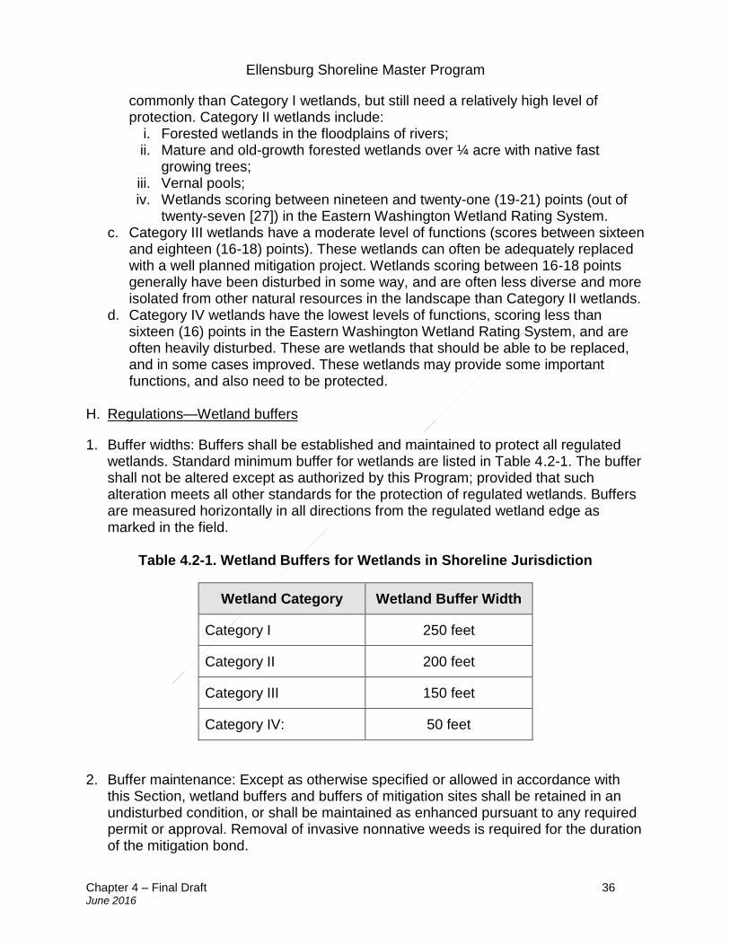
Ellensburg Shoreline Master Program
Chapter 4 – Final Draft 36 June 2016
commonly than Category I wetlands, but still need a relatively high level of protection. Category II wetlands include:
i. Forested wetlands in the floodplains of rivers; ii. Mature and old-growth forested wetlands over ¼ acre with native fast
growing trees; iii. Vernal pools; iv. Wetlands scoring between nineteen and twenty-one (19-21) points (out of
twenty-seven [27]) in the Eastern Washington Wetland Rating System. c. Category III wetlands have a moderate level of functions (scores between sixteen
and eighteen (16-18) points). These wetlands can often be adequately replaced with a well planned mitigation project. Wetlands scoring between 16-18 points generally have been disturbed in some way, and are often less diverse and more isolated from other natural resources in the landscape than Category II wetlands.
d. Category IV wetlands have the lowest levels of functions, scoring less than sixteen (16) points in the Eastern Washington Wetland Rating System, and are often heavily disturbed. These are wetlands that should be able to be replaced, and in some cases improved. These wetlands may provide some important functions, and also need to be protected.
H. Regulations—Wetland buffers
1. Buffer widths: Buffers shall be established and maintained to protect all regulated wetlands. Standard minimum buffer for wetlands are listed in Table 4.2-1. The buffer shall not be altered except as authorized by this Program; provided that such alteration meets all other standards for the protection of regulated wetlands. Buffers are measured horizontally in all directions from the regulated wetland edge as marked in the field.
Table 4.2-1. Wetland Buffers for Wetlands in Shoreline Jurisdiction
Wetland Category Wetland Buffer Width
Category I 250 feet
Category II 200 feet
Category III 150 feet
Category IV: 50 feet
2. Buffer maintenance: Except as otherwise specified or allowed in accordance with this Section, wetland buffers and buffers of mitigation sites shall be retained in an undisturbed condition, or shall be maintained as enhanced pursuant to any required permit or approval. Removal of invasive nonnative weeds is required for the duration of the mitigation bond.
Ellensburg Shoreline Master Program
Chapter 4 – Final Draft 37 June 2016
3. Multiple buffers: In the event that wetland buffers or other critical areas are
contiguous or overlapping, the landward-most edge of all such buffers shall apply.
4. Interrupted buffer: When a wetland buffer contains an existing legally established public road or private access road, the Administrator may allow development on the landward side of the road provided that the development will not have a detrimental impact to the wetland. The applicant may be required to provide a wetland critical areas report to describe the potential impacts. In determining whether a critical areas report is necessary, the City shall consider the hydrologic, geologic, and/or biological habitat connection potential and the extent and permanence of the buffer interruption.
5. Buffers of restored wetlands: The buffer for a wetland created, restored, or
enhanced as compensation for approved wetland alterations shall be the same as the buffer required for the category of the created, restored, or enhanced wetland.
6. Buffer averaging: The Administrator may allow averaging of the standard wetland
buffer widths in Table 4.2-1 in accordance with an approved critical area report on a case-by-case basis, when necessary to accommodate a single family residential development. With buffer averaging, the buffer width is reduced in one location and increased in another location to maintain the same overall buffer area. Proposals for buffer averaging shall not require a shoreline variance or compensatory mitigation if the following conditions are met:
a. It will not reduce wetland functions or functional performance; b. The buffer has not been averaged or reduced by any prior actions administered
by the City; c. The wetland contains variations in sensitivity due to existing physical
characteristics or the character of the buffer varies in slope, soils, or vegetation, and the wetland would benefit from a wider buffer in places and would not be adversely impacted by a narrower buffer in other places;
d. The total area contained in the buffer area after averaging is no less than that which would be contained within the standard buffer; and
e. The buffer width is not reduced to less than seventy-five percent (75%) of the standard width or thirty-five (35) feet.
7. Increased wetland buffers: The Administrator shall increase wetland buffer zone widths, up to a maximum of two (2) times the standard width in Table 4.2-1, for a development project on a case-by-case basis when a larger buffer is necessary to protect wetland functions and values based on site-specific characteristics. Such determination shall be based on site-specific and project-related conditions which include, but are not limited to the following criteria:
a. A larger buffer is needed to protect other critical areas; b. The buffer or adjacent uplands has a slope greater than fifteen percent (15%) or
Ellensburg Shoreline Master Program
Chapter 4 – Final Draft 38 June 2016
is susceptible to erosion and standard erosion-control measures will not prevent adverse impacts to the wetland;
c. The buffer area has minimal vegetative cover. In lieu of increasing the buffer width where existing buffer vegetation is inadequate to protect the wetland functions and values, implementation of a buffer planting plan may substitute. Where a buffer planting plan is proposed, it shall include densities that are not less than three (3) feet on center for shrubs and eight (8) feet on center for trees and require monitoring and maintenance to ensure success. Existing buffer vegetation is considered inadequate and will need to be enhanced through additional native plantings and (if appropriate) removal of nonnative plants when: (i) nonnative or invasive plant species provide the dominant cover, (ii) vegetation is lacking due to disturbance and wetland resources could be adversely affected, or (iii) enhancement plantings in the buffer could significantly improve buffer functions;
d. The standard buffer is less than that which is necessary to protect documented endangered, threatened, or sensitive wildlife species which have a primary association with the wetland;
e. The wetland contains plants listed as sensitive, threatened, or endangered; f. The proposed development density is greater than two (2) or more residential
units per acre and abuts a Category I or II wetland with high habitat value of eight to nine (8-9) points obtained in the wetland critical areas report; or
g. The wetland is associated with a stream segment on the 303d list for pollutants, or has a total daily maximum load for sediment or temperature and the proposal includes removal of trees and shrubs or untreated stormwater runoff.
8. Allowed buffer uses: The following uses may be permitted within a wetland buffer without a variance; provided they are not prohibited by any other applicable law, are consistent with the provisions of this Program, and they are conducted in a manner so as to minimize impacts to the buffer and adjacent wetland, including wetland functions and values:
a. Conservation or restoration activities aimed at protecting the soil, water, vegetation, or wildlife.
b. Passive recreation facilities designed in accordance with an approved critical area report, including:
i. Walkways and trails; provided that those pathways which are generally parallel to the perimeter of the wetland shall be located in the outer twenty-five percent (25%) of the buffer area, and constructed with a surface that is not impervious to water. Raised boardwalks utilizing non-treated pilings may be acceptable;
ii. Wildlife viewing structures less than five hundred (500) square feet in size; and
iii. Fishing access areas down to the water’s edge that shall be no wider than six (6) feet.
Ellensburg Shoreline Master Program
Chapter 4 – Final Draft 39 June 2016
c. Stormwater management facilities, limited to stormwater dispersion facilities, outfalls and bioswales, may be allowed within the outer twenty-five percent (25%) of the buffer of Category III or IV wetlands only; provided that:
i. No other location is feasible; and ii. The location of such facilities will not degrade the functions or values of the
wetland.
9. Signs and fencing of wetlands:
a. Temporary markers. The outer perimeter of the wetland and buffer and the limits of those areas to be disturbed pursuant to an approved permit or authorization shall be marked in the field in such a way as to ensure that no unauthorized intrusion will occur and is subject to inspection by the Administrator prior to the commencement of permitted activities. The Administrator shall have the authority to require that temporary fencing be placed on site to mark the outer perimeter of the wetland and its associated buffer area. This temporary marking, and any required temporary fencing, shall be maintained throughout construction and shall not be removed until permanent signs, if required, are in place.
b. Permanent signs. As a condition of any permit or authorization issued pursuant to this chapter, the Administrator may require the applicant to install permanent signs along the boundary of a wetland or buffer.
i. Permanent signs shall be made of a metal face with a green color background and white letters; attached to a metal post, or another non-treated material of equal durability; made with a sign face no smaller than one (1) foot by one (1) foot square and no larger than two (2) feet by two (2) feet square; and mounted with the bottom of the sign face no less than three (3) feet above and no more than five (5) feet above adjacent grade. Signs must be posted at a minimum of one per lot of record, or on large parcels every three hundred (300) feet, or additional signs as required by the Administrator and must remain unobstructed and be maintained by the property owner in perpetuity. The sign(s) shall be worded as follows or with alternative language approved by the Administrator:
Protected Critical Area Do Not Disturb Contact the City of Ellensburg Regarding Uses and Restrictions
ii. The provisions Section 4.2.H.9.b.i may be modified by the Administrator as
necessary to assure protection of sensitive features or wildlife. I. Regulations—Wetland reporting
1. All critical areas located within three hundred (300) feet of the project area that have been designated by the City and are shown on city, state, or federal government agency maps and/or reports shall be addressed in a critical area report for wetlands.
Ellensburg Shoreline Master Program
Chapter 4 – Final Draft 40 June 2016
2. Wetland analysis. A written assessment of the wetland, the appropriate wetland
type, and required buffer under the provisions of this Section.
3. As provided for in Section 4.2.D.2.c, the Administrator may require additional information to be included in the critical area report when determined to be necessary for the review of the proposed activity. Additional information for wetlands that may be required includes, but is not limited to, the following:
a. Vegetative, faunal, and hydrologic characteristics; b. Soil and substrate characteristics; c. Topographic elevations; d. A discussion of water sources supplying the wetland and documentation of the
hydrologic regime. Such discussion shall include an analysis of existing and future hydrologic regimes and proposed hydrologic regime for enhanced, created, or restored mitigation areas, if provided for in the project.
J. Regulations—Wetland compensatory mitigation
1. Wetland Mitigation Sequencing: Proposed activities or uses that would impact wetlands must follow the mitigation sequencing requirements of Section 4.2.B.2. Wetland impacts may be allowed when there is no reasonable alternative site design that would result in less adverse impact to a wetland or its buffer. Activities and uses within Category I wetlands shall be limited to the following:
a. An existing public facility that must be expanded or extended into the wetland; b. Utility construction or maintenance, where there is no other site that can serve
the utility’s function; or c. Development associated with an approved variance that allows the impact.
2. Compensatory mitigation requirement: Compensatory mitigation for alterations to wetlands shall achieve equivalent or greater biologic functions. Compensatory mitigation shall be consistent with “Wetland Mitigation in Washington State, part 1: Agency Policies and Guidance” (Ecology Publication #06-06-011a) and “Wetland Mitigation in Washington State Part 2: Guidelines for Developing Freshwater Mitigation Plans and Proposals” (Ecology Publication # 06-06-011b), or as revised.
3. Preference of mitigation actions: Mitigation actions that require compensation by
replacing, enhancing, or substitution shall occur in the following order of preference:
a. Restoring wetlands on upland sites that were formerly wetlands. b. Creating wetlands on disturbed upland sites such as those with vegetative cover
consisting primarily of nonnative introduced species. This should only be attempted when there is a consistent source of hydrology and it can be shown that the surface and subsurface hydrologic regime is conducive for the wetland community that is being designed.
c. Enhancing significantly degraded wetlands in combination with restoration or creation. Such enhancement should be part of a mitigation package that includes
Ellensburg Shoreline Master Program
Chapter 4 – Final Draft 41 June 2016
replacing the impacted area meeting appropriate ratio requirements.
4. Mitigation for affected functions or functions lost as a result of the proposed activity:
a. The lost wetland provides minimal functions as determined by a site-specific function assessment, and the proposed compensatory mitigation action(s) will provide equal or greater functions or will provide functions shown to be limiting within a watershed through a formal Washington state watershed assessment plan or protocol; or
b. Out-of-kind replacement will best meet formally identified watershed goals, such as replacement of historically diminished wetland types.
5. Type and location of mitigation: Unless it is demonstrated that a higher level of
ecological functioning would result from an alternate approach, compensatory mitigation for ecological functions shall be either in-kind and on-site, or in-kind and within the same stream reach, subbasin, or drift cell. Mitigation actions shall be conducted within the same subdrainage basin and on the site as the alteration except when all of the following apply:
a. There are no reasonable on-site or in-subdrainage basin opportunities or on-site and in-subdrainage basin opportunities do not have a high likelihood of success, after a determination of the natural capacity of the site to mitigate for the impacts. Consideration should include: anticipated wetland mitigation replacement ratios, buffer conditions and proposed widths, hydrogeomorphic classes of on-site wetlands when restored, proposed flood storage capacity, potential to mitigate riparian fish and wildlife impacts (such as connectivity);
b. Off-site mitigation has a greater likelihood of providing equal or improved wetland functions than the impacted wetland; and
c. Off-site locations shall be in the same subdrainage basin unless: i. Established watershed goals for water quality, flood or conveyance, habitat,
or other wetland functions have been established and strongly justify location of mitigation at another site; or
ii. Credits from a state certified wetland mitigation bank are used as mitigation and the use of credits is consistent with the terms of the bank’s certification.
6. Mitigation timing: Mitigation projects shall be completed with an approved monitoring
plan prior to activities that will disturb wetlands. In all other cases, mitigation shall be completed immediately following disturbance and prior to use or occupancy of the activity or development. Construction of mitigation projects shall be timed to reduce impacts to existing fisheries, wildlife, and flora. The Administrator may authorize a one-time temporary delay, up to one hundred twenty (120) days, in completing minor construction and landscaping when environmental conditions could produce a high probability of failure or significant construction difficulties. The delay shall not create or perpetuate hazardous conditions or environmental damage or degradation, and the delay shall not be injurious to the health, safety, and general welfare of the public. The request for the temporary delay must include a written justification that
Ellensburg Shoreline Master Program
Chapter 4 – Final Draft 42 June 2016
documents the environmental constraints which preclude implementation of the mitigation plan. The justification must be verified and approved by the City and include a financial guarantee.
7. Mitigation ratios for wetland impacts: The following ratios shall apply to creation or
restoration that is in-kind, is on-site, is the same category, is timed prior to or concurrent with alteration, and has a high probability of success. These ratios do not apply to remedial actions resulting from unauthorized alterations; greater ratios shall apply in those cases. These ratios do not apply to the use of credits from a state certified wetland mitigation bank. When credits from a certified bank are used, replacement ratios should be consistent with the requirements of the bank’s certification. The first number specifies the acreage of replacement wetlands and the second specifies the acreage of wetlands altered. The re-establishment or creation of Category I Natural Heritage Sites, Alkali, and Bog wetlands is not considered possible.
a. Category I: six-to-one (6:1) b. Category II: four-to-one (4:1) c. Category III: two-to-one (2:1) d. Category IV: one-and-one-half-to-one (1.5:1)
8. Increased replacement ratios: The Administrator may increase the ratios under the following circumstances:
a. Uncertainty exists as to the probable success of the proposed restoration or creation;
b. A significant period of time will elapse between impact and replication of wetland functions;
c. Proposed mitigation will result in a lower category wetland or reduced functions relative to the wetland being impacted; or
d. The impact was an unauthorized impact.
9. Wetlands enhancement as mitigation:
a. Impacts to wetland functions may be mitigated by enhancement of existing significantly degraded wetlands, but must be used in conjunction with restoration and/or creation. Applicants proposing to enhance wetlands must produce a critical area report that identifies how enhancement will increase the functions of the degraded wetland and how this increase will adequately mitigate for the loss of wetland area and function at the impact site. An enhancement proposal must also show whether existing wetland functions will be reduced by the enhancement actions.
b. At a minimum, enhancement acreage shall be double the acreage required for creation or restoration as specified above. The ratios shall be greater than double the required acreage where the enhancement proposal would result in minimal gain in the performance of wetland functions and/or result in the reduction of other wetland functions currently being provided in the wetland.
Ellensburg Shoreline Master Program
Chapter 4 – Final Draft 43 June 2016
c. Mitigation ratios for enhancement in combination with other forms of mitigation shall range from six-to-one (6:1) to three-to-one (3:1) and be limited to Class III and IV wetlands.
K. Regulations—Aquatic habitat conservation area designation, classification, and
mapping
1. Designation and classification: Aquatic Habitat Conservation Areas include:
a. Those streams and lakes which meet the criteria for Type S, F, Np, and Ns waters, as defined in the water type classifications in the forest practices rules in WAC 222-16-030. Type S waters are synonymous with shorelines of the state.
b. Areas with which federally and/or state-listed endangered, threatened, or sensitive aquatic species have a primary association;
c. State priority aquatics habitats and areas associated with state priority aquatic species;
d. Naturally occurring ponds under twenty (20) acres in size; and e. Naturally occurring lakes over twenty (20) acres and other waters of the state,
including waters planted with game fish by a government or tribal entity.
2. Mapping: The approximate location and extent of aquatic habitat conservation areas are shown on the City’s critical area maps. These maps are to be used as a guide and do not provide definitive information about aquatic habitat conservation areas size or presence. Other aquatic habitat conservation areas may exist that do not appear on the maps. The City shall update the maps as new aquatic habitat conservation areas are identified and as new information becomes available.
L. Regulations—Aquatic habitat conservation area buffers and mitigation requirements
1. Buffer widths: Buffers shall be established and maintained to protect regulated aquatic habitat conservation areas as shown in Table 4.2-2 below. These stream buffers shall be measured in all directions from the ordinary high watermark as identified in the field. The buffer widths for Type S Waters are shown in Table 4.5-1. Buffers shall not be altered except as authorized by this Program. These standard buffer widths are presumed to be adequate to protect aquatic habitat conservation area functions and values provided that the buffer contains relatively intact native vegetation at the time of the proposed use or development. Where the use is being intensified adjacent to a degraded buffer area that is not well vegetated, the Administrator may require the degraded area to be revegetated to maintain aquatic habitat conservation area functions and values.
Table 4.2-2. Aquatic Habitat Conservation Area Buffers for Type F, Np, and Ns Waters
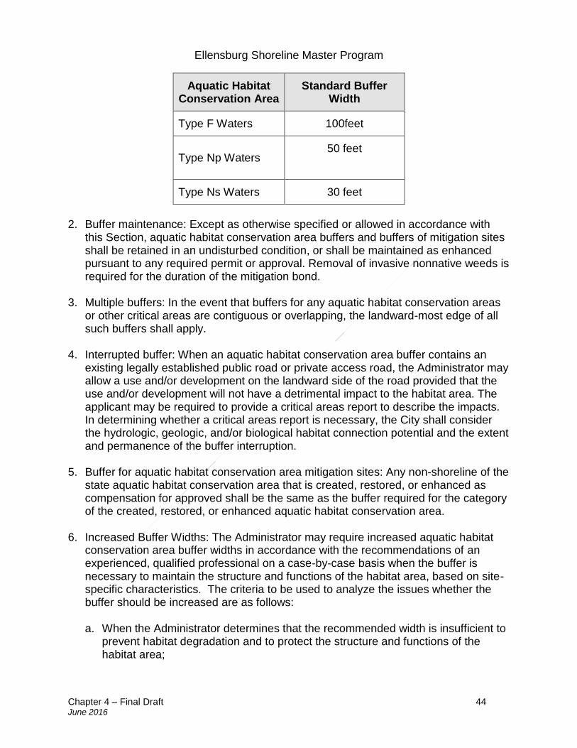
Ellensburg Shoreline Master Program
Chapter 4 – Final Draft 44 June 2016
Aquatic Habitat Conservation Area
Standard Buffer Width
Type F Waters 100feet
Type Np Waters 50 feet
Type Ns Waters 30 feet
2. Buffer maintenance: Except as otherwise specified or allowed in accordance with
this Section, aquatic habitat conservation area buffers and buffers of mitigation sites shall be retained in an undisturbed condition, or shall be maintained as enhanced pursuant to any required permit or approval. Removal of invasive nonnative weeds is required for the duration of the mitigation bond.
3. Multiple buffers: In the event that buffers for any aquatic habitat conservation areas
or other critical areas are contiguous or overlapping, the landward-most edge of all such buffers shall apply.
4. Interrupted buffer: When an aquatic habitat conservation area buffer contains an
existing legally established public road or private access road, the Administrator may allow a use and/or development on the landward side of the road provided that the use and/or development will not have a detrimental impact to the habitat area. The applicant may be required to provide a critical areas report to describe the impacts. In determining whether a critical areas report is necessary, the City shall consider the hydrologic, geologic, and/or biological habitat connection potential and the extent and permanence of the buffer interruption.
5. Buffer for aquatic habitat conservation area mitigation sites: Any non-shoreline of the
state aquatic habitat conservation area that is created, restored, or enhanced as compensation for approved shall be the same as the buffer required for the category of the created, restored, or enhanced aquatic habitat conservation area.
6. Increased Buffer Widths: The Administrator may require increased aquatic habitat
conservation area buffer widths in accordance with the recommendations of an experienced, qualified professional on a case-by-case basis when the buffer is necessary to maintain the structure and functions of the habitat area, based on site-specific characteristics. The criteria to be used to analyze the issues whether the buffer should be increased are as follows:
a. When the Administrator determines that the recommended width is insufficient to
prevent habitat degradation and to protect the structure and functions of the habitat area;
Ellensburg Shoreline Master Program
Chapter 4 – Final Draft 45 June 2016
b. The historical and current susceptibility to severe erosion, channel instability, or aggrading; or
c. The land adjacent to the ordinary high water mark and extending throughout the standard habitat buffer is steeply sloped (greater than forty percent [40%] slope), and there are no designated landslide hazards within the area of shoreline jurisdiction, such that an increased buffer may be required to protect ecological functions.
7. Buffer averaging: The Administrator may allow averaging of the aquatic habitat
buffer widths in Table 4.2-2 in accordance with an approved critical area report on a case-by-case basis, when necessary to accommodate a single-family residential development. With buffer averaging, the buffer width is reduced in one location and increased in another location to maintain the same overall buffer area. Proposals for buffer averaging shall not require a shoreline variance or compensatory mitigation if the following conditions are met:
a. The averaging will not reduce stream or habitat functions, including those of non-fish habitat;
b. The buffer has not been averaged or reduced by any prior actions administered by the City;
c. The averaging will not degrade the habitat, including habitat for salmon or trout; d. The proposal will provide additional habitat protection; e. The total area contained in the riparian habitat area of each stream on the
development proposal site is not decreased; f. The recommended stream buffer width is not reduced by more than twenty-five
percent (25%) in any one location; g. The width reduction will not be located within another critical area or associated
buffer; and h. The averaging is supported by the best available science.
8. Riparian habitat mitigation: Mitigation of adverse impacts to stream buffers shall
result in equivalent functions and values on a per function basis, be located as near the alteration as feasible, and be located in the same subdrainage basin as the habitat impacted.
9. Alternative mitigation for stream buffers: The performance standards set forth in this Section may be modified at the City’s discretion if the applicant demonstrates that greater habitat functions, on a per function basis, can be obtained in the affected subdrainage basin as a result of alternative mitigation measures.
10. Signs and fencing of aquatic habitat conservation areas:
a. Temporary markers. The outer perimeter of the aquatic habitat conservation and its buffer and the limits of those areas to be disturbed pursuant to an approved permit or authorization shall be marked in the field in such a way as to ensure that no unauthorized intrusion will occur and is subject to inspection by the
Ellensburg Shoreline Master Program
Chapter 4 – Final Draft 46 June 2016
Administrator prior to the commencement of permitted activities. The Administrator shall have the authority to require that temporary fencing be placed on site to mark the outer perimeter of the aquatic habitat conservation area and its associated buffer area. This temporary marking, and any required temporary fencing, shall be maintained throughout construction and shall not be removed until permanent signs, if required, are in place.
b. Permanent signs. As a condition of any permit or authorization issued pursuant to this Section, the Administrator may require the applicant to install permanent signs along the boundary of an aquatic habitat conservation area or buffer.
i. Permanent signs shall be made of a metal face with a green color background and white letters; attached to a metal post, or another non-treated material of equal durability; made with a sign face no smaller than one (1) foot by one (1) foot square and no larger than two (2) feet by two (2) feet square; and mounted with the bottom of the sign face no less than three (3) feet above and no more than five (5) feet above adjacent grade. Signs must be posted at a minimum of one (1) per lot of record, or on large parcels every three hundred (300) feet, or additional signs as required by the Administrator and must remain unobstructed and be maintained by the property owner in perpetuity. The sign(s) shall be worded as follows or with alternative language approved by the Administrator:
Protected Critical Area Do Not Disturb Contact the City of Ellensburg Regarding Uses and Restriction
ii. The provisions Section 4.2.L.10.b.i may be modified by the Administrator
as necessary to assure protection of sensitive features or wildlife. M. Regulations—Aquatic habitat conservation area reporting
1. Except for single-family residences located outside of shoreline buffers, if a proposed use or development is located within two hundred (200) feet of a designated aquatic habitat conservation area, a critical areas report is required and shall include the following, in addition to the general reporting requirements specified in Section 4.2.D:
a. The aquatic habitat conservation area habitat type and location of the ordinary high water mark;
b. All aquatic habitat conservation areas and required buffers within two hundred (200) feet of the project area shall be depicted on the site plan;
c. The vegetative, faunal, topographic, and hydrologic characteristics of the aquatic habitat conservation area; and
d. A detailed discussion of the direct and indirect potential impacts on aquatic habitat conservation area by the project. Such discussion shall include a
Ellensburg Shoreline Master Program
Chapter 4 – Final Draft 47 June 2016
discussion of the ongoing management practices that will protect habitat after the project site has been developed.
N. Regulations—Wildlife habitat conservation areas designation, classification,
mapping, and surveying
1. Designation: Wildlife habitat conservation areas shall include the following: a. Areas where federal and/or state listed endangered, threatened, and sensitive
species have a primary association. This includes locations of nests, rookeries, or other breeding areas of species of concern recognized by local, state, and federal public agencies having jurisdiction over such species;
b. State priority habitats and areas associated with state priority wildlife species; and
c. Other state-identified priority habitats, including Aspen stands, biodiversity areas and corridors, old-growth/mature forest, Oregon white oak woodlands, and shrub-steppe.
2. Mapping: The approximate location and extent of wildlife habitat conservation areas are shown on the City’s critical areas maps. These maps are to be used as a guide and do not provide definitive information about wildlife habitat conservation area size or presence. The City shall update the maps as new wildlife habitat conservation areas are identified and as new information becomes available.
3. Habitat boundary survey: If the Administrator determines that a wildlife habitat conservation area may be present within the project vicinity, a wildlife habitat boundary survey shall be required. Habitat surveys shall be conducted by a professional wildlife biologist who is knowledgeable of wildlife habitat within Kittitas County, or by the Washington Department of Fish and Wildlife. The Management Recommendations for Washington’s Priority Habitats and Species, or a federal equivalent, may be used as a tool for identifying and delineating the habitat boundary. The City may waive the requirement for the survey, if:
a. The proposed development is not within the extended proximity of the associated habitat;
b. There is adequate information available on the area proposed for development to determine the impacts of the proposed development and appropriate mitigating measures; and
c. The applicant provides voluntary deed restrictions that are approved by the City.
O. Regulations—Wildlife habitat conservation area reporting and mitigation requirements
1. Habitat management plan: When development is proposed in or adjacent to a wildlife habitat conservation area, the Administrator shall require the applicant to submit a habitat management plan, prepared by a professional wildlife biologist who
Ellensburg Shoreline Master Program
Chapter 4 – Final Draft 48 June 2016
is knowledgeable of wildlife habitat within Kittitas County, when the following conditions are met:
a. A proposed use or development is located within two hundred (200) feet of a known or suspected wildlife habitat conservation area; and
b. There are potential direct and/or indirect impacts on wildlife species or habitat from the proposed use or activity.
2. Habitat management plan contents: The habitat management plan shall include a
discussion of the potential direct and indirect impacts, as well as a discussion of the ongoing management practices that will protect habitat after the project site has been developed. The habitat management plan will include any relevant information and recommendations from the Washington Department of Fish and Wildlife habitat guidelines for the affected species and/or habitat. Based on the characteristics of the site, the Administrator may require that all or a portion of the following be included in a habitat management plan:
a. A map drawn to scale or survey showing the location of the fish and wildlife habitat conservation area on the subject property, as well as the approximate location of any potential fish and wildlife habitat conservation area within two hundred (200) feet of the subject property;
b. Detailed description of vegetation and habitat characteristics within and adjacent to the site;
c. Identification of any endangered, threatened, sensitive, or candidate species that have a primary association with habitat on the project area, and assessment of potential project impacts to use of the buffer and critical area on the site by the species;
d. Methods and measures to avoid, minimize and/or compensate for adverse impacts associated with the proposed development, including, but not limited to:
i. Prohibition or limitation of development activities within the fish and wildlife habitat conservation area;
ii. Establishment of a buffer around the fish and wildlife habitat conservation area;
iii. Retention of vegetation and/or revegetation of areas / habitats critically important to species;
iv. Special construction techniques; v. Implementation of erosion and sediment control measures; vi. Habitat enhancement (i.e., fish passage barrier removal); vii. Seasonal restrictions on construction activities on the subject property; viii. Clustering of development on the subject property; and ix. Any other requirements and/or recommendations from WDFW’s habitat
management guidelines.
3. Wildlife habitat management and mitigation plan: For unavoidable impacts to wildlife habitat conservation areas, a wildlife habitat management and mitigation plan shall be prepared. The wildlife habitat management and mitigation plan shall:
Ellensburg Shoreline Master Program
Chapter 4 – Final Draft 49 June 2016
a. Demonstrate, when implemented, that there shall be no net loss of
ecological function of habitat; and b. Identify how impacts from the proposed project shall be mitigated, as well
as the necessary monitoring and contingency actions for the continued maintenance of the wildlife habitat conservation area and its associated buffer.
4. In addition to the general mitigation plan requirements specified in Section 4.2.F, the
wildlife habitat management and mitigation plan shall contain a report containing, but not limited to, the following information:
a. A map or maps indicating the boundary of the habitat conservation areas; the width and length of all existing and proposed structures, utilities, roads, easements; wastewater and stormwater facilities; adjacent land uses, zoning districts and comprehensive plan designations;
b. A description of the proposed project including the nature, density, and intensity of the proposed development and the associated grading, structures, roads, easements, wastewater facilities, stormwater facilities, utilities, etc., in sufficient detail to allow analysis of such land use change upon the habitat conservation area;
c. A description of the vegetation in the habitat conservation area, on the overall project site and adjacent to the site;
d. A detailed description of the proposed project’s effect on the habitat conservation area, and a discussion of any federal, state, or local management recommendations which have been developed for the species or habitats in the area;
e. An explanation of how any adverse impacts created by the proposed development will be mitigated, including the following techniques:
i. Establishment of buffer zones; ii. Preservation of critically important plants and trees; iii. Limitation of access to the habitat conservation area; iv. Seasonal restriction of construction activities; and v. Establishment of a timetable for periodic review of the plan.
11. Signs and fencing of wildlife habitat conservation areas:
a. Temporary markers. The outer perimeter of the wildlife habitat conservation and its buffer and the limits of those areas to be disturbed pursuant to an approved permit or authorization shall be marked in the field in such a way as to ensure that no unauthorized intrusion will occur and is subject to inspection by the Administrator prior to the commencement of permitted activities. The Administrator shall have the authority to require that temporary fencing be placed on site to mark the outer perimeter of the aquatic habitat conservation area and its associated buffer area. This temporary marking, and any required temporary
Ellensburg Shoreline Master Program
Chapter 4 – Final Draft 50 June 2016
fencing, shall be maintained throughout construction and shall not be removed until permanent signs, if required, are in place.
b. Permanent signs. As a condition of any permit or authorization issued pursuant to this Section, the Administrator may require the applicant to install permanent signs along the boundary of a wildlife habitat conservation area or buffer.
i. Permanent signs shall be made of a metal face with a green color background and white letters; attached to a metal post, or another non-treated material of equal durability; made with a sign face no smaller than one (1) foot by one (1) foot square and no larger than two (2) feet by two (2) feet square; and mounted with the bottom of the sign face no less than 3 feet above and no more than five (5) feet above adjacent grade. Signs must be posted at a minimum of one (1) per lot of record, or on large parcels every three hundred (300) feet, or additional signs as required by the Administrator and must remain unobstructed and be maintained by the property owner in perpetuity. The sign(s) shall be worded as follows or with alternative language approved by the Administrator:
Protected Critical Area Do Not Disturb Contact the City of Ellensburg Regarding Uses and Restriction
ii. The provisions Section 4.2.O.5.b may be modified by the Administrator as
necessary to assure protection of sensitive features or wildlife. P. Regulations—Geologically hazardous areas designation, classification, and mapping
1. Designation: Lands classified as landslide, erosion, and seismic hazard areas are hereby designated as geologically hazardous areas and are subject to the standards of this Section.
2. Classification - Landslide hazard areas: Lands potentially subject to landslides
based on a combination of geologic, topographic, and hydrologic factors. They include any areas susceptible because of any combination of bedrock, soil, slope (gradient), slope aspect, structure, hydrology, or other factors. The following shall be designated as landslide hazards and are subject to the requirements of this Section:
a. Areas of historic failures, such as: i. Those areas delineated by the Natural Resource Conservation Service
(NRCS) as having a “severe” limitation for building site development; or ii. Those areas mapped as landslides, as having a liquefaction susceptibility or
having a NEHPR seismic site class A through D on the most current Washington State Department of Natural Resources Division of Geology and Earth Resources natural hazards web based map ; or
iii. Areas designated as quaternary slumps, earth-flows, mudflows, lahars, or landslides on maps published by the U.S. Geological Survey or Washington
Ellensburg Shoreline Master Program
Chapter 4 – Final Draft 51 June 2016
Department of Natural Resources (DNR) Division of Geology and Earth Resources.
b. Areas with all three of the following characteristics: i. Slopes steeper than fifteen percent (15%); ii. Hillsides intersecting geologic contacts with a relatively permeable sediment
overlying a relatively impermeable sediment or bedrock; and iii. Springs or groundwater seepage.
c. Areas that have shown movement during the Holocene epoch (from 10,000 years ago to the present) or which are underlain or covered by mass wastage debris of this epoch;
d. Slopes that are parallel or subparallel to planes of weakness (such as bedding planes, joint systems, and fault planes) in subsurface materials;
e. Slopes having gradients steeper than eighty percent (80%) subject to rockfall during seismic shaking;
f. Areas potentially unstable as a result of rapid stream incision, stream bank erosion, and undercutting by wave action, including stream channel migration zones;
g. Areas that show evidence of, or are at risk from snow avalanches; h. Areas located in a canyon or on an active alluvial fan, presently or potentially
subject to inundation by debris flows or catastrophic flooding; and i. Any area with a slope of forty percent (40%) or steeper and with a vertical relief
of ten (10) or more feet except areas composed of bedrock. A slope is delineated by establishing its toe and top and measured by averaging the inclination over at least ten (10) feet of vertical relief.
3. Classification - Erosion hazard areas: Areas containing soils that may experience
significant erosion, including: a. Slopes forty percent (40%) or steeper with a vertical relief of ten (10) or more
feet, except areas composed of consolidated rock. b. Concave slope forms equal to or greater than fifteen percent (15%) with a vertical
relief of ten (10) or more feet, except areas composed of consolidated rock. c. Channel migration zones: Areas within which the stream channel can reasonably
be expected to migrate over time as a result of normally occurring hydrological and related processes when considered with the characteristics of the river and its surroundings. Such hazards are characterized by abandoned channels, ongoing sediment deposition and erosion, topographic position, and changes in the plant community, age, structure and composition.
4. Classification - Seismic hazard areas: Lands subject to severe risk of damage as a result of earthquake induced ground shaking, slope failure, settlement, soil liquefaction, or surface faulting the following classifications shall be designated as seismic hazard and are subject to the requirements of this Section.
5. Classification- Other hazard areas: Geologically hazardous areas shall also include areas determined by the Administrator to be susceptible to other geological events including mass wasting, debris flows, rock falls, and differential settlement.
Ellensburg Shoreline Master Program
Chapter 4 – Final Draft 52 June 2016
6. Mapping: The approximately location and extent of geologically hazardous areas are
shown on maps maintained by the City. These maps shall be advisory and used by the Administrator to provide guidance in determining applicability of the standards to a property. These maps shall be updated periodically as new information becomes available.
Q. Regulations—Geologically hazardous areas reporting and protection standards
1. New shoreline uses and developments shall be located, designed, constructed, and maintained to avoid geologically hazardous areas. Impact avoidance measures shall include, but not be limited to, locating the use/development outside of the hazard area, reducing the number, size or scale of buildings, driveways and other features; altering the configuration or layout of the proposed development; using environmentally favorable construction materials; implementing special engineering methods for construction, drainage, runoff management practices, etc.; foregoing construction of accessory structures; preserving native vegetation; and other reasonable measures.
2. Alterations of geologically hazardous areas may only occur for activities that:
a. Will not increase the threat of the geological hazard to adjacent properties
beyond pre-development conditions; b. Will not adversely impact other critical areas; c. Are designed so that the hazard to the project is eliminated or mitigated to a level
equal to or less than pre-development conditions; and d. Are certified as safe as designed and under anticipated conditions by a qualified
engineer or geologist, licensed in the state of Washington.
3. Critical facilities shall be prohibited in geologically hazardous areas and/or their buffers.
4. The Administrator shall review each development proposal to determine if there is
any possible geologically hazardous area on-site. In making the determination, the Administrator shall use the best available information including any previously completed special reports conducted in the vicinity of the subject proposal. If no hazard area is determined to be present, this Section shall not apply to the review of the proposed development.
5. Hazard present: If it is determined that a severe erosion hazard, mine hazard,
seismic hazard, or landslide hazard may be present on or adjacent to a proposed development site, the applicant shall submit a geologic hazard area risk assessment prepared by a qualified professional. The geologic hazard area risk assessment shall include:
a. A description of the geology of the site and the proposed development;
Ellensburg Shoreline Master Program
Chapter 4 – Final Draft 53 June 2016
b. An assessment of the potential impact the project may have on the geologic hazard;
c. An assessment of what potential impact the geologic hazard may have on the project;
d. Appropriate mitigation measures, if any; and e. A conclusion as to whether further analysis is necessary.
The assessment shall be signed by and bear the seal of the qualified professional that prepared it. No further analysis shall be required if the geologic hazard area risk assessment concludes that there is no geologic hazard present on the site, nor will the project affect or be affected by any potential geologic hazards that may be nearby. If the professional preparing the geologic hazard area risk assessment concludes that further analysis is necessary, the applicant shall submit a geotechnical report consistent with the provisions of this Section.
6. Geotechnical report: The geotechnical report shall include a certification from the
professional preparing the report, including the professional’s stamp and signature. The geotechnical report shall include the following:
a. A detailed description of the geology and soil conditions of the site; b. Evaluation of the geologic conditions giving rise to the geologic hazard; c. An evaluation of the safety of the proposed project; d. Conclusions and recommendations regarding the effect of geologic conditions on
the proposed development; e. Conclusions and recommendations on the suitability of the site to be developed; f. A statement regarding the risk of damage from the project, both on- and off-site;
and whether or not the project will materially increase the risk of occurrence of the hazard;
g. Recommendations concerning drainage practices, vegetation retention and other mitigation, and monitoring measures which may be needed to ensure slope stability;
h. Recommended erosion and sediment control measures; i. A bibliography of scientific citations; and j. Any other specific measures which must be incorporated into the design and
operational plan of the project to eliminate or reduce the risk of damage due to the hazard. This shall include a recommendation on the required buffer or setback distance that must be maintained between the proposed development and the hazard to ensure the safety of the development.
7. Channel Migration Zone: If County maps indicate that a potential channel migration zone hazard exists on or adjacent to a proposed use or development site, the applicant shall either:
a. Locate the proposal landward of the channel migration hazard area as indicated on the map; or
b. Submit a channel migration zone study, prepared by a geologist, engineering geologist, or professional engineer licensed in the State of Washington with at
Ellensburg Shoreline Master Program
Chapter 4 – Final Draft 54 June 2016
least five (5) years of experience in analyzing channel responses in the fluvial systems of the Pacific Northwest, that demonstrate the following:
i. The parcel on which the development or use is proposed is effectively protected (disconnected) from channel movement due to the existence of permanent levees maintained by public agencies or infrastructure such as roads and bridges constructed and maintained by public agencies (not all roads and levees will be considered disconnection points); or
ii. The proposed use or development site has minimal risk of channel migration during the next one hundred (100 years as indicated by the existing channel type; land cover (and low likelihood of future alterations in land cover); surficial geology; low soil erosion potential; lack of evidence of likely avulsion pathways (including areas upstream or, but proximate to, the site); low inundation frequency(ies). The assessment shall include a review of available data regarding historical channel locations at the site, identification of the site within a broader geomorphic reach of the river system, and the general characteristics of that reach; description of existing channel type, existing channel alterations and likelihood of future alterations with changes in land cover, surficial geology, soils and erosion potential, and geotechnical setbacks relation to erosion at the toe of adjacent slope(s). The approach to assessing local migration shall be generally equivalent to the methods detailed in “ A Framework for Delineating Channel Migration Zones” (Ecology Publication #03-06-027), or similar method approved or sanctioned by Ecology.
8. Based upon the results of the channel migration zone assessment, the Administrator may prohibit or limit use or development within a channel migration zone and/or require a buffer of undisturbed natural vegetation from the edge of the channel migration zone.
9. The Administrator may impose conditions on any new shoreline use and
developments in a geologically hazardous area as needed to:
a. Protect slope stability and minimize erosion, seismic, and/or landslide hazard risks;
b. Maintain natural sediment and erosion processes that are integral to the health and sustainability of freshwater ecosystems;
c. Minimize the potential for property damage related to seismic events, erosion and/or landslides;
d. Minimize the need for structural shoreline stabilization in the future; e. Protect human health and safety; and f. Reduce public liabilities for damages associated with seismic events, erosion
and/or landslides.
Ellensburg Shoreline Master Program
Chapter 4 – Final Draft 55 June 2016
R. Regulations—Frequently flooded area designation and mapping
1. Designation and mapping: All lands classified as floodway or special flood hazard areas in the Federal Emergency Management Agency report titled “Flood Insurance Rate Maps and Flood Boundary and Floodway Maps” dated November 5, 1980, as now or hereafter amended are designated as frequently flooded areas. The report and maps are on file at the Ellensburg Community Development Department.
2. Use of additional information: The Administrator may use additional flood information that is more restrictive or detailed than that provided in the flood insurance study conducted by the Federal Emergency Management Agency to designate frequently flooded areas, including data on channel migration, historical data, high water marks, photographs of past flooding, location of restrictive floodway, maps showing future built-out conditions, maps that show riparian habitat areas, or similar information.
3. Flood elevation data: When base flood elevation data is not available, the
Administrator shall obtain, review, and reasonably utilize any base flood elevation and floodway data available from a federal, state, county, or other source, in order to administer this Section.
S. Regulations—Frequently flooded area protection standards: general requirements
1. The Administrator shall verify that all necessary permits have been obtained from those governmental agencies from which prior approval is required by federal, state, or local law, including, but not limited to Section 404 of the Federal Water Pollution Control Act Amendment of 1972 and the Endangered Species Act of 1973.
2. Development proposals must not reduce the effective base flood storage volume of a floodplain. Grading or other activity that would reduce the effective storage volume must be mitigated by creating compensatory storage on the site. The compensatory storage must provide equivalent volume at equivalent elevations to that being displaced, be hydraulically connected to the source of the flooding, be provided in the same construction season, and occur on site or off site, if legal arrangements can be made to assure that the effective compensatory storage will be preserved over time.
3. Areas without base flood elevation data: Where base flood elevation data is not
available and there is insufficient data available from federal, state, county, or other sources, the Administrator shall determine the base flood elevation using historical data, high water marks, photographs of past flooding, and other available information. If there is insufficient data available for the Administrator to make a determination of the base flood elevation, and standards requiring a base flood elevation cannot be implemented, the Administrator shall require measures that assure the proposed structures will be reasonably safe from flooding. At a minimum, the base flood elevation shall be set at least two (2) feet above the highest adjacent
Ellensburg Shoreline Master Program
Chapter 4 – Final Draft 56 June 2016
grade. The Administrator shall have the authority to set an average base flood elevation if there are sufficient grade deficiencies in elevation around the development area.
4. Construction materials and methods:
a. Methods that minimize flood damage: All new construction and substantial improvements shall be constructed using flood-resistant materials and utility equipment, and with methods and practices that minimize flood damage.
b. Structures shall be located outside the floodplain: All structures shall be located on the buildable portion of the site out of the floodplain unless there is no buildable site area out of the floodplain. For sites with no buildable area out of the floodplain, structures shall be placed on the highest land on the site, oriented parallel to the anticipated flow of water rather than perpendicular, and sited as far from the watercourse and other critical areas as possible. If the Administrator finds any evidence of active hyporheic exchange on a site, the development shall be located to minimize disruption of such exchange.
c. Utilities shall be protected: All utilities shall be located on the buildable portion of the site out of the floodplain unless there is no buildable site area out of the floodplain. Electrical, heating, ventilation, plumbing, and air-conditioning equipment and other service facilities shall be designed and/or otherwise elevated or located so as to prevent water from entering or accumulating within their components during conditions of flooding.
5. Elevation certificate required following construction: Following construction of a
structure within the floodplain where the base flood elevation is provided, the applicant shall be required to submit to the Administrator an as-built elevation certificate from a licensed professional land surveyor that records the elevation of the lowest floor. The Administrator shall obtain said as-built elevation certificate and maintain said certificates in its official records.
6. Floodproofing:
a. When a structure is to be floodproofed, it shall be designed and constructed using methods that meet the following requirements:
i. Watertight structure: The structure shall be watertight with walls substantially impermeable to the passage of water below one (1) foot above the base flood level;
ii. Hydrostatic resistance: Structural components shall be capable of resisting hydrostatic and hydrodynamic loads and effects of buoyancy; and
iii. Certified by a registered professional engineer or architect: The structure shall be certified by a registered professional engineer or architect that the design and methods of construction are in accordance with accepted standards of practice for meeting provisions of this subsection based on their development and/or review of the structural design, specifications and plans.
Ellensburg Shoreline Master Program
Chapter 4 – Final Draft 57 June 2016
b. Floodproofing certificate required following construction: Following construction of the structure, the applicant shall obtain a floodproofing certificate from a registered professional engineer or architect that records the actual (as-built) elevation to which the structure was floodproofed.
c. Floodproofing nonresidential buildings: Applicants floodproofing nonresidential buildings shall be notified by the Administrator that flood insurance premiums will be based on rates that are one (1) foot below the floodproofed level (for example, a building floodproofed to the base flood level will be rated as one foot below).
7. Anchoring:
a. Anchoring required: All new construction and substantial improvements within the floodplain shall be anchored to prevent flotation, collapse, or lateral movement of the structure.
b. Manufactured homes shall be anchored: All manufactured homes placed within the floodplain must be anchored to prevent flotation, collapse, or lateral movement, and shall be installed using methods and practices that minimize flood damage. Anchoring methods may include, but are not limited to, use of over-the-top or frame ties to ground anchors.
8. Fill and grading: Fill and grading within the floodplain shall only occur after the
review and approval by the City of the clearing, grading, and fill proposal. Such proposal shall require a determination from a licensed professional engineer that the fill or grading will not block side channels, inhibit channel migration, increase flood hazards to others, or be placed within a channel migration zone, whether or not the City delineated such zones as of the time of the application.
9. Critical facilities: Construction of new critical facilities shall be permissible within frequently flooded areas if no feasible alternative site is available. Critical facilities constructed within frequently flooded areas shall have the lowest floor elevated three (3) feet or more above the level of the base flood elevation (one hundred-(100)-year flood). Floodproofing and sealing measures must be taken to ensure that toxic substances will not be displaced by or released into floodwaters. Access routes elevated to or above the level of the base flood elevation shall be provided to all critical facilities to the extent possible.
10. Construction in floodways: a. New construction requires certification by a licensed professional engineer:
Encroachments, including new construction, substantial improvements, fill, and other development, are prohibited within designated floodways unless certified by a registered professional engineer. Such certification shall demonstrate through hydrologic and hydraulic analyses, performed in accordance with standard engineering practices, that the proposed encroachment will not result in any increase in flood levels during the occurrence of the base flood discharge. Small projects that are solely to protect or create fish habitat and designed by a qualified professional may be allowed without certification if the Administrator
Ellensburg Shoreline Master Program
Chapter 4 – Final Draft 58 June 2016
determines that the project will not obstruct flood flows. Fish protection projects shall be reviewed on behalf of the City by a qualified professional in the field of hydraulics.
b. Residential construction and reconstruction prohibited: Construction and reconstruction of residential structures is prohibited within designated floodways, except for:
i. Repairs, reconstruction, or improvements to a structure that do not increase the ground floor area; and
ii. Repairs, reconstruction or improvements to a structure, for which the cost does not exceed fifty percent (50%) of the market value of the structure either: 1. Before the repair or reconstruction is started; or 2. If the structure has been damaged, and is being restored, before the
damage occurred. Improvement to a structure to correct existing violations of state or local health, sanitary, or safety code specifications that have been identified by the local code enforcement official and that are the minimum necessary to assure safe living conditions or to structures identified as historic places may be excluded from the calculation of the fifty percent (50%).
T. Regulations—Frequently flooded area protection standards: specific uses
1. Residential construction:
a. Must be no lower than one (1) foot above the base flood elevation. New construction and substantial improvement of any residential structure shall have the lowest floor, including basement, elevated to one (1) foot above the base flood elevation for the area; and
b. Areas below the lowest floor must meet requirements for crawlspaces as set forth hereinabove in this Section.
2. Manufactured homes must be elevated. All manufactured homes to be placed or
substantially improved shall be elevated on a permanent foundation such that the lowest floor of the manufactured home is elevated one (1) foot or more above the base flood elevation and be securely anchored to an adequately anchored foundation system to resist flotation, collapse and lateral movement.
3. Recreational vehicles. Recreational vehicles are required to either: a. Be on the site for fewer than one hundred eighty (180) consecutive days; b. Be fully licensed and ready for highway use, on its wheels or jacking system, be
attached to the site only by quick disconnect type utilities and security devices, and have no permanently attached additions; or
c. Must obtain a development permit and meet the requirements of this Section, including elevation and anchoring, for manufactured homes.
4. Nonresidential Construction:
Ellensburg Shoreline Master Program
Chapter 4 – Final Draft 59 June 2016
a. Must be no lower than one (1) foot above the base flood elevation. Construction and substantial improvement of any commercial, industrial or other nonresidential structure shall either have the lowest floor, including basement, elevated to one (1) foot above the base flood elevation for the area or, together with attendant utility and sanitary facilities, shall be floodproofed, as specified above. Unavoidable impacts to flooded areas (from fill) need to be mitigated; and
b. Areas below the lowest floor must meet the requirements for crawlspaces set forth hereinabove in this Subsection.
5. Utilities:
a. Shall be designed to minimize infiltration of floodwaters. All new and replacement water supply systems shall be designed to minimize or eliminate infiltration of floodwaters into the systems.
b. Sanitary sewage systems. New and replacement sanitary sewage systems shall be designed to minimize or eliminate infiltration of floodwaters into the systems and discharges from the systems into floodwaters.
6. Subdivision proposals:
a. All subdivisions and short subdivisions shall: i. Minimize flood damage: Subdivisions and short subdivisions shall be
designed to minimize or eliminate flood damage to proposed structures; and public utilities and facilities that are installed as part of such subdivisions, such as sewer, gas, electrical, and water systems, shall be located and constructed to minimize flood damage. Subdivisions should be designed using natural features of the landscape, and should not incorporate flood protection changes;
ii. Have adequate drainage: Subdivisions and short subdivisions shall have adequate natural surface water drainage in accordance with City of Ellensburg Public Works Development Standards to reduce exposure to flood hazards; and
iii. Show flood areas on plat maps: Subdivisions and short subdivisions shall show the one hundred-(100)-year floodplain, floodway, and channel migration zone where designated by the City on the preliminary and final plat and short plat maps.
b. Detailed base flood elevation data shall be generated for subdivisions of at least fifty (50) lots or five (5) acres. Where detailed base flood elevation data has not been provided or is not available from another authoritative source, it shall be generated for subdivision proposals and other proposed developments which contain at least fifty (50) lots or five (5) acres.
7. Alteration of watercourses:
a. Shall require the submission of a critical area report by the applicant and be in accordance with this Program. Watercourse alterations shall only be allowed
Ellensburg Shoreline Master Program
Chapter 4 – Final Draft 60 June 2016
when no negative impacts occur to critical areas, in accordance with this Program.
b. Shall not result in blockage. Watercourse alteration projects shall not result in blockage of side channels.
c. Notification required: The City shall notify adjacent communities, the Washington State Department of Ecology, the Washington Department of Fish and Wildlife, and the Federal Insurance Administration of the proposed watercourse alteration at least thirty (30) days prior to permit issuance.
d. Maintenance of alterations: The applicant shall maintain the altered or relocated portion of the watercourse to ensure that the flood carrying capacity is not diminished. The applicant shall furnish the City with a surety bond for maintenance, which bond shall remain in effect for a period of five (5) years after completion of the alterations and be in accordance with a maintenance program approved by the Administrator for the alteration project. The bond shall be in an amount to be determined by the Administrator as sufficient to ensure that the flood carrying capacity of the watercourse is not diminished and complies with the terms of the maintenance program. The surety and the form of the bond shall be subject to the approval of the City attorney.
8. Crawlspaces: Crawlspaces are commonly used as a method of elevating buildings
to or above the base flood elevation or providing area for easier access to utilities and other building facilities. The following requirements apply to all crawlspaces that have enclosed areas or floors below the base flood elevation:
a. The building must be designed and adequately anchored to resist flotation, collapse, and lateral movement of the structure resulting from hydrodynamic and hydrostatic loads, including the effect of buoyancy. Hydrostatic loads and the effects of buoyancy can usually be addressed through the required opening standards set forth below in this Section. If crawlspace construction is proposed for areas in which the flood velocities exceed five (5) feet per second, the design must be reviewed and approved by a registered architect or engineer.
b. The crawlspace is an enclosed area below the base flood elevation, and as such, must have openings that equalize hydrostatic pressures by allowing for the automatic entry and exit of floodwaters. Openings or vents must meet the following criteria:
i. A minimum of two (2) openings having a total net area of not less than one (1) square inch for every square foot of enclosed area subject to flooding shall be provided;
ii. The bottom of all openings shall be no higher than one (1) foot above grade; and
iii. Openings may be equipped with screens, louvers, or other coverings or devices; provided, that they permit the automatic entry and exit of floodwaters.
c. All portions of the building below the base flood elevation must be constructed with materials resistant to flood damage. The recommended construction
Ellensburg Shoreline Master Program
Chapter 4 – Final Draft 61 June 2016
practice is to elevate the bottom of the joists and all insulation above the base flood elevation.
d. Any building utility systems within the crawlspace must be elevated above the base flood elevation or designed so that floodwaters cannot enter or accumulate within the system components. Duct work must either be placed above the base flood elevation or sealed from floodwaters.
e. In addition to the above requirements, the following specific provisions also apply to below grade crawlspaces:
i. The interior grade of a crawlspace below the base flood elevation must not be more than two (2) feet below the lowest adjacent exterior grade;
ii. The height of the below grade crawlspace, measured from the interior grade of the crawlspace to the top of the crawlspace foundation wall, must not exceed four (4) feet at any point;
iii. There must be an adequate drainage system that removes floodwaters from the interior area of the crawlspace. Possible options include natural drainage through porous, well-drained soils or drainage systems such as perforated pipes, tiles, gravel or other means; and
iv. Below grade crawlspace construction in accordance with the requirements listed above will not be considered basements.
U. Regulations—Frequently flooded area reporting
1. A frequently flooded areas report shall be prepared for development within floodplains. Such report shall be required to be prepared by a qualified professional who is a hydrologist or engineer familiar with hydrology, hydraulics, and fluvial geomorphology, and who is licensed in the state of Washington with experience in preparing flood hazard assessments.
2. The following areas shall be addressed in a critical area report for frequently flooded areas:
a. The location of the proposed activity; b. All areas of a special flood hazard area, as indicated on the flood insurance
map(s) within two hundred (200) feet of the project area; and c. All other flood areas indicated on the flood insurance map(s) within two hundred
(200) feet of the project area.
3. Flood hazard assessment: A critical area report for a proposed activity within a frequently flooded area shall contain a flood hazard assessment including the following site- and proposal-related information at a minimum:
a. Site and construction plans: A copy of the site and construction plans for the development proposal showing:
i. Floodplain (one hundred-(100)-year flood elevation); ten-(10)-year and fifty-(50)-year flood elevations and floodway, if required by the Administrator and, in addition, other critical areas, buffers, and shoreline areas;
ii. Proposed development, including the location of existing and proposed
Ellensburg Shoreline Master Program
Chapter 4 – Final Draft 62 June 2016
structures, fill, storage of materials, and drainage facilities, with dimensions indicating distances to the floodplain;
iii. Extent and location of proposed clearing and grading activity; and iv. Elevation of the lowest floor (including basement) of all structures, and the
level to which any structure has been floodproofed. b. Floodproofing certificate: When floodproofing is proposed, a certification by a
registered professional engineer or architect that the floodproofing methods meet the requirements of specified in this Section;
c. Watercourse alteration: When watercourse alteration is proposed, the critical area report shall include:
i. Extent of watercourse alteration: A description of and plan showing the extent to which a watercourse will be altered or relocated as a result of the proposal; and
ii. Maintenance program required for watercourse alterations: A maintenance program that provides maintenance practices for the altered or relocated portion of the watercourse to ensure that the flood-carrying capacity is not diminished.
d. Information regarding other critical areas: Potential impacts to wetlands, fish and wildlife habitat conservation areas and other critical areas shall be addressed in accordance with the applicable sections of this Section.
V. Regulations—Critical aquifer recharge areas designation, mapping, and classification
1. Designation: Critical aquifer recharge areas (CARAs) are those areas with a critical recharging effect on aquifers used for potable water as defined by WAC 365-190-030(2). CARAs have prevailing geographic conditions associated with infiltration rates that create a high potential for contamination of groundwater resources or contribute significantly to the replenishment of groundwater.
a. Wellhead protection areas. Wellhead protection areas may be defined by the boundaries of the ten-(10)-year time of groundwater travel or boundaries established using alternate criteria approved by the Washington State Department of Health in those settings where groundwater time of travel is not a reasonable delineation criterion, in accordance with WAC 246-290-135.
b. Sole source aquifers. Sole source aquifers are areas that have been designated by the U.S. Environmental Protection Agency pursuant to the Federal Safe Water Drinking Act.
c. Susceptible groundwater management areas. Susceptible groundwater management areas are areas that have been designated as moderately or highly vulnerable or susceptible in an adopted groundwater management program developed pursuant to Chapter 173-100 WAC.
d. Moderately or highly vulnerable aquifer recharge areas. Aquifer recharge areas that are moderately or highly vulnerable to degradation or depletion because of hydrogeologic characteristics are those areas delineated by a hydrogeologic study prepared in accordance with the Washington State Department of Ecology
Ellensburg Shoreline Master Program
Chapter 4 – Final Draft 63 June 2016
guidelines. e. Moderately or highly susceptible aquifer recharge areas. Aquifer recharge areas
moderately or highly susceptible to degradation or depletion because of hydrogeologic characteristics are those areas meeting the criteria established by the Washington State Department of Ecology.
2. Classification: Aquifer recharge areas shall be rated as having high, moderate, or
low susceptibility based on soil permeability, geologic matrix, infiltration and depth to water as determined by the criteria established by the Washington State Department of Ecology.
3. Mapping: The general location and extent of critical aquifer recharge are shown on
maps maintained by Kittitas County. These maps are useful as a guide for the City, project applicants, and/or property owners, and may be updated as more information on aquifer recharge and susceptibility becomes available. These maps are a reference and do not provide a conclusive or final critical area designation. As of the time of adoption of this Program, the City does not believe there are any critical aquifer recharge areas within City limits relating to public drinking supplies. If this situation changes, the City will show the approximate location and extent of critical aquifer recharge areas on the adopted critical areas map.
W. Regulations—Critical aquifer recharge areas protection standards
1. Protection standards for critical aquifer recharge areas have been incorporated into the water quality regulations in Section 4.6 and into the provisions for specific shoreline uses in Chapter 3. Such standards shall be considered the minimum necessary to protect critical aquifer recharge areas.
2. The following activities are allowed in critical aquifer recharge areas, and do not require submission of a critical areas report:
a. Construction of structures and improvements, including additions, resulting in less than five percent (5%) or two thousand five hundred (2,500) square feet (whichever is greater) total site impervious surface area that does not result in a change of use or increase the use of a hazardous substance.
b. Development and improvement of parks, recreational facilities, open space or conservation areas resulting in less than five percent (5%) total site impervious surface area that do not increase the use of a hazardous substance.
c. One-site domestic septic systems releasing less than fourteen thousand five hundred (14,500) gallons of effluent per day and that are limited to a maximum density of one (1) system per one (1) acre.
3. Activities may only be permitted in a critical aquifer recharge area if the applicant
can show that the proposed activity will not cause contaminants to enter the aquifer and that the proposed activity will not adversely affect the recharging of the aquifer.
Ellensburg Shoreline Master Program
Chapter 4 – Final Draft 64 June 2016
4. The proposed activity must comply with the water source protection requirements and recommendations of the U.S. Environmental Protection Agency, Washington State Department of Health and the City of Ellensburg Wellhead Protection Plan.
5. The proposed activity must be designed and constructed in accordance with the locally adopted surface water management or water quality regulations.
6. Storage tanks. All storage tanks proposed to be located in a critical aquifer recharge
area must comply with local building code requirements and must conform to the following requirements:
a. Underground tanks. All new underground storage facilities proposed for use in the storage of hazardous substances or hazardous wastes shall be designed and constructed so as to:
i. Prevent releases due to corrosion or structural failure for the operational life of the tank;
ii. Be protected against corrosion, constructed of noncorrosive material, steel clad with a noncorrosive material, or designed to include a secondary containment system to prevent the release or threatened release of any stored substances; and
iii. Use material in the construction or lining of the tank that is compatible with the substance to be stored.
b. Aboveground tanks. All new aboveground storage facilities proposed for use in the storage of hazardous substances or hazardous wastes shall be designed and constructed so as to:
i. Not allow the release of a hazardous substance to the ground, groundwaters, or surface waters;
ii. Have a primary containment area enclosing or underlying the tank or part thereof; and
iii. A secondary containment system either built into the tank structure or a dike system built outside the tank for all tanks.
7. Vehicle repair and servicing:
a. Vehicle repair and servicing must be conducted over impermeable pads and within a covered structure capable of withstanding normally expected weather conditions. Chemicals used in the process of vehicle repair and servicing must be stored in a manner that protects them from weather and provides containment should leaks occur.
b. No dry wells shall be allowed in critical aquifer recharge areas on sites used for vehicle repair and servicing. Dry wells existing on the site prior to facility establishment must be abandoned using techniques approved by the Washington State Department of Ecology prior to commencement of the proposed activity.
8. Residential use of pesticides and nutrients. Application of household pesticides,
Ellensburg Shoreline Master Program
Chapter 4 – Final Draft 65 June 2016
herbicides, and fertilizers shall not exceed times and rates specified in the packaging.
9. Use of reclaimed water for surface percolation or direct recharge. Water reuse projects for reclaimed water must be in accordance with the adopted water or sewer comprehensive plans that have been approved by the Washington State Departments of Ecology or Health. a. Use of reclaimed water for surface percolation must meet the groundwater
recharge criteria given in RCW 90.46.080(1) and RCW 90.46.010(10). The Washington State Department of Ecology may establish additional discharge limits in accordance with RCW 90.48.080(2).
b. Direct injection must be in accordance with the standards developed by authority of RCW 90.46.042.
X. Regulations—Critical aquifer recharge areas reports
1. Critical area reports for critical aquifer recharge areas must meet the requirements of this Section: a. Hydrogeologic assessment: For all proposed activities to be located in a critical
aquifer recharge area that are not listed in Section 4.2.W, a critical area report shall contain a level one (1) hydrogeological assessment. A level two (2) hydrogeological assessment shall be required for any of the following proposed activities:
i. Activities that result in five percent (5%) or more impervious site area; ii. Activities that divert, alter, or reduce the flow of surface or groundwaters, or
other reduce the recharging of the aquifer; iii. The use of hazardous substances, other than household chemicals used
according to the directions specified on the packaging for domestic applications;
iv. The use of injection wells, including on-site septic systems, except those domestic septic system releasing less than fourteen thousand five hundred (14,500 gallons) of effluent per day and that are limited to a maximum density of one (1) system per one (1) acre; or
v. Any other activity determined by the Administrator likely to have an adverse impact on groundwater quality or quantity or in the recharge of an aquifer.
b. Level one hydrogeologic assessment: A level one hydrogeologic assessment shall include the following site and proposal-related information at a minimum:
i. Available information regarding geologic or hydrogeologic characteristics of the site including the surface location of all critical aquifer recharge areas located on site or immediately adjacent to the site, and permeability of the unsaturated zone;
ii. Groundwater depth, flow direction and gradient based on available information;
iii. Currently available data on wells and springs within one thousand three hundred (1,300) feet of the project area;
iv. Location of other critical areas, including surface waters, within one
Ellensburg Shoreline Master Program
Chapter 4 – Final Draft 66 June 2016
thousand three hundred (1,300) feet of the project area; v. Available historic water quality data for the area to be affected by the
proposed activity; and vi. Best management practices proposed to be utilized.
c. Level two hydrologic assessment: A level two hydrologic assessment shall include the following site-and proposal-related information at a minimum, in addition to the requirements for a level one hydrological assessment:
i. Historic water quality data for the area to be affected by the proposed activity compiled for at least the previous five-(5)-year period;
ii. Groundwater monitoring plan provisions; iii. Discussion of the effects of the proposed project on the groundwater quality
and quantity, including: 1. Predictive evaluation of groundwater withdrawal effects on nearby
surface wells and surface water features; and 2. Predictive evaluation of contaminant transport based on potential
releases to groundwater; and 3. A spill plan that identifies equipment and/or structures that could fail,
resulting in an impact. Spill plans shall include provisions for regular inspection, repair and replacement of structures and equipment that could fail.
4.3 Flood hazard reduction
The following provisions apply to actions taken to reduce flood damage or hazard and to uses, development, and shoreline modifications that may increase flood hazards. Flood hazard reduction measures may consist of non-structural measures, such as setbacks, land use controls, wetland restoration, dike removal, use relocation, biotechnical measures, and stormwater management programs as well as structural measures such as dikes, levees, revetments, floodwalls, channel realignment, and elevation of structures consistent with the National Flood Insurance Program.
A. Policies
1. Minimize future use and development in flood prone areas in order to protect public health and private property.
2. Prohibit new or expanding shoreline uses or development in the shoreline, including subdivision of land that would likely require structural flood control works within a river, channel migration zone, floodway, or lakes.
3. Limit flood control works in the shoreline to those necessary to protect existing
development where non-structural flood hazard reduction measures are infeasible. 4. Encourage non-structural and non-regulatory methods to protect, enhance, and
restore shoreline ecological functions and processes and other shoreline resources as an alternative to structural flood hazard reduction measures and structures. Non-regulatory and non-structural methods may include public facility and resource
Ellensburg Shoreline Master Program
Chapter 4 – Final Draft 67 June 2016
planning, land or easement acquisition, education, voluntary protection and enhancement projects, or incentive programs.
5. Where feasible, flood hazard reduction measures should be bioengineered to enhance ecological functions, create a more natural appearance, improve ecological processes, and provide more flexibility for long-term shoreline management. Such features may include, but not be limited to, vegetated berms; and vegetative stabilization, including brush matting and buffer strips and retention of existing trees, shrubs and grasses on banks.
6. Plan and design flood hazard reduction measures in a manner consistent with applicable watershed management plans, flood hazard mitigation plans, local comprehensive planning efforts, the SMA and WAC 173-26.
7. Assure that flood hazard reduction measures result in no net loss of ecological functions and ecosystem-wide processes associated with rivers, streams and lakes.
8. Locate, design, construct and maintain flood control measures so their resultant
effects on geo-hydraulic shoreline processes will not cause significant damage to other properties or shoreline resources, and so that the physical integrity of the shoreline corridor is maintained.
9. Plan for and facilitate returning river and stream corridors to more natural
hydrological conditions, recognizing that seasonal flooding is an essential natural process.
10. When evaluating alternate flood control measures, consider the removal or relocation of structures in flood-prone areas.
11. Evaluate appropriate opportunities to remove or prevent structures that confine floodplains and inhibit channel migration.
B. Regulations
1. Use and development in floodplains shall not significantly or cumulatively increase flood hazards or be inconsistent with comprehensive flood hazard management plans adopted pursuant to RCW Chapter 86.12.
2. New uses or development in shoreline jurisdiction, including the subdivision of land, shall not be permitted when it would be reasonably foreseeable that the uses and/or development would require structural flood hazard reduction measures within the channel migration zone or floodway.
3. The following uses and activities may be appropriate and/or necessary within the channel migration zone or floodway:
Ellensburg Shoreline Master Program
Chapter 4 – Final Draft 68 June 2016
a. Actions that protect or restore the ecosystem-wide processes or ecological functions.
b. Forest practices in compliance with the Washington State Forest Practices Act and its implementing rules.
c. Existing and ongoing agricultural practices provided that no new restrictions to channel movement occur.
d. Mining when conducted in a manner consistent with Section 5.12 Mining, the shoreline environment designation, and with the provisions of WAC 173-26-241(3)(h).
e. Bridges, utility lines, and other public utility and transportation structures where no other feasible alternative exists or the alternative would result in unreasonable and disproportionate costs. Where such structures are allowed, mitigation shall address impacted functions and processes in the affected shoreline.
f. Repair and maintenance of an existing legal use, provided that such actions do not cause significant ecological impacts or increase flood hazards to other uses.
g. Use and development with a primary purpose of protecting or restoring ecological functions and ecosystem-wide processes.
h. Modification or additions to an existing nonagricultural legal use, provided that channel migration is not further limited and that the new uses and/or development includes appropriate protection of ecological functions.
i. Use and development in incorporated municipalities and designated urban growth areas, as defined in RCW Chapter 36.70A, where structures exist that prevent active channel movement and flooding.
4. Allow new structural flood hazard reduction measures in shoreline jurisdiction only when it can be demonstrated by a scientific and engineering analysis that they are necessary to protect existing development; that nonstructural measures are not feasible; that impacts on ecological functions and priority species and habitats can be successfully mitigated so as to assure no net loss; and that appropriate vegetation conservation actions are undertaken consistent with Section 4.5 Shoreline buffer and vegetation conservation, and WAC 173-26-221(5).
5. Structural flood hazard reduction measures shall be consistent with the adopted Kittitas County Multi-jurisdictional Hazard Mitigation Plan (October 2012).
6. Place new structural flood hazard reduction measures landward of the associated wetlands, and designated vegetation conservation areas, except for actions that increase ecological functions, such as wetland restoration; provided that such flood hazard reduction projects be authorized if it is determined that no other alternative to reduce flood hazard to existing uses and/or development is feasible. The need for, and analysis of feasible alternatives to, structural improvements shall be documented through a geotechnical analysis.
7. New structural public flood hazard reduction measures, such as dikes and levees, shall dedicate and improve public access pathways unless public access improvements would cause unavoidable health or safety hazards to the public,
Ellensburg Shoreline Master Program
Chapter 4 – Final Draft 69 June 2016
inherent and unavoidable security problems, unacceptable and unmitigated significant ecological impacts, unavoidable conflict with the proposed use, or cost that is disproportionate and unreasonable to the total long-term cost of the use or development.
8. The removal of gravel for flood management purposes shall be consistent with an adopted flood hazard reduction plan and with the provisions of WAC 173-26, Section 5.8 Dredging and dredge material disposal and Section 5.12 Mining; and be allowed only after a biological and geo-morphological study shows that extraction has a long-term benefit to flood hazard reduction, does not result in a net loss of ecological functions, and is part of a comprehensive flood management solution.
4.4 Public access
Public access includes the ability of the general public to reach, touch, and enjoy the water’s edge, to travel on the waters of the state, and to view the water and the shoreline from adjacent locations. Public access provisions below apply to all shorelines of the state unless stated otherwise.
A. Policies
1. Promote and enhance the public interest with regard to rights to access waters held in public trust by the state while protecting private property rights and public safety.
2. Protect the rights of navigation and space necessary for water-dependent uses.
3. Protect the public's opportunity to enjoy the physical and aesthetic qualities of shorelines of the state, including views of the water in a manner consistent with the overall best interest of the state and the people generally.
4. Public shoreline access should not cause negative impacts to surrounding properties,
such as litter or trespass.
5. Regulate the design, construction, and operation of permitted uses in the shorelines of the state to minimize, insofar as practical, interference with the public's use of the water.
6. Incorporate physical and/or visual public access to shorelines in new uses and development proposals.
7. Public access areas and/or facility requirements should be commensurate with the scale and character of the use or development and should be reasonable, fair and effective.
8. Shoreline use and development activities should be designed and operated to minimize obstructions of the public’s visual access to the water and shoreline.
Ellensburg Shoreline Master Program
Chapter 4 – Final Draft 70 June 2016
9. The linkage of shoreline parks, recreation areas and public access points by hiking paths, bicycle paths, easements and/or scenic drives, should be encouraged.
10. Public access should be designed for accessibility by disabled persons.
11. Public access improvements shall not result in a net loss of shoreline ecological functions.
12. Existing public access points, including parks, trailheads, and boat launches shall be maintained to support public use and enjoyment of shorelines.
13. Seek opportunities to establish new boat launches and picnic areas along the Yakima River.
14. Additional user amenities at or along shorelines in the Urban Conservancy environments, such as parking areas, restrooms, benches, picnic tables, and signage should be added throughout the city to improve the recreational experience along shorelines.
B. Regulations
1. Public access shall consist of a dedication of land or easement and a physical improvement in the form of a walkway, trail, bikeway, corridor, viewpoint, park, deck, observation tower, pier, boat launching ramp, dock or pier area, or other area serving as a means of view and/or physical approach to public waters and may include interpretive centers and displays.
2. New shoreline use and development by public entities, such as local governments, port districts, state agencies, and public utility districts, shall provide public access as part of each development project, unless such access is shown to be incompatible with the Program due to reasons of safety, security, or adverse impacts to shoreline functions and processes.
3. New shoreline use and development by private entities shall provide public access when:
a. The development would generate a public demand for one or more forms of such physical or visual access;
b. The development will impair existing legal access opportunities or rights; or c. The development is not a preferred shoreline use (e.g. non-water-oriented
commercial or industrial development).
4. Public health and safety concerns associated with community or public access sites shall be adequately mitigated.
Ellensburg Shoreline Master Program
Chapter 4 – Final Draft 71 June 2016
5. Efforts to implement the public access provisions of this Section shall be consistent with all relevant constitutional and other legal limitations on regulation of private property and the principles of nexus and proportionality.
6. Public access requirements on privately owned lands shall be commensurate with the scale and character of the use and/or development and shall be reasonable, effective and fair to all affected parties including but not limited to the landowner and the public.
7. Where feasible, providers of shoreline public access shall:
a. Locate and design public access improvements in a manner that is compatible with the natural shoreline character and avoids adverse impacts to shoreline ecological processes and functions; and
b. Ensure public access improvements and amenities are safe, respect individual privacy, and avoid or minimize visual impacts from neighboring properties; and
c. Provide maps, signage, and orientation information to inform the public of the presence and location of privately held shorelands, especially those adjacent to public access and recreational areas; and
d. Incorporate programs, signage and informational kiosks into public access locations, where appropriate, to enhance public education and appreciation of shoreline ecology and areas of historical or cultural significance.
8. Opportunities to provide visual public access shall be evaluated during the review
and conditioning of all proposed commercial and industrial shoreline developments and residential developments involving more than four (4) residential parcels.
9. Dedicated space for physical public access shall be incorporated into all use and development proposals on public lands, all public and private commercial and industrial uses and developments, multi-family residential development of more than four (4) dwelling units, and all residential subdivisions of greater than four (4) parcels unless the project proponent demonstrates that any of the following conditions exist:
a. Unavoidable public health or safety hazards exist and cannot be prevented through reasonable means; or
b. The use and/or development has inherent security or cultural sensitivity requirements that cannot be mitigated through reasonable design measures or other solutions; or
c. The provision of public access for the proposed use or development is not consistent with all relevant constitutional and other legal limitations on regulation of private property and the principles of nexus and proportionality; or
d. The cost of providing the access, easement or an alternative amenity is disproportionate to the total long-term cost of the proposed use or development; or
e. The public access will cause unacceptable environmental impacts that cannot be mitigated; or
Ellensburg Shoreline Master Program
Chapter 4 – Final Draft 72 June 2016
f. The access would create significant, undue, and unavoidable conflicts with adjacent uses that cannot be mitigated.
10. To be relieved from public access requirements, the project proponent must
demonstrate that all feasible alternatives have been considered, including, but not limited to:
a. Regulating access through means such as maintaining a gate and/or limiting hours of use; and
b. Separating uses and activities (e.g., fences, terracing, use of one-way glazing, hedges, landscaping, etc.).
11. When physical public access is deemed to be infeasible, the proponent shall provide visual access to the shoreline or provide physical access at an off-site location geographically separated from the proposed use or development (e.g., a street end, vista, or trail system), or for a residential development, provide community access to the shoreline or to a common waterfront lot/tract for non-commercial recreational use of the property owners and guests within the proposed subdivision.
12. Public access shall be located and designed to be compatible with the natural shoreline character, to avoid adverse impacts to shoreline ecological functions and processes, and to ensure public safety.
13. Public shoreline access provided by public road ends, public road rights-of-way, public utilities and rights-of-way shall not be diminished by the City, neighboring property owners, or other citizens, unless the property is zoned for industrial uses in accordance with RCW Chapter 36.87.130.
14. Public access sites shall be directly connected to the nearest public street and shall include improvements that conform to the requirements of the Americans with Disabilities Act (ADA) when feasible and impacts to shoreline ecology are mitigated.
15. Opportunities for boat-in public access and access to primitive shorelines not accessible by automobile shall be provided where feasible and appropriate.
16. When required for public land, commercial, port or industrial use or development, public access sites shall be fully developed and available for public use prior to final occupancy of such use or development.
17. Public access easements, dedications, and permit conditions shall be recorded on the deed of title and/or the face of a short or long plat as a condition running, at a minimum, for a period contemporaneous with the duration of the authorized land use. Recording of such easements, dedications, and conditions shall occur at the time of final approval for all subdivisions and binding site plans or prior to final occupancy for other permits.
Ellensburg Shoreline Master Program
Chapter 4 – Final Draft 73 June 2016
18. Where there is an irreconcilable conflict between water-dependent shoreline uses or
physical public access and maintenance of views from adjacent properties, the water-dependent uses and physical public access shall have priority, unless there is a compelling reason to the contrary.
19. Public access facilities shall be maintained over the life of the use or development.
Future actions by successors-in-interest or other parties shall not diminish the usefulness or value of required public access areas and associated improvements.
20. Maintenance of the public access facility shall be the responsibility of the owner or
home owner’s association, unless otherwise accepted by a public or non-profit agency through a formal agreement recorded with the County Auditor's Office. Applicants shall make provisions to assure permanence and maintenance of public access facilities.
21. Access improvements shall not result in a net loss of shoreline ecological functions
and values. 22. Rights of navigation shall be protected in conformance with the provisions of this
Program.
4.5 Shoreline buffers and vegetation conservation
Shoreline buffers protect shorelines from the adverse effect of adjacent land use and development. Buffers also help protect people and property from natural hazards that are present on some shorelines. Vegetated buffers provide habitat, maintain water quality, stabilize slopes and streambanks, and help achieve no net loss of shoreline ecological functions. To function effectively, buffers must be well-vegetated. As a result, the Program promotes vegetation conservation including restrictions on clearing and grading, vegetation restoration and enhancement, and the control of invasive weeds and non-native species.
Unless otherwise stated, buffer and vegetation conservation regulations of this Program do not apply to those activities covered under the Washington State Forest Practices Act, except for conversion of forest uses to other uses and those other forest practice activities over which local governments have authority. As with all master program provisions, buffer and vegetation conservation provisions apply even to those shoreline uses and developments that are exempt from the requirement to obtain a shoreline permit. Like other Master Program provisions, buffer and vegetation conservation standards do not apply retroactively to legally established existing uses and structures, such as existing agricultural activities. A. Policies
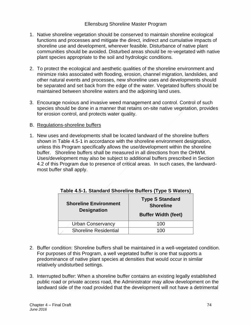
Ellensburg Shoreline Master Program
Chapter 4 – Final Draft 74 June 2016
1. Native shoreline vegetation should be conserved to maintain shoreline ecological functions and processes and mitigate the direct, indirect and cumulative impacts of shoreline use and development, wherever feasible. Disturbance of native plant communities should be avoided. Disturbed areas should be re-vegetated with native plant species appropriate to the soil and hydrologic conditions.
2. To protect the ecological and aesthetic qualities of the shoreline environment and minimize risks associated with flooding, erosion, channel migration, landslides, and other natural events and processes, new shoreline uses and developments should be separated and set back from the edge of the water. Vegetated buffers should be maintained between shoreline waters and the adjoining land uses.
3. Encourage noxious and invasive weed management and control. Control of such
species should be done in a manner that retains on-site native vegetation, provides for erosion control, and protects water quality.
B. Regulations-shoreline buffers
1. New uses and developments shall be located landward of the shoreline buffers shown in Table 4.5-1 in accordance with the shoreline environment designation, unless this Program specifically allows the use/development within the shoreline buffer. Shoreline buffers shall be measured in all directions from the OHWM. Uses/development may also be subject to additional buffers prescribed in Section 4.2 of this Program due to presence of critical areas. In such cases, the landward-most buffer shall apply.
Table 4.5-1. Standard Shoreline Buffers (Type S Waters)
Shoreline Environment
Designation
Type S Standard
Shoreline
Buffer Width (feet)
Urban Conservancy 100
Shoreline Residential 100
2. Buffer condition: Shoreline buffers shall be maintained in a well-vegetated condition. For purposes of this Program, a well vegetated buffer is one that supports a predominance of native plant species at densities that would occur in similar relatively undisturbed settings.
3. Interrupted buffer: When a shoreline buffer contains an existing legally established
public road or private access road, the Administrator may allow development on the landward side of the road provided that the development will not have a detrimental
Ellensburg Shoreline Master Program
Chapter 4 – Final Draft 75 June 2016
impact to the shoreline. The applicant may be required to provide a critical areas report to describe the impacts. In determining whether a critical areas report is necessary, the City shall consider the hydrologic, geologic, and/or biological habitat connection potential and the extent and permanence of the buffer interruption.
4. Allowed shoreline buffer alterations: Alteration or disturbance of the standard
shoreline buffers shown in Table 4.5-1 shall not be allowed except in those limited instances when the Administrator finds that the alteration is necessary to accommodate one of the following uses/developments. In all cases, the buffer alteration shall be the minimum necessary to accommodate the proposed use/development. The Administrator may require vegetation enhancement outside of the disturbed area as compensation for the buffer alteration: a. Shoreline view corridors: The Administrator may allow limited and selective tree
removal, pruning, and/or limbing within the shoreline buffer to create a view of the shoreline when otherwise consistent with this Program. The development or maintenance of view corridors can provide opportunities for visual access to water bodies associated with waterfront lots. One view corridor, limited to twenty-five (25) feet in width or twenty-five percent (25%) of the width of the lot frontage, whichever distance is less, may be permitted per lot. Prior to approval of a view corridor, Applicants shall provide a photo documentation showing the vegetation conditions from the top floor of the development one hundred eighty degrees (180°) toward the shoreline and a critical areas report demonstrating the proposed clearing will not result in a net loss of shoreline ecological function. The removal, pruning, and/or limbing of vegetation within the view corridor shall not require any ground-disturbing equipment and shall not materially alter soils or topography. The Administrator may require a view clearance plan prepared by a qualified ecologist, forester, arborist, or landscape architect prior to approving the view corridor. The view clearance plan shall identify and describe the location and extent of the proposed tree removal, pruning, and limbing and shall demonstrate compliance with American National Standards Institute (ANSI) A300 Standards for Tree Care Operations (Tree, Shrub, and Other Woody Plant Management – Standard Practices). For properties within designated landslide or erosion hazard areas, the Administrator may require review of the view clearance plan by an engineering geologist or geotechnical engineer to ensure that the proposed removal, pruning, and/or limbing will not cause or exacerbate hazards associated with soil or slope instability. The location and size of the view corridor shall be clearly defined on the site plan.
b. Private pathways: Private pathways which provide pedestrian access to the shoreline may be allowed within a shoreline buffer provided they are constructed of pervious material, are less than or equal to six (6) feet wide, and follow a route that minimizes erosion and gullying (e.g., a winding but direct path). Pathways shall be co-located within the view corridor if one is available in order to minimize buffer disturbance.
c. Hazard tree removal: Removal of a hazard tree may be allowed in the shoreline buffer when trimming is not sufficient to address the hazard. Where the hazard is
Ellensburg Shoreline Master Program
Chapter 4 – Final Draft 76 June 2016
not immediately apparent to the Administrator, the Administrator may require the applicant to submit a hazard tree determination report prepared by a qualified arborist or forester.
d. Invasive species management: Removing invasive, non-native shoreline vegetation listed on the Kittitas County Noxious Weed List or Washington State Noxious Weed Board Monitor List may be allowed in the shoreline buffer when otherwise consistent with this Program. The disturbed areas must be promptly re-vegetated using species native to Kittitas County and appropriate for the ecological sitting. If the removal area is greater than ten thousand (10,000) square feet or requires soil disturbance using non-handheld mechanized equipment, the Administrator shall require a vegetation management plan prepared by a qualified ecologist, forester, arborist, or landscape architect prior to approving the invasive species removal. The vegetation management plan shall identify and describe the location and extent of vegetation management. For properties within designated landslide or erosion hazard areas, the Administrator may require review of the vegetation management plan by an engineering geologist or geotechnical engineer to ensure that the vegetation management will not cause or exacerbate hazards associated with soil or slope instability. The location and size of the invasive species management area shall be clearly defined on the site plan.
e. Public trails and other public access improvements: Public trails and public access improvements may be allowed in the shoreline when there is no suitable alternative location outside the buffer and when they are otherwise consistent with the policies and regulations of this Program.
f. Utilities and essential public facilities: Utilities and essential public facilities that meet the definition of water-dependent or water-related may be allowed in the shoreline buffer when there is no suitable alternative location outside the buffer and when they are consistent with the policies and regulations specified in Section 5.20 of this Program.
g. Water-Dependent and Water-Related Uses: Water-dependent and water-related uses provided the amount of buffer encroachment and disturbance are the minimum needed to accommodate the use or development.
5. Buffer averaging: The Administrator may allow averaging of the shoreline buffer widths in Table 4.5-1 on a case-by-case basis, when necessary to accommodate a single-family residential development or a water-dependent or water-related use or development. The buffer averaging shall be allowed only in those limited instances when adherence to the standard buffer is infeasible or presents a substantial hardship because of site conditions, lot configuration or other circumstances. Residential subdivisions of more than four (4) lots and non-water-dependent non-water-related developments shall not be eligible for buffer averaging except through a shoreline variance. Buffers that have been averaged or reduced by any prior actions administered by the City shall not be further averaged. Prior to approving buffer averaging the Administrator shall require a critical area report (per the requirements in Section 4.2). With buffer averaging, the buffer width is reduced in one location and increased in another location to maintain the same overall buffer
Ellensburg Shoreline Master Program
Chapter 4 – Final Draft 77 June 2016
area. Proposals for buffer averaging shall not require a shoreline variance or compensatory mitigation if the following condition are met:
a. The minimum width of the buffer at any given point is at least seventy-five percent (75%) of the standard width per Table 4.5-1, or twenty-five (25) feet, whichever is greater; and
b. The net buffer area (acreage) after averaging is the same as the buffer area without averaging; and
c. The area that is added to the buffer to offset the reduction is well-vegetated. The Administrator may require vegetation enhancement if needed to ensure this criterion is met.
C. Regulations- vegetation outside of shoreline buffers
1. Where possible, development and uses within urban conservancy designated areas should be situated to avoid or minimize impacts to forest habitat and other relatively undisturbed native vegetation communities.
4.6 Water quality, stormwater, and nonpoint pollution
The following Section applies to all uses and development in shorelines of the state, as defined in WAC 173-26-020, that affect water quality.
To ensure mutual consistency between shoreline management provisions and other regulations that address water quality and stormwater quantity, including public health, stormwater, and water discharge standards, the regulations that are most protective of ecological functions shall apply.
A. Policies
1. Prevent impacts to water quality and stormwater quantity that would result in a net loss of shoreline ecological functions, or a significant impact to aesthetic qualities, or recreational opportunities.
2. Maintain or enhance the quantity and quality of surface and groundwater over the long term.
3. Shoreline use and development should minimize the need for chemical fertilizers,
pesticides or other similar chemical treatments to prevent contamination of surface and groundwater and/or soils and adverse effects on shoreline ecological functions and values.
B. Regulations
1. Shoreline use and development shall incorporate measures to protect and maintain surface and groundwater quantity and quality in accordance with all applicable laws.
Ellensburg Shoreline Master Program
Chapter 4 – Final Draft 78 June 2016
2. New uses and developments shall provide stormwater management facilities
designed, constructed, and maintained in accordance with the current stormwater management standards. Deviations from these standards may be approved where it can be demonstrated that off-site facilities would provide better treatment, or where common retention, detention and/or water quality facilities meeting such standards have been approved as part of a comprehensive stormwater management plan.
3. Best management practices for control of erosion and sedimentation shall be implemented for all use and development proposals in shorelines through an approved temporary erosion and sediment control (TESC) plan, identified in the Stormwater Management Manual for Eastern Washington, as amended.
4. On-site sewage systems shall be located, designed and maintained to meet all applicable water quality, utility, and health standards.
5. All building materials that may come in contact with water shall be constructed of untreated wood, cured concrete, or steel. Materials used for decking or other structural components shall be approved by applicable state agencies for contact with water to avoid discharge of pollutants. Wood treated with creosote, arsenate compounds, copper chromium arsenic or pentachlorophenol is prohibited in shoreline water bodies.
6. Permanent stormwater management systems serving property within the shoreline shall be designed using BMP’s ensuring water quality treatment in compliance with the Stormwater Management Manual for Eastern Washington to prevent stormwater runoff from degrading or adding to the pollution of recipient waters or adjacent properties. Maintenance of storm drainage facilities on private property shall be the responsibility of the property owner(s). This responsibility and the provision for maintenance shall be clearly stated on any recorded subdivision, short plat, or binding site plan map, building permit, property conveyance documents, maintenance agreements and /or improvement plans.
Ellensburg Shoreline Master Program
Chapter 5 – Final Draft 79 June 2016
5. Shoreline use and modification policies and regulations
Sections:
5.1 General shoreline use policies 5.2 General shoreline modification policies 5.3 Agriculture 5.4 Aquaculture 5.5 Boating facilities 5.6 Commercial development 5.7 Dredging and dredge material disposal 5.8 Filling, grading, and excavation 5.9 Forest practices 5.10 Industrial and port development 5.11 In-stream structures 5.12 Mining 5.13 Recreation 5.14 Residential development 5.15 Shoreline stabilization 5.16 Shoreline restoration and habitat enhancement 5.17 Signs 5.18 Transportation 5.19 Utilities 5.20 Shoreline bulk and dimensional standards 5.1 General shoreline use policies
A. Policies
1. Uses and development within the shoreline jurisdiction should be consistent with the provisions of the environment designation in which they are located and the policies and regulations of this Program.
2. Require a shoreline conditional use permit for shoreline uses and development that require specially tailored environmental analysis, design criteria, or consideration of cumulative impacts and for unanticipated uses not classified in this Program.
3. New uses and developments should be set back to protect ecological function and protect structures from flooding and channel migration hazards.
4. Avoid and reduce significant ecological impacts according to the mitigation sequence in Section 4.2(B)(2).
Ellensburg Shoreline Master Program
Chapter 5 – Final Draft 80 June 2016
5.2 General shoreline modification policies
A. Policies
1. Allow structural shoreline modifications only where they are demonstrated to be necessary to support or protect an allowed primary structure or a legally existing shoreline use that is in danger of loss or substantial damage or are necessary for reconfiguration of the shoreline for mitigation or enhancement purposes.
2. Limit the number and extent of shoreline modifications.
3. Allow only shoreline modifications that are appropriate to the specific type of shoreline and environmental conditions for which they are proposed.
4. Assure that shoreline modifications individually and cumulatively do not result in a
net loss of ecological functions. Give preference to those types of shoreline modifications that have a lesser impact on ecological functions. Require mitigation of identified impacts resulting from shoreline modifications.
5. Plan for the enhancement of impaired ecological functions where feasible and appropriate while accommodating permitted uses. As shoreline modifications occur, incorporate all feasible measures to protect ecological shoreline functions and ecosystem-wide processes.
5.3 Agriculture
A. Policies
1. Recognize the importance of agriculture in Ellensburg and support its continued economic viability.
2. Allow lawfully established agricultural activities occurring on agricultural lands to continue as they historically have. Require new agricultural activities on land not currently used for agriculture, conversion of agricultural lands to other uses, and other development on agricultural land that does not meet the definition of agricultural activities (including any agricultural uses and development not specifically exempted by Section 6.3.2) to meet shoreline requirements.
3. Use appropriate vegetation management and Natural Resources Conservation Service conservation practices to avoid and minimize water quality impacts from agricultural activities.
4. Encourage agricultural uses to maintain a buffer of permanent vegetation or other soil erosion control measures between tilled areas and associated water bodies that will restrict surface runoff, protect water quality, improve habitat and reduce siltation.
Ellensburg Shoreline Master Program
Chapter 5 – Final Draft 81 June 2016
B. Regulations
1. The applicability of shoreline review for agricultural activities shall be determined based on WAC 173-26-020 (Definitions) and WAC 173-26-241(3)(a) (Agriculture). Existing agricultural activities (see Section 6.2(B)), including maintenance, repair and replacement of existing equipment and facilities (e.g., machinery, roads, buildings, etc. see Section 6.3(2)(b)), may continue as they historically have and may include changes in crops. New agricultural activities on land not currently in agricultural use are subject to shoreline review. New agricultural activities, equipment, and facilities are subject to shoreline review or exemption when applicable. The following provisions apply to any development, construction, or use of land for agricultural purposes.
2. New agricultural activities on lands that did not have agricultural activities in place on the date of adoption of this Master Program; conversion of agricultural lands to non-agricultural activities; the development of non-agricultural activities on agricultural lands; and uses in support of agricultural activities are governed by the provisions of this Master Program and subject to the following criteria:
a. Uses and activities shall be consistent with the environment designation; b. Uses and activities shall be located and designed to ensure no net loss of
ecological functions; c. Uses and activities shall not have a significant impact on other shoreline
resources and values.
3. New agricultural activities, equipment, and facilities shall utilize best management practices established by the USDA Natural Resources Conservation Service or other similar agency.
4. Discharge of any manure storage facility into ground or surface water is prohibited.
5.4 Aquaculture
A. Policies
1. Aquaculture is a preferred water dependent use of the shoreline when consistent with control of pollution, avoidance of adverse impacts to the environment and preservation of habitat for resident native species.
2. Ensure that aquaculture uses do not conflict with other water-dependent uses or navigation, spread disease, establish non-native species that cause significant ecological impact, or significantly impact the aesthetic qualities of the shoreline.
3. Protect spawning areas designated by the Washington State Department of Fish and Wildlife from conflicting uses.
4. Forms of aquaculture that involve lesser environmental and visual impacts and lesser impacts to native plant and animal species are preferred. Projects that require either
Ellensburg Shoreline Master Program
Chapter 5 – Final Draft 82 June 2016
no structures or submerged structures are preferred over those that involve substantial floating structures. Projects that involve little or no substrate modification are preferred over those that involve substantial modification.
5. Design, locate and operate aquaculture activities in a manner that supports long-term beneficial use of the shoreline and protects and maintains shoreline ecological functions and processes. Prohibit aquaculture where it would result in a net loss of shoreline ecological functions; adversely affect the quality or extent of habitat for native species; adversely impact other habitat conservation areas; or interfere with navigation or other water-dependent uses.
B. Regulations
1. All structures located within water bodies shall not preclude navigability of those waters at any time, and shall be clearly marked so as to provide no hazard to navigation on those waters.
2. Aquaculture facilities shall avoid significant conflict with water-dependent uses, the spreading of disease, introduction of non-native species, or impacts to shoreline aesthetic qualities.
5.5 Boating facilities
A. Policies
1. Ensure that boating facilities are located only at sites with suitable environmental conditions, shoreline configuration, access, and neighboring uses. All boating facilities should be developed and operated in accordance with all state and local requirements.
2. In planning for boating facility location and design, special consideration should be given to facilities such as adequate access, parking, and restroom facilities for the public. Such facilities should be located away from the water's edge.
3. Boating facilities should provide public physical and visual shoreline access and provide for multiple uses, including water-related use, to the extent compatible with shoreline ecological functions and processes and adjacent shoreline use.
4. Accessory uses at boating facilities or launch ramps should be limited to water-oriented uses, or uses that provide physical or visual shoreline access for substantial numbers of the general public.
5. Special care should be given to preventing and controlling invasive species infestations at boat launches.
6. Piers and docks should only be allowed for water dependent uses and public access, except that water enjoyment and water-related uses may sometimes be included as part of a mixed use development. New piers and docks must have a specific need and
Ellensburg Shoreline Master Program
Chapter 5 – Final Draft 83 June 2016
not exceed the minimum size necessary. The cooperative use of piers and docks is encouraged.
7. New piers and docks, excluding docks accessory to single-family residences, should be permitted only when the applicant/proponent has demonstrated that a specific need exists to support intended water-dependent or public access use.
8. A port district or other public or commercial entity involving water-dependent uses may demonstrate a future need for a pier or dock according to WAC 173-26-231(3)(b), and seek approval of a pier design, size, and construction.
9. New and existing docks should be designed to be fish-friendly (e.g., grating to allow light penetration, and use of non-toxic materials).
10. The City shall prohibit the construction of private docks on rivers.
11. Overwater structure design, construction, and use shall minimize degradation of aquatic, near-shore, and shoreline habitats.
B. Regulations
1. For purposes of this chapter, “boating facilities” excludes docks serving four (4) or fewer single-family residences.
2. Private docks shall be prohibited on all rivers.
3. Boating facilities and extended mooring sites shall: a. Be located and designed as not to obstruct or cause danger to normal public
navigation of water bodies; b. Be restricted to suitable locations and should avoid locating in critical habitat
including spawning and holding areas for anadromous fish; c. Avoid or mitigate aesthetic impacts; d. Mitigate special impacts of live-aboard vessels, such as water and wastewater
needs, and garbage collection; e. Limit the total number of slips dedicated to live-aboard vessels to twenty percent
(20%) of boating facilities total slips; f. Mitigate impacts to existing public access and navigation; g. Provide documentation of ownership or authorization to use associated water
areas; h. Demonstrate that state and local regulations will be met. Agencies responsible for
such regulations shall be consulted as to the viability of the proposed design; and i. Submit an operations and site plan demonstrating:
i. Location and design of fuel handling and storage facilities to minimize
accidental spillage and protect water quality;
Ellensburg Shoreline Master Program
Chapter 5 – Final Draft 84 June 2016
ii. Proper water depth and flushing action for any area considered for overnight or long-term moorage facilities;
iii. Adequate facilities to properly handle wastes from holding tanks; iv. Suitable environmental conditions and shoreline configuration; v. Adequate access, parking, and restroom facilities for the public located away
from the immediate water's edge.
4. Piers, ramps, and docks shall meet the following dimensional standards: a. To prevent damage to shallow water habitat, piers and/or ramps shall extend at
least forty (40) feet perpendicular from the OHWM. Docks shall be positioned at least forty (40) feet horizontally from the OHWM.
b. Float components for single party docks shall not exceed the dimensions of eight-by-twenty (8-by-20)-feet or an aggregate total of one hundred sixty (160) square feet for all float components. Float components for joint-use docks shall not exceed the dimensions of eight-by-forty (8-by-40)-feet or an aggregate total of three hundred twenty (320) square feet for all float components.
c. Piers and ramps shall be no more than four (4) feet in width for single or joint-use docks. Greater widths may be permitted for community, public, or commercial docks where use patterns can justify the increase.
d. The bottom of the pier or bottom of the landward edge of the ramp shall be elevated at least two (2) feet above the plane of OHWM.
e. Floats shall not be located in shallow water habitat where they could ground or impede the passage or rearing of any life stage of salmonid. Floats shall be in at least ten (10) feet of water.
f. Grating shall cover the entire surface area of the pier, ramp, and/or float. The open area of grating shall be at least fifty percent (50%) as rated by the manufacturer.
g. Pier and ramp construction shall meet or exceed the standards and/or requirements of the Washington State Departments of Ecology, Fish and Wildlife, and Natural Resources and the United States Army Corps of Engineers.
h. Flotation materials shall be permanently encapsulated to prevent breakup into small pieces and dispersal in water, (e.g. rectangular float tubs).
5. New pier or dock construction, excluding docks accessory to single-family residences
must demonstrate that a specific need exists to support the intended water-dependent or public access use, for example, a market analysis showing demand for additional pier or dock facilities.
6. New residential development of two (2) or more dwellings must provide joint-use or community dock facilities, rather than allow individual docks for each residence, unless documentation is provided demonstrating joint use is not feasible.
7. All piers and docks shall be designed and constructed to avoid or, if that is not possible, to minimize and mitigate the impacts to ecological functions and critical areas. Structures shall be made of materials that have been approved by the Washington State Department of Fish and Wildlife.
Ellensburg Shoreline Master Program
Chapter 5 – Final Draft 85 June 2016
8. Extended moorage on waters of the state is prohibited, except as allowed by applicable state regulations and unless a lease or permission is obtained from the state and impacts to navigation and public access are mitigated.
9. Boat launch ramps shall meet the following: a. Minimize the area disturbed by boat launch construction. b. Submit an operations and site plan demonstrating:
i. Vegetation management, mowing, and trimming; ii. Litter pickup and disposal; iii. Appropriate directional and regulatory signs; iv. Adequate access location away from the immediate water’s edge; v. Adequate parking and restroom facilities located landward of the
shoreline buffers shown in Table 4.5-1. 5.6 Commercial development
A. Policies
1. Limit commercial development to those activities that are particularly dependent upon a shoreline location. Other commercial uses should be encouraged to locate upland.
2. Give first preference to water-dependent commercial uses over non-water-dependent commercial uses; and give second preference to water-related and water-enjoyment commercial uses over non-water-oriented commercial uses. Allow non-water-oriented commercial uses in limited situations.
3. Commercial uses located in the shoreline should provide public access unless such improvements are demonstrated to be infeasible or present hazards to life and property.
B. Regulations
1. Water-dependent commercial uses shall be given preference over-water-related and water-enjoyment commercial uses. Prior to approval of water-dependent uses, the Administrator shall review a proposal for design, layout, and operation of the use and shall make specific findings that the use qualifies as a water-dependent use.
2. Non-water-oriented commercial uses are prohibited in the shoreline unless the use provides significant public benefit with respect to the objective of the Act such as providing public access and ecological restoration, and the commercial use is:
a. Part of a mixed use project that includes a water-dependent use; or b. Proposed on a site where navigability is severely limited.
Ellensburg Shoreline Master Program
Chapter 5 – Final Draft 86 June 2016
3. Commercial development shall not result in a net loss of ecological functions that have significant adverse impacts to other shoreline uses, resources and values, such as navigation, recreation, and public access.
4. Public access and ecological restoration should be considered as potential mitigation of impacts to shoreline resources and values for all water-related or water- dependent development unless such improvements are demonstrated to be infeasible or inappropriate.
5. Only those portions of water-dependent commercial uses that require over-water facilities shall be permitted to locate waterward of the OHWM, provided they are located on pilings or other open-work structures, and they are limited to the minimum size necessary to support the structures intended use.
6. Non-water-dependent commercial uses shall not be allowed over-water except in limited instances where they are appurtenant and necessary to support water-dependent uses.
5.7 Dredging and dredge material disposal
A. Policies
1. Dredging material disposal on land away from the shoreline is generally preferred over open water disposal.
2. Dredging waterward of the OHWM for the primary purpose of obtaining fill material should not be allowed, except when the material is necessary for the restoration of ecological functions.
3. Disposal of dredge material on shorelands or wetlands within a river’s channel migration zone is discouraged.
B. Regulations
1. Dredging and dredge material disposal shall be done in a manner that avoids or minimizes significant ecological impacts. Impacts that cannot be avoided should be mitigated in a manner that assures no net loss of shoreline ecological functions.
2. New uses and developments should be sited and designed to avoid or, where avoidance is not possible, to minimize the need for new and/or maintenance dredging.
3. Dredging for the purpose of establishing, expanding, relocating, or reconfiguring navigation channels and basins shall be allowed where necessary for assuring safe and efficient accommodation of navigational uses and then only when significant ecological impacts are minimized and mitigated.
Ellensburg Shoreline Master Program
Chapter 5 – Final Draft 87 June 2016
4. Maintenance dredging of established navigation channels and basins shall be restricted to maintaining previously dredged and/or existing authorized locations, depths and widths.
5. All applications for substantial development permits that include dredging shall supply a dredging plan that includes the following information:
a. The quantity of material to be removed; b. The method of removal; c. Location of spoil disposal sites and measures that will be taken to protect the
environment around them; and d. Plans for the protection and restoration of the shoreline environment during and
after dredging operations.
6. A dredging operation judged by the Administrator to be insufficient for protection or restoration of the shoreline environment shall cause denial of a substantial development permit.
7. Dredging in surface waters shall be allowed only where necessary because of existing navigation needs, habitat restoration or improvement, maintenance or construction of water-dependent uses.
8. Minor trenching to allow the installation of necessary underground pipes or cables may be allowed if no alternative, including boring, is feasible, and:
a. Impacts to fish and wildlife habitat are avoided to the maximum extent possible; b. The utility installation shall not increase or decrease the natural rate, extent, or
opportunity of channel migration; c. Appropriate best management practices are employed to prevent water quality
impacts or other environmental degradation; and d. Mitigation is implemented, as appropriate, pursuant to Section 4.2 Environmental
protections and critical areas.
9. Dredging for the purpose of obtaining fill material is prohibited, except when permitted under Section 5.12 Mining; or when needed for a project associated with the Model Toxics Control Act (MTCA) or the Comprehensive Environmental Response, Compensation and Liability Act (CERCLA) habitat restoration, or any other significant restoration effort approved by a shoreline conditional use permit, where placement of fill is waterward of the OHWM.
10. Dredging and excavation shall be confined to the minimum area necessary to accomplish the intended purpose or use.
11. Hydraulic dredging or other techniques that minimize the dispersal and broadcast of bottom materials shall be preferred over agitation forms of dredging.
Ellensburg Shoreline Master Program
Chapter 5 – Final Draft 88 June 2016
12. Curtains and other appropriate mechanisms shall be used to minimize widespread dispersal of sediments and other dredge materials.
13. Entries across shore and wetland edges to accomplish dredging or excavation shall be confined to the minimum area necessary to gain entry and shall be confined to locations with the least potential for site disturbance and damage.
14. Dredging and excavation shall be scheduled at times having the least impact to fish spawning, nesting patterns, and other identified natural processes.
15. Dredge spoils are also considered fill, and shall not be deposited within the shoreline except where such deposit is in accordance with approved procedures intended to preserve or enhance wildlife habitat, natural drainage, or other naturally occurring conditions.
16. Disposal of dredge material within a river’s channel migration zone shall require a conditional use permit.
17. Dredge material disposal on land away from the shoreline is permitted under the following conditions:
a. Shoreline ecological functions and processes will be preserved, including
protection of surface and groundwater; b. Erosion, sedimentation, floodwaters or runoff will not increase adverse impacts to
shoreline ecological functions and processes or property; and c. Sites will be adequately screened from view of local residents or passersby on
public right-of-ways.
5.8 Filling, grading, and excavation
A. Policies
1. Filling, grading, and excavation should be located, designed, and constructed to protect shoreline ecological functions and ecosystem-wide processes, including channel migration.
2. Allow normal and reasonable land grading and filling where necessary to develop a
land area for a permitted use. There should be no substantial changes made in the natural drainage patterns and no reduction of floodwater storage capacity that might endanger other areas. Allow filling, grading, and excavation within the OHWM only when necessary to support water dependent uses, public access, transportation facilities, mitigation, restoration, enhancement, and other uses listed in 5.8.B.2.
3. In evaluating filling, grading, and excavation projects, such factors as total water
surface reduction, navigation restriction, impediment to water flow and circulation, impediment to irrigation systems, reduction of water quality, and destruction of fish and wildlife habitat should be examined.
Ellensburg Shoreline Master Program
Chapter 5 – Final Draft 89 June 2016
4. Locate and design shoreline fills or cuts to avoid creating a hazard to adjacent life,
property, and natural resources systems, and to provide all perimeters of fills with vegetation, retaining walls, or other mechanisms for erosion prevention.
B. Regulations
1. Filling, grading or excavation waterward of the OHWM for any use except ecological restoration shall require a conditional use permit.
2. Fill waterward of the OHWM shall be allowed with a shoreline conditional use permit only when necessary to support:
a. Water-dependent use; b. Public access; c. Cleanup and disposal of contaminated sediments as part of an interagency
environmental clean-up plan; d. Disposal of dredged material considered suitable under, and conducted in
accordance with the dredged material management program of the Washington State Department of Natural Resources;
e. Expansion or alteration of transportation facilities of statewide significance currently located on the shoreline and then only upon a demonstration that alternatives to fill are not feasible; or
f. Mitigation action, environmental restoration, or enhancement project.
3. Fill for the purpose of increasing elevation may be permitted if such can be accomplished in a manner consistent with the policies of this SMP.
4. Fill shall be the minimum necessary to accomplish the use or purpose and shall be
confined to areas having the least impact to the stream corridor. Other alternatives should be preferred over fill to elevate new homes in the floodplain, such as increasing foundation height or zero-rise methods such as piers, posts, columns, or other methods.
5. Fill in floodplains shall meet the requirements of Section 4.2 Environmental
protection and critical areas and Section 4.3 Flood hazard reduction.
6. Pile or pier supports shall be preferred over fill for water-dependent uses and facilities.
7. Unless site characteristics dictate otherwise, fill material within surface waters or
wetlands shall be sand, gravel, rock, or other clean material, with a minimum potential to degrade water quality.
8. Fill placement shall be scheduled at times having the least impact to fish spawning,
nesting patterns, and other identified natural processes.
Ellensburg Shoreline Master Program
Chapter 5 – Final Draft 90 June 2016
9. Fill shall be stabilized with native vegetation where appropriate to prevent erosion,
migration of sediments and other material from the fill area to surrounding water, shore, and wetlands, unless technical consultation with other regulating agencies indicates alternative means are required.
10. Projects that propose fill shall make every effort to acquire fill on-site (also known as
compensatory storage) where appropriate.
11. Excavation that occurs either waterward of the OHWM or within wetlands shall be considered dredging for purposes of this Program.
12. Filling, grading or excavation shall not be located where shoreline stabilization will be necessary to protect materials placed or removed. Disturbed areas shall be immediately stabilized and re-vegetated, as applicable.
13. Filling, grading, and excavation shall be designed to blend physically and visually with existing topography whenever possible, so as not to interfere with long-term appropriate use including lawful access and enjoyment of scenery.
14. Cut and fill slopes shall generally be no steeper than one (1) foot vertical for every three (3) feet horizontal unless a specific engineering analysis has been provided certifying that the proposed slope is stable, and the Administrator determines that the fill blends physically and visually with existing topography.
15. A temporary erosion and sediment control (TESC) plan, consistent with the standards found in the Stormwater Manual for Eastern Washington, shall be provided for all proposed filling, grading, and excavation activities.
16. Excavation and grading for the primary purpose of restoration of shoreline habitat and the natural character of the shoreline must demonstrate the following: a. The site is currently degraded and provides limited ecological function; b. The restoration project will result in a net increase in ecological function within
the project boundaries; and c. The project complies with the provisions of Section 4.2 Environmental protection
and critical areas. 5.9 Forest practices
A. Policies
1. Shoreline areas having well-known scenic qualities (such as those providing a diversity of views, unique landscape contrasts, or landscape panoramas) should be maintained as scenic views in timber harvesting areas. Timber harvesting practices, including road construction and debris removal, should be closely regulated so that
Ellensburg Shoreline Master Program
Chapter 5 – Final Draft 91 June 2016
the quality of the view and viewpoints along shorelines of statewide significance in the region are not degraded.
2. Forest management shall proceed in accordance with regulations established by the
Washington State Forest Practices Act, including coordination with Ellensburg on forest practice conversions and other Class IV-forest practices where there is a likelihood of conversion to non-forest uses.
3. Ensure that timber harvesting on shorelines of statewide significance does not
exceed the limitations established in RCW 90.058.150 (regarding selective harvest requirements), except as provided in cases where selective logging is rendered ecologically detrimental or is inadequate for preparation of land for other uses.
4. Accomplish reforestation in shorelines as quickly as possible. Replanting should be
done with native species common to the area.
5. Forest lands should be reserved for long-term forest management and other uses compatible with forest use.
B. Regulations
1. All federal forest practices or non-federal forest practices meeting the criteria below shall qualify for an exemption from this Program. All forest practices qualifying for this exemption shall demonstrate compliance by providing a copy of the federal approval or state forest practices permit. To qualify for an exemption a non-federal forest practice must meet the following criteria:
a. The activities includes harvest/treatment of at least five (5) acres of forestland, or
supporting such an operation; b. All harvesting within two hundred (200) feet of the OHWM of a shoreline of
statewide significance use methods meeting RCW 90.58.150 (selective harvest), as amended;
c. The activities are not associated with a conversion option harvest; d. The activities are approved under a forest practices permit; e. The activities are not associated with a harvest under a Class IV–General
application to convert forest land to non-forestry use. 2. Non-federal forest practices not meeting criteria (a), (b), or (c) above shall require a
conditional use permit.
3. Non-federal forest practices not meeting criteria (d) above (Class 1 forest practices activities not requiring DNR approval) shall be reviewed as separate uses or activities.
4. Non-federal forest practices not meeting criteria (e) above shall be reviewed as a
new proposed use.
Ellensburg Shoreline Master Program
Chapter 5 – Final Draft 92 June 2016
5. Within the shoreline jurisdiction, development activities associated with timber
harvest (such as road construction), land conversion of forest land to non-forest uses, and forest practices not meeting any of the exemptions listed above must conform to all applicable provisions of this Program.
5.10 Industrial and port development
A. Policies
1. Allocate sufficient quantities of suitable land for water related industry. Give preference to water-dependent industrial uses over non-water-dependent industrial uses; and give preference to water-related industrial uses over non-water-oriented industrial uses. Allow non-water-oriented industrial development in limited situations.
2. Industrial development shall be located, designed, or constructed in a manner that
assures no net loss of shoreline ecological functions such that it does not have significant adverse impacts to other shoreline resources and values.
3. Discourage industries which have proven to be environmentally hazardous from
locating along the shorelines.
4. Industrial development should consider incorporating public access as mitigation for impacts to shoreline resources and values unless public access cannot be provided in a manner that does not result in significant interference with operations or hazards to life or property.
5. Where industrial use is proposed for location on land in public ownership, public
access should be required.
6. Industrial development and redevelopment should be encouraged to locate where environmental cleanup and restoration of the shoreline area can be incorporated.
B. Regulations
1. Industrial uses are allowed subject to the policies and regulations of this Program and the specific criteria below:
a. Water-dependent industrial uses shall be given preference over non-water dependent industrial uses and, second, preference shall be given to water-related industrial uses over non-water-oriented industrial uses. Prior to approval of water-dependent uses, the Administrator shall review a proposal for design, layout, and operation of the proposed use and shall make specific findings that the use qualifies as water-dependent.
b. Non-water-oriented industrial uses may be permitted where located on a site physically separated from the shoreline by another property in separate ownership or a public right-of-way such that access for water-oriented use is
Ellensburg Shoreline Master Program
Chapter 5 – Final Draft 93 June 2016
precluded. All other non-water-oriented industrial and port uses are prohibited in the shoreline unless the use provides significant public benefit with respect to the objective of the Act and is either part of a mixed-use project that includes water-dependent uses; or located on a site where navigability is severely limited.
c. Industrial development shall be located, designed, and constructed in a manner that assures no net loss of shoreline ecological functions and such that it does not have significant adverse impacts to other shoreline resources and values.
2. Required setback areas shall not be used for storage of industrial equipment,
materials, or waste disposal, but may be used for outdoor recreation and public access. Portions of side yard setbacks may be used for light motor vehicle parking if design of such facilities is consistent with this Program.
3. Disposal or storage of solid or other industrial wastes is not permitted on shorelines.
4. When feasible, mitigation to ensure no net loss of shoreline ecological functions should be implemented in a manner consistent with restoration opportunities identified in the “Kittitas County Shoreline Restoration Plan.”
5. Only those portions of water-dependent industrial uses that require over-water facilities shall be permitted to locate waterward of the OHWM, provided they are located on pilings or other open-work structures, and they are limited to the minimum size necessary to support the structures intended use.
5.11 In-stream structures A. Policies
1. In-stream structures should be planned and designed to be compatible with appropriate multiple uses of stream resources over the long-term, especially in shorelines of statewide significance.
2. The location and planning of in-stream structures shall give due consideration to the full range of public interests, watershed functions and processes, and environmental concerns, with special emphasis on protecting and restoring priority habitats and species.
3. In-stream structures should be located, designed, constructed and maintained so their resultant effects on geologic or hydrologic shoreline processes will not cause damage to other properties or shoreline resources, and so that the physical integrity of the shoreline process corridor is maintained.
4. In-stream structures shall be sited and designed consistent with appropriate engineering principles, including, but not limited to, guidelines of the Natural Resource Conservation Service and the U.S. Army Corps of Engineers.

Ellensburg Shoreline Master Program
Chapter 5 – Final Draft 94 June 2016
5. Non-structural and non-regulatory methods to protect, enhance, and restore shoreline ecological functions and processes and other shoreline resources should be encouraged as an alternative to in-stream structures. Non-regulatory and non-structural methods may include public facility and resource planning, land or easement acquisition, education, voluntary protection and enhancement projects, or incentive programs.
6. Planning and design of in-stream structures should be consistent with and incorporate elements from applicable watershed management and restoration plans and/or surface water management plans.
B. Regulations
1. Channelization projects that damage fish and wildlife resources, degrade recreation and aesthetic resources, or result in high flood stages and velocities shall not be permitted when feasible alternatives are available.
2. Cut-and-fill slopes and backfilled areas shall be stabilized with brush matting and buffer strips and re-vegetated with native grasses, shrubs, or trees to prevent loss of shoreline ecological functions and processes.
3. In-stream structures shall be constructed and maintained in a manner that does not degrade the quality of affected waters. The jurisdictions may require reasonable conditions to achieve this objective, such as setbacks, buffers, or storage basins.
4. Natural in-stream features such as snags, uprooted trees, or stumps should be left in place unless it can be demonstrated that they are causing significant bank erosion or higher flood stages, or pose an unavoidable hazard to navigation.
5. In-stream structures shall allow for natural groundwater movement and surface runoff.
6. The jurisdictions shall require professionally engineered design of any proposed in-stream structure.
7. The design of all dams and the suitability of the proposed site for dam construction shall be certified by a professional engineer licensed in the state of Washington. The professional design shall include a maintenance schedule.
8. For all dams that are not regulated by either the Federal Energy Regulatory Commission licensing procedures, or the Washington State Department of Ecology reservoir permit requirements, a maintenance agreement and construction bond for one hundred-fifty percent (150%) of the cost of the structure shall be filed with the Administrator prior to construction. The maintenance agreement shall specify who is responsible for maintenance, shall incorporate the maintenance schedule specified by the design engineer, shall require annual inspections by a civil engineer licensed
Ellensburg Shoreline Master Program
Chapter 5 – Final Draft 95 June 2016
in the state of Washington and shall stipulate abandonment procedures which shall include, where appropriate, provisions for site restoration.
9. No in-stream structure may commence without having obtained all applicable federal, state, and local permits and approvals, including but not limited to an hydraulic project approval (HPA) from the Washington State Department of Fish and Wildlife.
10. Shoreline modification projects shall be designed and constructed to avoid or minimize impacts to sediment transport.
5.12 Mining
A. Policies
1. Mining and associated activities shall be designed and conducted to result in no net loss of shoreline ecological functions and processes. Mining should not be approved where it could interfere with shoreline ecological functions or processes or cause irreparable damage to shoreline resources or features. Application of this policy shall include avoidance and mitigation of adverse impacts during the course of mining and reclamation. The determination of whether there will be no net loss of ecological function shall be based on an evaluation of the reclamation plan required for the site and shall consider impacts on ecological functions during operation. Preference shall be given to mining proposals that result in the creation, restoration, or enhancement of habitat for priority species.
2. Mineral prospecting shall be allowed according to the provisions of WAC 220-110-200 through 220-110-206.
3. Mining should not be located on shorelines where unavoidable adverse impacts on other users or resources taken together equal or outweigh the benefits from mining.
4. Mining should not interfere with public recreation on the shoreline.
5. Mining should be located and operated so as to provide long-term protection of water quality, and fish and wildlife habitats.
6. Mining, particularly surface or strip mining, should provide for timely restoration of disturbed areas to a biologically productive, attractive semi-natural, or other useful condition through a reclamation process consistent with regulations administered by the Washington State Department of Natural Resources and other applicable local standards.
7. Mining of shorelines having high value for recreation, or as fish or wildlife habitat, should generally not be permitted.
Ellensburg Shoreline Master Program
Chapter 5 – Final Draft 96 June 2016
8. Mining should only be permitted where appropriate studies and detailed operation plans demonstrate that:
a. Fish habitat, upland habitat and water quality will not be significantly harmed; and
b. The operation will not adversely affect geologic or hydrologic processes, channel alignment, nor increase bank erosion or flood damage.
9. Mining operations should be located, designed, and managed so that other
appropriate uses are not subjected to substantial or unnecessary adverse impacts from noise, vibration, odor, dust or other effects of the operation. The operator may be required to implement measures such as buffers, limited hours, or other mitigating measures to minimize adverse impacts.
B. Regulations
1. Mining below the OHWM of a river shall be permitted only when:
a. Removal of specified quantities of sand and gravel or other materials at specific locations will not adversely affect the natural processes of gravel transportation for the river system as a whole; and
b. The mining and any associated permitted activities will not have significant adverse impacts to habitat for priority species nor cause a net loss of ecological functions of the shoreline.
Determination of whether the two provisions above have been met shall be made consistent with RCW 90.58.100(1) and WAC 173-26-201(2)(a). Such evaluation of impacts should be appropriately integrated with relevant environmental review requirements of SEPA (RCW Chapter 43.21C) and the SEPA rules WAC Chapter 197-11). The provisions of this Section do not apply to dredging of authorized navigation channels when conducted in accordance with WAC 173-26-231(3)(f).
2. Mining within any channel migration zone that is within the shoreline jurisdiction shall require a shoreline conditional use permit.
3. Mining shall not be permitted in designated fish and wildlife habitat areas except as a part of an approved flood control program or in conjunction with a habitat restoration or enhancement plan, provided that such activities are demonstrated to be water-dependent. A determination of water dependency shall be based on an evaluation of geologic factors such as the distribution and availability of mineral resources for that jurisdiction, and a need for such mineral resources, economic, transportation, and land use factors. This demonstration may rely on analysis or studies prepared for purposes of comprehensive plan designations, and may be integrated with any relevant environmental review conducted under SEPA (RCW Chapter 43.21 C), or otherwise be shown in a manner consistent with RCW 90.58.100(1) and WAC 173-26-201 (2)(a).
Ellensburg Shoreline Master Program
Chapter 5 – Final Draft 97 June 2016
4. Application for permits for mining operations shall be accompanied by operation plans, reclamation plans, and analysis of environmental impacts in compliance with local ordinances and sufficient to make a determination as to whether the project will result in net loss of shoreline ecological functions and processes during the course of mining and after reclamation. Creation, restoration, or enhancement of habitat for priority species and the future productivity of the site may be considered in determining no net loss of ecological functions.
5. The designation of mineral resource lands of long-term commercial significance and the development of mineral resource activities must demonstrate that mining is dependent on a shoreline location, and that demand cannot reasonably be accommodated in operations outside shoreline jurisdiction. Information required to meet this criteria shall evaluate geologic factors such as the distribution and availability of mineral resources and the need for such mineral resources.
6. Renewal, extension, or reauthorization of in-stream and gravel bar mining activities requires review for compliance with WAC 173-26-241(3)(h)(ii)(D)(IV).
7. A reclamation plan that complies with the format and detailed minimum standards of RCW 78.44 shall be included with any shoreline permit application for mining. In reviewing reclamation plans together with permit applications, the Administrator shall determine whether or not the plan is also consistent with this Program and other local regulations. An inconsistent reclamation plan shall constitute sufficient grounds for denial of a shoreline permit, provided, the applicant/proponent shall be given reasonable opportunity to revise the plan.
8. Subsequent use of reclaimed sites shall be consistent with the provisions of this Program.
5.13 Recreation
A. Policies
1. Recreational development includes both commercial and public recreational developments.
2. Recreational development should be given priority for shoreline location to the extent that the use facilitates the public’s ability to access, enjoy, and use the water and shoreline in accordance with Section 4.4 Public access.
3. Recreational uses and development should provide for the preservation and enhancement of scenic views and vistas.
4. Ensure that recreational facilities do not interfere with the use and enjoyment of adjacent properties by providing buffering when necessary between the recreation development and adjacent private property.
Ellensburg Shoreline Master Program
Chapter 5 – Final Draft 98 June 2016
5. Recreational uses and facilities should be designed and located to ensure no net loss of critical areas and shoreline ecological functions.
6. Opportunities incorporating educational and interpretive information should be pursued in design and operation of recreation facilities.
7. Where consistent with the provisions of this Program, shoreline use and development should specifically support opportunities to increase or enhance the following forms of recreation: boating, fishing, camping, hiking, bicycle riding, swimming, and picnicking.
8. Commercial recreational facilities should be consistent with the provisions of Section 5.6 Commercial development.
9. Components of an approved recreational use or development that are water-dependent or water-related may be allowed within the shoreline buffer provided that the amount of buffer encroachment and disturbance are the minimum needed to accommodate the water-dependent or water-related component and provided further that the use/development:
a. Is located in pre-existing disturbed areas with low habitat value or within the active use area;
b. Will not impact a geologically hazardous area; c. Uses low impact development techniques to minimize adverse effects on water
quality and habitat; and d. Complies with all other requirements of the Program.
10. The Administrator shall determine whether and how much water-dependent or
water-related recreational development to allow in the buffer on a case-by-case basis by considering all of the following factors: a. The type and intensity of the proposed recreational use; b. The size and configuration of the parcel and the ability to locate structures and
other facilities outside the buffer without significantly diminishing the recreational experience;
c. The amount of native vegetation that would be cleared/removed; d. The sensitivity of the aquatic habitat to the disturbances caused by the proposed
use; and e. The ability of the proponent to offset unavoidable impacts through compensatory
mitigation on-site or at an appropriate off-site location.
B. Regulations
1. Recreational development is a priority use of the shoreline. Preference shall be given to water-dependent uses such as fishing, swimming, and boating. Water-related and water-enjoyment uses such as picnicking, hiking, and walking are permitted provided they do not displace water-dependent uses and are consistent
Ellensburg Shoreline Master Program
Chapter 5 – Final Draft 99 June 2016
with the specific shoreline environment. Non-water-related recreation facilities and/or support facilities such as parking lots shall be located in upland areas.
2. Linkage of shoreline parks and public access points by means of linear access should be encouraged.
3. Commercial and public recreation areas or facilities on the shoreline shall provide public access (visual or physical) consistent with Section 4.4, Public access.
4. Commercial recreational facilities shall be consistent with the provisions of Section 5.6 Commercial development.
5. Recreational uses and facilities shall be designed and located to ensure no net loss of critical areas and shoreline ecological functions.
6. Recreation facilities shall be designed to take maximum advantage of and enhance the natural character of the shoreline area. The use of native plant species is preferred over the use of plant types that need extensive maintenance and support (mowing, pruning, irrigation, etc.).
7. Recreational facilities shall incorporate means to prevent erosion, control the amount of runoff and prevent harmful concentrations of chemicals and sediment from entering water bodies.
8. State-owned shorelines of the state are priority locations for wilderness beaches, ecological study areas and other recreational activities for the general public.
9. The location, design, and operation of recreational facilities shall be consistent with the purpose of the environmental designation.
10. Recreational activities in the urban conservancy environment must be compatible with existing or proposed uses in the area and must not create a noise, traffic, visual, or similar problem.
5.14 Residential development
A. Policies
1. Residential development shall be designed and constructed in a way that ensures no net loss of shoreline ecological function.
2. Residential development and appurtenant structures and uses should be set back an adequate distance from steep slope areas and shorelines vulnerable to erosion to ensure that shoreline and/or soil stabilization structures will not be needed to protect the residential use. (e.g., bulkheads, rip-rap or other shoreline or slope stabilization structures.)
Ellensburg Shoreline Master Program
Chapter 5 – Final Draft 100 June 2016
3. Residential development and appurtenant structures and uses should be sited in locations sufficiently set back from flood prone areas to ensure that flood hazard protection measures are not necessary to protect the structure.
4. Single-family residences are a priority use when planned and built in accordance with the policies and regulations of this Program. New over-water residences, including floating homes, are not a preferred shoreline use and should be prohibited.
5. New multi-unit residential developments, including short plats and subdivisions, should provide access (visual and physical) to the shoreline in conformance with Section 4.4, Public access.
6. New lot creation should not create a need for new shoreline stabilization or flood hazard reduction measures and should be consistent with the shoreline environment designation policies and general shoreline policies.
7. Measures to conserve native vegetation should be implemented in conformance with Section 4.2, Environmental protection and critical areas and Section 4.5 Shoreline buffer and Vegetation conservation.
8. Whenever possible, non-regulatory methods to protect, enhance and restore shoreline ecological functions and other shoreline resources should be encouraged for residential development. Such methods may include resource management planning, low impact development techniques, voluntary protection and enhancement projects, education, and/or incentive programs.
9. Encourage residential development that provides common ownership of the shoreline to protect views of the shoreline, provide equitable access for property owners and to protect the natural character and functions of the shoreline consistent with other provisions in the Master Program.
B. Regulations
1. New residential development, including lot creation, will not be approved in cases when it can be reasonably foreseeable that the use or development would require structural flood hazard reduction measures within the floodway during the life of the use or development.
2. New residential development shall assure that the proposal will not require shoreline or slope stabilization measures. Where located in a designated geologically hazardous area, a geotechnical analysis of the site and shoreline characteristics shall demonstrate that shoreline stabilization is unlikely to be necessary; setbacks from steep slopes, bluffs, landslide hazard areas, seismic hazard areas, riparian shoreline and erosion areas, shall be sufficient to protect structures during the life of the structure; and impacts to adjacent, downslope or down-current properties are not likely to occur during the life of the lots created.
Ellensburg Shoreline Master Program
Chapter 5 – Final Draft 101 June 2016
3. New over-water residential structures, including floating homes, are prohibited.
4. New residential development shall be designed to comply with applicable setbacks, critical area buffers, lot frontage requirements, height limits and density standards.
5. Residential development shall make provisions for vegetation conservation in conformance with Section 4.5 Shoreline buffer and vegetation conservation.
6. Shoreline access for residential development shall incorporate access to adjacent publicly owned shorelines or public water bodies as provided for in Section 4.4, Public access.
5.15 Shoreline stabilization
Shoreline erosion – including erosion caused by currents, flood, wind or wave action – is a natural phenomenon associated with properly functioning shoreline environments. However, erosion can put existing structures and uses at risk. In some cases, shoreline stabilization is necessary to protect existing uses and development from naturally occurring erosion. Shoreline stabilization includes actions taken to address erosion impacts to property and dwellings, businesses, or structures caused by natural processes, such as current, flood, wind, or wave action. These actions include nonstructural and structural methods.
Nonstructural methods include building setbacks, relocation of the structure to be protected, groundwater management, planning and regulatory measures to avoid the need for structural stabilization.
Structural stabilization measures include:
• Vegetation enhancement; • Anchor trees; • Gravel placement; • Rock revetments; • Gabions; • Concrete groins; • Retaining walls and bluff walls; and • Bulkheads.
Structural stabilization measures can be “hard” or “soft.” “Hard” structural stabilization refers to those with solid, hard surfaces, such as concrete bulkheads, while "soft" structural measures rely on less rigid materials, such as biotechnical vegetation measures.
Generally, the harder the construction measure, the greater the impact on shoreline processes, including sediment transport, geomorphology, and biological functions. Additionally, hard structures, especially vertical walls, often create conditions that lead to failure of the structure. Failed bulkheads and walls adversely impact beach
Ellensburg Shoreline Master Program
Chapter 5 – Final Draft 102 June 2016
aesthetics, may be a safety or navigational hazard, and may adversely impact shoreline ecological functions.
A. Policies
1. Nonstructural alternatives of stabilization should be encouraged over structural methods, whenever possible. Such alternatives may include no action, increased building setbacks, building relocation, drainage controls, and bioengineering, including vegetative stabilization.
2. New structures should be located and designed to avoid the need for future shoreline stabilization where feasible. New lots created through short plat or subdivision should be designed to assure that future use or development on the created lots will not require structural shoreline stabilization for reasonable use or development to occur.
3. New or expanded structural shoreline stabilization should be permitted only where demonstrated to be necessary to protect an existing primary structure that is in imminent danger of loss or substantial damage, and where mitigation of impacts would not cause a net loss of shoreline ecological functions and processes.
4. New or expanded structural shoreline stabilization for ecological enhancement, restoration, or hazardous substance remediation projects should be allowed only when non-structural measures, vegetation planting, or on-site drainage improvements would be insufficient to achieve enhancement, restoration or remediation objectives.
5. Shoreline stabilization should not interfere with public access to shorelines.
6. New shoreline stabilization should not cause significant impacts to adjacent or down-current properties.
7. Shoreline stabilization should be developed in a coordinated manner among affected property owners and public agencies. Where erosion threatens existing uses or developments, a comprehensive program for shoreline management should be established.
8. Non-regulatory methods to protect, enhance, and restore shoreline ecological functions and other shoreline resources should be encouraged for shoreline stabilization. Non-regulatory methods may include public facility and resource planning, technical assistance, education, voluntary enhancement and restoration projects, or other incentive programs.
9. Materials used for construction of shore stabilization should be selected for long-term durability, ease of maintenance, compatibility with local shore features including aesthetic values, and flexibility for future uses.
10. All shore stabilization activities must be designed and constructed to accepted engineering standards.
Ellensburg Shoreline Master Program
Chapter 5 – Final Draft 103 June 2016
11. Breakwaters, jetties, groins, and weirs are shoreline stabilization structures, which should be allowed only when necessary to support water-dependent uses, public access, shoreline stabilization, or other specific public purposes, and should be designed to protect critical areas and provide for mitigation.
B. Regulations
1. New uses and developments shall be located and designed to avoid the need for future shoreline stabilization to the extent feasible.
2. Subdivision of land may not create lots that will require shoreline stabilization in order
for reasonable use or development to occur.
3. New uses and developments on steep slopes or bluffs shall be set back sufficiently to ensure that shoreline stabilization is unlikely to be necessary during the life of the structure, as demonstrated by a geotechnical analysis.
4. New uses and developments that would require shoreline stabilization which causes
significant impacts to adjacent or down-current properties and shoreline areas shall not be allowed.
5. New structural stabilization measures shall only be allowed for the following instances,
and then only when necessity is demonstrated based on criteria included in this Section:
a. When necessary to protect an existing primary structure; b. In support of new non-water-dependent development, including single-family
residence; c. In support of new water-dependent development; and d. To protect projects for the restoration of ecological functions or hazardous
substance remediation projects.
6. New or enlarged structural shoreline stabilization measures for an existing primary structure, including residences, are permitted only if there is conclusive evidence, documented by a geotechnical analysis, that the structure is in danger from shoreline erosion caused by stream processes or waves. Normal sloughing, erosion of steep bluffs, or shoreline erosion itself, without a scientific or geotechnical analysis, is not demonstration of need. The geotechnical analysis shall evaluate on-site drainage issues and address drainage problems away from the shoreline edge before considering structural shoreline stabilization.
7. New structural stabilization for new non-water-dependent development, including single-family residences, is permitted only if it can be demonstrated that:
a. The erosion is not being caused by upland conditions, such as the loss of vegetation and drainage;
Ellensburg Shoreline Master Program
Chapter 5 – Final Draft 104 June 2016
b. Nonstructural measures, such as placing the proposed use or development further from the shoreline, planting vegetation, or installing on-site drainage improvements, are not feasible or not sufficient; and
c. The need to protect primary structures from damage due to erosion is demonstrated through a geotechnical report. The damage must be caused by natural processes, such as stream processes or waves.
8. New structural stabilization for water-dependent development is permitted only if it can be demonstrated that:
a. The erosion is not being caused by upland conditions, such as the loss of vegetation and drainage;
b. Nonstructural measures, planting vegetation, or installing on-site drainage improvements, are not feasible or not sufficient; and
c. The need to protect primary structures from damage due to erosion is demonstrated through a geotechnical report.
9. New structural stabilization to protect projects for the restoration of ecological functions or hazardous substance remediation projects is permitted only if it can be demonstrated that nonstructural measures, planting vegetation, or installing on-site drainage improvements, are not feasible or not sufficient.
10. An existing shoreline stabilization structure may be replaced with a similar structure
if there is a demonstrated need to protect primary uses or structures or public facilities from erosion caused by stream undercutting or wave action.
11. Soft shoreline stabilization measures that provide restoration of shoreline ecological functions may be permitted waterward of the OHWM, provided a geotechnical analysis documents that alternative solutions are not feasible or do not provide sufficient protection.
12. Replacement walls or bulkheads shall not encroach waterward of the OHWM or
existing structure unless the residence was occupied prior to January 1, 1992, and there are overriding safety or environmental concerns. In such cases, the replacement structure shall abut the existing shoreline stabilization structure.
13. All new, expanded, or replacement shoreline stabilization shall be permitted only if it
can be demonstrated that the erosion rate exceeds that which would normally occur in a natural condition, that the measure does not interfere with fluvial hydrological and geo-morphological processes normally acting in natural conditions, and that the proposed measures will not result in a net loss of shoreline ecological functions.
14. For purposes of this Section, "replacement" means the construction of a new
structure to perform a shoreline stabilization function of an existing structure which can no longer adequately serve its purpose. Additions to or increases in size of existing shoreline stabilization measures shall be considered new structures.
Ellensburg Shoreline Master Program
Chapter 5 – Final Draft 105 June 2016
15. Geotechnical reports that address the need to prevent potential damage to a primary structure shall address the necessity for shoreline stabilization by estimating time frames and rates of erosion and report on the urgency associated with the specific situation. Hard armoring solutions should not be authorized except when a geotechnical report confirms that there is a significant possibility that the primary structure will be damaged within three (3) years as a result of shoreline erosion in the absence of hard armoring measures, or where waiting until the need is that immediate, would foreclose the opportunity to use measures that avoid impacts on ecological functions. Where the geotechnical report confirms a need to prevent potential damage to a primary structure, but the need is not as immediate as the three (3) years, the report may still be used to justify more immediate authorization to protect against erosion using soft measures.
16. When structural shoreline stabilization measures are demonstrated to be necessary, the following provisions shall apply:
a. The size of stabilization measures shall be limited to the minimum necessary. Use measures designed to assure no net loss of shoreline ecological functions;
b. Soft approaches shall be used unless demonstrated not to be sufficient to protect primary structures, dwellings, and businesses; and
c. Publicly financed or subsidized shoreline erosion control measures may not restrict appropriate public access to the shoreline except where such access is not feasible because of incompatible uses, safety, security, or harm to ecological functions. See Section 4.4 Public access. Where feasible, incorporate ecological restoration and public access improvements into the project.
17. Breakwaters, jetties, groins, and weirs shall:
a. Be located waterward of the OHWM and shall be allowed only where necessary to support water-dependent uses, public access, shoreline stabilization, or other specific public purposes; and
b. Require a conditional use permit; except for those structures installed to protect or restore ecological functions, such as woody debris installed in streams.
18. Shoreline stabilization projects shall be designed to protect critical areas and shall avoid and reduce significant ecological impacts by providing for mitigation according to the sequence in Section 4.2.B.2.
19. Public access shall be required as part of publically-financed shoreline erosion control measures.
20. Shoreline stabilization projects shall be designed and constructed to avoid or minimize impacts to sediment transport.
Ellensburg Shoreline Master Program
Chapter 5 – Final Draft 106 June 2016
5.16 Shoreline restoration and habitat enhancement
A. Policies
1. Restoration actions should improve shoreline ecological functions and processes as well as shoreline features and should promote sustainability of sensitive and/or regionally important plant, fish, and/or wildlife species and their habitats.
2. Restoration and enhancement of shorelines should be designed using principles of landscape and conservation ecology and should restore or enhance chemical, physical, and biological watershed processes that create and sustain shoreline habitat structures and functions.
3. Cumulative effects.
4. Provide, where feasible and desirable, restoration of degraded areas along the shorelines of Ellensburg.
5. Restoration should be used to complement and not take the place of the shoreline protection strategies required by this Program to achieve the greatest overall ecological benefit.
6. Consider opportunities to seek funding from state, federal, private and other sources to implement planned restoration, enhancement, and acquisition projects.
7. Develop processing guidelines that will streamline the review of restoration only projects.
8. Encourage public and private shoreline owners to promote the proliferation of native, noninvasive wildlife, fish, and plants.
9. Ensure that long-term maintenance and monitoring of restoration sites is included in the original permitting of the project.
10. Support voluntary and cooperative restoration efforts between local, state, and federal public agencies, tribes, non-profit organizations, and landowners to improve shorelines with impaired ecological functions and/or processes.
11. Restoration projects should be coordinated with applicable local public utility and conservation districts.
12. Restoration should be integrated with and should support other natural resource management efforts in Ellensburg.
13. Jurisdictions should coordinate with state resource agencies to develop educational materials which promote the maintenance and restoration of shoreline functions. Educational materials shall provide resources for a variety of scenarios and trends
Ellensburg Shoreline Master Program
Chapter 5 – Final Draft 107 June 2016
occurring within the shoreline that is reflected in the inventory and analysis, such as: the conversion of agricultural land to non-agricultural use; existing and ongoing agricultural uses; and existing or planned residential and commercial development.
14. Encourage the agricultural industry to continue to work closely with agencies, such as the Natural Resource Conservation Service and conservation districts, with expertise in agricultural practices and restoration to improve degraded shoreline functions.
15. Allow for the use of tax incentive programs, mitigation banking, restoration grants, land swaps, or other programs, as they are developed, to encourage restoration of shoreline ecological functions and to protect habitat for fish, wildlife, and plants.
16. Jurisdictions should pursue the development of a public benefit rating system that provides incentives for the restoration of the shoreline.
B. Regulations
In addition to the regulations below, shoreline restoration and habitat enhancement is regulated though Section 4.2 Environmental protection and critical areas, Section 4.5 Shoreline buffer and vegetation conservation, and Section 4.6 Water quality, stormwater, and nonpoint pollution.
1. Restoration shall be carried out in accordance with a County or resource agency-approved restoration plan and in accordance with the policies and regulations of this Program.
2. All shoreline restoration and enhancement projects shall protect the integrity of adjacent natural resources, including aquatic habitats and water quality, and shall not result in significant adverse changes to ecological functions, processes or properties.
3. Restoration projects shall be monitored and maintained to ensure they achieve their intended restoration goals. The project proponent shall assess and document each restoration project according to the requirements prescribed by the applicable authorizing or funding agency. The project proponent shall be responsible for implementing corrective actions as needed to ensure the project’s ecological benefits are sustainable over time.
4. The Administrator shall track and document shoreline restoration efforts and their
expected and actual contribution to shoreline ecological functions on a regular and ongoing basis as part of demonstrating whether no net loss is being achieved.
5. The Administrator, at his/her discretion, may waive or reduce review fees for shoreline enhancement projects that meet either of the following criteria:
Ellensburg Shoreline Master Program
Chapter 5 – Final Draft 108 June 2016
a. Sponsored projects: Restoration and enhancement projects sponsored by City of Ellensburg, Washington State Department of Fish and Wildlife, Kittitas Conservation District, Natural Resources Conservation Service, United States Fish and Wildlife Service, Washington State Department of Natural Resources, Yakama Nation or other public agency approved by the Administrator which are consistent with the comprehensive plan or other plans adopted by the Ellensburg City Council.
b. Vegetation planting/removal: Planting of native vegetation or removal of non-native species for the enhancement of a shoreline buffer or designated critical area; provided that such activities are limited to the area being enhanced.
5.17 Signs
A. Policies
1. Signs should be located, designed, and maintained to be visually compatible with local shoreline scenery as seen from both land and water, especially on shorelines of statewide significance.
2. Sign location and design should not significantly impair shoreline views or public access.
B. Regulations
This Program does not contain specific regulations and standards associated with outdoor signage. Signs may be permitted above the ordinary high water mark in any shoreline environment, subject to the locally adopted signage standards.
5.18 Transportation
A. Policies
1. New public or private transportation facilities should be located inland from the water, out of the shoreline, unless:
a. Perpendicular water crossings are required for access to authorized uses consistent with this Program; or
b. Facilities are primarily oriented to pedestrian and non-motorized use and provide an opportunity for a substantial number of people to enjoy shoreline areas, and are consistent with policies and regulations in Section 4.2 Critical areas and environmental protection.
2. Transportation facilities should be located and designed to avoid public recreation and access areas and significant natural, historic, archaeological or cultural sites.
3. Parking should only be allowed to support authorized uses where no feasible alternatives exist.
Ellensburg Shoreline Master Program
Chapter 5 – Final Draft 109 June 2016
4. Circulation planning should include systems for pedestrian, bicycle and public transportation where appropriate. Circulation planning and projects should support existing and proposed shoreline uses that are consistent with this Master Program.
5. Transportation system route planning, acquisition, and design in the shoreline should provide space wherever possible, for compatible multiple uses such as utility lines, pedestrian shore access or view points, or recreational trails.
6. Transportation system plans and projects within shorelines should accommodate non-motorized traffic such as pedestrians, bicyclists, or equestrians. Space for such uses should be encouraged along roads on shorelines and should be considered when rights-of-way are being disposed of or abandoned.
7. Viewpoints, parking, trails and similar improvements should be considered for inclusion in transportation system projects in shoreline areas.
8. Public transportation routes should be located, designed, and maintained to provide safe enjoyment of adjacent shoreline areas.
B. Regulations
1. Roads and railroads shall not be located within a designated shoreline except where it is necessary to cross a stream corridor, or where an existing use, development, topography, and other conditions preclude locations outside the shoreline.
a. Construction of roadways across stream corridors shall be by the most direct
route possible having the least impact to the stream corridor. b. Roadways that must run parallel to stream or wetland edges shall be along
routes having the greatest possible distance from stream or wetland and the least impact to the corridor.
c. Roadways within the stream corridor shall not hydrologically obstruct, cut-off, or isolate stream corridor features.
2. Material excavated from the roadway area to achieve the design grade shall be used
as fill where necessary to maintain grade, or shall be transported outside the shoreline.
3. Necessary fill to elevate roadways shall not impede the normal flow of floodwaters or
cause displacement that would increase the elevation of flood waters such that it would cause properties not in the floodplain to be flood-prone.
4. Spoil, construction waste, and other debris shall not be used as road fill or buried
within the shoreline.
5. Bridges and water crossing structures shall not constrict the stream channel or impede the flow of the ordinary high water, sediment, and woody debris.
Ellensburg Shoreline Master Program
Chapter 5 – Final Draft 110 June 2016
6. Natural stream channels and drainage ways shall be preserved through the use of bridges for crossings, unless the use of culverts is demonstrated to be the only technically feasible means for crossing. The use of bridges shall be the preferred means to preserve natural streams and drainage ways. Where bridges are not feasible, large, natural bottom culverts, multi-plate pipes and bottomless arches shall be used.
7. The alignment and slope of culverts shall parallel and match the natural flow of
streams or drainage ways, unless doing so conflicts with subsections 1 and 2 above, and shall be sized to accommodate the OHWM, sediment, debris and ice.
8. Culverts for stream crossings, if needed, shall be designed according to applicable state and federal criteria for fish passage as required by law and regulation.
9. At least one end of a wood stringer bridge shall be anchored to prevent it from being
washed away during high water.
10. Roads must be designed and constructed using established flood resistant and design and construction methods when they may be subject to damage by floodwaters.
11. Parking is not a preferred shoreline use and shall be allowed only as an accessory use to an authorized primary use when no other feasible alternative exists.
12. Authorized parking areas shall be designed and constructed to minimize the visual impact of parking facilities from the shoreline and to prevent environmental impacts to the shoreline.
5.19 Utilities
A. Policies
1. New utility facilities should be located so as not to require extensive shoreline protection works.
2. Utility facilities and corridors should be located so as to protect scenic views.
Whenever possible, such facilities should be placed underground, or alongside or under bridges.
3. Utility facilities and rights-of-way should be designed to preserve the natural
landscape and to minimize conflicts with present and planned land uses.
B. Regulations
1. Utilities are services and facilities that produce, transmit, carry, store, process, or dispose of electric power, gas, water, sewage, communications, oil, and the like. The provisions in this Section apply to primary uses and activities, such as solid waste
Ellensburg Shoreline Master Program
Chapter 5 – Final Draft 111 June 2016
handling and disposal, sewage treatment plants, pipelines and outfalls, public high-tension utility lines on public property or easements, power generating or transfer facilities, and gas distribution lines and storage facilities that are water-dependent. The provisions in this Section do not apply to utility facilities accessory to an existing use or accessory to a new use or development undergoing review by this SMP.
2. Non-water dependent utilities should be placed outside of shoreline jurisdiction unless no other feasible option exists.
3. All utility facilities shall be designed and located to assure no net loss of shoreline ecological functions, preserve the natural landscape, and minimize conflicts with present and planned land and shoreline uses while meeting the needs of future populations in areas planned to accommodate growth. The Administrator may require the relocation or redesign of proposed utility development in order to ensure no net loss of ecological function.
4. Utility production and processing facilities, such as power plants and sewage or stormwater treatment facilities, or parts of those facilities that are non-water-oriented shall not be allowed in shoreline areas unless it can be demonstrated that no other feasible option is available. In such cases, significant ecological impacts shall be avoided.
5. Transmission facilities for the conveyance of services, such as power lines, cables, and pipelines, shall be located outside of the shoreline area where feasible and when necessarily located within the shoreline area shall assure no net loss of shoreline ecological functions. Utilities should be located in existing rights-of-way and corridors whenever feasible.
6. Development of pipelines and cables on shorelines, particularly those running
roughly parallel to the shoreline, and development of facilities that may require periodic maintenance or that cause significant ecological impacts shall not be allowed unless no other feasible option exists. When permitted, those facilities shall include adequate provisions to protect against significant ecological impacts.
7. Restoration of ecological functions shall be a condition of new and expanded non-
water-dependent utility facilities. The Administrator or designee will consult the provisions of this SMP and determine the applicability and extent of ecological restoration required. The extent of ecological restoration shall be that which is reasonable given the specific circumstances of utility development.
8. New solid waste disposal sites and facilities are prohibited. Existing solid waste
disposal and transfer facilities in shoreline jurisdiction shall not be added to or substantially reconstructed.
9. New electricity, communications and fuel lines shall be located underground, except where the presence of bedrock or other obstructions make such placement infeasible or if it is demonstrated that above-ground lines would have a lesser
Ellensburg Shoreline Master Program
Chapter 5 – Final Draft 112 June 2016
impact. Existing aboveground lines shall be moved underground during normal replacement processes.
10. Transmission and distribution facilities shall cross areas of shoreline jurisdiction by a route that has the least ecological impact to the shoreline.
11. Utility developments shall be located and designated so as to avoid or minimize the use of any structural or artificial shoreline stabilization or flood protection works.
12. Utility production and processing facilities shall be located outside shoreline jurisdiction unless no other feasible option exists. Where major facilities must be placed in a shoreline area, the location and design shall be chosen so as not to destroy or obstruct scenic views, and shall meet no-net-loss standards.
13. All underwater pipelines transporting liquids intrinsically harmful to aquatic life or potentially injurious to water quality are prohibited, unless no other feasible alternative exists. In those limited instances when permitted by conditional use, automatic shut-off valves shall be provided on both sides of the water body.
14. Filling in shoreline jurisdiction for development of utility facility or line purposes is prohibited. Permitted crossings shall utilize pier or open pile techniques.
15. Power-generating facilities shall require a conditional use permit.
16. Clearing of vegetation for the installation or maintenance of utilities shall be kept to a minimum and upon project completion any disturbed areas shall be restored to their pre-project condition.
17. Telecommunication towers, such as radio and cell phone towers, are specifically prohibited in shoreline jurisdiction.
18. Utilities that need water crossings shall be placed deep enough to avoid the need for bank stabilization and stream/riverbed filling both during construction and in the future due to flooding and bank erosion that may occur over time. Boring, rather than open trenching, is the preferred method of utility water crossing.
19. Water systems for irrigation or domestic supply are permitted uses if allowable under Washington State water laws and regulations.
5.20 Shoreline bulk and dimensional standards
A. Policies
1. Standards for density, setbacks, height, and other provisions should ensure no net loss of shoreline ecological functions and/or processes, and should preserve the existing character of the shoreline, consistent with the purpose of the shoreline environment designations.
Ellensburg Shoreline Master Program
Chapter 5 – Final Draft 113 June 2016
B. Regulations
1. Table 5.21-1 establishes the minimum dimensional requirements for shoreline use development. Dimensional standards are measured on the horizontal plane, as applicable. Dimensional standards relating to critical areas are governed by the provisions of Section 4.2 Environmental protection and critical areas.
2. Bulk and dimensional standards shall be coordinated with locally adopted zoning and development standards to protect the natural character of the shoreline and ensure no net loss of shoreline ecological functions and processes consistent with the purpose of the environment designation. In the event the provisions of this Program conflict with provisions of federal, state, or local regulations, the provision that is more protective of shoreline resources shall prevail, when consistent with SMA policy.
3. No new structures within the shoreline shall exceed a height of thirty-five (35) feet above average grade level, except as provided herein.
4. Proposals for new or expanded commercial, multi-family or mixed use structures exceeding the thirty-five (35) foot building height limitation shall only be allowed with a Shoreline Variance where the Administrator finds the following standards are met:
a. The proposed building shall not obstruct the view of the water for a substantial number of residential buildings located with a view of the adjoining shoreline.
b. The applicant shall provide a view analysis identifying the properties and structures located within the view corridor for that shoreline demonstrating the level of obstruction represented by the proposed structure for each affected property.
c. The view corridor shall include residential buildings located outside of the shoreline area if it can be clearly demonstrated that the property has significant water views.
d. To insure that the analysis is cumulative in nature, it shall include vacant existing parcels of record as well as existing structures. Vacant parcels of record shall be assumed to be developed with structures complying with the thirty-five (35) foot height limitation.
e. The proposed structure shall not obstruct more than thirty percent (30%) of the view of the shoreline enjoyed by the structures within the view corridor.
f. The structure shall be located and oriented on the subject property in a manner that diminishes the potential view impact.
g. No side yard setbacks shall be reduced to accommodate the proposed structure. Side yard setbacks may be increased where necessary to mitigate potential view obstruction resulting from the proposed structure.
h. Extraordinary circumstances are demonstrated and the public interest will be served by the proposed use or development.
Ellensburg Shoreline Master Program
Chapter 5 – Final Draft 114 June 2016
5. Where permitted above ground, power poles and transmission towers are not subject to height limits but shall not be higher than necessary to address public safety and meet federal and state standards.
6. The following types of development are not subject to side yard setbacks, provided that they are constructed and maintained in a manner that minimizes adverse impacts on shoreline functions and processes, and provided further that they comply with all applicable regulations in Sections 4.2 Environmental protection and critical areas and 4.5 Shoreline buffers and vegetation conservation:
a. Those portions of approved water-dependent development that require a location waterward of the OHWM of rivers and lakes, associated wetlands and/or within their associated buffers;
b. Underground utilities; c. Modifications to existing development that are necessary to comply with
environmental requirements of any agency, when otherwise consistent with this Program, provided that the Administrator determines that the facility cannot meet the dimensional standard and accomplish the purpose for which it is intended and the facility is located, designed, and constructed to meet specified dimensional standards to the maximum extent feasible, and the modification is in conformance with the provisions of Section 6.2.C Prior development and Section 6.2.D Non-conformance;
d. Roads, railways and other essential public facilities that must cross shorelines and are necessary to access approved water-dependent development;
e. Stairs and walkways not greater than five (5) feet in width or eighteen (18) inches in height above grade, except for railings;
f. An essential public facility or public utility where the Administrator determines that no feasible alternative location will accommodate the use;
g. Shared moorages shall not be subject to side yard setbacks when located on or adjacent to a property line shared in common by the project proponents.
7. Common line shoreline buffer : To ensure new single-family dwellings have similar,
though not necessarily equivalent, shoreline views as existing development, a common line shoreline buffer – determined by averaging the buffers for each of the adjacent residential dwelling units on the shoreline – may be utilized for the development of a single-family dwelling where:
a. The lot was a legal lot of record in place on the date of adoption of this Program; b. The lot is located adjacent to existing residential dwelling units on both adjacent
shoreline lots; c. The lot is located within an urban growth area; d. There is less than fifteen (15) feet of elevation difference between the vacant lot
and adjacent lots and less than two hundred fifty (250) cubic yards of grade or fill is required to accommodate use of the common line shoreline buffer; and
e. A management and mitigation plan prepared by a qualified professional shall be submitted and approved which demonstrates no net loss of ecological functions
Ellensburg Shoreline Master Program
Chapter 5 – Final Draft 115 June 2016
for the site in conformance with Sections 4.2 Environmental protection and critical areas and 4.5 Shoreline buffer and vegetation conservation.
8. Shoreline buffers shall comply with Sections 4.2 Environmental protection and critical areas and 4.5 Shoreline buffer and vegetation conservation.
9. Additional standards which apply to impervious surface area and water quality review may be found in Section 4.6, Water quality, stormwater and nonpoint pollution.
10. When calculating density for subdivisions, short plats, and multi-family and duplex development shall be calculated based on the total area of the parent parcel including those areas located outside of shoreline jurisdiction. Submerged lands within the boundaries of any waterfront parcel that are located waterward of the OHWM shall not be used in density calculations. The density of that portion of the parent parcel located outside of the shoreline jurisdiction shall be limited to the density permitted by the underlying zoning district.
11. Lot frontage: Lot frontage standards are provided in Table 5.21-1. Lot frontage standards of underlying zoning districts and/or development standards of each jurisdiction may be more restrictive. The most restrictive lot frontage standard shall apply. Lot frontage refers to the minimum lot frontage for any division or exempt parcel transfer, or parcel boundary modification permitted by a local jurisdiction on the shoreline. Lot frontage shall be measured at right angles along a horizontal distance, between the side lot lines, at the most landward point of the OHWM. Lot frontage requirements are measured in feet.
12. Reduced setbacks: the building setbacks listed in Table 5.21-1 may be reduced by twenty-five (25) percent where the applicant demonstrates that:
a. Compliance with the standard setback significantly interferes with development potential due to the unique size, shape or natural features of the lot;
b. The design of the project is compatible with other authorized and planned uses within the area; and
c. The project will not cause adverse impacts to the shoreline environment.
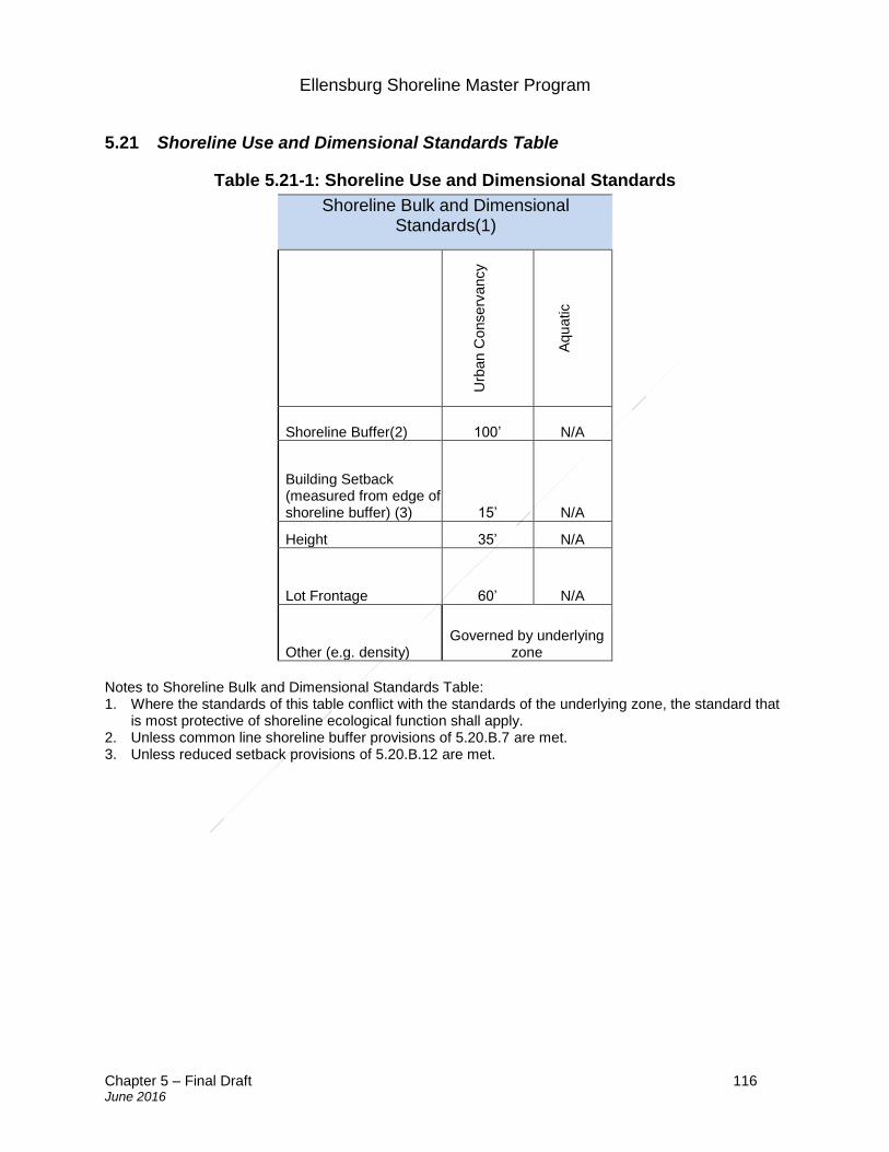
Ellensburg Shoreline Master Program
Chapter 5 – Final Draft 116 June 2016
5.21 Shoreline Use and Dimensional Standards Table
Table 5.21-1: Shoreline Use and Dimensional Standards
Shoreline Bulk and Dimensional Standards(1)
Urb
an C
onserv
ancy
Aqu
atic
Shoreline Buffer(2) 100’ N/A
Building Setback (measured from edge of shoreline buffer) (3) 15’ N/A
Height 35’ N/A
Lot Frontage 60’ N/A
Other (e.g. density) Governed by underlying
zone
Notes to Shoreline Bulk and Dimensional Standards Table: 1. Where the standards of this table conflict with the standards of the underlying zone, the standard that
is most protective of shoreline ecological function shall apply. 2. Unless common line shoreline buffer provisions of 5.20.B.7 are met. 3. Unless reduced setback provisions of 5.20.B.12 are met.
Ellensburg Shoreline Master Program
Chapter 6 – Final Draft 117 June 2016
6. Administration and Procedures
Sections: 6.1 Purpose 6.2 Applicability 6.3 Exemptions 6.4 Types of permits 6.5 Review authority 6.6 Review criteria 6.7 Review procedures 6.8 Appeals 6.9 Timing 6.10 Revisions 6.11 Liberal construction 6.12 Enforcement 6.13 Amendments to SMP 6.1 Purpose
The purpose of this Shoreline Management Program is to provide for the administration and management of uses and development within the shoreline jurisdiction in a manner consistent with RCW 90.58, the Shoreline Management Act, and other rules and guidelines adopted by the Washington State Department of Ecology.
6.2 Applicability
A. Generally Except when specifically exempted by statute, all proposed uses and development occurring within shoreline jurisdiction must conform to RCW Chapter 90.58, the Shoreline Management Act, and this master program. No substantial development shall be undertaken on shorelines of the state without first obtaining a permit. See also Section 1.7 Applicability.
B. Agricultural activities on agricultural lands
Nothing in this SMP shall require modification of or limit agricultural activities occurring on agricultural lands. However, new agricultural activities on land not meeting the definition of agricultural land, conversion of agricultural lands to other uses, and development not meeting the definition of agricultural activities is subject to the provisions of this SMP.
C. Prior development The provisions of WAC 173-27-070 shall apply to substantial development undertaken
Ellensburg Shoreline Master Program
Chapter 6 – Final Draft 118 June 2016
prior to the effective date of the Act.
D. Nonconformance
1. Applicability a. The following provisions apply to lots, structures and uses lawfully established
prior to the effective date of this master program, or amendments thereto, which do not conform to the current regulations or standards of this program.
b. The following provisions do not apply to lots, structures or uses that were unlawfully established.
2. Nonconforming lots. a. An undeveloped lot, tract, parcel, site, or division of land located landward of the
ordinary high water mark which was established in accordance with local and state subdivision requirements prior to the effective date of this master program but which does not conform to the present lot size standards may be developed as permitted by the land use regulations of the local government so long as such development conforms to all other requirements of the applicable master program and the act.
3. Nonconforming structures. a. Nonconforming structures may be maintained, repaired, renovated, and
remodeled, provided such activity does not enlarge or expand the structure. b. Nonconforming structures may be enlarged or expanded provided that said
enlargement does not increase the extent of nonconformity by further encroaching upon or extending into areas where construction would not be allowed for new development.
c. Enlarging or expanding a nonconforming non-residential structure in a manner that increases the extent of nonconformity requires a variance.
d. Enlarging or expanding nonconforming residential structures used for a conforming use in a manner that increases the extent of nonconformity may be allowed if the change is consistent with the provisions of this Program and demonstrates no net loss of shoreline ecological functions.
e. Nonconforming single-family residences may increase their height within the existing structural footprint up to maximum of thirty-five (35) feet without requiring a variance.
f. A nonconforming structure which is moved any distance must be brought into conformance with this Program and the Act.
g. Damaged nonconforming structures outside frequently flooded areas may be reconstructed to those configurations existing immediately prior to the time the development was damaged. Reconstruction of nonconforming development located in frequently flooded areas shall comply with regulations contained in Ellensburg City Code.
4. Nonconforming uses.
a. Nonconforming uses may be continued consistent with their lawfully established
Ellensburg Shoreline Master Program
Chapter 6 – Final Draft 119 June 2016
scale and range of uses. b. A structure which is being or has been used for a nonconforming use may be
used for a different nonconforming use only upon the approval of a conditional use permit. In addition to the conditional use permit criteria of Section 6.3, a conditional use permit for a change in a nonconforming use may be approved only upon a finding that: i. No reasonable alternative conforming use is practical because of the
configuration of the structure and/or the property; ii. The proposed use will be at least as consistent with the policies and
provisions of the Act and this Program and as compatible with the uses in the area as the pre-existing use;
iii. The use or activity is enlarged, intensified, increased or altered only to the minimum amount necessary to achieve the intended functional purpose;
iv. The structure(s) associated with the nonconforming use shall not be expanded in a manner that increases the extent of the non-conformity, including encroachment into areas such as setbacks, and any critical areas and/or associated buffers where new structures, use, or development would not be allowed;
v. The shoreline buffer and vegetation conservation standards of this Program are met (see Section 4.5);
vi. The change in use, remodel, or expansion will not create adverse impacts to shoreline ecological functions and/or processes;
vii. Uses which are specifically prohibited or which would thwart the intent of the Act or this Program shall not be authorized; and
viii. Conditions necessary to assure that the use will not become a nuisance or a hazard have been attached to the permit.
c. Redevelopment of nonconforming rights-of-way and associated transportation structures, such as railroad trestles, may be permitted for purposes of facilitating the development of public trails and/or public shoreline access; provided, that such redevelopment shall be otherwise consistent with the provisions of this Program, including, but not limited to, the provisions for public access and no net loss of shoreline ecological functions and processes, except as provided for in Section 6.3 of this chapter.
d. If a nonagricultural nonconforming use is discontinued for twelve (12) consecutive months or for twelve (12) months during any two-(2)-year period, the nonconforming rights shall expire and any subsequent use shall be conforming.
6.3 Permit Exemptions
1. General provisions:
a. Only those uses and developments that meet the precise terms of one (1) or more of the listed exemptions may be granted exemption from the substantial development permit process;
b. An exemption from the substantial development permit process is not an exemption from compliance with the Act or Master Program or from any other
Ellensburg Shoreline Master Program
Chapter 6 – Final Draft 120 June 2016
regulatory requirements; c. The burden of proof that a development or use is exempt from the permit process
is on the applicant; d. If any part of a proposed use or development is not eligible for exemption, then a
substantial development permit is required for the entire proposal; and e. Conditions may be attached to the approval of exempted uses or developments
as necessary to assure consistency of the project with the Act and the Master Program.
2. Developments exempt from shoreline substantial development permitting process:
Subject to the general provisions above, exempt activities include those set forth in WAC 173-27-040(2) and RCW 90.58.030, as amended:
a. Any use or development of which the total cost or fair market value, whichever is
higher, does not exceed six thousand four hundred sixteen dollars ($6,416), if such use or development does not materially interfere with the normal public use of the water or shorelines of the state. The dollar threshold established in this subsection will be adjusted for inflation by the office of financial management every five (5) years, according to WAC 172-27-040(2)(a). For purposes of determining whether or not a permit is required, the total cost or fair market value shall be based on the value of development that is occurring on shorelines of the state as defined in RCW 90.58.030 (2)(c). The total cost or fair market value of the development shall include the fair market value of any donated, contributed or found labor, equipment or materials;
b. Normal maintenance or repair of existing structures or developments, including damage by accident, fire or elements. "Normal maintenance" includes those usual acts to prevent a decline, lapse, or cessation from a lawfully established condition. "Normal repair" means to restore a development to a state comparable to its original condition including, but not limited to, its size, shape, configuration, location and external appearance, within a reasonable period after decay or partial destruction, except where repair causes substantial adverse effects to shoreline resource or environment. Replacement of a structure or development may be authorized as repair where such replacement is the common method of repair for the type of structure or development and the replacement structure or development is comparable to the original structure or development including, but not limited to, its size, shape, configuration, location and external appearance and the replacement does not cause substantial adverse effects to shoreline resources or environment;
c. Construction of the normal protective bulkhead common to single-family residences. A "normal protective" bulkhead includes those structural and nonstructural developments installed at or near, and parallel to, the OHWM for the sole purpose of protecting an existing single-family residence and appurtenant structures from loss or damage by erosion. A normal protective bulkhead is not exempt if constructed for the purpose of creating dry land. When a vertical or near vertical wall is being constructed or reconstructed, not more
Ellensburg Shoreline Master Program
Chapter 6 – Final Draft 121 June 2016
than one (1) cubic yard of fill per one (1) foot of wall may be used as backfill. When an existing bulkhead is being repaired by construction of a vertical wall fronting the existing wall, it shall be constructed no further waterward of the existing bulkhead than is necessary for construction of new footings. When a bulkhead has deteriorated such that an OHWM has been established by the presence and action of water landward of the bulkhead, then the replacement bulkhead must be located at or near the actual OHWM. Bioengineered erosion control projects may be considered a normal protective bulkhead when any structural elements are consistent with the above requirements and when the project has been approved by the Washington State Department of Fish and Wildlife;
d. Emergency construction necessary to protect property from damage by the elements. An "emergency" is an unanticipated and imminent threat to public health, safety, or the environment which requires immediate action within a time too short to allow full compliance with this chapter. Emergency construction does not include development of new permanent protective structures where none previously existed. Where new protective structures are deemed by the administrator to be the appropriate means to address the emergency situation, upon abatement of the emergency situation the new structure shall be removed or any permit which would have been required, absent the emergency, obtained, pursuant to RCW Chapter 90.58 and this Master Program. All emergency construction shall be consistent with the policies of RCW Chapter 90.58 and this Master Program. As a general matter, flooding or other seasonal events that can be anticipated and may occur but that are not imminent are not an emergency;
e. Construction and practices normal or necessary for farming, irrigation, and ranching activities, including agricultural service roads and utilities on shorelands, construction of a barn or similar agricultural structure, and the construction and maintenance of irrigation structures including, but not limited to, head gates, pumping facilities, and irrigation channels. Provided that a feedlot of any size; all processing plants; other activities of a commercial nature; alteration of the contour of the shorelands by leveling or filling other than that which results from normal cultivation; shall not be considered normal or necessary farming or ranching activities. A feedlot shall be an enclosure or facility used or capable of being used for feeding livestock hay, grain, silage, or other livestock feed, but shall not include land for growing crops or vegetation for livestock feeding and/or grazing, nor shall it include normal livestock wintering operations. See definition of “feedlot” at Section 7.38;
f. Construction or modification of navigational aids such as channel markers and anchor buoys;
g. Construction on shorelands by an owner, lessee or contract purchaser of a single-family residence for their own use or for the use of their family, which residence does not exceed a height of thirty-five (35) feet above average grade level and which meets all requirements of the City, other than requirements imposed pursuant to RCW Chapter 90.58. "Single-family residence" means a detached dwelling designed for and occupied by one (1) family including those structures and developments within a contiguous ownership which are a normal
Ellensburg Shoreline Master Program
Chapter 6 – Final Draft 122 June 2016
appurtenance. An "appurtenance" is necessarily connected to the use and enjoyment of a single-family residence and is located landward of the OHWM and the perimeter of a wetland. Normal appurtenances include a garage, deck, driveway, utilities, fences, installation of a septic tank and drainfield, and grading which does not exceed two hundred fifty (250) cubic yards and which does not involve placement of fill in any wetland or waterward of the OHWM. Construction authorized under this exemption shall be located landward of the OHWM;
h. Construction of a dock, including a community dock, designed for pleasure craft only for the private non-commercial use of the owner, lessee, or contract purchaser of single-family and multiple-family residences. A dock is a landing and moorage facility for watercraft and does not include recreational decks, storage facilities or other appurtenances. This exception applies if the fair market value of the dock does not exceed ten thousand dollars ($10,000); but if subsequent construction having a fair market value exceeding two thousand five hundred dollars ($2,500) occurs within five (5) years of completion of the prior construction, the subsequent construction shall be considered a substantial development for the purpose of this chapter;
i. Operation, maintenance, or construction of canals, waterways, drains, reservoirs, or other facilities that now exist or are hereafter created or developed as a part of an irrigation system for the primary purpose of making use of system waters including return flow and artificially stored groundwater from the irrigation of lands;
j. The marking of property lines or corners on state-owned lands, when such marking does not significantly interfere with normal public use of the surface of the water;
k. Operation and maintenance of any system of dikes, ditches, drains, or other facilities existing on September 8, 1975, which were created, developed, or utilized primarily as a part of an agricultural drainage or diking system;
l. Any project with a certification from the governor pursuant to RCW Chapter 80.50;
m. Site exploration and investigation activities that are prerequisite to preparation of an application for development authorization under WAC 173-27-040(2), when all of the following conditions are met;
i. The activity does not interfere with the normal public use of the surface waters;
ii. The activity will have no significant adverse impact on the environment including, but not limited to, fish; wildlife; fish or wildlife habitat; water quality; and aesthetic values;
iii. The activity does not involve the installation of any structure, and upon completion of the activity, the vegetation and land configuration of the site are restored to conditions existing before the activity; and
iv. A private entity seeking development authorization under this Section first posts a performance bond or provides other evidence of financial responsibility to the local jurisdiction to ensure that the site is restored to preexisting conditions;
Ellensburg Shoreline Master Program
Chapter 6 – Final Draft 123 June 2016
n. The process of removing or controlling aquatic noxious weeds, as defined in RCW 17.26.020, through the use of an herbicide or other treatment methods applicable to weed control that are recommended by a final environmental impact statement published by the Washington State Department of Agriculture or the Washington State Department of Ecology jointly with other state agencies under RCW Chapter 43.21C; recommended under RCW Chapter 43.21C;
o. Watershed restoration projects as defined herein. The City shall review the projects for consistency with the Shoreline Master Program in an expeditious manner and shall issue its decision along with any conditions within forty-five (45) days of receiving all materials necessary to review the request for exemption from the applicant. No fee may be charged for accepting and processing requests for exemption for watershed restoration projects as used in this Section.
i. "Watershed restoration project" means a public or private project authorized by the sponsor of a watershed restoration plan that implements the plan or a part of the plan and consists of one or more of the following activities:
A. A project that involves less than ten (10) miles of stream reach, in which less than twenty-five (25) cubic yards of sand, gravel, or soil is removed, imported, disturbed or discharged, and in which no existing vegetation is removed except as minimally necessary to facilitate additional plantings;
B. A project for the restoration of an eroded or unstable stream bank that employs the principles of bioengineering, including limited use of rock as a stabilization only at the toe of the bank, and with primary emphasis on using native vegetation to control the erosive forces of flowing water; or
C. A project primarily designed to improve fish and wildlife habitat, remove or reduce impediments to migration of fish, or enhance the fishery resource available for use by all of the citizens of the state; provided that any structure, other than a bridge or culvert or in-stream habitat enhancement structure associated with the project, is less than two hundred (200) square feet in floor area and is located above the OHWM of the stream.
ii. "Watershed restoration plan" means a plan, developed or sponsored by the Washington State Departments of Fish and Wildlife, Ecology, Natural Resources, and Transportation (WSDOT); a federally recognized Indian tribe acting within and pursuant to its authority; a city; a county; or a conservation district that provides a general program and implementation measures or actions for the preservation, restoration, re-creation, or enhancement of the natural resources, character, and ecology of a stream, stream segment, drainage area, or watershed for which agency and public review has been conducted pursuant to RCW Chapter 43.21C, the state Environmental Policy Act.
p. A public or private project that is designed to improve fish or wildlife habitat or
Ellensburg Shoreline Master Program
Chapter 6 – Final Draft 124 June 2016
fish passage, when all of the following apply:
i. The project has been approved in writing by the Washington State Department of Fish and Wildlife;
ii. The project has received hydraulic project approval by the Washington State Department of Fish and Wildlife pursuant to RCW Chapter 77.55; and
iii. The City determines that the project is substantially consistent with the Shoreline Master Program. The City shall make such determination in a timely manner and provide it by letter to the project proponent.
iv. Fish habitat enhancement projects that conform to the provisions of RCW 77.55.181 are determined to be consistent with local shoreline Master Programs, as follows:
A. In order to receive the permit review and approval process created in this Section, a fish habitat enhancement project must meet the criteria under p.iv.A.I and II of this subsection:
I. A fish habitat enhancement project must be a project to accomplish one or more of the following tasks:
1. Elimination of human-made fish passage barriers, including culvert repair and replacement;
2. Restoration of an eroded or unstable stream bank employing the principle of bioengineering, including limited use of rock as a stabilization only at the toe of the bank, and with primary emphasis on using native vegetation to control the erosive forces of flowing water; or
3. Placement of woody debris or other instream structures that benefit naturally reproducing fish stocks.
The Washington State Department of Fish and Wildlife shall develop size or scale threshold tests to determine if projects accomplishing any of these tasks should be evaluated under the process created in this Section or under other project review and approval processes. A project proposal shall not be reviewed under the process created in this Section if the Washington State Department of Ecology determines that the scale of the project raises concerns regarding public health and safety; and
II. A fish habitat enhancement project must be approved in one
of the following ways:
Ellensburg Shoreline Master Program
Chapter 6 – Final Draft 125 June 2016
1. By the Washington State Department of Fish and Wildlife pursuant to RCW Chapter 77.95 or 77.100;
2. By the sponsor of a watershed restoration plan as provided in RCW Chapter 89.08;
3. By the Washington State Department of Ecology as a WDFW-sponsored fish habitat enhancement or restoration project;
4. Through the review and approval process for the Jobs for the Environment Program;
5. Through the review and approval process for conservation district-sponsored projects, where the project complies with design standards established by the Conservation Commission through interagency agreement with the U. S. Fish and Wildlife Service and the Natural Resource Conservation Service;
6. Through a formal grant program established by the Legislature or the Washington State Department of Fish and Wildlife for fish habitat enhancement or restoration; and
7. Through other formal review and approval processes established by the Legislature.
B. Fish habitat enhancement projects meeting the criteria of p.iii.A of this subsection are expected to result in beneficial impacts to the environment. Decisions pertaining to fish habitat enhancement projects meeting the criteria of p.iii.A of this subsection and being reviewed and approved according to the provisions of this Section are not subject to the requirements of RCW 43.21C.030 (2)(c).
C. A hydraulic project approval (HPA) permit is required for projects that meet the criteria of p.iii.A of this subsection and are being reviewed and approved under this Section. An applicant shall use a joint aquatic resource permit (JARPA) application form developed by the Office of Regulatory Assistance to apply for approval under this chapter. On the same day, the applicant shall provide copies of the completed application form to the Washington State Department of Fish and Wildlife and to each appropriate local government agency. Local governments shall accept the application as notice of the proposed project. The Washington State Department of Fish and Wildlife shall provide a fifteen-(15)-day comment period during which it will receive comments regarding environmental impacts. Within forty-five (45) days, the Washington State Department of Ecology shall either issue a permit, with or without conditions, deny approval, or make a determination that the review and approval process created by this Section is not appropriate for the proposed project. Ecology shall base this determination on identification during the comment period
Ellensburg Shoreline Master Program
Chapter 6 – Final Draft 126 June 2016
of adverse impacts that cannot be mitigated by the conditioning of a permit. If Ecology determines that the review and approval process created by this Section is not appropriate for the proposed project, Ecology shall notify the applicant and the appropriate local governments of its determination. The applicant may reapply for approval of the project under other review and approval processes. Any person aggrieved by the approval, denial, conditioning, or modification of a permit under this Section may formally appeal the decision to the Hydraulic Appeals Board pursuant to the provisions of this chapter.
D. The City may not require permits or charge fees for fish habitat enhancement projects that meet the criteria of p.iii.A of this subsection and that are reviewed and approved according to the provisions of this Section.
3. Letter of exemption:
a. General. A letter of exemption is required for all requests for exemption from a shoreline substantial development permit to ensure the proposal complies with the regulations of this SMP, except for emergency development pursuant to WAC 173-27-040(2)(d).
b. Application. Any person claiming exemption from the substantial development permit requirements shall submit an application for such an exemption in the manner prescribed by the Shoreline Administrator. Applications shall include, at a minimum: a summary of the proposed development project; identification of the specific exemption provisions from WAC 173-27-040 that applies to the proposal; and a description of how the proposal will comply with the applicable policies and regulations of this Shoreline Master Program.
c. Letter of exemption. City of Ellensburg shall prepare a letter of exemption, addressed to the applicant and the Washington State Department of Ecology, whenever a proposal is determined to be exempt from the substantial development permit requirements. The letter of exemption must indicate the specific exemption provision from WAC 173-27-040 that is applicable to the proposal and provide a summary of the consistency of the proposal with the regulations of this SMP.
d. Watershed restoration projects. This Section applies to a letter of exemption for a watershed restoration project pursuant to WAC 173-27-040 or subject to one or more of the following federal permits: U.S. Army Corps of Engineers Section 10 permit under the Rivers and Harbors Act of 1899 (generally applicable to any project occurring on or over navigable waters); or Section 404 permit under the Federal Water Pollution Control Act of 1972 (generally applicable to any project which may involve discharge of dredge or fill material to any water or wetland area). i. The letter of exemption must indicate the specific exemption provision from
WAC 173-27-040 that is applicable to the proposal and provide a summary of the consistency of the proposal with the regulations of this SMP.
Ellensburg Shoreline Master Program
Chapter 6 – Final Draft 127 June 2016
Watershed restorations projects must be reviewed in an expeditious manner and an exemption decision, together with any conditions, must be issued within forty-five (45) days of receiving all materials necessary to review the request for exemption. No fee may be charged for accepting and processing requests for exemption for watershed restoration projects as used in this Section.
4. Programmatic statements of exemption.
a. Applicability. Programmatic statements of exemption may be issued for activities exempt under the provisions of subsection 6.3.2 above that:
i. Are repetitive and part of a maintenance program or other similar program; ii. Have the same or similar identifiable impacts each time the activity is
repeated at all sites covered by the programmatic statement of exemption; and
iii. Are suitable to having standard conditions that will apply to any and all sites.
b. Conditions. A programmatic statement of exemption shall not be issued until appropriate conditions, if needed, are developed and approved. Conditions shall apply uniformly to each activity authorized and all locations covered by the programmatic statement of exemption. Conditions may include specifications for the frequency, method and contents of periodic status reports.
c. Revisions. The programmatic statement of exemption may be modified or withdrawn if the department determines that:
i. The programmatic statement of exemption or activities authorized under the statement of exemption no longer comply with law;
ii. The programmatic statement of exemption does not provide adequate regulation of the activity;
iii. The conditions or the manner in which the conditions are implemented are not adequate to protect against the impacts resulting from the activity.
d. Expiration. Programmatic exemptions shall expire 5 years after the date of issuance if a shorter expiration period is not specified in the exemption approval.
6.4 Types of permits
1. Substantial development permits: All substantial development undertaken on
shorelines of the state requires a permit to ensure consistency with the policies of RCW 90.58.020 and the Master Program.
2. Variances: The purpose of a variance permit is strictly limited to granting relief from specific bulk, dimensional or performance standards set forth in the applicable Master Program where there are extraordinary circumstances relating to the physical character or configuration of property such that the strict implementation of the Master Program will impose unnecessary hardships on the applicant or thwart the policies set forth in RCW 90.58.020. When a use or development is proposed that does not comply with the bulk, dimensional and performance standards of the
Ellensburg Shoreline Master Program
Chapter 6 – Final Draft 128 June 2016
Master Program, such use or development can only be authorized by approval of a variance.
3. Conditional uses: The purpose of a conditional use permit is to provide a system within the Master Program which allows flexibility in the application of use regulations in a manner consistent with the policies of RCW 90.58.020. Uses which are classified or set forth in the applicable Master Program as conditional uses may be authorized with a conditional use permit. Other uses which are not classified or set forth in the applicable Master Program may be authorized as conditional uses provided the applicant can demonstrate consistency with the requirements of this Section and the requirements for conditional uses contained in the Master Program. Uses which are specifically prohibited by the Master Program may not be authorized as conditional uses.
6.5 Review authority 1. Administrator: The Administrator or his/her designee shall have the authority to
review and approve, deny, or approve with conditions, applications for the following: a. Letters of exemption; b. Shoreline substantial development permits; c. Revisions to substantial development permits; and d. Requests for timing extensions.
2. Hearing Examiner: The Hearing Examiner or his/her designee shall have the
authority to review and make initial recommendations for approval, denial, or approval with conditions for the following: a. Shoreline conditional use permits; and b. Shoreline variances.
3. City Council: The City Council or their designee shall have the authority to:
a. Acquire lands and easements within shorelines of the state by purchase, lease,
or gift, either alone or in concert with other governmental entities, when necessary to achieve implementation of the Master Program;
b. Accept grants, contributions, and appropriations from any agency, public or private, or individual for the purposes of the Master Program;
c. Appoint advisory committees to assist in carrying out the purposes of the Master Program;
d. Contract for professional or technical services required by the Master Program which cannot be performed by its employees; and
e. Adopt moratoria or other interim official controls necessary to implement SMP, in accordance with RCW 90.58.590 as amended.
Ellensburg Shoreline Master Program
Chapter 6 – Final Draft 129 June 2016
4. Washington State Department of Ecology: The Washington State Department of Ecology shall be responsible for the final approval, denial, or approval with conditions for the following: a. Shoreline conditional use permits and revisions to same; and b. Shoreline variances and revisions to same.
6.6 Review Criteria
1. All development permits: As provided in Section 5.20, no permit shall be issued for any new or expanded building or structure of more than thirty-five (35) feet above average grade level on shorelines of the state that will obstruct the view of a substantial number of residences on areas adjoining such shorelines unless overriding considerations of the public interest will be served.
2. Substantial development permits: A substantial development permit shall be granted only when the applicant demonstrates all of the following: a. That the proposal is consistent with the policies and procedures in RCW Chapter
90.58 and WACN Chapter 173-27; b. That the proposal is consistent with the policies and procedures of the Master
Program; and c. That the proposal has been appropriately conditioned where necessary to assure
consistency of the project with the Act and the local Master Program.
3. Conditional use permits: Uses which are classified or set forth in Table 3.7-1 as conditional uses, or unclassified uses not specifically prohibited, may be authorized as a conditional use provided that the applicant demonstrates all of the following:
a. That the proposed use is consistent with the policies of RCW 90.58.020 and the
Master Program; b. That the proposed use will not interfere with the normal public use of public
shorelines; c. That the proposed use of the site and design of the project is compatible with
other authorized uses within the area and with uses planned for the area under the comprehensive plan and SMP;
d. That the proposed use will cause no significant adverse effects to the shoreline environment in which it is to be located;
e. That the public interest suffers no substantial detrimental effect; f. That if conditional use permits were granted for other developments in the area
where similar circumstances exist, the cumulative impact of such uses would remain consistent with the policies of RCW 90.58.020 and not produce substantial adverse effects to the shoreline environment;
g. That the proposed use has been appropriately conditioned to prevent undesirable effects of the proposed use and to assure consistency of the project with the Act and the local Master Program;
Ellensburg Shoreline Master Program
Chapter 6 – Final Draft 130 June 2016
h. When converting from one nonconforming use to a different nonconforming use, the applicant must demonstrate that no reasonable alternative conforming use is practical and that the proposed use will be at least as consistent with the policies and provisions of the Act and the Master Program and as compatible with the uses in the area as the pre-existing use.
4. Variance:
a. General provisions. Variance permits should be granted in circumstances where
denial of the permit would result in a thwarting of the policy enumerated in RCW 90.58.020. In all instances the applicant must demonstrate that extraordinary circumstances shall be shown and the public interest shall suffer no substantial detrimental effect. Variances from the use regulations of the Master Program are prohibited.
b. Review criteria for all variances. Variance permits for uses and/or development that will be located landward of the OHWM and/or landward of any wetland may be authorized provided the applicant can demonstrate all of the following:
i. That the strict application of the bulk, dimensional or performance standards set forth in the applicable Master Program precludes, or significantly interferes with, reasonable use of the property;
ii. That the hardship is specifically related to the property, and is the result of unique conditions such as irregular lot shape, size, or natural features and the application of the Master Program, and not, for example, from deed restrictions or the applicant's own actions;
iii. That the design of the project is compatible with other authorized uses within the area and with uses planned for the area under the comprehensive plan and SMP and will not cause adverse impacts to the shoreline environment;
iv. That the variance will not constitute a grant of special privilege not enjoyed by the other properties in the area;
v. That the variance requested is the minimum necessary to afford relief; vi. That the public interest will suffer no substantial detrimental effect; and vii. That the cumulative impact of additional requests for variances in the area
where similar circumstances exist would not produce substantial adverse effects to the shoreline environment.
c. Additional review criteria for variances waterward of the OHWM. In addition to the criteria established under subsection 4.b above, applicants for variance permits for uses and/or development that will be located waterward of the OHWM must also demonstrate:
i. That the strict application of the bulk, dimensional or performance standards set forth in the applicable Master Program precludes all reasonable use of the property; and
ii. That the public rights of navigation and use of the shorelines will not be adversely affected.
Ellensburg Shoreline Master Program
Chapter 6 – Final Draft 131 June 2016
6.7 Review procedures
1. Generally: The general procedural requirements of the City shall apply to shoreline permits except where this chapter is more restrictive or specific, in which case the provision of this chapter shall apply.
2. Complete application: The Administrator shall issue a determination of completeness, upon finding that the following required information has been submitted with an application for a substantial development, conditional use, or variance permit:
a. A completed joint aquatic resources permit application (JARPA); b. A site development plan consisting of maps and elevation drawings, drawn to an
appropriate scale to depict clearly all required information, photographs and text which shall include:
i. The boundary of the parcel(s) of land upon which the use or development is proposed;
ii. The OHWM of all water bodies located adjacent to or within the boundary of the project. This may be an approximate location provided, that for any use or development where a determination of consistency with the applicable regulations requires a precise location of the OHWM, the mark shall be located precisely and the biological and hydrological basis for the location as indicated on the plans shall be included in the development plan. Where the OHWM is neither adjacent to or within the boundary of the project, the plan shall indicate the distance and direction to the nearest OHWM of a shoreline;
iii. Existing and proposed land contours. The contours shall be at intervals sufficient to accurately determine the existing character of the property and the extent of proposed change to the land that is necessary for the use or development. Areas within the boundary that will not be altered by the use or development may be indicated as such and contours approximated for that area;
iv. A delineation of all wetland areas that will be altered or used as a part of the proposal;
v. A general indication of the character of vegetation found on the site; vi. The dimensions and locations of all existing and proposed structures and
improvements including, but not limited to: buildings, paved or graveled areas; roads; utilities; septic tanks and drainfields; material stockpiles or surcharge; and stormwater management facilities;
vii. Where applicable, scaled elevation drawings of all proposed structures including location of the OWHM;
viii. Where applicable, a landscaping plan for the project; ix. Where applicable, plans for use and development of areas on or off the site
as mitigation for impacts associated with the proposed project shall be included and contain information consistent with the requirements of this Section;
Ellensburg Shoreline Master Program
Chapter 6 – Final Draft 132 June 2016
x. Quantity, source, and composition of any fill material that is placed on the site whether temporary or permanent;
xi. Quantity, composition, and destination of any excavated or dredged material;
xii. A vicinity map showing the relationship of the property and proposed use or development to roads, utilities, and existing uses and developments on adjacent properties;
xiii. Where applicable, a depiction of the impacts to views from existing residential uses and public areas; and
xiv. On all Variance Permit applications the plans shall clearly indicate where use and/or development could occur without approval of a variance, the physical features and circumstances on the property that provide a basis for the request, and the location of adjacent structures and uses.
3. Concurrent submittals: When a substantial development permit and a conditional
use or variance permit are required for a proposal, the submittal on the permits shall be made concurrently.
4. Notice:
a. Required. The Administrator shall notify the public, the Washington State
Department of Ecology, the Yakama Nation, other agencies with jurisdiction as well as individuals and organizations that have requested notice in writing of applications for a shoreline management substantial development, conditional use, or variance permit.
b. Timing. Notice of application shall be provided within fourteen (14) days after the determination of completeness. When an open record hearing is required. If an open record pre-decision hearing is required for the requested project permits, the notice of application shall be provided at least fifteen (15) days prior to the open record hearing.
c. Contents. The notice shall include:
i. The date of application; the date of the notice of completion for the application; and the date of the notice of application;
ii. A description of the proposed project action and a list of the project permits included in the application and, if applicable, a list of any studies requested;
iii. The identification of other permits not included in the application to the extent known by the local government;
iv. The identification of existing environmental documents that evaluate the proposed project, and, if not otherwise stated on the document providing the notice of application, such as a city land use bulletin, the location where the application and any studies can be reviewed;
v. A statement of the public comment period, which shall be not less than thirty (30) days following the date of notice of application, and statements of the right of any person to comment on the application, receive notice of and participate in any hearings, request a copy of the decision once made, and
Ellensburg Shoreline Master Program
Chapter 6 – Final Draft 133 June 2016
any appeal rights. A local government may accept public comments at any time prior to the closing of the record of an open record pre-decision hearing, if any, or, if no open record pre-decision hearing is provided, prior to the decision on the project permit;
vi. The date, time, place, and type of hearing, if applicable and scheduled at the date of notice of the application;
vii. A statement of the preliminary determination, if one has been made at the time of notice, of those development regulations that will be used for project mitigation and of consistency; and
viii. Any other information determined appropriate by the local government.
d. Method. The notification system shall assure that notice to the general public and property owners in the vicinity of such application is given by at least one of the following methods:
i. Mailing of the notice to the latest recorded real property owners as shown by the records of the county assessor within at least three hundred (300) feet of the boundary of the property upon which the use or development is proposed; or
ii. Posting of the notice in a conspicuous manner on the property upon which the project is to be undertaken.
5. Review and decision: The appropriate review authority identified in Section 6.5 shall
review applications for compliance with review criteria in Section 6.6 and either approve, deny, or approve with conditions. In the case of shoreline conditional use and variance Permits, the decision shall serve as a recommendation to the Washington State Department of Ecology, which is responsible for the final decision on shoreline conditional use permits and variances.
6. Submittal to the Washington State Department of Ecology:
a. Required submittal. All applications for a permit or a permit revision shall be submitted to the Washington State Department of Ecology upon a final decision by local government, pursuant to WAC 173-27-130.
b. Appeals. When a permit has been appealed pursuant to RCW 90.58.180, upon conclusion of all review proceedings, a copy of the final order shall be provided by the local government to the Washington State Department of Ecology.
c. Modified project. When the project has been modified in the course of the review proceeding, plans or text shall be provided to the local government that clearly indicate the final approved plan, and the local government shall reissue the permit accordingly and submit a copy of the reissued permit and supporting documents to the Washington State Department of Ecology for completion of the file on the permit. The purpose of this provision is to assure that the local and Ecology files on the permit are complete and accurate and not to provide a new opportunity for appeal of the permit.
d. Conditional use permits and variances. Shoreline Conditional Use Permits and
Ellensburg Shoreline Master Program
Chapter 6 – Final Draft 134 June 2016
Variances shall be transmitted to the Washington State Department of Ecology for final approval, denial, or approval with conditions.
6.8 Appeals
Any person aggrieved by the granting, denying, or rescinding of a permit on shorelines of the state may seek review from the shorelines hearings board by filing a petition for review within twenty-one (21) days of the date of filing of the decision, pursuant to RCW 90.58.180.
6.9 Timing 1. Applicability: The time requirements of this Section shall apply to all Substantial
Development Permits and to any development authorized pursuant to a Variance or Conditional Use Permit.
2. Effective date: The effective date of a Substantial Development Permit shall be the date of filing as provided in RCW 90.58.140(6).
3. Commencement: Construction activities associated with a shoreline permit are not
authorized and shall not begin until twenty-one (21) days from the date of filing or until all review proceedings initiated within twenty-one (21) days from the date of such filing have been terminated. Construction activities, or the use or activity where no construction activities are involved, shall be commenced within two (2) years of the effective date of a Substantial Development Permit.
4. Expiration: Authorization to conduct development activities shall terminate five (5)
years after the effective date of a shoreline permit, unless extended in accordance with the provisions below.
5. Extension: The Administrator may authorize a single extension for a period not to
exceed one (1) year based on reasonable factors, if a request for extension has been filed before the expiration date and notice of the proposed extension is given to parties of record on the shoreline permit and to the Washington State Department of Ecology.
6. Exclusions: The time periods in this Section do not include the time during which a
use or activity was not actually pursued due to the pendency of administrative appeals or legal actions or due to the need to obtain any other government permits and approvals for the proposal, including all reasonably related administrative or legal actions on any such permits or approvals.
7. Flexibility: Upon a finding of good cause, based on the requirements and circumstances of the project proposed and consistent with the policy and provisions of the master program and RCW 90.58, the City may adopt different time limits from those set forth in this subsection as part of action on a Substantial Development
Ellensburg Shoreline Master Program
Chapter 6 – Final Draft 135 June 2016
Permit.
6.10 Revisions 1. Applicability:
a. Substantive changes. A permit revision is required whenever the applicant
proposes substantive changes to the design, terms, or conditions of a project from that which is approved in the permit. Changes are substantive if they materially alter the project in a manner that relates to its conformance to the terms and conditions of the permit, the Master Program and/or the policies and provisions of the Shoreline Management Act (RCW 90.58). Changes which are not substantive in effect do not require approval of a revision.
b. Substantial development. If the proposed change, or the sum of the proposed revisions and any previously approved revisions, constitutes substantial development then the applicant is not eligible for the revision process and shall be required to apply for a new permit.
2. Submittal requirements: An applicant seeking to revise a permit shall submit
detailed plans and text describing the proposed changes to the Administrator.
3. Review criteria and findings: The Administrator may approve a revision when the proposed changes are within the scope and intent of the original permit, and are consistent with the applicable Master Program and the Act. At a minimum, Administrator must find:
a. No additional over-water construction is involved except that pier, dock, or float
construction may be increased by five hundred (500) square feet or ten percent (10%) from the provisions of the original permit, whichever is less;
b. Ground area coverage and height may be increased a maximum of ten percent (10%) from the provisions of the original permit;
c. The revised permit does not authorize development to exceed height, lot coverage, setback, or any other requirements of the applicable Master Program except as authorized under a variance granted as the original permit or a part thereof;
d. Additional or revised landscaping is consistent with any conditions attached to the original permit and with the applicable Master Program;
e. The use authorized pursuant to the original permit is not changed; and f. No adverse environmental impact will be caused by the project revision
4. Timing and limitations: Revisions to permits may be authorized after original permit
authorization has expired. However, such revisions shall be limited to authorization of changes which are consistent with this Section and which would not require a shoreline permit for the development or change. This subsection shall not be used to extend the time requirements or to authorize substantial development beyond the time limits of the original permit.
Ellensburg Shoreline Master Program
Chapter 6 – Final Draft 136 June 2016
5. Notice: Notice of the revision approval shall be given to parties of record on the
original permit and to the Washington State Department of Ecology.
6. Effective date: The revised permit is effective immediately upon final decision by the Administrator or, when appropriate, upon final action by the Washington State Department of Ecology.
7. Appeals:
a. Timing. Appeals shall be in accordance with RCW 90.58.180 and shall be filed
within twenty-one (21) days from the date of receipt of the local government's action on a substantial development permit revision by the Washington State Department of Ecology or, for revisions to conditional use permits or variances, the date Ecology's final decision is transmitted to local government and the applicant.
b. Grounds. Appeals shall be based only upon contentions of noncompliance with the provisions of WAC 173-27-100.
c. Construction during appeal period. Construction undertaken pursuant to that portion of a revised permit not authorized under the original permit is at the applicant's own risk until the expiration of the appeals deadline.
d. Impact of appeal on original permit. If an appeal is successful in proving that a revision is not within the scope and intent of the original permit, the decision shall have no bearing on the original permit.
6.11 Liberal construction
As provided for in RCW 90.58.900, the Act is exempted from the rule of strict construction. The Act and this Program shall be liberally construed to give full effect to the purposes, goals, objectives, and policies for which the Act and this Program were enacted and adopted, respectively. In the event the provisions of this Program conflict with provisions of federal, state, or local regulations, the provision that is the most protective of shoreline resources shall prevail, when consistent with policies set out in the SMA.
6.12 Enforcement
Chapter 173-27 WAC contains enforcement regulations, including authority for the City to issue regulatory orders to enforce the SMA and the SMP. Upon a determination that there has been a violation of any provision of the City’s shoreline regulations, the City may pursue code enforcement and penalties in accordance with the provisions of the ECC.
1. Violations
a. It is a violation of this SMP for any person to initiate or maintain or cause to be initiated or maintained the use of any structure, land or property within the
Ellensburg Shoreline Master Program
Chapter 6 – Final Draft 137 June 2016
shorelines of the City without first obtaining the permits or authorizations required for the use by this Chapter.
b. It is a violation of this SMP for any person to use, construct, locate, or demolish any structure, land or property within shorelines of the City in any manner that is not permitted by the terms of any permit or authorization issued pursuant to this SMP, provided that the terms or conditions are explicitly stated on the permit or the approved plans.
c. It is a violation of this SMP to remove or deface any sign, notice, or order required by or posted in accordance with this SMP.
d. It is a violation of this SMP to misrepresent any material fact in any application, plans or other information submitted to obtain any shoreline use or development authorization.
e. It is a violation of this SMP for anyone to fail to comply with any other requirement of this SMP.
2. Duty to Enforce
a. It shall be the duty of the Administrator to enforce this Chapter. The Administrator may call upon the police, fire, health, or other appropriate City or county departments, or the state of Washington, to assist in enforcement.
b. Upon presentation of proper credentials, the Administrator, or duly authorized representative of the Administrator may, with the consent of the owner or occupier of a building or premises, or pursuant to lawfully issued inspection warrant, enter at reasonable times any building or premises subject to the consent or warrant to perform the duties imposed by this SMP.
c. This SMP shall be enforced for the benefit of the health, safety and welfare of the general public, and not for the benefit of any particular person or class of persons.
d. It is the intent of this SMP to place the obligation of complying with its requirements upon the owner, occupier or other person responsible for the condition of the land and buildings within the scope of this SMP.
e. No provision of or term used in the SMP is intended to impose any duty upon the City or any of its officers or employees which would subject them to damages in a civil action.
3. Investigation, Notice of Violation and Penalties
a. The Administrator or his/her representative shall investigate any structure, premises or use which the Administrator reasonably believes does not comply with the standards and requirements of this SMP.
b. If after investigation the Administrator determines that the SMP’s standards or requirements have been violated, the Administrator shall follow the procedures for enforcement action and penalties shall be as specified in RCW 90.58 and WAC 173-27.
c. The Shoreline Management Act calls for a cooperative enforcement program between local and state government. It provides for both civil and criminal
Ellensburg Shoreline Master Program
Chapter 6 – Final Draft 138 June 2016
penalties, orders to cease and desist, orders to take corrective action and permit rescission. The choice of enforcement action and the severity of any penalty should be based on the nature of the violation and the damage or risk to the public or to public resources. The existence or degree of bad faith of the persons subject to the enforcement action, the benefits that accrue to the violator, and the cost of obtaining compliance may also be considered.
d. Notwithstanding any other provision of the SMP, the Administrator or his/her representative, shall have the authority to enforce the provisions of the SMP in accordance with the ECC.
6.13 Amendments to Master Program
1. Applicability: This Section applies to comprehensive Shoreline Master Program updates as well as limited SMP amendments that may be necessary from time to time to comply with state and federal laws and implementing rules, address newly annexed shorelines, improve consistency with the Act’s goals and policies, or correct errors or omissions. All Master Program amendments shall be processed pursuant to the procedural requirements of WAC 173-26-010 through 173-26-160 and RCW 90.58.090.
2. Initiation of amendments:
a. By elected or appointed officials. The City Council or Planning Commission may initiate an amendment to this Program according to the procedures prescribed in WAC 173-26-100.
b. By the public. Any person may petition the City Council or Planning Commission to amend this Program. Petitions shall specify the changes requested and any and all reasons therefor. The City Council or Planning Commission may schedule a public hearing on said petition(s) if it deems the proposed amendment would make this Program more consistent with the Act or more equitable in its application to persons or property due to changed conditions in an area.
c. As the result of annual review. The Administrator shall submit an annual report reviewing the effectiveness of the Program in achieving its stated purpose, goals, and objectives as well as any proposed amendments deemed necessary to increase its effectiveness or equity. If said report contains proposed amendments, the City Council may schedule a public hearing to consider such matter.
3. Notice: Notice of a public hearing shall be published in one or more newspapers of
general circulation in the area in which the hearing is to be held. The notice shall include: a reference to the authority under which the action is proposed; a statement or summary of the proposed changes to the Master Program; the date, time and location of the hearing; the manner in which interested persons may present their views; and reference to the availability of the draft proposal for public inspection at the Ellensburg Community Development Department.
Ellensburg Shoreline Master Program
Chapter 6 – Final Draft 139 June 2016
4. Consultations: a. The local government shall consult with and solicit the comments of any persons,
groups, federal, state, regional, or local agency, and tribes having interests or responsibilities relating to the shorelines or any special expertise with respect to any environmental impact.
b. Adjacent local governments with jurisdiction over common shorelines of that state shall be included in the consultation process.
c. The local government shall solicit comments on the draft proposal from the Washington State Departments of Ecology and Commerce at least sixty (60) days prior to final local approval.
5. Coordination: The City shall coordinate with the participating jurisdictions and verify
concurrence with or denial of the proposal. The amendments of concurring jurisdictions shall be processed together.
6. Hearing: The City shall conduct at least one (1) public hearing to consider the draft proposal.
7. Washington State Department of Ecology Approval: Washington State Department of Ecology approval is required pursuant to RCW 90.58.090.
Ellensburg Shoreline Master Program
Chapter 7 – Final Draft 140 June 2016
7. Definitions and Acronym List
The terms used throughout this Program shall be defined and interpreted as indicated below. When consistent with the context, words used in the present tense shall include the future; the singular shall include the plural, and the plural the singular. Definitions established by WAC 173 have been incorporated herein; and should these definitions in the WAC be amended, the most current WAC definition shall apply.
1. "Act" means the Washington State Shoreline Management Act, RCW Chapter 90.58.
2. "Adoption by rule" means an official action by the Washington State Department of Ecology to make a local government shoreline master program effective through rule consistent with the requirements of the Administrative Procedure Act, RCW Chapter 34.05, thereby incorporating the adopted shoreline master program or amendment into the state master program.
3. "Administrator" means the City of Ellensburg Community Development Director or designee.
4. "Agricultural activities" means agricultural uses and practices including, but not limited to: Producing, breeding, or increasing agricultural products; rotating and changing agricultural crops; allowing land used for agricultural activities to lie fallow in which it is plowed and tilled but left unseeded; allowing land used for agricultural activities to lie dormant as a result of adverse agricultural market conditions; allowing land used for agricultural activities to lie dormant because the land is enrolled in a local, state, or federal conservation program, or the land is subject to a conservation easement; conducting agricultural operations; maintaining, repairing, and replacing agricultural equipment; maintaining, repairing, and replacing agricultural facilities, provided that the replacement facility is no closer to the shoreline than the original facility; and maintaining agricultural lands under production or cultivation.
5. "Agricultural products" includes, but is not limited to, horticultural, viticultural, floricultural, vegetable, fruit, berry, grain, hops, hay, straw, turf, sod, seed, and apiary products; feed or forage for livestock; Christmas trees; hybrid cottonwood and similar hardwood trees grown as crops and harvested within twenty (20) years of planting; and livestock including both the animals themselves and animal products including, but not limited to, meat, upland finfish, poultry and poultry products, and dairy products.
6. "Agricultural equipment" and "agricultural facilities" includes, but is not limited to:
a. The following used in agricultural operations: Equipment; machinery; constructed shelters; buildings and ponds; fences; upland finfish rearing facilities; water diversion, withdrawal, conveyance, and use equipment and facilities including, but not limited to, pumps, pipes, tapes, canals, ditches, and drains;
Ellensburg Shoreline Master Program
Chapter 7 – Final Draft 141 June 2016
b. Corridors and facilities for transporting personnel, livestock, and equipment to, from, and within agricultural lands;
c. Farm residences and associated equipment, lands, and facilities; and d. Roadside stands and on-farm markets for marketing fruit or vegetables; and
7. "Agricultural land" means those specific land areas on which agricultural activities are conducted as of the date of adoption of a local master program pursuant to these guidelines as evidenced by aerial photography or other documentation. After the effective date of the master program, land converted to agricultural use is subject to compliance with the requirements of the master program.
8. "Alluvial fan" or "Alluvial fan hazard area" is a low, outspread, relatively flat-to- gentle sloping features deposited by a stream at the transitional area between valley floodplains and steep mountain slopes. Channel pattern is highly variable, often dependent on substrate size and age of the landform. Channels may change course frequently, resulting in a multi-branched stream network. Channels can also be deeply incised within highly erodible alluvial material.
9. "Amendment" means a revision, update, addition, deletion, and/or reenactment to an existing shoreline master program.
10. "Approval" means an official action by a local government legislative body agreeing to submit a proposed shoreline master program or amendments to the Washington State Department of Ecology for review and official action pursuant to this chapter; or an official action by the Washington State Department of Ecology to make a local government shoreline master program effective, thereby incorporating the approved shoreline master program or amendment into the state master program.
11. "Aquaculture" means the culture or farming of fish, shellfish, or other aquatic plants and animals. Aquaculture does not include the harvest of wild geoduck associated with the state managed wildstock geoduck fishery.
12. "Average grade level" means the average of the natural or existing topography of the portion of the lot, parcel, or tract of real property which will be directly under the proposed building or structure. In the case of structures to be built over-water, average grade level shall be the elevation of the ordinary high water mark (OHWM). Calculation of the average grade level shall be made by averaging the ground elevations at the midpoint of all exterior walls of the proposed building or structure.
13. "Avulsion" means a sudden cutting off or separation of land by a flood breaking through a meander or by a sudden change in current whereby the stream deserts its old channel for a new one.
14. "Bulkhead" means a wall-like, shoreline armoring structure such as a revetment that is placed parallel to the shoreline (at or near the OHWM) primarily for retaining uplands, stabilizing shoreline and fills, and prone to sliding or sheet erosion and to protect uplands and fills from erosion by waves or currents.
Ellensburg Shoreline Master Program
Chapter 7 – Final Draft 142 June 2016
15. "Channel migration zone (CMZ)" means the area along a river within which the channel(s) can be reasonably predicted to migrate over time as a result of natural and normally occurring hydrological and related processes when considered with the characteristics of the river and its surroundings.
16. "Conditional use" means a use, development, or substantial development which is classified as a conditional use or is not classified within the master program.
17. "Comprehensive master program update" means a master program that fully achieves the procedural and substantive requirements of the Washington State Department of Ecology’s shoreline master program guidelines effective January 17, 2004, as now or hereafter amended.
18. "Comprehensive plan" means the guiding policy document for all land use and development regulations in a defined area and for regional services throughout the area including transit, parks, trails, utilities, environment and natural resource protection, cultural resource protection and providing open space.
19. "Critical areas" includes the following areas and ecosystems: (a) Wetlands; (b) areas with a critical recharging effect on aquifers used for potable water; (c) fish and wildlife habitat conservation areas; (d) frequently flooded areas; and (e) geologically hazardous areas. "Fish and wildlife habitat conservation areas" do not include such artificial features or constructs as irrigation delivery systems, irrigation infrastructure, irrigation canals, or drainage ditches that lie within the boundaries of and are maintained by a port district or an irrigation district or company.
20. "Critical aquifer recharge area (CARA) " means an area designated by WAC 365-190-100 that is determined to have a critical recharging effect on aquifers (i.e., maintain the quality and quantity of water) used for potable water as defined by WAC 365-190-030(3).
21. "Critical facility" means a facility for which even a slight chance of flooding, inundation, or impact from a hazard event might be too great. Critical facilities include, but are not limited to, schools, nursing homes, hospitals, police, fire and emergency response installations, and installations that produce, use, or store hazardous materials or hazardous waste.
22. "Dam" means a barrier or controlling and appurtenant works across a stream or river that does or can confine, impound or regulate flow or raise water levels for purposes such as flood or irrigation water storage, erosion control, power generation, or collection of sediment or debris.
23. "Degradation" as it pertains to riverine morphology means the lowering of a streambed due to such factors as increased scouring.
24. "Department" means the Washington State Department of Ecology.
Ellensburg Shoreline Master Program
Chapter 7 – Final Draft 143 June 2016
25. "Development" means a use consisting of the construction or exterior alteration of structures, dredging, drilling, dumping, filling; removal of any sand, gravel or minerals; bulkheading; driving of pilings; placing of obstructions; interior building improvements that do not change the use or occupancy; or any project of a permanent or temporary nature that interferes with the normal public use of the surface of the waters overlying lands subject to the Shoreline Management Act at any stage state of water level. Residential development includes single-family development, multi-family development, and the creation of new residential lots through subdivision.
26. "Development regulations" means the controls placed on development or land uses by a county or city, including, but not limited to, zoning ordinances, critical areas ordinances, all portions of a shoreline master program other than goals and policies approved or adopted under RCW Chapter 90.58, planned unit development ordinances, subdivision ordinances, and binding site plan ordinances, together with any amendments thereto.
27. "Document of record" means the most current shoreline master program officially approved or adopted by rule by the Washington State Department of Ecology for a given local government jurisdiction, including any changes resulting from appeals filed pursuant to RCW 90.58.190.
28. "Ecological functions" or "shoreline functions" means the work performed or role played by the physical, chemical, and biological processes that contribute to the maintenance of the aquatic and terrestrial environments that constitute the shoreline's natural ecosystem. See WAC 173-26-201(2)(c).
29. "Ecological restoration" see definition for “restore.”
30. "Ecologically intact shorelines" means those shoreline areas that retain the majority of their natural shoreline functions, as evidenced by the shoreline configuration and the presence of native vegetation, and provide valuable functions for the larger aquatic and terrestrial environments which could be lost or significantly reduced by human development. Ecologically intact shoreline areas range from larger reaches that may include multiple properties to small areas located within a single property and are generally free of structural shoreline modifications, structures, and intensive human uses.
31. "Ecosystem-wide processes" means the suite of naturally occurring physical and geologic processes of erosion, transport, and deposition; and specific chemical processes that shape landforms within a specific shoreline ecosystem and determine both the types of habitat and the associated ecological functions.
32. “Enhancement” means actions performed within an existing degraded shoreline, critical area, and/or buffer to intentionally increase or augment one or more ecological functions or values of the existing area. Enhancement actions include, but are not limited to, increasing plant diversity and cover; increasing wildlife habitat and
Ellensburg Shoreline Master Program
Chapter 7 – Final Draft 144 June 2016
structural complexity (snags, woody debris); installing environmentally compatible erosion controls; removing non-indigenous plant or animal species; or removing human-made structures or fill that are degrading ecological functions or values.
33. "Environmental designation" means a categorical classification of a land parcel that reflects the biological and physical character of the shoreline, as well as the type of development that has or should take place in a given area.
34. "Exempt" developments are those set forth in WAC 173-27-040 and RCW 90.58.030(3)(e), 90.58.140(9), and 90.58.515 which are not required to obtain a substantial development permit but which must otherwise comply with applicable provisions of the act and the local master program.
35. "Fair market value" of a development is the open market bid price for conducting the work, using the equipment and facilities, and purchase of the goods, services and materials necessary to accomplish the development. This would normally equate to the cost of hiring a contractor to undertake the development from start to finish, including the cost of labor, materials, equipment and facility usage, transportation and contractor overhead and profit. The fair market value of the development shall include the fair market value of any donated, contributed or found labor, equipment or materials.
36. "Feasible" means, for the purpose of this chapter, that an action, such as a development project, mitigation, or preservation requirement, meets all of the following conditions:
a. The action can be accomplished with technologies and methods that have been used in the past in similar circumstances, or studies or tests have demonstrated in similar circumstances that such approaches are currently available and likely to achieve the intended results;
b. The action provides a reasonable likelihood of achieving its intended purpose; c. The action does not physically preclude achieving the project's primary intended
legal use; and d. In cases where these guidelines require certain actions unless they are
infeasible, the burden of proving infeasibility is on the applicant. In determining an action's infeasibility, the reviewing agency may weigh the action's relative public costs and public benefits, considered in the short- and long-term time frames.
37. "Feedlot" means the use of structures or pens for the concentrated feeding or
holding of animals or poultry including, but not limited to, horses, cattle, sheep or swine. This definition includes dairy confinement areas, slaughterhouses, shipping terminal holding pens, poultry and/or egg production facilities and fur farms, but does not include animal husbandry and normal farming practices.
38. "Fill" means any solid or semi-solid material that when placed, changes the grade or elevation of the receiving site, including the addition of soil, sand, rock, gravel,
Ellensburg Shoreline Master Program
Chapter 7 – Final Draft 145 June 2016
sediment, earth retaining structure, or other material to an area waterward of the ordinary high water mark (OHWM), in wetlands, or on shorelands in a manner that raises the elevation or creates dry land.
39. "Fish and wildlife habitat area" means Fish and Wildlife Habitat Conservation Areas (FWHCA) that serve a critical role in sustaining needed habitats and species for the functional integrity of the ecosystem, and which, if altered, may reduce the likelihood that the species will persist over the long term. These areas may include, but are not limited to, rare or vulnerable ecological systems; communities; and habitat or habitat elements including seasonal ranges, breeding habitat, winter range, and movement corridors; and areas with high relative population density or species richness. Counties and cities may also designate locally important habitats and species.
40. "Floodplain" is synonymous with one hundred-(100)-year floodplain and means that land area susceptible to inundation with a one percent (1%) chance of being equaled or exceeded in any given year. The limit of this area shall be based upon flood ordinance regulation maps or a reasonable method which meets the objectives of the act.
41. "Floodway" means the area, as identified in a master program, that either:
a. Has been established in federal emergency management agency flood insurance rate maps or floodway maps (defined as the channel of a river or other watercourse and the adjacent land areas that must be reserved in order to discharge the base flood (one hundred-(100)-year flood) without cumulatively increasing water surface elevation more than a designated height of one (1) foot); or
b. Consists of those portions of a river valley lying streamward from the outer limits of a watercourse upon which flood waters are carried during periods of flooding that occur with reasonable regularity, although not necessarily annually; said floodway being identified, under normal condition, by changes in surface soil conditions or changes in types or quality of vegetative ground cover condition, topography, or other indicators of flooding that occur with reasonable regularity, although not necessarily annually. Regardless of the method used to identify the floodway, the floodway shall not include those lands that can reasonably be expected to be protected from flood waters by flood control devices maintained by or maintained under license from the federal government, the state, or a political subdivision of the state.
42. "Frequently flooded areas" means lands in the floodplain subject to a one percent (1%) or greater chance of flooding in any given year, or within areas subject to flooding due to high groundwater and those lands that provide important flood storage, conveyance, and attenuation functions. These areas include, but are not limited to, streams, rivers, lakes, wetlands, and areas where high groundwater forms ponds on the ground surface. As designated and classified determined by a local government in accordance with WAC 365-190-110. Classifications of frequently
Ellensburg Shoreline Master Program
Chapter 7 – Final Draft 146 June 2016
flooded areas include, at a minimum, the one hundred-(100)-year floodplain designations of the Federal Emergency Management Agency and the National Flood Insurance Program.
43. "Geotechnical analysis" or "geotechnical report" means a scientific study or evaluation conducted by a qualified expert that includes a description of the ground and surface hydrology and geology, the affected land form and its susceptibility to mass wasting, erosion, and other geologic hazards or processes, conclusions and recommendations regarding the effect of the proposed development on geologic conditions, the adequacy of the site to be developed, the impacts of the proposed development, alternative approaches to the proposed development, and measures to mitigate potential site-specific and cumulative geological and hydrological impacts of the proposed development, including the potential adverse impacts to adjacent and down-current properties. Geotechnical reports shall conform to accepted technical standards and must be prepared by qualified professional engineers or geologists who have professional expertise about the regional and local shoreline geology and processes.
44. "Grading" means the movement or redistribution of the soil, sand, rock, gravel, sediment, or other material on a site in a manner that alters the natural contour of the land.
45. "Groundwater" means all the water that exists beneath the land surface or beneath the bed of any stream, lake or reservoir, or other body of surface water, whatever may be the geological formation or structure in which such water stands or flows, percolates or otherwise moves.
46. "Guidelines" means those standards adopted by the Washington State Department of Ecology to implement the policy of RCW Chapter 90.58 for regulation of use of the shorelines of the state prior to adoption of master programs. Such standards shall also provide criteria for local governments and the Washington State Department of Ecology in developing and amending master programs.
47. "Height" is measured from average grade level to the highest point of a structure: provided, that television antennas, chimneys, and similar appurtenances shall not be used in calculating height, except where such appurtenances obstruct the view of the shoreline of a substantial number of residences on areas adjoining such shorelines, or the applicable master program specifically requires that such appurtenances be included; provided further, that temporary construction equipment is excluded in this calculation.
48. "Hydric soil" means a soil that is saturated, flooded, or ponded long enough during the growing season to develop anaerobic conditions in the upper part. The presence of hydric soil shall be determined following the methods described in WAC 173-22-035.
Ellensburg Shoreline Master Program
Chapter 7 – Final Draft 147 June 2016
49. “Hyporheic zone” is the region beneath and alongside a stream bed, where there is mixing of shallow groundwater and surface water.
50. "In-stream structure" is a structure other than a pier or dock, which is placed waterward of the ordinary high water mark and either causes or has the potential to cause water impoundment or the diversion, obstruction, or modification of water flow.
51. "Lake" means a body of standing water in a depression of land or expanded part of a stream, of twenty (20) acres or greater in total surface area, including reservoirs. A lake is bounded by the ordinary high water mark (OHWM), or where a stream enters the lake, the extension of the lake's OHWM within the stream.
52. "Limited master program amendment" means a master program amendment that addresses specific procedural and/or substantive topics and which is not intended to meet the complete requirements of a comprehensive master program update.
53. "Local government" means any county, incorporated city or town which contains within its boundaries shorelines of the state subject to RCW Chapter 90.58.
54. "Marine" means pertaining to tidally influenced waters, including oceans, sounds, straits, marine channels, and estuaries, including the Pacific Ocean, Puget Sound, Straits of Georgia and Juan de Fuca, and the bays, estuaries, and inlets associated therewith.
55. "Master program" or "Shoreline master program" or “Program” means the comprehensive use plan for a described area, the use regulations together with maps, diagrams, charts, or other descriptive material and text, a statement of desired goals, and standards developed in accordance with the policies enunciated in RCW 90.58.020 and the applicable guidelines. As provided in RCW 36.70A.480, the goals and policies of a shoreline master program for a county or city approved under RCW Chapter 90.58 shall be considered an element of the county or city's comprehensive plan. All other portions of the shoreline master program for a county or city adopted under RCW Chapter 90.58, including use regulations, shall be considered a part of the county or city's development regulations.
56. "May" means the action is acceptable, provided it conforms to the provisions of this chapter.
57. “Mineral prospecting” means to excavate, process, or classify aggregate using hand-held mineral prospecting tools and mineral prospecting equipment, conducted according to the provisions of WAC 220-110-200 through 220-110-206.
58. “Mining” means the removal of sand, gravel, soil, minerals, and other earth materials for commercial and other uses. Mining does not include mineral prospecting conducted according to WAC 220-110-200 through 220-110-206.
Ellensburg Shoreline Master Program
Chapter 7 – Final Draft 148 June 2016
59. "Must" means a mandate; the action is required.
60. "Natural or existing topography" means the topography of the lot, parcel, or tract of real property immediately prior to any site preparation or grading, including excavation or filling.
61. "Nonconforming structure" means a structure within the shoreline jurisdiction that was lawfully established prior to the effective date of this master program, or through the variance process, which does not conform to present setbacks, buffers, bulk, height or other development standards.
62. "Nonconforming use" means a use which was lawfully established prior to the effective date of this master program, or amendments thereto, but which does not conform to present regulations or standards of this program, including procedural requirements such as those requiring certain uses to obtain conditional use permit approval.
63. "Non-water-oriented uses" means those uses that are not water-dependent, water-related, or water-enjoyment.
64. "Ordinary high water mark (OHWM)" on all lakes, streams, and tidal water means that mark that will be found by examining the bed and banks and ascertaining where the presence and action of waters are so common and usual, and so long continued in all ordinary years, as to mark upon the soil a character distinct from that of the abutting upland, in respect to vegetation as that condition exists on June 1, 1971, as it may naturally change thereafter, or as it may change thereafter in accordance with permits issued by a local government or the Washington State Department of Ecology; provided that in any area where the OHWM cannot be found, the OHWM salt water shall be the line of mean higher high tide and the OHWM adjoining freshwater shall be the line of mean high water.
65. "Party of record" includes all persons, agencies, or organizations who have submitted written comments in response to a notice of application; made oral comments in a formal public hearing conducted on the application; or notified local government of their desire to receive a copy of the final decision on a permit; and who have provided an address for delivery of such notice by mail.
66. "Permit" means any substantial development, variance, conditional use permit, or revision authorized under RCW Chapter 90.58.
67. "Priority habitat" means a habitat type with a unique or significant value to one (1) or more species. An area classified and mapped as priority habitat must have one (1) or more of the following attributes: comparatively high fish or wildlife densities; comparatively high fish or wildlife species diversity; fish spawning habitat; important wildlife habitat; important fish or wildlife seasonal range; important fish or wildlife movement corridors; rearing and foraging habitat; refuge; limited availability; high vulnerability to habitat alteration; unique or dependent species; or shellfish beds. A
Ellensburg Shoreline Master Program
Chapter 7 – Final Draft 149 June 2016
priority habitat may be described by its unique vegetation type or by a dominant plant species that is of primary importance to fish and wildlife (such as oak woodlands or eelgrass meadows). A priority habitat may also be described by a successional stage (such as old growth and mature forests). Alternatively, a priority habitat may consist of a specific habitat element (such as talus slopes, caves, snags) of key value to fish and wildlife. A priority habitat may contain priority and/or non-priority fish and wildlife (WAC 173-26-020(28)).
68. "Priority species" means species requiring protective measures and/or management guidelines to ensure their persistence at genetically viable population levels. Priority species are those that meet any of the criteria listed in WAC 173-26-020(29).
69. "Program" see definition for "Master program."
70. "Provisions" means policies, regulations, standards, guideline criteria or environment designations.
71. "Public interest" means the interest shared by the citizens of the state or community at large in the affairs of government, or some interest by which their rights or liabilities are affected including, but not limited to, an effect on public property or on health, safety, or general welfare resulting from a use or development.
72. "Qualified Professional" means a person with experience and training with expertise appropriate for the relevant subject. A qualified professional must have obtained a B.S. or B.A. degree or have appropriate education and experience in biology, soil science, engineering, environmental studies, fisheries, geology, geomorphology, or related field.
73. "Rehabilitation" means a type of restoration action intended to repair natural or historic functions and processes. Activities could involve breaching a dike to reconnect wetlands to a floodplain or other activities that restore the natural water regime.
74. "Restore," "restoration" or "ecological restoration" means the re-establishment or upgrading of impaired ecological shoreline processes or functions. This may be accomplished through measures including, but not limited to, re-vegetation, removal of intrusive shoreline structures and removal or treatment of toxic materials. Restoration does not imply a requirement for returning the shoreline area to aboriginal or pre-European settlement conditions.
75. "Riverine erosion hazard areas" are located within the lateral extent of likely watercourse channel movement due to bank destabilization and erosion, rapid incision, and shifts in location of watercourse channels. Riverine erosion hazard areas are also referred to as channel migration zones (CMZs).
Ellensburg Shoreline Master Program
Chapter 7 – Final Draft 150 June 2016
76. "Setback" means the distance a building or structure is placed behind a specified limit such as a lot line or shoreline buffer.
77. "Shall" means a mandate; the action must be done.
78. "Shorelands" or "shoreland areas" means those lands extending landward for two hundred (200) feet in all directions as measured on a horizontal plane from the OHWM; floodways and contiguous floodplain areas landward two hundred (200) feet from such floodways; and all wetlands and river deltas associated with the streams, lakes, and tidal waters which are subject to the provisions of this chapter; the same to be designated as to location by the Washington State Department of Ecology.
a. Any county or city may determine that portion of a one hundred-(100)-year-floodplain to be included in its master program as long as such portion includes, as a minimum, the floodway and the adjacent land extending landward two hundred (200) feet therefrom.
b. Any city or county may also include in its master program land necessary for buffers for critical areas, as defined in RCW Chapter 36.70A, that occur within shorelines of the state, provided that forest practices regulated under RCW Chapter 76.09, except conversions to non-forest land use, on lands subject to the provisions of RCW 98.58.030(2)(d)(ii) are not subject to additional regulations under this chapter.
79. "Shoreline areas" and "shoreline jurisdiction" means all "shorelines of the state" and "shorelands" as defined in RCW 90.58.030.
80. "Shoreline functions" see definition for "ecological functions."
81. "Shoreline master program" see definition for "master program."
82. "Shoreline modifications" means any human activity that changes the structure, hydrology, habitat, and/or functions of a shoreline. Bulkheads, piers, docks, shoreline stabilization systems, clearing and grading, application of chemicals, berms or significant vegetation removal, and dikes are all examples of shoreline modifications.
83. "Shorelines" means all of the water areas of the state, including reservoirs, and their associated shorelands, together with the lands underlying them; except (i) shorelines of statewide significance; (ii) shorelines on segments of streams upstream of a point where the mean annual flow is twenty cubic feet per second (20 cfs) or less and the wetlands associated with such upstream segments; and (iii) shorelines on lakes less than twenty (20) acres in size and wetlands associated with such small lakes.
84. "Shorelines of statewide significance" means the shorelines identified in RCW 90.58.030 which because of their elevated status require the optimum implementation of the Shoreline Management Act’s policies. This includes all rivers
Ellensburg Shoreline Master Program
Chapter 7 – Final Draft 151 June 2016
with a mean annual flow of greater than two hundred cubic feet per second (200 cfs) and lakes with surface areas of one thousand (1,000) acres or more.
85. "Shorelines of the state" are the total of all "shorelines" and "shorelines of statewide significance" within the state.
86. "Should" means that the particular action is required unless there is a demonstrated, compelling reason, based on policy of the Shoreline Management Act and this chapter, against taking the action.
87. "Significant vegetation removal" means the removal or alteration of trees, shrubs, and/or groundcover by clearing, grading, cutting, burning, chemical means, or other activity that causes significant ecological impacts to functions provided by such vegetation. The removal of invasive or noxious weeds does not constitute significant vegetation removal. Tree pruning, not including tree topping where it does not affect ecological functions, does not constitute significant vegetation removal.
88. "State master program" means the cumulative total of all shoreline master programs and amendments thereto approved or adopted by rule by the Washington State Department of Ecology.
89. "Structure" means a permanent or temporary edifice or building, or any piece of work artificially built or composed of parts joined together in some definite manner, whether installed on, above, or below the surface of the ground or water, except for vessels.
90. "Structure, In-stream" see definition of "In-stream structure."
91. "Substantial development" as defined by RCW 90.58.030(3)(e).
92. "Transmit" means to send from one (1) person or place to another by mail or hand delivery. The date of transmittal for mailed items is the date that the document is certified for mailing or, for hand-delivered items, is the date of receipt at the destination.
93. “Type F Water” means streams and waterbodies that are known to be used by fish, or meet the physical criteria to be potentially used by fish. Fish streams may or may not have flowing water all year; they may be perennial or seasonal.
94. “Type Np Water” means streams that have flow year round and may have spatially intermittent dry reaches downstream of perennial flow. Type Np streams do not meet the physical criteria of a Type F stream.
95. “Type Ns Water” means stream that do not have surface flow during at least some portion of the year, and do not meet the physical criteria of a Type F water.
96. “Type S Water” means streams and waterbodies that are designated as “shorelines of the state.”
Ellensburg Shoreline Master Program
Chapter 7 – Final Draft 152 June 2016
97. "Water-dependent use" means a use or portion of a use which cannot exist in a location that is not adjacent to the water and which is dependent on the water by reason of the intrinsic nature of its operations.
98. "Water-enjoyment use" means a recreational use or other use that facilitates public access to the shoreline as a primary characteristic of the use; or a use that provides for recreational use or aesthetic enjoyment of the shoreline for a substantial number of people as a general characteristic of the use and which through location, design, and operation ensures the public's ability to enjoy the physical and aesthetic qualities of the shoreline. In order to qualify as a water-enjoyment use, the use must be open to the general public and the shoreline-oriented space within the project must be devoted to the specific aspects of the use that fosters shoreline enjoyment.
99. "Water-oriented use" means a use that is water-dependent, water-related, or water-enjoyment, or a combination of such uses.
100. "Water quality" means the physical characteristics of water within shoreline jurisdiction, including water quantity, hydrological, physical, chemical, aesthetic, recreation-related, and biological characteristics. Where used in this chapter, the term "water quantity" refers only to development and uses regulated under this chapter and affecting water quantity, such as impermeable surfaces and stormwater handling practices. Water quantity, for purposes of this chapter, does not mean the withdrawal of groundwater or diversion of surface water pursuant to RCW 90.03.250 through 90.03.340.
101. "Water-related use" means a use or portion of a use which is not intrinsically dependent on a waterfront location but whose economic viability is dependent upon a waterfront location because:
a. The use has a functional requirement for a waterfront location such as the arrival or shipment of materials by water or the need for large quantities of water; or
b. The use provides a necessary service supportive of the water-dependent uses and the proximity of the use to its customers makes its services less expensive and/or more convenient.
102. "Water system" means any system providing water intended for, or used for, human consumption, domestic uses, or commercial businesses. It includes, but is not limited to, the source, purification, storage, transmission, pumping, and distribution facilities.
103. "Wetland Creation" means construction of a wetland in an area that was historically non-wetland.
104. "Wetland restoration" means restoration of original wetland hydrology, vegetation, and functions at sites where wetlands existed previously, but where they have been impacted by prior or surrounding land uses.
Ellensburg Shoreline Master Program
Chapter 7 – Final Draft 153 June 2016
105. "Wetlands" means areas that are inundated or saturated by surface water or groundwater at a frequency and duration sufficient to support, and that under normal circumstances do support a prevalence of vegetation typically adapted for life in saturated soil conditions. Wetlands generally include swamps, marshes, bogs, and similar areas. Wetlands do not include those artificial wetlands intentionally created from non-wetland sites, including, but not limited to, irrigation and drainage ditches, grass-lined swales, canals, detention facilities, wastewater treatment facilities, farm ponds, and landscape amenities, or those wetlands created after July 1, 1990, that were unintentionally created as a result of the construction of a road, street, or highway. Wetlands may include those artificial wetlands intentionally created from non-wetland areas to mitigate the conversion of wetlands.
106. "Variance" is a means to grant relief from the specific bulk, dimensional or performance standards set forth in the applicable master program and not a means to vary a use of a shoreline.
107. "Vessel" includes ships, boats, barges, or any other floating craft which are designed and used for navigation and do not interfere with the normal public use of the water.
Chapter 7 – Final Draft 154 June 2016
Acronym List
ADA Americans with Disabilities Act
BLM Federal Bureau of Land Management
BMPs Best Management Practices
CAC Citizen advisory committee
CARA Critical aquifer recharge area
CERCLA Comprehensive Environmental Response, Compensation and Liability Act
CFS Cubic feet per second
CMZ Channel migration zone
ECC Ellensburg City Code
EPA Environmental Protection Agency
FEMA Federal Emergency Management Agency
FWHCA Fish and wildlife habitat conservation area
GMA Growth Management Act
HPA Hydraulic project approval
ICR Shoreline Inventory and Characterization Report
JARPA Joint aquatic resource permit
LAMIRD Limited areas of more intensive rural development
MTCA Model Toxics Control Act
OHWM Ordinary high water mark
RCW Revised Code of Washington
SMA Shoreline Management Act
SMP Shoreline Master Program
TAC Technical advisory committee
TESC Temporary erosion and sediment control
Chapter 7 – Final Draft 155 June 2016
UGA Urban Growth Area
WAC Washington Administrative Code
WDFW Washington State Department of Fish and Wildlife
WSDOT Washington State Department of Transportation

![Shoreline Master Program Update First Review of Preliminary Draft Shoreline Master Program [Entity] [Month Day, 2009] 1](https://img.pdfslide.us/doc/110x75/56649e5d5503460f94b55840/shoreline-master-program-update-first-review-of-preliminary-draft-shoreline.jpg)