Embed Size (px)
Citation preview
SEBGIS 2005, Agia Napa, Cyprus, October 31 - November 4, 2005
MECOSIG Adapted to the Design of MECOSIG Adapted to the Design of Distributed GISDistributed GIS
F. Pasquasy, F. Laplanche, J-C. Sainte & J-P. DonnayF. Pasquasy, F. Laplanche, J-C. Sainte & J-P. Donnay
Unit of Geomatics, University of Liège, BelgiumUnit of Geomatics, University of Liège, Belgium
http://www.geo.ulg.ac.behttp://www.geo.ulg.ac.be
SEBGIS 2005, Agia Napa, Cyprus, October 31 - November 4, 2005 2
MECOSIGMECOSIG
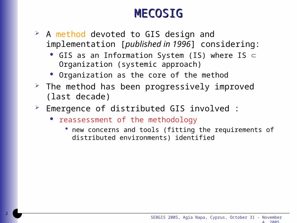
A method devoted to GIS design and implementation [published in 1996] considering:
GIS as an Information System (IS) where IS Organization (systemic approach)
Organization as the core of the method The method has been progressively improved (last
decade) Emergence of distributed GIS involved :
reassessment of the methodology new concerns and tools (fitting the requirements of distributed
environments) identified
SEBGIS 2005, Agia Napa, Cyprus, October 31 - November 4, 2005 3
MECOSIG - Design protocolMECOSIG - Design protocol
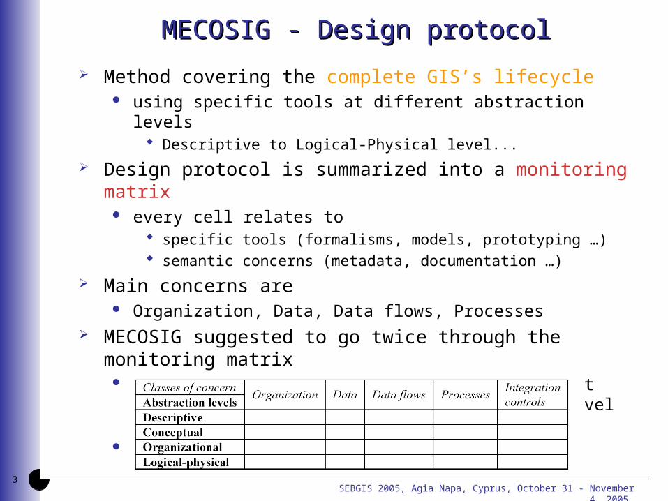
Method covering the complete GIS’s lifecycle using specific tools at different abstraction levels
Descriptive to Logical-Physical level...
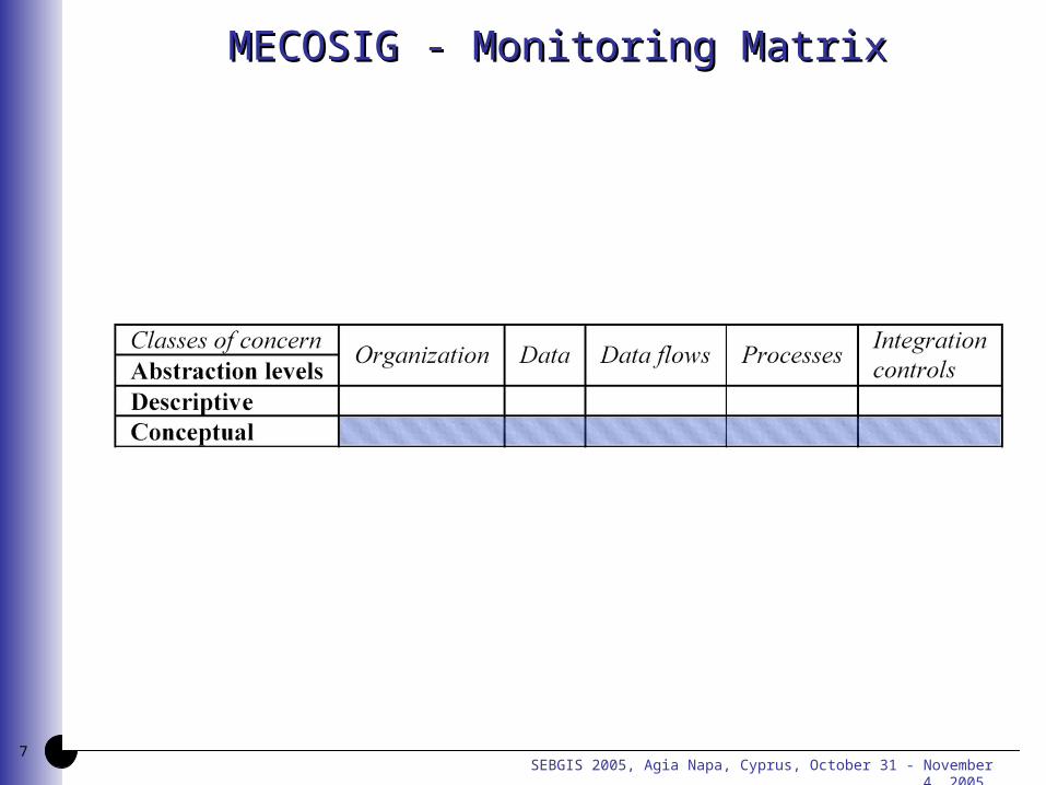
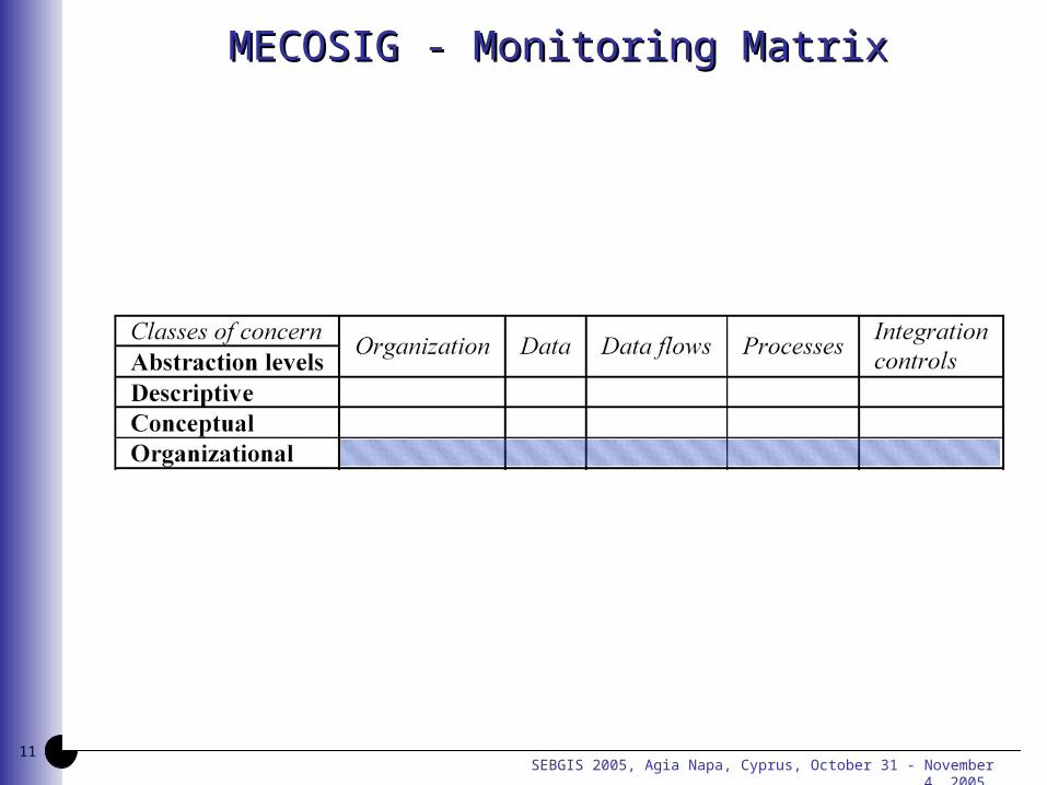
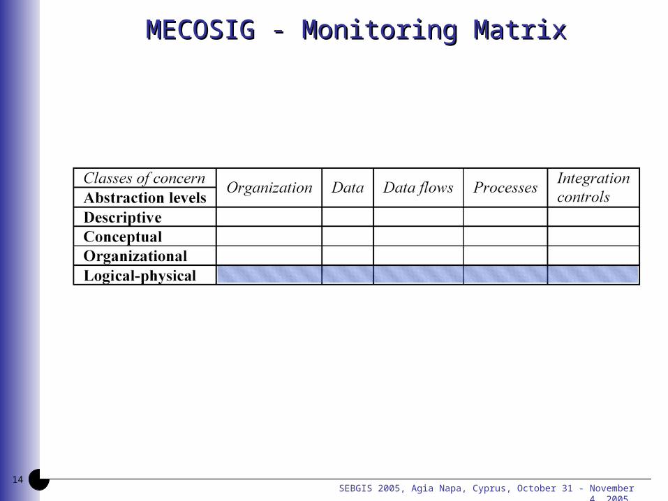
Design protocol is summarized into a monitoring matrix every cell relates to
specific tools (formalisms, models, prototyping …) semantic concerns (metadata, documentation …)
Main concerns are Organization, Data, Data flows, Processes
MECOSIG suggested to go twice through the monitoring matrix
analysis stage (not anymore taken into account because of redundancy with the descriptive level in conception step)
conception step
SEBGIS 2005, Agia Napa, Cyprus, October 31 - November 4, 2005 4
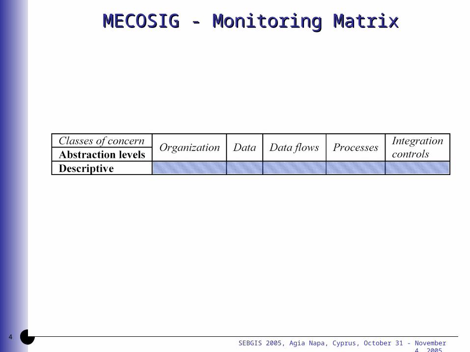
MECOSIG - Monitoring MatrixMECOSIG - Monitoring Matrix
SEBGIS 2005, Agia Napa, Cyprus, October 31 - November 4, 2005 5
Adaptations - Descriptive levelAdaptations - Descriptive level
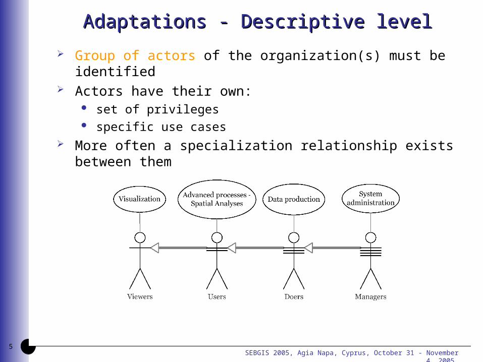
Group of actors of the organization(s) must be identified Actors have their own:
set of privileges specific use cases
More often a specialization relationship exists between them
SEBGIS 2005, Agia Napa, Cyprus, October 31 - November 4, 2005 6
Adaptations - Descriptive levelAdaptations - Descriptive level
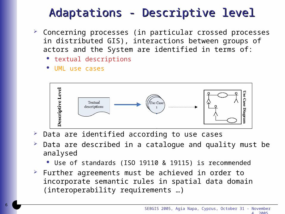
Concerning processes (in particular crossed processes in distributed GIS), interactions between groups of actors and the System are identified in terms of:
textual descriptions UML use cases
Data are identified according to use cases Data are described in a catalogue and quality must be
analysed Use of standards (ISO 19110 & 19115) is recommended
Further agreements must be achieved in order to incorporate semantic rules in spatial data domain (interoperability requirements …)
SEBGIS 2005, Agia Napa, Cyprus, October 31 - November 4, 2005 7
MECOSIG - Monitoring MatrixMECOSIG - Monitoring Matrix
SEBGIS 2005, Agia Napa, Cyprus, October 31 - November 4, 2005 8
Adaptations - Conceptual levelAdaptations - Conceptual level
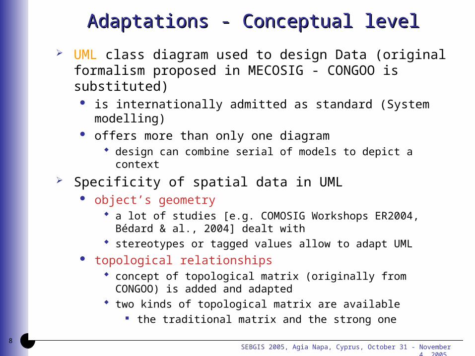
UML class diagram used to design Data (original formalism proposed in MECOSIG - CONGOO is substituted)
is internationally admitted as standard (System modelling) offers more than only one diagram
design can combine serial of models to depict a context
Specificity of spatial data in UML object’s geometry
a lot of studies [e.g. COMOSIG Workshops ER2004, Bédard & al., 2004] dealt with
stereotypes or tagged values allow to adapt UML topological relationships
concept of topological matrix (originally from CONGOO) is added and adapted
two kinds of topological matrix are available the traditional matrix and the strong one
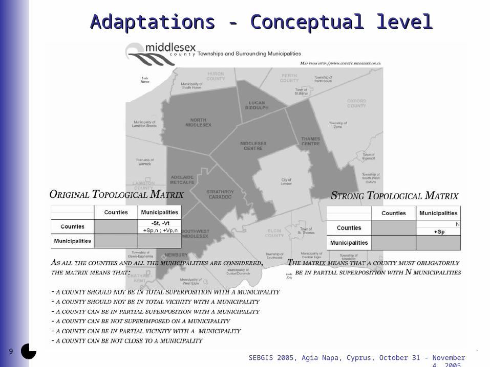
SEBGIS 2005, Agia Napa, Cyprus, October 31 - November 4, 2005 9
Adaptations - Conceptual levelAdaptations - Conceptual level
SEBGIS 2005, Agia Napa, Cyprus, October 31 - November 4, 2005 10
Adaptations - Conceptual levelAdaptations - Conceptual level
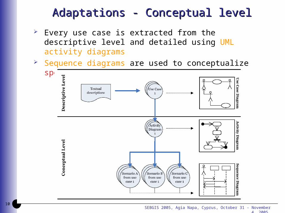
Every use case is extracted from the descriptive level and detailed using UML activity diagrams
Sequence diagrams are used to conceptualize specific scenarios of activity diagrams
SEBGIS 2005, Agia Napa, Cyprus, October 31 - November 4, 2005 11
MECOSIG - Monitoring MatrixMECOSIG - Monitoring Matrix
SEBGIS 2005, Agia Napa, Cyprus, October 31 - November 4, 2005 12
Adaptations - Organizational levelAdaptations - Organizational level
Facing the implementation of a distributed infrastructure, important organisational constraints must be met
missions of all actors should be assessed and possibly redefined
new tasks are introduced in order to guarantee maintenance, permanent working and growth of the
distributed System new data flows are generated and others have to be
adapted data exchange must be performed easily and in a
transparent way for all users access to metadata [ISO standards] - particularly metadata
related to quality (data usability and appraisal of final results) some data / services access can be restricted or subject to
authorization(s)
SEBGIS 2005, Agia Napa, Cyprus, October 31 - November 4, 2005 13
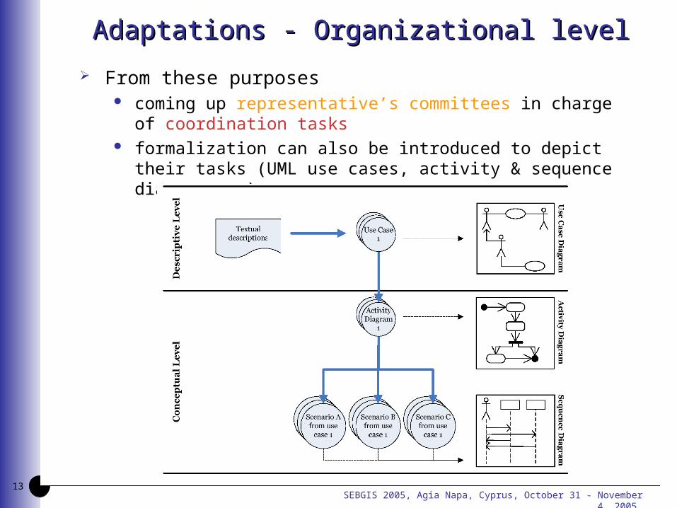
Adaptations - Organizational levelAdaptations - Organizational level
From these purposes coming up representative’s committees in charge of
coordination tasks formalization can also be introduced to depict their tasks
(UML use cases, activity & sequence diagrams, …)
SEBGIS 2005, Agia Napa, Cyprus, October 31 - November 4, 2005 14
MECOSIG - Monitoring MatrixMECOSIG - Monitoring Matrix
SEBGIS 2005, Agia Napa, Cyprus, October 31 - November 4, 2005 15
Adaptations - Logical-Physical levelAdaptations - Logical-Physical level
Roles and tasks of all actors should be clearly specified key is to associate all actors in the new System which will
be set up e.g.:
sensitizing and training sessions to facilitate the understanding of the re-engineered system
possible reallocation of human resources
Constitution of the representative’s committees in charge of coordination tasks
competent and representative of the various departments or organizations
receiving the ability to act decisively Managerial economies and economies of scale could be
achieved Acquisition of common reference data Globalisation of software licenses
SEBGIS 2005, Agia Napa, Cyprus, October 31 - November 4, 2005 16
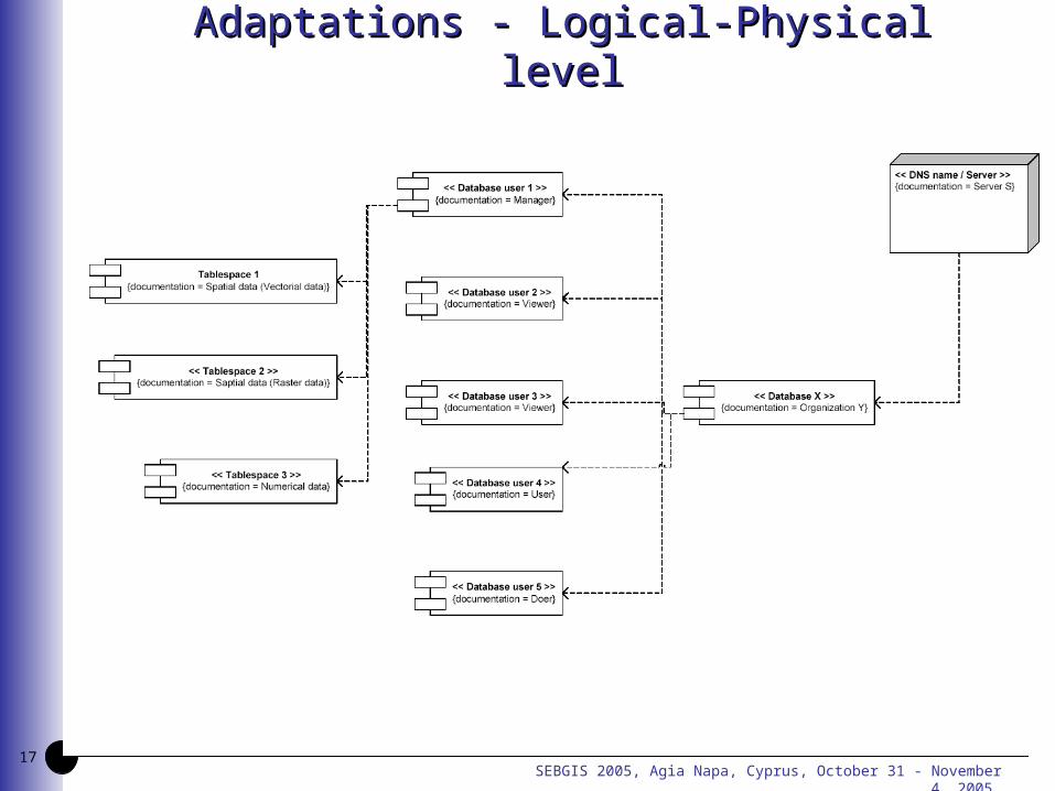
Adaptations - Logical-Physical levelAdaptations - Logical-Physical level
A technical study must be completed to guarantee the required degree of interoperability to identify precisely
add-on hardware and software distributed system components systems for cross-relating items of information across multiple
sources
Modelling process is to design objects which must be deployed in a distributed System
e.g. data storage structure (components and deployment UML diagrams)
previous activity and sequence diagrams (conceptual level) are improved
by adding objects dealing with data flows, procedures and processes according to GIS software, tools and DBMS specificities...
SEBGIS 2005, Agia Napa, Cyprus, October 31 - November 4, 2005 17
Adaptations - Logical-Physical levelAdaptations - Logical-Physical level
SEBGIS 2005, Agia Napa, Cyprus, October 31 - November 4, 2005 18
Adaptations - Logical-Physical levelAdaptations - Logical-Physical level
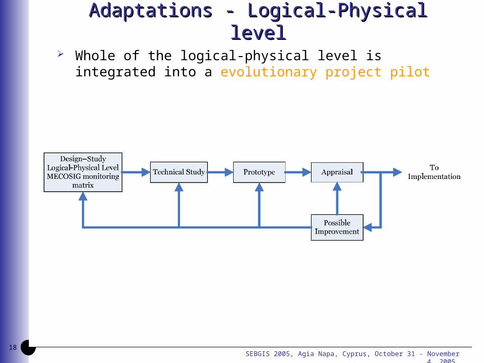
Whole of the logical-physical level is integrated into a evolutionary project pilot
SEBGIS 2005, Agia Napa, Cyprus, October 31 - November 4, 2005
Thank you…Thank you…
Q / A ?Q / A ?
http://www.geo.ulg.ac.behttp://www.geo.ulg.ac.be
![The Dome House Agia Marina [neighbourhood] Megalochori ...Agia Marina [neighbourhood] Megalochori [village] Santorini, Greece Dear Guest Thank you for choosing our place for your holiday](https://img.pdfslide.us/doc/110x75/5f0d30147e708231d4391a7f/the-dome-house-agia-marina-neighbourhood-megalochori-agia-marina-neighbourhood.jpg)


![52056100 Laplanche J Pontalis J B Vocabularul Psihanalizei Editura Humanitas Bucuresti 1994[1]](https://img.pdfslide.us/doc/110x75/55720e70497959fc0b8c781b/52056100-laplanche-j-pontalis-j-b-vocabularul-psihanalizei-editura-humanitas-bucuresti-19941.jpg)