Embed Size (px)
Citation preview
Reaching the top of Mont Blanc, Europe’s highest peak, is a for-midable challenge even to the most experienced alpinists - not only because of its elevation, but also because of its weather conditions. Strong winds and snowfall at the summit constantly cause altitude and volume fluc-tuations to the mountain’s ice cap. This motivated a team of expert surveyors to take on the mountain’s challenge and every two years, determine the actual variations of the ice cap using the latest in measurement tech-nology. This year the team con-sisting of two surveyors from Leica Geosystems France and the Chartered Land Surveyors, based in France’s Upper Savoy region, decided to make the first ever 3D laser scan of the shape and volume of this legendary glacier using the Leica Nova MS50 MultiStation.
The team of 14 climbers included the surveyors and their technical partners: Covadis (Géomédia), Teria (Exagone) and Leica Geosystems. They were accompanied by guides, a photographer and a cameraman.
Leica Geosystems, responsible for measuring the elevation and shape of the ice cap of Mont Blanc, was represented by Farouk Kadded, Product Manager at LGS France, an experienced alpinist and pioneer of the partnership formed with the surveyors from the Upper Savoy region. Farouk has taken part in the expedition since 2001 and explained why 2013 offered an opportunity to add a new technical dimension to the adventure.
Farouk said, “It seemed altogether appropriate to use the world’s first MultiStation, the Leica Nova MS50, to capture the first ever 3D laser scan of the Mont Blanc ice cap. This
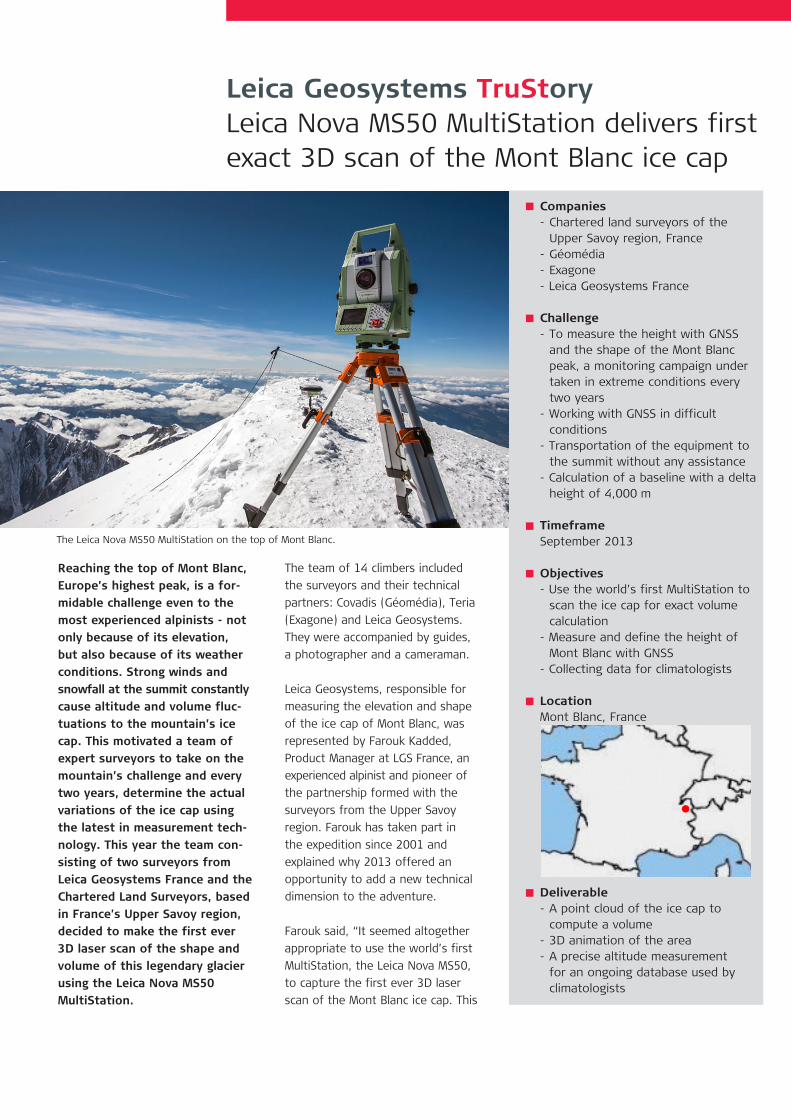
Leica Geosystems TruStoryLeica Nova MS50 MultiStation delivers first exact 3D scan of the Mont Blanc ice cap
Companies - Chartered land surveyors of the Upper Savoy region, France- Géomédia- Exagone- Leica Geosystems France
Challenge- To measure the height with GNSS and the shape of the Mont Blanc peak, a monitoring campaign under taken in extreme conditions every two years- Working with GNSS in difficult conditions- Transportation of the equipment to the summit without any assistance- Calculation of a baseline with a delta height of 4,000 m
TimeframeSeptember 2013
Objectives- Use the world’s first MultiStation to scan the ice cap for exact volume calculation- Measure and define the height of Mont Blanc with GNSS- Collecting data for climatologists
LocationMont Blanc, France
Deliverable- A point cloud of the ice cap to compute a volume- 3D animation of the area - A precise altitude measurement for an ongoing database used by climatologists
The Leica Nova MS50 MultiStation on the top of Mont Blanc.
would save time and provide higher point density compared to just using GPS measurements, as we have in previous years. In the extreme tem-peratures and wind chill associated with -10°C, fast data collection is a real bonus.” “For the first time we had at our disposal an instrument that not only combines the latest technologies in the fields of total station measurments, digital imagery, 3D laser scanning and GNSS posi-tioning but is designed to operate in extreme conditions. Our only consideration was the additional weight. Transporting the instrument to the summit added about 7 kg to my backpack but the results were certainly worth it.”
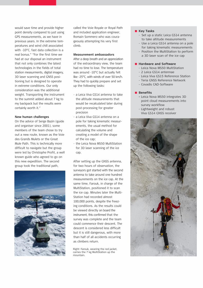
New human challenges On the advice of Serge Bazin (guide and organiser since 2001), some members of the team chose to try out a new route, known as the Voie des Grands Mulets or the Great Mule Path. This is technically more difficult to navigate but the group were led by Christophe Profit, a well known guide who agreed to go on this new expedition. The second group took the traditional path,
called the Voie Royale or Royal Path and included application engineer, Romain Sommero who was coura-geously attempting his very first climb.
Measurement ambassadors After a deep breath and an appreciation of the extraordinary view, the team had no time to lose. The temperature was around -10°C but actually felt like -25°C, with winds of over 50 km/h. They had to quickly prepare and set up the following tasks:
- a Leica Viva GS14 antenna to take the altitude measurements that would be recalculated later during post-processing for greater precision- a Leica Viva GS14 antenna on a pole for taking kinematic measur- ements, the usual method for calculating the volume and creating a model of the shape of the ice cap;- the Leica Nova MS50 MultiStation for 3D laser scanning of the ice cap.
After setting up the GNSS antenna, for two hours of observation, the surveyors got started with the second antenna to take around one hundred measurements on the ice cap. At the same time, Farouk, in charge of the MultiStation, positioned it to scan the ice cap. Minutes later the Multi-Station had recorded almost 100,000 points, despite the freez-ing conditions. As the results could be viewed directly on board the instrument, this confirmed that the survey was complete and the team could commence their descent. The descent is considered less difficult but it is still dangerous, with more than half of all accidents occurring as climbers return.
Key Tasks- Set up a static Leica GS14 antenna to take altitude measurements- Use a Leica GS14 antenna on a pole for taking kinematic measurements- Position the MultiStation to perform a 3D laser scan of the ice cap
Hardware and Software- Leica Nova MS50 MultiStation- 2 Leica GS14 antennae - Leica Viva GS15 Reference Station- Teria GNSS Reference Network- Covadis CAD-Software
Benefits - Leica Nova MS50 integrates 3D point cloud measurements into survey workflow- Lightweight and robust Viva GS14 GNSS receiver
Right: Farouk, wearing the red jacket, carries the 7 kg MultiStation up the mountain.
Farouk charts the story of the team’s assault on the peak
The climb to Europe’s highest point requires some preparation. This is why on the weekend prior to the measurement campaign, some of our highly skilled climbers ascended Weissmies and Lagginhorn, both peaks reaching over 4,000 m are located in the Saas valley in Switzerland.
After waiting a few days because bad weather delayed our departure date, our entire team prepared to embark upon on the seventh Mont Blanc measurement campaign.
Thursday, September 12 It was around 10 am when the first departure from Chamonix, at an altitude of 1,030 m was announced. My group, taking the Great Mule Path, was able to take a ten minute cable car ride while the other group, including Romain, set off for an hour and a half train journey. After hik-
ing a few hours, each of our groups stopped, one group at the Grand Mulets mountain refuge and the other at the Tête Rousse refuge, at an altitude of 3,100 m. By now it was 5 pm and time to rest because the following day would be a long one.
Friday September 13Some of the group rose at 2:30 am while others chose to sleep till 4:30 am before putting on their cram-pons. The team, taking the usual path, climbed to the first rest area at the Goûter Hut, while the other group headed straight to the Vallot Hut, which was to be the meeting point of the expedition. The hut is just a 5 m x 5 m shelter! The second group, having arrived at the Goûter Hut after two hours of hiking, barely had time to rest after crossing the Goûter corridor, well known for its rock falls.
During this time, my team was advan-cing towards the Vallot Hut, where
we waited patiently for the second group to arrive safe and sound. After going over the Dôme du Goûter, the second team finally arrived at the meeting point. By 11:15 am on Friday, September 13, our climbers reached an altitude of 4,362 m.
For Romain this stage was a decisive moment. Could he muster the courage to carry on, suffering as he was with mountain sickness and pain in his legs? The group’s enthusiasm and energy spurred him on and he per-severed for the last two hours of the climb. The climb between 4,632 m and the summit was extremely difficult, as the teams had to follow a narrow ridge while a strong northerly wind was blowing. I always enjoy seeing my colleagues’ first response at the summit and for Romain, this was a moment of congratulations. Here, at the summit of Western Europe’s highest peak, the impact of this human and technical adventure was tangible: a coming together of man, technology and nature.
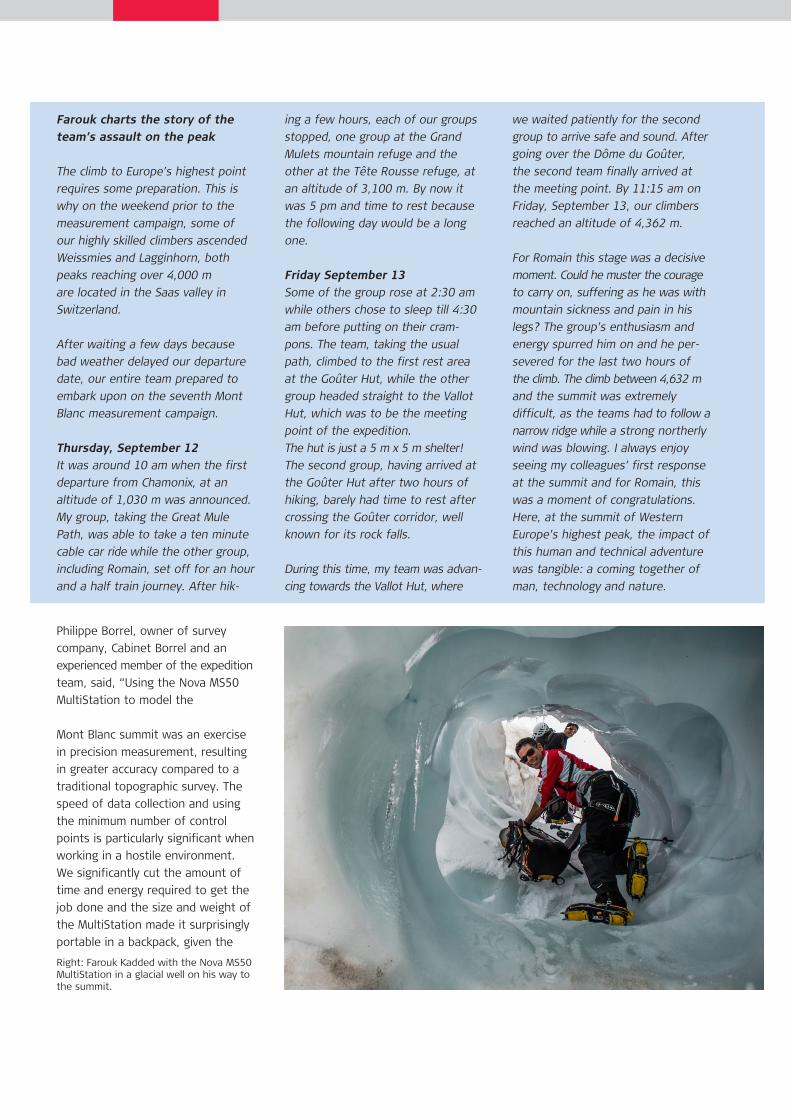
Philippe Borrel, owner of survey company, Cabinet Borrel and an experienced member of the expedition team, said, “Using the Nova MS50 MultiStation to model the
Mont Blanc summit was an exercise in precision measurement, resulting in greater accuracy compared to a traditional topographic survey. The speed of data collection and using the minimum number of control points is particularly significant when working in a hostile environment. We significantly cut the amount of time and energy required to get the job done and the size and weight of the MultiStation made it surprisingly portable in a backpack, given the
Right: Farouk Kadded with the Nova MS50 MultiStation in a glacial well on his way to the summit.
Leica Geosystems AGHeinrich-Wild-Strasse CH-9435 Heerbrugg Switzerland Phone +41 71 727 31 31 www.leica-geosystems.com
Year Altitude measured Snow volume over 4,800 m2013 4810.02 20,213 m32011 4810.44 21,281 m32009 4810.45 21,626 m32007 4810.90 24,062 m32005 4808.75 14,248 m32003 4808.45 14,598 m32001 4810.40 Not measured
The Mont Blanc surveyor Team 2013 on the ice cap celebrating the successful ascent of Europe‘s highest mountain.
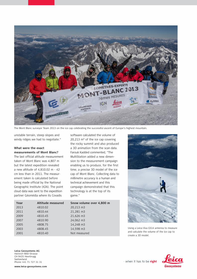
Using a Leica Viva GS14 antenna to measure and calculate the volume of the ice cap to create a 3D model.
software calculated the volume of 20,213 m³ of the ice cap covering the rocky summit and also produced a 3D animation from the scan data. Farouk Kadded commented, “The MultiStation added a new dimen-sion to the measurement campaign enabling us to produce, for the first time, a precise 3D model of the ice cap of Mont Blanc. Collecting data to millimetre accuracy is a human and technical achievement and this campaign demonstrated that this technology is at the top of its game.”
unstable terrain, steep slopes and windy ridges we had to negotiate.“
What were the exact measurements of Mont Blanc?The last official altitude measurement taken of Mont Blanc was 4,807 m but the latest expedition revealed a new altitude of 4,810.02 m - 42 cm less than in 2011. The measur-ement taken is calculated before being made official by the National Geographic Institute (IGN). The point cloud data was sent to the expedition partner Géomédia where its Covadis

![Apogée ou appendice? 'Mont Blanc' et le mont Blanc dans … · 2017. 1. 4. · Le Mont Blanc était devant nous, mais il était recouvert de nuages […] 1. Publié anonymement](https://img.pdfslide.us/doc/110x75/6026385739ba8a1931426ab3/apoge-ou-appendice-mont-blanc-et-le-mont-blanc-dans-2017-1-4-le-mont.jpg)