Embed Size (px)
Citation preview

DOI: 10.1126/science.1148615, 1304 (2008);320 Science
et al.Carmala N. GarzioneRise of the Andes
This copy is for your personal, non-commercial use only.
clicking here.colleagues, clients, or customers by , you can order high-quality copies for yourIf you wish to distribute this article to others
here.following the guidelines
can be obtained byPermission to republish or repurpose articles or portions of articles
): March 7, 2013 www.sciencemag.org (this information is current as of
The following resources related to this article are available online at
http://www.sciencemag.org/content/321/5894/1295.2.full.htmlA correction has been published for this article at:
http://www.sciencemag.org/content/320/5881/1304.full.htmlversion of this article at:
including high-resolution figures, can be found in the onlineUpdated information and services,
http://www.sciencemag.org/content/suppl/2008/06/05/320.5881.1304.DC1.html can be found at: Supporting Online Material
http://www.sciencemag.org/content/320/5881/1304.full.html#relatedfound at:
can berelated to this article A list of selected additional articles on the Science Web sites
http://www.sciencemag.org/content/320/5881/1304.full.html#ref-list-1, 13 of which can be accessed free:cites 53 articlesThis article
37 article(s) on the ISI Web of Sciencecited by This article has been
http://www.sciencemag.org/content/320/5881/1304.full.html#related-urls29 articles hosted by HighWire Press; see:cited by This article has been
http://www.sciencemag.org/cgi/collection/geochem_physGeochemistry, Geophysics
subject collections:This article appears in the following
registered trademark of AAAS. is aScience2008 by the American Association for the Advancement of Science; all rights reserved. The title
CopyrightAmerican Association for the Advancement of Science, 1200 New York Avenue NW, Washington, DC 20005. (print ISSN 0036-8075; online ISSN 1095-9203) is published weekly, except the last week in December, by theScience
on
Mar
ch 7
, 201
3w
ww
.sci
ence
mag
.org
Dow
nloa
ded
from
Rise of the AndesCarmala N. Garzione,1* Gregory D. Hoke,1 Julie C. Libarkin,2 Saunia Withers,3Bruce MacFadden,4 John Eiler,5 Prosenjit Ghosh,6 Andreas Mulch7
The surface uplift of mountain belts is generally assumed to reflect progressive shortening andcrustal thickening, leading to their gradual rise. Recent studies of the Andes indicate that theirelevation remained relatively stable for long periods (tens of millions of years), separated by rapid(1 to 4 million years) changes of 1.5 kilometers or more. Periodic punctuated surface uplift ofmountain belts probably reflects the rapid removal of unstable, dense lower lithosphere afterlong-term thickening of the crust and lithospheric mantle.
The surface uplift of mountain belts, such asthe central Andes plateau, has long beenthought to be the isostatic response of
shortening and thickening of the continental crust.Recently developed isotopic techniques allow usto determine the uplift history of the central Andesindependently from the shortening history. Theseresults show that shortening and uplift aretemporally decoupled, with shortening and thick-ening happening over protracted periods of time,whereas uplift occurs geologically rapidly. Thusarises a paradox: Why does slow, continuousshortening and thickening not produce slow,continuous isostatic uplift in the central Andes?
Both crustal thickening and the removal ofrelatively dense mantle or lower crust can generateisostatic surface uplift (1, 2). Paleoelevation studieshelp resolve the geodynamic evolution ofmountainbelts because the rate and lateral extent of surfaceuplift depends on the processes involved. Here, wesynthesize the elevation history of the centralAndes, Earth’s second largest mountain belt. Wethen compare paleoelevation estimates to histor-ies of regional incision, sedimentation, shorten-ing, and volcanism within the mountain belt tocharacterize lithospheric evolution and the geo-dynamic mechanisms that led to surface uplift.
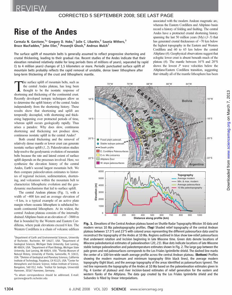
The central Andean plateau (Fig. 1), with awidth of ~400 km and an average elevation of~4 km, is a typical example of an active platemargin where oceanic lithosphere is subducted be-neath continental lithosphere. At its widest, thecentral Andean plateau consists of the internallydrainedAltiplano basin at an elevation of ~3800mthat is bounded by the Western and Eastern Cor-dilleras, where peak elevations exceed 6 km. TheWestern Cordillera is a chain of volcanic edifices
associated with the modern Andean magmatic arc,whereas the Eastern Cordillera and Altiplano basinrecord a history of folding and faulting. The centralAndes have a protracted crustal shortening historyspanning the last 50 million years (My) (3–5) thathas generated crustal thicknesses of ~70 km belowthe highest topography in the Eastern and WesternCordillera and 60 to 65 km below the centralAltiplano (6). Geophysical observations suggest thateclogitic lower crust is absent beneath much of theplateau (6). The mantle between 16°S and 20°Sshows the lowest P wave velocities below theAltiplano/Eastern Cordillera transition, suggestingthat virtually all of the mantle lithosphere has been
REVIEW
1Department of Earth and Environmental Sciences, Universityof Rochester, Rochester, NY 14627, USA. 2Department ofGeological Sciences, Michigan State University, East Lansing,MI 48824, USA. 3Department of Plant Biology, Michigan StateUniversity, East Lansing, MI 48824, USA. 4Florida Museum ofNatural History, University of Florida, Gainesville, FL 32611,USA. 5Division of Geological and Planetary Sciences, CaliforniaInstitute of Technology, Pasadena, CA 91125, USA. 6Center forAtmospheric and Oceanic Science, Indian Institute of Science,Bangalore, 560 012, India. 7Institut für Geologie, UniversitätHannover, 30167 Hannover, Germany.
*To whom correspondence should be addressed. E-mail:[email protected]
PotosiPotosi
CorqueCorque
CallapaCallapa
SallaSalla
JakkokotaJakkokota
PotosiPotosi
16°S
18°S
20°S
22°S
16°W
18°S
20°S
22°S
Bolivia
Chile Argentina
Peru
1000
2000
3000
4000
5000
6000
Ele
vati
on
(m
)
Distance along profile (km)0 100 200 300 400 500 600 700 800 900 1000
TopographyAverage modernMin. & max. modernAverage paleosurface10 Ma paleotopography
Fossil plant paleoalt.
Stable isotope paleoalt.
Swath profile
E. Cordillera Paleosurfaces
E-m. Mio volcanics
Altiplano floor
W. slope paleosurfaces
E a s t e r n C o r d i l l e r a
A l t i p l a n o
W e s t e r n C
o r d i l l e r a64°W66°W68°W70°W72°W
0
JakkokotaJakkokotaSallaSalla
CallapaCallapa
CorqueCorque
Fig. 1. Elevations of the Central Andean plateau based on Shuttle Radar Topography Mission 30 data andmodern versus 10 Ma paleotopography profiles. (Top) Shaded relief topography of the central Andeanplateau between 17.5°S and 23°S with colored areas representing the different paleosurface data used toreconstruct the topography of the Andes at 10 Ma. Regions outlined in blue show low-relief paleosurfacesthat underwent rotation and incision beginning in late Miocene time. Green dots denote locations ofMiocene paleobotanical estimates of paleoelevation (20, 21). Blue dots indicate locations of late Miocenestable isotope paleoelevation and paleotemperature estimates shown in Fig. 2. The large gap between thepale green and red paleosurfaces corresponds to the Los Friales ignimibrite shield. The dashed line marksthe center of a 100-km-wide swath average profile across the central Andean plateau. (Bottom) Profilesshowing the modern maximum and minimum topography (thin black lines), the average moderntopography (light blue), and the average topography of the areas identified as paloesurfaces (green). Thered line represents the topography of the Andes at 10 Ma based on the paleoelevation estimates given inFig. 4 (center of plateau) and river incision-based estimates of relief generation for the eastern andwestern flanks of the Altiplano. The data gap created by the Los Friales ignimbrite shield and theSubandes is filled by linear interpolations.
6 JUNE 2008 VOL 320 SCIENCE www.sciencemag.org1304
CORRECTED 5 SEPTEMBER 2008; SEE LAST PAGE
on
Mar
ch 7
, 201
3w
ww
.sci
ence
mag
.org
Dow
nloa
ded
from
removed (7–9). In addition, high 3He/4He ratiosin hydrothermal fluids and gases across much ofthe Altiplano and Eastern Cordillera indicate thedegassing of mantle asthenosphere-derived mag-mas (10). Together, these observations supportprevious suggestions for the southern Altiplanoand Puna (11, 12) that both mantle lithosphereand eclogitic lower crust were removed belowmuch of the Altiplano and the western part of theEastern Cordillera (6). Removal of lower litho-sphere might occur rapidly by delamination orconvective removal (1, 13) or gradually by abla-tive subduction of foreland cratonic lithosphere(14, 15). Either case results in an influx of lighterasthenosphere, generating surface uplift of sev-eral kilometers. However, rapid removal of lowerlithosphere would result in surface uplift in aslittle as several million years, whereas gradualremoval by ablative subduction would generatesurface uplift over tens of millions of years,coincident with crustal shortening.
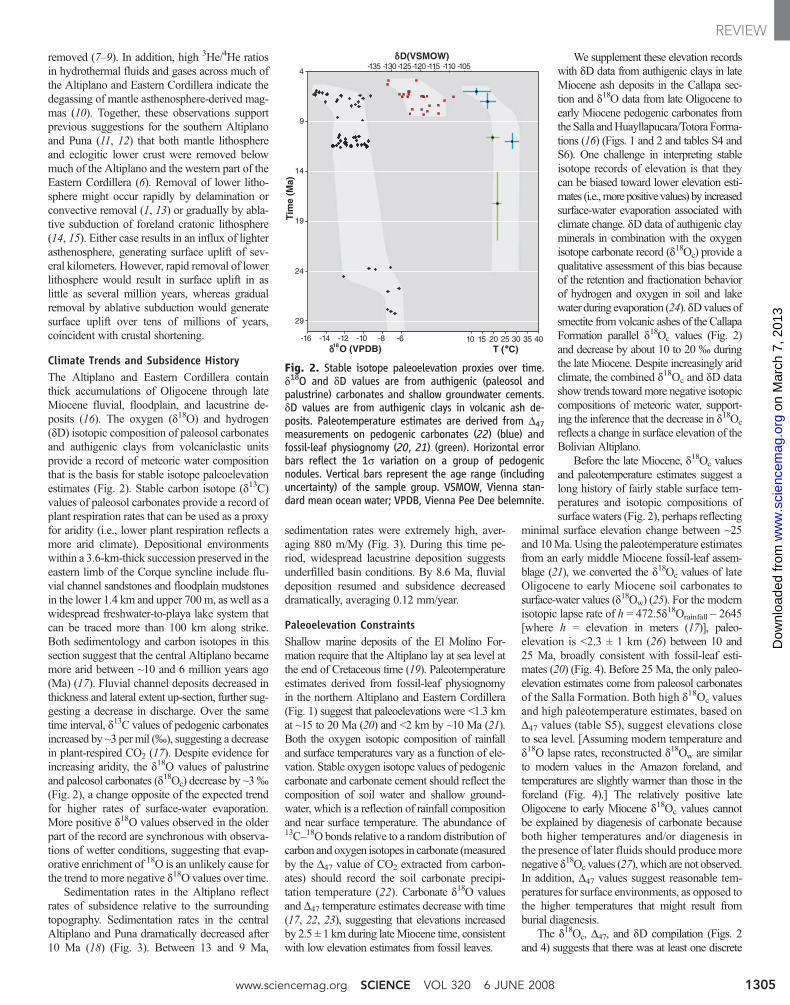
Climate Trends and Subsidence HistoryThe Altiplano and Eastern Cordillera containthick accumulations of Oligocene through lateMiocene fluvial, floodplain, and lacustrine de-posits (16). The oxygen (d18O) and hydrogen(dD) isotopic composition of paleosol carbonatesand authigenic clays from volcaniclastic unitsprovide a record of meteoric water compositionthat is the basis for stable isotope paleoelevationestimates (Fig. 2). Stable carbon isotope (d13C)values of paleosol carbonates provide a record ofplant respiration rates that can be used as a proxyfor aridity (i.e., lower plant respiration reflects amore arid climate). Depositional environmentswithin a 3.6-km-thick succession preserved in theeastern limb of the Corque syncline include flu-vial channel sandstones and floodplain mudstonesin the lower 1.4 km and upper 700 m, as well as awidespread freshwater-to-playa lake system thatcan be traced more than 100 km along strike.Both sedimentology and carbon isotopes in thissection suggest that the central Altiplano becamemore arid between ~10 and 6 million years ago(Ma) (17). Fluvial channel deposits decreased inthickness and lateral extent up-section, further sug-gesting a decrease in discharge. Over the sametime interval, d13C values of pedogenic carbonatesincreased by ~3 permil (‰), suggesting a decreasein plant-respired CO2 (17). Despite evidence forincreasing aridity, the d18O values of palustrineand paleosol carbonates (d18Oc) decrease by ~3‰(Fig. 2), a change opposite of the expected trendfor higher rates of surface-water evaporation.More positive d18O values observed in the olderpart of the record are synchronous with observa-tions of wetter conditions, suggesting that evap-orative enrichment of 18O is an unlikely cause forthe trend to more negative d18O values over time.
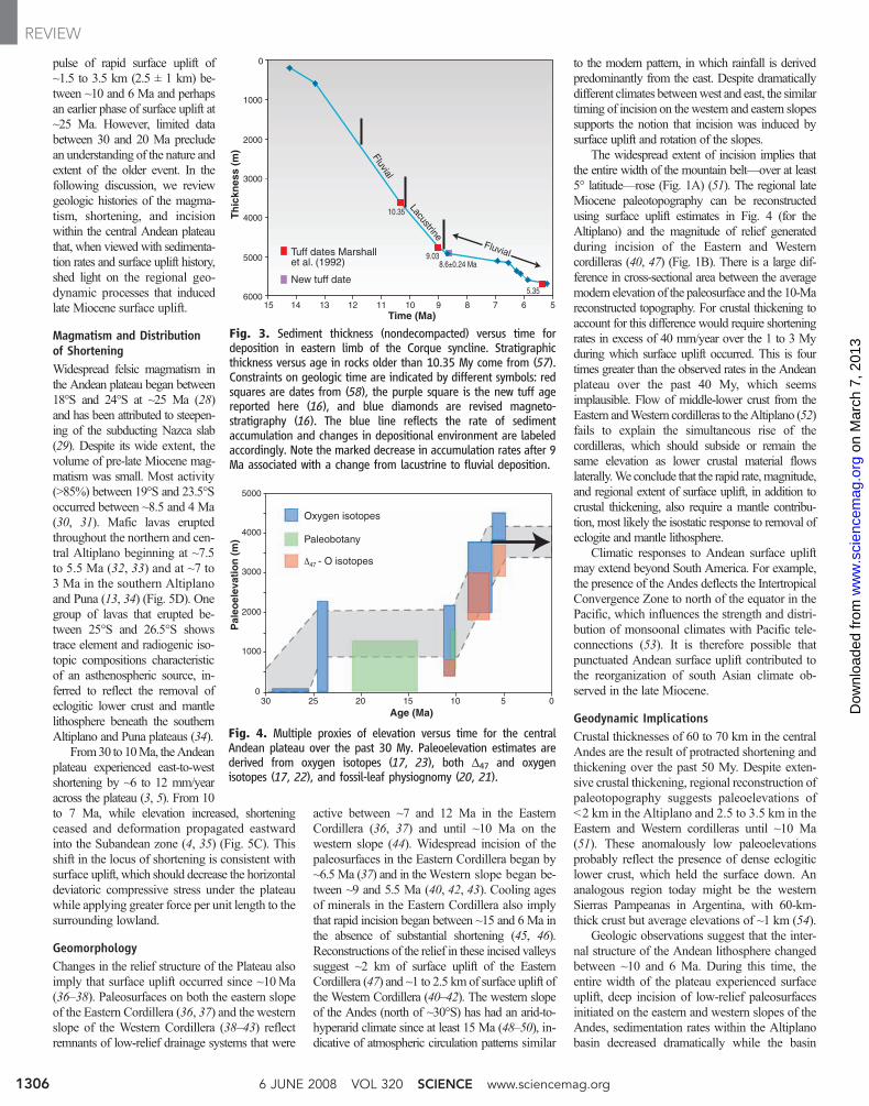
Sedimentation rates in the Altiplano reflectrates of subsidence relative to the surroundingtopography. Sedimentation rates in the centralAltiplano and Puna dramatically decreased after10 Ma (18) (Fig. 3). Between 13 and 9 Ma,
sedimentation rates were extremely high, aver-aging 880 m/My (Fig. 3). During this time pe-riod, widespread lacustrine deposition suggestsunderfilled basin conditions. By 8.6 Ma, fluvialdeposition resumed and subsidence decreaseddramatically, averaging 0.12 mm/year.
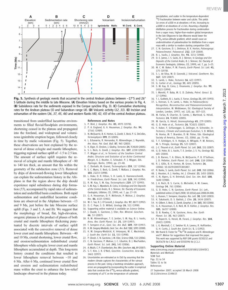
Paleoelevation ConstraintsShallow marine deposits of the El Molino For-mation require that the Altiplano lay at sea level atthe end of Cretaceous time (19). Paleotemperatureestimates derived from fossil-leaf physiognomyin the northern Altiplano and Eastern Cordillera(Fig. 1) suggest that paleoelevations were <1.3 kmat ~15 to 20 Ma (20) and <2 km by ~10 Ma (21).Both the oxygen isotopic composition of rainfalland surface temperatures vary as a function of ele-vation. Stable oxygen isotope values of pedogeniccarbonate and carbonate cement should reflect thecomposition of soil water and shallow ground-water, which is a reflection of rainfall compositionand near surface temperature. The abundance of13C–18O bonds relative to a random distribution ofcarbon and oxygen isotopes in carbonate (measuredby the D47 value of CO2 extracted from carbon-ates) should record the soil carbonate precipi-tation temperature (22). Carbonate d18O valuesand D47 temperature estimates decrease with time(17, 22, 23), suggesting that elevations increasedby 2.5 ± 1 km during lateMiocene time, consistentwith low elevation estimates from fossil leaves.
We supplement these elevation recordswith dD data from authigenic clays in lateMiocene ash deposits in the Callapa sec-tion and d18O data from late Oligocene toearly Miocene pedogenic carbonates fromthe Salla andHuayllapucara/Totora Forma-tions (16) (Figs. 1 and 2 and tables S4 andS6). One challenge in interpreting stableisotope records of elevation is that theycan be biased toward lower elevation esti-mates (i.e.,more positive values) by increasedsurface-water evaporation associated withclimate change. dD data of authigenic clayminerals in combination with the oxygenisotope carbonate record (d18Oc) provide aqualitative assessment of this bias becauseof the retention and fractionation behaviorof hydrogen and oxygen in soil and lakewater during evaporation (24). dDvalues ofsmectite from volcanic ashes of the CallapaFormation parallel d18Oc values (Fig. 2)and decrease by about 10 to 20 ‰ duringthe late Miocene. Despite increasingly aridclimate, the combined d18Oc and dD datashow trends towardmore negative isotopiccompositions of meteoric water, support-ing the inference that the decrease in d18Oc
reflects a change in surface elevation of theBolivian Altiplano.
Before the late Miocene, d18Oc valuesand paleotemperature estimates suggest along history of fairly stable surface tem-peratures and isotopic compositions ofsurface waters (Fig. 2), perhaps reflecting
minimal surface elevation change between ~25and 10Ma. Using the paleotemperature estimatesfrom an early middle Miocene fossil-leaf assem-blage (21), we converted the d18Oc values of lateOligocene to early Miocene soil carbonates tosurface-water values (d18Ow) (25). For the modernisotopic lapse rate of h = 472.5d18Orainfall – 2645[where h = elevation in meters (17)], paleo-elevation is <2.3 ± 1 km (26) between 10 and25 Ma, broadly consistent with fossil-leaf esti-mates (20) (Fig. 4). Before 25Ma, the only paleo-elevation estimates come from paleosol carbonatesof the Salla Formation. Both high d18Oc valuesand high paleotemperature estimates, based onD47 values (table S5), suggest elevations closeto sea level. [Assuming modern temperature andd18O lapse rates, reconstructed d18Ow are similarto modern values in the Amazon foreland, andtemperatures are slightly warmer than those in theforeland (Fig. 4).] The relatively positive lateOligocene to early Miocene d18Oc values cannotbe explained by diagenesis of carbonate becauseboth higher temperatures and/or diagenesis inthe presence of later fluids should produce morenegative d18Oc values (27), which are not observed.In addition, D47 values suggest reasonable tem-peratures for surface environments, as opposed tothe higher temperatures that might result fromburial diagenesis.
The d18Oc, D47, and dD compilation (Figs. 2and 4) suggests that there was at least one discrete
Tim
e (M
a)
D(VSMOW)
4
9
14
19
24
29
-135 -130 -125-120 -115 -110 -105
-16 -14 -12 -10 -8 -6 10 15 20 25 30 35 40T ( C)O (VPDB)18
Fig. 2. Stable isotope paleoelevation proxies over time.d18O and dD values are from authigenic (paleosol andpalustrine) carbonates and shallow groundwater cements.dD values are from authigenic clays in volcanic ash de-posits. Paleotemperature estimates are derived from D47measurements on pedogenic carbonates (22) (blue) andfossil-leaf physiognomy (20, 21) (green). Horizontal errorbars reflect the 1s variation on a group of pedogenicnodules. Vertical bars represent the age range (includinguncertainty) of the sample group. VSMOW, Vienna stan-dard mean ocean water; VPDB, Vienna Pee Dee belemnite.
www.sciencemag.org SCIENCE VOL 320 6 JUNE 2008 1305
REVIEW
on
Mar
ch 7
, 201
3w
ww
.sci
ence
mag
.org
Dow
nloa
ded
from
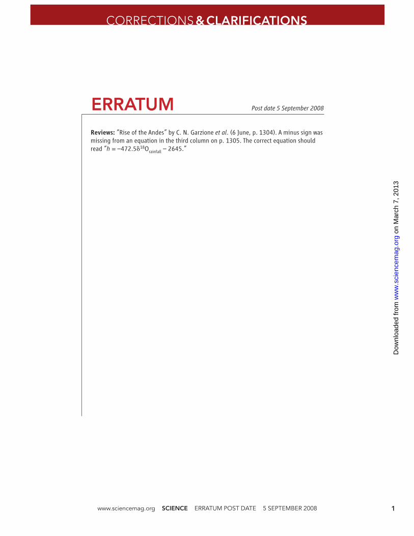
pulse of rapid surface uplift of~1.5 to 3.5 km (2.5 ± 1 km) be-tween ~10 and 6 Ma and perhapsan earlier phase of surface uplift at~25 Ma. However, limited databetween 30 and 20 Ma precludean understanding of the nature andextent of the older event. In thefollowing discussion, we reviewgeologic histories of the magma-tism, shortening, and incisionwithin the central Andean plateauthat, when viewed with sedimenta-tion rates and surface uplift history,shed light on the regional geo-dynamic processes that inducedlate Miocene surface uplift.
Magmatism and Distributionof ShorteningWidespread felsic magmatism inthe Andean plateau began between18°S and 24°S at ~25 Ma (28)and has been attributed to steepen-ing of the subducting Nazca slab(29). Despite its wide extent, thevolume of pre-late Miocene mag-matism was small. Most activity(>85%) between 19°S and 23.5°Soccurred between ~8.5 and 4 Ma(30, 31). Mafic lavas eruptedthroughout the northern and cen-tral Altiplano beginning at ~7.5to 5.5 Ma (32, 33) and at ~7 to3 Ma in the southern Altiplanoand Puna (13, 34) (Fig. 5D). Onegroup of lavas that erupted be-tween 25°S and 26.5°S showstrace element and radiogenic iso-topic compositions characteristicof an asthenospheric source, in-ferred to reflect the removal ofeclogitic lower crust and mantlelithosphere beneath the southernAltiplano and Puna plateaus (34).
From30 to 10Ma, theAndeanplateau experienced east-to-westshortening by ~6 to 12 mm/yearacross the plateau (3, 5). From 10to 7 Ma, while elevation increased, shorteningceased and deformation propagated eastwardinto the Subandean zone (4, 35) (Fig. 5C). Thisshift in the locus of shortening is consistent withsurface uplift, which should decrease the horizontaldeviatoric compressive stress under the plateauwhile applying greater force per unit length to thesurrounding lowland.
GeomorphologyChanges in the relief structure of the Plateau alsoimply that surface uplift occurred since ~10Ma(36–38). Paleosurfaces on both the eastern slopeof the Eastern Cordillera (36, 37) and the westernslope of the Western Cordillera (38–43) reflectremnants of low-relief drainage systems that were
active between ~7 and 12 Ma in the EasternCordillera (36, 37) and until ~10 Ma on thewestern slope (44). Widespread incision of thepaleosurfaces in the Eastern Cordillera began by~6.5 Ma (37) and in theWestern slope began be-tween ~9 and 5.5 Ma (40, 42, 43). Cooling agesof minerals in the Eastern Cordillera also implythat rapid incision began between ~15 and 6Ma inthe absence of substantial shortening (45, 46).Reconstructions of the relief in these incised valleyssuggest ~2 km of surface uplift of the EasternCordillera (47) and ~1 to 2.5 km of surface uplift ofthe Western Cordillera (40–42). The western slopeof the Andes (north of ~30°S) has had an arid-to-hyperarid climate since at least 15 Ma (48–50), in-dicative of atmospheric circulation patterns similar
to the modern pattern, in which rainfall is derivedpredominantly from the east. Despite dramaticallydifferent climates betweenwest and east, the similartiming of incision on the western and eastern slopessupports the notion that incision was induced bysurface uplift and rotation of the slopes.
The widespread extent of incision implies thatthe entire width of the mountain belt—over at least5° latitude—rose (Fig. 1A) (51). The regional lateMiocene paleotopography can be reconstructedusing surface uplift estimates in Fig. 4 (for theAltiplano) and the magnitude of relief generatedduring incision of the Eastern and Westerncordilleras (40, 47) (Fig. 1B). There is a large dif-ference in cross-sectional area between the averagemodern elevation of the paleosurface and the 10-Mareconstructed topography. For crustal thickening toaccount for this difference would require shorteningrates in excess of 40 mm/year over the 1 to 3 Myduring which surface uplift occurred. This is fourtimes greater than the observed rates in the Andeanplateau over the past 40 My, which seemsimplausible. Flow of middle-lower crust from theEastern andWestern cordilleras to theAltiplano (52)fails to explain the simultaneous rise of thecordilleras, which should subside or remain thesame elevation as lower crustal material flowslaterally.We conclude that the rapid rate,magnitude,and regional extent of surface uplift, in addition tocrustal thickening, also require a mantle contribu-tion, most likely the isostatic response to removal ofeclogite and mantle lithosphere.
Climatic responses to Andean surface upliftmay extend beyond South America. For example,the presence of the Andes deflects the IntertropicalConvergence Zone to north of the equator in thePacific, which influences the strength and distri-bution of monsoonal climates with Pacific tele-connections (53). It is therefore possible thatpunctuated Andean surface uplift contributed tothe reorganization of south Asian climate ob-served in the late Miocene.
Geodynamic ImplicationsCrustal thicknesses of 60 to 70 km in the centralAndes are the result of protracted shortening andthickening over the past 50 My. Despite exten-sive crustal thickening, regional reconstruction ofpaleotopography suggests paleoelevations of<2 km in the Altiplano and 2.5 to 3.5 km in theEastern and Western cordilleras until ~10 Ma(51). These anomalously low paleoelevationsprobably reflect the presence of dense eclogiticlower crust, which held the surface down. Ananalogous region today might be the westernSierras Pampeanas in Argentina, with 60-km-thick crust but average elevations of ~1 km (54).
Geologic observations suggest that the inter-nal structure of the Andean lithosphere changedbetween ~10 and 6 Ma. During this time, theentire width of the plateau experienced surfaceuplift, deep incision of low-relief paleosurfacesinitiated on the eastern and western slopes of theAndes, sedimentation rates within the Altiplanobasin decreased dramatically while the basin
Th
ickn
ess
(m)
Time (Ma)56789101112131415
Tuff dates Marshall et al. (1992)
New tuff date
10.35
8.6±0.24 Ma
5.35
9.03
Fluvial
Fluvial
Lacustrine
0
1000
2000
3000
4000
5000
6000
Fig. 3. Sediment thickness (nondecompacted) versus time fordeposition in eastern limb of the Corque syncline. Stratigraphicthickness versus age in rocks older than 10.35 My come from (57).Constraints on geologic time are indicated by different symbols: redsquares are dates from (58), the purple square is the new tuff agereported here (16), and blue diamonds are revised magneto-stratigraphy (16). The blue line reflects the rate of sedimentaccumulation and changes in depositional environment are labeledaccordingly. Note the marked decrease in accumulation rates after 9Ma associated with a change from lacustrine to fluvial deposition.
Age (Ma)
Pal
eoel
evat
ion
(m
)
0
1000
2000
3000
4000
5000
51015202530 0
47
Oxygen isotopes
Paleobotany
Δ - O isotopes
Fig. 4. Multiple proxies of elevation versus time for the centralAndean plateau over the past 30 My. Paleoelevation estimates arederived from oxygen isotopes (17, 23), both D47 and oxygenisotopes (17, 22), and fossil-leaf physiognomy (20, 21).
6 JUNE 2008 VOL 320 SCIENCE www.sciencemag.org1306
REVIEW
on
Mar
ch 7
, 201
3w
ww
.sci
ence
mag
.org
Dow
nloa
ded
from
transitioned from underfilled lacustrine environ-ments to filled fluvial/floodplain environments,shortening ceased in the plateau and propagatedinto the foreland, and widespread and volumi-nous ignimbrite eruption began, followed closelyin time by mafic volcanism (Fig. 5). Together,these observations are best explained by the re-moval of dense eclogite and mantle lithosphere,triggering regional surface uplift of ~1.5 to 2.5 km.The amount of surface uplift requires the re-moval of eclogite and mantle lithosphere of ~80to 140 km thick, an amount that fits within thegeometry of the subduction zone (51). Removalby drips of downward-flowing lower lithospherecan explain the sedimentation history in the Alti-plano in that the region above the drip shouldexperience rapid subsidence during drip forma-tion (55), accompanied by rapid rates of sedimen-tation and underfilled basin conditions. Both rapidsedimentation and underfilled lacustrine condi-tions are observed in the Altiplano between ~13and 9 Ma, just before the late Miocene surfaceuplift (Figs. 3 and 5, A and B). We suggest thatthe morphology of broad, flat, high-elevation,orogenic plateaus is the product of phases of bothcrustal and mantle lithosphere thickening punc-tuated by discrete intervals of surface upliftassociated with the convective removal of denselower crust and mantle lithosphere. Between ~40and 10Ma, crustal shortening, lower crustal flow,and erosion/sedimentation redistributed crustallithosphere while eclogitic lower crust and mantlelithosphere accumulated at depth. This long-termhistory created the conditions that resulted inlower lithosphere removal between ~10 and6 Ma. After 6 Ma, continued lower crustal flowand erosion and sedimentation redistributedmass within the crust to enhance the low-relieflandscape observed in the plateau today.
References and Notes1. P. Bird, J. Geophys. Res. 83, 4975 (1978).2. P. A. England, G. A. Houseman, J. Geophys. Res. 94,
17561 (1989).3. N. McQuarrie, B. K. Horton, G. Zandt, S. Beck, P. G. DeCelles,
Tectonophysics 399, 15 (2005).4. L. Echavarria, R. Hernandez, R. Allmendinger, J. Reynolds,
Am. Assoc. Pet. Geol. Bull. 87, 965 (2003).5. K. Elger, O. Oncken, J. Glodny, Tectonics 24, TC4020 (2005).6. S. L. Beck, G. Zandt, J. Geophys. Res. 107, 2230 (2002).7. P. Wigger et al., in Tectonics of the Southern Central
Andes: Structure and Evolution of an Active ContinentalMargin, K. J. Reutter, E. Scheuber, P. J. Wigger, Eds.(Springer, Berlin, 1994), pp. 23–48.
8. C. Dorbath, M. Granet, Tectonophysics 259, 117 (1996).9. S. C. Myers, S. Beck, G. Zandt, T. Wallace, J. Geophys. Res.
103, 21233 (1998).10. L. Hoke, D. R. Hilton, S. H. Lamb, K. Hammerschmidt,
H. Friedrichsen, Earth Planet. Sci. Lett. 128, 341 (1994).11. R. W. Kay, S. M. Kay, Tectonophysics 219, 177 (1993).12. S. M. Kay, C. Mpodozis, B. Coira, in Geology and Ore Deposits
of the Central Andes, B. J. Skinner, Ed. (Society of EconomicGeologists, Littleton, CO, 1999), vol. 7, pp. 27–59.
13. G. A. Houseman, D. P. McKenzie, P. Molnar, J. Geophys.Res. 86, 6115 (1981).
14. W. C. Tao, R. J. O'Connell, J. Geophys. Res. 97, 8877 (1992).15. D. C. Pope, S. D. Willett, Geology 26, 511 (1998).16. Supporting online material is available on Science Online.17. J. Quade, C. Garzione, J. Eiler, Rev. Mineral. Geochem.
66, 53 (2007).18. R. W. Allmendinger, T. E. Jordan, S. M. Kay, B. L. Isacks,
Annu. Rev. Earth Planet. Sci. 25, 139 (1997).19. T. Sempere et al., Geol. Soc. Am. Bull. 109, 709 (1997).20. K. M. Gregory-Wodzicki, Geol. Soc. Am. Bull. 112, 1091 (2000).21. K. M. Gregory-Wodzicki, K. Velasquez, W. C. MacIntosh,
J. South Am. Earth Sci. 11, 533 (1998).22. P. Ghosh, C. N. Garzione, J. M. Eiler, Science 311, 511 (2006).23. C. N. Garzione, P. Molnar, J. C. Libarkin, B. J. MacFadden,
Earth Planet. Sci. Lett. 241, 543 (2006).24. A.Mulch, C. P. Chamberlain, Rev.Min. Geochem.66, 89 (2007).25. S.-T. Kim, J. R. O'Neil, Geochim. Cosmochim. Acta 61,
3461 (1997).26. Uncertainties are estimated as in (56) by assuming that the
modern climate captures the characteristics of the rainoutprocess in the past. Using a bootstrap simulation approach,errors are propagated by incorporating the scatter in empiricaldata that constrain the d18Ow-versus-altitude gradient,uncertainty of ±5°C on the temperature of carbonate
precipitation, and scatter in the temperature-dependent18O fractionation between water and calcite. This yields1s errors of ±500 m at elevations >4 km, increasing to±1000 m at elevations of <1 km. Assuming a Rayleighdistillation process for fractionation during condensationfrom a vapor mass, higher-than-modern global temperaturein the late Oligocene to late Miocene would lower thed18Ow-versus-altitude gradient, which would cause anunderestimation of paleoelevation for distillation from a vapormass with a similar to modern starting composition (56).
27. C. N. Garzione, D. L. Dettman, B. K. Horton, Palaeogeogr.Palaeoclimatol. Palaeoecol. 212, 119 (2004).
28. B. L. Isacks, J. Geophys. Res. 93, 3211 (1988).29. D. E. James, I. S. Sacks, B. J. Skinner, in Geology and Ore
Deposits of the Central Andes, B. J. Skinner, Ed. (Society ofEconomic Geologists, Littleton, CO, 1999), vol. 7, pp. 1–25.
30. M. C. W. Baker, P. W. Francis, Earth Planet. Sci. Lett. 41,175 (1978).
31. S. L. de Silva, W. D. Gosnold, J. Volcanol. Geotherm. Res.167, 320 (2007).
32. S. Lamb, L. Hoke, Tectonics 16, 623 (1997).33. G. Carlier et al., Geology 33, 601 (2005).34. S. M. Kay, B. Coira, J. Viramonte, J. Geophys. Res. 99,
24323 (1994).35. I. Moretti, P. Baby, M. E. D. Zubieta, Petrol. Geosci. 2,
17 (1996).36. T. L. Gubbels, B. L. Isacks, E. Farrar, Geology 21, 695 (1993).37. L. Kennan, S. H. Lamb, L. Hoke, in Palaeosurfaces;
Recognition, Reconstruction and PalaeoenvironmentalInterpretation, M. Widdowson, Ed. (Geological Society ofLondon, London, 1997), vol. 120, pp. 307–323.
38. M. Farías, R. Charrier, D. Comte, J. Martinod, G. Hérail,Tectonics 24, TC4001 (2005).
39. M. García, G. Hérail, Geomorphology 65, 279 (2005).40. G. D. Hoke et al., Tectonics 26, TC5021 (2007).41. F. Kober, F. Schlunegger, G. Zeilinger, H. Schneider, in
Tectonics, Climate and Landscape Evolution, S. D. Willett,N. Hovius, M. T. Brandon, D. M. Fisher, Eds. (GeologicalSociety of America, Denver, CO, 2006), pp. 75–86.
42. T. F. Schildgen, K. V. Hodges, K. Whipple, P. W. Reiners,M. S. Pringle, Geology 35, 523 (2007).
43. J.-C. Thouret et al., Earth Planet. Sci. Lett. 263, 151 (2007).44. G. D. Hoke, B. L. Isacks, T. E. Jordan, J. S. Yu, Geology 32,
605 (2004).45. J. B. Barnes, T. A. Ehlers, N. McQuarrie, P. B. O'Sullivan,
J. D. Pelletier, Earth Planet. Sci. Lett. 248, 118 (2006).46. R. J. Gillis, B. K. Horton, M. Grove, Tectonics 26,
(2006); 10.1029/2005TC001887.47. R. Barke, S. Lamb, Earth Planet. Sci. Lett. 249, 350 (2006).48. J. Houston, A. J. Hartley, Int. J. Climatol. 23, 1453 (2003).49. C. N. Alpers, G. H. Brimhall, Geol. Soc. Am. Bull. 100,
1640 (1988).50. J. A. Rech, B. S. Currie, G. Michalski, A. M. Cowan,
Geology 34, 761 (2006).51. G. D. Hoke, C. N. Garzione, Earth Planet. Sci. Lett.,
published online 22 April 2008; 10.1016/j.epsl.2008.04.008.52. L. Husson, T. Sempere, Geophys. Res. Lett. 30, 1243 (2003).53. K. Takahashi, D. S. Battisti, J. Clim. 20, 3434 (2007).54. H. Gilbert, S. Beck, G. Zandt, Geophys. J. Int. 165, 383 (2006).55. G. A. Houseman, E. A. Neil, M. D. Kohler, J. Geophys. Res.
105, 16237 (2000).56. D. B. Rowley, C. N. Garzione, Annu. Rev. Earth
Planet. Sci. 35, 463 (2007).57. P. Roperch, G. Herail, M. Forani, J. Geophys. Res. 104,
20415 (1999).58. L. G. Marshall, C. C. Swisher III, A. Lavenu, R. Hoffstetter,
G. H. Curtis, J. South Am. Earth Sci. 5, 1 (1992).59. We thank D. Foster for 40Ar/39Ar analyses and R. Allmedinger
and P. Molnar for suggestions that improved the paper.This work was supported by NSF EAR grants 0230232 and0635678 (to C.N.G.) and 0350396 (to J.C.L.).
Supporting Online Materialwww.sciencemag.org/cgi/content/full/320/5881/1304/DC1Materials and MethodsSOM TextFigs. S1 to S4Tables S1 to S6References
27 September 2007; accepted 18 March 200810.1126/science.1148615
AElevation
(km)
CShortening rate
(mm/yr)
DVolcanism
EIncision/exhumation
BSedimentation rate
(km)
Fluv
ial
Flu
vial
Lacu
strin
e
1 2 3 4 1 2 3 4 5 60 0246810 5
6
7
8
9
10
11
12
13
14
15
Tim
e (M
a)
Ignimbrite Mafic W. Cord. E. Cord.
And
ean
Pla
teau
Sub
ande
s
Fig. 5. Synthesis of geologic events that occurred in the central Andean plateau between ~17°S and 26°S latitude during the middle to late Miocene. (A) Elevation history based on the various proxies in Fig. 4.(B) Subsidence rate for the sediments exposed in the Corque syncline (Fig. 3). (C) Cumulative shorteningrates for the Andean plateau (5) and Subandean range (4). (D) Volcanic activity (12, 31). (E) Incision andexhumation of the eastern (36, 37, 45, 46) and western flanks (40, 42, 43) of the central Andean plateau.
www.sciencemag.org SCIENCE VOL 320 6 JUNE 2008 1307
REVIEW
on
Mar
ch 7
, 201
3w
ww
.sci
ence
mag
.org
Dow
nloa
ded
from
ERRATUM
www.sciencemag.org SCIENCE ERRATUM POST DATE 5 SEPTEMBER 2008 1
CORRECTIONS &CLARIFICATIONS
Reviews: “Rise of the Andes” by C. N. Garzione et al. (6 June, p. 1304). A minus sign was
missing from an equation in the third column on p. 1305. The correct equation should
read “h = –472.5�18Orainfall
– 2645.”
Post date 5 September 2008
on
Mar
ch 7
, 201
3w
ww
.sci
ence
mag
.org
Dow
nloa
ded
from