Embed Size (px)
Citation preview
Report to
Committee of the Whole
To: Mayor Linton and Members of Council
Prepared By: Lisa Miller, Supervisor of Customer Service / Deputy Clerk
Report: COR2016-76
Date: 21 Nov 2016
RE: Amendments to the Township of Centre Wellington Parking By-law
Recommendation:
THAT the Council of the Township of Centre Wellington approve the amendments to By-law 5000-05, the Township's Parking Bylaw, as outlined in Report COR2016-76 dated November 21, 2016.
Summary:
The amendments to the Parking By-law are minor in nature and address resident concerns with boulevard parking. A number of the schedules to the by-law are also being updated. The additional no parking areas will improve consistency for on-street parking, and safety of the travelling public. This will ensure that emergency vehicles, will have safe access and efficiency in snow plowing operations.
Report:
The amendments to the Parking By-law address the concerns with parking on the boulevard and on the shoulder. The changes to the current By-law are the addition of the definitions of a boulevard and a shoulder. A boulevard as defined in the amending By-law is the portion of the road allowance which is not used as a sidewalk, driveway, traveled roadway or shoulder and includes areas where grass is growing, seeded or where an earth surface exists. The shoulder is the portion of every highway which abuts the roadway and which is designed and intended for passage and stopping of motor vehicles. This area will not extend more than 3.6 metres in width from the limit of the roadway. Further it will be an offence to park a vehicle on the boulevard or shoulder of the roadway. Following the passing of the By-law short form wording will be sent for approval under the Provincial Offences Act permitting the OPP to ticket.
The Parking By-law was passed in 2005 and this is the first amendment to the main body. Representatives for each area municipality met with County representatives over the past year to address resident and staff concerns with the current Parking By-law. The attached by-law represents minor changes agreed to by Municipal staff from each Municipality and the amending By-law was passed by County Council at their meeting held September 22, 2016.
In addition to amending the by-law, a number of schedules are being replaced to update where parking and stopping is allowed on municipal property and on municipal streets. These changes include an addition of a municipal parking lot, additional no parking zones and a school bus loading zone at John Black Public School. The schedules to the Parking By-law were last updated in 2015 by By-law 2015-039. The following is a summary of the updates to the schedules of the Parking By-law:
Schedule “D” - Municipal Parking Lots
The area known as 66 Patrick Boulevard - Elora
Schedule “E” – No Parking Zones
Princess St from Mill St to David St E on the east side
Mellville St from Church St to David St E on the east side
Chalmers St from Mill St to David St E on the west side
North Queen St from Mill St to David St E on the east side
Mary St from Mill St to David St E on the east side
John St from Mill St to David St E on the east side
Remove No Parking signs on west side of John St between Church St and Colborne St
Irvine St from Mill St to Colborne St on the east side
Irvine St from house # 225 at the northerly property line on the east side to John St
Wellesley St from Mill St to Colborne St on the west side
Kertland St from Mill St to Colborne St on the east side
Church St E from east of Princess to Kertland St on the north side
Colborne Street from the east side of Princess St to Cuthbert St on the south side
David St E from Irvine St to the easterly portion of John St on the north and south side
David St E from Geddes to the westerly portion of John St on the south side
David St W from Geddes St to Wellington Rd 7 on the north side
Marr Dr form Irvine St to Clegg Rd on the north and south side
Water Street from the easterly limit of the layby parking along O’Brien Park to the west leg of Bridge Street on the north
Lamond Street from St. Andrew St E to approximately 207 meters south on the east side
Phase 2 of the Southridge Subdivision
McGowan St from Stafford St to Spencer Dr on the west side
Finnie Lane from Stafford St to Spencer Dr on the west side
Reynolds Rd from Stafford St to Spencer Dr on the west side
Spencer Dr from McGowan St to Reynolds Rd on the south side
Stafford St from McGowan St to Reynolds Rd on the north side
First Line from Spencer Dr easterly for 155 meters on the south side
Schedule “G” – School Bus Loading Zones
Add student bus loading and unloading zone to the east side of Lamond St along the front of the school in the lay by lane
Schedule "I" - Time Limited Parking - Fergus
No Parking Monday - Friday 8:00am - 4:00pm
Schedule "J" - Student Drop Off and Pick Up Zone - Fergus
John Black School along the lay by area located in front of the school
The changes to the no parking zones, bus loading zone, at John Black Public School are shown in Attachment 1. Township staff will provide notice to all homeowners in the vicinity of the proposed parking changes with a hand delivered letter prior to signs being installed.
Corporate Strategic Plan:
Reliable Infrastructure - The Township will manage and upgrade the community's infrastructure assets in an environmentally responsible way.
Financial Implications:
The cost to purchase and install additional signage will be included in existing Infrastructure Services operating accounts. There are no other budget/ financial implications as a result of the implementation of the amendments to the parking by-law.
Consultation:
The Superintendent of Public Works, Rob Rosso, provided all updates required for the proposed changes to the by-law schedules.
Fire Chief Brad Patton was consulted by Public Works regarding the proposed changes to the schedules.
Attachments:
● Map John Black Public School On Street Parking
● Draft Parking By-law
Approved By:
Wes Snarr, Managing Director of Corporate Services
Andy Goldie, Chief Administrative Officer
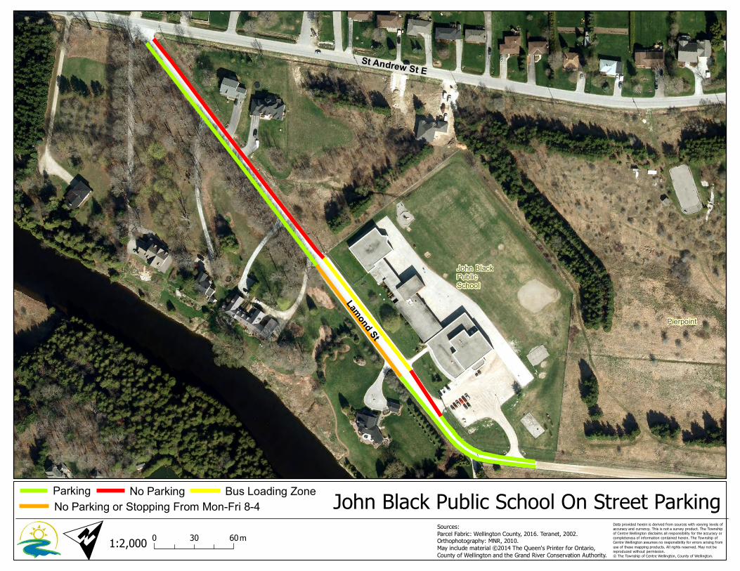
John BlackPublicSchool
Pierpoint
St Andrew St E
Lamond St
O
1:2,000
John Black Public School On Street Parking0 6030 m
Data provided herein is derived from sources with varying levels ofaccuracy and currency. This is not a survey product. The Townshipof Centre Wellington disclaims all responsibility for the accuracy orcompleteness of information contained herein. The Township ofCentre Wellington assumes no responsibility for errors arising fromuse of these mapping products. All rights reserved. May not bereproduced without permission.© The Township of Centre Wellington, County of Wellington.
Sources:Parcel Fabric: Wellington County, 2016. Teranet, 2002.Orthophotography: MNR, 2010.May include material ©2014 The Queen's Printer for Ontario,County of Wellington and the Grand River Conservation Authority.
No Parking or Stopping From Mon-Fri 8-4Bus Loading ZoneParking No Parking
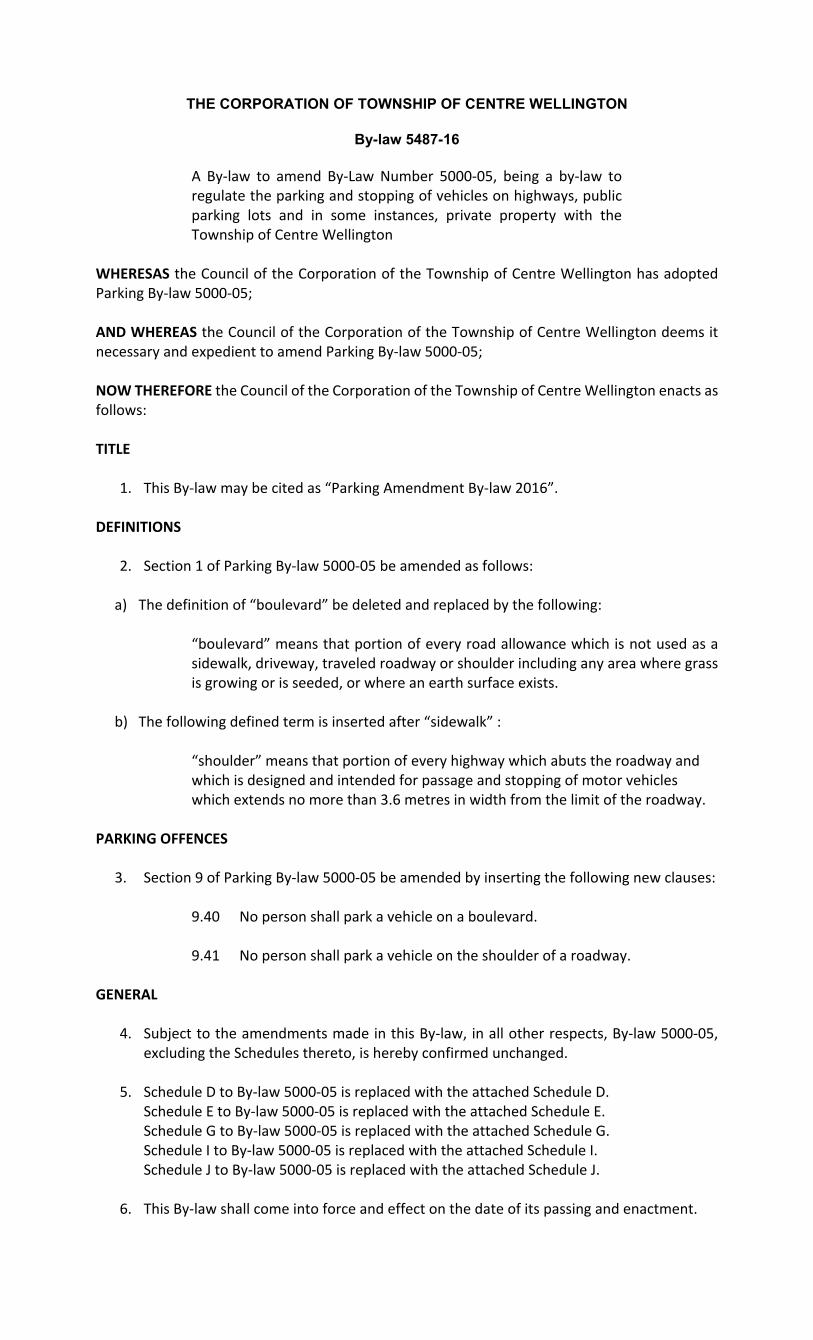
THE CORPORATION OF TOWNSHIP OF CENTRE WELLINGTON
By-law 5487-16
A By‐law to amend By‐Law Number 5000‐05, being a by‐law to regulate the parking and stopping of vehicles on highways, public parking lots and in some instances, private property with the Township of Centre Wellington
WHERESAS the Council of the Corporation of the Township of Centre Wellington has adopted Parking By‐law 5000‐05; AND WHEREAS the Council of the Corporation of the Township of Centre Wellington deems it necessary and expedient to amend Parking By‐law 5000‐05; NOW THEREFORE the Council of the Corporation of the Township of Centre Wellington enacts as follows: TITLE
1. This By‐law may be cited as “Parking Amendment By‐law 2016”. DEFINITIONS
2. Section 1 of Parking By‐law 5000‐05 be amended as follows: a) The definition of “boulevard” be deleted and replaced by the following:
“boulevard” means that portion of every road allowance which is not used as a sidewalk, driveway, traveled roadway or shoulder including any area where grass is growing or is seeded, or where an earth surface exists.
b) The following defined term is inserted after “sidewalk” :
“shoulder” means that portion of every highway which abuts the roadway and which is designed and intended for passage and stopping of motor vehicles which extends no more than 3.6 metres in width from the limit of the roadway.
PARKING OFFENCES
3. Section 9 of Parking By‐law 5000‐05 be amended by inserting the following new clauses:
9.40 No person shall park a vehicle on a boulevard.
9.41 No person shall park a vehicle on the shoulder of a roadway. GENERAL
4. Subject to the amendments made in this By‐law, in all other respects, By‐law 5000‐05, excluding the Schedules thereto, is hereby confirmed unchanged.
5. Schedule D to By‐law 5000‐05 is replaced with the attached Schedule D. Schedule E to By‐law 5000‐05 is replaced with the attached Schedule E. Schedule G to By‐law 5000‐05 is replaced with the attached Schedule G. Schedule I to By‐law 5000‐05 is replaced with the attached Schedule I. Schedule J to By‐law 5000‐05 is replaced with the attached Schedule J.
6. This By‐law shall come into force and effect on the date of its passing and enactment.

Read a first, second and third time and finally passed this 28th day of November, 2016.
Mayor – Kelly Linton Clerk – Kerri O’Kane
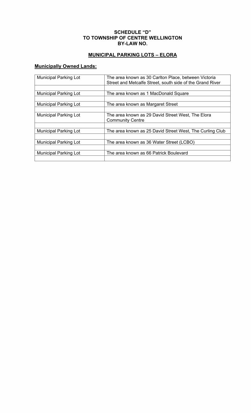
SCHEDULE “D” TO TOWNSHIP OF CENTRE WELLINGTON
BY-LAW NO.
MUNICIPAL PARKING LOTS – ELORA
Municipally Owned Lands: Municipal Parking Lot The area known as 30 Carlton Place, between Victoria
Street and Metcalfe Street, south side of the Grand River Municipal Parking Lot The area known as 1 MacDonald Square Municipal Parking Lot The area known as Margaret Street Municipal Parking Lot The area known as 29 David Street West, The Elora
Community Centre Municipal Parking Lot The area known as 25 David Street West, The Curling Club Municipal Parking Lot The area known as 36 Water Street (LCBO) Municipal Parking Lot The area known as 66 Patrick Boulevard

SCHEDULE “D” TO TOWNSHIP OF CENTRE WELLINGTON
BY-LAW NO.
MUNICIPAL PARKING LOTS – FERGUS
Municipally Owned Lands: Municipal Parking Lot 145 St. David Street South, between St. Andrew Street West
and the Grand River Municipal Parking Lot The area known as 160 Provost Lane, between St. Andrew
Street West and St. Patrick Street West Municipal Parking Lot The area known as 150 St. George Street West, The Curling
Club Municipal Parking Lot The area known as 155 St. George Street West, Public
Parking North side Centre Wellington Community Sportsplex (Fergus)
The area known as 550 Belsyde Avenue East, Fergus Sportsplex
Municipal Parking Lot The area known as 450 Belsyde Avenue East, the Flannery
Drive parking lot
Municipal Parking Lot The area known as 330 Millburn Street, the Scott Street
parking lot Municipal Parking Lot The area known as 295 Queen Street East parking lot,
Confederation Park Municipal Parking Lot The area known as 195 Scotland Street parking lot,
Confederation Park
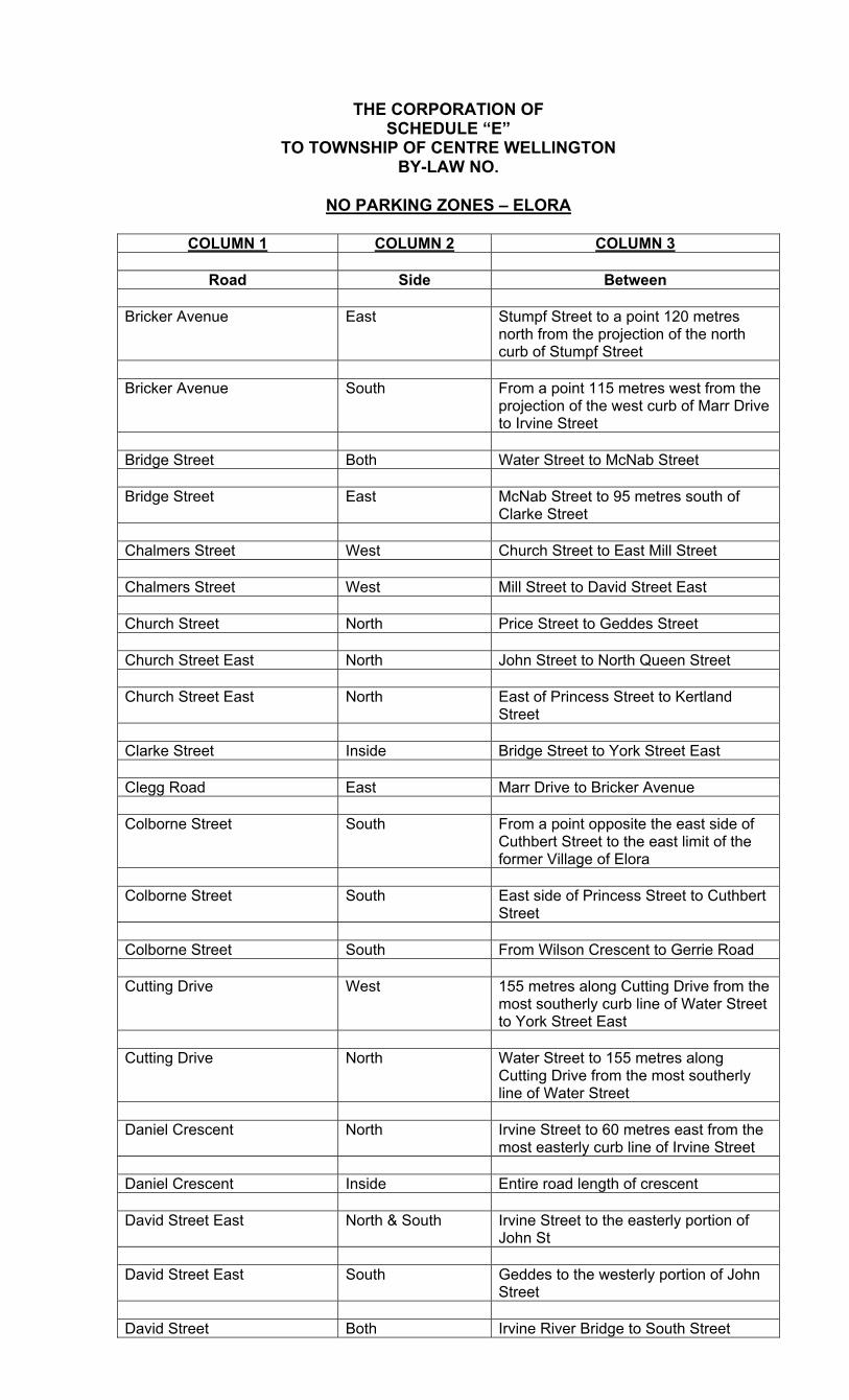
THE CORPORATION OF SCHEDULE “E”
TO TOWNSHIP OF CENTRE WELLINGTON BY-LAW NO.
NO PARKING ZONES – ELORA
COLUMN 1 COLUMN 2 COLUMN 3
Road Side Between
Bricker Avenue East Stumpf Street to a point 120 metres
north from the projection of the north curb of Stumpf Street
Bricker Avenue South From a point 115 metres west from the
projection of the west curb of Marr Drive to Irvine Street
Bridge Street Both Water Street to McNab Street Bridge Street East McNab Street to 95 metres south of
Clarke Street Chalmers Street West Church Street to East Mill Street Chalmers Street West Mill Street to David Street East Church Street North Price Street to Geddes Street Church Street East North John Street to North Queen Street Church Street East North East of Princess Street to Kertland
Street Clarke Street Inside Bridge Street to York Street East Clegg Road East Marr Drive to Bricker Avenue Colborne Street South From a point opposite the east side of
Cuthbert Street to the east limit of the former Village of Elora
Colborne Street South East side of Princess Street to Cuthbert
Street Colborne Street South From Wilson Crescent to Gerrie Road Cutting Drive West 155 metres along Cutting Drive from the
most southerly curb line of Water Street to York Street East
Cutting Drive North Water Street to 155 metres along
Cutting Drive from the most southerly line of Water Street
Daniel Crescent North Irvine Street to 60 metres east from the
most easterly curb line of Irvine Street Daniel Crescent Inside Entire road length of crescent David Street East North & South Irvine Street to the easterly portion of
John St David Street East South Geddes to the westerly portion of John
Street David Street Both Irvine River Bridge to South Street
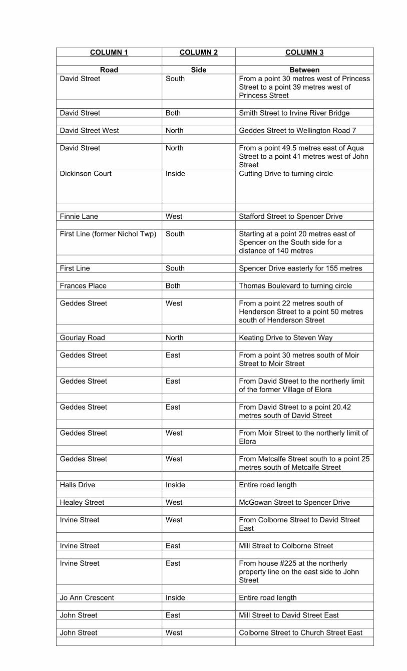
COLUMN 1 COLUMN 2 COLUMN 3
Road Side Between David Street South From a point 30 metres west of Princess
Street to a point 39 metres west of Princess Street
David Street Both Smith Street to Irvine River Bridge David Street West North Geddes Street to Wellington Road 7 David Street North From a point 49.5 metres east of Aqua
Street to a point 41 metres west of John Street
Dickinson Court Inside Cutting Drive to turning circle
Finnie Lane West Stafford Street to Spencer Drive First Line (former Nichol Twp) South Starting at a point 20 metres east of
Spencer on the South side for a distance of 140 metres
First Line South Spencer Drive easterly for 155 metres Frances Place Both Thomas Boulevard to turning circle Geddes Street West From a point 22 metres south of
Henderson Street to a point 50 metres south of Henderson Street
Gourlay Road North Keating Drive to Steven Way Geddes Street East From a point 30 metres south of Moir
Street to Moir Street Geddes Street East From David Street to the northerly limit
of the former Village of Elora Geddes Street East From David Street to a point 20.42
metres south of David Street Geddes Street West From Moir Street to the northerly limit of
Elora Geddes Street West From Metcalfe Street south to a point 25
metres south of Metcalfe Street Halls Drive Inside Entire road length Healey Street West McGowan Street to Spencer Drive Irvine Street West From Colborne Street to David Street
East Irvine Street East Mill Street to Colborne Street Irvine Street East From house #225 at the northerly
property line on the east side to John Street
Jo Ann Crescent Inside Entire road length John Street East Mill Street to David Street East John Street West Colborne Street to Church Street East
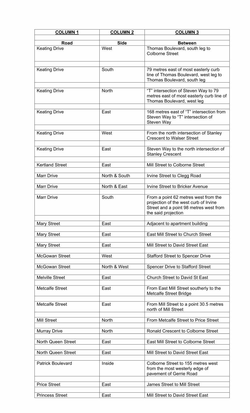
COLUMN 1 COLUMN 2 COLUMN 3
Road Side Between Keating Drive West Thomas Boulevard, south leg to
Colborne Street
Keating Drive South 79 metres east of most easterly curb
line of Thomas Boulevard, west leg to Thomas Boulevard, south leg
Keating Drive North “T” intersection of Steven Way to 79
metres east of most easterly curb line of Thomas Boulevard, west leg
Keating Drive East 168 metres east of “T” intersection from
Steven Way to “T” intersection of Steven Way
Keating Drive West From the north intersection of Stanley
Crescent to Walser Street Keating Drive East Steven Way to the north intersection of
Stanley Crescent Kertland Street East Mill Street to Colborne Street Marr Drive North & South Irvine Street to Clegg Road Marr Drive North & East Irvine Street to Bricker Avenue Marr Drive South From a point 62 metres west from the
projection of the west curb of Irvine Street and a point 98 metres west from the said projection
Mary Street East Adjacent to apartment building Mary Street East East Mill Street to Church Street Mary Street East Mill Street to David Street East McGowan Street West Stafford Street to Spencer Drive McGowan Street North & West Spencer Drive to Stafford Street Melville Street East Church Street to David St East Metcalfe Street East From East Mill Street southerly to the
Metcalfe Street Bridge Metcalfe Street East From Mill Street to a point 30.5 metres
north of Mill Street Mill Street North From Metcalfe Street to Price Street Murray Drive North Ronald Crescent to Colborne Street North Queen Street East East Mill Street to Colborne Street North Queen Street East Mill Street to David Street East Patrick Boulevard Inside Colborne Street to 155 metres west
from the most westerly edge of pavement of Gerrie Road
Price Street East James Street to Mill Street Princess Street East Mill Street to David Street East

COLUMN 1 COLUMN 2 COLUMN 3
Road Side Between
Reynolds Road West Stafford Street to Spencer Drive Ronald Crescent West York Street east to Murray Drive South Street West St.David Street to a point 15 metres
north of house # 346 Spencer Drive East & South First Line to McGowan Street Spencer Drive South McGowan Street to Reynolds Road Stafford Street North McGowan Street to Reynolds Road Stafford Street North Spencer Drive to McGowan Street Stafford Street Both Bridge Street to Spencer Drive Stanley Crescent Inside Entire road length of crescent Steven Way East Colborne Street to Keating Drive Stumpf Street North Geddes Street to Marr Drive Thomas Boulevard Inside Entire length of road Victoria Street East Carlton Place to Victoria Street Bridge Victoria Street East McNab Street to York Street Victoria Street West From a point 57 metres north of York
Street to York Street Victoria Street West From Ross Street to Carlton Place Walser Street North Irvine Street to Keating Drive Water Street North From the easterly limit of the layby
parking along O’Brien Park to the west leg of Bridge Street
Wellesley Street West Mill Street to Colborne Street West Mill Street South From a point 26 metres east of Price
Street to a point 18 metres east of Price Street
Wellington Drive South Steven Way to Cuthbert Street Wilson Crescent Inside Entire length of road York Street East South Bridge Street to Cutting Drive York Street East North Bridge Street to Fisher Street
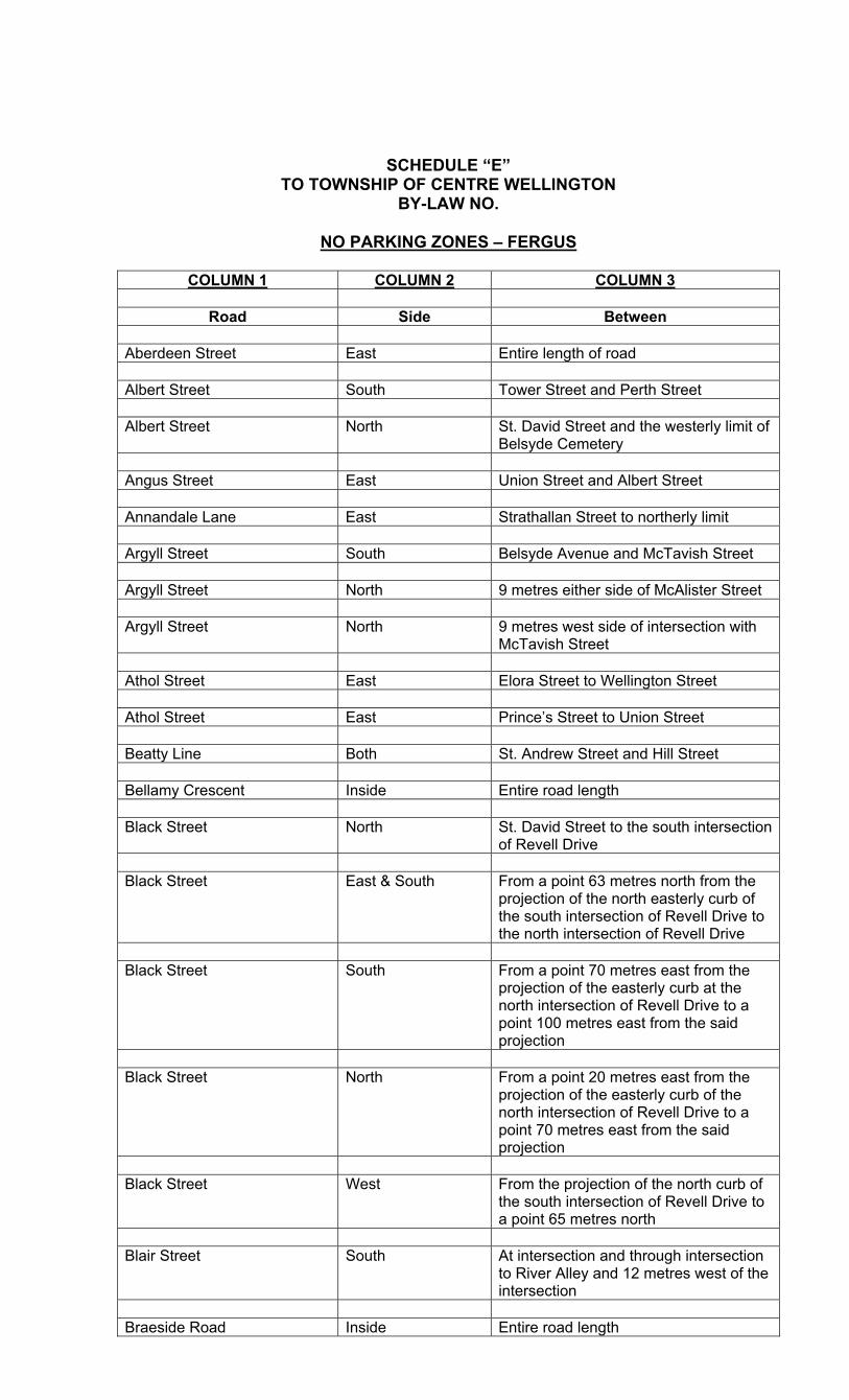
SCHEDULE “E”
TO TOWNSHIP OF CENTRE WELLINGTON BY-LAW NO.
NO PARKING ZONES – FERGUS
COLUMN 1 COLUMN 2 COLUMN 3
Road Side Between
Aberdeen Street East Entire length of road
Albert Street South Tower Street and Perth Street Albert Street North St. David Street and the westerly limit of
Belsyde Cemetery Angus Street East Union Street and Albert Street Annandale Lane East Strathallan Street to northerly limit Argyll Street South Belsyde Avenue and McTavish Street Argyll Street North 9 metres either side of McAlister Street Argyll Street North 9 metres west side of intersection with
McTavish Street Athol Street East Elora Street to Wellington Street Athol Street East Prince’s Street to Union Street Beatty Line Both St. Andrew Street and Hill Street Bellamy Crescent Inside Entire road length Black Street North St. David Street to the south intersection
of Revell Drive Black Street East & South From a point 63 metres north from the
projection of the north easterly curb of the south intersection of Revell Drive to the north intersection of Revell Drive
Black Street South From a point 70 metres east from the
projection of the easterly curb at the north intersection of Revell Drive to a point 100 metres east from the said projection
Black Street North From a point 20 metres east from the
projection of the easterly curb of the north intersection of Revell Drive to a point 70 metres east from the said projection
Black Street West From the projection of the north curb of
the south intersection of Revell Drive to a point 65 metres north
Blair Street South At intersection and through intersection
to River Alley and 12 metres west of the intersection
Braeside Road Inside Entire road length

COLUMN 1 COLUMN 2 COLUMN 3
Road Side Between Breadalbane Street East St. Andrew Street and River Alley Breadalbane Street West St. Andrew Street and St. Patrick Bridge Street West Tower Street and St. David Street Burnside Street East Flannery Drive and Millburn Boulevard Campbell Avenue North & East Woodhill Drive to Elizabeth Crescent Cherry Hill Place Inside St. David Street South to turning circle Churchill Crescent Southwest A point measured 40.8 metres
southeasterly from the projection northeasterly of the southeasterly curb of Edinburgh Avenue and a point 92.9 metres southeasterly from the said projection
Churchill Crescent Northeast A point measured 41.1 west metres
northwesterly from the projection southwesterly of the northwesterly curb of Churchill Crescent and a point measured 92.7 metres northwesterly from the said projection
Colquhoun Street North Johnston Street south and 66 metres
east thereof Craighead Drive Inside Entire road length Darroch Way East Entire road length Davison Place Inside Millburn Boulevard to turning circle Douglas Crescent Both From a point measured along the centre
line 92 metres east of Gzowski Street and a point measured along the centre line 155 metres from Gzowski Street
Edinburgh Avenue South St. David Street and the east side of
Churchill Crescent Edinburgh Avenue North St. David Street and 299 Edinburgh
Avenue Elizabeth Crescent South Campbell Avenue and Woodhill Drive Elkin Court South St. David Street South to turning circle Elora Street North Guelph Road and a point 77.2 metres
east thereof Elora Street North Tower Street south to Guelph Road Elora Street Both Tower Street and a point 100 metres
west of Tower Street Elora Street Both Tower Street and a point 100 metres
west of the westerly curb of Tower Street
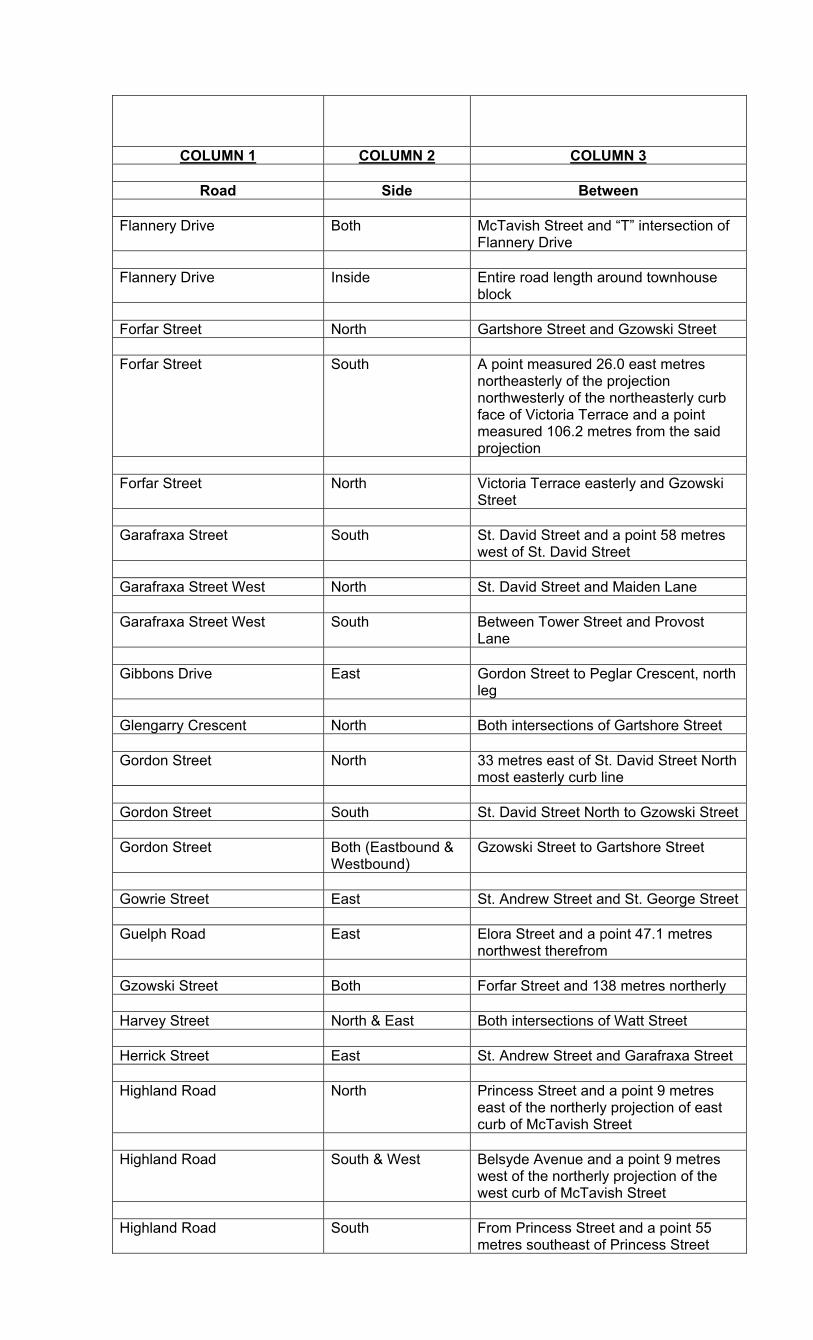
COLUMN 1 COLUMN 2 COLUMN 3
Road Side Between Flannery Drive Both McTavish Street and “T” intersection of
Flannery Drive Flannery Drive Inside Entire road length around townhouse
block Forfar Street North Gartshore Street and Gzowski Street Forfar Street South A point measured 26.0 east metres
northeasterly of the projection northwesterly of the northeasterly curb face of Victoria Terrace and a point measured 106.2 metres from the said projection
Forfar Street North Victoria Terrace easterly and Gzowski
Street Garafraxa Street South St. David Street and a point 58 metres
west of St. David Street Garafraxa Street West North St. David Street and Maiden Lane Garafraxa Street West South Between Tower Street and Provost
Lane Gibbons Drive East Gordon Street to Peglar Crescent, north
leg Glengarry Crescent North Both intersections of Gartshore Street Gordon Street North 33 metres east of St. David Street North
most easterly curb line Gordon Street South St. David Street North to Gzowski Street Gordon Street Both (Eastbound &
Westbound) Gzowski Street to Gartshore Street
Gowrie Street East St. Andrew Street and St. George Street Guelph Road East Elora Street and a point 47.1 metres
northwest therefrom Gzowski Street Both Forfar Street and 138 metres northerly Harvey Street North & East Both intersections of Watt Street Herrick Street East St. Andrew Street and Garafraxa Street Highland Road North Princess Street and a point 9 metres
east of the northerly projection of east curb of McTavish Street
Highland Road South & West Belsyde Avenue and a point 9 metres
west of the northerly projection of the west curb of McTavish Street
Highland Road South From Princess Street and a point 55
metres southeast of Princess Street
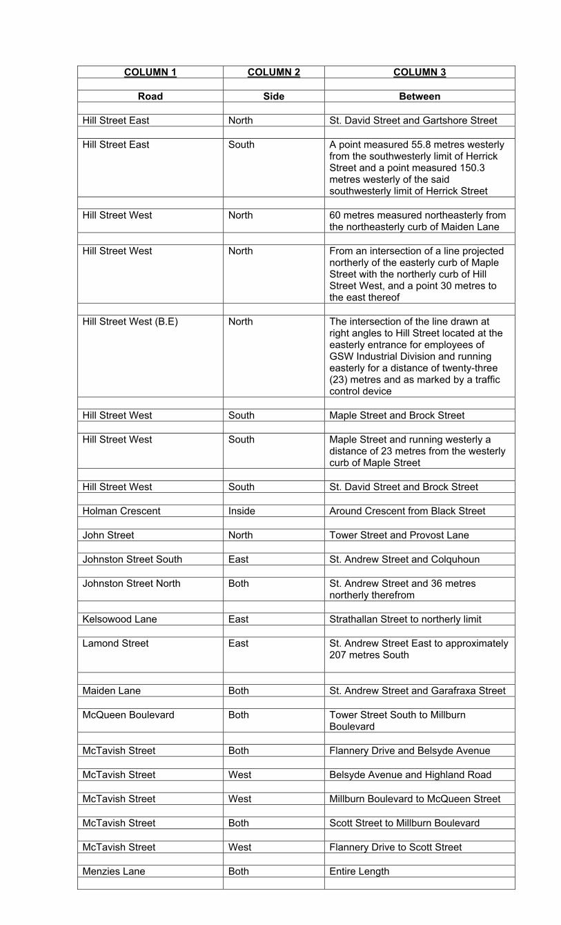
COLUMN 1 COLUMN 2 COLUMN 3
Road Side Between Hill Street East North St. David Street and Gartshore Street Hill Street East South A point measured 55.8 metres westerly
from the southwesterly limit of Herrick Street and a point measured 150.3 metres westerly of the said southwesterly limit of Herrick Street
Hill Street West North 60 metres measured northeasterly from
the northeasterly curb of Maiden Lane Hill Street West North From an intersection of a line projected
northerly of the easterly curb of Maple Street with the northerly curb of Hill Street West, and a point 30 metres to the east thereof
Hill Street West (B.E) North The intersection of the line drawn at
right angles to Hill Street located at the easterly entrance for employees of GSW Industrial Division and running easterly for a distance of twenty-three (23) metres and as marked by a traffic control device
Hill Street West South Maple Street and Brock Street Hill Street West South Maple Street and running westerly a
distance of 23 metres from the westerly curb of Maple Street
Hill Street West South St. David Street and Brock Street Holman Crescent Inside Around Crescent from Black Street John Street North Tower Street and Provost Lane Johnston Street South East St. Andrew Street and Colquhoun Johnston Street North Both St. Andrew Street and 36 metres
northerly therefrom Kelsowood Lane East Strathallan Street to northerly limit Lamond Street East St. Andrew Street East to approximately
207 metres South
Maiden Lane Both St. Andrew Street and Garafraxa Street McQueen Boulevard Both Tower Street South to Millburn
Boulevard McTavish Street Both Flannery Drive and Belsyde Avenue McTavish Street West Belsyde Avenue and Highland Road McTavish Street West Millburn Boulevard to McQueen Street McTavish Street Both Scott Street to Millburn Boulevard McTavish Street West Flannery Drive to Scott Street Menzies Lane Both Entire Length
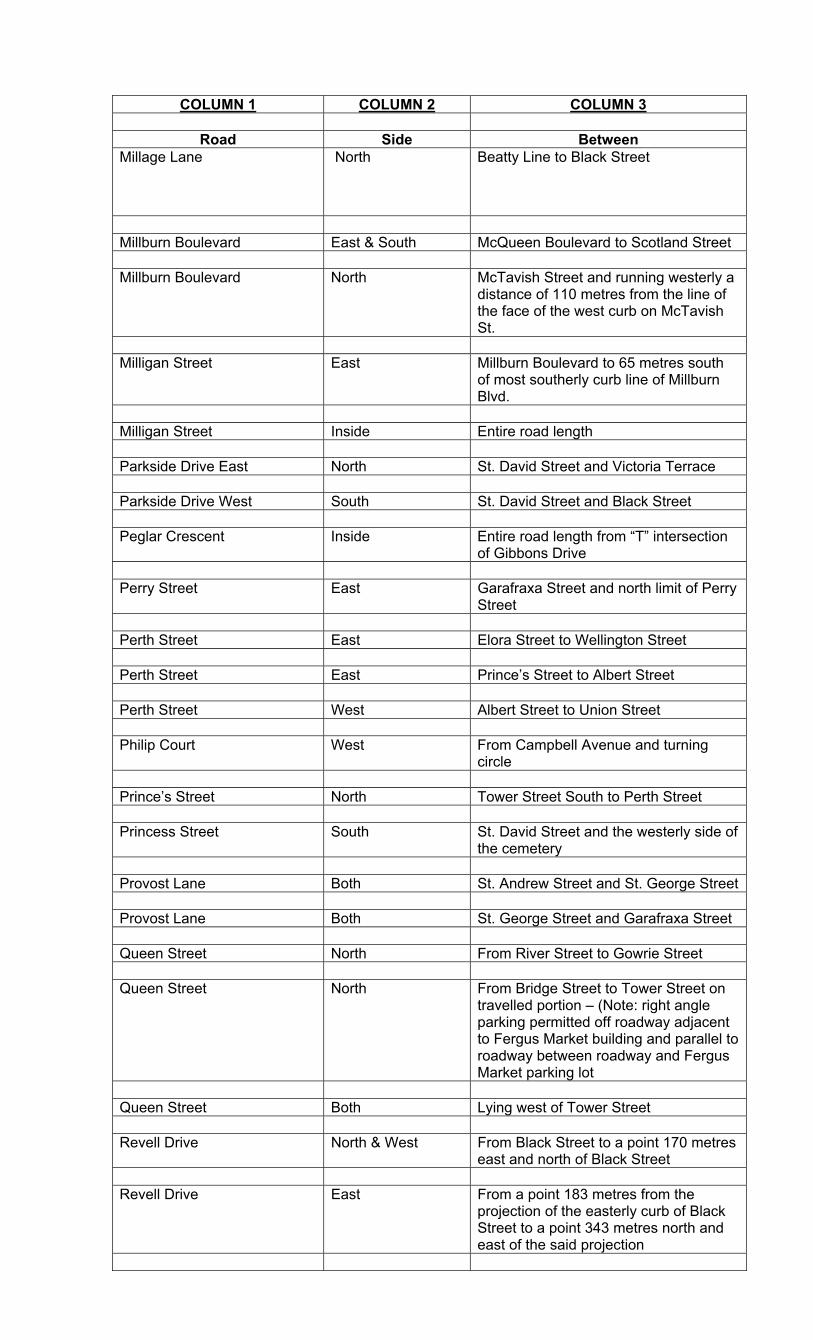
COLUMN 1 COLUMN 2 COLUMN 3
Road Side Between Millage Lane North Beatty Line to Black Street
Millburn Boulevard East & South McQueen Boulevard to Scotland Street Millburn Boulevard North McTavish Street and running westerly a
distance of 110 metres from the line of the face of the west curb on McTavish St.
Milligan Street East Millburn Boulevard to 65 metres south
of most southerly curb line of Millburn Blvd.
Milligan Street Inside Entire road length Parkside Drive East North St. David Street and Victoria Terrace Parkside Drive West South St. David Street and Black Street Peglar Crescent Inside Entire road length from “T” intersection
of Gibbons Drive Perry Street East Garafraxa Street and north limit of Perry
Street Perth Street East Elora Street to Wellington Street Perth Street East Prince’s Street to Albert Street Perth Street West Albert Street to Union Street Philip Court West From Campbell Avenue and turning
circle Prince’s Street North Tower Street South to Perth Street Princess Street South St. David Street and the westerly side of
the cemetery Provost Lane Both St. Andrew Street and St. George Street Provost Lane Both St. George Street and Garafraxa Street Queen Street North From River Street to Gowrie Street Queen Street North From Bridge Street to Tower Street on
travelled portion – (Note: right angle parking permitted off roadway adjacent to Fergus Market building and parallel to roadway between roadway and Fergus Market parking lot
Queen Street Both Lying west of Tower Street Revell Drive North & West From Black Street to a point 170 metres
east and north of Black Street Revell Drive East From a point 183 metres from the
projection of the easterly curb of Black Street to a point 343 metres north and east of the said projection

COLUMN 1 COLUMN 2 COLUMN 3
Road Side Between Revell Drive West From the north intersection of Black
Street to a point 123 metres south from the projection of the south westerly curb of the north intersection of Black Street
Richardson Court East Black Street and turning circle Riley Crescent Inside Entire length of road River Alley Both Breadalbane and most easterly limit of
River Alley River Street East Queen Street and a point 100 metres
south thereof Robertson Street East Tait Crescent to Millburn Boulevard St. Andrew Street North Gowrie Street and Cameron Street St. Andrew Street South Cameron Street and Gartshore Street St. Andrew Street East South St. David Street and a point 19.6 metres
East of St. David Street St. Andrew Street East North St. David Street and a point 29.8 metres
East of St. David Street St. Andrew Street East South Herrick Street to Gartshore Street St. David Street Both St. Andrew Street and Queen Street St. David Street North Both Hill Street and Parkside Drive St. David Street South West Queen Street and Albert Street St. David Street South Both Albert Street and Belsyde Avenue St. David Street South Both 15 metres north and 15 metres south of
Union Street St. David Street South East Millburn Boulevard to Belsyde Avenue St. David Street South West Elkin Court to Belsyde Avenue St. George Street East North St. David Street and Gartshore Street St. George Street West South The intersection of the projection of the
southeasterly curb face of St. George Street with the projection of the southwesterly curb face of Tower Street lying within St. James Square and 22.8 metres southwesterly
St. George Street West South Provost Lane and St. David Street St. George Street West North The intersection of the projection of the
northwest curb face of St. Patrick Street with the southerly curb face of Tower Street (lying within St. James Square) and 22.5 metres southwesterly
COLUMN 1 COLUMN 2 COLUMN 3
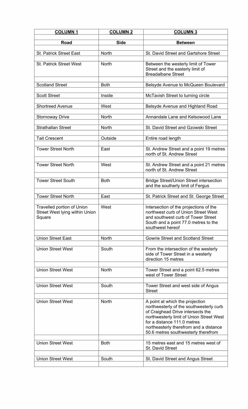
Road Side Between
St. Patrick Street East North St. David Street and Gartshore Street St. Patrick Street West North Between the westerly limit of Tower
Street and the easterly limit of Breadalbane Street
Scotland Street Both Belsyde Avenue to McQueen Boulevard Scott Street Inside McTavish Street to turning circle Shortreed Avenue West Belsyde Avenue and Highland Road Stornoway Drive North Annandale Lane and Kelsowood Lane Strathallan Street North St. David Street and Gzowski Street Tait Crescent Outside Entire road length Tower Street North East St. Andrew Street and a point 19 metres
north of St. Andrew Street Tower Street North West St. Andrew Street and a point 21 metres
north of St. Andrew Street Tower Street South Both Bridge Street/Union Street intersection
and the southerly limit of Fergus Tower Street North East St. Patrick Street and St. George Street Travelled portion of Union Street West lying within Union Square
West Intersection of the projections of the northwest curb of Union Street West and southwest curb of Tower Street South and a point 77.0 metres to the southwest hereof
Union Street East North Gowrie Street and Scotland Street Union Street West South From the intersection of the westerly
side of Tower Street in a westerly direction 15 metres
Union Street West North Tower Street and a point 62.5 metres
west of Tower Street Union Street West South Tower Street and west side of Angus
Street Union Street West North A point at which the projection
northwesterly of the southwesterly curb of Craighead Drive intersects the northwesterly limit of Union Street West for a distance 111.0 metres northeasterly therefrom and a distance 50.6 metres southwesterly therefrom
Union Street West Both 15 metres east and 15 metres west of
St. David Street Union Street West South St. David Street and Angus Street
COLUMN 1 COLUMN 2 COLUMN 3
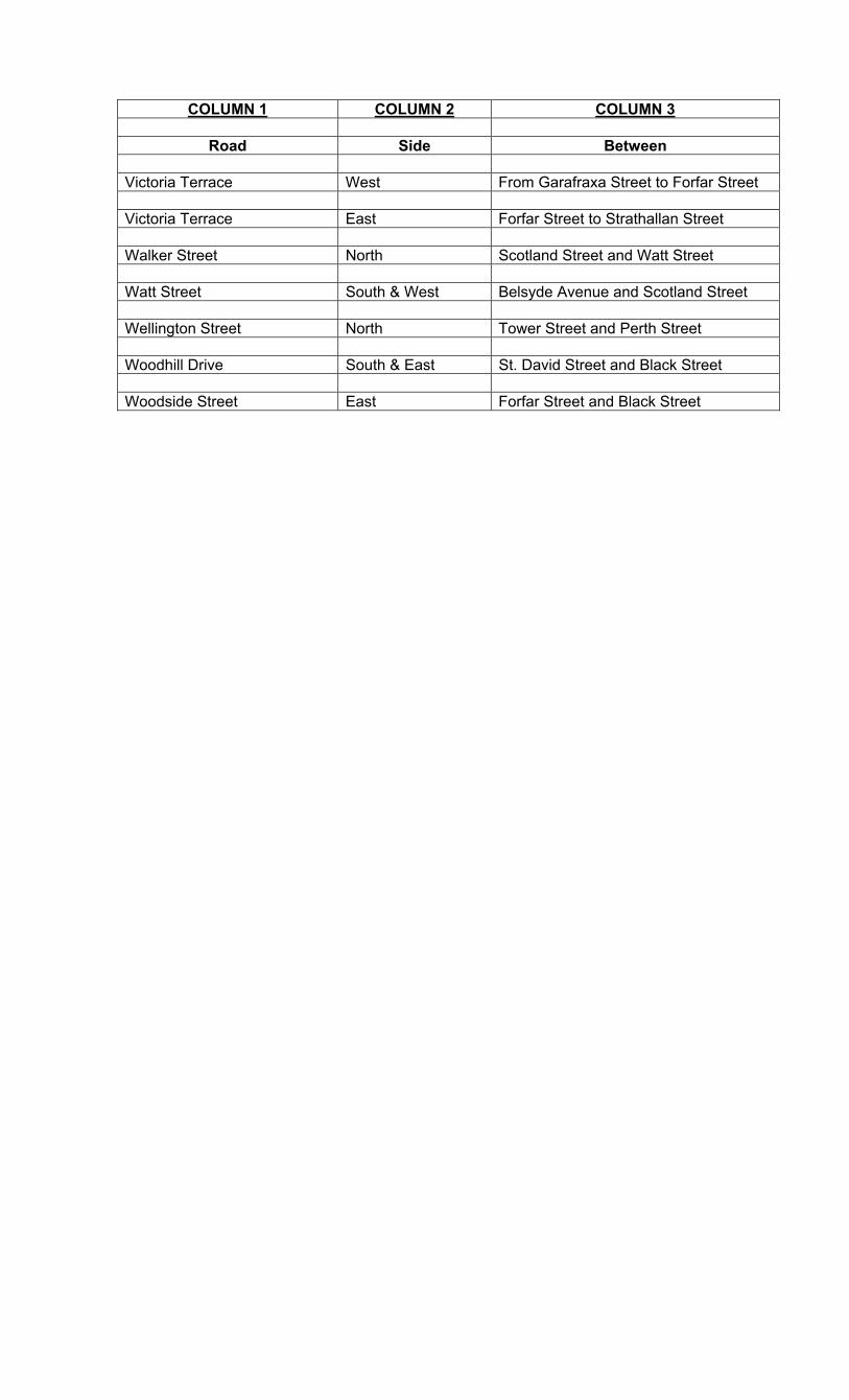
Road Side Between Victoria Terrace West From Garafraxa Street to Forfar Street Victoria Terrace East Forfar Street to Strathallan Street Walker Street North Scotland Street and Watt Street Watt Street South & West Belsyde Avenue and Scotland Street Wellington Street North Tower Street and Perth Street Woodhill Drive South & East St. David Street and Black Street Woodside Street East Forfar Street and Black Street
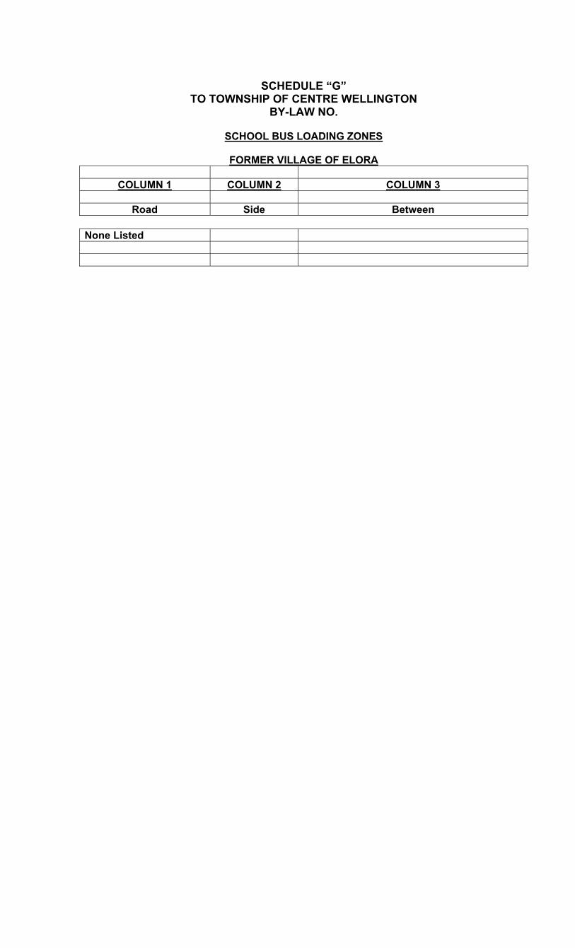
SCHEDULE “G”
TO TOWNSHIP OF CENTRE WELLINGTON BY-LAW NO.
SCHOOL BUS LOADING ZONES
FORMER VILLAGE OF ELORA
COLUMN 1 COLUMN 2 COLUMN 3
Road Side Between
None Listed

SCHEDULE “G” TO TOWNSHIP OF CENTRE WELLINGTON
BY-LAW NO.
SCHOOL BUS LOADING ZONES
FORMER TOWN OF FERGUS
COLUMN 1 COLUMN 2 COLUMN 3
Road Side Between St. George Street West North 28 metres east of intersection of Maiden Lane
and running easterly from this point for 34 metres
Victoria Terrace East 138 metres south of the intersection of Victoria
Terrace and Forfar Street East and running southerly from this point for 34 metres
Hill Street South From a point 30 metres from the north-easterly
curb of Maiden lane to a point 60 metres from the northeasterly curb of Maiden Lane
Lamond Street East Along the front of the school in the lay by lane

SCHEDULE “I” TO TOWNSHIP OF CENTRE WELLINGTON
BY-LAW NO.
TIME LIMITED PARKING – ELORA
COLUMN 1 COLUMN 2 COLUMN 3 COLUMN 4 COLUMN 5
Road Side Between Times of Day Max. Period Permitted
David Street Both John Street and
Irvine Street 8 a.m to 5 p.m Monday to Friday
No Parking
East Mill Street Both Metcalfe Street to
Princess Street 8 a.m to 7 p.m 2 hours
Geddes Street East From a point 42
metres south of Colborne Street to David Street
8 a.m to 7 p.m 2 hours
Geddes Street West Metcalfe Street to
Moir Street 8 a.m to 7 p.m 2 hours
Irvine Street West John Street and
David Street 8 a.m to 5 p.m Monday to Friday
No Parking
James Street North In front of Medical
building 9 a.m to 9 p.m Monday to Friday
2 hours
Metcalfe Street Both Geddes Street to Mill Street
8 a.m to 7 p.m 2 hours
West Mill Street South Metcalfe Street to
a point 26 metres east of Price Street
8 a.m to 7 p.m 2 hours
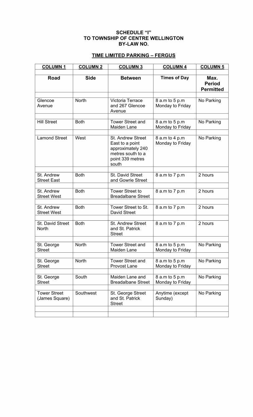
SCHEDULE “I” TO TOWNSHIP OF CENTRE WELLINGTON
BY-LAW NO.
TIME LIMITED PARKING – FERGUS
COLUMN 1 COLUMN 2 COLUMN 3 COLUMN 4 COLUMN 5
Road Side Between Times of Day Max. Period
Permitted
Glencoe Avenue
North Victoria Terrace and 267 Glencoe Avenue
8 a.m to 5 p.m Monday to Friday
No Parking
Hill Street Both Tower Street and
Maiden Lane 8 a.m to 5 p.m Monday to Friday
No Parking
Lamond Street West St. Andrew Street
East to a point approximately 240 metres south to a point 339 metres south
8 a.m to 4 p.m Monday to Friday
No Parking
St. Andrew Street East
Both St. David Street and Gowrie Street
8 a.m to 7 p.m 2 hours
St. Andrew Street West
Both Tower Street to Breadalbane Street
8 a.m to 7 p.m 2 hours
St. Andrew Street West
Both Tower Street to St. David Street
8 a.m to 7 p.m 2 hours
St. David Street North
Both St. Andrew Street and St. Patrick Street
8 a.m to 7 p.m 2 hours
St. George Street
North Tower Street and Maiden Lane
8 a.m to 5 p.m Monday to Friday
No Parking
St. George Street
North Tower Street and Provost Lane
8 a.m to 5 p.m Monday to Friday
No Parking
St. George Street
South Maiden Lane and Breadalbane Street
8 a.m to 5 p.m Monday to Friday
No Parking
Tower Street (James Square)
Southwest St. George Street and St. Patrick Street
Anytime (except Sunday)
No Parking
SCHEDULE “J” TO TOWNSHIP OF CENTRE WELLINGTON
BY-LAW NO.
STUDENT DROP OFF & PICK UP ZONE – FERGUS
COLUMN 1 COLUMN 2 COLUMN 3 COLUMN 4 COLUMN 5
Road Side Between Time Max. Period Permitted
Victoria Terrace East From a point 15
metres north of Garafraxa Street to a limit of 57 metres north
8 a.m to 5 p.m Monday to Friday
5 Minutes
Lamond Street John Black School
along the lay by area located in
front of the school
8 a.m to 5 p.m Monday to Friday
5 Minutes
Student drop off and pickup zones are hereby established at the locations and times set out in the above Schedule J of this by-law. When a traffic control device is displayed indicating a student drop off and pickup zone, no person shall park any portion of a vehicle within such zone for longer than five minutes.

SCHEDULE “J” TO TOWNSHIP OF CENTRE WELLINGTON
BY-LAW NO.
STUDENT DROP OFF & PICK UP ZONE – ELORA
COLUMN 1 COLUMN 2 COLUMN 3 COLUMN 4 COLUMN 5
Road Side Between Time Max. Period Permitted
Wellington Drive
North From a point 15 metres east of Heritage River driveway known as 25 Wellington Dr. and continue easterly for a distance of 100 metres.
8 a.m to 5 p.m Monday to Friday
5 Minutes
Student drop off and pickup zones are hereby established at the locations and times set out in the above Schedule J of this by-law. When a traffic control device is displayed indicating a student drop off and pickup zone, no person shall park any portion of a vehicle within such zone for longer than five minutes.