Embed Size (px)
Citation preview
Seediscussions,stats,andauthorprofilesforthispublicationat:https://www.researchgate.net/publication/317823649
Rents,actors,andtheexpansionofcommodityfrontiersintheGranChaco
ArticleinAnnalsoftheAssociationofAmericanGeographers·June2017
CITATIONS
0
READS
113
10authors,including:
Someoftheauthorsofthispublicationarealsoworkingontheserelatedprojects:
VOLANTEViewproject
Trase:TransparencyforthesustainableeconomiesViewproject
MatthiasBaumann
Humboldt-UniversitätzuBerlin
39PUBLICATIONS734CITATIONS
SEEPROFILE
GregorioIgnacioGavier-Pizarro
InstitutoNacionaldeTecnologíaAgropecuaria
46PUBLICATIONS329CITATIONS
SEEPROFILE
TobiasKuemmerle
Humboldt-UniversitätzuBerlin
201PUBLICATIONS4,500CITATIONS
SEEPROFILE
PatrickMeyfroidt
UniversitéCatholiquedeLouvain
66PUBLICATIONS3,226CITATIONS
SEEPROFILE
AllcontentfollowingthispagewasuploadedbyYannLePolaindeWarouxon23June2017.
Theuserhasrequestedenhancementofthedownloadedfile.Allin-textreferencesunderlinedinblueareaddedtotheoriginaldocument
andarelinkedtopublicationsonResearchGate,lettingyouaccessandreadthemimmediately.
MANUSCRIPTACCEPTEDFORPUBLICATIONATANNALSOFTHEASSOCIATIONOFAMERICAN
GEOGRAPHERS—JUNE2017—VERSIONFORSHARING
1
Title: Rents, actors, and the expansion of commodity frontiers in the Gran Chaco 1
2
Author affiliations (family names underlined): Yann le Polain de Warouxa,b, Matthias 3
Baumannc, Nestor Ignacio Gasparrid,e, Gregorio Gavier-Pizarrof, Javier Godarg, Tobias 4
Kuemmerlec, Robert Müller, Fabricio Vázquezh, José Norberto Volantei and Patrick 5
Meyfroidtj. 6
7
aSchool of Earth, Energy, and Environmental Sciences, Stanford University; bWoods Institute 8
for the Environment, Stanford University; cGeography Department, Humboldt-University 9
Berlin; dConsejo Nacional de Investigaciones Científicas y Técnicas (CONICET), Argentina; 10
eInstituto de Ecología Regional, Universidad Nacional de Tucumán, Argentina; fCentro de 11
Investigación de Recursos Naturales (CIRN) and Instituto de Recursos Biológicos (IRB), 12
Instituto Nacional de Tecnología Agropecuaria (INTA), Argentina; gStockholm Environment 13
Institute, Sweden; hUniversidad Nacional de Asunción; iLaboratorio de Teledetección y SIG, 14
Instituto Nacional de Tecnología Agropecuaria (INTA), Argentina; jGeorges Lemaître Centre 15
for Earth and Climate Research, Earth and Life Institute, Université Catholique de Louvain, 16
Belgium. 17
18
Corresponding author: Yann le Polain de Waroux, School of Earth, Energy, and 19
Environmental Sciences, Stanford University, 473 Via Ortega, Stanford, CA 94305. Email: 20
[email protected]. Telephone: +1-650-7361-677. 21
MANUSCRIPTACCEPTEDFORPUBLICATIONATANNALSOFTHEASSOCIATIONOFAMERICAN
GEOGRAPHERS—JUNE2017—VERSIONFORSHARING
2
Abstract 22
Theories of frontier expansion in the last four decades have been mostly shaped by studies 23
of state-driven smallholder colonization. Modern-day agricultural frontiers, however, are 24
increasingly driven by capitalized corporate agriculture operating with little direct government 25
intervention. The expansion of contemporary frontiers has been explained by the existence of 26
spatially heterogeneous “abnormal” rents, which can be caused by cheap land and labor, 27
technological innovation, lack of regulations, and a variety of other incentives. Here, we argue 28
that understanding the dynamics of these frontiers requires considering the differential ability 29
of actors to capture such rents, which depends on their access to production factors and their 30
information, preferences, and agency. 31
We propose a new conceptual framework drawing on neo-classical economics and 32
political economy, which we apply to the South American Gran Chaco, a hotspot of 33
deforestation for soy and cattle production. We divide the region into a set of distinct frontiers 34
based on satellite data, field interviews, and expert knowledge, to review the drivers and actors 35
of agricultural expansion in these frontiers. We show that frontier expansion in the Chaco 36
responded to the rents created by new agricultural technologies, infrastructure, and rising 37
producer prices, but that the frontier dynamics were strongly influenced by actors’ ability to 38
capture or influence these rents. Our findings thus highlight that understanding contemporary 39
commodity frontiers requires analyzing the novel ways by which the agency of particular 40
groups of actors shapes land-use outcomes. 41
42
Keywords: frontiers; rent; Gran Chaco; soy; cattle 43
MANUSCRIPTACCEPTEDFORPUBLICATIONATANNALSOFTHEASSOCIATIONOFAMERICAN
GEOGRAPHERS—JUNE2017—VERSIONFORSHARING
3
Introduction 44
Humans have always sought to appropriate natural resources, and have done so in part by 45
expanding agriculture through agricultural frontiers, characterized by “the initial existence of 46
abundant land, mostly unoccupied, and by a substantial migration of capital and people” (di 47
Tella 1982). Historically, tropical agricultural frontiers operated through a reallocation of 48
smallholders to marginal areas, driven by a combination of population increase and land 49
scarcity in their areas of origin (Carr 2004; Carr, Lopez, and Bilsborrow 2010), depletion of 50
natural resources, conflicts, and mining booms, and often initiated or supported by states 51
(Rindfuss et al. 2007; Rudel 2007; De Koninck 2000). 52
Several theories have sought to explain such smallholder frontiers (Browder et al. 2008; 53
Walker et al. 2009; Godar, Tizado, Pokorny, and Johnson 2012). The capitalist penetration 54
thesis posits that frontiers correspond to the progressive spread of capitalist relations of 55
production into ‘‘non-capitalist’’ environments. The inter-sectoral articulation thesis analyses 56
how capital accumulation in the secondary and tertiary sectors builds on the captive labor force 57
of smallholders (Browder et al. 2008). Chayanovian models explain frontier land-use change 58
as a dynamic aggregation of household-level economic and demographic processes (Caldas et 59
al. 2007). 60
These theories generally describe frontiers as moving from a populist or pioneer stage, 61
dominated by smallholders, towards a capitalized or consolidated stage, where more powerful 62
actors consolidate land into large holdings (Foley et al. 2005; Pacheco 2005). This transition 63
can be driven by the low profitability of pioneer agriculture (e.g., due to soil degradation, poor 64
soil quality, lack of technical and financial support), leading to the formation of a “hollow 65
frontier” (Casetti and Gauthier 1977; Hecht 2005), or by a “technology treadmill”, where 66
continuing competition leads to intensification and the exclusion of laggards (Levins and 67
Cochrane 2010; Chatalova, Müller, Valentinov, and Balmann 2016). Depending on the 68
MANUSCRIPTACCEPTEDFORPUBLICATIONATANNALSOFTHEASSOCIATIONOFAMERICAN
GEOGRAPHERS—JUNE2017—VERSIONFORSHARING
4
contexts, smallholders may sell their land or be expelled, and either migrate to urban areas or 69
seek cheaper land elsewhere, thereby driving further frontier expansion (Richards 2015, 2012). 70
In modern frontiers, however, the role of corporate capital and commodity agriculture 71
changes from an indirect cause of frontier expansion through the consolidation of frontiers 72
initially opened up by smallholder pioneers, to its main direct cause (Rudel 2007). This has led 73
some authors to refer to corporatist frontiers, in contrast to smallholder frontiers (Browder and 74
Godfrey 1997), although this distinction is not always clear-cut (Pacheco 2012), and some 75
contemporary frontiers can be driven by both types of farmers (Barbier 2012). Governments, 76
meanwhile, have shifted from a role of planning to one of facilitation (Rudel 2007), or of non-77
intervention. The combination of corporate actors and the relative absence of state planning 78
gives rise to so-called neoliberal frontiers (Brannstrom 2009; Hecht 2005). In this paper, we 79
define commodity frontiers as areas where the production of agricultural commodities (such as 80
beef, soy, or palm oil) by large-scale farms expands over other land uses, and whose 81
development is shaped by the greater ability of these large-scale actors to influence and capture 82
agricultural rents. In that sense, the concept of commodity frontier overlaps with, but is distinct 83
from, that of neoliberal frontier. While the latter is defined by a neoliberal political 84
environment, commodity frontiers have continued to exist in a “post-neoliberal” era (Grugel 85
and Riggirozzi 2012). The concept of commodity frontiers also puts greater emphasis on the 86
agency of large farms, in addition to that of states and meso-level organizations (Jepson 2006). 87
The expansion of commodity frontiers is premised on the existence of an “abnormal” rent, 88
i.e. an economic rent that exceeds the bid rent or land price, generated by factors such as cheap 89
(or forced) labor, technological innovation, or legal and economic incentives (Barbier 2012; di 90
Tella 1982). As long as this extraordinary rent exists, new actors move in to exploit it, driving 91
frontier expansion. Not all actors, however, have equal access to this rent, and differences in 92
their ability to capture it determine whether and when they move in. In state-driven frontiers, 93
MANUSCRIPTACCEPTEDFORPUBLICATIONATANNALSOFTHEASSOCIATIONOFAMERICAN
GEOGRAPHERS—JUNE2017—VERSIONFORSHARING
5
which are often motivated by geopolitical and other motives rather than by potential rents, these 94
differences are often dampened by targeted policies and support for actors with lower capacity. 95
In the absence of such safeguards, the presence of highly capitalized actors creates larger 96
differentials between actors. We argue that these differentials have the potential to shape land-97
use and social outcomes more than they would in smallholder frontiers. To understand the 98
dynamics of contemporary commodity frontiers, it is therefore important to consider not only 99
the causes that increase economic rents, but also the role and characteristics of heterogeneous 100
actors, and their capacity to shape and capture those rents. 101
The objective of this paper is to analyze how the interactions between structural 102
mechanisms that create rents and the capabilities of heterogeneous agents influence the 103
development of commodity frontiers, using the case of the Gran Chaco (Figure 1), a dry 104
woodland ecoregion extending between Northern Argentina, Western Paraguay and South-105
Eastern Bolivia, and one of the most active deforestation frontiers of the world (Baumann et al. 106
2016). Based on a review of the causes and agents of frontier expansion in the Gran Chaco, we 107
show that the interaction of rents and agentic capabilities can play out in various ways, but that 108
there are key common processes in these frontiers. We start by laying out the foundations of 109
our theoretical framework; then, we provide a short comparative history of the different 110
commodity frontiers of the Gran Chaco. Finally, we discuss the ways in which the integration 111
of actor heterogeneity helps improve our understanding of frontier expansion processes. 112
113
Theoretical framework 114
Agricultural frontiers are characterized by an abundance of “unoccupied” land, i.e., land 115
not yet under permanent cultivation (di Tella 1982). At equilibrium, whether land is cultivated 116
or not depends on the economic rent of agricultural vs. non-agricultural land uses, reflected in 117
the bid rent that users are willing to pay for land, which itself determines land prices (Walker 118
MANUSCRIPTACCEPTEDFORPUBLICATIONATANNALSOFTHEASSOCIATIONOFAMERICAN
GEOGRAPHERS—JUNE2017—VERSIONFORSHARING
6
2004). Following von Thünen, this rent decreases with distance to agricultural markets, and the 119
transition between cultivated and uncultivated land happens where the rent of the former is 120
lower than that of the latter ((Angelsen 2010); Figure 2A). This border moves as the factors 121
influencing rents, e.g., transport and input costs or commodity prices, change. Gradual changes 122
in the rent factors, however, do not satisfactorily explain the rapid expansion of commodity 123
frontiers. For a commodity frontier to emerge, free or cheap uncultivated land must suddenly 124
acquire potential value for at least some actors through an abnormal rent (di Tella, 1982, p.212), 125
(Figure 2B). The expectation of such an exceptional rent, founded or speculative, drives 126
investments at the frontier until the bid rent catches up with the economic rent (Figure 2C). 127
Five main mechanisms may induce a sudden increase in the economic rent in commodity 128
frontiers. First, a change in accessibility, typically through the construction of roads and 129
railways, improvements in waterways, and new storage or processing facilities, will diminish 130
production costs and increase rents (Angelsen 2010). Second, a change in land productivity, 131
due to changing agro-environmental conditions (e.g., increasing rainfall or temperatures, or 132
wetland drainage), can increase the output-to-input ratio. Third, rent can increase through 133
technological innovations such as improvement in cultivation techniques, seed technology, or 134
machinery (Kaimowitz and Smith 2001; Angelsen and Kaimowitz 2001). Fourth, producer 135
prices and/or demand may change abruptly, for example when export restrictions are lifted (e.g., 136
when a region becomes foot-and-mouth disease-free, see (Schierhorn et al. 2016)), raising 137
producer prices or allowing farmers to sell more at the same price. Finally, subsidies or other 138
policies such as tax exemptions can directly affect rents by decreasing the cost of inputs such 139
as labor, capital, or energy, or raising producer prices (Hecht 1985; Jepson 2006; Binswanger 140
1991). 141
Other processes such as agglomeration economies can support these mechanisms, as 142
clusters of farmers may benefit from the same infrastructures, spread new technologies, or 143
MANUSCRIPTACCEPTEDFORPUBLICATIONATANNALSOFTHEASSOCIATIONOFAMERICAN
GEOGRAPHERS—JUNE2017—VERSIONFORSHARING
7
lobby more effectively for subsidies (Garrett, Lambin, and Naylor 2013b). Abnormal rents will 144
naturally tend towards zero under a perfectly competitive market situation with finite land 145
reserves, as more and more agents exploit them, driving demand for land, and thus land prices, 146
up. However, heterogeneous agents and imperfect markets can temporarily maintain a 147
disequilibrium between bid rent and economic rent, thus creating the conditions for commodity 148
frontiers to emerge. 149
Recent work on frontiers has examined the complex ways in which frontier expansion is 150
shaped by factors affecting incentives at different scales, but it has tended to overlook the role 151
of agent heterogeneity in frontier formation. For example, building upon rent theory and 152
political economy, Jepson (2006) used an institutional approach to show “how organizations 153
interact with the political economy (cheap credit, development programs, and subsidies) and 154
influence other important cost factors (technology, property rights, and access to markets) to 155
produce the new modern frontier in the South American tropics”. Jepson et al. (2010) further 156
developed the role of institutions such as property rights and contracts, and showed that, along 157
with organizations (firms and cooperatives), they “formed a regime of access that mediated 158
social-environmental interaction to create the conditions for […] land-change outcomes”. 159
While this work highlights the diversity of institutional forms influencing incentives that 160
produce frontiers, it tends to treat farmers themselves as relatively homogeneous in their 161
response to these incentives. 162
High rents at the margin are not, however, a sufficient condition for frontier development. 163
If no actor is positioned or willing to act upon them, the frontier will remain unexploited. While 164
in some situations (e.g., at frontiers dominated by small-scale colonists), famers can be treated 165
as relatively homogeneous in their response to rents and their influence on frontier 166
development, this is increasingly inaccurate in contemporary commodity frontiers. We 167
distinguish between four characteristics that differentiate actors’ response to an existing rent. 168
MANUSCRIPTACCEPTEDFORPUBLICATIONATANNALSOFTHEASSOCIATIONOFAMERICAN
GEOGRAPHERS—JUNE2017—VERSIONFORSHARING
8
First, they need information on the existence and the amount of the rent. An actor with no 169
information will not invest, and an actor with insufficient information may perceive investments 170
as riskier. Second, access to land and other factors of production (including financial capital) is 171
a necessary condition for production. Third, preferences, particularly risk and time preference, 172
induce different responses for a given rent, risk level and time frame. High rents may be 173
associated with higher risks, deterring risk-averse actors, or they may require a long time to 174
materialize, which may deter actors favoring short-term returns. Finally, actors with greater 175
agency, or power to influence factors that affect agricultural rents, may invest more readily than 176
others, as they can expect some conditions to improve as a result of their actions. Examples 177
include lobbying for legal access or building transport infrastructure (Figure 2D). 178
The combination of economic rents and heterogeneous actors can explain why the rapid 179
dynamics observed on modern commodity frontiers depart from the gradual expansion 180
predicted by the von Thünen model. At an early stage of commodity frontier expansion, which 181
we call “pre-frontier” after Rodrigues et al. (2009), an economic rent is created for the reasons 182
mentioned above, but in the absence of actors with sufficient access or information to capture 183
it, it does not trigger land-use change or an increase in the bid rent (Figure 2E). During early 184
frontier development, only a limited number of actors are positioned to take advantage of the 185
rent. Initial developments generate agglomeration economies, decreasing costs, and 186
information on the rent spreads, which decreases perceived risk. The area becomes attractive to 187
new actors, and capital flows into the frontier. As this happens, land prices start rising more 188
drastically towards the point of equilibrium, and the abnormal rent decreases, along with the 189
flow of investment. This leads to a post-frontier stage when the abnormal rent disappears, and 190
agricultural expansion returns to being a function of gradual changes in population and land 191
prices. 192
MANUSCRIPTACCEPTEDFORPUBLICATIONATANNALSOFTHEASSOCIATIONOFAMERICAN
GEOGRAPHERS—JUNE2017—VERSIONFORSHARING
9
The existence and magnitude of different kinds of rent factors and the presence of certain 193
types of actors, as well as the way their interactions play out in terms of frontier dynamics 194
(Figure 3), depend on local context and history. Cultural factors, historical legacies, ties to 195
global markets, or geographic particularities all shape the development of specific frontiers. In 196
the next section, we review different frontiers in the Gran Chaco, and reexamine their dynamics 197
in the light of our theoretical framework. 198
199
Frontiers of the Gran Chaco 200
The Gran Chaco, a dry woodland ecoregion, covers over seventy million hectares in 201
Argentina, Bolivia and Paraguay. In the last decades, the Gran Chaco has experienced among 202
the world’s highest deforestation rates, with the conversion of over fourteen million hectares of 203
woodlands to agriculture between 1985 and 2013 (Baumann et al. 2016). The new wealth 204
generated by this expansion has come at a high social and environmental cost. Many of the 205
Gran Chaco’s 145 mammal, 400 bird, thirty amphibian and forty-six tree species are threatened 206
(Torres, Gasparri, Blendinger, and Grau 2014), and agricultural expansion has triggered huge 207
carbon emissions (Baumann et al. 2016), and caused the displacement of indigenous 208
populations and other smallholders (e.g., Bessire 2014). 209
Agricultural expansion has occurred along several distinct frontiers. While these share 210
common causal processes and pathways, they also exhibit significant differences, e.g., in the 211
actors involved or the land uses driving expansion. To study these differences and 212
commonalities, we divided the Gran Chaco into twelve frontiers, and reviewed their recent 213
history. This analytical approach is not meant to provide a formal typology of frontier pathways, 214
but rather to facilitate the discussion of local-level dynamics. 215
MANUSCRIPTACCEPTEDFORPUBLICATIONATANNALSOFTHEASSOCIATIONOFAMERICAN
GEOGRAPHERS—JUNE2017—VERSIONFORSHARING
10
We first divided the Gran Chaco (Olson et al. 2001) into hexagons of 10-km diameter, for 216
which we calculated the total area of cropland, pastures, and forests for 1985, 2000 and 2013, 217
using land-cover maps from Bauman et al. (2016). We then divided these hexagons into classes 218
of high (>66 percent), medium (33 to 66 percent) and low (<33 percent) forest cover, and high 219
(>2.5 percent), medium (1-2.5 percent) and low (<1 percent) annual deforestation rates1 for the 220
periods 1985-2000 and 2000-2013 (Figure 4A). We considered as “active deforestation 221
frontier” (Rodrigues et al. 2009) the hexagons with a combination of high forest cover and high 222
or medium deforestation rates, or medium forest cover and high deforestation rates, assuming 223
a transition from dense forest to low-density forest and agriculture. We considered frontiers as 224
distinct when they expanded from a different geographic origin, based both on the patterns 225
observed in maps and on the authors’ knowledge, resulting in the identification of twelve 226
distinct frontiers (seven in Argentina, two in Bolivia, and three in Paraguay; Figure 4C). The 227
number and location of frontiers was robust to variations in the thresholds used to define classes 228
of high, medium and low forest cover and deforestation. 229
We characterized each frontier based on information on land-use change, sources of rent, 230
and actors involved. Interviews conducted by the first author in 2013, 2014 and 2016 form the 231
basis of our qualitative insights, along with expert knowledge of the other authors, literature, 232
and data from various government and non-government sources. Interviews were conducted 233
with 126 medium- to large-scale farmers and with key informants from agricultural 234
cooperatives and lobbies (29), industry and services (17), research and extension services (22), 235
social and environmental NGOs (29), and government organizations (13, Table 1). We used a 236
snowball sampling procedure. Farmers, contacted through producers’ associations or other 237
contacts (e.g., real-estate agents, NGO employees, or researchers), were asked to provide the 238
contacts of other producers they knew. We used key informant interviews to verify that we were 239
not missing important categories of actors. Semi-structured interviews with farmers included 240
MANUSCRIPTACCEPTEDFORPUBLICATIONATANNALSOFTHEASSOCIATIONOFAMERICAN
GEOGRAPHERS—JUNE2017—VERSIONFORSHARING
11
questions about production history and methods, past land investments, and other 241
characteristics such as their relationship to other supply chain actors. Open and semi-structured 242
interviews with key informants covered a wide range of topics, from actors and dynamics of 243
frontier expansion to supply chain structure, social and environmental issues, and governance. 244
Interviews were conducted in Spanish or German (in the Mennonite colonies) and transcribed 245
subsequently. We conducted textual searches through the body of transcribed interviews to 246
generate and cross-check statements on processes and actors of land use change. Wherever 247
possible, we cite independent sources to support our evidence. 248
249
Frontiers of Argentina 250
The pre-frontier Chaco in Argentina long harbored criollos (i.e., small-scale pastoralists 251
of European and indigenous descent) and indigenous communities living from subsistence 252
farming and herding, hunting and gathering, and occasional contract work in factories and farms 253
(Miller 2001). While some commodity crops, such as white and black beans, sugar cane, cotton, 254
wheat, sorghum and corn, had encroached timidly into the Gran Chaco in earlier decades 255
(Morello, Pengue, and Rodriguez 2005), frontier expansion took off with the 1990s’ soy boom 256
(Grau, Gasparri, and Aide 2005), caused by increasing global demand and rising prices for soy, 257
and the adoption of no-till cropping and genetically modified (GM) soy seeds in the mid-1990s, 258
in the context of a long-term increase in rainfall (Delvenne, Vasen, and Vara 2013; Grau, 259
Gasparri, and Aide 2005; Hoyos et al. 2013; Zak, Cabido, Cáceres, and Díaz 2008). No-till 260
cropping allowed for higher water retention in soils, a key factor in dry environments, and its 261
spread was enabled by the development of Glyphosate-resistant GM soy, which removed the 262
need to till the soil for weed control (Qaim and Traxler 2005). The introduction of storage bags 263
in the mid-1990s also supported expansion into areas without proper storage infrastructure 264
(Goldfarb and van der Haar 2015). Soy cultivation displaced cattle ranching from the Humid 265
MANUSCRIPTACCEPTEDFORPUBLICATIONATANNALSOFTHEASSOCIATIONOFAMERICAN
GEOGRAPHERS—JUNE2017—VERSIONFORSHARING
12
Pampas, a grassland ecoregion of Central Argentina (Figure 1) to the Chaco, and provided soy 266
farmers with surplus capital to reinvest in expansion (Viglizzo et al. 2011). The expansion of 267
cattle ranching was also supported by growing meat demand and improved pasture varieties. In 268
2001, following the Argentine economic crisis, currency devaluation lowered production costs 269
(mostly borne in pesos) relative to export prices, increasing profits from soy exports (Gasparri 270
and Grau 2009). The government granted farmers the payment in pesos of debts contracted in 271
dollars, which in effect dramatically reduced these debts (Cáceres 2015). In parallel, a loss of 272
trust in the banking system provoked a massive redirection of capital towards agriculture, 273
considered a safer investment. These conditions triggered a second soy boom that led to further 274
expansion in the Argentine Chaco (Gasparri, Grau, and Gutiérrez Angonese 2013). 275
Argentine frontiers expanded from consolidated agricultural areas in humid regions 276
towards the drier parts of the Chaco. In this process, criollos and indigenous communities were 277
displaced further into the Chaco (Goldfarb and van der Haar 2015), migrated to towns and cities 278
(Sacchi and Gasparri 2015; Vivaldi 2011) or integrated the frontier economy as agricultural 279
workers, e.g., for forest clearing (Paolasso, Krapovickas, and Gasparri 2012). Service providers 280
from the Pampas followed pioneers, some of them buying land and becoming farmers 281
themselves. Multinational corporations progressively replaced local grain traders, and 282
numerous medium-scale pioneer farms, unable to withstand growing competition, were 283
consolidated into larger farms. 284
The frontiers of Córdoba, Bandera and Chaco-Santiago (1-3 on Figure 4C; Figure 5), 285
separated from each other by a series of vast saline depressions, expanded north- and westwards 286
along a decreasing rainfall gradient (Zak, Cabido, and Hodgson 2004; Gasparri, Grau, and 287
Sacchi 2015; Hoyos et al. 2013). Agricultural expansion in the northeast of Córdoba took off 288
in the mid-1990s when the soy boom displaced cattle ranching from the Pampas and created a 289
sudden abundance of capital that led farmers to seek new investment outlets. Pioneers met 290
MANUSCRIPTACCEPTEDFORPUBLICATIONATANNALSOFTHEASSOCIATIONOFAMERICAN
GEOGRAPHERS—JUNE2017—VERSIONFORSHARING
13
limited resistance from criollo populations, though agricultural expansion was met with fierce 291
opposition from urban civil society (Cáceres 2015). Soy gradually replaced pastures (Table 2, 292
Figure 4B), thanks in part to an increase in rainfall, except in northwest Córdoba where no such 293
increase occurred (Hoyos et al. 2013). In the water-deficient west, recent expansion was caused 294
mostly by selective logging for fuelwood and charcoal production, with some cattle ranching 295
and irrigated cultivation. 296
Bandera’s agricultural development dates back to the arrival in the early 1990s of small-297
scale farmers, many of them affiliated to an agricultural cooperative in northern Santa Fe 298
(Avellaneda), and some from the Pampas of Córdoba. A wave of larger investors from the 299
Pampas arrived in the 2000s, while transnational commodity traders established offices in the 300
area. Bandera’s development follows the same pattern as Córdoba’s, with an early expansion 301
as a cattle frontier followed by a soy boom from the mid-1990s on. By the late 2000s, many of 302
the original pioneers had sold or leased their land to larger companies and returned home, for 303
either economic or personal reasons. 304
Further North, the Chaco-Santiago frontier expanded along roads 16 and 89 into two 305
provinces with markedly different social and political contexts. Santiago del Estero (Figure 1), 306
with large undeveloped properties, ongoing social conflicts, and weak governance, had little 307
agriculture before the soy boom. Chaco province had smaller properties, a stronger rule of law, 308
and a longer legacy of agriculture. A cotton boom in the late 1980s caused a first influx of 309
investment from Buenos Aires and Córdoba to the Chaco province, speeding up deforestation. 310
Following several harvest failures in the mid-1990s, cotton gave way to soy as the primary 311
driver of this agricultural expansion (Abel Gómez 2014). The proximity to booming agricultural 312
clusters in the Chaco province made the large undeveloped properties of Santiago del Estero 313
increasingly attractive, and in the 2000s, more outside investors appeared, many of them from 314
MANUSCRIPTACCEPTEDFORPUBLICATIONATANNALSOFTHEASSOCIATIONOFAMERICAN
GEOGRAPHERS—JUNE2017—VERSIONFORSHARING
14
Córdoba, driving crops and pastures further west into the dry Chaco, and exacerbating existing 315
conflicts (Goldfarb and van der Haar 2015). 316
Frontiers of Argentina’s Umbral al Chaco (4-6 in Figure 4C) are characterized by a 317
westward gradient of increasing rainfall due to the presence of the sierras and pre-Andean 318
mountains. Initial agricultural developments occurred in the wetter foothills of Tucumán, Jujuy 319
and Salta for the cultivation of sugar cane, followed by a limited expansion north- and eastwards 320
of white and black bean cultivation in the 1970s, after all land suitable for sugar cane had been 321
settled. Faster expansion into the Chaco, east of the main north-south road axis (roads 5 and 322
34), is more recent, and mostly related to soy cultivation. 323
Tucumán’s agricultural experimentation center, the Estación Experimental 324
Agroindustrial Obispo Colombres, had a pivotal role in the development of new soy varieties 325
in Argentina. By 1985, Tucumán’s frontier had already extended to towns in the South of Salta 326
province (Metán, Rosario de la Frontera), and sugar cane had colonized all areas with sufficient 327
rainfall. In the 1990s, eastward expansion beyond these areas was driven by local sugar cane 328
farmers diversifying into soy and cattle production, and by the displacement of cattle by soy 329
farming. In the 2000s, more farmers bought and developed land across provincial borders, 330
particularly in western Santiago del Estero following the pavement of road 34 in 2005, but also 331
in Catamarca and Salta. Unlike farmers from Córdoba or Buenos Aires, they mostly favored 332
areas close to Tucumán, and few jumped to other frontiers. 333
Anta’s development beyond the wetter foothills took off in the 1980s with early forest 334
clearings for cattle ranching and bean production by family companies from Salta, Jujuy and 335
Buenos Aires. With the first soy boom, expansion quickened and new actors appeared, notably 336
foreign companies which, although not numerous, acquired large quantities of land. Anta had 337
very large properties of up to tens of thousands of hectares, favoring large investments, and a 338
powerful landed elite, mostly from Salta. Towards the end of the 2000s, expansion was almost 339
MANUSCRIPTACCEPTEDFORPUBLICATIONATANNALSOFTHEASSOCIATIONOFAMERICAN
GEOGRAPHERS—JUNE2017—VERSIONFORSHARING
15
exclusively driven by cattle ranching, as most of the land suitable for cultivation was already in 340
use. 341
The agricultural frontier in Tartagal is an eastward extension of the colonization of the 342
moist Yunga forests in the Andean foothills during the 1980s and 1990s (Brown and Malizia 343
2004), facilitated by a network of trails left by petroleum exploration (Morello 2005). The area 344
has been an important producer of beans in addition to soy and cattle, and croplands, rather than 345
pastures, remain the primary driver of expansion (Figures 4B & 5, Table 2). Bound by the 346
Bermejo and Pilcomayo rivers, the region has strong indigenous and criollo presence, which 347
has led to the majority of the area being designated as a zone of restricted agricultural 348
development under the 2007 forest law (ley de bosques, law 26,331). 349
Finally, Formosa is the most recent agricultural frontier in the Argentine Chaco, 350
expanding alongside road 81 and limited to the north by the Río Pilcomayo, and to the south by 351
the Río Bermejo. Long ignored by industrial agriculture because of its uneven soil quality, its 352
inaccessibility, the prevalence of diseases, and the high flood risk, it became more attractive in 353
the late 2000s as land elsewhere was getting scarcer and the completion of road 81 (in 2009) 354
improved accessibility. Experiments with improved pastures, conducted in the 1990s and 2000s 355
by the Centro de Validación de Tecnologías Agropecuarias (CEDEVA), and laxer 356
environmental regulations than in neighboring provinces, may have incentivized expansion (le 357
Polain de Waroux, Garrett, Heilmayr, and Lambin 2016). Almost exclusively a cattle frontier 358
(Figure 4B & 5, Table 2), Formosa was developed by farmers from the Córdoba, Buenos Aires, 359
and to a lesser extent, Chaco provinces. Holding the largest indigenous population in the 360
country, the area has similar social conflicts to the Tartagal and Chaco-Santiago frontiers, but 361
with lower visibility and less legal protection, even though land titles were delivered relatively 362
early to indigenous communities. 363
364
MANUSCRIPTACCEPTEDFORPUBLICATIONATANNALSOFTHEASSOCIATIONOFAMERICAN
GEOGRAPHERS—JUNE2017—VERSIONFORSHARING
16
Frontiers of Bolivia 365
The Santa Cruz lowlands, traditionally a sugar cane production area, extend eastwards 366
from the pre-Andes in a triangle of highly fertile alluvial land with moderate rainfall, limited to 367
the north by more humid areas, to the east by the infertile Brazilian shield, and to the south and 368
southeast by decreasing rainfall2 (Müller, Müller, Schierhorn, Gerold, et al. 2011). Starting in 369
1985, structural adjustment led to currency devaluation, reduced tariffs and suppression of price 370
controls, preferential access to Andean markets, and liberalization of land markets (Kaimowitz, 371
Thiele, and Pacheco 1999; Pacheco 2006). These changes, along with extremely cheap land 372
(Zoomers 2003); abundant private capital from the coca, timber and gas industries and from 373
Brazilian investors (Kaimowitz, Thiele, and Pacheco 1999; Hecht 2005); new transport and 374
storage infrastructure (Pacheco 2006); and improved agricultural technologies, including no-375
till cropping and new soy and grass varieties (Pérez Luna 2007), unleashed an era of rapid 376
deforestation, which the 1996 agrarian reform further incentivized by making land rights 377
conditional on productive use (Redo, Millington, and Hindery 2011). 378
A first phase of soy expansion in the early 1990’s was largely driven by farmers from 379
Mato Grosso do Sul and Paraná (Figure 1) fleeing extreme inflation in Brazil. Mennonite 380
colonies also opened up new areas, albeit with a different model, based on clusters of small-381
scale properties under intensive use in isolated locations. Bolivian farmers were less involved, 382
and while some thrived, many ended up selling or leasing their land (McKay and Colque 2015). 383
In the late 1990s, several consecutive harvest failures, combined with a credit crisis and 384
plummeting global soy prices, drove many farmers out of business. Amidst collapsing land 385
prices, numerous Brazilian farms were acquired by Bolivian companies or claimed by creditors 386
(Killeen et al. 2008). Meanwhile, in the 2000s, Argentine companies, mostly from the Pampas, 387
participated in a second Bolivian soy boom, with a production model based on the outsourcing 388
of services such as spraying or harvesting (Urioste 2012). Cattle ranching dominated expansion 389
MANUSCRIPTACCEPTEDFORPUBLICATIONATANNALSOFTHEASSOCIATIONOFAMERICAN
GEOGRAPHERS—JUNE2017—VERSIONFORSHARING
17
during this second period (Table 2, Figure 5), both because of the aridity and lower fertility of 390
the remaining land, and because of the conversion to pastures of areas no longer suitable for 391
crop cultivation (Müller, Pacheco, and Montero 2014). 392
The small frontier of the Bolivian Andean Foothills is limited by decreasing rainfall to 393
the east, leaving a narrow strip of suitable land, much of which is protected under the Kaa-Iya 394
National Park and indigenous reserves. As in neighboring Tartagal, petroleum exploration has 395
left a grid of roads that facilitate access. Mennonite colonies have established mixed agricultural 396
production in some areas, and Bolivian ranchers practice extensive cattle ranching (Müller, 397
Larrea-Alcázar, Cuéllar, and Espinoza 2014). Recently, increasing numbers of Santa Cruz 398
ranchers acquired ranchland, benefiting from low land prices, improved pasture varieties and 399
new water storage technology. 400
401
Frontiers of Paraguay 402
The Paraguayan Chaco is characterized by a westward gradient of decreasing rainfall, and 403
limited by the rivers Paraguay and Pilcomayo to the east and southwest, and by sandy soils to 404
the northwest. Indigenous communities have since the 1920s shared this territory with 405
Mennonite colonists from Canada, Russia and Germany. With most of the land in private hands 406
since its distribution to foreign investors after the Triple Alliance war (Vázquez 2013; Caldas, 407
Goodin, Sherwood, Krauer, et al. 2013), extremely cheap land, and a quasi-absence of the State, 408
the Paraguayan Chaco has been a haven for large-scale speculative investments. In the 1990s, 409
research conducted locally on drought-resistant pastures, and new Brazilian deforestation 410
techniques using chains spanned between bulldozers, enabled fast expansion of cattle ranching. 411
In the 2000s, improvements in sanitary conditions, the eradication of foot-and-mouth disease 412
(in 2005, (Reuters 2005)), improved water storage technology, and the construction of new 413
export-grade slaughterhouses and acquisition of older ones by Brazilian companies with tight 414
MANUSCRIPTACCEPTEDFORPUBLICATIONATANNALSOFTHEASSOCIATIONOFAMERICAN
GEOGRAPHERS—JUNE2017—VERSIONFORSHARING
18
links to international markets (Velázquez 2012), supported a boom in beef production for 415
export. Prospects of a highly profitable beef sector, advertised in the 2006 “National Meat Plan” 416
(Brusquetti and Vasconsellos 2006), incentivized national banks endowed with large amounts 417
of capital from the Eastern Paraguayan soy boom to support investments in the Chaco. The 418
2004 “zero-deforestation law” in Paraguay’s Atlantic Forest (law 2,524) may also have 419
displaced some cattle ranching to the Chaco. Finally, Mennonite colonies acted as a service hub 420
for outsiders whom the highly-developed infrastructure and service industry enabled to manage 421
ranches remotely. The development of the Paraguayan Chaco led to important social and 422
demographic changes, with indigenous populations being pushed into settlements (Bessire 423
2014), and contract workers form Eastern Paraguay and Brazil progressively outnumbering 424
Mennonites in the colonies. 425
The development of Paraguay’s Central Chaco frontier (Figure 4C, 10) started in the first 426
half of the 20th century with the first Mennonite settlements (Loma Plata in 1927, Filadelfia in 427
1930). The expansion of pastures around the colonies was quickened by the introduction of new 428
tropical grasses, such as Panicum maximum, in the mid-1980s, and the commercial success of 429
milk production, leading to the acquisition by Mennonite cooperatives of large properties for 430
planned colonization. In the 2000s, Mennonites also increasingly managed foreign-owned 431
farms. The cooperatives maintained roads and built their own slaughterhouses in the Central 432
Chaco and close to Asunción. 433
The Paraguayan Semiarid Chaco (Figure 4C, 11), close to the Mennonite colonies, but 434
removed from their early developments, experienced an influx of investments by French and 435
German companies in the 1980s (Vázquez, 2013; p.154). Following the expansion of the 436
Central Chaco frontier, numerous national and foreign companies started investing in the area, 437
which enjoyed the proximity to the colonies’ infrastructure, but with lower land prices. In the 438
late 2000s, an Argentine company was starting to experiment with large-scale soy production. 439
MANUSCRIPTACCEPTEDFORPUBLICATIONATANNALSOFTHEASSOCIATIONOFAMERICAN
GEOGRAPHERS—JUNE2017—VERSIONFORSHARING
19
Finally, the Chaco-Pantanal frontier (Figure 4C, 12), a region with very fertile soils and 440
high rainfall, was initiated in the late 1990s by large-scale ranchers from the Brazilian states of 441
Mato Grosso do Sul and São Paulo (Figure 1), who took advantage of the area’s proximity to 442
Brazil and the Mennonite colonies. In the 2000s, Eastern Paraguayan cattle ranchers followed 443
their lead, as did many non-agricultural companies. In the late 2000s, as Argentinians flooded 444
the Uruguayan land market (Piñeiro 2012), increasing numbers of Uruguayan investors 445
(González 2013), and by 2016, also a few Argentine companies, appeared. The Korean 446
Reverend Sun Myung Moon’s Unification Church also purchased 600,000 ha of land in 2000 447
through its company “La Victoria” (Vázquez 2013). 448
449
Rents, actors, and frontier expansion in the Gran Chaco 450
Causes of high agricultural rents 451
While there is no quantitative data on the value of economic rents, statements from our 452
interviews provide ample anecdotal evidence that they far exceeded the low land prices in early 453
frontiers (Figure 5), e.g., “there wasn’t land of such fertility for such ridiculously low prices 454
anywhere else in the world”, (interview with a Uruguayan cattle rancher in the Chaco-Pantanal 455
frontier, 10/21/2013), or “in 3, 4 years, you recoup your investment — that’s why we’re here” 456
(interview with an Argentine farmer in the Santa Cruz frontier, 08/04/2013). Technological 457
innovation was arguably the major source of such rents in the Gran Chaco (Table 2). GM soy 458
and no-till cropping enabled expansion in Argentina and Bolivia, and new pasture varieties 459
were essential to the growth of the cattle sector, particularly in Paraguay. Booming soy prices 460
in the late 1990s and mid-2000s, combined with currency devaluation, strongly incentivized 461
soy expansion, since soy was sold in dollars but most production costs were paid in local 462
currencies. A boom in Paraguayan beef exports significantly raised producer prices. Apart from 463
cheap loans for Bolivian agriculture in the late 1980s, there were few direct subsidies to 464
MANUSCRIPTACCEPTEDFORPUBLICATIONATANNALSOFTHEASSOCIATIONOFAMERICAN
GEOGRAPHERS—JUNE2017—VERSIONFORSHARING
20
agriculture, although macro-economic policies such as currency devaluation, the suppression 465
of export taxes and reduction of tariffs in Bolivia after 1985, or the repayment in pesos of dollar 466
debts in Argentina after 2001, can be regarded as indirect subsidies. Thus, even in the 467
“neoliberal” era, the State played an important role in generating rents through tax and monetary 468
policies. While increased rainfall and improved accessibility were crucial to expansion, these 469
changes were mostly gradual, and in the case of roads, often endogenous to expansion, and they 470
acted as predisposing factors, rather than triggers, for development. 471
472
Actors and their characteristics 473
Economic rents driving frontier expansion are sustained when forces of friction, 474
determined by the differential ability of actors to capture these rents, prevent land prices from 475
catching up. Here we propose a typology of actors, followed by a discussion of the role of 476
differences in access, information, preferences and agency in generating these frictions. 477
Commodity producers, the principal direct agents of frontier expansion, can be divided 478
into three categories. Established farmers are farmers from an earlier wave of expansion who 479
produce commodity crops in or near the frontier, e.g., Bolivian farmers in Santa Cruz before 480
the soy boom, Mennonite ranchers in Central Chaco, or small-scale farmers in Chaco-Santiago. 481
They have access to land and information on local conditions, but are often constrained in other 482
aspects, e.g., a lack of financial or technological capital and access to market information, or 483
unfavorable preferences (e.g. risk aversion). Pioneers are farmers from other regions who move 484
to a frontier at early stages, such as the farmers from Córdoba in Chaco-Santiago, or Brazilian 485
ranchers in Chaco-Pantanal. Their higher risk-tolerance enables them to “activate” frontiers in 486
information-poor environments by bringing financial, technical and social capital to marginal 487
areas. The more risk-averse latecomers appear when uncertainty on rents is lower, and 488
MANUSCRIPTACCEPTEDFORPUBLICATIONATANNALSOFTHEASSOCIATIONOFAMERICAN
GEOGRAPHERS—JUNE2017—VERSIONFORSHARING
21
infrastructure better, and tend to focus on the colonization of the “internal” frontier, the forest 489
remnants. 490
Besides producers, several categories of actors play a less direct, but equally important 491
role in frontier expansion. Speculators derive profits from the increase in land prices associated 492
with frontier development. They often overlap with pioneers, arriving when prices are low, and 493
acquiring land that they sell for a premium to latecomers, often after developing it. Their main 494
assets are financial capital and information. Rentiers lease land to farmers. They are often 495
established farmers or pioneers outcompeted by newer arrivers. Service providers clear land, 496
sow crops, spread herbicides, and harvest, store and transport commodities. Rather than 497
investing in land, they acquire machinery and agricultural inputs, often spearheading the arrival 498
of major service providers and becoming their representatives. Commodity traders and 499
corporations buy, process and export commodities, and often also provide inputs and credit to 500
farmers. Agricultural workers provide labor for agricultural production. Smallholders, 501
including indigenous and criollo populations, live from small-scale farming and herding, 502
hunting, gathering, fishing, charcoal production and contract work. Poor, mostly without land 503
titles, they are generally displaced by frontier development, except where they can secure land 504
titles, as in parts of Bolivia and Argentina, or integrate commodity agriculture as labor. Finally, 505
government bodies build roads, set taxes, tariffs and subsidies, allocate land rights, and regulate 506
land use, research and extension agencies generate technology and information on local 507
conditions, and farmers’ associations transfer information through social networks, and lobby 508
governments for changes. Below, we focus on the characteristics of commodity producers, and 509
the ways in which their differences influence their ability to capture and influence rents. 510
511
512
513
MANUSCRIPTACCEPTEDFORPUBLICATIONATANNALSOFTHEASSOCIATIONOFAMERICAN
GEOGRAPHERS—JUNE2017—VERSIONFORSHARING
22
The role of access 514
Differential access to land, capital, technology, and production networks, allows some 515
actors to capture rents inaccessible to others. Availability of capital from agriculture or other 516
activities, for example, was common to many pioneers, including farmers from the Pampas 517
investing in the Argentine Chaco, and Brazilian and Uruguayan investors in Paraguay 518
(González 2013). Differential access to credit has also been invoked to explain the success of 519
foreign farmers in Santa Cruz in the 1990s. In the 2000s, in a context of greater credit scarcity, 520
commodity traders came to play an increasingly important role in the financing of farmers, and 521
thus in access to financial capital. 522
Additionally, pioneers often had better access to technological capital and know-how, 523
e.g., Brazilian farmers’ advanced agricultural technologies, in part the result of the Brazilian 524
government’s investments in agricultural research and development through its Agricultural 525
Research Corporation (Embrapa), or Argentine famers’ highly-efficient, service-based 526
management models. In some cases, a combination of local and “imported” know-how enabled 527
farmers to capture rents, e.g., new pastures and cattle breeds developed by Mennonites in 528
Paraguay, and Brazilian ranchers’ ability for large-scale management and access to capital and 529
markets. Continuous technological improvement could also function as a “technology 530
treadmill”, keeping newcomers out. 531
Access to land for large and foreign farms improved with neoliberal policies in the 1990s, 532
but suffered setbacks under left-wing governments in the 2000s. Land ownership in the 533
Argentine and Paraguayan Chaco was overwhelmingly private (Nolte, le Polain de Waroux, 534
Munger, Reis, et al. 2017). In Bolivia, where public and indigenous ownership dominate, the 535
1990s’ neoliberal turn led to the distribution of land titles to large-scale commercial farmers 536
(Pacheco 2006). The government, however, maintained an ambiguous relationship to 537
commercial farming, tolerating a powerful agricultural elite while supporting smallholder 538
MANUSCRIPTACCEPTEDFORPUBLICATIONATANNALSOFTHEASSOCIATIONOFAMERICAN
GEOGRAPHERS—JUNE2017—VERSIONFORSHARING
23
opposition (Colque 2014) and prohibiting land purchases by foreigners (National Constitution, 539
art. 396). Paraguay’s 2005 prohibition of foreign land acquisitions in border areas on grounds 540
of national sovereignty (Law 2,532) may have harmed Brazilian agriculture in the Chaco-541
Pantanal frontier, although land distributed in the context of Paraguay’s agrarian reform was 542
hardly regulated (Glauser 2009). Argentina imposed quotas on foreign ownership of land in 543
2011 (Law 26.737), but this measure did not affect the main actors of land acquisitions in the 544
Chaco, who were nationals. 545
The “stickiness” of trade relations creates differences in access to production networks, 546
especially for relational value chains (e.g. beef), in which trust and shared norms are an 547
important part of the exchange (Gereffi, Humphrey, and Sturgeon 2005). Small or traditional 548
ranchers in the Chaco often sold to complex chains of local traders catering to regional markets, 549
while large, modern ones often sold to industrialized slaughterhouses that required higher 550
traceability, could handle larger volumes, and catered to international markets. Both 551
transactions involved high levels of trust, but the formalization of norms by large 552
slaughterhouses made it easier for actors able to meet them to gain trust and enter new markets. 553
Finally, alliances and contracts, formal or not, can facilitate access (W. Jepson, 554
Brannstrom, and Filippi 2010; Garrett, Lambin, and Naylor 2013a). Companies with ties to 555
local or national governments enjoyed preferential access to public lands, often under irregular 556
conditions (e.g., Morini 2011). Local name-bearers for foreign businesses (common in Bolivia 557
and Paraguay), or formal leasing contracts (common in the Argentine Chaco), improved access 558
to land for outsiders. Contracts between absentee landowners and local managers (e.g. 559
Uruguayan companies and Mennonite managers) allowed the former to capture rents without 560
know-how or on-site presence. In the presence of power inequalities and information 561
asymmetries between commercial farmers and smallholders, the formalization of land tenure 562
MANUSCRIPTACCEPTEDFORPUBLICATIONATANNALSOFTHEASSOCIATIONOFAMERICAN
GEOGRAPHERS—JUNE2017—VERSIONFORSHARING
24
also secured access to land for the former, facilitating ‘land grabs’ and the dispossession of 563
smallholders (Goldfarb and van der Haar 2015; Cáceres 2015; de L.T. Oliveira 2013). 564
565
The role of information 566
In the absence of information, potentially lucrative investments at the frontier originally 567
go unnoticed or are considered too risky for most. Chaco pioneers relied on direct observation, 568
hearsay, and comparisons to assess land productivity and climate conditions, and they used 569
knowledge of market, institutional and access conditions to estimate potential rents. Their first 570
experiences generated a limited body of information that decreased uncertainty, and thus 571
perceived risk, for others. The selective transfer of information through social networks 572
participated in the creation of cohorts of farmers following each other’s footsteps into new 573
frontiers, while putting outsiders at a disadvantage. 574
Information asymmetries among actors made prospection a crucial activity: pioneers and 575
speculators were always on the lookout for new opportunities, constantly learning about places, 576
market conditions, and potential returns on investments. In the early 2010s, it was common 577
among Chaco farmers to pay prospective visits to other South American countries, or even to 578
Africa. Experienced pioneers could take advantage of their greater knowledge by brokering 579
land deals or managing farms for less-experienced landowners. Respected pioneers created an 580
expectation of high profits that triggered investments by their peers, even if expectations were 581
unmatched by actual rents. 582
As commodity frontiers expanded, access to information became less dependent on 583
specific social ties. Success stories in the media put the new frontiers on the map for the larger 584
public, e.g. the Bolivian lowlands for Brazilians (Klintowitz 1995) and Argentines (Lorenzatti 585
2007), or the Paraguayan Chaco for Uruguayans (Farías 2012). Prominent farmers were equally 586
MANUSCRIPTACCEPTEDFORPUBLICATIONATANNALSOFTHEASSOCIATIONOFAMERICAN
GEOGRAPHERS—JUNE2017—VERSIONFORSHARING
25
important in spreading success narratives (e.g. Muñoz 2015; Artagaveytia 2011), in part with 587
the intention to reap the benefits of land appreciation (through land sales) and agglomeration 588
economies (through lower production costs). Governments too publicized the Chaco for outside 589
investors, e.g., with the Paraguayan National Meat Plan, and extension agencies or farmers’ 590
associations frequently provided information to outsiders on local investment conditions. Thus, 591
government institutions contributed to the erosion of information asymmetries, which 592
accelerated expansion, increased competition and contributed to closing the gap between 593
economic and bid rent. 594
595
The role of preferences 596
Farmers’ preferences positioned them differently in front of equal potential rents. Risk 597
preference differentiated (risk-tolerant) pioneers from (risk-averse) latecomers. Greater risk 598
tolerance could result from an availability of enough backup capital to withstand failure, 599
especially for large, multi-site companies, or from a lack of options, as for medium-size farmers 600
driven away by competition and divided landholdings. Some companies used investment 601
portfolios to buffer risks, acting as pioneers in some areas and as latecomers in others. 602
Management styles differed markedly between cohorts of farmers, shaping their attitudes 603
towards specific frontiers. Brazilian farmers often specialized in large-scale investments with 604
full ownership of factors of production, which allowed them to settle in remote places, such as 605
the Chaco-Pantanal frontier, or Santa Cruz in the early 1990s. Argentine farmers tended to 606
outsource most services and were thus more dependent on infrastructure and service providers, 607
which may explain the late development of Formosa. Mennonites, who expanded mostly 608
through the acquisition of land by cooperatives, sought vast expanses of land in remote places 609
for subdivision among their members, though some more entrepreneurial Paraguayan 610
Mennonites started buying land individually in the 2000s. Management preferences also 611
MANUSCRIPTACCEPTEDFORPUBLICATIONATANNALSOFTHEASSOCIATIONOFAMERICAN
GEOGRAPHERS—JUNE2017—VERSIONFORSHARING
26
differed between cattle ranchers and soy farmers, the latter being much more dependent on the 612
proximity to agricultural clusters than the former. 613
Cultural and lifestyle preferences mattered, too. For many, being a pioneer implied 614
leaving a familiar cultural context for a more challenging social and physical environment. 615
Familiarity made places “legible” — in Santa Cruz, Brazilians were said to prefer wetter, and 616
Argentines, drier areas, more similar to their respective homes. On the contrary, cultural 617
“otherness” often generated confusion and frustration, to a point that could discourage 618
investors. Farmers from the Pampas, for example, frequently complained about the difficulty 619
of raising a family in the “backwards” towns of the Chaco. 620
621
The role of agency 622
One particularity of commodity frontiers of the Chaco was the ability of certain actors or 623
groups of actors to influence agricultural rents and modify their own access to these rents, e.g., 624
by building their own roads, investing in technological improvements, lobbying governments 625
for legal access, or capturing different levels in the supply chain. Actors were thus differentiated 626
not only by the rent immediately accessible to them, but also by the rent they could expect to 627
access in the future, given their ability to overcome specific constraints (see Figure 2D). 628
Politically powerful actors, for example, could expect to access land that others could not. 629
Government officials and their allies acquired enormous amounts of land in Anta, the Central 630
Paraguayan Chaco, or Santa Cruz, and large-scale farmers lobbied successfully for the 631
downgrading of zoning plans that limited deforestation in Argentina. Farmers with enough 632
capital also opened their own access roads, or built grain silos, traded inputs and acquired 633
slaughterhouses to capture rents at other levels of the supply chain and improve the profitability 634
of their own activities. 635
MANUSCRIPTACCEPTEDFORPUBLICATIONATANNALSOFTHEASSOCIATIONOFAMERICAN
GEOGRAPHERS—JUNE2017—VERSIONFORSHARING
27
Greater agency was often achieved through alliances, such as farmers’ organizations or 636
cooperatives, similarly to the situation in the Brazilian Cerrado (Jepson 2006). Major roads in 637
the Paraguayan Chaco, such as the one linking Mennonite colonies to the Chaco-Pantanal 638
frontier, were built and maintained by consortia of farmers who managed machines and labor, 639
and imposed tolls and use rules. Cooperatives facilitated land acquisition and development by 640
small farmers, as with the Avellaneda cooperative in Bandera, or with Mennonite cooperatives 641
in Paraguay and Bolivia. Other farmers’ associations engaged in research, prospection and 642
experimentation in ways that were inaccessible to isolated farmers. Groups of the Consorcio 643
Regional de Experimentación Agraria (CREA groups), for example, an organization focused 644
on innovation in agriculture, regularly invited experts from other countries, facilitating 645
technology transfer to their members (Gras and Hernández 2016) (similar to the role of 646
APROSOJA in Brazil (Empinotti 2015)). Finally, medium-sized farmers from the Pampas or 647
Uruguay created consortiums of investors to generate economies of scale — e.g. in the purchase 648
of land and machinery — that made investments in distant Bolivia or Paraguay possible. 649
650
Common dynamics of frontier expansion 651
Despite differences in the causes of rents and the actors driving expansion, frontiers of the 652
Gran Chaco underwent relatively similar trajectories. High rents in early frontier stages were 653
captured by a limited number of actors, usually outsiders with capital (e.g., from the soy boom) 654
and technology (e.g., deforestation techniques), high risk-tolerance, and sufficient agency to 655
alter some of the conditions of production (e.g., accessibility, storing and processing facilities) 656
or political access. Pioneers maintained a competitive advantage through selective information 657
sharing, political exclusion, or technological innovation. Ultimately though, once established, 658
pioneers participated in the diffusion of information in order to fasten expansion and generate 659
speculative benefits and/or agglomeration economies. Land prices boomed as a result (Figure 660
MANUSCRIPTACCEPTEDFORPUBLICATIONATANNALSOFTHEASSOCIATIONOFAMERICAN
GEOGRAPHERS—JUNE2017—VERSIONFORSHARING
28
5), reflecting growing expectations of rents. As agricultural clusters developed, competition for 661
land rose and land prices caught up with rents, ending the disequilibrium. 662
Taking actor characteristics into consideration in the explanation of frontier dynamics in 663
the Chaco is particularly important at the early stages of frontier development, for three main 664
reasons. First, the ability of certain actors to influence rents makes the emergence of commodity 665
frontiers less predictable based solely on structural factors. Second, mobile actors can embody 666
a link between distant places, allowing for explanations that transcend local drivers. Chaco 667
frontiers were triggered not only by local changes, but also, and especially, by the arrival of 668
new actors responding to changes elsewhere (e.g., sudden capital availability or deteriorating 669
economic conditions). Third, differential access to rents creates the friction necessary to delay 670
a return to equilibrium, generating the nonlinear expansion dynamics observed on commodity 671
frontiers. We argue that selective transfer of information along social networks was an essential 672
mechanism in maintaining these frictions in the Gran Chaco. 673
674
Conclusion 675
Commodity frontiers are expanding into the last remaining undeveloped agricultural land 676
on the planet. While this expansion constitutes a continuation of historical processes, the forms 677
it takes and the actors that drive it are changing. In the 1960s and 1970s, many governments in 678
the Global South directly supported the settlement of frontiers for geopolitical and demographic 679
reasons (Rudel 2007) via colonization plans, land reforms, credit schemes, infrastructure 680
investments, or technological packages. With the 1980s’ neoliberal turn in South America, 681
governments largely disengaged from planned settlement, leaving a void that was filled by 682
private actors (and non-governmental organizations, see Brannstrom (2005)), who benefitted 683
from previous infrastructure investments, and from policies generating new rents. Among these 684
were regulation and enforcement of land rights (de L.T. Oliveira 2013), legal protection of 685
MANUSCRIPTACCEPTEDFORPUBLICATIONATANNALSOFTHEASSOCIATIONOFAMERICAN
GEOGRAPHERS—JUNE2017—VERSIONFORSHARING
29
foreign investments (McKay and Colque 2015), legalization of technological innovations such 686
as GM soy, or macro-economic policies, such as the removal of trade barriers and currency 687
devaluation. In the 2000s’ “post-neoliberal” era (Grugel and Riggirozzi 2012), the rise of left-688
wing governments in several South American countries signaled a shift to more ambiguous 689
attitudes towards large-scale farming. The governments of the Kirchners’ Argentina, Lula’s 690
Brazil, Lugo’s Paraguay or Morales’s Bolivia acquired legitimacy with their base by adopting 691
policies to defend smallholder and indigenous rights, tax commercial agriculture and curb 692
deforestation and foreign land acquisitions, while continuing to support, or at least tolerate, a 693
powerful agricultural sector on which they depended (Cáceres 2015). 694
This changing role of the state and the emergence of large-scale commodity farms as major 695
drivers of frontier expansion, while not uniform across the region (see Pacheco (2009)), have 696
consequences for how we conceptualize contemporary frontiers. The Gran Chaco shows how 697
their advance is shaped by the existence of abnormal economic rents and by the presence of 698
actors able to capture these rents. In contrast to a classical view of frontiers, where actors are 699
largely responsive to structural changes often initiated by governments, commodity frontiers of 700
the Gran Chaco were characterized by large differences in the ability of actor groups to capture 701
and influence rents, and to strategically manipulate conditions of access. This differential ability 702
is related to different endowments in terms of information and access to capital, land, 703
technology or markets, which determine their role and position in the process. 704
Based on our review of frontiers of the Gran Chaco, we propose that dynamics of 705
commodity frontier expansion are characterized by 1) the prevalence of a limited number of 706
actors with the ability to influence rents and access; 2) the mobility of actors across regions and 707
countries, enabling distant causal interactions, including transfers of knowledge and capital; 708
and 3) the importance of the creation and selective transfer of information about agricultural 709
rents in creating and maintaining access differentials. The rent-actor typology proposed here 710
MANUSCRIPTACCEPTEDFORPUBLICATIONATANNALSOFTHEASSOCIATIONOFAMERICAN
GEOGRAPHERS—JUNE2017—VERSIONFORSHARING
30
attempts to represent these dynamics by combining agentic and structural explanations of 711
frontier development. As such, it builds upon existing efforts to overcome the limitations of bid 712
rent theory and better represent agent-level and political/institutional dynamics in theories of 713
land-use change (Walker 2004; Jepson 2006; W. E. Jepson, Brannstrom, and Filippi 2010) by 714
incorporating the notions agent-level heterogeneity and disequilibrium as determinants of 715
agricultural expansion. This is important if we are to better anticipate the emergence and 716
development of new commodity frontiers, and the associated social and environmental 717
challenges they might bring. 718
MANUSCRIPTACCEPTEDFORPUBLICATIONATANNALSOFTHEASSOCIATIONOFAMERICAN
GEOGRAPHERS—JUNE2017—VERSIONFORSHARING
31
Notes 719
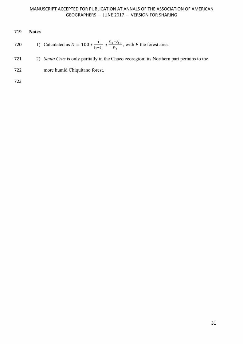
1) Calculated as 𝐷 = 100 ∗ &'()'*
∗ ,-(),-*,-*
, with 𝐹 the forest area. 720
2) Santa Cruz is only partially in the Chaco ecoregion; its Northern part pertains to the 721
more humid Chiquitano forest. 722
723
MANUSCRIPTACCEPTEDFORPUBLICATIONATANNALSOFTHEASSOCIATIONOFAMERICAN
GEOGRAPHERS—JUNE2017—VERSIONFORSHARING
32
Acknowledgements 724
This work has received support from the Gordon and Betty Moore Foundation (grant 725
agreement GBMF 426); the European Research Council (ERC) under the European 726
Union’s Horizon 2020 research and innovation program (grant agreement 677140 727
MIDLAND); the German Federal Ministry of Education and Research (BMBF, grant 728
agreement 031B0034A PASANOA); and the German Research Foundation (DFG, grant 729
agreement KU 2458/5-1). This paper contributes to the Global Land Programme, 730
www.glp.earth. We thank the Editor and four anonymous reviewers for their helpful 731
comments. 732
733
MANUSCRIPTACCEPTEDFORPUBLICATIONATANNALSOFTHEASSOCIATIONOFAMERICAN
GEOGRAPHERS—JUNE2017—VERSIONFORSHARING
33
References 734
Abel Gómez, C. 2014. Cuestión agraria y emergencia campesina. Las disputas por el acceso a 735la tierra en la provincia del Chaco, Argentina. Estudios sociológicos 30 (89):489–517. 736
Angelsen, A. 2010. Policies for reduced deforestation and their impact on agricultural 737production. Proceedings of the National Academy of Sciences of the United States of America 738107 (46):19639–19644. 739
Angelsen, A., and D. Kaimowitz eds. 2001. Agricultural Technologies and Tropical 740Deforestation. CABI Edition. 741
Artagaveytia, R. 2011. Paraíso ganadero: Paraguay, tierra de oportunidades. Estudio 3000. 742
Barbier, E. B. 2012. Scarcity, frontiers and development. Geographical Journal 178 (2):110–743122. 744
Baumann, M. et al. 2016. Carbon emissions from agricultural expansion and intensification in 745the Chaco. Global Change Biology. 746
Bessire, L. 2014. Behold the black caiman: A chronicle of Ayoreo life. University of Chicago 747Press. 748
Binswanger, H. P. 1991. Brazilian policies that encourage deforestation in the Amazon. World 749Development 19 (7):821–829. 750
Brannstrom, C. 2005. Environmental policy reform on north-eastern Brazil’s agricultural 751frontier. Geoforum 36:257–271. 752
———. 2009. South America’s neoliberal agricultural frontiers: places of environmental 753sacrifice or conservation opportunity? Ambio 38 (3):141–149. 754
Browder, J. O. et al. 2008. Revisiting Theories of Frontier Expansion in the Brazilian 755Amazon: A Survey of the Colonist Farming Population in Rondônia’s Post-Frontier, 1992-7562002. World Development 36 (8):1469–1492. 757
Browder, J. O., and B. . Godfrey. 1997. Rainforest Cities, Urbanization, Development and 758Globalization of the Brazilian Amazon. New York: Columbia University Press. 759
Brown, A. D., and L. R. Malizia. 2004. Las Selvas Pedemontanas de las Yungas. Ciencia Hoy 76014 (83):52–63. 761
Brusquetti, M. F., and A. Vasconsellos. 2006. Plan Nacional de la Carne. Asunción, 762Paraguay. 763
Cáceres, D. M. 2015. Accumulation by Dispossession and Socio-Environmental Conflicts 764Caused by the Expansion of Agribusiness in Argentina. Journal of Agrarian Change 15 765(1):116–147. 766
Caldas, M. et al. 2007. Theorizing land cover and land use change: The peasant economy of 767Amazonian deforestation. Annals of the Association of American Geographers 97 (1):86–110. 768
Caldas, M. M., D. Goodin, S. Sherwood, J. M. C. Krauer, et al. 2013. Land Cover Change in 769the Paraguayan Chaco: 2000-2011. Journal of Land Use Science (June 7702013):130614103019000. 771
Carr, D. L. 2004. Proximate population factors and deforestation in tropical agricultural 772frontiers. Population and Environment 25 (6):585–612. 773
Carr, D. L., A. C. Lopez, and R. E. Bilsborrow. 2010. The population, agriculture, and 774environment nexus in Latin America: Country-level evidence from the latter half of the 775
MANUSCRIPTACCEPTEDFORPUBLICATIONATANNALSOFTHEASSOCIATIONOFAMERICAN
GEOGRAPHERS—JUNE2017—VERSIONFORSHARING
34
twentieth century. Population and Environment 30 (6):222–246. 776
Casetti, E., and H. L. Gauthier. 1977. A formalization and test of the “hollow frontier” 777hypothesis. Economic Geography 53 (1):70–78. 778
Chatalova, L., D. Müller, V. Valentinov, and A. Balmann. 2016. The Rise of the Food Risk 779Society and the Changing Nature of the Technological Treadmill. Sustainability 8 (6):1–10. 780
Colque, G. 2014. Expansión de la frontera agrícola. La Paz, Bolivia: Fundación Tierra. 781
Delvenne, P., F. Vasen, and A. M. Vara. 2013. The “soy-ization” of Argentina: The dynamics 782of the “globalized” privatization regime in a peripheral context. Technology in Society 35 (2). 783
Empinotti, V. 2015. Beyond the dualities: a nuanced understanding of Brazilian soybean 784producers. Food Security 7 (6):1165–1174. http://dx.doi.org/10.1007/s12571-015-0504-3. 785
Farías, L. 2012. Experiencias exitosas de uruguayos en Paraguay estimulan a nuevos 786inversores. El Observador 1 June. http://www.elobservador.com.uy/experiencias-exitosas-787uruguayos-paraguay-estimulan-nuevos-inversores-n225245. 788
Foley, J. a et al. 2005. Global consequences of land use. Science 309 (5734):570–574. 789
Garrett, R. D., E. F. Lambin, and R. L. Naylor. 2013a. Land institutions and supply chain 790configurations as determinants of soybean planted area and yields in Brazil. Land Use Policy 79131:385–396. 792
———. 2013b. The new economic geography of land use change: Supply chain 793configurations and land use in the Brazilian Amazon. Land Use Policy 34:265–275. 794
Gasparri, N. I., and H. R. Grau. 2009. Deforestation and fragmentation of Chaco dry forest in 795NW Argentina (1972–2007). Forest Ecology and Management 258 (6):913–921. 796
Gasparri, N. I., H. R. Grau, and J. Gutiérrez Angonese. 2013. Linkages between soybean and 797neotropical deforestation : coupling and transient decoupling dynamics in a multi-decadal 798analysis. Global Environmental Change 23:1605–1614. 799
Gasparri, N. I., H. R. Grau, and L. V. Sacchi. 2015. Determinants of the spatial distribution of 800cultivated land in the North Argentine Dry Chaco in a multi-decadal study. Journal of Arid 801Environments 123:31–39. 802
Gereffi, G., J. Humphrey, and T. Sturgeon. 2005. The governance of global value chains. 803Review of International Political Economy 12 (1):78–104. 804
Glauser, M. 2009. Extranjerización del Territorio Paraguayo. Asunción, Paraguay: BASE IS. 805
Godar, J., E. J. Tizado, B. Pokorny, and J. Johnson. 2012. Typology and Characterization of 806Amazon Colonists: A Case Study Along the Transamazon Highway. Human Ecology :1–17. 807
Goldfarb, L., and G. van der Haar. 2015. The moving frontiers of genetically modified soy 808production: shifts in land control in the Argentinian Chaco. The Journal of Peasant Studies 43 809(2):1–22. 810
González, D. 2013. Uruguayos ya explotan el 12,5% de las tierras ganaderas en Paraguay. 811Última Hora 12 February. http://www.ultimahora.com/uruguayos-ya-explotan-el-125-las-812tierras-ganaderas-paraguay-n599977.html. 813
Gras, C., and V. Hernández. 2016. Radiografía del nuevo campo argentino: del terrateniente 814al empresario transnacional. Buenos Aires: Siglo XXI Editores. 815
Grau, H. R., N. I. Gasparri, and T. M. Aide. 2005. Agriculture expansion and deforestation in 816seasonally dry forests of north-west Argentina. Environmental Conservation 32 (2):140. 817
MANUSCRIPTACCEPTEDFORPUBLICATIONATANNALSOFTHEASSOCIATIONOFAMERICAN
GEOGRAPHERS—JUNE2017—VERSIONFORSHARING
35
Grugel, J., and P. Riggirozzi. 2012. Post-neoliberalism in Latin America: Rebuilding and 818Reclaiming the State after Crisis. Development and Change 43 (1):1–21. 819
Hecht, S. B. 1985. Environment, development and politics: Capital accumulation and the 820livestock sector in Eastern Amazonia. World Development 13 (6):663–684. 821
———. 2005. Soybeans, Development and Conservation on the Amazon Frontier. 822Development and Change 36 (2):375–404. 823
Hoyos, L. E. et al. 2013. Deforestation and precipitation patterns in the arid Chaco forests of 824central Argentina ed. G. Henebry. Applied Vegetation Science 16 (2):260–271. 825
Jepson, W., C. Brannstrom, and A. Filippi. 2010. Access Regimes and Regional Land Change 826in the Brazilian Cerrado, 1972–2002. Annals of the Association of American Geographers 100 827(1):87–111. 828
Jepson, W. E. 2006. Producing a modern agricultural frontier: Firms and cooperatives in 829eastern Mato Grosso, Brazil. Economic Geography 82 (3):289–316. 830
Jepson, W. E., C. Brannstrom, and A. Filippi. 2010. Access Regimes and Regional Land 831Change in the Brazilian Cerrado, 1972-2002. Annals of the Association of American 832Geographers 100 (1):87–111. 833
Kaimowitz, D., and J. Smith. 2001. Soybean technology and the loss of natural vegetation in 834Brazil and Bolivia. In Agricultural Technologies and Tropical Deforestation, eds. A. 835Angelsen and D. Kaimowitz, 195–212. Wallingford, Oxon, UK: CABI International. 836
Kaimowitz, D., G. Thiele, and P. Pacheco. 1999. The Effects of Structural Adjustment on 837Deforestation and Forest Degradation in Lowland Bolivia. World Development 27 (3). 838
Killeen, T. J. et al. 2008. Total Historical Land-Use Change in Eastern Bolivia: Who, Where, 839When, and How Much ? Ecology And Society 13 (1):36. 840
Klintowitz, J. 1995. O País pula a cerca. Veja :60–67. 841
De Koninck, R. 2000. The theory and practice of frontier development: Vietnam’s 842contribution. Asia Pacific Viewpoint 41 (1):7–21. 843
de L.T. Oliveira, G. 2013. Land Regularization in Brazil and the Global Land Grab. 844Development and Change 44 (2):261–283. 845
Levins, R. A., and W. W. Cochrane. 2010. The Treadmill Revisited. Land Economics 72 846(4):550–553. 847
Lorenzatti, S. 2007. Un Cordobés en Bolivia. Clarín. 848http://edant.clarin.com/suplementos/rural/2007/12/15/r-01564515.htm. 849
McKay, B., and G. Colque. 2015. Bolivia’s soy complex: the development of “productive 850exclusion.” The Journal of Peasant Studies 43 (2):583–610. 851
Miller, E. S. 2001. Peoples of the Gran Chaco. Greenwood Publishing Group. 852
Morello, J. H. 2005. Etapas de uso de los recursos y desmantelamiento de la biota del chaco. 853In Situación ambiental Argentina 2005, eds. A. D. Brown et al., 83–90. 854
Morello, J. H., W. Pengue, and A. F. Rodriguez. 2005. Un siglo de cambios de diseño del 855paisaje: el Chaco Argentino. In Primeras Jornadas Argentinas de Ecología del paisaje, 1–31. 856
Morini, G. 2011. Una fortuna hecha de favores fiscales. Página/12 14 February. 857https://www.pagina12.com.ar/diario/elpais/1-162319-2011-02-14.html (last accessed 7 June 8582017). 859
MANUSCRIPTACCEPTEDFORPUBLICATIONATANNALSOFTHEASSOCIATIONOFAMERICAN
GEOGRAPHERS—JUNE2017—VERSIONFORSHARING
36
Müller, R., D. M. Larrea-Alcázar, S. Cuéllar, and S. Espinoza. 2014. Causas directas de la 860deforestación reciente (2000-2010) y modelado de dos escenarios futuros en las tierras bajas 861de Bolivia. Ecología en Bolivia 49 (1):20–34. 862
Müller, R., D. Müller, F. Schierhorn, G. Gerold, et al. 2011. Proximate causes of deforestation 863in the Bolivian lowlands: an analysis of spatial dynamics. Regional Environmental Change 12 864(3):445–459. 865
Müller, R., P. Pacheco, and J. Montero. 2014. The context of deforestation and forest 866degradation in Bolivia: Drivers, agents and institutions. Bogor, Indonesia. 867
Muñoz, L. 2015. Grobocopatel: “Chaco está lleno de oportunidades y desafíos que requieren 868inversión” | Diario Norte Chaco. Diario Norte. 869
Nolte, C., Y. le Polain de Waroux, J. Munger, T. N. P. Reis, et al. 2017. Conditions 870influencing the adoption of effective anti-deforestation policies in South America’s 871commodity frontiers. Global Environmental Change (43):1–14. 872
Olson, D. M. et al. 2001. Terrestrial Ecoregions of the World: A New Map of Life on Earth. 873BioScience 51 (11):933. 874
Pacheco, P. 2012. Actor and frontier types in the Brazilian Amazon: Assessing interactions 875and outcomes associated with frontier expansion. Geoforum 43 (4):864–874. 876
———. 2009. Agrarian change, cattle ranching and deforestation: Assessing their linkages in 877southern Pará. Environment and History 15 (4):493–520. 878
———. 2006. Agricultural expansion and deforestation in lowland Bolivia: the import 879substitution versus the structural adjustment model. Land Use Policy 23 (3):205–225. 880
———. 2005. Populist and capitalist frontiers in the Amazon: diverging dynamics of agrarian 881and land-use change. 882
Paolasso, P., J. Krapovickas, and N. Gasparri. 2012. Deforestación, expansión agropecuaria y 883dinámica demográfica en el Chaco Seco Argentino durante la década de los noventa. Latin 884American Research Review 47 (1). 885
Pérez Luna, M. 2007. No todo grano que brilla es oro: un análisis de la soya en Bolivia ed. 886CEDLA. La Paz, Bolivia. 887
Piñeiro, D. 2012. Land grabbing : concentration and “foreignisation” of land in Uruguay. 888Canadian Journal of Development Studies/Revue canadienne d’études du développement 33 889(4):471–489. 890
le Polain de Waroux, Y., R. D. Garrett, R. Heilmayr, and E. F. Lambin. 2016. Land-use 891policies and corporate investments in agriculture in the Gran Chaco and Chiquitano. 892Proceedings of the National Academy of Sciences 113 (15):4021–4026. 893
Qaim, M., and G. Traxler. 2005. Roundup Ready soybeans in Argentina : farm level and 894aggregate welfare effects. Agricultural Economics 32:73–86. 895
Redo, D., A. C. Millington, and D. Hindery. 2011. Deforestation dynamics and policy 896changes in Bolivia’s post-neoliberal era. Land Use Policy 28 (1):227–241. 897
Reuters. 2005. Paraguay, sin aftosa. La Nación 20 January. 898http://www.lanacion.com.ar/672552-paraguay-sin-aftosa. 899
Richards, P. 2015. What Drives Indirect Land Use Change? How Brazil’s Agriculture Sector 900Influences Frontier Deforestation. Annals of the Association of American Geographers 105 901(5):1026–1040. 902
MANUSCRIPTACCEPTEDFORPUBLICATIONATANNALSOFTHEASSOCIATIONOFAMERICAN
GEOGRAPHERS—JUNE2017—VERSIONFORSHARING
37
Richards, P. D. 2012. Food, fuel, and the hidden margins of capital. Journal of Land Use 903Science 7 (3):289–310. 904
Rindfuss, R. R. et al. 2007. Frontier Land Use Change: Synthesis, Challenges, and Next 905Steps. Annals of the Association of American Geographers 97 (4):739–754. 906
Rodrigues, A. S. L. et al. 2009. Boom-and-bust development patterns across the Amazon 907deforestation frontier. Science 324 (5933):1435–7. 908
Rudel, T. K. 2007. Changing agents of deforestation: From state-initiated to enterprise driven 909processes, 1970-2000. Land Use Policy 24 (1):35–41. 910
Sacchi, L. V., and N. I. Gasparri. 2015. Impacts of the deforestation driven by agribusiness on 911urban population and economic activity in the Dry Chaco of Argentina. Journal of Land Use 912Science 4248 (October):1–17. 913
Schierhorn, F. et al. 2016. The dynamics of beef trade between Brazil and Russia and their 914environmental implications. Global Food Security :1–9. 915
di Tella, G. 1982. The Economics of the Frontier. In Economics in the Long View, eds. C. 916Kindleberger and G. di Tella, 210–27. Palgrave Macmillan UK. 917
Torres, R., N. I. Gasparri, P. G. Blendinger, and H. R. Grau. 2014. Land-use and land-cover 918effects on regional biodiversity distribution in a subtropical dry forest: a hierarchical 919integrative multi-taxa study. Regional Environmental Change 14 (4):1549–1561. 920
Urioste, M. 2012. Concentration and “foreignisation” of land in Bolivia. Canadian Journal of 921Development Studies/Revue canadienne d’études du développement 33 (4):439–457. 922
Vázquez, F. 2013. Geografía humana del Chaco paraguayo ADEPO. Asunción. 923
Velázquez, M. R. 2012. El 60% de frigoríficos exportadores son controlados por firmas 924brasileñas. ABC Color 27 November. http://www.abc.com.py/edicion-impresa/economia/el-92560-de-frigorificos-exportadores-son-controlados-por-firmas-brasilenas-482655.html. 926
Viglizzo, E. F. et al. 2011. Ecological and environmental footprint of 50 years of agricultural 927expansion in Argentina. Global Change Biology 17 (2):959–973. 928
Vivaldi, A. 2011. Stuck on a Muddy Road: Frictions of Mobility amongst Urban Toba in 929Northern Argentina. Identities: Global Studies in Culture and Power 18 (6):599–619. 930
Walker, R. et al. 2009. Ranching and the new global range: Amazônia in the 21st century. 931Geoforum 40 (5):732–745. 932
———. 2004. Theorizing Land-Cover and Land-Use Change: The Case of Tropical 933Deforestation. International Regional Science Review 27 (3):247–270. 934
Zak, M. R., M. Cabido, D. Cáceres, and S. Díaz. 2008. What drives accelerated land cover 935change in central Argentina? Synergistic consequences of climatic, socioeconomic, and 936technological factors. Environmental management 42 (2):181–9. 937
Zak, M. R., M. Cabido, and J. G. Hodgson. 2004. Do subtropical seasonal forests in the Gran 938Chaco, Argentina, have a future? Biological Conservation 120 (4):589–598. 939
Zoomers, A. 2003. Land liberalisation and sustainable development in Latin America: 940Unravelling the land sales market of Santa Cruz, Bolivia. International Development 941Planning Review 25 (3):245–262. 942
943
MANUSCRIPTACCEPTEDFORPUBLICATIONATANNALSOFTHEASSOCIATIONOFAMERICAN
GEOGRAPHERS—JUNE2017—VERSIONFORSHARING
38
Author Biographies: 944
945
YANN LE POLAIN DE WAROUX is a postdoctoral researcher at Stanford University, in the 946
United States. E-mail: [email protected]. His research addresses the relationship 947
between dynamics of land-use and land-cover change and processes of economic 948
globalization. 949
950
MATTHIAS BAUMANN is a postdoctoral researcher at Humboldt-Universität zu Berlin 951
(Humboldt University Berlin), in Germany. E-mail: [email protected]. His 952
research addresses land-use science-related questions, currently with a regional focus on 953
South America. Remote sensing and statistical modelling form the backbone of his work. 954
955
NESTOR IGNACIO GASPARRI is a researcher at the Consejo Nacional de Investigaciones 956
Científicas y Técnicas (National Scientific and Technical Research Council, CONICET) of 957
Argentina and a lecturer of landscape ecology at the Universidad Nacional de Tucumán 958
(National University of Tucumán), in Argentina. E-mail: [email protected]. His 959
research interests include contemporary deforestation frontiers and questions of carbon 960
balance related with forests and land use change. In particular, he studies soybean expansion 961
as driver of deforestation in the Gran Chaco region. 962
963
GREGORIO IGNACIO GAVIER-PIZARRO is a researcher at the Centro de Investigación de 964
Recursos Naturales (Center for Natural Resource Research, CIRN) and Instituto de Recursos 965
Biológicos (Institute for Biological Resources, IRB), of the Instituto Nacional de Tecnología 966
Agropecuaria (National Institute of Agrarian Technology , INTA), in Argentina. Email: 967
[email protected]. His research focuses on understanding the biodiversity response to 968
MANUSCRIPTACCEPTEDFORPUBLICATIONATANNALSOFTHEASSOCIATIONOFAMERICAN
GEOGRAPHERS—JUNE2017—VERSIONFORSHARING
39
human-related landscape changes, including agricultural expansion and forest loss and 969
fragmentation, exurban development, biological invasions and land use change. 970
971
JAVIER GODAR is a Senior Research Fellow at the Stockholm Environment Institute in 972
Stockholm, Sweden. E-mail: [email protected]. His primary research focus 973
is on transitions towards more sustainable land-use systems in the forested tropics, in 974
particular by mapping and understanding global trade flows and the risks associated to the 975
local production and trade of forest-risk commodities (e.g. soy, beef or palm oil). He is a co-976
founder of the Trase platform http://trase.earth/ 977
978
TOBIAS KUEMMERLE is Professor at the Department of Geography at Humboldt-979
Universität zu Berlin (Humboldt University Berlin), in Germany. E-mail: 980
[email protected]. His research focuses on understanding dynamics in land 981
systems, how these dynamics impact the environment, and how to balance human resource 982
use and environmental conservation. Regionally, he has recently focused on South America 983
and Eastern Europe. 984
985
ROBERT MÜLLER is a biologist and a geographer, working as an independent consultant in 986
Berlin, Germany. Email: [email protected]. His research interests include land use 987
change, biodiversity conservation and climate change, with a focus on South America. 988
989
JOSE VOLANTE is a National Project Coordinator at the Salta Experimental station of the 990
Instituto Nacional de Tecnología Agropecuaria (National Institute of Agrarian Technology, 991
INTA) in Salta, Argentina. E-mail: [email protected]. His research interests include 992
land use-cover changes and their impacts, particularly in the Argentine Chaco. 993
MANUSCRIPTACCEPTEDFORPUBLICATIONATANNALSOFTHEASSOCIATIONOFAMERICAN
GEOGRAPHERS—JUNE2017—VERSIONFORSHARING
40
994
FABRICIO VAZQUEZ is a lecturer at the National University of Asunción, Paraguay. E-995
mail: [email protected]. He researches regional economic development, 996
agricultural value chains and demographic processes in Paraguay. 997
998
PATRICK MEYFROIDT is Research Associate at the F.R.S.-FNRS, Brussels, Belgium, and 999
Professor in the Earth and Life Institute at Université catholique de Louvain, Louvain-La-1000
Neuve, Belgium. E-mail: [email protected]. His research interests include the 1001
causes of land use changes and the role of globalization in tropical landscapes. 1002
1003
1004
Figure Captions 1005
1006
Figure 1: Study area and main places mentioned in the paper. Administrative units (provinces, 1007
departments, states): BA = Buenos Aires; CA = Catamarca; CO = Córdoba; CH = Chaco; JU 1008
= Jujuy; FO = Formosa; MS = Mato Grosso do Sul; PR = Paraná ; SA = Salta; SC = Santa 1009
Cruz; SE = Santiago del Estero; SF = Santa Fe; SP = São Paulo; TU = Tucumán. “S.C. de la 1010
Sierra” is Santa Cruz de la Sierra, and “S.M. de Tucumán” is San Miguel de Tucumán. The 1011
Humid Pampas are indicated as one region from which multiple actors in the Chaco frontiers 1012
originate. 1013
Figure 2: Rents and dynamics of frontier expansion. A & C: Pre- and post-frontier equilibrium 1014
where bid rent equals economic rent, and the transition to uncultivated land (f) happens where 1015
rent is zero (assuming zero rent for uncultivated land). B: Frontier situation where the 1016
economic rent exceeds the bid rent, generating an “abnormal” rent and a frontier space F 1017
where expansion may happen. D: Rent curves under a scenario of technological innovation 1018
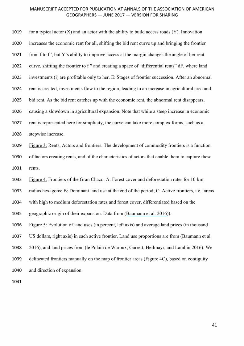
MANUSCRIPTACCEPTEDFORPUBLICATIONATANNALSOFTHEASSOCIATIONOFAMERICAN
GEOGRAPHERS—JUNE2017—VERSIONFORSHARING
41
for a typical actor (X) and an actor with the ability to build access roads (Y). Innovation 1019
increases the economic rent for all, shifting the bid rent curve up and bringing the frontier 1020
from f to f ′, but Y’s ability to improve access at the margin changes the angle of her rent 1021
curve, shifting the frontier to f ′′ and creating a space of “differential rents” dF, where land 1022
investments (i) are profitable only to her. E: Stages of frontier succession. After an abnormal 1023
rent is created, investments flow to the region, leading to an increase in agricultural area and 1024
bid rent. As the bid rent catches up with the economic rent, the abnormal rent disappears, 1025
causing a slowdown in agricultural expansion. Note that while a steep increase in economic 1026
rent is represented here for simplicity, the curve can take more complex forms, such as a 1027
stepwise increase. 1028
Figure 3: Rents, Actors and frontiers. The development of commodity frontiers is a function 1029
of factors creating rents, and of the characteristics of actors that enable them to capture these 1030
rents. 1031
Figure 4: Frontiers of the Gran Chaco. A: Forest cover and deforestation rates for 10-km 1032
radius hexagons; B: Dominant land use at the end of the period; C: Active frontiers, i.e., areas 1033
with high to medium deforestation rates and forest cover, differentiated based on the 1034
geographic origin of their expansion. Data from (Baumann et al. 2016)). 1035
Figure 5: Evolution of land uses (in percent, left axis) and average land prices (in thousand 1036
US dollars, right axis) in each active frontier. Land use proportions are from (Baumann et al. 1037
2016), and land prices from (le Polain de Waroux, Garrett, Heilmayr, and Lambin 2016). We 1038
delineated frontiers manually on the map of frontier areas (Figure 4C), based on contiguity 1039
and direction of expansion. 1040
1041
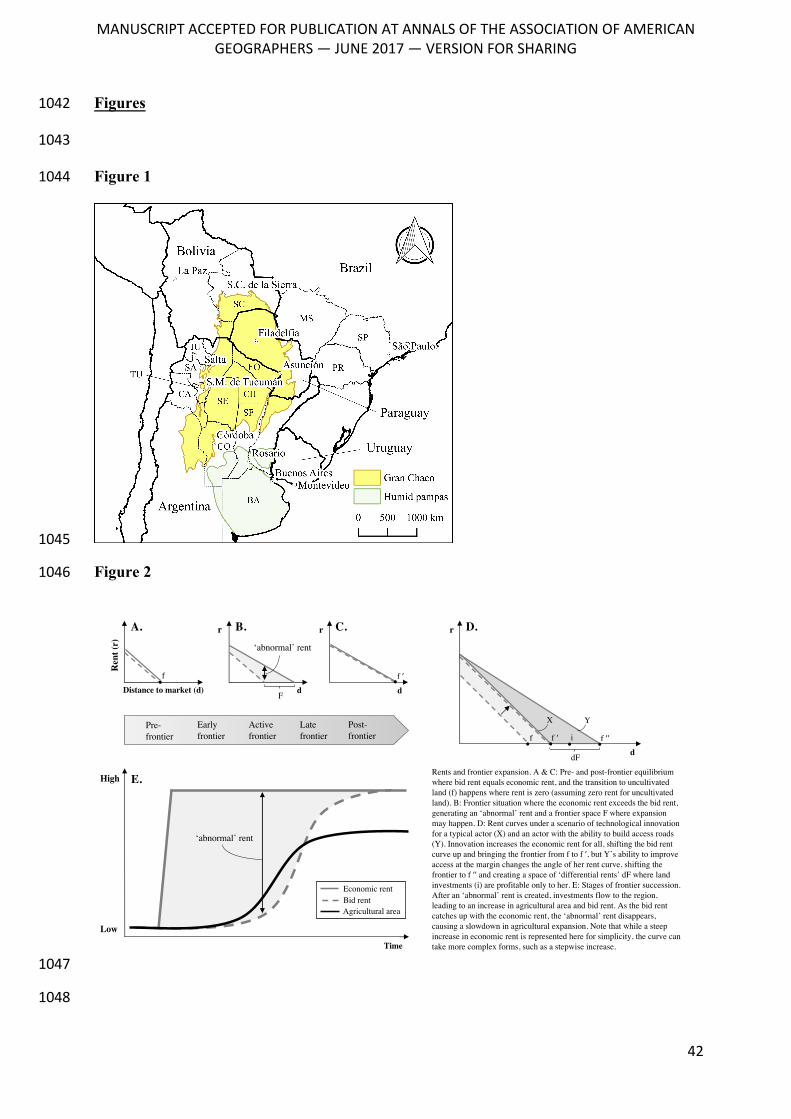
MANUSCRIPTACCEPTEDFORPUBLICATIONATANNALSOFTHEASSOCIATIONOFAMERICAN
GEOGRAPHERS—JUNE2017—VERSIONFORSHARING
42
Figures 1042
1043
Figure 1 1044
1045
Figure 2 1046
1047
1048
Distance to market (d)
Ren
t (r)
A.
d
B.r
f
d
C.r
f ′
F
Early frontier
Active frontier
Late frontier
Post-frontier
Pre-frontier
Time
High
Low
E.
‘abnormal’ rent
Economic rent
Agricultural areaBid rent
Rents and frontier expansion. A & C: Pre- and post-frontier equilibrium where bid rent equals economic rent, and the transition to uncultivated land (f) happens where rent is zero (assuming zero rent for uncultivated land). B: Frontier situation where the economic rent exceeds the bid rent, generating an ‘abnormal’ rent and a frontier space F where expansion may happen. D: Rent curves under a scenario of technological innovation for a typical actor (X) and an actor with the ability to build access roads (Y). Innovation increases the economic rent for all, shifting the bid rent curve up and bringing the frontier from f to f ′, but Y’s ability to improve access at the margin changes the angle of her rent curve, shifting the frontier to f ′′ and creating a space of ‘differential rents’ dF where land investments (i) are profitable only to her. E: Stages of frontier succession. After an ‘abnormal’ rent is created, investments flow to the region, leading to an increase in agricultural area and bid rent. As the bid rent catches up with the economic rent, the ‘abnormal’ rent disappears, causing a slowdown in agricultural expansion. Note that while a steep increase in economic rent is represented here for simplicity, the curve can take more complex forms, such as a stepwise increase.
f ′′f ′
dF
if
D.r
d
X Y
‘abnormal’ rent
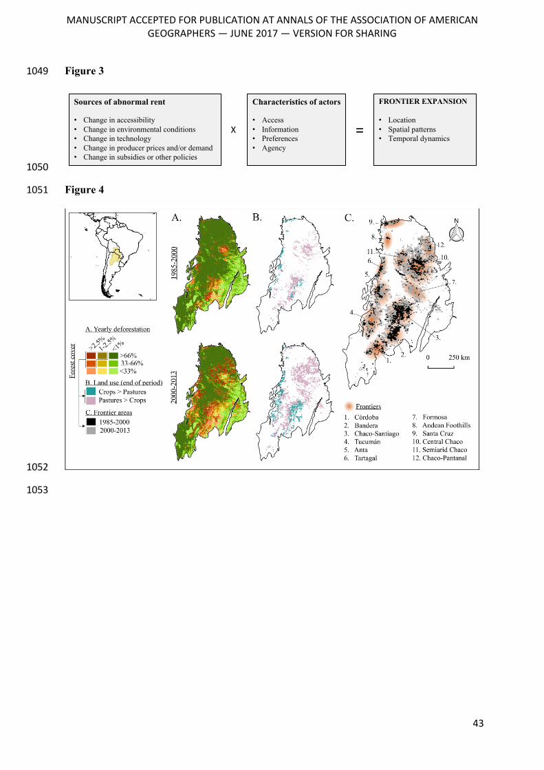
MANUSCRIPTACCEPTEDFORPUBLICATIONATANNALSOFTHEASSOCIATIONOFAMERICAN
GEOGRAPHERS—JUNE2017—VERSIONFORSHARING
43
Figure 3 1049
1050
Figure 4 1051
1052
1053
Sources of abnormal rent
• Change in accessibility• Change in environmental conditions• Change in technology• Change in producer prices and/or demand• Change in subsidies or other policies
Characteristics of actors
• Access• Information• Preferences• Agency
FRONTIER EXPANSION
• Location• Spatial patterns• Temporal dynamics
X =
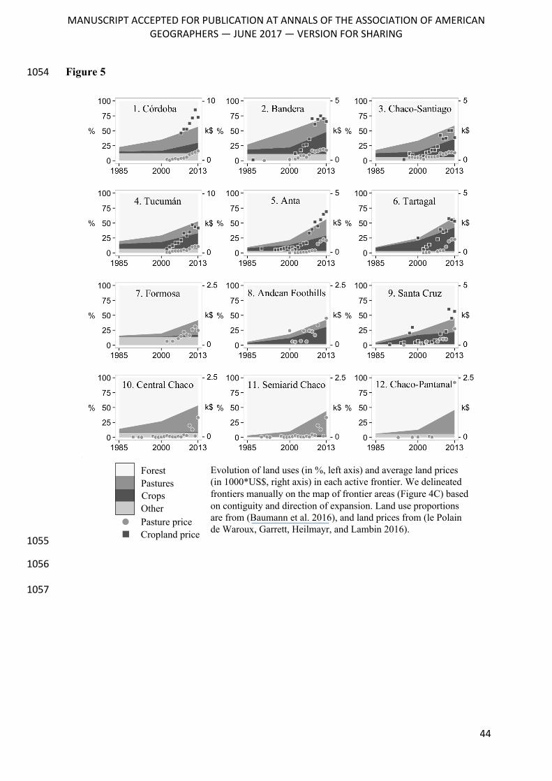
MANUSCRIPTACCEPTEDFORPUBLICATIONATANNALSOFTHEASSOCIATIONOFAMERICAN
GEOGRAPHERS—JUNE2017—VERSIONFORSHARING
44
Figure 5 1054
1055
1056
1057
k$
- 0
- 10
k$
- 0
- 5
k$
- 0
- 5
k$
- 0
- 5
k$
- 0
- 5
k$
- 0
- 2.5
k$
- 0
- 5
k$
- 0
- 2.5
k$
- 0
- 2.5
k$
- 0
- 10
k$
- 0
- 2.5
k$
- 0
- 2.5
1. Córdoba 2. Bandera 3. Chaco-Santiago
4. Tucumán
7. Formosa
10. Central Chaco
5. Anta
8. Andean Foothills
11. Semiarid Chaco
6. Tartagal
9. Santa Cruz
12. Chaco-Pantanal
Forest
CropsOther
Pastures
Pasture priceCropland price
Evolution of land uses (in %, left axis) and average land prices (in 1000*US$, right axis) in each active frontier. We delineated frontiers manually on the map of frontier areas (Figure 4C) based on contiguity and direction of expansion. Land use proportions are from (Baumann et al. 2016), and land prices from (le Polain de Waroux, Garrett, Heilmayr, and Lambin 2016).
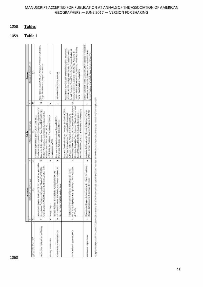
MANUSCRIPTACCEPTEDFORPUBLICATIONATANNALSOFTHEASSOCIATIONOFAMERICAN
GEOGRAPHERS—JUNE2017—VERSIONFORSHARING
45
Tables 1058
Table 1 1059
1060
#Af
filia
tions
of i
nter
view
ees
#Af
filia
tions
of i
nter
view
ees
#Af
filia
tions
of i
nter
view
ees
Agr
icul
tura
l pro
duce
rs*
46n.
a.37
n.a.
43n.
a.
Agr
icul
tura
l coo
pera
tives
and
lobb
ies
9A
soci
ació
n A
rgen
tina
de G
rupo
s CR
EA (A
AC
REA
), A
soci
ació
n A
rgen
tina
de P
rodu
ctor
es e
n Si
embr
a D
irect
a (A
APR
ESID
), G
rupo
Laj
itas,
PRO
GR
AN
O, S
ocie
dad
Rur
al A
rgen
tina
(SR
A)
10
Aso
ciac
ión
Bol
ivia
na d
e gr
upos
CR
EA (A
BC
REA
), A
soci
ació
n de
Pro
duct
ores
de
Ole
agin
osas
y tr
igo
(AN
APO
), Fe
dera
ción
de
Gan
ader
os d
e Sa
nta
Cru
z (F
EGA
SAC
RU
Z),
UN
ISO
YA
, Cám
ara
de E
xpor
tado
res (
CA
DEX
), In
stitu
to
Bol
ivia
no d
e C
omer
cio
Exte
rior (
IBC
E)
10A
soci
ació
n de
Gru
pos C
REA
de
Para
guay
, Coo
pera
tiva
Cho
rtitz
er,
Coo
pera
tiva
Fern
heim
, Coo
pera
tiva
Neu
land
Indu
stry
and
serv
ices
*8
Bun
ge, C
argi
ll3
AD
M-S
AO
, Aso
ciac
ión
de P
rove
edor
es d
e In
sum
os
Agr
opec
uario
s (A
PIA
)6
n.a.
Res
earc
h an
d ex
tens
ion
serv
ices
16In
stitu
to N
acio
nal d
e Te
cnol
ogía
Agr
opec
uaria
(IN
TA),
Uni
vers
idad
Nac
iona
l de
Cór
doba
, Uni
vers
idad
Nac
iona
l del
N
ores
te, U
nive
rsid
ad N
acio
nal d
e Sa
lta4
Cen
tro d
e In
vest
igac
ión
Agr
ícol
a Tr
opic
al (C
IAT)
, U
nive
rsid
ad A
uton
oma
Gab
riel R
ené
Mor
eno
2U
nive
rsid
ad N
acio
nal d
e A
sunc
ión
Soci
al a
nd e
nviro
nmen
tal N
GO
s3
Fund
apaz
, Mov
imie
nto
Cam
pesi
no d
e Sa
ntia
go d
el E
ster
o (M
OC
ASE
), Pr
oyun
gas,
Red
Agr
ofor
esta
l Cha
co A
rgen
tina
(RED
AF)
14
Cen
tro d
e Es
tudi
os Ju
rídic
os e
Inve
stig
ació
n So
cial
(CEJ
IS),
Cen
tro d
e In
vest
igac
ión
y Pr
omoc
ión
del C
ampe
sina
do
(CIP
CA
), Fu
ndac
ión
Am
igos
de
la N
atur
alez
a (F
AN
), Fu
ndac
ión
Nat
ura,
Fun
daci
ón p
ara
la C
onse
rvac
ión
del B
osqu
e C
hiqu
itano
, Fun
daci
ón T
ierr
a, M
useo
de
His
toria
Nat
ural
Noe
l K
empf
f Mer
cado
, PR
OB
IOM
A, S
ocie
dad
Bol
ivia
na d
e D
erec
ho A
mbi
enta
l (SB
DA
), W
orld
Wild
life
Fund
(WW
F)
12
Aso
ciac
ión
de S
ervi
cios
de
Coo
pera
ción
Indí
gena
- M
enno
nita
, (A
CSI
M),
BA
SE In
vest
igac
ione
s Soc
iale
s, Fu
ndac
ión
Moi
ses
Ber
toni
, Fun
daci
ón D
esde
lCha
co, G
uyra
Par
agua
y, In
stitu
to d
e D
erec
ho y
Eco
nom
ia A
mbi
enta
l (ID
EA),
Red
Par
agua
ya d
e C
onse
rvac
ión
en T
ierr
as P
rivad
as, W
ildlif
e C
onse
rvat
ion
Soci
ety
(WC
S) W
orld
Wild
life
Fund
(WW
F)
Gov
ernm
ent o
rgan
izat
ions
3D
irecc
ión
de B
osqu
es d
e la
pro
vinc
ia d
el C
haco
, Dire
cció
n de
B
osqu
es d
e la
pro
vinc
ia d
e Sa
ntia
go d
el E
ster
o3
Aut
orid
ad d
e Fi
scal
izac
ión
y C
ontro
l de
Bos
ques
y T
ierr
as
(AB
T); S
ervi
cio
Nac
iona
l de
Are
as P
rote
gida
s (SE
RN
AP)
7In
stitu
to F
ores
tal N
acio
nal (
INFO
NA
), M
unic
ipal
idad
de
Fila
delfi
a,
Gob
erna
ción
de
Boq
ueró
n, S
ecre
taria
del
Am
bien
te (S
EAM
), Se
rvic
io N
acio
nal d
e C
alid
ad y
Sal
ud A
nim
al (S
ENA
CSA
)
*) A
gric
ultu
ral p
rodu
cers
and
sm
all-s
cale
ser
vice
s co
mpa
nies
are
not
nam
ed fo
r pr
ivac
y re
ason
s; p
rodu
cers
who
als
o ha
ve in
dust
ry a
nd/o
r se
rvic
es a
ctiv
ities
are
cou
nted
onl
y on
ce a
s pr
oduc
ers
Argentina
Bolivia
Paraguay
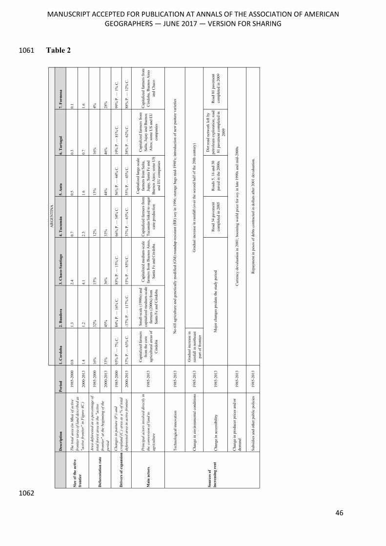
MANUSCRIPTACCEPTEDFORPUBLICATIONATANNALSOFTHEASSOCIATIONOFAMERICAN
GEOGRAPHERS—JUNE2017—VERSIONFORSHARING
46
Table 2 1061
1062
Des
crip
tion
Peri
od1.
Cor
doba
2. B
ande
ra3.
Cha
co-S
antia
go4.
Tuc
umán
5. A
nta
6. T
arta
gal
7. F
orm
osa
1985
-200
00.
81.
32.
40.
70.
50.
30.
1
2000
-201
31.
41.
24.
12.
31.
60.
71.
6
1985
-200
016
%32
%15
%12
%13
%16
%4%
2000
-201
333
%45
%36
%33
%44
%46
%28
%
1985
-200
093
% P
. — 7
% C
.84
% P
. — 1
6% C
.85
% P
. — 1
5% C
.66
% P
. — 3
4% C
.56
% P
. — 4
4% C
.19
% P
. — 8
1% C
.99
% P
. — 1
% C
.
2000
-201
337
% P
. — 6
3% C
.-1
7% P
. — 1
17%
C.
15%
P. —
85%
C.
37%
P. —
63%
C.
55%
P. —
45%
C.
38%
P. —
62%
C.
88%
P. —
12%
C.
Mai
n ac
tors
Prin
cipa
l act
ors
invo
lved
dir
ectly
in
the
conv
ersi
on o
f lan
d to
ag
ricu
lture
1985
-201
3
Cap
italiz
ed fa
rmer
s fr
om th
e co
re
agric
ultu
ral a
reas
of
Cór
doba
Smal
l-sca
le (1
990s
) and
ca
pita
lized
med
ium
-sca
le
farm
ers
(200
0s) f
rom
Sa
nta
Fe a
nd C
órdo
ba
Cap
italiz
ed m
ediu
m-s
cale
fa
rmer
s fr
om B
ueno
s A
ires,
Sa
nta
Fe a
nd C
órdo
ba
Cap
italiz
ed fa
rmer
s fr
om
Tucu
mán
link
ed to
sug
ar
cane
pro
duct
ion
Cap
italiz
ed la
rge-
scal
e fa
rmer
s fr
om S
alta
, Ju
juy,
San
ta F
e an
d B
ueno
s A
ires;
som
e U
S an
d EU
com
pani
es
Cap
italiz
ed fa
rmer
s fr
om
Salta
, Juj
uy a
nd B
ueno
s A
ires;
som
e U
S an
d EU
co
mpa
nies
Cap
italiz
ed fa
rmer
s fr
om
Cór
doba
, Bue
nos
Aire
s an
d C
haco
Tech
nolo
gica
l inn
ovat
ion
1985
-201
3
Cha
nge
in e
nviro
nmen
tal c
ondi
tions
1985
-201
3G
radu
al in
crea
se in
ra
infa
ll in
nor
thea
st
part
of fr
ontie
r
Cha
nge
in a
cces
sibi
lity
1985
-201
3R
oad
34 p
avem
ent
com
plet
ed in
200
5R
oads
5, 1
6 an
d 30
pa
ved
in th
e 20
00s
Dirt
road
net
wor
k le
ft by
pe
trole
um e
xplo
ratio
n; ro
ad
81 p
avem
ent c
ompl
eted
in
2009
Roa
d 81
pav
emen
t co
mpl
eted
in 2
009
Cha
nge
in p
rodu
cer p
rices
and
/or
dem
and
1985
-201
3
Subs
idie
s an
d ot
her p
ublic
pol
icie
s19
85-2
013
Sour
ces
of
incr
easi
ng r
ent
No-
till a
gric
ultu
re a
nd g
enet
ical
ly m
odifi
ed (G
M) r
ound
up-r
esis
tant
(RR
) soy
in 1
996;
sto
rage
bag
s m
id-1
990'
s; in
trodu
ctio
n of
new
pas
ture
var
ietie
s
Cur
renc
y de
valu
atio
n in
200
1; b
oom
ing
wor
ld p
rice
for s
oy in
late
199
0s a
nd m
id-2
000s
Rep
aym
ent i
n pe
sos
of d
ebts
con
tract
ed in
dol
lars
afte
r 200
1 de
valu
atio
n.
Maj
or c
hang
es p
reda
te th
e st
udy
perio
d
Gra
dual
incr
ease
in ra
infa
ll (o
ver t
he s
econ
d ha
lf of
the
20th
cen
tury
)
AR
GEN
TIN
A
Dri
vers
of e
xpan
sion
Size
of t
he a
ctiv
e fr
ontie
r
The
tota
l are
a (in
Mha
) of a
ctiv
e fr
ontie
r (a
rea
of la
nd d
escr
ibed
as
"act
ive
fron
tier"
in F
igur
e 4C
.)
Cha
nges
in p
astu
re (P
.) an
d cr
opla
nd (C
.) ar
ea a
s a
% o
f tot
al
defo
rest
ed a
rea
in a
ctiv
e fr
ontie
r
Def
ores
tatio
n ra
te
Area
def
ores
ted
as a
per
cent
age
of
tota
l for
est a
rea
in th
e "a
ctiv
e fr
ontie
r" a
t the
beg
inni
ng o
f the
pe
riod
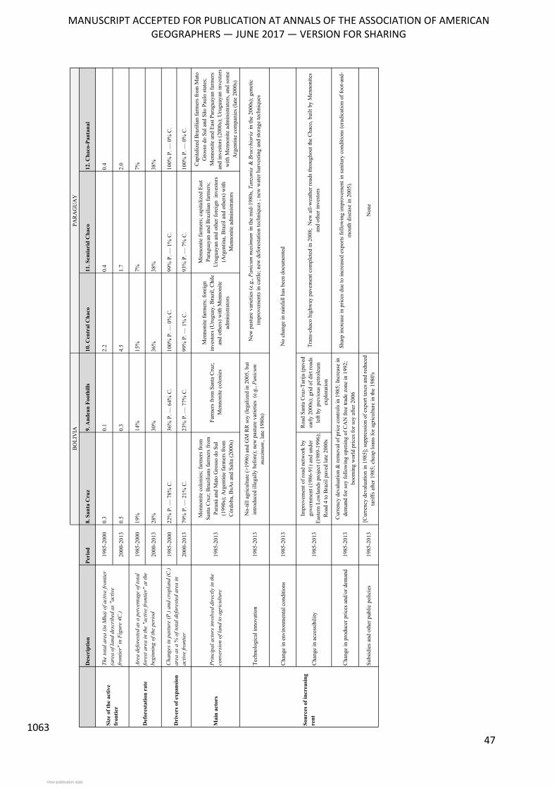
MANUSCRIPTACCEPTEDFORPUBLICATIONATANNALSOFTHEASSOCIATIONOFAMERICAN
GEOGRAPHERS—JUNE2017—VERSIONFORSHARING
47 1063
Des
crip
tion
Peri
od8.
San
ta C
ruz
9. A
ndea
n Fo
othi
lls10
. Cen
tral
Cha
co11
. Sem
iari
d C
haco
12. C
haco
-Pan
tana
l
1985
-200
00.
30.
12.
20.
40.
4
2000
-201
30.
50.
34.
51.
72.
0
1985
-200
019
%14
%15
%7%
7%
2000
-201
328
%30
%36
%38
%38
%
1985
-200
022
% P
. — 7
8% C
.36
% P
. — 6
4% C
.10
0% P
. — 0
% C
.99
% P
. — 1
% C
.10
0% P
. — 0
% C
.
2000
-201
379
% P
. — 2
1% C
.23
% P
. — 7
7% C
.99
% P
. — 1
% C
.93
% P
. — 7
% C
.10
0% P
. — 0
% C
.
Mai
n ac
tors
Prin
cipa
l act
ors
invo
lved
dir
ectly
in th
e co
nver
sion
of l
and
to a
gric
ultu
re19
85-2
013
Men
noni
te c
olon
ies;
farm
ers f
rom
Sa
nta
Cru
z; B
razi
lians
farm
ers f
rom
Pa
raná
and
Mat
o G
ross
o do
Sul
(1
990s
); A
rgen
tine
farm
ers f
rom
C
órdo
ba, B
sAs a
nd S
alta
(200
0s)
Farm
ers f
rom
San
ta C
ruz;
M
enno
nite
col
onie
s
Men
noni
te fa
rmer
s; fo
reig
n in
vest
ors (
Uru
guay
, Bra
zil,
Chi
le
and
othe
rs) w
ith M
enno
nite
ad
min
istra
tors
Men
noni
te fa
rmer
s; c
apita
lized
Eas
t Pa
ragu
ayan
and
Bra
zilia
n fa
rmer
s;
Uru
guay
an a
nd o
ther
fore
ign
inve
stor
s (A
rgen
tina,
Bra
zil a
nd o
ther
s) w
ith
Men
noni
te a
dmin
istra
tors
Cap
italiz
ed B
razi
lian
farm
ers f
rom
Mat
o G
ross
o do
Sul
and
São
Pau
lo st
ates
; M
enno
nite
and
Eas
t Par
agua
yan
farm
ers
and
inve
stor
s (20
00s)
; Uru
guay
an in
vest
ors
with
Men
noni
te a
dmin
istra
tors
, and
som
e A
rgen
tine
com
pani
es (l
ate
2000
s)
Tech
nolo
gica
l inn
ovat
ion
1985
-201
3
Cha
nge
in e
nviro
nmen
tal c
ondi
tions
1985
-201
3
Cha
nge
in a
cces
sibi
lity
1985
-201
3
Impr
ovem
ent o
f roa
d ne
twor
k by
go
vern
men
t (19
86-9
1) a
nd u
nder
Ea
ster
n Lo
wla
nds p
roje
ct (1
989-
1996
); R
oad
4 to
Bra
zil p
aved
late
200
0s
Roa
d Sa
nta
Cru
z-Ta
rija
(pav
ed
early
200
0s);
grid
of d
irt ro
ads
left
by p
revi
ous p
etro
leum
ex
plor
atio
n
Cha
nge
in p
rodu
cer p
rices
and
/or d
eman
d19
85-2
013
Subs
idie
s and
oth
er p
ublic
pol
icie
s19
85-2
013
No-
till a
gric
ultu
re (>
1996
) and
GM
RR
soy
(lega
lized
in 2
005,
but
in
trodu
ced
illeg
ally
bef
ore)
; new
pas
ture
var
ietie
s (e
.g.,
Pani
cum
m
axim
um, l
ate
1980
s)
New
pas
ture
var
ietie
s (e.
g., P
anic
um m
axim
um in
the
mid
-198
0s, T
anza
nia
& B
racc
hiar
ia in
the
2000
s); g
enet
ic
impr
ovem
ents
in c
attle
; new
def
ores
tatio
n te
chni
ques
; ne
w w
ater
har
vest
ing
and
stor
age
tech
niqu
es
No
chan
ge in
rain
fall
has b
een
docu
men
ted
Tran
s-ch
aco
high
way
pav
emen
t com
plet
ed in
200
8; N
ew a
ll-w
eath
er ro
ads t
hrou
ghou
t the
Cha
co, b
uilt
by M
enno
nite
s an
d ot
her i
nves
tors
Cur
renc
y de
valu
atio
n &
rem
oval
of p
rice
cont
rols
in 1
985;
Incr
ease
in
dem
and
for s
oy fo
llow
ing
open
ing
of C
AN
free
trad
e zo
ne in
199
2;
boom
ing
wor
ld p
rices
for s
oy a
fter 2
006
Shar
p in
crea
se in
pric
es d
ue to
incr
ease
d ex
ports
follo
win
g im
prov
emen
t in
sani
tary
con
ditio
ns (e
radi
catio
n of
foot
-and
-m
outh
dis
ease
in 2
005)
.
[Cur
renc
y de
valu
atio
n in
198
5]; s
uppr
essi
on o
f exp
ort t
axes
and
redu
ced
tarif
fs a
fter 1
985;
che
ap lo
ans f
or a
gric
ultu
re in
the
1980
's N
one
Sour
ces
of in
crea
sing
re
nt
PAR
AG
UA
YB
OLI
VIA
Size
of t
he a
ctiv
e fr
ontie
r
The
tota
l are
a (in
Mha
) of a
ctiv
e fr
ontie
r (a
rea
of la
nd d
escr
ibed
as
"act
ive
fron
tier"
in F
igur
e 4C
.)
Dri
vers
of e
xpan
sion
Cha
nges
in p
astu
re (P
.) an
d cr
opla
nd (C
.) ar
ea a
s a
% o
f tot
al d
efor
este
d ar
ea in
ac
tive
fron
tier
Def
ores
tatio
n ra
teAr
ea d
efor
este
d as
a p
erce
ntag
e of
tota
l fo
rest
are
a in
the
"act
ive
fron
tier"
at t
he
begi
nnin
g of
the
peri
od
View publication statsView publication stats