Embed Size (px)
Citation preview

REMOTeVIEW
®
™

A Trusted NameOver the past 15 years, RemoteView software has evolved from an imagery analysis product into a complete solution for national, command, and tactical analysts. RemoteView Pro software is the preferred solution, used by over 12,000 imagery and GEOINT analysts within the US Defense and Intelligence community for the import, viewing, analysis, and reporting of national and commercial remote sensing data. Broad CapabilitiesRemoteView Pro is the core geospatial solution, able to be used for commercial and civil analysis, ecosystem monitoring, urban planning, and management of disaster relief. Optional extensions expand the power of the RemoteView product, allowing customization to meet unique requirements. Overwatch offers a restricted NTM Module that contains additional capabilities developed to serve the needs of the intelligence community.
An Efficient WorkflowRemoteView software combines high-speed processing chain technology with a carefully refined user interface to enhance workflow and boost productivity on the largest images, videos, and data sets. The interface is easy to control across all capability levels, minimizing both procurement costs and training requirements as functional needs change.
The Standard for AccuracyRemoteView software obtains advanced geopositioning accuracy through rigorous sensor models such the Com-munity Sensor Model (CSM). An automatic terrain elevation capability references all data "to the ground" and warning indicators inform analysts on the quality of the positioning data. The additional NTM Module includes CGS for precision positioning and highly accurate mensuration tools such as MSP.
Continual InnovationOverwatch has been leading the industry’s evolution with advanced solutions. RemoteView software efficiently processes extremely large images, vectors, and associated metadata. This enables analysts to create real-time, multi-terabyte mosaics and perform complex geospatial processing such as orthorectification, multispectral clas-sification, epipolar resampling, and pan sharpening “on the fly.”
THE #1 GEOSPATIAL ANALYSIS TOOL FOR INTELLIGENCE EXPLOITATION
Version 3.2.2 Highlights
•High performance, flicker free roam for Windows® 7
•New ImageStack workflow for viewing time-sequenced imagery
•Updated to support MSP 1.1.3
•Updated to support CGS 2.3.3
• Improved Virtual Mosaic interface and workflow
•GeoCatalog now supports cataloging of DPPDB data sets

COMPREHENSIVE IMAGERY ANALYSIS & GEOSPATIAL EXPLOITATION CAPABILITIES
Imagery Analysis Geospatial Analysis Enhanced Functionality Power ExtensionsProcesses All National & Most Commercial Imagery 3D Terrain Visualization Common Geo-Positioning Services (NTM Module)* Virtual Mosaic
· Use LIDAR data as an elevation source · Supports version 2.3.3 · Supports unlimited images and 100+ GB mosaics Over 30 Image Formats Supported · View terrain draped over elevation data in 3D · DPPDB Stand Alone (DSA) monoscopic positioning · Wizard-based mosaic creation
· Elevation and volume calculation · NTM, Panchromatic and SAR, registered to DPPDB (NRD) · Virtual, ortho-mosaic, and map projection options
Complete Work Folder Architecture · Real-time, interactive 3D navigation · Two-to-four ray Multi-Image Geopositioning (MIG) · Drag-and-Drop mosaic building from RemoteView folder
· Ground path and flight path creation · DPPDB for height reference in Single Image Geopositioning · Dynamic Range Control (Sharpen, Brightness, Contrast) Image Quality and Enhancement · Capture flight path as AVI video file · Height offset tools for measuring targets not on the ground · Auto or manual image alignment options· Contrast, Brightness, ICA Sharpening, and Haze controls · Stereo support · Automatic image location based on target requirements · Rapid virtual mosaic creation· Magnify region of interest w/o obscuring original image · 2D Slope visualization tool · User customizable output integrated into same workflow · Rapid mosaic navigation· Dynamic Range Adjustment · 2D Colorized elevation · Automatic determination of missed point picks · Create search patterns in Overview or Main Viewer windows· ICA Tonal Transfer Curves · 2D Field of View · Apply pre-defined search patterns as Shapefiles· Bicubic & Lagrange Resampling · 2D Landing Zone Tool for aerial vehicle landing sites RVPinPoint · Overlay image data on mosaic option· Dual head support · Positioning tool with rigorous error propagation · Hide individual images or outlines· Mask creation using pixel threshold values GIS & Vector Integration · Wizard-based source image collection · Create broad or directed area search patterns· Review multiple images simultaneously in a grid pattern · Vector Import, Display, Creation and Editing · Works with unclassified commercial imagery
· Display, edit, and create in Shapefile format RVConnectImage Mosaic and Search · Vector query capabilities – spatial and attribute based Video Analysis (V-TRAC Basic Extension)* · Real-time RemoteView/ArcGIS interoperability· Automatic Mosaic Creation using up to four images · Vector cleaning tool – snap/clip to specified tolerance · Play video files leveraging intuitive player · Sharing of vector layers and raster images· Virtual Mosaics · Attribute table auto-populate tool · Tag video files for marking areas of interest · Synchronized viewers and navigation · Map Projected, processed Mosaics · Polygon joining/splitting tools · Adjust video brightness and contrast in real-time · Load/edit Esri Geodatabases directly into RemoteView· Virtual Mosaic Editor · Union, Intersect, XOR, Subtraction, Partition, Convex Hull · Ability to zoom, adjust rotation, and pan through videos · Sharing of feature attribute modifications and changes · Broad Area Searching · Track video flight path over a 2D or 3D map or image · Automated orthorectification of images to ArcGIS· Directed Area Searching Multi-Spectral Analysis · Apply annotations to video frames within RemoteView· Geo-Jump location finding · Multispectral Classification Wizard · Organize mission sets 3D Pro
· Overview window · Supervised classification · View large LIDAR point cloud data sets
· Import training sets from vector files MASINT (NTM Module)* · Night vision scene simulationChange Detection · Unsupervised classification · AGITK · Filter and adjust LIDAR point cloud attributes· Side-by-side comparison · Thresholding, Multiple-rules · AGP “Smart Loading” · Flight simulation with Heads-Up-Display· Geographic and feature based alignment of images · Signature Editor · Building Extrusions from Shapefiles· Color multiview · Statistics, Histograms Production & Productivity Support · 3D Threat Domes and Buffer Zones· Flicker · Image Calculator NDVI, TSI, Tasseled Cap · Templates for report generation · 3D View Shed/Line-of-Sight (LOS) Analysis· Colorized difference · Edge Detection, Filtering, Sharpening, Smoothing · Custom sorting of folder contents · 3D Text Annotations· Blend · Pan-sharpening with auto-registration · Bookmark display configuration for images · Supports industry standard 3D formats
· Compose individual images into multispectral images · Hyperlinks to images, maps, and websites · Displays 3D Geo-specific modelsPhotogrammetry · Softcopy georeferencing support · Edit and import 3D models in Google SketchUp· Geo data confidence indicator Mapping, Charting, Geodesy · Comprehensive graphics support · Create 3D walls· Elevation coverage warning and display · OGC Support · Diagnostic Tools · Extended 3D model library with auto population tool· Precision Positioning - Web Map Service (WMS) · Geographical graphics layers · 3D Interactive Measuring Tools· Mensuration Tools - Web Coverage Service (WCS) · SPIA Tag support and editor · 3D Interactive Landing Zone Tool· Orthorectification and Orthocalibration · Georeferencing · Individual and batch R-set generation · Google Earth Support· Block Adjustment (Triangulation) · Scale bar and grid lines · Image chipping · Save specific viewpoints for later review· Rigorous Orbview® and QuickBird sensor models · Orientation aids · Chip to Google Earth, PDF, or PowerPoint · Capture the image to publish in reports and presentations· Community Sensor Model (CSM) interface · Robust symbology pallet · Counting tool · Export image with all 3D data to 3D-enabled PDF· Image-to-Image and Image-to-Reference calibration · Graphics and text annotation · Dimensioned graphics· Stereo Viewing · North Arrow Design Tool · Capture user activity to a WMV or AVI movie file V-TRAC Pro*· On-the-fly epipolar resampling · Datum conversions · Capture live video streams· Complete end-to-end processing and production tools · Full set of USGS Map projections GeoCatalog · Navigate live streams using forward, reverse, pause· Position Quality Assessment (PQA) tool · Rapid access to and management of geospatial data · Tag, clip, and annotate frames in real-time
Map Composer · SQL Server and Oracle support · Annotate with common shape graphic editorStereo Viewing · Save and reload map compositions · Federated access to additional external data sources · Generate reports using integrated Report Editor· Stereo pair shutter mode display · Save and reuse standardized map layouts · Rapid video segmenting, cataloging, and retrieval · Automatically populate reports with metadata· Synthesize and view anaglyph/pseudo stereo pair · Orthorectify to precise map scales · Single query access to diverse collections of geospatial data · Export reports to PowerPoint or PDF
· Precise placement of composition elements · Highly configurable and flexible Multi-Band Analysis Display (MAD) · Automatic map elements: scale bars, scale text, etc. · Customized query templates GeoPDF· Simultaneous display of up to sixteen band combinations · Advanced graphical alignment · Dynamic database modification · Publish georeferenced imagery/annotations as GeoPDF· Synchronized/individual panning and histogram adjustment · Precise element placing · Supports DPPDB data sets· Configurable band combinations, band formula, and layout · Large and small hardcopy output· Templates for quick generation of MAD compositions · Multi-Page Output Google Earth Collaboration· Image histogram manipulation · Save as Image: TIFF, JPEG, NITF, BMP, PNG
· Multiple geo-locked images Javascript® API Integration
*The NTM Module is restricted only to qualified customers. Both the NTM Module and V-TRAC software extension are controlled on the USML and whose export or re-export is subject to the U.S. International Traffic in Arms Regulations (22 CFR 120-130) and will require a license issued by the U.S. Department of State.
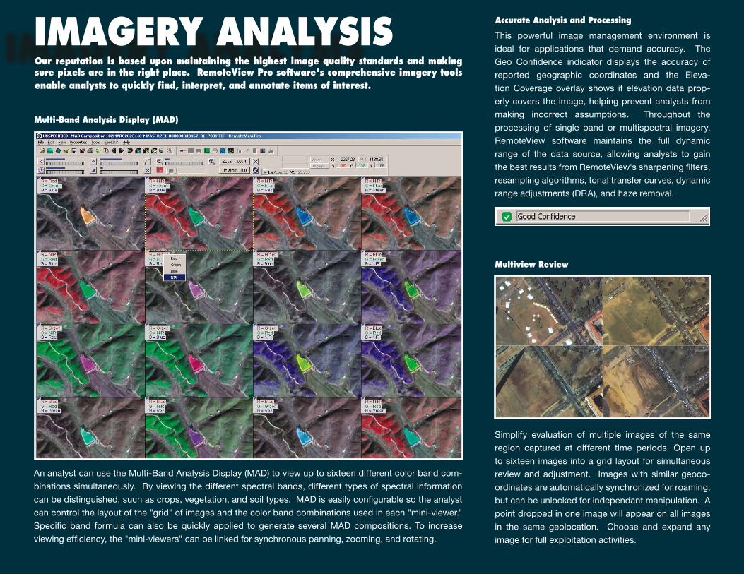
This powerful image management environment is
ideal for applications that demand accuracy. The
Geo Confidence indicator displays the accuracy of
reported geographic coordinates and the Eleva-
tion Coverage overlay shows if elevation data prop-
erly covers the image, helping prevent analysts from
making incorrect assumptions. Throughout the
processing of single band or multispectral imagery,
RemoteView software maintains the full dynamic
range of the data source, allowing analysts to gain
the best results from RemoteView's sharpening filters,
resampling algorithms, tonal transfer curves, dynamic
range adjustments (DRA), and haze removal.
An analyst can use the Multi-Band Analysis Display (MAD) to view up to sixteen different color band com-
binations simultaneously. By viewing the different spectral bands, different types of spectral information
can be distinguished, such as crops, vegetation, and soil types. MAD is easily configurable so the analyst
can control the layout of the "grid" of images and the color band combinations used in each "mini-viewer."
Specific band formula can also be quickly applied to generate several MAD compositions. To increase
viewing efficiency, the "mini-viewers" can be linked for synchronous panning, zooming, and rotating.
Simplify evaluation of multiple images of the same
region captured at different time periods. Open up
to sixteen images into a grid layout for simultaneous
review and adjustment. Images with similar geoco-
ordinates are automatically synchronized for roaming,
but can be unlocked for independant manipulation. A
point dropped in one image will appear on all images
in the same geolocation. Choose and expand any
image for full exploitation activities.
IMAGERY ANALYSIS Our reputation is based upon maintaining the highest image quality standards and making sure pixels are in the right place. RemoteView Pro software's comprehensive imagery tools enable analysts to quickly find, interpret, and annotate items of interest.
Multiview Review
Multi-Band Analysis Display (MAD)
Accurate Analysis and Processing

The ImageStack toolset upgrades the software's
Image Comparison and Research & Negation (R&N)
capabilities into one unified interface for reviewing
multiple time-sequenced images. It's now easier to
open a series of images, order them as you desire,
and then play through the images to view changes
over time for the same location. Use custom sort and
alignment tools to further adjust the images and refine
the comparison.
ImageStack Time Sequenced Imagery Automated Change Detection
RemoteView software contains a powerful tool for au-
tomated change detection. A pair of time-sequenced
images is aligned using either georegistration informa-
tion or corresponding features. Differences are then
color coded, providing the analyst with quick visual
cues as to any changes.
Pan Sharpening
Pan Sharpening allows analysts to select one of several algorithms to add natural appearing color to high-resolu-
tion panchromatic images. RemoteView's selection of available algorithms includes Projective Pan-sharpening.
Movement across the image is optimized for smooth
roam performance. Analysts can search imagery
along features such as roads, power lines, waterways,
pipelines, and automatically jump from one point fea-
ture to another; or automatically limit the search by an
aerial feature boundary.
Advanced Roaming, Autoreview, and Search

GEOSPATIAL ANALYSIS
An analyst desiring a better understanding of the landscape is able to drape an image over elevation data and
create a 3D perspective view. The analyst can interactively navigate in real-time over the land, pre-program
flight paths, and capture flight paths as AVI video files.
3D Terrain Visualization
Users can generate hardcopy image-based map products directly from annotated imagery using the Map
Composer. It offers composition tools such as map grids, scale bars, north arrows, and map projection. The
analyst can create custom templates saving hours of effort when new imagery becomes available. These
professional and accurate map products are useful for displaying, training, briefings, situational awareness,
and mission planning.
Modern sensors collect data from wide ranging spectra, including panchromatic, color, infrared, multispectral,
hyperspectral, and radar. Analysts need tools to fully process this data, not just display a few bands on the
screen. RemoteView software fills the need with both supervised and unsupervised image classification wizards.
This allows analysts to find certain signatures in an image based on an object's reflectance without undergoing
months of training. RemoteView also uses classic algorithms for vegetation analysis and delineation of land
and water boundaries.
Multi and Hyperspectral Processing
Map Composer Tool
RemoteView software enables analysts to enhance their imagery to gain perspective through a wide variety of geospatial tools such as vectorized layers, 3D visualization, and high resolution LIDAR point clouds. These capabilities are essential for enhanced mission planning support.
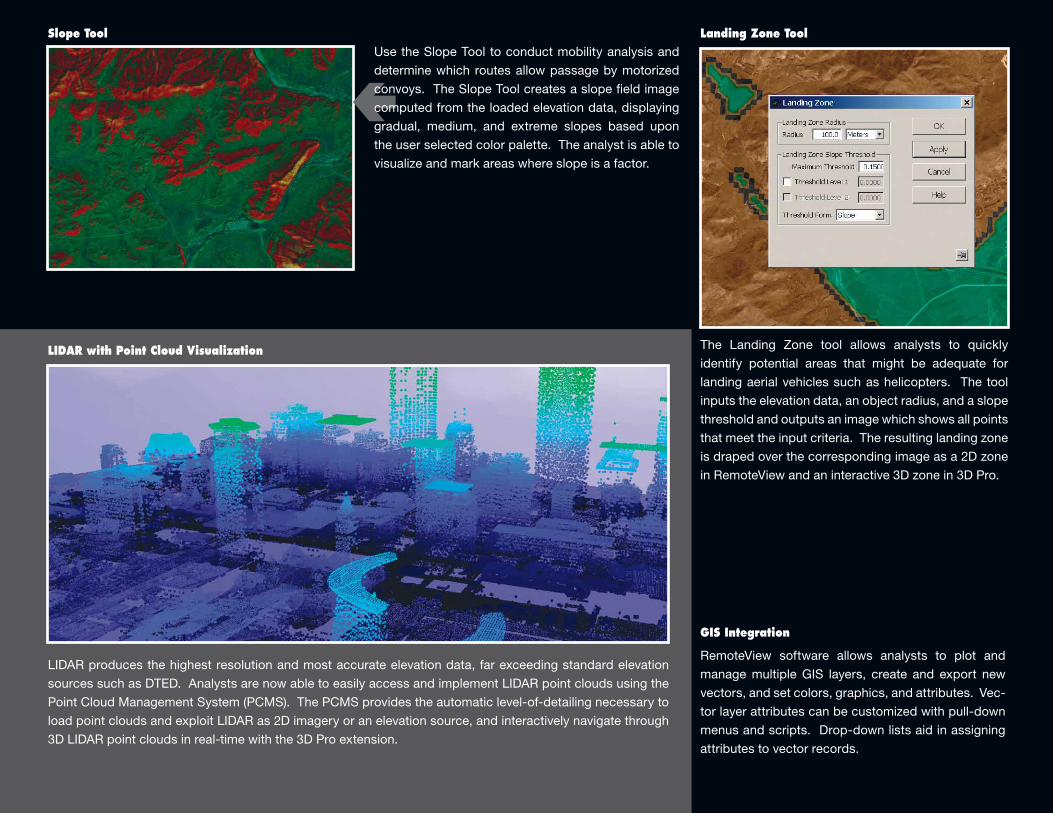
The Landing Zone tool allows analysts to quickly
identify potential areas that might be adequate for
landing aerial vehicles such as helicopters. The tool
inputs the elevation data, an object radius, and a slope
threshold and outputs an image which shows all points
that meet the input criteria. The resulting landing zone
is draped over the corresponding image as a 2D zone
in RemoteView and an interactive 3D zone in 3D Pro.
GEOSPATIAL ANALYSIS
LIDAR produces the highest resolution and most accurate elevation data, far exceeding standard elevation
sources such as DTED. Analysts are now able to easily access and implement LIDAR point clouds using the
Point Cloud Management System (PCMS). The PCMS provides the automatic level-of-detailing necessary to
load point clouds and exploit LIDAR as 2D imagery or an elevation source, and interactively navigate through
3D LIDAR point clouds in real-time with the 3D Pro extension.
Slope Tool
LIDAR with Point Cloud Visualization
Landing Zone ToolUse the Slope Tool to conduct mobility analysis and
determine which routes allow passage by motorized
convoys. The Slope Tool creates a slope field image
computed from the loaded elevation data, displaying
gradual, medium, and extreme slopes based upon
the user selected color palette. The analyst is able to
visualize and mark areas where slope is a factor.
RemoteView software allows analysts to plot and
manage multiple GIS layers, create and export new
vectors, and set colors, graphics, and attributes. Vec-
tor layer attributes can be customized with pull-down
menus and scripts. Drop-down lists aid in assigning
attributes to vector records.
GIS Integration

Publish geospatial products in commonly accessible
formats such as PDF, Google Earth®, and Power
Point®. RemoteView's standard PDF Publishing
feature includes predefined and custom templates,
but geospatial metadata is not saved as part of the
publication process. Users can purchase the Geo-
PDF® extension to add TerraGo® GeoPDF production
capabilities to RemoteView.
The GeoPDF extension facilitates convenient pub-
lishing of geo-referenced content from RemoteView
to a PDF file, which may then be accessed through
standard Adobe® Reader software using the free
TerraGo Toolbar™. TerraGo's geospatial collaboration
software is among the most widely adopted solutions
for sharing geospatial information. Geo-PDF maps
and imagery generated from RemoteView software
include all annotations and are easily used by intel-
ligence analysts, military personnel, and individuals
with little or no GIS experience.
Achieve precision positioning through the use of
Common Geopositioning Services (CGS). RemoteView
Pro software with the NTM Module supports CGS
2.3.3 point mensuration, so RemoteView users have
the most precise coordinates available from imagery.
A simple configuration file is used during CGS
installation to set any site-specific options such
as Digital Point Positioning Data Base (DPPDB) or
Digital Terrain Elevation Data (DTED). A convenient
wizard interface guides the user through all of the
steps required to utilize CGS.
(Note: The NTM Module is restricted only to qualified
customers and is not available with the international
version of RemoteView. The NTM Module is controlled
on the USML and the export or re-export is subject to
the U.S. International Traffic in Arms Regulations [22
CFR 120 - 130] and will require a license issued by the
U.S. Department of State.)
Publishing Tools and the GeoPDF® Extension Common Geopositioning Service
ENHANCED FUNCTIONALITYIn order to support front-line operations, analysts must provide accurate information in a timely manner. RemoteView software includes tools that speed productivity, broaden the type of images and data that can be analyzed, and achieve precision positioning.
®
Custom Folder Sorting
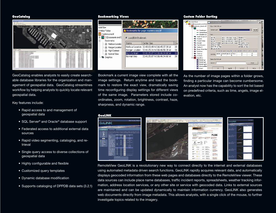
As the number of image pages within a folder grows,
finding a particular image can become cumbersome.
An analyst now has the capability to sort the list based
on predefined criteria, such as time, angels, image el-
evation, etc.
Bookmark a current image view complete with all the
image settings. Return anytime and load the book-
mark to restore the exact view, dramatically saving
time reconfiguring display settings for different views
of the same image. Parameters stored include co-
ordinates, zoom, rotation, brightness, contrast, haze,
sharpness, and dynamic range.
Bookmarking Views
GeoCatalog enables analysts to easily create search-
able database libraries for the organization and man-
agement of geospatial data. GeoCatalog streamlines
workflow by helping analysts to quickly locate relevant
geospatial data.
Key features include:
• Rapidaccesstoandmanagementof geospatial data
• SQLServer® and Oracle® database support
• Federatedaccesstoadditionalexternaldatasources
• Rapidvideosegmenting,cataloging,andre-trieval
• Singlequeryaccesstodiversecollectionsofgeospatial data
• Highlyconfigurableandflexible
• Customizedquerytemplates
• Dynamicdatabasemodification
• SupportscatalogingofDPPDBdatasets(3.2.1)
GeoCatalog
RemoteView GeoLINK is a revolutionary new way to connect directly to the internet and external databases
using automated metadata driven search functions. GeoLINK rapidly acquires relevant data, and automatically
displays geocoded information from these web pages and databases directly to the RemoteView viewer. These
data sources can include place name databases, traffic incident reports, spreadsheets, weather tracking infor-
mation, address location services, or any other site or service with geocoded data. Links to external sources
are maintained and can be updated dynamically to maintain information currency. GeoLINK also generates
web documents directly from image metadata. This allows analysts, with a single click of the mouse, to further
investigate topics related to the imagery.
GeoLINK

RemoteView’s Virtual Mosaic extension streamlines the process of building extremely large-scale virtual mosa-ics from national level and high-resolution commercial imagery. Virtual Mosaic is ideal for broad area search applications or anytime a large area context is required for imagery analysis. Virtual mosaics require no prepro-cessing steps or conversion of images to proprietary formats.
An intuitive GUI that works with a sophisticated catalog application is included as a new standard feature in RemoteView Pro. The catalog allows users to search for relevant imagery and apply filters to limit the selected files by geographic area, cloud coverage, NIIRS ratings, sensor type, date acquired, and a host of other selec-tion criteria.
In addition to making virtual mosaics the application also allows the creation of processed products, which are finished orthorectified mosaics that can be saved and printed. These finished mosaics also make an ideal backdrop for larger Shape files.
VIRTUAL MOSAIC
RVCONNECTThe RVConnect extension offers geospatial intelligence
analysts real-time interoperability between RemoteView
and Esri’s ArcGIS®, the widely used GIS software. RV-
Connect links the two applications together so data and
workflow is shared across both applications. By synchro-
nizing image and feature data, analysts can leverage the
strength of each tool and become much more efficient.
Key features include:
• Loadortho-rectifiedimageryintoArcGISon-the-flyviathe Image Service
• Simultaneous sharing and synchronizedmodificationof vector layers and raster images
• Synchronized navigation between RemoteView andArcGIS
• Load ESRI Geodatabase feature classes into
RemoteView
The Virtual Mosaic extension streamlines the process of building extremely large-scale virtual mosaics from
individual high-resolution images. Virtual Mosaic is ideal for broad area search applications or anytime a large
area context is required for imagery analysis. Finished mosaics make an ideal Shapefile backdrop.
Key features include:
•Supportsunlimitedimagesandmosaicsuptohundredsofgigabytesinsize
•InterfaceswithRemoteView’sGeoCatalogfordesktoptosearchandfilterrelevantimagery
•Doesnotrequireimagepre-processingorconversionintoproprietaryformats
•Allowscreationofprocessedproducts(finishedorthorectifiedmosaicsthatcanbesavedandprinted)
POWER EXTENSIONSOur optional extensions expand the power of RemoteView Pro software, allowing ana-lysts to choose from a selection of enhanced tools to augment their analytical capability.
Assembling the World's Largest Puzzles
Speeding Efficiency and Collaboration
011011100100011011010 0 101101101010110101000 1 1 01011100110110101000 1 0 0
1 1 1 01000110110101001111 1 0 101011010100011110101 0 1 10110101000011011010
™
extensions
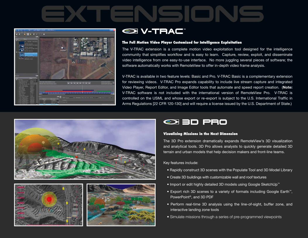
The 3D Pro extension dramatically expands RemoteView’s 3D visualization
and analytical tools. 3D Pro allows analysts to quickly generate detailed 3D
terrain and urban models that help decision makers and front-line teams.
Key features include:
•Rapidlyconstruct3DsceneswiththePopulateTooland3DModelLibrary
•Create3Dbuildingswithcustomizablewallandrooftextures
•Importoredithighlydetailed3DmodelsusingGoogleSketchUp™
•Export rich3Dscenes toavarietyof formats includingGoogleEarth™,
PowerPoint®, and 3D PDF
• Perform real-time 3D analysis using the line-of-sight, buffer zone, and
interactive landing zone tools
• Simulate missions through a series of pre-programmed viewpoints
Visualizing Missions in the Next Dimension
3D Pro
The Full Motion Video Player Customized for Intelligence Exploitation
™
The V-TRAC extension is a complete motion video exploitation tool designed for the intelligence
community that simplifies workflow and is easy to learn. Capture, review, exploit, and disseminate
video intelligence from one easy-to-use interface. No more juggling several pieces of software; the
software automatically works with RemoteView to offer in-depth video frame analysis.
V-TRAC is available in two feature levels: Basic and Pro. V-TRAC Basic is a complementary extension
for reviewing videos. V-TRAC Pro expands capability to include live stream capture and integrated
Video Player, Report Editor, and Image Editor tools that automate and speed report creation. (Note: V-TRAC software is not included with the international version of RemoteView Pro. V-TRAC is
controlled on the USML and whose export or re-export is subject to the U.S. International Traffic in
Arms Regulations [22 CFR 120-130] and will require a license issued by the U.S. Department of State.)
Overwatch Systems, Ltd.21660 Ridgetop CircleSuite 110Sterling, VA 20166(800) 937-6881RV 5/2012
© 2012 Overwatch Systems, Ltd. All rights reserved. Overwatch is a strategic business of Textron Systems Advanced Systems, an operating unit of Textron Systems, a Textron Inc. (NYSE: TXT) company. RemoteView, V-TRAC, and RVConnect are tradmarks of Overwatch Systems, Ltd. Google Earth and SketchUp are trademarks of Google, Inc. Windows, PowerPoint, and SQL Server are registered trademarks of Microsoft Corporation. Oracle and Javascript are registered trademarks of Oracle Corporation. TerraGo Toolbar is a trademark and GeoPDF is a registered trademark of TerraGo Technologies, Inc. ArcGIS is a registered trademark of Esri. Orbview is a registered trademark of GeoEye Imagery Collection Systems Inc. Adobe is a registered trademark of Adobe Systems Incorporated. Satellite imagery courtesy of GeoEye, DigitalGlobe, and Intermap.
www.overwatch.com