Embed Size (px)
Citation preview
Page1 February 28, 2015 Division of Planning and Local Assistance Office of Transportation Planning
RELINQUISHMENT ASSESSMENT REPORT For State Route 187 relinquishment within the City of Los Angeles and Culver City
DISTRICT 7
FEBRUARY 28, 2015
Prepared by
Office of Transportation Planning Division of Planning and Local Assistance District 7, Department of Transportation
Page2 February 28, 2015 Division of Planning and Local Assistance Office of Transportation Planning
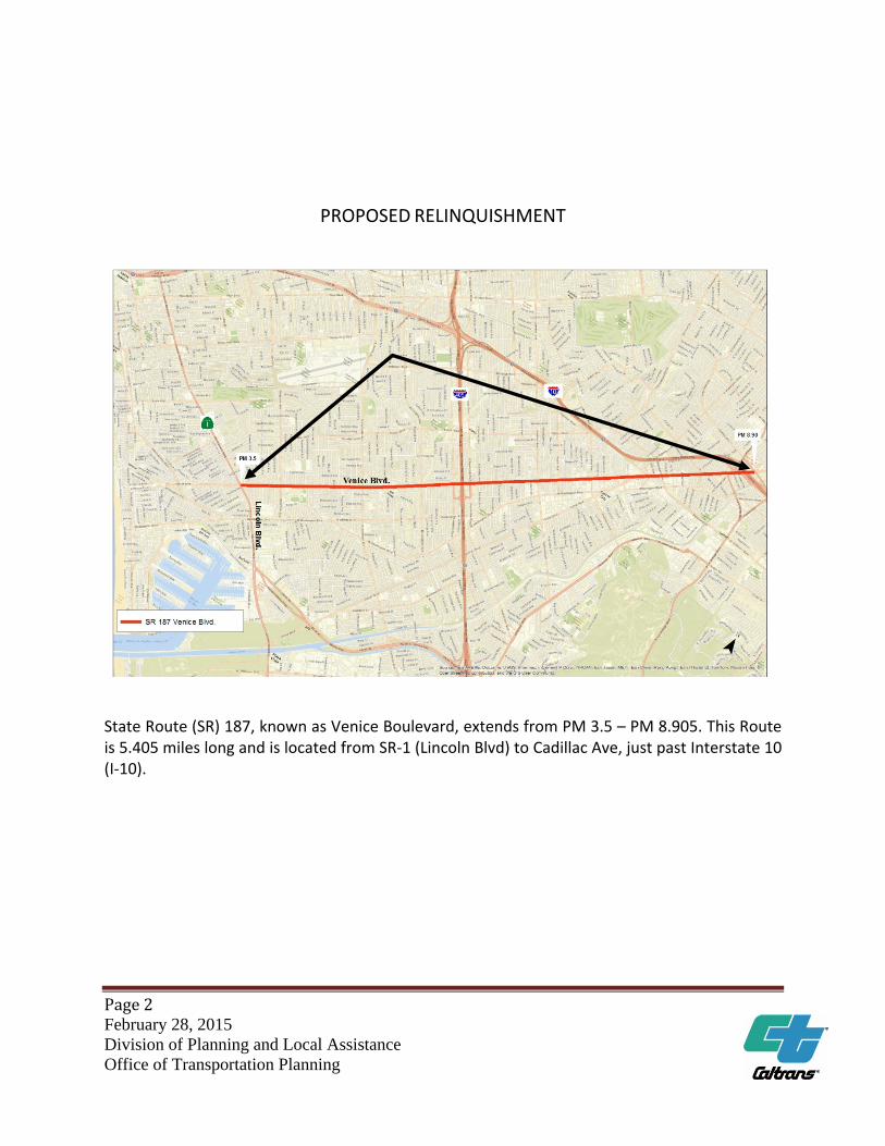
PROPOSED RELINQUISHMENT
State Route (SR) 187, known as Venice Boulevard, extends from PM 3.5 – PM 8.905. This Route is 5.405 miles long and is located from SR‐1 (Lincoln Blvd) to Cadillac Ave, just past Interstate 10 (I‐10).
Page3 February 28, 2015 Division of Planning and Local Assistance Office of Transportation Planning
Disclaimer: The information and data contained in this document are for planning purposes only and should not be relied upon for final design of any project. Any information in this Relinquishment Assessment Report (RAR) is subject to modification as conditions change and new information is obtained. Although planning information is dynamic and continually changing, the District 07 Transportation Planning Office makes every effort to ensure the accuracy and timeliness of the information contained in the RAR. The information in the RAR does not constitute a standard, or regulation, nor is it intended to address design policies and procedures.
California Department of Transportation
Provide a safe, sustainable, integrated and efficient transportation system to enhance California’s economy and livability.
Page5 February 28, 2015 Division of Planning and Local Assistance Office of Transportation Planning
TABLE OF CONTENTS
Page
Title Page...................................................................................................................... 1 Signature Sheet.............................................................................................................4 Table of Contents..........................................................................................................5 Elements of the State Route Relinquishment Assessment Report.............................6
1. Description of Route and Basis of Request for Relinquishment................................6 2. Route or Corridor Concept and Recommendations for Route Development..............10 3. District coordination with RTPA’s................................................................................ 19 4. Coordination with State, Federal, and Tribal Plans and Programs...............................21 5. Internal District Coordination.......................................................................................23 6. Map and Photos........................................................................................................... 24
Page6 February 28, 2015 Division of Planning and Local Assistance Office of Transportation Planning
Elements of the State Route Relinquishment Assessment Report The information provided below should be used by the District and the System Planning Branch in Headquarters to determine whether there is a State Highway System need to retain state ownership of the highway or whether the facility is appropriate for relinquishment. Both the state route RAR and the park and ride lot RAR have six elements to help describe and document the relinquishment. Within each element are various actions that help describe each element. For example, element 1 of a state route relinquishment has five actions which are indicated by the letters A‐E. This information is the basis of the RAR Template.
1. Description of Route and Basis of Request for Relinquishment
A. Action: provide county, route‐number, post miles, functional classification, and other designations such as Surface Transportation Assistance Act (STAA) truck terminal access route, Interregional Road System (IRRS), or other designations as applicable.
County, Route, Post Mile and Location Description
County of Los Angeles, Venice Boulevard, also known as State Route 187 (SR‐187), from Post Mile (PM) 3.5 – PM 8.905. SR‐187 is 5.405 miles long and is located from SR‐1 (Lincoln Blvd) to Cadillac Ave, just past Interstate 10 (I‐10) within the City of Los Angeles. Except for a small segment from approximately Bledsoe Ave. (PM 5.6) to Overland Ave. (PM 6.6), that shares City of Los Angeles boundaries with the city limits of Culver City inside SR‐187 right of way. SR‐187 is a 6‐ lane conventional highway type.
Route Classification Functional classification: The Functional Classification system,
implemented by the Federal government in 1976 to help states and their DOT’s for many years as a management tool in a variety of areas pertaining to highways. Federal, State, and local government use this tool to assign jurisdictional responsibility, allocate funds, and establish appropriate design standards for roadways.
The Functional Classification of SR‐187 is “Other Principal Arterial” in its
entirety.
Page7 February 28, 2015 Division of Planning and Local Assistance Office of Transportation Planning
Route designations:
SR‐ 187 is federally designated as a Terminal Access Route Surface Transportation Assistance Act (STAA), which allows large trucks to operate on State routes.
SR‐187 is not in the IRRS, and it is not a part of the Freeway and Expressway System.
B. Action: Demonstrate that the District has identified the route or route segment as a
relinquishment candidate in the District System Management Plan (DSMP), Transportation Concept Report (TCR), and/or other district planning documents
SR‐ 187 is included in the Two Tier System Report as part of the Secondary system. The District concurs with this designation; SR‐187 is predominantly used for local use, as evidenced by its traffic use patterns.
The most recent, April 1991, TCR proposed this route to be relinquished.
C. Action: Evaluate if the segment proposed is in fact between two logical termini and identify any issues with the proposed limits of the relinquishment. Indicate how identified issues will be addressed. Examples of issues with logical termini are relinquishments that will create a stub route, terminate in mid block or intersection, a break in extra legal truck route, etcetera.
SR‐187 proposed relinquishment is within two logical termini – From SR‐1 (Lincoln Ave.) to I‐10. No issues are identified. The Route’s primary function is for local use, the relinquishment will not impact its traffic use patterns.
A small segment of SR‐187, approximately from Bledsoe Ave. (PM 5.6) to Overland Ave. (PM 6.6), shares City of Los Angeles boundaries with the city limits of Culver City inside SR‐187 right of way.
Ultimately, District 7 intends to relinquish all the Secondary System segments, including SR‐187 within Los Angeles County. Due to the authority given and limitations by legislation, plus the challenges of multi‐jurisdictional agreements and commitments, it is a general practice to legislatively relinquish route segments in a piece‐meal fashion. Though the relinquishment of entire State Highway Route to the local jurisdiction is not occurring simultaneously, this approach would ensure that the relinquishment occurs at the earliest time possible, and avoid the potential of delay or rescission of relinquishment project.
Page 8
February 28, 2015
Division of Planning and Local Assistance
Office of Transportation Planning
D. Action: Describe the basis of the request for the relinquishment and identify local
jurisdiction(s) requesting it. Indicate why the city or county does not want the state route designation. Explain the issues and history including request for encroachment permits and issues with approving or denying requests. Include district/local jurisdiction local development discussions, comments, and issues. Document context sensitive solutions efforts and what could and could not be resolved under state ownership of the route. Explain how the relinquishment benefits local planning and community design and circulation considerations.
The City of Los Angeles requested the relinquishment in an effort to better meet the needs of and directly serve its community. The City’s interest in pursuing the relinquishment is primarily for the flexibility in making future improvements to the corridor. The relinquishment of SR-187 will allow the City of Los Angeles to expedite proposed improvements and maintenance without going through the encroachment permit process, reducing delays. Currently, the City of Los Angeles is planning for a complete street concept project. The relinquishment would allow more for flexibility and resources to expedite this proposed improvement.
The City of Culver City has not formally expressed interest in pursuing relinquishment of SR-187 within its city limits. However, Culver City has been made aware of the proposed improvement project planned by the City of Los Angeles. The City of Culver City is supportive of the proposed improvement. The City of Los Angeles staff will further coordinate with the City of Culver City regarding the proposed improvement and relinquishment of SR-187 within their city Limits.
Currently, there are a number of permits that are issued to private owners, government agencies, utility companies, etc. -one to be noted, is the permit issued to the City of Los Angeles, under permit number 713-NUK-1039 to excavate four pits for depth of 12 to 25 feet and to excavate a section of Venice Blvd to place/push a 60” sewer line from Kelton Ave. to Overland Ave.
City of Los Angeles has recently updated their General Plan’s Transportation Element (Mobility Plan), which is consistent with the State’s Complete Streets policies and Smart Mobility Framework. Due to the urbanized nature of this route, right-of-way is highly constrained, and the City’s potential improvements to enhance mobility options along SR-187 (to be consistent with Complete Streets policies) may not be possible if the City must adhere to State’s design criteria. By relinquishing the roadway to the local agency, proposed
Page9 February 28, 2015 Division of Planning and Local Assistance Office of Transportation Planning
improvements to bicycle, pedestrian, and transit modes may become more viable.
The IGR Branch has no objections to the proposed relinquishment of SR‐187. No significant changes to the transportation/circulation system are anticipated as the result of the proposed relinquishment. No major local development projects in the vicinity of SR‐187 have been reviewed by the IGR Branch.
E. Action: Identify the status of the route in the local agencies “circulation element” of the general plan and any currently applicable local planning studies or community initiatives that may impact the request.
There are no known conflicts with the City’s General Plan and Circulation Element as a result of relinquishing SR‐187 in the City of Los Angeles. The relinquishment would benefit the local agency’s planning process with an opportunity to adopt context sensitive solutions, complete streets, community design elements and incorporate local values. The relinquishment is consistent with Caltrans goal to relinquish the entire route.
The relinquishment is not expected to change the status of the route in the City’s Circulation Element or in the City’s General Plan. There are no current local planning studies or community initiatives that would negatively impact the relinquishment.
The City of Los Angeles identifies SR‐187 (Venice Boulevard) as a Divided Major Class II highway. The selection criteria for this designation are:
Major highways (Class II) should typically be located one mile apart in a
grid system. 30,000 to 50,000 ADT
Performance Criteria: Three travel lanes in each direction during peak hours+ left turn lanes
at signalized intersections. 2400 vph in each direction during peak hours.
Page10 February 28, 2015 Division of Planning and Local Assistance Office of Transportation Planning
2. Route or Corridor Concept and Recommendations for Route Development
A. Action: Identify the route development or relinquishment recommendation in the most recent District TCR, District System Management Plan (DSMP), or other applicable internal reports or studies.
The April 1991 TCR proposed this route to be relinquished.
B. Action: Describe current and projected future traffic and components of the traffic stream (5‐plus axle trucks) for the route, as it exists on the State Highway System and any system restrictions for large trucks. Identify how this is forecasted to change based on the relinquishment.
Truck data from the 2012 AADT for SR‐187 ranges from 40,000 at SR‐1 (Lincoln Blvd) to 70,000 at Route 405. The truck AADT at Lincoln Blvd. is 1323, or 3.31 percent of AADT. Of
these, 84.4 percent are 2 axle, 9.83 are 3 axle, 3.03 are 4 axle, and 2.74 are 5 axle.
At Route 405, the truck AADT is 1771, or 2.53 percent of AADT. Of these, 84.54 percent are 2 axle, 9.6 percent are 3 axle, 1.67 percent are 4‐axle, and 4.19 are 5 axle.
No significant changes to the current or future highway and circulation system would be anticipated as a result of the relinquishment.
No truck restriction is currently imposed on this segment of SR‐187. There is no known plan to restrict truck access by the City of Los Angeles upon the relinquishment.
C. Action: Identify the primary origins and destinations for travel on the route segment in
terms of interregional and major regional trips and sub area functions that may impact relinquishment considerations, for example, connectivity to a regional mall, a regional area industrial park, regional airport, and other functions.
SR‐187 (Venice Boulevard), serves the neighborhoods of Palms, Venice and Mar Vista in West Los Angeles, as well as the City of Culver City.
Page11 February 28, 2015 Division of Planning and Local Assistance Office of Transportation Planning
Trip generators on State Route 187 include: Venice High School Mark Twain Middle School The Actors’ Gang Theater The Culver City Station for the Expo Light Rail Line The Helms Bakery Building (shops and restaurants) The Museum of Jurassic Technology The Mar Vista Branch Public Library Culver City Gospel Hall Hare Krishna Temple And a variety of restaurants and small businesses
Trip generators near State Route 187 include: Culver Studios Sony Pictures The Culver Hotel (a National Historic Landmark) The Pacific Ocean Marina Del Rey Venice Beach (and the Venice Boardwalk) The Ballona Wetlands Ecological Reserve Santa Monica Airport The Kirk Douglas Theater
SR‐187 also provides access to SR‐1 (Lincoln Blvd).
Bicycles are permitted on SR‐187 (Class II facility).
Current Transit Buses:
1) Metropolitan Transit Authority: Metro Bus #33: The 33 bus serves Venice Blvd from Lincoln Ave to Rte 10 and continues on into Downtown Los Angeles. Regular fare is $1.75 and senior fare is $1.00. Metro Rapid Transit line 733 serves Venice Blvd from Ocean and Santa Monica to Union Station in Downtown Los Angeles. 2) City of Santa Monica Big Blue Bus: There are two Big Blue Bus routes that serve small portions of Venice Blvd:
Page12 February 28, 2015 Division of Planning and Local Assistance Office of Transportation Planning
Rte 1: The Route 1 bus serves Venice Blvd from Lincoln Blvd. to Walgrove Ave with “select trips” involving every other bus. Rte 12: The Route 12 bus serves Venice Blvd from Bagley Ave. to National Blvd. Regular fare for either route is $1.00 and senior fare is 50 cents.
Light Rail:
The Culver City Station for the Expo Light Rail Line is located at Venice and Robertson (to the west) and National and Washington (to the east). The actual address is 8817 Washington Blvd, Culver City. The Expo line runs from Culver City to downtown Los Angeles. Additionally, Exposition Transit Corridor, Phase 2 is extending the Metro Expo Line west to Santa Monica from the Culver City Station, running along the old Pacific Electric Exposition right‐of‐way to 4th St. and Colorado Ave. in downtown Santa Monica.
The 6.6 mile second phase will connect Santa Monica by rail to Downtown LA, Pasadena, San Fernando Valley, South Bay, Long Beach and dozens of points in between. With seven new stations serving diverse LA neighborhoods such as Century City, West Los Angeles, and Santa Monica, the Metro Rail system will expand to 87 stations and over 93 miles of rail to destinations across L.A. County.
Major construction began in 2012 and is scheduled to be completed in 2015. The Exposition Construction Authority awarded the design‐build contract for Phase 2 to Skanska‐Rados, Joint Venture in March 2011.
Metro is scheduled to begin train safety tests in late 2015, with a projected line opening in early 2016.
Phase 2 includes new stations at:
Palms Westwood/Rancho Park Expo/Sepulveda Expo/Bundy 26th St./Bergamot 17th St./SMC
Page13 February 28, 2015 Division of Planning and Local Assistance Office of Transportation Planning
Downtown Santa Monica
Light Rail Park and Ride Lots:
Culver City Station Park and Ride Lot 8817 W. Washington Blvd Culver City, CA Open 24 hours, 7 days a week. 586 spaces/8 bike racks/16 bike lockers
Very little or no impact to transit is expected from the relinquishment. Any future impacts will occur as a result of Metro or the City of Santa Monica transit changes to the existing lines or adding new lines, if needed. Metro re‐evaluates all lines biannually in December and June. Poor performing (low ridership) lines are either cancelled or rerouted in the hope of increasing performance. The City of Santa Monica also conducts service assessments twice a year, once in March and again right before the summer.
A balance is expected between increased gas prices and periodic fare increases. As gas prices increase, a small percentage of riders turn to transit. However, as with any increase in transit fares, a small percentage (conservatively 1% to 2%, depending on the fare increase) of transit riders will forego public transportation and find other modes, usually returning to driving alone, carpooling, bicycling or even walking if the distance is short enough. These increases not only affect home/work trips, but also students, the elderly and the transit dependant.
SR‐187 has existing sidewalks and Class II bike lanes. Primary origins and destinations for pedestrians and bicyclists include all the same primary origins and destinations as for motor vehicles: beaches, harbor, commercial, retail, service business, offices, restaurants, schools, parks, theaters, and residences. Bicyclists have access to the Pacific Coast Bike Route on SR‐1, and the Marvin Braude Bike Trail, a Class I bike path, on the coastline is used by both pedestrians and bicyclists.
No impact to the regional and interregional transportation system would be anticipated due to the relinquishment.
D. Action: Identify issues that could negatively impact interregional or regional travel and
connectivity, inter‐modal transfer for freight, and other functions. Identify how the
Page14 February 28, 2015 Division of Planning and Local Assistance Office of Transportation Planning
concerns will be addressed. This includes potential local restriction of truck access and truck delivery issues.
Use of this route for long haul trucking purposes has not been a primary use of SR‐187, given other Freeway options, the urbanized nature of this portion of the route and the need for frequent stops on an urban arterial street.
Relinquishment of this route is not expected to negatively impact interregional, regional travel, connectivity or the trucking industry because its design limits use of this facility for this purpose.
E. Action: Identify if the relinquishment is expected to cause diversion of interregional and
regional trips (including large trucks) to other state routes or local arterials thus creating a potential need for additional improvements to accommodate increased travel demand on other routes.
No diversion is anticipated. It is not anticipated that City of Los Angeles will have access restriction through this segment.
Relinquishment of this route is not expected to negatively impact interregional or regional travel and connectivity or the trucking industry because its design limits use of this facility for this purpose.
Interregional and regional travel is accommodated to the North, connecting at the East terminus of SR‐187, and running East to West, by I‐10 (Santa Monica Freeway). Running North‐South, perpendicular and intersecting SR‐187, is the I‐405 (San Diego Freeway), which connects to I‐5 to the north in Los Angeles County, and to the south, in Orange County.
F. Action: Identify any compatibility issues for adjoining jurisdictions created by the
proposed relinquishment (such as gaps created by the relinquishment). For example, will a relinquishment terminate at an intersection or mid‐way in an identified bikeway segment creating potential traveler confusion or difference in design standards? Identify how compatibility issues will be resolved.
No compatibility issues exist. With the exception of a small portion where the City of Los Angeles and Culver City share their boundaries within SR‐187, from approximately Bledsoe Ave. (PM 5.6) to Overland Ave. (PM 6.6), SR‐187 is proposed to be relinquished and lies within the City of Los Angeles, and terminates at logical points, SR‐1 and I‐10.
Page15 February 28, 2015 Division of Planning and Local Assistance Office of Transportation Planning
Venice Blvd. (SR‐187) is included in the City of Los Angeles Bicycle Plan, which represents a new commitment by the City to complete streets, toward a sustainable transportation system which supports both motor vehicle use as well as other modes of transportation, such as bicycling. The plan includes three bikeway networks: the Backbone network (of which Venice Blvd is part of), the Neighborhood Network, and the Green Network. These bicycle networks have established three goals: (1) increase the number and types of bicyclists who bicycle in the City; (2) make every street a safe place to ride a bicycle; and (3) make the City of Los Angeles a bicycle friendly community. The SR‐187 relinquishment will pave the way form the City of Los Angeles to facilitate the transformation of Venice Blvd. to complete streets.
The Southern California Association of Governments (SCAG), as well as the Los Angeles County Metropolitan Transportation Authority (Metro) support strategies and projects that promote various modes of transportation, such as walking and bicycling.
G. Action: Identify any issues with signs, pavement markings, signal coordination and
control along the route and existing agreements with local jurisdictions that will need to be modified as a result of the relinquishment. Identify recommended actions to resolve.
Traffic signals on SR‐187 are currently operated and maintained by the City of Los Angeles Department of Transportation as per a delegated maintenance agreement.
The relinquishment will have no adverse impact to traffic signal operation within SR‐187.
A traffic sign installation order is in progress for Terminal Access signs (G66‐56) at various locations on SR‐187:
Eastbound on SR‐187 (Venice Blvd), just East of SR‐1 (Lincoln Blvd). Eastbound on SR‐187 at the corner of Melvil St., combined with a G66‐
21(CA) (mod) END sign. Eastbound on SR‐187, at west of La Cienega, combined with a G66‐21(CA)
(mod) END sign. Westbound on SR‐187 Just East of Redwood Ave., combined with a G66‐
21(CA) (mod) END sign. Westbound I‐10 freeway off ramp to Venice Blvd. /La Cienega Blvd.,
Combined with a G66‐21A (CA) (mod) End sign.
Page16 February 28, 2015 Division of Planning and Local Assistance Office of Transportation Planning
The sign installation is not expected to affect this relinquishment.
H. Action: Identify actions that may be needed to advise interregional travelers and the
trucking industry on connecting routes if the segment recommended for relinquishment will impact throughput or connecting trips (based on anticipated or known local redesign and development plans). Include justification for creating this impact; for example, requiring an extra legal transportation permit from local jurisdictions.
No notification need is currently foreseen, as through and connecting truck trips must still be accommodated, given the commercial properties adjacent to SR‐187. Other vehicles can access any route open to trucks.
I. Action: Identify any Department of Transportation funded studies ongoing or completed
that impact the route portion (Environmental Justice, Community Planning, State Planning, Research Innovation and System Information, etc.) and related recommendations.
The Office of Projects and Special Studies shows no projects or documents being prepared that may impact this relinquishment.
The IGR Branch is not involved in any current planning studies in the vicinity of this proposed relinquishment.
No other Units contacted have indicated that there are any studies that may impact this relinquishment.
J. Action: Identify adjacent local agency position(s) on the relinquishment and how they
have been coordinated and addressed between jurisdictions. This should include tribal governments and law enforcement where applicable.
No adjacent agencies will be negatively impacted by this relinquishment. The entire relinquishment lies within the City of Los Angeles, except for a small portion (approximately PM 5.6‐6.6) where the city of Los Angeles and Culver City share boundaries inside SR‐187 right of way. Culver City is the only City adjacent to this relinquishment. City of Los Angeles is in coordination with the City of Culver City regarding the planned improvement project and the relinquishment of SR‐187.
Page17 February 28, 2015 Division of Planning and Local Assistance Office of Transportation Planning
K. Action: Identify potential liability issues of relinquishment including but not limited to seismic zones, inundation, and issues pertaining to the American Disabilities Act (ADA).
SR‐187 is located in Los Angeles County, an area prone to earthquake activity. Per the California Department of Conservation, the areas in the vicinity of Routes SR‐1/SR‐187 interchange, as well as the area in the vicinity of I‐10/SR‐187 interchange, are located in a liquefaction zone. This should not negatively impact this relinquishment. SR‐187 proposed relinquishment is within City of Los Angeles boundaries, and the City is aware of seismic conditions in the area. The department of conservation makes maps available to the public and jurisdictions at the following link: http://www.conservation.ca.gov/cgs/rghm/ap/Pages/Index.aspx
The complete route is within Seismic Zone 4 (.040 g).
Fault activity shows quaternary faults less than 130,000 years.
The route is within proximity of the Newport‐Inglewood Fault Zone
Newport‐Inglewood Fault line is a right‐lateral; local reverse slip
Approximately 75 km.
0.6 mm/yr slip rate.
There are five structures within SR‐187 right of way: 53‐2658M, 53‐2659M, 53‐3070L/53‐3070R, 53‐1610G. The two ‘M’ structures are culvert type. The two ‘L/R’ structures are newly constructed for light‐rail trains, and recently been added into our system. The last ‘G’ structure is at the I‐10 on‐ramp, and it should remain in the State’s inventory. This structure is approximately 667 feet from the beginning of the structure measured perpendicular to the center line of SR‐187.
SR‐187 is not within a flood zone, as determined by the Los Angeles County Department of Public Works Flood Zone Determination Website: http://dpw.lacounty.gov/wmd/floodzone/
The requirement to provide equivalent access to facilities for all individuals, regardless of disability, is stated in several laws adopted at both the State and Federal level. Two of the most notable references are The Americans with Disabilities Act of 1990 (ADA) which was enacted by the Federal Government and took effect on January 26, 1992, and Section 4450 of the California Government Code.
Page18 February 28, 2015 Division of Planning and Local Assistance Office of Transportation Planning
ADA standards are required on all new resurfacing projects.
Future Projects:
PID 713000493 ‐ Rehabilitate pavement. – LA 187 PM 3.5 to PM 8.9
Mabel Tran Project Manager
Program for Fiscal Year 17/18
L. Action: Identify any environmental issues.
Los Angeles is known for traffic congestion and its impacts. Pollution of various types is typical in this region. Air quality, noise and water pollution are common. Below is the latest California Air Resources Board attainment/nonattainment status of SR‐187 Corridor which falls in the South Coast Air Basin.
POLLUTANTS STATE DESIGNATION Ozone (1hr) ‐Nonattainment Ozone (8hr) ‐Nonattainment CO (8hr) ‐ Attainment PM10 (24 hr.) ‐ Nonattainment PM2.5 (24 hr.) ‐ Nonattainment NO2 (Annual) ‐ Attainment SO2 (1 hr) ‐ Attainment Lead ‐ Nonattainment
M. Action: Identify coordination with transit agencies that may provide service on the
segment.
Caltrans Planning has been in contact with Metro. Metro has not expressed any concerns, and has no projects planned that will negatively impact this relinquishment.
N. Action: Identify coordination with neighboring Caltrans districts that may be affected by
the relinquishment.
SR‐187 is centrally located within Caltrans District 7. No neighboring District will be affected.
Page19 February 28, 2015 Division of Planning and Local Assistance Office of Transportation Planning
3. District Coordination with RTPA’s
A. Action: Identify steps the district has taken to coordinate the relinquishment request
with the Regional Transportation Planning Agency (RTPA) and/or Metropolitan Planning Organization (MPO).
Caltrans District 7 Planning has notified and been in contact with SCAG regarding this relinquishment. SCAG has not expressed any concerns that will adversely affect this relinquishment.
B. Action: Identify the route development strategy in the Regional Transportation Plan and any supportive or contrary recommendations on the relinquishments.
A specific route development strategy for SR‐187 was not prepared as part of SCAG’s 2012‐2035 Regional Transportation Plan/Sustainable Communities Strategies (RTP/SCS).
SCAG, as well as Metro, support strategies and projects that promote various modes of transportation, such as walking and bicycling.
SCAG’s 2012‐2035 Regional Transportation Plan/Sustainable Communities Strategies (RTP/SCS) invests $6.7 billion towards increasing bikeways, bringing sidewalks into compliance with Americans with Disabilities Act, safety improvements and other Active Transportation Strategies. SCAG supports and encourages implementation of Complete Streets policies in the 2012–2035 RTP/SCS.
SR 187 relinquishment will pave the way for the City of Los Angeles to facilitate the transformation of Venice Boulevard to Complete Streets.
C. Action: Describe District actions to provide relinquishment information and
recommendations to the regional agency Technical Advisory Committee (TAC) and other applicable groups.
Page20 February 28, 2015 Division of Planning and Local Assistance Office of Transportation Planning
District staff has contacted Metro’s Technical Advisory Committee, to advise of SR 187 relinquishment, and request comments. Metro does not anticipate any negative impact resulting from this relinquishment.
D. Action: Identify regional studies that include the proposed route or route segment. Do the recommendations in these studies support, or run contrary to, the relinquishment request?
Caltrans District 7 maintains and prepares various documents such as the Transportation Concept Report (TCR), Corridor System Management Plan (CSMP), District System Management Plan (DSMP) and others that are constantly coordinated with SCAG, Metro and locally impacted partners. The relinquishment of SR‐187 is supported and recommended by the TCR, and is consistent with transportation planning’s efforts for comprehensive congestion management.
The Los Angeles Department of Transportation is leading the Westside Mobility Plan, a comprehensive study to develop potential short‐term solutions as well as long‐term plans to address congestion and mobility challenges in the Westside. The study boundary is comprised of two areas: the West Los Angeles Transportation Area and the Coastal Transportation Corridor Area. The Coastal area is comprised of the boundaries defined in the Coastal Transportation Corridor Specific Plan, and includes the communities of Venice, Mar Vista, Playa Vista, Westchester and LAX. The Plan is creating a transportation blueprint for the Westside and upon completion will develop recommendations to improve the connectivity of the transit network, better serve all modes of transportation, improve the efficiency of the transportation system, and enhance the livability of the major boulevards in Westside communities. The Westside Council of Governments lists the Westside Mobility Plan as a current project. The plan is in line with City of Los Angeles plans to improve SR‐187 to Complete Streets.
Page21 February 28, 2015 Division of Planning and Local Assistance Office of Transportation Planning
4. Coordination with State, Federal, and Tribal Plans and Programs
A. Action: Identify any known plans from other State agencies, departments, local agencies, or non‐profits that would potentially impact (or would be impacted by) the relinquishment decision. (e.g. ‐ coastal plans, truck routes, bike plans, pedestrian plans, environmental mitigation).
SR‐187 has existing sidewalks and Class II bike lanes. Bicyclists traveling on SR‐187 have access to the Pacific Coast Bike Route on SR‐1. This relinquishment is not anticipated to negatively impact these facilities.
No other known plans other than those already identified in this RAR.
B. Action: Identify any state regulatory agencies that may require input on the
relinquishment such as the Coastal Commission, California Environmental Protection Agency.
The California Coastal Commission (CCC) was contacted and they find SR‐187 outside of the coastal zone boundaries.
The California Coastal Act of 1976 requires local governments to prepare and implement Local Coastal Programs, or LCP, to carry out the mandate to protect coastal resources and maximize public access to the shoreline. In September 5, 2013, the City of Los Angeles applied for a grant from the CCC to develop the “Venice Local Coastal Program”, which includes portions of SR‐187, from Lincoln Blvd. (SR‐1) to Walgrove Ave., and from Walgrove Ave. to Lyceum Ave. This Portion of SR‐187 will be part of the “Coastal Transportation Corridor” specific plan mentioned above (Action 3, sec D). The portion of the plan dealing with Climate Resiliency will address the impact of Climate change and sea level rise and include developing a framework for the protection of and development in the City’s coastal areas. SR‐187 relinquishment will aid City of Los Angeles efforts and coordination with the CCC.
C. Action: Identify projects that are now programmed or planned on the State Highway System within the area or in adjacent segments that may be impacted by the relinquishment. Include all programs regardless of funding type (STIP, SHOPP, Local Programs – CMAQ, and RSTP) and include transit capital projects as applicable.
Page22 February 28, 2015 Division of Planning and Local Assistance Office of Transportation Planning
Caltrans recently programmed a capital preventive maintenance project for funding fiscal year 2017/2018. The project limits are between SR‐1 (Lincoln Blvd), and Cadillac Ave. just past east of I‐10, effectively the entire SR‐187. The purpose of the project is to preserve and extend the life of the existing pavement and improve ride quality. The strategy is cold plane and AC overlay. Construction is scheduled to start in summer 2018 and will take approximately one year.
A $630,000 minor project is underway at the intersection of Venice Blvd and Motor Avenue involving signalization of the intersection for operational improvement. Construction started in June and expected to last 4.5 months.
Additionally, a protective left turn signal phasing has been proposed for Venice Blvd. (SR‐187), at the intersection of Grand View Blvd.
Other improvements made by Caltrans in recent years include: Median island and curb ramp improvements at Maplewood Ave.,
completed in June 2011 at a cost of $245,000. Installation of left‐turn phasing signal and upgrade curb ramps at
Beethoven Street, completed in October 2012 at a cost of $301,000.
D. Action: Identify coordination and formal consultation with Native American Tribal
Governments that may be affected by the relinquishment.
No Native American Tribal Governments will be affected by this relinquishment
E. Action: Identify coordination with Federal Agencies (National Park Service, Department of Defense, and Bureau of Land Management).
SR‐187 does not impact any access to lands that are part of the National Park Service, or the Bureau of Land Management.
SR‐187 does not connect to any military bases or part of the Strategic Highway Network; it is not identified as part of the STRAHNET network.
Page23 February 28, 2015 Division of Planning and Local Assistance Office of Transportation Planning
5. Internal District Coordination
A. Action: Identify the functional unit in the district, project manager for the relinquishment package, and the staff contact person for questions on SHS evaluation.
For relinquishment, contact Richard Chiang (Assistant Relinquishment Program Advisor) at (213) 897‐3768.
For Project Manager, contact David Yan (Senior Project Engineer) at (213) 897‐9126.
For System Analysis, contact Neil Hashiba (Branch Chief, Transportation System Information, Office of Advanced Planning, Division of Planning and Local Assistance) at (213) 897‐4369
B. Action: Identify the responsible unit and individual for coordinating the revised state
highway information based on the proposed relinquished segment within the district (Maintenance, Traffic Operations Design, etc.) and headquarters division. Ensure local enforcement and safety agencies are informed of the change in route status when it occurs.
David Yan (Project Manager, Program Project Management) ‐ (213) 897‐9126.
C. Action: Identify functional unit and responsible position in the district for ensuring that
the State Highway Inventory accurately reflects the relinquished segment post miles with final approval.
Neil Hashiba (Branch Chief, Transportation System Information, Office of Advanced Planning, Division of Planning and Local Assistance) ‐ (213) 897‐4369.
Page24 February 28, 2015 Division of Planning and Local Assistance Office of Transportation Planning
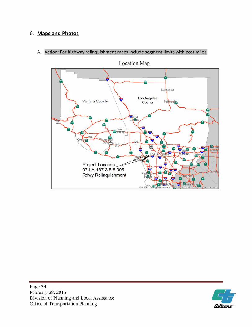
6. Maps and Photos
A. Action: For highway relinquishment maps include segment limits with post miles.
Page25 February 28, 2015 Division of Planning and Local Assistance Office of Transportation Planning
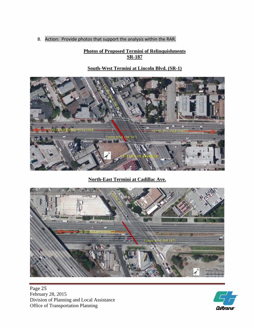
B. Action: Provide photos that support the analysis within the RAR.
Photos of Proposed Termini of Relinquishments SR-187
South-West Termini at Lincoln Blvd. (SR-1)
North-East Termini at Cadillac Ave.
![Risk Assessment Report (RAR) · Web viewRisk Assessment Report (RAR) Executive Sponsor: [Name] Project Manager: [Name] Program Management Consultant: [Name] Revision Date: [Insert](https://img.pdfslide.us/doc/110x75/5ed182497ccbff5d266f2b31/risk-assessment-report-rar-web-view-risk-assessment-report-rar-executive-sponsor.jpg)