Embed Size (px)
Citation preview

West Elizabeth Enhanced Travel Corridor PlanDN15-0488
Prepared For:
Presented By:
July 13, 2016 - DRAFT

DRAFT
ACKNOWLEDGMENTS
Photographs provided by the City of Fort Collins and Fehr & Peers; sources credited.
Design and Layout by Fehr & Peers 621 17th Street, Suite 2301 Denver, CO 80293
ALL RIGHTS RESERVED Copyright ©2015 Fehr & Peers
No portion of this report may be used or reproduced without prior written consent of City of Fort Collins.
TECHNICAL ADVISORY COMMITTEE
City of Fort Collins
Emily Allen, CommunityLiaison, Neighborhood Services
Sue Beck-Ferkiss, Social Sustainability Specialist, Social Sustainability
Sarah Burnett, Neighborhood Development Review Liaison, Neighborhood Services
Rebecca Everette, Senior Environmental Planner, Planning Services
Tessa Greegor, FC Bikes Program Manager, FC Moves
Basil Hamdan, Stormwater Quality Engineer, Streets
Craig Horton, Police Officer, Police Services
Aaron Iverson, Senior Transportation Planner, FC Moves
Nancy Nichols, Safe Routes to School Coordinator, FC Moves
Joe Olson, City Traffic Engineer, Traffic Operations
Erika Rasmussen, Special Projects Engineer, Engineering
Kurt Ravenschlag, General Manager, Transfort
Paul Sizemore, Program Manager, FC Moves
Timothy Wilder, Service Development Manager, Transfort
Steve Wilkin, Field and Training Coordinator, Transfort
Martina Wilkinson, Assistant City Traffic Engineer, Traffic Operations
Clint Wood, Civil Engineer, Streets
Colorado State UniversityAaron Fodge, Alternative Transportation Manager, Parking and Transportation Services
Fred Haberecht, Assistant Director of Campus Planning, Facilities Management
David Hansen, University Landscape Architect, Facilities Management

DRAFT
WEST ELIZABETH ENHANCED TRAVEL CORRIDOR PLAN 3 SECTION AND SUBSECTION TITLE
CITY COUNCIL
Wade Troxell, Mayor
Gerry Horak, Mayor Pro Tem, District 6
Bob Overbeck, Councilmember, District 1
Ray Martinez, Councilmember, District 2
Gino Campana, Councilmember, District 3
Kristin Stephens, Councilmember, District 4
Ross Cunniff, Councilmember,
District 5
TRANSPORTATION BOARD
Annabelle Berklund
Cari Brown
Olga Duvall
Rita Pat Jordan
Eric Shenk
Tim Sutton
Gary Thomas
York
PROJECT MANAGEMENT TEAM
Amy Lewin, Senior Transportation Planner, FC Moves
Emma Belmont, Transit Planner, Transfort
Rachel Prelog, Intern, FC Moves & Transfort
DRAFT
Figure 17: Urban Design Elements:
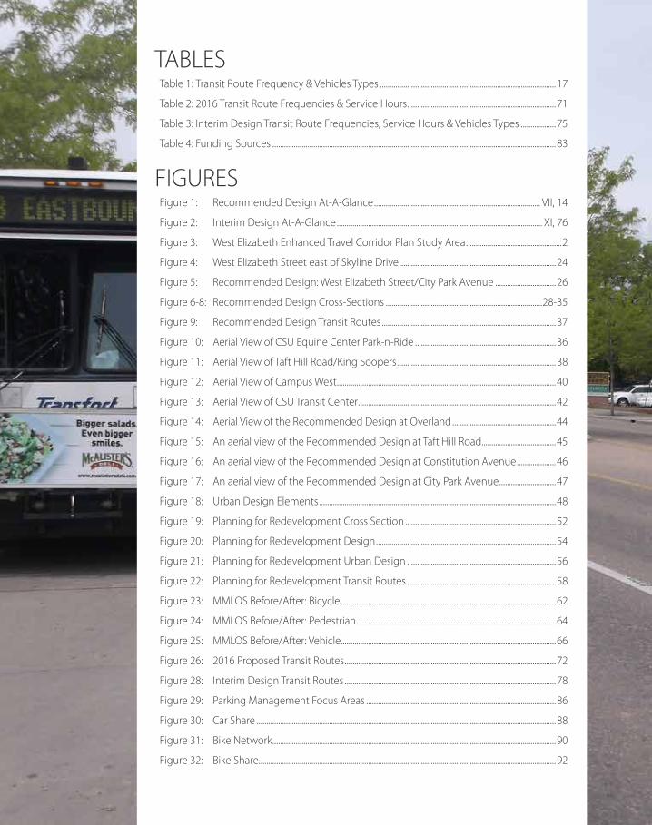
TABLES Table 1: Transit Route Frequency & Vehicles Types ..........................................................................................17
Table 2: 2016 Transit Route Frequencies & Service Hours ............................................................................71
Table 3: Interim Design Transit Route Frequencies, Service Hours & Vehicles Types ..................75
Table 4: Funding Sources .................................................................................................................................................83
FIGURES Figure 1: Recommended Design At-A-Glance ..................................................................................... VII, 14
Figure 2: Interim Design At-A-Glance ......................................................................................................... XI, 76
Figure 3: West Elizabeth Enhanced Travel Corridor Plan Study Area .................................................2
Figure 4: West Elizabeth Street east of Skyline Drive ................................................................................24
Figure 5: Recommended Design: West Elizabeth Street/City Park Avenue ...............................26
Figure 6-8: Recommended Design Cross-Sections ................................................................................28-35
Figure 9: Recommended Design Transit Routes .........................................................................................37
Figure 10: Aerial View of CSU Equine Center Park-n-Ride ........................................................................36
Figure 11: Aerial View of Taft Hill Road/King Soopers .................................................................................38
Figure 12: Aerial View of Campus West ................................................................................................................40
Figure 13: Aerial View of CSU Transit Center .....................................................................................................42
Figure 14: Aerial View of the Recommended Design at Overland .....................................................44
Figure 15: An aerial view of the Recommended Design at Taft Hill Road ......................................45
Figure 16: An aerial view of the Recommended Design at Constitution Avenue ....................46
Figure 17: An aerial view of the Recommended Design at City Park Avenue .............................47
Figure 18: Urban Design Elements .........................................................................................................................48
Figure 19: Planning for Redevelopment Cross Section .............................................................................52
Figure 20: Planning for Redevelopment Design ............................................................................................54
Figure 21: Planning for Redevelopment Urban Design ............................................................................56
Figure 22: Planning for Redevelopment Transit Routes ............................................................................58
Figure 23: MMLOS Before/After: Bicycle ..............................................................................................................62
Figure 24: MMLOS Before/After: Pedestrian ......................................................................................................64
Figure 25: MMLOS Before/After: Vehicle..............................................................................................................66
Figure 26: 2016 Proposed Transit Routes ............................................................................................................72
Figure 28: Interim Design Transit Routes ............................................................................................................78
Figure 29: Parking Management Focus Areas .................................................................................................86
Figure 30: Car Share .........................................................................................................................................................88
Figure 31: Bike Network .................................................................................................................................................90
Figure 32: Bike Share........................................................................................................................................................92

DRAFT
EXECUTIVE SUMMARY ............................................................................II
INTRODUCTION .................................................................................................................................................. 1
VISION, PURPOSE & NEED ..................................................................................................................... 5 Vision Statement ...................................................................................................................................................... 5 Project Purpose ......................................................................................................................................................... 6 Statement of Project Need ................................................................................................................................ 7
PLAN DEVELOPMENT .................................................................................................................................. 9 Community Engagement .................................................................................................................................. 9 Technical Process .................................................................................................................................................. 11
RECOMMENDED DESIGN..................................................................................................................... 13 Recommended Design for West Elizabeth Street ............................................................................ 16 Fullfilling the Project Vision ............................................................................................................................ 60
IMPLEMENTATION ........................................................................................................................................ 69 Recommended Design Phasing ................................................................................................................. 69 Recommendations for Other Streets ....................................................................................................... 80 Cost Estimates & Funding Sources ............................................................................................................ 80 Tracking Performance ........................................................................................................................................ 84 Other Network Considerations .................................................................................................................... 84
NEXT STEPS ........................................................................................................................................................... 95 Further Planning ............................................................................................................................................ 96
APPENDICES Appendix A: Vision, Purpose & Need Appendix B: Community Engagement Summary Appendix C: Corridor Understanding Report Appendix D: Alternatives Analysis Summary Appendix E: Conceptual Designs of Recommended Design and Interim Design Appendix F: Responding to the Project Need Appendix G: Traffic Operations Calculations Appendix H: Cost Estimates Summary and Methodology Appendix I: Maintenance Considerations
1.2.
3.
4.
5.
6.
CONTENTStable of

EXECUTIVE SUMMARY
DRAFT
THE WEST ELIZABETH ETC PLAN HAS
A SPECIAL FOCUS ON ADDRESSING
EXISTING DEFICIENCIES, SUCH AS
INADEQUATE TRANSIT SERVICE FOR
THE AREA’S DEMANDS, INCOMPLETE
BIKE AND PEDESTRIAN NETWORKS,
AND HIGHER THAN EXPECTED
NUMBERS OF CRASHES IN CERTAIN
LOCATIONS.
DRAFT
WEST ELIZABETH ENHANCED TRAVEL CORRIDOR PLAN II EXECUTIVE SUMMARY
EXECUTIVE SU
MM
ARY
THE WEST ELIZABETH CORRIDOR IS IDENTIFIED AS ONE OF SEVERAL FUTURE ENHANCED TRAVEL CORRIDORS (ETCS) IN THE CITY’S TRANSPORTATION MASTER PLAN (2011). EACH ETC WILL HAVE A PLANNING DOCUMENT THAT PROVIDES A ROADMAP TO ACHIEVE A LONG-TERM MULTIMODAL VISION FOR THE CORRIDOR. THE FOCUS OF THE PLAN IS TO EMPHASIZE TRANSIT, BIKING AND WALKING IN A WAY THAT SERVES EXISTING AND FUTURE TRANSPORTATION AND LAND USE NEEDS OF EACH AREA.
THE WEST ELIZABETH ETC PLAN HAS A SPECIAL FOCUS ON ADDRESSING EXISTING DEFICIENCIES, SUCH AS INADEQUATE TRANSIT SERVICE FOR THE AREA’S DEMANDS, INCOMPLETE BIKE AND PEDESTRIAN NETWORKS, AND HIGHER THAN EXPECTED NUMBERS OF CRASHES IN CERTAIN LOCATIONS.
This document details the plan to improve upon and emphasize transit, biking and walking in the West Elizabeth Corridor. The Corridor is defined as West Elizabeth Street between Overland Trail and Shields Street, as well as segments of Plum Street, Constitution Avenue, and City Park Avenue. The study area also includes the surrounding network to address connections with the CSU Foothills Campus on the west, the CSU Main Campus on the east, and the rest of the community.
projectEXECUTIVE SUMMARY

DRAFT
WEST ELIZABETH ENHANCED TRAVEL CORRIDOR PLAN III EXECUTIVE SUMMARY

DRAFT
WEST ELIZABETH ENHANCED TRAVEL CORRIDOR PLAN IV EXECUTIVE SUMMARY
EXECUTIVE SU
MM
ARY

WEST ELIZABETH ENHANCED TRAVEL CORRIDOR PLAN V EXECUTIVE SUMMARY
The plan was developed through a community-driven, context-sensitive process that occurred in 2015 -16. The planning effort included: The development of a
community-driven Vision for the West Elizabeth Corridor
A context-sensitive Recommended Design designed to meet the Vision
Phasing of Improvements to achieve the Recommended Design, including Interim Improvements addressing high-need issues in the near-term
An Implementation Strategy that includes cost estimates and potential funding sources
Other Network Considerations for the study area, such as the larger bicycle facility network and parking
PLAN DEVELOPMENT
The West Elizabeth ETC Plan was developed through a combination of community engagement and rigorous technical analysis to inform decision-making. The project was guided by a set of principles that included:
An emphasis on high-frequency transit, biking and walking to help accommodate growth (per the ETC definition)
Work within the existing Public Right-of-Way (ROW) as much as possible
Incorporate potential phasing from the beginning of the design development
Learn from the evaluation to understand the trade-offs and make further refinements to the design
MARCH-JULY 2015
PHASE 1: Project Start Up
Corridor Understanding
JULY-JAN 2016
PHASE 2: Visioning
Design, Approach, Development
Design, Approach, Evaluation
JAN-APRIL 2016
PHASE 3: Recommended Design
Implementation Planning
APRIL-AUG 2016
PHASE 4: Draft master Plan
Adoption Process
CO
MM
UN
ITY ENG
AG
EMEN
T
WE ARE HERE

WEST ELIZABETH ENHANCED TRAVEL CORRIDOR PLAN VI EXECUTIVE SUMMARY
EXECUTIVE SU
MM
ARY
VisionA Vision was developed for the West Elizabeth Corridor to define the long-term desired outcome from the West Elizabeth ETC Plan. The Vision for the West Elizabeth Corridor is that it shall:
Be unique and adaptable to the distinctive characteristics of each corridor segment
Be safe and comfortable for all users
Encourage and prioritize public transportation and active transportation options
Support the interconnectivity of all modes
Be a beautiful and vibrant environment
COMMUNITY ENGAGEMENT HIGHLIGHTS:
A Stakeholder Committee made up of residents, property
owners, students and other corridor stakeholders that met
five times throughout the duration of the project
Community Open Houses in August 2015, December 2015
and June 2016
Surveys (intercept, paper, text and Web-based)
Listening sessions
Focus groups with business owners, multifamily property
management, CSU facilities and administration, and
alternative transportation advocates
An online WikiMap
Neighborhood transit, bicycling and walking tours
An Open Streets event in June 2015

WEST ELIZABETH ENHANCED TRAVEL CORRIDOR PLAN VII EXECUTIVE SUMMARY
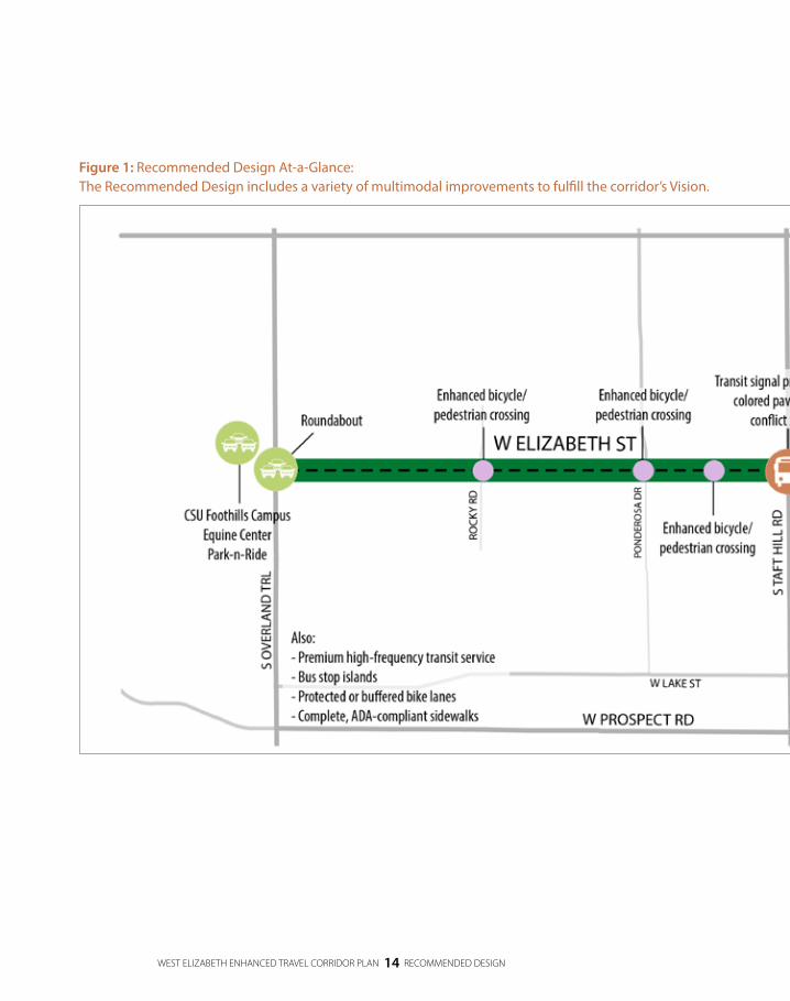
Recommended DesignThe Recommended Design includes enhancement for all modes. Key elements are listed in the table below and the locations of improvements are depicted on the Recommended Design At-a-Glance figure that follows
Figure 1: Recommended Design At-A-Glance Map below.
WEST ELIZABETH ENHANCED TRAVEL CORRIDOR PLAN VIII EXECUTIVE SUMMARY
EXECUTIVE SU
MM
ARY
WEST ELIZABETH ENHANCED TRAVEL CORRIDOR PLAN IX EXECUTIVE SUMMARY
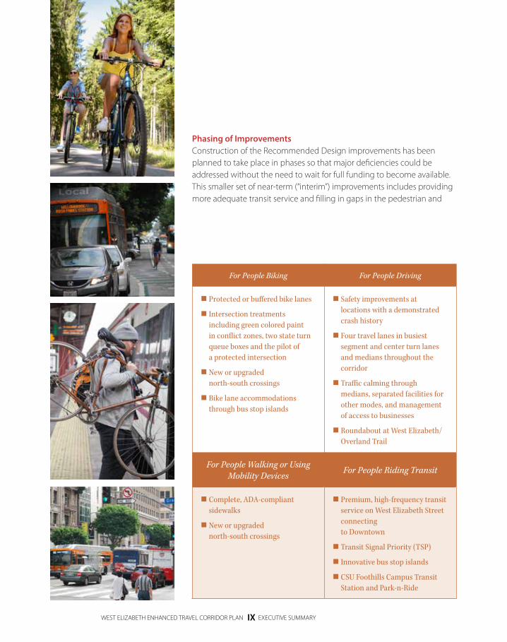
Phasing of ImprovementsConstruction of the Recommended Design improvements has been planned to take place in phases so that major deficiencies could be addressed without the need to wait for full funding to become available. This smaller set of near-term (“interim”) improvements includes providing more adequate transit service and filling in gaps in the pedestrian and
For People Biking For People Driving
Protected or buffered bike lanes
Intersection treatments including green colored paint in conflict zones, two state turn queue boxes and the pilot of a protected intersection
New or upgraded north-south crossings
Bike lane accommodations through bus stop islands
Safety improvements at locations with a demonstrated crash history
Four travel lanes in busiest segment and center turn lanes and medians throughout the corridor
Traffic calming through medians, separated facilities for other modes, and management of access to businesses
Roundabout at West Elizabeth/Overland Trail
For People Walking or Using Mobility Devices For People Riding Transit
Complete, ADA-compliant sidewalks
New or upgraded north-south crossings
Premium, high-frequency transit service on West Elizabeth Street connecting to Downtown
Transit Signal Priority (TSP)
Innovative bus stop islands
CSU Foothills Campus Transit Station and Park-n-Ride

WEST ELIZABETH ENHANCED TRAVEL CORRIDOR PLAN X EXECUTIVE SUMMARY
EXECUTIVE SU
MM
ARY
bicycle networks. The phased approach described in the Plan is designed to use public funds wisely and efficiently; specifically, the interim design was done with the longer-term Recommended Design in mind with the idea that constructing near-term improvements in the same place as future improvements would minimize potential throw-away costs.
Transit service and amenity improvements
Completion of the bike network
Completion of the sidewalk network (minimum standards)
Tweak to improve upon the existing transit service
Skyline crossing relocation/improvement
High-frequency transit service
Protected/buffered bike lanes and protected intersection
Enhance pedestrian network (detached sidewalks)
Roundabout at Overland and access management improvements
Upgraded and new north-south crossings
PROPOSED FOR 2016INTERIM
IMPROVEMENTSRECOMMENDED
DESIGN
BRT-like transit service
Changes in the Campus West Area
WHAT IF CAMPUS WEST REDEVELOPS? (COST TBD)
COST ESTIMATES <$ $$ $$$$$

WEST ELIZABETH ENHANCED TRAVEL CORRIDOR PLAN XI EXECUTIVE SUMMARY
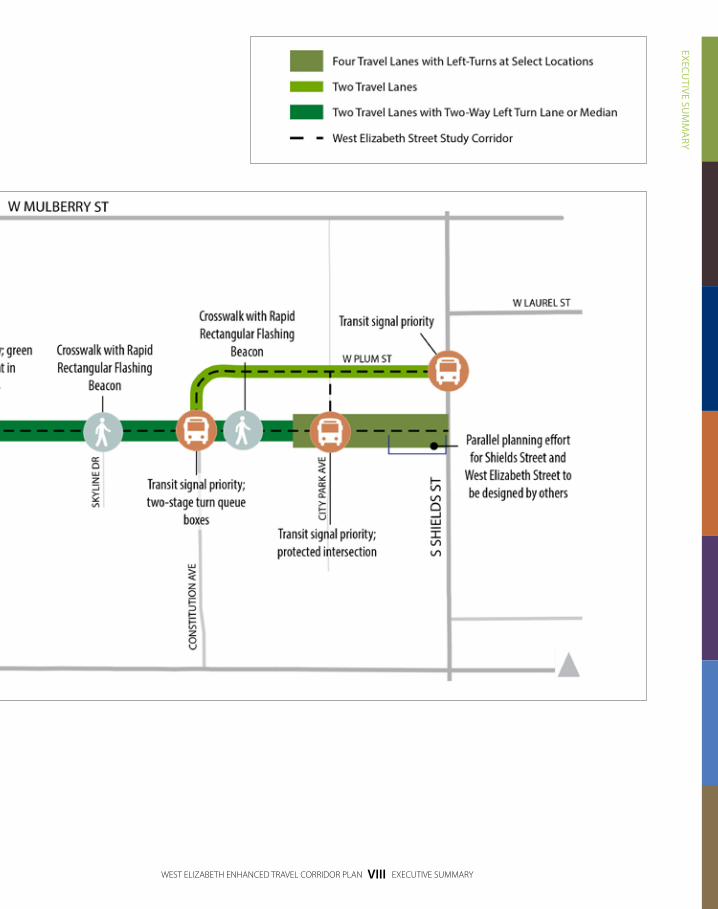
Figure 2: Interim Design at-A-GlanceThe proposed interim improvements are depicted in the Interim Design At-A-Glance map below.

WEST ELIZABETH ENHANCED TRAVEL CORRIDOR PLAN XII EXECUTIVE SUMMARY
EXECUTIVE SU
MM
ARY
WEST ELIZABETH ENHANCED TRAVEL CORRIDOR PLAN XIII EXECUTIVE SUMMARY
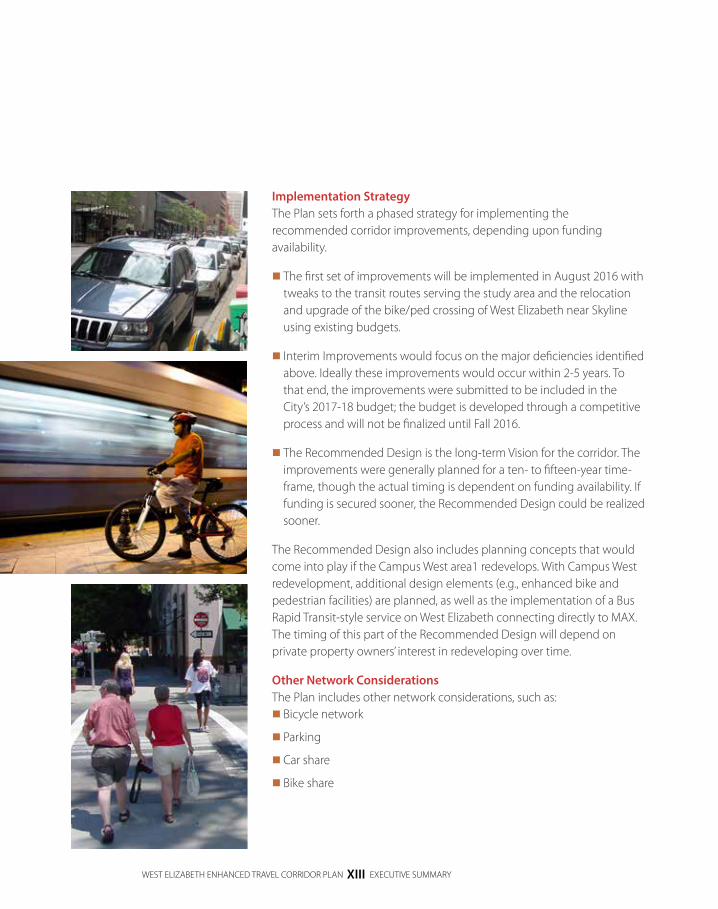
Implementation StrategyThe Plan sets forth a phased strategy for implementing the recommended corridor improvements, depending upon funding availability.
The first set of improvements will be implemented in August 2016 with tweaks to the transit routes serving the study area and the relocation and upgrade of the bike/ped crossing of West Elizabeth near Skyline using existing budgets.
Interim Improvements would focus on the major deficiencies identified above. Ideally these improvements would occur within 2-5 years. To that end, the improvements were submitted to be included in the City’s 2017-18 budget; the budget is developed through a competitive process and will not be finalized until Fall 2016.
The Recommended Design is the long-term Vision for the corridor. The improvements were generally planned for a ten- to fifteen-year time-frame, though the actual timing is dependent on funding availability. If funding is secured sooner, the Recommended Design could be realized sooner.
The Recommended Design also includes planning concepts that would come into play if the Campus West area1 redevelops. With Campus West redevelopment, additional design elements (e.g., enhanced bike and pedestrian facilities) are planned, as well as the implementation of a Bus Rapid Transit-style service on West Elizabeth connecting directly to MAX. The timing of this part of the Recommended Design will depend on private property owners’ interest in redeveloping over time.
Other Network ConsiderationsThe Plan includes other network considerations, such as: Bicycle network
Parking
Car share
Bike share

WEST ELIZABETH ENHANCED TRAVEL CORRIDOR PLAN XIV EXECUTIVE SUMMARY
EXECUTIVE SU
MM
ARY
Next StepsKey next steps to take after the adoption of this plan include:
Complete 35 percent design of the Recommended Design,including a survey of the corridor, a drainage study and a utility study, to develop a more refined cost estimate for the corridor and any incremental projects for which the City may pursue funding.
Inform the Federal Transit Administration of the corridor’s longterm plan by conducting a field review with FTA Region 8 staff.
Complete a National Environmental Policy Act (NEPA) process of the Recommended Design based on FTA recommendations.
Apply for incremental projects that are a part of the Recommended Design through appropriate funding sources, including CMAQ and TAP.
Apply for large-scale projects, possibly the entire Recommended Design, as a TIGER discretionary grant. As shown by previously selected projects, it is common to submit three or more application submittals for TIGER discretionary grants before a project is selected.
Update Master Street Plan to show segment of West Elizabeth between City Park Avenue and Taft Hill Road as Arterial 2 Lanes (instead of Arterial 4 Lanes).
1. Campus West is generally the area along West Elizabeth between City Park Avenue and Shields Street.

DRAFT
WEST ELIZABETH ENHANCED TRAVEL CORRIDOR PLAN XV SECTION AND SUBSECTION TITLE
“ENHANCED TRAVEL CORRIDORS
(ETCS) ARE UNIQUELY DESIGNED
CORRIDORS THAT ARE PLANNED TO
INCORPORATE HIGH FREQUENCY
TRANSIT, BICYCLING AND WALKING
AS PART OF THE CORRIDOR. ETCS
ARE INTENDED TO SUPPORT HIGH
QUALITY ECONOMIC DEVELOPMENT
OPPORTUNITIES FOR MIXED USE,
TRANSIT ORIENTED DEVELOPMENT
AND SUPPORT FORT COLLINS’ ACTIVE
LIFESTYLES AND ENVIRONMENTAL
STEWARDSHIP GOALS.”
TRANSPORTATION MASTER PLAN
(2011)

DRAFT
WEST ELIZABETH ENHANCED TRAVEL CORRIDOR PLAN 1 INTRODUCTION
INTRO
DU
CTIO
N
The West Elizabeth Enhanced Travel Corridor Plan includes a Vision, Recommended Design and implementation plan for a study area that includes West Elizabeth Street and nearby roadways.
The West Elizabeth Enhanced Travel Corridor Plan is the result of applying the Enhanced Travel Corridor definition and concept to West Elizabeth Street. It was developed through a community driven, context sensitive process that occurred in 2015 and 2016. In some cases, Recommended Design elements of the West Elizabeth Enhanced Travel Corridor Plan are similar to design elements seen elsewhere in Fort Collins. However, in many cases the West Elizabeth Enhanced Travel Corridor Plan’s Recommended Design elements are truly unique.
The West Elizabeth Enhanced Travel Corridor Plan includes: The corridor’s Vision, Purpose and Need
The corridor’s Recommended Design
An implementation strategy for the Recommended Design including a phasing strategy, cost estimates, funding sources and other considerations
INTRODUCTION

WEST ELIZABETH ENHANCED TRAVEL CORRIDOR PLAN 2 INTRODUCTION
Figure 3: West Elizabeth Enhanced Travel Corridor Plan Study Area:
The West Elizabeth Enhanced Travel Corridor Plan study area includes West Elizabeth Street from Shields Street to Overland Trail, portions of Constitution Avenue, Plum Street and City Park Avenue, the CSU Main Campus and CSU Foothills Campus and nearby neighborhoods.

DRAFT
WEST ELIZABETH ENHANCED TRAVEL CORRIDOR PLAN 3 INTRODUCTION
INTRO
DU
CTIO
N
Figure 3: West Elizabeth Enhanced Travel Corridor Plan Study Area:
The West Elizabeth Enhanced Travel Corridor Plan study area includes West Elizabeth Street from Shields Street to Overland Trail, portions of Constitution Avenue, Plum Street and City Park Avenue, the CSU Main Campus and CSU Foothills Campus and nearby neighborhoods.

DRAFT
THE WEST ELIZABETH ENHANCED
TRAVEL CORRIDOR WILL FOSTER
EXISTING BUSINESS AND FUTURE
INFILL AND REDEVELOPMENT TO
ACCOMMODATE THE GROWING
NUMBER AND DIVERSITY OF
USERS. THE CORRIDOR WILL BE AN
EASILY ACCESSIBLE AND RELIABLE
MULTIMODAL CORRIDOR WITH A
FOCUS ON IMPROVING TRANSIT,
BIKING AND WALKING.

VISION
, PURPO
SE &
NEED
DRAFT
WEST ELIZABETH ENHANCED TRAVEL CORRIDOR PLAN 5 VISION, PURPOSE & NEED: VISION STATEMENT
The Vision is the long term anticipated outcome of the West Elizabeth Enhanced Travel Corridor Plan’s implementation. The Purpose defines the transportation problem being solved through implementation of the Plan and the role of the Plan in the problem solving process. The Need provides information to support the Purpose.
Appendix A includes the detailed Vision, Purpose and Need. Key excerpts from the Vision, Purpose and Need are included below and are important to understanding the impetus of the Plan.
VISION STATEMENT
The Vision for the West Elizabeth Enhanced Travel Corridor is to be an easily accessible and reliable multimodal corridor with an emphasis on connectivity to Colorado State University’s Foothills Campus on the west and Colorado State University’s Main Campus (including MAX stations) on the east. The corridor will be well integrated and well connected within the City, with a focus on improving transit, biking and walking. The corridor will foster existing business and future infill and redevelopment to accommodate the growing number and diversity of users in the corridor, which include students, families and seniors. The network shall: Be unique and adaptable to the distinctive
characteristics of each corridor segment.
Be safe and comfortable for all users.
Encourage and prioritize public transportation and active transportation options.
Support the interconnectivity of all modes.
Be a beautiful and vibrant corridor.
VISION, PURPOSE & NEEDsection 1

DRAFT
WEST ELIZABETH ENHANCED TRAVEL CORRIDOR PLAN 6 VISION, PURPOSE & NEED: PROJECT PURPOSE
PROJECT PURPOSE
The Purpose of the West Elizabeth Street Enhanced Travel Corridor Plan is to develop a corridor plan that will serve existing and future transportation demands, with a focus on multimodal transportation improvements. Anticipated growth is expected through infill projects (development of vacant or under used land parcels within existing urban areas) and redevelopment with increased density within and around the study area, thereby increasing travel demand. The goal of this Plan is to address the growing demand for transportation options by increasing and improving transit, bicycling and walking infrastructure and operations. Improvements shall provide users with highly efficient, reliable and frequent transit service as well as bicycling, walking, and driving options that are safe, comfortable, efficient and easy to use. Improvements will foster economic vitality through high quality and attractive facilities, while remaining committed to the long term fiscal responsibility of the City.
Specifically, the Purpose is to: Increase transit capacity, reliability
and improve transit stop amenities to accommodate current demand and future growth in population, student enrollment, and travel demand.
Improve transit system connectivity to and from West Elizabeth Street, Colorado State University’s Main and Foothills Campuses, Downtown and other Transfort routes including MAX.
Improve pedestrian facilities for comfort, safety and accessibility throughout the corridor.
Improve bicycling facilities for ease, comfort and safety and to attract new riders.
Maintain vehicular mobility, improve safety and enhance access to commercial properties in the corridor.
Support the interconnectivity between travel modes.
The goal of this Plan is to address the growing demand for transportation options by
increasing and improving transit, bicycling and walking infrastructure and operations.
Improvements shall provide users with highly efficient, reliable and frequent transit service
as well as bicycling, walking, and driving options that are safe, comfortable, efficient and
easy to use.

DRAFT
WEST ELIZABETH ENHANCED TRAVEL CORRIDOR PLAN 7 VISION, PURPOSE & NEED: STATEMENT OF PROJECT NEED
VISION
, PURPO
SE &
NEED
STATEMENT OF PROJECT NEED
The specific needs to address in the corridor include: Inability to support existing travel demands and anticipated
growth, which will exacerbate existing deficiencies in transit service, pedestrian facilities, bicycle facilities and vehicle safety.
Inadequate transit service due primarily to insufficient system connectivity, low and inconsistent route frequencies, poor reliability, lack of capacity to serve current and future demands and lack of patron stop amenities.
Uncomfortable and incomplete pedestrian facilities and safety concerns due to inconsistent and missing sidewalks, as well as sidewalks that are not Americans with Disabilities Act (ADA)-compliant; in addition, there are limited north/south crossing opportunities, and pedestrians experience significant delays crossing West Elizabeth Street.
Uncomfortable and inconsistent bicycle facilities and safety concerns due to incomplete bike lanes and inadequate intersection treatments. There is also a higher than expected number of bicycle- and vehicle-related crashes in several locations.
Vehicular mobility, safety and access concerns exist due to intersection and driveway turning conflicts, as well as queue spillback (traffic backed up at a left-turn lane, for example) at some signalized intersections.
Challenges connecting between modes for trips in the corridor including inadequate pedestrian and bicycle facilities to and at transit stops and parking challenges in the corridor.

DRAFT
THE WEST ELIZABETH ENHANCED
TRAVEL CORRIDOR PLAN TOOK PLACE
OVER APPROXIMATELY 18 MONTHS.
STAKEHOLDERS INCLUDED RESIDENTS,
PROPERTY OWNERS, BUSINESS
OWNERS, STUDENTS AND OTHER
COMMUNITY STAKEHOLDERS. THEY
WERE ENGAGED AND COLLABORATED
WITH THROUGH A VARIETY OF
COMMUNICATION METHODS
AND EVENTS.

DRAFT
WEST ELIZABETH ENHANCED TRAVEL CORRIDOR PLAN 9 PLAN DEVELOPMENT: COMMUNITY ENGAGEMENT
PLAN
DEVELO
PMEN
T
section 2
The West Elizabeth Enhanced Travel Corridor Plan was developed through a combination of community engagement and rigorous technical analysis to inform decision making.
COMMUNITY ENGAGEMENT
The West Elizabeth Enhanced Travel Corridor Plan took place over approximately 18 months in 2015 and 2016. Stakeholders were prioritized from the start through a community driven process that engaged residents, property owners, business owners, students and other community stakeholders. These stakeholders were engaged through a variety of communication methods and events, including:
A Stakeholder Committee made up of residents, property owners, students and other corridor stakeholders that met five times throughout the duration of the project
Community Open Houses in August 2015, December 2015 and June 2016
Surveys (intercept, paper, text and Web-based)
Listening sessions
Focus groups with business owners, multifamily property management, CSU facilities and administration, and alternative transportation advocates
An online WikiMap
Neighborhood transit, bicycling and walking tours
An Open Streets event in June 2015
PLAN DEVELOPMENT

DRAFT
WEST ELIZABETH ENHANCED TRAVEL CORRIDOR PLAN 10 PLAN DEVELOPMENT: COMMUNITY ENGAGEMENT
Community feedback informed every aspect of this plan: the corridor’s Vision, Purpose and Need; the design alternatives developed and analyzed in developing a Recommended Design; and refinements to the Recommended Design to ensure that the West Elizabeth Enhanced Travel Corridor Plan is supportable by the area’s stakeholders and broad community that uses West Elizabeth Street.
Community Engagement Key ThemesDuring the public engagement process to gather input on the West Elizabeth Street corridor’s existing conditions, several common themes regarding the current experience of traveling in the corridor emerged. Below are key themes organized by transportation mode.
For People Riding Transit Overcrowded buses, people
are left behind
Not enough bus stop amenities
Not enough service (e.g., late night, weekend, summer)
For People Biking Inconsistent facilities
west of Taft Hill Road
Lots of driveway conflicts in Campus West
Challenging intersections (e.g., West Elizabeth Street/Taft Hill Road, West Elizabeth Street/City Park Avenue, West Elizabeth Street/Shields Street)
High number of bicyclist crashes
For People Walking & Rolling Inconsistent facilities, lack
of sidewalks
Not comfortable
Largely not ADA-compliant
Hard to cross West Elizabeth Street at key intersections
Lack of sufficient midblock crossing opportunities
Driving Challenging to make left-turns
to and from driveways
Conflicts with pedestrians and bicyclists
Speeding
Sight distance issues
Appendix B includes a summary of feedback received through community engagement.

DRAFT
WEST ELIZABETH ENHANCED TRAVEL CORRIDOR PLAN 11 PLAN DEVELOPMENT: COMMUNITY ENGAGEMENT
PLAN
DEVELO
PMEN
T
Technical ProcessA rigorous technical process informed the West Elizabeth Enhanced Travel Corridor Plan to ensure that the outcomes of the recommendations would result in meaningful and measurable benefits to the corridor. The technical process informed community engagement by reporting various performance measures related to the corridor’s Vision, Purpose and Need. Lastly, the technical process was completed in such a way to successfully position the City for available funding sources. Generally, the technical process included:
Developing a thorough understanding of the corridor’s existing conditions. Appendix C includes the Corridor Understanding Report.
Identifying the corridor’s Vision, Purpose and Need based on community engagement, the Transportation Master Plan’s definition of an Enhanced Travel Corridor and key findings from the Corridor Understanding Report.
Generating alternatives that responded to the Vision, Purpose and Need and explored the range of community values.
Analyzing alternatives using a variety of performance measures to understand how well individual alternatives (or alternative elements) responded to the Vision, Purpose and Need. Appendix D includes the alternatives analysis.
Developing a Recommended Design that incorporated the best performing elements from the alternatives analysis and refining the Recommended Design based on community feedback.
MARCH-JULY 2015
PHASE 1: Project Start Up
Corridor Understanding
JULY-JAN 2016
PHASE 2: Visioning
Design, Approach, Development
Design, Approach, Evaluation
JAN-APRIL 2016
PHASE 3: Recommended Design
Implementation Planning
APRIL-AUG 2016
PHASE 4: Draft master Plan
Adoption Process
CO
MM
UN
ITY ENG
AG
EMEN
T
WE ARE HERE

DRAFT
THE RECOMMENDED DESIGN
ADDRESSES THE PROJECT’S VISION
AND NEED BY IMPROVING CONDITIONS
FOR PEOPLE RIDING TRANSIT, BIKING,
WALKING AND DRIVING. IT KEEPS
COST-EFFECTIVENESS, MINIMIZING
IMPACT TO PROPERTY OWNERS AND
PHASE IMPLEMENTATION AS KEY
ELEMENTS.

DRAFT
WEST ELIZABETH ENHANCED TRAVEL CORRIDOR PLAN 13 RECOMMENDED DESIGN
RECOM
MEN
DED
DESIG
N
The Recommended Design defines the long term vision for the transportation network the in West Elizabeth Street corridor, including transit service and multimodal improvements. The Recommended Design will further guide infill and redevelopment and future capital improvement in the area.
The Recommended Design for West Elizabeth Street was developed specifically to fulfill the project’s Vision and to respond to its Purpose and Need. Additionally, three key principles guided the Recommended Design’s development:
1. The Recommended Design should meet the project’s Vision, Purpose and Need in a cost-effective manner.
2. The Recommended Design should minimize impacts to private property owners (including limiting right-of-way acquisition).
3. The Recommended Design should be implementable in phases and minimize throwaway costs.
The Plan proposes implementation of the Recommended Design in three main phases. The actual implementation of improvements will depend upon funding availability. In addition, the Recommended Design includes considerations for redevelopment, particularly in Campus West.
RECOMMENDED DESIGNsection 2
WEST ELIZABETH ENHANCED TRAVEL CORRIDOR PLAN 14 RECOMMENDED DESIGN
Figure 1: Recommended Design At-a-Glance: The Recommended Design includes a variety of multimodal improvements to fulfill the corridor’s Vision.

RECOM
MEN
DED
DESIG
N
DRAFT
WEST ELIZABETH ENHANCED TRAVEL CORRIDOR PLAN 15 RECOMMENDED DESIGN
Figure 1: Recommended Design At-a-Glance: The Recommended Design includes a variety of multimodal improvements to fulfill the corridor’s Vision.

DRAFT
WEST ELIZABETH ENHANCED TRAVEL CORRIDOR PLAN 16 RECOMMENDED DESIGN FOR WEST ELIZABETH
RECOMMENDED DESIGN FOR WEST ELIZABETH STREET
For People Riding TransitThe transit elements of the Recommended Design intend to improve the capacity, reliability and simplicity of transit service in the West Elizabeth Street study area, including both transit operational changes and transit-related infrastructure
Transit Operations The Recommended Design’s proposed transit operations include five key transit routes:
Route 3 – West Elizabeth Street Route: a cross town route that will run along West Elizabeth Street from the CSU Foothills Campus Equine Center, along West Elizabeth Street and Plum Street, through the CSU Main Campus, to the CSU Transit Center and continuing to Downtown Fort Collins and the Downtown Transit Center via Mason Street. Route 3 will provide a one seat ride for passengers from West Elizabeth Street to Downtown Fort Collins.
Route 31 – Plum Street Route: a circulator route that will operate similar to the existing Route 31 from the CSU Transit Center to Campus West via West Elizabeth Street and Plum Street.
Route 2 – West Prospect Road Route: a radial route that will run along Prospect Road from Overland Trail to Lake Street/College Avenue.
The HORN – a circulator that will serve destinations throughout the CSU Main Campus and CSU Veterinary School, similar to the existing HORN
The CSU Foothills Campus Shuttle – a circulator that will connect destinations within the CSU Foothills Campus off of Rampart Road and off of Laporte Avenue.
KEY ELEMENTS FOR PEOPLE RIDING TRANSIT:
Premium, high-
frequency transit
service on West
Elizabeth Street
Transit Signal Priority
(TSP)
Bus stop islands
CSU Foothills Campus
Equine Center Transit
Station and Park-n-Ride
Key recommendations will improve capacity, reliability and
simplicity of transit service in five key transit routes in the
West Elizabeth study area.

RECOM
MEN
DED
DESIG
N
DRAFT
WEST ELIZABETH ENHANCED TRAVEL CORRIDOR PLAN 17 RECOMMENDED DESIGN FOR WEST ELIZABETH
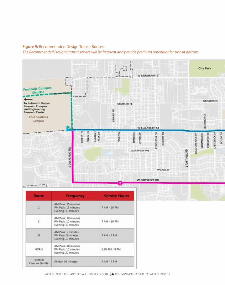
Table 1 shows frequency, hours and vehicle types for the transit routes in the study area when CSU is in session; route frequencies are likely to be reduced during periods when CSU is out of session. Route 3, Route 31 and the HORN are expected to be the most productive routes in the study area. Therefore, frequencies on these routes will be high to increase the number of passengers the system can move and to minimize passenger wait times. With 10 minute or less frequencies Route 3, Route 31 and the HORN will all operate frequently enough that passengers do not need to consult a schedule prior to planning their trip. All of the routes will use standard Transfort buses, with the exception of the CSU Foothills Campus Shuttle, which will use a 25 passenger shuttle bus.
Table 1: Transit Route Frequency & Vehicles Types
Route Frequency Hours Vehicle Type
2AM-PM Peak: 15 minutes
Evening: 30 minutes7 AM – 10 PM Standard Transfort buses
3AM-PM Peak: 10 minutes
Evening: 30 minutes7 AM – 10 PM Standard Transfort buses
31AM-PM Peak: 5 minutes
Evening: 10 minutes7 AM – 7 PM Standard Transfort buses
HORNAM-PM Peak: 10 minutes
Evening: 20 minutes6:30 AM – 8 PM Standard Transfort buses
CSU Foothills Campus Shuttle
All day: 30 minutes 7 AM – 7 PM 25 passenger shuttle bus
Transit InfrastructureTransit Signal Priority (TSP) will be added to signalized intersections throughout the study area, in locations where possible and beneficial to transit operations. Transit Signal Priority reduces delay at traffic signals by holding green lights longer for approaching buses, giving the buses a higher priority at the intersection. Transit Signal Priority will be added in the east-west directions at the following intersections: West Elizabeth Street/Taft Hill Road, West Elizabeth Street/Constitution Avenue, West Elizabeth Street/City Park Avenue, and Plum Street/Shields Street. Transit Signal Priority will also be added to the Laurel Street/Meldrum Street intersection for the new Route 3, which will connect West Elizabeth Street to Downtown Fort Collins via the CSU Transit Center.

DRAFT
WEST ELIZABETH ENHANCED TRAVEL CORRIDOR PLAN 18 RECOMMENDED DESIGN FOR WEST ELIZABETH
The Recommended Design includes innovative bus stop islands that have recently been installed successfully in progressive transit cities such as Seattle and Denver. In some cases the bus islands allow buses to stop in the travel lane while passengers board, which eliminates bus delay waiting to re-enter the travel lane. Bus stop islands that allow buses to stop in the travel lane are less impactful to adjacent private property compared to bus stop islands with pullouts. Generally, the Recommended Design includes bus stop islands that allow buses to stop in the travel lane although bus stop islands with pullouts are recommended at Skyline Drive. Other benefits of the bus stop islands are that they allow for passengers to get on and off the buses from both doors, which minimizes bus dwell time at each stop and allows people biking to pass to the right of the passenger boarding area rather than having to merge into the travel lane to pass the bus. Unique design elements, such as a raised pedestrian crossing across the bike lane or strategically placed planter bollards, will minimize the potential for conflicts between people biking and people walking from the bus to the sidewalks. Bus stop islands will feature typical amenities such as signage, shelters, benches, trash cans and bike racks. Should Bus Rapid Transit (BRT)-style service eventually be implemented on the corridor, the bus stop islands are sufficiently large for future passenger amenities including enhanced shelters, benches, bike racks and kiosks.
A Park-n-Ride at the CSU Foothills Campus Equine Center will take advantage of the 720 space parking lot that is nearly empty on most days. The Park-n-Ride will include a transit station south of the Equine Center with space for passenger boarding and space for buses to layover between routes, if needed. Students, faculty and staff from areas in west Fort Collins bound for CSU Main Campus can park at the Park-n-Ride and ride the bus to the CSU Main Campus.
At the CSU Transit Center, minor modifications to Plum Street south of Allison Hall will allow Route 3 buses to drop-off and pick-up passengers at the CSU Transit Center without circulating through the transit center itself.
Other likely infrastructure improvements may be needed at the College Avenue/Lake Street intersection to facilitate the turning movements for the east leg of Route 2.
KEY ELEMENTS FOR PEOPLE BIKING:
Protected or buffered bike lanes
Intersection treatments including green
colored pavement in conflict zones, two
stage turn queue boxes and the pilot of a
protected intersection
North-south crossings
Bus stop islands

RECOM
MEN
DED
DESIG
N
Bottom Left: A two-stage turn queue box allows people biking to turn left in two stages without crossing multiple travel lanes
Bottom Right: A buffered bike lane provides a painted buffer between the bike lane and travel lane
Top Right: A protected bike lane provides a raised curb between the bike lane and travel lane
DRAFT
WEST ELIZABETH ENHANCED TRAVEL CORRIDOR PLAN 19 RECOMMENDED DESIGN FOR WEST ELIZABETH
For People BikingConsistent with the recommendations of the City’s Bicycle Master Plan (2014). The Recommended Design includes one-way protected bike lanes and buffered bike lanes on West Elizabeth Street from Shields Street to Overland Trail. In locations where adequate space for protection exists the protection will consist of a raised curb. In locations where there is not adequate space for protection there will be a painted buffer between the bike lane and the travel lane.
Various intersection treatments are recommended to make turning movements easier for people bicycling as well as to improve safety. Green colored pavement will be used in conflict zones where people bicycling have the right of way. Two-stage turn queue boxes will be used at signalized intersections so that people biking do not have to cross multiple travel lanes to access a left-turn lane.

DRAFT
WEST ELIZABETH ENHANCED TRAVEL CORRIDOR PLAN 20 RECOMMENDED DESIGN FOR WEST ELIZABETH
The Recommended Design also includes the pilot of a protected intersection at the West Elizabeth Street/City Park Avenue intersection. The protected intersection features corner refuge islands that provide increased separation between vehicles and bicyclists, put the bicyclist stop bar ahead of the vehicle stop bar, set back the bicyclist crossings approximately one car length from the adjacent travel lane and allow for two-stage left-turns and free bicyclist right-turns.
The Recommended Design further implements the City’s Bicycle Plan by providing a variety of north-south crossing treatments, including the protected intersection at City Park Avenue and on street bikeways on Constitution Avenue. Skyline Drive, on which a neighborhood greenway is proposed, is expected to be improved in summer 2016 with either a Rectangular Rapid Flashing Beacon (the crosswalk across Laurel Street at Sherwood Street is a local example of a Rectangular Rapid Flashing Beacon) or a Pedestrian Hybrid Beacon (the crosswalk across Taft Hill Road a Blevins Middle School is a local example of a Pedestrian Hybrid Beacon) at the West Elizabeth Street/Skyline Drive intersection to make crossing West Elizabeth Street safer and more comfortable. Ponderosa Drive is recommended to be improved in the future with enhancements for bicyclists such as medians that allow for people bicycling to cross West Elizabeth Street in two stages.
As described earlier, bus stop islands along the West Elizabeth Street corridor will allow people biking to pass to the right of the passenger boarding area. When buses are stopped, people biking will not have to merge into travel lanes to go around them. Unique design elements at the bus island stops will minimize the potential for conflicts between people biking and people walking from the bus to the sidewalks.
KEY ELEMENTS FOR PEOPLE WALKING AND ROLLING:
Complete, ADA-
compliant sidewalks
New or upgraded
crossings

RECOM
MEN
DED
DESIG
N
DRAFT
WEST ELIZABETH ENHANCED TRAVEL CORRIDOR PLAN 21 RECOMMENDED DESIGN FOR WEST ELIZABETH
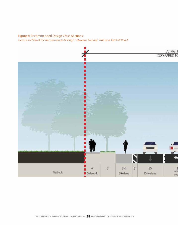
For People Walking and RollingThe Recommended Design will complete the sidewalk network on West Elizabeth Street. In most cases, new sidewalks will be detached with landscaping separating the clear sidewalk width from the adjacent travel lanes. In Campus West sidewalks will be detached with an amenity zone for tree grates, street lighting, bike parking and other amenities separating the clear sidewalk width from adjacent travel lanes. In some cases where private property would be significantly impacted by the preferred detached sidewalk and landscaping between the adjacent travel lanes, sidewalks will be attached (directly adjacent to travel lanes). This condition occurs mostly west of Taft Hill Road. The complete sidewalk network will include accessible design elements throughout the corridor for people with disabilities, including ADA-compliant curb ramps.
People walking will have new and upgraded crossings of West Elizabeth Street. In Campus West, the existing midblock crosswalk will be upgraded to feature a Pedestrian Hybrid Beacon (previously known as a HAWK beacon). A new crossing will be constructed near the Woodbridge Senior Apartments with a median and a Rectangular Rapid Flashing Beacon (the crosswalk across Laurel Street at Sherwood Street is a local example of a Rectangular Rapid Flashing Beacon). The existing crosswalk at Castlerock Drive will be relocated to Skyline Drive and upgraded to feature either a Rectangular Rapid Flashing Beacon or a Pedestrian Hybrid Beacon. Two future crossings will also be added once demand justifies their installation per the crossing policy in the City’s Pedestrian Master Plan: one at Ponderosa Drive and another at Rocky Road/Azuro Drive. Lastly, the Recommended Design includes a roundabout at Overland Trail and West Elizabeth Street.
Rectangular Rapid Flashing Beacons are user-actuated amber LEDs that use a flash pattern that is similar to emergency flashers on police vehicles.
A Pedestrian Hybrid Beacon is a user-actuated beacon that uses amber and red beacons to increase drivers’ awareness of pedestrian crossings.

DRAFT
WEST ELIZABETH ENHANCED TRAVEL CORRIDOR PLAN 22 RECOMMENDED DESIGN FOR WEST ELIZABETH
For People DrivingThe Recommended Design maintains four travel lanes with turn lanes on West Elizabeth Street’s busiest segment between Shields Street and City Park Avenue. Between City Park Avenue and Constitution Avenue, West Elizabeth Street will transition to two travel lanes with a two-way left-turn lane. This three lane cross section will continue to Overland Trail with medians in certain locations where street and driveway access allow.
The Recommended Design includes a variety of design elements to improve safety at locations with a demonstrated crash history. In most cases access management in Campus West will allow for right-turns and left-turns into driveways and right-turns out of driveways. Left-turns out of driveways, which are a common cause of crashes in Campus West, will be prohibited between Shields Street and City Park Avenue. West of Taft Hill Road, access management will allow for right-turns and left-turns into and out of the King Soopers driveway. Driveways on the north side of West Elizabeth Street will be right-in/right-out. Lastly, a roundabout at Overland Trail will calm traffic on Overland Trail itself and improve the ease of turning onto and off of West Elizabeth Street.
KEY ELEMENTS FOR PEOPLE DRIVING:
Safety improvements
at locations with a
demonstrated crash
history
WEST ELIZABETH STREET/SHIELDS STREET INTERSECTION
Prior to and separate from the West Elizabeth Enhanced Travel Corridor Plan, the City and CSU entered into an Intergovernmental Agreement (IGA) addressing various CSU on-campus stadium impacts to nearby City streets. The IGA includes requirements for at-grade improvements at the intersection of West Elizabeth Street and Shields Street and identifies the potential for a grade-separated crossing of Shields Street to help accommodate bicycle and pedestrian movements across Shields Street. Since the IGA’s approval, CSU and the City have been working on the design for the at-grade improvements and have completed a feasibility study for the grade-separated crossing. The at-grade improvements and underpass are now in design, a neighborhood meeting has been held and additional opportunities for public input will be provided as the process moves forward.
Due to the overlapping timing of the IGA efforts and the West Elizabeth Enhanced Travel Corridor Plan, and since the goals of each effort are generally in alignment, the detailed design for the West Elizabeth Street/Shields Street intersection has been left to the IGA team. As such, the Recommended Design for the West Elizabeth Street corridor does not include the design for this area, and instead notes various considerations that should be taken in to account as the design moves toward finalization. These considerations include: business access, driveway crossings and connections to the midblock crossing in Campus West. The West Elizabeth Enhanced Travel Corridor Plan project team will continue to participate in the design work for this intersection to ensure that the final plans fit together well and the goals of the West Elizabeth Enhanced Travel Corridor Plan are carried forward.

RECOM
MEN
DED
DESIG
N
DRAFT
WEST ELIZABETH ENHANCED TRAVEL CORRIDOR PLAN 23 RECOMMENDED DESIGN FOR WEST ELIZABETH
Urban DesignAs a part of the West Elizabeth Enhanced Travel Corridor Plan’s community engagement, an effort was made to understand what the community felt was the overriding character of the corridor. While there was not a strong consensus regarding the overall theme for West Elizabeth Street, many community engagement participants generally identified the corridor’s already artful, unique feel which was attributed to the existing eclectic urban design and public art installations on the corridor (such as the foundations on street light poles in Campus West). Many community engagement participants also thought it would be appropriate to distinguish the design of Campus West from the CSU Main Campus.

WEST ELIZABETH ENHANCED TRAVEL CORRIDOR PLAN 24 RECOMMENDED DESIGN FOR WEST ELIZABETH
Figure 4: Photo simulation of West Elizabeth Street east of Skyline Drive:A photo simulation of the Recommended Design as seen looking east from Skyline Drive.

RECOM
MEN
DED
DESIG
N
DRAFTDRAFT
WEST ELIZABETH ENHANCED TRAVEL CORRIDOR PLAN 25 RECOMMENDED DESIGN FOR WEST ELIZABETH
Figure 4: Photo simulation of West Elizabeth Street east of Skyline Drive:A photo simulation of the Recommended Design as seen looking east from Skyline Drive.

WEST ELIZABETH ENHANCED TRAVEL CORRIDOR PLAN 26 RECOMMENDED DESIGN FOR WEST ELIZABETH
Figure 5: Photo simulation of West Elizabeth Street and City Park Avenue A photo simulation of the Recommended Design as seen at West Elizabeth Street and City Park Avenue.

DRAFT
WEST ELIZABETH ENHANCED TRAVEL CORRIDOR PLAN 27 RECOMMENDED DESIGN FOR WEST ELIZABETH
Figure 5: Photo simulation of West Elizabeth Street and City Park Avenue A photo simulation of the Recommended Design as seen at West Elizabeth Street and City Park Avenue.
RECOM
MEN
DED
DESIG
N
WEST ELIZABETH ENHANCED TRAVEL CORRIDOR PLAN 28 RECOMMENDED DESIGN FOR WEST ELIZABETH
Figure 6: Recommended Design Cross-Sections:A cross-section of the Recommended Design between Overland Trail and Taft Hill Road.

DRAFT
WEST ELIZABETH ENHANCED TRAVEL CORRIDOR PLAN 29 RECOMMENDED DESIGN FOR WEST ELIZABETH
Figure 6: Recommended Design Cross-Sections:A cross-section of the Recommended Design between Overland Trail and Taft Hill Road.
RECOM
MEN
DED
DESIG
N

WEST ELIZABETH ENHANCED TRAVEL CORRIDOR PLAN 30 RECOMMENDED DESIGN FOR WEST ELIZABETH
Figure 7: Recommended Design Cross-Sections:A cross-section of the Recommended Design between Taft Hill Road and City Park Avenue.

DRAFT
WEST ELIZABETH ENHANCED TRAVEL CORRIDOR PLAN 31 RECOMMENDED DESIGN FOR WEST ELIZABETH
Figure 7: Recommended Design Cross-Sections:A cross-section of the Recommended Design between Taft Hill Road and City Park Avenue.
RECOM
MEN
DED
DESIG
N

WEST ELIZABETH ENHANCED TRAVEL CORRIDOR PLAN 32 RECOMMENDED DESIGN FOR WEST ELIZABETH
Figure 8: Recommended Design Cross-Sections:A cross-section of the Recommended Design between City Park Avenue and Shields Street.

DRAFT
WEST ELIZABETH ENHANCED TRAVEL CORRIDOR PLAN 33 RECOMMENDED DESIGN FOR WEST ELIZABETH
RECOM
MEN
DED
DESIG
N
Figure 8: Recommended Design Cross-Sections:A cross-section of the Recommended Design between City Park Avenue and Shields Street.
WEST ELIZABETH ENHANCED TRAVEL CORRIDOR PLAN 34 RECOMMENDED DESIGN FOR WEST ELIZABETH
Figure 9: Recommended Design Transit Routes:The Recommended Design’s transit service will be frequent and provide premium amenities for transit patrons.

DRAFT
WEST ELIZABETH ENHANCED TRAVEL CORRIDOR PLAN 35 RECOMMENDED DESIGN FOR WEST ELIZABETH
RECOM
MEN
DED
DESIG
N
Figure 9: Recommended Design Transit Routes:The Recommended Design’s transit service will be frequent and provide premium amenities for transit patrons.

WEST ELIZABETH ENHANCED TRAVEL CORRIDOR PLAN 36 RECOMMENDED DESIGN FOR WEST ELIZABETH
Figure 10: Aerial View of CSU Equine Center Park-n-Ride:
An aerial view of the Recommended. Design at Overland Trail and the CSU Foothills Campus Equine Center.

DRAFT
WEST ELIZABETH ENHANCED TRAVEL CORRIDOR PLAN 37 RECOMMENDED DESIGN FOR WEST ELIZABETH
RECOM
MEN
DED
DESIG
N
Figure 10: Aerial View of CSU Equine Center Park-n-Ride:
An aerial view of the Recommended. Design at Overland Trail and the CSU Foothills Campus Equine Center.

WEST ELIZABETH ENHANCED TRAVEL CORRIDOR PLAN 38 RECOMMENDED DESIGN FOR WEST ELIZABETH
Figure 11: Aerial View of Taft Hill Road/King Soopers:An aerial view of the Recommended Design west of Taft Hill Road.

DRAFT
WEST ELIZABETH ENHANCED TRAVEL CORRIDOR PLAN 39 RECOMMENDED DESIGN FOR WEST ELIZABETH
RECOM
MEN
DED
DESIG
N
Figure 11: Aerial View of Taft Hill Road/King Soopers:An aerial view of the Recommended Design west of Taft Hill Road.

WEST ELIZABETH ENHANCED TRAVEL CORRIDOR PLAN 40 RECOMMENDED DESIGN FOR WEST ELIZABETH
Figure 12: Aerial View of Campus West:An aerial view of the Recommended Design in Campus West.
Appendix E includes the entire Recommended Design aerial views.

DRAFT
WEST ELIZABETH ENHANCED TRAVEL CORRIDOR PLAN 41 RECOMMENDED DESIGN FOR WEST ELIZABETH
RECOM
MEN
DED
DESIG
N
Figure 12: Aerial View of Campus West:An aerial view of the Recommended Design in Campus West.
Appendix E includes the entire Recommended Design aerial views.

WEST ELIZABETH ENHANCED TRAVEL CORRIDOR PLAN 42 RECOMMENDED DESIGN FOR WEST ELIZABETH
Figure 13: Aerial View of CSU Transit Center:An aerial view of the Recommended Design at the CSU Transit Center.

DRAFT
WEST ELIZABETH ENHANCED TRAVEL CORRIDOR PLAN 43 RECOMMENDED DESIGN FOR WEST ELIZABETH
RECOM
MEN
DED
DESIG
N
Figure 13: Aerial View of CSU Transit Center:An aerial view of the Recommended Design at the CSU Transit Center.

DRAFT
WEST ELIZABETH ENHANCED TRAVEL CORRIDOR PLAN 44 RECOMMENDED DESIGN FOR WEST ELIZABETH
Figure 14: An aerial view of the Recommended Design at Overland Trail.
WEST ELIZABETH STREET INTERSECTIONSaerial views

DRAFT
WEST ELIZABETH ENHANCED TRAVEL CORRIDOR PLAN 45 RECOMMENDED DESIGN FOR WEST ELIZABETH
RECOM
MEN
DED
DESIG
N
Figure 15: An aerial view of the Recommended Design at Taft Hill Road.
DRAFT
WEST ELIZABETH ENHANCED TRAVEL CORRIDOR PLAN 46 RECOMMENDED DESIGN FOR WEST ELIZABETH
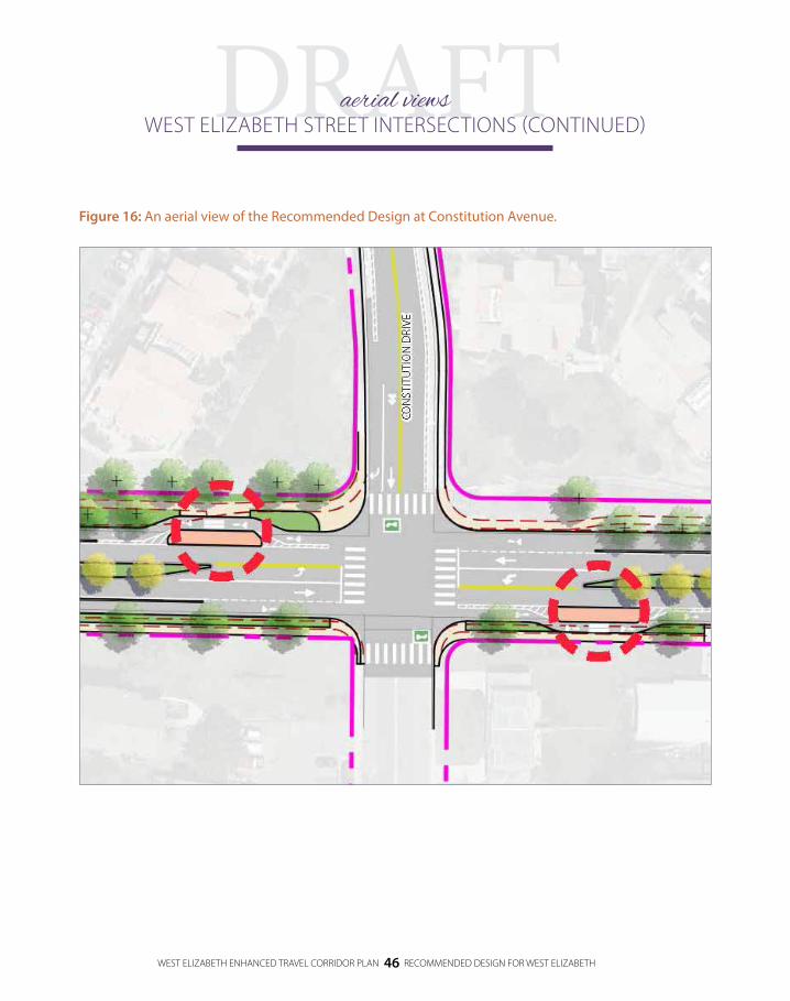
Figure 16: An aerial view of the Recommended Design at Constitution Avenue.
WEST ELIZABETH STREET INTERSECTIONS (CONTINUED)aerial views

DRAFT
WEST ELIZABETH ENHANCED TRAVEL CORRIDOR PLAN 47 RECOMMENDED DESIGN FOR WEST ELIZABETH
RECOM
MEN
DED
DESIG
N
Figure 17: An aerial view of the Recommended Design at City Park Avenue.

DRAFT
WEST ELIZABETH ENHANCED TRAVEL CORRIDOR PLAN 48 RECOMMENDED DESIGN FOR WEST ELIZABETH
Figure 18: Urban Design Elements:Artful urban design elements will create a cohesive look and feel for the corridor.

DRAFT
WEST ELIZABETH ENHANCED TRAVEL CORRIDOR PLAN 49 RECOMMENDED DESIGN FOR WEST ELIZABETH
RECOM
MEN
DED
DESIG
N
Figure 18: Urban Design Elements:Artful urban design elements will create a cohesive look and feel for the corridor.

DRAFT
WEST ELIZABETH ENHANCED TRAVEL CORRIDOR PLAN 50 RECOMMENDED DESIGN FOR WEST ELIZABETH
Land Use and Built FormExisting properties have already begun to redevelop and additional redevelopment is likely in the future. The existing Land Use Code regulations set the stage for redevelopment that is intended to create a vibrant, pedestrian-oriented, mixed use commercial district. A variety of elements will contribute to this environment. Buildings will be multistory and oriented toward the street with parking behind. The buildings will feature a combination of public spaces such as courtyards, corner plazas, paseos or raised terraces. This plan is consistent with the Campus West Community Commercial District Planning Study Report (2001) recommending additional north-south connectivity toward Plum Street and University Avenue to break up the large blocks and improve the walkability to nearby destinations off of West Elizabeth Street.
Currently in the study area residential land uses are focused on Plum Street and commercial land uses are focused on West Elizabeth Street. Currently transit service in the study area is significantly influenced by home-to-school trips and is therefore focused on Plum Street. As Campus West redevelops, West Elizabeth Street may become the epicenter of both commercial and residential activity in the area. Such land uses would generate more diverse trip types using the transit system and may justify shifting the focus of transit service from Plum Street to West
Elizabeth Street. Once land use patterns resulting in more diverse trip types are apt to occur on West Elizabeth Street, expansion of Bus Rapid Transit (BRT)-style transit to West Elizabeth Street may be viable.
Bus Rapid Transit-Style Service on West Elizabeth StreetBus Rapid Transit (BRT) is a rapid transit mode that combines various physical, operating and system elements into a permanently integrated system with a quality image and unique identity. In Fort Collins MAX is an example of a service that features many of the elements typical of BRT, including dedicated right-of-way, specially designed stations and unique vehicles.
BRT-style service on West Elizabeth Street would operate similar to MAX, though not in a dedicated right-of-way, running along West Elizabeth Street from the CSU Foothills Campus Equine Center Park-n-Ride, through the CSU Main Campus (generally parallel to University Avenue), to Mason Street and continuing to Downtown Fort Collins and the Downtown Transit Center. Similar to Route 3, BRT-style service on Elizabeth Street would operate at 10 minute frequencies during the AM peak, midday and PM peak. In the evening it may operate at 15 or 30 minute frequencies.
Planning for Redevelopment
Planning for redevelopment, particularly in Campus West, ensures that the corridor
is adaptable to future changes. Planning for redevelopment in Campus West is focused
between Shields Street and City Park Avenue and assumes that the Recommended
Design is otherwise complete on the corridor.

DRAFT
WEST ELIZABETH ENHANCED TRAVEL CORRIDOR PLAN 51 RECOMMENDED DESIGN FOR WEST ELIZABETH
RECOM
MEN
DED
DESIG
N
In addition to supportive land use on West Elizabeth Street, BRT-style service will be most direct if it uses an alignment central to the CSU Main Campus generally parallel to University Avenue. Through the West Elizabeth Enhanced Travel Corridor Plan, CSU indicated that support does not currently exist for such an alignment. However, the City should continue to work with CSU to understand if support for this alignment may exist in the future. In the event that supportive land use forms on West Elizabeth Street without support from CSU for an alignment generally parallel to University Avenue, the City and CSU may choose to implement an interim BRT-style service on Plum Street.
A variety of BRT-supporting elements can be implemented once transit service is upgraded on West Elizabeth Street, including: branding, articulated buses, styled transit stations with shelters and seating, off board fare payment technologies and passenger information and wayfinding. Off board fare payment, whether with ticket machines or future ticketless technologies, would significantly reduce bus dwell time at stops as it would allow for all door boarding.
Each of these elements can be designed with a unique style to match that of the West Elizabeth Street corridor while still unifying the Transfort brand.
Other InfrastructureRedevelopment and its resulting changes to the built form create a real opportunity to effect transportation infrastructure change in Campus West. Specifically, once properties are assembled and parceled, buildings can be located with regularly spaced, consolidated access points. Right-of-way can be dedicated on both sides of West Elizabeth Street to accommodate 12 foot sidewalks with a 10 foot amenity zone as currently identified in the Campus West Community Commercial District Planning Study Report (2001). Protected bike lanes, previously infeasible in Campus West due to the frequent spacing of driveways, can be constructed. And, a BRT stop can be provided midblock by relocating the existing midblock crosswalk. Other design considerations may include elements to improve environmental sustainability, such as bioswales built into parkways or center medians to help improve the water quality from runoff generated in the area.
Hutchison Drive at the University of
California, Davis is an example of a roadway that
successfully mixes transit vehicles
with people walking and
people biking.

WEST ELIZABETH ENHANCED TRAVEL CORRIDOR PLAN 52 RECOMMENDED DESIGN FOR WEST ELIZABETH
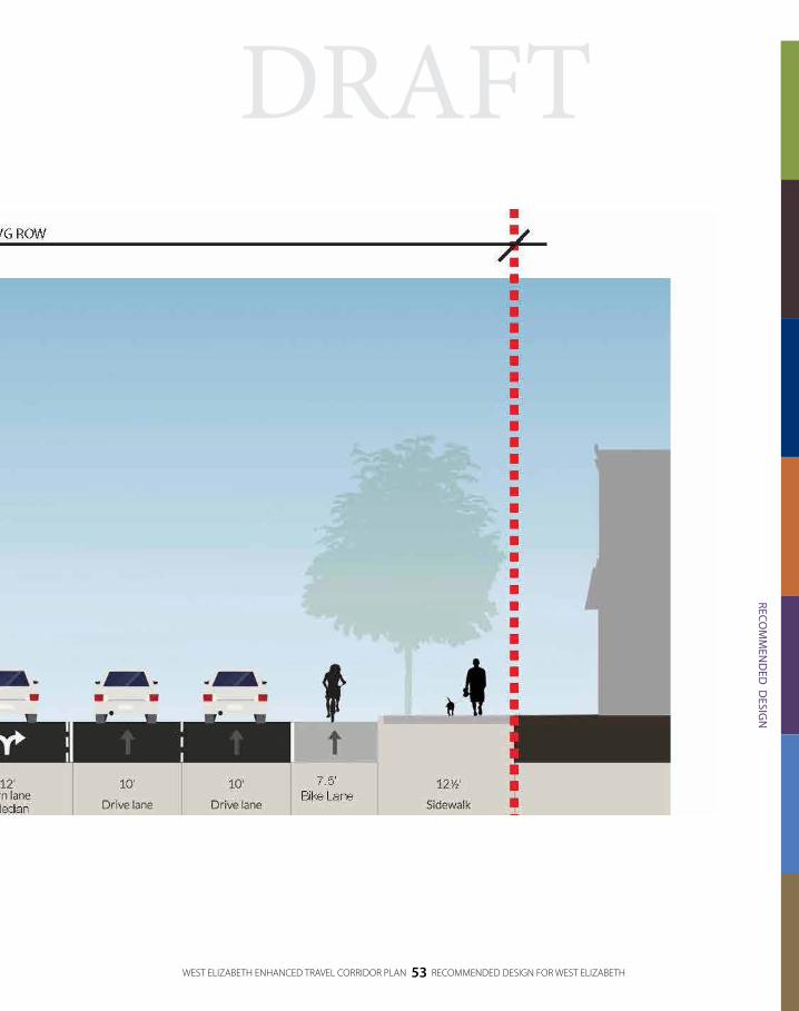
Figure 19: Planning for Redevelopment Cross Section:A cross-section of the Recommended Design that plans for redevelopment between City Park Avenue and Shields Street.
DRAFT
WEST ELIZABETH ENHANCED TRAVEL CORRIDOR PLAN 53 RECOMMENDED DESIGN FOR WEST ELIZABETH
RECOM
MEN
DED
DESIG
N
Figure 19: Planning for Redevelopment Cross Section:A cross-section of the Recommended Design that plans for redevelopment between City Park Avenue and Shields Street.

WEST ELIZABETH ENHANCED TRAVEL CORRIDOR PLAN 54 RECOMMENDED DESIGN FOR WEST ELIZABETH
Figure 20: Planning for Redevelopment Conceptual Design.An aerial view of the Recommended Design that plans for redevelopment in Campus West.

DRAFT
WEST ELIZABETH ENHANCED TRAVEL CORRIDOR PLAN 55 RECOMMENDED DESIGN FOR WEST ELIZABETH
RECOM
MEN
DED
DESIG
N
Figure 20: Planning for Redevelopment Conceptual Design.An aerial view of the Recommended Design that plans for redevelopment in Campus West.

WEST ELIZABETH ENHANCED TRAVEL CORRIDOR PLAN 56 RECOMMENDED DESIGN FOR WEST ELIZABETH
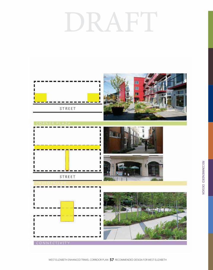
Figure 21: Planning for Redevelopment Urban Design.With redevelopment, new buildings in Campus West will feature a variety of privately-owned public spaces such as courtyards, raised terraces, corner plazas and paseos.
DRAFTDRAFT
WEST ELIZABETH ENHANCED TRAVEL CORRIDOR PLAN 57 RECOMMENDED DESIGN FOR WEST ELIZABETH
RECOM
MEN
DED
DESIG
N
Figure 21: Planning for Redevelopment Urban Design.With redevelopment, new buildings in Campus West will feature a variety of privately-owned public spaces such as courtyards, raised terraces, corner plazas and paseos.

WEST ELIZABETH ENHANCED TRAVEL CORRIDOR PLAN 58 RECOMMENDED DESIGN FOR WEST ELIZABETH
Figure 22: Planning for Redevelopment Transit Routes:Redevelopment in the corridor will be a catalyst for BRT-style transit service.

DRAFT
WEST ELIZABETH ENHANCED TRAVEL CORRIDOR PLAN 59 RECOMMENDED DESIGN FOR WEST ELIZABETH
RECOM
MEN
DED
DESIG
N
Figure 22: Planning for Redevelopment Transit Routes:Redevelopment in the corridor will be a catalyst for BRT-style transit service.

DRAFT
WEST ELIZABETH ENHANCED TRAVEL CORRIDOR PLAN 60 RECOMMENDED DESIGN FOR WEST ELIZABETH
FULFILLING THE PROJECT VISION
The Recommended Design was specifically developed to the fulfill project Vision:
Be unique and adaptable to the distinctive characteristics of each corridor segment
The Recommended Design is context sensitive proposing different treatments throughout the corridor. Examples include:
Phased implementation – improvements are recommended to be phased-in over time and as properties redevelop to adapt to the changing demands in the corridor, including transit service and bicycle and pedestrian facilities.)
Bicycle facility design – protected and buffered bike lanes adapt to the context of the surrounding area.
Sidewalk network – pedestrian facilities differ throughout the corridor to create a complete pedestrian network while minimizing impacts to private property.
Travel lanes – the number of travel lanes in the corridor varies depending on traffic volumes.
Be safe and comfortable for all users
The Recommended Design emphasizes safety and comfort by integrating the following improvements:
Bus stop islands – convenient, easily accessible bus stops with enhanced amenities to improve patron comfort and safety.
Bicycle facility design – protected or buffered bike lanes and the pilot of a protected intersection at West Elizabeth Street/City Park Avenue improve comfort and safety for people biking.
North/south crossings – additional north/south crossings are recommended to improve the comfort and safety of crossing West Elizabeth Street.

DRAFT
WEST ELIZABETH ENHANCED TRAVEL CORRIDOR PLAN 61 RECOMMENDED DESIGN FOR WEST ELIZABETH
RECOM
MEN
DED
DESIG
N
Street design – medians, parkways, pedestrian crossings and a roundabout are recommended to calm traffic and reduce conflict points between users.
Encourage and prioritize public transportation and active transportation options
The Recommended Design encourages and prioritizes public transportation and active transportation options through the following treatments:
Premium/high-frequency transit service – transit service is high-frequency with enhanced passenger amenities, including bus stop islands that help reduce bus dwell time and delay pulling back into traffic
Protected/buffered bike lanes and bus stop islands – bicycling is encouraged by improved separation from vehicles via protected/buffered bike lanes and a bike lane behind bus stop islands
Sidewalk network – the pedestrian environment is improved to help encourage more walking in the corridor
Support the interconnectivity of all modes
The Recommended Design supports interconnectivity for all modes through the following:
Improved bus stops – integration of bike parking and premium passenger amenities at stops make it easier to walk or bike to transit.
Park-n-Ride and future parking considerations – a Park-n-Ride is recommended at the CSU Foothills Campus Equine Center to decrease the need for people driving from far away to park at CSU Main Campus. Additionally, a parking district is recommended at key areas in the corridor to decrease informal park-n-ride activity as transit service is enhanced.
Be a beautiful and vibrant corridor
The Recommended Design provides for a beautiful and vibrant corridor through the following enhancements:
Sidewalk network – the pedestrian environment is improved to include parkways with landscaping between the sidewalk and adjacent travel lanes.
Street design – the street design includes medians with landscaping to help beautify the corridor.
Urban design – unique, artful urban design elements will be incorporated into the public realm and the private realm.
Redevelopment – future redevelopment in the Campus West area will provide privately-owned public spaces that foster a vibrant environment for corridor visitors.
Appendix F describes how the West Elizabeth Enhanced Travel Corridor Plan responds to the Project Need.
WEST ELIZABETH ENHANCED TRAVEL CORRIDOR PLAN 62 RECOMMENDED DESIGN FOR WEST ELIZABETH
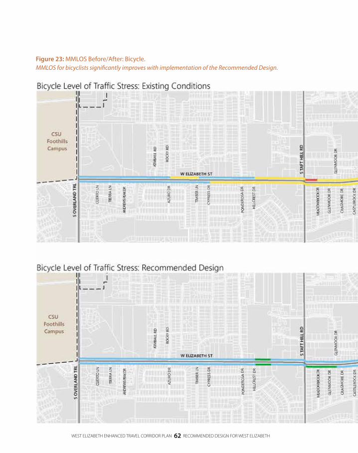
Figure 23: MMLOS Before/After: Bicycle.MMLOS for bicyclists significantly improves with implementation of the Recommended Design.

DRAFT
WEST ELIZABETH ENHANCED TRAVEL CORRIDOR PLAN 63 RECOMMENDED DESIGN FOR WEST ELIZABETH
RECOM
MEN
DED
DESIG
N
Figure 23: MMLOS Before/After: Bicycle.MMLOS for bicyclists significantly improves with implementation of the Recommended Design.

WEST ELIZABETH ENHANCED TRAVEL CORRIDOR PLAN 64 RECOMMENDED DESIGN FOR WEST ELIZABETH
Figure 24: MMLOS Before/After: Pedestrian MMLOS for pedestrians significantly improves with implementation of the Recommended Design.

DRAFT
WEST ELIZABETH ENHANCED TRAVEL CORRIDOR PLAN 65 RECOMMENDED DESIGN FOR WEST ELIZABETH
RECOM
MEN
DED
DESIG
N
Figure 24: MMLOS Before/After: Pedestrian MMLOS for pedestrians significantly improves with implementation of the Recommended Design.

WEST ELIZABETH ENHANCED TRAVEL CORRIDOR PLAN 66 RECOMMENDED DESIGN FOR WEST ELIZABETH
Figure 25: MMLOS Before/After: Vehicle Level of Service for vehicles is maintained at a reasonable level with implementation of the Recommended Design.
Appendix G includes detailed traffic operations calculations for 2015 and 2040 conditions.

DRAFT
WEST ELIZABETH ENHANCED TRAVEL CORRIDOR PLAN 67 RECOMMENDED DESIGN FOR WEST ELIZABETH
RECOM
MEN
DED
DESIG
N
Figure 25: MMLOS Before/After: Vehicle Level of Service for vehicles is maintained at a reasonable level with implementation of the Recommended Design.
Appendix G includes detailed traffic operations calculations for 2015 and 2040 conditions.

DRAFT
THE RECOMMENDED DESIGN’S
DEVELOPMENT IS IMPLEMENTABLE IN
THREE KEY PHASES. ADDITIONALLY,
THE ENHANCED TRAVEL CORRIDOR
PLAN IS PREPARED TO BE ADAPTABLE
TO FUTURE CHANGES THAT MAY
AFFECT THE CORRIDOR.

DRAFT
WEST ELIZABETH ENHANCED TRAVEL CORRIDOR PLAN 69 IMPLEMENTATION
IMPLEM
ENTATIO
N
Section 4IMPLEMENTATION
Implementing the West Elizabeth Enhanced Travel Corridor Plan will take many years. During this time, the City will implement early project phases, conduct further planning and environmental studies, refine the Recommended Design, and pursue a variety of funding sources.
RECOMMENDED DESIGN PHASING
A key principle that guided the Recommended Design’s development was that it should be implementable in phases. The plan for implementation of the Recommended Design includes three main phases, although the Recommended Design may ultimately be implemented as multiple projects depending on the availability of funding. Additionally, the Enhanced Travel Corridor Plan is prepared to be adaptable to future changes that may affect the corridor.

DRAFT
WEST ELIZABETH ENHANCED TRAVEL CORRIDOR PLAN 70 IMPLEMENTATION
Transit service changes will be implemented in 2016. This is the first phase.
The interim design implements elements that address the highest need, such as sidewalk and bike lane gap closures and additional transit service. This is the second phase. A budget offer in the City’s biennial budget process, Budgeting for Outcomes, for 2017-18 has been submitted to fund the interim design. The budget will be finalized in fall 2016; however, it cannot currently be guaranteed that the interim design will be included.
Building upon the first and second phases, completion of the Recommended Design is the third phase. There is currently no estimate of when the Recommended Design will be complete. Furthermore, planning for redevelopment, particularly in Campus West, ensures that the corridor is adaptable to future change.
2016 Transit Service ChangesIn fall 2016 Transfort will implement a variety of transit service changes to improve the capacity and reliability of transit service in the West Elizabeth Street study area. Technical analysis and the public process helped shape the transit service changes, which are focused on the highest demand area of the corridor, on West Elizabeth Street between Ponderosa Drive and the CSU Main Campus. The 2016 transit service includes new and modified routes as well as existing routes.
New and modified routes:Route 3: a new radial route that will run east/west along West Elizabeth
Street and Plum Street from West Elizabeth Street/Ponderosa Drive intersection to the CSU Transit Center.
Route 33 (CSU Foothills Campus Shuttle): a new radial route connecting the CSU Foothills Campus to the CSU Main Campus utilizing Mulberry Road and Laporte Avenue.
Technical analysis and the public process helped shape the transit service changes, which are
focused on the highest demand area of the corridor. The 2016 transit service includes new and
modified routes as well as existing routes.

DRAFT
WEST ELIZABETH ENHANCED TRAVEL CORRIDOR PLAN 71 IMPLEMENTATION
IMPLEM
ENTATIO
N
Existing routes that will remain:Route 2: the existing loop route that runs south
on Shields Street, west along Prospect Road, north on Overland Trail and then east on West Elizabeth Street back to the CSU Transit Center.
Route 31: the existing radial route that connects the Plum Street neighborhood to the CSU Transit Center.
Route 32: the existing loop route that runs west along West Elizabeth Street, south on Overland Trail, then east on Prospect Road back to the CSU Transit Center.
The HORN: the on-campus circulator route that links the CSU South Campus to the CSU Main Campus as well as the Lory Student Center and Moby Arena.
In addition to new and modified routes, three existing bus stops on West Elizabeth Street will be consolidated with nearby stops to improve bus travel time and reliability.
Table 2 shows frequencies, service hours and service enhancements during peak periods of demand for transit service as a part of the 2016 transit service changes.
Table 2: 2016 Transit Route Frequencies & Service Hours
Route Frequency (CSU out of session, if
service changes)
Hours Peak Period Service Enhancements
2 All day: 30 minutes 7:00 AM – 7:00 PMTrailer bus during morning hours when CSU
is in session
3All day: 15 minutes
(All day: 30 minutes)7:00 AM – 10:00 PM N/A
31 All day: 10 minutes1 7:00 AM – 7:00 PMTrailer buses during morning hours
(2 additional) and afternoon hours (1 additional) when CSU is in session
32 All day: 30 minutes1 7:00 AM – 7:00 PMTrailer bus during morning hours
when CSU is in session
33 All day: 60 minutes1 7:00 AM – 7:00 PM N/A
HORNAll day: 10 minutes
(All day: 30 minutes)7:00 AM – 7:00 PM N/A
Notes: 30 series routes only operate when CSU is in session.
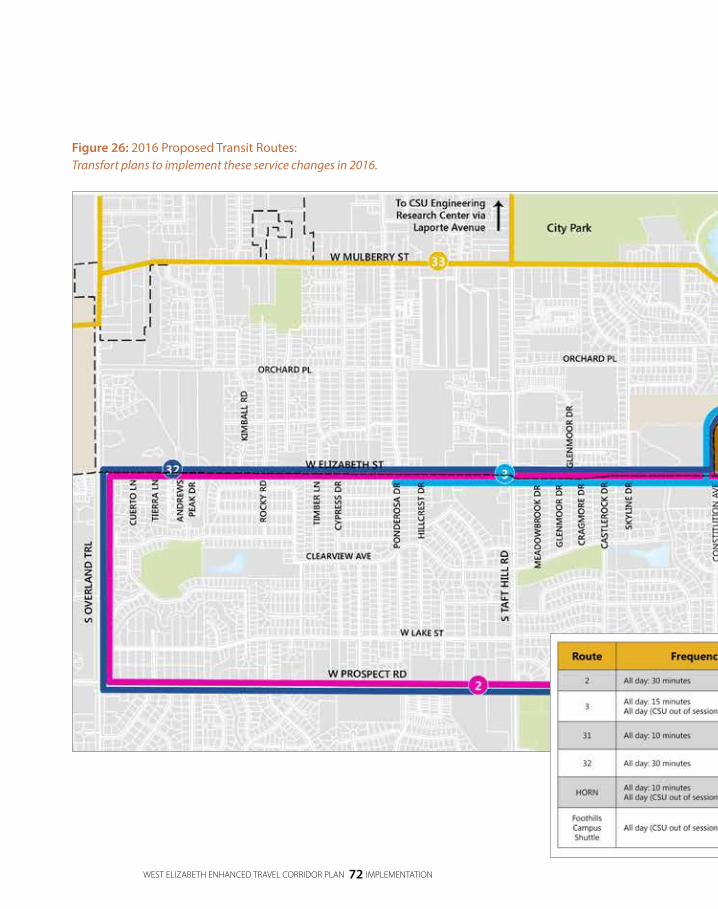
WEST ELIZABETH ENHANCED TRAVEL CORRIDOR PLAN 72 IMPLEMENTATION
Figure 26: 2016 Proposed Transit Routes:Transfort plans to implement these service changes in 2016.
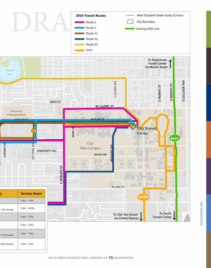
DRAFT
WEST ELIZABETH ENHANCED TRAVEL CORRIDOR PLAN 73 IMPLEMENTATION
IMPLEM
ENTATIO
N
Figure 26: 2016 Proposed Transit Routes:Transfort plans to implement these service changes in 2016.

DRAFT
WEST ELIZABETH ENHANCED TRAVEL CORRIDOR PLAN 74 IMPLEMENTATION
Interim DesignA budget request has been submitted for the interim design, which includes elements of the Recommended Design with the highest need, such as sidewalk gap closures, ADA-compliant curb ramps, bike lane gap closures and additional transit service. These improvements have been proposed to be funded through the City’s biennial budget for 2017-18. The budget will be finalized in fall 2016; however, it cannot currently be guaranteed that the interim design will be included. The elements in the interim design are formed such that the full Recommended Design can later be constructed with minimal throwaway costs.
For people riding transit, transit routes in the study area will be implemented similar to the Recommended Design although some routes themselves change and other routes have lower frequencies. The CSU Foothills Campus Shuttle will continue to operate between the CSU Transit Center and CSU Foothills Campus destinations off of Rampart Road and Laporte Avenue (in the Recommended Design, the CSU Foothills Campus Shuttle will operate exclusively on the CSU Foothills Campus once an on campus roadway connection is available between Rampart Road and Laporte Avenue). Table 3 shows frequencies and vehicle types for the transit routes in the study area after implementation of the interim design.
KEY ELEMENTS OF THE INTERIM DESIGN:
Complete, ADA-compliant sidewalks
Complete bike lanes between Shields Street and Taft Hill Road
Additional transit service
Transit Signal Priority at signalized intersections will be implemented with the interim design. Basic bus stop amenities, including ADA-compliant platforms and signage, will be constructed. Lastly, the City is working with CSU to make improvements to the CSU Foothills Campus Equine Center facility to provide for a Park-n-Ride and transit turnaround which will significantly improve transit operations efficiency and provide a Park-n-Ride opportunity for CSU students, faculty and staff.

DRAFT
WEST ELIZABETH ENHANCED TRAVEL CORRIDOR PLAN 75 IMPLEMENTATION
IMPLEM
ENTATIO
N
Table 3: Interim Design Transit Route Frequencies, Service Hours & Vehicles Types
Route Frequencies Service Hours Vehicle Type2 All day: 30 minutes 7 AM - 7 PM Standard Transfort buses
3AM-PM Peak: 15 minutes
Evening: 30 minutes7 AM – 10 PM Standard Transfort buses
31 All day: 10 minutes 7 AM – 7 PM Standard Transfort buses
HORNAM-PM Peak: 10 minutes
Evening: 20 minutes6:30 AM – 8 PM Standard Transfort buses
33 (CSU Foothills Campus Shuttle)
All day: 60 minutes 7 AM – 7PM 25 passenger shuttle bus
Notes: 30 series routes only operate when CSU is in session.
For people biking green colored pavement will be added to conflict zones where people biking have the right-of-way. Two-stage turn queue boxes will be installed at City Park Avenue as an interim solution (until implementation of the pilot protected intersection) and at Constitution Avenue. Bike lane gaps will be closed throughout the corridor, including the existing gaps at the Taft Hill Road intersection and on the north side of West Elizabeth Street west of Hillcrest Drive. For people walking and rolling, ADA-compliant sidewalks and curb ramps will be completed along West Elizabeth Street. These sidewalk gaps are primarily between Skyline Drive and Taft Hill Road (on the south side of West Elizabeth Street) and between Hillcrest Drive and Andrews Peak Drive (on the north side of West Elizabeth Street). The existing crosswalk at Castlerock Drive will be relocated to Skyline Drive and upgraded to feature a Pedestrian Hybrid Beacon.

WEST ELIZABETH ENHANCED TRAVEL CORRIDOR PLAN 76 IMPLEMENTATION
Figure 2: Interim Design At-a-Glance:The interim design includes elements of the Recommended Design with the highest need, such as sidewalk gap closures, ADA-compliant curb ramps, bike lane gap closures and additional transit service.
Appendix E includes a conceptual, aerial view of the interim design.

DRAFT
WEST ELIZABETH ENHANCED TRAVEL CORRIDOR PLAN 77 IMPLEMENTATION
IMPLEM
ENTATIO
N
Figure 2: Interim Design At-a-Glance:The interim design includes elements of the Recommended Design with the highest need, such as sidewalk gap closures, ADA-compliant curb ramps, bike lane gap closures and additional transit service.
Appendix E includes a conceptual, aerial view of the interim design.

WEST ELIZABETH ENHANCED TRAVEL CORRIDOR PLAN 78 IMPLEMENTATION
Figure 28: Interim Design Transit Routes:Transit service with the interim design will include more efficient transit routing so that Transfort can more cost-effectively provide higher frequency service in the area.

DRAFT
WEST ELIZABETH ENHANCED TRAVEL CORRIDOR PLAN 79 IMPLEMENTATION
IMPLEM
ENTATIO
N
Figure 28: Interim Design Transit Routes:Transit service with the interim design will include more efficient transit routing so that Transfort can more cost-effectively provide higher frequency service in the area.

DRAFT
WEST ELIZABETH ENHANCED TRAVEL CORRIDOR PLAN 80 IMPLEMENTATION
Recommendations recognize that study area roadways
operate as a system and also includes elements on
Constitution Avenue and Plum Street.
RECOMMENDATIONS FOR OTHER STREETS
Constitution Avenue & Plum StreetFor people biking, the Recommended Design for Constitution Avenue and Plum Street from West Elizabeth Street to Shields Street includes buffered bike lanes, consistent with the recommendations of the City’s Bicycle Master Plan (2014). West of City Park Avenue, an existing canal bridge is too narrow for both bike lanes and sidewalks. The Recommended Design includes the widening of this bridge to provide for continuous buffered bike lanes. Additionally, there are occasional obstructions in the sidewalk on Plum Street (including streetlight poles); these obstructions would be removed as a part of the Recommended Design to the benefit of people walking.
COST ESTIMATES & FUNDING SOURCES
Capital Cost EstimatesCapital costs to implement the West Elizabeth Enhanced Travel Corridor Plan include the costs of final design, infrastructure construction and transit vehicles. The cost estimates of each phase are:
Interim Design (second phase) Design - $300,000
Infrastructure costs – $1.4-$2.6 million ($2.0 million most probable cost)
Transit vehicles – one additional vehicle necessary

DRAFT
WEST ELIZABETH ENHANCED TRAVEL CORRIDOR PLAN 81 IMPLEMENTATION
IMPLEM
ENTATIO
N
Recommended Design (third phase)
Design - $2-4.5 million
Infrastructure costs – $12.6-23.4 million ($18 million most probable cost)
Transit vehicles – four additional vehicles necessary
Recommended Design’s planning for redevelopment
Infrastructure costs – $1.2-2.3 million ($1.7 million most probable cost)
Transit vehicles – five BRT vehicles necessary (including one spare) at approximately $800,000 each
BRT-like amenities – 12-14 stations at approximately $100,000-250,000 per station
ONGOING COST EstimatesAs elements of the West Elizabeth Enhanced Travel Corridor Plan are implemented, ongoing costs associated with operations and maintenance of new facilities and services will need to be identified and included in ongoing budgets.
Operating ExpensesThe Plan recommends significant improvements to the transit service in the West Elizabeth Street corridor study area. Ongoing annual cost estimates for each phase are:
Near-term 2016 transit service changes (first phase) – an additional $160,000 per year is being shifted from an underperforming route to fund the 2016 transit service changes on West Elizabeth Street.
Interim Design (second phase) - $2.05 million
Recommended Design (third phase) - $7.31 million
Recommended Design’s planning for redevelopment $7.63 million
DRAFT
WEST ELIZABETH ENHANCED TRAVEL CORRIDOR PLAN 82 IMPLEMENTATION
Maintenance ConsiderationsSome high quality elements, such as protected bike lanes, new landscape medians and potential custom transit station amenities, will require more time to maintain and may require the purchase of specialized equipment, incurring higher maintenance costs. For example, based on analysis completed for the Bicycle Master Plan, the Fort Collins Streets Department estimated that it costs $17,900 per year to sweep and plow one mile of protected bike lane (compared to $3,970 per year to sweep and plow one mile of standard bike lane).
As elements go through final design, the project management team shall work closely with the Transfort, Streets Department, Forestry, and the Parks Department to identify mitigation requirements, context appropriate materials, and maintenance responsibilities. Cost estimates based on the final design and the maintenance considerations will be integrated into future budget requests at the time the recommended facilities are built. Additional information on maintenance costs is included in Appendix H.
Funding SourcesThe West Elizabeth Street Enhanced Travel Corridor Plan’s Recommended Design includes a diverse set of projects that require an equally diverse and resourceful plan to implement.
Table 4 shows funding recommendations for all three phases of the project.
As new funding opportunities arise out of federal, state or local actions, momentum and progress on the corridor add tremendous weight to those awarding grants or prioritizing funding.
The phases identified in Table 4 are not necessarily consecutive and will have periods of overlap. For example, the National Environmental Policy Act (NEPA) process could begin relatively soon and last a year or more. Meanwhile Transportation Investment Generating Economic Recovery (TIGER) Discretionary Grants and other grants should be pursued. An important and complex corridor like West Elizabeth Street will need an ongoing champion who is dedicated to aggressively pursue funding and overall project support.
The West Elizabeth Street Enhanced Travel Corridor Plan’s Recommended Design includes
a diverse set of projects that require an equally diverse and resourceful plan to implement.

DRAFT
WEST ELIZABETH ENHANCED TRAVEL CORRIDOR PLAN 83 IMPLEMENTATION
Table 4: Funding Sources
Phase Potential Source(s) Implementation Steps or Actions
2016 Transit Service Changes ( first phase)
N/A – does not require additional fundingTransfort to implement transit
service changes in 2016
Interim Design (second phase)
Budgeting for Outcomes for infrastructure
Congestion Mitigation and Air Quality Improvements (CMAQ) Program for transit service upgrades and/or
transit signal priority
Apply during the CMAQ call for projects, summer 2016
Recommended Design
(third phase)
Transportation Alternatives Program (TAP) or Great Outdoors Colorado (GOCO) for smaller-scale projects
Transportation Investment Generating Economic Recovery (TIGER) or Building on Basics (BOB) 3.0 for
corridor-wide improvements
Apply during the TAP call for projects, summer 2016
Planning for Redevelopment
Federal Transit Authority (FTA) Section 5309 (Small Starts) for Bus Rapid Transit
CMAQ for Bus Rapid Transit
TIGER for Bus Rapid Transit
Conduct a field review with FTA Region 8 staff, summer 2016
Initiate a NEPA process along the corridor based on FTA
recommendation
IMPLEM
ENTATIO
N

DRAFT
WEST ELIZABETH ENHANCED TRAVEL CORRIDOR PLAN 84 IMPLEMENTATION
TRACKING PERFORMANCE
As elements of the West Elizabeth Enhanced Travel Corridor Plan are implemented, tracking the corridor’s performance will be important for demonstrating the Plan’s benefits, acquiring future funding and possibly refining the Recommended Design. There are a variety of performance measures that should be tracked over time to understand the Plan’s effects:
Health and safety, as measured by crashes, vehicular travel speed and crime on the corridor
Multimodal effects, as measured by user delay, travel time, travel time reliability, user counts, mode split and vehicle miles traveled (per capita)
Economic development, as measured by commercial and residential vacancies, tax yields and property values
Culture, as measured by arts creation and community participation in area events
OTHER NETWORK CONSIDERATIONS
ParkingAs transit is improved along West Elizabeth Street, there may be an increase in unintended park-n-ride activity in nearby neighborhoods and surface parking. This effect has been realized on the Mason Street corridor with the implementation of MAX. Transportation Demand Management (TDM) measures at Colorado State University, such as increased parking permit prices may further increase the likelihood of unintended park-and-ride activity.
While the new Park-n-Ride at the CSU Foothills Campus Equine Center will, in part, alleviate demand for unintended park-and-ride activity by creating a formal area for it, additional parking management practices may be necessary. A Residential Parking Permit Program (RP3) may be necessary to control parking within single family neighborhoods. For multifamily housing and commercial properties, a new parking district may be more appropriate. In a parking district, participating property

DRAFT
WEST ELIZABETH ENHANCED TRAVEL CORRIDOR PLAN 85 IMPLEMENTATION
IMPLEM
ENTATIO
N
owners would pay into a common fund used to implement a parking management and enforcement strategy. The City may also incur some of the costs of such a management and enforcement strategy. Existing zoning can inform where a Residential Parking Permit Program or Parking District may be appropriate; however, the exact boundaries for such programs will change year to year as development occurs and land uses change.
Car ShareAdditional car share in the West Elizabeth Street study will provide personalized mobility for a variety of situations, especially corridor residents who take public transit but need a car sometimes or corridor residents who occasionally need a second car. Car share reduces the need for residents of the corridor to own a car and makes it easier for corridor residents and visitors to primarily rely on other modes (including bicycling, transit and walking) and access a car for special occasions.
Future focus areas for car share (ie. areas in which car share will be more viable) include locations with high residential or employment density.
Bicycle NetworkThrough the development of the West Elizabeth Enhanced Travel Corridor Plan, revisions to the full build bicycle network in the Bicycle Master Plan were identified. Specifically, a neighborhood greenway is now recommended on Skyline Drive south of West Elizabeth Street to connect the bike lanes north of West Elizabeth Street to Avery Park and the Springfield Drive neighborhood greenway.
Bike ShareBike share launched in Fort Collins in April 2016, and the City has a Bike Share Business Plan for future expansion of the system. CSU desires 10 to 15 stations on its Main Campus but currently has no plans for stations at the CSU Foothills Campus. Additionally, three high quality locations for bike share stations were identified in the Bike Share Business Plan in the West Elizabeth Street study area: near the Plum Street/City Park Avenue intersection, in Campus West and near the commercial land uses at the West Elizabeth Street/Taft Hill Road intersection.

WEST ELIZABETH ENHANCED TRAVEL CORRIDOR PLAN 86 IMPLEMENTATION
Figure 29: Parking Management Focus Areas:Parking management, either in the form of a Residential Parking Permit Program or a parking district, will help discourage undesired park-n-ride activity.

DRAFT
WEST ELIZABETH ENHANCED TRAVEL CORRIDOR PLAN 87 IMPLEMENTATION
IMPLEM
ENTATIO
N
Figure 29: Parking Management Focus Areas:Parking management, either in the form of a Residential Parking Permit Program or a parking district, will help discourage undesired park-n-ride activity.

WEST ELIZABETH ENHANCED TRAVEL CORRIDOR PLAN 88 IMPLEMENTATION
Figure 30: Car Share:Additional car share in the corridor will provide additional mobility options without owning a car.

DRAFTDRAFT
WEST ELIZABETH ENHANCED TRAVEL CORRIDOR PLAN 89 IMPLEMENTATION
IMPLEM
ENTATIO
N
Figure 30: Car Share:Additional car share in the corridor will provide additional mobility options without owning a car.
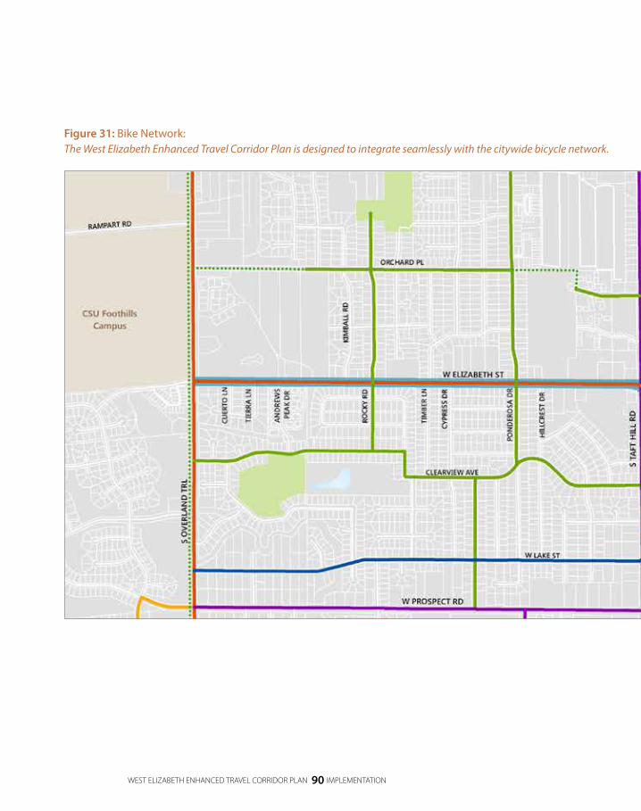
WEST ELIZABETH ENHANCED TRAVEL CORRIDOR PLAN 90 IMPLEMENTATION
Figure 31: Bike Network:The West Elizabeth Enhanced Travel Corridor Plan is designed to integrate seamlessly with the citywide bicycle network.

DRAFT
WEST ELIZABETH ENHANCED TRAVEL CORRIDOR PLAN 91 IMPLEMENTATION
IMPLEM
ENTATIO
N
Figure 31: Bike Network:The West Elizabeth Enhanced Travel Corridor Plan is designed to integrate seamlessly with the citywide bicycle network.

WEST ELIZABETH ENHANCED TRAVEL CORRIDOR PLAN 92 IMPLEMENTATION
Figure 32: Bike Share:Bike share on the CSU Main Campus and on the West Elizabeth Street corridor will provide an additional mobility option in the area.

DRAFT
WEST ELIZABETH ENHANCED TRAVEL CORRIDOR PLAN 93 IMPLEMENTATION
IMPLEM
ENTATIO
N
Figure 32: Bike Share:Bike share on the CSU Main Campus and on the West Elizabeth Street corridor will provide an additional mobility option in the area.

DRAFT
A CRITICAL NEXT STEP IN
IMPLEMENTING THE SHORT-TERM
AND LONG-TERM ACTIONS OF THE
WEST ELIZABETH ENHANCED TRAVEL
CORRIDOR PLAN IS TO IDENTIFY A
PROJECT CHAMPION (EITHER AN
INDIVIDUAL OR A DEPARTMENT).

DRAFT
WEST ELIZABETH ENHANCED TRAVEL CORRIDOR PLAN 95 NEXT STEPS
NEXT STEPS
Section 4
A critical next step in implementing the short-term and long-term actions of the West Elizabeth Enhanced Travel Corridor Plan is to identify a Project Champion (either an individual or a department). The Project Champion’s responsibility is to regularly identify and coordinate next steps, including pursuing grant opportunities or submitting projects to Budgeting for Outcomes, the City’s budgeting process.
Key next steps to the implementation of the West Elizabeth Enhanced Travel Corridor Plan are:
Complete 35 percent design of the Recommended Design, including a survey of the corridor, a drainage study and a utility study, to develop a more refined cost estimate for the corridor and any incremental projects for which the City may pursue funding.
Inform the Federal Transit Administration of the corridor’s long-term plan by conducting a field review with FTA Region 8 staff.
Complete a National Environmental Policy Act (NEPA) process of the Recommended Design based on FTA recommendations.
Apply for incremental projects that are a part of the Recommended Design through appropriate funding sources, including CMAQ and TAP.
NEXT STEPS

DRAFT
WEST ELIZABETH ENHANCED TRAVEL CORRIDOR PLAN 96 NEXT STEPS
Apply for large-scale projects, possibly the entire Recommended Design, as a TIGER discretionary grant. As shown by previously selected projects, it is common to submit three or more application submittals for TIGER discretionary grants before a project is selected.
Update Master Street Plan to show segment of West Elizabeth between City Park Avenue and Taft Hill Road as Arterial 2 Lanes (instead of Arterial 4 Lanes).
For any competitive grant, more letters of support or City Council actions voicing support for the project will increase the project’s competitiveness. However, public and political support for a project can wane when implementation slows. One of the Project Champion’s responsibilities is to continuously generate support for the project. Continuing implementation of the West Elizabeth Enhanced Travel Corridor Plan, even in small steps, is a key to maintaining consistent project support.
FURTHER PLANNING
Through the West Elizabeth Enhanced Travel Corridor Plan’s development process, the futures of City Park Avenue and Shields Street were explored at a high-level. This process revealed that further corridor planning is necessary on these streets to identify a community - and City-supported vision for infrastructure on these corridors.

DRAFT
WEST ELIZABETH ENHANCED TRAVEL CORRIDOR PLAN 97 APPENDICES
Appendix A: Vision, Purpose & Need
Appendix B: Community Engagement Summary
Appendix C: Corridor Understanding Report
Appendix D: Alternatives Analysis Summary
Appendix E: Conceptual Designs of Recommended Design and Interim Design
Appendix F: Responding to the Project Need
Appendix G: Traffic Operations Calculations
Appendix H: Cost Estimates Summary and Methodology
Appendix I: Maintenance Considerations
APPENDICES

DRAFT