Embed Size (px)
Citation preview
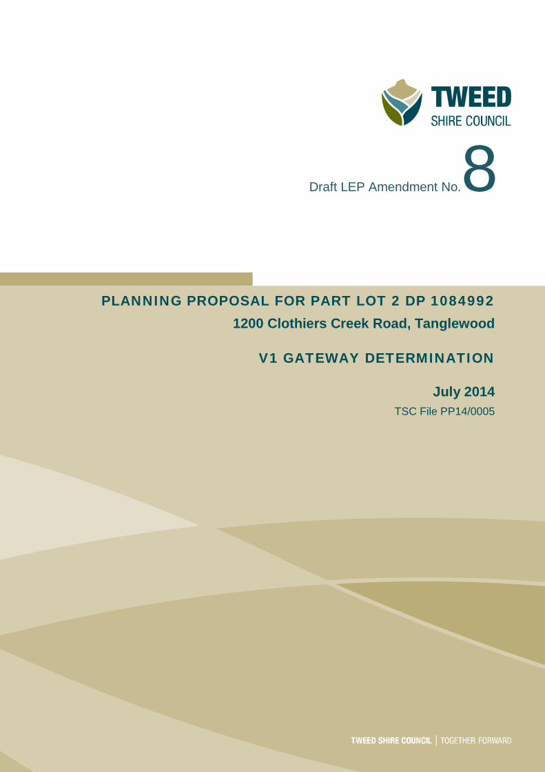
Draft LEP Amendment No.8
PLANNING PROPOSAL FOR PART LOT 2 DP 1084992 1200 Clothiers Creek Road, Tanglewood
V1 GATEWAY DETERMINATION
July 2014 TSC File PP14/0005

THIS PAGE IS BLANK
Table of Contents
Contents i
Introduction ....................................................................................................................................... 1
Purpose ......................................................................................................................................... 1
Property details ............................................................................................................................. 1
Site context and setting ................................................................................................................. 1
Part 1 Objectives and intended outcomes .................................................................................... 4
Objective and Intended outcome ................................................................................................... 4
Part 2 Explanation of provisions ................................................................................................... 4
Part 3 Justification ........................................................................................................................ 4
Section A Need for the planning proposal .............................................................................. 4
1 Is the planning proposal a result of any strategic study or report? ...................................... 4
2 Is the planning proposal the best means of achieving the objectives or intended outcomes, or is there a better way? ............................................................................................................ 4
3 Is there a net community benefit? ...................................................................................... 4
Section B Relationship to strategic planning framework......................................................... 6
1 Is the planning proposal consistent with the objectives and actions contained within the applicable regional or sub-regional strategy (including the Sydney Metropolitan Strategy and exhibited draft strategies)?......................................................................................................... 6
2 Is the planning proposal consistent with the local Council’s Community Strategic Plan, or other local strategic plan? .......................................................................................................... 6
3 Is the planning proposal consistent with the applicable State Environmental Planning Policies (SEPPs)? ..................................................................................................................... 7
4 Is the planning proposal consistent with applicable Ministerial Directions (s117 Directions)? 9
Section C Environmental, Social and economic impact ....................................................... 25
1 Is there any likelihood that critical habitat or threatened species, populations or ecological communities, or their habitats will be adversely affected as a result of the proposal? .............. 25
2 Are there any other likely environmental effects as a result of the planning proposal and how are they proposed to be managed? .................................................................................. 25
3 How has the planning proposal adequately addressed any social and economic effects? 25
Section D State and Commonwealth interests ...................................................................... 26
1 Is there adequate public infrastructure for the planning proposal? ................................... 26
2 What are the views of State and Commonwealth public authorities consulted in accordance with the gateway determination? .......................................................................... 26
Part 4 Mapping - Amendments to the Tweed LEP 2014 .................................................................. 27
Part 5 Community consultation ........................................................................................................ 28
Summary and conclusions .............................................................................................................. 28

Planning Proposal Highway Service Centre l April 2014
Page 1
Introduction
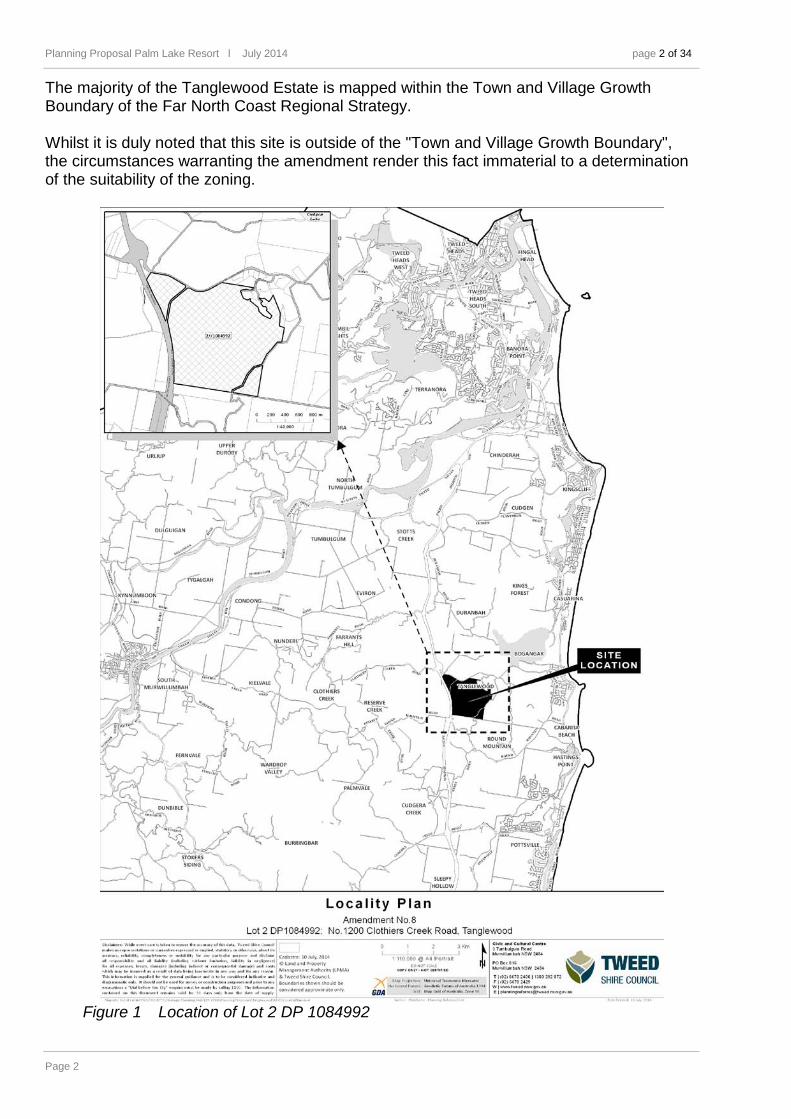
Purpos e The purpose of this planning proposal is to seek an approval for the preparation of amendment to the Land Zoning Map of the Tweed Local Environmental Plan (LEP) 2014. The proposed amendment will rectify a site-specific zoning error ("the error") that occurred during the conversion of the Tweed LEP 2000 Land Zoning Map into the zoning schedule under the then draft Tweed LEP 2012, and later published as Tweed LEP 2014. The area affected by the error is a part of Lot 2 DP 1084992, and is located at Clothiers Creek Road, Tanglewood (refer to Figures 1 and 2 for details). The previous LEP 2000 1(c) Rural Living zone applying to the site was exhibited in November 2012 – January 2013 as R5 Large Lot Residential, however, when referred to NSW P&E post public exhibition the site was incorrectly translated to RE2 Private Recreation and thus, when made did not reflect the exhibited version or direct translation. The resultant effect of the error was a significant change in the land use permissibility's and prohibitions, as prescribed by the respective zoning schedules. Tweed Shire Council received a copy of the Summons (Judicial Review), as filed with the NSW Land and Environment Court on 4 July 2014, as the named Second Respondent to the Minister for Planning, from the landowners Solicitor. The 'Applicant' (Hillpalm Pty Ltd) is seeking a declaration that the RE2 zoning over part of Lot 2 DP1084992 is invalid. At the Directions Hearing of the Court on 18 July 2014, and at the request of all parties, the Matter (14/40479) has been stood over until further direction scheduled on 19 December 2014. This is to enable the NSW Planning & Environment (P&E) and the Council to rectify the error by an amending LEP.
Property de ta ils
The proposal affects part of Lot 2 DP 1084992, located at Clothiers Creek Road, in Tanglewood. The property is owned by Hillpalm Pty Limited. Lot 2 DP 1084992 is part of the property known as the Tanglewood Estate which includes the following allotments:
• Lots 154 and 156 on DP 801121, • Lots 530 and 533 on DP 1003396, • Lot 2 on DP 1084992 (being subject to this planning proposal), and • Lots 151 and 152 on DP 630766.
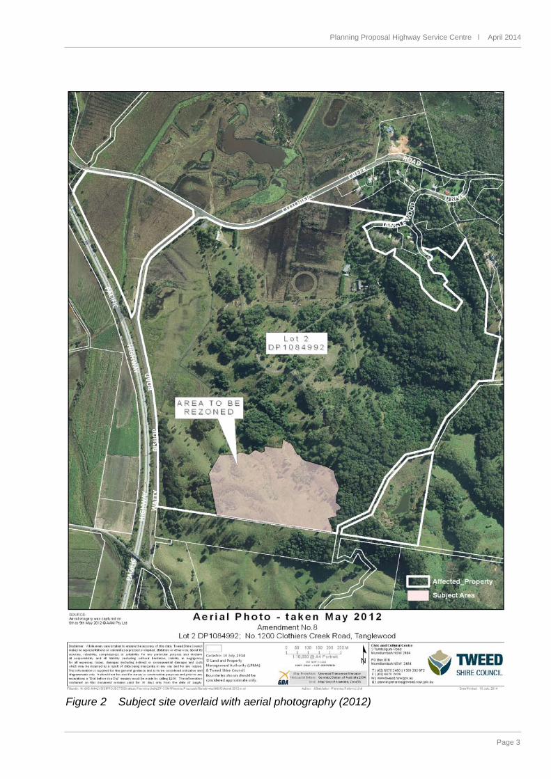
Site context and s e tting The land known as the Tanglewood Estate is located approximately 4.5 km from the coastal villages of Cabarita Beach and Bogangar, and adjoins Pacific Motorway located immediately to the west. To the east and north, the Estate adjoins Cudgen Nature Reserve recognised as habitat important for many wildlife species, including an endangered population of coastal koala. The total area of the Tanglewood Estate is approximately 344 hectares. The majority of the estate is zoned under the Tweed LEP 2014 with zones allowing for residential and tourist development (RU5 Village, R5 Large Lot Residential, RE2 Private Recreation). A portion of the Tanglewood Estate was proposed to be zoned E2 Environmental Conservation under the Tweed LEP 2014, however this zone was deferred from the LEP due to the E-Zone Review currently being undertaken by NSW P&E.
Planning Proposal Palm Lake Resort l July 2014 page 2 of 34
Page 2
The majority of the Tanglewood Estate is mapped within the Town and Village Growth Boundary of the Far North Coast Regional Strategy. Whilst it is duly noted that this site is outside of the "Town and Village Growth Boundary", the circumstances warranting the amendment render this fact immaterial to a determination of the suitability of the zoning.
Figure 1 Location of Lot 2 DP 1084992
Planning Proposal Highway Service Centre l April 2014
Page 3
Figure 2 Subject site overlaid with aerial photography (2012)
Planning Proposal Palm Lake Resort l July 2014 page 4 of 34
Page 4
Part 1 Objectives and intended outcomes
Objec tive and in tended outcomes This planning proposal seeks to rectify the mapping error which occurred during the conversion of the Tweed LEP 2000 Land Zoning Map into the Tweed LEP 2014 Land Zoning Map.
Part 2 Explanation of provisions The intended outcome is to be achieved by the following amendments to the Tweed LEP 2014:
• Tweed LEP 2014 Land Zoning Map to be amended to zone the subject site as R5 Large Lot Residential,
• Tweed LEP 2014 Height of Building Map for the subject site to be amended to apply height control of J - 9 metres, which is standard for the R5 Large Lot Residential zone,
• Tweed LEP 2014 Floor Space Ratio Map for the subject site to be amended to apply ratio of E - 0.55, which is standard for the R5 Large Lot Residential zone,
• Tweed LEP 2014 Lot Size Map for the subject site to be amended to apply Lot Size Standard of Y - 1 ha, which is standard for the R5 Large Lot Residential zone, and a reference to Clause 4.2 A of the LEP by labelling the subject site as "Area A".
Part 3 Justification
Sec tion A Need for the p lanning propos a l
1 Is the p lanning propos a l a res u lt o f any s tra teg ic s tudy or report? This planning proposal is not a result of any strategic study or report. The Proposal has been initiated by Council in order to rectify an error on the Tweed LEP 2014 Land Zoning Map. The error is described within the Introduction on Page 1. A brief assessment of the proposal with the strategic planning framework is provided under Section B following.
2 Is the p lanning propos a l the bes t means of achieving the objec tives or in tended outcomes , or is the re a be tte r way?
Tweed Shire Council has been advised that a Summons (Judicial Review) was filed on 4 July 2014 on behalf of the landowners of the subject site, seeking a declaration that the RE2 zoning over this site is invalid. This judicial review is premised on the basis that the previous LEP 2000 1(c) Rural Living zone applying to the site was exhibited in November 2012 – January 2013 as R5 Large Lot Residential, however, when referred to NSW P&E post public exhibition the site was incorrectly translated to RE2 Private Recreation and thus, when made did not reflect the exhibited version or direct translation. Initial consultation between Council and NSW Planning & Environment (P&E) indicate that this planning proposal is considered a high priority in order to correct the error and meet the judicial review timeframe. In this context, the planning proposal process is considered to be the most appropriate means of applying an appropriate zone over the subject site.
Planning Proposal Highway Service Centre l April 2014
Page 5
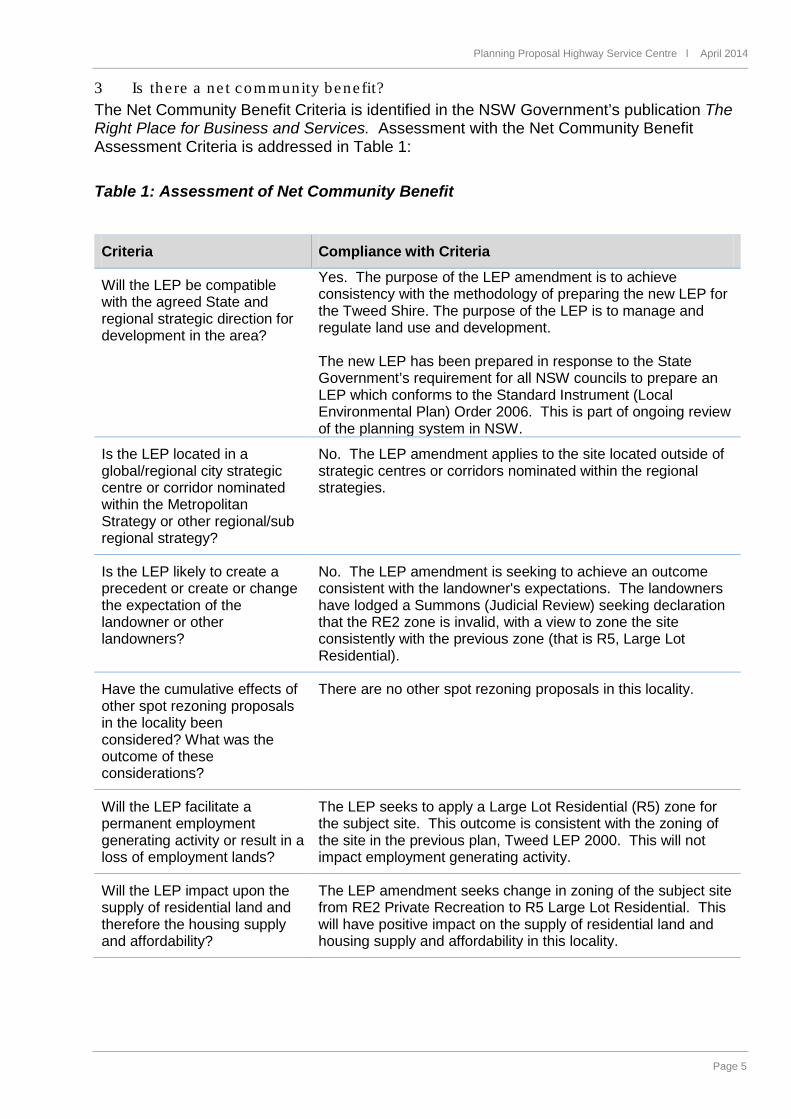
3 Is the re a ne t community benefit? The Net Community Benefit Criteria is identified in the NSW Government’s publication The Right Place for Business and Services. Assessment with the Net Community Benefit Assessment Criteria is addressed in Table 1: Table 1: Assessment of Net Community Benefit
Criteria Compliance with Criteria
Will the LEP be compatible with the agreed State and regional strategic direction for development in the area?
Yes. The purpose of the LEP amendment is to achieve consistency with the methodology of preparing the new LEP for the Tweed Shire. The purpose of the LEP is to manage and regulate land use and development. The new LEP has been prepared in response to the State Government’s requirement for all NSW councils to prepare an LEP which conforms to the Standard Instrument (Local Environmental Plan) Order 2006. This is part of ongoing review of the planning system in NSW.
Is the LEP located in a global/regional city strategic centre or corridor nominated within the Metropolitan Strategy or other regional/sub regional strategy?
No. The LEP amendment applies to the site located outside of strategic centres or corridors nominated within the regional strategies.
Is the LEP likely to create a precedent or create or change the expectation of the landowner or other landowners?
No. The LEP amendment is seeking to achieve an outcome consistent with the landowner's expectations. The landowners have lodged a Summons (Judicial Review) seeking declaration that the RE2 zone is invalid, with a view to zone the site consistently with the previous zone (that is R5, Large Lot Residential).
Have the cumulative effects of other spot rezoning proposals in the locality been considered? What was the outcome of these considerations?
There are no other spot rezoning proposals in this locality.
Will the LEP facilitate a permanent employment generating activity or result in a loss of employment lands?
The LEP seeks to apply a Large Lot Residential (R5) zone for the subject site. This outcome is consistent with the zoning of the site in the previous plan, Tweed LEP 2000. This will not impact employment generating activity.
Will the LEP impact upon the supply of residential land and therefore the housing supply and affordability?
The LEP amendment seeks change in zoning of the subject site from RE2 Private Recreation to R5 Large Lot Residential. This will have positive impact on the supply of residential land and housing supply and affordability in this locality.
Planning Proposal Palm Lake Resort l July 2014 page 6 of 34
Page 6
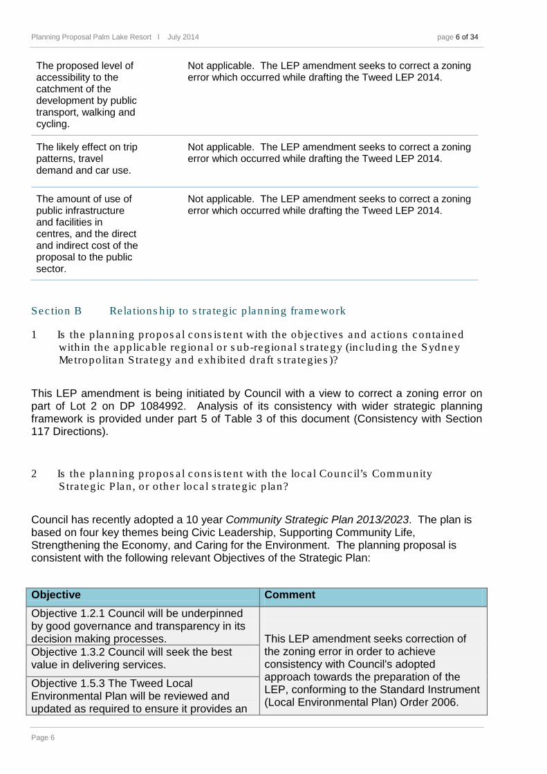
The proposed level of accessibility to the catchment of the development by public transport, walking and cycling.
Not applicable. The LEP amendment seeks to correct a zoning error which occurred while drafting the Tweed LEP 2014.
The likely effect on trip patterns, travel demand and car use.
Not applicable. The LEP amendment seeks to correct a zoning error which occurred while drafting the Tweed LEP 2014.
The amount of use of public infrastructure and facilities in centres, and the direct and indirect cost of the proposal to the public sector.
Not applicable. The LEP amendment seeks to correct a zoning error which occurred while drafting the Tweed LEP 2014.
Sec tion B Re la tions hip to s tra teg ic p lanning framework
1 Is the p lanning propos a l cons is ten t with the objec tives and ac tions conta ined with in the applicable reg iona l or s ub-reg iona l s tra tegy (inc luding the Sydne y Metropolitan S tra tegy and exhib ited dra ft s tra teg ies )?
This LEP amendment is being initiated by Council with a view to correct a zoning error on part of Lot 2 on DP 1084992. Analysis of its consistency with wider strategic planning framework is provided under part 5 of Table 3 of this document (Consistency with Section 117 Directions).
2 Is the p lanning propos a l cons is ten t with the local Counc il’s Community S tra teg ic P lan , o r o the r loca l s tra teg ic p lan?
Council has recently adopted a 10 year Community Strategic Plan 2013/2023. The plan is based on four key themes being Civic Leadership, Supporting Community Life, Strengthening the Economy, and Caring for the Environment. The planning proposal is consistent with the following relevant Objectives of the Strategic Plan:
Objective Comment Objective 1.2.1 Council will be underpinned by good governance and transparency in its decision making processes.
This LEP amendment seeks correction of the zoning error in order to achieve consistency with Council's adopted approach towards the preparation of the LEP, conforming to the Standard Instrument (Local Environmental Plan) Order 2006.
Objective 1.3.2 Council will seek the best value in delivering services.
Objective 1.5.3 The Tweed Local Environmental Plan will be reviewed and updated as required to ensure it provides an
Planning Proposal Highway Service Centre l April 2014
Page 7
effective statutory framework to meet the needs of the Tweed community.
On the basis of compliance with the abovementioned Objectives, this planning proposal is considered consistent with Council’s strategic plans.
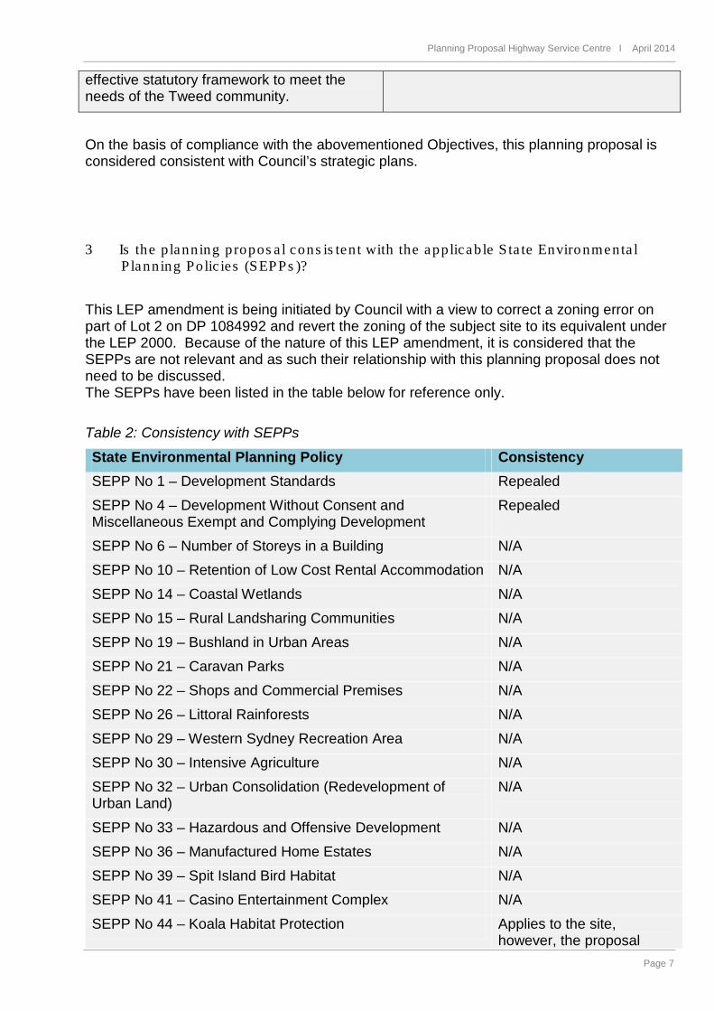
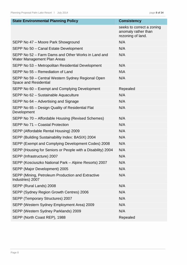
3 Is the p lanning propos a l cons is ten t with the applicable S ta te Environmenta l P lanning Polic ies (SEPPs )?
This LEP amendment is being initiated by Council with a view to correct a zoning error on part of Lot 2 on DP 1084992 and revert the zoning of the subject site to its equivalent under the LEP 2000. Because of the nature of this LEP amendment, it is considered that the SEPPs are not relevant and as such their relationship with this planning proposal does not need to be discussed. The SEPPs have been listed in the table below for reference only. Table 2: Consistency with SEPPs
State Environmental Planning Policy Consistency SEPP No 1 – Development Standards Repealed
SEPP No 4 – Development Without Consent and Miscellaneous Exempt and Complying Development
Repealed
SEPP No 6 – Number of Storeys in a Building N/A
SEPP No 10 – Retention of Low Cost Rental Accommodation N/A
SEPP No 14 – Coastal Wetlands N/A
SEPP No 15 – Rural Landsharing Communities N/A
SEPP No 19 – Bushland in Urban Areas N/A
SEPP No 21 – Caravan Parks N/A
SEPP No 22 – Shops and Commercial Premises N/A
SEPP No 26 – Littoral Rainforests N/A
SEPP No 29 – Western Sydney Recreation Area N/A
SEPP No 30 – Intensive Agriculture N/A
SEPP No 32 – Urban Consolidation (Redevelopment of Urban Land)
N/A
SEPP No 33 – Hazardous and Offensive Development N/A
SEPP No 36 – Manufactured Home Estates N/A
SEPP No 39 – Spit Island Bird Habitat N/A
SEPP No 41 – Casino Entertainment Complex N/A
SEPP No 44 – Koala Habitat Protection Applies to the site, however, the proposal
Planning Proposal Palm Lake Resort l July 2014 page 8 of 34
Page 8
State Environmental Planning Policy Consistency seeks to correct a zoning anomaly rather than rezoning of land.
SEPP No 47 – Moore Park Showground N/A
SEPP No 50 – Canal Estate Development N/A
SEPP No 52 – Farm Dams and Other Works in Land and Water Management Plan Areas
N/A
SEPP No 53 – Metropolitan Residential Development N/A
SEPP No 55 – Remediation of Land N\A
SEPP No 59 – Central Western Sydney Regional Open Space and Residential
N/A
SEPP No 60 – Exempt and Complying Development Repealed
SEPP No 62 – Sustainable Aquaculture N/A
SEPP No 64 – Advertising and Signage N/A
SEPP No 65 – Design Quality of Residential Flat Development
N/A
SEPP No 70 – Affordable Housing (Revised Schemes) N/A
SEPP No 71 – Coastal Protection N/A
SEPP (Affordable Rental Housing) 2009 N/A
SEPP (Building Sustainability Index: BASIX) 2004 N/A
SEPP (Exempt and Complying Development Codes) 2008 N/A
SEPP (Housing for Seniors or People with a Disability) 2004 N/A
SEPP (Infrastructure) 2007 N/A
SEPP (Kosciuszko National Park – Alpine Resorts) 2007 N/A
SEPP (Major Development) 2005 N/A
SEPP (Mining, Petroleum Production and Extractive Industries) 2007
N/A
SEPP (Rural Lands) 2008 N/A
SEPP (Sydney Region Growth Centres) 2006 N/A
SEPP (Temporary Structures) 2007 N/A
SEPP (Western Sydney Employment Area) 2009 N/A
SEPP (Western Sydney Parklands) 2009 N/A
SEPP (North Coast REP), 1988 Repealed
Planning Proposal Highway Service Centre l April 2014
Page 9
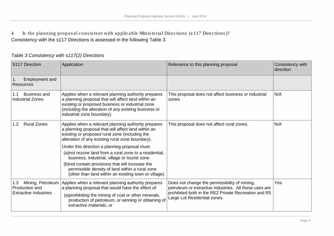
4 Is the p lanning propos a l cons is ten t with applicable Minis te ria l Direc tions (s 117 Direc tions )? Consistency with the s117 Directions is assessed in the following Table 3. Table 3 Consistency with s117(2) Directions
S117 Direction Application Relevance to this planning proposal Consistency with direction
1. Employment and Resources
1.1 Business and Industrial Zones
Applies when a relevant planning authority prepares a planning proposal that will affect land within an existing or proposed business or industrial zone (including the alteration of any existing business or industrial zone boundary).
This proposal does not affect business or industrial zones.
N/A
1.2 Rural Zones Applies when a relevant planning authority prepares a planning proposal that will affect land within an existing or proposed rural zone (including the alteration of any existing rural zone boundary).
Under this direction a planning proposal must: (a)not rezone land from a rural zone to a residential,
business, industrial, village or tourist zone. (b)not contain provisions that will increase the
permissible density of land within a rural zone (other than land within an existing town or village).
This proposal does not affect rural zones.
N/A
1.3 Mining, Petroleum Production and Extractive Industries
Applies when a relevant planning authority prepares a planning proposal that would have the effect of:
(a)prohibiting the mining of coal or other minerals, production of petroleum, or winning or obtaining of extractive materials, or
Does not change the permissibility of mining, petroleum or extractive industries. All these uses are prohibited both in the RE2 Private Recreation and R5 Large Lot Residential zones.
Yes
Planning Proposal Palm Lake Resort l July 2014 page 10 of 34
Page 10
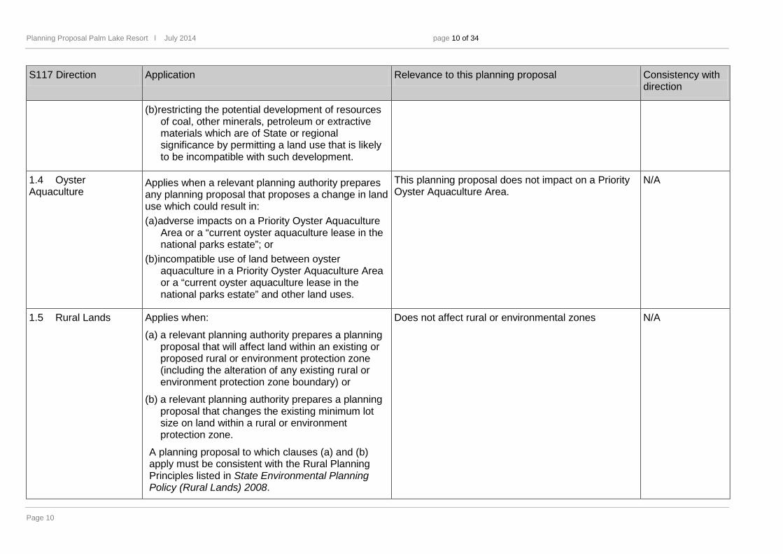
S117 Direction Application Relevance to this planning proposal Consistency with direction
(b)restricting the potential development of resources of coal, other minerals, petroleum or extractive materials which are of State or regional significance by permitting a land use that is likely to be incompatible with such development.
1.4 Oyster Aquaculture
Applies when a relevant planning authority prepares any planning proposal that proposes a change in land use which could result in: (a)adverse impacts on a Priority Oyster Aquaculture
Area or a “current oyster aquaculture lease in the national parks estate”; or
(b)incompatible use of land between oyster aquaculture in a Priority Oyster Aquaculture Area or a “current oyster aquaculture lease in the national parks estate” and other land uses.
This planning proposal does not impact on a Priority Oyster Aquaculture Area.
N/A
1.5 Rural Lands Applies when:
(a) a relevant planning authority prepares a planning proposal that will affect land within an existing or proposed rural or environment protection zone (including the alteration of any existing rural or environment protection zone boundary) or
(b) a relevant planning authority prepares a planning proposal that changes the existing minimum lot size on land within a rural or environment protection zone.
A planning proposal to which clauses (a) and (b) apply must be consistent with the Rural Planning Principles listed in State Environmental Planning Policy (Rural Lands) 2008.
Does not affect rural or environmental zones N/A
Planning Proposal Highway Service Centre l April 2014
Page 11
S117 Direction Application Relevance to this planning proposal Consistency with direction
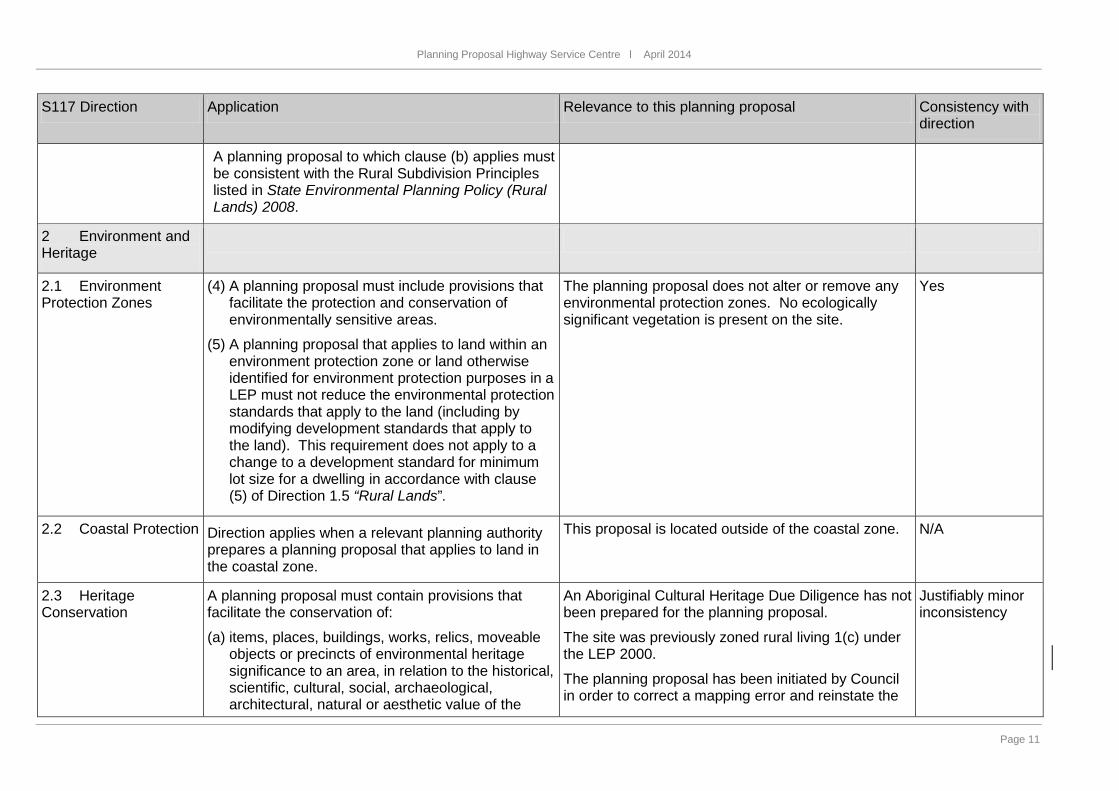
A planning proposal to which clause (b) applies must be consistent with the Rural Subdivision Principles listed in State Environmental Planning Policy (Rural Lands) 2008.
2 Environment and Heritage
2.1 Environment Protection Zones
(4) A planning proposal must include provisions that facilitate the protection and conservation of environmentally sensitive areas.
(5) A planning proposal that applies to land within an environment protection zone or land otherwise identified for environment protection purposes in a LEP must not reduce the environmental protection standards that apply to the land (including by modifying development standards that apply to the land). This requirement does not apply to a change to a development standard for minimum lot size for a dwelling in accordance with clause (5) of Direction 1.5 “Rural Lands”.
The planning proposal does not alter or remove any environmental protection zones. No ecologically significant vegetation is present on the site.
Yes
2.2 Coastal Protection Direction applies when a relevant planning authority prepares a planning proposal that applies to land in the coastal zone.
This proposal is located outside of the coastal zone.
N/A
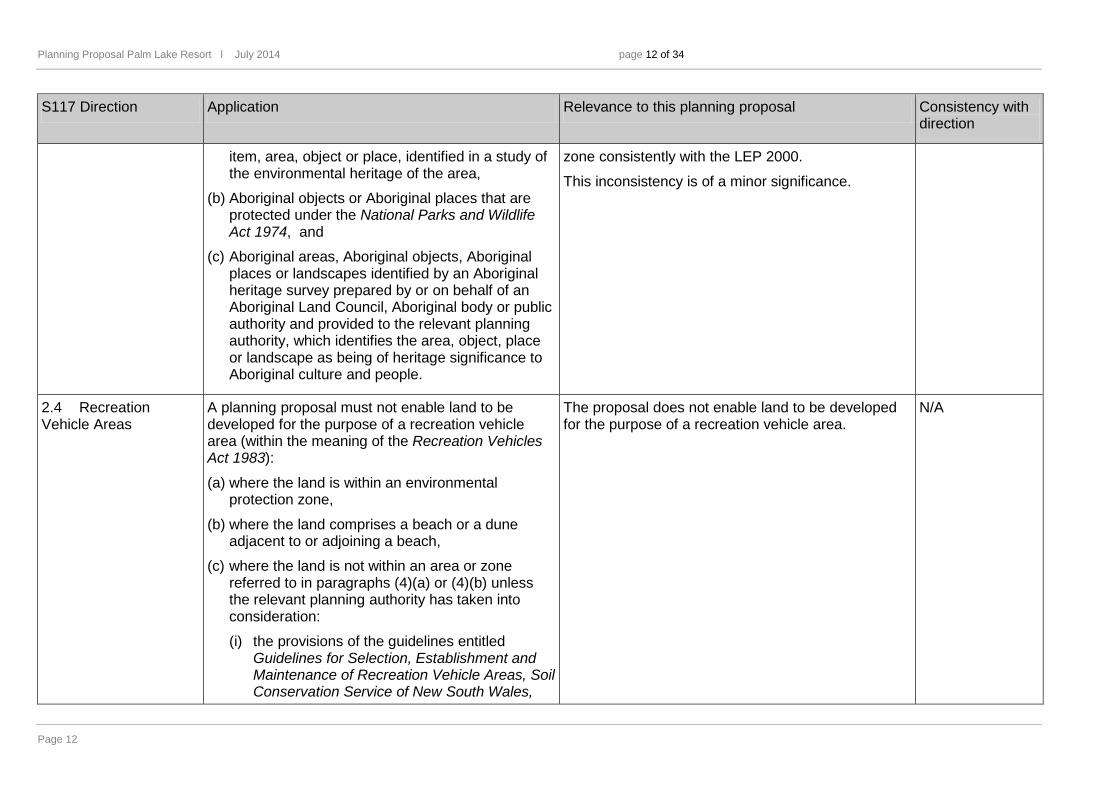
2.3 Heritage Conservation
A planning proposal must contain provisions that facilitate the conservation of:
(a) items, places, buildings, works, relics, moveable objects or precincts of environmental heritage significance to an area, in relation to the historical, scientific, cultural, social, archaeological, architectural, natural or aesthetic value of the
An Aboriginal Cultural Heritage Due Diligence has not been prepared for the planning proposal.
The site was previously zoned rural living 1(c) under the LEP 2000.
The planning proposal has been initiated by Council in order to correct a mapping error and reinstate the
Justifiably minor inconsistency
Planning Proposal Palm Lake Resort l July 2014 page 12 of 34
Page 12
S117 Direction Application Relevance to this planning proposal Consistency with direction
item, area, object or place, identified in a study of the environmental heritage of the area,
(b) Aboriginal objects or Aboriginal places that are protected under the National Parks and Wildlife Act 1974, and
(c) Aboriginal areas, Aboriginal objects, Aboriginal places or landscapes identified by an Aboriginal heritage survey prepared by or on behalf of an Aboriginal Land Council, Aboriginal body or public authority and provided to the relevant planning authority, which identifies the area, object, place or landscape as being of heritage significance to Aboriginal culture and people.
zone consistently with the LEP 2000.
This inconsistency is of a minor significance.
2.4 Recreation Vehicle Areas
A planning proposal must not enable land to be developed for the purpose of a recreation vehicle area (within the meaning of the Recreation Vehicles Act 1983):
(a) where the land is within an environmental protection zone,
(b) where the land comprises a beach or a dune adjacent to or adjoining a beach,
(c) where the land is not within an area or zone referred to in paragraphs (4)(a) or (4)(b) unless the relevant planning authority has taken into consideration:
(i) the provisions of the guidelines entitled Guidelines for Selection, Establishment and Maintenance of Recreation Vehicle Areas, Soil Conservation Service of New South Wales,
The proposal does not enable land to be developed for the purpose of a recreation vehicle area.
N/A
Planning Proposal Highway Service Centre l April 2014
Page 13
S117 Direction Application Relevance to this planning proposal Consistency with direction
September, 1985, and
(ii) the provisions of the guidelines entitled Recreation Vehicles Act, 1983, Guidelines for Selection, Design, and Operation of Recreation Vehicle Areas, State Pollution Control Commission, September 1985.
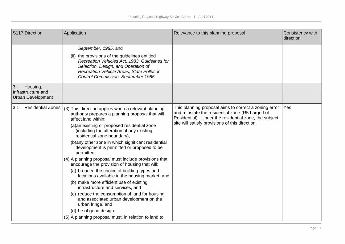
3. Housing, Infrastructure and Urban Development
3.1 Residential Zones (3) This direction applies when a relevant planning authority prepares a planning proposal that will affect land within: (a)an existing or proposed residential zone
(including the alteration of any existing residential zone boundary),
(b)any other zone in which significant residential development is permitted or proposed to be permitted.
(4) A planning proposal must include provisions that encourage the provision of housing that will: (a) broaden the choice of building types and
locations available in the housing market, and (b) make more efficient use of existing
infrastructure and services, and (c) reduce the consumption of land for housing
and associated urban development on the urban fringe, and
(d) be of good design. (5) A planning proposal must, in relation to land to
This planning proposal aims to correct a zoning error and reinstate the residential zone (R5 Large Lot Residential). Under the residential zone, the subject site will satisfy provisions of this direction.
Yes

Planning Proposal Palm Lake Resort l July 2014 page 14 of 34
Page 14
S117 Direction Application Relevance to this planning proposal Consistency with direction
which this direction applies: (a) contain a requirement that residential
development is not permitted until land is adequately serviced (or arrangements satisfactory to the council, or other appropriate authority, have been made to service it), and
(b) not contain provisions which will reduce the permissible residential density of land.
3.2 Caravan Parks and Manufactured Home Estates
Applies when a relevant planning authority prepares a planning proposal.
(1) In identifying suitable zones, locations and provisions for caravan parks in a planning proposal, the relevant planning authority must: (a) retain provisions that permit development for
the purposes of a caravan park to be carried out on land, and
(b) retain the zonings of existing caravan parks, or in the case of a new principal LEP zone the land in accordance with an appropriate zone under the Standard Instrument (Local Environmental Plans) Order 2006 that would facilitate the retention of the existing caravan park.
(2) In identifying suitable zones, locations and provisions for manufactured home estates (MHEs) in a planning proposal, the relevant planning authority must: (a) take into account the categories of land set out
in Schedule 2 of SEPP 36 as to where MHEs should not be located,
(b) take into account the principles listed in clause
This proposal does not seek development for the purposes of a caravan park or manufactured homes estate nor does it impact upon any land that does permit development for the purposes of a caravan park or manufactured homes estate.
N/A

Planning Proposal Highway Service Centre l April 2014
Page 15
S117 Direction Application Relevance to this planning proposal Consistency with direction
9 of SEPP 36 (which relevant planning authorities are required to consider when assessing and determining the development and subdivision proposals), and
(c) include provisions that the subdivision of MHEs by long term lease of up to 20 years or under the Community Land Development Act 1989 be permissible with consent.
3.3 Home Occupations
Planning proposals must permit home occupations to be carried out in dwelling houses without the need for development consent.
Home occupation land use is permissible without consent in the R5 Large Lot Residential zone, which is the desired outcome of this planning proposal.
Yes
3.4 Integrating Land Use and Transport
Applies when a relevant planning authority prepares a planning proposal that will create, alter or remove a zone or a provision relating to urban land, including land zoned for residential, business, industrial, village or tourist purposes.
(3) A planning proposal must locate zones for urban purposes and include provisions that give effect to and are consistent with the aims, objectives and principles of: (a) Improving Transport Choice – Guidelines for
planning and development (DUAP 2001), and (b) The Right Place for Business and Services –
Planning Policy (DUAP 2001).
This planning proposal aims to correct a zoning error and reinstate the residential zone (R5 Large Lot Residential) which was changed to a private recreation zone while drafting the LEP 2014.
The planning proposal is not in itself a major traffic generator and will not result in increased resident population.
Yes
3.5 Development Near Licensed Aerodrome
Applies when a relevant planning authority prepares a planning proposal that will create, alter or remove a zone or a provision relating to land in the vicinity of a licensed aerodrome.
This proposal does not create, alter or remove a zone or provision relating to an airport.
N/A
Planning Proposal Palm Lake Resort l July 2014 page 16 of 34
Page 16
S117 Direction Application Relevance to this planning proposal Consistency with direction
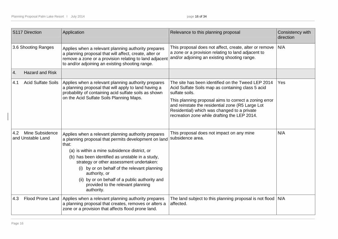
3.6 Shooting Ranges Applies when a relevant planning authority prepares a planning proposal that will affect, create, alter or remove a zone or a provision relating to land adjacent to and/or adjoining an existing shooting range.
This proposal does not affect, create, alter or remove a zone or a provision relating to land adjacent to and/or adjoining an existing shooting range.
N/A
4. Hazard and Risk
4.1 Acid Sulfate Soils Applies when a relevant planning authority prepares a planning proposal that will apply to land having a probability of containing acid sulfate soils as shown on the Acid Sulfate Soils Planning Maps.
The site has been identified on the Tweed LEP 2014 Acid Sulfate Soils map as containing class 5 acid sulfate soils.
This planning proposal aims to correct a zoning error and reinstate the residential zone (R5 Large Lot Residential) which was changed to a private recreation zone while drafting the LEP 2014.
Yes
4.2 Mine Subsidence and Unstable Land
Applies when a relevant planning authority prepares a planning proposal that permits development on land that:
(a) is within a mine subsidence district, or (b) has been identified as unstable in a study,
strategy or other assessment undertaken: (i) by or on behalf of the relevant planning
authority, or (ii) by or on behalf of a public authority and
provided to the relevant planning authority.
This proposal does not impact on any mine subsidence area.
N/A
4.3 Flood Prone Land Applies when a relevant planning authority prepares a planning proposal that creates, removes or alters a zone or a provision that affects flood prone land.
The land subject to this planning proposal is not flood affected.
N/A
Planning Proposal Highway Service Centre l April 2014
Page 17
S117 Direction Application Relevance to this planning proposal Consistency with direction
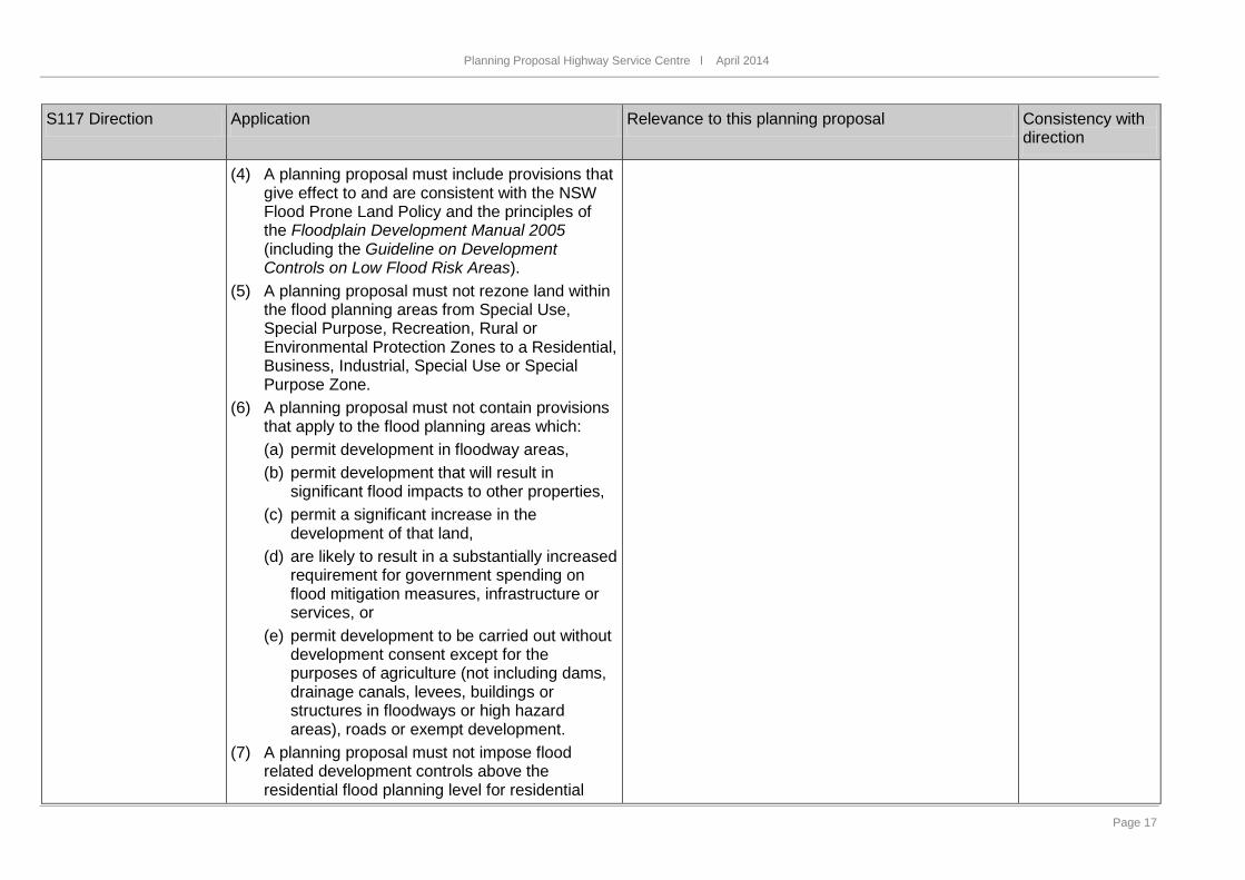
(4) A planning proposal must include provisions that give effect to and are consistent with the NSW Flood Prone Land Policy and the principles of the Floodplain Development Manual 2005 (including the Guideline on Development Controls on Low Flood Risk Areas).
(5) A planning proposal must not rezone land within the flood planning areas from Special Use, Special Purpose, Recreation, Rural or Environmental Protection Zones to a Residential, Business, Industrial, Special Use or Special Purpose Zone.
(6) A planning proposal must not contain provisions that apply to the flood planning areas which: (a) permit development in floodway areas, (b) permit development that will result in
significant flood impacts to other properties, (c) permit a significant increase in the
development of that land, (d) are likely to result in a substantially increased
requirement for government spending on flood mitigation measures, infrastructure or services, or
(e) permit development to be carried out without development consent except for the purposes of agriculture (not including dams, drainage canals, levees, buildings or structures in floodways or high hazard areas), roads or exempt development.
(7) A planning proposal must not impose flood related development controls above the residential flood planning level for residential
Planning Proposal Palm Lake Resort l July 2014 page 18 of 34
Page 18
S117 Direction Application Relevance to this planning proposal Consistency with direction
development on land, unless a relevant planning authority provides adequate justification for those controls to the satisfaction of the Director-General (or an officer of the Department nominated by the Director-General).
(8) For the purposes of a planning proposal, a relevant planning authority must not determine a flood planning level that is inconsistent with the Floodplain Development Manual 2005 (including the Guideline on Development Controls on Low Flood Risk Areas) unless a relevant planning authority provides adequate justification for the proposed departure from that Manual to the satisfaction of the Director-General (or an officer of the Department nominated by the Director-General).
4.4 Planning for Bushfire Protection
Applies when a relevant planning authority prepares a planning proposal that will affect, or is in proximity to land mapped as bushfire prone land.
(9) In the preparation of a planning proposal the relevant planning authority must consult with the Commissioner of the NSW Rural Fire Service following receipt of a gateway determination under section 56 of the Act, and prior to undertaking community consultation in satisfaction of section 57 of the Act, and take into account any comments so made,
(10) A planning proposal must: (a) have regard to Planning for Bushfire
Protection 2006, (b) introduce controls that avoid placing
The proposal applies to land identified as being Bushfire Prone.
This planning proposal has been initiated by Council in order to correct a zoning error and reinstate the residential zone (R5 Large Lot Residential) which was changed to a private recreation zone while drafting the LEP 2014. Compliance with relevant bushfire protection controls has not been assessed.
Council will seek advice from NSW Planning & Environment whether this matter should be further consulted with the Commissioner of the NSW Rural Fire Service, in order to give effect to this direction.
Justifiably minor inconsistency
Planning Proposal Highway Service Centre l April 2014
Page 19
S117 Direction Application Relevance to this planning proposal Consistency with direction
inappropriate developments in hazardous areas, and
(c) ensure that bushfire hazard reduction is not prohibited within the APZ.
(11) A planning proposal must, where development is proposed, comply with the following provisions, as appropriate: (a) provide an Asset Protection Zone (APZ)
incorporating at a minimum: (i) an Inner Protection Area bounded by a
perimeter road or reserve which circumscribes the hazard side of the land intended for development and has a building line consistent with the incorporation of an APZ, within the property, and
(ii) an Outer Protection Area managed for hazard reduction and located on the bushland side of the perimeter road,
(b) for infill development (that is development within an already subdivided area), where an appropriate APZ cannot be achieved, provide for an appropriate performance standard, in consultation with the NSW Rural Fire Service. If the provisions of the planning proposal permit Special Fire Protection Purposes (as defined under section 100B of the Rural Fires Act 1997), the APZ provisions must be complied with,
(c) contain provisions for two-way access roads which links to perimeter roads and/or to fire trail networks,
Planning Proposal Palm Lake Resort l July 2014 page 20 of 34
Page 20
S117 Direction Application Relevance to this planning proposal Consistency with direction
(d) contain provisions for adequate water supply for firefighting purposes,
(e) minimise the perimeter of the area of land interfacing the hazard which may be developed,
(f) introduce controls on the placement of combustible materials in the Inner Protection Area.
5. Regional Planning
5.1 Implementation of Regional Strategies
Planning proposals must be consistent with a regional strategy released by the Minister for Planning.
The Far North Coast Regional Strategy is identifying the subject site as being outside of the Town and Village Growth Boundaries, therefore the desired outcome of this planning proposal is not consistent with the Strategy.
Council considers this inconsistency to be of a minor significance because the purpose of this planning proposal is to correct a zoning error occurred during the preparation of the Tweed LEP 2014.
Justifiably minor inconsistency
5.2 Sydney Drinking Water Catchments
Applies when a relevant planning authority prepares a planning proposal that applies to the hydrological catchment.
The proposal is not within this catchment. N/A
5.3 Farmland of State and Regional Significance on the NSW Far North Coast
Applies (to Tweed) when a relevant planning authority prepares a planning proposal for land mapped as: (a) State significant farmland, or (b) regionally significant farmland, or
The site is not mapped as State or regionally significant farmland.
N/A
Planning Proposal Highway Service Centre l April 2014
Page 21
S117 Direction Application Relevance to this planning proposal Consistency with direction
(c) significant non-contiguous farmland, on the set of four maps held in the Department of Planning and marked “Northern Rivers Farmland Protection Project, Final Map 2005 (Section 117(2) Direction)”.
A planning proposal must not: (a) rezone land identified as “State Significant
Farmland” for urban or rural residential purposes.
(b) rezone land identified as “Regionally Significant Farmland” for urban or rural residential purposes.
(c) rezone land identified as “significant non-contiguous farmland” for urban or rural residential purposes.
5.4 Commercial and Retail Development along the Pacific Highway, North Coast
Applies when a relevant planning authority prepares a planning proposal for land in the vicinity of the existing and/or proposed alignment of the Pacific Highway.
(5) A planning proposal that applies to land located on “out-of-town” segments of the Pacific Highway must provide that:
(a) new commercial or retail development must not be established near the Pacific Highway if this proximity would be inconsistent with the objectives of this Direction.
(b) development with frontage to the Pacific Highway must consider impact the development has on the safety and efficiency of the highway.
(c) For the purposes of this paragraph, “out-of-town”
The proposed development is located in the vicinity of the Pacific Highway, however does not immediately adjoin it. It is considered that the new development will not have any impact on safety on Pacific Highway.
Yes
Planning Proposal Palm Lake Resort l July 2014 page 22 of 34
Page 22
S117 Direction Application Relevance to this planning proposal Consistency with direction
means areas which, prior to the draft local environmental plan, do not have an urban zone (eg:
“village”, “residential”, “tourist”, “commercial”, “industrial”, etc) or are in areas where the Pacific Highway speed limit is 80km/hour or greater.
(6) Notwithstanding the requirements of paragraphs (4) and (5), the establishment of highway service centres may be permitted at the localities listed in Table 1, provided that the Roads and Traffic Authority is satisfied that the highway service centre(s) can be safely and efficiently integrated into the Highway interchange(s) at those localities.
Table 1
Chinderah
Chinderah Bay Road interchange (southbound)
Western side of highway in urban zone (northbound)
5.8 Second Sydney Airport
Applies to land shown within the boundaries of the proposed airport site.
The proposal is not within these boundaries. N/A
6. Local Plan Making
6.1 Approval and Referral Requirements
A planning proposal must: (d) minimise the inclusion of provisions that require
the concurrence, consultation or referral of development applications to a Minister or public authority, and
(e) not contain provisions requiring concurrence, consultation or referral of a Minister or public authority unless the relevant planning authority
The planning proposal will not include provisions that require the concurrence, consultation or referral of development applications to a Minister or public authority.
N/A
Planning Proposal Highway Service Centre l April 2014
Page 23
S117 Direction Application Relevance to this planning proposal Consistency with direction
has obtained the approval of: (i) the appropriate Minister or public authority, and (ii) the Director-General of the Department of
Planning (or an officer of the Department nominated by the Director-General),
prior to undertaking community consultation in satisfaction of section 57 of the Act, and (f) not identify development as designated
development unless the relevant planning authority: (i) can satisfy the Director-General of the
Department of Planning (or an officer of the Department nominated by the Director-General) that the class of development is likely to have a significant impact on the environment, and
(ii) has obtained the approval of the Director-General of the Department of Planning (or an officer of the Department nominated by the Director-General) prior to undertaking community consultation in satisfaction of section 57 of the Act.
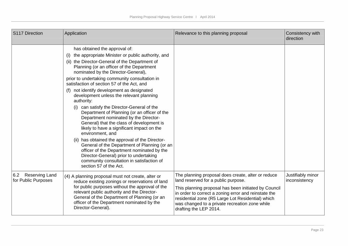
6.2 Reserving Land for Public Purposes
(4) A planning proposal must not create, alter or reduce existing zonings or reservations of land for public purposes without the approval of the relevant public authority and the Director-General of the Department of Planning (or an officer of the Department nominated by the Director-General).
The planning proposal does create, alter or reduce land reserved for a public purpose.
This planning proposal has been initiated by Council in order to correct a zoning error and reinstate the residential zone (R5 Large Lot Residential) which was changed to a private recreation zone while drafting the LEP 2014.
Justifiably minor inconsistency

Planning Proposal Palm Lake Resort l July 2014 page 24 of 34
Page 24
S117 Direction Application Relevance to this planning proposal Consistency with direction
6.3 Site Specific Provisions
Applies when a relevant planning authority prepares a planning proposal that will allow a particular development to be carried out. (4)A planning proposal that will amend another
environmental planning instrument in order to allow a particular development proposal to be carried out must either: (a) allow that land use to be carried out in the
zone the land is situated on, or (b) rezone the site to an existing zone already
applying in the environmental planning instrument that allows that land use without imposing any development standards or requirements in addition to those already contained in that zone, or
(c) allow that land use on the relevant land without imposing any development standards or requirements in addition to those already contained in the principal environmental planning instrument being amended.
(5)A planning proposal must not contain or refer to drawings that show details of the development.
This planning proposal does not seek to allow a particular development to be carried out. Instead, it has been initiated by Council in order to correct a zoning error and reinstate the residential zone (R5 Large Lot Residential) which was changed to a private recreation zone while drafting the LEP 2014. It does .
N/A
Planning Proposal Highway Service Centre l April 2014
Page 25
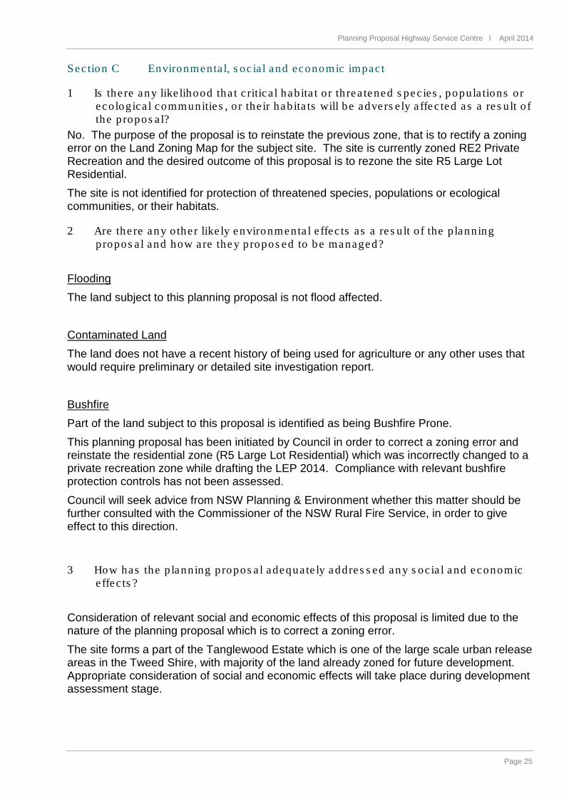
Sec tion C Environmenta l, s oc ia l and economic impac t
1 Is the re any like lihood tha t c ritica l habita t o r th rea tened s pec ies , popula tions or ecologica l communitie s , o r the ir habita ts will be advers e ly a ffe c ted as a res u lt o f the propos a l?
No. The purpose of the proposal is to reinstate the previous zone, that is to rectify a zoning error on the Land Zoning Map for the subject site. The site is currently zoned RE2 Private Recreation and the desired outcome of this proposal is to rezone the site R5 Large Lot Residential. The site is not identified for protection of threatened species, populations or ecological communities, or their habitats.
2 Are the re any o the r like ly environmenta l e ffec ts as a re s u lt o f the p lanning propos a l and how a re the y propos ed to be managed?
Flooding The land subject to this planning proposal is not flood affected. Contaminated Land The land does not have a recent history of being used for agriculture or any other uses that would require preliminary or detailed site investigation report. Bushfire Part of the land subject to this proposal is identified as being Bushfire Prone. This planning proposal has been initiated by Council in order to correct a zoning error and reinstate the residential zone (R5 Large Lot Residential) which was incorrectly changed to a private recreation zone while drafting the LEP 2014. Compliance with relevant bushfire protection controls has not been assessed. Council will seek advice from NSW Planning & Environment whether this matter should be further consulted with the Commissioner of the NSW Rural Fire Service, in order to give effect to this direction.
3 How has the p lanning propos a l adequa te ly addres s ed any s oc ia l and economic e ffec ts ?
Consideration of relevant social and economic effects of this proposal is limited due to the nature of the planning proposal which is to correct a zoning error. The site forms a part of the Tanglewood Estate which is one of the large scale urban release areas in the Tweed Shire, with majority of the land already zoned for future development. Appropriate consideration of social and economic effects will take place during development assessment stage.
Planning Proposal Palm Lake Resort l July 2014 page 26 of 34
Page 26
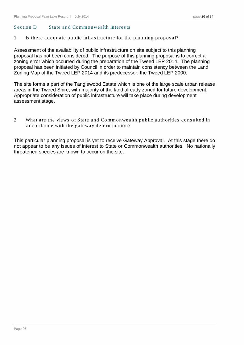
Sec tion D S ta te and Commonwea lth in te res ts
1 Is the re adequa te public in fras truc ture for the p lanning propos a l?
Assessment of the availability of public infrastructure on site subject to this planning proposal has not been considered. The purpose of this planning proposal is to correct a zoning error which occurred during the preparation of the Tweed LEP 2014. The planning proposal has been initiated by Council in order to maintain consistency between the Land Zoning Map of the Tweed LEP 2014 and its predecessor, the Tweed LEP 2000. The site forms a part of the Tanglewood Estate which is one of the large scale urban release areas in the Tweed Shire, with majority of the land already zoned for future development. Appropriate consideration of public infrastructure will take place during development assessment stage.
2 What a re the views of S ta te and Commonwea lth public au thoritie s cons ulted in accordance with the ga tewa y de te rmina tion?
This particular planning proposal is yet to receive Gateway Approval. At this stage there do not appear to be any issues of interest to State or Commonwealth authorities. No nationally threatened species are known to occur on the site.
Planning Proposal Highway Service Centre l April 2014
Page 27
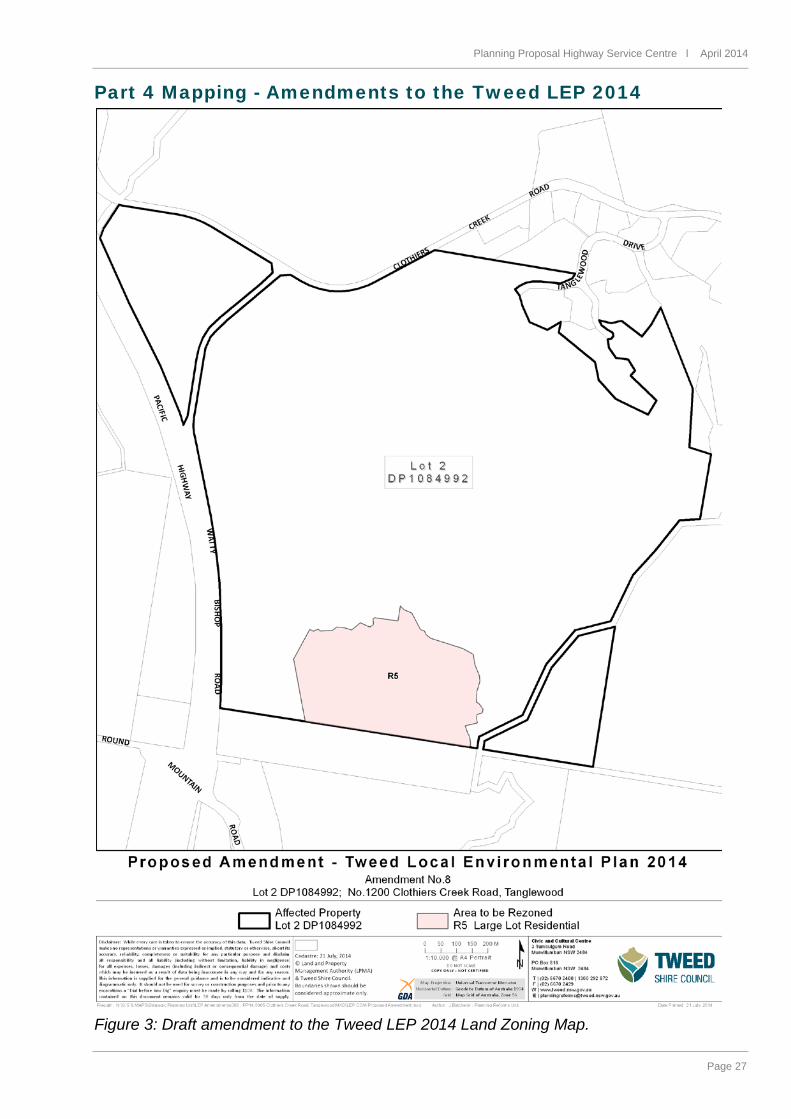
Part 4 Mapping - Amendments to the Tweed LEP 2014
Figure 3: Draft amendment to the Tweed LEP 2014 Land Zoning Map.
Planning Proposal Palm Lake Resort l July 2014 page 28 of 34
Page 28
Part 5 Community consultation The appropriate form, and timeframes of the community consultation are expected to be determined by NSW Planning & Environment during the Gateway Determination stage. Council recommends that public exhibition is not required for this planning proposal.
Summary and conclusions This planning proposal seeks approval for the preparation of an amendment to the Land Zoning Map of the Tweed Local Environmental Plan (LEP) 2014. The LEP amendment will rectify a site-specific zoning error which occurred while converting the Tweed LEP 2000 zoning into the Land Zoning Map provided under the Tweed LEP 2014. The zoning error can be described as an incorrect conversion of zone 1(c) Rural Living over the subject site into zone RE2 Private Recreation, while the correct conversion to the relevant zone should result in zoning the site as R5 Large Lot Residential. This excluded certain land uses, including dwelling houses, from the list of permitted land uses and therefore, impacts on the range of uses permitted within the site. Tweed Shire Council has been advised that a Summons (Judicial Review) was filed on 4 July 2014 on behalf of the landowners of the subject site, seeking a declaration that the RE2 zoning over this site is invalid. Initial consultation between Council and NSW Planning & Environment (P&E) indicate that this planning proposal is considered a high priority and therefore, it is recommended the planning proposal proceed.


Customer Service 1300 292 872 (02)66702400
Fax(02)6670 2429POBox816MurwillumbahNSW2484