Embed Size (px)
Citation preview
YASS HARDEN CANBERRA SYDNEY GOSFORD NEWCASTLE
TM
5QS Consulting Group South is a division of Twelve20 Pty Ltd ABN 58 609 085 207
6226 5598 [email protected] PO Box 645 Yass NSW 2582
30 November 2020 5QS Ref: 208059 Ms Angela Smith Blackwattle Alpacas 315 Patemans Lane, MURRUMBATEMAN NSW 2582 Dear Ms Smith, Re: On-site Wastewater Management Assessment
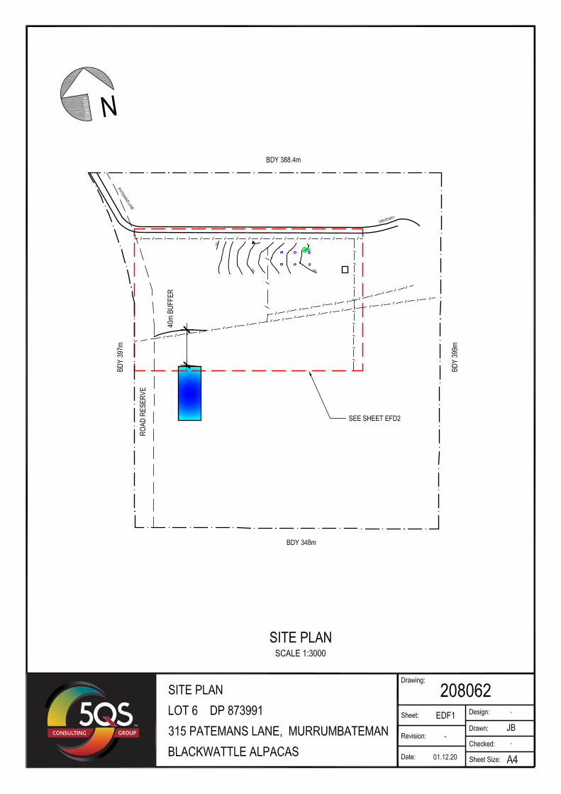
Lot 6, DP 1250191 315 Patemans Lane, Murrumbateman
1 Introduction An on-site wastewater dispersal geotechnical investigation has been undertaken on the above property in accordance with AS/NZS1547:2012 ‘On-site Domestic Wastewater Management’ and the Environment and Health Protection Guideline ‘On-site Sewage Management for Single Households’. This report provides details of the investigation and recommendations for on-site dispersal of treated sewage wastewater at the subject site. A Site and Soil Evaluation and various dispersal area calculation sheets that address specific matters as required by AS/NZS1547:2012 ‘On-site Domestic Wastewater Management’ and the Environment and Health Protection Guideline ‘On-site Sewage Management for Single Households’ have been attached. Details of the property and pertinent site features may be seen on the attached drawing 208059/EFD2 and details of the site assessment and dispersal area calculations are set out in the attached Site and Soil Evaluation and irrigation area calculation sheets.
5QS Consulting Group 30 November 2020 Consulting Engineers 5QS Ref: 208059
2 On-site Wastewater Management Assessment 315 Patemans Lane, Murrumbateman
2 Project Description The investigation was for the surface irrigation dispersal of aerated wastewater treatment system (AWTS) treated domestic wastewater from a proposed new alpaca fibre dying workshop, craft activity workshops and alpaca interactive experience centre. The assessment has been based on;
a) Projected staff levels.
b) Projected visitor numbers.
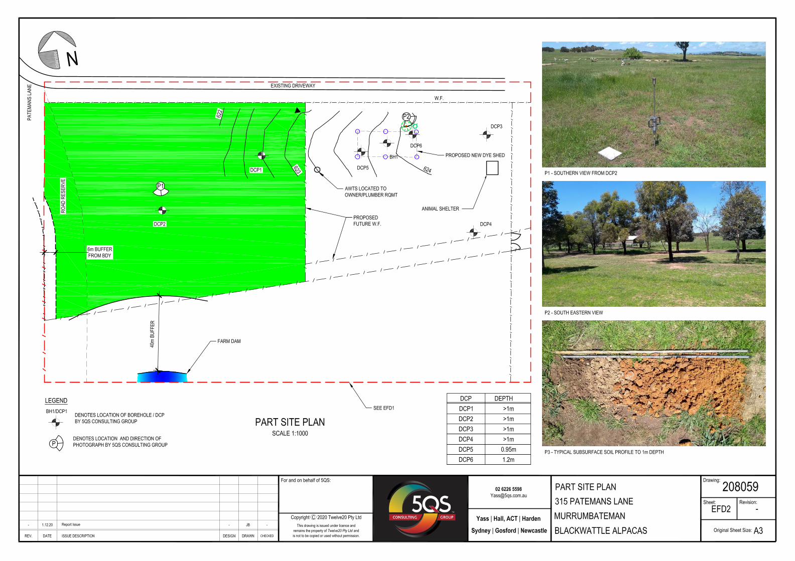
The surface grades in the vicinity of the proposed available dispersal area were linear planar with grades of approximately1 - 3% downslope to the south west. The location of the proposed new Dye Shed and pertinent site features are set out on the attached drawing 208059/EFD2. 3 Desktop Study 3.1 Soil Landscape
The site lies within the Williamsdale Soil Landscape as described in the Soil Landscapes of the Canberra 1:100,000 Sheet published by the Soil Conservation Service of NSW (2000). The Williamsdale Soil Landscape occurs on undulating rises, fans, valley flats and depressions on Silurian Volcanics of the Canberra Lowlands. Local relief is 5 – 50m at elevations of 550m to 650m AHD. There is little or no rock outcrop. The original woodland has been substantially cleared and grassland areas have been extensively altered. Minor gully erosion is common and widespread. The soil profile on the site was consistent with the Williamsdale Type Profile 1, consisting of: Layer 1, (wi1) 0-80mm, yellow brown Loam. Layer 2, (wi2) 80- 160mm, yellow orange silty Loam, moderately structured. Layer 3, (wi3) 160 – 600+mm, yellow brown sandy Clay, becoming sub-angular gravelly over bedrock. 3.2 Groundwater Bore Search
A groundwater bore search was undertaken using the NSW Government’s online search facility at allwaterdata.water.nsw.gov.au. The search identified 3 registered groundwater bore within a 500m radius from the proposed dispersal area.
5QS Consulting Group 30 November 2020 Consulting Engineers 5QS Ref: 208059
3 On-site Wastewater Management Assessment 315 Patemans Lane, Murrumbateman
Table 1 –Registered groundwater bores within 500m of the site.
Mark Distance Direction Depth to aquifer Purpose
GW404063 250m South east 18m Domestic/Stock
GW404738 250m North 18m Domestic/Stock
GW402013 400m West 15m Domestic/Stock
Provided wastewater treatment and dispersal options detailed in this report are implemented it is believed that the dispersal of treated wastewater on the site does not pose a risk to groundwater at any registered bore. 3.3 Groundwater Vulnerability
Yass Valley Local Environment Plan 2013, cl 6.4 Groundwater Vulnerability, requires the following matters set out in Table 2 to be addressed: Table 2 - Groundwater Vulnerability Assessment
2 Is the site within land identified as “Groundwater vulnerability” on the Groundwater Vulnerability Map?
Yes
3(a) Likelihood of groundwater contamination from the development
It is extremely unlikely that AWTS treated effluent dispersed via spray irrigation or absorption trench system will cause any groundwater contamination.
3(b) Any adverse impacts the development will have on groundwater dependent ecosystems
It is extremely unlikely that the proposed effluent dispersal via surface irrigation or absorption trench will have any adverse impact on any groundwater dependent ecosystems.
3(c) The cumulative impact the development may have on groundwater
It is not expected that the proposed effluent dispersal via a surface irrigation or absorption trench will have any cumulative adverse impact on groundwater
3(d) Appropriate measure proposed to avoid, minimise or mitigate the impacts of the development
Install and operate an onsite effluent treatment system and dispersal mechanism in accordance with the recommendations set out in this report.
4 Methodology and Calculations 4.1 Fieldwork
The fieldwork undertaken on 3 November 2020 consisted of a visual assessment of the site and surrounding area the driving of 6 falling weight dynamic cone penetrometer probes (DCPs) and 1 hand augered borehole. All fieldwork was conducted generally in accordance with the methodology outlined in AS/NZS1547:2012 ‘On-site Domestic Wastewater Management’ and the Environment and Health Protection Guideline ‘On-site Sewage Management for Single Households’.
5QS Consulting Group 30 November 2020 Consulting Engineers 5QS Ref: 208059
4 On-site Wastewater Management Assessment 315 Patemans Lane, Murrumbateman
4.2 Subsurface Profile
The exposed subsoil profile was typical of the Williamsdale Soil Landscape , Type 1 profile, consisting of:- Table 3 -Indicative Soil Profile
0 – 150mm Dark grey, LOAM, topsoil, moist, well structured.
150 – 350mm Light grey, sandy Clay , moist, trace of roots , Moderately structured
350 – 1000+mm Yellow orange, sandy Clay, Moist, becoming dryer with depth, weakly structured.
The above sub-surface profile was anticipated to be representative of the natural sub-surface soil profile across the proposed wastewater dispersal area. The depth of strata may be expected to vary across the proposed dispersal area. Neither groundwater nor surface water were encountered in during the investigation. 4.3 Hydraulic Loading
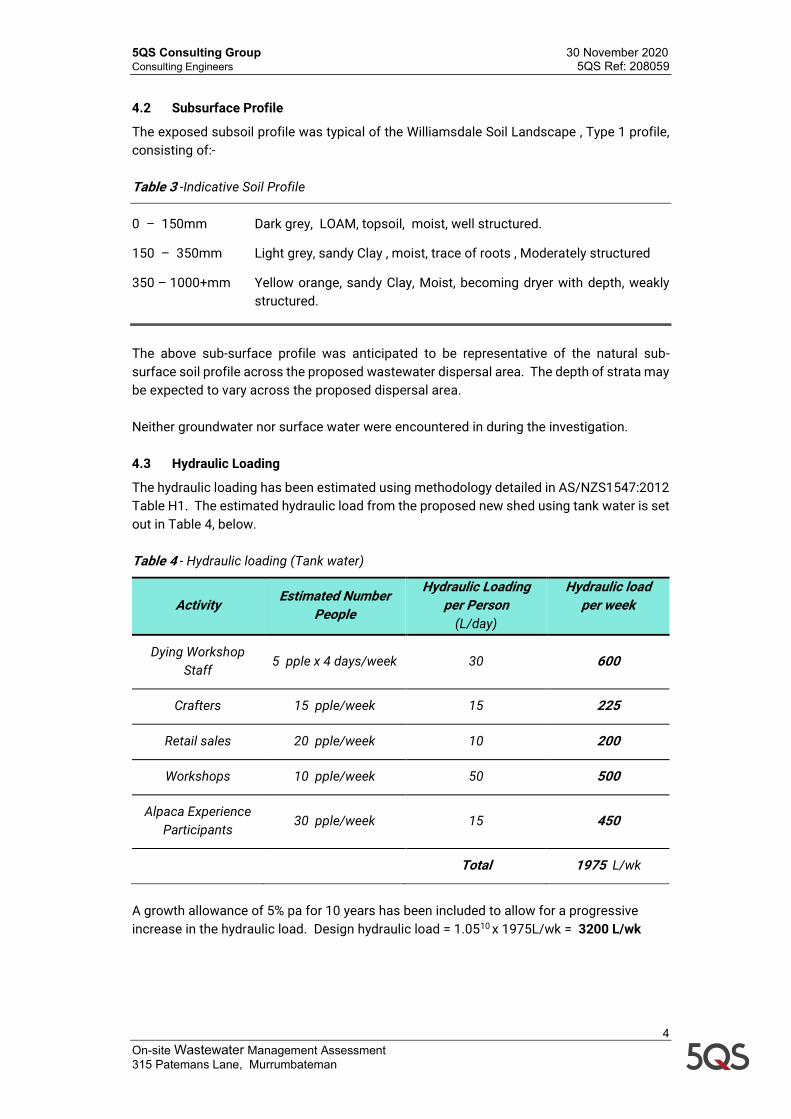
The hydraulic loading has been estimated using methodology detailed in AS/NZS1547:2012 Table H1. The estimated hydraulic load from the proposed new shed using tank water is set out in Table 4, below. Table 4 - Hydraulic loading (Tank water)
Activity Estimated Number People
Hydraulic Loading per Person
(L/day)
Hydraulic load per week
Dying Workshop Staff
5 pple x 4 days/week 30 600
Crafters 15 pple/week 15 225
Retail sales 20 pple/week 10 200
Workshops 10 pple/week 50 500
Alpaca Experience Participants
30 pple/week 15 450
Total 1975 L/wk
A growth allowance of 5% pa for 10 years has been included to allow for a progressive increase in the hydraulic load. Design hydraulic load = 1.0510 x 1975L/wk = 3200 L/wk
5QS Consulting Group 30 November 2020 Consulting Engineers 5QS Ref: 208059
5 On-site Wastewater Management Assessment 315 Patemans Lane, Murrumbateman
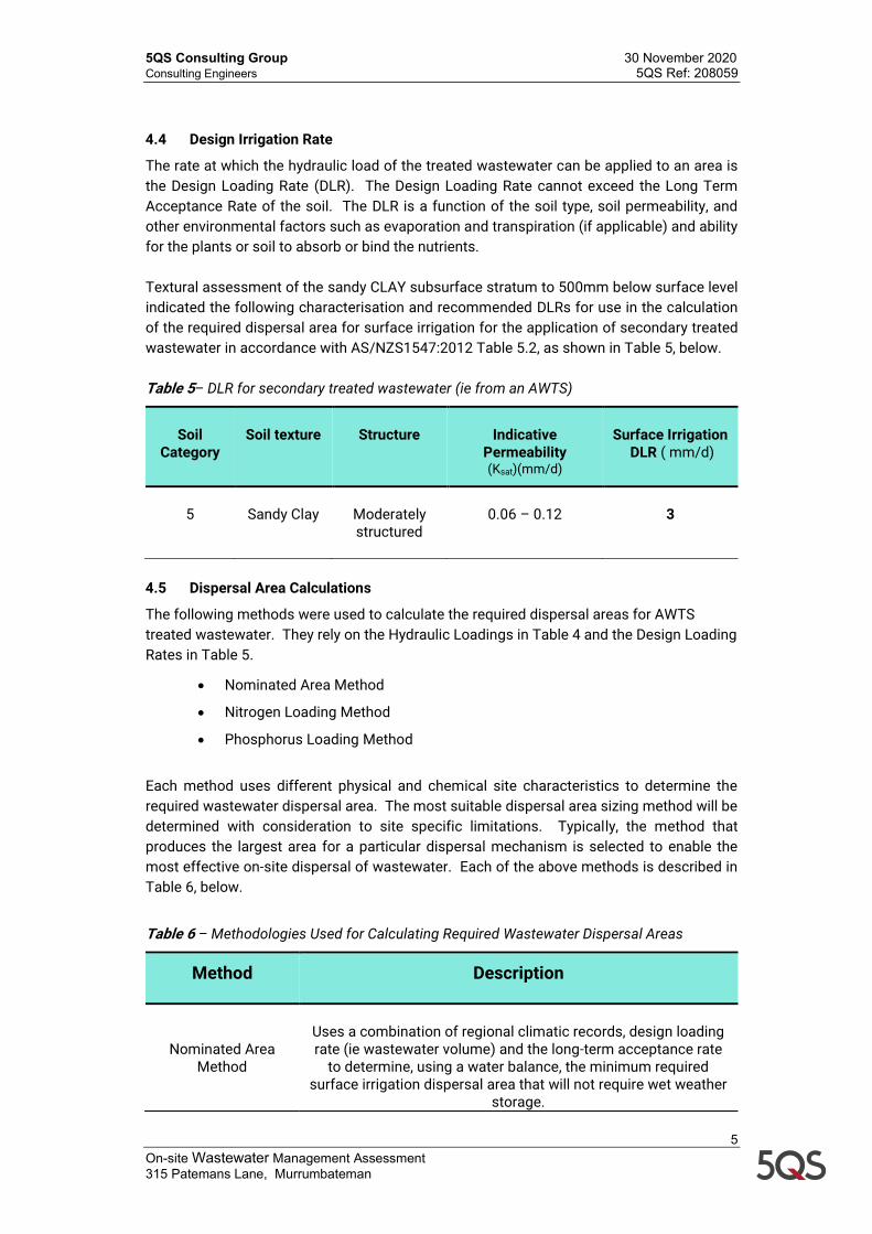
4.4 Design Irrigation Rate
The rate at which the hydraulic load of the treated wastewater can be applied to an area is the Design Loading Rate (DLR). The Design Loading Rate cannot exceed the Long Term Acceptance Rate of the soil. The DLR is a function of the soil type, soil permeability, and other environmental factors such as evaporation and transpiration (if applicable) and ability for the plants or soil to absorb or bind the nutrients. Textural assessment of the sandy CLAY subsurface stratum to 500mm below surface level indicated the following characterisation and recommended DLRs for use in the calculation of the required dispersal area for surface irrigation for the application of secondary treated wastewater in accordance with AS/NZS1547:2012 Table 5.2, as shown in Table 5, below. Table 5– DLR for secondary treated wastewater (ie from an AWTS)
Soil
Category
Soil texture
Structure
Indicative
Permeability (Ksat)(mm/d)
Surface Irrigation
DLR ( mm/d)
5
Sandy Clay
Moderately structured
0.06 – 0.12
3
4.5 Dispersal Area Calculations
The following methods were used to calculate the required dispersal areas for AWTS treated wastewater. They rely on the Hydraulic Loadings in Table 4 and the Design Loading Rates in Table 5.
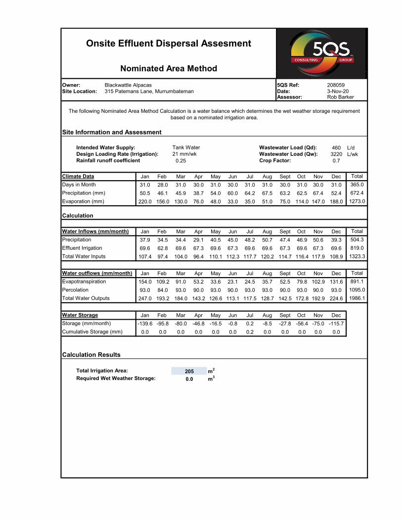
• Nominated Area Method
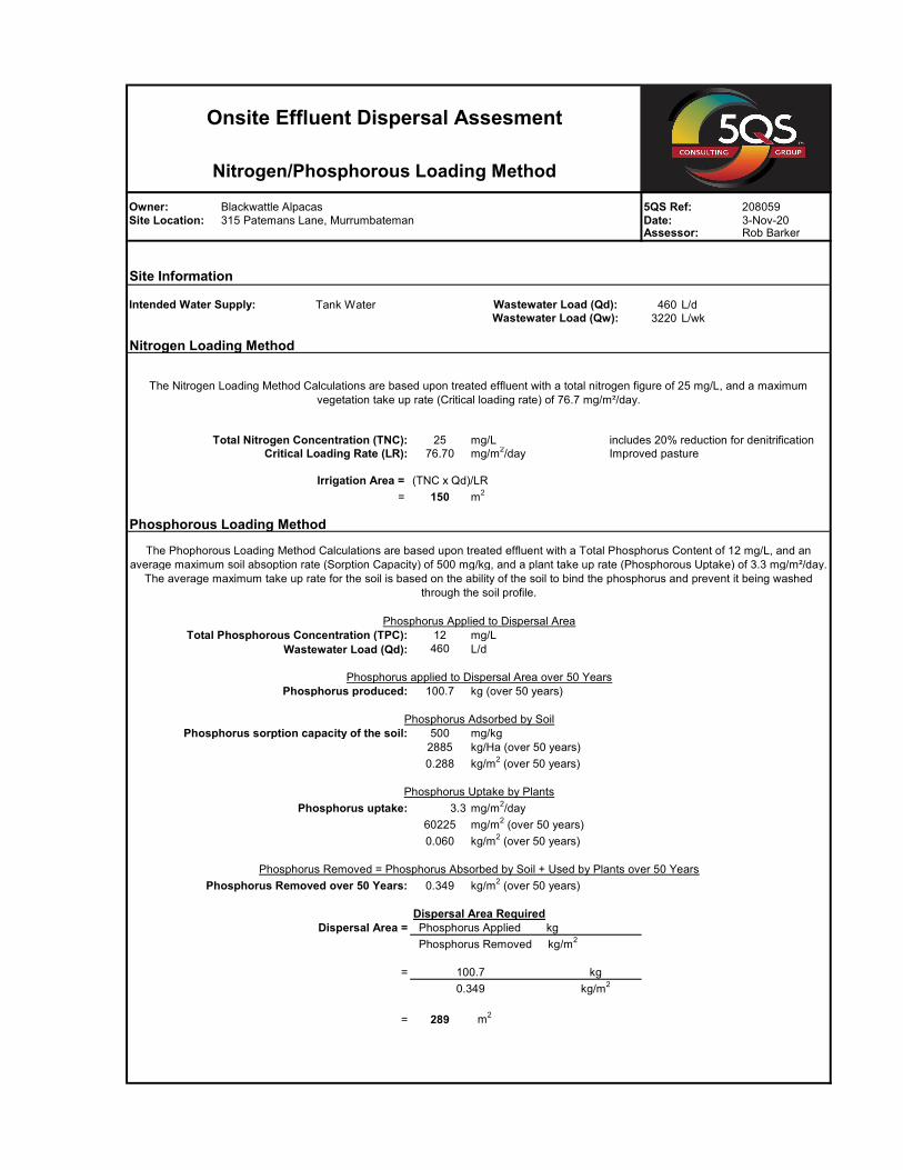
• Nitrogen Loading Method
• Phosphorus Loading Method
Each method uses different physical and chemical site characteristics to determine the required wastewater dispersal area. The most suitable dispersal area sizing method will be determined with consideration to site specific limitations. Typically, the method that produces the largest area for a particular dispersal mechanism is selected to enable the most effective on-site dispersal of wastewater. Each of the above methods is described in Table 6, below.
Table 6 – Methodologies Used for Calculating Required Wastewater Dispersal Areas
Method Description
Nominated Area Method
Uses a combination of regional climatic records, design loading rate (ie wastewater volume) and the long-term acceptance rate
to determine, using a water balance, the minimum required surface irrigation dispersal area that will not require wet weather
storage.
5QS Consulting Group 30 November 2020 Consulting Engineers 5QS Ref: 208059
6 On-site Wastewater Management Assessment 315 Patemans Lane, Murrumbateman
Method Description
Nitrogen Loading Method
Calculations are based upon treated wastewater with a total
nitrogen content of 25mg/L, and an average maximum vegetation uptake rate of 76.7mg/m2/day. The average
maximum uptake rate for the vegetation is based on the ability of the vegetation to use the nutrient before it passes through the
root zone.
Phosphorus Loading Methods
Calculations are based upon treated wastewater with a total phosphorus content of 12mg/L, and an average maximum vegetation uptake rate of 3.3mg/m2/day. The phosphorus absorption capacity of the soil is also used to calculate the
required area with the soil absorption rate based on the ability of the soil to bind the phosphorus and prevent it being washed
through the soil profile (where it can become a source of pollution).
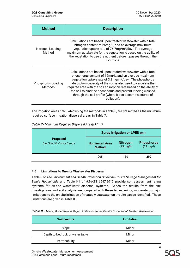
The irrigation areas calculated using the methods in Table 6, are presented as the minimum required surface irrigation dispersal areas, in Table 7. Table 7 - Minimum Required Dispersal Area(s) (m2)
Proposed Dye Shed & Visitor Centre
Spray Irrigation or LPED (m2)
Nominated Area Method
Nitrogen (25 mg/l)
Phosphorus (12 mg/l)
205 150 290
4.6 Limitations to On-site Wastewater Dispersal
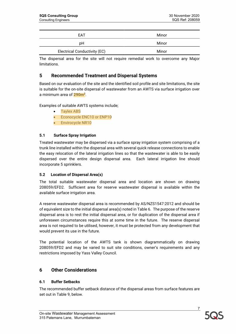
Table 6 of The Environment and Health Protection Guideline On-site Sewage Management for Single Households and Table K1 of AS/NZS 1547:2012 provide soil assessment rating systems for on-site wastewater dispersal systems. When the results from the site investigations and soil analysis are compared with these tables, minor, moderate or major limitations to the on-site irrigation of treated wastewater on the site can be identified. These limitations are given in Table 8. Table 8 – Minor, Moderate and Major Limitations to the On-site Dispersal of Treated Wastewater
Soil Feature Limitation
Slope Minor
Depth to bedrock or water table Minor
Permeability Minor
5QS Consulting Group 30 November 2020 Consulting Engineers 5QS Ref: 208059
7 On-site Wastewater Management Assessment 315 Patemans Lane, Murrumbateman
EAT Minor
pH Minor
Electrical Conductivity (EC) Minor
The dispersal area for the site will not require remedial work to overcome any Major limitations. 5 Recommended Treatment and Dispersal Systems Based on our evaluation of the site and the identified soil profile and site limitations, the site is suitable for the on-site dispersal of wastewater from an AWTS via surface irrigation over a minimum area of 290m2. Examples of suitable AWTS systems include;
• Taylex ABS • Econocycle ENC10 or ENP10 • Envirocycle NR10
5.1 Surface Spray Irrigation
Treated wastewater may be dispersed via a surface spray irrigation system comprising of a trunk line installed within the dispersal area with several quick release connections to enable the easy relocation of the lateral irrigation lines so that the wastewater is able to be easily dispersed over the entire design dispersal area. Each lateral irrigation line should incorporate 5 sprinklers. 5.2 Location of Dispersal Area(s)
The total suitable wastewater dispersal area and location are shown on drawing 208059/EFD2. Sufficient area for reserve wastewater dispersal is available within the available surface irrigation area. A reserve wastewater dispersal area is recommended by AS/NZS1547:2012 and should be of equivalent size to the initial dispersal area(s) noted in Table 6. The purpose of the reserve dispersal area is to rest the initial dispersal area, or for duplication of the dispersal area if unforeseen circumstances require this at some time in the future. The reserve dispersal area is not required to be utilised, however, it must be protected from any development that would prevent its use in the future. The potential location of the AWTS tank is shown diagrammatically on drawing 208059/EFD2 and may be varied to suit site conditions, owner’s requirements and any restrictions imposed by Yass Valley Council. 6 Other Considerations 6.1 Buffer Setbacks
The recommended buffer setback distance of the dispersal areas from surface features are set out in Table 9, below.
5QS Consulting Group 30 November 2020 Consulting Engineers 5QS Ref: 208059
8 On-site Wastewater Management Assessment 315 Patemans Lane, Murrumbateman
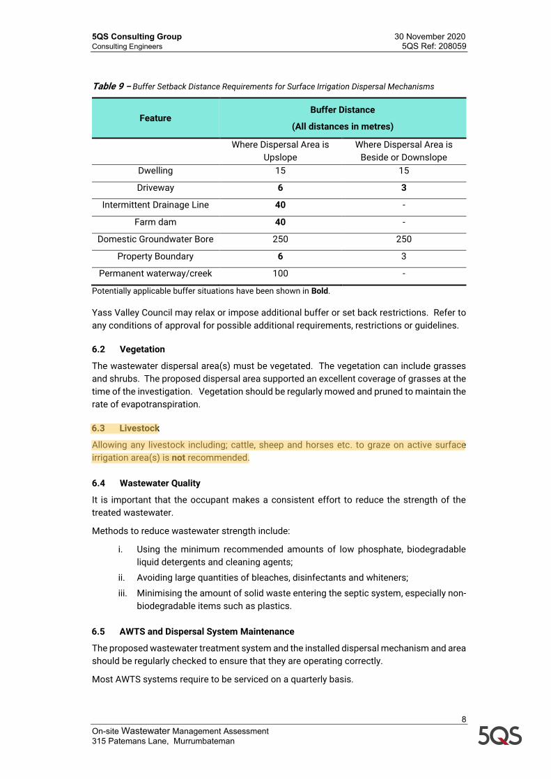
Table 9 – Buffer Setback Distance Requirements for Surface Irrigation Dispersal Mechanisms
Feature Buffer Distance
(All distances in metres)
Where Dispersal Area is
Upslope Where Dispersal Area is
Beside or Downslope Dwelling 15 15
Driveway 6 3
Intermittent Drainage Line 40 -
Farm dam 40 -
Domestic Groundwater Bore 250 250
Property Boundary 6 3
Permanent waterway/creek 100 -
Potentially applicable buffer situations have been shown in Bold. Yass Valley Council may relax or impose additional buffer or set back restrictions. Refer to any conditions of approval for possible additional requirements, restrictions or guidelines. 6.2 Vegetation
The wastewater dispersal area(s) must be vegetated. The vegetation can include grasses and shrubs. The proposed dispersal area supported an excellent coverage of grasses at the time of the investigation. Vegetation should be regularly mowed and pruned to maintain the rate of evapotranspiration. 6.3 Livestock
Allowing any livestock including; cattle, sheep and horses etc. to graze on active surface irrigation area(s) is not recommended. 6.4 Wastewater Quality
It is important that the occupant makes a consistent effort to reduce the strength of the treated wastewater.
Methods to reduce wastewater strength include:
i. Using the minimum recommended amounts of low phosphate, biodegradable liquid detergents and cleaning agents;
ii. Avoiding large quantities of bleaches, disinfectants and whiteners;
iii. Minimising the amount of solid waste entering the septic system, especially non-biodegradable items such as plastics.
6.5 AWTS and Dispersal System Maintenance
The proposed wastewater treatment system and the installed dispersal mechanism and area should be regularly checked to ensure that they are operating correctly.
Most AWTS systems require to be serviced on a quarterly basis.
5QS Consulting Group 30 November 2020 Consulting Engineers 5QS Ref: 208059
9 On-site Wastewater Management Assessment 315 Patemans Lane, Murrumbateman
Signs of failure include surface ponding, wastewater run off, erosion, leaching of the soil, poor vegetation growth including burnt vegetation, odours or the formation of surface crusts. 7 Report Limitations and Site Variations The extent of testing associated with this assessment is limited to the activities referenced in the report and variations in ground conditions may occur. 5QS Consulting Group should be contacted immediately should subsurface conditions be found to differ from those described in this report.
This On-Site Wastewater Management Assessment was not an investigation of the specific subsurface profile at the location and is not intended to provide any comment on the potential excavatability of the subsurface material. For and on behalf of 5QS Consulting Group
Rob Barker FIE Aust CPEng NER (Civil/Structural) Attachments
1. Drawing 208059/EFD1!' !FGE3 2. Site and Soil Evaluation 3. Dispersal Area Calculation Sheets
5QS Ref:Date:Assessor:
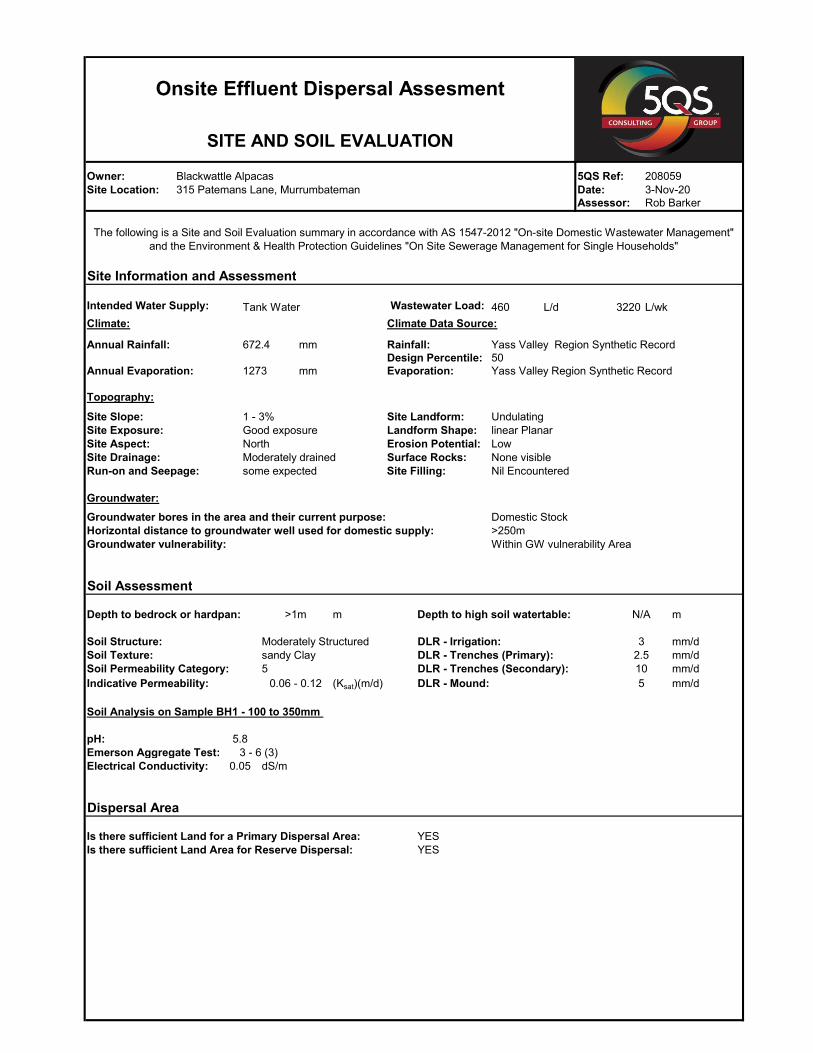
460 L/d L/wkClimate: Climate Data Source:
mm
mm
Topography:
Groundwater:
m
500 mg/kg 0.00 0.0
dS/m 0.00% 0.0g/cm3 0.0 meq/100g 0.0
YESYES
Calcium
DLR - Irrigation:DLR - Trenches (Primary):
DLR - Mound:
Moderately Structuredsandy Clay5
Indicative Permeability:
Groundwater bores in the area and their current purpose:Horizontal distance to groundwater well used for domestic supply:Groundwater vulnerability:
Domestic Stock>250mWithin GW vulnerability Area
>1m
Soil Structure:
LowNone visibleNil Encountered
Soil Texture:
0.06 - 0.12 (Ksat)(m/d)
mm/d
DLR - Trenches (Secondary): 10 mm/d
Soil Assessment
mN/ADepth to bedrock or hardpan: Depth to high soil watertable:
mm/d
mm/d
32.5
5
Run-on and Seepage: Site Filling:some expected
Site Aspect:Site Drainage:
Owner:Site Location:Client:
Site Landform:Landform Shape:Erosion Potential:Surface Rocks:
Intended Water Supply: Tank Water
Annual Rainfall:
Annual Evaporation: Evaporation:
1 - 3%Good exposureNorthModerately drained
Is there sufficient Land Area for Reserve Dispersal:Is there sufficient Land for a Primary Dispersal Area:
Phosphorous Sorption:Emerson Aggregate Test:Electrical Conductivity: 0.05
Dispersal Area
Soil Permeability Category:
5.8
0.0Bulk Density:ESP:
Soil Analysis on Sample BH1 - 100 to 350mm
meq/100g
pH:
Aluminium:
meq/100gmeq/100gmeq/100g
Cation Exchange Capacity:
Sodium:Magnesium:Potassium:3 - 6 (3)
linear Planar
1273
672.4
Site Information and Assessment
Rob Barker
The following is a Site and Soil Evaluation summary in accordance with AS 1547-2012 "On-site Domestic Wastewater Management" and the Environment & Health Protection Guidelines "On Site Sewerage Management for Single Households"
3220Wastewater Load:
Rainfall:Design Percentile: 50
Yass Valley Region Synthetic Record
Yass Valley Region Synthetic Record
Site Slope:Site Exposure:
Onsite Effluent Dispersal Assesment
SITE AND SOIL EVALUATION
Blackwattle Alpacas315 Patemans Lane, Murrumbateman0
2080593-Nov-20
Undulating
460 L/d3220 L/wk
0.25 0.7
Jan Feb Mar Apr May Jun Jul Aug Sept Oct Nov Dec31.0 28.0 31.0 30.0 31.0 30.0 31.0 31.0 30.0 31.0 30.0 31.050.5 46.1 45.9 38.7 54.0 60.0 64.2 67.5 63.2 62.5 67.4 52.4220.0 156.0 130.0 76.0 48.0 33.0 35.0 51.0 75.0 114.0 147.0 188.0
Jan Feb Mar Apr May Jun Jul Aug Sept Oct Nov Dec37.9 34.5 34.4 29.1 40.5 45.0 48.2 50.7 47.4 46.9 50.6 39.369.6 62.8 69.6 67.3 69.6 67.3 69.6 69.6 67.3 69.6 67.3 69.6107.4 97.4 104.0 96.4 110.1 112.3 117.7 120.2 114.7 116.4 117.9 108.9
Jan Feb Mar Apr May Jun Jul Aug Sept Oct Nov Dec154.0 109.2 91.0 53.2 33.6 23.1 24.5 35.7 52.5 79.8 102.9 131.693.0 84.0 93.0 90.0 93.0 90.0 93.0 93.0 90.0 93.0 90.0 93.0247.0 193.2 184.0 143.2 126.6 113.1 117.5 128.7 142.5 172.8 192.9 224.6
Jan Feb Mar Apr May Jun Jul Aug Sept Oct Nov Dec-139.6 -95.8 -80.0 -46.8 -16.5 -0.8 0.2 -8.5 -27.8 -56.4 -75.0 -115.7
0.0 0.0 0.0 0.0 0.0 0.0 0.2 0.0 0.0 0.0 0.0 0.0
m2
m3
Total504.3819.01323.3
Total891.11095.01986.1
0.0205
Required Wet Weather Storage:
Calculation Results
Total Irrigation Area:
Site Location:Client:
Owner: 5QS Ref:
1273.0
Total365.0672.4
Climate Data
21 mm/wk
Site Information and Assessment
Blackwattle Alpacas315 Patemans Lane, Murrumbateman
0
Wastewater Load (Qw):Rainfall runoff coefficient
Calculation
Days in MonthPrecipitation (mm)Evaporation (mm)
Tank WaterIntended Water Supply:Design Loading Rate (Irrigation):
Crop Factor:
Wastewater Load (Qd):
PercolationTotal Water Outputs
PrecipitationEffluent IrrigationTotal Water Inputs
Onsite Effluent Dispersal Assesment
Nominated Area Method
The following Nominated Area Method Calculation is a water balance which determines the wet weather storage requirement based on a nominated irrigation area.
Storage (mm/month)Cumulative Storage (mm)
Date:Assessor:
2080593-Nov-20Rob Barker
Water Storage
Water Inflows (mm/month)
Water outflows (mm/month)Evapotranspiration
5QS Ref:Date:Assessor:
460 L/d3220 L/wk
includes 20% reduction for denitrificationImproved pasture
Total Phosphorous Concentration (TPC): mg/LWastewater Load (Qd): L/d
Phosphorus produced:
Phosphorus sorption capacity of the soil:
=
= m2
Site Location:
m2
Nitrogen Loading Method
3-Nov-20Client: Rob Barker
mg/Lmg/m2/day
Site Information
Intended Water Supply: Tank Water
(TNC x Qd)/LR
315 Patemans Lane, Murrumbateman0
Wastewater Load (Qd):Wastewater Load (Qw):
Owner:
Onsite Effluent Dispersal Assesment
Nitrogen/Phosphorous Loading Method
Blackwattle Alpacas 208059
Phosphorus Removed kg/m2
100.7
kg (over 50 years)
Phosphorus Uptake by Plants
100.7
Phosphorus Removed = Phosphorus Absorbed by Soil + Used by Plants over 50 Years
Phosphorus uptake:
mg/kgkg/Ha (over 50 years)kg/m2 (over 50 years)
Phosphorus Adsorbed by Soil500
28850.288
0.349
Dispersal Area =
Phosphorus Removed over 50 Years:
289
mg/m2/daymg/m2 (over 50 years)kg/m2 (over 50 years)
3.3602250.060
0.349 kg/m2 (over 50 years)
Dispersal Area Required
kgkg/m2
Phosphorus Applied kg
The Nitrogen Loading Method Calculations are based upon treated effluent with a total nitrogen figure of 25 mg/L, and a maximum vegetation take up rate (Critical loading rate) of 76.7 mg/m²/day.
Phosphorus applied to Dispersal Area over 50 Years
12
Total Nitrogen Concentration (TNC):Critical Loading Rate (LR):
Irrigation Area = = 150
2576.70
Phosphorous Loading Method
Phosphorus Applied to Dispersal Area
The Phophorous Loading Method Calculations are based upon treated effluent with a Total Phosphorus Content of 12 mg/L, and an average maximum soil absoption rate (Sorption Capacity) of 500 mg/kg, and a plant take up rate (Phosphorous Uptake) of 3.3 mg/m²/day.
The average maximum take up rate for the soil is based on the ability of the soil to bind the phosphorus and prevent it being washed through the soil profile.
460