Embed Size (px)
Citation preview

Photo: © Matthew J. Roberts. Eyjafjallajökull ash cloud 17 April 2010. Flight with the Icelandic Coast Guards. http://en.vedur.is/about-imo/news/2010/nr/1883
Takashi Y. Nakajima
Observations of volcanic ashfrom space
Photo: © Matthew J. Roberts. Eyjafjallajökull ash cloud 17 April 2010. Flight with the Icelandic Coast Guards. http://en.vedur.is/about-imo/news/2010/nr/1883
Observations of volcanic ashfrom space
Takashi Y. Nakajima
©JMA
©Wikipedia
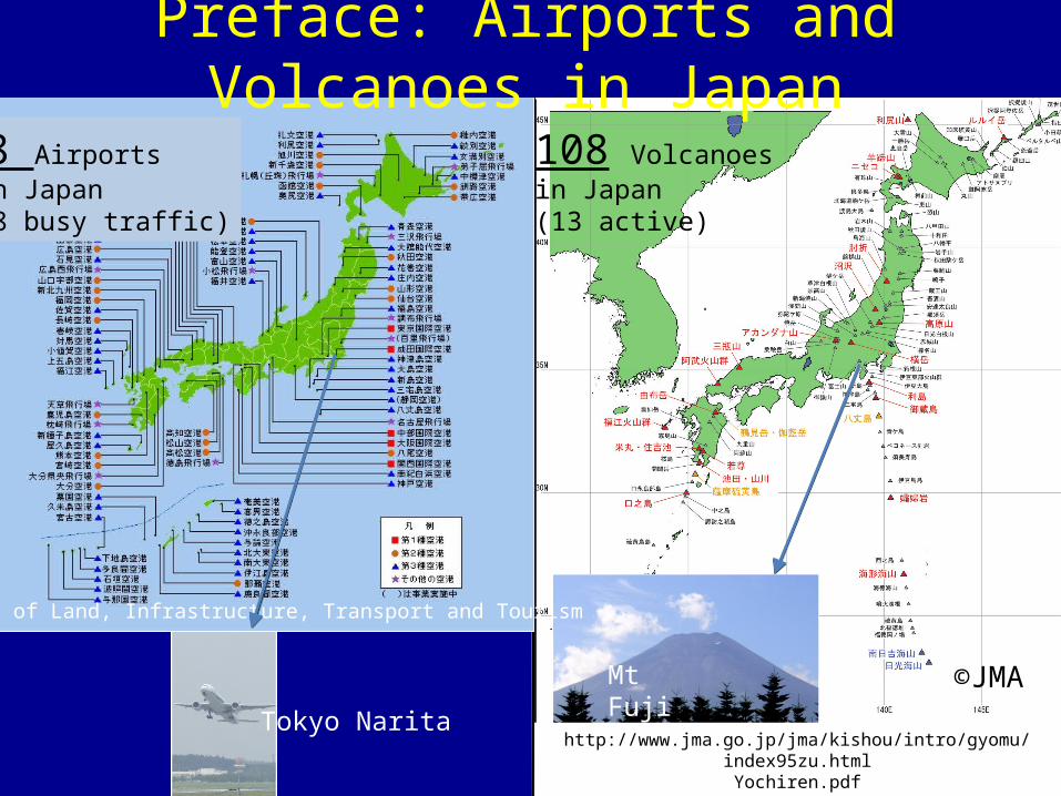
108 Volcanoesin Japan(13 active)
TOKYO NRT
Mt Fuji3,776 m
98 Airports in Japan(28 busy traffic)
Tokyo Narita
Ministry of Land, Infrastructure, Transport and Tourism
http://www.jma.go.jp/jma/kishou/intro/gyomu/index95zu.htmlYochiren.pdf
Preface: Airports and Volcanoes in Japan

Nikkei 4/19 Mainichi. jp 4/19
Yomiuri online 4/18
Nikkei web 4/20News in April about Iceland eruption .
Contents (about 15 min. )
1. Impacts of volcanic ash and role of satellite observations
2. Scientific concept for ash observations3. Horizontal observations from CAI imager4. Vertical observation from CALIPSO lidar5. Future satellite missions in Japan6. Summary

Impacts of volcanic ashand role of satellite observations
Aviation impacts (= one of disasters)• Quick response is needed• Monitoring destination / broadening of volcanic ash• Assists numerical simulation of ash transportation using satellite-view. Qualitatively visualizations have high demand.
Climate impacts (months to years)• Year-to-decadal impact of eruption to climate.• Monitoring the background aerosol (ash and other ) environment. Quantitatively observations of the aerosol amount have high
demand.
Today’s talk

Scientific concept of ash observation from spaceSpectrum analysis • Using multi-spectral, to detect ash plumes.
ContaminationDiscrimination
• Some solutions – Japanese Imagers equip 0.38-µm (UV) channel.it distinguishes clouds and volcanic ash.
Volcano
Cloud
Ash
Latit
ude
Longitude
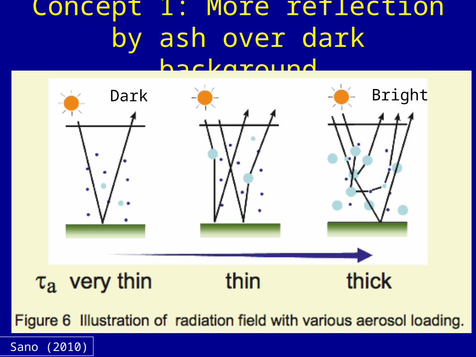
Concept 1: More reflection by ash over dark background
I. Sano (2010)
Bright Dark

Example: biomass burning in Asia captured by Midori-2 Global Imager (GLI)
GLI Ch. Wavelength
Red 13 0.678µm
Green 8 0.545µm
Blue 5 0.460µm
GLI Ch. Wavelength
Red 13 0.678µm
Green 8 0.545µm
Blue 1 0.380µm
Appeared in “Nature”
Cyranosky, D. and I. Fuyuno,news in Nature, 434, pp128, (2005).
Concept 2: Effective of 0.38-µm
2003/5/20

Channel specification of Wide-swath imagers in JAXA
0.38µm
ChannelLocationsof JapaneseImagers
1980’
1990’
2000’
2010’ has 0.38µm

Horizontal observation of Eyjafjallajokull eruption
byGOSAT(Ibuki) CAI sensor
CAI = Cloud and Aerosol ImagerPolar orbit, swath = 1000km
Spatial resolution = 500m
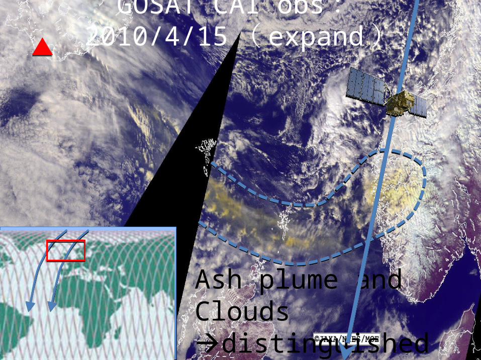
GOSAT CAI obs :2010/4/15 ( expand )
Ash plume and Cloudsdistinguished
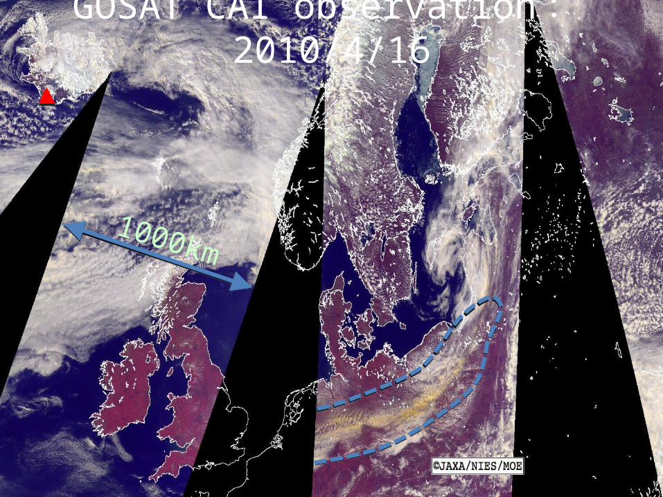
GOSAT CAI observation :2010/4/16
1000km

GOSAT CAI observatio
n2010/4/30Kikuchi and Matsunaga (2010, NIES)
Ash contaminated Clouds detectable by CAI
Vertical Observations
- NASA CALIPSO Lidar

NASA CALIPSO Lidar ( 2010/4/17 )
http://eosweb.larc.nasa.gov/PRODOCS/calipso6km6km
Some future Earth observing satellite missions
in Japan
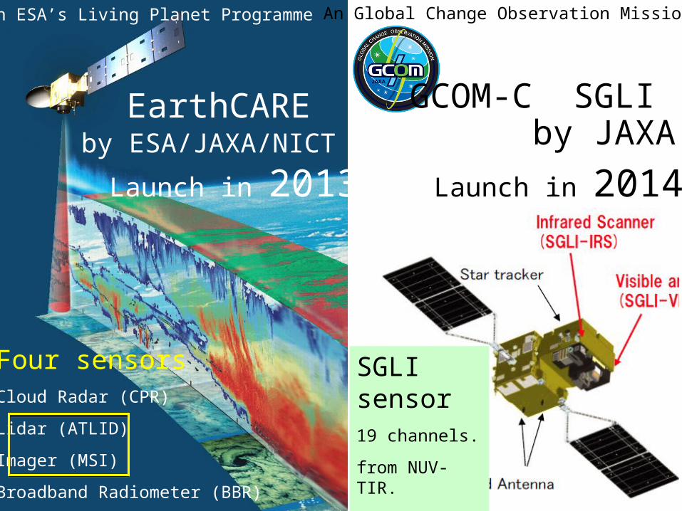
EarthCARE by ESA/JAXA/NICT
17
An ESA’s Living Planet Programme
Launch in 2013
Four sensorsCloud Radar (CPR)
Lidar (ATLID)
Imager (MSI)
Broadband Radiometer (BBR)
GCOM-C SGLI by JAXA
Launch in 2014
An Global Change Observation Mission
SGLI sensor19 channels.
from NUV-TIR.
Incl. 0.38µm
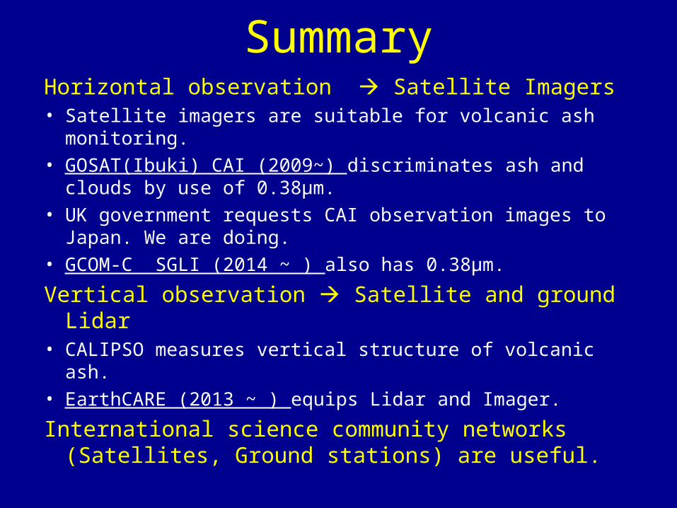
SummaryHorizontal observation Satellite Imagers• Satellite imagers are suitable for volcanic ash monitoring.• GOSAT(Ibuki) CAI (2009~) discriminates ash and clouds by
use of 0.38µm. • UK government requests CAI observation images to Japan.
We are doing.• GCOM-C SGLI (2014 ~ ) also has 0.38µm.
Vertical observation Satellite and ground Lidar• CALIPSO measures vertical structure of volcanic ash.• EarthCARE (2013 ~ ) equips Lidar and Imager.
International science community networks (Satellites, Ground stations) are useful.

Science projects for satellite aerosol observations in Japan
Aerosol observations from space• GOSAT CAI Science Team (NIES-JAXA-MOE)
PI: Teruyuki Nakajima (U. Tokyo)• EarthCARE Science Team (JAXA)
PI: Teruyuki Nakajima (U. Tokyo)
• GCOM-C Atmosphere Science Team (JAXA)PI: Takashi Y. Nakajima (Tokai U.)
• SKYNET ground observation network. (Chiba-U, Tohoku-U) . Collaborate with AERONET and EARLINET.
PI: Tamio Takamura (Chiba U.) Tadahiro Hayasaka (Tohoku U.)

END