Embed Size (px)
Citation preview

Reviewed research article
Structure and tectonic position of the Eyjafjallajökull volcano,S-Iceland
Páll Einarsson and Ásta Rut HjartardóttirInstitute of Earth Sciences, University of Iceland, Sturlugata 7, 101 Reykjavík, Iceland
[email protected], [email protected]
Abstract — The Eyjafjallajökull volcano, one of the oldest active volcanoes in Iceland, is located in the vol-canic flank zone of South Iceland, a few tens of kilometers south of the nearest branch of the mid-Atlantic plateboundary. It is an elongated, broad cone of about 1650 m height. A 100-200 m thick glacier covers the upperpart of the volcano and its elliptical 2.5–km-wide summit crater or caldera. An E-W trending rift zone transectsthe volcano, but a few radial fissures are observed around the summit area. Eruptive fissures on the west flankare curved and tend to be aligned along the maximum gradient of the topography. The E-W orientation of therift zone and the apparent correlation with the topography suggests strong influence of gravity. Dikes in theolder parts of the volcano strike north-easterly and indicate a change in the stress orientation during the last0.78 My. This change may be related to a southward propagation of the Eastern Volcanic Rift Zone of Icelandand the transfer of spreading from the Western to the Eastern Volcanic Rift Zone. We suggest that the anoma-lous orientation of the Eyjafjallajökull volcanic system is the result of preexisting topography and gravitationalstresses when the volcanic edifice was built up unconformably on old oceanic crust. All known episodes ofactivity in Eyjafjallajökull have been accompanied by activity in the neighbouring volcano Katla. The mostrecent examples are the two thermal events, possibly subglacial eruptions, of 1999 and 2011 at Katla followingthe 1999 sill intrusion and 2010 eruption of Eyjafjallajökull. The coupling mechanism between the volcanoesremains enigmatic. One volcano may be triggered by the other by direct dike or sill injection. Furthermore,pressure perturbation in the mantle may affect the magma sources of both volcanoes.
INTRODUCTIONThe 2010 eruptive activity of the Eyjafjallajökull vol-cano in Iceland demonstrated the vulnerability ofmodern society. A relatively modest eruption of amoderately active volcano caused widespread disrup-tion of everyday life in Europe for several weeks.The Eyjafjallajökull volcanic system is one of over 30presently active volcanic systems in Iceland (Figure1). The activity of these systems builds the Icelandiccrust, partly to compensate for the divergence alongthe N-America – Eurasia plate boundary, and partlyto contribute to the thickening of the crust above theIceland hotspot. The plate boundary crosses the coun-try from SW to NE and calculated from global mod-els of plate motions (e.g. DeMets et al. 1994) the full
spreading rate in the area is about 19 mm/year and thedirection of spreading about 104◦. The majority ofthe volcanic systems are located at the plate boundaryand their activity is heavily influenced by the tectonicmovements. Others are located off the boundary, inthe so called flank zones (e.g. Saemundsson, 1978),and their activity is only affected slightly by the platemovements. Examples of these are Eyjafjallajökulland Vestmannaeyjar, including Surtsey and Heimaeyeruptions (Figures 1 and 2). As a consequence ofthis varied tectonic environment Icelandic volcanoesdisplay an unusually wide range of behaviour, bothduring eruptions and the preparation time of erup-tions, i.e. the time from the initiation of rechargeuntil eruptions break out (e.g. Thordarson and Hösk-
JÖKULL No. 65, 2015 1

Einarsson and Hjartardóttir
Figure 1. Map of topography and volcano-tectonic structures in Iceland. Volcanic systems (central volcanoshown with red contour, fissure swarm in yellow) are from Einarsson and Saemundsson (1987). WVZ, EVZand NVZ are the Western, Eastern and Northern Volcanic Rift Zones, respectively, SISZ is the South IcelandSeismic Zone. The Hreppar Microplate, HM, is bounded by the two parallel rifts, EVZ and WVZ, and the trans-form zone, SISZ (e.g. Einarsson, 2008). The volcanic flank zone of South Iceland is located south of the mainplate boundary marked by the SISZ and the EVZ. – Yfirlitskort af landslagi og tektóník Íslands. Eldstöðvakerfi(Einarsson and Sæmundsson, 1987) eru sýnd með rauðum útlínum megineldstöðva og gulum lit sprungusveima.WVZ, EVZ og NVZ tákna Vestur-, Austur-, og Norðurgosbeltin, SISZ er skjálftabelti Suðurlands, HM er Hreppa-flekinn (sjá t.d. Einarsson, 2008) sem afmarkast af Vestur- og Austurgosbeltunum og skjálftabelti Suðurlands.Suðurlandseldfjöllin sitja á Evrasíuflekanum, sunnan flekaskilanna sem markast af skjálftabelti Suðurlands ogAusturgosbeltinu.
uldsson, 2008; Sturkell et al., 2006). Added com-plexity is provided by the relative motion of the plateboundary with respect to the deeper roots of the Ice-land hotspot. This leads to instability and repeatedjumps of the ridge segments achieved by rift propa-gation away from the center of the hotspot (e.g. Sae-mundsson, 1978; Einarsson, 1991; Sigmundsson etal., 1995; Sigmundsson, 2006). Microplates are tem-
porarily created between the propagating and reced-ing rifts. This is the present situation in South Ice-land. The propagating Eastern Volcanic Zone (EVZ)and the receding Western Volcanic Zone (WVZ) de-markate the Hreppar Microplate that is in the pro-cess of being transferred from the Eurasia Plate to theN-America Plate (Einarsson, 2008). Latitude depen-dent variations in spreading rate are observed along
2 JÖKULL No. 65, 2015
Structure and tectonic position of the Eyjafjallajökull volcano, S-Iceland
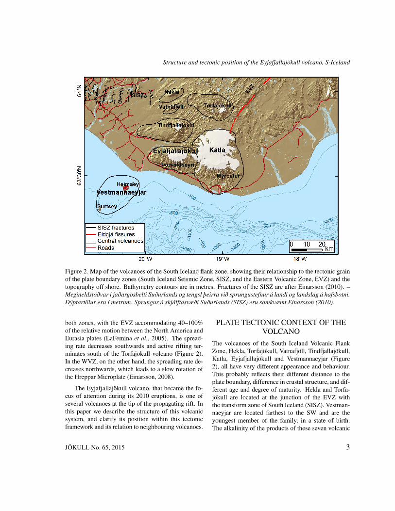
Figure 2. Map of the volcanoes of the South Iceland flank zone, showing their relationship to the tectonic grainof the plate boundary zones (South Iceland Seismic Zone, SISZ, and the Eastern Volcanic Zone, EVZ) and thetopography off shore. Bathymetry contours are in metres. Fractures of the SISZ are after Einarsson (2010). –Megineldstöðvar í jaðargosbelti Suðurlands og tengsl þeirra við sprungustefnur á landi og landslag á hafsbotni.Dýptartölur eru í metrum. Sprungur á skjálftasvæði Suðurlands (SISZ) eru samkvæmt Einarsson (2010).
both zones, with the EVZ accommodating 40–100%of the relative motion between the North America andEurasia plates (LaFemina et al., 2005). The spread-ing rate decreases southwards and active rifting ter-minates south of the Torfajökull volcano (Figure 2).In the WVZ, on the other hand, the spreading rate de-creases northwards, which leads to a slow rotation ofthe Hreppar Microplate (Einarsson, 2008).
The Eyjafjallajökull volcano, that became the fo-cus of attention during its 2010 eruptions, is one ofseveral volcanoes at the tip of the propagating rift. Inthis paper we describe the structure of this volcanicsystem, and clarify its position within this tectonicframework and its relation to neighbouring volcanoes.
PLATE TECTONIC CONTEXT OF THEVOLCANO
The volcanoes of the South Iceland Volcanic FlankZone, Hekla, Torfajökull, Vatnafjöll, Tindfjallajökull,Katla, Eyjafjallajökull and Vestmannaeyjar (Figure2), all have very different appearance and behaviour.This probably reflects their different distance to theplate boundary, difference in crustal structure, and dif-ferent age and degree of maturity. Hekla and Torfa-jökull are located at the junction of the EVZ withthe transform zone of South Iceland (SISZ). Vestman-naeyjar are located farthest to the SW and are theyoungest member of the family, in a state of birth.The alkalinity of the products of these seven volcanic
JÖKULL No. 65, 2015 3

Einarsson and Hjartardóttir
systems increases with distance from the EVZ-SISZjunction (Óskarsson et al., 1982). Furthermore, FeTivolcanism, characteristic for propagating rifts (e.g.Sinton et al., 1983), is found within this area, be-ginning 2–3 Myr ago (Jóhannesson et al., 1990). Itcan thus be argued that the area between Torfajökulland the south coast in Mýrdalur district (see Figure2) has been created during the last 3 million yearsby voluminous FeTi basalt placed unconformably ontop of older sea floor. This is supported by xenolithsfound in the hyaloclastites in Mýrdalur, on the S-flankof Katla (Áskelsson, 1960; Einarsson, 1962, 1967).These xenoliths are fragments of oceanic sedimentscontaining fossils. In spite of this copious volcan-ism no measurable crustal spreading has begun yet,as shown by GPS-geodesy in the last decade (LaFem-ina et al., 2005; Geirsson et al., 2006; Árnadóttir etal., 2009). Hence, Eyjafjallajökull is situated on sta-ble Eurasia Plate and can be classified as an intraplatevolcano. Same applies to its nearest neighbour, Katla,in spite of its occasional connection with rifting in theEVZ, exemplified by the AD 934 Eldgjá eruption (e.g.Larsen, 2000; Thordarson et al., 2001), (Figure 2).
The transition from the divergent EVZ to theSouth Iceland flank zone is also clearly seen inthe structural architecture. Long, parallel extensionalstructures such as normal faults and eruptive fissurescharacterize the EVZ (Thórarinsson et al., 1973; Ein-arsson, 2008). South of the EVZ-SISZ junction thesestructures become short and their strike variable. Thesouthern fissure swarm of Torfajökull has a trend ofENE, and the Hekla volcanic system similarly. TheTindfjallajökull and Eyjafjallajökull volcanic systemstrend almost E-W (Figures 2 and 3).
STRUCTURE OF THE VOLCANICSYSTEM
The Eyjafjallajökull volcano is relatively old. Theoldest formations are found at the lowest stratigraphiclevel on the south flank, near Þorvaldseyri farm (Fig-ure 3). Reversely magnetised layers are found thereindicating an age older than the Matuyama-Brunhesmagnetic boundary (0.78 My), confirmed by K-Ardating (Kristjánsson et al., 1988). The bulk of the
volcano was, however, built up during the Brunhesmagnetic chron as shown by a large positive mag-netic anomaly associated with the edifice (Jónssonet al., 1991). The anomaly can be traced towardsthe south and west, towards the Vestmannaeyjar vol-canic system off shore. The construction of the ed-ifice therefore occurred in the presence of water andice. Erosional scars, mainly in the southern flank areaof the volcano, show assemblages characteristic forsubglacial deposition and indicate that a good part ofthe volcanic edifice was emplaced during deglaciation(Loughlin, 2002).
Geothermal activity at Eyjafjallajökull is only lim-ited. The only significant occurrence is near the Selja-vellir farm on the south flank, where the oldest rocksare exposed and the level of erosion is deepest. Jóns-son (1998) reports a volume of highly altered rocks inthis area, cut by numerous dikes and veins, indicatinglong-lasting geothermal activity.
Loughlin (1995) mapped 118 dikes on the southside of Eyjafjallajökull. The area with the highestdensity of eroded dikes is in the valleys and gorgesabove Seljavellir and Þorvaldseyri farms (Figure 3).The vast majority of the observed dikes are 0.1–0.7 mwide. They dip steeply and about 50% of them have adip of 90◦. The distribution of dike strike is bimodalwith the bulk of the observations in a bell-shaped dis-tribution with the center azimuth of 45◦, and the sec-ond peak (small and narrow) at 180◦.
Jakobsson (1979) analysed 20 lava units at Eyja-fjallajökull that he identified as being of Postglacialage. Only two of them turned out to be of basalticcomposition, both located in the eastern fissureswarm, at Fimmvörðuháls. Of the rest, 17 were ofintermediate composition and one quartz-trachytic.Here it should be noted that the term Postglacial mayhave a variable meaning because of the glacial coverof the volcano and high elevation of most of the erup-tion sites. The glacier attained its maximum areal cov-erage around 1900 AD and has been shrinking eversince at a high rate. Lavas erupted in the Holocenemay therefore be glacially eroded and show evidenceof close interaction with snow, ice and water. Eventhe lava of March 2010 on the eastern flank at Fimm-vörðuháls was influenced by such interaction.
4 JÖKULL No. 65, 2015

Structure and tectonic position of the Eyjafjallajökull volcano, S-Iceland
Figure 3. Active structures at Eyjafjallajökull and neighbouring volcanoes, Katla, and Tindfjallajökull. Thebase map is a digital elevation model from the National Land Survey of Iceland. Eruption sites within the Katlacaldera are shown with respective year (e.g. Björnsson et al., 2000; Gudmundsson et al., 2007). Structuralfeatures are based on the geological maps of Jóhannesson et al. (1990), Jónsson (1998), Torfason and Jónsson(2005), and the paper of Jakobsson (1979). – Sprungukort af Eyjafjallajökli og nálægum eldstöðvum, Kötlu ogTindfjallajökli, byggt á stafrænum gögnum frá Landmælingum Íslands. Gosstöðvar innan Kötluöskjunnar erumerktar með viðkomandi gosári (Björnsson et al., 2000; Gudmundsson et al., 2007). Kortið er byggt á eldrijarðfræðikortum (Jóhannesson et al., 1990; Jónsson, 1998; Torfason and Jónsson, 2005; Jakobsson, 1979).
We have compiled a structural map of the Eyja-fjallajökull volcanic system and surrounding areasfrom available publications, aerial photographs andsatellite images (Figure 3). Topography and geo-graphic information is from the IS50 data base of theNational Land Survey of Iceland. We rely heavily onthe geological maps of Jóhannesson et al. (1990) andJónsson (1998), also the geological mapping of theeast flank area by Torfason and Jónsson (2005) andthe paper of Jakobsson (1979) on the petrology of theEVZ and the South Iceland flank zone. Faults and
eruptive fissures on those maps were checked againstlow altitude aerial photographs from Loftmyndir ehfand satellite images and then mapped into a GIS database. Small corrections were made when obviousdiscrepancies turned up. The outlines of the vol-canic systems are those of Einarsson and Saemunds-son (1987). The subglacial caldera of Katla is redrawnfrom Björnsson et al. (2000).
The fissure system that emerges from the map ofFigure 3 has a clear E-W trend and extends from the
JÖKULL No. 65, 2015 5

Einarsson and Hjartardóttir
summit region, about 15 km to the west and 10 km tothe east where it merges with the edifice of the neigh-bouring Katla volcano. There is a notable differencebetween the eastern and western fissure swarms. TheE-W structural grain is strong in the eastern swarm.Eruptive fissures in the col between the two volca-noes (Fimmvörðuháls) are mostly E-W striking, andso are the normal faults that are prominent in thearea. Hyaloclastite ridges formed by subglacial fis-sure eruptions on the SE-flank also have a strong E-Wstrike. The western fissure swarm, on the other hand,shows a divergent pattern towards the west. Fissuresalong the main ridge of the edifice trend E-W, but fis-sures on the side of the ridge have an arcuate shape.This is most prominent in the Skerin fissure on theNW-flank, thought to be the source of the eruptionaround the year 920 AD (Óskarsson, 2009), but isalso seen in older fissures on the SW-flank. On theNW-flank the fissures are concave to the north, on theSW-flank they are concave to the south.
It is noteworthy that the two short eruptive fissuresactive in the Fimmvörðuháls flank eruption of March-April 2010 had strikes that are inconsistent with thegeneral E-W structural grain.
Although the fissure swarms, or rift zones, ofEyjafjallajökull are distinct and well defined, theircharacteristics are different from those of the typicalfissure swarms of the divergent plate boundary defor-mation zones. At Eyjafjallajökull they are defined bythe orientation of eruptive fissures and the preferredlocation of eruption sites on the eastern and westernflank of the volcano. The rift zones or the fissureswarms do not extend beyond the volcano’s edifice.A typical fissure swarm at a divergent branch of theplate boundary, such as the Askja and Kverkfjöll fis-sure swarms in the Northern Volcanic Zone (Figure 1)contain long normal faults and open fissures, in ad-dition to eruptive fissures (Hjartardóttir et al., 2015;Hjartardóttir et al., 2009; Hjartardóttir and Einarsson,2012; Hjartardóttir et al., 2012). They also extend fortens of kilometers beyond the edifice of the centralvolcano of the respective system. The rift zones ofEyjafjallajökull thus show evidence of weak tectoniccontrol, as opposed to the strong tectonic influence onthe volcanic systems at the divergent plate boundary.
MORPHOLOGY
The Eyjafjallajökull edifice has the shape of an elon-gated, relatively flat cone that rises about 1,650 mabove the coastal plain. The volcano is capped by aglacier, from which the volcano takes its name (jökullin Icelandic is glacier). The glacier is up to 200 mthick (Guðmundsson and Högnadóttir, 2005). Thevolcano has an elliptical 2.5-km-wide summit crateror caldera. The outlet glacier Gígjökull originates inthe summit crater and flows towards the north throughan opening in the crater rim. In the classificationscheme of Icelandic volcanoes Eyjafjallajökull wasfrequently called a stratovolcano, mainly with refer-ence to its mixed eruptions of lavas and tephra (e.g.Thórarinsson, 1960; Saemundsson, 1978, Gudmunds-son, 2000). Jakobsson (1979) pointed out, however,that morphologically Eyjafjallajökull is comparable toHekla, which is classified as a stratified ridge due to itselongated shape. Indeed, the aspect ratios of the twovolcanoes (long axis divided by the short axis) is quitesimilar. For Eyjafjallajökull it is 2.5 measured at 1100m elevation contour, for Hekla it is 2.4 at 1000 m. So,if anything, Eyjafjallajökull is a bit more elongatedthan Hekla. Slope has been used to classify volca-noes, particularly to distinguish between stratovolca-noes and shield volcanoes. Because of the elongatedshape of Eyjafjallajökull the slopes are quite differentalong the long or short axes of the volcano. We find anaverage slope of 0.20 along the short axis (N-S) and0.09 along the long axis (E-W). These slopes are com-parable to that of some of the Hawaiian shield vol-canoes. Thordarson and Larsen (2007) point out theclose morphological resemblance to the polygeneticHawaiian shield volcanoes and call Eyjafjallajökull"a shield-like volcano". Then, Thordarson and Hösk-uldsson (2008) classify Eyjafjallajökull as a shieldvolcano. We concur with this idea and emphasize theresemblance of Eyjafjallajökull to the Kohala volcanoin Hawaii. The likeness is striking with respect to di-mensions, shape and structure. Both volcanoes areabout 1600 m a.s.l. and have an uncertain extensionbelow sea level. The elongation is about the same,similarly the slopes. The rift zones have similar ap-pearance and structure.
6 JÖKULL No. 65, 2015
Structure and tectonic position of the Eyjafjallajökull volcano, S-Iceland
HISTORICAL ACTIVITY ANDSYMPATHETIC BEHAVIOUR OF KATLAEyjafjallajökull is only a moderately active volcano.Only four episodes of activity are known since Icelandbecame inhabited in the ninth century, one of which isonly known from geological evidence. It is remark-able that all the episodes have been accompanied bysome activity or unrest at the neighbouring, and muchmore active, volcano Katla. In most cases this sym-pathetic reaction has been small, even insignificant.But the possibility that Eyjafjallajökull could trigger alarge Katla eruption is intriguing in light of the gener-ally dangerous behaviour of Katla (e.g. Larsen, 2000;Óladóttir et al., 2005, 2008). The known episodes arethe following:
Around 920: No written documents exist of theseeruptions. Stratigraphy of flood deposits and tephraon the NW-flank of Eyjafjallajökull indicate that aneruption of Eyjafjallajökull occurred synchronouslywith an eruption of Katla about the year 920 AD(Óskarsson, 2009). The most likely eruption site isa 4.5 km long radial fissure, Skerin, that extends fromthe summit down the flank to the WNW (Figure 3).The eruption was a mixed eruption, the lower parterupted alkali basalt and the upper part produced tra-chyte. Intermediate compositions also were produced.
1612–1613: The interpretation of historical doc-uments on eruptive activity in 1612–13 has changedconsiderably with time. In his compilation of writtendocuments on eruptions of Katla, Thorarinsson (1975)found two contradictory entries. One mentions erup-tion in Eyjafjallajökull, the other eruption and jökul-hlaup from Katla. He dismissed the Eyjafjallajökullentry as erroneous and only lists eruption of Katlathat year. Thoroddsen (1925) only lists an eruption ofEyjafjallajökull in 1612, beginning on October 12. Inher tephrochronological studies Larsen (1978) findsevidence for tephra from both volcanic systems con-sistent with eruptive activity in 1612-1613. Contem-porary description by a Czech traveler, Daniel Vetter(Vetter, 1983, Jónsson and Sigurðsson, 2010) stronglysuggest an eruption of Eyjafjallajökull. So apparentlythere were small eruptions in both volcanoes. Therestill is no tephrochronological evidence to indicatewhich volcano erupted first, Eyjafjallajökull or Katla.
1821–1823: An eruption began on December 19,1821, apparently in the western part of the sum-mit caldera of Eyjafjallajökull (Thoroddsen, 1925;Larsen, 1999). It continued with varying intensityfor several months, accompanied by moderate ash-fall and jökulhlaups. Increased intensity was noted inJune 1822 and eruptive activity was documented wellinto the year 1823. On June 26, 1823, Katla beganerupting after a 68-year repose (Larsen, 2000). Theeruption was explosive and originated in the SE partof the caldera (Figure 3). It lasted 28 days and pro-duced jökulhlaups for most of that time. It ranks asa moderately small Katla eruption, if compared to theeruptions of 1721, 1755, and 1918.
1994–2011: No activity is known in Eyjafjalla-jökull following the end of the 1823 activity. Seismicnetwork installed in South Iceland after 1973 showsthat no significant activity took place in Eyjafjalla-jökull (e.g. Einarsson and Brandsdóttir, 2000) until1992 when a flurry of microearthquakes was recorded.The seismicity increased significantly in 1994 andwas associated with upheaval of the SE-flank of thevolcano (Sturkell et al., 2003; Dahm and Brandsdóttir,1997; Jakobsdóttir, 2008; Pedersen et al., 2007). Ped-ersen and Sigmundsson (2004) interpreted the infla-tion bulge as the result of a sill intrusion at the depth ofabout 4.6 km. A slightly larger sill intrusion occurredin 1999 (Pedersen and Sigmundsson, 2006; Sturkell etal., 2003). This sill was horizontally offset from the1994 sill and at a greater depth, about 6 km. The intru-sion began in July and lasted several months. At thesame time unrest was detected at Katla. A small jök-ulhlaup issued from the Sólheimajökull outlet glacieron July 18, presumably caused by a small subglacialeruption at the SW rim of the Katla caldera (Guð-mundsson et al., 2007). Inflation of the caldera re-gion followed, accompanied by large increase in seis-micity, both in the caldera and the Goðabunga seis-micity cluster on the W-flank of Katla (Sturkell et al.,2003, 2008, 2009). Increase in geothermal activityin the caldera and along its rims was also noted anddocumented (Guðmundsson et al., 2007). This unrestcame to an end in 2004 or 2005. The next chapterin the development was the intrusion of the third sillbeneath Eyjafjallajökull in 2009, indicated by uplift
JÖKULL No. 65, 2015 7

Einarsson and Hjartardóttir
of the SE flank and increase in seismicity beginningin April and ending in August (Sigmundsson et al.,2010). Towards the end of the year, however, inflationresumed at a higher rate. A sill and then a dike wereintruded, ending with an outbreak of a lava eruptionon March 20, 2010, in the eastern fissure swarm, atFimmvörðuháls, the col between Eyjafjallajökull andKatla. The eruption issued from two short fissures andproduced alkali basalt. The lava flow field was 1.3km2 in area and the volume was only 0.020 km3 (Gud-mundsson et al., 2012). This small eruption ended onApril 12 and did not lead to any deflation of the pre-viously inflated volcano. A new eruption then brokeout in the summit region of the volcano on April 14(e.g. Gudmundsson et al., 2012). The product was tra-chyandesite, mostly in the form of fine ash, but also alava flow was issued down the Gígjökull outlet glacierof the caldera. The eruption came to an end towardsthe end of May and was accompanied by deflation ofthe volcano, not in the same area as the pre-eruptioninflation, however (Sigmundsson et al., 2010).
The 2010 activity at Eyjafjallajökull did not seemto affect the seismicity at Katla much. But the follow-ing year, on July 8, a burst of tremor was recorded atKatla that lasted 23 hours (Sgattoni et al., 2015). Sev-eral cauldrons formed in the glacier at the SE calderarim and a jökulhlaup issued from the Kötlujökull out-let glacier. The bridge on the Múlakvísl river waswashed away. A new seismic area became active onthe south flank of Katla (Sgattoni et al., 2014) and theseismicity increased in the caldera as well. To accountfor these observations it is considered possible that asmall eruption occurred under the glacier, accompa-nied by an intrusion into the south flank, but directproof is missing.
INTERNAL STRUCTURE OFEYJAFJALLAJÖKULL AND KATLA
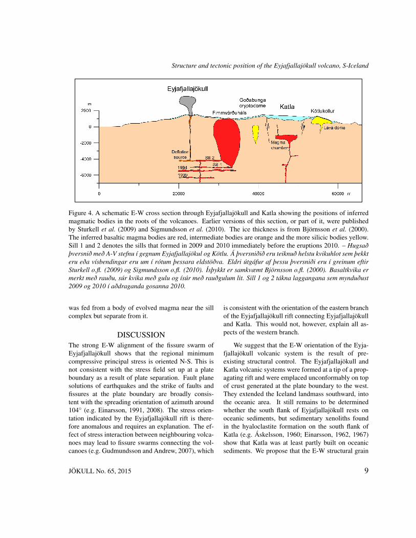
In order to come up with sensible suggestions for amechanism of the interaction between the volcanoesit is necessary to review all evidence that may havebearing on the problem. The available indications arecompiled in a conceptual model shown in a W-E crosssection through the volcanoes in Figure 4.
The shallow-level magma chamber that is shownin Figure 4 beneath the Katla caldera is based on seis-mic undershooting by Guðmundsson et al. (1994) thatrevealed an area of P-wave delay and S-wave attenu-ation in the caldera. Its existence is further supportedby the inflation measured by Sturkell et al. (2003,2008) during 1999-2004. The topographic expressionof the caldera is derived from the radio-echo sound-ing of Björnsson et al. (2000). Topography and thethermal effects of a magma chamber are also con-sidered to be responsible for a pronounced negativemagnetic anomaly over the caldera region (Jónssonand Kristjánsson, 2000). The small dike extendingtowards the surface near the western extreme of thechamber (Figure 4) is meant to represent the feedingchannel of the presumed small eruption that occurredon July 18, 1999 (Guðmundsson et al., 2007).
The Katla caldera is surrounded by several sili-cic domes (Jóhannesson et al., 1990), one of which,Kötlukollur, is shown in the cross section. Some othercentral volcanoes in Iceland have similar halo of sili-cic domes, notably Krafla in the Northern VolcanicZone. These silicic formations have been suggestedto be the result of remelting of hydrated basalticcrust by frequent feeding of the volcano by primarybasaltic melt from the mantle (Jónasson, 1994). Thecryptodome shown on the west side of the Katlacaldera is based on the interpretation of Soosalu et al.(2006) and Einarsson et al. (2005), that the persistentseismicity cluster at Goðabunga is caused by a slowlyrising body of semi-molten rock of low density. Analternate explanation of the seismicity at Goðabungais offered by Jónsdóttir et al. (2007), who suggest thatthe low-frequency seismic events are caused by fallingice blocks.
The complex of sills and dikes shown beneathEyjafjallajökull represents the intrusive bodies re-vealed by the repeated inflation episodes of 1994-2010. Shown are the three sills of 1994, 1999, and2009, respectively, also the sill that immediately pre-ceded the eruptive activity in 2010 (Pedersen and Sig-mundsson, 2004, 2006; Sigmundsson et al., 2010).The final dike that fed the flank eruption at Fimm-vörðuháls appears as a large red blob because it liesin the plane of the cross section. The summit eruption
8 JÖKULL No. 65, 2015
Structure and tectonic position of the Eyjafjallajökull volcano, S-Iceland
Figure 4. A schematic E-W cross section through Eyjafjallajökull and Katla showing the positions of inferredmagmatic bodies in the roots of the volcanoes. Earlier versions of this section, or part of it, were publishedby Sturkell et al. (2009) and Sigmundsson et al. (2010). The ice thickness is from Björnsson et al. (2000).The inferred basaltic magma bodies are red, intermediate bodies are orange and the more silicic bodies yellow.Sill 1 and 2 denotes the sills that formed in 2009 and 2010 immediately before the eruptions 2010. – Hugsaðþversnið með A-V stefnu í gegnum Eyjafjallajökul og Kötlu. Á þversniðið eru teiknuð helstu kvikuhlot sem þekkteru eða vísbendingar eru um í rótum þessara eldstöðva. Eldri útgáfur af þessu þversniði eru í greinum eftirSturkell o.fl. (2009) og Sigmundsson o.fl. (2010). Ísþykkt er samkvæmt Björnsson o.fl. (2000). Basaltkvika ermerkt með rauðu, súr kvika með gulu og ísúr með rauðgulum lit. Sill 1 og 2 tákna laggangana sem mynduðust2009 og 2010 í aðdraganda gosanna 2010.
was fed from a body of evolved magma near the sillcomplex but separate from it.
DISCUSSIONThe strong E-W alignment of the fissure swarm ofEyjafjallajökull shows that the regional minimumcompressive principal stress is oriented N-S. This isnot consistent with the stress field set up at a plateboundary as a result of plate separation. Fault planesolutions of earthquakes and the strike of faults andfissures at the plate boundary are broadly consis-tent with the spreading orientation of azimuth around104◦ (e.g. Einarsson, 1991, 2008). The stress orien-tation indicated by the Eyjafjallajökull rift is there-fore anomalous and requires an explanation. The ef-fect of stress interaction between neighbouring volca-noes may lead to fissure swarms connecting the vol-canoes (e.g. Gudmundsson and Andrew, 2007), which
is consistent with the orientation of the eastern branchof the Eyjafjallajökull rift connecting Eyjafjallajökulland Katla. This would not, however, explain all as-pects of the western branch.
We suggest that the E-W orientation of the Eyja-fjallajökull volcanic system is the result of pre-existing structural control. The Eyjafjallajökull andKatla volcanic systems were formed at a tip of a prop-agating rift and were emplaced unconformably on topof crust generated at the plate boundary to the west.They extended the Iceland landmass southward, intothe oceanic area. It still remains to be determinedwhether the south flank of Eyjafjallajökull rests onoceanic sediments, but sedimentary xenoliths foundin the hyaloclastite formation on the south flank ofKatla (e.g. Áskelsson, 1960; Einarsson, 1962, 1967)show that Katla was at least partly built on oceanicsediments. We propose that the E-W structural grain
JÖKULL No. 65, 2015 9

Einarsson and Hjartardóttir
is inherited from, and reflects the original coastline orthe original shelf edge. The N-S extension across theEyjafjallajökull rifts is thus the result of minor slump-ing of the south flank towards the oceanic side. Thenorth flanks are buttressed against the pre-existinglandmass (Figure 5). Similar explanations were pro-posed by Fiske and Jackson (1972) for the locationand orientation of the rifts of the Hawaiian volca-noes. According to their ideas each new volcano ofthe Hawaiian chain was built up on the flank of thepreexisting volcanoes and the orientation of the newrifts was governed by the gravitational effect and thebuttressing effect of the preexisting edifice. Similarconditions may arise where a new volcano is formedat the tip of a propagating rift. Today the Eyjafjalla-jökull edifice is buttressed on the SW-side by the ad-dition to the insular shelf area produced by the youngVestmannaeyjar volcanic system, that did not existduring the main building phase of Eyjafjallajökull.
The westwards divergence of the faults and erup-tive fissures of the western fissure swarm is a remark-able feature of the volcano. Since dikes and eruptivefissures generally tend to form at right angle to theleast compressive principal stress, the fissure swarmpattern should reflect the stress field. Nakamura etal. (1980) showed how the local stress field of a vol-
cano dominates the fissure pattern in the central partof a volcano, but farther away the regional stress fieldtakes over and the fissure pattern begins to reflect theregional stress. Under these conditions the fissurepattern is radial close to the volcano and parallel far-ther away, opposite to what we observe in the westernbranch of the Eyjafjallajökull fissure swarm. The fis-sures become more radial with increasing distance.This is an argument for a weak influence of the re-gional stress field. We suggest that the fissure patternis the result of topographic influence through gravity.The eruptive fissures tend to form perpendicular to theelevation contours on the lower flanks of the volcano.This is in line with recent papers that show a strongtopographic control on the propagation of dikes be-neath volcanic edifices. The horizontally propagatingdike from Bárðarbunga volcano in August 2014 wasshown to follow a path of maximum gradient in po-tential energy along its way to feed the Holuhrauneruption at a distance of 45 km from the center ofthe volcano (Sigmundsson et al., 2015; Heimissonet al., 2015). Even gently sloping flanks of mono-genetic lava shields have been shown to influence theintensity of fissure swarms that pass through them(Hjartardóttir and Einarsson, 2015).
Figure 5. A North-South topographic profile through Eyjafjallajökull and surrounding area. The buttressingeffect of the Tindfjallajökull volcano is evident, also the lack of support on the south side. – Þversnið meðN-S stefnu í gegnum Eyjafjallajökul og nærliggjandi svæði. Sjá má hvernig Tindfjallajökull styður við norðanmegin, en stuðning vantar við suðurhlíðar fjallsins.
10 JÖKULL No. 65, 2015
Structure and tectonic position of the Eyjafjallajökull volcano, S-Iceland
The idea of gravitational stresses being responsi-ble for the Eyjafjallajökull fissure swarm, its evolu-tion and presently anomalous E-W orientation is sup-ported by, or consistent with, the following lines ofargumentation:1. Eyjafjallajökull and Katla were constructed in apropagating rift (Óskarsson et al., 1982). They ex-tended the land mass of Iceland beyond the insularshelf. This happened before the youngest volcanicsystem, the Vestmannaeyjar system, was formed.2. The observations and model calculations show-ing sill intrusions in 1994 and 1999 (Pedersen andSigmundsson, 2004, 2006), accompanied by earth-quake focal mechanisms with vertical T-axis (Dahmand Brandsdóttir, 1997), and sill intrusion followedby a vertical E-W dike preceding the 2010 flank erup-tion within the fissure swarm (Sigmundsson et al.,2010) are all consistent with an idea of an E-W fissureswarm primarily affected by gravitational stresses.3. The oldest dikes exposed at the base of the volcanohave a dominating strike of NE (Loughlin, 1995),whereas the most recent eruptive fissures show a clearE-W strike. This indicates that the original stress fieldwas modified as the volcanic edifice was built up.4. Topography of the volcano correlates with the ori-entation of eruptive fissure in the western branch ofthe fissure swarm, demonstrating the effect of gravityon stresses in the volcano.
In this paper we point out the rather unique posi-tion of the Eyjafjallajökull and Katla volcanoes thatthey are placed unconformably on top of old seafloor,at least partly. In this respect they resemble oceanicisland volcanoes more than any of the other volcanicsystems in Iceland do. The anomalous orientationof the E-W rift zone or fissure swarm that connectsthe two central volcanoes may be a result of vol-cano spreading that often characterizes oceanic vol-canoes (e.g. McGuire, 1996; Van Wyk de Vries andBorgia, 1996). This structural relationship may in-duce hazards that are associated with flank instabil-ities and sudden failure of the edifice (e.g. Acocellaand Puglisi, 2010). The question must be consideredunder what conditions the flank may become unsta-ble. Intrusion of dikes or sills at shallow level or evenwithin the edifice is an obvious source of weakness.
Measurements of the deformation of the volcanoesduring the present unrest period since 1994 have givenno indications of flank failure so far. The deforma-tion field prior to the 2010 eruptions was successfullymodelled as the result of Mogi-type point sources(Sturkell et al., 2003, 2008) or rather deep sill intru-sions (Pedersen and Sigmundsson, 2004, 2006). Thedeformation during the eruptions and immediately be-fore them also indicated sills, dikes and rather deepsource of deflation (Sigmundsson et al., 2010) withno hint of flank instability. This possibility should bekept in mind, however, during future unrest periods.
The anomalous E-W orientation of the volcanicsystems of Tindfjallajökull and Eyjafjallajökull hasattracted attention and is mentioned in several placesin the literature. The opinion has been expressed thatthe E-W orientation of the rift of Eyjafjallajökull isyet another expression of horizontal shear in the flankzone of S-Iceland (e.g. Saemundsson, 1978) or eventhe South Iceland Seismic Zone (e.g. Jónsson, 1998).Our investigation does not support these views. Thestructures we find do not resemble any of the struc-tures associated with strike-slip faulting (e.g. Einars-son, 2010). In spite of a clear E-W orientation of theSISZ no major faults with that orientation have beenidentified there (see Figure 2).
Other processes have been invoked as possiblecauses of anomalous fracture orientations in Iceland,such as loading and unloading of the crust by glacia-tion and deglaciation. E-W oriented fractures in therift zone of Central Iceland may be related to recentchanges in the load of the Vatnajökull glacier (Hjar-tardóttir et al., 2015), and the anomalous orientationof the Upptyppingar dike intrusion in 2007-2008 hasbeen attributed to the present reduction in glacier loaddue to global warming (Hooper et al., 2011). TheEyjafjallajökull edifice was built up mostly in thePleistocene during which Iceland was repeatedly cov-ered by thick glacier ice. During glacial periods theice load north of the volcano was large, whereas theice south of the volcano would have been floating onthe ocean. Changes in the ice load would thereforehave resulted in differential stress changes in the crustat the location of the volcano that may have influencedthe orientation of its fissure swarms.
JÖKULL No. 65, 2015 11
Einarsson and Hjartardóttir
We have shown that activity of Eyjafjallajökull isoften accompanied by activity of Katla. The Katlaevents are not all large, as shown best by the recentevents accompanying the intrusion of 1999 and erup-tions of 2010. Mechanisms of possible interaction ofthe two volcanoes include alteration of stress aroundKatla magma chambers caused by inflation or defla-tion of an Eyjafjallajökull magma chamber, and di-rect injection of Eyjafjallajökull magma into a pas-sive magma chamber at Katla. Other mechanisms arepossible, even if less likely, such as a deep pressureconnection through the mantle magma sources, or thetriggering effects of increased melting rate of the over-lying glaciers induced by ash fall. Albino and Sig-mundsson (2014) showed that stress interactions be-tween magma bodies are strongly dependent on thedistance between the bodies and their shape. This in-teraction is probably insignificant in the case of Eyja-fjallajökull and Katla.
CONCLUSIONS1. The Eyjafjallajökull volcano belongs to a groupof volcanoes that are located off the plate boundary,south of the rift-transform junction where the EVZand the SISZ meet. Rifting in the area is insignifi-cant but the volcanoes represent activity at the the tipof a propagating rift. The volcanoes are likely to beunconformably placed on top of ocean sediments.2. The volcanic edifice has the shape of an elongatedshield volcano with a summit elevation of 1650 m,long-axis of about 30 km and short-axis 15 km.3. The volcanic system has an immature rift zone, ora fissure swarm, with an E-W orientation. It does notextend beyond the edifice. The western branch is 15km long and the eastern branch extends at least 10 kmwhere it merges with the neighbouring Katla volcanicsystem. Both volcanoes may inject magma into thiseastern branch of the rift zone.4. The anomalous orientation of the rift may be theresult of gravitational stresses generated by the edi-fice and the preexisting topography when the volcanostarted growing at the propagating rift tip.5. On the W flank the pattern of lateral eruptive fis-sures becomes more radial with increasing distance
from the volcanic center. This is inconsistent withtectonic control of the dike orientations and suggeststhat gravitational stresses of the edifice are more im-portant.6. Geological and historical evidence show that ac-tivity of Eyjafjallajökull is often accompanied by ac-tivity of Katla. The most likely mechanisms of inter-action of the two volcanoes is considered to be di-rect injection of Eyjafjallajökull magma into a passivemagma chamber at Katla. Other mechanisms are pos-sible.
AcknowledgementsThis paper benefits from long discussions with numer-ous scientists and laymen through several decades.In particular we like to mention the farmer Einar H.Einarsson (1912–1992), who meticulously operateda seismograph at his farm Skammadalshóll for morethan two decades and had a special relationship to hisvolcanoes, Katla and Eyjafjallajökull. He also wastireless pointing out the importance of the fossilifer-ous xenoliths found at his farm in the fifties. RósaÓlafsdóttir helped draft Figures 1 and 4, and FinnurPálsson provided ice thickness data for Figure 4. Con-structive criticism by two reviewers led to significantimprovements of the paper.
ÁGRIPEyjafjallajökull er ein af elstu virku megineldstöðv-um Íslands. Hann stendur í jaðargosbelti Suðurlands,í nokkurra tuga kílómetra fjarlægð frá flekaskilumAtlantshafsins sem liggja í gegnum Ísland. Fjallið erílöng, flöt keila, sem stendur um 1650 m yfir sjáv-arborði. Lítill jökull hylur efsta hluta fjallsins, þarmeð talda litla toppöskju, sem er um 2,5 km að þver-máli. Fremur vanþroskaður sprungusveimur liggurí gegnum fjallið. Hann hefur A-V stefnu og fylgjagossprungur og gígaraðir oftast þeirri stefnu. Næsttoppnum hafa þó gossprungur tilhneigingu til að verageislalægar. Í vesturhluta sprungusveimsins sveigjagossprungur frá meginstefnunni og liggja þá hornréttá hæðarlínur fjallsins. Meginstefna sprungusveimsinsgefur til kynna spennusvið með tognun í N-S, sem erekki í samræmi við þekktar flekahreyfingar. Stefnasprungna bendir til þess að lögun fjallsins og spennasem af henni stafar stjórni miklu um ferðir kviku á
12 JÖKULL No. 65, 2015
Structure and tectonic position of the Eyjafjallajökull volcano, S-Iceland
leið hennar til yfirborðs. Berggangar í eldri hlut-um fjallsins stefna NA-SV sem þýðir að spennusviðiðhefur breyst meðan á 0,78 milljón ára uppbyggingufjallsins stóð. Breytingarnar gætu staðið í sambandivið framsókn gosbeltisins til suðvesturs þegar frárekfærðist frá Vesturgosbelti Íslands til Austurgosbeltis-ins. Við stingum upp á þeirri skýringu á núverandi af-brigðilegri stefnu eldstöðvakerfis Eyjafjallajökuls aðhún tengist landslaginu sem fyrir var þegar kerfið fórí gang, einkum stefnu landgrunnsbrúnarinnar. Þannighafi Eyjafjallajökull ekki gliðnað vegna flekareks einsog flestar aðrar eldstöðvar Íslands, heldur gliðni hannundan eigin þunga vegna skorts á aðhaldi, sem er af-leiðing af 3000 m lækkun á landslagi til suðurs fráeldstöðinni. Eldstöðvakerfið situr mislægt ofan á eldriskorpu og mislægið markast af setlagi. Eystri greinsprungusveimsins tengir Eyjafjallajökul við nágrannasinn, Kötlu. Fjarlægð milli miðja þessara ólíku meg-ineldstöðva er aðeins 25 km. Efnasamsetning kviku-kerfanna er þó ólík. Sterkar vísbendingar eru umþað að kerfin hafi áhrif hvort á annað. Eldstöðvarn-ar hafa oftar en einu sinni verið virkar samtímis eðaá svipuðum tíma. Gosið í Kötlu 1823 kom í beinuframhaldi langdregins goss í Eyjafjallajökli sem hófst1821. Báðar eldstöðvarnar virðast hafa verið virkar1612 og um 920. Þá má benda á að laggangsinnskotií Eyjafjallajökli 1999 fylgdi lítið jökulhlaup frá Kötlusem virðist hafa stafað af litlu gosi undir jöklinum.Svipaður atburður varð einnig efst í Kötlujökli 2011,ári eftir gosið í Eyjafjallajökli. Ekki er alveg ljósthvernig samspili eldstöðvanna er háttað. Líklegast mátelja að önnur hafi áhrif á hina með litlu gangainn-skoti, en einnig er hugsanlegt að báðar eldstöðvarnarverði fyrir sameiginlegum áhrifum af þrýstingsbreyt-ingum í möttli jarðar.
REFERENCESAcocella, V. and G. Puglisi 2010. Hazard mitigation of
unstable volcano edifices. Eos, Trans. Am. Geophys.Union 91, 357–358.
Albino, F. and F. Sigmundsson 2014. Stress trans-fer between magma bodies: Influence of intru-sions prior to 2010 eruptions at Eyjafjallajökull vol-cano, Iceland. J. Geophys. Res. 119, 2964–2975,doi:10.1002/2013JB010510.
Árnadóttir, Th., B. Lund, W. Jiang, H. Geirsson, H.
Björnsson, P. Einarsson and T. Sigurdsson 2009.Glacial rebound and plate spreading: Results fromthe first countrywide GPS observations in Iceland.Geophys. J. Int. 177(2), 691–716, doi:10.1111/j.1365-246X. 2008.04059.x.
Áskelsson, J. 1960. Fossiliferous xenoliths in the móbergformation of South Iceland. Acta Nat. Islandica II, 3.
Björnsson, H., F. Pálsson and M. T. Guðmundsson 2000.Surface and bedrock topography of Mýrdalsjökull,South Iceland: The Katla caldera, eruption sites androutes of jökulhlaups. Jökull 49, 29–46.
Dahm, T. and B. Brandsdóttir 1997. Moment tensors ofmicroearthquakes from the Eyjafjallajökull volcano insouth Iceland. Geophys. J. Int. 130, 183–192.
DeMets, R., G. Gordon, D. F. Argus and S. Stein 1994.Effect of recent revisions to the geomagnetic reversaltime scale on estimates of current plate motions. Geo-phys. Res. Lett. 21, 2191–2194.
Einarsson, E. H. 1962. Fornskeljar í móbergi í Höfða-brekkuheiði (Ancient molluscs in hyaloclastites atHöfðabrekkuheiði, in Icelandic). Náttúrufræðingurinn32, 35–45.
Einarsson, E. H. 1967. Steingervingar í Skammadals-kömbum (Fossils in Skammadalskambar, in Ice-landic). Náttúrufræðingurinn 37, 93–104.
Einarsson, P. 1991. Earthquakes and present-day tectonismin Iceland. Tectonophysics 189, 261–279.
Einarsson, P. 2008. Plate boundaries, rifts and transformsin Iceland. Jökull 58, 35–58.
Einarsson, P. 2010. Mapping of Holocene surface rupturesin the South Iceland Seismic Zone. Jökull 60, 121–138.
Einarsson, P. and B. Brandsdóttir 2000. Earthquakes inthe Mýrdalsjökull area, Iceland, 1978–1985: Seasonalcorrelation and relation to volcanoes. Jökull 49, 59–73.
Einarsson, P. and K. Saemundsson 1987. Earthquake epi-centers 1982–1985 and volcanic systems in Iceland(map), in Í Hlutarins Eðli: Festschrift for ÞorbjörnSigurgeirsson, Th. Sigfússon (ed.), Reykjavík, Menn-ingarsjóður.
Einarsson, P., H. Soosalu, E. Sturkell, F. Sigmundssonand H. Geirsson 2005. Virkni í Kötlueldstöðinni ognágrenni hennar sídan 1999 og hugsanleg þróun at-burðarásar (Activity of Katla and surrounding areasince 1999 and potential scenarios). In: Hættumatvegna eldgosa og hlaupa frá vestanverðum Mýrdals-jökli og Eyjafjallajökli (Assessment of hazard due to
JÖKULL No. 65, 2015 13

Einarsson and Hjartardóttir
eruptions and jökulhlaups from western Mýrdalsjökulland Eyjafjallajökull), M. T. Guðmundsson and Á. G.Gylfason (eds.), Reykjavík, Iceland, University Publ.,151–158.
Fiske, R. S. and E. D. Jackson 1972. Orientation andgrowth of Hawaiian volcanic rifts: the effect of re-gional structure and gravitational stress. Proc. RoyalSoc. London, Series A-329, 299–326.
Geirsson, H., Th. Árnadóttir, C. Völksen, W. Jiang,E. Sturkell, T. Villemin, P. Einarsson, F. Sig-mundsson and R. Stefánsson 2006. Current platemovements across the Mid-Atlantic Ridge deter-mined from 5 years of continuous GPS measure-ments in Iceland. J. Geophys. Res. 111, B09407,doi:10.1029/2005JB003717.
Gudmundsson, A. 2000. Dynamics of volcanic systems inIceland: example of tectonism and volcanism at juxta-posed hot spot and mid-ocean ridge systems. Ann. Rev.Earth Planet. Sci. 28, 107–140.
Gudmundsson, A. and R. E. B. Andrew 2007. Me-chanical interaction between active volcanoesin Iceland. Geophys. Res. Lett. 34, L10310,doi:10.1029/2007GL029873.
Guðmundsson, M. T. and Th. Högnadóttir 2005. Ísbráðnunog upptakarennsli jökulhlaupa vegna eldgoss í Eyja-fjallajökli og vestanverðum Mýrdalsjökli (The melt-ing distribution and origin of the jökulhlaups thatcan be caused by eruptions from western Mýrdals-jökull and Eyjafjallajökull, in Icelandic). In: Hættumatvegna eldgosa og hlaupa frá vestanverðum Mýrdals-jökli og Eyjafjallajökli (Assessment of hazard due toeruptions and jökulhlaups from western Mýrdalsjökulland Eyjafjallajökull). M. T. Guðmundsson and Á. G.Gylfason (eds.), Reykjavík, Iceland, University Publ.,158–179.
Guðmundsson, M. T., Th. Högnadóttir, A. B. Kristinssonand S. Guðbjörnsson 2007. Geothermal activity in thesubglacial Katla caldera, Iceland, 1999–2005, studiedwith radar altimetry. Ann. Glaciology 45, 66–72.
Gudmundsson, M. T., T. Thordarson, Á. Höskuldsson,G. Larsen, H. Björnsson, F. J. Prata, B. Oddsson, E.Magnússon, T. Högnadóttir, G. N. Petersen, C. L.Hayward, J. A. Stevenson and I. Jónsdóttir 2012. Ashgeneration and distribution from the April-May 2010eruption of Eyjafjallajökull, Iceland. Sci. Rep. 2, 572;doi:10.1038/srep00572.
Guðmundsson, Ó., B. Brandsdóttir, W. Menke and G. E.Sigvaldason 1994. The crustal magma chamber of the
Katla volcano in South Iceland revealed by 2-D seis-mic undershooting. Geophys. J. Int. 119, 277–296.
Heimisson, E. R., A. Hooper and F. Sigmundsson 2015.Forecasting the path of a laterally propagating dike. J.Geophys. Res. 120, doi:10.1002/2015JB012402.
Hjartardóttir, Á. R. and P. Einarsson 2012. The Kverkfjöllfissure swarm and the eastern boundary of the North-ern Volcanic Rift Zone, Iceland. Bull. Volcanol. 74,143–162, doi:10.1007/s00445-011-0496-6.
Hjartardottir, Á. R. and P. Einarsson 2015. The interac-tion of fissure swarms and monogenetic lava shields inthe rift zones of Iceland. J. Volcanol. Geothermal Res.299, 91–102, doi:10.1016/j.jvolgeores.2015.04.001
Hjartardóttir, Á. R., P. Einarsson and H. Sigurðsson2009. The fissure swarm of the Askja volcanic sys-tem along the divergent plate boundary of N Iceland.Bull. Volcanol. 71 (9), 961–975. doi:10.1007/s00445-009-0282x.
Hjartardóttir, Á. R., P. Einarsson, E. Bramham and T.J. Wright 2012. The Krafla fissure swarm, Iceland,and its formation by rifting events. Bull. Volcanol. 74,2139–2153. doi:10.1007/s00445-012-0659-0.
Hjartardóttir, Á. R., P. Einarsson, S. Magnúsdóttir, Þ.Björnsdóttir and B. Brandsdóttir 2015. Fracture sys-tems of the Northern Volcanic Rift Zone, Iceland –An onshore part of the Mid-Atlantic plate boundary.In: T. J. Wright, A. Ayele, D. J. Ferguson, T. Kidaneand C. Vye-Brown (eds.) Magmatic Rifting and Ac-tive Volcanism. Geol. Soc., London Special Publ. 420,http://dx.doi.org/10.1144/SP420.1
Hooper, A., B. G. Ofeigsson, F. Sigmundsson, B. Lund,H. Geirsson, P. Einarsson and E. Sturkell 2011. In-creased capture of magma in the crust promotedby ice-cap retreat in Iceland. Nature Geoscience,doi:10.1038/NGEO1269.
Jakobsdóttir, S. S. 2008. Seismicity in Iceland 1994–2007.Jökull 58, 75–100.
Jakobsson, S. P. 1979. Petrology of recent basalts of theeastern volcanic zone, Iceland. Acta Nat. Islandica 21,1–103.
Jóhannesson, H., S. P. Jakobsson and K. Sæmundsson1990. Geological Map of Iceland, Sheet 6, South-Central Iceland. 3rd ed. Institute of Natural Historyand Icelandic Geodetic Survey.
Jónasson, K. 1994. Rhyolite volcanism in the Krafla cen-tral volcano, North-East Iceland. Bull. Volcanol. 56,516–528.
14 JÖKULL No. 65, 2015
Structure and tectonic position of the Eyjafjallajökull volcano, S-Iceland
Jónsdóttir, K., A. Tryggvason, R. Roberts, B. Lund, H.Soosalu and R. Bödvarsson 2007. Habits of a glaciercovered volcano: seismicity and a structure study ofthe Katla volcano, South Iceland. Ann. Glaciology 45,169–177.
Jónsson, G. and L. Kristjánsson 2000. Aeromagnetic mea-surements over Mýrdalsjökull and vicinity. Jökull 49,47–58.
Jónsson, G., L. Kristjánsson and M. Sverrisson 1991.Magnetic surveys of Iceland. Tectonophys. 189, 229–247.
Jónsson, J. 1998. Eyjafjöll, drög að jarðfræði (Eyjafjöll,Geological overview, in Icelandic). Publ. 53, 1–111,Research Station Neðri Ás, Hveragerði, Iceland.
Jónsson, T. and O. Sigurðsson 2010. The eruption of Eyja-fjallajökull 1612 or 1613 (Eyjafjallajökulsgosið 1612eða 1613, in Icelandic). Web page of the Icelandic Me-teorological Office, vedur.is, June 2011.
Kristjánsson, L., H. Jóhannesson, J. Eiríksson and A. I.Gudmundsson 1988. Brunhes-Matuyama paleomag-netism in three lava sections in Iceland. Can. J. EarthSci. 25, 215–225.
LaFemina, P. C., T. H. Dixon, R. Malservisi, Th. Árna-dóttir, E. Sturkell, F. Sigmundsson and P. Einars-son 2005. Geodetic GPS measurements in South Ice-land: strain accumulation and partitioning in a prop-agating ridge system. J. Geophys. Res. 110, B11405.doi:10.1029/2005JB003675.
Larsen, G. 1978. Gjóskulög í nágrenni Kötlu (Tephra lay-ers in the Katla region, in Icelandic). B.Sc. Hons. the-sis, University of Iceland, 57 pp.
Larsen, G. 1999. Gosið í Eyjafjallajökli 1821–1823 (Theeruption of the Eyjafjallajökull volcano in 1821–1823,in Icelandic). Science Institute Res. Rep. RH-28-99, 13pp.
Larsen, G. 2000. Holocene eruptions within the Katla vol-canic system, south Iceland: characteristics and envi-ronmental impact. Jökull 49, 1–28.
Loughlin, S. C. 1995. The evolution of the Eyjafjöll vol-canic system. PhD. thesis, University of Durham, UK.
Loughlin, S. C. 2002. Facies analysis of proximal sub-glacial volcanoclastic successions at the Eyjafjalla-jökull central volcano, southern Iceland. In: Volcano-Ice Interaction on Earth and Mars. J. L. Smellie andM. G. Chapman (eds.). Geological Soc. London, Spec.Publ. 202, 149–178.
McGuire, W. J. 1996. Volcano instability: a review of con-temporary themes. In: Volcano instability on the Earth
and Other Planets. W. J. McGuire, A. P. Jones and J.Neuberg (eds.). Geol. Soc. Spec. Publ. 110, 1–23.
Nakamura, K., G. Plafker, K. H. Jacob and J. N. Davies1980. A tectonic stress trajectory map of Alaska usinginformation from volcanoes and faults. Bull. Earth-quake Res. Inst. 55, 89–100.
Óladóttir, B. A., G. Larsen, Th. Thordarson and O.Sigmarsson 2005. The Katla volcano, S-Iceland:Holocene tephra stratigraphy and eruption frequency.Jökull 55, 53–74.
Óladóttir, B. A., O. Sigmarsson, G. Larsen and Th. Thord-arson 2008. Katla volcano, Iceland: Magma composi-tion, dynamics and eruption frequency as depicted bythe Holocene tephra layer record. Bull. Volcanol. 71,473–493.
Óskarsson, B. V. 2009. The Skerin ridge on Eyjafjalla-jökull, South Iceland: Morphology and magma-iceinteraction in an ice-confined silicic fissure eruption.M.Sc. thesis, Faculty of Earth Sciences, University ofIceland. 111 p.
Óskarsson, N., G. E. Sigvaldason and S. Steinthórsson1982. A dynamic model of rift zone petrogenesis andthe regional petrology of Iceland. J. Petrol. 23, 28–74.
Pedersen, R. and F. Sigmundsson 2004. InSAR basedsill model links spatially offset areas of deformationand seismicity for the 1994 unrest episode at Eyja-fjallajökull volcano, Iceland. Geophys. Res. Lett. 31,L14610, doi:10.1029/2004GL020368.
Pedersen, R. and F. Sigmundsson 2006. Temporal devel-opment of the 1999 intrusive episode in the Eyjafjalla-jökull volcano, Iceland, derived from InSAR images.Bull. Volcanol. 68, 377–393.
Pedersen, R., F. Sigmundsson and P. Einarsson 2007. Con-trolling factors on earthquake swarms associated withmagmatic intrusions; Constraints from Iceland. J. Vol-canol. Geothermal Res. 162, 73–80.
Saemundsson, K. 1978. Fissure swarms and central vol-canoes of the neovolcanic zones of Iceland. Geol. J.Special Issue 10, 415–432.
Sgattoni, G., P. Einarsson, Ó. Guðmundsson, F. Lucchi, G.De Astis and C. A. Tranne 2014. A new source of seis-mic events on Katla volcano’s south flank. Poster atEuropean Geophysical Union, General Assembly, Vi-enna, 2014, Session GMPV37, EGU2014-543, B774.
Sgattoni, G., Ó. Guðmundsson, A. Tryggvason, F. Lucchiand P. Einarsson 2015. The 2011 unrest at Katla vol-cano: location and interpretation of the tremor source.Poster at 26th International Union of Geodesy and
JÖKULL No. 65, 2015 15
Einarsson and Hjartardóttir
Geophysics General Assembly 2015, Prague, 22 June-2 July, Abstract IUGG-JV03p-054.
Sigmundsson, F. 2006. Iceland Geodynamics, Crustal De-formation and Divergent Plate Tectonics. Chichester,Springer–Praxis Publishing Ltd, 209 pp.
Sigmundsson, F., P. Einarsson, R. Bilham and E. Sturkell1995. Rift-transform kinematics in south Iceland: de-formation from Global Positioning System measure-ments, 1986 to 1992. J. Geophys. Res. 100, 6235–6248.
Sigmundsson, F., et al. 2010. Intrusion triggering of the2010 Eyjafjallajökull explosive eruption. Nature 468,426–430.
Sigmundsson, F., et al., 2015. Segmented lateraldyke growth in a rifting event at Bárðarbungavolcanic system, Iceland. Nature 517, 191–195,doi:10.1038/nature14111.
Sinton, J. M., D. S. Wilson, D. M. Christie, R. N. Heyand J. R. Delaney 1983. Petrological consequencesof rift propagation on oceanic spreading ridges. EarthPlanet. Sci. Lett. 62, 193–207.
Soosalu, H., K. Jónsdóttir and P. Einarsson 2006. Seismic-ity crisis at the Katla volcano, Iceland – signs of acryptodome? J. Volcanol. Geoth. Res. 153, 177–186.
Sturkell, E., F. Sigmundsson and P. Einarsson 2003.Recent unrest and magma movements at Eyjafjalla-jökull and Katla volcanoes, Iceland. J. Geophys. Res.108(B8), 2369, doi:10.1029/2001JB00091.
Sturkell, E., P. Einarsson, F. Sigmundsson, H. Geirsson, H.Ólafsson, R. Pedersen, E. De Zeeuw van Dalfsen, A.T. Linde, I. S. Sacks and R. Stefánsson 2006. Volcanogeodesy and magma dynamics in Iceland. J. Volcanol.Geothermal Res. 150, 14–34.
Sturkell, E., P. Einarsson, M. J. Roberts, H. Geirs-son, M. T. Gudmundsson, F. Sigmundsson, V. Pinel,G. B. Guðmundsson, H. Ólafsson and R. Stef-ánsson 2008. Seismic and geodetic insights intomagma accumulation at Katla subglacial volcano, Ice-land: 1999 to 2005. J. Geophys. Res. 113, B03212,doi:10.1029/2006JB004851.
Sturkell, E., P. Einarsson, F. Sigmundsson, A. Hooper,B. G. Ófeigsson, H. Geirsson and H. Ólafsson 2009.Katla and Eyjafjallajökull volcanoes. In: The Mýrdal-sjökull ice-cap, Iceland. Glacial processes, sedimentsand landforms on an active volcano. A. Schomacker,J. Krüger and J. Kjær (eds.). Dev. Quat. Sci. 13, Else-vier, Amsterdam, 211 pp., ISBN 1571-0866, 5–21.
Thórarinsson, S. 1960. The Postglacial volcanism. In: Onthe Geology and Geophysics of Iceland, Guide to Ex-cursion A2, S. Thorarinsson (ed.), Int. Geol. Congress1960, 33–45.
Thórarinsson, S. 1975. Katla and an annal of its erup-tions (Katla og annáll Kötlugosa, in Icelandic). Ice-land Touring Assoc., Yearbook, Reykjavík, 125–149.
Thórarinsson, S., K. Sæmundsson and R. S. Williams1973. ERTS-1 image of Vatnajökull: Analysis ofglaciological, structural and volcanic features. Jökull23, 7–17.
Thordarson, T. and A. Höskuldsson 2008. Postglacial vol-canism in Iceland. Jökull 58, 197–228.
Thordarson, T. and G. Larsen 2007. Volcanism in Icelandin historical time: Volcano types, eruption styles anderuptive history. In: Hotspot Iceland. W. R. Jacoby andM. T. Gudmundsson (eds.). J. Geodyn. 43, 118–152.
Thordarson, T., D. J. Miller, G. Larsen, S. Self and H.Sigurdsson 2001. New estimates of sulfur degassingand atmospheric mass-loading by the 934 AD Eldgjáeruption, Iceland. J. Volcanol. Geothermal Res. 108,33–54.
Torfason, H. and H. B. Jónsson 2005. Geology at theNW-edge of Mýrdalsjökull (Jarðfræði við norðvest-anverðan Mýrdalsjökul, in Icelandic). In: Hættumatvegna eldgosa og hlaupa frá vestanverðum Mýrdals-jökli og Eyjafjallajökli (Assessment of hazard due toeruptions and jökulhlaups from western Mýrdalsjökulland Eyjafjallajökull). M. T. Guðmundsson and Á. G.Gylfason (eds.), Reykjavík, Iceland, University Publ.,45–73.
Thoroddsen, Th. 1925. Die Geschichte der isländis-chen Vulkane (History of the Icelandic Volcanoes, inGerman). Kongelige Danske Videnskabernes SelskabSkrifter, Naturvidenskabelig og Matematisk Afdeling,8, Raekke, IX, Copenhagen, 458 pp.
Van Wyk de Vries, B. and A. Borgia 1996. The role ofbasement in volcano deformation. In: Volcano Insta-bilty on the Earth and Other Planets. W. J. McGuire,A. P. Jones and J. Neuberg (eds.). Geol. Soc. Spec.Publ. 110, 95–110.
Vetter, D. 1983. Iceland: Travel log from 17th century (Ice-landic transl., H. Ö. Eiríksson and O. M. Franzdóttir),Icelandic History Society, Reykjavík, 150 pp.
16 JÖKULL No. 65, 2015