Embed Size (px)
Citation preview
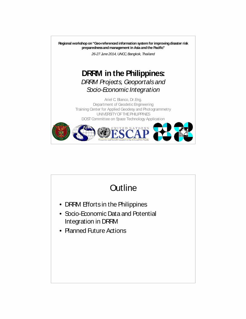
DRRM in the Philippines: DRRM Projects, Geoportals and
Socio-Economic Integration
Ariel C. Blanco, Dr.Eng.Department of Geodetic Engineering
Training Center for Applied Geodesy and PhotogrammetryUNIVERSITY OF THE PHILIPPINES
DOST Committee on Space Technology Application
Regional workshop on “Geo-referenced information system for improving disaster risk preparedness and management in Asia and the Pacific”
26-27 June 2014, UNCC, Bangkok, Thailand
Outline
• DRRM Efforts in the Philippines
• Socio-Economic Data and Potential Integration in DRRM
• Planned Future Actions

DRRM Efforts (Examples)
• UP DOST NOAH Project
• UP DOST DREAM Program
• UNDP CCC Project Rebuild

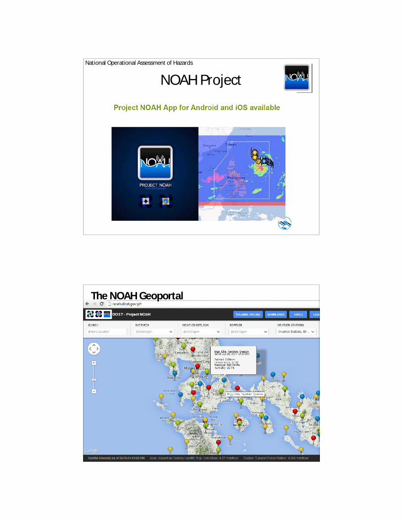
NOAH Project
Component Projects
•Hydromet Sensors Development•DREAM-LIDAR 3-D Mapping Project•Flood NET-Flood Modeling Project•Hazards Information Media
– Strategic Communication Intervention– Disaster Management using WebGIS
•Enhancing Geo-hazards Mapping through LIDAR•Doppler System Development•Landslide Sensors Development Project•Storm Surge Inundation Mapping Project•Weather Information - Integration for System Enhancement (WISE)
National Operational Assessment of Hazards
Accomplishments
• Web-based and mobile-based platforms (mobile apps) of noah.dost.gov.ph
• A central active repository of hazards and disaster-related information in the form of a disaster information geo-database system.
• Prototype I of Moses Tablet developed and launched. 70 units for distribution in Metro Manila preferably to barangays and PAGASA Regional Directors
Disaster Management using WEB-GISObjective
To provide robust visualization of geospatial data where the end-users can avail of near real-time high resolution hazards and disaster-related information as an important tool for decision- making.
NOAH Project
National Operational Assessment of Hazards
The NOAH Geoportal

Doppler Radar Data(noah.dost.gov.ph)
Flood Map (noah.dost.gov.ph)
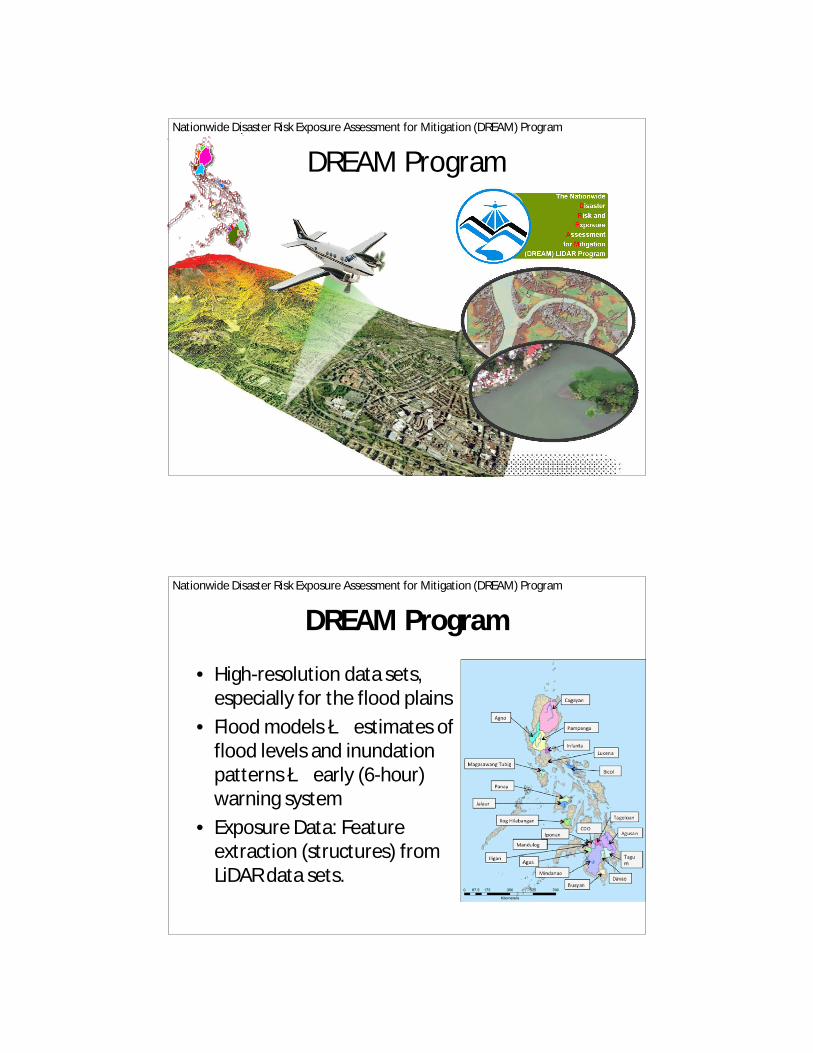
DREAM Program
Nationwide Disaster Risk Exposure Assessment for Mitigation (DREAM) ProgramBuayan_Malungon River Basin
/Buayan_Malungon River Basin
/
DREAM Program
• High-resolution data sets, especially for the flood plains
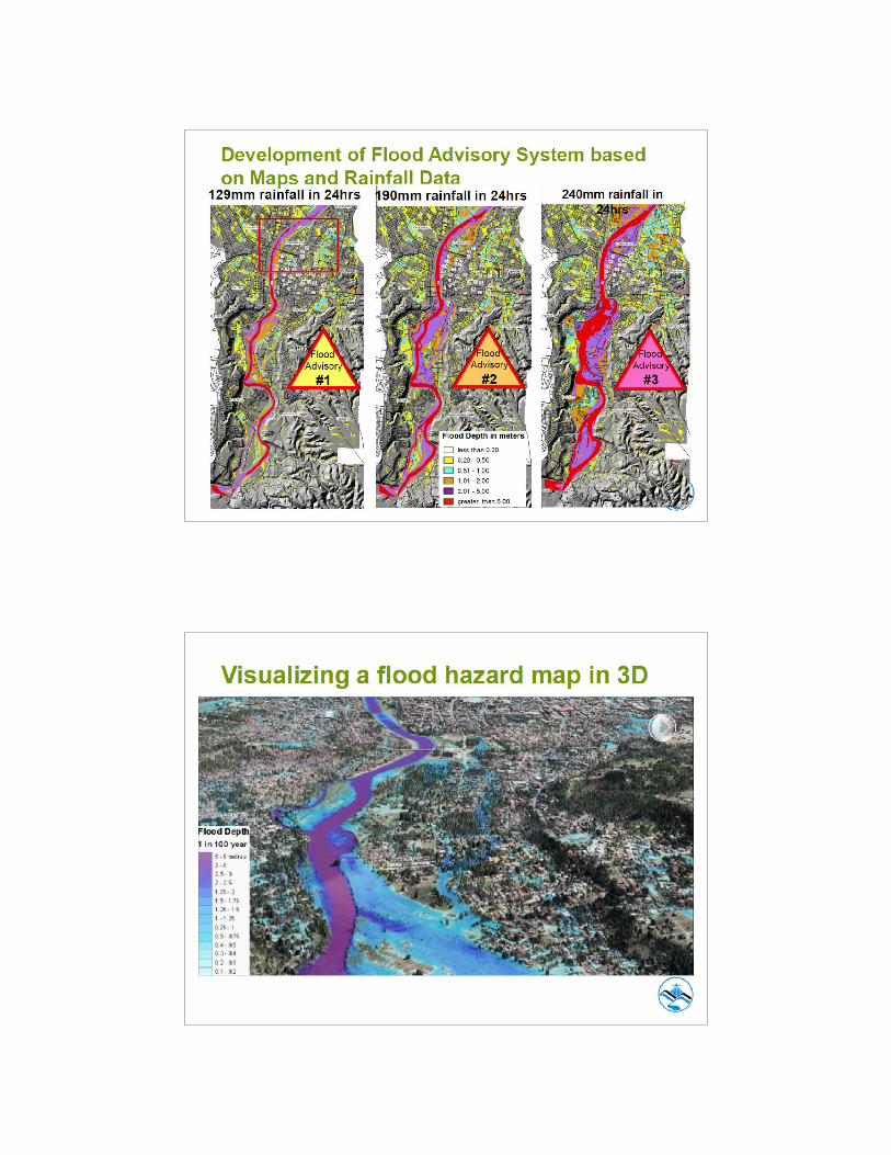
• Flood models è estimates of flood levels and inundation patterns è early (6-hour) warning system
• Exposure Data: Feature extraction (structures) from LiDAR data sets.
Nationwide Disaster Risk Exposure Assessment for Mitigation (DREAM) Program

Satellite-based Monitoring of Rehabilitation in Typhoon-effected Regions (SMARTER Visayas)
Objectives
To acquire high-resolution satellite multispectral satellite imagery through a dedicated tasking services (DTS) for rapid assessment of the damages (e.g. infrastructures, natural resources)
Expected Outputs
• Geocoding of damaged areas and rehabilitation in 171 municipalities and cities, at least within 50 kms from the path of the eye of the typhoon, equivalent to 26,800 sq.km.
• Basic datasets in GIS compatible format linked to population data, administrative boundaries of barangay, municipalities and cities.
DOST DIRECTED RESEARCHES DOST DIRECTED RESEARCHES IN CY 2014IN CY 2014
Climate Change Adaptation and Disaster Risk Reduction (CCA-DRR) Funds in 2014
DREAM Phase 1 Outputs
Data Integration, Archiving and Distribution
18
Training
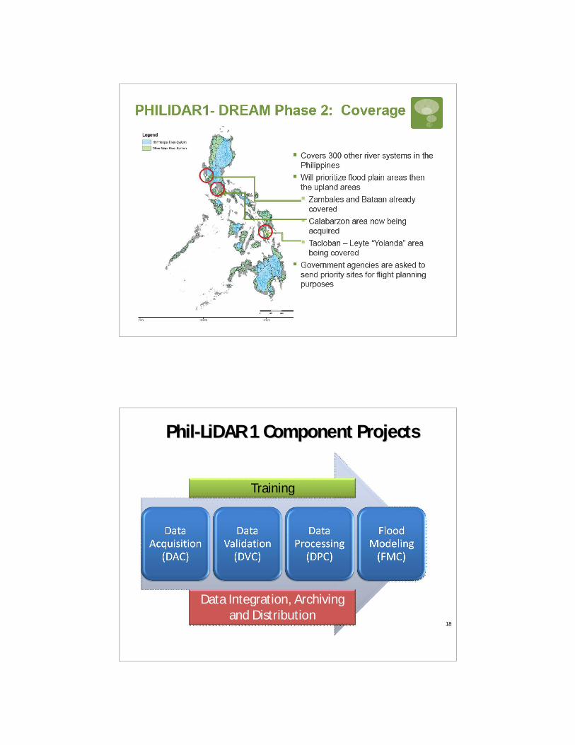
PhilPhil--LiDAR 1 Component ProjectsLiDAR 1 Component Projects

Data Integration, Archiving, and Distribution of LiDAR datasets in the Philippines
UPD
SUCs
Other Data Users
UPD LiDARGeoDatabase
SUC LiDARGeoDatabase
Raw Data
Distribution
Replication
Distribution
Integration & Archiving
Integration & Archiving
Standards & Protocols
SUCsSUCs
Acquisition
The Need for Detailed Resource Assessment
HazardsExposure
VulnerabilityDisasters
Loss of lives and properties
Destruction of resources
Severe Impacts on:POVERTY ALLEVIATIONFOOD SECURITYECONOMIC GROWTHENERGY SUPPLY
INFORMATION NEEDED TO MITIGATE DISASTERS:
What resources exist where?
Which resources are exposed and vulnerable to hazards?
How to protect and conserve resources?
THESE DETAILED INFORMATION ARE NEEDED BY GOVERNMENT AGENCIES ANDLOCAL GOVERNMENT UNITS FOR BETTER PLANNING AND DECISION MAKING.
Characteristics and status of these resources?

PhilPhil--LiDAR 2 FRAMEWORKLiDAR 2 FRAMEWORK
Project 5: Renewable
Energy Datasets Extraction
Project 5: Renewable
Energy Datasets Extraction
Project 4: HydroLogic Datasets for Watersheds
Project 3: Forest Datasets
Extraction
Program 2.1
UP-TCAGPLIDAR & SAR Data Acquisition,
Integration, Archiving, Distribution and Capacity Building
Program 2.2 Luzon ClusterProgram 2.2
Luzon ClusterProcessing, Modeling
& Validation
Program 2.2 Visayas Cluster
Program 2.2 Visayas Cluster
Processing, Modeling & Validation
Program 2.2 Mindanao Cluster
Program 2.2 Mindanao Cluster
Processing, Modeling & Validation
Project 1: High Value
Crops Datasets
Extraction
Project 1: High Value
Crops Datasets
Extraction
Project 2: Aquatic Datasets
Extraction
Feature Extraction using enhanced methodologies and workflow; Databasing
NGAsNGAs
PhilPhil--LiDAR 2 Project SitesLiDAR 2 Project Sites
LUZON
MMSU Northern Luzon (Region 1)ISU Region 2 and Abulog River Basin in
Region 1CLSU Region 3 and Pangasinan
UPLB MIMAROPA and Laguna (Region 4)MIT CABARZON (Region 4A except
Laguna)AdNU Bicol (Region 5)
VISAYAS
UP Cebu Western Visayas (Region 6)USC Central Visayas (Region 7)VSU Eastern Visayas (Region 8)
MINDANAOAdZU Zamboanga Peninsula (Region 9)MSU-IIT Selected Sites in Region 10 and
ARMMCMU Northern Mindanao (Region 10)
UP Min Davao Region / Southern Mindanao (Region 11)
CSU CARAGA Region (Region 13)

Project ReBUILD
Resilience Capacity Building for Cities and Municipalities to Reduce Disaster Risks from Climate Change and Natural Hazards
Expected Outputs:•Climate/disaster risk vulnerabilities of the Cagayan River Basin (Region 2 and CAR) and the Jalaur River Basin (Region 6), including cities and municipalities around these river basins assessed;•Priority climate/disaster mitigation actions for priority cities and municipalities around the Cagayan and Jalaur River Basins developed;•Climate/disaster risk management mainstreamed into the planning and regulatory processes of cities/municipalities within and around the Cagayan and Jalaur River Basins;•Socio-economic resilience of the poor and most vulnerable in Cagayan and Jalaur River Basins Developed; and•Local knowledge management (KM) systems for communities around the Cagayan and Jalaur River Basins established.
Socio-Economic Data
• National Statistics Office (NSO)
• National Statistical Coordination Board (NSCB)
• National Anti-Poverty Commission (NAPC)
• Local Government Units (LGUs)
– Community-Based Monitoring System (CBMS)

CBMS
• Community-Based Monitoring System– CBMS aims to design and pilot community-based systems
for monitoring poverty in its multidimensional sense
• CBMS provides– Local-level census of poverty indicators
– Detailed measurement of many dimensions of poverty
– Identification of households that are poor in each dimension
– Systematic source of data (household and member level)
– Georeferencing (sometimes)
Socio-Economic Data
Planned Actions
• Exposure Data è Understanding vulnerabilities, Use of CBMS Data in DRRM, Incorporating DRRM in CBMS Data
• Build and enhance the capacities of LGUs and communities to collect, collate, update and analyze spatial data

Capacity Building Training on Applications of GIS and Geospatial Data Management for DRR in the
Philippines
Planned Actions Towards the End of 2014
• GIS, Geoportal appreciation course for LGU executives
• GIS Training for LGUs
• UAS/UAV for DRRM
THANK YOU!
Regional workshop on “Geo-referenced information system for improving disaster risk preparedness and management in Asia and the Pacific”
26-27 June 2014, UNCC, Bangkok, Thailand