Embed Size (px)
Citation preview
Overview of WETLANDS SSTATUS IIN VVIET NNAM FFOLLOWING 115 YYEARS OOFRAMSAR CCONVENTION IIMPLEMENTATION
The designation of geographical entities in this book, and the presentation of the material, do not imply the expressionof any opinion whatsoever on the part of VEPA, IUCN, or MWBP concerning the legal status of any country, territory,or area, or of its authorities, or concerning the delimitation of its frontiers or boundaries.
The views expressed in this publication do not necessarily reflect those of VEPA, IUCN or MWBP.
Published by: Viet Nam Environment Protection AgencyThe World Conversation Union, IUCN Viet NamMekong Wetlands Biodiversity Conservation and Sustainable Use ProgrammeHanoi, Viet Nam
Copyright: © 2005 Viet Nam Environment Protection Agency
Reproduction of this publication for educational or other non-commercial purposes is authorizedwithout prior written permission from the copyright holder provided the source is fullyacknowledged.Reproduction of this publication for resale or other commercial purposes is prohibited without priorwritten permission of the copyright holder.
Citation: Viet Nam Environment Protection Agency (2005). Overview of Wetlands Status in Viet Nam Following15 Years of Ramsar Convention Implementation. Hanoi, Viet Nam. 72 pp.
Printed by: Luck House Graphics Ltd., Hanoi, Viet Nam.
Available from: Viet Nam Environment Protection AgencyMinistry of Natural Resources and Environment67 Nguyen Du Street, Hanoi, Viet NamTel: +84 4 942 4581, Fax: +84 4 822 3189Email: [email protected] www.nea.gov.vn
IUCN Viet NamVilla 44/4 Van Bao Street, Ba Dinh, Hanoi, Viet NamTel: +84 4 726 1575, Fax: +84 4 726 1561Email: [email protected]
Mekong Wetlands Biodiversity Conservation and Sustainable Use Programmec/o Viet Nam Environment Protection Agency (VEPA)67 Nguyen Du Street, Hanoi, Viet NamTel: +84 4 942 7800, Fax: +84 4 942 7801Email: [email protected]
i
Acronyms and Abbreviations iv
Acknowledgements v
1. Introduction 1
2. Overview of wetlands in Viet Nam 3
2.1. Wetlands in Viet Nam 32.1.1. Physical characteristics of wetlands in Viet Nam 32.1.2. Inventory of wetlands 32.1.3. Development of a classification system and mapping
of wetlands 42.1.4. Wetland ecosystems 52.1.5. Wetland trends in Viet Nam 14
2.2. Values and functions of wetlands in Viet Nam 152.2.1. Functions of wetlands in Viet Nam 152.2.2. Values of wetlands in Viet Nam 162.2.3. Biodiversity 18
3. Wetland management in Viet Nam 20
3.1. Current state of wetland management in Viet Nam 203.1.1. Wetland management at the central level 203.1.2. Wetland management at the provincial level 213.1.3. Activities undertaken and trends in wetland conservation 213.1.4. Wetland utilisation and trends 22
3.2. Legal framework for wetland management in Viet Nam 243.2.1. Legal and policy systems relating to wetland management 243.2.2. Summary of Viet Nam's participation in international
conventions related to wetlands 24
3.3. Measures and methods in wetland management 27
3.4. Wetlands research, communication, education and awareness 283.4.1. Activities undertaken 283.4.2. Trends in wetlands knowledge and awareness 29
3.5. Achievements and challenges relating to wetland management in Viet Nam 29
3.5.1. Achievements 293.5.2. Issues and challenges in wetland management in Viet Nam 303.5.3. Recommendations for wetland management in Viet Nam 32
4. Conclusions 34
5. Recommendations 36
References 37
Overview of Wetlands Status in Viet Nam Following 15 Years of Ramsar Convention Implementation
Table of Contents
Appendix
Appendix A: Summary of the Ramsar Convention 39
Appendix B: Wetlands Classification System by MARD 40
Appendix C: Maps of Wetlands in Viet Nam 46
Appendix D: Wetland Sites of Biodiversity and Environmental Value in Viet Nam 49
Appendix E: Economic Valuation of Selected Wetlands in Viet Nam 64
Appendix F: List of selected legal documents related to wetlands 69
Picture 1: Tidal flat wetlands at Ba Lat Estuary 7
Picture 2: Mangrove forests along Nang channel of Ong Doc River mouth 7
Picture 3: Coastal mangrove forests in Ca Mau Province 7
Picture 4: Houses along Ca Mau River 8
Picture 5: Tam Giang-Cau Hai Lagoon 9
Picture 6: Mangrove forests in Quang Dien Commune, Hai Ha, Quang Ninh 10
Picture 7: Destruction of mangrove forests for conversion into shrimp farming ponds in Tien Toi Commune, Hai Ha, Quang Ninh Province 11
Picture 8: Coral reefs in Ninh Thuan 11
Picture 9: Th. hemprichii lives together with corals around Truong Sa Island 11
Picture 10: Exploitation of corals for souvenirs in Nha Trang - Khanh Hoa 11
Picture 11: Seagrass beds of C.rotundatata in Phu Quy Island 12
Picture 12: Seagrass degradation in Thuy Trieu Lagoon of Cam Ranh Bay 13
Picture 13: Ba Be Lake 13
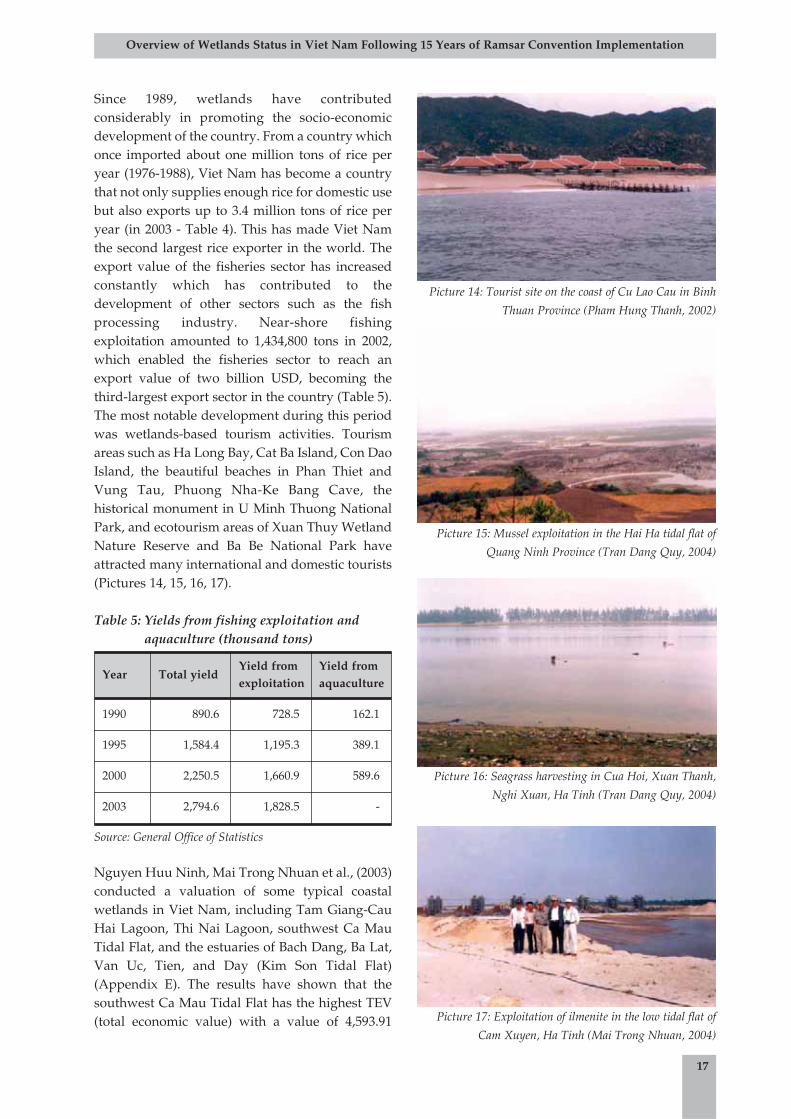
Picture 14: Tourist site on the coast of Cu Lao Cau in Binh Thuan Province 17
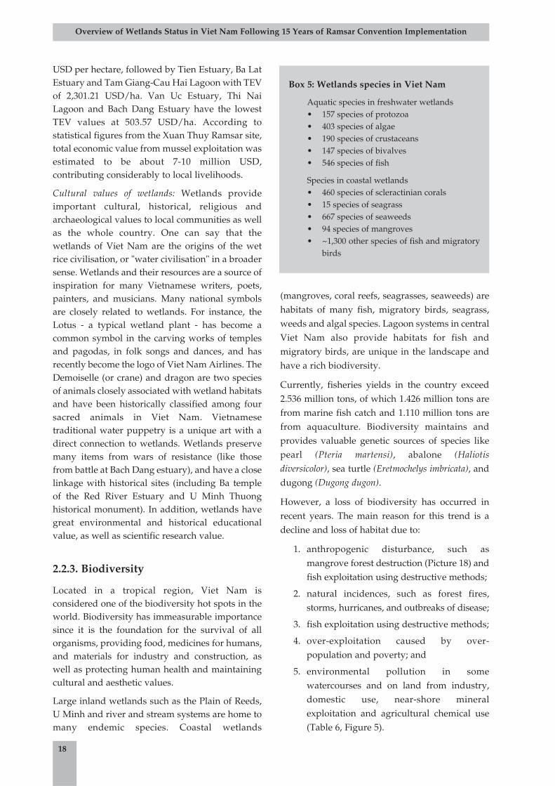
Picture 15: Mussel exploitation in the Hai Ha tidal flat of Quang Ninh Province 17
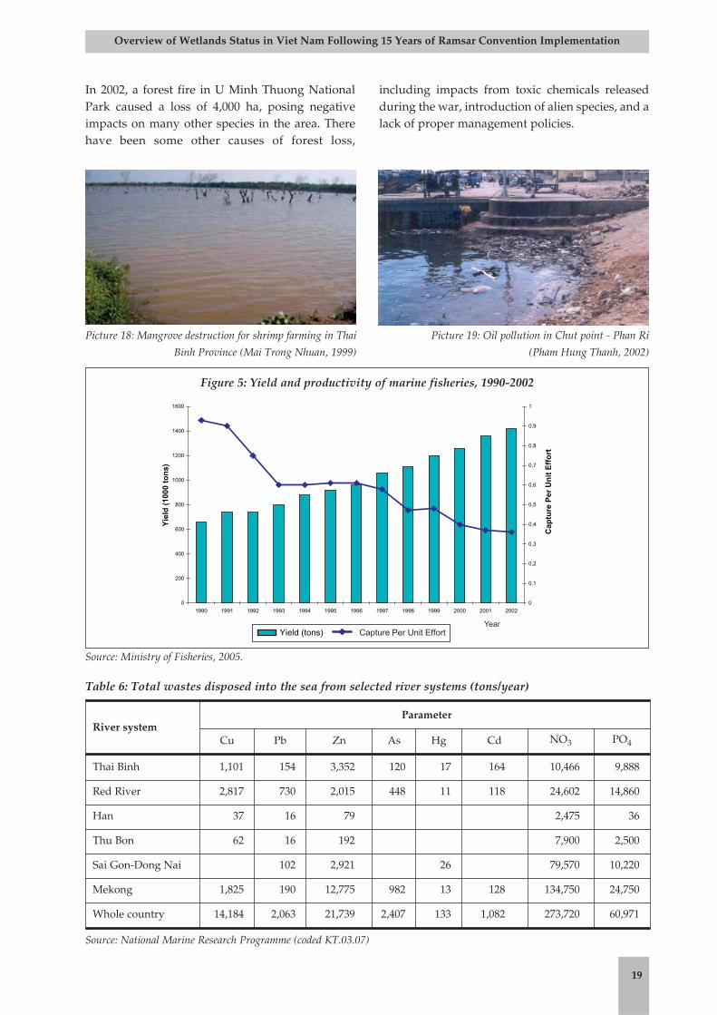
Picture 16: Seagrass harvesting in Cua Hoi, Xuan Thanh, Nghi Xuan, Ha Tinh 17
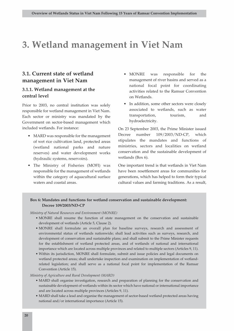
Picture 17: Exploitation of ilmenite in the low tidal flat of Cam Xuyen, Ha Tinh 17
Picture 18: Mangrove destruction for shrimp farming in Thai Binh Province 19
Picture 19: Oil pollution in Chut point - Phan Ri 19
Picture 20: Awareness-raising for local communities on integrated coastal zone management in Nam Dinh 29
ii
Overview of Wetlands Status in Viet Nam Following 15 Years of Ramsar Convention Implementation
Pictures
iii
Overview of Wetlands Status in Viet Nam Following 15 Years of Ramsar Convention Implementation
Table 1: Wetlands in the Red River Delta 6
Table 2: Wetland National Parks and Nature Reserves in the Mekong Delta 9
Table 3: Decrease in coral coverage in some coastal areas of Viet Nam 12
Table 4: Rice cultivation areas and yields of Viet Nam 16
Table 5: Yields from fishing exploitation and aquaculture 17
Table 6: Total wastes disposed into the sea from selected river systems 19
Table 7: International Conventions and Treaties related to wetlands 25
Figure 1: Areas of typical wetland types in the Mekong Delta 7
Figure 2: Mangrove forest distribution in Viet Nam 10
Figure 3: Changes in mangrove forest areas in Viet Nam, 1943-2000 11
Figure 4: Total value of selected seagrass beds in Viet Nam 12
Figure 5: Yield and productivity of marine fisheries, 1990-2002 19
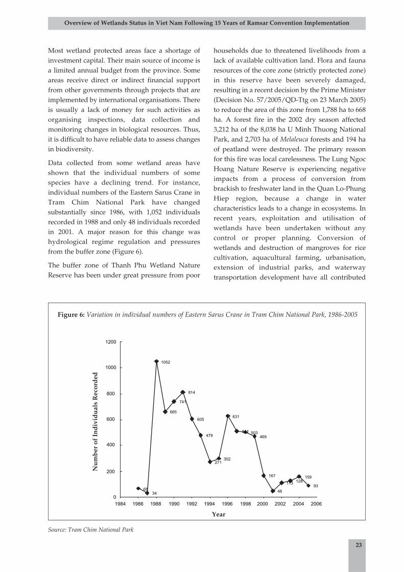
Figure 6: Variation in individual numbers of Eastern Sarus Crane in Tram Chim National Park, 1986-2005 23
Box 1: Major river systems in Viet Nam 3
Box 2: Typical wetland areas in Viet Nam 4
Box 3: Ten coastal wetland sites of highest value in Viet Nam 4
Box 4: Lagoon systems in central Viet Nam 10
Box 5: Wetlands species in Viet Nam 18
Box 6: Mandates and functions for wetland conservation and sustainable development: Decree 109/2003/ND-CP 20
Box 7: Wetlands special use forests in Viet Nam 21
Box 8: Steps in ecosystem-based management 27
Tables
Figures
Boxes

iv
Overview of Wetlands Status in Viet Nam Following 15 Years of Ramsar Convention Implementation
BAP Biodiversity Action Plan
CBD Convention on Biological Diversity
CDM Clean Development Mechanisms
CERED Centre for Environment Research Education and Development
CITES Convention on International Trade in Endangered Species of Wild Fauna and Flora
CRES Centre for Natural Resources and Environmental Studies
DARD Department of Agriculture and Rural Development
DOFI Department of Fisheries
DONRE Department of Natural Resources and Environment
GEF Global Environment Facility
GIS Geographic Information System
IUCN The World Conservation Union
MARD Ministry of Agriculture and Rural Development
MERC Mangrove Ecosystem Research Centre
MOFI Ministry of Fisheries
MONRE Ministry of Natural Resources and Environment
MOSTE Ministry of Science, Technology and Environment
MRC Mekong River Commission
MWBP Mekong Wetlands Biodiversity Conservation and Sustainable Use Programme
NEA National Environment Agency
NGO Non-Governmental Organisation
PPC Provincial People's Committee
RRA Rapid Rural Appraisal
SIDA Swedish International Development Cooperation Agency
Sub-FIPI Southern Sub-Institute of Forest Inventory and Planning
TEV Total Economic Value
UNCLOS United Nations Convention on the Law of the Sea
UNEP United Nations Environment Programme
UNESCO United Nations Educational, Scientific and Cultural Organisation
UNFCCC United Nations Framework Convention on Climate Change
VEPA Viet Nam Environment Protection Agency
WOTRO Netherlands Foundation for the Advancement of Tropical Research
WWF World Wildlife Fund
Acronyms and Abbreviations
v
Overview of Wetlands Status in Viet Nam Following 15 Years of Ramsar Convention Implementation
Viet Nam Environment Protection Agency (VEPA) and the World Conservation Union Viet Namoffice (IUCN Viet Nam) are grateful for the valuable contributions of the report team, including:Prof. Dr. Mai Trong Nhuan, Dr. Tran Hong Ha, MSc. Nguyen Chi Thanh, MSc. Le Thanh Binh, Dr.
Hoang Van Thang and Pham Dinh Viet Hong.
Our appreciation and gratitude go to the Mekong Wetlands Biodiversity Conservation and SustainableUse Programme (MWBP) for their financial and technical support. Thanks also go to the Viet NamNational University Ha Noi, the Centre for Natural Resources and Environmental Studies (CRES), theSouthern Sub-Institute of Forest Inventory and Planning (Sub-FIPI), a Wetlands Component of the"Prevention of Environmental Degradation in the East Sea" project, for providing data and research resultsand for their participation in developing this report.
VEPA and IUCN Viet Nam also express sincere thanks to Prof. Dr. Le Dien Duc, Prof. DrSc. Phan NguyenHong, Prof. Dr. Mai Dinh Yen, Prof. DrSc. Dang Huy Huynh, Prof. Dr. Pham Binh Quyen, Prof. Dr.Nguyen Hoang Tri, Dr. Dao Manh Tien, Nguyen Thi Hong Hue, Nguyen Thi Hoang Ha, Tran Dang Quy,Nguyen Tai Tue and others for their cooperation and valuable comments.
Finally, VEPA and IUCN Viet Nam acknowledge the valuable contribution provided by the SwedishInternational Development Cooperation Agency (Sida); their generous support is appreciated.
Acknowledgements

There is a great diversity of wetlands in VietNam that possess a range of resources,biodiversity, functions and important
social, economic and cultural values. With an areaof more than 10 million hectares, wetlands can befound in almost all ecological regions of thecountry. These wetlands play a vital role in thelives of the local people and the socio-economicdevelopment of the country.
In recognition of the importance of wetlands, VietNam joined the Ramsar Convention on Wetlandsin 1989 as the 50th State Member. Over the last 15years, Viet Nam has initiated a great number ofefforts relating to research, inventory, anddevelopment of tools and techniques for theconservation, utilisation and management ofwetlands following the Ramsar Convention'sobjectives. However, these efforts have not fullymet the requirements of wise use, sustainableconservation and development of wetlands. Inregard to wetland management, one mainconstraint has been that available data andinformation on the location and status of wetlands,as well as legal frameworks and managementpolicies relating to wetlands have been dispersedand incomplete. This has made it difficult to gatheran overall assessment of wetland status in VietNam, which could lay a foundation for theidentification of priorities and proper wetlandsmanagement strategies. In addition, up to now,Viet Nam has lacked a comprehensive andupdated assessment of wetland status in thecountry. In regard to this it was necessary toconduct a review and assessment of achievements,shortcomings and trends of activities relating towetlands in order to share lessons and identify
recommendations about wise use, conservationand management of wetlands in Viet Nam.
In response to the above mentioned situation andto contribute to the biodiversity conservation,management and sustainable development ofwetlands in Viet Nam, the Viet Nam EnvironmentProtection Agency (VEPA) of the Ministry ofNatural Resources and Environment (MONRE)together with IUCN Viet Nam have prepared the"Overview of Wetlands Status in Viet NamFollowing 15 Years of Ramsar ConventionImplementation".
This report has been developed through a collationand analysis of reliable, up-to-date data, using aninterdisciplinary approach and also recognisingthat wetland ecosystems should be conserved anddeveloped in a sustainable manner. The reportconsists of three parts and six annexes (summaryof the Ramsar Convention; Viet Nam wetlandclassification by MARD; maps of wetlands in VietNam; wetland sites of biodiversity andenvironmental value in Viet Nam; economicvaluation of selected wetlands in Viet Nam; andlist of selected legal documents related towetlands).
It is anticipated that this report could serve as avaluable reference for managers, policy makers,researchers, post graduate students and otherswhose work relates to wetlands. The report couldalso serve as a milestone marking processes andtrends in conservation and management ofwetlands in Viet Nam over the last 15 years, andpresenting recommendations for the country'swetland management in the future.
1
Overview of Wetlands Status in Viet Nam Following 15 Years of Ramsar Convention Implementation
1. Introduction
2.1. Wetlands in Viet Nam There are a number of definitions of wetlandsworldwide which vary from country to country,and depend on the purpose of wetlands use andmanagement. In Viet Nam, the definition stated inArticle 1 of the Ramsar Convention on Wetlands(Appendix A) has been officially applied foractivities relating to wetlands: "Wetlands are areas ofmarsh, fen, peatland or water, whether natural orartificial, permanent or temporary, with water that isstatic or flowing, fresh, brackish or salt, including areasof marine water the depth of which at low tide does notexceed six metres".
Under this definition, factors like geomorphology,hydrology, pedology, flora and fauna, and land usestatus are important criteria in the identification ofwetlands.
2.1.1. Physical characteristics ofwetlands in Viet Nam
Geomorphology: Hills and mountains cover twothirds of the total natural area of Viet Nam, with ageneral downward slope from west to east. Thenorthern and southern plains are river basinswhich form two of the typical wetlands in thecountry known as the Red River Delta and theMekong River Delta.
Climate: Viet Nam is located in a tropical monsoonarea. It has a rather high average annualtemperature (above 200C), a high average annualhumidity (above 80%), and a high rate of rainfall(1,500 mm/year). Differences in the climate regimebetween regions, especially in terms of temperatureand humidity, have influenced their respectivehydrological regimes (e.g. duration of inundation,depth of inundated water, water temperature),leading to differences in wetland types.
Hydrology: Viet Nam has a dense network ofrivers and streams through which water is drainedto the sea. There are a total of 2,500 rivers in thecountry, 2,360 of which have a length of more than
10 km (Phan Nguyen Hong, 1996). The MekongRiver system has the largest discharge volume intothe country, accounting for 61.4% of the totalvolume of national runoff. Rivers flowing to thesea have created a number of estuarial systems -one of the most important wetland types in VietNam. There are currently more than 3,500 smallreservoirs and 650 medium and large-sizereservoirs in Viet Nam. Typical large reservoirsinclude Thac Ba, Hoa Binh, Dau Tieng and Tri Anwith surface areas of 23,400 ha, 21,800 ha, 35,000 haand 27,000 ha respectively (Nguyen Viet Pho, VuVan Tuan, Tran Thanh Xuan, 2003).
Pedology: There are 15 soil types in Viet Nam,seven of which are related to soil characteristics ofwetlands. They include saline, acid sulphate,alluvial sediments, clay, peat, grey, and sandy soil.The differences in geomorphology, climate andpedology define the vegetation characteristics ofwetland ecosystems, with two typical types:vegetation of saltwater wetlands and vegetation offreshwater wetlands.
2.1.2. Inventory of wetlands
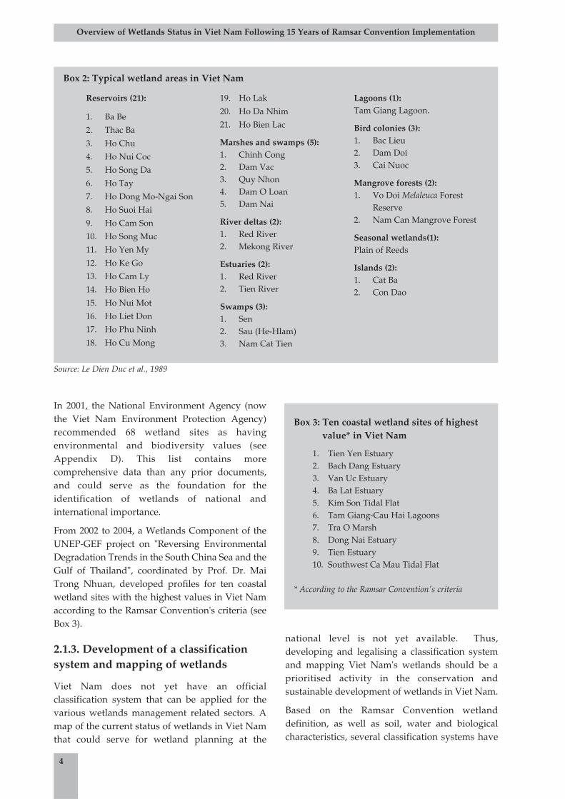
The first effort at creating an inventory of wetlandswas conducted in 1989 by Le Dien Duc et al. (seeBox 2).
3
Overview of Wetlands Status in Viet Nam Following 15 Years of Ramsar Convention Implementation
2. Overview of wetlands in Viet Nam
Box 1: Major river systems in Viet Nam
1. Mekong River2. Red River3. Thai Binh River4. Ky Cung-Bang River5. Ma River6. Ca River7. Thu Bon River8. Ba River9. Dong Nai River
In 2001, the National Environment Agency (nowthe Viet Nam Environment Protection Agency)recommended 68 wetland sites as havingenvironmental and biodiversity values (seeAppendix D). This list contains morecomprehensive data than any prior documents,and could serve as the foundation for theidentification of wetlands of national andinternational importance.
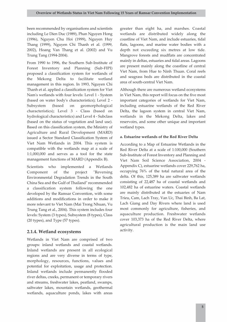
From 2002 to 2004, a Wetlands Component of theUNEP-GEF project on "Reversing EnvironmentalDegradation Trends in the South China Sea and theGulf of Thailand", coordinated by Prof. Dr. MaiTrong Nhuan, developed profiles for ten coastalwetland sites with the highest values in Viet Namaccording to the Ramsar Convention's criteria (seeBox 3).
2.1.3. Development of a classificationsystem and mapping of wetlands
Viet Nam does not yet have an officialclassification system that can be applied for thevarious wetlands management related sectors. Amap of the current status of wetlands in Viet Namthat could serve for wetland planning at the
national level is not yet available. Thus,developing and legalising a classification systemand mapping Viet Nam's wetlands should be aprioritised activity in the conservation andsustainable development of wetlands in Viet Nam.
Based on the Ramsar Convention wetlanddefinition, as well as soil, water and biologicalcharacteristics, several classification systems have
4
Overview of Wetlands Status in Viet Nam Following 15 Years of Ramsar Convention Implementation
Box 2: Typical wetland areas in Viet Nam
Reservoirs (21):
1. Ba Be
2. Thac Ba
3. Ho Chu
4. Ho Nui Coc
5. Ho Song Da
6. Ho Tay
7. Ho Dong Mo-Ngai Son
8. Ho Suoi Hai
9. Ho Cam Son
10. Ho Song Muc
11. Ho Yen My
12. Ho Ke Go
13. Ho Cam Ly
14. Ho Bien Ho
15. Ho Nui Mot
16. Ho Liet Don
17. Ho Phu Ninh
18. Ho Cu Mong
19. Ho Lak
20. Ho Da Nhim
21. Ho Bien Lac
Marshes and swamps (5): 1. Chinh Cong2. Dam Vac3. Quy Nhon4. Dam O Loan5. Dam Nai
River deltas (2):1. Red River2. Mekong River
Estuaries (2): 1. Red River2. Tien River
Swamps (3): 1. Sen2. Sau (He-Hlam)3. Nam Cat Tien
Lagoons (1): Tam Giang Lagoon.
Bird colonies (3): 1. Bac Lieu2. Dam Doi3. Cai Nuoc
Mangrove forests (2): 1. Vo Doi Melaleuca Forest
Reserve2. Nam Can Mangrove Forest
Seasonal wetlands(1): Plain of Reeds
Islands (2): 1. Cat Ba2. Con Dao
Box 3: Ten coastal wetland sites of highestvalue* in Viet Nam
1. Tien Yen Estuary2. Bach Dang Estuary3. Van Uc Estuary4. Ba Lat Estuary5. Kim Son Tidal Flat6. Tam Giang-Cau Hai Lagoons7. Tra O Marsh8. Dong Nai Estuary9. Tien Estuary10. Southwest Ca Mau Tidal Flat
* According to the Ramsar Convention's criteria
Source: Le Dien Duc et al., 1989
been recommended by organisations and scientistsincluding Le Dien Duc (1989), Phan Nguyen Hong(1996), Nguyen Chu Hoi (1999), Nguyen HuyThang (1999), Nguyen Chi Thanh et al. (1999,2002), Hoang Van Thang et al. (2002) and VuTrung Tang (1994-2004).
From 1990 to 1996, the Southern Sub-Institute ofForest Inventory and Planning (Sub-FIPI)proposed a classification system for wetlands ofthe Mekong Delta to facilitate wetlandmanagement in this region. In 1993, Nguyen ChiThanh et al. applied a classification system for VietNam's wetlands with four levels: Level 1 - System(based on water body's characteristics); Level 2 -Subsystem (based on geomorphologicalcharacteristics); Level 3 - Class (based onhydrological characteristics) and Level 4 - Subclass(based on the status of vegetation and land use).Based on this classification system, the Ministry ofAgriculture and Rural Development (MARD)issued a Sector Standard Classification System ofViet Nam Wetlands in 2004. This system iscompatible with the wetlands map at a scale of1:1,000,000 and serves as a tool for the statemanagement functions of MARD (Appendix B).
Scientists who implemented a WetlandsComponent of the project "ReversingEnvironmental Degradation Trends in the SouthChina Sea and the Gulf of Thailand" recommendeda classification system following the onedeveloped by the Ramsar Convention, with someadditions and modifications in order to make itmore relevant to Viet Nam (Mai Trong Nhuan, VuTrung Tang et al., 2004). This system includes fourlevels: System (3 types), Subsystem (8 types), Class(20 types), and Type (57 types).
2.1.4. Wetland ecosystems
Wetlands in Viet Nam are comprised of twogroups: inland wetlands and coastal wetlands.Inland wetlands are present in all ecologicalregions and are very diverse in terms of type,morphology, resources, functions, values andpotential for exploitation, usage and protection.Inland wetlands include permanently floodedriver deltas, creeks, permanent or temporary riversand streams, freshwater lakes, peatland, swamps,saltwater lakes, mountain wetlands, geothermalwetlands, aquaculture ponds, lakes with areas
greater than eight ha, and marshes. Coastalwetlands are distributed widely along thecoastline of Viet Nam, and include estuaries, tidalflats, lagoons, and marine water bodies with adepth not exceeding six metres at low tide.Mangrove forests and mudflats are concentratedmainly in deltas, estuaries and tidal areas. Lagoonsare present mainly along the coastline of centralViet Nam, from Hue to Ninh Thuan. Coral reefsand seagrass beds are distributed in the coastalarea of south-central Viet Nam.
Although there are numerous wetland ecosystemsin Viet Nam, this report will focus on the five mostimportant categories of wetlands for Viet Nam,including estuarine wetlands of the Red RiverDelta, the lagoon system in central Viet Nam,wetlands in the Mekong Delta, lakes andreservoirs, and some other unique and importantwetland types.
a. Estuarine wetlands of the Red River Delta
According to a Map of Estuarine Wetlands in theRed River Delta at a scale of 1:100,000 (SouthernSub-Institute of Forest Inventory and Planning andViet Nam Soil Science Association, 2004 -Appendix C), estuarine wetlands cover 229,762 ha,occupying 76% of the total natural area of thedelta. Of this, 125,389 ha are saltwater wetlandsconsisting of 22,487 ha of coastal wetlands and102,482 ha of estuarine waters. Coastal wetlandsare mainly distributed at the estuaries of NamTrieu, Cam, Lach Tray, Van Uc, Thai Binh, Ba Lat,Lach Giang and Day Rivers where land is usedmost commonly for agriculture, fisheries, andaquaculture production. Freshwater wetlandscover 103,373 ha of the Red River Delta, whereagricultural production is the main land useactivity.
5
Overview of Wetlands Status in Viet Nam Following 15 Years of Ramsar Convention Implementation
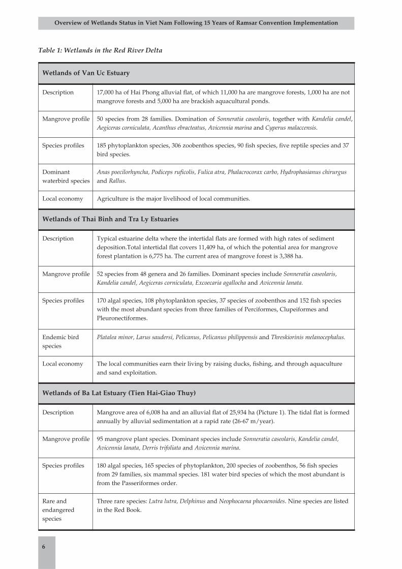
Table 1: Wetlands in the Red River Delta
6
Overview of Wetlands Status in Viet Nam Following 15 Years of Ramsar Convention Implementation
Wetlands of Van Uc Estuary
Description 17,000 ha of Hai Phong alluvial flat, of which 11,000 ha are mangrove forests, 1,000 ha are notmangrove forests and 5,000 ha are brackish aquacultural ponds.
Mangrove profile 50 species from 28 families. Domination of Sonneratia caseolaris, together with Kandelia candel,Aegiceras corniculata, Acanthus ebracteatus, Avicennia marina and Cyperus malaccensis.
Species profiles 185 phytoplankton species, 306 zoobenthos species, 90 fish species, five reptile species and 37bird species.
Dominantwaterbird species
Anas poecilorhyncha, Podiceps ruficolis, Fulica atra, Phalacrocorax carbo, Hydrophasianus chirurgusand Rallus.
Local economy Agriculture is the major livelihood of local communities.
Wetlands of Thai Binh and Tra Ly Estuaries
Description Typical estuarine delta where the intertidal flats are formed with high rates of sedimentdeposition.Total intertidal flat covers 11,409 ha, of which the potential area for mangroveforest plantation is 6,775 ha. The current area of mangrove forest is 3,388 ha.
Mangrove profile 52 species from 48 genera and 26 families. Dominant species include Sonneratia caseolaris,Kandelia candel, Aegiceras corniculata, Excoecaria agallocha and Avicennia lanata.
Species profiles 170 algal species, 108 phytoplankton species, 37 species of zoobenthos and 152 fish specieswith the most abundant species from three families of Perciformes, Clupeiformes andPleuronectiformes.
Endemic birdspecies
Platalea minor, Larus saudersi, Pelicanus, Pelicanus philippensis and Threskiorinis melanocephalus.
Local economy The local communities earn their living by raising ducks, fishing, and through aquacultureand sand exploitation.
Wetlands of Ba Lat Estuary (Tien Hai-Giao Thuy)
Description Mangrove area of 6,008 ha and an alluvial flat of 25,934 ha (Picture 1). The tidal flat is formedannually by alluvial sedimentation at a rapid rate (26-67 m/year).
Mangrove profile 95 mangrove plant species. Dominant species include Sonneratia caseolaris, Kandelia candel,Avicennia lanata, Derris trifoliata and Avicennia marina.
Species profiles 180 algal species, 165 species of phytoplankton, 200 species of zoobenthos, 56 fish speciesfrom 29 families, six mammal species. 181 water bird species of which the most abundant isfrom the Passeriformes order.
Rare andendangeredspecies
Three rare species: Lutra lutra, Delphinus and Neophocaena phocaenoides. Nine species are listedin the Red Book.

b. Wetlands in the Mekong Delta
The Mekong Delta within Viet Nam territory is thefurthest downstream portion of the Mekong RiverBasin. The Mekong Delta has a total area ofapproximately 3.9 million hectares, occupyingabout 12% of the total natural area of the country,including thirteen provinces and cities: Long An,Tien Giang, Dong Thap, An Giang, Kien Giang,Hau Giang, Ca Mau (Picture 2), Bac Lieu, Soc Trang,Tra Vinh, Vinh long, Ben Tre and Can Tho City.
Wetlands of the Mekong Delta are among therichest ecosystems of the basin (tidal floodplains,coastal marshes, peatland marsh, estuaries, etc.)and are important breeding sites for many aquaticspecies migrating from upper reaches of theMekong River. According to a Map of Wetlands inthe Mekong Delta at a scale of 1:250,000 (AppendixC3), the wetland area covers 4,939,684 ha, whichincludes inland wetlands and coastal wetlandswith a depth of less than six metres at low tide(Figure 1).
Saline coastal wetlands are distributed along thecoastline of the East Sea, southwest of the Ca MauPeninsula and the Gulf of Thailand. Of a total of1,636,069 ha, 879,644 ha are permanently floodedwetlands distributed in the sea region at depthsless than six metres at low tide, and 756,425 ha areseasonally flooded. The most common wetlandtypes in this area include permanently flooded andnon-vegetated saltwater wetlands, seasonalsaltwater wetlands for agricultural cultivation, andseasonal saltwater wetlands for aquaculture.Mangrove forests along the coastline play a very
important role in the coastal wetland ecosystem(Picture 3). In the past, mangrove cover wasextensive along the coast, but mangroves have
Saline coastal wetlands, 1,636,069 haSaline estuarine wetlands, 1,052,102 haSaline lagoons, 2,521 haFreshwater rivery wetlands, 1,963,240 haFreshwater lacustrine wetlands, 56,389 haMarshes and swamps, 229,363 ha
7
Overview of Wetlands Status in Viet Nam Following 15 Years of Ramsar Convention Implementation
Picture 2: Mangrove forests along Nang channel of Ong
Doc River mouth (Mai Trong Nhuan, 2003)
Picture 3: Coastal mangrove forests in Ca Mau Province
(Mai Trong Nhuan, 1998)
Picture 1: Tidal flat wetlands at Ba Lat Estuary
(Mai Trong Nhuan, 2003)
Source: Southern Sub-FIPI, 2003
Figure 1: Areas of typical wetland types in theMekong Delta (according to the Map ofWetlands at a 1:250,000 scale)
since been degraded and reduced substantially interms of both quantity and quality.
Estuarine wetlands are distributed mainly in themouth of the Mekong River in the provinces LongAn, Tien Giang, Ben Tre, Tra Vinh and Soc Trang.They are either seasonal saltwater wetlands foragricultural cultivation or seasonal saltwaterwetlands for aquaculture.
Saltwater lagoons are distributed in Dong HoLagoon (Ha Tien) and Thi Tuong Lagoon (Ca Mau)within the coastal area of the Gulf of Thailand.
Riverine wetlands cover a huge floodplain in thecentre of the Mekong Delta. Permanent riverinewetlands are major tributaries of the Tien and HauRivers, and of other rivers and channels, covering128,139 ha. Seasonal riverine wetlands have anarea of 1,771,381 ha and are mainly rice fields, fruitgardens and other agricultural cultivation areas(Picture 4).
Lacustrine wetlands are distributed in lakes ofMelaleuca forest in U Minh Ha (Ca Mau Province),lakes of Melaleuca forest in U Minh Thuong (KienGiang Province) and in Tram Chim National Park(Dong Thap Province). In the past, Melaleucaforests covered almost all acid sulphate regions ofthe Mekong Delta. Nowadays, only 182,170 ha ofMelaleuca forest remain, and are distributedmainly in the U Minh peatland area, in the acidsulphate soil area of the Plain of Reeds and in theHa Tien grassland region (Southern Sub-FIPI,2004). These are habitats for many freshwateraquatic species and also provide woods, fuels,fishes and honey. An outstanding feature is that apeaty soil layer in the U Minh Melaleuca forestplays a very important role in the ecosystem.
Under saturated conditions, the peat will preventthe process of acidification in potentially acidicsulphate soil. Under dry conditions however, suchas when the wetlands are drained, the peat israpidly oxidised, leading to acidification of the soil.
Swamps and marshes in the Mekong Delta aremainly intermittent marshes used for agriculturalcultivation. They are distributed in the Plain ofReeds and Long Xuyen Quadrangle.
Major wetland ecosystems in the Mekong Delta arevery important to the region, and includemangroves, Melaleuca forests, and estuaries. Sometypical wetlands in the region are wetland nationalparks and nature reserves that have beenestablished by the Prime Minister (Table 2).
c. Lagoon systems in central Viet Nam
Lagoon systems of Viet Nam are located mainlyalong the coastline of central Viet Nam, from ThuaThien Hue to Ninh Thuan (Box 4). The total area ofthese lagoons is about 447.7 km2. The biggestlagoon is the Tam Giang-Cau Hai system which ismore than 67 km in length with an area ofapproximate 216 km2 (Appendix C2, Picture 5).The smallest is Nuoc Man Lagoon in Quang NgaiProvince with an area of about 2.8 km2. Currently,for a number of reasons, lagoons have not beenproperly managed and have been exploitedirrationally leading to their degradation. Withinthe lagoon systems, there are four wetland groups,including non-vegetated wetlands, vegetatedwetlands, wetlands with a water depth reachingsix metres, and man-made wetlands. Dependingon the origins of formation, physical conditionsand interactions between natural processes andhuman activities, wetland types in the lagoonsystems differ from one another.
Biological resources: Lagoon systems supportvery rich fauna resources in terms of compositionand structure, including freshwater, brackish andsaltwater species. Dominant species varyaccording to season. Potential biologicalresources from lagoons are mainly fish,crustaceans, molluscs, seaweeds and seagrasses.The most typical species include: Mugil cephalus,Clupanodon punctatus, Metapenaeus ensis, Penaeusmonodon, Arca, and Meretrix. These wetlandhabitats also have some valuable algal species,such as Glacilaria asiatica and Glacilaria
8
Overview of Wetlands Status in Viet Nam Following 15 Years of Ramsar Convention Implementation
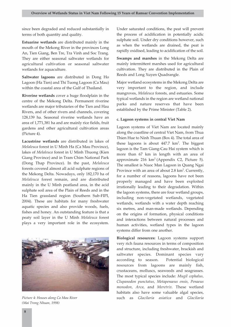
Picture 4: Houses along Ca Mau River (Mai Trong Nhuan, 1998)
tenuistipitata, and some seagrass species with high
biomass, which can be exploited and used as
fertilisers and food source for cattle. In the Tam
Giang-Cau Hai Lagoon system, there are 37
species of zoobenthos (Polychaeta), crustaceans
and molluscs, of which molluscs are the most
abundant, followed by crustaceans. The potential
stock of dried Glacilaria can reach 5,000
tons/year, and the density of fresh Valisneria
spiralis can range from 3.6 to 10.2 kg/m2.
9
Overview of Wetlands Status in Viet Nam Following 15 Years of Ramsar Convention Implementation
Mui Ca Mau National Park
Ca Mau ProvinceArea: 41,862 ha
Main functions and tasks are to conserve the mangrove forest ecosystem of the Ca Maucape. This ecosystem is typical of coastal wetlands in southern Viet Nam and has a vastarray of values in terms of biodiversity, socio-economics, culture and history of the area.
Tram Chim National Park
Dong Thap ProvinceArea: 7,588 ha
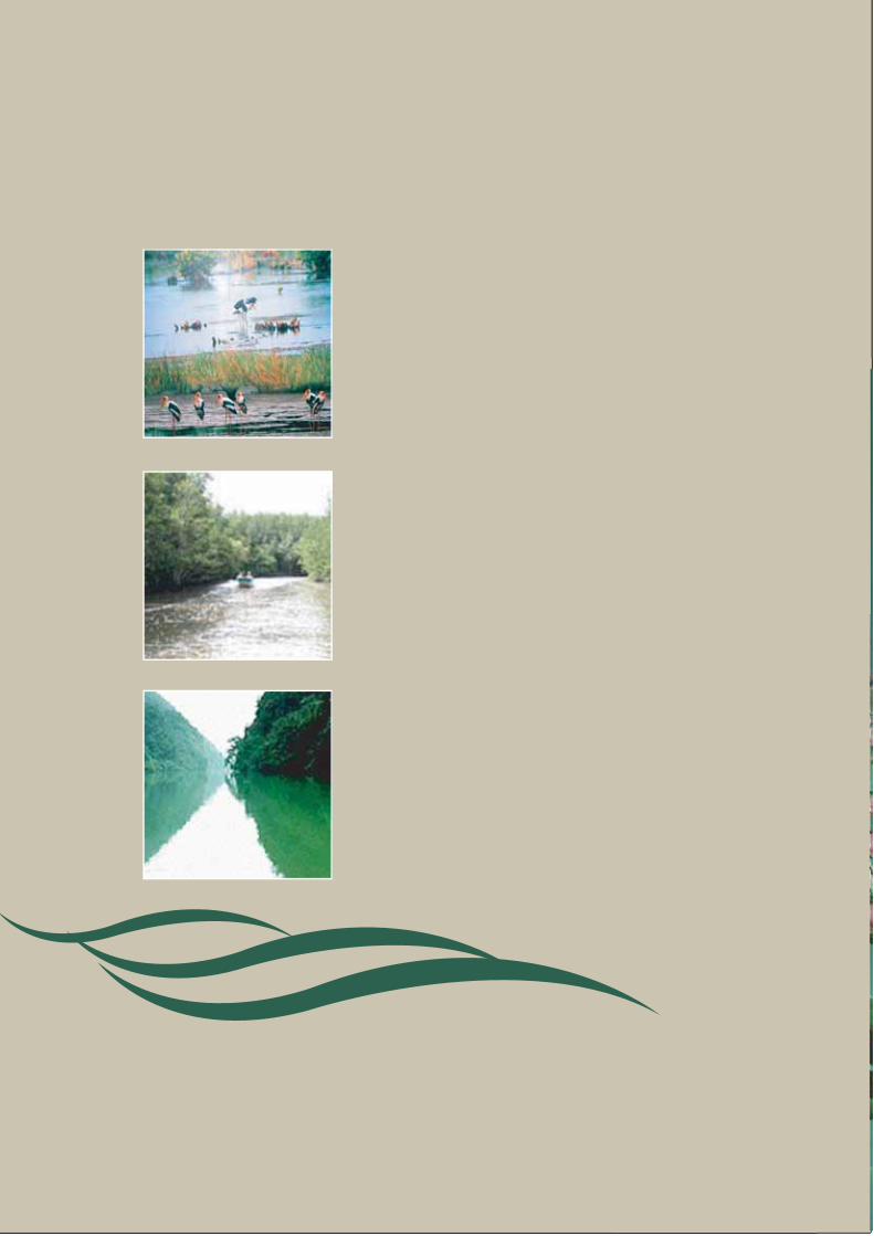
Main functions and tasks are to conserve a flooded Melaleuca forest ecosystem of theMekong River, which is a typical wetland ecosystem of the Plain of Reeds and a habitat formany rare waterbirds, especially the Eastern Sarus Crane (Grus antigone).
U Minh Thuong National Park
Kien Giang ProvinceArea: 8,038 ha
Main functions and tasks are to conserve Melaleuca forest and peatland, together with thepreservation of rare wildlife species and the U Minh historical monument.
Thanh Phu Wetland Nature Reserve
Ben Tre ProvinceArea: 4,510 ha
Main functions and tasks are to conserve mangrove forests of the Mekong Delta Estuaryand the Ho Chi Minh sea trail of southern Viet Nam - a national historical monument.
Kien Luong Landscape Reserve
Kien Giang ProvinceArea: 14,605 ha
Main functions and tasks are to conserve a Melaleuca forest ecosystem and a seasonallyflooded grassland as well as the conservation of rare waterbirds, especially the Grusantigone.
Lung Ngoc Hoang Wetland Nature Reserve
Hau Giang ProvinceArea: 6,000 ha
Main functions and tasks are to conserve Melaleuca forest and floodplain wetlands in thewest of Hau River, as well as waterbird species and cultural values relating to historicalperiods of wet rice cultivation expansion in southern Viet Nam.
Bac Lieu Bird Colony Reserve
Bac Lieu ProvinceArea: 127 ha
Mandates are to conserve saline wetland areas and waterbird species.
Vo Doi Wetland Nature Reserve
Ca Mau ProvinceArea: 3,394 ha
Main functions and tasks are to conserve rare waterbird species and natural Melaleucaforests above peatland.
Table 2: Wetland National Parks and Nature Reserves in the Mekong Delta
Picture 5: Tam Giang-Cau Hai Lagoon
(Mai Trong Nhuan, 1999)
Abiological resources: Abiological resources arenot rich, but minerals present include zircon,ilmenite, and sand for construction. White sand ispresent in many lagoons and can be used as a rawmaterial for making glass. For instance, the whitesand area of Phu Xuan (Tam Giang-Cau HaiLagoon) has a potential volume of approximately 8million m3.
In terms of biodiversity and ecological functions,there are five coastal lagoons that could beconsidered important wetlands of Viet Nam. Theyinclude O Loan (Phu Yen Province), Thi Nai and DeGi (Binh Dinh Province), Cau Hai (Thua Thien HueProvince) and Dam Nai (Ninh Thuan Province).
d. Some other wetland types in coastal Viet Nam
Mangrove forests: According to statistical dataprovided by the Viet Nam Forest Science Institutein 2001, Viet Nam has approximately 155,290 ha ofmangrove forests, of which natural mangroveforests cover 32,402 ha (21%) and plantedmangrove forests cover 122,892 ha (79%).Mangrove forests play a vital role in coastlineprotection, mitigation of wave and storm impactsand local climate stabilisation. Mangroves alsoprovide tourism and recreation areas as well asmedicine and animal food sources.
Mangrove forests have many important functionsand values, including: provision of wood, fuel, fishand other resources; provision of breeding, feedingand nursing areas for many species which haveeconomic values; stabilisation of newly formedtidal mudflats; protection of the coastline fromimpacts of waves, storms and tsunamis; and
provision of habitats for many local and migratorywildlife species (bird, mammal, amphibian,reptile). According to Phan Nguyen Hong (2004),the Red River Estuary has 111 mangrove specieswhich can be used as food and medicinal sources,13 species provide food source for cattle, and 33species can play a role in dike protection andmitigation of impacts from waves, wind and soilerosion (Picture 6).
10
Overview of Wetlands Status in Viet Nam Following 15 Years of Ramsar Convention Implementation
Northeast region, 22,969 ha
Red River Delta region, 20,842 ha
North Central region and Ho Chi Minh City, 22,969 ha
Mekong Delta region, 82,387 ha
Figure 2: Mangrove forest distribution in VietNam
Source: Viet Nam Forest Science Institute, 2001
Picture 6: Mangrove forests in Quang Dien Commune, HaiHa, Quang Ninh (Tran Dang Quy, 2004)
Box 4: Lagoon systems in central Viet Nam
1. Tam Giang-Cau Hai2. Lang Co3. Truong Giang4. An Khe5. Nuoc Man6. Tra O7. Nuoc Ngot8. Thi Nai9. Cu Mong10. O Loan11. Thuy Trieu
However, mangrove forests are being severelydegraded due to their conversion into agriculturaland aquacultural land (Picture 7) and due to seareclamation and coastal bank erosion. More than200,000 ha of mangrove forests have beendestroyed over the last two decades for the purposeof shrimp farming. Specifically, in the Ganh Haoarea of Bac Lieu Province, about 7,000 hamangroves have been lost during a 27-year period(from 1964 to 1991) due to erosion, with an averageloss of approximately 259 ha/year (Figure 3).
Loss of mangrove forests could have extremelynegative effects, including a loss of richness inbiodiversity, loss of habitats and breeding sites,soil acidification, environmental pollution, andcoastline and estuary erosion. For instance, insouthwestern Ca Mau, after one year of conversionof mangrove forests into shrimp ponds,approximately 20 zoobenthos species were lostwhile bird species from Bac Lieu and Dam Doicolonies migrated to other areas. In Tien Hai (ThaiBinh Province), the conversion of 2,500 hamangrove forests to shrimp ponds has causedsubstantial damage to the environment (e.g. H2Sand COD concentrations exceed standards,leading to acidification and salinisation of the soiland water environment over a vast area; as well aserosion and subsequent loss of habitat formigratory birds); in addition, local communitieshave experienced difficulty in maintaining theirlivelihoods, and some poor fishermen have losttheir jobs.
Coral reefs: Coral reefs are among the mostunique marine habitats in the country with a greatdiversity of species, huge volume of primaryproduction and marvellous landscapes. Coral
11
Overview of Wetlands Status in Viet Nam Following 15 Years of Ramsar Convention Implementation
408,500
290,000
252,000
155,290
1943 1962 1982 2000
Figure 3: Changes in mangrove forest areas in VietNam, 1943-2000 (ha)
Source: Viet Nam Forest Science Institute, 2000
Picture 7: Destruction of mangrove forests for
conversion into shrimp farming ponds in Tien Toi
Commune, Hai Ha, Quang Ninh Province
(Tran Dang Quy, 2004)
Picture 8: Coral reefs in Ninh Thuan(Dam Quang Minh, 2002)
Picture 9: Th.hemprichii lives together with corals aroundTruong Sa Island (Nguyen Huy Yet, 1996)
Picture 10: Exploitation of corals for souvenirs in Nha Trang- Khanh Hoa (Mai Trong Nhuan, 2003)
reefs are distributed widely throughout Viet Nam,from the north to the south with an area of about1,112km2, concentrated mainly in the sea of south-central and southeastern Viet Nam, Hoang Sa andTruong Sa Archipelagos (Pictures 8, 9). Viet Nam'scoral is unique in its abundance and variety ofreefs with more than 350 species of scleractinian(reef building) corals. Approximately 3,000marine species are closely associated with coralreefs, of which about 2,000 are zoobenthos species,500 are fish species and many others areeconomically significant species including lobster(Panulirus), abalone (Haliotis diversicolor), pearl(Pteria martensi), and holothurian (Holothuria). InHa Long Bay, 205 hard corals (Scleratina), and 27soft corals, including Gorgonacea, Alcyonacea andStolonifera have been identified. In Con DaoIsland, 219 coral species from 17 families havebeen identified. They are concentrated in a largearea in which approximately 160 coral fish speciescan be found. Coral reefs have a very complicatedstructure and are sensitive to environmentalthreats, especially those caused by humans, suchas cyanide and explosive fishing, over-exploitation (Picture 10), tourism, and other socio-economic development activities. In the lastfifteen years, about 15-20% of coral coverage hasbeen lost in Viet Nam, mainly in residential areassuch as Ha Long-Cat Ba Bay, the coastal provincesof central Viet Nam from Da Nang to Binh Thuan,and around some islands of Truong SaArchipelago.
Live coral coverage has been decreasing over time,with some areas losing more than 30% of theircoral coverage in a ten-year period, as shown in
Table 3. This indicates that coral reefs are beingdestroyed and intensively degraded. A loss of andharm to coral reefs could have many subsequenteffects, such as degradation of biodiversity andmarine environmental quality, loss of livelihoodsources for coastal communities and losses for thefisheries and tourism sectors.
12
Overview of Wetlands Status in Viet Nam Following 15 Years of Ramsar Convention Implementation
Study area No. of sites Change in coral coverage (%) Period of change
1 Ha Long-Cat Ba -7.1 1993-1998
2 Cu Lao Cham 5 -1.9 1994-2002
3 Nha Trang Bay 8 -21.2 1994-2002
4 Con Dao 8 -32.3 1994-2004
5 Phu Quoc 5 -3.3 -
Table 3: Decrease in coral coverage in some coastal areas of Viet Nam
Source: Nha Trang Oceanography Institute, 2003.
1000
800
180120
14
0
200
400
600
800
1000
1200
Tam Giang Cam Ranh
ha
0
1000
2000
3000
4000
5000
USD/ha
Area (ha)
Value
Are
a (
ha)
Valu
e (
US
D)
Dinh VuLang CoLien V
Figure 4: Total value of selected seagrass beds inViet Nam
Source: Nguyen Thi Thu et al
Picture 11: Seagrass beds of C.rotundatata in Phu QuyIsland (Nguyen Huu Dai, 1999)
Seagrass beds: Seagrass beds are ecosystems withhigh values (Figure 4), providing habitats,breeding and nursery grounds for many species ofalgae, zoobenthos, and marine fish and mammals.Seagrasses provide food sources for organisms likefish, sea turtles, and dugongs, are also sources ofraw materials for the production of paper,chemical fertiliser, and food for livestock, and aregood sites for tourism. They play important rolesin trapping sediments and in protecting againstwave and coastal erosion. Of the sixteen seagrassspecies present in all of Southeast Asia, fifteenseagrass species have been identified in Viet Nam.Seagrass beds are distributed in coastal tidal areas,around islands, estuaries, mangroves, bays, and inbrackish swamps with a depth of 0-20 m, within asalinity concentration of 5-32% (Picture 11). In theTam Giang-Cau Hai Lagoon, seagrass beds coverapproximately 1,000 ha with five species ofseagrasses present and a total stock ofapproximately 95,500 tons of fresh seagrass(Nguyen Van Tien, 2003).
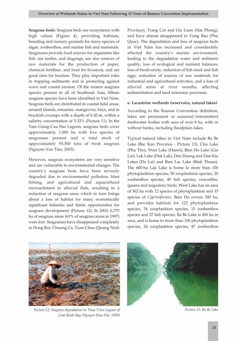
However, seagrass ecosystems are very sensitiveand are vulnerable to environmental changes. Thecountry's seagrass beds have been severelydegraded due to environmental pollution, blastfishing, and agricultural and aquaculturalencroachment in alluvial flats, resulting in areduction of seagrass areas which in turn bringsabout a loss of habitat for many economicallysignificant fisheries and limits opportunities forseagrass development (Picture 12). In 2003, 6,775ha of seagrass areas (63% of seagrass areas in 1997)were lost. Seagrasses have disappeared completelyin Dong Rui, Chuong Ca, Tuan Chau (Quang Ninh
Province), Trang Cat and Gia Luan (Hai Phong),and have almost disappeared in Vung Bau (PhuQuoc). The degradation and loss of seagrass bedsin Viet Nam has increased and considerablyaffected the country's marine environment,leading to the degradation water and sedimentquality, loss of ecological and nutrient balances,loss of biodiversity, reduction of fish stock and fisheggs, reduction of sources of raw materials forindustrial and agricultural activities, and a loss ofalluvial areas at river mouths, affectingsedimentation and land extension processes.
e. Lacustrine wetlands (reservoirs, natural lakes)
According to the Ramsar Convention definition,lakes are permanent or seasonal/intermittentfreshwater bodies with area of over 8 ha, with orwithout banks, including floodplain lakes.
Typical natural lakes in Viet Nam include Ba BeLake (Bac Kan Province - Picture 13), Chu Lake(Phu Tho), West Lake (Hanoi), Bien Ho Lake (GiaLai), Lak Lake (Dak Lak), Don Duong and Dan KiaLakes (Da Lat) and Bien Lac Lake (Binh Thuan).The 600-ha Lak Lake is home to more than 100phytoplankton species, 50 zooplankton species, 20zoobenthos species, 49 fish species, crocodiles,iguana and migratory birds. West Lake has an areaof 562 ha with 12 species of phytoplankton and 33species of Cypriniformes. Bien Ho covers 300 ha,and provides habitats for 122 phytoplanktonspecies, 54 zooplankton species, 15 zoobenthosspecies and 27 fish species. Ba Be Lake is 450 ha inarea, and is home to more than 100 phytoplanktonspecies, 24 zooplankton species, 47 zoobenthos
13
Overview of Wetlands Status in Viet Nam Following 15 Years of Ramsar Convention Implementation
Picture 12: Seagrass degradation in Thuy Trieu Lagoon ofCam Ranh Bay (Nguyen Huu Dai, 1999)
Picture 13: Ba Be Lake
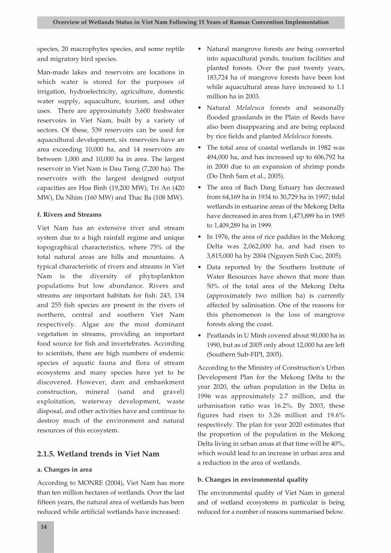
species, 20 macrophytes species, and some reptileand migratory bird species.
Man-made lakes and reservoirs are locations inwhich water is stored for the purposes ofirrigation, hydroelectricity, agriculture, domesticwater supply, aquaculture, tourism, and otheruses. There are approximately 3,600 freshwaterreservoirs in Viet Nam, built by a variety ofsectors. Of these, 539 reservoirs can be used foraquacultural development, six reservoirs have anarea exceeding 10,000 ha, and 14 reservoirs arebetween 1,000 and 10,000 ha in area. The largestreservoir in Viet Nam is Dau Tieng (7,200 ha). Thereservoirs with the largest designed outputcapacities are Hoa Binh (19,200 MW), Tri An (420MW), Da Nhim (160 MW) and Thac Ba (108 MW).
f. Rivers and Streams
Viet Nam has an extensive river and streamsystem due to a high rainfall regime and uniquetopographical characteristics, where 75% of thetotal natural areas are hills and mountains. Atypical characteristic of rivers and streams in VietNam is the diversity of phytoplanktonpopulations but low abundance. Rivers andstreams are important habitats for fish: 243, 134and 255 fish species are present in the rivers ofnorthern, central and southern Viet Namrespectively. Algae are the most dominantvegetation in streams, providing an importantfood source for fish and invertebrates. Accordingto scientists, there are high numbers of endemicspecies of aquatic fauna and flora of streamecosystems and many species have yet to bediscovered. However, dam and embankmentconstruction, mineral (sand and gravel)exploitation, waterway development, wastedisposal, and other activities have and continue todestroy much of the environment and naturalresources of this ecosystem.
2.1.5. Wetland trends in Viet Nam
a. Changes in area
According to MONRE (2004), Viet Nam has morethan ten million hectares of wetlands. Over the lastfifteen years, the natural area of wetlands has beenreduced while artificial wetlands have increased:
• Natural mangrove forests are being convertedinto aquacultural ponds, tourism facilities andplanted forests. Over the past twenty years,183,724 ha of mangrove forests have been lostwhile aquacultural areas have increased to 1.1million ha in 2003.
• Natural Melaleuca forests and seasonallyflooded grasslands in the Plain of Reeds havealso been disappearing and are being replacedby rice fields and planted Melaleuca forests.
• The total area of coastal wetlands in 1982 was494,000 ha, and has increased up to 606,792 hain 2000 due to an expansion of shrimp ponds(Do Dinh Sam et al., 2005).
• The area of Bach Dang Estuary has decreasedfrom 64,169 ha in 1934 to 30,729 ha in 1997; tidalwetlands in estuarine areas of the Mekong Deltahave decreased in area from 1,473,889 ha in 1995to 1,409,289 ha in 1999.
• In 1976, the area of rice paddies in the MekongDelta was 2,062,000 ha, and had risen to3,815,000 ha by 2004 (Nguyen Sinh Cuc, 2005).
• Data reported by the Southern Institute ofWater Resources have shown that more than50% of the total area of the Mekong Delta(approximately two million ha) is currentlyaffected by salinisation. One of the reasons forthis phenomenon is the loss of mangroveforests along the coast.
• Peatlands in U Minh covered about 90,000 ha in1990, but as of 2005 only about 12,000 ha are left(Southern Sub-FIPI, 2005).
According to the Ministry of Construction's UrbanDevelopment Plan for the Mekong Delta to theyear 2020, the urban population in the Delta in1996 was approximately 2.7 million, and theurbanisation ratio was 16.2%. By 2003, thesefigures had risen to 3.26 million and 19.6%respectively. The plan for year 2020 estimates thatthe proportion of the population in the MekongDelta living in urban areas at that time will be 40%,which would lead to an increase in urban area anda reduction in the area of wetlands.
b. Changes in environmental quality
The environmental quality of Viet Nam in generaland of wetland ecosystems in particular is beingreduced for a number of reasons summarised below.
14
Overview of Wetlands Status in Viet Nam Following 15 Years of Ramsar Convention Implementation
• Pollution caused by industrial wastes: Industrialwastes from vessels and from productionand processing plants have severelyimpacted the quality of wetlandecosystems, particularly rivers, lakes andchannels. Industrial and processing parksof the Southern Focal EconomicDevelopment Zone dispose of more than137,000 m3 of waste per day (of which is 90tons are solid wastes) into Dong Nai, ThiVai and Sai Gon Rivers.
• Oil pollution: Oil pollution is most severe inriver mouths and sea ports (Picture 19).Between 1995 and 2000, 30 oil spills pouredabout 92,000 tons of oil into the sea, causingconsiderable damage to the coastal andmarine environment (World Bank, 2003).
• Pollution caused by agrochemicals: The RedRiver Delta has a very high level ofagrochemical utilisation. In Thai BinhProvince alone, 152-268 tons of chemicalswere used annually from 1990 to 1995.Concentrations of pesticide compounds inthe Red River Estuary at low tide during therainy season always exceed permitted limitsby factors of between 23 and 28. DDT andLindane concentrations in benthic strata ofthe Sai Gon-Dong Nai River Basin are high,reaching 6-32 mg/kg.
• Organic pollution: Concentrations of organicmatters, together with nutrients and toxiccompounds, have shown an increasingtrend, resulting in eutrophication and toxicalgal blooms. These phenomena pose a greatthreat to the biological resources of wetlandecosystems. In 2002, a toxic algal bloom(known as the red tide) occurred in BinhThuan and Nha Trang, causing widespreaddeath of fishes and significant economic loss(World Bank, 2003). In 2005, toxic algaeoccurred again in Binh Thuan, causingnegative effects to the environment and totourism activities in this area. The Sai GonRiver has become heavily polluted withorganic matters, where the BOD level at NhaRong port is 30 ml/l, exceeding nationalenvironmental standards by more than afactor of seven.
• Application of toxic chemicals in the exploitationof wetland resources: The use of explosivecompounds and cyanide in fishing hascaused pollution in the benthic environmentand has destroyed the structure of coralreefs in Co To, Bach Long Vi and Con DaoIslands. This kind of practice has destroyedbiotic communities and left long-termnegative impacts on the environment andbiodiversity.
2.2. Values and functions of wetlandsin Viet Nam
2.2.1. Functions of wetlands in Viet Nam
Functions of wetlands in Viet Nam includegroundwater recharge and discharge, freshwatersupply, climate regulation, biomass export, floodprotection, wave and storm prevention, shorelineerosion control, coastline stabilisation, andmaintenance of biodiversity. Wetlands alsoprovide opportunities for recreation, tourism anda favourable environment for many economicsectors including fisheries, forestry, watertransportation, energy production, tourism, andmineral exploitation. Wetlands are vital sources fora major part of Viet Nam's population since theyprovide many benefits and contributeimmeasurable social, economic, cultural andenvironmental values to the industrialisation andmodernisation in Viet Nam.
Recharge and discharge of groundwater: During therainy season, when there is a surplus of surfacewaters, wetlands act as storage tanks that allowwater to gradually infiltrate into the groundwatersystems later during the dry season. This is acontinuous process that supplies water forgroundwater aquifers. In addition, a continuousprocess of recharge and discharge of groundwaterfrom wetlands and aquifers also contributes togroundwater purification. For instance, wetlandsof Melaleuca forests in U Minh Thuong play a rolein water storage, humidity regulation andmoisture maintenance of the peaty soil layer. Theycan also prevent soil acidification and act assources of water for domestic uses.
15
Overview of Wetlands Status in Viet Nam Following 15 Years of Ramsar Convention Implementation
Trapping of sediment and toxic substances: Wetlandecosystems (especially lakes, mangroves, tidalmarshes, and coastal bays) can function as sinkstrapping sediments, pollutants, toxic substancesor general wastes, in order to purify water andreduce the possibility of marine water pollution.
Nutrient retention: Wetland ecosystems canabsorb nutrients, mainly nitrogen, phosphorusand microminerals, which are important formicro-organisms, fisheries and forestrydevelopment. This process also reduceseutrophication in the Red River and MekongRiver floodplains and some other waterbodies.
Microclimate regulation: This function isparticularly evident in areas having seagrasses,mangroves, and coral reefs, where wetlandscontribute to balancing O2 and CO2
concentrations in the atmosphere, regulatingmicroclimate (temperature, humidity,precipitation) and reducing the greenhouseeffect. According to Jim Enright and YadfonAssociation (2000), mangrove forests can absorbsignificant CO2: a 15-year-old mangrove forestcould absorb 90.24 tons CO2/ha/year,contributing considerably to a reduction of thegreenhouse effect.
Flood control: Wetlands (particularly mangroves,natural and man-made lakes) can function aswater storage tanks, regulating rainfall andsurface runoff, which slows the flow of floodwater and reduces floods in surrounding areas ofreservoirs such as Hoa Binh, Thac Ba, and Tri An.
Biomass production: Biomass produced inwetlands provides food sources for aquaticorganisms, livestock, wildlife and domesticanimals. In addition, part of the nutrient sourcefrom rotten and decomposed organisms istransported by surface flows and provides foodsources to downstream and coastal areas.
Maintenance of biodiversity: Many wetlands,especially mangroves, coral reefs, and seagrasses,are favourable breeding, nursing and growingareas for a variety of wild fauna and flora. Manygenetic resources, particularly those of rare andvaluable species, are preserved in wetlands.
Wave and storm protection, shoreline stabilisation andcoastline erosion control: Thanks to vegetation cover,especially mangrove forests, seagrass beds, andcoral reefs, coastal wetlands can protect shorelinesfrom waves, tides, erosion and tsunamis. They
also provide a favourable environment for alluvialdeposition which contributes to the stabilisationand extension of alluvial flats. Extensive coralreefs have reduced the intensity of waves thatotherwise could effect coastlines and the areassurrounding islands during hurricanes andtsunamis. Recently, many natural wetlands(mangroves, coral reefs, seagrass beds) have beenconsiderably degraded due to over-exploitationand land reclamation activities for agriculturaland aquacultural development. Thus, shorelinesare undergoing continuous change and coastlineerosion has increased, especially along the coast ofthe Red River Delta, central and south-central VietNam, and the Mekong Delta.
Other functions of wetlands: Apart from thefunctions mentioned above, wetlands play a vitalrole in providing a favourable environment foreconomic activities in many sectors includingagriculture, fisheries, forestry, watertransportation, tourism, and mineral exploitation.Notably, 80% of Viet Nam's population is settledwithin wetlands.
2.2.2. Values of wetlands in Viet Nam
Economic values of wetlands: Wetlands contributesubstantially to the development of agriculture,fisheries, forestry, energy, and watertransportation, among other sectors. Permanentflows have created vast and fertile deltas (the mostproductive agricultural land) where fish fauna isvery abundant, providing a good source of foodfor local communities.
Table 4: Rice cultivation areas and yields of Viet Nam
Source: General Office of Statistics
16
Overview of Wetlands Status in Viet Nam Following 15 Years of Ramsar Convention Implementation
YearArea
(thousand ha)Yield
(thousand tons)
1990 6,042.8 19,225.1
1995 6,765.6 24,963.7
2000 7,666.3 32,592.5
2003 7,449.3 34,518.6
Since 1989, wetlands have contributedconsiderably in promoting the socio-economicdevelopment of the country. From a country whichonce imported about one million tons of rice peryear (1976-1988), Viet Nam has become a countrythat not only supplies enough rice for domestic usebut also exports up to 3.4 million tons of rice peryear (in 2003 - Table 4). This has made Viet Namthe second largest rice exporter in the world. Theexport value of the fisheries sector has increasedconstantly which has contributed to thedevelopment of other sectors such as the fishprocessing industry. Near-shore fishingexploitation amounted to 1,434,800 tons in 2002,which enabled the fisheries sector to reach anexport value of two billion USD, becoming thethird-largest export sector in the country (Table 5).The most notable development during this periodwas wetlands-based tourism activities. Tourismareas such as Ha Long Bay, Cat Ba Island, Con DaoIsland, the beautiful beaches in Phan Thiet andVung Tau, Phuong Nha-Ke Bang Cave, thehistorical monument in U Minh Thuong NationalPark, and ecotourism areas of Xuan Thuy WetlandNature Reserve and Ba Be National Park haveattracted many international and domestic tourists(Pictures 14, 15, 16, 17).
Table 5: Yields from fishing exploitation andaquaculture (thousand tons)
Source: General Office of Statistics
Nguyen Huu Ninh, Mai Trong Nhuan et al., (2003)conducted a valuation of some typical coastalwetlands in Viet Nam, including Tam Giang-CauHai Lagoon, Thi Nai Lagoon, southwest Ca MauTidal Flat, and the estuaries of Bach Dang, Ba Lat,Van Uc, Tien, and Day (Kim Son Tidal Flat)(Appendix E). The results have shown that thesouthwest Ca Mau Tidal Flat has the highest TEV(total economic value) with a value of 4,593.91
17
Overview of Wetlands Status in Viet Nam Following 15 Years of Ramsar Convention Implementation
Year Total yieldYield fromexploitation
Yield fromaquaculture
1990 890.6 728.5 162.1
1995 1,584.4 1,195.3 389.1
2000 2,250.5 1,660.9 589.6
2003 2,794.6 1,828.5 -
Picture 14: Tourist site on the coast of Cu Lao Cau in Binh
Thuan Province (Pham Hung Thanh, 2002)
Picture 15: Mussel exploitation in the Hai Ha tidal flat of
Quang Ninh Province (Tran Dang Quy, 2004)
Picture 16: Seagrass harvesting in Cua Hoi, Xuan Thanh,
Nghi Xuan, Ha Tinh (Tran Dang Quy, 2004)
Picture 17: Exploitation of ilmenite in the low tidal flat of
Cam Xuyen, Ha Tinh (Mai Trong Nhuan, 2004)
USD per hectare, followed by Tien Estuary, Ba LatEstuary and Tam Giang-Cau Hai Lagoon with TEVof 2,301.21 USD/ha. Van Uc Estuary, Thi NaiLagoon and Bach Dang Estuary have the lowestTEV values at 503.57 USD/ha. According tostatistical figures from the Xuan Thuy Ramsar site,total economic value from mussel exploitation wasestimated to be about 7-10 million USD,contributing considerably to local livelihoods.
Cultural values of wetlands: Wetlands provideimportant cultural, historical, religious andarchaeological values to local communities as wellas the whole country. One can say that thewetlands of Viet Nam are the origins of the wetrice civilisation, or "water civilisation" in a broadersense. Wetlands and their resources are a source ofinspiration for many Vietnamese writers, poets,painters, and musicians. Many national symbolsare closely related to wetlands. For instance, theLotus - a typical wetland plant - has become acommon symbol in the carving works of templesand pagodas, in folk songs and dances, and hasrecently become the logo of Viet Nam Airlines. TheDemoiselle (or crane) and dragon are two speciesof animals closely associated with wetland habitatsand have been historically classified among foursacred animals in Viet Nam. Vietnamesetraditional water puppetry is a unique art with adirect connection to wetlands. Wetlands preservemany items from wars of resistance (like thosefrom battle at Bach Dang estuary), and have a closelinkage with historical sites (including Ba templeof the Red River Estuary and U Minh Thuonghistorical monument). In addition, wetlands havegreat environmental and historical educationalvalue, as well as scientific research value.
2.2.3. Biodiversity
Located in a tropical region, Viet Nam isconsidered one of the biodiversity hot spots in theworld. Biodiversity has immeasurable importancesince it is the foundation for the survival of allorganisms, providing food, medicines for humans,and materials for industry and construction, aswell as protecting human health and maintainingcultural and aesthetic values.
Large inland wetlands such as the Plain of Reeds,U Minh and river and stream systems are home tomany endemic species. Coastal wetlands
(mangroves, coral reefs, seagrasses, seaweeds) arehabitats of many fish, migratory birds, seagrass,weeds and algal species. Lagoon systems in centralViet Nam also provide habitats for fish andmigratory birds, are unique in the landscape andhave a rich biodiversity.
Currently, fisheries yields in the country exceed2.536 million tons, of which 1.426 million tons arefrom marine fish catch and 1.110 million tons arefrom aquaculture. Biodiversity maintains andprovides valuable genetic sources of species likepearl (Pteria martensi), abalone (Haliotisdiversicolor), sea turtle (Eretmochelys imbricata), anddugong (Dugong dugon).
However, a loss of biodiversity has occurred inrecent years. The main reason for this trend is adecline and loss of habitat due to:
1. anthropogenic disturbance, such asmangrove forest destruction (Picture 18) andfish exploitation using destructive methods;
2. natural incidences, such as forest fires,storms, hurricanes, and outbreaks of disease;
3. fish exploitation using destructive methods;
4. over-exploitation caused by over-population and poverty; and
5. environmental pollution in somewatercourses and on land from industry,domestic use, near-shore mineralexploitation and agricultural chemical use(Table 6, Figure 5).
18
Overview of Wetlands Status in Viet Nam Following 15 Years of Ramsar Convention Implementation
Box 5: Wetlands species in Viet Nam
Aquatic species in freshwater wetlands• 157 species of protozoa• 403 species of algae• 190 species of crustaceans• 147 species of bivalves• 546 species of fish
Species in coastal wetlands• 460 species of scleractinian corals• 15 species of seagrass• 667 species of seaweeds• 94 species of mangroves• ~1,300 other species of fish and migratory
birds
In 2002, a forest fire in U Minh Thuong NationalPark caused a loss of 4,000 ha, posing negativeimpacts on many other species in the area. Therehave been some other causes of forest loss,
including impacts from toxic chemicals releasedduring the war, introduction of alien species, and alack of proper management policies.
19
Overview of Wetlands Status in Viet Nam Following 15 Years of Ramsar Convention Implementation
Picture 18: Mangrove destruction for shrimp farming in Thai
Binh Province (Mai Trong Nhuan, 1999)
Picture 19: Oil pollution in Chut point - Phan Ri
(Pham Hung Thanh, 2002)
0
002
004
006
008
0001
0021
0041
0061
2002100200029991899179916991599149913991299119910991
Yie
ld (
10
00
to
ns
)
0
1,0
2,0
3,0
4,0
5,0
6,0
7,0
8,0
9,0
1
Ca
ptu
re P
er
Un
it E
ffo
rt
)snot( dleiYYear
Figure 5: Yield and productivity of marine fisheries, 1990-2002
Source: Ministry of Fisheries, 2005.
River systemParameter
Cu Pb Zn As Hg Cd NO3 PO4
Thai Binh 1,101 154 3,352 120 17 164 10,466 9,888
Red River 2,817 730 2,015 448 11 118 24,602 14,860
Han 37 16 79 2,475 36
Thu Bon 62 16 192 7,900 2,500
Sai Gon-Dong Nai 102 2,921 26 79,570 10,220
Mekong 1,825 190 12,775 982 13 128 134,750 24,750
Whole country 14,184 2,063 21,739 2,407 133 1,082 273,720 60,971
Source: National Marine Research Programme (coded KT.03.07)
Table 6: Total wastes disposed into the sea from selected river systems (tons/year)
20
3.1. Current state of wetlandmanagement in Viet Nam
3.1.1. Wetland management at thecentral level
Prior to 2003, no central institution was solelyresponsible for wetland management in Viet Nam.Each sector or ministry was mandated by theGovernment on sector-based management whichincluded wetlands. For instance:
• MARD was responsible for the managementof wet rice cultivation land, protected areas(wetland national parks and naturereserves) and water development works(hydraulic systems, reservoirs).
• The Ministry of Fisheries (MOFI) wasresponsible for the management of wetlandswithin the category of aquacultural surfacewaters and coastal areas.
• MONRE was responsible for themanagement of river basins and served as anational focal point for coordinatingactivities related to the Ramsar Conventionon Wetlands.
• In addition, some other sectors were closelyassociated to wetlands, such as watertransportation, tourism, andhydroelectricity.
On 23 September 2003, the Prime Minister issuedDecree number 109/2003/ND-CP, whichstipulates the mandates and functions ofministries, sectors and localities on wetlandconservation and the sustainable development ofwetlands (Box 6).
One important trend is that wetlands in Viet Namhave been resettlement areas for communities forgenerations, which has helped to form their typicalcultural values and farming traditions. As a result,
Overview of Wetlands Status in Viet Nam Following 15 Years of Ramsar Convention Implementation
Box 6: Mandates and functions for wetland conservation and sustainable development:Decree 109/2003/ND-CP
Ministry of Natural Resources and Environment (MONRE)• MONRE shall resume the function of state management on the conservation and sustainable
development of wetlands (Article 5, Clause 2).• MONRE shall formulate an overall plan for baseline surveys, research and assessment of
environmental status of wetlands nationwide; shall lead activities such as surveys, research, anddevelopment of conservation and sustainable plans; and shall submit to the Prime Minister requestsfor the establishment of wetland protected areas, and of wetlands of national and internationalimportance which are located across multiple provinces and related to multiple sectors (Articles 9, 11).
• Within its jurisdiction, MONRE shall formulate, submit and issue policies and legal documents onwetland protected areas; shall undertake inspection and examination on implementation of wetland-related legislation; and shall serve as a national focal point for implementation of the RamsarConvention (Article 15).
Ministry of Agriculture and Rural Development (MARD)• MARD shall organise investigation, research and preparation of planning for the conservation and
sustainable development of wetlands within its sector which have national or international importanceand are located across multiple provinces (Articles 9, 11).
• MARD shall take a lead and organise the management of sector-based wetland protected areas havingnational and/or international importance (Article 15).
3. Wetland management in Viet Nam
wetland management cannot be separated on asectoral basis, nor can it be separated fromcommunity development. The challenge is thatplanning of wetland development has not beensynchronised and there has been a lack ofcoordination between sectors in integrated wetlandmanagement. Wetland management and wise useof wetlands require synchronised and integratedpolicies and measures.
3.1.2. Wetland management at theprovincial level
Viet Nam has 64 provinces and centrally run cities.The Provincial People's Committee (PPC) is thehighest administrative authority in a province,under which departments are organised followinga similar vertical structure to the central level.Thus, wetland management at the provincial levelis similar to that at the central level. In otherwords, each provincial sector/department isresponsible for state management on theirrespective issues, including wetlands-relatedissues, according to the laws and duties assignedby the PPC. Specifically, the Decree 109/2003/ND-CP has stipulated the following:
• PPCs of provinces and centrally run citiesshall organise management of those wetlandprotected areas that do not fall under themanagement responsibility of ministriesand that belong administratively to theseprovinces and cities.
• The Departments of Natural Resources andEnvironment of provinces and centrally runcities shall take a lead in surveys, research,conservation planning and sustainableexploitation of wetlands of provincial andlocal importance.
Currently, technical capacity in the conservationand sustainable development of wetlands withinprovincial institutions is limited. Thus, there is aneed for local awareness-raising in this regard.
3.1.3. Activities undertaken and trendsin wetland conservation
Priorities have been set for the conservation ofnatural wetlands that have high biodiversity value
and unique ecosystems. There are two protectedarea systems in Viet Nam: a system of special useforests which belongs under the managementmandate of MARD, and a marine protected areasystem under the management of MOFI. Most ofthe current wetland protected areas are special useforests. As of March 2004, there were 126 specialuse forests approved by the Prime Minister, amongwhich 28 were national parks, 59 were naturereserves, and 39 were landscape protected areas.
Viet Nam has four wetland biosphere reservesdeclared by UNESCO, including Can GioMangrove, Cat Tien, Cat Ba Islands and the coastalwetlands of the Red River Delta.
In 2001, MONRE proposed 68 wetland sites of highbiodiversity and environmental value in Viet Nam,including natural and artificial lakes andreservoirs, marshes, lagoons, estuaries, birdcolonies, mangrove forests and seasonallyinundated grasslands. Of these wetlands 17 belongto the special use forest systems, which have beenapproved for establishment by the Prime Minister.
In August 2005, Bau Sau and the seasonal wetlandsof Cat Tien National Park were designated as VietNam's second Ramsar site.
21
Overview of Wetlands Status in Viet Nam Following 15 Years of Ramsar Convention Implementation
Box 7: Wetlands special use forests in Viet Nam
National Parks
Wholly covered bywetlands
1. Xuan Thuy2. Tram Chim3. U Minh Thuong4. Ca Mau Cape
Partially covered bywetlands
1. Ba Be2. Bai Tu Long3. Cat Tien4. Con Dao5. Phu Quoc6. Lo Go - Sa Mat
Nature ReservesWholly covered bywetlands
1. Thanh Phu2. Lung Ngoc Hoang3. Kien Luong4. Bac Lieu5. Tien Hai6. Vo Doi7. Hoa Binh Reservoir8. Cam Son Reservoir9. Lak Lake10. Nui Coc Reservoir
Partially covered bywetlands
1. Binh Chau - Phuoc Buu
2. EaRal3. Trap Kso4. Van Long
Substantial effort has gone into the rehabilitationof selected degraded wetlands in Viet Nam,including the reforestation of mangroves inaquacultural ponds in Tien Hai, Giao Thuy, andCa Mau, among others.
Since 1989, some wetlands have increased in area,including Xuan Thuy, U Minh Thuong, and PhuQuoc National Parks, and Lung Ngoc Hoang, LoGo-Xa Mat, and Nui Chua Nature Reserves. Thishas demonstrated effort and commitment on behalfof the Government of Viet Nam in the conservationof natural wetlands with high biodiversity andnatural landscape values, against a background ofrapid growth in population and land exploitationfor economic development purposes.
3.1.4. Wetland utilisation and trends
According to preliminary statistics, more than 50%of the total area of Viet Nam's wetlands has beenused for cultivation (mainly wet rice) with a veryhigh land use rotation rate (2-3 cropping seasonsper year); 25% of the total area of Viet Nam'swetlands has been used for aquaculture; 10% arerivers and streams; and 10% are artificial lakes andreservoirs for hydroelectricity and hydraulicpurposes. This latter use is undergoing anincreasing trend.
The total area for wet rice cultivation in thecountry is 4.1 million hectares. From 1989 to 2004,more than 45 million tons of rice were exported,equivalent to a total value of 10 billion USD. Theexport value of fisheries products in 2002 exceededtwo billion USD.
Revenues from wetland-based tourism activities insuch areas as Ha Long Bay, Cat Ba, Phu Quoc, ConDao, Phong Nha-Ke Bang, Ca Mau Cape, and theMekong Delta are undergoing steady increases.
Thanks to the government's policy on the rationaland effective utilisation of wetlands, the economicvalues of wetland ecosystems have increased since1989. Economic values of wetlands are alsoreflected in their contributions to farmers'livelihoods and a reduction in the poverty rate.Wetlands can thus be shown to be of profoundsocial and political importance in Vietnamesesociety.
Most areas of wet rice cultivation and aquacultureare used by households in the traditional mannerof the area. The remaining wetland areas aremanaged by state institutions, mainly throughinvestment projects or management plans thathave been approved and financed by thegovernment. Wetland utilisation starts with landuse planning at the central, regional, provincialand local levels, and is based on the wetland'sphysical and socio-economic characteristics as wellas the development targets for each region orprovince as set out by the Government. However,at the household level, shortcomings in effectiveland use remain due to a lack of investment capitaland limited knowledge about the wise use ofwetlands. Many households in coastal areas havefailed in shrimp production due to a lack ofinvestment capital and knowledge aboutaquaculture, leading to negative impacts on theenvironment. Therefore, in order to contribute tothe wise use of wetlands, it is necessary to provideknowledge about wetlands and experience inusing wetlands sustainably to experts in planningand policy making, and in agricultural, forestry,and fishery extension, who can then train farmersin economically and environmentally effectivetechniques in sustainable wetland utilisation.
Wetland areas used for aquacultural purposeshave increased while coastal mangrove areas arebeing reduced. This trend may have negativeenvironmental and ecological impacts, but itcontributes to an increase in the export value ofViet Nam's fisheries sector. In addition, thewetland areas of rice fields have increased to meetnational food security policies and agriculturaldevelopment targets.
There are currently no separate managementregulations for each wetland type. National parksand nature reserves that are wholly or partlywetlands shall be managed following a regulationon the management of special use forests. In theseareas, the "wise use of wetlands" approach has notbeen applied because conservation (rather thanuse) has been the major focus. In addition,although it has not yet been done, the managementpractices of each wetland area should be putwithin the hydrological regime of the broaderregion since hydrological factors have an impacton the soil, fauna and flora of a wetland area.
22
Overview of Wetlands Status in Viet Nam Following 15 Years of Ramsar Convention Implementation
Most wetland protected areas face a shortage ofinvestment capital. Their main source of income isa limited annual budget from the province. Someareas receive direct or indirect financial supportfrom other governments through projects that areimplemented by international organisations. Thereis usually a lack of money for such activities asorganising inspections, data collection andmonitoring changes in biological resources. Thus,it is difficult to have reliable data to assess changesin biodiversity.
Data collected from some wetland areas haveshown that the individual numbers of somespecies have a declining trend. For instance,individual numbers of the Eastern Sarus Crane inTram Chim National Park have changedsubstantially since 1986, with 1,052 individualsrecorded in 1988 and only 48 individuals recordedin 2001. A major reason for this change washydrological regime regulation and pressuresfrom the buffer zone (Figure 6).
The buffer zone of Thanh Phu Wetland NatureReserve has been under great pressure from poor
households due to threatened livelihoods from alack of available cultivation land. Flora and faunaresources of the core zone (strictly protected zone)in this reserve have been severely damaged,resulting in a recent decision by the Prime Minister(Decision No. 57/2005/QD-Ttg on 23 March 2005)to reduce the area of this zone from 1,788 ha to 668ha. A forest fire in the 2002 dry season affected3,212 ha of the 8,038 ha U Minh Thuong NationalPark, and 2,703 ha of Melaleuca forests and 194 haof peatland were destroyed. The primary reasonfor this fire was local carelessness. The Lung NgocHoang Nature Reserve is experiencing negativeimpacts from a process of conversion frombrackish to freshwater land in the Quan Lo-PhungHiep region, because a change in watercharacteristics leads to a change in ecosystems. Inrecent years, exploitation and utilisation ofwetlands have been undertaken without anycontrol or proper planning. Conversion ofwetlands and destruction of mangroves for ricecultivation, aquacultural farming, urbanisation,extension of industrial parks, and waterwaytransportation development have all contributed
23
Overview of Wetlands Status in Viet Nam Following 15 Years of Ramsar Convention Implementation
68 34
1052
665
741
814
605
479
271302
631
511 503469
167
48
113128
159
93 0
200
400
600
800
1000
1200
1984 1986 1988 1990 1992 1994 1996 1998 2000 2002 2004 2006
Nu
mb
er o
f In
div
idu
als
Rec
ord
ed
Year
Figure 6: Variation in individual numbers of Eastern Sarus Crane in Tram Chim National Park, 1986-2005
Source: Tram Chim National Park
to a decrease in natural wetlands areas, a reductionin their resource base, an increase in erosion,sedimentation and environmental pollution (e.g.pollutions by oil, heavy metals, agrochemicals anddisease-causing microorganisms), and a loss ofbiodiversity. In the absence of immediate andeffective counter-measures, these trends are likelyto continue.
3.2. Legal framework for wetlandmanagement in Viet Nam
3.2.1. Legal and policy systems relatingto wetland management
Over the last fifteen years, the Government of VietNam has paid great attention to the formulationand completion of a legislation system that wouldset a legal foundation for national governance, andwould create favourable conditions forinternational integration. A number of theseregulations are related to wetland management.
Legislation on environmental protection andnature conservation has contributed significantlyto wetland protection. Viet Nam has passed morethan 500 regulations on environmental protectionand nature conservation since 1976. However, ofthese, only about ten refer directly to wetlands,while the rest are indirectly related through theprotection of various components of wetlandssuch as water resources and wildlife protection.The Land Law (1993) does not define wetlands asa separate land type. Instead, wetlands can beunderstood as "land for wet rice cultivation", "landfor salt production", "land for aquaculturalfarming", "special use forest land as national parksand nature reserves" and "rivers, streams, creeks,springs, and special use water surfaces". Legaldocuments that directly regulate wetlands arepresented in Appendix F.
Recently, Viet Nam has formulated and organisedthe implementation of an action plan relating tothe conservation and development of wetlands.Some key documents of relevance to this actionplan are as follows:
• Strategy on planning, rational utilisation andprotection of water resources in Viet Nam.
• Management strategy to the year 2010 of theprotected area system in Viet Nam.
• Government Decree No. 109/2003/ND-CPissued on 23 September 2003, and CircularNo. 18/2004/TT-BTNMT issued on 23August 2004 on the conservation andsustainable development of wetlands.
• Decision No. 04/2004/QD-BTNMT issuedby the Minister of MONRE on 5 April 2004on the approval of the Action Plan onConservation and Sustainable Developmentof Wetlands for the 2004-2010 period.
• The Viet Nam Biodiversity Action Plan tothe year 2015 and vision to the year 2020(currently being drafted).
• A draft "National Action Plan to ReverseEnvironmental Degradation Trends in theSouth China Sea and the Gulf of Thailand tothe year 2010" which has been formulatedwithin the framework of the UNEP/GEFproject "Reversing EnvironmentalDegradation Trends in the South China Seaand the Gulf of Thailand". This Action Planincludes componential action plans formangroves, seagrasses, coral reefs, coastalwetlands, protection of fisheries resources,and prevention of pollution originatingfrom inland sources.
3.2.2. Summary of Viet Nam'sparticipation in internationalconventions related to wetlands (Table 7)
After joining the Ramsar Convention, Viet Namissued a number of legal documents todemonstrate its compliance to obligations definedby the Convention. In 1989, Viet Nam designatedthe Xuan Thuy wetland site in Giao Thuy Districtof Nam Dinh Province to the List of Wetlands ofInternational Importance. Xuan Thuy was the firstRamsar site in Southeast Asia, and the 50th Ramsarsite in the world. This site, with a total area of12,000 ha, has since been conserved followinginternational regulations. Viet Nam is in theprocess of designating more sites to the List, aswell as establishing more wetland nature reserves.Among the 68 wetlands identified as havingenvironmental and biological values, 17 areas have
24
Overview of Wetlands Status in Viet Nam Following 15 Years of Ramsar Convention Implementation

25
Overview of Wetlands Status in Viet Nam Following 15 Years of Ramsar Convention Implementation
Table 7: International Conventions and Treaties related to wetlands
Ramsar Convention on Wetlands
The Convention's mission is theconservation and wise use of allwetlands through local, regionaland national actions andinternational cooperation, as acontribution towards achievingsustainable developmentthroughout the world.
Signed on 2 February 1971 inRamsar, Iran.
146 Contracting Parties to theConvention.
www.ramsar.org
(see Appendix A)
The Convention aims to stem the progressive encroachment on and to halt theloss of wetlands now and in the future, in order to ensure biodiversity ofwaterfowl of national and international importance. Ramsar was the first of themodern global intergovernmental treaties on conservation and wise use ofnatural resources, and its provisions are relatively straightforward and generalcompared with more recent treaties. Over the years, the Conference of theContracting Parties has further developed and interpreted the basic tenets ofthe treaty text and succeeded in keeping the work of the Convention abreast ofchanging world perceptions, priorities, and trends in environmentalthinking.As a Contracting Party of the Ramsar Convention, Viet Nam hasconsidered its international responsibilities for the conservation and wise useof wetlands in full compliance with international regulations, and hasdesignated some wetlands within its territory for inclusion in the List ofWetlands of International Importance according to Ramsar criteria ("Ramsarsites"). Xuan Thuy Nature Reserve was accepted as a Ramsar site in 1989.
Convention on Biological Diversity (CBD)
The objectives of thisConvention are the conservationof biological diversity, thesustainable use of itscomponents, and the fair andequitable sharing of the benefitsarising out of the utilisation ofgenetic resources.
Signed at the 1992 Rio EarthSummit in Rio de Janeiro, Brazil.
188 Contracting Parties to theConvention.
www.biodiv.org
Biodiversity conservation and sustainable development of biodiversity'scomponents, including wetlands and its components, are the most importantobjectives of the CBD.Among the Convention's successes is theacknowledgement that biodiversity conservation should be undertaken at thethree levels of gene, species and habitats, of which genetic conservation is themost important. By recognising the sovereign right of States over their geneticresources (Article 15), the Convention has provided the legal basis forcontracting parties to develop regulations on genetic resources. This is also afoundation for the development of cooperation between countries in theexploitation of genetic resources, including rare and precious genetic resourcesfrom species in wetland ecosystems.
Convention on International Trade in Endangered Species of Wild Fauna and Flora (CITES)
CITES aims to ensure thatinternational trade in specimensof wild animals and plants doesnot threaten their survival.
Signed on 3 March 1973 inWashington, DC (USA), andentered into force on 1 July 1975.
169 Contracting Parties to theConvention.
www.cites.org
In order to effectively implement regulations on the management of wildlifespecies, the Convention has stipulated necessary measures that should betaken by Contracting Parties, including penalties for the trade or possession ofspecimens and the designation of one or more Management Authorities andone or more Scientific Authorities to meet the obligations of the Convention.However, only one of the measures of the Constitution is related to wetlandconservation. The Convention does not yet fully regulate activities on theconservation of wild endangered species, including those of wetlandecosystems.
been approved by the government and 20 areas
have been recommended for inclusion in the
country's system of forest protected areas.
Although it is not yet available, the country has
initiated preliminary steps in developing a
National Strategy on Wetlands to meet
international obligations, especially those of the
Ramsar Convention, including a National Action
Plan on the Conservation and Sustainable
Development of Viet Nam's Wetlands. Viet Nam
has also passed and implemented a Biodiversity
Action Plan (BAP) since 1995 with several
26
Overview of Wetlands Status in Viet Nam Following 15 Years of Ramsar Convention Implementation
United Nations Convention on the Law of the Sea (UNCLOS)
The Convention is an unprecedentedattempt by the international communityto regulate all aspects of the resourcesof the sea and uses of the ocean.
Signed on 10 December 1982 at MontegoBay, Jamaica and entered into force on 16November 1994.
148 Contracting Parties to the Convention.
www.un.org/Depts/los
An important principle in natural resource exploitation is stated inArticle 193: "States have the sovereign right to exploit their naturalresources pursuant to their environmental policies and in accordancewith their duty to protect and preserve the marine environment". ThisConvention focuses on the protection of habitats for marine biologicalresources. Its provisions are directly associated with the conservationand sustainable use of coastal wetlands and of watercourses withdepths exceeding 6 metres.
Agreement on Cooperation for the Sustainable Development of the Mekong River Basin (The MekongAgreement)
The Mekong Agreement determines tocooperate in a mutually beneficialmanner for sustainable development,conservation, utilisation andmanagement of the Mekong River Basinwater and related resources.
Signed in April 1995 by the four ripariancountries of the lower Mekong Basin,including Thailand, Viet Nam, Lao PDR,and Cambodia.
In recent years, Viet Nam has been an active member in most activitiesinitiated by the Mekong River Commission (MRC). Since 2005, VietNam has participated in the Mekong Wetlands BiodiversityConservation and Sustainable Use Programme, financed byUNDP/GEF and others. In addition, a system of legal documents thatregulate a number of issues relating to the conservation, managementand sustainable use of wetlands is being completed.
Kyoto Protocol
The objective is the stabilisation ofgreenhouse gas concentrations in theatmosphere at a level that wouldprevent dangerous anthropogenicinterference with the climate system.
Adopted in December 1997 in Kyoto, Japan.
157 Contracting Parties to the Protocol.
unfccc.int/resource/docs/convkp/kpeng.html
The goal of the Protocol is for developed nations to commit to reducetheir overall emissions of greenhouse gases (carbon dioxide - CO2,methane - CH4, nitrous oxide - N2O, hydrofluorocarbons - HFCs,perfluorocarbons - PFCs and sulphur hexafluoride - SF6) by at least5.2% below 1990 levels by 2012. Specific reduction levels are applied foreach country, where levels for the EU, USA and Japan are 8%, 7% and6% respectively. Viet Nam signed the Kyoto Protocol on 3 December1998 and ratified it on 25 September 2002. The Protocol defines threeflexible mechanisms that enable developed nations to meet theircommitment in reducing greenhouse gas emission. These mechanismsinclude Joint Implementation, Emissions Trading and CleanDevelopment Mechanisms (CDMs). The conservation of wetlandresources, especially of their vegetation cover and mangrove forests,contributes significantly to the carbon sequestration process, throughwhich it is hoped that global warming could be mitigated.
considerable achievements. Viet Nam's BAP to theyear 2015 is currently being developed.
The Government of Viet Nam has assignedMONRE to be the national focal point forimplementation of United Nations FrameworkConvention on Climate Change (UNFCCC) andKyoto Protocol in Viet Nam. MONRE hasundertaken some activities in this regard, includingthe establishment of a Working Group and aTechnical Experts Group to implement projects onclimate change; the development and assessment ofoptions in reducing greenhouse gases; therecommendation of adaptation measures to globalwarming; and the formulation of a legal frameworkto enable activities relating to CDM.
3.3. Measures and methods inwetland managementWetland management in Viet Nam remainssector-based, and a system of integrated technicaltools is lacking. Some technical measures relatingto sector-based wetlands have been issued:
• The agricultural sector has issued technicalprocedures on the production of plants andon livestock and agro-extension techniques.
• The forestry sector has issued technicalprocedures on forest management,including forests relating to wetlands,especially special use forests. In particular,the Prime Minister has issued a regulationon the management of special-use, protectedand production forests, including those inwetland areas.
• The water resources sector has issuedtechnical procedures on the management ofwater development works, on thecalculation of water balances, on floodcontrol and on water supply for agricultureand aquaculture.
• The fisheries sector has issued technicalprocedures on the management of fisheriesresources and aquacultural practices insaltwater and freshwater areas.
• The health sector has issued technicalprocedures on hygiene and public health,
including issues related to clean water inrural areas.
In addition, some scientific and trainingorganisations as well as some managementinstitutions in wetland areas have applied newapproaches and methods in wetland resourcemanagement at different levels. They include:
• Community-based natural resourcesmanagement in Xuan Thuy, Tien Hai andThi Nai.
• Co-management of natural resources inTam Giang-Cau Hai Lagoon, Phong Dienand Da Krong.
• Integrated conservation and developmentprojects in Cat Tien and U Minh.
• Intersectoral multi-stakeholder managementapproaches in wetland protected areas indevelopment, planning and implementationof projects.
• Ecosystem-based management in Cat Tien,Tam Giang-Cau Hai, Chau Truc and Thi Nai.
27
Overview of Wetlands Status in Viet Nam Following 15 Years of Ramsar Convention Implementation
Box 8: Steps in ecosystem-basedmanagement
1. Description of major components of theecosystem
2. Analysis of functions, linkages and boundariesof the ecosystem
3. Analysis of opportunities, challenges, causesand effects
4. Identification of objectives of ecosystemmanagement
5. Description of management measures that willbe applied in order to address opportunitiesand challenges
6. Analysis of expected outputs of keymanagement activities
7. Description of monitoring methods, includingindicators, principles of measurement andmethods of analysis
8. Definition of requirements for adaptivemanagement
9. Institutional arrangements and policy-makingprocess
10. Reporting and communication
11. Finance and budget allocation
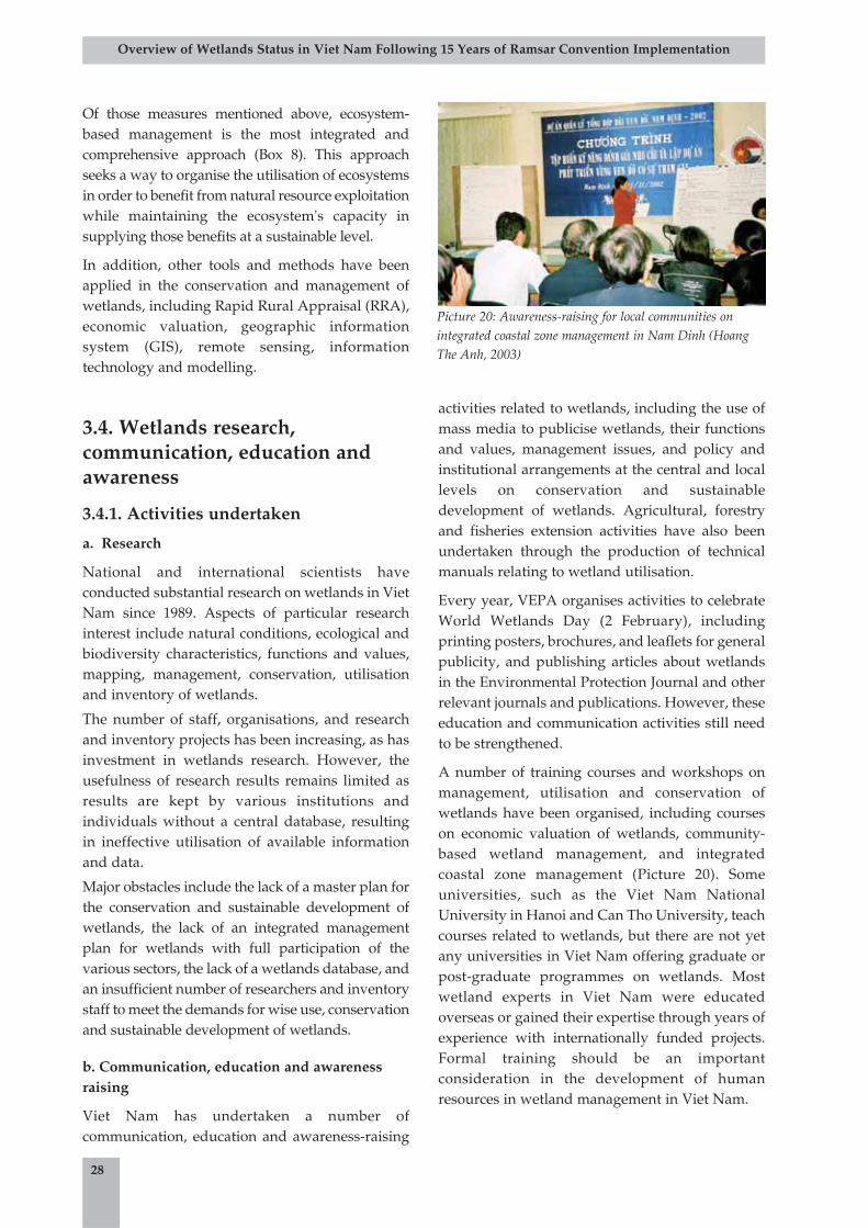
Of those measures mentioned above, ecosystem-based management is the most integrated andcomprehensive approach (Box 8). This approachseeks a way to organise the utilisation of ecosystemsin order to benefit from natural resource exploitationwhile maintaining the ecosystem's capacity insupplying those benefits at a sustainable level.
In addition, other tools and methods have beenapplied in the conservation and management ofwetlands, including Rapid Rural Appraisal (RRA),economic valuation, geographic informationsystem (GIS), remote sensing, informationtechnology and modelling.
3.4. Wetlands research,communication, education andawareness
3.4.1. Activities undertaken
a. Research
National and international scientists haveconducted substantial research on wetlands in VietNam since 1989. Aspects of particular researchinterest include natural conditions, ecological andbiodiversity characteristics, functions and values,mapping, management, conservation, utilisationand inventory of wetlands.
The number of staff, organisations, and researchand inventory projects has been increasing, as hasinvestment in wetlands research. However, theusefulness of research results remains limited asresults are kept by various institutions andindividuals without a central database, resultingin ineffective utilisation of available informationand data.
Major obstacles include the lack of a master plan forthe conservation and sustainable development ofwetlands, the lack of an integrated managementplan for wetlands with full participation of thevarious sectors, the lack of a wetlands database, andan insufficient number of researchers and inventorystaff to meet the demands for wise use, conservationand sustainable development of wetlands.
b. Communication, education and awarenessraising
Viet Nam has undertaken a number ofcommunication, education and awareness-raising
activities related to wetlands, including the use ofmass media to publicise wetlands, their functionsand values, management issues, and policy andinstitutional arrangements at the central and locallevels on conservation and sustainabledevelopment of wetlands. Agricultural, forestryand fisheries extension activities have also beenundertaken through the production of technicalmanuals relating to wetland utilisation.
Every year, VEPA organises activities to celebrateWorld Wetlands Day (2 February), includingprinting posters, brochures, and leaflets for generalpublicity, and publishing articles about wetlandsin the Environmental Protection Journal and otherrelevant journals and publications. However, theseeducation and communication activities still needto be strengthened.
A number of training courses and workshops onmanagement, utilisation and conservation ofwetlands have been organised, including courseson economic valuation of wetlands, community-based wetland management, and integratedcoastal zone management (Picture 20). Someuniversities, such as the Viet Nam NationalUniversity in Hanoi and Can Tho University, teachcourses related to wetlands, but there are not yetany universities in Viet Nam offering graduate orpost-graduate programmes on wetlands. Mostwetland experts in Viet Nam were educatedoverseas or gained their expertise through years ofexperience with internationally funded projects.Formal training should be an importantconsideration in the development of humanresources in wetland management in Viet Nam.
28
Overview of Wetlands Status in Viet Nam Following 15 Years of Ramsar Convention Implementation
Picture 20: Awareness-raising for local communities onintegrated coastal zone management in Nam Dinh (HoangThe Anh, 2003)
3.4.2. Trends in wetlands knowledgeand awareness
Prior to 1989, knowledge about wetlands in VietNam was rather limited. Since 1990 however,international organisations have assisted Viet Namin the implementation of wetlands or wetland-related projects. Thus, Vietnamese experts whoparticipated in these projects had an opportunityto gain exposure to wetland issues and gainedknowledge and experience. The NationalEnvironment Agency (now VEPA) became thenational focal point for wetlands. In 1990, Patrik J.Dugan's book "Conservation of wetlands" wastranslated into Vietnamese by the NationalEnvironment Agency, enabling many people toincrease their knowledge about wetlands. Alsoduring this time, Le Dien Duc published an"Inventory of Wetlands in Viet Nam" andparticipated in the development of a Directory ofAsian Wetlands. Since 2000, wetlands andbiodiversity issues have received the attention ofmany agencies at both the central and local levels,through such initiatives as the formulation of awetlands strategy and an action plan on theutilisation, conservation and management ofwetlands. Viet Nam's National MekongCommittee has established a working group forinvestigation and research on wetlands of theMekong Delta, facilitating the development of aclassification system and the mapping of wetlandsin the region. Various aspects relating to wetlandshave been addressed in a number of researchprojects and programmes, including thedevelopment of a classification system,formulation of management and conservationplans, community participation, institutionalarrangements, policy, and economic, cultural andhistorical values.
Thus, knowledge and awareness about wetlandshave increased since 1989, thanks to local, nationaland international efforts. However, one significantremaining challenge is that most local peopleliving within wetland areas do not yet have a clearunderstanding of wetlands issues. It is thesecommunities who use wetland resources directly,and who may potentially play a very importantrole in the conservation and sustainabledevelopment of wetlands.
3.5. Achievements and challengesrelating to wetland managementin Viet Nam
3.5.1. Achievements
The following achievements in wetlandmanagement in Viet Nam should be highlighted:
• The Government of Viet Nam haspromulgated a number of relevant policiesin order to enhance effectiveness ofconservation, utilisation and managementof wetlands in the country.
• Many regulations on institutional structure,mandates, and responsibilities within thewetland management system at the centrallevel have been issued and have graduallybeen elaborated upon. In particular, theLaw on Government Structure (2001) andGovernment Decree No. 91/2002/ND-CP(2002) stipulate the extended functions,responsibilities and power of MONRE overland and water resources as well as itsorganisational structure. This hascontributed to the legal foundation for theformulation of a state managementorganisational system on wetlands. TheGovernment Decree No. 109/2003/ND-CPissued on 23 September 2003institutionalised state management ofwetlands through a delegation ofresponsibilities to ministries and provinces.
• There is increasing involvement oforganisations and agencies in theconservation and management of wetlands.Under the guidance of the Government andwith the former Ministry of Science,Technology and Environment (MOSTE,now MONRE) as focal point, ministries andagencies at the ministerial level have madeinitial progress in coordinating worksrelated to wetland issues. Cooperationbetween MOSTE and MARD in themanagement of wetland protected areas, aconsolidation of management structures forenvironment and natural resources, and aprocess of policy formulation on wetlandconservation have ensured that Viet Nam iseffectively implementing and participating
29
Overview of Wetlands Status in Viet Nam Following 15 Years of Ramsar Convention Implementation
in international commitments relating towetlands.
• Institutional arrangements of statemanagement at the local level have beenorganised under dual supervision: undertechnical management at the central leveland provincial management at the locallevel. This has facilitated effectivemanagement of a number of local wetlands.
• Government investment and internationalsupport in wetland conservation andsustainable development has increasedsteadily. The number of national andinternational projects relating to wetlandshas also increased. Generally they havegenerated positive impacts, although someof them were not very well managed andtheir impacts not very good.
• The Government of Viet Nam has approveda national system of protected areas,including wetlands areas, and has approveda system of marine protected areas.Protected areas contribute to theconservation of the functions, values andbiodiversity resources of wetlands.
3.5.2. Issues and challenges in wetlandmanagement in Viet Nam
a. Legislative system
Viet Nam lacks a specific law on wetlands,
regulations on the conservation, management,
wise use and sustainable development of
wetlands, and clear and detailed regulations on the
state management system. In addition, there
remains a lack of agreement on coordination
mechanisms between ministries, sectors and
localities in activities relating to wetlands and a
lack of enforcement measures for implementation.
Existing legal documents directly related to the
conservation and management of wetlands are
issued primarily by ministries and provincial
authorities while documents promulgated at a
higher level, such as Government Decrees, are still
limited. Decree No. 109/2003/ND-CP is currently
the highest piece of legislation directly addressing
a division of mandates on wetland management.
Current legislation does not yet meet therequirements of conservation and sustainabledevelopment of wetlands. Documents issued byProvincial People's Committees have mainlyfocused on administrative measures, and there hasbeen a lack of sanctions to mobilise communityparticipation in wetland exploitation.
The system of policies and regulations on wetlandmanagement has not been completed orsynchronised. Specific provisions in legaldocuments relating to wetlands often overlap, andare also often scattered within different pieces oflegislation. They lack scientific detail and do nottake into account a number of socio-economicfactors, which prevents their effectiveimplementation.
Many terms and concepts relating to wetlandshave been not clearly defined or explained in thelegal documents and policies of Viet Nam. Existingdocuments have not comprehensively covered thevariety of issues faced by wetland conservationand management work, but instead haveaddressed such things as:
• classification and division of themanagement mandates within wetlandprotected areas (National Parks or NatureReserves);
• economic aspects (addressed in suchlegislation as the Fisheries Law and otherregulations issued by local authorities);
• protective measures, including punishmentof violators and banning of destructivepractices in the exploitation of biologicalresources; and
• conservation activities for some species,especially waterfowl whose habitats arewetlands.
Monetary fines for violations are low and do notreflected current socio-economic conditions of thecountry. As a result, punitive measures are noteffective in deterring violations. Sanctionsapplied for the violation of regulations onbiodiversity conservation are often irrelevant orinappropriate.
There is currently no clear policy regardingprotection, extension or reduction of wetlandareas, nor does any existing policy involve local
30
Overview of Wetlands Status in Viet Nam Following 15 Years of Ramsar Convention Implementation
31
communities in wetland management. Manywetlands are still considered as wasted land due toa lack of proper knowledge on the roles and valuesof wetlands. Some existing policies aim to convertnatural wetlands into artificial ones (reservoirs,aquacultural ponds, or rice fields) or industrial,residential and urban areas, and there is a lack oflegislation on planning and wise use of wetlands.These legislative limitations have led toenvironmental pollution and degradation ofbiodiversity resources.
Viet Nam has developed a system of legaldocuments and policies to implement the RamsarConvention as well as other internationalcommitments relating to the conservation andsustainable development of wetlands. However,these documents do not yet meet RamsarConvention requirements on the wise use ofwetlands. Effectiveness in the implementation ofinternational obligations as defined in internationalconventions is assessed through the formulationand implementation of legislation and policies onconservation and management of wetlands.
The implementation of the Law on ForestProtection and Development and the Regulation onConservation of Special Use Forests has generatedproblems in the planning, management andconservation of wetlands. The Fisheries Law is notfeasible in the core zones of protected areas, and thewise use principle promoted by the RamsarConvention has not yet been institutionalised.
b. Wetlands management
Some of the big challenges to conservation andsustainable management of wetlands are a rapidlyincreasing population (at a rate of about 1.32% peryear), heavy population density in many wetlandareas (for example, a population density of 276persons/km2 in coastal districts) and a rapid anduncontrolled rate of urbanisation (estimated to beabout 33% by 2010).
Managers and beneficiaries do not yet fullyunderstand the social, economic and ecologicalfunctions and values of wetlands, or the role ofconservation and management in theirpreservation. Therefore, decisions relating to theutilisation of wetlands have not been feasible.
Wetland management in Viet Nam remains sector-based, overlapping, uncoordinated, scattered, and
a management mandate on wetlands has not yetbeen clearly defined.
Policies on wetland management have beeninconsistent and unsystematic, with changes overtime which have had negative effects, includingloss of biodiversity, environmental degradationand pollution. One example is that Dam Doiexperienced land use changes five times between1975 and 1985, which has led to a severe loss ofnatural resources.
Conflicts in wetland utilisation and degradation ofwetlands resources have resulted from a lack of amaster plan regarding wetland management, andfrom detailed wetlands plans that areinappropriate to the physical and socio-economicconditions of each region. Regional planning,economic development, transportation, waterresources development, hydro-electricity andtourism have changed and sometimes preventedthe effective management of wetlands. A top-down approach in wetland management hinderslocal initiatives and participation in wetlandprotection and sustainable use.
Wetlands of high value have not been conservedand managed effectively. According to aninventory taken by VEPA in 2001 titled "Wetlandsof high biodiversity values and environmentalimportance", proper wetland conservation andmanagement policies have not been put in place insuch areas as: Chu Lake (Phu Tho), Cam Son Lake(Bac Giang), Thai Binh Estuary (Tien Lang District,Hai Phong), Nui Coc Lake, Ba Be Lake, Hoa BinhReservoir, Cau Hai Lagoon (Thua Thien Hue), TraO and De Gi Lagoons (Binh Dinh), Nui Mot Lake(Binh Dinh), Lak Lake, Bien Ho (CentralHighlands), Dankia Lake (Lam Dong), and DaNhim and Dau Tieng Reservoirs (Ho Chi MinhCity).
Investment in human resources for conservationand sustainable development of wetlands has notcorresponded to the values and potentials ofwetlands. Many kinds of investment have beenunreasonably limited and imbalanced, includinghuman resources development, scientific research,and development of models on sustainabledevelopment, conservation, and protection ofwetlands and their resources.
Research and integrated surveys on wetlands havenot been carried out in a synchronised and
Overview of Wetlands Status in Viet Nam Following 15 Years of Ramsar Convention Implementation
systematic manner. There has been limitedinvestment in capacity building and training forresearch and survey work. Advanced researchmethods are not being considered for applicationor modification for the specific conditions of VietNam. A good database on wetlands in the countryis still lacking, and existing wetland inventory andassessment work does not meet the requirementsfor wetland conservation, management, andsustainable development.
Knowledge and awareness about the functionsand values of wetlands, and about theirconservation and management, are rather limited.Communication and awareness-raising activitieshave not received proper attention and have notalways been suitable to the various target groups.Wetlands are not yet included in theenvironmental education programme.
3.5.3. Recommendations for wetlandmanagement in Viet Nam
a. Formulation and implementation of a nationalstrategy on the conservation and sustainabledevelopment of wetlands
A national strategy on the conservation andsustainable development of wetlands which couldprovide national benefits and improve the welfareof local communities should be formulated andimplemented nationwide. In addition, eachecoregion or province should develop its ownaction plan with its own specific characteristics inmind. These action plans could go into higherdetail than the national strategy, with localrelevance and high feasibility.
b. Enhancing the effectiveness and validity ofthe institutional and legislative system inwetland management
A synchronised and systematic system ofinstitutions, legislation and managementmechanisms for wetlands must be developed at alllevels.
A National Coordination Committee on Wetlandsshould be established and operated under thedirect guidance of the Deputy Prime Minister.This Committee would be an intersectoral bodyresponsible for coordination and cooperation
between line ministries dealing with wetlands,including MONRE, MARD, MOFI, the Ministry ofTransportation, the Ministry of Culture andInformation, the Ministry of Planning andInvestment, the Ministry of Finance, the Ministryof Justice, the Ministry of Education and Training,and other related agencies. A Technical AdvisoryCouncil would be established to support theNational Coordination Committee's activities.Specialised bodies within these related sectors andministries need to be allocated with clearmandates and power. In particular, attentionshould be paid to the consolidation of localauthorities that directly manage wetland areas,such as People's Committees at the commune anddistrict levels.
A policy on capacity building for wetlandmanagement agencies is needed, ensuringtraining, modernisation of facilities, anddevelopment and consolidation of theorganisational structure.
A system of wetland protected areas needs to beestablished and developed. Management andaction plans at different levels should be reviewedand assessed, and important wetlands thatcurrently lack sustainable planning andmanagement would be identified.
A model on wetland management relevant to thepractical conditions of Viet Nam should bedeveloped. In existing wetland protected areas,there should be a focus on technical capacitybuilding and on completion of the managementstructure.
c. Implementation of supporting measures inwetland management
Attention should be paid to:
• Providing human resource training to meetthe requirements of wetland conservationand wise use.
• Communication and awareness-raising onthe functions and values of wetlands and ondeveloping skills in conservation andsustainable use of wetlands.
• Promoting incentives and supportingpolicies to ensure local communities'livelihoods and enable them to participate in
32
Overview of Wetlands Status in Viet Nam Following 15 Years of Ramsar Convention Implementation
33
the management and sustainable use ofwetlands as guided by the RamsarConvention.
• Providing financial support for wetlandsustainable use activities.
• Establishing a wetland conservation fund.Sources of revenue could come fromagricultural taxes, tourism, eco-tourism andother services relating to wetlands.
• Scientific research, inventory andmonitoring of wetlands at the national andecoregional levels as well as in wetlandareas having high biodiversity andenvironmental values, especially those ofnational and international importance.
d. Development of measures for theconservation, utilisation and management ofwetlands
The following activities should be undertaken:
• Development and issuance of a list ofcriteria for a wetlands classification system.
• Establishment of a management and actionmechanism for the conservation of wetlandsof high value.
• Implementation of policies and activitiesrelating to the conservation and sustainableuse of wetlands.
• Creation of a rehabilitation plan fordegraded wetlands.
• Provision of incentives for the protectionand improvement of clean water sources.
• Development of wise use models such asecological aquaculture and otherenvironmentally friendly models.
• Strict implementation of regulations onconservation and sustainable use ofwetlands.
• Enforcement and punishment of violators.
• Development of a website and regularlyupdated national database on wetlands ofViet Nam.
• Undertaking of research on thedevelopment and application of advancedmethods in wetland management, such asthe ecosystem-based approach, co-management, intersectoral managementand community-based management.
e. Planning for conservation and sustainable useof biodiversity in coastal and estuarine areas
A series of wetlands maps at different scalesshould be produced (e.g. 1:1,000,000 for anationwide map; 1:250,000 for ecoregional maps;1:100,000 for provincial maps; and between1:10,000 and 1:25,000 for maps at each wetlandsite). A master plan on conservation andsustainable development of wetlands at thenational level and at the ecoregional level shouldalso be developed.
f. Formulation and implementation ofregulations on wetlands resource management
The formulation of such regulations would play adecisive role in the management of fisheries withinwetland areas. Its contents would include thefollowing key issues:
• Regulating relationships between wetlandsmanagers; and
• Budget allocation for management offisheries and wetlands resources.
According to the Ordinance on Fisheries ResourceManagement, any fisheries activities (includingcatching, aquaculture, research on fisheriesresources) need to obtain permission from theprovincial department of fisheries resourcesmanagement.
Overview of Wetlands Status in Viet Nam Following 15 Years of Ramsar Convention Implementation
4.1. Wetlands of Viet Nam are very diverse anddistributed widely over all ecoregions. Theyplay a key role in and contribute value tosocio-economic development, nationaldefence, poverty and hungry alleviation,cultural maintenance and development,disaster prevention, environmental protection,and preservation and development ofbiodiversity.
4.2. Wetland ecosystems in Viet Nam are verysensitive, vulnerable and unable to adapt tosudden changes, which may result in a loss ofecological balance. They have been degradedin terms of habitat destruction, environmentalpollution and a severe erosion of biologicalresources.
4.3. Major challenges to wetlands in Viet Naminclude: rapid population increase; practicesand poverty of people living within andaround wetland areas; an inconsistent policyand legislative system for wetlandmanagement; a lack of coordination andintersectoral approach to wetlandmanagement; unsustainable exploitation;imbalanced utilisation and conservation ofwetlands; limited or misdirected investmentsources for activities such as human resourcetraining, scientific research, development ofwise use models, conservation andenvironmental protection; lack ofcomprehensive wetlands data to meet therequirements of wetland management andsustainable development; low knowledge andawareness about conservation andmanagement of wetlands; impacts of naturaldisasters such as erosion, floods, storms, forestfires, and salinisation; and impactsglobalisation and global environmentalchanges.
4.4. Wetlands in Viet Nam have been changeddramatically following the trends below:
a. The number of wetland types and areas ofartificial wetlands (e.g. reservoirs,aquaculture ponds, rice fields, wastewatertreatment wetlands, etc.) has increased,while areas of natural wetlands, especiallymangroves, seagrass beds, coral reefs, tidalmud flats, Melaleuca forests and naturallakes, have been rapidly decreasing.
b. The role and value of wetlands in relation tosocio-economic development,environmental protection and disasterprevention has increased.
c. The quality of environment and wetlandecosystems in suburban areas, industrialzones, aquacultural and rice cultivationregions, mangrove forests, seagrass bedsand coral reefs has degraded, resulting in arapid reduction of biodiversity.
d. There is an increasing number of threats towetlands, such as: natural disasters, war,population pressure, over-exploitation,irrelevant management mechanisms,structure and methods, lack of linkagebetween economic development policy andenvironmental and natural resourceprotection.
e. Awareness about the functions and valuesof wetlands has been continuouslyenhanced, however it is not yet sufficient tomeet the requirements of the principle ofwise use and sustainable development.
f. Wetland management tools and approachesare becoming more diverse and advanced.The number of legal documents relating towetlands, as well as a number of wetlandmanagement agencies has increased,however coordination, effectiveness,efficiency and positive effects of themanagement system have not increasedsufficiently.
34
Overview of Wetlands Status in Viet Nam Following 15 Years of Ramsar Convention Implementation
4. Conclusions
g. The number of projects and scientific workrelating to wetlands has increased, togetherwith an increase in scientific potential interms of the number of scientific agencies,number of scientists and equipment.Despite this, research results have not beenapplied and brought into play effectively.
h. Communication and education aboutwetlands has received increasing attention,but formal training about wetland issues hasnot received proper attention. This work hasnot met the requirements of wetlandconservation, utilisation and management.
i. The number of international wetlands-related projects and organisations withwhich Viet Nam is collaborating has beenincreasing. This has resulted in positiveoutcomes related to conservation andmanagement of wetlands.
4.5. Different sectors and authorities at differentlevels should pay attention to conservationand sustainable use of wetlands. A long-termstrategy on wetland management togetherwith a relevant legal and institutionalframework should be formulated and put intopractice.
4.6. Viet Nam's membership of the RamsarConvention and its efforts to implement therequired obligations of the Contracting Partyhave played an important role in promotingconservation, management and sustainabledevelopment of wetlands in the country.However, conservation and sustainabledevelopment of wetlands in Viet Nam is in theearly stages and therefore requires the supportand assistance from donors, as well as nationaland international organisations.
35
Overview of Wetlands Status in Viet Nam Following 15 Years of Ramsar Convention Implementation
In order to use wetlands wisely and managethem sustainably to prevent negativeecosystem changes, the following
recommendations are made:
5.1. Promote the implementation ofGovernment Decree No. 109/2003/ND-CP on conservation and sustainabledevelopment of wetlands, and theNational Action Plan on Conservationand Sustainable Development ofWetlands for the period 2004-2010,issued by MONRE in 2004.
5.2. Develop and issue the criteria andclassification system of wetlands;produce wetland maps for the wholecountry as well each ecoregion (atdifferent scales); promote research inwetlands, including on forecastingtrends of wetland changes in Viet Nam.
5.3. Formulate and implement a NationalStrategy and Master Plan onconservation and sustainabledevelopment of wetlands.
5.4. Develop and apply relevant models onwise use of wetlands.
5.5. Complete policy and institutionalsystems, as well as wetland managementmechanisms, tools and methods.
5.6. Promote wetlands-related awarenessraising, education and training activitiesthat are suitable to Vietnameseconditions while meeting the demands ofinternational integration.
5.7. Promote communication and educationabout wetlands; human resourcestraining; capacity building in wetlandinventory, survey and research;modernisation of facilities for training,research and management to meet therequirements of wetland conservationand sustainable development.
5.8. Promote and enhance internationalcooperation on conservation andsustainable development of wetlands.
5.9. Develop a national database and websiteabout the wetlands of Viet Nam to meetthe demand for inventory, research,education, training, management,utilisation, conservation and sustainabledevelopment of wetlands.
5.10. Select and complete documents, anddesignate new Ramsar sites.
36
Overview of Wetlands Status in Viet Nam Following 15 Years of Ramsar Convention Implementation
5. Recommendations
37
Overview of Wetlands Status in Viet Nam Following 15 Years of Ramsar Convention Implementation
1. Cu, Nguyen Duc et al., 1998. Summary Report on the state-level basic survey project "Investigation andsurvey of the environmental quality and nutrient regime of the river mouth areas of the Red River Delta", p.7-18. Hai Phong Institute of Oceanology. Hai Phong.
2. Decree No. 109/2003/ND-CP on the conservation and sustainable development of wetlands, 23September 2003.
3. Duc, Le Dien, 1989. Viet Nam's Wetland Inventory. Centre for Natural Resources and EnvironmentalStudies, Viet Nam National University, Hanoi.
4. Hoi, Nguyen Chu, et al., 1996. Protection and management of lagoons in the coastal area of Central VietNam. Proceedings of the workshop "Viet Nam - National strategy on wetland protection and management- Status, utilization, protection and management." Sida/IUCN, Ministry of Science, Technology andEnvironment, National Environment Agency. Hanoi.
5. Hong, Phan Nguyen, et al., 1998. Strategies for the protection and management wetlands in Viet Nam,1996-2000.
6. Hong, Phan Nguyen, 1999. Mangroves of Viet Nam. Agricultural Publishing House, Hanoi.
7. Government of the Socialist Republic of Viet Nam, 2003. Law on Environmental Protection.
8. Government of the Socialist Republic of Viet Nam, 2003. Law on Fisheries, 10 December 2003.
9. Government of the Socialist Republic of Viet Nam, 1991. Law on Forest Protection andDevelopment, 12 August 1991.
10. Government of the Socialist Republic of Viet Nam, 1998. Law on Land, amended 2 December 1998.
11. Government of the Socialist Republic of Viet Nam, 1998. Law on Water Resources, 20 May 1998.
12. Ministry of Agriculture and Rural Development, Institute of Forest Planning and Sub-Institute ofForest Planning II, 2004. Wetland classification system of Viet Nam. Ho Chi Minh City.
13. Ministry of Natural Resources and Environment, 1998. General report on wetlands of Viet Nam. Hanoi.
14. Ministry of Natural Resources and Environment, 2001. Wetlands with high biodiversity andenvironmental value in Viet Nam. Hanoi.
15. National Environment Agency, 2001. 2001-2010 National Environmental Protection Strategy.
16. National Environment Agency, Ministry of Natural Resources and Environment, 2002. Researchsub-project "Evaluation of cultural and social aspects of using wetlands in Viet Nam" under the project"Establishment of a national program for management and conservation of wetlands in Viet Nam," Assoc.Prof. Dr. Pham Binh Quyen (Leader), p. 44-48, Hanoi.
17. Nhuan, Mai Trong, D.V. Luyen, N.T.T. Hang, 2002. Vulnerability assessment of coastal socio-naturalsystem (case study of Khanh Hoa coast). Science Journal of Viet Nam National University, Hanoi.
18. Nhuan, Mai Trong , N.T.H. Hue, T.D. Quy, 2004. Impact assessment of erosion disaster on the coastalzone (case study of Phan Ri-Phan Thiet coast, Central Viet Nam). Journal of Earth Sciences.
19. Nhuan, Mai Trong, et al., 2004. Environmental Geology of the Phan Thiet-Ho Tram Coastal Zone.Scientific Project Report, Archive of Marine Geology Union.
References
38
Overview of Wetlands Status in Viet Nam Following 15 Years of Ramsar Convention Implementation
20. Nhuan, Mai Trong et al., 2003. Geo-hazard Status and Forecasting of the Phan Ri-Phan Thiet Coastal Zone.Scientific Project Report, Archive of Marine Geology Union.
21. Nhuan, Mai Trong, et al., 2004. National strategic action plan for Viet Nam coastal wetland conservationand sustainable development.
22. Nhuan, Mai Trong, et al., 2004. Viet Nam Coastal Wetlands, under the UNEP project "ReversingEnvironmental Degradation Trends in the South China Sea and Gulf of Thailand."
23. Ramsar, 1971. Ramsar Convention on Wetlands. Ramsar, Iran.
24. Ramsar, 2002. Review of Internationally Important Wetland Sites. www.ramsar.org.
25. Tang, Vu Trung, 1996. Strategy for management and protection of estuarine wetlands for 1996-2010.
26. Thanh, Nguyen Chi, 2003. Wetland classification system of Viet Nam. Branch Forest Investigation andPlanning Institute II, p.60-62.
27. Thanh, Tran Duc et al., 1999. Wetland exploitation and utilisation in Tam Giang-Cau Hai Lagoon:Importance and Current Status. Proceedings of Management and Sustainable Use of NaturalResources and Environment in Coastal Wetlands. VNU/ACTMANG. Hanoi.
28. Tien, Nguyen Van et al., 2004. Approaches to management of seagrass ecosystems in Viet Nam. Scienceand Technics Publishing House. Hanoi.
29. Trong, Pham Dinh, 1996. Zoobenthos in the mangrove forest ecosystem along the western coast of Bac BoGulf. Ph.D. dissertation in biology: 156 pages.
30. Yet, Nguyen Huy, 1996. Some aspects of coral reef protection in the coastal waters of Viet Nam.Proceedings of the workshop "Viet Nam - National strategy on wetland protection and management -Status, utilization, protection and management," p. 47-55, Sida/IUCN, Ministry of Science, Technologyand Environment, National Environment Agency. Hanoi.
1. Mission Statement
The Convention's mission is the conservation andwise use of all wetlands through local, regionaland national actions and international cooperation,as a contribution towards achieving sustainabledevelopment throughout the world.
2. Commitment of Parties to theConvention
By taking part in the Convention, nations arecontributing to international efforts in theconservation and wise use of wetlands. TheConvention consists of four commitments asfollows:
2.1. The list of internationally importantwetlands
At the time of joining the Convention, eachContracting Party undertakes to designate at leastone site for inclusion in the List of Wetlands ofInternational Importance. The inclusion of a site inthe Ramsar List will ensure the conservation andwise use of wetlands in this site. The selection ofinternationally important wetlands is based onecological characters, diversity of flora and faunasystems, or hydrographical conditions at thewetlands. All contracting parties must acceptspecific criteria and regulations on identifying
wetlands of international importance as set by theConvention.
2.2. The wise use of wetlands
Contracting Parties agree to formulate andimplement their planning so as to promote theconservation of the wetlands included in the List,and as far as possible the wise use of wetlands intheir territory.
Conference of the Parties accepts the guidingprinciples and guidelines about the sustainableand wise use of wetlands.
2.3. Reserves and training
Members of the Ramsar Convention haveresponsibility to establish nature reserves withinwetlands, regardless of whether they are classifiedas internationally important or not. In additions,contracting parties are required to promotetraining courses in the fields of research,management and wetlands monitoring.
2.4. International cooperation
The Contracting Parties shall consult with eachother about implementing obligations arising fromthe Convention especially in the case of a wetlandextending over the territories of more than oneContracting Party or where a water system isshared by Contracting Parties.
39
Overview of Wetlands Status in Viet Nam Following 15 Years of Ramsar Convention Implementation
Appendix A:
Summary of the Ramsar Convention
40
Overview of Wetlands Status in Viet Nam Following 15 Years of Ramsar Convention Implementation
MINISTRY OF AGRICULTURE THE SOCIALIST REPUBLIC OF VIET NAMAND RURAL DEVELOPMENT Independence - Freedom - Happiness
No. 646/QD/BNN-KHCN Ha Noi, 17 March 2004
DECISIONBY THE MINISTER OF AGRICULTURE AND RURAL DEVELOPMENT
Re: Issuance of sectoral standards on wetlands
THE MINISTER OF AGRICULTURE AND RURAL DEVELOPMENT
- Pursuant to Decree No. 86/2003/ND-CP dated 18 July 2003, by the Government stipulating functions,responsibilities, authorities and organisational structure of the Ministry of Agriculture and RuralDevelopment;
- Pursuant to Decree No. 109/2003/ND-CP dated 13 September 2003, by the Government on conservationand sustainable development of wetlands;
- Pursuant to Regulations on formulation, approval and issuance of sectoral standards which waspromulgated by Decision No. 135/QD/BNN-KHCN dated 1 October 1999;
- Following the request by the Director of the Department of Science and Technology.
DECIDES
Article 1: To issue herewith this decision the sectoral standards 04TCN67-2004 on Wetlands ClassificationSystem.
Article 2: These standards are the basis for management, conservation, sustainable use and developmentof wetlands under the management responsibilities of the Ministry of Agriculture and RuralDevelopment. These standards shall come into force 15 days from the date of signing.
Article 3: The Head Ministry Office, Director of Department of Science and Technology, and heads ofconcerned institutions assume responsibility to implement this decision.
For and on behalf of the Minister of c/c: Agriculture and Rural Development
- As defined in Article 3 Vice Minister- Ministry office for filing
Prof. Dr. Bui Ba Bong
(Signed)
Appendix B: Wetlands Classification System by MARD
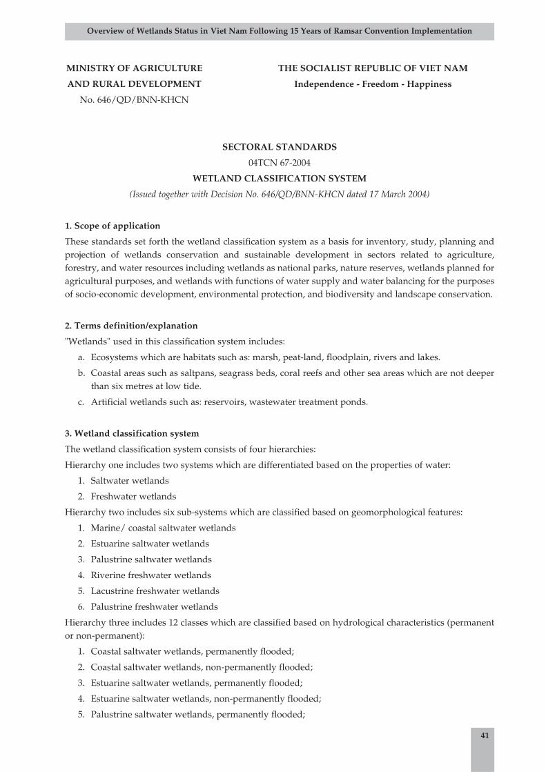
MINISTRY OF AGRICULTURE THE SOCIALIST REPUBLIC OF VIET NAM
AND RURAL DEVELOPMENT Independence - Freedom - Happiness
No. 646/QD/BNN-KHCN
SECTORAL STANDARDS
04TCN 67-2004
WETLAND CLASSIFICATION SYSTEM
(Issued together with Decision No. 646/QD/BNN-KHCN dated 17 March 2004)
1. Scope of application
These standards set forth the wetland classification system as a basis for inventory, study, planning andprojection of wetlands conservation and sustainable development in sectors related to agriculture,forestry, and water resources including wetlands as national parks, nature reserves, wetlands planned foragricultural purposes, and wetlands with functions of water supply and water balancing for the purposesof socio-economic development, environmental protection, and biodiversity and landscape conservation.
2. Terms definition/explanation
"Wetlands" used in this classification system includes:
a. Ecosystems which are habitats such as: marsh, peat-land, floodplain, rivers and lakes.
b. Coastal areas such as saltpans, seagrass beds, coral reefs and other sea areas which are not deeperthan six metres at low tide.
c. Artificial wetlands such as: reservoirs, wastewater treatment ponds.
3. Wetland classification system
The wetland classification system consists of four hierarchies:
Hierarchy one includes two systems which are differentiated based on the properties of water:
1. Saltwater wetlands
2. Freshwater wetlands
Hierarchy two includes six sub-systems which are classified based on geomorphological features:
1. Marine/ coastal saltwater wetlands
2. Estuarine saltwater wetlands
3. Palustrine saltwater wetlands
4. Riverine freshwater wetlands
5. Lacustrine freshwater wetlands
6. Palustrine freshwater wetlands
Hierarchy three includes 12 classes which are classified based on hydrological characteristics (permanentor non-permanent):
1. Coastal saltwater wetlands, permanently flooded;
2. Coastal saltwater wetlands, non-permanently flooded;
3. Estuarine saltwater wetlands, permanently flooded;
4. Estuarine saltwater wetlands, non-permanently flooded;
5. Palustrine saltwater wetlands, permanently flooded;
41
Overview of Wetlands Status in Viet Nam Following 15 Years of Ramsar Convention Implementation
6. Palustrine saltwater wetlands, non-permanently flooded;
7. Riverine freshwater wetlands, permanently flooded;
8. Riverine freshwater wetlands, non-permanently flooded;
9. Lacustrine freshwater wetlands, permanently flooded;
10. Lacustrine freshwater wetlands, non-permanently flooded;
11. Palustrine freshwater wetlands, permanently flooded;
12. Palustrine freshwater wetlands, non-permanently flooded;
Hierarchy four includes 69 sub-classes which are classified based on land-use characteristics, of which:
• Saltwater wetlands system contains 42 sub-classes
• Freshwater wetlands contain 27 sub-classes.
For and on behalf of the Minister of Agriculture and Rural Development
Vice-Minister
Prof. Dr. Bui Ba Bong
(Signed)
42
Overview of Wetlands Status in Viet Nam Following 15 Years of Ramsar Convention Implementation
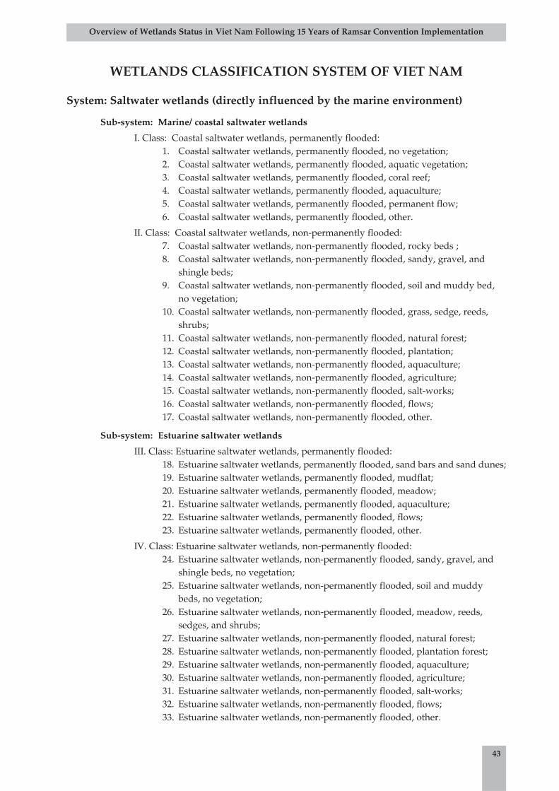
43
Overview of Wetlands Status in Viet Nam Following 15 Years of Ramsar Convention Implementation
WETLANDS CLASSIFICATION SYSTEM OF VIET NAM
System: Saltwater wetlands (directly influenced by the marine environment)
Sub-system: Marine/ coastal saltwater wetlands
I. Class: Coastal saltwater wetlands, permanently flooded:1. Coastal saltwater wetlands, permanently flooded, no vegetation;2. Coastal saltwater wetlands, permanently flooded, aquatic vegetation;3. Coastal saltwater wetlands, permanently flooded, coral reef;4. Coastal saltwater wetlands, permanently flooded, aquaculture;5. Coastal saltwater wetlands, permanently flooded, permanent flow;6. Coastal saltwater wetlands, permanently flooded, other.
II. Class: Coastal saltwater wetlands, non-permanently flooded: 7. Coastal saltwater wetlands, non-permanently flooded, rocky beds ;8. Coastal saltwater wetlands, non-permanently flooded, sandy, gravel, and
shingle beds;9. Coastal saltwater wetlands, non-permanently flooded, soil and muddy bed,
no vegetation;10. Coastal saltwater wetlands, non-permanently flooded, grass, sedge, reeds,
shrubs;11. Coastal saltwater wetlands, non-permanently flooded, natural forest;12. Coastal saltwater wetlands, non-permanently flooded, plantation;13. Coastal saltwater wetlands, non-permanently flooded, aquaculture;14. Coastal saltwater wetlands, non-permanently flooded, agriculture;15. Coastal saltwater wetlands, non-permanently flooded, salt-works;16. Coastal saltwater wetlands, non-permanently flooded, flows;17. Coastal saltwater wetlands, non-permanently flooded, other.
Sub-system: Estuarine saltwater wetlands
III. Class: Estuarine saltwater wetlands, permanently flooded:18. Estuarine saltwater wetlands, permanently flooded, sand bars and sand dunes;19. Estuarine saltwater wetlands, permanently flooded, mudflat;20. Estuarine saltwater wetlands, permanently flooded, meadow;21. Estuarine saltwater wetlands, permanently flooded, aquaculture;22. Estuarine saltwater wetlands, permanently flooded, flows;23. Estuarine saltwater wetlands, permanently flooded, other.
IV. Class: Estuarine saltwater wetlands, non-permanently flooded:24. Estuarine saltwater wetlands, non-permanently flooded, sandy, gravel, and
shingle beds, no vegetation;25. Estuarine saltwater wetlands, non-permanently flooded, soil and muddy
beds, no vegetation;26. Estuarine saltwater wetlands, non-permanently flooded, meadow, reeds,
sedges, and shrubs;27. Estuarine saltwater wetlands, non-permanently flooded, natural forest;28. Estuarine saltwater wetlands, non-permanently flooded, plantation forest;29. Estuarine saltwater wetlands, non-permanently flooded, aquaculture;30. Estuarine saltwater wetlands, non-permanently flooded, agriculture;31. Estuarine saltwater wetlands, non-permanently flooded, salt-works;32. Estuarine saltwater wetlands, non-permanently flooded, flows;33. Estuarine saltwater wetlands, non-permanently flooded, other.
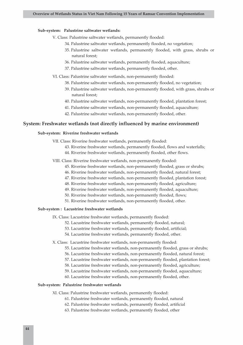
44
Overview of Wetlands Status in Viet Nam Following 15 Years of Ramsar Convention Implementation
Sub-system: Palustrine saltwater wetlands:
V. Class: Palustrine saltwater wetlands, permanently flooded:
34. Palustrine saltwater wetlands, permanently flooded, no vegetation;
35. Palustrine saltwater wetlands, permanently flooded, with grass, shrubs ornatural forest;
36. Palustrine saltwater wetlands, permanently flooded, aquaculture;
37. Palustrine saltwater wetlands, permanently flooded, other.
VI. Class: Palustrine saltwater wetlands, non-permanently flooded:
38. Palustrine saltwater wetlands, non-permanently flooded, no vegetation;
39. Palustrine saltwater wetlands, non-permanently flooded, with grass, shrubs ornatural forest;
40. Palustrine saltwater wetlands, non-permanently flooded, plantation forest;
41. Palustrine saltwater wetlands, non-permanently flooded, aquaculture;
42. Palustrine saltwater wetlands, non-permanently flooded, other.
System: Freshwater wetlands (not directly influenced by marine environment)
Sub-system: Riverine freshwater wetlands
VII. Class: Riverine freshwater wetlands, permanently flooded:43. Riverine freshwater wetlands, permanently flooded, flows and waterfalls;44. Riverine freshwater wetlands, permanently flooded, other flows.
VIII. Class: Riverine freshwater wetlands, non-permanently flooded:45. Riverine freshwater wetlands, non-permanently flooded, grass or shrubs;46. Riverine freshwater wetlands, non-permanently flooded, natural forest;47. Riverine freshwater wetlands, non-permanently flooded, plantation forest;48. Riverine freshwater wetlands, non-permanently flooded, agriculture;49. Riverine freshwater wetlands, non-permanently flooded, aquaculture;50. Riverine freshwater wetlands, non-permanently flooded, flows;51. Riverine freshwater wetlands, non-permanently flooded, other.
Sub-system : Lacustrine freshwater wetlands
IX. Class: Lacustrine freshwater wetlands, permanently flooded:52. Lacustrine freshwater wetlands, permanently flooded, natural;53. Lacustrine freshwater wetlands, permanently flooded, artificial;54. Lacustrine freshwater wetlands, permanently flooded, other.
X. Class: Lacustrine freshwater wetlands, non-permanently flooded:55. Lacustrine freshwater wetlands, non-permanently flooded, grass or shrubs;56. Lacustrine freshwater wetlands, non-permanently flooded, natural forest;57. Lacustrine freshwater wetlands, non-permanently flooded, plantation forest;58. Lacustrine freshwater wetlands, non-permanently flooded, agriculture;59. Lacustrine freshwater wetlands, non-permanently flooded, aquaculture;60. Lacustrine freshwater wetlands, non-permanently flooded, other.
Sub-system: Palustrine freshwater wetlands
XI. Class: Palustrine freshwater wetlands, permanently flooded:61. Palustrine freshwater wetlands, permanently flooded, natural62. Palustrine freshwater wetlands, permanently flooded, artificial63. Palustrine freshwater wetlands, permanently flooded, other

45
Overview of Wetlands Status in Viet Nam Following 15 Years of Ramsar Convention Implementation
XII. Class: Palustrine freshwater wetlands, non-permanently flooded64. Palustrine freshwater wetlands, non-permanently flooded, grass or shrubs65. Palustrine freshwater wetlands, non-permanently flooded, natural forest66. Palustrine freshwater wetlands, non-permanently flooded, plantation forest67. Palustrine freshwater wetlands, non-permanently flooded, agriculture68. Palustrine freshwater wetlands, non-permanently flooded, aquaculture69. Palustrine freshwater wetlands, non-permanently flooded, other

C1: Wetlands Map of the Red River Delta
46
Overview of Wetlands Status in Viet Nam Following 15 Years of Ramsar Convention Implementation
Appendix C:
Maps of Wetlands in Viet Nam
Non-ve getated
Aquatic plants
Natural forest (mangrove)
Aquaculture
Agriculture
Salt pan
Non-ve getated mudflat
Aquatic plants
Sedge
Natural forest
Plantation
Aquaculture
Agriculture
Salt pan
Water course
Agriculture
Agriculture
Aquaculture
Agriculture
Aquaculture
Permanent water
Permanent water
Temporary water
Temporary water
Temporary water
Temporary water
Temporary shallow and medium inundated
Temporary shallow inundated
Coastal Salty water
Estuarine
Riverine Fresh water
Marshland
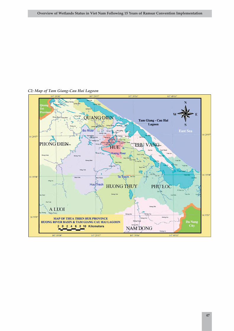
47
Overview of Wetlands Status in Viet Nam Following 15 Years of Ramsar Convention Implementation
C2: Map of Tam Giang-Cau Hai Lagoon
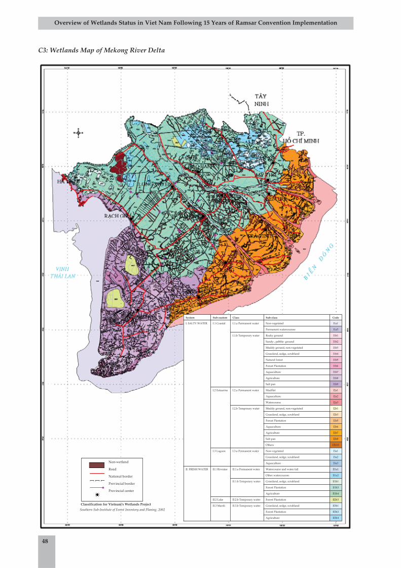
C3: Wetlands Map of Mekong River Delta
48
Overview of Wetlands Status in Viet Nam Following 15 Years of Ramsar Convention Implementation
System Sub-sustem Class Sub-class Code
I. SALTY WATER I.1 Coastal I.1.a Permanent water Non-vegetated I1a1
Permanent watercourese I1a5
I.1.b Temporary water Rocky ground I1b1
Sandy-, pebble- ground I1b2
Muddy ground, non-vegetated I1b3
Grassland, sedge, scrubland I1b4
Natural forest I1b5
Forest Plantation I1b6
Aquaculture I1b7
Agriculture I1b8
Salt pan I1b9
I.2 Estuarine I.2.a Permanent water Mudflat I2a1
Aquaculture I2a2
Watercourse I2a3
I.2.b Temporary water Muddy ground, non-vegetated I2b1
Grassland, sedge, scrubland I2b3
Forest Plantation I2b5
Aquaculture I2b6
Agriculture I2b7
Salt pan I2b8
Others I2b10
I.3 Lagoon I.3.a Permanent water Non-vegetated I3a1
Grassland, sedge, scrubland I3a2
Aquaculture I3a3
II. FRESH WATER II.1 Riverine II.1.a Permanent water Watercourse and water fall II1a1
Other watercourses II1a2
II.1.b Temporary water Grassland, sedge, scrubland II1b1
Forest Plantation II1b3
Agriculture II1b4
II.2 Lake II.2.b Temporary water Forest Plantation II2b3
II.3 Marsh II.3.b Temporary water Grassland, sedge, scrubland II3b1
Forest Plantation II3b3
Agriculture II3b4
Classification for Vietnam's Wetlands Project
Southern Sub-Institute of Forest Inventory and Planing, 2002
Non-wetland
Road
National border
Provincial border
Provincial center

49
Overview of Wetlands Status in Viet Nam Following 15 Years of Ramsar Convention Implementation
Wetland Sites of Biodiversity and Environmental Value in Viet Nam(December 1999)
Appendix D:
Wetland Sites of Biodiversity andEnvironmental Value in Viet Nam
No Name ProvinceArea
(ha)Coordinates Characteristics
Recognised
by the
Vietnamese
Government
1. Hoa Binh Lake Hoa Binh 72,800 20000' - 21030'103000' - 106000'
Reservoir
2. Ba Be Lake Bac Can 450 22024' 105037' Natural reservoir X3. Thac Ba Lake Yen Bai 19,000 21041' - 22005'
104045' - 105003'Reservoir
4. Nui Coc Lake ThaiNguyen
2,600 21033' - 21037'105046'
Reservoir with migrant birds
5. Chu Lake Vinh Phuc 300 22024' 105037' Natural reservoir withwaterbirds
6. Chinh CongLake
Vinh Phuc 400 21031' 105005' Freshwater reservoir
7. Vac Swamp Vinh Phuc 250 21018' 105036' Natural swamp
8. Cam Son Lake Bac Giang 2,620 21032' 106034' Reservoir with migrantwaterbirds
9. Dong Mo, Ngai Son Lake
Ha Tay 900 21005' 105027' Reservoir with migrantwaterbirds
10. Suoi Hai Lake Ha Tay 1,200 21007' - 21025'105022' - 105025'
Artificial reservoir withmigrant birds
11. West Lake Ha Noi 526 21004' 105050' Natural reservoir with migrantbirds
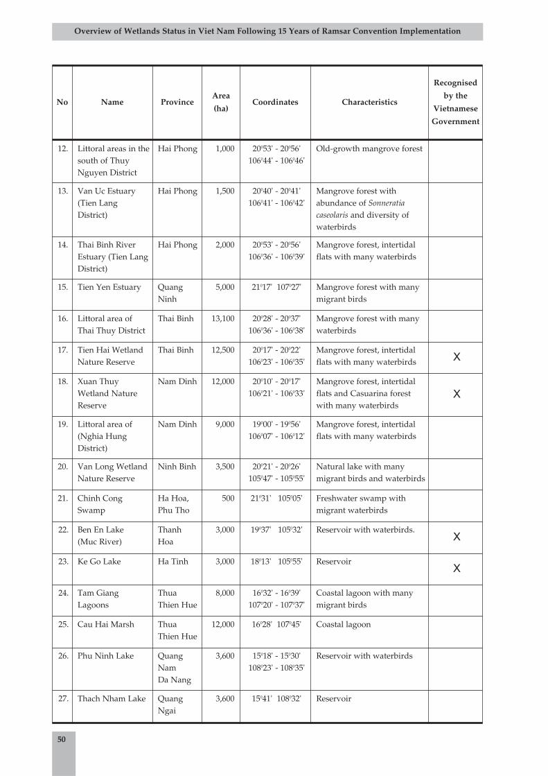
50
Overview of Wetlands Status in Viet Nam Following 15 Years of Ramsar Convention Implementation
No Name ProvinceArea
(ha)Coordinates Characteristics
Recognised
by the
Vietnamese
Government
12. Littoral areas in thesouth of ThuyNguyen District
Hai Phong 1,000 20053' - 20056'106044' - 106046'
Old-growth mangrove forest
13. Van Uc Estuary(Tien LangDistrict)
Hai Phong 1,500 20040' - 20041'106041' - 106042'
Mangrove forest withabundance of Sonneratiacaseolaris and diversity ofwaterbirds
14. Thai Binh RiverEstuary (Tien LangDistrict)
Hai Phong 2,000 20053' - 20056'106036' - 106039'
Mangrove forest, intertidalflats with many waterbirds
15. Tien Yen Estuary QuangNinh
5,000 21017' 107027' Mangrove forest with manymigrant birds
16. Littoral area ofThai Thuy District
Thai Binh 13,100 20028' - 20037'106036' - 106038'
Mangrove forest with manywaterbirds
17. Tien Hai WetlandNature Reserve
Thai Binh 12,500 20017' - 20022'106023' - 106035'
Mangrove forest, intertidalflats with many waterbirds X
18. Xuan ThuyWetland NatureReserve
Nam Dinh 12,000 20010' - 20017'106021' - 106033'
Mangrove forest, intertidalflats and Casuarina forestwith many waterbirds
X
19. Littoral area of(Nghia HungDistrict)
Nam Dinh 9,000 19000' - 19056'106007' - 106012'
Mangrove forest, intertidalflats with many waterbirds
20. Van Long WetlandNature Reserve
Ninh Binh 3,500 20021' - 20026'105047' - 105055'
Natural lake with manymigrant birds and waterbirds
21. Chinh CongSwamp
Ha Hoa,Phu Tho
500 21031' 105005' Freshwater swamp withmigrant waterbirds
22. Ben En Lake (Muc River)
ThanhHoa
3,000 19037' 105032' Reservoir with waterbirds.X
23. Ke Go Lake Ha Tinh 3,000 18013' 105055' ReservoirX
24. Tam GiangLagoons
ThuaThien Hue
8,000 16032' - 16039'107020' - 107037'
Coastal lagoon with manymigrant birds
25. Cau Hai Marsh ThuaThien Hue
12,000 16028' 107045' Coastal lagoon
26. Phu Ninh Lake QuangNam Da Nang
3,600 15018' - 15030'108023' - 108035'
Reservoir with waterbirds
27. Thach Nham Lake QuangNgai
3,600 15041' 108032' Reservoir
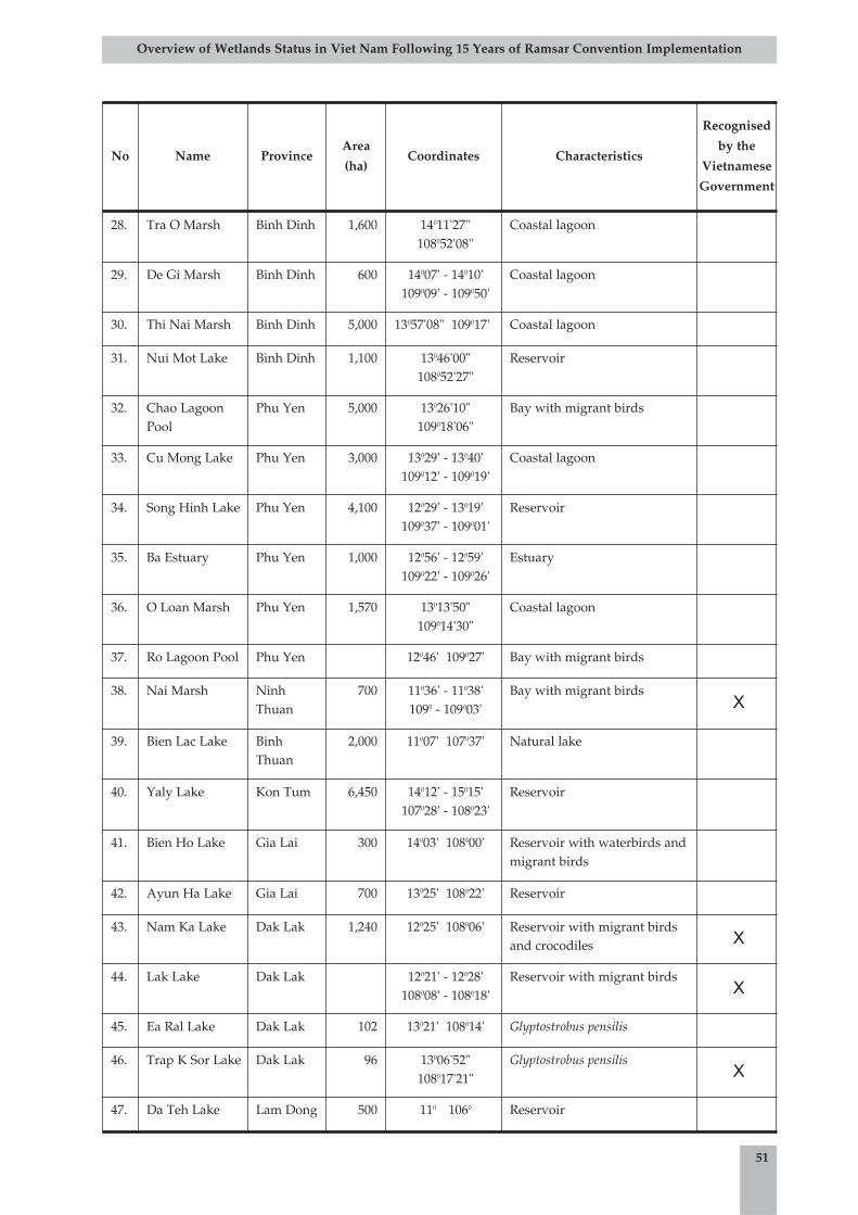
51
Overview of Wetlands Status in Viet Nam Following 15 Years of Ramsar Convention Implementation
No Name ProvinceArea
(ha)Coordinates Characteristics
Recognised
by the
Vietnamese
Government
28. Tra O Marsh Binh Dinh 1,600 14011'27''108052'08''
Coastal lagoon
29. De Gi Marsh Binh Dinh 600 14007' - 14010'109009' - 109050'
Coastal lagoon
30. Thi Nai Marsh Binh Dinh 5,000 13057'08" 109017' Coastal lagoon
31. Nui Mot Lake Binh Dinh 1,100 13046'00"108052'27"
Reservoir
32. Chao LagoonPool
Phu Yen 5,000 13026'10"109018'06"
Bay with migrant birds
33. Cu Mong Lake Phu Yen 3,000 13029' - 13040'109012' - 109019'
Coastal lagoon
34. Song Hinh Lake Phu Yen 4,100 12029' - 13019'109037' - 109001'
Reservoir
35. Ba Estuary Phu Yen 1,000 12056' - 12059'109022' - 109026'
Estuary
36. O Loan Marsh Phu Yen 1,570 13013'50"109014'30"
Coastal lagoon
37. Ro Lagoon Pool Phu Yen 12046' 109027' Bay with migrant birds
38. Nai Marsh NinhThuan
700 11036' - 11038'1090 - 109003'
Bay with migrant birdsX
39. Bien Lac Lake BinhThuan
2,000 11007' 107037' Natural lake
40. Yaly Lake Kon Tum 6,450 14012' - 15015'107028' - 108023'
Reservoir
41. Bien Ho Lake Gia Lai 300 14003' 108000' Reservoir with waterbirds andmigrant birds
42. Ayun Ha Lake Gia Lai 700 13025' 108022' Reservoir
43. Nam Ka Lake Dak Lak 1,240 12025' 108006' Reservoir with migrant birdsand crocodiles X
44. Lak Lake Dak Lak 12021' - 12028'108008' - 108018'
Reservoir with migrant birdsX
45. Ea Ral Lake Dak Lak 102 13021' 108014' Glyptostrobus pensilis
46. Trap K Sor Lake Dak Lak 96 13006'52"108017'21"
Glyptostrobus pensilisX
47. Da Teh Lake Lam Dong 500 110 1060 Reservoir
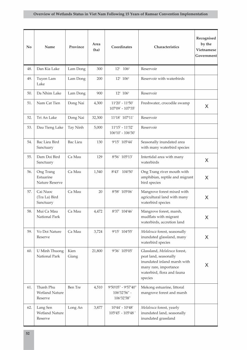
52
Overview of Wetlands Status in Viet Nam Following 15 Years of Ramsar Convention Implementation
No Name ProvinceArea
(ha)Coordinates Characteristics
Recognised
by the
Vietnamese
Government
48. Dan Kia Lake Lam Dong 300 120 1060 Reservoir
49. Tuyen LamLake
Lam Dong 200 120 1060 Reservoir with waterbirds
50. Da Nhim Lake Lam Dong 900 120 1060 Reservoir
51. Nam Cat Tien Dong Nai 4,300 11020' - 11050'107009' - 107035'
Freshwater, crocodile swampX
52. Tri An Lake Dong Nai 32,300 11018' 107011' Reservoir
53. Dau Tieng Lake Tay Ninh 5,000 11015' - 11032'106010' - 106030'
Reservoir
54. Bac Lieu BirdSanctuary
Bac Lieu 130 9015' 105044' Seasonally inundated areawith many waterbird species
55. Dam Doi BirdSanctuary
Ca Mau 129 8056' 105013' Intertidal area with manywaterbirds X
56. Ong TrangEstuarineNature Reserve
Ca Mau 1,540 8043' 104050' Ong Trang river mouth withamphibian, reptile and migrantbird species
X
57. Cai Nuoc (Tra La) BirdSanctuary
Ca Mau 20 8058' 105006' Mangrove forest mixed withagricultural land with manywaterbird species
X
58. Mui Ca MauNational Park
Ca Mau 4,472 8037' 104046' Mangrove forest, marsh,mudflats with migrantwaterbirds, accretion land
X
59. Vo Doi NatureReserve
Ca Mau 3,724 9015' 104055' Melaleuca forest, seasonallyinundated glassland, manywaterbird species
X
60. U Minh ThuongNational Park
KienGiang
21,800 9036' 105005' Glassland, Melaleuca forest,peat land, seasonallyinundated inland marsh withmany rare, importancewaterbird, flora and faunaspecies
X
61. Thanh PhuWetland NatureReserve
Ben Tre 4,510 9050'05" - 9057'40"106032'56" -106032'58"
Mekong estuarine, littoralmangrove forest and marsh
62. Lang SenWetland NatureReserve
Long An 3,877 10044' - 10048'105045' - 105048 '
Melaleuca forest, yearlyinundated land, seasonallyinundated grassland
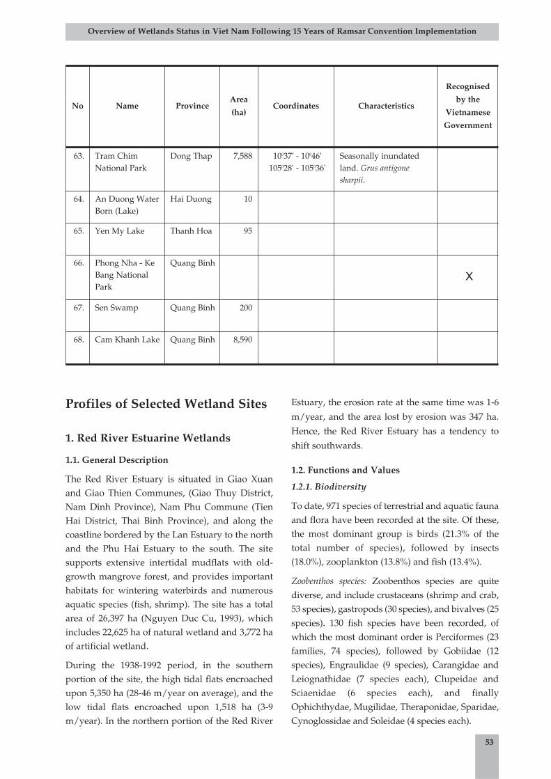
Profiles of Selected Wetland Sites
1. Red River Estuarine Wetlands
1.1. General Description
The Red River Estuary is situated in Giao Xuanand Giao Thien Communes, (Giao Thuy District,Nam Dinh Province), Nam Phu Commune (TienHai District, Thai Binh Province), and along thecoastline bordered by the Lan Estuary to the northand the Phu Hai Estuary to the south. The sitesupports extensive intertidal mudflats with old-growth mangrove forest, and provides importanthabitats for wintering waterbirds and numerousaquatic species (fish, shrimp). The site has a totalarea of 26,397 ha (Nguyen Duc Cu, 1993), whichincludes 22,625 ha of natural wetland and 3,772 haof artificial wetland.
During the 1938-1992 period, in the southernportion of the site, the high tidal flats encroachedupon 5,350 ha (28-46 m/year on average), and thelow tidal flats encroached upon 1,518 ha (3-9m/year). In the northern portion of the Red River
Estuary, the erosion rate at the same time was 1-6
m/year, and the area lost by erosion was 347 ha.
Hence, the Red River Estuary has a tendency to
shift southwards.
1.2. Functions and Values
1.2.1. Biodiversity
To date, 971 species of terrestrial and aquatic faunaand flora have been recorded at the site. Of these,the most dominant group is birds (21.3% of thetotal number of species), followed by insects(18.0%), zooplankton (13.8%) and fish (13.4%).
Zoobenthos species: Zoobenthos species are quitediverse, and include crustaceans (shrimp and crab,53 species), gastropods (30 species), and bivalves (25species). 130 fish species have been recorded, ofwhich the most dominant order is Perciformes (23families, 74 species), followed by Gobiidae (12species), Engraulidae (9 species), Carangidae andLeiognathidae (7 species each), Clupeidae andSciaenidae (6 species each), and finallyOphichthydae, Mugilidae, Theraponidae, Sparidae,Cynoglossidae and Soleidae (4 species each).
53
Overview of Wetlands Status in Viet Nam Following 15 Years of Ramsar Convention Implementation
No Name ProvinceArea
(ha)Coordinates Characteristics
Recognised
by the
Vietnamese
Government
63. Tram ChimNational Park
Dong Thap 7,588 10037' - 10046'105028' - 105036'
Seasonally inundatedland. Grus antigonesharpii.
64. An Duong WaterBorn (Lake)
Hai Duong 10
65. Yen My Lake Thanh Hoa 95
66. Phong Nha - KeBang NationalPark
Quang Binh
X
67. Sen Swamp Quang Binh 200
68. Cam Khanh Lake Quang Binh 8,590
Terrestrial species: The two most dominant groupsare birds with 113 migratory species (54.1 %) andinsects, including Lepidoptera (13 families, 41species), Coleoptera (13 families, 40 species),Diptera (5 families, 21 species), Hemiptera (10families, 18 species), and Hymenoptera (9 families,15 species). The level of diversity of other groups isvery low.
Plants: 12 mangrove species and 31 mangrove-dependent species (from 29 families) formimportant vegetation at the site. Mangrove forestsdo not only provide coastal protection but also areimportant habitats for congregations of birds andfishes. The dominant plant species includeAvicennia lantana, Excoecaria agallocha, Aegicerascorniculata, Bruguiera gymnorrhiza, Kandelia candel,and Sonneratia caseolaris.
1.2.2. Functions, values and significance
The site has the function of maintaining anddeveloping mangrove ecosystems, resources andenvironment, aquaculture and fisheries. Themangroves form forests and provide a number ofsignificant indirect values in microclimateregulation, pollution absorption, environmentalself-cleaning, maintenance of aquatic geneticresources, and regulation of sedimentation to formtidal flats.
Some flagship species at the site include 'Ngan'grass (Scirpus kimsonensis), and waterbird speciessuch as the Common Teal (Anas crecca), NorthernShoveler (Anas clypeata), Eurasian Wigeon (Anaspenelope), Northern Pintail (Anas acuta), Garganey(Anas querquedula), Little Egret (Egretta garzetta),Grey Heron (Ardea cinerea), Black-tailed Godwit(Limosa limosa), Spotted Redshank (Tringaerythropus), and Common Redshank (Tringatotanus).
The site supports a large fishing ground for thesmall fishery industry, and a large area of bivalveproduction grounds with a number of species ofhigh economic value such as Meretrix meretrix, M.lusoria, Ostrea rivularis, Anadana granosa, A. antipa,Cyclina sinesis, Solen spp., Lingula anatina, Sinovaculaconstricta, and Glaucomia chinensis. The bivalveproduction ground covers an area ofapproximately 15,000 ha in Thu and Vanh Islands(Thai Binh Province), and Ngan and Lu Islands
(Nam Dinh Province), with an annual yield ofapproximately 10,000-15,000 tons.
The Red River Estuary provides breeding andnursery grounds for many fish and molluscspecies, as well as passage and wintering habitatsfor a number of migratory birds in their winterflyway from north to south (storks, cranes, ducks,geese, gulls, etc.). Every year, at least 8 billionprawns of the Penaeidae family are bred naturallyin the site (Vu Trung Tang, 1994). The estuary isalso a gateway along the sea-river migratory pathof fish species such as Clupanodon thrissa (sardine)and Macrura reevesii (alose) from the Gulf ofTonkin to fresh watercourses for breeding. Finally,the site is an entrance for marine animals travellinginland to contribute to the creation of freshwateranimal communities.
1.3. Current Uses
Major activities at the site include:
• Agricultural production: Agriculturalproduction is concentrated in Nam Phu,Nam Hung and Nam Thinh Communes.
• Aquacultural and fishery activities: 40% ofthe local labour force is involved in theseactivities and this rate is continuallyincreasing with the recent district policy ofaquacultural industry expansion.
• Forestry production: Another large portionof the local labour force is involved inforestry. With funding from theGovernment and Danish Red Cross, 3,000 haof mangrove were planted and themanagement of this area was graduallyallocated to local households.
• Other services: Other services includeseafood processing in Nam Thinh Commune,provision of aquacultural foodstuffs, fishingequipment, ecotourism services, etc.
1.4. Threats
At present, the Red River Estuarine Wetland isfaced with the following major threats:
• Population pressure: High population isleading to over-exploitation and depletionof wetland resources.
54
Overview of Wetlands Status in Viet Nam Following 15 Years of Ramsar Convention Implementation
• Agricultural activities: Overuse of chemicalfertilisers and pesticides is leading topollution of land and water sources,threatening the habitats of numerous plantand animal species.
• Aquacultural and fishery activitiesinvolving destructive practices.
• Insufficiency and weakness of themanagement system, and of mechanisms,practices, regulations and policies.
• Natural disasters (7-10 storms/typhoonsevery year).
1.5. Solutions for Wetland Management andConservation
1.5.1. Management institutions
The core zone of Xuan Thuy Ramsar Site is underthe management of the National Park'sManagement Board. The buffer zone communesmanage the tidal flats following an identifiedboundary system, the Management Board of ConNgan Project manages activities in some mudflatsin the buffer zone, and the Red Cross manages thenewly planted mangrove areas.
The southern portion of Ba Lat Estuary is managedby different agencies of Nam Dinh Province andGiao Thuy District including the Division ofAgriculture and Rural Development, the Divisionof Natural Resources and Environment, and theDivision of Transportation. On the other hand, thenorthern portion of Lat Estuary is managed byagencies of Thai Binh Province and Tien HaiDistrict including the Division of Agriculture andRural Development, the Division of Fisheries, theDivision of Natural Resources and Environment,the Division of Transportation, and Viet-MyCompany (which manages approximately 2,000 haof wetlands for the development of shrimp ponds,which includes some areas of mangrove forest).The linkages and institutional arrangementsbetween agencies are not clear; there are overlapsin their management activities and conflicts intheir interests and authority.
1.5.2. Scientific research
A large number of scientific studies have beenundertaken in this site by different national andinternational institutions such as VEPA (1992-
2002), and several NGOs including the Centre forResearch and Development (CERED), MangroveEcosystem Research Centre (MERC), Centre forNatural Resources and Environmental Studies(CRES), IUCN, WWF, Birdlife International, theNetherlands Foundation for the Advancement ofTropical Research (WOTRO), Hanoi NationalUniversity, and others. The Ramsar NatureReserve Management Board (recently changed toXuan Thuy National Park Management Board)also collaborated with a number of researchinstitutes to implement a number of scientificstudies in different subject areas in the site. Thesestudies have contributed to the development ofpolicy for local authorities to manage the site aswell as the mutual impacts between people and theenvironment.
1.5.3. Conservation measuresa.
a. Conservation situation: The Red River Estuary isone of only two Ramsar sites in Viet Nam, and isalso gazetted as a national park. Therefore, it hasreceived the attention of many scientists andinternational organisations such as IUCN andBirdlife International to support the ManagementBoard in natural resources management andconservation, environmental protection andsustainable socio-economic development.
b. Conservation education: Local and nationalworkshops and training courses have been held topromote conservation at the site. Local authoritieshave implemented some training and educationalprogrammes to raise local awareness of theimportance of wetlands to the development of thelocal economy and nature conservation.
2. Tam Giang-Cau Hai Lagoon
2.1. General Description
The Tam Giang-Cau Hai Lagoon complex lies inthe coastal zone of Thua Thien Hue Province, andstretches from the O Lau River mouth to the footof Vinh Phong Mountain. The complex opens tothe sea through two mouths at Thuan An and TuHien. In total, the complex covers 216 km2,forming the largest lagoon system in Viet Nam(approximately 40% of the total lagoon area of thecountry). The lagoon lies in Phu Vang, HuongTra, Quang Dien and Phong Dien Districts ofThua Thien Hue Province. The natural resources
55
Overview of Wetlands Status in Viet Nam Following 15 Years of Ramsar Convention Implementation
of the lagoon are used to support the livelihoodsof local communities.
2.2. Functions and Values
2.2.1. Biodiversity
Phytoplankton: 357 Phytoplankton species of 6orders were recorded. Of them, Cyanophyta orderhas 19 species (accounting for 5.3% of the totalnumber of species), Heterokontophyta has 241species (67.5%), Chlorophyta has 3 species (0.8%),Dinophyta has 72 species (20.2%), Euglenophytahas 2 species (0.6%), and Chlorophyta has 20species (5.6%).
Macrophyte: 16 vascular plant species of 11 generaand 6 families were recorded. Of them, 3 speciesbelong to the Magnoliopsida class (accounting for18.75% of the total number of species) and 13species belong to the Liliopsida class (81.25%).
Aquatic higher plants: The number of species isrelatively low, however, the living mass andvolume of the plants are both high. Abundantspecies are Valisneria spiralis with a living mass of3.5 kg of fresh plant per square metre, Najas indica(2.8 kg/m2), Halophila beccarii (2.5 kg/m2), andCymodocea rotundata (1.8 kg/m2).
Zooplankton: Average density is 3,115organisms/m2, and 34 species have beenrecorded. Of them, Copepoda is most dominant(28 species of 12 families), followed byDiaptomidae (1 species), Pseudodiaptomidae (5species), Paracalanidae (1 species), andPlntellidae (4 species). The Copepoda speciescontribute to 90% of the living volume ofzooplankton, the remainder of which is theCladocera species.
Zoobenthos: Four groups have been recorded. ThePolychaeta class of the Anelida division is the mostdiverse with 25 species (38.5% of the total numberof species), followed by the Mollusca division with24 species (36.9%), Crustacea class with 15 species(23.1%), and Insecta class with 1 species (1.5%).The mean density is 1,384 organisms/m2,equivalent to 133 g/m2. In this living mass, thecrustacean group is the most dense with 660organisms/m2 (47.70%), followed by Polychaetewith 561 organisms/m2 (40.52%) and molluscswith 163 organisms/m2 (11.78%).
Fish: 171 species have been identified. Of them, thePerciformes order is most abundant with 97
species (56.73% of total species), followed by theMugiliformes order with 14 species (8.19%), andthe Clupeiformes order with 10 species (5.58%).
Birds: 73 species of 53 genera, 29 families, and 11orders were recorded. Of them, 39 are residentspecies (53.43%) and 34 are migrant species(46.57%). 30 bird species present are ranked asstrictly protected by the EC, and one species is listedin the Viet Nam Red List of Endangered Species.
2.2.2. Values of the lagoons
Lagoon products such as fish, crabs, shrimps,bivalves, and marine plants are importantresources not only for local consumption but alsofor export with high economic value. The total fishyield of the lagoon complex reaches 3,600tons/year. Gracilaria algae is also a valuableaquatic product in the site.
2.3. Current Uses
The lagoon complex is bordered by a large area ofagricultural land consisting of approximately37,000 ha of rice paddies. There are over 54,000 haof agricultural land in the area. However, foodproductivity is low at approximately 1.5tons/year (Tran Duc Thanh et al. 1999).Aquacultural and fishery activities are welldeveloped with about 3,000 ha of aquaculturalland (9.3% of total production land area). TheVinh Hung, Vinh My, Vinh Giang, Vinh Hai andVinh Hien Communes are famous for theiragricultural and aquacultural industries.
2.4. Threats
Increasing population, coupled with increasingdemand for economic development, is leading tothe over-exploitation of aquatic products (forexample, the fish yield reduced significantly from4,515 tons/year in 1973 to 2,700 tons/year in 1997).Destructive fisheries activities, poorly plannedaquacultural development, and hunting ofwaterbirds are activities threatening theenvironment of the lagoon. Irrigationalinfrastructure, such as the Thao Long Barrage andthe dike system in Phong Dien District, is stronglyimpacting the circulation of sediments, preventingthe migration of aquatic species, and leading tohabitat loss and fragmentation. In addition, indirectthreats on the wetland site are posed by theweaknesses of the management and legalframework and by natural disasters.
56
Overview of Wetlands Status in Viet Nam Following 15 Years of Ramsar Convention Implementation
2.5. Solutions for Wetland Management andConservation
2.5.1. Management institutions
This wetland site is under the management of thePeople's Committees of Quang Dien, Huong Tra,Phu Vang, Phong Dien, and Phu Loc (Thua ThienHue Province) and their coastal communes. Variousprovincial agencies manage specific activities in thesite, including the Department of Agriculture andRural Development (DARD), the Department ofNatural Resources and Environment (DONRE), theDepartment of Fisheries (DOFI), and theDepartment of Transportation.
2.5.2. Conservation measures
To date, no biodiversity conservation plan is beingimplemented in the Tam Giang-Cau Hai Lagooncomplex. However, a number of scientific researchprojects have been implemented by national andministerial institutes, international organisations(UNDP, IUCN) and foreign governments (Canada,Netherlands). Some national and local projectshave made initial assessments of the economicalpotential and values of this wetland site.
3. Mui Ca Mau Wetland
3.1. General Description
Mui Ca Mau Wetland is situated at thesouthernmost tip of Viet Nam in Ngoc HienDistrict, Ca Mau Province, about 100 km south ofCa Mau Town. The wetland ecosystems of this siteare typical for the coastal ecological zone with largeareas of tidal mudflats inhabited by a number ofmangrove-dependent organisms. The site has animportant role in biodiversity conservation andmaintenance of the ecological balance. The site hasa total area of 41,862 ha of various wetland typesincluding shallow seas of depths not exceeding 6 mat low tide with sandy and mudflats, sandybeaches, sandy bars and capes, intertidal sandy andmudflats, and swampy mangroves.
3.2. Functions and Values
3.2.1. Biodiversity
Mui Ca Mau supports a diversity of fauna andflora. Thirteen mammal species from nine familieswere recorded including two species on the IUCNRed List of Endangered Species: the Long-tailMacaque (Macaca fasciculalis) and Silvered Langur
(Trachypithecus cristatus) as well as four species onViet Nam's Red List. 74 bird species from 23families were recorded, including five species onthe IUCN Red List and seven species on VietNam's Red List. 28 migratory bird species wererecorded, of which many were rare migrantsincluding the Chinese Egret (Egretta eglophotes), theSpot-billed Pelican (Pelicanus philippensis), and thePainted Stork (Mycteria leucocephala). Seventeenreptile species from nine families were recorded, ofwhich two species were listed in IUCN Red List,and six species were listed in Viet Nam's Red List.Five amphibian species from three families wererecorded. The vascular plant flora of the siteconsists of all dominant mangrove species of VietNam. 22 plant species were recorded in Ong TrangIsland. The most dominant plant communities areRhizophora spp., Kadelia spp., and Avicennia spp.
3.2.2. Cultural and social values
Mui Ca Mau Wetland is important for supportingthe small fishery industry, biodiversityconservation, dynamic landform stabilisation andcoastal protection.
The wetland provides a series of products for thelivelihoods of local people including medicine andfood such as fishes and shrimps. In addition, themangrove ecosystems of the site are touristattractions for recreational purposes as well as fornature education.
3.3. Current Uses
Mui Ca Mau National Park has been divided intothe following functional zones: 12,203 ha of strictlyprotected area (5,998 ha of forest land, 6,110 ha oftidal flats, 95 ha of other land), 2,859 ha ofecological rehabilitation area, 200 ha ofadministrative and service area; and 26,000 ha ofmarine protected area. There are 6,000 ha ofnatural mangrove and 44,291 ha of mangroveplantation in Ngoc Hien District (Vu Trung Tang,2001). This area has been exploited foraquacultural expansion, timber and firewoodexploitation and fisheries. The inland area wasconverted for cultivation of agricultural plants andindustrial trees.
3.4. Threats
Mui Ca Mau National Park faces threats fromaquacultural development, over-fishing, and over-
57
Overview of Wetlands Status in Viet Nam Following 15 Years of Ramsar Convention Implementation
exploitation of natural resources. In addition,increasing population and economic developmentdemands and illegal immigration have alsocontributed to changes in the ecologicalcharacteristics of the site in recent years.
At present, the site is also threatened by pollutantsfrom the wastewater of agricultural activities inNgoc Hien and neighbouring districts. With therecent flux of industrialisation and modernisationin Ca Mau Province, industrial pollution is posingnew challenges for site conservation.
Illegal exploitation of natural resources, especiallyby destructive fishing methods such as dynamitefishing or the use of small-grid nets, has shown anincreasing trend in recent years. The illegalhunting of waterbirds is still observed in the park.Although park managers have made many effortsfor conservation of the site, a lack of manpowerand other resources to prevent illegal activitiesmeans that conservation interventions have notbeen effective.
3.5. Solutions for Wetland Management andConservation
3.5.1. Management institutions
The wetland is under the management of theDistrict People's Councils of Ngoc Hien and DatMui, the Management Board of Mui Ca MauNational Park, and the Commune People's Councilsof Dat Mui, Vien An (Ngoc Hien District), Dat Moi(Dat Mui District). Various provincial agenciesmanage specific activities in the site, includingDARD, DONRE, DOFI, and the Department ofTransportation. The Provincial Forest ProtectionDepartment is responsible for the management andprotection of the mangrove forests in the site.
3.5.2. Conservation measures
a. Implemented measures: A number ofenvironmental and natural resource managementactivities were proposed in the investment plan forthe establishment, protection and development ofthe Mui Ca Mau National Park and in the projectProtection and development of the coastalwetlands in the east of the Mekong Delta, VietNam. These activities include forest managementand protection, forest rehabilitation on themudflats, awareness-raising and education onforest and wetland ecosystems, boundarydemarcation, setting up a signboard of the Park's
regulations, construction of observation towersand guard stations, provision of essentialequipment, setting up the concrete fences at theends of the main channels, and prevention oferosion in the East Sea.
b. Proposed measures: Proposed measures that havenot yet been implemented include research andmonitoring of wildlife populations, conservationresearch on marine species, policy setting formarine management and conservation,strengthening of management capacity, andtraining to increase the knowledge and skill sets ofmanagement.
c. Research implemented: Research and piloting ofmodels for best aquacultural and reforestationpractices have been conducted at the site. Manynatural plant products were also studied and theiruses tested.
4. Ba Be Lake
4.1. General Description
Ba Be Lake is a natural lake situated in a limestonearea and created by karst tectonics. The lake isapproximately 500 ha in area and located in Ba BeNational Park, Ba Be District, Bac Kan Province. BaBe Lake is surrounded by a series of limestonemountains elevated at 570-893 m above sea level.The lake is connected to Nang River by a streamthat helps to regulate its water level. There are anumber of limestone caves at the site, the mostfamous of which is the Puong Cave, where theNang River flows through a limestone mountain.
4.2. Functions and Values
4.2.1. Biodiversity
The unique and important features of the fauna ofthe park are presented by the occurrences of theFrancois Langur (Semnopithecus francoisi), Owston'sPalm Civet (Hemigalus owstoni), and especially theTonkin Snub-nosed Monkey (Pithecus avunculus), aprimate species that was believed to be extinctbefore rediscovery in Na Hang Nature Reserve in1992. In addition, one endemic and globallythreatened amphibian species, the VietnameseSalamander (Paramesotriton deloustali), wasrecorded in the south of the park.
58
Overview of Wetlands Status in Viet Nam Following 15 Years of Ramsar Convention Implementation
59
Overview of Wetlands Status in Viet Nam Following 15 Years of Ramsar Convention Implementation
The most notable plant species recorded in Ba BeNational Park include Annamocarya sinensis,Burretiodendron tonkinense and Calocedrus macrolepis.
In Ba Be National Park and surrounding areas, 70reptile and amphibian species have been recorded,eleven of which were ranked as globallythreatened, including the Big-headed Turtle(Platysternon megacephalum), the Black-breasted LeafTurtle (Geoemyda spengleri), the Keeled Box Turtle(Pyxidea mouhoti), the Chinese Soft-shell Turtle(Pelodiscus sinensis), and the VietnameseSalamander (Paramesotriton deloustali). There are 370bird species recorded for the site. The 94 mammalspecies recorded include eighteen species listed inthe 2004 IUCN Red List of Globally ThreatenedSpecies. Ba Be is considered a natural lake thatsupports the most abundant fish fauna in Viet Nam.87 fish species of 61 genera, 17 families and 5 ordershave been recorded in the lake (Nguyen TrongHiep, Nguyen Huu Duc, 2003).
4.2.2. Cultural and social values
a. Local population and ethnic minorities: The localpopulation includes Tay people (inhabiting theriverbanks and lakesides and representing 44% ofthe population), H'mong people (inhabiting themountainous areas and representing 54% of thepopulation), and Dao, Nung and Kinh ethnicgroups (representing 2% of the population). Eachethnic group has their own culture and farmingpractices. The Tay people often live in woodenstilt houses and they are experts in fishing andtextiles. The H'mong people often practice shiftingcultivation and are experts in wildlife hunting.
b. Agricultural production: Both paddy field andterrace rice farming are practiced in the area. Thelocal average income is 298 kg rice per person peryear. Terrace rice fields are mostly mono-crops,and other food plants are cultivated in the alluvialplains along the streams, rivers and lakesides. Dueto frequent alluvial deposition, this area forsecondary crops is also solely for mono-crops andprovides low productivity.
c. Forestry production: From 1994-2001, 3,000 ha offorest land in the ecological rehabilitation zonewere contracted to 592 local households forrehabilitation and plantations. This providedalternative livelihoods and income for localpeople, contributed to raising awareness on the
environment and nature conservation, andreduced human pressures on the core zone of thenational park.
d. Animal husbandry: Animal husbandry has yet tobe developed in the region. The major domesticanimal species are cow, buffalo, goat, pig andchicken. Animals are kept in the traditional waywith little attention paid to veterinaryrequirements, and the revenue from husbandry istherefore not high. Because of insufficientinvestment in animal husbandry, the growth rateof domestic animals is low and these animals areonly for domestic use.
e. Tourism and trade: The community-basedecotourism model (in which tourists stay in thestilt houses of the Tay people) is effectivelyrunning. It is not only an alternative income sourcefor local households but also helps to raise localawareness about environmental protection.
4.3. Current Uses
The national park has a total area of 10,048 ha, ofwhich 7,303 ha is forest land (73% of total area,including 4,058 ha of undisturbed forests, 2,690 haof disturbed forests and 555 ha of generatingforests), 448 ha is agricultural land (4%), 120 ha areupland fields, and 506 ha are water surfaces.
During the ten years since national parkestablishment, the forest areas were protected andhave gradually expanded. In particular, the totalarea of good forest has increased from 1,073 ha to4,058 ha, including undisturbed forests and well-rehabilitated forests. However, there are 1,719 ha ofbare land in the park in which suitable forestrymeasures for rehabilitation should be applied.
4.4. Threats
The main threats to biodiversity in the site arehunting, fishing, logging, forest clearance forshifting cultivation, increasing sedimentation inthe lake (due to forest destruction in the rivercatchments), and insufficient enforcement ofprotected area regulations.
In recent years, national park rangers haveinvestigated and prosecuted over 5,000 cases ofillegal logging and hunting, and have confiscatedhundreds of cubic metres of illegal wood and over400 guns. In particular, in only the five first monthsof 2004, there were 100 violations, of which the
60
Overview of Wetlands Status in Viet Nam Following 15 Years of Ramsar Convention Implementation
most common was the transportation of the illegalforest products (56 violations).
Every month, at least 1-2 incidences of dynamiteor electric fishing in Ba Be Lake occur.Encroachment on forest land for cultivation isincreasing every year.
The development of tourism services isunregulated and poses adverse impacts on thenational park from an increasing number ofmotorboats on the lake, causing pollution anddisturbances to wildlife populations.
4.5. Solutions for Wetland Management andConservation
4.5.1. Management institutions
Ba Be National Park is under the management ofthe Bac Kan Provincial People's Committee via theProvincial DARD and DOFI.
4.5.2. Conservation measures
a. Forest management, protection anddevelopment
Organisation and management: The National ParkManagement Board was established and currentlycomprises a Directorate Board and functionaldivisions, Forest Protection Section and ten guardstations. Additional guard stations and sub-stations (guard boxes), such as Cao Thuong andKhuoi Luong Guard Stations and Khau Qua, BuocLom, Ban Tau, Ban Lom and Na Han Sub-Stations,have been established in hotspot areas of the park.
Protection: Boundary demarcation has beencompleted. 7,303 ha of forest of the park have beenwell protected (including 3,000 ha protectedthrough forest protection contracts with localhouseholds). 1,443 ha of forested land wereidentified for rehabilitation. A 50-ha botanicalgarden was planted. The area of shiftingcultivation was reduced from 1,553 ha in 1990 to120 ha in 2003. Park managers are also assistinglocal communities to prepare village forestprotection agreements.
b. Infrastructure development
Essential infrastructure of Ba Be National Park hasbeen completed, including 1,175 m2 of housing(offices, dormitories, guest houses, etc.), and about70 km of internal and local roads in the buffer zone
communes. The Management Board is alsorelatively well equipped with two cars, threespeedboats, fifteen motorbikes, computers andother office equipment.
c. Socio-economic stabilisation and development
Aware of the importance of reducing pressuresfrom economic activities on the national park, anumber of projects on socio-economic stabilisationand development have been implemented in thesite in recent years. These projects have assistedpark managers in infrastructure development,community-based ecotourism development,establishment of a Conservation Fund, and themoving of 74 households out of the core zone ofthe park and stabilising their livelihoods.
d. International programmes
The GEF/UNDP-funded Creating Protected Areasfor Resource Conservation using Landscape Ecologyproject was the biggest internationally supportedconservation project implemented in Ba BeNational Park. Other international projects thatwere also implemented in the park included theNetherlands Government-funded projectSustainable Use of Non-timber Forest Products, aHelvetas-funded project that aimed to investigateand analyse the local institutional arrangementsand environmental rights, and projects on thedevelopment policies and rural livelihood systemsin Ba Be District, Bac Kan Province.
e. Proposed measures
Other measures that have been proposed but notyet implemented are to supplement and completethe essential infrastructure for the guard stations,to strengthen community participation in theconservation of the park, and to prepare the WorldNatural Heritage documents for Ba Be NationalPark to submit to UNESCO for its approval.
f. Scientific research
The first mammal surveys in the Ba Be Lake areawere conducted by Dao Van Tien et al. beginningin 1963. To date, a number of studies on differentaspects have been done for the site. They include aseries of fauna and flora monographs compiled bythe Hanoi National University, the Institute ofEcology and Biological Resources, and the ForestInventory and Planning Institute that aimed to
61
Overview of Wetlands Status in Viet Nam Following 15 Years of Ramsar Convention Implementation
contribute to the preparation of an investment planfor Ba Be National Park.
g. Education
Fifty teachers from local schools were trained inenvironmental education to enable them to teachthe 3,141 pupils in their schools. In collaborationwith the colleges of the Ministry of Agricultureand Rural Development, park managers heldtraining courses on conservation and biodiversitymonitoring skills for protected area managers.
A series of awareness-raising campaigns on forestprotection and environment were organised forover 500 farmer households in Khang Ninh andNam Mau Communes (Ba Be District, Bac KanProvince) and Da Vi Commune (Na Hang District,Tuyen Quang Province). Awareness-raising andenvironmental education materials were producedfor visitors, school pupils and local people. Apainting contest on the forest and environmentaltopics was organised with the participation of over600 students.
5. Con Dao National Park
5.1. General Description
Con Dao National Park is located in Con DaoDistrict, Ba Ria-Vung Tau Province, consisting ofan archipelago with fourteen large and smallislands. Con Son Island is the only inhabited island,with a population of approximately 4,000. Mostisland inhabitants practice coastal fishing,agriculture, small trade, and other services.
The Con Dao marine area is rich in marinebiological resources with high biodiversity valuesand ecosystem diversity (including ecosystems ofmangroves, seagrasses, tidal rock banks, tidalsandy flats, and coral reefs), and supports anumber of endemic species to Viet Nam.
5.2. Functions and Values
5.2.1. Biodiversity
Con Dao National Park supports two mainecosystem types: terrestrial forest ecosystems andmarine and coastal ecosystems. Recent surveysrecorded 882 forest plant species, 144 forest animalspecies, and 1,300 marine species in Con DaoNational Park. Based on data from Hai Phong's
Oceanography Institute, the coastal zone of thepark supports 23 mangrove species, 127 algaespecies, 9 seagrass species, 157 phytoplanktonspecies, 115 zooplankton species, 258 coral species,130 polychaete species, 116 crustacean species, 187mollusc species, 75 echinoderm species and 5species of sea mammals and reptiles.
The mangrove ecosystems are well developedalong the west coasts of Con Son, Hon Ba, Hon BayCanh, Hon Tre Lon, and Hon Cau Islands, formingbeautiful scenery on those islands. The dominantmangrove species include Kandelia candel,Rhizophora apiculata, and Sonneratia ovata. Themangrove ecosystems support a number ofcrustacean and mollusc species such as Ocypodaceratophthalma, Upogebia carcincauda, Thalamitacrenata, Thalamita danae, Planaxis sulcatus, Cerithiumechinatum, C. nodulosum, and C. asperum.
The seagrass vegetation covers almost the entirebed of the Con Son Gulf and provides habitats forother marine species. Of them, the most famous isthe Sea-cow (Dugong dugong), and other seagrass-dependent species including sea snails such asCerithidae cingulata, Architectonica perspectiva,Cerithium tenuifilosum, and Nassaruis goudiosus, andbivalves such as Paphia malabarica, Mactra violacea,Asaphis violascens, and Gafrarium pectinatum.
5.2.2. Cultural and social values
The Con Son archipelago in general and Con DaoNational Park in particular is a marine area ofmany historical, cultural and social values.
The historical relics of the site, including the prisonand "tiger cages" (called 'chuong cop') that wereonce used for the incarceration and torture of therevolutionaries and patriots who struggled fornation's independence in the Viet Nam Wars, weregazetted as national historical monuments by theMinistry of Information and Culture. The HangDuong Cemetery where thousands ofrevolutionaries and patriots were buried was alsogazetted as a national historical monument.
5.3. Current Uses
Con Dao National Park has a total area of 19,998 haconsisting of 5,998 ha of inland protected areas and14,000 ha of marine protected areas. The park isdivided into the following functional zones:
a. Inland strictly protected area (5,446 ha): Mainobjectives are to strictly protect the forest plant and
62
Overview of Wetlands Status in Viet Nam Following 15 Years of Ramsar Convention Implementation
animal resources, and to ensure the natural growthof forest ecosystems without human intervention.
b. Inland ecological rehabilitation area (500 ha): Mainobjectives are to rehabilitate the forest plant andanimal resources and forest ecosystems usingsuitable technical forestry measures and natureconservation interventions.
c. Marine species protection area (14,000 ha): Mainobjectives are to protect the coastal and marineecosystems, to conserve the marine biologicalresources, especially the threatened species, and toconserve the wetlands around the islands.
d. Inland administrative and service area (52 ha): Theheadquarters and essential infrastructure servingthe national park's management and operation,tourism services and community education arehoused within this area.
5.4. Threats
The wetland ecosystems of the site are underthreat from fishing and tourism activities, pressurefrom population increases, infrastructuredevelopment and danger of forest fires.
A number of boats from other areas enter the sitefor fishing and shelter from the strong winds andstorms, posing a severe risk to the safety of themarine ecosystems in Con Dao. The increase inpopulation and number of tourists are alsopotential obstacles to marine resourcesmanagement efforts.
5.5. Solutions for Wetland Management andConservation
5.5.1. Management institutions
Con Dao National Park is under the managementof the Ba Ria-Vung Tau Provincial People'sCommittee and its agencies including DARD, theSub-Department of Forest Protection, DONRE,DOFI, the Department of Investment andPlanning, the Department of Finance, and otherrelevant authorities.
5.5.2. Conservation measures
a. Implemented measures
Functional zoning plans to manage the marinebiological resources define the locations ofdifferent activities. At each location, the level andmethods of marine product exploitation areregulated, and restrictions and penalties for
violation have been announced. Maps anddocuments on the park's natural resources havebeen distributed to local authorities and fishermen,and training courses were held for disseminatingpark regulations.
Park rangers conduct intensive patrolling activitiesto investigate and respond to violations on thepark's forest and marine resources.
An environmental interpretation centre wasestablished to introduce the park's forest andmarine resources, the endemic and threatenedspecies present, and the park regulations. Asignboard system was set up in public areas todisseminate the importance of protected areas tothe public.
An investment plan for ecotourism developmentin association with protection of forest and marineresources was prepared. This plan was assessed bythe Ministry of Agriculture and RuralDevelopment and approved by the Chairman ofthe Ba Ria-Vung Tau Provincial People'sCommittee for implementation.
b. Proposed measures
Several measures on marine species and wetlandsconservation have been approved, but have not yetbeen implemented, including boundarydemarcation for the marine species protectionareas, annual monitoring of marine species status(with a focus on coastal wetlands and threatenedand endemic species), and establishment of thenational park's Fishery Protection Division whichwill be in charge of patrolling and will have ajurisdiction over the punishment for violations ofrelevant laws.
c. Scientific research
Several scientific research projects wereimplemented by the Con Dao National ParkManagement Board with financial support fromthe government and international organisations.For instance, a scientific research project on forestresources rehabilitation focused on the Chukrasiatabularis population, a national red-listed plantspecies that was severely depleted duringTyphoon Linda in 1997, and a WWF-fundedproject focused on research and conservation ofthe sea turtle species, and on conservationplanning and marine resources management.
63
Overview of Wetlands Status in Viet Nam Following 15 Years of Ramsar Convention Implementation
Through these projects, essential equipment formarine research was provided to the National ParkManagement Board, including diving andunderwater survey equipment and speedboats.
d. Conservation education
The following conservation education activitieshave been implemented by the Con Dao NationalPark Management Board:
• Establishment of an environmentalinterpretation centre to introduce the park'sforest and marine resources, its endemic and
threatened species, and park regulations tolocal people and visitors.
• Production and dissemination of materialsto introduce Con Dao National Park to localpeople, school pupils, local authorities andvisitors to raise their awareness andknowledge of the conservation of the park'snatural resources.
• Establishment of a signboard system inpublic areas such as the district centre,harbours, and airport to disseminate theimportance of protected areas to the public.
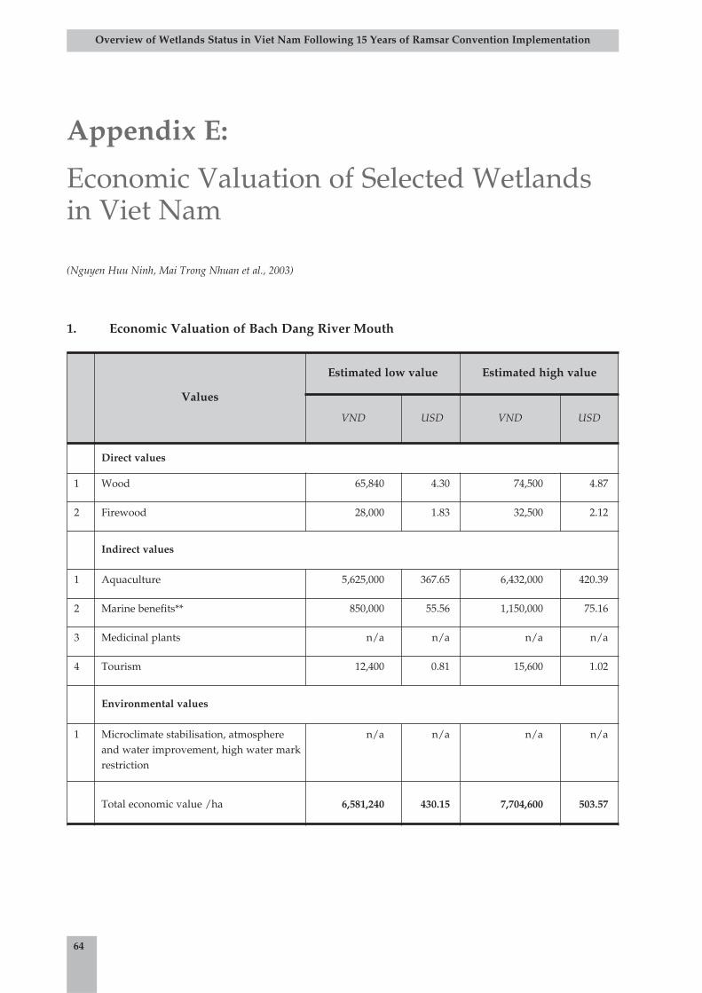
64
Overview of Wetlands Status in Viet Nam Following 15 Years of Ramsar Convention Implementation
1. Economic Valuation of Bach Dang River Mouth
Appendix E:
Economic Valuation of Selected Wetlandsin Viet Nam
(Nguyen Huu Ninh, Mai Trong Nhuan et al., 2003)
Values
Estimated low value Estimated high value
VND USD VND USD
Direct values
1 Wood 65,840 4.30 74,500 4.87
2 Firewood 28,000 1.83 32,500 2.12
Indirect values
1 Aquaculture 5,625,000 367.65 6,432,000 420.39
2 Marine benefits** 850,000 55.56 1,150,000 75.16
3 Medicinal plants n/a n/a n/a n/a
4 Tourism 12,400 0.81 15,600 1.02
Environmental values
1 Microclimate stabilisation, atmosphereand water improvement, high water markrestriction
n/a n/a n/a n/a
Total economic value /ha 6,581,240 430.15 7,704,600 503.57
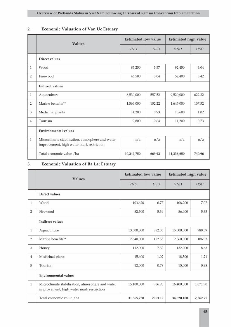
65
Overview of Wetlands Status in Viet Nam Following 15 Years of Ramsar Convention Implementation
2. Economic Valuation of Van Uc Estuary
3. Economic Valuation of Ba Lat Estuary
ValuesEstimated low value Estimated high value
VND USD VND USD
Direct values
1 Wood 85,250 5.57 92,450 6.04
2 Firewood 46,500 3.04 52,400 3.42
Indirect values
1 Aquaculture 8,530,000 557.52 9,520,000 622.22
2 Marine benefits** 1,564,000 102.22 1,645,000 107.52
3 Medicinal plants 14,200 0.93 15,600 1.02
4 Tourism 9,800 0.64 11,200 0.73
Environmental values
1 Microclimate stabilisation, atmosphere and waterimprovement, high water mark restriction
n/a n/a n/a n/a
Total economic value /ha 10,249,750 669.92 11,336,650 740.96
ValuesEstimated low value Estimated high value
VND USD VND USD
Direct values
1 Wood 103,620 6.77 108,200 7.07
2 Firewood 82,500 5.39 86,400 5.65
Indirect values
1 Aquaculture 13,500,000 882.35 15,000,000 980.39
2 Marine benefits** 2,640,000 172.55 2,860,000 186.93
3 Honey 112,000 7.32 132,000 8.63
4 Medicinal plants 15,600 1.02 18,500 1.21
5 Tourism 12,000 0.78 15,000 0.98
Environmental values
1 Microclimate stabilisation, atmosphere and waterimprovement, high water mark restriction
15,100,000 986.93 16,400,000 1,071.90
Total economic value /ha 31,565,720 2063.12 34,620,100 2,262.75
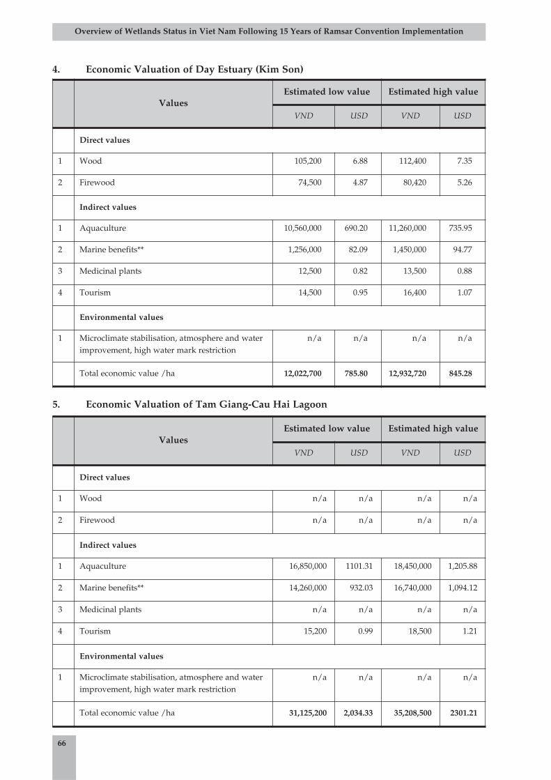
66
Overview of Wetlands Status in Viet Nam Following 15 Years of Ramsar Convention Implementation
4. Economic Valuation of Day Estuary (Kim Son)
5. Economic Valuation of Tam Giang-Cau Hai Lagoon
ValuesEstimated low value Estimated high value
VND USD VND USD
Direct values
1 Wood 105,200 6.88 112,400 7.35
2 Firewood 74,500 4.87 80,420 5.26
Indirect values
1 Aquaculture 10,560,000 690.20 11,260,000 735.95
2 Marine benefits** 1,256,000 82.09 1,450,000 94.77
3 Medicinal plants 12,500 0.82 13,500 0.88
4 Tourism 14,500 0.95 16,400 1.07
Environmental values
1 Microclimate stabilisation, atmosphere and waterimprovement, high water mark restriction
n/a n/a n/a n/a
Total economic value /ha 12,022,700 785.80 12,932,720 845.28
ValuesEstimated low value Estimated high value
VND USD VND USD
Direct values
1 Wood n/a n/a n/a n/a
2 Firewood n/a n/a n/a n/a
Indirect values
1 Aquaculture 16,850,000 1101.31 18,450,000 1,205.88
2 Marine benefits** 14,260,000 932.03 16,740,000 1,094.12
3 Medicinal plants n/a n/a n/a n/a
4 Tourism 15,200 0.99 18,500 1.21
Environmental values
1 Microclimate stabilisation, atmosphere and waterimprovement, high water mark restriction
n/a n/a n/a n/a
Total economic value /ha 31,125,200 2,034.33 35,208,500 2301.21
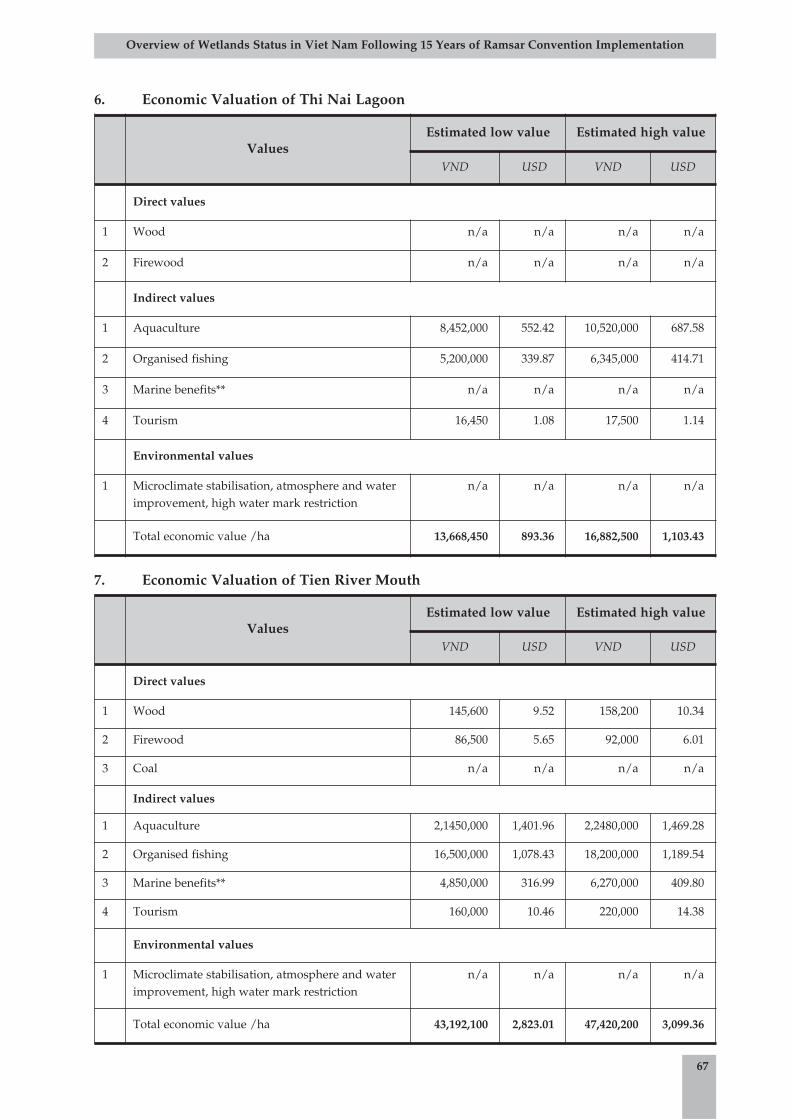
67
Overview of Wetlands Status in Viet Nam Following 15 Years of Ramsar Convention Implementation
6. Economic Valuation of Thi Nai Lagoon
7. Economic Valuation of Tien River Mouth
ValuesEstimated low value Estimated high value
VND USD VND USD
Direct values
1 Wood n/a n/a n/a n/a
2 Firewood n/a n/a n/a n/a
Indirect values
1 Aquaculture 8,452,000 552.42 10,520,000 687.58
2 Organised fishing 5,200,000 339.87 6,345,000 414.71
3 Marine benefits** n/a n/a n/a n/a
4 Tourism 16,450 1.08 17,500 1.14
Environmental values
1 Microclimate stabilisation, atmosphere and waterimprovement, high water mark restriction
n/a n/a n/a n/a
Total economic value /ha 13,668,450 893.36 16,882,500 1,103.43
ValuesEstimated low value Estimated high value
VND USD VND USD
Direct values
1 Wood 145,600 9.52 158,200 10.34
2 Firewood 86,500 5.65 92,000 6.01
3 Coal n/a n/a n/a n/a
Indirect values
1 Aquaculture 2,1450,000 1,401.96 2,2480,000 1,469.28
2 Organised fishing 16,500,000 1,078.43 18,200,000 1,189.54
3 Marine benefits** 4,850,000 316.99 6,270,000 409.80
4 Tourism 160,000 10.46 220,000 14.38
Environmental values
1 Microclimate stabilisation, atmosphere and waterimprovement, high water mark restriction
n/a n/a n/a n/a
Total economic value /ha 43,192,100 2,823.01 47,420,200 3,099.36
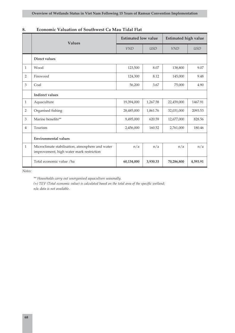
68
Overview of Wetlands Status in Viet Nam Following 15 Years of Ramsar Convention Implementation
8. Economic Valuation of Southwest Ca Mau Tidal Flat
Notes:
** Households carry out unorganised aquaculture seasonally. (+) TEV (Total economic value) is calculated based on the total area of the specific wetland; n/a: data is not available.
ValuesEstimated low value Estimated high value
VND USD VND USD
Direct values
1 Wood 123,500 8.07 138,800 9.07
2 Firewood 124,300 8.12 145,000 9.48
3 Coal 56,200 3.67 75,000 4.90
Indirect values
1 Aquaculture 19,394,000 1,267.58 22,459,000 1467.91
2 Organised fishing 28,485,000 1,861.76 32,031,000 2093.53
3 Marine benefits** 9,495,000 620.59 12,677,000 828.56
4 Tourism 2,456,000 160.52 2,761,000 180.46
Environmental values
1 Microclimate stabilisation, atmosphere and waterimprovement, high water mark restriction
n/a n/a n/a n/a
Total economic value /ha 60,134,000 3,930.33 70,286,800 4,593.91
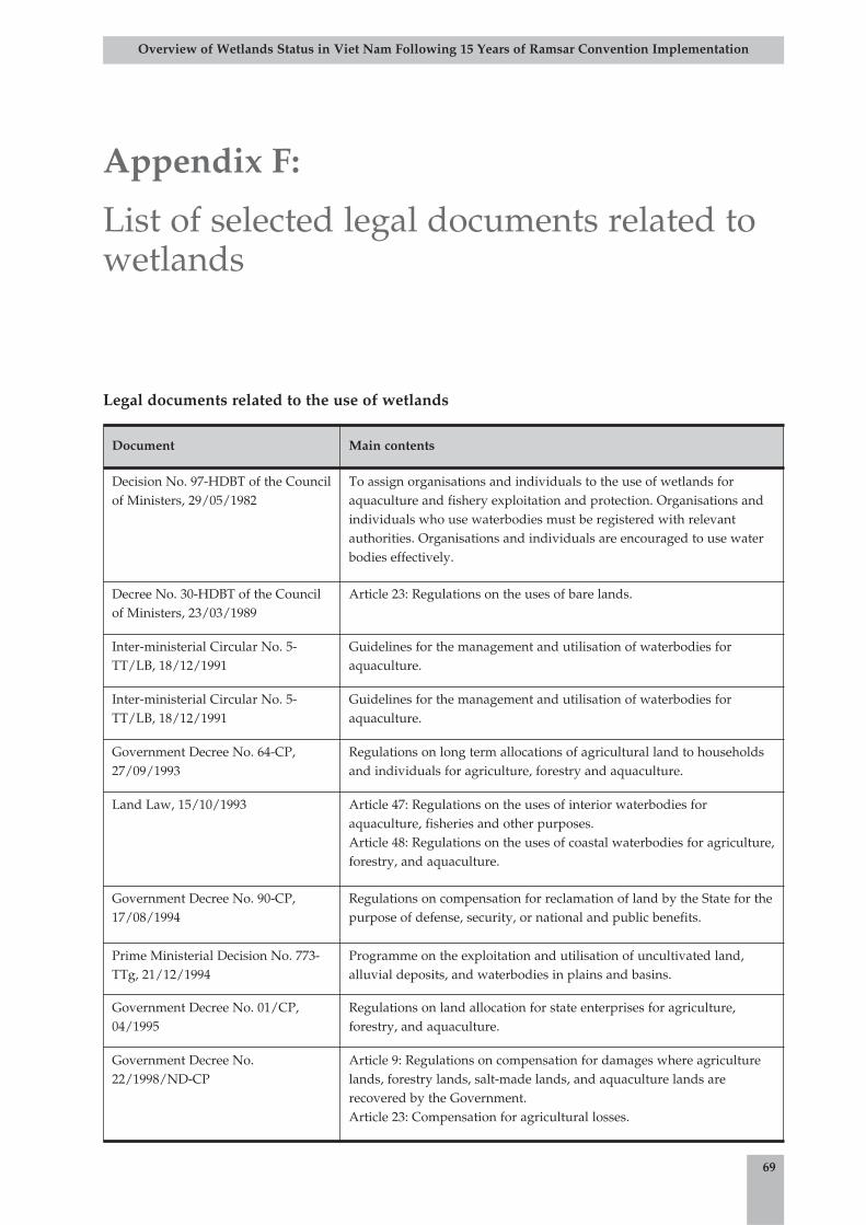
69
Overview of Wetlands Status in Viet Nam Following 15 Years of Ramsar Convention Implementation
Legal documents related to the use of wetlands
Document Main contents
Decision No. 97-HDBT of the Councilof Ministers, 29/05/1982
To assign organisations and individuals to the use of wetlands foraquaculture and fishery exploitation and protection. Organisations andindividuals who use waterbodies must be registered with relevantauthorities. Organisations and individuals are encouraged to use waterbodies effectively.
Decree No. 30-HDBT of the Councilof Ministers, 23/03/1989
Article 23: Regulations on the uses of bare lands.
Inter-ministerial Circular No. 5-TT/LB, 18/12/1991
Guidelines for the management and utilisation of waterbodies foraquaculture.
Inter-ministerial Circular No. 5-TT/LB, 18/12/1991
Guidelines for the management and utilisation of waterbodies foraquaculture.
Government Decree No. 64-CP,27/09/1993
Regulations on long term allocations of agricultural land to householdsand individuals for agriculture, forestry and aquaculture.
Land Law, 15/10/1993 Article 47: Regulations on the uses of interior waterbodies foraquaculture, fisheries and other purposes. Article 48: Regulations on the uses of coastal waterbodies for agriculture,forestry, and aquaculture.
Government Decree No. 90-CP,17/08/1994
Regulations on compensation for reclamation of land by the State for thepurpose of defense, security, or national and public benefits.
Prime Ministerial Decision No. 773-TTg, 21/12/1994
Programme on the exploitation and utilisation of uncultivated land,alluvial deposits, and waterbodies in plains and basins.
Government Decree No. 01/CP,04/1995
Regulations on land allocation for state enterprises for agriculture,forestry, and aquaculture.
Government Decree No.22/1998/ND-CP
Article 9: Regulations on compensation for damages where agriculturelands, forestry lands, salt-made lands, and aquaculture lands arerecovered by the Government. Article 23: Compensation for agricultural losses.
Appendix F:
List of selected legal documents related towetlands

70
Overview of Wetlands Status in Viet Nam Following 15 Years of Ramsar Convention Implementation
Legal documents on wetlands management and conservation
Document Main contents
Official Letter No. 1558/DC-DDBD,13/10/1999
On agriculture land statistics, including water bodies for aquaculture.Statistics should be carried out separately for waterbodies foraquaculture and for waterbodies for other purposes.
Prime Ministerial Decision No.224/1999/QD-TTg, 08/12/1999
Policies on the uses of land and waterbodies for aquaculture. Allocationsor leases of planned lands, waterbodies, bays, lagoons and reservoirs tosectors for aquaculture purposes. Transformation of salt-lands, low-lyingfields, and waterlogged lands for aquaculture purposes.
Resolution No. 03/2000/NQ-CP,02/02/2000
Long-term State policies on the farm economy in which the State stronglyencourages investment in and effective use of bare lands on midland,mountain, border, and island areas and to make use of bare lands, ponds,lakes, lagoons, and alluvial grounds for extensive agriculture, forestryand aquaculture.
Ordinance on Aquaculture Protectionand Development
Article 4: State agencies, societies, organisations, and individuals areallowed to exploit natural fisheries in accordance with this Ordinance.
Law on Environmental Protection Article 11: The State encourages and promotes organisations andindividuals in the use and reasonable exploitation of environmentalcomponents. Article 15: Application of methods to restrict and preventerosion, landslides, soil salination and alkination, unplanneddesalination, laterisation and desertification.
Document Main contents
Decision No. 97-HDBT of theCouncil of Ministers,29/05/1982
Every type of waterbody, including ponds, lakes, rivers, canals, and bays,belongs to the people and is managed by the State. Promotes education andencourages organisations and individuals to protect aquaculture and habitatsfor aquaculture species.
Directive No. 169-CT of theChairman of the Council ofMinisters, 18/05/1992
Implementation of urgent measures to protect Grus antigone and wetlandbiodiversity in the Plain of Reeds.
Land Law, 15/10/1993 Article 50: The management and use of inshore alluvial lands is regulated bythe Government. Article 71: The State allocates waterbodies to suitable households andindividuals according to the identified utilisation purposes. The Governmentregulates the management and utilisation schemes of these areas.
Law on Land Use Taxes,10/07/1993, and theaccompanying Decree No. 74-CP, 25/10/1993
Article 2: Waterbodies for aquaculture are subject to agricultural taxes. Article 7: Agricultural and aquacultural lands are divided into six categories.Article 9: Annually imposed tariffs are calculated by kilogram of rice perhectare for each land category, including land with waterbodies foraquaculture.Article 19: Tax exemption for newly exploited land in mountainous regions,marshes, and land reclaimed from the sea for seven years. Marshes and landreclaimed from the sea will be exempted for an additional six years.
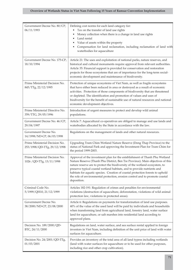
71
Overview of Wetlands Status in Viet Nam Following 15 Years of Ramsar Convention Implementation
Government Decree No. 80/CP,06/11/1993
Defining cost norms for each land category for:• Tax on the transfer of land use rights• Money collection when there is a change in land use rights• Land rental• Value of assets within the property• Compensation for land reclamation, including reclamation of land with
waterbodies for aquaculture
Government Decree No. 175-CP,18/10/1994
Article 21: The uses and exploitation of national parks, nature reserves, andhistorical and cultural monuments require approval from relevant authorities.Article 35: Financial support is provided for conservation and restorationprojects for those ecosystems that are of importance for the long-term social-economic development and maintenance of biodiversity.
Prime Ministerial Decision No.845/TTg, 22/12/1995
Protection of unique ecosystems of Viet Nam, as well as fragile ecosystemsthat have either been reduced in area or destroyed as a result of economicactivities. Protection of those components of biodiversity that are threatenedor depleted. The identification and promotion of values and uses ofbiodiversity for the benefit of sustainable use of natural resources and nationaleconomic development objectives.
Prime Ministerial Directive No.359/TTG, 29/05/1996
Introduction of urgent measures to protect and develop wild animalpopulations.
Government Decree No. 46/CP,29/04/1997
Article 7: Aquacultural co-operatives are obliged to manage and use lands andwaterbodies allocated by the State in accordance with the law.
Government Decree No.14/1998/ND-CP, 06/03/1998
Regulations on the management of lands and other natural resources.
Prime Ministerial Decision No.253/1998/QD-TTg, 29/12/1998
Upgrading Tram Chim Wetland Nature Reserve (Dong Thap Province) to thestatus of National Park and approving the Investment Plan for Tram Chim forthe period 1999-2003.
Prime Ministerial Decision No.1026 /QD-TTg, 13/11/1998
Approval of the investment plan for the establishment of Thanh Phu WetlandNature Reserve (Thanh Phu District, Ben Tre Province). Main objectives of thisnature reserve are to protect the biodiversity of the wetland ecosystem, topreserve typical coastal wetland habitats, and to provide nutrients andhabitats for aquatic species. Creation of coastal protection forests to upholdthe role of environmental protection, erosion control and to promote coastaldeposition.
Criminal Code No.5/1999/QH10, 21/12/1999
Articles 182-191: Regulation of crimes and penalties for environmentalviolations (destruction of aquaculture, deforestation, violations of wild animalprotection law, violations in protected areas).
Government Decree No.38/2000/ND-CP, 23/08/2000
Article 6: Regulations on payments for transformation of land use purposes.40% of the value of the used land will be paid by individuals and householdswhen transforming land from agricultural land, forestry land, water surfaceland for aquaculture, or salt marshes into residential land according toapproved plans.
Decision No. 189/2000/QD-BTC, 24/11/2000
Regulations on land, water surface, and sea surface rental applied to foreigninvestors in Viet Nam, including definition of the unit price of land with watersurfaces for aquaculture.
Decision No. 24/2001/QD-TTg,01/03/2001
Provides an inventory of the total area of all land typess including wetlands(land with water surfaces for aquaculture or to be used for other purposes,including rice and other crop cultivation).
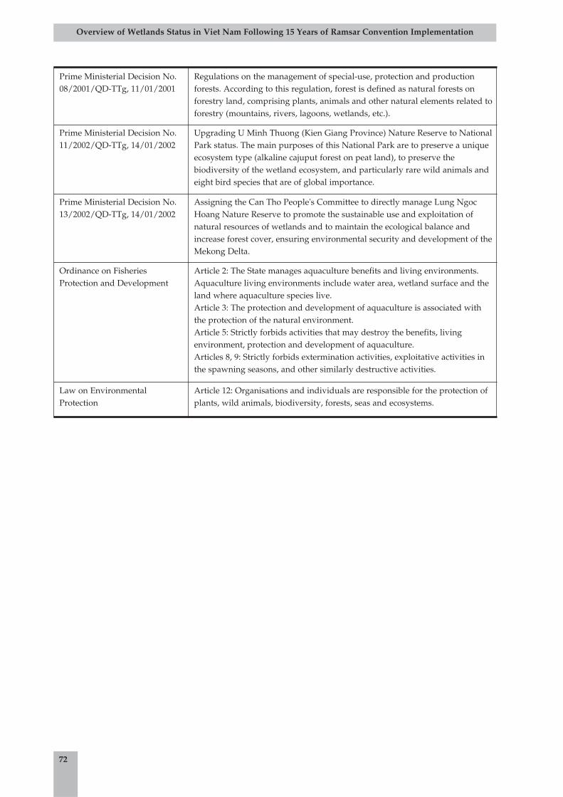
72
Overview of Wetlands Status in Viet Nam Following 15 Years of Ramsar Convention Implementation
Prime Ministerial Decision No.08/2001/QD-TTg, 11/01/2001
Regulations on the management of special-use, protection and productionforests. According to this regulation, forest is defined as natural forests onforestry land, comprising plants, animals and other natural elements related toforestry (mountains, rivers, lagoons, wetlands, etc.).
Prime Ministerial Decision No.11/2002/QD-TTg, 14/01/2002
Upgrading U Minh Thuong (Kien Giang Province) Nature Reserve to NationalPark status. The main purposes of this National Park are to preserve a uniqueecosystem type (alkaline cajuput forest on peat land), to preserve thebiodiversity of the wetland ecosystem, and particularly rare wild animals andeight bird species that are of global importance.
Prime Ministerial Decision No.13/2002/QD-TTg, 14/01/2002
Assigning the Can Tho People's Committee to directly manage Lung NgocHoang Nature Reserve to promote the sustainable use and exploitation ofnatural resources of wetlands and to maintain the ecological balance andincrease forest cover, ensuring environmental security and development of theMekong Delta.
Ordinance on FisheriesProtection and Development
Article 2: The State manages aquaculture benefits and living environments.Aquaculture living environments include water area, wetland surface and theland where aquaculture species live. Article 3: The protection and development of aquaculture is associated withthe protection of the natural environment. Article 5: Strictly forbids activities that may destroy the benefits, livingenvironment, protection and development of aquaculture. Articles 8, 9: Strictly forbids extermination activities, exploitative activities inthe spawning seasons, and other similarly destructive activities.
Law on EnvironmentalProtection
Article 12: Organisations and individuals are responsible for the protection ofplants, wild animals, biodiversity, forests, seas and ecosystems.