Embed Size (px)
Citation preview
Range Sustainability Environmental Program Assessment(RSEPA)
Range Condition Assessment (RCA) Phase III
On-Site VisitInformation Collection and Review Synopsis
Virginia Capes Complex
June 2004

THIS PAGE WAS INTENTIONALLY LEFT BLANK
RSEPA RCA Report June 2004Phase III
P3-iii
TABLE OF CONTENTSPage
1. INTRODUCTION......................................................................................................................... P3-1-11.1 OVERVIEW OF ENVIRONMENTAL COMPLIANCE ................................................... P3-1-21.2 OVERVIEW OF ORSMS ................................................................................................... P3-1-31.3 REPORT FORMAT ............................................................................................................ P3-1-3
2. BACKGROUND FOR VACAPES............................................................................................... P3-2-13. ENVIRONMENTAL COMPLIANCE FOR VACAPES.............................................................. P3-3-1
3.1 ENVIRONMENTAL REGULATORY APPLICABILITY AND COMPLIANCEASSESSMENT.................................................................................................................... P3-3-23.1.1 Air Quality.............................................................................................................. P3-3-23.1.2 Water Quality ......................................................................................................... P3-3-33.1.3 Hazardous Materials ............................................................................................... P3-3-43.1.4 Hazardous Waste .................................................................................................... P3-3-43.1.5 Emergency Planning and Community Right-to-Know Act.................................... P3-3-53.1.6 Pollution Prevention ............................................................................................... P3-3-63.1.7 Storage Tank Management ..................................................................................... P3-3-73.1.8 Petroleum, Oils, and Lubricants ............................................................................. P3-3-73.1.9 Natural Resources................................................................................................... P3-3-83.1.10 Cultural Resources.................................................................................................. P3-3-93.1.11 National Environmental Policy Act........................................................................ P3-3-93.1.12 Pesticide Management .......................................................................................... P3-3-103.1.13 Lead-Based Paint Management ............................................................................ P3-3-103.1.14 Asbestos Management .......................................................................................... P3-3-103.1.15 PCB Management................................................................................................. P3-3-113.1.16 Environmental and Explosives Safety Management ............................................ P3-3-11
3.2 RSEPA COMPLIANCE STATUS SUMMARY .............................................................. P3-3-123.3 CONCLUSIONS ............................................................................................................... P3-3-15
3.3.1 Operational Range Areas...................................................................................... P3-3-153.3.2 Dam Neck Range and Navy DCBR Range Support Operations and Facilities.... P3-3-15
4. OPERATIONAL RANGE SITE MODEL (ORSM)..................................................................... P3-4-14.1 DEFINITION OF RANGES................................................................................................ P3-4-14.2 OPERATIONAL COMPONENT ....................................................................................... P3-4-1
4.2.1 Historical Military Operations................................................................................ P3-4-14.2.2 Current Military Operations ................................................................................... P3-4-3
4.2.2.1 Navy Dare County Bombing Range....................................................... P3-4-34.2.2.2 Dam Neck Range ................................................................................... P3-4-34.2.2.3 Summary of Land-Based Ranges and Components of Ranges .............. P3-4-6
4.2.3 Future Military Operations ..................................................................................... P3-4-64.3 ENVIRONMENTAL AND CULTURAL COMPONENTS OF VACAPES ORSM ......... P3-4-6
4.3.1 Predominant Soil Types.......................................................................................... P3-4-64.3.1.1 Navy Dare County Bombing Range....................................................... P3-4-64.3.1.2 Dam Neck Range ................................................................................... P3-4-7
4.3.2 Predominant Topography ....................................................................................... P3-4-74.3.2.1 Navy Dare County Bombing Range....................................................... P3-4-94.3.2.2 Dam Neck Range ................................................................................... P3-4-9
4.3.3 Predominant Vegetation ......................................................................................... P3-4-94.3.3.1 Navy Dare County Bombing Range....................................................... P3-4-94.3.3.2 Dam Neck Range ................................................................................... P3-4-9
TABLE OF CONTENTS (Continued)Page
RSEPA RCA Report June 2004Phase III
P3-iv
4.3.4 Surface Water and Groundwater ............................................................................ P3-4-94.3.4.1 Navy Dare County Bombing Range..................................................... P3-4-114.3.4.2 Dam Neck Range ................................................................................. P3-4-11
4.3.5 Sensitive Ecosystems............................................................................................ P3-4-114.3.5.1 Navy Dare County Bombing Range Known Threatened and
Endangered Species.............................................................................. P3-4-114.3.5.2 Dam Neck Range Known Threatened and Endangered Species.......... P3-4-134.3.5.3 Human Impacts on Sensitive Ecosystems on Dare County Bombing
Range.................................................................................................... P3-4-134.3.5.4 Human Impacts on Sensitive Ecosystems on Dam Neck Range.......... P3-4-14
4.3.6 Cultural Resources................................................................................................ P3-4-144.3.6.1 Navy Dare County Bombing Range..................................................... P3-4-144.3.6.2 Dam Neck Range ................................................................................. P3-4-14
4.4 LAND USE COMPONENT.............................................................................................. P3-4-144.4.1 Navy Dare County Bombing Range..................................................................... P3-4-15
4.4.1.1 Military Use.......................................................................................... P3-4-154.4.1.2 Public Use ............................................................................................ P3-4-15
4.4.2 Dam Neck Range.................................................................................................. P3-4-154.4.2.1 Military Use.......................................................................................... P3-4-164.4.2.2 Public Use ............................................................................................ P3-4-16
4.5 OPERATIONAL RANGE SITE MODELS...................................................................... P3-4-164.5.1 ORSM for Navy DCBR........................................................................................ P3-4-164.5.2 ORSM for Dam Neck Range................................................................................ P3-4-18
5. CONCLUSIONS ........................................................................................................................... P3-5-16. REFERENCES.............................................................................................................................. P3-6-1
APPENDICES
APPENDIX A. CONTENTS OF VACAPES RANGE DATA FOLDER
APPENDIX B. ENVIRONMENTAL REGULATORY APPLICABILITY AND COMPLIANCEASSESSMENT
APPENDIX C. RCA PHASE III FORMS
APPENDIX D. U.S. NAVY ATLANTIC AIR COMMAND’S TARGET AND RANGEINFORMATION SYSTEM (TRIMS) REPORTS
RSEPA RCA Report June 2004Phase III
P3-v
LIST OF TABLESPage
Table 3-1. Summary of RSEPA Compliance Status for Range....................................................... P3-3-13Table 4-1. Summary of Munitions-Related Activities Occurring at VACAPES............................... P3-4-2Table 4-2. Summary of Ranges, Operational Areas, and Warning Areas at VACAPES .................. P3-4-4Table 4-3. Land-Based Ranges at VACAPES................................................................................... P3-4-7Table 4-4. Federally Protected Plant and Animal Species Identified by U.S. Fish and Wildlife
Service ............................................................................................................................ P3-4-12Table 4-5. Federally Protected Plant and Animal Species Identified by the North Carolina
Division of Parks and Recreation Natural Heritage Program......................................... P3-4-12
LIST OF FIGURESPage
Figure 2-1. VACAPES Complex Location Map................................................................................. P3-2-2Figure 4-1. Sorties Executed and Munitions Used at Navy DCBR .................................................... P3-4-4Figure 4-2. VACAPES Operational Areas and Airspace.................................................................... P3-4-5Figure 4-3. Primary Soil Types Within Navy DCBR ......................................................................... P3-4-8Figure 4-4. Primary Vegetation Types at Navy DCBR .................................................................... P3-4-10Figure 4-5. Operational Range Site Model for Navy Dare County Bombing Range........................ P3-4-17Figure 4-6. Operational Range Site Model for the Dam Neck Range 5-Inch Gunline ..................... P3-4-19Figure 4-7. Operational Range Site Model for the Dam Neck Range Drone Launch Area.............. P3-4-20
RSEPA RCA Report June 2004Phase III
P3-vi
LIST OF ACRONYMS AND ABBREVIATIONS
2-A-4,6-DNT 2-Amino-4,6-dinitrotoluene2,4-DNT 2,4-Dinitrotoluene2,6-DNT 2,6-Dinitrotoluene4-A-2,6-DNT 4-Amino-2,6-dinitrotolueneACM Asbestos-containing MaterialsAFB Air Force BaseAPM Asbestos Program ManagerAST Aboveground Storage TankBDU Bomb Dummy UnitCATEX Categorical ExclusionCNRMA Commander, Navy Region, Mid-AtlanticCOMLANTFLT Commander, Atlantic FleetCRE Comprehensive Range EvaluationCRMP Cultural Resources Management PlantCWA Clean Water ActDCBR Dare County Bombing RangeDEQ Department of Environmental QualityDOD U.S. Department of DefenseDODD U.S. Department of Defense DirectiveDQO Data Quality ObjectiveECAMP Environmental Compliance Assessment and Management ProgramECE Environmental Compliance EvaluationEOD Explosive Ordnance DisposalEPCRA Emergency Planning and Community Right-to-Know ActEQA Environmental Quality AssessmentESA Endangered Species ActFAA U.S. Federal Aviation AdministrationFACSFAC Fleet Area Control and Surveillance FacilityFEIS Final Environmental Impact StatementFIFRA Federal Insecticide, Fungicide, and Rodenticide ActFRP Facility Response PlanHMCM Hazardous Material Control and ManagementHMX Octahydro-1,3,5,7-tetranitro-1,3,5,7-tetrazocineHWMP Hazardous Waste Management PlanICRMP Integrated Cultural Resources Management PlanINRMP Integrated Natural Resources Management PlanJATO Jet Assisted Take-OffLANTDIV Naval Facilities Engineering Command, Atlantic DivisionLAT Large Area TargetsLATR Large Area Tracking RangeMACT Maximum Achievable Control TechnologyMC Munitions ConstituentsMIDAS Munitions Items Disposition Action SystemMMR Military Munitions RuleNAAQS National Ambient Air Quality StandardsNAS Naval Air StationNASA National Aeronautical Space AgencyNCDENR North Carolina Department of Environmental and Natural ResourcesNEPA National Environmental Policy Act
RSEPA RCA Report June 2004Phase III
P3-vii
NESHAP National Emission Standards for Hazardous Air PollutantsNHPA National Historic Preservation ActNOV Notice of ViolationOB/OD Open Burn/Open DetonationOMB Office of Management and BudgetOPA90 Oil Pollution Act of 1990OPAREA Operating AreaOPNAVINST Operational Navy InstructionOPP Oil Pollution Prevention Regulation of 1973ORSM Operational Range Site ModelOSHA Occupational Safety and Health AgencyP2 Pollution PreventionPCB Polychlorinated BiphenylPOL Petroleum, Oils, and LubricantsPWCNORVA Public Works Center – Norfolk, VirginiaRACM Regulated Asbestos-containing MaterialRCA Range Condition AssessmentRCRA Resource Conservation and Recovery ActRDF Range Data FolderRDX Hexahydro-1,3,5-triniro-1,3,5-triazineREG Regional Environmental GroupRSEPA Range Sustainability Environmental Program AssessmentSAIC Science Applications International CorporationSARA Superfund Amendments and Reauthorization ActSCP Spill Contingency PlanSEPTAR Seaborne Powered TargetSPCC Spill Prevention Control and CountermeasuresTACAN Tactical Air NavigationTACTS Tactical Aircrew Training SystemTEAM U.S. Army Corps of Engineers Environmental Assessment and ManagementTetryl Methyl-2,4,6-trinitrophenylnitramineTNT 2,4,6-TrinitrotolueneTRI Toxics Release InventoryTRIMS Target and Range Information Management SystemTSCA Toxic Substances Control ActUSACE U.S. Army Corps of EngineersUSAF U.S. Air ForceUSC U.S. CodeUSEPA U.S. Environmental Protection AgencyUSFWS U.S. Fish and Wildlife ServiceUST Underground Storage TankUXO Unexploded OrdnanceVACAPES Virginia Capes ComplexVSP-RSM Visual Sample Plan-Range Sustainment Module

THIS PAGE WAS INTENTIONALLY LEFT BLANK
RSEPA RCA Report June 2004Phase III
P3-1-1
1. INTRODUCTION
This synopsis documents the Range Sustainability Environmental Program Assessment (RSEPA) RangeCondition Assessment (RCA) – Phase III (On-Site Visit Information Collection and Review) that wasconducted at two ranges within the Virginia Capes (VACAPES) Complex. The purpose of RCA PhaseIII is to obtain and evaluate information needed to address the following questions from Decision Point 1of the RSEPA Policy Implementation Manual (U.S. Navy 2003b) for the two ranges at VACAPES: “Arefurther steps required to maintain compliance?” and “Is further analysis required to assess risk of off-range release?”
This synopsis assesses the environmental compliance status of land-based ranges or components of rangesin the VACAPES Complex. This synopsis also includes the operational range site model (ORSM)developed for munitions-related military testing and training operations conducted by the Navy at land-based ranges or components of ranges within VACAPES. The land-based components include the DareCounty Bombing Range (DCBR) in North Carolina and a firing point and a target drone launch padlocated at Dam Neck Annex, which is the land component of the Dam Neck Range. Unless otherwisespecified, references to Dam Neck Range include both the firing point and the drone launch area locatedon Dam Neck Annex.
The environmental compliance section is a summary of the compliance status and major issues found forall possible environmental areas at the two ranges. The ORSM is a summary of operational andenvironmental conditions and is used to support range planning and management. Predictive modeling istypically conducted to forecast the possibility of a release of munitions constituents (MCs) posing animminent and substantial threat to human health or the environment. MCs are defined in the RSEPAPolicy Implementation Manual (U.S. Navy 2003b) as materials originating from military munitions,including explosive and non-explosive materials, and the emissions, degradation, or breakdown productsof such munitions, including the following:
• 1,3-Dinitrobenzene• 2,4-Dinitrotoluene (2,4-DNT)• 2,6-Dinitrotoluene (2,6-DNT)• Hexahydro-1,3,5-trinitro-1,3,5-triazine (RDX)• Nitrobenzene• Nitroglycerin• 2-Nitrotoluene• 3-Nitrotoluene• 4-Nitrotoluene• 1,3,5-Trinitrobenzene• Octahydro-1,3,5,7-tetranitro-1,3,5,7-tetrazocine (HMX)• Perchlorate• 2,4,6-Trinitrotoluene (TNT)• Methyl-2,4,6-trinitrophenylnitramine (Tetryl)• 2-Amino-4,6-dinitrotoluene (2-A-4,6-DNT)• 4-Amino-2,6-dinitrotoluene (4-A-2,6-DNT).
Because the two ranges do not use live munitions, predictive modeling was not conducted. Thisdocument, however, is still able to provide information needed to address both Decision Point 1questions.
The Technical Team consisting of Navy civilians and personnel from Science Applications InternationalCorporation (SAIC) simultaneously conducted the RCA (Phase II Pre-Site Visit Information Collection)and the RCA Phase III (Onsite Visit Information Collection and Review) for VACAPES from 15 to 17
RSEPA RCA Report June 2004Phase III
P3-1-2
July 2003. During Phase II and III activities, the Team interviewed key Navy personnel responsible forrange and environmental operations and collected range, operational, and environmental informationwhere exercises with munitions are conducted.
The key Navy personnel that the Technical Team interviewed were located at Navy DCBR, Dam NeckRange, and Naval Air Station (NAS) Oceana in Virginia Beach, Virginia. These personnel were affiliatedwith the following organizations:
• Commander, Atlantic Fleet (COMLANTFLT)• Commander, Navy Region Mid-Atlantic (CNRMA)• Fleet Area Control and Surveillance Facility, Virginia Capes (FACSFAC VACAPES)• NAS Oceana• Naval Facilities Engineering Command, Atlantic Division (LANTDIV)• Public Works Center – Norfolk, Virginia (PWCNORVA)
In addition, the Team conducted a tour of VACAPES, Navy DCBR, and Dam Neck Range. Theinformation obtained during RCA Phases II and III is used to complete an environmental complianceassessment, develop the ORSM, and conduct predictive modeling, if necessary. The following sectionspresent information needed to complete this evaluation.
1.1 OVERVIEW OF ENVIRONMENTAL COMPLIANCE
The assessment of environmental compliance serves as a basis for addressing one of the two majorquestions posed during Decision Point 1 of the RSEPA process. During Phase III, information iscollected about the possible impacts of range operations on the environment. Efforts during Phase III arefocused on munitions usage on land-based operational ranges. The collected information is reviewed andanalyzed for environmental regulatory applicability and compliance deficiencies.
Phase III information collection efforts are not carried out to the same degree of detail as a NavyEnvironmental Quality Assessment (EQA), which is a Navy internal environmental complianceassessment program audit. Rather, range personnel and environmental managers are interviewed todetermine what environmental and range management programs are in place and to what extent theseprograms addressed environmental regulatory requirements and current and potential environmental andhuman health risks due to range operations. The environmental compliance and explosives safetymanagement areas addressed during interviews and in this section include:
• Air Quality• Water Quality• Hazardous Materials• Hazardous Waste• Emergency Planning and Community Right-to-Know Act (EPCRA)• Pollution Prevention• Storage Tank Management• Petroleum, Oils, and Lubricants (POL)• Natural Resources• Cultural Resources• National Environmental Policy Act (NEPA)• Pesticides Management• Lead-Based Paint Management• Asbestos Management• Polychlorinated Biphenyl (PCB) Management• Environmental and Explosives Safety Management.
RSEPA RCA Report June 2004Phase III
P3-1-3
The assessment areas listed above were chosen based upon those environmental compliance andexplosives safety management areas found in the Navy’s Environmental Compliance Evaluation Program,the U.S. Army Corps of Engineers (USACE) Environmental Assessment and Management (TEAM)Guide (Revised March 2003), and Operational Navy Instruction (OPNAVINST) 5090.1B.
1.2 OVERVIEW OF ORSMS
ORSMs use existing knowledge to describe land-based operational ranges and their environments in bothgraphical and tabular formats. ORSMs summarize operational and potential release information,migration and exposure pathways, and expected levels and locations of releases. They summarize thelinks between potential sources of MCs, release mechanisms, exposure pathways, exposure routes, andreceptors. ORSMs include range boundaries, topography, vegetation, and hydrology to the extent that isknown through available historical information and a range visit.
ORSMs assist in planning studies, interpreting data, and communicating conclusions. They aredeveloped initially during RCA Phase III and if conducted, they are refined during the ComprehensiveRange Evaluation (CRE) Phase I (Preliminary Screening), and further refined during CRE Phase II(Verification Analysis).
If a CRE is conducted, ORSMs then are used in the systematic planning process, particularly in thedevelopment of data quality objectives (DQOs) and to support the use of tools such as Visual SamplePlan-Range Sustainment Module (VSP-RSM). In other words, ORSMs are tools to assist decisionmakers in determining the types, locations, and degrees of field analysis that might be needed in the CRE.
1.3 REPORT FORMAT
Section 2 presents a brief description of the VACAPES Complex and mission. Section 3 presents each ofthe environmental compliance areas assessed and any deficiencies noted as a result of the Phase IIIinformation collection process. Section 4 presents the ORSMs. It includes information about historical,current, and planned future military operations at VACAPES and describes where military testing andtraining operations occur on the two ranges at VACAPES. Section 4 also details the physicalenvironment of VACAPES and describes factors that may affect MC release, fate and transport, andpotential receptors. Cultural resources also are presented in Section 4, along with land use andinformation that could identify and evaluate the applicable scenarios and locations of human andecological exposure to potential releases of MCs. The conclusions are provided in Section 5.

THIS PAGE WAS INTENTIONALLY LEFT BLANK
RSEPA RCA Report June 2004Phase III
P3-2-1
2. BACKGROUND FOR VACAPES
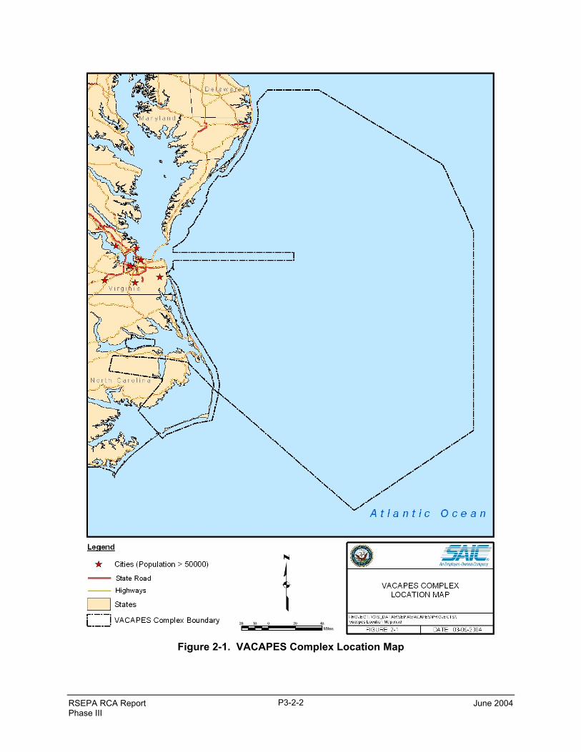
The VACAPES Complex, presented in Figure 2-1, spans an area extending approximately fromCharleston, South Carolina to just south of Nantucket Island, Massachusetts, and eastward covering morethan 200 nautical miles of the Atlantic Ocean. The VACAPES Complex includes the following ranges(U.S. Navy 2000b):
• Harvey Point Range• Palmetto Point Range• Stumpy Point Range• Navy DCBR• Dam Neck Range• Oceana Tactical Aircrew Training System (TACTS) Range• Large Area Tracking Range (LATR)
Of the seven ranges listed above and unlisted warning areas and operating areas that also are part ofVACAPES, only Navy DCBR and Dam Neck Range include land-based assets relevant to RSEPA. DamNeck Range includes a firing line of five-inch guns that are functional but are used only for maintenancetraining. During the site visit, Navy personnel indicated that the guns had not been fired since the 1980s.Navy DCBR also includes an area where BQM-74E drones are stored, maintained, and launched.Additional information about these land-based assets are provided in the discussion of the operationalcomponent of the ORSM (Section 4.2). The Fleet Area Control and Surveillance Facility, Virginia Capes(FACSFAC VACAPES) manages VACAPES Operating Area (OPAREA). FACSFAC VACAPES islocated in Virginia Beach, Virginia. On 1 October 1977, FACSFAC VACAPES was commissioned asthe designated air traffic control facility for VACAPES OPAREA. Its primary mission was to act as thecentral scheduling point for all Atlantic Fleet aircraft services, the use of VACAPES, and the joint use ofairspace by the U.S. Department of Defense (DOD), Federal Aviation Administration (FAA), and theNational Aeronautical Space Agency (NASA). It monitors aircraft movements and coordinatesassignments in response to the increased use of military and civilian aircraft on the U.S. east coast. It alsomonitors the use of offshore warning areas for air, surface, and subsurface units. Radio communicationsand radar surveillance are used to monitor and mediate high performance military aircraft and commercialair traffic (Global Security 2003a).
Since commissioning, the mission of FACSFAC VACAPES has grown in scope and complexity. Itsmission now includes Oceanic Airspace Coordination; scheduling and de-confliction of 17 militarytraining routes; monitoring and assisting in search and rescue operations; acting as naval liaison for theNorfolk area with the FAA; providing range safety surveillance and control for missile firing exercises inassigned operational area; and supplying air intercept control services for Fleet Replacement TrainingSquadrons (Global Security 2003a).
RSEPA RCA Report June 2004Phase III
P3-2-2
Figure 2-1. VACAPES Complex Location Map
RSEPA RCA Report June 2004Phase III
P3-3-1
3. ENVIRONMENTAL COMPLIANCE FOR VACAPES
The assessment of environmental compliance serves as the basis for addressing the first of the two majorquestions posed during Decision Point 1 of the RSEPA process. During the RCA Phase III, informationis collected about the possible impacts of range operations to the environment. Efforts during the RCAPhase III are focused on munitions usage on land-based operational ranges. The collected information isreviewed and analyzed for applicability to environmental regulations and potential compliancedeficiencies.
Initially, pertinent information was gathered and reviewed in order to plan the onsite visit. Thesedocuments are compiled and organized in the VACAPES Range Data Folder (RDF). Appendix Acontains a spreadsheet outlining all documents obtained thus far in the VACAPES RDF. The TechnicalTeam used this information to make an initial assessment of applicability of environmental regulations tothe range and its operations. This initial assessment prior to the onsite visit identified data gaps, increasedthe efficiency of the onsite visit, and minimized disruptions to installation personnel and operationsduring the onsite visit.
The Technical Team commenced the RCA Phase III for the VACAPES ranges by meeting with theCommanding Officer, range personnel, the Public Affairs Officer, and environmental managers from 15to 17 July 2003 at different locations within VACAPES. The Technical Team assessed operational rangeareas (Navy DCBR and Dam Neck Range), along with range support operations and facilities. It shouldbe noted that the RCA conducted at the VACAPES ranges was not carried out to the degree of detail as aNavy Environmental Compliance Evaluation, which is a Navy environmental programs audit. Rather,range personnel and environmental managers were interviewed to determine what environmental andrange management programs are in place and to what extent these programs addressed environmentalregulatory requirements and current and potential environmental and human health risks due to rangeoperations. The environmental compliance and explosives safety management areas addressed duringinterviews and in this document include:
• Air Quality• Water Quality• Hazardous Materials• Hazardous Waste• EPCRA• Pollution Prevention• Storage Tank Management• POL• Natural Resources• Cultural Resources• NEPA• Pesticides Management• Lead-Based Paint Management• Asbestos Management• PCB Management• Environmental and Explosives Safety Management.
The assessment areas listed above were chosen based upon those environmental compliance andexplosives safety management areas found in the Navy’s Environmental Compliance Evaluation Program,TEAM Guide (Revised March 2003), and OPNAVINST 5090.1B. To supplement information gainedfrom interviews, copies of additional documents pertaining to range operations and environmentalprograms were obtained during the onsite visit and are compiled and organized in the VACAPES RDF.A summary of the documents contained in the RDF is provided in Appendix A.
RSEPA RCA Report June 2004Phase III
P3-3-2
Technical Team members analyzed the information gained from the VACAPES range visit, interviews,and documents received. The Team documented their findings as individual reports for their assignedenvironmental media. These individual reports are contained in Appendix B. Section 3.2 summarizes theTeam members’ individual reports and entails the Team’s environmental regulatory applicability andcompliance assessment of the VACAPES ranges.
3.1 ENVIRONMENTAL REGULATORY APPLICABILITY AND COMPLIANCEASSESSMENT
The following sections discuss the environmental and operational areas that were assessed at VACAPESin terms of the environmental compliance and explosives safety management areas listed above.
3.1.1 Air Quality
The Clean Air Act and its amendments apply to ranges, their operations, and support facilities. Themajority of air quality regulations apply to stationary emission sources, which in Virginia (Dam NeckRange), are regulated by the Virginia Department of Environmental Quality (DEQ), Office of AirProgram Coordination and in North Carolina (DCBR), are regulated by the North Carolina Department ofEnvironmental and Natural Resources, Division of Air Quality. DCBR lies within an air basin that is inattainment for Federal and state ambient air quality standards. This means that DCBR is not subject to theGeneral Conformity Rule and, in general, is not subject to as many regulations as it would be if it werelocated in a non-attainment air basin. Dam Neck Range is located in an air basin that is a maintenancearea for Federal and state ambient air quality standards for ozone.
Dam Neck Range has a Federal Title V Operating Permit but, according to the Air Program Manager,Dam Neck Range is not a major source for any criteria or hazardous air pollutant. Dam Neck Range hasthis Title V permit due to error in submitting an application for a Title V permit to Virginia DEQ.Because Dam Neck Range is not a major source of any criteria or hazardous air pollutants, it is notrequired to have a Title V permit. The Air Program Manager with CNRMA Regional EnvironmentalGroup (REG) stated that Dam Neck Range will request a Synthetic Minor permit from the Virginia DEQwhen the current Title V permit expires in four years. Dam Neck Range has no stationary emissionsources on either the firing line or the drone launch pad. Navy DCBR has only two stationary emissionsources, and they are the two internal combustion engines associated with a diesel generator and agasoline generator. Neither engine has a large enough rating capacity to require air permitting. NavyDCBR does not have a Title V permit and is not required to have one, as they have only two stationaryemission sources that do not exceed threshold emissions limits for permitting. According to the AirProgram Manager for Dam Neck Range, there are no source categories at Dam Neck Range or NavyDCBR that are subject to Clean Air Act Amendments of 1990, Title III, maximum achievable controltechnology (MACT) Standards.
The Federal General Conformity Rule applies to federal actions generating air pollutants within non-attainment or maintenance air basins for National Ambient Air Quality Standards (NAAQS). NavyDCBR lies within an attainment air basin for NAAQS; therefore, the General Conformity Rule does notapply to Navy DCBR. However, Dam Neck Range is in a maintenance air basin for ozone, which meansthat Dam Neck Range would be required to perform a General Conformity Rule applicability analysis forall federal actions that generate air pollutants. The CNRMA REG managers are not aware of any airemission calculations performed for the purpose of determining applicability of a federal action under theGeneral Conformity Rule. Drones launched from Dam Neck Range are mobile emission sources thatmight be considered in a General Conformity applicability analysis. It is recommended that the CNRMAair quality program managers and environmental planners keep this General Conformity applicabilityanalysis requirement in mind if any new federal actions are proposed at Dam Neck Range that will emitair pollutants.
RSEPA RCA Report June 2004Phase III
P3-3-3
The Federal Asbestos National Emission Standards for Hazardous Air Pollutants (NESHAP) regulationwould apply to any structures at Dam Neck Range or Navy DCBR that contain regulated asbestos-containing material (RACM) and the abatement and demolition of those materials. An Asbestos Surveywas conducted for buildings at Dam Neck Range, and asbestos-containing materials (ACM) were abatedor contained as needed. According to the CNRMA Air Program Manager, it is thought that an AsbestosSurvey was conducted for Dam Neck Range. The CNRMA Air Program Manager is uncertain as to whothe Asbestos Program Manager (APM) is for Dam Neck Range and who is responsible for FederalAsbestos NESHAP reporting requirements. It is unclear who reports to the Virginia DEQ when asbestosabatement jobs involve the abatement/demolition of RACM. It is recommended that the CNRMA assistDam Neck Range in designating an APM if this has not already been done, and designate someone atDam Neck Range or CNRMA Air Program Office as responsible for submitting RACMabatement/demolition notifications to the U.S. Environmental Protection Agency (USEPA) or adesignated agency.
The Dam Neck Range 5-inch gun firing operation, which has not fired since the 1980’s, and the droneslaunched from Dam Neck Range do not require open burning or open detonation (OB/OD); therefore, theEmission Standards for the Virginia Open Burning Rule (Rule 4-40) would not apply. Navy DCBR is aninert range using only spotting charges associated with dummy practice bombs; therefore, no OB/ODpractices are required.
The ranges appear to be in compliance with all applicable air quality regulations. However, it isrecommended that the Air Program Manager with CNRMA REG determine who the APM is for DamNeck Range and who is responsible for submitting the Federal Asbestos NESHAP notifications toUSEPA for the abatement/demolition of RACM.
3.1.2 Water Quality
DCBR is located on a peninsula surrounded by the Alligator River, Albemarle Sound, Croatan Sound,and Pamlico Sound. However, the actual target range is located in the interior of the peninsula and doesnot adjoin any of these major bodies of water. Four major streams drain the Dare County Peninsula:Milltail Creek, Whipping Creek, Callaghan Creek, and Long Shoal River. However, none of thesestreams flow through the Navy target at DCBR. According to the North Carolina Department ofEnvironment and Natural Resources’ Division of Coastal Management, Navy DCBR consists primarily ofpocosin and freshwater marsh, which are both wetland community types. Any new actions or proposedprojects at Navy DCBR would require an impact assessment to potential jurisdictional wetlands or U.S.waters, per Section 404 of the Clean Water Act (CWA) and North Carolina’s Coastal Zone ManagementAct. In June 2003, DCBR proposed replacing an existing sheet metal simulated runway target with a newone. In a June 2003 document to the Wilmington, North Carolina, District Office of the USACE, theNavy issued the following statement, “The proposed project [simulated runway replacement] does notimpact jurisdictional waters or wetlands.” Navy DCBR appears to be taking the impacts of their actionsinto account with respect to wetlands since the National Environmental Policy Act (NEPA)documentation and a USACE review were prepared in June 2003 for the replacement of a simulatedrunway target on the range.
The Safe Drinking Water Act applies to and regulates drinking water sources and public water systemsfor the purpose of ensuring safe drinking water. There are no sources of drinking water at Navy DCBRand there is no sole source aquifer at Navy DCBR that requires protection under the Safe Drinking WaterAct. DCBR obtains all drinking water by bottled water brought in by truck. There also is no source ofpotable water at Dam Neck Range. The City of Virginia Beach supplies Dam Neck Range with potablewater via lines from their drinking water treatment plant. With regard to wastewater discharge, NavyDCBR is on a sanitary septic system, and Dam Neck Range discharges its domestic and industrialwastewater to the Hampton Roads Sanitation District, which is a publicly owned treatment works.
RSEPA RCA Report June 2004Phase III
P3-3-4
Dam Neck Range is paved and adjoins beaches along the Atlantic Ocean. Dam Neck Range has aStormwater Pollution Prevention Plan that requires monitoring of stormwater run-off from primarilypaved areas. However, Dam Neck Range’s Stormwater Pollution Prevention Plan does not addressstormwater run-off from paved range areas. The CNRMA, water program managers state that theVirginia DEQ water quality regulators have not required Dam Neck Range to monitor stormwater run-offfrom range impervious surfaces. It does not appear that this lack of monitoring of stormwater would beof great concern to the migration of MCs to nearby beaches considering that the Dam Neck Range firingline is not in operation. However, Jet Assisted Take-off (JATO) rockets that are used to launch BQM-74E drones are stored in a magazine and handled and used at the Dam Neck Range drone launch area.The JATO rockets used to launch BQM-74Es at Dam Neck Range are series MK-117, which arenitrocellulose-based. Currently, there are no USEPA set concentration limits associated with, or healthconcerns from exposure to, nitrocellulose in water. However, in September 1987, USEPA published aPublic Health Advisory regarding “the health effects, analytical methodology and treatment technologiesthat would be useful in dealing with Nitrocellulose contamination of drinking water.” USEPA HealthAdvisories describe non-regulated concentrations of drinking water contaminants at which adverse healtheffects would not be anticipated to occur over specific exposure durations. It is advised that the CNRMAwater quality program managers be aware that JATO rockets used by Dam Neck Range’s VC-6 squadronmay contain constituents that either are or will be regulated in the future and warrant monitoring instormwater runoff from drone launch area impervious surfaces.
3.1.3 Hazardous Materials
Dam Neck Range participates in a Hazard Communication Program under the Hazardous MaterialControl and Management (HMCM) Program. Dam Neck Range meets Occupational Safety and HealthAgency (OSHA) hazardous material regulatory requirements for the ranges by having an AuthorizedUsers List. Air Force personnel and contractors from Seymour Johnson Air Force Base (AFB) managehazardous material regulatory requirements for DCBR. In addition, a CNRMA representative at NASOceana conducts hazardous material management monthly inspections at DCBR.
Based upon the information gained during Navy DCBR interviews and the site visit, the Technical Teamidentified an underground storage tank (UST) used to fuel range vehicles leaked gasoline. The UST wasremoved and replaced by an aboveground storage tank (AST). Groundwater currently is monitored forthe presence of fuel-related contaminants. Based on this isolated fuel spill that was limited to a small areaat Navy DCBR, it is not likely that any fuel spills will go off range.
Since range support areas are normally assessed under the Navy’s existing EQA Program, this RCAfocused on any hazardous materials management related to the ranges themselves. Therefore, the RSEPATechnical Team did not inquire about hazardous material management Notices of Violation (NOVs) forrange support operations/facilities.
The Navy DCBR and Dam Neck Range have not received any hazardous material management NOVs asof the date of the RCA site visit in July 2003. With the possible exception of EPCRA reporting, which isaddressed in Section 3.1.5, Navy DCBR and Dam Neck Range appear to be in compliance with hazardousmaterial management regulations.
3.1.4 Solid and Hazardous Waste
The Resource Conservation and Recovery Act (RCRA) of 1976 applies to the VACAPES ranges, sincehazardous wastes are present on the operational range areas, such as the DCBR satellite accumulationpoint. The satellite accumulation point is used for the temporary storage of spent mercury light bulbsbefore they are sent to Air Force property for proper disposal. Very limited quantities of the followingsolid waste items are generated during normal operations at DCBR: mercury vapor light bulbs, batteries,as well as limited amounts of paint, oil, and grease. These items are transported over roads on Navy
RSEPA RCA Report June 2004Phase III
P3-3-5
DCBR to the Air Force property, where personnel from Seymour Johnson AFB assume responsibility forproper disposal. However, since the Navy is the generator, the Navy is ultimately responsible for properdisposal.
The Military Munitions Rule (MMR), under RCRA, defines when conventional and chemical militarymunitions become solid wastes and when they are potentially subject to hazardous waste regulations. TheMMR also establishes procedures and management standards for waste military munitions. Air Forcepersonnel and contractors from Seymour Johnson AFB conduct biennial range clearance (includingdisposal of residue) and manage hazardous waste requirements for the Navy DCBR. In addition, arepresentative from CNRMA REG at NAS Oceana conducts monthly inspections for DCBR and DamNeck Range compliance with MMR and RCRA. The MMR applies to operational ranges whenenergetics are used, such as Navy DCBR’s use of spotting charges and Dam Neck Range VC-6’s use ofdrone JATO rockets. From review of information and interviews with Navy personnel, it appears that theVACAPES ranges are in compliance with MMR and there are no known areas where military munitionswere discarded historically (i.e., abandoned without following proper disposal procedures).
The Navy recently released the Operational Range Clearance Policy for Navy Ranges (U.S. Navy 2004),which includes new requirements for activities such as the removal, disposal, and recycling of UXO,range scrap, and debris. Generally, existing DCBR procedures appear to comply with the operationalrange clearance policy, but the DCBR Range Manager should ensure that range-specific scrapmanagement policies and procedures comply with the operational range clearance policy.
CNRMA REG’s Hazardous Material Program manages solid waste, hazardous waste, and MMRrequirements at Dam Neck Range. Dam Neck Range meets RCRA hazardous waste regulatoryrequirements by having a Hazardous Waste Management Plan (HWMP), which applies to Dam NeckRange and the facilities located at the range.
The Navy DCBR and Dam Neck Range have not received any hazardous waste management NOVs as ofthe RCA site visit in July 2003 and currently appear to be in compliance with hazardous wastemanagement regulations.
3.1.5 Emergency Planning and Community Right-to-Know Act
The primary purpose of the EPCRA of 1986, otherwise known as Superfund Amendments andReauthorization Act (SARA) Title III, is to inform communities and citizens of chemical hazards in theirareas. Sections 311 and 312 of EPCRA require businesses to report the locations and quantities ofchemicals stored onsite to state and local governments in order to help communities prepare to respond tochemical spills and similar emergencies. Section 313 of EPCRA requires USEPA and the states toannually collect data on releases and transfers of certain toxic chemicals from industrial facilities, andmake the data available to the public in the Toxics Release Inventory (TRI). Hazardous materials underEPCRA also would be subject to state regulations.
Prior to 1998, naval installations only had to assess the storage, use, transfer, and potential release ofhazardous materials for Section 313 reporting for the facility side of the installation. However, accordingto a DOD Deputy Under Secretary of Defense for Environmental Security policy dated March 1998,EPCRA Section 313 reporting was extended to the use of military munitions on operational ranges. Inaccordance with the DOD guidance of March 2000 on EPCRA Compliance for Ranges, training, intendeduse, and onsite explosive ordnance disposal (EOD) activities are included under EPCRA reportingbeginning with 2001 calendar year, reports due 1 July 2002. Facilities must meet two initial criteriabefore they are required to conduct a toxic release threshold determination for their range. The criteriaare that military munitions must have been used on the range in the past calendar year and that the facilitymust have 10 or more full-time employees (or meet the full-time equivalent hours of 20,000 hours peryear). Navy DCBR meets the full-time equivalent hours of 20,000 hours per year and, even though inert
RSEPA RCA Report June 2004Phase III
P3-3-6
practice bombs are used, some of these practice bombs have spotting charges with chemical constituentsand other munitions include lead-ball ammunition that are reportable under Section 313.
According to Targets and Ranges Information Management System (TRIMS) data for DCBR, thefollowing Bomb Dummy Unit (BDU) practice bombs were dropped at Navy DCBR in 2002: BDU-33,BDU-45, BDU-46, BDU-48, BDU-50 and BDU-56. Not all of these BDUs have spotting charges and ofthose BDUs with spotting charges, not all contain TRI reportable chemicals. The chemical compositionof BDU can be determined through the combined use of Munitions Items Disposition Action System(MIDAS) Database (MIDAS 2004) and the ORDATA Online (ORDATA 2004). It should be noted thataccording to the ORDATA Online, BDU-33 can use spotting charges, such as CXU 2/B, which containstitanium tetrachloride. Titanium Tetrachloride is a TRI listed chemical with a reporting threshold of 1%by weight. Therefore, CNRMA EPCRA managers are advised to determine if any BDU dropped at NavyDCBR contain any Section 313 reportable chemicals and, if so, conduct a Section 313 toxic releasethreshold determination for munitions related activities at Navy DCBR. Note that even if it is determinedthat there are no chemicals in any practice bombs used at Navy DCBR that are on the Section 313 TRIlist, other munitions include lead-ball ammunition and CNRMA needs to document this determination.
With regard to Dam Neck Range and Section 313 compliance, the 5-inch gun firing line at Dam NeckRange is operational, but has not been fired for years, so this range area is not required to completeEPCRA Section 313 analysis and reporting for munitions. It is advisable, though, that the CNRMAEPCRA managers document why the 5-inch gun firing line is not subject to the EPCRA Section 313 toxicrelease threshold determination.
The VC-6 Squadron’s BQM-74E drone launch area at Dam Neck Range uses JATO rockets to launch thedrones. The drones themselves do not contain munitions; however, the JATO rockets used to launch theBQM drones (MK-117) contain nitrocellulose as the energetic propellant. Rockets, in general, areconsidered munitions under EPCRA; however, nitrocellulose is not reportable under EPCRA Section 313.Therefore, Dam Neck Range is not required to perform an EPCRA Section 313 toxic threshold releasedetermination for the JATO rockets as long as the JATO rockets used by the VC-6 squadron do notcontain any of the chemical constituents listed in EPCRA Section 313. However, the CNRMA EPCRAmanagers are strongly advised to document whether this operation is or is not subject to EPCRA Section313 reporting due to the type and quantity of chemical constituents used in these JATO rockets.
Sections 311, 312, and 313 of EPCRA apply to Navy DCBR and Dam Neck Range support facilities thatstore, handle, and may potentially release hazardous and toxic chemicals. A few examples include dieselstored in an AST that is associated with a generator at Navy DCBR, gasoline at the Gas Station at DamNeck Range, and the use of paints at both Dam Neck Range and Navy DCBR. There is no record of aSection 313 toxic release threshold determination for Dam Neck Range or Navy DCBR. It is advised thatthe CNRMA EPCRA Program Manager document all determinations made as to whether and why NavyDCBR and Dam Neck Range are or are not required to submit a Form R report for each reporting year.
Considering that 1 July 2002 was the first deadline to submit any Form R reports for munitions-relatedactivities, it is possible that both Navy DCBR and Dam Neck Range could be out of compliance forsubmitting Form R reports in 2002 and 2003. The Technical Team strongly advises that alldeterminations with regard to Navy DCBR and Dam Neck Range EPCRA reporting requirements bedocumented and that any required Form R reports be submitted.
3.1.6 Pollution Prevention
NAS Oceana, which is the parent command for Navy DCBR and is located approximately 180 milesNorth of Navy DCBR, has a Pollution Prevention (P2) Plan. The plan, however, apparently does notspecifically address P2 practices at Navy DCBR. P2 opportunities at the ranges are few since there are
RSEPA RCA Report June 2004Phase III
P3-3-7
few waste streams produced at the ranges. Most P2 opportunities are related to the recycling of scrapmetal from range targets, and the recycling of POL drained from targets prior to placement on the ranges.
The Dam Neck Range has a P2 plan, but it does not specifically address P2 for range operations. DamNeck Range’s 5-inch gunline is no longer used for firing munitions; therefore, recycling of munitioncasings is not an option. Reuse, which is an element of P2, is practiced by the VC-6 Squadron who reusedrones. However, JATO rocket components are not recovered after being consumed during the launchand dropped in the ocean near the launch pad.
NAS Oceana’s P2 plan does not appear to actively extend to Navy DCBR since there is no formalprocedure in place for the recycling of scrap metal at Navy DCBR. For example, in the past, NavyDCBR’s Range Manager and his men loaded used MK-76 practice bombs and fragments into a pickuptruck and hauled them to NAS Oceana landfill where the load was rejected. No information was providedregarding the final disposition of these used practice bombs and fragments. Currently, there is no formalmethod of collection and transport of scrap metal for recycling. In the past, Air Force contractors havetransported target carcasses and other range-related debris from the range that could be recycled. Frominterviews with DCBR Range Management personnel, it appears that Navy DCBR would like to developan agreement with Seymour Johnson AFB and use their contractors for the collection and transport ofaccumulated scrap metal for recycling.
With respect to Navy facilities at Dam Neck Range and NAS Oceana, the Navy Regional P2 programappears compliant based upon the presence of a P2 Plan for Dam Neck Range and NAS Oceana. Becausethe RSEPA RCA focuses primarily on the ranges and because there are few P2 opportunities on theranges, the P2 programs at Dam Neck Range and NAS Oceana were not assessed. The only deficiencynoted is the lack of a formal plan to recycle scrap metal at Navy DCBR.
3.1.7 Storage Tank Management
The CNRMA REG manages storage tank and POL regulatory requirements on Dam Neck Range andNavy DCBR operational ranges. The current Tank Management Plan, as required under OPNAVINST5090.1B, extends to the operational range areas. An UST was removed from Navy DCBR and the areawhere the tank was formerly located is undergoing in-situ remediation and long-term monitoring. TwoASTs exist on Navy DCBR. Therefore, no Federal or state UST regulations apply to Navy DCBR. Thereare no tanks located at the Dam Neck Range 5-inch gunline or drone launch area.
The CNRMA REG is responsible for overseeing the Spill Prevention Control and Countermeasures(SPCC) Plan for Dam Neck Range and Navy DCBR. DCBR, however, is being removed from the SPCCPlan because the aggregate capacity at the range is below the federally required threshold. Under theSPCC Plan, Dam Neck Range may be impacted by new secondary containment requirements of tanks,where any 55 gallon container or larger, containing petroleum products, is affected.
Based upon the information gained during the interviews, there have been no off-range releases fromUSTs or ASTs in the past. Regarding the restoration activities associated with the UST removed fromNavy DCBR, the site will be monitored under a long-term monitoring process, so there is little potentialfor a future off-range release.
In regard to all regulations that apply to storage tanks and Navy DCBR and Dam Neck Range, no knownNOVs have been issued as of the RCA site visit in July 2003. Overall, OPNAVINST 5090.1B, OilPollution Prevention Regulation of 1973 (OPP), Oil Pollution Act of 1990 (OPA90), and OSHAregulatory requirements are met for the range areas and no deficiencies have been noted.
3.1.8 Petroleum, Oils, and Lubricants
CWA, OPP, and OPA90 are the key environmental regulations related to POLs. OPA90 applies whenfuel transfer occurs in areas of navigable waters. OPA90 defines navigable waters as “wetlands adjacent
RSEPA RCA Report June 2004Phase III
P3-3-8
to waters” or “all other waters such as intrastate lakes, rivers, streams (including intermittent streams),mudflats, sandflats, and wetlands where the use, degradation, or destruction of which would affect orcould affect interstate or foreign commerce” on waters as defined in OPA90. Further study is required todetermine if the wetlands and water within Navy DCBR constitute navigable waters or could affectinterstate commerce on waters defined in OPA90. A Spill Contingency Plan (SCP) or a FacilityResponse Plan (FRP) may be required for Navy DCBR in order to satisfy regulatory requirements underCWA and OPA90.
The Navy DCBR manager mentioned that they had one small fuel oil spill on dry soil. The spill wascontained and the soil was removed and remediated. The Range manager does not have onsite spillprevention kits or a means to dam up canals that are alongside the road leading into the range area. Hedoes have some heavy equipment that could be used to create an earthen berm to stop or slow the spreadof an oil spill. Any targets used on the ranges, such as old vehicles, tanks or planes, are drained of oilprior to placement on the ranges.
As of the RCA site visit in July 2003, no NOVs have been issued for Navy DCBR and Dam Neck Rangein regard to regulations applicable to POL. Dam Neck Range appears to be in compliance due topresence of SPCC and SCP Plans. It is recommended that Navy DCBR develop a spill response plan andhave appropriate spill kits available for use at the range.
3.1.9 Natural Resources
Seymour Johnson AFB, as the host agency for the Navy DCBR, is responsible for the day-to-daymanagement and compliance with natural resources requirements. The Navy reviews and complies withnatural resource management planning as tenants of the DCBR. Navy compliance with regard to naturalresource management is evaluated through the Navy Environmental Compliance Evaluation (ECE)program.
The Air Force prepared an Integrated Natural Resources Management Plan (INRMP) for the DCBR(dated 14 March 2000), with the cooperation and concurrence of the U.S. Fish and Wildlife Service(USFWS) and the North Carolina Wildlife Resources Commission. The INRMP describes themanagement protocols developed by Seymour Johnson AFB to meet applicable natural resourceregulations.
The 1995 Ecosystem Survey of Dare County Air Force Range (U.S. Air Force 2000) is the most currentand comprehensive survey of natural communities for DCBR to date. In this survey, vegetation is used toclassify natural communities (eight types of communities were identified in the survey). In addition,according to the North Carolina Department of Environment and Natural Resources, Navy DCBRconsists primarily of pocosin and freshwater marsh, which are wetland community types that mayconstitute jurisdictional wetlands. For any project undertaken, Navy DCBR needs to take these possiblejurisdictional wetlands into account. Navy DCBR has generated a categorical exclusion (CATEX) for thereplacement of an existing sheet metal simulated runway target and submitted a project review form toUSACE stating that “the proposed project does not impact jurisdictional waters or wetlands” (U.S. AirForce 2003).
No federally listed threatened or endangered species are known to exist on Navy DCBR; however a 1993census identified several groups of woodpeckers (one of which was the federally listed red-cockadedwoodpecker) and habitat in the Navy portion of the range (i.e., north of the Air Force impact area andsouth of the Navy impact area). Other species of concern near and possibly on the impact area include theblack bear (which has no legal protection status on DCBR, but is designated as significantly rare by theState) and the American alligator (formerly endangered), which has been sighted in canals throughout therange and the red wolf (federally endangered), which was released for reintroduction at the DCBR in1987.
RSEPA RCA Report June 2004Phase III
P3-3-9
Since the 5-inch gunline at Dam Neck Range is inactive and the area has unsuitable habitat covered byimpervious surfaces, the endangered species act is not likely to significantly impact operations. If theguns were to be fired, endangered species that may be on the shoreline (such as various species of seaturtles) may cause a change in the operational tempo if spotted in the area.
Regulations associated with the control of invasive species (such as the common reed [Phragmitesaustralis]), outdoor recreation (including hunting), coastal zone consistency and forestry apply to theDCBR area surrounding the impact areas, and the Navy is obligated to comply with these regulations.Regulations associated with marine mammals apply to the range areas over water, but not to the land-based portion of the DCBR, Dam Neck Range firing line, and VC-6 launch area. Regulations associatedwith the Bald Eagle Protection Act are not specifically applicable to the Navy DCBR and Dam NeckRange because no known sightings of bald eagles have been documented in these areas. Navy DCBR andDam Neck Range appear compliant with natural resource regulations.
3.1.10 Cultural Resources
Since Navy DCBR is leased from the Air Force, they are ultimately responsible for cultural resourcemanagement at this range. According to the Cultural Resources Management Plan (CRMP), there are noresources eligible for listing in the National Register, no indication of any future eligibility of any sites orlocations, and no Native American burial or sacred areas on the range. The CRMP describes themanagement protocols developed to meet the various cultural resource regulations noted above.Responsibility for implementation of the CRMP is assigned to the Cultural Resources Manager of the AirCombat Command’s 4th Fighter Wing Civil Engineer Squadron.
No CRMP or Integrated CRMP (ICRMP) has been prepared for Dam Neck Range, which normallydescribes the management protocols developed to meet cultural resource regulations. Potential impactson cultural resources are treated on a case-by-case basis to comply with Section 106 of the NationalHistoric Preservation Area (NHPA). Archeological sites and a cemetery are located at Dam Neck Range,but none appear to be located within the 5-inch gun firing line or VC-6 drone launch area. There are nofederally recognized Native American tribes in Virginia, although some public outreach to non-recognized groups is conducted as part of Navy community relations activities.
There have been no known NOVs issued for either Dam Neck Range or Navy DCBR with regard tocultural resource regulatory requirements. DCBR appears to be currently in compliance with culturalresource regulations. Dam Neck Range, however, is currently not compliant with DOD Instruction4715.3, since the Navy has not prepared an ICRMP.
3.1.11 National Environmental Policy Act
According to Navy Region Environmental Planning personnel, NEPA responsibilities for the region aredivided. Navy Region Environmental Planning personnel complete the site approvals and CATEXs, andthe Navy REG completes Environmental Assessments and Environmental Impact Statements. Since thesame basic operations of jet pilot training of dropping inert ordnance have been ongoing at DCBR sincethe 1940’s, no NEPA documentation exists for these on-going operations. In addition, operations havebeen consistent at Dam Neck Range since it was established in the early 1940’s. Any major changes inoperations at either Navy DCBR or Dam Neck Range would invoke the NEPA process. The potentialincrease in tempo of operations at DCBR due to the introduction of F/A-18EF squadrons on the EastCoast was addressed in the “Final Environmental Impact Statement, Realignment of F/A-18 Aircraft andOperational Functions from NAS Cecil Field, Florida, to Other East Coast Installations.”
The range operations at Dam Neck Range and Navy DCBR appear to be in compliance with therequirements of the statutes, regulations, and instructions that govern NEPA actions. The DCBR recentlygenerated a CATEX for the replacement of a simulated runway target (U.S. Air Force 2003). Dam Neck
RSEPA RCA Report June 2004Phase III
P3-3-10
Range appears to lack NEPA documentation. Environmental Planners state that operations have beenongoing since early 1940s and that no NEPA documentation has been required, so no deficiencies havebeen noted.
3.1.12 Pesticide Management
The Federal Insecticide, Fungicide, and Rodenticide Act (FIFRA), 7 U.S. Code (USC) 136-136y;Endangered Species Act (ESA) of 1973 (16 USC 1531-1547, et al. last amended in October 1988); andExecutive Order 12088, Federal Compliance with Pollution Standards (13 October 1978) are regulationsthat would apply if pesticides were stored, mixed, or applied on the range. No pesticides are stored,mixed or applied at Navy DCBR or Dam Neck Range so these regulations are not applicable. However,the DCBR manager requested that the Navy Regional Natural Resources manager apply herbicides tocontrol Phragmites australis, a non-native potentially invasive reed, that is “filling up on the sides of theroad.” On either side of all roads in Navy DCBR are small canals formed from the removal of soil toform the elevated roads. Water pools in these canals and phragmites grow. Up until the time of theinterview with the DCBR manager, no spraying for phragmites had been conducted. The DCBR managerhas, in coordination with the Air Force and North Carolina Forest Service, conducted controlled burns tocontrol phragmites and the overgrowth of canals and to maintain Navy DCBR.
Navy DCBR and Dam Neck Range have not received any NOVs for pesticide management. They appearto be in compliance with pesticide management regulations.
3.1.13 Lead-Based Paint Management
According to the REG Hazardous Waste Program Manager, they oversee compliance with RCRA lead-based paint disposal requirements at Dam Neck Range and Seymour Johnson AFB oversees compliancewith applicable lead-based paint regulations at DCBR.
The Toxic Substances Control Act (TSCA), with respect to the regulation of lead-based paint, could applyto the renovation of the few buildings that are located at Navy DCBR, such as the control towers or thegun turret housing at Dam Neck Range’s 5-inch gunline if they contained lead-based paint. According tothe Range manager, buildings have been surveyed for lead-based paint and there are no structures thatcontain lead-based paint; therefore, TSCA does not apply to Navy DCBR structures. It is unknown as towhether the gun turrets at Dam Neck Range’s 5-inch gunline were painted with lead-based paint. It is notpossible to make an applicability assessment with respect to the range buildings without knowing if thebuildings contain lead-based paint.
Due to the focus of the RCA on the VACAPES ranges and since lead-based paint is not a majorcompliance issue for the ranges, which have very few structures, no deficiencies have been noted.
3.1.14 Asbestos Management
Asbestos is well recognized as a health hazard and is highly regulated. OSHA regulates the construction,repair, containment and removal of ACM to protect workers from exposure of asbestos in the workplace.The Clean Air Act’s Asbestos NESHAP applies to asbestos abatement practices. The HazardousMaterials Transportation Act (49 CFR 172-177, amended in 1978, to regulate the transport of asbestosmaterials) requires that asbestos must be loaded, handled, and unloaded in a manner that will minimizeoccupational exposure to airborne asbestos. Asbestos-containing wastes, which are transported fordisposal to a landfill or other disposal facility, must meet all applicable RCRA hazardous waste disposalrequirements. Asbestos NESHAP and OSHA would apply to the abatement of ACM in any buildings atNavy DCBR and Dam Neck Range and the few buildings located on operational range areas. TheHazardous Materials Transportation Act would apply to the transport of ACM abated from buildings andRCRA would apply to hazardous waste manifesting of ACM to a landfill licensed to receive ACM. With
RSEPA RCA Report June 2004Phase III
P3-3-11
regard to applicability of asbestos management regulations and the ranges, the Federal TSCA and theAsbestos Hazard Emergency Response Act do not apply since there are no schools on the VACAPESranges.
For DCBR, the Air Force is responsible for designating an APM and developing an asbestos managementplan. RCA Technical Team members were informed that all structures at Navy DCBR were surveyed forACM. Two findings were provided from the 1999 Environmental Compliance Assessment andManagement Program (ECAMP). The first related ECAMP finding indicates that “Asbestos containingmaterial were removed from the east tower during renovation. No documentation available to indicateproper removal, transportation and disposal.” This finding was closed on 2 August 1999. The secondrelated ECAMP finding indicates that “Asbestos containing material were removed from the west towerduring renovation. No documentation available to indicate proper removal, transportation and disposal.”This finding was closed on 27 October 1999.
The CNRMA REG Air Program Manager believes an Asbestos Survey has been conducted for buildingsat Dam Neck Range and ACM are abated or contained, as needed. The Air Program Manager is uncertainas to who the APM is for Dam Neck Range and who is responsible for Federal Asbestos NESHAPreporting requirements. It is unclear as to who is reporting to the Nevada Bureau of Air Pollution Controlwhen asbestos abatement jobs contain “regulated asbestos containing material.” The CNRMA REG AirProgram Manager identified this as a concern that needs to be addressed.
3.1.15 PCB Management
TSCA (40 Code of Federal Regulations [CFR] 761) currently regulates polychlorinated biphenyls(PCBs). TSCA generally bans the use, manufacture, processing, and distribution in commerce of PCBs.Regulations issued under TSCA regulate the marking, storage, and disposal of items containing PCBs andrequire generator identification numbers and the manifesting of PCB wastes. RCRA (40 CFR 260-270)applies to the disposal of items containing PCBs in certain instances. According to the CNRMA REGHazardous Waste Manager, there is no equipment containing PCBs at Dam Neck Range; therefore, theseranges are currently not subject to the PCB regulating statutes listed above. According to the NavyDCBR Manager, no equipment on the range contains PCBs. There are two transformers, one new andone old. The new one has been inspected and it does not contain any PCBs. However, the older one hasno plate indicating the date of equipment and whether it does or does not contain PCBs. The TechnicalTeam recommends that if the older transformer does not contain PCBs, it be labeled appropriately. Noequipment on Dam Neck Range contains PCBs.
Due to the focus of the RCA on the VACAPES ranges and due to the lack of presence of equipmentcontaining PCBs on the ranges, no deficiencies were noted for the VACAPES ranges. The TechnicalTeam suggests that the old transformer at Navy DCBR be labeled stating if it contains PCBs.
3.1.16 Environmental and Explosives Safety Management
DOD Directive (DODD) 4715.11, Environmental and Explosives Safety Management on Department ofDefense Active and Inactive Ranges Within the United States applies to Navy DCBR and Dam NeckRange. In general, the Directive requires range managers to ensure the future sustainability of militaryranges. The Directive includes requirements to ensure range sustainability related to explosives safetymeasures, unexploded ordnance (UXO) hazard notifications and education, assessment of environmentalimpacts of range operations, and working with the community to promote compatible land use aroundranges.
Two deficiencies were noted with regard to compliance with DODD 4715.11. There are no procedures toassess the environmental impacts of munitions use on DOD ranges (DODD 4715.11, paragraph 5.5.14).The RSEPA RCA program will help to satisfy this requirement. Also, there is no established program in
RSEPA RCA Report June 2004Phase III
P3-3-12
place to educate on- and off-base personnel or personnel authorized to enter the range (i.e., forestryservice personnel and hunters) regarding hazards posed by explosives on the ranges (DODD 4715.11,paragraphs 5.5.12 and 5.5.1.2, respectively). Navy DCBR personnel do, however, work with a number oforganizations. They meet quarterly with the DCBR Advisory Committee, which is attended by somehunters. In addition, Navy DCBR works with Seymour Johnson AFB, and Navy DCBR works withNorth Carolina Forest Service with regard to range land management. Navy DCBR has a FireManagement Plan with North Carolina Forest Service.
Encroachment due to urban or residential development has not been an issue for Navy DCBR comparedto other Navy facilities in more populated areas of the country, but it is something that must continue tobe managed. For example, jets must modify their flight speed and altitude as they approach or leave theDCBR due to noise complaints from residents on the North Carolina Coast. At Dam Neck Range, the 5-inch gunline has not been in operation since the 1980s due to the difficulty in clearing the adjacent oceanof recreational and commercial boaters. The VC-6 drone operation does not have any knownencroachment issues.
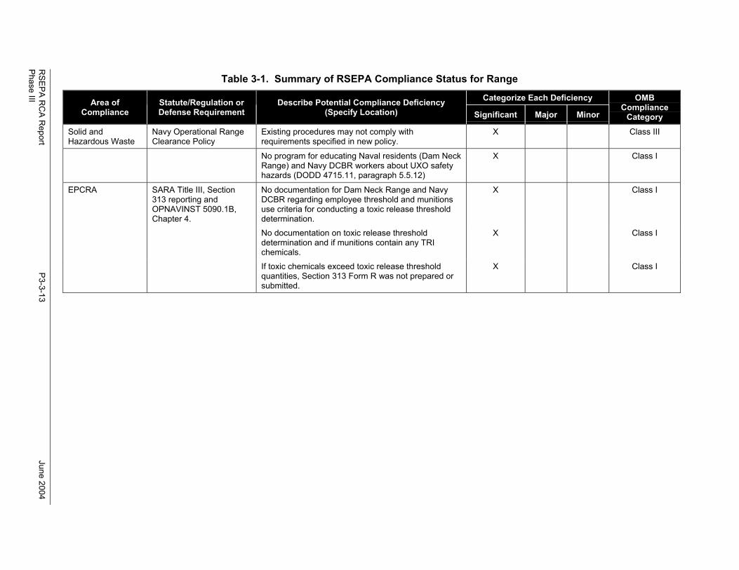
3.2 RSEPA COMPLIANCE STATUS SUMMARY
Section 3.1 outlined the compliance assessment performed for VACAPES ranges and support facilities.All significant deficiencies found by team members during the RCA, which are items not in compliancewith Federal, State, or local environmental laws or regulations, or DOD/Navy requirements are outlinedin Table 3-1. The environmental compliance deficiencies are classified according to compliancecategories found in Chapter 1 of OPNAVINST 5090.1B. The OPNAVINST 5090.1B compliancecategories are defined as follows:
• Minor Deficiency–Mostly administrative in nature. May involve temporary or occasionalinstances of noncompliance with environmental statutes.
• Major Deficiency–Requires action, but not necessarily immediately. This category identifiesconditions that usually represent violations of environmental statutes and may result in a noticeof violation. Major findings may pose a future threat to human health, safety, the environment,or the ability to accomplish the mission.
• Significant Deficiency–Requires immediate action. These deficiencies pose, or have a highlikelihood of posing, a direct and immediate threat to human health, safety, the environment, orthe mission of the range.
Each deficiency listed in Tables 3-1 and 3-2 also is classified according to Office of Management andBudget (OMB) compliance categories. These compliance categories are defined as follows:
• Class I–Class I projects are those in which ranges are currently out of compliance withestablished regulatory deadlines.
• Class II–Class II projects are those in which ranges will be out of compliance at a specific,impending published deadline, if action is not taken. If not accomplished by the deadline,projects become Class I.
• Class III–Class III projects are those needed to meet DOD, Assistant Secretary of the Navy(Installations and Environment), Chief of Naval Operations, and/or claimant goals related toenvironmental protection, P2, cost effectiveness, environmental quality, or enhancementinitiatives. These requirements are not mandated by law, but demonstrate Federal leadershipand goodwill.
RSEPA R
CA R
eportP3-3-13
June 2004Phase III
Table 3-1. Summary of RSEPA Compliance Status for Range
Categorize Each DeficiencyArea ofCompliance
Statute/Regulation orDefense Requirement
Describe Potential Compliance Deficiency(Specify Location) Significant Major Minor
OMBCompliance
CategorySolid andHazardous Waste
Navy Operational RangeClearance Policy
Existing procedures may not comply withrequirements specified in new policy.
X Class III
No program for educating Naval residents (Dam NeckRange) and Navy DCBR workers about UXO safetyhazards (DODD 4715.11, paragraph 5.5.12)
X Class I
EPCRA SARA Title III, Section313 reporting andOPNAVINST 5090.1B,Chapter 4.
No documentation for Dam Neck Range and NavyDCBR regarding employee threshold and munitionsuse criteria for conducting a toxic release thresholddetermination.
X Class I
No documentation on toxic release thresholddetermination and if munitions contain any TRIchemicals.
X Class I
If toxic chemicals exceed toxic release thresholdquantities, Section 313 Form R was not prepared orsubmitted.
X Class I
RSEPA R
CA R
eportP3-3-14
June 2004Phase III
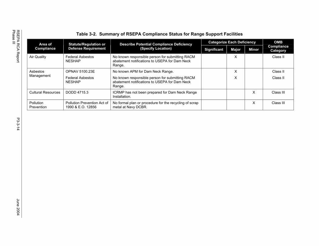
Table 3-2. Summary of RSEPA Compliance Status for Range Support Facilities
Categorize Each DeficiencyArea ofCompliance
Statute/Regulation orDefense Requirement
Describe Potential Compliance Deficiency(Specify Location) Significant Major Minor
OMBCompliance
CategoryAir Quality Federal Asbestos
NESHAPNo known responsible person for submitting RACMabatement notifications to USEPA for Dam NeckRange.
X Class II
OPNAV 5100.23E No known APM for Dam Neck Range. X Class IIAsbestosManagement Federal Asbestos
NESHAPNo known responsible person for submitting RACMabatement notifications to USEPA for Dam NeckRange.
X Class II
Cultural Resources DODD 4715.3 ICRMP has not been prepared for Dam Neck RangeInstallation.
X Class III
PollutionPrevention
Pollution Prevention Act of1990 & E.O. 12856
No formal plan or procedure for the recycling of scrapmetal at Navy DCBR.
X Class III
RSEPA RCA Report June 2004Phase III
P3-3-15
3.3 CONCLUSIONS
The conclusions for the assessment of environmental compliance are presented for the operational rangeareas and support facilities below.
3.3.1 Operational Range Areas
There are few environmental regulations that have specific reporting and compliance requirements ofmilitary ranges. Two exceptions are the MMR and EPCRA. Based upon information gained duringinterviews with Navy CNRMA REG program managers and review of environmental documents receivedin the RDF, VACAPES ranges appear to be in compliance with MMR; however, there is a question ofcompliance with regard to EPCRA. Under the recently required Section 313 of SARA Title III EPCRATRI, the RCA Technical Team advises the CNRMA EPCRA Manager to document whether Navy DCBRand Dam Neck Range exceed any TRI reportable quantity thresholds. It is very important thatdeterminations regarding the applicability of EPCRA Section 313 to Dam Neck Range and Navy DCBRbe documented, along with toxic release threshold calculations, if it is determined that any munitionscontain TRI listed chemicals. If any of the ranges exceed TRI chemical thresholds, a Form R report mustbe submitted by 1 July for the previous calendar year.
The Navy recently released the Operational Range Clearance Policy for Navy Ranges (U.S. Navy 2004),which includes new requirements for activities such as the removal, disposal, and recycling of UXO,range scrap, and debris. Generally, existing VACAPES procedures appear to comply with the operationalrange clearance policy, but the Range Manager should ensure that range-specific scrap managementpolicies and procedures comply with the operational range clearance policy.
An additional requirement that pertains specifically to operational range areas is required by DODD4715.11, which requires DOD ranges to implement procedures to ensure range sustainability throughrange explosives safety measures and assess environmental impacts due to range munitions use. Manyrequirements under DODD 4715.11 are being met through range management plans; however, thefollowing two deficiencies were noted: addressing environmental impacts from range operations andeducating on- and off-base personnel regarding explosives hazards.
3.3.2 Dam Neck Range and Navy DCBR Range Support Operations and Facilities
Additional environmental regulations were reviewed that apply to clean air; clean water; hazardousmaterials and waste management; storage tank and POL management; environmental planning; PCBs,lead-based paint and asbestos management; and natural and cultural resources management. Regulationsin these environmental areas apply most directly to Dam Neck Range and Navy DCBR support operationsand facilities; however, they can apply to the operational range areas, as well.
Based upon information gained thus far, both Dam Neck Range and Navy DCBR operations/facilities andoperational range areas appear to be in compliance with most requirements, with the exception of thedeficiencies noted in Table 3-1 of this report. Noted environmental regulatory and Navy requirementdeficiencies are: the APM is not known for either Dam Neck Range or Navy DCBR, the personresponsible for reporting asbestos abatement USEPA notifications is not known, an ICRMP was notprepared for Dam Neck Range, and a formal plan or procedures have not been developed for the recyclingof scrap metal. The RCA Technical Team advises that Dam Neck Range and Navy DCBR bring theseissues into compliance.
It is important to reiterate that the primary focus of the RSEPA RCA is to evaluate the compliance ofranges, as the Navy already has an EQA Program in place to identify compliance deficiencies at Navyinstallations. The Navy EQA Program is required to audit, on a routine basis, Navy shore stationenvironmental programs for compliance with applicable environmental regulations and Navy

RSEPA RCA Report June 2004Phase III
P3-3-16
requirements. It should be noted that Seymour Johnson AFB, as range owners, annually inspect NavyDCBR via the Air Force’s ECAMP. Air Force environmental managers at the DCBR report theirfindings to Navy DCBR for the Navy to address. It is expected by the RCA Technical Team that thestatus of the deficiencies noted in this report will be evaluated during the next scheduled EQA for DamNeck Range and Navy DCBR.
RSEPA RCA Report June 2004Phase III
P3-4-1
4. OPERATIONAL RANGE SITE MODEL (ORSM)
Section 4 presents the ORSM for land-based ranges and components of ranges within the VACAPESComplex. Section 4.1 describes the areas where munitions are handled, stored, used for testing andtraining at the VACAPES ranges. Section 4.2 describes the operational component of the ORSM. Theenvironmental and land use components are described in Sections 4.3 and 4.4, respectively. Thecompleted ORSMs for both ranges within VACAPES are described in Section 4.5.
4.1 DEFINITION OF RANGES
The purpose of defining ranges in RSEPA is to identify areas where MCs could migrate to off-range areasand potentially pose risks to human health or ecological receptors. Therefore, RSEPA focuses on land-based ranges and components of ranges on land where munitions testing and training operations areconducted. ORSMs are used to determine where munitions operations occur on land, what theenvironmental conditions are in and around those areas, and what the land uses are in and around theseareas that could pose risks to humans or ecological receptors being exposed to residues of the munitionsoperations.
ORSMs are used to determine where predictive modeling is needed to assess the risk of off-range releasesof MCs. The MCs listed previously typically are not found in small-arms ammunition or inert weapons.Consequently, RSEPA typically excludes these areas from predictive modeling. Furthermore, becauseairborne emissions are assessed as a function of EPCRA TRI reporting, RSEPA typically excludes airemissions from predictive modeling.
The Technical Team looked for locations where munitions are handled, stored, or used for testing andtraining at VACAPES ranges. Table 4-1 summarizes the results of the assessment of munitions-relatedactivities found within VACAPES.
4.2 OPERATIONAL COMPONENT
This section summarizes information about land-based military operations, particularly where operationsutilizing munitions are conducted, since RSEPA Decision Point 1 is concerned with releases of MCs tooff-range areas. Sections 4.2.1, 4.2.2, and 4.2.3 describe past, current, and planned future uses of bothVACAPES ranges, respectively.
The majority of the information that is presented in this report reflects current range use. Current andfuture uses of ranges are more relevant than are past uses to the primary purpose of RSEPA, which issustainment of operational ranges. In addition, limited information about past and future range use isavailable.
4.2.1 Historical Military Operations
VACAPES OPAREA is a surface and subsurface operating area located in Maryland, Virginia, and NorthCarolina and their adjacent coastal waters. In previous operations, military aircraft flying overinternational waters off the U.S. east coast required that the airspace be set aside as a warning area formilitary operations. This method of air traffic control meant that any and all civilian/commercial aircraftwere required to vacate the area, and if approaching, to be re-routed by air traffic control in order to avoidany conflict between military and non-military flight paths and operations. This method was found to bea very inefficient way of managing airspace.
As a way to better manage the airspace along the U.S east coast, the Fleet Area Control and SurveillanceFacility, Virginia Capes (FACSFAC VACAPES) was established on 1 October 1977. FACSFAC
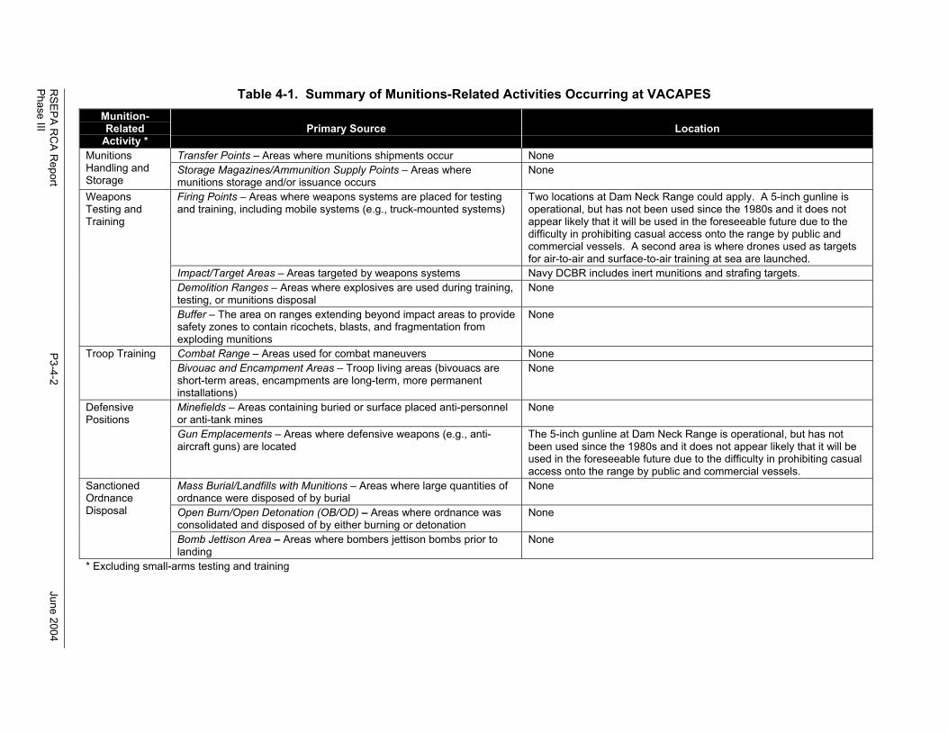
RSEPA R
CA R
eportP3-4-2
June 2004Phase III
Table 4-1. Summary of Munitions-Related Activities Occurring at VACAPESMunition-Related
Activity *Primary Source Location
Transfer Points – Areas where munitions shipments occur NoneMunitionsHandling andStorage
Storage Magazines/Ammunition Supply Points – Areas wheremunitions storage and/or issuance occurs
None
Firing Points – Areas where weapons systems are placed for testingand training, including mobile systems (e.g., truck-mounted systems)
Two locations at Dam Neck Range could apply. A 5-inch gunline isoperational, but has not been used since the 1980s and it does notappear likely that it will be used in the foreseeable future due to thedifficulty in prohibiting casual access onto the range by public andcommercial vessels. A second area is where drones used as targetsfor air-to-air and surface-to-air training at sea are launched.
Impact/Target Areas – Areas targeted by weapons systems Navy DCBR includes inert munitions and strafing targets.Demolition Ranges – Areas where explosives are used during training,testing, or munitions disposal
None
WeaponsTesting andTraining
Buffer – The area on ranges extending beyond impact areas to providesafety zones to contain ricochets, blasts, and fragmentation fromexploding munitions
None
Combat Range – Areas used for combat maneuvers NoneTroop TrainingBivouac and Encampment Areas – Troop living areas (bivouacs areshort-term areas, encampments are long-term, more permanentinstallations)
None
Minefields – Areas containing buried or surface placed anti-personnelor anti-tank mines
NoneDefensivePositions
Gun Emplacements – Areas where defensive weapons (e.g., anti-aircraft guns) are located
The 5-inch gunline at Dam Neck Range is operational, but has notbeen used since the 1980s and it does not appear likely that it will beused in the foreseeable future due to the difficulty in prohibiting casualaccess onto the range by public and commercial vessels.
Mass Burial/Landfills with Munitions – Areas where large quantities ofordnance were disposed of by burial
None
Open Burn/Open Detonation (OB/OD) – Areas where ordnance wasconsolidated and disposed of by either burning or detonation
None
SanctionedOrdnanceDisposal
Bomb Jettison Area – Areas where bombers jettison bombs prior tolanding
None
* Excluding small-arms testing and training
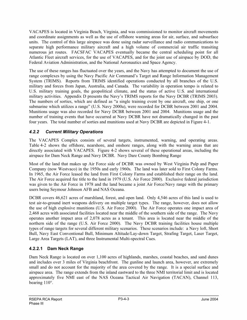
RSEPA RCA Report June 2004Phase III
P3-4-3
VACAPES is located in Virginia Beach, Virginia, and was commissioned to monitor aircraft movementsand coordinate assignments as well as the use of offshore warning areas for air, surface, and subsurfaceunits. The control of this large airspace was done using radar surveillance and radio communications toseparate high performance military aircraft and a high volume of commercial air traffic transitingnumerous jet routes. FACSFAC VACAPES eventually became the central scheduling point for allAtlantic Fleet aircraft services, for the use of VACAPES, and for the joint use of airspace by DOD, theFederal Aviation Administration, and the National Aeronautics and Space Agency.
The use of these ranges has fluctuated over the years, and the Navy has attempted to document the use ofrange complexes by using the Navy Pacific Air Command’s Target and Range Information ManagementSystem (TRIMS). Reports from TRIMS identified operations conducted by all branches of the U.S.military and forces from Japan, Australia, and Canada. The variability in operation tempo is related toU.S. military training goals, the geopolitical climate, and the status of active U.S. and internationalmilitary activities. Appendix D presents the Navy’s TRIMS reports for the Navy DCBR (TRIMS 2003).The numbers of sorties, which are defined as “a single training event by one aircraft, one ship, or onesubmarine which utilizes a range” (U.S. Navy 2000a), were recorded for DCBR between 2001 and 2004.Munitions usage was also recorded for Navy DCBR between 2001 and 2004. Munitions usage and thenumber of training events that have occurred at Navy DCBR have not dramatically changed in the pastfour years. The total number of sorties and munitions used at Navy DCBR are depicted in Figure 4-1.
4.2.2 Current Military Operations
The VACAPES Complex consists of several targets, instrumented, warning, and operating areas.Table 4-2 shows the offshore, nearshore, and onshore ranges, along with the warning areas that aredirectly associated with VACAPES. Figure 4-2 shows several of these operational areas, including theairspace for Dam Neck Range and Navy DCBR. Navy Dare County Bombing Range
Most of the land that makes up Air Force side of DCBR was owned by West Virginia Pulp and PaperCompany (now Westvaco) in the 1950s and early 1960s. The land was later sold to First Colony Farms.In 1965, the Air Force leased the land from First Colony Farms and established their range on the land.The Air Force acquired fee title to the land in 1979 (U.S. Air Force 2000). Exclusive federal jurisdictionwas given to the Air Force in 1978 and the land became a joint Air Force/Navy range with the primaryusers being Seymour Johnson AFB and NAS Oceana.
DCBR covers 46,621 acres of marshland, forest, and open land. Only 4,546 acres of this land is used totest air-to-ground inert weapons delivery on multiple target types. The range, however, does not allowthe use of high explosive munitions (U.S. Air Force 2000). The Air Force operates one impact area of2,468 acres with associated facilities located near the middle of the southern side of the range. The Navyoperates another impact area of 2,078 acres as a tenant. This area is located near the middle of thenorthern side of the range (U.S. Air Force 2000). The Navy DCBR training facilities house multipletypes of range targets for several different military scenarios. These scenarios include: a Navy loft, ShortBull, Navy East Conventional Bull, Minimum Altitude/Lay-down Target, Strafing Target, Laser Target,Large Area Targets (LAT), and three Instrumental Multi-spectral Cues.
4.2.2.1 Dam Neck Range
Dam Neck Range is located on over 1,100 acres of highlands, marshes, coastal beaches, and sand dunesand includes over 3 miles of Virginia beachfront. The gunline and launch area, however, are extremelysmall and do not account for the majority of the area covered by the range. It is a special surface andairspace area. The range extends from the inland eastward to the three NMI territorial limit and is locatedapproximately five NMI east of the NAS Oceana Tactical Air Navigation (TACAN), Channel 113,bearing 110°.
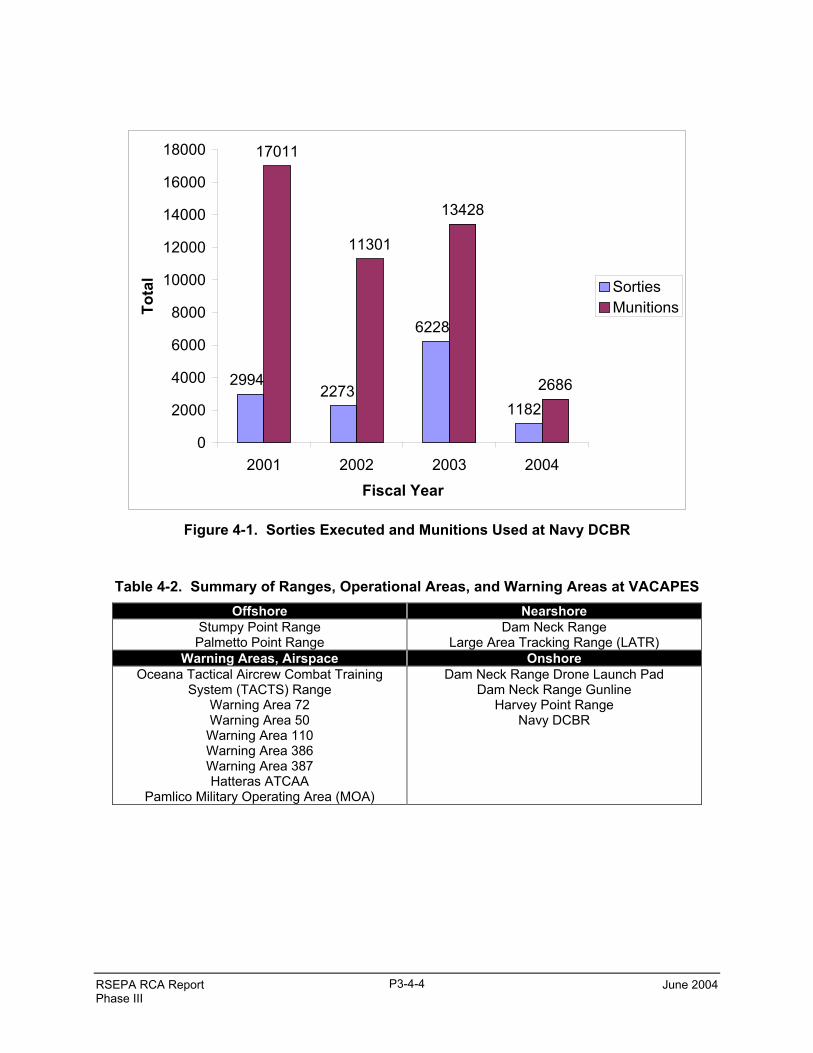
RSEPA RCA Report June 2004Phase III
P3-4-4
17011
11301
13428
26861182
6228
22732994
0
2000
4000
6000
8000
10000
12000
14000
16000
18000
2001 2002 2003 2004Fiscal Year
Tota
l SortiesMunitions
Figure 4-1. Sorties Executed and Munitions Used at Navy DCBR
Table 4-2. Summary of Ranges, Operational Areas, and Warning Areas at VACAPESOffshore Nearshore
Stumpy Point RangePalmetto Point Range
Dam Neck RangeLarge Area Tracking Range (LATR)
Warning Areas, Airspace OnshoreOceana Tactical Aircrew Combat Training
System (TACTS) RangeWarning Area 72Warning Area 50Warning Area 110Warning Area 386Warning Area 387Hatteras ATCAA
Pamlico Military Operating Area (MOA)
Dam Neck Range Drone Launch PadDam Neck Range Gunline
Harvey Point RangeNavy DCBR
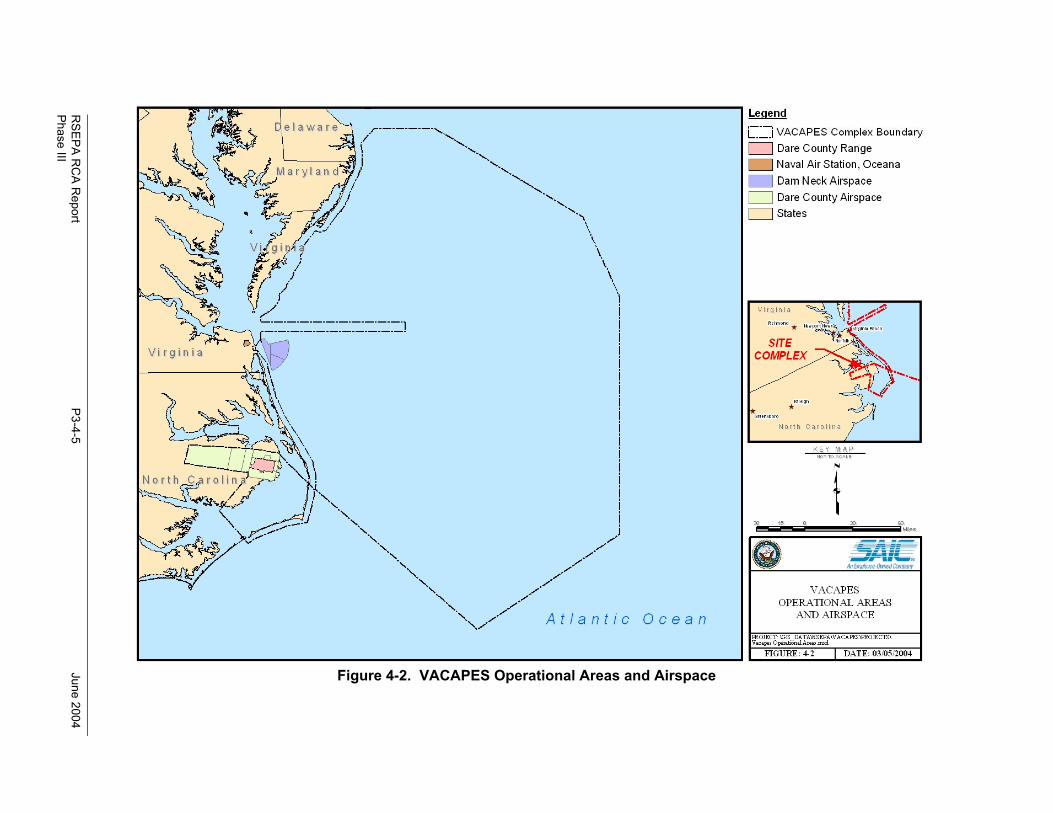
RSEPA R
CA R
eportP3-4-5
June 2004Phase III
Figure 4-2. VACAPES Operational Areas and Airspace
RSEPA RCA Report June 2004Phase III
P3-4-6
The primary use of the Dam Neck Range occurs at sea and is air-to-air exercises using live ordnance andair-to-surface exercises using MK-76 or MK-106 practice bombs and inert 2.75-inch folding fin aerialrockets. There are two types of targets that are used on the range to detonate the weapons. The VC-6Squadron’s BQM-74E powered drones are remotely controlled subsonic air-to-air and surface-to-airtargets. JATO rockets are used to launch the drones and the control of the drones is accomplished withthe use of Portable Radio Tracking and Control System or Integrated Target Control System. The secondtarget used at the facility is the QST-33/35 highly maneuverable, remote controlled, fiberglass boats usedas moving targets for inert rocket and/or practice bombs. The QST-33 Seaborne Powered Target(SEPTAR) is 18-feet long, while the QST-35 is 55-feet long. The control over the targets is maintainedwith either the Portable Radio Tracking and Control System, Integrated Target Control System, orControl Target Transmitter System (U.S. Navy 2000b).
4.2.2.2 Summary of Land-Based Ranges and Components of Ranges
RSEPA is concerned with land-based ranges where munitions larger than small-arms ammunition areused. Table 4-3 describes military operations on land-based ranges at VACAPES.
4.2.3 Future Military Operations
The information regarding future military operations is limited. An INRMP was written in 1998 by theAir Force for DCBR and, at that time, there were no anticipated changes in training operations at DCBR.In 2003, Seymour Johnson AFB issued a request for NEPA CATEX for construction of a simulatedaircraft runway within the existing Air Force’s bombing range (U.S. Air Force 2003). Although thissimulated runway would be a different target, it is not known how it would impact the operational tempoof the Air Force at DCBR. Future operations for Navy operations at DCBR and Dam Neck Range havenot been identified to date.
4.3 ENVIRONMENTAL AND CULTURAL COMPONENTS OF VACAPES ORSM
The following sections present an evaluation of the environmental components of the ORSM for the NavyDCBR and Dam Neck Range. In order to ensure the long-term sustainability of VACAPES as a trainingrange complex, the Navy must define what environmental conditions are at the range complexes anddetermine if the resources are being managed in an environmentally sound manner. Information wascollected for both ranges regarding predominant soil types; topography; vegetation; aquifercharacteristics; and potential or known sensitive, threatened, or endangered flora or fauna from existingdocumentation.
4.3.1 Predominant Soil Types
The following sections discuss the types of soil found at Navy DCBR and Dam Neck Range.
4.3.1.1 Navy Dare County Bombing Range
Soils at DCBR were formed by wetland community development. This development is based on theQuarternary deposits of surficial organic materials of varying thickness overlying undifferentiated andcomplexly interbedded layers of sand, silt, clay, and mollusk shells (U.S. Air Force 2000). A 1992 U.S.Department of Agriculture Soil Conservation Service Soil Survey for Dare County found that the areawas comprised of seven soil types. These soil types are hydric, support hydrophytic vegetation, andinclude Belhaven muck, Cape Fear loam, Hobonny muck, Hyde loam, Ponzer muck, Pungo muck, andRoper muck (U.S. Air Force 2000).
RSEPA RCA Report June 2004Phase III
P3-4-7
Table 4-3. Land-Based Ranges at VACAPES
Range Description Status of ORSM and Predictive Modeling
Dam Neck Range Located in Virginia along the beach fivenautical miles east of NAS Oceana. Livetarget drones (BQM-74E) for surface-to-airand air-to-air exercises are remotely firedfrom the beach at the drone launch area. Aninactive 5-inch gunline runs along the beachfront. Air-to-surface exercises also areallowed with inert ordnance, but only in theoffshore areas of the range.
Include in ORSM, but exclude from predictivemodeling because live munitions are notused. If required, emissions from JATObottles used to launch drones should beassessed as a function of EPCRA TRIreporting.
Large AreaTracking Range(LATR)
Encompasses a radial area roughly 500nautical miles from the LATR GroundInterrogation Station (GIS) on Bodie Island,North Carolina. Primarily used for trackingand exercise data support for up to 124exercise participants. No specific targets.
Exclude, as munitions are not used.
Navy Dare CountyBombing Range
Located near Manteo, North Carolina and is ajoint US Navy and US Air Force weaponsrange. The Navy operates the northernportion and the Air Force (Seymour JohnsonAFB) operates the southern portion. Air-to-ground exercises are allowed with inertordnance and ordnance which uses markingcharges. Strafing exercises also are allowed.Targets consist of two conventional bulltargets, a strafing target, a laser target, andseveral other types of targets.
Include in ORSM, but exclude from predictivemodeling because only use inert munitionsand munitions that use marking charges.
The predominant soil type found in the DCBR is Pungo muck. It is distributed throughout the entiresoutheastern portion of the range. Several strips of Pungo muck exist in other areas of DCBR. One areaextends northward, lying east of the Navy impact area and continuing to the northern border of the range,and the other extends westward through the Air Force impact area to the western border of the range.Figure 4-3 shows the location of Pungo muck within Navy DCBR. Mineral soils also have beendiscovered in the northwestern and southwestern portions of the range. These sections of the range arenot found to contain a very significant depth of organic material and consist of Hyde and Cape Fear loamsoils (U.S. Air Force 2000).
4.3.1.2 Dam Neck Range
Dam Neck Range is located on over 1,100 acres of highlands, marshes, and sand dunes. The majority ofDam Neck Range, including the land-based components of the range, is covered by asphalt. Theremaining portion of the range is made up of over 3 miles of Virginia Beach shoreline, where thepredominant soil type is sand.
4.3.2 Predominant Topography
The following sections discuss the topography of Navy DCBR and Dam Neck Range.
RSEPA R
CA R
eportP3-4-8
June 2004Phase III
Figure 4-3. Primary Soil Types Within Navy DCBR
RSEPA RCA Report June 2004Phase III
P3-4-9
4.3.2.1 Navy Dare County Bombing Range
The Dare County mainland is the product of progressive wetland community development. Thepredominant overlying geologic formation in the area is composed mainly of the Pamlico Terrace, whichis low, flat, and in certain areas, a gently sloping plain. This plain lies east of the Suffolk Scarp, which isa prehistoric Atlantic Ocean Shoreline.
4.3.2.2 Dam Neck Range
Dam Neck Range is located on over 1,100 acres of highlands, marshes, and sand dunes. The topographyin the vicinity of the land-based components of the range is flat with the exception of sand dunes and aberm made between the beach and areas where military operations occur.
4.3.3 Predominant Vegetation
The following sections discuss the predominant vegetation found at Navy DCBR and Dam Neck Range.
4.3.3.1 Navy Dare County Bombing Range
The vegetation mapped at DCBR is very diverse and typical for an area that is the product of progressivewetland community development. The majority of the vegetation found in the uncleared areas of therange is forest. This area consists of low and high pocosin, bay and swamp forest, and natural lakeshoreline (U.S. Air Force 2000). These vegetation types are discussed below and are shown inFigure 4-4:
• Low Pocosin and High Pocosin—These vegetation types are generally located in the center ofpeatlands and include Pond Pine Woodland, Peatland Atlantic White Cedar Forest, andunderlying shrubs. Peatland Atlantic White Cedar Forest species that have been disturbedwithin the last 10 years also are included with this vegetation type.
• Bay and Swamp Forest—Bay forest is usually associated with the outer edges of pond pinewoodland. This vegetation type is characterized by an evergreen hardwood forest and anaverage canopy height of 25 feet. Vegetation in bay forest includes red bay, loblolly bay, andsweet bay with some understory shrubby vegetation. Swamp forest is relatively uncommonwith peatland and is usually found around streams. Trees in this forest type typically grow to45 feet. Vegetation in swamp forest includes non-riverine swamp forest and non-riverineswamp forest species that have been disturbed within the past 10 years. Swamp red bay,swamp blackgum, and red maple are typical types of trees found in swamp forest areas.
• Natural Lake Shoreline—This area is characterized by periodic human disturbance. Itincludes vegetation such as herbs, shrubs, and grasses.
4.3.3.2 Dam Neck Range
The majority of the land-based portion of Dam Neck Range is covered by asphalt. This makes the area anunsuitable habitat for a variety of plant species. The beachfront portion of Dam Neck Range would be theonly area at the range where vegetation would exist.
4.3.4 Surface Water and Groundwater
The following sections discuss the surface water and groundwater at Navy DCBR and Dam Neck Range.
RSEPA R
CA R
eportP3-4-10
June 2004Phase III
Figure 4-4. Primary Vegetation Types at Navy DCBR
RSEPA RCA Report June 2004Phase III
P3-4-11
4.3.4.1 Navy Dare County Bombing Range
The ecosystems found within Dare County and DCBR consist of swamps, bogs, marshes, and pocosinhabitats (U.S. Air Force 2000). Although the range is not adjacent to any major body of water, thewestern boundary of the range lies within a mile of the Alligator River and the eastern boundary lieswithin a mile of Stumpy Point Bay. Stumpy Point Bay connects to the Pamlico Sound. The Albermarleand Croatan Sounds also surround the DCBR.
The two major sources of surface water in the DCBR are Whipping Creek and Whipping Creek Lake.Both are located in the Pasquotank River Basin, which covers approximately 3,635 square miles. ThePasquotank River flows from the Great Dismal Swamp to the Albermarle Sound, traveling northeast tosoutheast. These two sources are protected by the North Carolina Department of Environment andNatural Resources for recreation, fishing, aquatic life, and wildlife purposes. The department alsoconsiders these waters to be Outstanding Resource Waters, meaning that they hold significant state ornational importance for recreation or ecological reasons resulting in special measures of protection.There are currently no bodies of water on the DCBR that are designated National Wild and Scenic Rivers.(U.S. Air Force 2000).
The upper aquifer and the limestone aquifer are the two principal aquifers that supply the groundwaterresources on the DCBR (U.S. Air Force 2000). Sedimentary deposits that form these two groundwateraquifers cover underlying bedrock in Dare County. The upper aquifer yields the most water and providesa source to the overlying streams and estuaries. Groundwater is very near the surface during most of theyear across the system (U.S. Air Force 2000).
4.3.4.2 Dam Neck Range
Because of the proximity of the land-based components of Dam Neck Range to the Atlantic Ocean,surface water hydrology and groundwater hydrogeology are predominantly ocean water. No informationwas available to determine the depth to the shallowest fresh groundwater.
4.3.5 Sensitive Ecosystems
The following sections discuss the sensitive ecosystems found within Navy DCBR and Dam Neck Range.These sections also address human impacts to sensitive ecosystems at these ranges.
4.3.5.1 Navy Dare County Bombing Range Known Threatened and Endangered Species
Surveys conducted on DCBR revealed that this area of remote and relatively undisturbed land is home toa number of endangered and threatened species. The forest and pocosin lands that make up the range area very suitable environment for many species of mammal, reptile, bird, and amphibian (U.S. Air Force2000).
USFWS currently lists 15 Federally protected plant and animal species that are known to be in DareCounty (U.S. Air Force 2000), which are listed on Table 4-4. The North Carolina Division of Parks andRecreation Natural Heritage Program lists 19 Federally protected plant and animal species that have beenrecorded in Dare County (U.S. Air Force 2000), which are listed on Table 4-5.
Ecological surveys conducted on the installation revealed that 25 of 65 natural communities could bedeemed sensitive ecosystems (U.S. Air Force 2000) and critically impaired because of their vulnerabilityto potential destruction (U.S. Air Force 2000). These areas combined account for at least 23,000 acres ofhabitat that is impaired and vulnerable to potential destruction, thus requiring top priority protection.
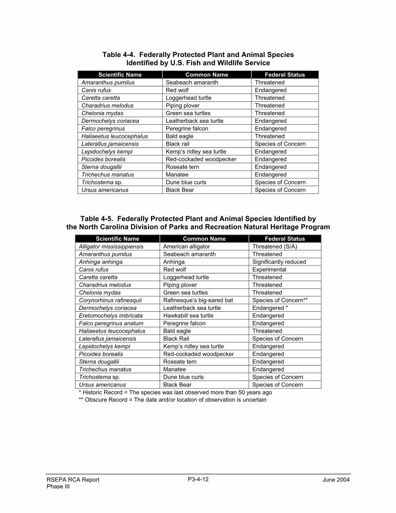
RSEPA RCA Report June 2004Phase III
P3-4-12
Table 4-4. Federally Protected Plant and Animal SpeciesIdentified by U.S. Fish and Wildlife Service
Scientific Name Common Name Federal StatusAmaranthus pumilus Seabeach amaranth ThreatenedCanis rufus Red wolf EndangeredCaretta caretta Loggerhead turtle ThreatenedCharadrius melodus Piping plover ThreatenedChelonia mydas Green sea turtles ThreatenedDermochelys coriacea Leatherback sea turtle EndangeredFalco peregrinus Peregrine falcon EndangeredHaliaeetus leucocephalus Bald eagle ThreatenedLaterallus jamaicensis Black rail Species of ConcernLepidochelys kempi Kemp’s ridley sea turtle EndangeredPicoides borealis Red-cockaded woodpecker EndangeredSterna dougallii Roseate tern EndangeredTrichechus manatus Manatee EndangeredTrichostema sp. Dune blue curls Species of ConcernUrsus americanus Black Bear Species of Concern
Table 4-5. Federally Protected Plant and Animal Species Identified bythe North Carolina Division of Parks and Recreation Natural Heritage Program
Scientific Name Common Name Federal StatusAlligator mississippiensis American alligator Threatened (S/A)Amaranthus pumilus Seabeach amaranth ThreatenedAnhinga anhinga Anhinga Significantly reducedCanis rufus Red wolf ExperimentalCaretta caretta Loggerhead turtle ThreatenedCharadrius melodus Piping plover ThreatenedChelonia mydas Green sea turtles ThreatenedCorynorhinus rafinesquii Rafinesque’s big-eared bat Species of Concern**Dermochelys coriacea Leatherback sea turtle Endangered *Eretomochelys imbricata Hawksbill sea turtle EndangeredFalco peregrinus anatum Peregrine falcon EndangeredHaliaeetus leucocephalus Bald eagle ThreatenedLaterallus jamaicensis Black Rail Species of ConcernLepidochelys kempi Kemp’s ridley sea turtle EndangeredPicoides borealis Red-cockaded woodpecker EndangeredSterna dougallii Roseate tern EndangeredTrichechus manatus Manatee EndangeredTrichostema sp. Dune blue curls Species of ConcernUrsus americanus Black Bear Species of Concern* Historic Record = The species was last observed more than 50 years ago** Obscure Record = The date and/or location of observation is uncertain
RSEPA RCA Report June 2004Phase III
P3-4-13
These include natural communities, many of which are found at DCBR. The 25 sensitive ecosystemcommunities are listed below:
• Basic Mesic Forest (Coastal PlainSubtype)
• Coastal Fringe Sandhill• Basic Mesic Forest (Piedmont
Subtype)• Coastal Plain Marl Outcrop• Coastal Fringe Evergreen Forest• Diabase Glade• Non-Riverine Swamp Forest• Floodplain Pool• Non-Riverine Wet Hardwood Forest• Granitic Flatrock• Peatland Atlantic White Cedar Forest• Piedmont/Mountain Swamp Forest
• Pine Savanna• Small Depression Pocosin• Small Depression Pond• Ultramafic Outcrop Barren• Tidal Freshwater Marsh (Freshwater
Variant)• Upland Depression Swamp Forest• Interdune Pond• Maritime Deciduous Forest• Maritime Dry Grassland• Maritime Evergreen Forest• Maritime Shrub Swamp• Maritime Swamp Forest• Maritime Wet Grassland.
For DCBR, the American alligator is the only rare reptile documented to inhabit the range. Sporadicsurveys of the alligators have occurred at Whipping Creek and Whipping Creek Lake, the canals aroundthe Air Force’s and the Navy’s impact areas. Twenty-five to 35 alligators were counted during a 1993survey and 46 to 60 alligators were counted during a 1994 survey. Whipping Creek Lake had the highestdensity of alligators, while low densities of alligators were noted within the ranges. Due to the limitedscope and inconsistent methodology of the alligator surveys at DCBR, data gaps exist and there are somediscrepancies between reports. Although DCBR could benefit from further surveys, the research that hasbeen completed indicates that military operations will not impact the alligators since the majority of thealligator population is not located within the impact areas (U.S. Air Force 2000).
4.3.5.2 Dam Neck Range Known Threatened and Endangered Species
The majority of the land-based portion of Dam Neck Range is covered by asphalt. This makes the area anunsuitable habitat for a variety of plant and animal species. The beach front portion of Dam Neck Rangewould be the only area at the range where plant and animal species are likely to exist. Various species ofsea turtles may frequent the beach front.
4.3.5.3 Human Impacts on Sensitive Ecosystems on Dare County Bombing Range
In the 1950s and 1960s, well before the Air Force and Navy began use of the Dare County lands, canalswere dug spanning 180 miles. These canals ranged from 16 to 25 feet wide and 6 to 8 feet deep. Theinitial action was quite damaging to the land’s original natural hydrology. The canals are currently usedto control the flow of water to areas for the purpose of fire prevention. There also is an effort on the partof the military to study and evaluate the possibility of trying to restore the land’s original hydrology.Until military studies begin, the North Carolina Department of Environment and Natural Resources(NCDENR) had given these canals the same environmental classification as Whipping Creek andWhipping Creek Lake.
In 1995, an Ecosystem Survey was conducted for the Dare County Bombing Range in which eight naturalcommunity types, 46 subdivisions of those communities, and 12 subdivisions of disturbed naturalcommunities were identified (U.S. Air Force 2000). Within Dare County and DCBR, there were at least23,000 acres of habitat that was considered top priority for protection. These natural communities werelisted in Section 4.3.5.1.
RSEPA RCA Report June 2004Phase III
P3-4-14
Five “Natural Heritage Priority Areas” were also designated. They included: U.S. 264 Lower PocosinNatural Area, Faircloth Road Pond Pine Pocosin Natural Area, Pine Road Swamp Natural Area, TaylorRoad Natural Area, and the Alligator River Swamp Natural Area.
Along with the vast types of sensitive ecosystems, there also are a fair number of sensitive speciesinhabiting DCBR and the surrounding Alligator River National Wildlife Refuge. The refuge supports 145species of resident and migratory birds. Many of these resident and migratory species use the land forforaging and nesting habitat, including raptors, shorebirds, warblers, and numerous waterfowl. Due to thetypes of habitat that support the shorebirds and waterfowl, these species are not found to inhabit the rangeitself; however the warbler, woodpecker duck, egret, heron, nuthatches, and gnatcatcher do inhabit areassurrounding the range. The range also is home to many mammalian species such as black bears, bobcats,river otters, white-tailed deer, and minks.
4.3.5.4 Human Impacts on Sensitive Ecosystems on Dam Neck Range
Dam Neck Range is currently unused by the public. Recreational and commercial boating does occurwithin the waters off the coast of the land-based portions of the range.
4.3.6 Cultural Resources
This section summarizes the cultural resources found at Navy DCBR and Dam Neck Range.
4.3.6.1 Navy Dare County Bombing Range
Because the Navy leases their portion of DCBR from the Air Force, the Air Force is ultimatelyresponsible for cultural resource management at this range. During 1994 and 1995, a cultural resourcestudy was conducted for the DCBR to locate any possible historical resources of significance and providefor their protection and preservation. The resulting CRMP stated that there are no resources eligible forlisting on the National Register, no indication of any future eligibility of any sites or locations, and noNative American burial or sacred areas on the range. The plan was submitted to Seymour Johnson AFBand was then submitted and approved by the State Historic Preservation Officer (U.S. Air Force 2000).
4.3.6.2 Dam Neck Range
Dam Neck Range is positioned in an area of Virginia that is engulfed with much cultural history. TheDam Neck Range gunline is positioned near the shore where the first Jamestown settlers landed, CivilWar battles were fought, and where German submarines sank American shipping vessels during WorldWar II. The name “Dam Neck” became firmly established in 1881 when it was given to a life-savingstation built where the Bachelor Officer Quarters are now located. The Coast Guard purchased the life-saving station in 1930 and used it as a signal station until the Navy bought the land during World War II(Global Security 2003b).
Neither a CRMP nor an Integrated CRMP has been prepared for Dam Neck Range, which normallydescribes the management protocols developed to meet cultural resource regulations. Archeological sitesand a cemetery are located at Dam Neck Range, but none appear to be located within the 5-inch gun firingline or the drone launch area. There are no federally-recognized Native American tribes in Virginia,although some public outreach to non-recognized groups is conducted as part of Navy communityrelations activities.
4.4 LAND USE COMPONENT
The following sections describe land use on and around Navy DCBR and the land-based components ofthe Dam Neck Range.
RSEPA RCA Report June 2004Phase III
P3-4-15
4.4.1 Navy Dare County Bombing Range
Most of the Dare County mainland area is made up of expansive swamp forests and vast impenetrablepocosins. Forestry has been an important enterprise for most of its history, although there were somefarming activities in the late 1700s and early 1800s (U.S. Air Force 2000). Most of the mainlandwilderness has been acquired for permanent protection as the Alligator River National Wildlife Refuge.
4.4.1.1 Military Use
The primary military land use of the area involves flight operations, aircraft maintenance, supportfacilities, training and administrative uses, housing, community support, and recreational uses (U.S. Navy2003a). The military-owned range can be categorized by one of three uses: semi-improved grounds,unimproved grounds, and land under facilities. Semi-improved grounds are those that receive periodicmaintenance for operational and aesthetic purposes. Such grounds are the two target areas comprised of4,546 acres, areas of transportation, weapons ranges, and areas of commercial use. Unimproved groundsare those that require no upkeep and consist mainly of natural lands with no government or publicfacilities on them. This type of land makes up the majority of the DCBR. Finally, land under facilitiesdescribes all grounds that have been directly affected by anthropogenic construction. Such areas consistof buildings, roads, parking areas, and airfields (U.S. Air Force 2000).
4.4.1.2 Public Use
The Dare County land is used for timber, fire and water management, and landfills. Due to the remotelocation of DCBR, much of the land remains unused by the public. While there are no formal recreationalopportunities on the DCBR land, people do participate in activities pertaining to ecotourism and wildlife.Of the existing activities available to the public, hunting of whitetailed deer is the most attended. Since1978, the DCBR has been leased as a Gaming Land by the state of North Carolina, resulting in annualrevenue of $30,000 for Seymour Johnson AFB. Other outdoor activities are expected to increase due topublic interest in several endangered and threatened species known to inhabit the range. Such expectedactivities include nature walking, bird watching, canoeing, and kayaking (U.S. Air Force 2000). Due topublic access to many areas of the range, the Dare County Sheriff, North Carolina State Troopers,USFWS, and the North Carolina Wildlife Resources Commission provide civilian law enforcement (U.S.Air Force 2000).
Land surrounding DCBR includes a variety of residential, commercial, industrial, and agricultural uses.West of the DCBR is a small municipal airport that serves helicopters and small fixed-wing planes forgeneral aviation traffic. Aircraft conducting instrument flight rules approaches may interact with thenortheastern portion of the DCBR restricted airspace, requiring permission to enter the airspace, cease ofall military operations, and the absence of military planes (U.S. Navy 2003a).
4.4.2 Dam Neck Range
Dam Neck Range is located on over 1,100 acres of highlands, marshes, coastal beaches, and sand dunesand includes over 3 miles of Virginia beachfront. The gunline and launch area, however, are extremelysmall and do not account for the majority of the area covered by the range. Dam Neck Range is host to12 tenant commands and over 5,600 instructors, students, and support personnel live or work at the range.Dam Neck Range operates on an educational premise, graduating over 17,000 students from one of over200 courses of instruction. Many of these courses are taught via the Video Tele-training network, as wellas military tactical training premise (Global Security 2003b).
RSEPA RCA Report June 2004Phase III
P3-4-16
4.4.2.1 Military Use
A 5-inch gunline is located on Gunline Street at Dam Neck Range. These guns are located within a fewhundred feet of the Atlantic Ocean. Navy personnel interviewed during the range visit indicated that theguns had not been fired since the 1980s due to the difficulty of clearing recreational and commercialvessels in the safety zone. Furthermore, they indicated that the difficulty in clearing vessels from thesafety zone is likely to worsen; therefore, it appears that the guns will not be used for live fire training inthe future. The guns, however, are currently used for maintenance training. A target drone launch pad islocated at the Dam Neck Range on Regulus Avenue. BQM-74E target drones are launched from the pad.
4.4.2.2 Public Use
Dam Neck Range is currently unused by the public. Recreational and commercial boating does occurwithin the waters off the coast of the range.
4.5 OPERATIONAL RANGE SITE MODELS
Prior sections presented the three components of the VACAPES ORSMs: operational, environmental,and land use. This section integrates these three components into the ORSMs for the Navy portion ofNavy DCBR and the land-based components of the Dam Neck Range.
4.5.1 ORSM for Navy DCBR
DCBR is divided into two independent operating areas; one operated and maintained by the U.S. AirForce and the other by the U.S. Navy. Figure 4-5 illustrates only the ORSM for Navy DCBR; however, itdoes show the location of the Air Force impact area in relation to the Navy impact area. The followingsections summarize and depict the source areas, receptors, and potential transport pathways in terms ofthe operational, environmental, and land use components.
• Operational—Navy DCBR is located in North Carolina and is a joint Navy and Air Force inertweapons training range. The Navy operates the northern portion and the Air Force (SeymourJohnson AFB) operates the southern portion. Air-to-ground exercises are allowed with inertordnance and ordnance which uses marking charges. Strafing exercises also are allowed.Targets consist of two conventional bull targets, a strafing target, a laser target, and severalother types of targets.
• Environmental—Navy DCBR is located on a peninsula surrounded by the Alligator River,Albemarle Sound, Croatan Sound, and the Pamlico Sound. The target range, however, islocated in the interior of the peninsula and does not adjoin any of these water bodies. Fourmajor streams drain the peninsula; however, none of these streams flow through the targetrange. The range was formed by wetland community development and the ecosystems foundwithin the range consist of swamps, bogs, marshes, and pocosin habitat. The predominant soilsfound in DCBR are a hydric soil known as “Pungo muck.” The topography of Navy DCBR islow, flat, and in certain areas, gently sloping. Two aquifers supply the groundwater resourcesat Navy DCBR and the groundwater is very near the surface during most of the year.At least 15 Federally protected plant and animal species are known to occur in Dare County.Only one rare species, the American alligator, inhabits the range, including the canals aroundthe Navy’s impact area. Alligator surveys, however, have shown that military operations willnot impact the rare species since the majority of the population is not located within the impactareas.A cultural resources study was conducted for DCBR, however, no cultural resources wereidentified that were eligible for listing on the National Register.
RSEPA R
CA R
eportP3-4-17
June 2004Phase III
Alligator RiverNational Wildlife Refuge
Allig
ator
Riv
erNavy Dare County Bombing Range
Navy Impact Area(2,078 Acres)
Air Force Impact Area(2,468 Acres)
Alligator RiverNational WildlifeRefuge
Wetlands • Low, flat terrain• Marshlands, forest, and open space• Land is leased from U.S. Air Force
• Upper aquifer and limestone aquifier• Over 15 Federally protected plant and animal species in Dare County• Ecotourism and hunting occur in refugeTargets
Source: GlobeXplorer (2004)
Figure 4-5. Operational Range Site Model for Navy Dare County Bombing Range
RSEPA RCA Report June 2004Phase III
P3-4-18
• Land Use—Navy DCBR consists of over 46,000 acres, however, both the Navy and Air Forceonly use approximately 2,000 acres apiece as impact areas. While there are no formalrecreational opportunities on DCBR land, people do participate in activities pertaining toecotourism and wildlife. Land surrounding Navy DCBR includes a variety of residential,commercial, industrial, and agricultural uses.
4.5.2 ORSM for Dam Neck Range
Dam Neck Range is an air-to-air and air-to-surface range and an extensive portion of the range is basedover the water. Figures 4-6 and 4-7 illustrate the ORSM for the Dam Neck Range 5-inch gunline and thedrone launch area, respectively. The following sections summarize and depict the source areas, receptors,and potential transport pathways in terms of the operational, environmental, and land use components.
• Operational—Dam Neck Range is located in Virginia along the beach. Live targets for air-to-air exercises are remotely fired from the beach at the drone launch area. An inactive 5-inchgunline runs along the beach front on a paved area. Firing was done over the beach into theocean. Air-to-surface exercises also are allowed with inert ordnance.
• Environmental—Dam Neck Range is located on over 1,100 acres of highlands, marshes, andsand dunes. The range includes over 3 miles of beachfront. The land-based, non-beach portionof the range is paved, making the area an unsuitable habitat for a variety of plant and animalspecies. Various species of sea turtles may inhabit the beaches at Dam Neck Range.Archeological sites and a cemetery are located at Dam Neck Range but they are not locatednear the gunline or the drone launch area.
• Land Use— Dam Neck Range is currently unused by the public. Recreational and commercialboating does occur within the waters off the coast of the range.
RSEPA RCA Report June 2004Phase III
P3-4-19
• Three guns at 5-inch gunline
• Guns are currently inactive but are used for maintenance training
Inactive 5-inch Gunlinex
xxx
xx
xxxxx
xxxx
xx
x
x
Beachfront, including marshes and sand dunes
x x x Fence Line Areas possibly inhabited by sea turtles
Asphalt Surface
Source: GlobeXplorer (2004)
Figure 4-6. Operational Range Site Model for the Dam Neck Range 5-Inch Gunline
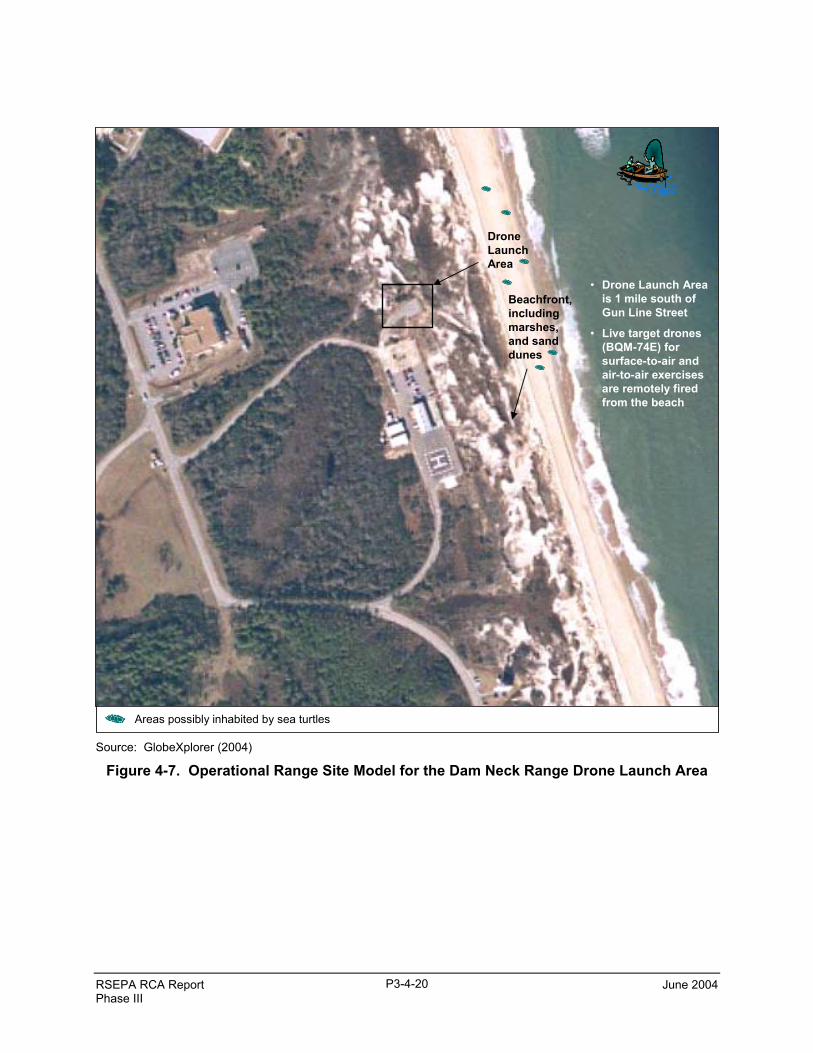
RSEPA RCA Report June 2004Phase III
P3-4-20
Areas possibly inhabited by sea turtles
Drone Launch Area
Beachfront,includingmarshes,and sanddunes
• Drone Launch Area is 1 mile south of Gun Line Street
• Live target drones (BQM-74E) for surface-to-air and air-to-air exercises are remotely fired from the beach
Source: GlobeXplorer (2004)
Figure 4-7. Operational Range Site Model for the Dam Neck Range Drone Launch Area
RSEPA Decision Point 1 June 2004Phase III
5-1
5. CONCLUSIONS
The conclusions presented in this synopsis complete the requirement for RCA Phase III and discussinformation necessary to answer Decision Point 1 questions (U.S. Navy 2003b) for VACAPES: “Arefurther steps required to maintain compliance?” and “Is further analysis required to assess risk of off-range release?”
• To maintain compliance with environmental regulations, VACAPES Ranges need to (1)determine the applicability of EPCRA Section 313 to Navy DCBR and Dam Neck Range andconduct the necessary calculations, if applicable, (2) address environmental impacts from rangeoperations and educate on- and off-base personnel regarding explosives hazards, and (3) ensurethat range-specific scrap management policies and procedures comply with the operationalrange clearance policy.
• Based on the current and planned continued use and the ORSMs for Navy DCBR and DamNeck Range, further analysis is not required to assess the risk of off-range releases. None ofthe munitions used at Navy DCBR include any MCs as defined in RSEPA. The 5-inch gunline,though operational, has not been fired since the 1980s and plans do not exist to fire it in theforeseeable future; therefore, releases of MCs are not a concern. Finally, MCs as defined byRSEPA are neither contained in nor used to launch BQM-74Es; therefore, releases of MCs arenot a concern.
These conclusions will be incorporated into the Decision Point 1 Recommendations Report.

THIS PAGE WAS INTENTIONALLY LEFT BLANK
RSEPA Decision Point 1 June 2004Phase III
6-1
6. REFERENCES
Global Security. 2003a. Virginia Capes Operating Area.(http://www.globalsecurity.org/military/facility/vacapes.htm). 11 July 2003.
Global Security. 2003b. R-6606 Dam Neck Range.(http://www.globalsecurity.org/military/facility/dam-neck.htm). 11 July 2003.
GlobeXplorer. 2004. GlobeXplorer Image Viewer. Online database of aerial photographs(http://www.globexplorer.com).
MIDAS. 2004. Munitions Items Disposition Action System Database (MIDAS). Online database ofstructural and characteristic data associated with munitions. Maintained by U.S. Army DefenseAmmunition Center (USADAC).
ORDATA. 2004. ORDATA Online. Online database provides information for the identification,recovery, transportation, and disposal of over 5,000 ordnance items(http://www.maic.jmu.edu/ordata/Mission.asp).
TRIMS (Target and Range Information Management System). 2003. Online database of Navalrange complex usage totals (https://trims.corona.navy.mil).
U.S. Navy. 2000a. Operations Management Plan for the Ranges and Operational Areas at SanClemente Island, California. Prepared by Southwest Division Naval Facilities EngineeringCommand. Draft. April.
U.S. Navy 2000b. Fleet Training Area/Range Directory. Prepared by Naval Warfare AssessmentStation and Naval Sea Systems Command (NAVSEA). Corona, California. May.
U.S. Navy. 2003a. Final Environmental Impact Statement for Introduction of F/A-18 E/F (SuperHornet) Aircraft to the East Coast of the United States.(http://www.efaircraft.ene.com/eis_documents.htm). July.
U.S. Navy. 2003b. U.S. Navy Range Sustainability Environmental Program Assessment (RSEPA)Policy Implementation Manual. Prepared by Chief of Naval Operations, EnvironmentalReadiness Division (N45). Revision 0. December.
U.S. Air Force. 2000. Dare County Bombing Range Integrated Natural Resources ManagementPlan. Prepared by Texas Research Institute for Environmental Studies (TRIES) for 4CES/CEV, Environmental Management Flight, Seymour Johnson AFB, North Carolina. 14March.
U.S. Air Force. 2003. National Environmental Policy Act of 1969 Record of Categorical Exclusionfor Construction of a Simulated Aircraft Runway, Navy Dare Bombing Range, Dare County,North Carolina. July.
U.S. Navy. 2004. Operational Range Clearance Policy for Navy Ranges. 3000 SeriesN43/4U741226. April 2.

THIS PAGE WAS INTENTIONALLY LEFT BLANK


![Jesus Youth · XqenI 411 2 acn¨hsc klm-bn -¡m\pw AhÀ¡p-thn {]mÀ°\IÄ kaÀ¸n -¡m\pw \mw kwi-bn -¡ -cp -Xv. hnip² tPm¬ {IntkmkvtXmw XqenI PokÊv bq¯v Zp_mbnbpsS hmcm´y](https://img.pdfslide.us/doc/110x75/60f732f74d976c35f6299693/jesus-youth-xqeni-411-2-acnhsc-klm-bn-mpw-ahp-thn-mi-kan.jpg)