Embed Size (px)
Citation preview
DEPARTMENT OF THE INTERIORHubert Work, Secretary
U. S. GEOLOGICAL SURVEY George Otis Smith, Director
Bulletin 772
A RECONNAISSANCEOF, .THE
POINT BARROW REGION, ALASKA
BY
SIDNEY PAIGE, W. T. FORAN
ANDJAMES GILLULY
WASHINGTONGOVERNMENT PRINTING OFFICE
1925
CK*&: B
ADDITIONAL COPIESOF THIS PUBLICATION MAY BE PROCURED FROM
THE SUPERINTENDENT OF DOCUMENTS
GOVERNMENT PRINTING OFFICE
WASHINGTON, D. C.
AT
20 CENTS A COPY

CONTENTS
PagePreface, by Alfred H. Brooks _ v
\ Introduction.. _ __ _ 1 i Plans for survey__________ -_ 2, Field work ______ _ 3
Previous explorations __ ____ _ '. 5Geography _ _____________ _ 6
General features.__________ _ 6j Topography and drainage. - 7
Climate _______________ 8Vegetation__ _ 9
1 Navigation___ __^_____________ _______ __ 9Settlements______________ _ : 10
'| Geology __ . 11'^ Outline_________________ __: _ __ __ __ 11
Mesozoic rocks...__________ _ __ 12Lithology______________________________ 12Age___________________________________ 12Correlation ______ _ _ _ __ __ 16Thickness- ______ : _ _-____ 17Structure .____ _ _ _ ____________ 17
Quaternary deposits_______________ _ __ ____ , 20Geologic history and physiography _ _ _ ____ 21
Petroleum____________________________________ 23Occurrence __ ___ _ _ _ ______ 23Character _____1_____________________________ . 24Oil possibilities of the reserve... __ _ ____ 25
Coal________________________________________ 26General features____________________________ 26Kukpowruk-Utukok district__________________________ 26Wainwright Inlet________________________________ 29Meade River district ____._ _____ _____________ 30Quality of the coal_____________________________ 30Summary__________________ ________________^ 31
Index ___________ _ ___ __________ 33
ILLUSTRATIONS
PagePLATE I. Map of northwestern part of Naval Petroleum Reserve No. 4_ In pocket.
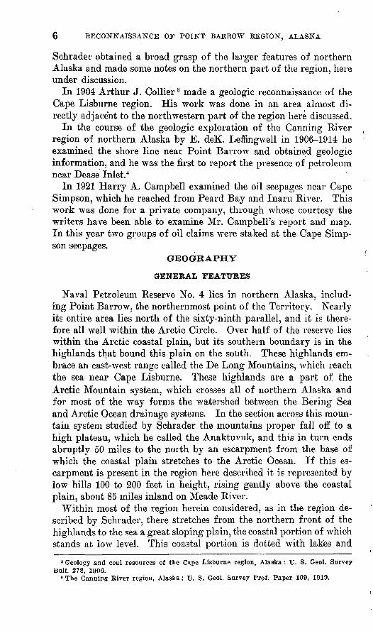
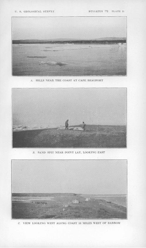
II. A, Hills near the coast at Cape Beaufort; B, Sand spit near Point Lay; C, View looking west along coast 18 miles west of Barrow ________________________________ 8
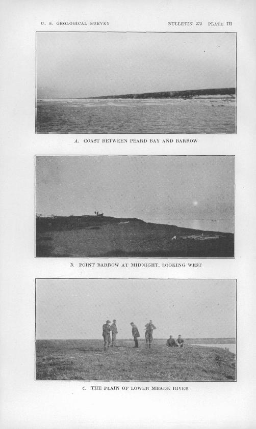
III. A, Coast between Peard Bay and.Barrow; B, Point Barrow atmidnight; C, The plain of lower Meade River_______ 8
330735
.IV CONTENTS
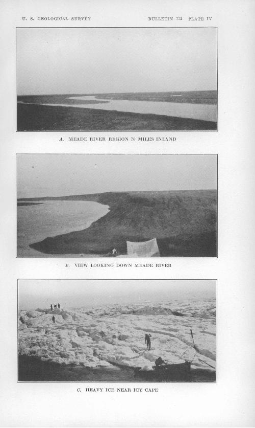
Pag* PLATE IV. A, Meade River region 70 miles inland; B, View looking down
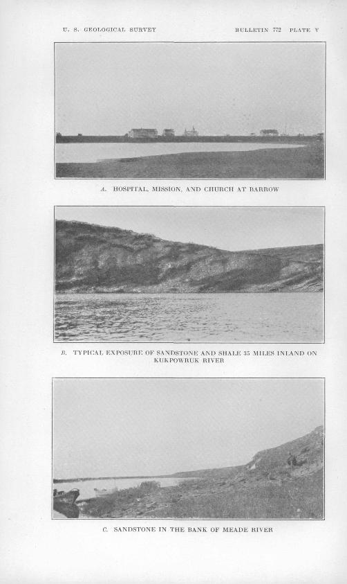
Meade River; C, Heavy ice near Icy Cape__________ 8V. A, Hospital, mission, and church at Barrow; B, Typical ex
posure of sandstone and shale 35 miles inland on Kukpow- ruk River; C, Sandstone in the bank of Meade River___ 9
VI. A, B, Oil seepage No. 1, Cape Simpson; C, Oil seepage No. 2,Cape Simpson ____________________________ 24
VII. Oil seepage No. 2, Cape Simpson_________________ 25 'VIII. Columnar sections of portions of the coal-bearing series meas
ured on Kukpowruk River__________-_______ 28 ' IX. A, Sandstone in cliffs 20 miles east of Peard Bay; B, Ten-foot
bed of bituminous coal 5 miles inland on Kukpowruk River; C, Ten-foot bed of bituminous coal 35 miles inland on west bank of Kukpowruk River__ _^______ 28 '
FIGUBE 1. Structure cross section on Kukpowruk River along lineA-B, Plate I ____________'. _______________ 19 ;
2. Structure cross section on Utukok River along line C-D,Plate I__^________________,___________ 19 t
3. Structure cross section on Wainwright Inlet along line E-F, \ Plate I_______________________________ 20 /
4. Detailed columnar sections of coal on Wainwright Inlet___ 29
PREFACE
By ALFRED H. BROOKS
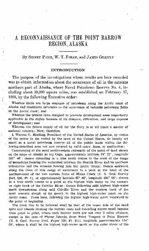
As shown in the following report, the Point Barrow expedition of 1923 was sent north as a part of a plan to search Naval Petroleum Re serve No. 4 for evidence of petroleum. The project originated with the'Department of the Navy and has been carried out under grants from that department. In spite of the shortness of the field season and other obstacles to travel in this remote region, the expedition successfully made the topographic and geologic surveys planned. The two large oil seepages at Cape Simpson, the only ones yet known within the reserve, were surveyed, and much was learned about the geology of a belt extending from the coast 50 to 200 miles inland. The information at hand is still too meager to justify a definite opinion as to the existence of oil pools of present commercial importance in this region. It does, however, give evidence that fur ther geologic exploration of the region is fully justified.
The Paige expedition ajso discovered an extensive coal field in the area explored.
Because of the information obtained by this expedition, further exploration of the reserve was. approved by the Department of the Navy. .Accordingly, an expedition led by Philip S. Smith was assembled at Tanana, on Yukon River, in February, 1924, and proceeded overland by way of the Alatna into the mountains that form the southern boundary of the reserve. The winter was devoted to transporting supplies and exploring the region contiguous to the reserve on the east, and later, when the streams had become free of ice, the basin of Colville River was explored and the Ikpikpuk traced to the Arctic Ocean. During the summer of 1924 W. T. Foran extended the earlier surveys in the vicinity of Wainwright by ascending Kuk River, traversing the upper parts of the Utukok and Colville basins, crossing the mountains into the basin of the Noatak, and descending the Noatak to Kotzebue.

A RECONNAISSANCE OF THE POINT BARROW REGION, ALASKA
By SIDNEY PAIGE, W. T. FORAN, and JAMES GILLULY
INTRODUCTION
The purpose of the investigations whose results are here recorded was to obtain information about the occurrence of oil in the extreme northern part of Alaska, where Naval Petroleum Reserve No. 4, in cluding about 35,000 square miles, was established on February 27, 1923, by the following Executive order :
Whereas there ai'e large seepages of petroleum along the Arctic coast of Alaska and conditions favorable to the occurrence of valuable petroleum fields on the Arctic coast; and
Whereas the present laws designed to promote development seem imperfectly applicable in the region because of its distance, difficulties, and large expense of development; and
Whereas the future supply of oil for the Navy is at all times a matter of national concern: Now, therefore,
I, Warren G. Harding, President of the United States of America, by virtue of the power in me vested by the laws of the United States, do hereby set apart as a naval petroleum reserve all of the public lands within the fol lowing-described area not now covered by valid entry, lease, or application:
Commencing at the most northwestern extremity of the point of land shown on the maps of Alaska as Icy Cape, approximately latitude 70° 21', longitude 161° 46'; thence extending in a true south course to the crest of the range of mountains forming the watershed between the Noatak River and its northern tributaries and the streams flowing into the Arctic Ocean; thence eastward along the crest of this range of mountains to a peak at the head of the northernmost of the two eastern forks of Midas Creek [U. S. Geol. Survey Bull. 536, PI. I], at approximately latitude 67° 50', longitude 156° OS': thence in a true north course to a point at the highest high water on the western or right bank of the Colville River; thence following said highest high-water mark downstream along said Colville River and the western bank of the most western slough at its mouth to the highest high-water mark on the Arctic coast. From here, following the highest high-water mark westward to the point of beginning.
The coast line to be followed shall be that of the ocean side of the sand spits and islands forming the barrier reefs and extending across small lagoons from point to point, where such barrier reefs are not over 3 miles offshore, except in the case of Plover Islands, from Point Tangent to Point Barrow [U. S. Geol. Survey Prof. Paper 109, PI. Ill], longitude approximately 154° 50', where it shall be the highest high-water mark on the outer shore of the
1
.2 BECONSAISSANCE OF POINT BAEEOW BEGION, ALASKA
islands forming the groups and extending between the most adjacent points of these islands and the sand spits at either end. In cases where the barrier reef is over 3 miles offshore the boundary shall be the highest high-water mark of the coast of the mainland.
Said lands to be so reserved for six years for classification, examination, and preparation of plans for development and until otherwise ordered by the Congress or the President.
The reservation hereby established shall be for oil.and gas only and shall not interfere with the use of the lands or waters within the area indicated for any legal purpose not inconsistent therewith.
As shown above, the reserve (see PL I) was established because there was some evidence of the presence of a large oil field in this northern region. In 1914 E. deK. Leffingwell reported to the Geo logical Survey the occurrence of a petroleum seepage near the Arctic coast, 50 miles southeast of Point Barrow. A sample of the material from this seepage, obtained from C. D. Brower, of Point Barrow, proved to be a petroleum residue. In 1921 this locality was examined by the representatives of two oil companies, who confirmed the presence of petroleum and reported the presence of two large seepages. Kather vague reports of other seepages in the northern region were obtained from other sources, but none of these have been definitely located. The most significant of these localities is one reported on the authority of natives, 300 miles east of Point Barrow, near the international boundary. This meager evidence and what was known of the geology justified the hope that there might be a large oil field in this fairly accessible region. As the bedrock source of the oil was unknown, the boundaries of the reserve were so drawn as to include the complete geologic section from the Arctic Mountain watershed on the south to the shores of the Polar Sea on the north, a distance of some 200 miles. East and west it measures nearly 300 miles.
PLANS FOR SURVEY
Shortly after the establishment of the reserve the Department of the Navy made a request on the Department of the Interior for the Geological Survey to undertake a topographic and geologic survey of the entire area withdrawn for the purpose of determining its petroleum resources. On March 17, 1923, a plan was submitted by Alfred H. Brooks for this project, which may be outlined as follows:
1. The general topographic and geologic map of the reserve was to be on a scale of 4 miles to the inch.
2. More detailed maps were to be made of the areas where geologic features were found to be most favorable to the presence of petroleum.
FIELD WORK 3
3. The larger topographic and geologic features of the region were to be determined by a network of reconnaissance surveys, traversing the entire reserve. The areas lying between the network of ground surveys were to be covered by aerial surveys. As a result of the sur veys of these two classes a fairly complete map of the entire reserve would be obtained.
When this plan was made, it was too late to undertake any winter exploration; it was therefore recommended that the first year's work should be confined to the region accessible from the Arctic coast during the short summer season.
The total cost of the ground surveys was estimated to be $500,000, and the time required about five years. The cost of the surveys of the first year, 1923, was estimated at $75,000.
This plan was approved by the Secretary of the Interior and the Secretary of the Navy. As the Geological Survey had no funds to carry it out, an allotment of $75,000 w,as made for the first year's work from the appropriation for engineering of the Department of the Navy, on March 27,1923.
Mr. Brooks also prepared a summary of all the available informa tion about the geography and geology of Petroleum Reserve No. 4 and adjacent regions. This summary has been drawn upon in the preparation of this report.
FIELD WORK
On May 1 Sidney Paige was detailed as geologist in charge of the expedition and was instructed to visit all known and reported oil seepages in the Point Barrow region, to locate them by surveys, and to determine the detailed geology in their vicinity; also to study and map the geology along the Arctic coast between the Cape Lisburne region 'and Point Barrow and eastward from Peard Bay, including the Inaru River basin, Dease Inlet, and the seepages at Cape Simp- son, and to extend the work up the rivers emptying into the sea be-
1 tween Cape Beaufort and Peard Bay, up Meade River, and, if pos sible, up Chipp River, so far 'as time permitted.
The expedition, including 18 men in all, reached Nome from Seattle by the steamer Victoria on June 13, which marked the be ginning of outside ocean communication of the season.
Capt. Joseph Bernard, an experienced navigator of Arctic waters, was engaged 'at Nome, with his 15-ton gasoline schooner Teddy Bear, for the entire summer. This contract was necessary to insure independent transportation southward in the fall, should other means fail, and it also greatly facilitated the transfer of 'a party from one locality to another. At Nome, in accordance with the original plan, the expedition was divided into three parties, which operated prac-
7705 25 2
4 RECONNAISSANCE OF POINT BARROW REGION, ALASKA
tically independently in the field. The personnel of these p'arties was 33 follows: One was led by Sidney Paige, geologist in charge, and included E. C. Guerin, topographic engineer; a second,was led by James Gillnly, geologist, with James Whi,taker, topographic engi neer; and the third by William T. Foran, geologist, with Gerald FitzGei'ald, topographic engineer. Four camp hands accompanied each of the three parties.
The first two parties sailed northward from Nome June 3, on the four-masted gasoline schooner Arctic, of Liebes & Co., fur traders of San Francisco, bound for Wainwright Inlet, 400 miles distant. The Arctic, after touching at a number of points, reached Wain wright July 23. Mr. Paige 'and Mr. Gilluly had previously left the ship by canoe and thus reached Wainwright July 17, even before nav igation opened.
The Paige party left Wainwright by motor canoe July 25, follow ing the coast to Barrow post office and trading post, which it reached July 31. On August 1 the party continued eastward, following the outer sand spit to Point Tangent and thence to Cape Simpson, the most easterly point reached. After examining and surveying the oil seepages here, the party followed the east shore of De'ase Bay, crossed to the mouth of Inaru River, ascended and surveyed the Inaru to Meade River and the Meade to a point 86 miles (in an air line) from Dease Bay. The party turned back August 21 and re'ached Barrow September 2.
The Gilluly party left Wainwright in canoes July 24 and fol lowed the coast to Peard Bay. Here surveys were begun, and the party turned inland, ascended a small stream, portaged 3^ miles to the headwaters of Inaru River, descended that stream to Dease Bay, explored its south end, ascended Topagarok River about 40 miles from the coast, and later located the mouth of Chipp River about 20 miles east of the point where it had been indicated on the maps. Continuing its voyage along the co'ast the party reached Barrow late in August. The Paige and Gilluly parties returned from Barrow on the Arctic to Nome, where they arrived September 16.
The Foran party left Nome by the gasoline schooner Teddy Bear July 11 and began surveys 10 miles east of Cape Beaufort July 16. The party then surveyed the shore line northward 'as far as Icy Cape and also Kukpowruk River inland for 35 miles, Kokolik River for 25 miles, and Utukok River for 40 miles. It reached Wainwright Inlet September 8 and after making some examinations in that vicinity sailed for Nome on the Teddy Bear September 11. The re turn voyage was 'a perilous one because of severe gales, and the party narrowly escaped shipwreck.
The expedition left Nome October 22 on the steamship Victoria and reached Seattle November 1.
PREVIOUS EXPLORATIONS 5
The expedition was successful in carrying out the plans that were made. It made a practically complete map of the shore line from Cape Beaufort to Dease Inlet and traced all the large streams of the region, except Kuk River, emptying into Wainwright Inlet, for 25 to 90 miles inland from the coast. (See PI. I, in pocket.) The total area topographically surveyed in a field season of less than six weeks is 2,145 square miles, but the geologic examinations throw a flood of light on the geology and physical features of over 10,000 square miles, or nearly a third of the.reserve. This expedition has obtained the information needed to plan the rest of the surveys efficiently and economically.
PREVIOUS EXPLORATIONS
The coast line of Arctic Alaska was fairly well known before the middle of the last century, though there is little of it that has even yet been accurately charted. On the other hand, the inland region is almost unexplored, and except for the work of the expedition of 1923 the naval reserve has not been surveyed.
A magnetic station was maintained at Point Barrow from 1881 to 1883. This was commanded by Maj. P. H. Ray, United States Engineer Corps, who made a dog-team exploration of the lower part of Meade River.1
In 1886 Capt. (then Ensign) W. L. Howard made a winter ex ploration of the head of Colville River, crossed the watershed to Chipp River, traced that stream to its mouth, and returned by way of Point Barrow.2 Captain Howard made a sketch map of his route of travel and described its physical features. He is the only man ex cept some prospectors who has yet crossed the entire naval reserve. It is worthy of note that he brought back a specimen of a peculiar substance believed to be petroleum residuum from the upper Colville basin. This is the only evidence of petroleum that has yet been found in the southern part of the reserve.
Since 1880 the vessels of the Coast Guard have made annual visits to Point Barrow and visited other settlements on the way. A few traders and whalers have also traversed the waters, but these voyages have added little to our knowledge.of these waters, and not every year are they able to visit the ocean east of Point Barrow.
F. C. Schrader was the first geologist to visit Arctic Alaska. In 1901, in company with W. J. Peters, topographic engineer, he made an exploration from Yukon River to the Arctic coast, by way of John, Anaktuvuk, and Colville rivers, and skirted the coast linearound Point Barrow and southward beyond Wainwright Inlet.ti__________________________________________
1 Ray, P. H., Report of the international polar expedition to Point Barrow, Alaska, 1881-1884: 49th Coog., 2d sess., H., Ex. Doc. 44, 1888.
s Stoney, G. M., Naval exploration in Alaska, U. S. Naval Inst, 1900.
6 RECONNAISSANCE OF POINT BARROW REGION, ALASKA
Schrader obtained a broad grasp of the larger features of northern Alaska and made some notes on the northern part of the region, here under discussion.
In 1904 Arthur J. Collier 3 made a geologic reconnaissance of the Cape Lisburne region. His work was done in an area almost di rectly adjacent to the northwestern part of the region here discussed.
In the course of the geologic exploration of the Canning River region of northern Alaska by E. deK. Leffingwell in 1906-1914 he examined the shore line near Point Barrow and obtained geologic information, and he was the first to report the presence of petroleum near Dease Inlet.4
In 1921 Harry A. Campbell examined the oil seepages near Cape Simpson, which he reached from Peard Bay and Inaru River. This work was done for a private company, through whose courtesy the writers have been able to examine Mr. Campbell's report and map. In this year two groups of oil claims were staked at the Cape Simp- son seepages.
GEOGRAPHY
GENERAL FEATURES
Naval Petroleum Reserve No. 4 lies in northern Alaska, includ ing Point Barrow, the northernmost point of the Territor}^. Nearly its entire area lies north of the sixty-ninth parallel, and it is there fore all well within the Arctic Circle. Over half of the reserve lies within the Arctic coastal plain, but its southern boundary is in the highlands that bound this plain on the south. These highlands em brace an east-west range called the De Long Mountains, which reach the sea near Cape Lisburne. These highlands are a part of the Arctic Mountain system, which crosses all of northern Alaska and for most of the way forms the watershed between the Bering Sea and Arctic Ocean drainage systems. In the section across this moun tain system studied by Schrader the mountains proper fall off to a high plateau, which he called the Anaktuvuk, and this in turn ends abruptly 50 miles to the north by an escarpment from the base of which the coastal plain stretches to the Arctic Ocean. If this es carpment is present in the region here described it is represented by low hills 100 to 200 feet in height, rising gently above the coastal plain, about 85 miles inland on Meade River.
Within most of the region herein considered, as in the region de scribed by Schrader, there stretches from the northern front of the highlands to the sea a great sloping plain, the coastal portion of which stands at low level. This coastal portion is dotted with lakes and
8 Geology and coal resources of the Cape Lisburne region. Alaska: U. S. Geol. Survey Bull. 278, 1906.
4 The Canning River region, Alaska: U. S. Geol. Survey Prof. Paper 109, 1919.
GEOGRAPHY 7
lakelets, and across it streams meander in tortuous courses. A number of large rivers and many smaller streams enter the Arctic Ocean between Cape Beaufort and Cape Simpson. Of these, the Colville, east of the area mapped on Plate I, the Chipp, and the Meade are probably the largest, though there are many others drain ing extensive areas.
TOPOGRAPHY AND DRAINAGE
The region surveyed in 1923 was entirely within the coastal plain, except at the southwest, where, along the Kukpowruk Valley near Point Lay, the margin of the southern highland was reached. This margin is marked by some rounded hills whose summits are 1,000 to ,1,500 feet above the sea. (See PL II, A.) From Cape Beaufort to Wainwright the coast is entirely without major indentations, and a nearly continuous line of gently curving sand spits incloses a series of long, narrow lagoons. (See PL II, B.) The water is shallow, and the bordering sea floor slopes gently northward. From Wain wright to Point Barrow lagoons are less numerous, but the smooth curving line of the low coast persists. (See l*ls. II, £7, and III, A.) East of Point Barrow, which is a low, narrow sand spit, are many?1 lagoons, separated from the sea by a fringe of low, narrow islands and sand bars. (See PL III, B.) This part of the coast is deeply .indented, for Dease, Smith, and Harrison bays, all considerable bodies of water, penetrate it for 20 miles or more.
Along the entire coast line, as seen from the ocean, the country appears low and flat, a featureless expanse stretching as far as the eye can see. (See Pis. Ill, A, C, and IV, A.) Here the shore in few places stands more than 30 feet above sea level. Near Peard Bay there are some flat hills, not over 200 feet high, between the sea and the headwaters of Inaru River. With this exception, the plain for 80 miles from the sea in but few places stands above 50 feet. The valleys are very shallow and ill defined. The coastal plain rises gradually to the south and on Meade Eiver 85 miles inland stands about 100 feet above sea. Here the river bottom is incised to a depth of 60 feet. Along the lower reaches of the river much of the land is swampy and is flooded during high-water stages. The plain is dotted by innumerable lakes. Farther inland the rivers are cut deeper and the swamps are not so abundant. The coastal swamps are not continuous but are separated by dry areas, affording hard ground. It is these dry areas that furnish the reindeer pastures so abundantly utilized in regions adjacent to Wainwright and Barrow.
The accompanying map (PL I) contains all the available informa tion about the drainage of the region explored. None of the rivers except the Kukpowruk have been traced to the mountains. Near the
8 RECONNAISSANCE OF POINT BARROW REGION, ALASKA
coast the valleys of the larger rivers explored are.all cut below the flat-lying sand and gravel of Pleistocene age. The hard rocks are re vealed beneath these deposits in the valley bottoms, outcrops of rock increasing as the streams are ascended. (See PL V, C.) The mouths of the larger rivers have broad deltas.
In Admiralty Bay, at the head of Dease Bay, four or more rivers enter the sea by a series of intricately interwoven distributaries along a flat delta front of 20 miles. Thus it is difficult to identify the in dividual rivers until they are traced 10 miles or more from the sea. The tide on the Arctic Ocean is not of practical importance, being less than 3 feet. The direction of the wind will affect the level of the water far more. Tide ascends Meade River about 30 miles by the meanders of the river. The current in the lower course of the Meade averages 2 to 3 miles an hour, increasing gradually upstream; as rock appears in the channel from place to place more rapid and shallower water alternates with stretches of quieter water. Thus at low stages in places canoes must be dragged up shallow riffles. A hundred miles up the Meade the current averages 3 to 5 miles an hour. The channel of Meade River at the head of the delta is 1,000 to 2,000 feet wide. The main distributaries through the delta aver age 500 feet in width. At 40 miles from the delta the width is about 1,200 to 1,500 feet. (See PL IV, B.) Where the expedition turned back, 125 miles up the river (by meander), the channel is but 500 to 600 feet wide. Throughout this length, at low stages of water, the river occupies only about one-half or less of the channel. Chipp River is reported slightly larger than Meade River. Kukpowruk River in its delta portion meanders in a channel 150 feet wide, but 5 miles inland the width is less than 100 feet. Utukok River, with a delta front of 8^2 miles, enters the sea by a ramifying network of channels 100 to 150 feet wide, and at 35 miles inland the channel is 100 feet wide. This stream meanders in a nearly flat valley bottom 1 mile to 2 miles wide, 150 to 200 feet below the bordering plain. (See PL I.)
CLIMATE
The region has an arctic climate, characterized by short, cool sum mers, long, cold winters, and low annual precipitation. Weather rec ords have been kept at Point Barrow for many years by the United States Weather Bureau. The results of these records are summar ized as follows:
Siimmary of climatic record? at Point Barrow
Temperature (° F.) :Mean summer temperature_________________ 35 Mean July temperature (warmest month)________ 40 Highest temperature recorded_______________ 65
V. S, GEOLOGICAL SURVEY BULLETIN 772 PLATE II
A. HILLS NEAR THE COAST AT CAPE BEAUFORT
B. SAND SPIT NEAR POINT LAY, LOOKING EAST
C. VIEW LOOKING WEST ALONG COAST 18 MILES WEST OF BARROW
U. S. GEOLOGICAL SURVEY BULLETIN 272 PLATE III
A. COAST BETWEEN PEARD BAY AND BARROW
It. POINT BARROW AT MIDNIGHT, LOOKING WEST
C. THE PLAIN OF LOWER MEADE RIVER
TJ. S. GEOLOGICAL SURVEY BULLETIN 772 PLATE IV
A. MEADE RIVER REGION 70 MILES INLAND
R. VIEW LOOKING DOWN MEADE RIVER
C. HEAVY ICE NEAR ICY CAPE
U. S. GEOLOGICAL SURVEY BULLETIN 772 PLATE V
A. HOSPITAL, MISSION, AND CHURCH AT HARROW
11. TYPICAL KXI'OSUKK OK SANDSTONE AND KHALK 35 MILKS INLAND ON KUKPOWRUK RIVER
C. SANDSTONE IN THE BANK OF MEADE RIVER
GEOGRAPHY 9
Temperature (° F.) Continued.Mean January temperature________________ 22 Lowest temperature recorded________________ 53 Mean annual temperature___________________ 10
Precipitation (inches) :Mean annual precipitation_________________ S Mean total summer precipitation_____________ 3+
VEGETATION
That part of the reserve visited in 1923 is entirely without timber. Stunted willow begins to appear a few miles inland and is found in increasing size toward the south. At 50 to 80 miles from the coast willow can be relied on for fuel. The entire coastal plain is covered with lichens and mosses, a variety of grasses, and flower ing plants. The large herds of reindeer that are being maintained near Wainwright and Barrow show that there is considerable pas ture land in this region.
NAVIGATION
The southern Arctic Ocean is open to navigation from about July 1 to not later -than the end of September.5 Barrow post office (Gape Smyth) can be reached by vessel by some date between July 12 and August 15, depending on the season on the average about August 1. (See PI. IV, C.) The polar ice cap does not usually move down to Point Barrow until the later part of September, but vessels usually leave Barrow post office by about September 10.
The polar ice cap seldom moves more than a few miles off shore between Icy Cape and Point Barrow. In a favorable season ves sels may round Point Barrow and may have a month of open navi gation.
Wainwright Inlet can usually be reached by gas boat from Nome by about July 15, and the return can be made as late as September 15, though as late as that heavy weather may be expected south of Cape Lisburne. At Wainwright Inlet the 10-fathom. line is 5 miles off shore, and large ships have only an open roadstead. Kotzebue Sound is open to navigation from about July 15 to September 15.
In the Point Barrow region the open season is usually one of light winds or calms, with fog and light rains. Inland, about 75 per cent of the summer days are said to be clear. In the Arctic Ocean gales are said to be uncommon, but occasionally very heavy winds blow from the southwest. The prevailing winds are from the northeast. Late in the season of navigation the weather is boisterous. The rivers freeze up about the last week in Septem ber and break the first week in June. At times of freeze-up and
B U. S. Coast Pilot, Alaska, pt. 2, Ya.kutat Bay to Arctic Ocean, U. S. Coast and Geo detic Survey.
10 RECONNAISSANCE OF POINT BARROW REGION, ALASKA
break-up there are 10 days or more when no traveling can be done. October and November are fairly good times for sled travel, and better still is the time from March to June. From December to February 15 the severe winter weather and short days make it impracticable to take long journeys or to carry on surveying.
There are no harbors for seagoing vessels on the entire Arctic coast between Cape Lisbume and Colville River. A harbor might be constructed within the lagoon at the mouth of Kukpowruk River by deeping the entrance through the protecting sand spit. (See PL I.) Wainwright Inlet is a large body of shallow water, the estuary of Kuk River. It can be entered only through a nar row shifting channel. Peard Bay is a lagoon-like shallow body of water. Large ships must stand far off shore here. East of Point Barrow, Dease Bay, lying behind a straight line of sand spits, in dents the coast line 20 miles or more. It is a shallow body of water not navigable by seagoing vessels. Farther east Smith Bay and Harrison Bay offer little or no protection to large or small vessels. In general the coast between Cape Lisburn© and Colville River may be regarded as open roadstead. Ships must stand to sea dur ing on-shore gales.
SETTLEMENTS
The total population of this northern district, concentrated along the coast, between Cape Lisburne and Colville River, is about 660 (1920 census), all Eskimos except 15 or 20 whites. Nuwak, the native village at Point Barrow, has a population of 94. A large settlement, Barrow post office, 10 miles south, at Cape Smyth, con tains about 322 people. Here there is a Government school, a Presbyterian mission and hospital, and the trading post of the Cape Smyth Whaling & Trading Co., in charge of Charles D. Brower. (See PL V, A)
At Wainwright Inlet, 110 miles to the southwest, there is a settle ment of 100 natives. Here there is also a Government school and a trading post of the Cape Smyth Whaling & Trading Co., in charge of James Alien. These settlements receive three winter mails and one summer mail from Nome. They are visited each summer by a Coast Guard cutter and by a trading vessel of Liebes & Co., of San Francisco, principal owners in the trading posts. The nearest points of outside communication are the radio sta
tions of the Bureau of Education at Noorvik, on Kobuk River, and at Kotzebue, about 400 miles by winter trail from Wainwright Inlet.
West of Wainwright, at Icy Cape, there is a Government school and a few natives. At Point Lay there is a small native village of about a dozen souls.
GEOLOGY 11
Wainwright is 540 miles by sea from Nome and can be reached usually between July 20 and September 15, the sea during this period usually being clear of ice. To reach Barrow, it may be necessary to wait as late as August 1. There are, however, no regular means of travel from Nome to these far northern points, and the visitor must either make arrangements with a trading vessel or charter a small gasoline schooner. Such boats can usually be engaged at Nome.
GEOLOGY
OUTLINE
The region mapped is for the most part very unfavorable to geo logic studies. In most of the coastal plain a,sheet of Quaternary gravel mantles the underlying formations, and even where the gravel is lacking the mat of vegetation typical of the tundra region obscures the hard rock. The bedrock at the oil seepages near Cape Simpson consists of poorly exposed sandy shale, the bedding of which is very obscure.
On Meade River poor outcrops of coal-bearing strata prove that the beds are .nearly flat and gently warped, but the details of structure are entirely obscured. Good outcrops occur near the western boundary of the reserve, on Kukpowruk and Utukok rivers. On Wainwright Inlet hard rocks are fairly well exposed near the water's edge beneath a mantle of sand and gravel. The examination of all these places and the collection of fossils, chiefly plants, has given an understanding of the larger stratigraphic features of the entire re gion and furnished a clue to the structure.
It is believed that details of the geology of the coastal plain can not be worked out without some method of reaching the underlying hard rock. Excavating the frozen surficial deposits would be a very time-consuming task and would therefore be limited to few localities. It should be possible to reach the required depth by a light hand- boring apparatus. Such shallow borings would of course not suffice to determine the presence or absence of petroleum, but they might throw light on the stratigraphy and structure that would guide the selection of localities where deep drilling would seem to be warranted.
The geology of the region examined in 1923 is relatively simple. The entire area is underlain by a thick series of sediments, which near the highlands are folded in an east-west direction, parallel to the mountain front. At increasing distances from the mountains the folds grow less accentuated until the rocks are but gently flexed and nearly horizontal.
Overlying the hard rocks just described is a deposit of sand and gravel 10 to 50 feet thick, extending inland 15 to 20 miles from
12 RECONNAISSANCE OF POINT BABBOW REGION, ALASKA
the coast. This beach deposit masks the outcrops of the hard rocks in so many places that it will always be difficult to determine the geology along the coastal portion of the reserve.
No outcrops of igneous rocks were found in the area examined. The Quaternary gravel, however, contains numerous pebbles of granitic and other intrusive rocks. This gives evidence that intru sive rocks are present in the region from which the gravel has been derived, and this region presumably lies within the highlands to the south.'
MESOZOIC ROCKS
LITHOLOGYc.
A thick series of sandstone, shale, thin-bedded limestone, and associated beds of coal extends from Cape Beaufort westward to the Cape Lisburne region. These rocks are believed to extend eastward to and beyond Cape Simpson and inland at least 80 miles south of the coast at Meade Elver. (See PL V, B y C.)
The sandstone is gray where fresh but weathers to a yellow or buff color. It is medium to fine grained, grades in places into shale and rarely into conglomerate, and in general is of normal types that were laid down at the margin of or in the sea by rivers and streams that entered it. Cross-bedding and ripple marks are locally abun dant.
The shale is gray to yellow, many beds are fine-grained mudrocks, and some beds are darkened by an appreciable amount of carbona ceous debris. In places it grades into sandy shale or sandstone, of which shale is the normal accompaniment in deposition of the type suggested above.
The limestone is gray to brownish and occurs in beds intercalated with the shale, into which it grades'. It was noted only in very thin layers or as nodular concretions.
The coal that accompanies these rocks is abundant and occurs in beds of workable thickness. In the regions of strong folding it is bituminous, and in the less disturbed regions it is of subbituminous rank. Details of its occurrence and quality are given on pages 26-31.
AGE
As shown below, Mesozoic formations of Upper Jurassic, Lower Cretaceous, and Upper Cretaceous age have been found in northern Alaska. All these horizons may be represented in the Point Bar row region, but only the Lower Cretaceous and Upper Jurassic of Cape Lisburne were recognized. As the geology of this region has hitherto been unknown, it seems desirable to record the complete paleontologic description, which is as follows:
GEOLOGY 13
.FOSSIL PLANTS FROM ICUKPOWBUK AND UTUKOK RIVERS, COLLECTED BY WILLIAM T.
FORAN
By P. H. KNOWLTON
No. 1 (7640). Low ridge 10 miles east of Cape Beaufort. Stratigraphic posi tion probably near top of the coal series of Kukpqwruk River:
Macerated fragments of plants but nothing determinate. No. 11 (7441). Kukpowruk River 5 miles above mouth, near bottom of coal
series:Phoenicopsis? sp. Phoenicopsis is common in the Cape Lisburne Jurassic.
No. 12 (7642). Float from beach, sand spit opposite mouth of Kukpowruk River:
Unknown to me. Possibly tooth or tusk of elephant.No. 13 (7643). From shale below 10-foot bed of coal 5 miles up Kukpowruk
River, near bottom of coal'series:A single waterworn specimen. Not organic.
No. 14 (7644). From shale below 10-foot bed of coal 5 miles up KukpowrukRiver, near bottom of coal series:
Three small pieces of matrix. Shows stems, some grasslike, and frag ments that appear to be a Taeniopteris. No age determination possible.
No. 15 (7645). In shale 1 foot below coal 5 miles up Kukpowruk River:Fragments of what appears to be a Phoenicopsis.
No. 16 (7646). In sandstone associated with coal 5 miles up Kukpowruk River, near bottom of coal series:
Stem not determinable.No. 17 (7647). Kukpowruk River 4y2 miles above mouth, near bottom of coal
series:Phoenicopsis? sp<_ Same remark as under No. 11.
No. 18 (7648). Parting in 10-foot bed of coal, Kukpowruk River 5 miles above mouth, near bottom of coal series:
Fragments not determinable.Nos. 19, 20, 21, 22 (7649). Kukpowruk River 6 miles above mouth, approxi
mately 2,000 feet stratigraphically above 10-foot bed of coal:Coniferous wood fairly well preserved, but no sections have been cut.
No. 23 (7650). Kukpowruk River 10 miles above mouth. Syncline axis: Oinkgo sp.?Cladophlebis lata Fontaine. Fragments of two or three dicotyledonous leaves.
This is by all odds the most puzzling lot in the whole collection. The Ginkgo, although large and well enough preserved, is of little value in fixing the age, as Ginkgo has come down to us from the Jurassic to the present with very little change. The fragment of a fern seems to be the same'as a form from Cape Lisburne, but the well-defined
. * dicotyledons absolutely preclude a reference to the Jurassic. On the basis of present knowledge it can hardly be older than the middle or upper part of the Lower Cretaceous.
No. 24 (7651). Kukpowruk River 17 miles above mouth, at junction of forked stream:
Phoenicopsis? sp.No. 27 (7652). Kukpowruk River 22 miles above mouth, probably near top
of coal series.A single small fragment. A conifer, and apparently a Taxites, but not
sufficient for positive identification.
14 RECONNAISSANCE OF POINT BABKOW REGION, ALASKA7
No. 28 (7653). Kukpowruk River 18 miles above mouth, probably near top of coal series:
Ginkgo sp.?Cladophlel)is ulata Fontaine.
These forms are similar to forms found in the Cape Lisburne Juras sic, but considering the report on No. 23. I hesitate to call it Juras sic. No dicotyledons are present.
No. 35 (7654). Kukpowruk River 40 miles above mouth, approximately 1,000 feet stratigraphically below coal series, in zone of disturbance:
Unknown. Supposed to be trails of crustaceans. Station B (7664). On Utukok River:
Waterworn specimen, not determinable. Station E (7666). Utukok River 17 miles above mouth:
Phoenicopsis speciosa Heer. fCladophlebis alata Fontaine.
These forms occur also in the Jurassic of Cape Lisburne. Station W (7667). Utukok River 24 miles above mouth :
Not organic. Station Z (7668). Utukok River 43 miles above mouth:
A single small piece of matrix with fragments of about six species of plants, among them Oleandridi/um sp., Onychiopsis sp., CladophleMs sp., an apparently new fern, and some coniferous leaves. The age appears to be Lower Cretaceous, in the approximate position of the Kootenai or Wealden.
Station X (7665). On Utukok River: Taxites olriki Heer? Stems, etc.
Age can not be fixed by this specimen. May be Tertiary.
FOSSIL PLANTS FROM MEADE RIVER, COLLECTED BY SIDNEY PAIGE
By F. H. KNOWLTON
This material is the same as that from Cape Lisburne, Alaska, namely, upper Jurassic.
No. 1 (7699). Right bank of Meade River about 27 miles above mouth; poor exposure.(float?) :
Stems and coniferous leaves, the latter probably Finns sp. No. 2 (7700). Right bank of Meade River 33 miles above mouth; poor ex-
posure:Phoenicopsis speciosa Heer.Podosamites lanceolatus eichwaldi (Heer) Seward. Taeniopteris sp.Taxites zamioides? (Leckenby) Seward.
No. 3 (7701). Meade River 67 miles above mouth; horizontal bed in sha-le, sandstone, and coal series:
Paffiophyllum sp. Baiera sp.
FOSSIL PLANTS FROM KUKPOWRUK AND UTUKOK RIVERS, COLLECTED BY WILLIAM T.
FORAN
By ARTHUR HOLLICK
Most of these collections (lots 7640-7654 and 7664-7666) consist of a single piece of matrix each. Plant remains are included in most of them, but they
GEOLOGY 15
are fragmentary, and few are identifiable, even generically. Certain of the single specimens, however, if considered by themselves, would be regarded as almost certainly Jurassic ; » but at least one and possibly two of the collections undoubtedly represent Lower Cretaceous horizons, viz:
No. 7650. Kukpowruk River 10 miles above mouth:This collection, in addition to more or less well defined specimens of a
v fern (CladophleMs sp.) and a gymnosperm (Ginlcgo sp.), contains fragmentary remains of leaves of angiosperms. This precludes the possibility of Jurassic age for the rock in which they occur. The age is Lower Cretaceous and apparently about the equivalent of the Poto- mac group.
No. 7668. Utukok River 43 miles above mouth:This collection, consisting of a single piece of matrix, contains plant re
mains, mostly fragments of ferns, among which are specimens of Oleandridium sp. and CladophleUs sp. The age appears to be Lower Cretaceous and equivalent to the Kootenai formation.
FOSSIL PLANTS FROM MEADE RIVER, COLLECTED BY SIDNEY PAIGE
By ARTHUR HOLLICK
No. 7699. Right bank of Meade River about 27 miles above mouth:Nine pieces of matrix, consisting of gray and brown sandstones and con
taining leaf fragments, apparently of conifers or possibly of cycads, but not generically identifiable. Age apparently not younger than Lower Cretaceous and probably Jurassic.
No. 7700. Right bank of Meade River about 33 miles above mouth:Twenty pieces of matrix, consisting of yellowish-brown sandstone, con
taining fragmentary remains of conifers and cycads, including Podoza- mites sp. and Phoenicopsis sp. Age Jurassic.
No. 7701. Meade River about 67 miles above month:Seven pieces of matrix, consisting of yellowish-brown sandstone, con
taining fragmentary remains of gymnosperins, apparently Pagiophyl- lum sp. and Baiera sp. Age Jurassic.
INVERTEBRATE FOSSILS FROM ARCTIC SLOPE OF ALASKA, COLLECTED BY WILLIAM T.
FORAN
By JOHN B. REESIDE., Jr.
12178 (original Nos. 100 and 101). Thin conglomerate bed 43 miles from mouth of Kukpowruk River, about 1,000 feet stratigraphically below coal series:
Ostrea sp., large simple form. Pecten sp.Pelecypod related to Anisocardiitni' but probably a new genus. Thracia sp. . Tellina sp.
I have not been able to identify this fauna with any degree of cer tainty. The species present are probably all new and might come equally well from the Upper Jurassic, Lower Cretaceous, or Upper Cretaceous. It impresses me as more likely to be Upper Cretaceous than older.
16 RECONNAISSANCE OF POINT BARROW REGION, ALASKA
The foregoing descriptions indicate that the age of these rocks is Upper Jurassic (of Cape Lisburne) and Lower Cretaceous. As shown above, fossilized remains of plant fragments are found rather abundantly on Kukpowruk River and at a number of places on Meade River. Most of the identifiable plants belong to supposed Jurassic genera or species. At one locality on Kukpowruk River (7650) there is a fern which is possibly identical with a species that occurs in the supposed Jurassic rocks near Cape Lisburne, together with dicotyledonous leaves which are indicative of the Cretaceous. At another locality on Utukok River (7668) the plants appear to be " Lower Cretaceous, in the approximate position of the Kootenai or Wealden." At another locality on Kukpowruk River (12178) a few marine shells were found which may be either Upper Jurassic or Cretaceous but which according to Reeside seem to be "more likely to be Upper Cretaceous."
CORRELATION
In the areas both east and west of the reserve the subdivisions of the Mesozoic have been fairly well defined. Though definite cor relation between the stratigraphy of the Point Barrow region and that of other parts of northern Alaska within the same geologic province is not now possible, yet some similarities as well as some differences should be pointed out.
Collier's section of the Cape Lisburne region 6 includes the Corwin formation, over 15,000 feet thick and made up of rather closely folded beds of slate, sandstone, and coal. These rocks contain an abundant fossil flora, which has been described by F. H. Knowlton and assigned to the upper part of the Middle Jurassic or lower part of the Upper Jurassic.7 Above the Corwin Collier found a series of sandstone and shale which were estimated to be 10,000 feet in thickness and provisionally assigned to the Lower Cretaceous but contained no fossils.
The coal-bearing Corwin formation was traced by Collier nearly to Cape Beaufort and can be definitely correlated with the imme diately adjacent coal-bearing rocks studied by Mr. Foran. The Corwin, however, has been assigned to the Jurassic, but the plant- bearing beds of the area here described carry not only some of the supposed Jurassic species of the original Corwin formation but also dicotyledonous leaves which are post-Jurassic.
Correlation with Schrader's section along Anaktuyuk and lower Colville rivers is far from definite, because in the Point Barrow
8 Collier, A. J., Geology and coal resources of the Cape Lisburne region, Alaska: U. S'. Geol. Survey Bull. 278, 1906.
7 Knowlton, F. H., The Jurassic flora of Cape Lisburne, Alaska: U. S. Geol. Survey Prof. Paper 85, pp. 41-42, 1914.
GEOLOGV 17
region the Mesozoic rocks are dominatingly fluviatile and the fossils are chiefly plants, whereas in the more eastern area they all con tain marine invertebrate fossils. 8 Schrader's known Mesozoic rocks included about 2,000 feet of conglomerate, slate, and shale (An- aktuvuk group), carrying Lower Cretaceous invertebrate fossils in some of its beds, but no fossils are known from its basal beds. This group is unconformably overlain by the Nanushuk formation, made up of about 2,000 feet of sandstone, gray limestone, chert, shale, and coal, carrying Upper Cretaceous fossils.
To summarize this rather meager information, it seems probable that the prevailing country rock of the Point Barrow region forms a great series, the lower and major part of which is to be correlated with the Convin formation of the Lisburne region, but it m&y also include the equivalent of part of the Anaktuvuk group (Lower Cretaceous, at least in part) of the Anaktuvuk-Colville region.
THICKNESS
The bottom of the series was not seen, nor is it possible to estimate from the data in hand how mahy feet of strata have been removed by erosion. By direct measurement and by estimates from observed dips it is known that the coal-bearing portion of this sedimentary series is not less than 7,000 feet thick and may be considerably more and that a non coal-bearing portion beneath the coal is at least 2,000 feet thick and in all probability much more. An estimate of the entire thickness of these rocks can not be made at this time, though it may be stated with considerable assurance as more than 15,000 feet. The series is therefore comparable in thickness to the Corwin formation.
Detailed sections measured on Kukpowruk River and at Wain- wright Inlet are illustrated in the columnar sections on Plate VIII.
» STRUCTURE
The Jurassic (Cape Lisburne) and Cretaceous rocks of the region, since their deposition as essentially horizontal beds, have been up lifted, folded, faulted, and eroded. There has been no igneous intru sion in the area examined, nor are the rocks metamorphosed. The folding of the rocks is directly related to the uplift of the mountains that extend east from Cape Lisburne. These are the DeLong Moun tains, the westernmost extension of the Rocky Mountain system.
The folds trend east, parallel to the mountain front (see PI. I), and are most intense near the mountains and progressively less pro-
8 Schrader, F. C., A reconnaissance in northern Alaska across the Rocky Mountains, along Koyukuk, John, Anaktuvuk, and Colville rivers and the Arctic coast to Cape Lis burne in 1901: U. S. Geol. Survey Prof. Paper 20, pp. 72-81, 1904.
18 RECONNAISSANCE OF POINT BARROW REGION, ALASKA
nounced at increasing distances from the mountains. Thus, in the Kukpowruk region, near the mountains, folding is very marked; at Wainwright, much farther from the mountains, the rocks are but slightly warped; and still farther north, in the Meade River region, the beds are essentially flat or only very gently flexed.
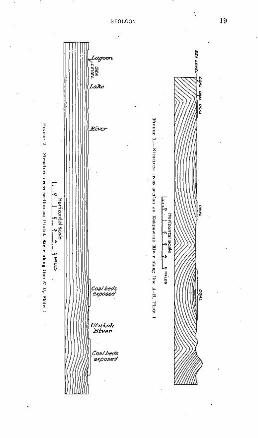
On Kukpowruk River there are three anticlinal folds trending east between the coast and a point 36 miles inland. (See fig. 1.) The axis of the first is 3 miles from the coast, of the second 16 miles, and of the third 23 miles. All these folds are somewhat unsymmetrical. On the northern anticline the dips range from 90° at the crest to 3° at a point 2 miles north. On the south flank of this fold the dips are 35° near the crest and grow progressively less southward to the center of the adjacent syncline.
On the central anticline the dips are steeper on the southern flank than on the northern and range from 70° near the crest to 9° at the synclinal axis. On the northern flank the dips are about 47°.
On the southernmost anticline the northern flank carries the steep est dips, from 50° near the ,crest to 9° in the syncline to the north. On the southern flank the dips range between 12° and 28°.
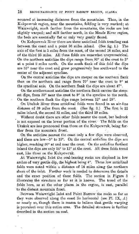
On Utukok River three anticlinal folds were found in an air-line distance of 39 miles from the coast. (See fig. 2.) The first is 22 miles inland, the second 33 miles, and the third 39 miles.
Without doubt there are other folds nearer the coast, but bedrock is not exposed on the lower portion of the river. The folds on the Utukok are less pronouced than those on the Kukpowruk, being far ther from the mountain front.
On the anticline nearest the coast only a few dips were observed, and these are low 5° to 10°. On the central anticline the dips are higher, reaching 50° at and near the crest. On the anticline farthest inland the dips are only 14° to 15° at the crest. All these folds trend east, like those on the Kukpowruk.
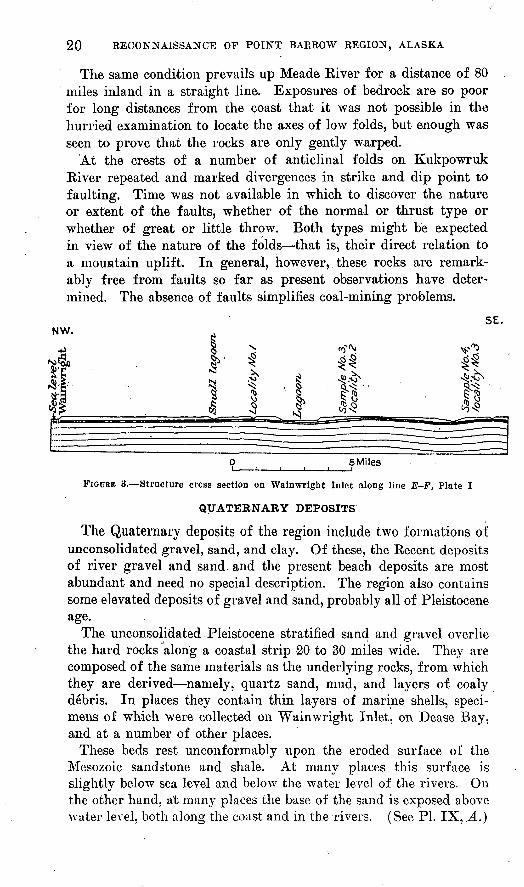
At Wainwright Inlet the coal-bearing rocks are disposed in low arches of very gentle dip, the highest being 4°. Three low anticlinal folds were noted within a distance of 14 miles along the northern shore of the inlet. Further work is needed to determine the details and the exact position of these folds. The section in Figure 3 illustrates the structure so far as it is known. The trend of the folds here, as at the other places in the region, is east, parallel to the distant mountain front.
Between Wainwright Inlet and Point Barrow the rocks so far as they were observed along the coast lie horizontal (see PL IX, A) or nearly so, though there is reason to believe that gentle warping is prevalent over this entire area. The detailed structure is further described in the section on coal.
££* L
£V
£L
Ho
rizon
tal scale
1 O
.I
2346 M
ILE
S
FinniiE
1
. Stv
iic-tnre
cross
section
on
Kukpow
ruk
Riv
er alon
g
line A
B, P
late I
$-SftJ
HorizontaJ scale
.9
! ?
3 *
? MILES
r.uuE 2. S
tructu
re
cross
section
on
Utu
ko
k R
iver
along lin
e C
-D,
Plate
I
20 RECONNAISSANCE OF POINT BARROW REGION, ALASKA
The same condition prevails up Meade Kiver for a distance of 80 miles inland in a straight line. Exposures of bedrock are so poor for long distances from the coast that it was not possible in the hurried examination to locate the axes of low folds, but enough was seen to prove that the rocks are only gently warped.
At the crests of a number of anticlinal folds on Kukpowruk River repeated and marked divergences in strike and dip point to faulting. Time was not available in which to discover the nature or extent of the faults, whether of the normal or thrust type or whether of great or little throw. Both types might be expected in view of the nature of the folds that is, their direct relation to a mountain uplift. In general, however, these rocks are remark ably free from faults so far as present observations have deter mined. The absence of faults simplifies coal-mining problems.
5E. NW.
1NJ«fl
n ^'l-II
1 « "^S\ «5 ri &
t t ^t NO V £ 4JSV^ ^ '1 ^ ' "S Vj N. ^ tjIs 6 CT ^5 OCQ vj ^ to*s
v">
t̂^p-fi«
[ » - . -^zr: n :sMiles
FIGURE 3. Structure cress section on Wainwright Inlet along line E-F, Plate I
The Quaternary deposits of the region include two formations of unconsolidated gravel, sand, and clay. Of these, the Kecent deposits of river gravel and sand, and the present beach deposits are most abundant and need no special description. The region also contains some elevated deposits of gravel and sand, probably all of Pleistocene age.
The unconsolidated Pleistocene stratified sand and gravel overlie the hard rocks along a coastal strip 20 to 30 miles wide. They are composed of the same materials as the underlying rocks, from which they are derived namely, quartz sand, mud, and layers of coaly debris. In places they contain thin layers of marine shells, speci mens of which were collected on Wainwright Inlet, on Dease Bay, and at a number of other places.
These beds rest unconformably upon the eroded surface of the Mesozoic sandstone and shale. At many places this surface is slightly below sea level and below the water level of the rivers. On the other hand, at many places the base of the sand is exposed above water level, both along the coast and in the rivers. (See PL IX, .A.)
GEOLOGY 21
In general the sand forms a most effective blanket over the hard rocks of the interstream areas inland for a distance of 20 miles or more, except in a few places where low hills rise above the general level of the plain.
Inland the marine sand merges with Pleistocene fresh-water sand and gravel. This is to be expected, for at the same time the rivers were delivering sediment to the sea flood-plain fresh-water deposits were no doubt being laid down along the lower courses of the larger streams. At a point about 60 miles inland on Topogarok Kiver Mr. Gilluly collected a fresh-water Pleistocene fauna from these de posits of sand and gravel.
Leffingwell has described shale and yellow sand near Point Barrow in which he found marine Pleistocene fossils. 9 Some evidence of the presence of the elevated Pleistocene deposits has been found 10 along the coast to the east and even beyond the international boundary at Herschel Island.11
The geologic history of this region is as yet very incompletely known. As shown by the foregoing statements, the oldest.rocks are Jurassic (Cape Lisburne) and Lower and Upper Cretaceous sand stone and shale. The Recent sand and gravel are undisturbed, but the Pleistocene alluvium rests on an elevated surface, which near the coast stands in places about 20 feet above the se'a. All the Quaternary deposits rest on the more or less folded Mesozoic rocks. On Colville River Schrader found gently tilted beds of sand, gravel, and clay of the upper part of the Colville " series," which yielded marine shells, determined as of Pliocene age by W. H. Dall. These beds are under lain conformably by similar deposits of probable Oligocene age and are overlain by 10 or 15 feet of argillaceous sand (the Gubik sand) provisionally referred to the Pleistocene. In the area here discussed no Tertiary rocks were found, but the Gubik sand may be of the same age as the Pleistocene elevated beach sand above described. The presence of the large areas of Tertiary rocks in Schrader's sec tion, which is uplifted but only slightly folded, suggests that the folding of the Mesozoic beds occurred in pre-Tertiary time.
The Mesozoic rocks are folded, strongly near the mountains but only slightly at long distances from the mountains. The Quaternary sand and gravel lie above the folded Mesozoic rocks upon a surface of
8 Leffingwell, E. deK., The Canning River region, northern Alaska: U. S'. Geol. Survey Prof. Paper 109, p. 149, 1919. Dall, W. H., Pliocene and Pleistocene fossils from the Arctic coast of Alaska and the auriferous beaches of Nome, Norton Sound, Alaska: U. S. Geo. Survey Prof. Paper 125, p. 24, 1921.
10 Schrader, F. C., U. S. Geol. Survey Prof. Paper 20, p. 93, 1904.11 Canadian Arctic Expedition, vol. 8,. pt. A, pp. 20A-20B, Ottawa, 1919.
22 RECONNAISSANCE OF POINT BARROW REGION, ALASKA
erosion. The Mesozoic sediments were laid down, in part at least, beneath the sea, for they contain some limestone, and it is probable that Cretaceous rocks once extended across the site of the present mountains, for in Schrader's section Cretaceous rocks are found on both the, north and the south sides of the mountains. Along the mountain axis uplift and folding took place, probably in late Cretaceous time, but no doubt it also occured to a more moderate de gree over the entire area between the present mountains and the sea.
As the land rose and erosion began sediments of Tertiary age were deposited in places, but there are no data on which to base an opinion as to how much of the present land area they covered. As mountains were formed through a combination of folding, uplift, and erosion, a great upland plain or plateau was developed to the north of the mountains, by similar but less active processes. At least along the coast an uplift has occurred since Pleistocene time.
The fact that Cretaceous sediments remain in the synclines on this eroded plain indicates that an immense thickness of sandstone and shale has been removed. ' Nevertheless, it 1 does not follow that the topography of this plateau or plain was ever decidedly more rugged than at present, for inasmuch as the rocks that underlie the plateau are strongly folded only near the mountain front it may be presumed that as they rose from beneath the sea they assumed, at long dis tances from the mountains, a topography essentially plateau-like.
Nevertheless, this rising land was subjected to erosion, and we have to-day the end product of this erosion cycle preserved beneath the Pleistocene horizontal sand and gravel. The term " cycle " is used in its broadest sense, for there may have been several cycles of erosion interspersed with subsidences in Tertiary time, of which therecord is as yet undeciphered. To-day the surface on which the horizontal marine sand and gravel lie is an undulating erosion sur face that cuts across the structure of the underlying rocks, irre spective of the degree of folding or the nature of the sediment. Along the seacoast and on the lower courses of the rivers this sur face is now in some places) beneath sea level and in other places above it. It is apparent, therefore, that the land along the coast, al though it has recently been raised above the sea, has not risen to the altitude at which it stood prior to the deposition of the Pleistocene sand.
At 80 miles inland on Meade River there are river terraces 40 feet above the water. These terraces may have been cut when the Pleistocene sand was being deposited that is, when the land stood lower than it does now. As the land arose the river intrenched itself in its present position.
KECONXAISSANCE OF POINT BARROW REGION,, ALASKA 23
PETROLEUM
OCCURRENCE
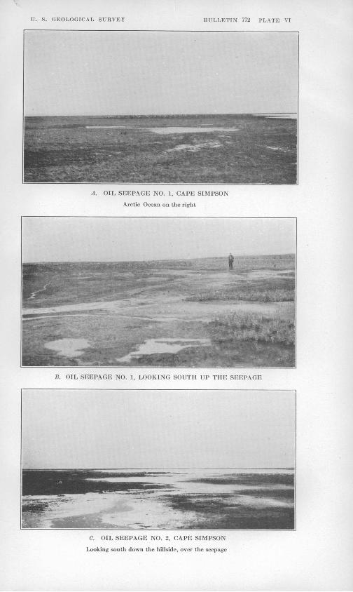
The Cape Simpson oil seepages are so far the only definite evi dence obtained of the presence of petroleum in the naval reserve, for the others reported and sought for in the surveyed area were not found during the present hasty reconnaissance. The two seepages are on the very margin of the Arctic Ocean and hence of the re serve.
A low moss-covered ridge of irregular shape stretches for 2 miles along the Arctic Ocean, its southeast terminal about a mile north west of Cape Simpson. Its highest point is about 50 feet above the sea. (See insert on PI. I.) Seepage No. 1 occurs near the inland base of this ridge, a third of a mile from the ocean and 20 feet above tidewater, from which it is visible. Here in an irregular area several hundred feet in diameter the moss is soaked with petroleum, which also slowly seeps from the gentle slope. (See PL VI, A, #.)
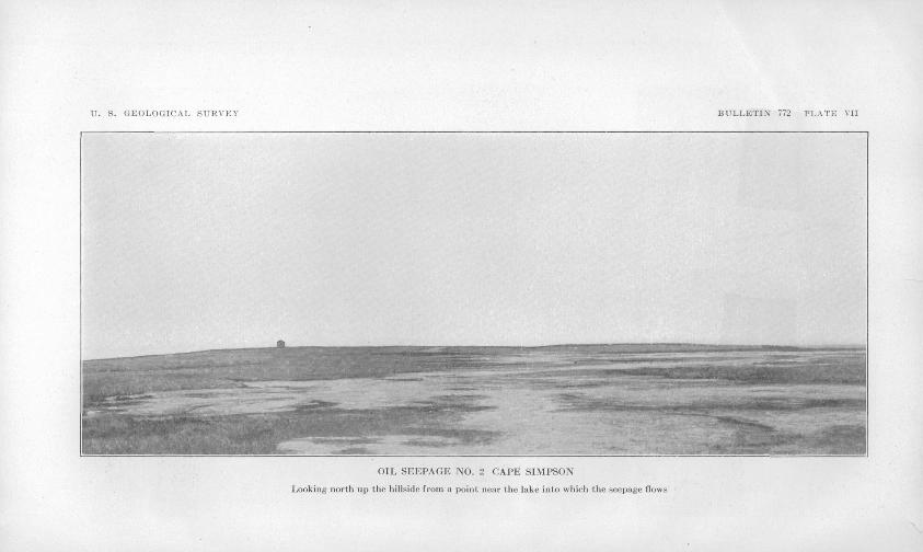
Seepage No. 2 is on the southern top, 40 feet high, of a small double knob 3 miles almost due south of seepage No. 1 and 1^4 miles west of Smith Bay. Here the residue from the seepage covers several acres. (See.Pis. VI, C, and VII.)
The main petroleum flow moves southward down the slope for 600 or 700 feet to a lake. This active channel is 6 to 10 feet wide, though the area covered by residue is several hundred square feet and indicates that a considerable flow is coming from this seepage. The ridge at these two seepages is covered with moss and muck, and there are no surface indications that it is made up of hard rock. In sur face form the ridges are not different from others elsewhere that ap pear to consist of Pleistocene alluvium, but shallow excavations at these localities reveal an aggregate of angular shale d6bris and clearly prove that hard rock is near the surface and that the ridges are the result of the erosion of bedrock and not of alluvium. This suggests that significant geologic facts might be obtained by piercing some of the other mounds or ridges in the coastal plain. Leffingwell 12 has described mounds in the Canning River region. He does not. regard them as being made up of bedrock, but he reports on the authority of natives that petroleum occurs at one of them.
The material exposed in shallow pits is sandy and calcareous shale, whose structure can not be definitely determined, but it appears to be practically horizontal. No fossils were found in this vicinity, but the rocks from which the petroleum emerges are believed to be part of the Mesozoic rocks that have been described on pages 12-20 and that appear to be the dominating country rocks throughout
13 Leffingwell, E. deK., The Canning River region, northern Alaska: U. S. Geol. Survey Prof. Paper 109, pp. 150-155, 1919.
RECONNAISSANCE OF POINT BARROW REGION, ALASKA
much of the Point Barrow region. This would place their age somewhere in the Upper Jurassic or Lower Cretaceous. The evi dence in hand indicates, therefore, that these petroleum seepages do not come from Tertiary rocks, as was formerly believed.
CHARACTER
A sample for examination was taken from a surface seepage and represents weathered oil. A statement of the results of tests of this sample by the Bureau of Mines follows:
Results of tests of oil sample No. 28510, from Naval Petroleum Reserve No. 4,Alaska
[Seepage at surface collected by United States Geological Survey; analyzed by United States Bureau of Mines, August, 1923]
Specific gravity, 0.943; A. P. I. gravity, 18.6°. Sulphur, 0.36 per cent; water, 7.5 per cent.Saybolt Universal viscosity at 70° F., 5,160 seconds; at 100° F., 1,370 seconds.
Pour point, below 5° F.
Distillation, Bureau of Mines Hempel method
[Vacuum distillation at 40 millimeters]
Temperature(rc.)
Up to 200...... ...200-225............225-250............O'tfU'w;275-300...... ......
Per cent cut
13.6 10.2 9.0
10.5 10.7
Sum (per cent)
13.6 23.8 32.8 43.3 54.0
Gravity
Specific
0.894 .920 .923 .931 .936
A. P. I.(°)
26.8 22.3 21.8 20.5 19.7
Viscosity at 100° F.
34.............68..... .. ......116....... ..240............Over 400.......
Cloud test (°F.)
.....do.........
.....do.........
.....do.........
.....do.........
Tempera ture (°F.)
Up to 392. 392-437. 437-482. 482-527. 527-572.
Carboa residue, of residuum, 4.9 per cent.
Approximate summary
Gas oU... ............. .................................
Per cent
12.5 12.7 9.7
19.1
Gravity
Specific
0.892 . 906-. 922 . 922-. 928
9. 928-. 939
A. P. I. (°)
27.1 24. 7-22. 0 22. 0-21. 0 21.0-19.2
Viscosity
50-100. 100-200. Above 200.
Results of test of petroleum residue from Alaska, sample No. 28508
[Extraction with benzene]
Sample marked "dried" __________ ____________ .
Oil (per cent)
44.562.0
Sulphur (per cent)
0.55.47
Specific gravity
1.014.971
U. S. GEOLOGICAL SURVEY BULLETIN 772 PLATE VI
A. OIL SEEPAGE NO. 1, CAPE SIMPSON
Arctic Ocean on the right
B. OIL SEEPAGE NO. 1, LOOKING SOUTH UP THE SEEPAGE
C. OIL SEEPAGE NO. 2, CAPE SIMPSON
Looking south down the hillside, over the seepage
U. S. GEOLOGICAL SURVEY BULLETIN 772 PLATE VII
OIL SEEPAGE MO. 2. CAPE SIMPSON
Looking north up the hillside from a point near the hike into which the seepage flows
X PETROLEUM 25
As a qualitative test by the Holde-Mueller method 13 showed that only a comparatively small part of the oil was precipitated as asphalt with excess of petroleum ether, it would appear that the unusually high viscosity of the sample ig not due to an appreciable extent to the presence of asphalt. Although no chemical study of the oil has been made, it seems probable that the high viscosity may be due to the presence of a large proportion of naphthalene hydrocarbons, a view supported by the general appearance of the sample, its low sulphur content, and the small percentage of carbon residue of the residuum.
The tests indicate lubricant values in the weathered oil, which in fact appears comparable in Baume gravity, sulphur content, viscosity, and distillation tests to the oil obtained from shallow wells in the Pliocene rocks of the Blue Ridge field, in Texas. 14
Beyond doubt light hydrocarbons have escaped from the surfaceseepage, though evaporation in the Arctic climate may not have been so rapid and may not have taken place at so high a temperature as in the better-known regions in lower altitudes. It is to be remembered, however, that the climate of this region is dry. On the whole, there fore, while it is difficult on the basis of the above tests to predict the composition of the unweathered oil, it is practically certain that the oil contains some of the lighter hydrocarbons. It will be seen that 13.6 per cent of the sample was distilled off under 200° C. at a pres sure of 40 millimeters.
The expectation that the oil from wells at depth will be of value for its lighter hydrocarbons, as well as for use as lubricants and fuel, is likely to be fully confirmed. At Blue Ridge, Tex., already men tioned, lighter oils are found in the same field at greater depths.
OIL POSSIBILITIES OF THE RESERVE
The Point Barrow region, as has been shown, is underlain by sedi mentary rocks consisting chiefly of shale, sandstone, and conglom erate, with some thin beds of limestone. This great series of rocks is believed to aggregate over 15,000 feet in thickness. The oil of the seepages is believed to emerge from this series, all of which is re garded as of Mesozoic age. There is no clue as to the part of this series in which the oil originates; it may be in the Lower Cretaceous or the Jurassic. This series of rocks is widely distributed, having been found from the north coast to the mountains, a distance of over ' 100 miles. It will require more detailed geologic surveys than h'ave yet been made to give any clue, except the seepages, as to the part
18 Holcle, D., Hydrocarbon oils and saponiflable fats and waxes, 2d ed.. transl. by Edward Mueller, p. 105, 1922.
14 Smith, N. A. C., Banes, A. D., and LeJenne, N. F., Properties of typical crude oils from the producing fields of southern Louisiana and southern Texas : Bur. Mines Repts. Inv. 2416, p. 39, November, 1922.
26 RECONNAISSANCE OF POINT BARROW REGION, ALASKA \4
of the reserve that may be most favorable to the occurrence of petro leum. The part of the reserve that has been investigated appe'ars to contain structural features that would be favorable to the entrap ping of petroleum. The evidence in hand fully justifies the con tinuation of the exploration for oil, which is now going on.
COAL
GENERAL FEATURES
The earliest explorers of northwestern Alaska did not overlook the abundant outcrops of coal beds that extended along the northern shore line of the Cape Lisburne peninsula. In former days the whalers used to supply themselves with coal at the Corwin Bluffs. The discovery of coal in the Colville basin by Schrader " indicated a wide distribution of coal in this northern province. This con clusion is borne out by the discoveries made in the region here de scribed. All this coal is believed to be of Mesozoic age. The coal at the Corwin Bluffs occurs in a Jurassic formation,16 and in the Colville basin Schrader reports an Upper Cretaceous coal-bearing formation also. The coal beds of the region here described may be in part of Jurassic age and in part of Lower Cretaceous age.
Coal is widely distributed over the region examined in 1923. In the Kukpowruk River area, where the rocks are folded, much coal is exposed at the surface. On Utukok River, where the rocks are less folded, less coal is exposed, but enough was seen to prove that it is present. At Wainwright Inlet, though the rocks are nearly flat, some coal can be seen, and on Meade River at many places debris of coal was seen in such relations as to suggest strongly that consider able quantities are present. There is reason to believe that at many other places coal is present at shallow depths and that within 500 feet of the surface over an area of many thousand square miles there are a number of workable beds of coal.
KUKPOWRUK-UTUKOK REGION
Much coal is present at the surface on Kupowruk and Utukok rivers, and the intervening area is believed to be underlain by the same beds that are exposed along the rivers. The general course of Kukpowruk River is northward, nearly at right angles to the folding of the region. Along the river two major anticlines and the corresponding synclinal basins are thus disclosed. In these two
15 Schrader, F. C., A reconnaissance in northern Alaska across the Rocky Mountains, along Koyukuk, John, Anaktuvuk, and Colville rivers and the Arctic coast to Cape Lis burne, in 1901: U. S. Geol. Survey Prof. Paper 20, pp. 107-109, 1904.
1(1 Collier, A. J., Geology and coal resources of the Cape Lisburne region, Alaska : TJ. S. Gool. Survey Bull. 278, 1906.
COAL 27
synclinal basins much coal is exposed, and there is every reason to believe that the area between the northern anticlinal axis and the sea also carries much coal. (See PL I and figs. 1 and 2.)
A 3-foot bed of coal is exposed near the mouth of the river. Thence inland for 5 or 6 miles, to the crest of the first anticline, there are no exposures, but the general structure of the rocks and the fact that coal is present on the southern limb of this anticline sup port the belief that much coal underlies this lower part of the river and would be revealed by excavation.
At the crest of the first anticline, on its north side, two beds of coal crop out, the northern one (stratigraphically the higher) 10 feet thick, and beneath it a 3-foot bed. These beds are numbered 12 and 13 in the columnar section (see Pis. VIII and IX. 5), on which is shown the stratigraphy of the southern limb of this anticline. Inother words, these beds appear on both sides of the crest of the fold and are the lowest stratigraphically in this section.
Upstream from the crest of this anticline 13 minable beds of coal, 3 feet or more in thickness, and 18 thinner beds are exposed within a distance of about 1% miles. Their relative stratigraphic position is shown in the columnar section of the south limb of the northern anticline (PI. VIII).
The thickest beds are described in the following table:
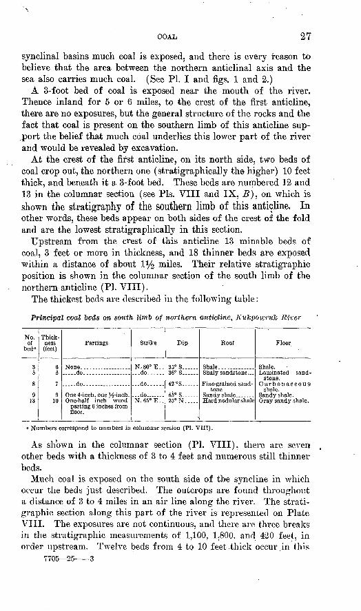
Principal coal 'beds on south limb of northern anticline, Kukpowulc River
No.of
bed 0
3
8
913
Thickness(feet)
6
7
910
Partings
.....do..-..--... .--.
.....do. ................
One-half inch woodparting 6 inches fromfloor.
Strike
N,80°E.....do ...
... do---...
... do... .-.-N.650 E._
Dip
35° S 36° S .
42 °S. ..
55° S 25° N-
Roof
Shale----- ..
tone
Hard nodular shale
Floor
Shale.
stone.
shale.
Gray sandy shale..
° Numbers correspond to numbers in columnar section (PI. VIII).
As shown in the columnar section (PI. VIII), there are seven other beds with a thickness of 3 to 4 feet and numerous still thinner beds.
Much coal is exposed on the south side of the syncline in which occur the beds just described. The outcrops are found throughout a distance of 3 to 4 miles in an air line along the river. The strati- graphic section along this part of the river is represented on Plate VIII. The exposures are not continuous, and there are three breaks in the stratigraphic measurements of 1,100. 1,800. and 420 feet, in order upstream. Twelve beds from 4 to 10 feet thick occur in this
7705 25 3
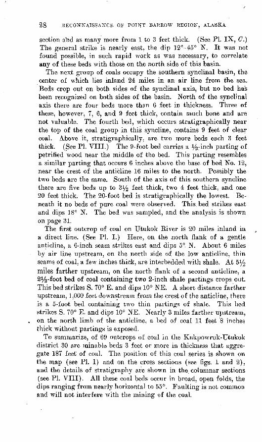
28 RECONNAISSANCE OF POINT BARROW REGION, ALASKA
section and as many more from 1 to 3 feet thick. (See PI. IX, C.) The general strike is nearly east, the dip 12°-45° N. It was not found possible, in such rapid work as was necessary, to correlate any of these beds with those on the north side of this basin.
The next group of coals occupy the southern synclinal basin, the centeir of which lies inland 24 miles in an air line from the sea. Beds crop out on both sides of the synclinal axis, but no bed has been recogniz-ed on both sides of the basin. North of the synclinal axis there are four beds more than 6 feet in thickness. Three of these, however, 7, 6, and 9 feet thick, contain much bone and are not valuable. The fourth bed, which occurs stratigraphically near the top of the coal group in this syncline, contains 9 feet of clear coal. Above it, stratigraphically, are two more beds each 3 feet thick. (See PI. VIII.) The 9-foot bed carries a i/^inch parting of petrified wood near the middle of the bed. This parting resembles a similar parting that occurs 6 inches above the base of bed No. 12, near the crest of the anticline 16 miles to the north. Possibly the two beds are the same. South of the axis of this southern syncline there are five beds up to %y2 feet thick, two 4 feet thick, and one 20 feet thick. The 20-foot bed is stratigraphically the lowest. Be neath it no beds of pure coal were observed. This bed strikes east and dips 18° N. The bed was sampled, and the analysis is shown on page 31.
The first outcrop of coal on Utukok River is 20 miles inland in a direct line. (See PL I.) Here, on the north flank of a gentle anticline, a 6-inch seam strikes east and dips 5°. N. About 6 miles by air line upstream, on the north side of the low anticline, thin seams of coal, a few inches thick, are interbedded with shale. At S 1/^ miles farther upstream, on the north flank of a second anticline, a 2^-foot bed of coal containing two 2-inch shale partings crops out. This bed strikes S. 70° E. and dips 10° NE. A short distance farther upstream, 1,000 feet downstream from the crest of the anticline, there is a 5-foot bed containing two thin partings of shale. This bed strikes S. 70° E. and dips 10° NE. Nearly 3 miles farther upstream, on the north limb of the anticline, a bed of coal 11 feet 8 inches thick without partings is exposed.
To summarize, of 69 outcrops of coal in the Kukpowruk-TJtukok district 30 are minable beds 3 feet or more in thickness that aggre gate 187 feet of coal. The position of this coal series is shown on the map (see PL I) and on the cross sections (see figs. 1 and 2), and the details of stratigraphy are shown in the columnar sections (see PL VIII). All these coal beds occur in broad, open folds, the dips ranging from nearly horizontal to 55°. Faulting is not common and will not interfere with the mining of the coal.
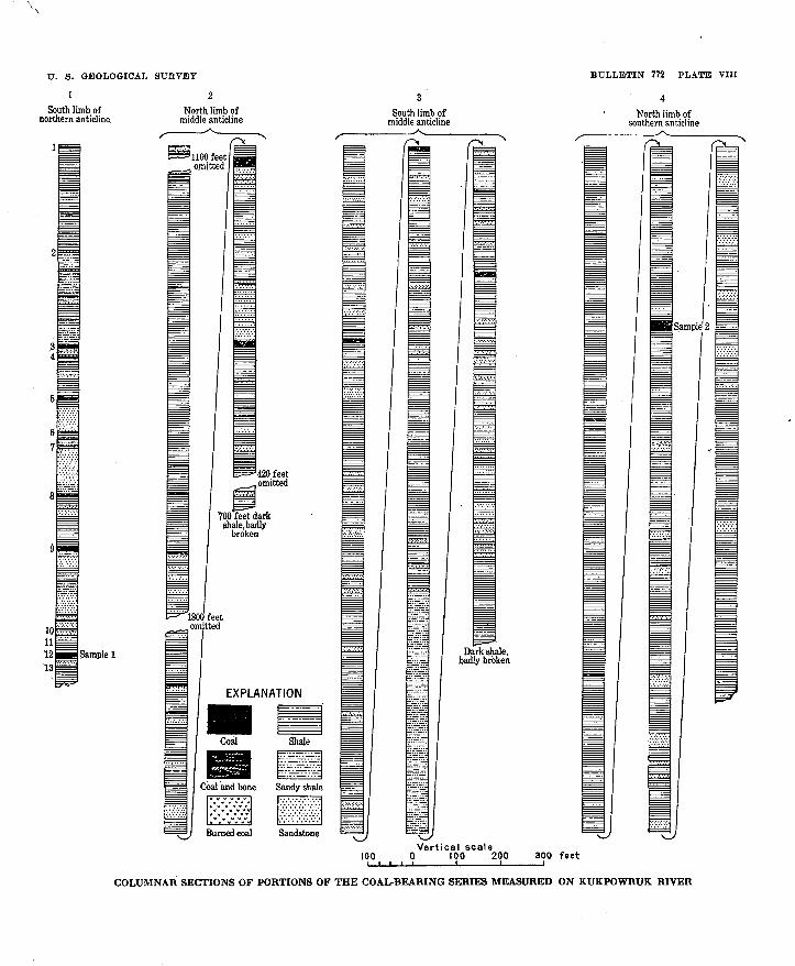
U. 8. GEOLOGICAL SURVEY
1 2
South limb of northern anticline.
Sample 1
North limb of middle anticline
BULLETIN 772 PLATE VIII
North limb of southern anticline
Sample 2
100Vertical scale
0 100 200 300 feet
COLUMNAR SECTIONS OF PORTIONS OF THE COAL-BEARING SERIES MEASURED ON KUKPOWRUK RIVER
U. S, GEOLOGICAL SURVEY BULLETIN 772 PLATE IX
-1. SANDSTONE IN CLIFFS 20 MILES EAST OF PEARD BAY
B. TEN-FOOT BED OF BITUMINOUS COAL 5 MILES INLAND ON KUKPOWRUKRIVER
C. TEN-FOOT BED OF BITUMINOUS COAL 35 MILES INLAND ON WEST BANK OF KUKPOWRUK RIVER
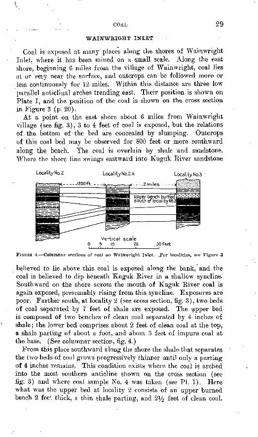
COAL 29
WAINWRIGHT INLET
Coal is exposed at many places along the shores of Wainwright Inlet, where it has been mined on a small scale. Along the east shore, beginning 6 miles from the village of Wainwright, coal lies at or very near the surface, and outcrops can be followed more or less continuously for 12 miles. Within this distance are three low parallel anticlinal arches trending east. Their position is shown on Plate I, arid the position of the coal is shown on the cross section in Figure 3 (p. 20).
At a point on the east shore about 6 miles from Wainwright village (see fig. 3), 3 to 4 feet of coal is exposed, but the relations of the bottom of the bed are concealed by slumping. Outcrops of this coal bed may be observed for 800 feet or more southward along the beach. The coal is overlain by shale and sandstone. Where the shore line swings eastward into Kuguk River sandstone
Locality No. 2
r----_IZOOft.--.-->
Locality No.Z A Locality No.3
- . _ _2 miles ^--~
Upper bench burned south of locality N<x3
FIGURE 4. Columnar sections of coal on Wftinwright Inlet. .For localities, set- Figure 3
believed to lie above this coal is exposed along the bank, and the coal is believed to dip beneath Kuguk River in a shallow syncline. Southward on the shore across the mouth of Kuguk River coal is again exposed, presumably rising from this syncline. Exposures are poor. Farther south, at locality 2 (see cross section, fig. 3), two beds of coal separated by 7 feet of shale are exposed. The upper bed is composed of two benches of clean coal separated by 4 inches of shale; the lower bed comprises about 2 feet of clean coal at the top, a shale parting of about a foot, and about 3 feet of impure coal at the base. (See columnar section, fig. 4.)
From this place southAvard along the shore the shale that separates the two beds of coal grows progressively thinner until only a parting of 4 inches remains. This condition exists where the coal is arched into the most southern anticline shown on the cross section (see fig. 3) and where coal sample No. 4 was taken (see PI. I). Here what was the upper bed at locality 2 consists of an upper burned bench 2 fee"1; thick, a thin shale parting, and 2i/2 feet of clean coal.
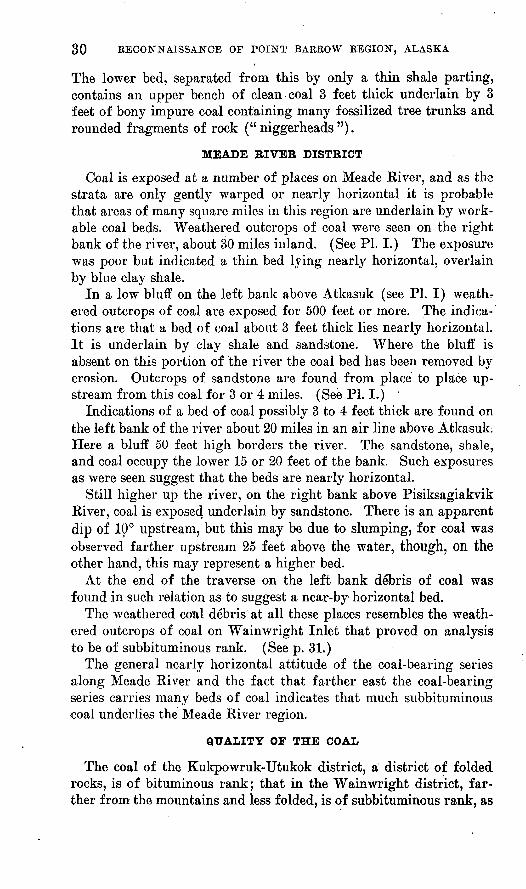
30
The lower bed, separated from this by only a thin shale parting, contains an upper bench of clean coal 3 feet thick underlain by 3 feet of bony impure coal containing many fossilized tree trunks and rounded fragments of rock ("niggerheads").
MEADE RIVER DISTRICT
Coal is exposed at a number of places on Meade Kiver, and as the strata are only gently warped or nearly horizontal it is probable that areas of many square miles in this region are underlain by work able coal beds. Weathered outcrops of coal were seen on the right bank of the river, about 30 miles inland. (See PI. I.) The exposure was poor but indicated a thin bed lying nearly horizontal, overlain by blue clay shale.
In a low bluff on the left bank above Atkasuk (see PI. I) weathr ered outcrops of coal are exposed for 500 feet or more. The indica tions are that a bed of coal about 3 feet thick lies nearly horizontal. It is underlain by clay shale and sandstone. Where the bluff is absent on this portion of the river the coal bed has been removed by erosion. Outcrops of sandstone are found from place to place up stream from this coal for 3 or 4 miles. (See PI. I.) '
Indications of a bed of coal possibly 3 to 4 feet thick are found on the left bank of the river about 20 miles in an air line above Atkasuk. Here a bluff 50 feet high borders the river. The sandstone, shale, and coal occupy the lower 15 or 20 feet of the bank. Such exposures as were seen suggest that the beds are nearly horizontal.
Still higher up the river, on the right bank above Pisiksagiakvik Kiver, coal is exposed underlain by sandstone. There is an apparent dip of 10° upstream, but this may be due to slumping, for coal was observed farther upstream 25 feet above the water, though, on the other hand, this may represent a higher bed.
At the end of the traverse on the left bank debris of coal was found in such relation as to suggest a near-by horizontal bed.
The weathered coal debris at all these places resembles the weath ered outcrops of coal on Wainwright Inlet that proved on analysis to be of subbituminous rank. (See p. 31.)
The general nearly horizontal attitude of the coal-bearing series along Meade River and the fact that farther east the coal-bearing series carries many beds of coal indicates that much subbituminous coal underlies the Meade River region.
QUALITY OF THE COAL
The coal of the Kukpowruk-Utukok district, a district of folded rocks, is of bituminous rank; that in the Wainwright district, far ther from the mountains and less folded, is of subbituminous rank, as
COAL 31
is probably the coal of the Meade River region. There is no doubt a progressive change in rank from the mountains northward, due to differences in regional metamorphism.
Below are presented proximate analyses by the Bureau of Mines of two samples from the Kukpowruk region and two from Wain- wright Inlet.
Analyses of coal samples from the Kukpo^eruk and Waimoright coal fields,Ala.ska
[Made at the'Pittsburgh laboratory of the Bureau of Mines; H. M. Cooper, chief chemist]
No. on Plate
I
l
2
3
4
Labora tory No.
96820
96821
96823
96822
Air-dry ing loss
3.3
1.0
8.7
9.2
Form of analysis 0
A B C D
A B C D
A B C D
A B C D
Proximate analysis
Mois ture
9.9 6.8
3.92.8
22.3 14.9
21.8 13.9
Volatile matter
31.5 32.5 34.9 35.9
38.6 38.6 40.0 41.0
30.6 33.6 39.4 40.8
29.3 32.3 37.5 40.2
Fixed carbon
56.1 58.1 62.3 64.1
55.5 56.4 57.7 59.0
44.5 48.7 57.3 59.2
43.7 48.1 55.8 59.8
Ash
2.5 2.6 2.8
2.0 2.2 2.3
2.6 2.8 3.3
5.2 5.7 6.7
Sul phur
0.4 .4 .5 .5
.2
.2
.2
.2
.3
.4 ' .4
.4
.4
.4
.5
.5
Heating value
Calories
6,617 6.844 7,339 7,556
, 7,661 ' 7,860
7,978 8,140
' 5,500 6,017 7,072 7,317
5,256 5,789 6,722 7,206
British thermal
. units
11,910 12,320 13, 210
,. 13,600
13,790 14, 640 14, 360 14,660
9,900 10,830 12, 730 13, 170
9,460 10, 420 12,100 12, 970
o A, As received; B, air dried; C, moisture free; D, moisture and ash free.1. Sample taken 5 miles inland on Kukpowruk Riyer.2. Sample taken 25 miles inland on Kukpowruk River.3. Sample taken 11 miles inland on east shore of Wainwright Inlet.4. Sample taken 16 miles inland on east shore of Wainwright Inlet.
For comparison an analysis of coal from Corwin Buff, a few miles west of Kukpowruk River, is given below:
Analysis of coal from Corwin Buff, Alaska
Fixed carbon__________________________ 57.49Volatile hydrocarbon_____________________ 34. 59Moisture _____________________________ 4.49Ash _________________________________ 3.43Sulphur _ __ __ ____/_________ . 39
100.39 Coke_____________ _ _____________ _ None.Ash_________________________________ Gray. Fuel ratio_____________________________ 1.63
SUMMARY
The foregoing statements indicate that coal that ranges from sub- bituminous to bituminous occurs in workable beds in this region. At least 1,000 square miles of coal area was examined by this
32 . BECONNAISSANCE OF POINT BAEEOW BJEGION, ALASKA
expedition. Probably most of the coal, because of the remoteness of the field, will not be utilized for many years to come. At Lisburne some 2,600 tons of coal has been mined since 1880, mostly for use of near-by vessels, but a little has been taken to Nome. The Alaska Natives School Service has mined about 3,500 tons of coal for use of the native settlements at and near Wainwright Inlet.
The availability of these coals for other northern settlements de pends on the transportation afforded. The navigation of the Arctic Ocean has already been summarized. To this may be added the fol lowing statement referring specially to the transportation of coal:
The principal outcrops of coal on Kukpowruk Kiver lie between 5 and 7 miles from the coast, in a region of low relief. Shallow- draft barges could convey this coal to the coast, and a harbor for a 400-ton schooner could be made within the lagoon at the mouth of Kukpowruk Kiver. The coal at Wainwright Inlet lies 8 to 16 miles from the coast. Shallow-draft barges could be used to convey this coal to the coast also. Considerable dredging would be necessary to afford good protection for anything but launches.
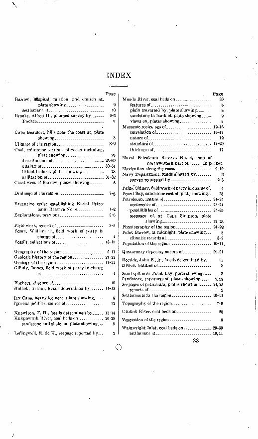
INDEX
Barrow, Hospital, mission, and church at, plate showing.....-----.-....-..
settlement &t...........................-Brooks, Alfred H., planned survey by_-..-
Preface.----------.---- ......-.--.---.
Cape Beaufort, hills near the coast at, plate showing..-.--.....----..-----...
Climate of the region..----------------------Coal, columnar sections of rocks including,
plate showing...................distribution of...._......... .quality of..........................10-foot beds of, plates showing......utilization of-----------------------
Coast west of Barrow, plates showing...
10 2-3
v
28 26-3030-31
2831-32
Drainage of the region.
Executive order establishing Naval Petro leum Reserve No. 4-----.----..-- 1-2
Explorations, previous.--------------------- 5-6
Field work, record of ------------------------ 3-5Foran, William T., field work of party in
charge of-...----.--------------- 4Fossils, collections of.............._------- 13-15
Geography of the region....---..--...-.-.... 6-11Geologic h istory of the region................ 21-22Geology of the region........................ 11-22Gilluly, James, field work of party in charge
of....-.....-...------.--..---..-. 4
Harbors, absence of_._--_..----..-___Hollick, Arthur, fossils determined by.
10 14-15
Icy Cape, heavy ice near, plate showing..-.. 8 Igneous pebbles, source of-.-- --- 12
Kno\vlton, F. H., fossils determined by_.. 13-14 Kukpowrtik River, coal beds on.--.......-.. 26-28
sandstone and shale on, plate showing.- t 9
Leflingwell, E. cle K., seepage reported by... 2
Page Meade River, coal beds on....___....... 30
features of. . 8 plain traversed by, plate showing_.... 8sandstone in bank of, plate showing.. _ 9 views on,.plates showing._--------_ 8
Mesozoic rocks, age of... ------_.._ 12-16correlation of.. .-.......---.-.__... 16-17nature of.._._._ --..----...---- 12structure of........ . 17-20thickness of..--...---.------------.---.. 17
Naval Petroleum Reserve No. 4, map ofnorthwestern part of........In pocket.
Navigation along the coast-.-.---..--------- 9-10Navy Department, funds allotted by,....... 3
survey requested by.. .......... 2-3
Paige,' Sidney, field work of party in charge of. 4 Peard Bay, sandstone east of, plate showing.. 28 Petroleum, nature of...---------..-.-------- 24-25
occurrence of....---------.--..-.-------. 23-24possibilities of-.--,---- ------- 25-26seepages of, at Cape Simpson, plate
showing..-.---.-----....-.___ 24,25Physiography of the region....--..__.._ 21-22Point Barrow, at midnight, plate showing... 8
climatic records at.----.----....... ... 8-9Population of the region.--------___._ ._ 10-11.
Quaternary deposits, nature of.............. 20-21
Reeside, John B., jr., fossils determined by_ 15 Rivers, features of..--....-.-_._.-_-.-_ 8
Sand spit near Point Lay, plate showing.... 8Sandstone, exposures of, plates showing_.. 9,28Seepages of petroleum, plates showing..----. 24,25
reports of...--.-.---------..... .........^ ' 2Settlements in the region..-------...---.-... 10-11
Topography of the region.......-...--__... 7-8
Utukok River, coal beds on......___.-... 28
Vegetation of the region..-...--.-...-------. 9
Wainwright Inlet, coal beds on..........._ 29-30settlement at...----....-....______ 10,11
33