Embed Size (px)
Citation preview
BARROWWATERFRONT,BARROW-IN-FURNESS,CUMBRIA
ArchaeologicalWatching BriefReport
Oxford Archaeology North
February 2011
Carillion and Capita Symonds
Issue No: 2010-11/1152OA North Job No: L10107NGR: SD 2000 6795Planning reference: 6/06/9027
Barrow Waterfront, Barrow-in-Furness, Cumbria: Archaeological Watching Brief Report 1
For the use of Carillion and Capita Symonds © OA North: February 2011
CONTENTS
SUMMARY.................................................................................................................. 3
ACKNOWLEDGEMENTS.............................................................................................. 4
1 INTRODUCTION ..................................................................................................... 5
1.1 Circumstances of the Project ........................................................................... 5
1.2 Site Location, Topography and Geology.......................................................... 5
1.3 Historical and Archaeological Background ...................................................... 6
2. METHODOLOGY....................................................................................................10
2.1 Written Scheme of Investigation.....................................................................10
2.2 Watching brief................................................................................................10
2.3 Archive ..........................................................................................................10
3. RESULTS ...............................................................................................................11
3.1 Introduction ...................................................................................................11
3.2 Results ...........................................................................................................11
3.3 Finds ..............................................................................................................12
4. CONCLUSIONS.......................................................................................................13
4.1 Discussion......................................................................................................13
5. BIBLIOGRAPHY....................................................................................................15
5.1 Primary Sources .............................................................................................15
5.2 Secondary Sources .........................................................................................15
6. ILLUSTRATIONS ...................................................................................................17
6.1 Figures ...........................................................................................................17
6.2 Plates .............................................................................................................17
APPENDIX 1: CCCHES BRIEF .................................................................................18
APPENDIX 2: PROJECT DESIGN ................................................................................19
Barrow Waterfront, Barrow-in-Furness, Cumbria: Archaeological Watching Brief Report 2
For the use of Carillion and Capita Symonds © OA North: February 2011
APPENDIX 3: CONTEXT INDEX .................................................................................25
APPENDIX 4: FINDS SUMMARY.................................................................................27
Barrow Waterfront, Barrow-in-Furness, Cumbria: Archaeological Watching Brief Report 3
For the use of Carillion and Capita Symonds © OA North: February 2011
SUMMARY
In 2006, proposals were submitted for the redevelopment of former allotment gardenson the southern part of Barrow Island, Barrow-in-Furness, Cumbria (SD 2000 6795;planning reference 6/06/9027). The area was considered to have archaeologicalpotential and, accordingly, Cumbria County Council Historic Environment Service(CCCHES), the body responsible for advising local planning authorities on culturalheritage matters, requested that the works should be accompanied by a scheme ofarchaeological recording. Carillion, on behalf of Capita Symonds and Cumbria CountyCouncil, commissioned Oxford Archaeological North (OA North) to undertake therequired archaeological watching brief, which was completed in two phases in Januaryand August 2009.
During the groundworks the below-ground remains of two separate building rangeswere identified and recorded, one of which was orientated north/south, whilst the otherwas orientated east/west. Both date to the latter part of the nineteenth century andfrom part of terraced dwellings that are first plotted on the 1883 Dockyard plan of thispart of Barrow Waterfront. They are described as the ‘Foremen’s Cottages’ on the1891 Ordnance Survey (OS) map.
At the eastern edge of the allotment gardens evidence for a sand pit was discovered ina position plotted on the 1891 OS map. The sand deposit was found to underlie thewhole of the site and, whilst it could gave have originated from the dredging of thechannels and dock basins, it was very clean, and more likely to have been the wind-blown sand of a former dune system.
Barrow Waterfront, Barrow-in-Furness, Cumbria: Archaeological Watching Brief Report 4
For the use of Carillion and Capita Symonds © OA North: February 2011
ACKNOWLEDGEMENTS
Oxford Archaeology North (OA North) would like to thank Robert Nicholson andMark Landrum of Carillion, repsectively for commissioning the project and for theirassistance on site.
The watching brief was undertaken by Andy Bates, Jeremy Bradley, Nathaniel Jepsonand Pascal Eloy, each of whom contributed to the report. The finds were examined byChris Howard-Davis and the drawings were produced by Anne Stewardson. Theproject was managed by Stephen Rowland, who also edited the report.
Barrow Waterfront, Barrow-in-Furness, Cumbria: Archaeological Watching Brief Report 5
For the use of Carillion and Capita Symonds © OA North: February 2011
1 INTRODUCTION
1.1 CIRCUMSTANCES OF THE PROJECT
1.1.1 As part of the Barrow Ports Regeneration Project, Carillion, on behalf ofCapita Symonds and Cumbria County Council, proposed to undertake aprogramme of remediation, infrastructure works and reconstruction of theallotment gardens towards the south of Barrow Island, Barrow-in-Furness,Cumbria (SD 2000 6795; planning reference 6/06/9027). Previousarchaeological works undertaken by Oxford Archaeology North in associationwith the wider programme of development, including a desk-based assessment(DBA; OA North 2003) and a trial-trench evaluation (OA North 2005)identified that the present area of proposed ground works had somearchaeological potential. Consequently, in accordance with Planning PolicyGuidance note 16 (Archaeology and Planning (PPG16; Department of theEnvironment 1991) and the Cumbria and Lake District Joint Structure 2001-16 (CCC and LDNPA 2001), Cumbria County Council Historic EnvironmentService (CCCHES) issued a brief and plan requesting that an archaeologicalwatching brief be maintained during any ground-disturbing activities associatedwith the development (Appendix 1). Following the production of a projectdesign (Appendix 2) to meet the requirements of the CCCHES brief, OA Northwas commissioned by Carillion, on behalf of Capita Symonds and CumbriaCounty Council, to undertake the archaeological watching brief. This tookplace in two phases in January and August 2009.
1.2 SITE LOCATION, TOPOGRAPHY AND GEOLOGY
1.2.1 Barrow-in-Furness lies at the south-western tip of the Furness Peninsula inSouth Cumbria, although it is historically in that part of Lancashire known as‘across the sands’, or North Lonsdale. It is bounded by Morecambe Bay to thesouth and Duddon Sands to the north, with the Furness Fells to the east andIrish Sea to the west (Fig 1). The development site is located to the south ofthe centre of Barrow-in-Furness, on Barrow Island and north-west of thejunction of Michaelson and Bridge Roads. The site is bound to the north by theDevonshire Dock, to the south by Bridge Road, to the east by the Grade IIlisted Heavy Engineering Shop, and to the west by Edwardian terraces.
1.2.2 The topography is essential artificial, due to the massive extent of constructionand development within the study area. It is typically low-lying, little more than10m above sea level. The more general area is a mix of stretches of coastlineand undulating fields rising up to fells to the north-east (CountrysideCommission 1998, 25).
1.2.3 The solid geology is made up almost entirely of Triassic red sandstone, withareas of red, grey and green mudstones and siltstones to the south-west (BritishGeological Survey 1982). As the study area is generally urban, the nature of theoverlying drift geology is not clear. It is likely to consist of glacially deriveddeposits, overlain by typical brown earths as in neighbouring areas (OrdnanceSurvey 1983).
Barrow Waterfront, Barrow-in-Furness, Cumbria: Archaeological Watching Brief Report 6
For the use of Carillion and Capita Symonds © OA North: February 2011
1.3 HISTORICAL AND ARCHAEOLOGICAL BACKGROUND
1.3.1 Prehistory: evidence for post-glacial activity is not common in this part ofNorth West England. Nevertheless, recent work has established that groups ofhunter-gatherers were active in the region, some of the most compellingevidence having come from the Furness Peninsula itself (Young 2002). Cavesites excavated near Ulverston and Grange-over-Sands have revealed remainsdating to around 10,000 years ago (op cit, 20), and it is possible that theremains of deer, discovered in layers of peat at great depth during theconstruction of the Barrow Docks, could also date to this period (Kendall1900). There is considerably more evidence of sites in the vicinity of Barrowdating to the Mesolithic period, many artefacts having been discovered onWalney Island, just off the south-west coast. These consist almost entirely ofsurface finds (Cherry and Cherry 2002). Needless to say, by the beginning ofthe Neolithic, the area around Barrow was well visited, and recent excavationssuggest a degree of continuity from the Mesolithic (Jones 2001; OA North2002).
1.3.2 During the later Neolithic and Bronze Age, more extensive settlements beganto be established across the Furness Peninsula, and numerous stray finds havebeen discovered, including stone and bronze axes, along with bronze swords,spearheads and other weapons (Barnes 1978, 9). Large enclosures, such asthose at Skelmore Heads and Stainton, may have their origins at this time(Powell et al 1963; Barnes 1978), although they appear to have remained inuse until the coming of the Romans. Numerous burial mounds, many of whichwere explored during the eighteenth and nineteenth centuries (West 1774), alsodate to this period, as well as the stone circle at Birkrigg (Gelderd and Dobson1912). During the Iron Age further settlements were constructed, such as thatat Stone Walls near Urswick, where there is evidence that open-cast miningwas carried out (Bowden 2000); there may even have been some form ofhabitation at Back (or Black) Castle, now the site of Barrow public park(Barnes 1978, 9).
1.3.3 Roman: there are no confirmed structural remains dating to the Roman periodin Barrow, and it is not clear to what extent there was a Roman presencewithin the area. Shotter (1995) has argued that the relatively large number ofRoman coins found in South Cumbria, particularly in the Furness Peninsula,suggests a large degree of interaction between the Romans and the localpopulation and the possibility that a fort may yet be discovered.
1.3.4 Early Medieval: like many parts of North West England, evidence for activityduring the early medieval period is sparse, and is largely confined to twosources: place-names and the remains of a cross fragment. The name Barrow-in-Furness is a relatively modern one, the village originally being calledBarrowhead. Barrow appears to have referred to Old Barrow Island and isthought to consist of a British word ‘barr,’ meaning top or summit, with theNorse ‘ai,’ meaning island, added to the end and making ‘barrai’ (Ekwall1922); it is still pronounced ‘Barrah’ by locals to this day. Furness, too, ispossibly named after Fouldney Island (sometimes mistakenly called Piel Island)‘fu,’ or ‘fud,’ being Old Norse for small island, and ‘ness’ meaning headland orpeninsula (ibid). Finds from the area include the pommel, grip, guard and
Barrow Waterfront, Barrow-in-Furness, Cumbria: Archaeological Watching Brief Report 7
For the use of Carillion and Capita Symonds © OA North: February 2011
400mm of the blade of a Viking sword which was recovered in 1909 whiledigging a grave in the churchyard at Rampside, near Roa Island (Parsons perscomm 2002). At the time of the Norman Conquest, Furness formed part of theManor of Hougun, thought to be based at High Haume near Dalton, under thecontrol of Earl Tostig (OA North 2003).
1.3.5 Medieval: the history of Furness soon became synonymous with that of itsabbey, which was founded in 1127 after a gift of land by Stephen Count ofMortain and Boulogne (later King Stephen) in 1124 (West 1774, 24). Theabbey came to dominate almost everything in the area, and both Barrow andSalthouse were granges connected to it; however, Barrow was not mentionedby name until after the Dissolution (Leach 1981, 24). Salthouse, as the namemight suggest, was established as a grange in 1247 with a saltworks, and wasgranted several indulgences, including exemption from tithes (Kendall 1948,24). Both Barrow and Salthouse are likely to have changed little in thefollowing centuries and, although the Great Raid by Robert the Bruce of 1322entered Furness and caused much devastation, it is not clear how severe thiswas (Barnes 1978, 32). One of the obligations held by the villagers was tomaintain the sea defences (Kendall 1948), which was observed until theDissolution of the Monasteries. During the sixteenth and seventeenth centurythere were several inundations of the coastline, which destroyed property in thevillage of Salthouse among others (Phillips and Rollinson 1971, 3).
1.3.6 Post-medieval: until the end of the eighteenth century Barrow consisted ofonly five farm houses with outbuildings, and originally consisted of eighthomesteads founded by the abbey (Kendall 1909, 185). With the exception of asmall farm, located close to the centre of the island, Barrow Island itselfremained largely undeveloped pasture and arable fields well into the eighteenthcentury. In 1726, a large house was built close to the island’s north coast, witha ford crossing the tidal Barrow Channel (Kendal 1948). The island, mansionand farm were bought by Robert Michaelson of Cartmel in 1746 (ibid).Salthouse too originally consisted of only four houses; the people living therewere no doubt engaged at the salt works (Kendall 1948). Barrow was afarming village, not a fishing village, the latter would appear to be a Victorianmyth (Trescatheric and The Dock Museum 2000, 2); its produce includingoats, barley, wheat, beans and dairy cattle (op cit, 1) which remained thestaples into the nineteenth century (Rollinson and Harrison 1986). The houseswere probably similar to two pulled down in Salthouses in 1800 and 1802,which were recorded as being made of cobbles and clay, with cobbled floorsand thatched roofs, and included a buttery (Kendall 1948, 36-7).
1.3.7 Industrial period: at first the events of the Industrial Revolution had littleeffect on Barrow, but the huge iron ore reserves of the Furness peninsula weresoon to become a dominating factor in the town’s development. The ore hadbeen exploited on a small scale since at least medieval times (Fell 1908), andwas shipped from a number of places across Furness (Marshall 1958).Transport links by land across the Furness Peninsula were very bad, consistingof little more than cart tracks, and the way across the sands of Morecambe Baysouthwards was extremely dangerous (Marshall 1958, 82-3).
Barrow Waterfront, Barrow-in-Furness, Cumbria: Archaeological Watching Brief Report 8
For the use of Carillion and Capita Symonds © OA North: February 2011
1.3.8 The deep-water port at Barrow was controlled by a custom house built at Pieland connected with Furness Abbey. By the middle of the eighteenth century theBackbarrow Iron Company began transporting small quantities of ore fromBarrow and, as a result, a small number of new houses were built (Kendall1909, 185). As demand for iron increased, the Newland Company bought landto found an ore-dumping ground in 1776, to allow the larger scale transport ofmaterial (Marshall 1958, 88). The Newland Company bought more land in1780 and, in 1782, built a jetty, followed by a larger one in 1790, so that boatscould be loaded at low tide (ibid).
1.3.9 Ore shipments increased steadily over the next few years; with a second jettybeing built in 1833 by John Rawlinson, a third in 1839 by the Ulverston MiningCompany, and a fourth in 1842 by Schneider and Partners (op cit, 91). Barrowincreased little in size during this time, and is described as a ‘hamlet’ in 1829(Parson and White 1829, 710) and gets almost no mention in guides of theperiod (such as Evans 1842 and Jopling 1843). It was the coming of therailway in 1846 that transformed Barrow, allowing huge amounts of iron ore tobe transported from the mine to the harbour (Banks 1984). Two principalfigures stand out in the history of Barrow at this crucial point: HW Schneiderand James Ramsden. It was Schneider who encouraged the exploitation of ironin the area, albeit after several abortive attempts (Banks 1984), which led toincreased prosperity in the area and ultimately to the development of smeltingfurnaces in the town. Ramsden increased the ability to transport the iron ore bymassively improving the rail network in the area (Kellett 1990), which in turnled to the enlargement of the docks. In 1867 the Devonshire dock was opened(Barnes 1978, 91) after an Act was passed in 1863 allowing this expansion. In1867 Barrow had grown so large that it received its Charter of Incorporationas a Borough (Trescatheric 1987, 5). It continued to grow from this point on,the docks growing alongside the development of the town. Many new houseswere built at this time (Trescatheric 1985), including large blocks of flats builtin the Scottish style (op cit, 27), the grid-pattern layout of the town havingbeen established by James Ramsden in 1856.
1.3.10 Barrow’s prosperity continued to rest on its maritime links and ability toprovide a safe harbour for ships. Shipbuilding itself did not begin in earnest inthe town until the end of the 1840s (Latham 1991, 20), and it became asignificant industry in the following decades. By 1872 the Graving Dock wasopened, and in 1873 the Buccleuch Dock was complete (Barnes 1978, 91).Ramsden Dock was finished in 1879, and Cavendish Dock opened shortlyafterwards (ibid). By this point, however, Barrow’s iron industry was in seriousdecline; not only was the supply of ore at the mines running out, but there wasalso less demand for the materials and the hinterland could not support such alarge harbour (Stark 1972, 2). As a result, the Cavendish Dock was neverproperly used and is perhaps symbolic of the excessive aspirations for Barrowwhich, in the event, were not fulfilled (ibid). As a result of the collapse of theiron and steel industry, Barrow reverted to an economy based entirely onshipbuilding and armaments (ibid). As late as 1867, Barrow Island remainedlargely undeveloped (Kellet 1990), and the earliest documented industrialactivity on the present development site was that of the Barrow IronShipbuilding Company, established in 1871.
Barrow Waterfront, Barrow-in-Furness, Cumbria: Archaeological Watching Brief Report 9
For the use of Carillion and Capita Symonds © OA North: February 2011
1.3.11 Plans of the Barrow docks drawn-up between 1867 and 1883 trace the rapidindustrial development of Barrow Island. Within the area now forming theallotment gardens, this industrial development included the construction of anL-shaped configuration of Foremen’s cottages (OA North 2003, Site 72),which are shown on the 1883 Dockyard plan and labeled on the 1891 OrdnanceSurvey (OS) map (Figs 2 and 3). During an earlier archaeological evaluation,several trenches were excavated quite close to the allotment gardens and theseindicated that to the north-east of the cottages the ground had been made-upwith building debris and redeposited sand deposits, seemingly to a depth of 1.6-2m (OA North 2005). Evaluation trenches excavated to the south of thecottages also revealed successive sandy layers that may have originated fromthe dredging of the channels and dock basins (ibid). The cottages themselveswere not evaluated, and the potential for the preservation of associatedstructural remained high, particularly where sealed by later dumped layers.

Barrow Waterfront, Barrow-in-Furness, Cumbria: Archaeological Watching Brief Report 10
For the use of Carillion and Capita Symonds © OA North: February 2011
2. METHODOLOGY
2.1 WRITTEN SCHEME OF INVESTIGATION
2.1.1 The CCCHES-approved project design (Appendix 2) was adhered to in full,and all works were consistent with the relevant standards and procedures of theInstitute for Archaeologists, and generally accepted best practice.
2.2 WATCHING BRIEF
2.2.1 The archaeological watching brief observed two separate phases ofgroundworks completed at the allotment gardens. The first phase ofgroundworks was undertaken between 12th and 16th January 2009 and entailedthe reduction of ground levels by 2.5m at the eastern end of the area ofarchaeological potential as defined by CCCHES (Appendix 1; Fig 1). This areawas excavated using a 360º mechanical excavator fitted with a toothed bucket.The second phase of groundworks was undertaken between the 17th and 28th
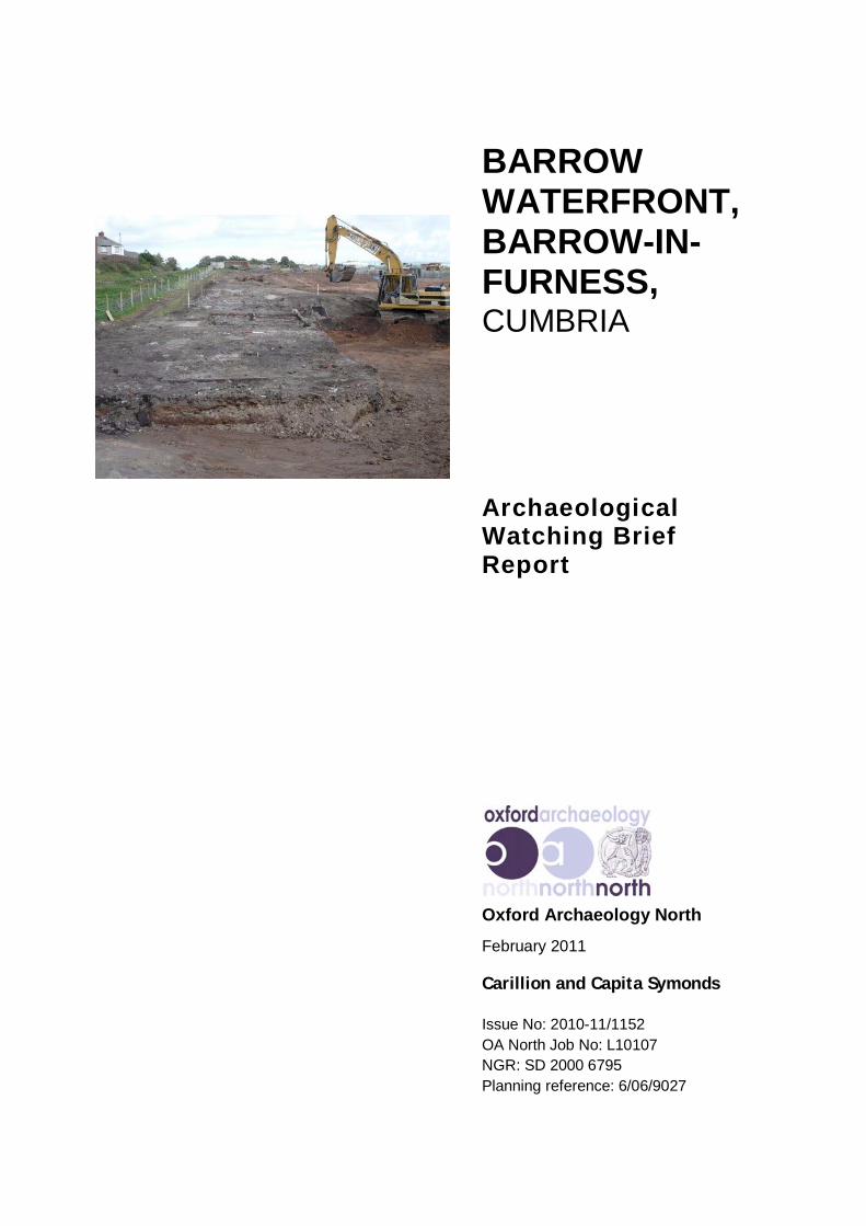
August 2009 and comprised the reduction of ground levels to a maximumdepth of 2.5m within the central portion of the area of archaeological potential(Plate 1). As with the first phase, this area was also excavated using a 360ºmechanical excavator fitted with a toothed bucket.
2.2.2 Both phases of the watching brief aimed to record the location, extent, andcharacter of any surviving archaeological features, artefacts and/or depositsrevealed by the ground works. Recording on OA North pro-forma sheetscomprised a full description and preliminary classification of features orstructures revealed, and their accurate location in plan. An indexedphotographic record in colour slide and monochrome formats was alsocompiled, with digital photographs taken for illustrative purposes.
2.2.3 A single ten-litre environmental bulk sample was recovered from what wasthought to be a charcoal-rich sandy lens (04). This was processed by manualflotation in accordance with accepted professional guidelines (English Heritage2002).
2.3 ARCHIVE
2.3.1 A full archive of the watching brief has been produced in accordance withcurrent English Heritage guidelines (English Heritage 1991). The archive willbe deposited in the County Record Office (Barrow), and a copy of this reportsubmitted to the Cumbria Historic Environment Record (Kendal). The Arts andHumanities Data Service (AHDS) online database Online Access to index ofArchaeological Investigations (OASIS) will be completed as part of thearchiving phase of the project.
Barrow Waterfront, Barrow-in-Furness, Cumbria: Archaeological Watching Brief Report 11
For the use of Carillion and Capita Symonds © OA North: February 2011
3. RESULTS
3.1 INTRODUCTION
3.1.1 The following section summarises the results of the watching brief instratigraphic order rather than by works phase; detailed context descriptionsare provided in Appendix 3. The works location is shown on Figure 1, anddetailed plans of the results are presented on Figures 4-6.
3.2 RESULTS
3.2.1 The earliest deposits, identified at depths of 2.5-3m below ground level andcontinuing beyond the 6m-deep limit of excavation, comprised rather mixedlayers of coarse sand and clays, and were interpreted as the natural geology(15). Overlying this was a deposit of layered sand (05) which, where exposed,was seen to traverse the whole of the site. This deposit was over 0.5m deep(Plate 2), and was observed to have several lenses of darker coloured sand.Close to the surface of sand deposit 05 was a lens of dark discoloured sand(04), which contained some fragments of coal and heat-affected vesicularmaterial (E Huckerby pers comm).
3.2.2 Overlying the sand was a c 1.2m-thick deposit of pinkish-orange clay (02)containing pebbles but no finds (Plate 3). The depositional history of this claylayer was not particularly clear, and it may be re-deposited glacial clay. Theclay was in turn overlain by sandy silt deposits 27 and 28.
3.2.3 Located at the western end of the site and defining the northern boundary wasthe truncated foundations of an east/west-orientated terraced building (07),measuring 5.95m wide by some 100m long (Plates 4 and 5; Figs 4 and 5). Anorth/south-aligned range (06 and 08), measuring 6.2m by 39m, was located atthe west end of the terrace (Plate 6; Figs 4 and 6). Both buildings (03) hadbeen constructed on the surface of clay layer 02 and sandy silt layers 27 and 28.The foundations, which generally survived to a maximum height of five coursesand ranged from one to three bricks wide, were composed of nineteenth-century handmade bricks, which included both frogged and non-frogged types(Section 3.3; Appendix 3). Within the interior of the buildings, the fragmentaryremains of a number of internal brick-built partition walls were noted (Plate 7).They were much better preserved in Building 07, where they clearly formeddivisions between different houses, and separate rooms within those dwellings.Preservation of these features was limited to the northern end of building06/08, its southern half surviving only as a shell of outer walls. Even withvariable preservation considered (only the easternmost house of Building 07seemed to have its full complement of internal walls), there was much variationin the internal conformation of the individual dwellings. For example, in severalcases the dividing walls appeared to define a series of long rooms perpendicularto the axis of the house, whilst others seemed to divide the house into front andback rooms. The remains of brick and stone-flagged surfaces were occasionally
Barrow Waterfront, Barrow-in-Furness, Cumbria: Archaeological Watching Brief Report 12
For the use of Carillion and Capita Symonds © OA North: February 2011
preserved, mostly along the northern exterior wall of Building 07 (Plate 8).Other than a nineteenth-century perfume bottle (Appendix 3), no other artefactswere discovered within the building’s interior.
3.2.4 To the west of building 03 a substantial dump of industrial waste (30) wasidentified sitting above sand 02 (Plate 9), and was interpreted as evidence of aninfilled sand extraction pit. The latest activity identified related to the use of thesite for allotments following the demolition of buildings 06-08. Topsoilstripping revealed numerous twentieth-century features related to the modernuse of the allotment. These features, which, due to their late date, were notrecorded in detail, included postholes, garden and drainage features. They wereassociated with fragments of modern ceramic building material, pottery andplastic, and were cut into a deposit of mid-orange clay (02) or, at times, utilisedthe footings of the demolished terrace. The features were sealed by topsoil 01,which contained a mixture modern debris, including building materials andgeneral refuse mixed with a brown organic soil, all remnants of the areas use asallotments.
3.3 FINDS
3.3.1 Only four objects were recovered during the project, a small pressed glassbottle and three bricks. All are from building 03 and of nineteenth- totwentieth-century date.
3.3.2 The bottle is mould-blown in imitation of faceted cut glass, and has a narrowscrew-threaded top. The cap survives and appears to be plastic, thus placing itsdate in the mid-twentieth century at the earliest.
3.3.3 Two of the three bricks (Appendix 3) appear to be in the same or similar fabric.Both lack a frog and are thus probably hand-made. The third, in a coarser butpaler fabric, has a shallow depression on one face. All retain patches of a harddarkish grey mortar, which does not appear to be of any antiquity.
Barrow Waterfront, Barrow-in-Furness, Cumbria: Archaeological Watching Brief Report 13
For the use of Carillion and Capita Symonds © OA North: February 2011
4. CONCLUSIONS
4.1 DISCUSSION
4.1.1 The most significant archaeological remains identified during the watching briefwere those of the late nineteenth-century L-shaped terrace (recorded asbuildings 06/08 and 07) that are first plotted on the 1883 Dockyard plan ofBarrow (Kellet 1883) and annotated as the Foremen’s Cottages on the 1891OS map. Both the 1891 and 1913 OS maps (Figs 2 and 3) show that theeast/west-aligned terrace was divided into ten dwellings, whilst the north/southterrace was divided into four. If the divisions depicted on the OS maps arecommensurate with the size of each dwelling, then each house would be 10mwide by about 6m deep. Certainly, the depth of buildings 06/08 and 07 aresimilar to this, and it is possible to divide building 07 into ten 10m-wide unitson the basis of surviving internal walls.
4.1.2 The historical maps depict a series of small, square, regularly spaced andidentically sized outshuts adjoining the northern and western exterior walls ofbuildings 06/08 and 07 respectively. Each of the houses has its own outshut,and, placed straddling the party wall, shares a second with a neighbour. Verylittle archaeological evidence for these structures survived, so it must beassumed that they were fairly insubstantial, single-storey features. Some hint oftheir character was preserved at the western end of building 07. Here, inpositions analogous to those portrayed on the historical maps, two areas ofbrick flooring were bounded by brick walls and concrete yard surfaces. A shortlength of brick wall close to the party wall of the westernmost and penultimatedwellings of building 07 (houses a and b), together with an appropriately sizedgap in the concrete surfaces there, was all that remained of one of the sharedoutshuts. Several ceramic drains were observed in similar positions at theeastern end of building 07 and it can be assumed that some of the outshutsfunctioned as privies to the rear of each dwelling, others perhaps as coal sheds.Given that each household would have been responsible for the procurementand storage of their coal, it might not be unreasonable to suggest that theprivies were the shared facility.
4.1.3 The historical maps, particularly where the arrangement of the outshuts isconcerned, appear to suggest that the cottages were built as mirrored pairs to astandard plan. Subsequent modifications and differential preservation meantthat there was little surviving evidence for an original internal ground plan.However, there is some uniformity and mirroring to the internal plans of housesa-d and g-h, suggesting the ground floor was divided into at least five rooms,and quite possibly more. Where preserved, brick floors were most common inthe dwellings’ northern corner closest to the position of the shared outshut.Despite subsequent modifications to other parts of the house, these 2m-squareareas were particularly common, and were likely to have been kitchens orsculleries. Generally, however, the lack of in-situ artefacts and internal featuresprecludes any identification of the use that the other rooms were put to.
Barrow Waterfront, Barrow-in-Furness, Cumbria: Archaeological Watching Brief Report 14
For the use of Carillion and Capita Symonds © OA North: February 2011
4.1.4 Given the complex depositional history of Barrow Island, which has hadglacial, marine-alluvial and human (such as dredging) influences, the origin ofthose deposits underlying the archaeological remains is hard to interpret.Similar sandy layers were revealed by evaluation trenches excavated to thesouth of the cottages and were interpreted as either originating naturally, orwere from the dredging of the channels and dock basins (OA North 2005). Inthis case, three factors might indicate that the sand is natural. First, the site is along way from the shore, and perhaps thus unlikely to receive large amounts ofdredging material. Secondly, the fact that the sand was extracted in the latterpart of the nineteenth century (OS 1891) suggests that it was of a sort thatcould not be had from the ready supplies of dredged material elsewhere.Thirdly, the presence of fine sediment lines in the sand would indicate natural,aeolian, deposition. The character of lens 04 does not refute such aninterpretation. The coal fragments therein could have derived naturally frombeach deposits (from a seam of coal is known to exist off the Cumbrian coast;E Huckerby pers comm), or, particularly when the heat-affected vesicularmaterial is considered, may indicate that natural deposition continued into thenineteenth century.
Barrow Waterfront, Barrow-in-Furness, Cumbria: Archaeological Watching Brief Report 15
For the use of Carillion and Capita Symonds © OA North: February 2011
5. BIBLIOGRAPHY
5.1 PRIMARY SOURCES
British Geological Survey, 1982 Lake District, Sheet 54º N 04º W, 1 : 250000
Ordnance Survey, 1851 1st edn, 6” : 1 Mile, Lancashire
Ordnance Survey, 1873 1st edn, 25” : 1 Mile, Lancashire
Ordnance Survey, 1891 2nd edn, 25” : 1 Mile, Lancashire Sheet
Ordnance Survey, 1913, 3rd edn, 25” : 1 Mile, Lancashire Sheet
Ordnance Survey, 1983 Soils of Northern England, 1 : 250000
5.2 SECONDARY SOURCES
Banks, AG, 1984 HW Schneider of Barrow and Bowness, Kendal
Barnes, F, 1978 Barrow and District, 3rd edn, Barrow-in-Furness
Bowden, M ed, 2000 Furness Iron, Swindon
Cherry, PJ and Cherry, J, 2002 Coastline and Upland in Cumbrian Prehistory – ARetrospective, Trans Cumberland Westmorland Antiq Arch Soc, 3rd ser, 2, 1-20
Countryside Commission, 1998 Countryside Character Volume 2: North West,Cheltenham
Cumbria County Council and Lake District National Park Authority, 2001 TheCumbria and Lake District Joint Structure Plan 2001-16, Kendal
Department of the Environment, 1990 Planning Policy Guidance Note No 16 onArchaeology and Planning (PPG-16)
Ekwall, E, 1922 The Place-Names of Lancashire, Manchester
English Heritage, 1991 Management of Archaeological Projects, 2nd edn, London
English Heritage, 2002 Environmental Archaeology: a guide to theory and practice ofmethods, from sampling and recovery to post excavation, London
Evans, F, 1842 Furness and Furness Abbey, Ulverston
Fell, A, 1908 The Early Iron Industry of Furness and District, London (1968facsimile)
Gelderd, C and Dobson, J, 1912 Report on the Excavations Carried out at the “Druid’sCircle” on Birkrigg in the Parish of Urswick, September 1911, Trans CumberlandWestmorland Antiq Arch Soc, n ser, 12, 262-276
Jones, E, 2001 Results of an Archaeological Evaluation at Roose Quarry, Barrow-in-Furness, Cumbria, Headland Archaeology RQB01, unpubl rep
Jopling, CM, 1843 Sketch of Furness and Cartmel, Ulverston
Kellett, J, 1990 James Ramsden, Barrow’s Man of Vision, Ulverston
Barrow Waterfront, Barrow-in-Furness, Cumbria: Archaeological Watching Brief Report 16
For the use of Carillion and Capita Symonds © OA North: February 2011
Kendall, WB, 1900 Submerged Peat Mosses, Forest Remains, and Post-GlacialDeposits in Barrow Harbour, Furness Lore: Trans Barrow Nat Field Club 3, 54-62
Kendall, WB, 1909 The Village of Barrow in the Parish of Dalton-in-Furness, BarrowNat Field Club, Annual Rep Proc 1903-4 17, 181-91
Kendall, WB, 1948 The History of the Hamlet of Salthouse, Proc Barrow Nat FieldClub, n ser, 6, 21-43
Latham, T, 1991 The Ashburner Schooners, Manchester
Leach, A, 1981 Our Barrow, Part 4, Barrow Island, Ulverston
Marshall, JD, 1958 Furness and the Industrial Revolution, Barrow-in-Furness
OA North, 2002 Holbeck Park Avenue, Barrow-in-Furness, Cumbria: ArchaeologicalEvaluation, unpubl rep
OA North, 2003, Barrow Harbour, Barrow-in-Furness, Cumbria, Desk BasedAssessment, unpubl rep
OA North, 2005, Barrow Ports Regeneration Project, Archaeological EvaluationReport, unpubl rep
Parson, W and White, W, 1829 History, Directory and Gazetteer of Cumberland andWestmorland With Furness and Cartmel, Beckermet (1976 facsimile)
Phillips, AW and Rollinson, W, 1971 Coastal Change on Walney Island, EllesmerePort
Powell, TGE, Fell, CI, Corcoran, XWP and Barnes, F, 1963 Excavations at SkelmoreHeads Near Ulverston, 1957 and 1959, Trans Cumberland Westmorland Antiq ArchSoc, n ser, 63, 1-30
Rollinson, W and Harrison, B, 1986 The Diary of William Fisher of Barrow, 1811 to1849, Centre North-West Regional Studies, occ pap 15, Lancaster
Shotter, DCA, 1995 Romans in South Cumbria, Trans Cumberland WestmorlandAntiq Arch Soc, n ser, 95, 73-8
Stark, D, 1972The Origins of a Single Industry Town – Barrow-in-Furness 1890-1910, unpubl dissertation
Trescatheric, B, 1985 How Barrow was Built, Barrow-in-Furness
Trescatheric, B, 1987 Barrow Town Hall 1887-1987, Kendal
Trescatheric, B, 1992 Building Barrow, From Fisher’s Farm to Maggie’s Farm,Kendal
Trescatheric, B and The Dock Museum 2000 The Barrow Story, Barrow-in-Furness
Young, R, 2002 The Palaeolithic and Mesolithic Periods in Northern England: AnOverview, in Brooks, C, Daniels, R and Harding, A eds, Past Present and Future, TheArchaeology of Northern England, Architect Arch Soc Durham Northumberland, resrep 5, Durham
West, T, 1774 The Antiquities of Furness, Beckermet (1977 facsimile)
Barrow Waterfront, Barrow-in-Furness, Cumbria: Archaeological Watching Brief Report 17
For the use of Carillion and Capita Symonds © OA North: February 2011
6. ILLUSTRATIONS
6.1 FIGURES
Figure 1: Site Location Map
Figure 2: Extract of the Ordnance Survey 6” to one mile map, 1891
Figure 3: Extract of the Ordnance Survey 6” to one mile map, 1913
Figure 4: Overall plan of remains of the Foremen’s Cottages
Figure 5: East/west aligned part of the Foremen’s Cottages
Figure 6: North/south-aligned part of the Foremen’s Cottages
6.2 PLATES
Plate 1: General working shot of ground reduction
Plate 2: Sand deposit (05), which extended across the whole of the site; viewed fromthe west
Plate 3: Section through the site’s deposits
Plate 4: Western end of the east/west-aligned range of the Foremen’s Cottages(Building 07); viewed toward the west
Plate 5: The western extent Building 07
Plate 6: Plate 2: The north/south-aligned range of the Foremen’s Cottages (Building06); viewed from the north-east
Plate 7: Well-preserved internal walls within Building 07
Plate 8: Internal brick floor within Building 07
Plate 9: The edge of the sand extraction pit, denoted by the truncated clay deposit (02)to the left, upon which the Foremen’s Cottages (03) were constructed and sanddeposit (05) to the right. The later backfill (30) can be seen in the centre by the 2mranging rod
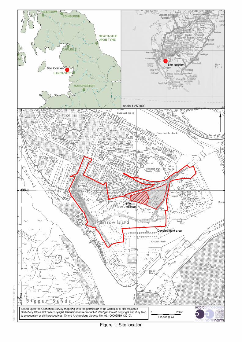
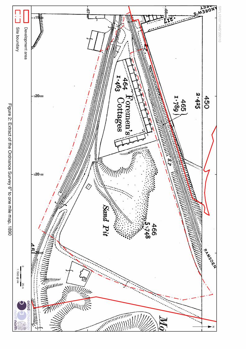
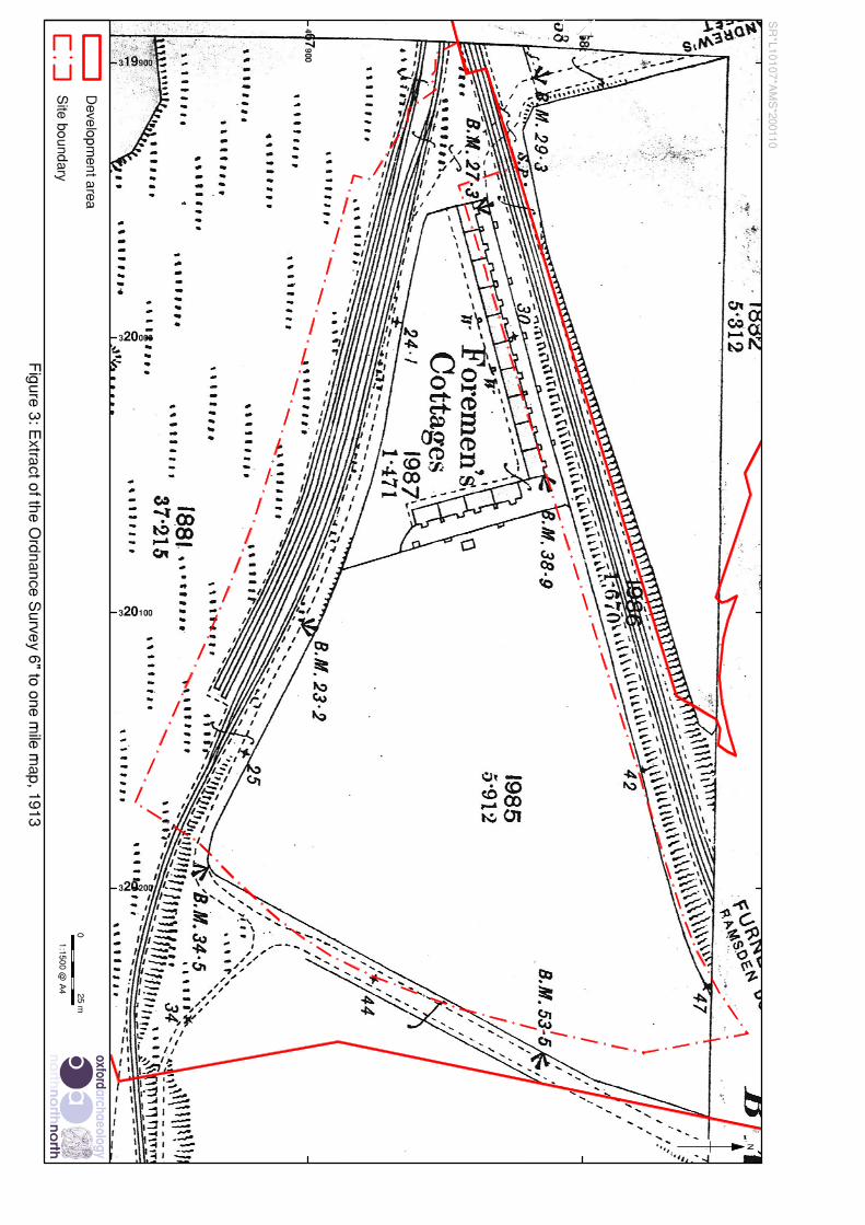
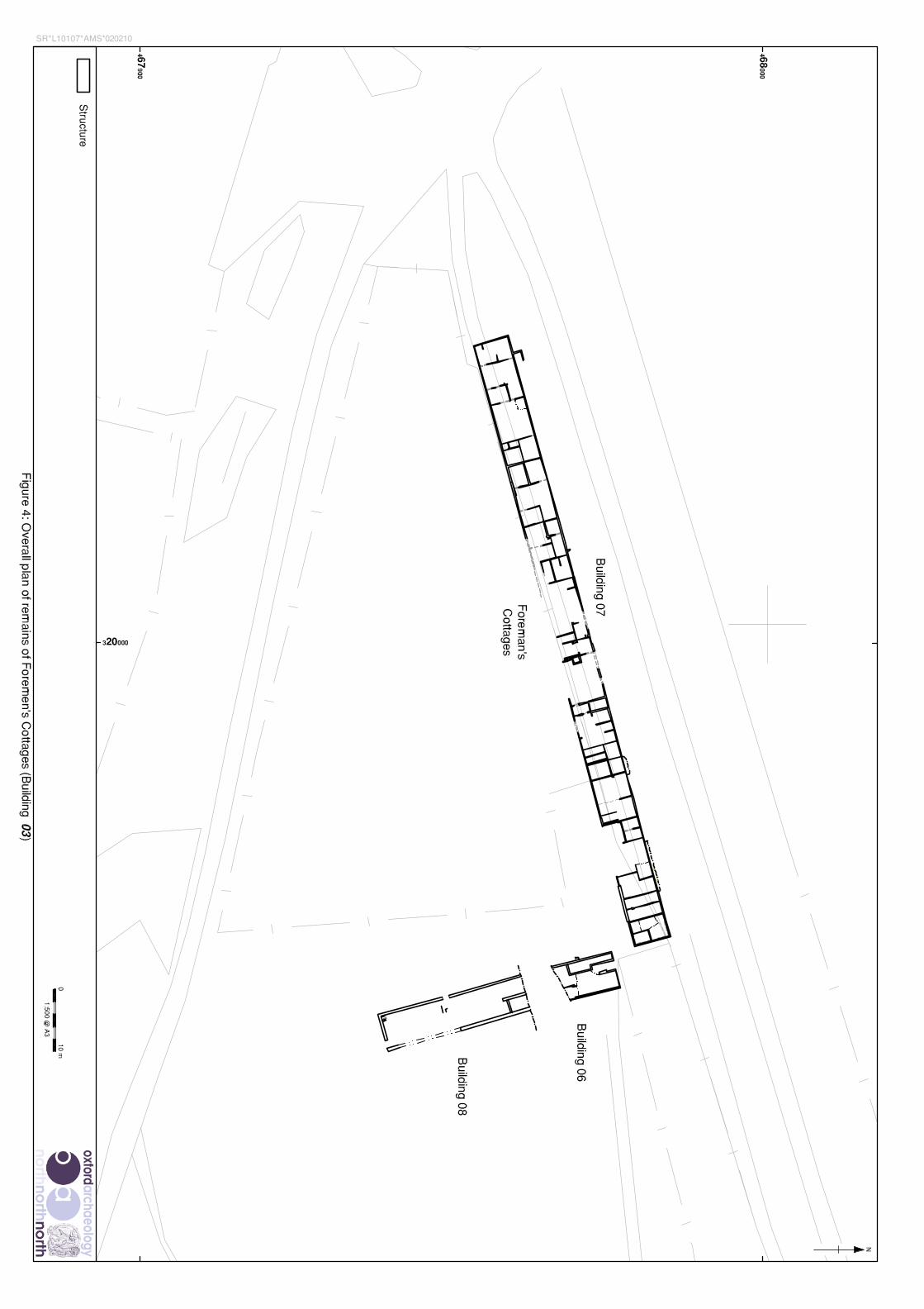
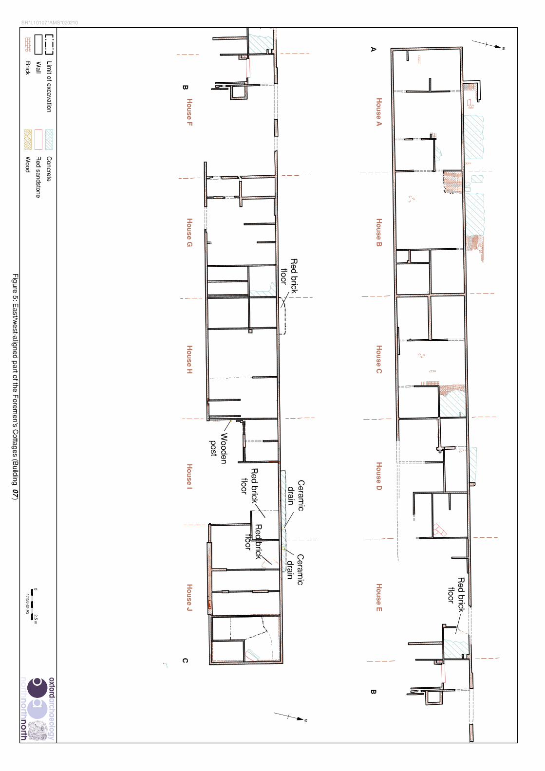
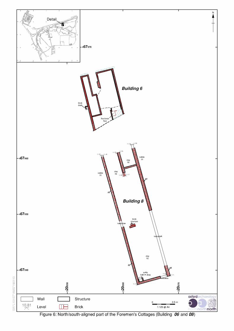
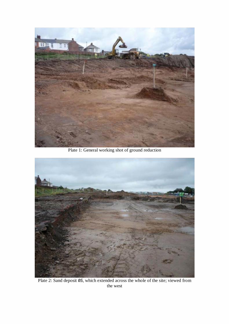
Plate 1: General working shot of ground reduction
Plate 2: Sand deposit 05, which extended across the whole of the site; viewed fromthe west
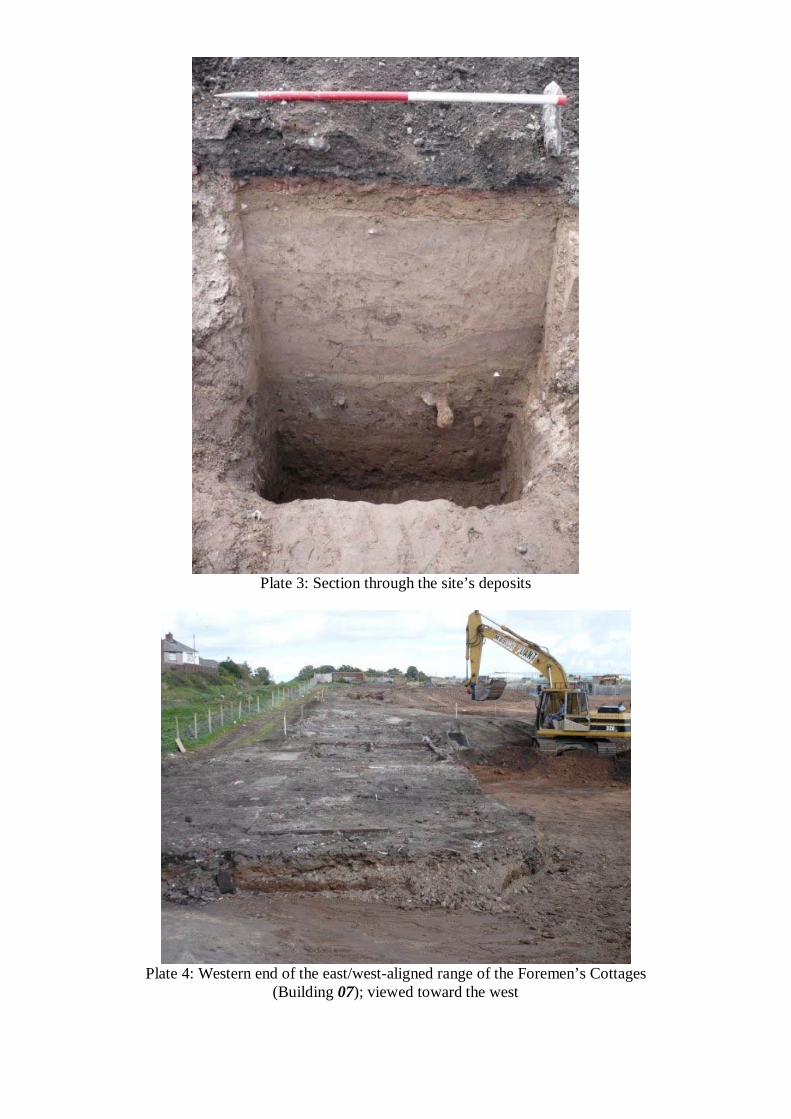
Plate 3: Section through the site’s deposits
Plate 4: Western end of the east/west-aligned range of the Foremen’s Cottages(Building 07); viewed toward the west
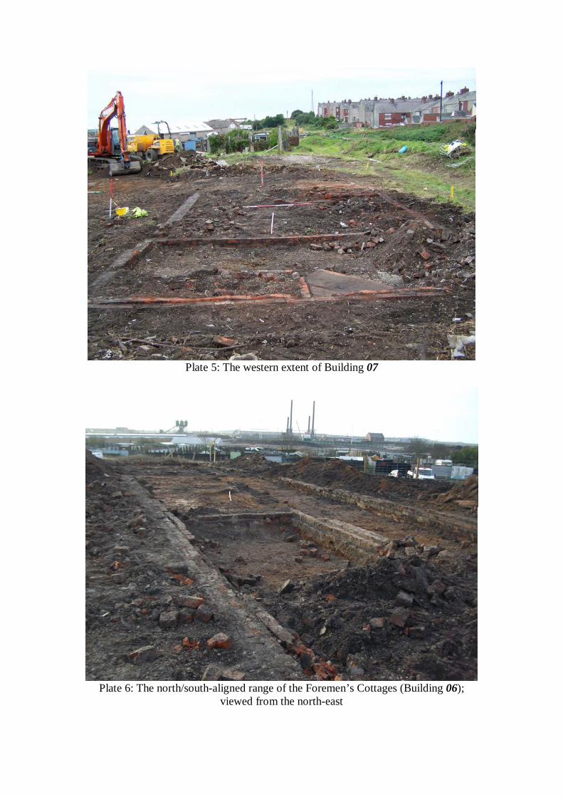
Plate 5: The western extent of Building 07
Plate 6: The north/south-aligned range of the Foremen’s Cottages (Building 06);viewed from the north-east
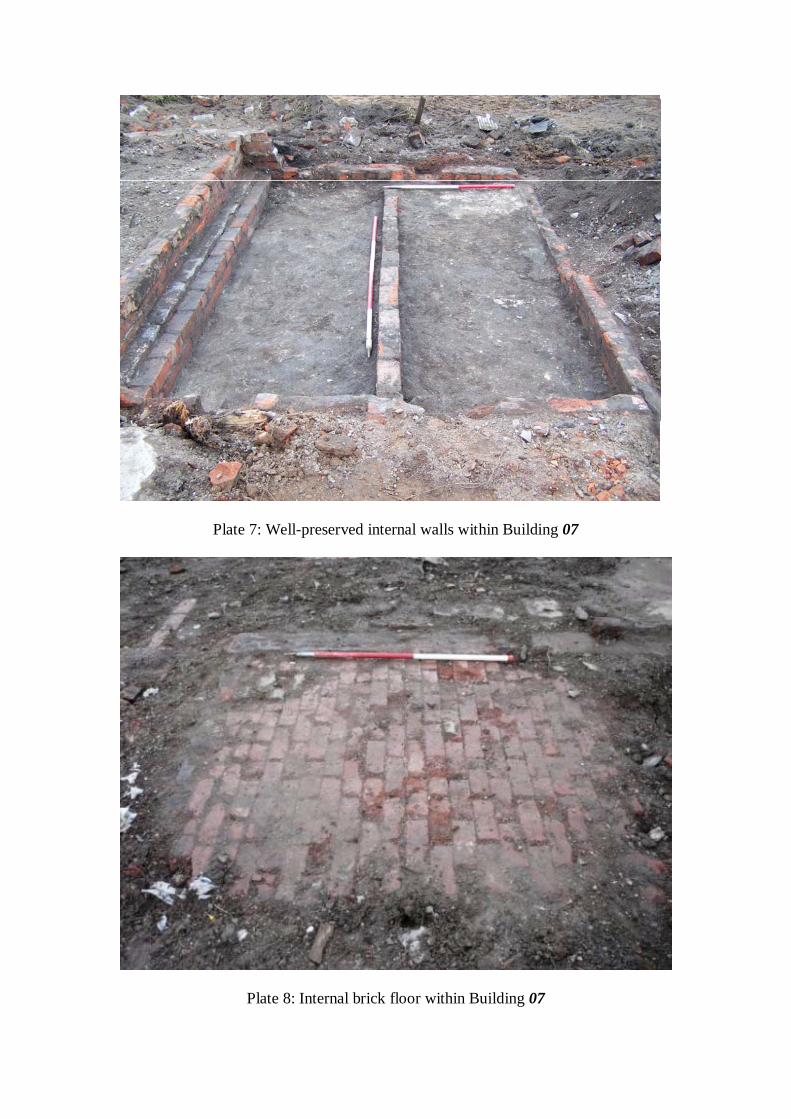
Plate 7: Well-preserved internal walls within Building 07
Plate 8: Internal brick floor within Building 07
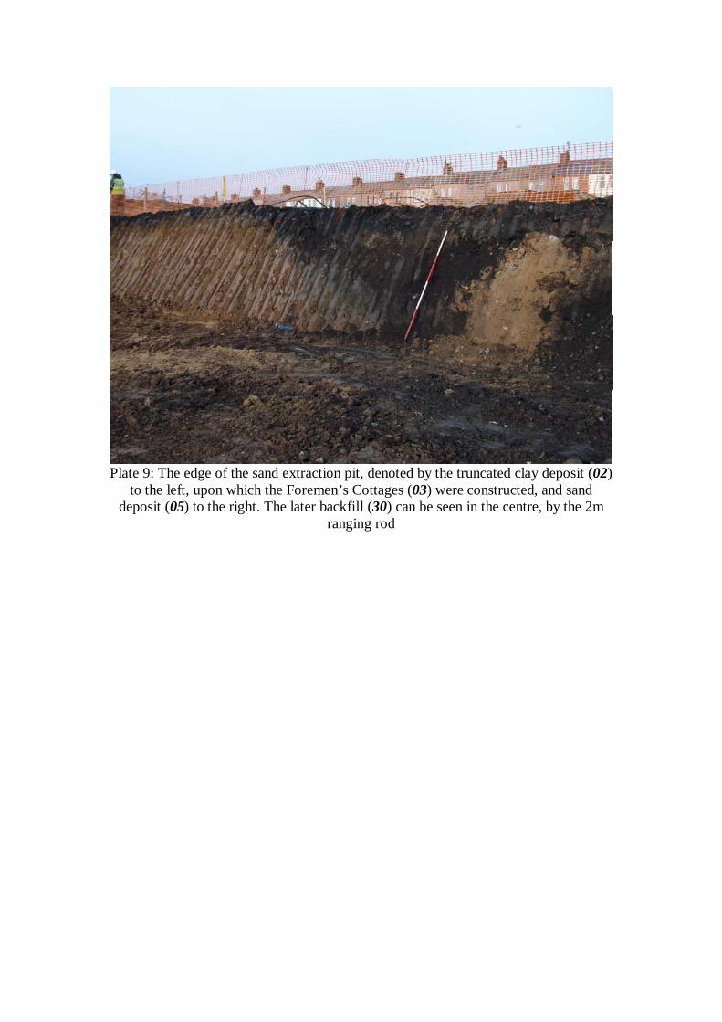
Plate 9: The edge of the sand extraction pit, denoted by the truncated clay deposit (02)to the left, upon which the Foremen’s Cottages (03) were constructed, and sand
deposit (05) to the right. The later backfill (30) can be seen in the centre, by the 2mranging rod

Barrow Waterfront, Barrow-in-Furness, Cumbria: Archaeological Watching Brief Report 18
For the use of Carillion and Capita Symonds © OA North: February 2011
APPENDIX 1: CCCHES BRIEF
BRIEF FOR AN ARCHAEOLOGICAL WATCHING BRIEF
ON LAND TO THE SOUTH OF BARROW ISLAND AND EAST OF WALNEY CHANNEL
BARROW-IN-FURNESS, CUMBRIA
Issued by the
County Historic Environment Service
Environment Unit, Economy, Culture and Environment
Date of Brief: 16 May 2007
This Design Brief is only valid for 1 year after the above date. After this period the County Historic EnvironmentService should be contacted. Any specification resulting from this Brief will only be considered for the same period.
Brief for an archaeological watching brief on land to the south of Barrow Island and east of Walney Channel, Barrow-in-Furness
Cumbria County Council Historic Environment Service2
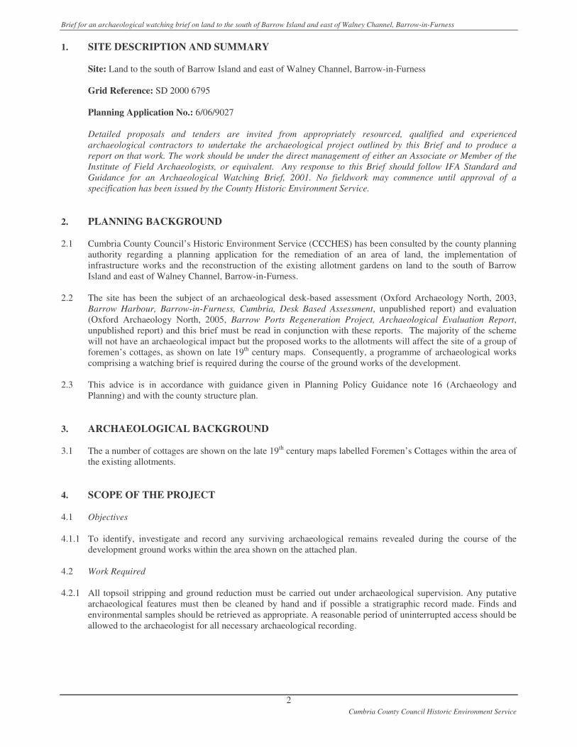
1. SITE DESCRIPTION AND SUMMARY
Site: Land to the south of Barrow Island and east of Walney Channel, Barrow-in-Furness
Grid Reference: SD 2000 6795
Planning Application No.: 6/06/9027
Detailed proposals and tenders are invited from appropriately resourced, qualified and experiencedarchaeological contractors to undertake the archaeological project outlined by this Brief and to produce areport on that work. The work should be under the direct management of either an Associate or Member of theInstitute of Field Archaeologists, or equivalent. Any response to this Brief should follow IFA Standard andGuidance for an Archaeological Watching Brief, 2001. No fieldwork may commence until approval of aspecification has been issued by the County Historic Environment Service.
2. PLANNING BACKGROUND
2.1 Cumbria County Council’s Historic Environment Service (CCCHES) has been consulted by the county planningauthority regarding a planning application for the remediation of an area of land, the implementation ofinfrastructure works and the reconstruction of the existing allotment gardens on land to the south of BarrowIsland and east of Walney Channel, Barrow-in-Furness.
2.2 The site has been the subject of an archaeological desk-based assessment (Oxford Archaeology North, 2003,Barrow Harbour, Barrow-in-Furness, Cumbria, Desk Based Assessment, unpublished report) and evaluation(Oxford Archaeology North, 2005, Barrow Ports Regeneration Project, Archaeological Evaluation Report,unpublished report) and this brief must be read in conjunction with these reports. The majority of the schemewill not have an archaeological impact but the proposed works to the allotments will affect the site of a group offoremen’s cottages, as shown on late 19th century maps. Consequently, a programme of archaeological workscomprising a watching brief is required during the course of the ground works of the development.
2.3 This advice is in accordance with guidance given in Planning Policy Guidance note 16 (Archaeology andPlanning) and with the county structure plan.
3. ARCHAEOLOGICAL BACKGROUND
3.1 The a number of cottages are shown on the late 19th century maps labelled Foremen’s Cottages within the area ofthe existing allotments.
4. SCOPE OF THE PROJECT
4.1 Objectives
4.1.1 To identify, investigate and record any surviving archaeological remains revealed during the course of thedevelopment ground works within the area shown on the attached plan.
4.2 Work Required
4.2.1 All topsoil stripping and ground reduction must be carried out under archaeological supervision. Any putativearchaeological features must then be cleaned by hand and if possible a stratigraphic record made. Finds andenvironmental samples should be retrieved as appropriate. A reasonable period of uninterrupted access should beallowed to the archaeologist for all necessary archaeological recording.
Brief for an archaeological watching brief on land to the south of Barrow Island and east of Walney Channel, Barrow-in-Furness
Cumbria County Council Historic Environment Service3
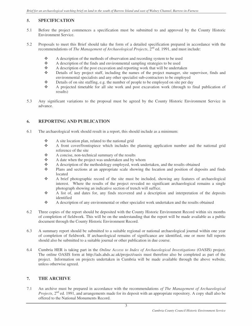
5. SPECIFICATION
5.1 Before the project commences a specification must be submitted to and approved by the County HistoricEnvironment Service.
5.2 Proposals to meet this Brief should take the form of a detailed specification prepared in accordance with therecommendations of The Management of Archaeological Projects, 2nd ed. 1991, and must include:
� A description of the methods of observation and recording system to be used� A description of the finds and environmental sampling strategies to be used� A description of the post excavation and reporting work that will be undertaken� Details of key project staff, including the names of the project manager, site supervisor, finds and
environmental specialists and any other specialist sub-contractors to be employed� Details of on site staffing, e.g. the number of people to be employed on site per day� A projected timetable for all site work and post excavation work (through to final publication of
results)
5.3 Any significant variations to the proposal must be agreed by the County Historic Environment Service inadvance.
6. REPORTING AND PUBLICATION
6.1 The archaeological work should result in a report, this should include as a minimum:
� A site location plan, related to the national grid� A front cover/frontispiece which includes the planning application number and the national grid
reference of the site� A concise, non-technical summary of the results� A date when the project was undertaken and by whom� A description of the methodology employed, work undertaken, and the results obtained� Plans and sections at an appropriate scale showing the location and position of deposits and finds
located� A brief photographic record of the site must be included, showing any features of archaeological
interest. Where the results of the project revealed no significant archaeological remains a singlephotograph showing an indicative section of trench will suffice.
� A list of, and dates for, any finds recovered and a description and interpretation of the depositsidentified
� A description of any environmental or other specialist work undertaken and the results obtained
6.2 Three copies of the report should be deposited with the County Historic Environment Record within six monthsof completion of fieldwork. This will be on the understanding that the report will be made available as a publicdocument through the County Historic Environment Record.
6.3 A summary report should be submitted to a suitable regional or national archaeological journal within one yearof completion of fieldwork. If archaeological remains of significance are identified, one or more full reportsshould also be submitted to a suitable journal or other publication in due course.
6.4 Cumbria HER is taking part in the Online Access to Index of Archaeological Investigations (OASIS) project.The online OASIS form at http://ads.ahds.ac.uk/project/oasis must therefore also be completed as part of theproject. Information on projects undertaken in Cumbria will be made available through the above website,unless otherwise agreed.
7. THE ARCHIVE
7.1 An archive must be prepared in accordance with the recommendations of The Management of ArchaeologicalProjects, 2nd ed. 1991, and arrangements made for its deposit with an appropriate repository. A copy shall also beoffered to the National Monuments Record.
Brief for an archaeological watching brief on land to the south of Barrow Island and east of Walney Channel, Barrow-in-Furness
Cumbria County Council Historic Environment Service4
7.2 The landowner should be encouraged to transfer the ownership of finds to a local or relevant specialist museum.The museum’s requirements for the transfer and storage of finds should be discussed before the projectcommences.
7.3 The County Historic Environment Service must be notified of the arrangements made.
8. PROJECT MONITORING
8.1 One weeks notice must be given to the County Historic Environment Service prior to the commencement offieldwork.
9. FURTHER REQUIREMENTS
9.1 It is the archaeological contractor’s responsibility to establish safe working practices in terms of current healthand safety legislation, to ensure site access and to obtain notification of hazards (eg. services, contaminatedground, etc.). The County Historic Environment Service bears no responsibility for the inclusion orexclusion of such information within this brief or subsequent specification.
9.2 The Code of Conduct of the Institute of Field Archaeologists must be followed.
9.3 The involvement of the County Historic Environment Service should be acknowledged in any report orpublication generated by this project.
10. FURTHER INFORMATION
For further information regarding this Brief, contact
Jeremy ParsonsAssistant ArchaeologistCumbria County CouncilCounty OfficesKendalCumbria LA9 4RQTel: 01539 773431Email: [email protected]
For further information regarding the County Historic Environment Record, contact
Jo MackintoshHistoric Environment Records OfficerCumbria County CouncilCounty OfficesKendalCumbria LA9 4RQTel: 01539 773432Email: [email protected]
As part of our desire to provide a quality service to all our clients we would welcome any comments you mayhave on the content or presentation of this design brief. Please address them to the Assistant Archaeologist atthe above address.
Barrow Waterfront, Barrow-in-Furness, Cumbria: Archaeological Watching Brief Report 19
For the use of Carillion and Capita Symonds © OA North: February 2011
APPENDIX 2: PROJECT DESIGN
1.1 PROJECT BACKGROUND
1.1.1 As part of the Barrow Ports Regeneration Project, Carillion plc, on behalf of Capita Symondsand Cumbria County Council, propose to undertake a programme of remediation,infrastructure works and reconstruction of the allotment gardens towards the south of BarrowIsland, Barrow-in-Furness, Cumbria (Grid reference SD 2000 6795; Planning reference6/06/9027). Previous archaeological works undertaken in association with the widerprogramme of development, including a desk-based assessment (DBA; OA North 2003) anda trial trench evaluation (OA North 2005) identified that the present area of proposedgroundworks does have some archaeological potential. Consequently, in accordance withPlanning Policy Guidance note 16 (Archaeology and Planning: PPG16) and with the countystructure plan, Cumbria County Council Historic Environment Service (CCCHES) issued abrief and plan requesting that an archaeological watching brief be maintained during anyground disturbing activities associated with the development. The following documentrepresents a project design to carry out the above programme of work and has been preparedin accordance with the CCCHES brief.
1.2 HISTORICAL AND ARCHAEOLOGICAL BACKGROUND
1.2.1 More comprehensive details of the history and archaeology of the area can be found in earlierreports prepared for the development (OA North 2003; OA North 2005), and will not bereiterated here. Although in the wider locale there is quite extensive evidence for prehistoricactivity, often in the form of scatters of flint tools and debitage, no such sites have beenidentified within the present watching brief area. It would appear that the present area ofinvestigation remained undeveloped and rather marshy until the later nineteenth century. The1842 Tithe map indicates the presence of sheepfolds close-by (DBA Site 53), suggesting thatthe area may traditionally have been given over to rough pasture.
1.2.2 Between 1867 and 1883, when plans of the Barrow docks were drawn-up, Barrow Island sawrapid industrial development including, within the present watching brief area, an ‘L’-shapedconfiguration of Foreman’s cottages (DBA Site 72) shown on the 1883 Dockyard plan andlabeled on the 1891 OS map. During the evaluation, several trenches were excavated quiteclose to the present watching brief area. Trenches to the north-east of the cottages (ie, Trench71) indicated that the ground had been made-up with building debris and redeposited sanddeposits, seemingly to a depth of 1.6m-2m. Those to the south of the cottages (ie, Trenches69 and 70) revealed successive sandy layers that are likely to have originated from thedredging of the channels and dock basins. It is possible that the remains of the cottages couldlie sealed between such dumping episodes.
1.3 OXFORD ARCHAEOLOGY NORTH
Barrow Waterfront, Barrow-in-Furness, Cumbria: Archaeological Watching Brief Report 20
For the use of Carillion and Capita Symonds © OA North: February 2011
1.3.1 OA North has considerable experience of excavation of sites of all periods, havingundertaken a great number of small and large scale projects throughout Northern Englandduring the past 25 years. Evaluations, desk-based assessments, watching briefs andexcavations have taken place within the planning process, to fulfil the requirements of clientsand planning authorities, to very rigorous timetables. OA North has the professionalexpertise and resources to undertake the project detailed below to a high level of quality andefficiency. OA North is an Institute of Field Archaeologists (IFA) registered organisation,registration number 17, and all its members of staff operate subject to the IFA Code ofConduct.
2 OBJECTIVES
2.1 The following programme has been designed to record the archaeological deposits affected bythe proposed development of the site, in order to determine their extent, nature andsignificance and to preserve them by record in advance of the destruction. To this end, thefollowing programme has been designed, in accordance with a brief by CCCHES and willinvolve the following stages:
2.2 Archaeological Watching Brief
To undertake a programme of observation and recording during any ground disturbance todetermine the presence, quality, extent and importance of any archaeological remains on thesite and to record them in an appropriate level of detail prior to their destruction.
2.3 Report and Archive
A report will be produced for the Client within eight weeks of completion of the fieldwork. Asite archive will be produced to English Heritage guidelines (1991) and in accordance withthe Guidelines for the Preparation of Excavation Archives for Long Term Storage (UKIC1990).
3. METHOD STATEMENT
3.1 WATCHING BRIEF
3.1.1 Methodology: a programme of field observation will accurately record the location, extent,and character of any surviving archaeological features and/or deposits within the area shownon the plan attached to the CCCHES brief dated 16th May 2007. This work will compriseobservation during all ground reduction and excavations for the proposed development, thesystematic examination of any subsoil horizons exposed during the course of thegroundworks, and the accurate recording of all archaeological features and horizons, and anyartefacts, identified during observation.
3.1.2 The watching brief will cover the whole of the area to be disturbed by the developmentincluding, topsoil stripping, foundation trenches and other earthmoving activities.
3.1.3 Putative archaeological features and/or deposits identified during the observation ofgroundworks, together with the immediate vicinity of any such features, will be cleaned byhand, using either hoes, shovel scraping, and/or trowels depending on the subsoil conditionsand, where appropriate, sections will be studied and drawn. Any such features will be sampleexcavated (ie. selected pits and postholes will normally only be half-sectioned, linear featureswill be subject to no more than a 10% sample, and extensive layers will, where possible, besampled by partial rather than complete removal).
Barrow Waterfront, Barrow-in-Furness, Cumbria: Archaeological Watching Brief Report 21
For the use of Carillion and Capita Symonds © OA North: February 2011
3.1.4 During this phase of work, recording will comprise a full description and preliminaryclassification of features or materials revealed, and their accurate location (either on planand/or section, and as grid co-ordinates where appropriate). Features will be plannedaccurately at appropriate scales and annotated on to a large-scale plan provided by the Client.A photographic record will be undertaken simultaneously.
3.1.5 A plan will be produced of the areas of groundworks showing the location and extent of theground disturbance and one or more dimensioned sections will be produced.
3.1.6 Treatment of finds: all finds will be exposed, lifted, cleaned, conserved, marked, bagged andboxed in accordance with the United Kingdom Institute for Conservation (UKIC) First AidFor Finds, 1998 (new edition) and the recipient museum's guidelines.
3.1.7 Treasure: any gold and silver artefacts recovered during the course of the excavation will beremoved to a safe place and reported to the local Coroner according to the procedures relatingto the Treasure Act, 1996. Where removal cannot take place on the same working day asdiscovery, suitable security will be employed to protect the finds from theft.
3.1.8 All identified finds and artefacts will be retained, although certain classes of building materialcan sometimes be discarded after recording if an appropriate sample is retained on advice fromthe recipient museum’s archive curator.
3.1.9 Human Remains: any human remains uncovered will be left in situ, covered and protected.No further investigation will continue beyond that required to establish the date and characterof the burial. CCCHES and the local Coroner will be informed immediately. If removal isessential, the exhumation of any funerary remains will require the provision of a Home Officelicense, under section 25 of the Burial Act of 1857. An application will be made by OA Northfor the study area on discovery of any such remains and the removal will be carried out withdue care and sensitivity under the environmental health regulations.
3.1.10 Contingency plan: in the event of significant archaeological features being encounteredduring the watching brief, discussions will take place with the Planning Archaeologist or hisrepresentative, as to the extent of further works to be carried out. All further works would besubject to a variation to this project design. In the event of environmental/organic depositsbeing present on site, it would be necessary to discuss and agree a programme ofpalaeoenvironmental sampling and or dating with the Planning Archaeologist.
3.2 REPORT AND ARCHIVE
3.2.1 Report: one bound and one unbound copy of a written synthetic report will be submitted tothe Client, and a further three copies submitted to the Cumbria HER within eight weeks ofcompletion. The report will include:
• a front cover to include the planning application number and the NGR
• a site location plan, related to the national grid
• the dates on which the fieldwork was undertaken
• a concise, non-technical summary of the results
• a description of the methodology employed, work undertaken and results obtained
• plans and sections at an appropriate scale, showing the location of features
• other illustrations and photographic plates showing, as appropriate, features of interestor to demonstrate the absence of archaeological features.
• a description and appropriate interpretation of any environmental, finds, or otherspecialist work undertaken, and the results obtained, including spot dates.
Barrow Waterfront, Barrow-in-Furness, Cumbria: Archaeological Watching Brief Report 22
For the use of Carillion and Capita Symonds © OA North: February 2011
• the report will also include a complete bibliography of sources from which data hasbeen derived.
• a copy of this project design in the appendices, and indications of any agreed departurefrom that design
3.2.2 This report will be in the same basic format as this project design; a copy of the report canbe provided on CD, if required.
3.2.3 Archive: the results of all archaeological work carried out will form the basis for a fullarchive to professional standards, in accordance with current English Heritage guidelines(Management of Archaeological Projects, 2nd edition, 1991). The project archiverepresents the collation and indexing of all the data and material gathered during the courseof the project. It will include summary processing and analysis of all features, finds, orpalaeoenvironmental data recovered during fieldwork, which will be catalogued by context.All artefacts will be processed to MAP2 standards and will be assessed by our in-housefinds specialists.
3.2.4 The deposition of a properly ordered and indexed project archive in an appropriaterepository is considered an essential and integral element of all archaeological projects bythe IFA in that organisation's code of conduct. OA North conforms to best practice in thepreparation of project archives for long-term storage. This archive will be provided in theEnglish Heritage Centre for Archaeology format and a synthesis will be submitted to theCumbria HER (the index to the archive and a copy of the report). OA North practice is todeposit the original record archive of projects with the County Record Office, Kendal. Thematerial archive (artefacts and ecofacts) will be deposited with an appropriate museumfollowing agreement with the client.
3.2.5 The Arts and Humanities Data Service (AHDS) online database project Online Access toindex of Archaeological Investigations (OASIS) will be completed as part of the archivingphase of the project.
3.2.6 Confidentiality: all internal reports to the client are designed as documents for the specificuse of the client, for the particular purpose as defined in the project brief and project design,and should be treated as such. They are not suitable for publication as academic documentsor otherwise without amendment or revision. Any requirement to revise or reorder thematerial for submission or presentation to third parties beyond the project brief and projectdesign, or for any other explicit purpose, can be fulfilled, but will require separatediscussion and funding.
4. HEALTH AND SAFETY
4.1 OA North provides a Health and Safety Statement for all projects and maintains a UnitSafety policy. All site procedures are in accordance with the guidance set out in the Healthand Safety Manual compiled by the Standing Conference of Archaeological Unit Managers(1997). A risk assessment will be completed in advance of any on-site works and copies willbe made available on request to all interested parties.
5. WORK TIMETABLE
5.1 Archaeological Watching Brief: the duration of this element is dependant upon the durationof any ground disturbing activities on the site, but is presently estimated as three weeks fromthe 12/1/09.
5.2 Report and Archive: a report will be submitted within eight weeks of the completion of thefieldwork. However, should an interim statement be required this can be issued within twoweeks but instruction must be received from the client prior to completion of the fieldwork.
Barrow Waterfront, Barrow-in-Furness, Cumbria: Archaeological Watching Brief Report 23
For the use of Carillion and Capita Symonds © OA North: February 2011
5.3 Written Instruction; OA North can execute projects at very short notice once writtenconfirmation of commission has been received from the Client. One weeks notice would besufficient to allow the necessary arrangements to be made to commence the task and informCCCHES.
6. PROJECT MONITORING
6.1 Access: liaison for site access during the evaluation will be arranged with the client unlessotherwise instructed prior to commencement of the archaeological investigation.
6.2 Whilst the work is undertaken for the client, the County Archaeologist will be kept fullyinformed of the work and its results, and will be notified a week in advance of thecommencement of the fieldwork. Any proposed changes to the project design will be agreedwith CCCHES in consultation with the Client.
7. STAFFING PROPOSALS
7.1 The project will be under the direct management of Stephen Rowland (OA North projectmanager) to whom all correspondence should be addressed.
7.2 All elements of the archaeological investigation will be supervised by either an OA Northproject officer or supervisor experienced in this type of project. Due to schedulingrequirements it is not possible to provide these details at the present time. All OA Northproject officers and supervisors are experienced field archaeologists capable of carrying outprojects of all sizes.
7.3 Assessment of the finds from the evaluation will be undertaken under the auspices of OANorth's in-house finds specialist Christine Howard-Davis BA MIFA (OA North projectofficer). Christine has extensive knowledge of all finds of all periods from archaeologicalsites in northern England. However, she has specialist knowledge regarding glass,metalwork, and leather, the recording and management of waterlogged wood, and mostaspects of wetland and environmental archaeology.
7.4 Assessment of any palaeoenvironmental samples which may be taken will be undertaken byElizabeth Huckerby MSc (OA North project officer). Elizabeth has extensive knowledge ofthe palaeoecology of the North West through her work on the English Heritage-funded NorthWest Wetlands Survey. Assessment of any faunal material will be undertaken by AndrewBates MSc (OA North Supervisor).
8. BIBLIOGRAPHY
Institute of Field Archaeologists (IFA), 1992, Guidelines for data collection andcompilation
OA North, 2003, Barrow Harbour, Barrow-in-Furness, Cumbria, Desk Based Assessment,unpubl rep
OA North, 2005, Barrow Ports Regeneration Project, Archaeological Evaluation Report,unpubl rep
SCAUM (Standing Conference of Archaeological Unit Managers), 1997, Health and SafetyManual, Poole
United Kingdom Institute for Conservation (UKIC), 1990, Guidelines for the preparation ofarchives for long-term storage, London

Barrow Waterfront, Barrow-in-Furness, Cumbria: Archaeological Watching Brief Report 24
For the use of Carillion and Capita Symonds © OA North: February 2011
United Kingdom Institute for Conservation (UKIC), 1998, First Aid for Finds, London
Barrow Waterfront, Barrow-in-Furness, Cumbria: Archaeological Watching Brief Report 25
For the use of Carillion and Capita Symonds © OA North: February 2011
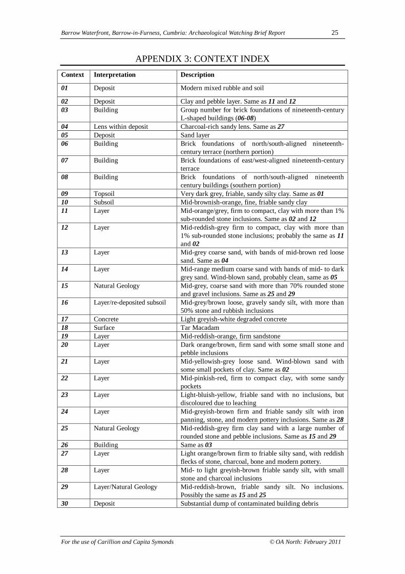
APPENDIX 3: CONTEXT INDEXContext Interpretation Description
01 Deposit Modern mixed rubble and soil
02 Deposit Clay and pebble layer. Same as 11 and 1203 Building Group number for brick foundations of nineteenth-century
L-shaped buildings (06-08)04 Lens within deposit Charcoal-rich sandy lens. Same as 2705 Deposit Sand layer06 Building Brick foundations of north/south-aligned nineteenth-
century terrace (northern portion)07 Building Brick foundations of east/west-aligned nineteenth-century
terrace08 Building Brick foundations of north/south-aligned nineteenth
century buildings (southern portion)09 Topsoil Very dark grey, friable, sandy silty clay. Same as 0110 Subsoil Mid-brownish-orange, fine, friable sandy clay11 Layer Mid-orange/grey, firm to compact, clay with more than 1%
sub-rounded stone inclusions. Same as 02 and 1212 Layer Mid-reddish-grey firm to compact, clay with more than
1% sub-rounded stone inclusions; probably the same as 11and 02
13 Layer Mid-grey coarse sand, with bands of mid-brown red loosesand. Same as 04
14 Layer Mid-range medium coarse sand with bands of mid- to darkgrey sand. Wind-blown sand, probably clean, same as 05
15 Natural Geology Mid-grey, coarse sand with more than 70% rounded stoneand gravel inclusions. Same as 25 and 29
16 Layer/re-deposited subsoil Mid-grey/brown loose, gravely sandy silt, with more than50% stone and rubbish inclusions
17 Concrete Light greyish-white degraded concrete18 Surface Tar Macadam19 Layer Mid-reddish-orange, firm sandstone20 Layer Dark orange/brown, firm sand with some small stone and
pebble inclusions21 Layer Mid-yellowish-grey loose sand. Wind-blown sand with
some small pockets of clay. Same as 0222 Layer Mid-pinkish-red, firm to compact clay, with some sandy
pockets23 Layer Light-bluish-yellow, friable sand with no inclusions, but
discoloured due to leaching24 Layer Mid-greyish-brown firm and friable sandy silt with iron
panning, stone, and modern pottery inclusions. Same as 2825 Natural Geology Mid-reddish-grey firm clay sand with a large number of
rounded stone and pebble inclusions. Same as 15 and 2926 Building Same as 0327 Layer Light orange/brown firm to friable silty sand, with reddish
flecks of stone, charcoal, bone and modern pottery.28 Layer Mid- to light greyish-brown friable sandy silt, with small
stone and charcoal inclusions29 Layer/Natural Geology Mid-reddish-brown, friable sandy silt. No inclusions.
Possibly the same as 15 and 2530 Deposit Substantial dump of contaminated building debris

Barrow Waterfront, Barrow-in-Furness, Cumbria: Archaeological Watching Brief Report 26
For the use of Carillion and Capita Symonds © OA North: February 2011
Barrow Waterfront, Barrow-in-Furness, Cumbria: Archaeological Watching Brief Report 27
For the use of Carillion and Capita Symonds © OA North: February 2011
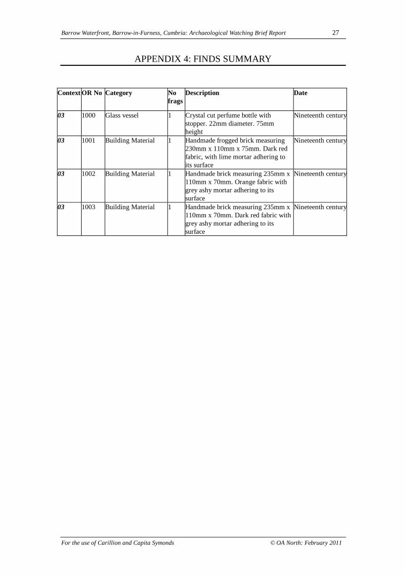
APPENDIX 4: FINDS SUMMARY
Context OR No Category Nofrags
Description Date
03 1000 Glass vessel 1 Crystal cut perfume bottle withstopper. 22mm diameter. 75mmheight
Nineteenth century
03 1001 Building Material 1 Handmade frogged brick measuring230mm x 110mm x 75mm. Dark redfabric, with lime mortar adhering toits surface
Nineteenth century
03 1002 Building Material 1 Handmade brick measuring 235mm x110mm x 70mm. Orange fabric withgrey ashy mortar adhering to itssurface
Nineteenth century
03 1003 Building Material 1 Handmade brick measuring 235mm x110mm x 70mm. Dark red fabric withgrey ashy mortar adhering to itssurface
Nineteenth century


![CENTRAL NORTH SEA - carbcap.geos.ed.ac.uk [Converted]2 copy.pdf · Bacton Theddlethorpe Easington Teesside Cruden Bay St Fergus Nigg Flotta Sullum Voe Belfast Barrow-in-Furness Point](https://img.pdfslide.us/doc/110x75/5e5cdb83f6944d7f8943246a/central-north-sea-converted2-copypdf-bacton-theddlethorpe-easington-teesside.jpg)