Embed Size (px)
Citation preview
July lst, 1994
Regional District of North Okanagan 9848 Aberdeen Road Vernon, B. C . VIB 2K9
Attention: Mr. Fred Levitt Planner
Dear Sirs:
Reference: Water Supply Evaluation - Proposed Subdivision of Part of the S W 1/4 of Sec. 34, Twp. 14, 0. D. K D. -
The present investigation has been carried out at the request of Mi- to assess the
availability of groundwater as a source of water supply for the proposed subdivision described
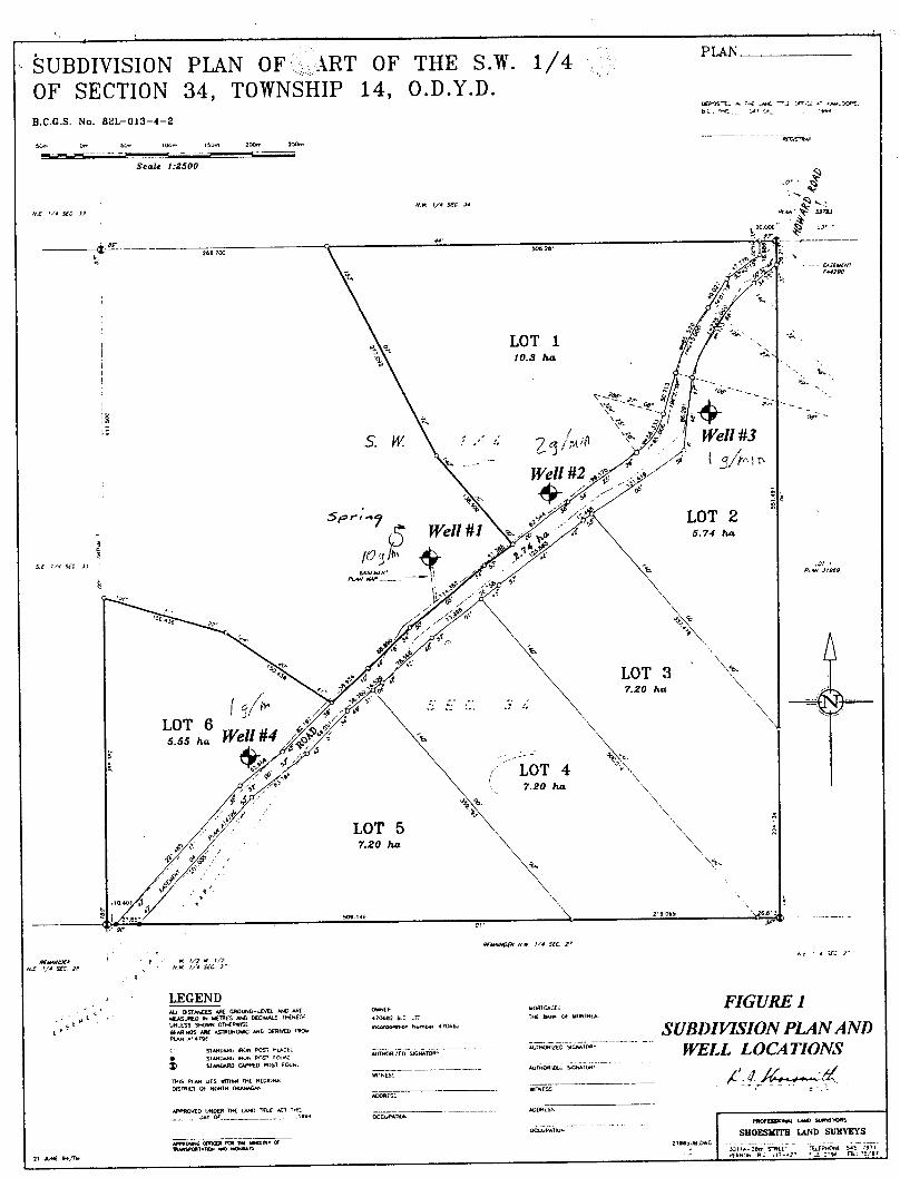
herein. It is currently planned to subdivide the property into seven (7) parcels, which will include
six (6) designated lots and a remainder parcel as shown on the subdivision plan (Figure 1). The
proposed source of water supply is shallow groundwater to be obtained from dug water wells.
Our investigation has involved a site inspection, plus an evaluation of pumping test results from
four of the recently completed water wells. In addition, we have conducted a review of available
information including a topographic map, surficial and bedrock geology reports, plus air photos.
Site Description
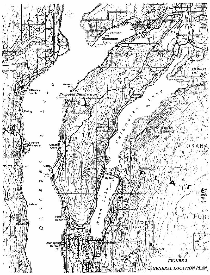
The property is located on the west side of Commonage Road, a short distance south of the
Predator Ridge Golf Course (see Figure 2). The topographc expression would be described as
valley side with a northwest facing exposure overlooking Okanagan Lake and Ellison Provincial
Kala Groundwater Consulting Ltd.
Page 1
s33
s33
PLAh I SUBDIVISION PLAN O F ' - \ A R T OF THE S.W. i/4 1 OF SECTION 34, TOWNSHIP 14, O.D.Y.D. B.C.C.S. No. 82L-013-1-2
Iun lW?. 15"rn 2 m 2%- _ -
LOT 5 7.20 ha
21 xlrr S4JI"
1
4
Park. On a more local basis, the relatively steep valley side topography gives way to a shallow
bench area, which roughly parallels the road easement through the centre of the property.
The surfkial deposits in this area are for the most part comprised of exposed bedrock, with a thin
mantle of colluvium and glacial moraine occurring throughout. The local bedrock is part of a
large granitic pluton of Late Jurassic Age and is comprised of granodiorite, granite, minor gabbro,
diorite and quartz diorite. Rocks of this particular group generally exhibit structural deformation
in the form of joints, fractures shears and cataclastic zones. The younger plutons are usually more
massive. Based on an inspection of air photos, the bench area previously'defined, reflects some
bedrock structural control.
Finally with respect to potential groundwater recharge to the property, there is a spring discharge
area occurring on the remainder parcel (see Figure l), and some small ponds on proposed Lots 1
and 2. West of the property and immediately adjacent to Commonage Road is a small lake
(Howard Lake?), which is slightly elevated with respect to the bench area discussed previously.
Existinp Water Wells
At the present time, four (4) wells have been completed on the property at locations shown on
Figure 1. Water well constructed on Lots 1 and 2 and also the remainder parcel, have been
completed to a total depth of 10 feet with three-foot diameter cement culvert and a gravel
envelop. The well on Lot 6 has been dug to a depth of 10.5 feet and is completed with a two-foot
diameter steel culvert.
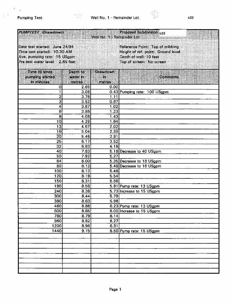
In order to provide an assessment of well capacity, pumping tests have been conducted with each
of the four existing wells by Moore's Well and Pump Service of Vernon, B.C. Each test was
conducted for a 24 hour period and involved an initial pump-out phase, pumping the wells at
somewhere between 50 and 100 USgpm to remove water stored within the gravel envelop.
Following the initial phase, the pumping rate was reduced until a steady rate of drawdown was
observed in each well. This rate was then held more or less constant for the remainder of the test.
Kala Groundwater Consulting Ltd. Page 2
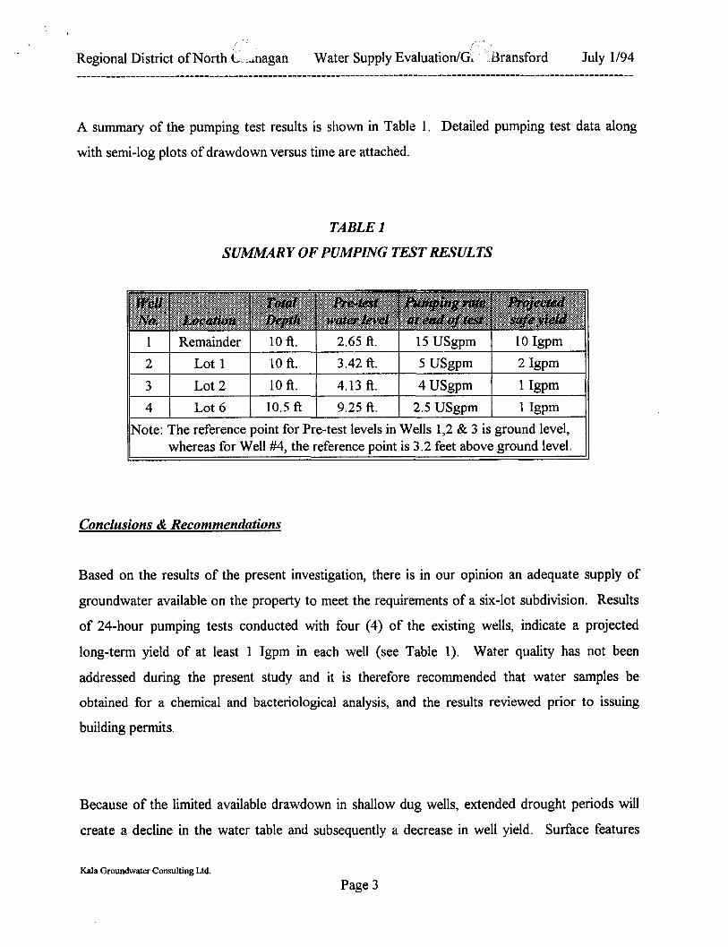
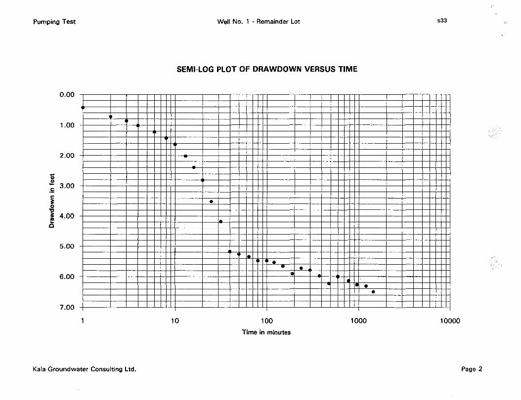
A summary of the pumping test results is shown in Table I . Detailed pumping test data along
with semi-log plots of drawdown versus time are attached.
1 2 3 4
TABLE 1
SUMMARY OF PUMPING TEST RESULTS
Remainder 10 ft. 2.65 ft. 15 USgpm 10 Igpm Lot 1 10 ft. 3.42 ft. 5 USgpm 2 Igpm Lot 2 10 ft. 4.13 ft. 4 USgpm 1 Igpm Lot 6 10.5 ft 9.25 ft. 2.5 USgpm 1 IgPm
Conclusions & Recommendations
Based on the results of the present investigation, there is in our opinion an adequate supply of
groundwater available on the property to meet the requirements of a six-lot subdivision. Results
of 24-hour pumping tests conducted with four (4) of the existing wells, indicate a projected
long-term yield of at least 1 Tgpm in each well (see Table 1). Water quality has not been
addressed during the present study and it is therefore recommended that water samples be
obtained for a chemical and bacteriological analysis, and the results reviewed prior to issuing
building permits.
Because of the limited available drawdown in shallow dug wells, extended drought periods will
create a. decline in the water table and subsequently a decrease in well yield. Surface features
Kala Groundwater Consulting Ltd.
Page 3
. \ I ,
Regional District of North L -.magan Water Supply EvaluationlG. Bransford July 1/94 _ _ _ _ _ _ _ _ _ _ _ _ _ _ _ _ _ _ _ _ _ _ _ _ _ _ _ _ _ _ _ _ _ _ _ _ _
observed during our site reconnaissance, such as the spring discharge area and the small ponds
occurring on Lots 1 and 2, would tend to indicate that there is an adequate source of groundwater
recharge to the property. We would recommend however that water levels be monitored in the
existing wells during the forthcoming summer months and if a significant decline is observed (i.e.
2 to 3 feet - see Table 1) then the wells should be relocated to areas of obvious groundwater
discharge. The water level measurements should be made a prerequisite for each building permit
application.
We trust this meets your present requirements and if there are any questions, please do not
hesitate to contact the undersigned.
Yours truly,
KALA GROUNDWATER CONSULTING LTD. I
LCT/it Encl:
C.C.
Kala Groundwater Consulting Ltd. Page 4
s33
Pumping Test
380 480 600 780 960
1200 1440
Well No. 1 - Remainder Lot
8.63 5.98 8.88 8.65 8.79 6.14 8.92 6.27 8.96 6.31 9.1 5
6.23 Pump rate: 13 USgpm 6.00 Increase to 15 USgpm
6.50 Pump rate: 15 USgpm
I I I I I
Page 1
s33
s33
Pumping Test
+ 0) 0 ) .c C .- C
0 U E L E n
0.00
1 .oo
2.00
3.00
4.00
5.00
6.00
7.00
1
Kala Groundwater Consulting Ltd.
Well No. 1 - Remainder Lot
SEMI-LOG PLOT OF DRAWDOWN VERSUS TIME
10 100 Time in minutes
Page 2
1000 10000
s33
Pumping Test
780 960
1200 1440
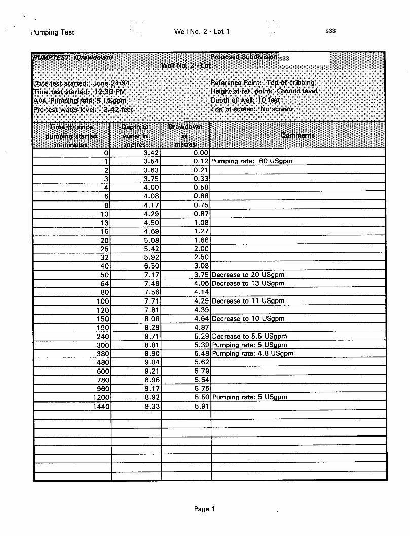
Well No. 2 - Lot 1
8.96 5.54 9.1 7 5.75 8.92 9.33 5.91
5.50 Pumping rate: 5 USgpm
I I I I
I I 1
Page 1
s33
s33
Pumping Test
3 3.00
L 0 TI
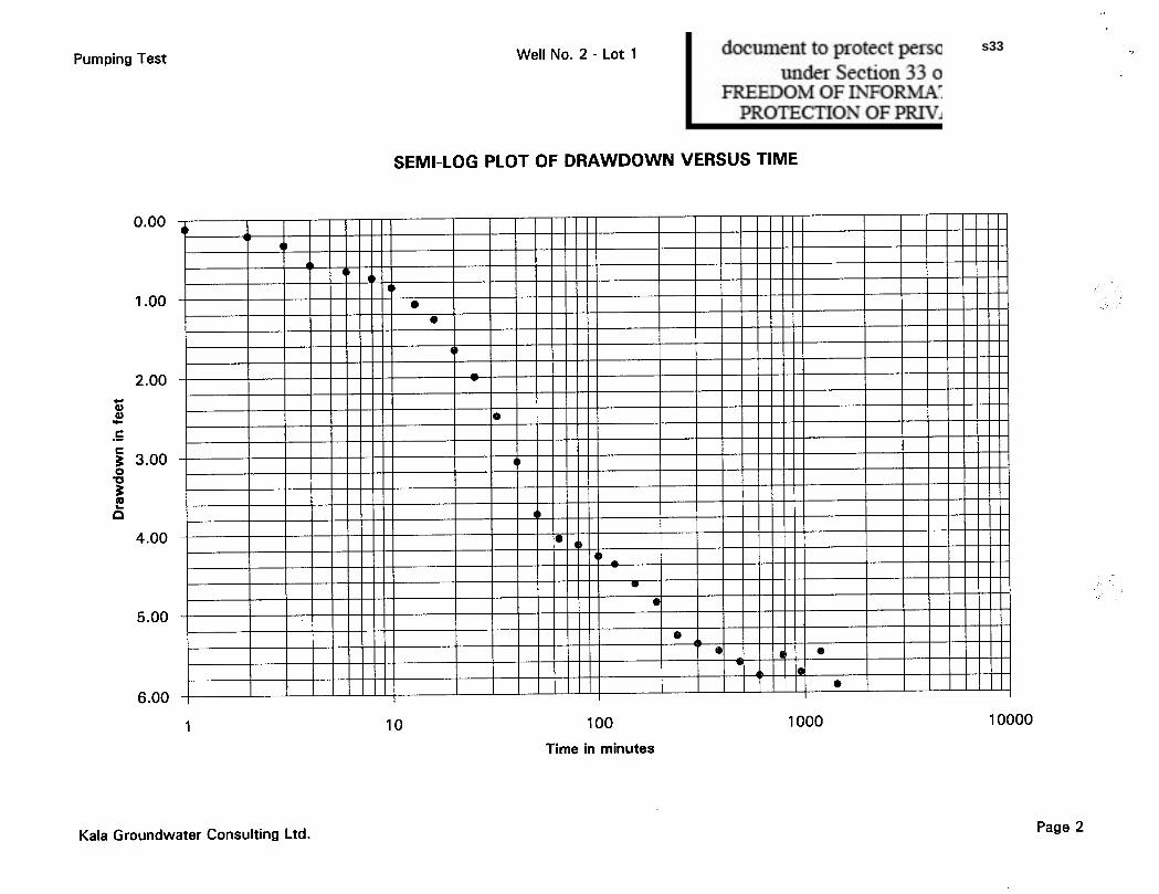
Well No. 2 - Lot 1
I
t I
SEMI-LOG PLOT OF DRAWDOWN VERSUS TIME
e 5.00
e
a e -* e -. w 1 h e
e
Kala Groundwater Consulting Ltd. Page 2
s33
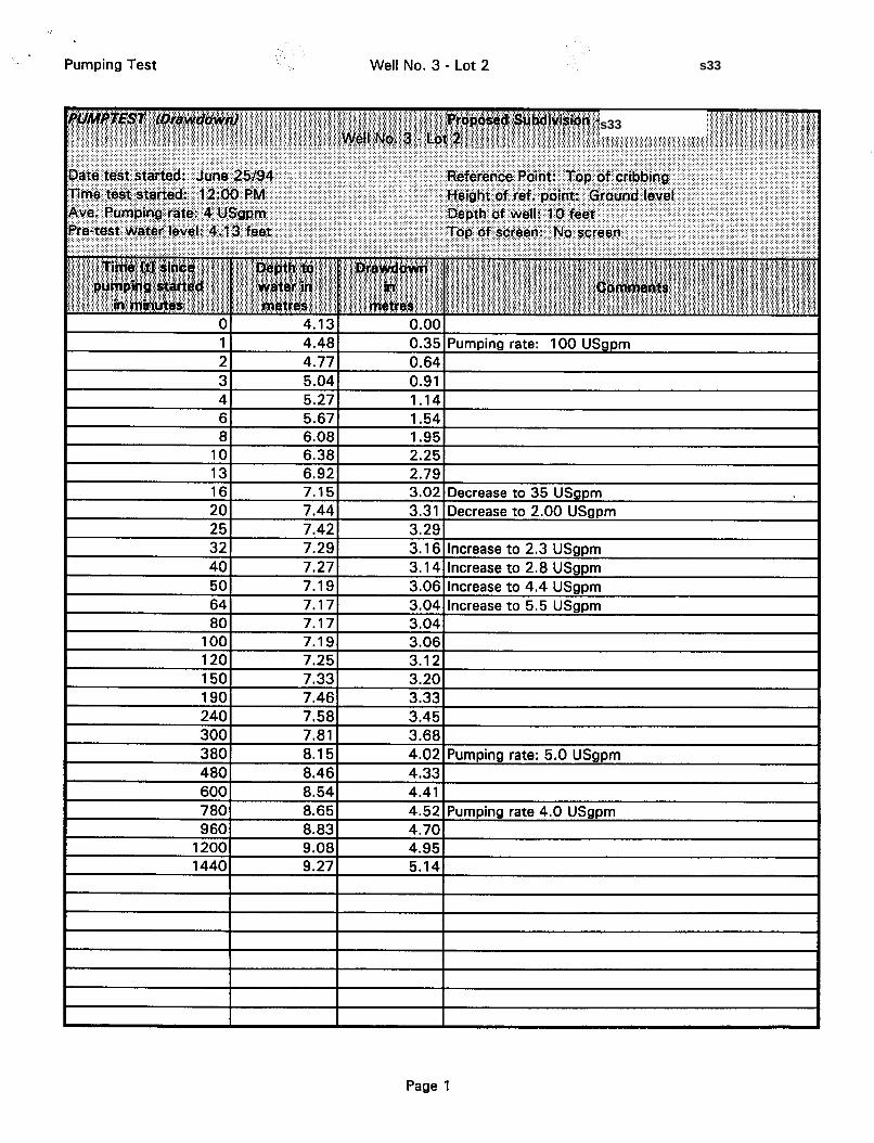
Pumping Test Well No. 3 - Lot 2
1 4.48 0.35 Pumping rate: 100 USgpm 2 4.77 0.64
Page 1
s33
s33
Pumping Test
0.00
1 .oo
2.00 c1
.c W W
C
C
0 U
.- g 3.00
E z 4.00
5.00
6.00
1
Kala Groundwater Consulting Ltd.
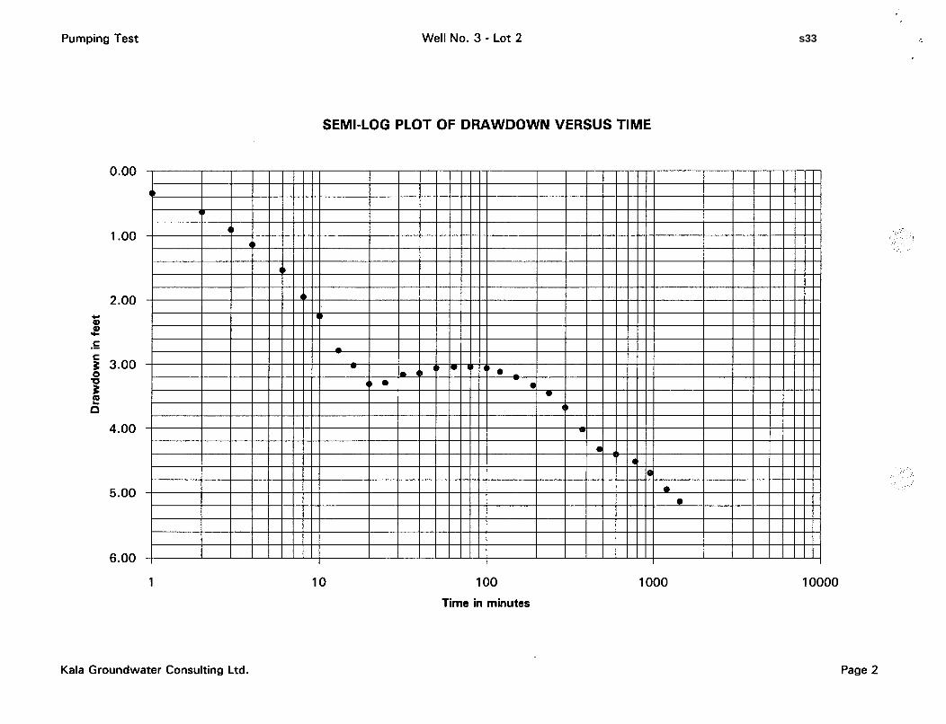
Well No. 3 - Lot 2
SEMI-LOG PLOT OF DRAWDOWN VERSUS TIME
10 100 Time in minutes
1000 10000
Page 2
s33
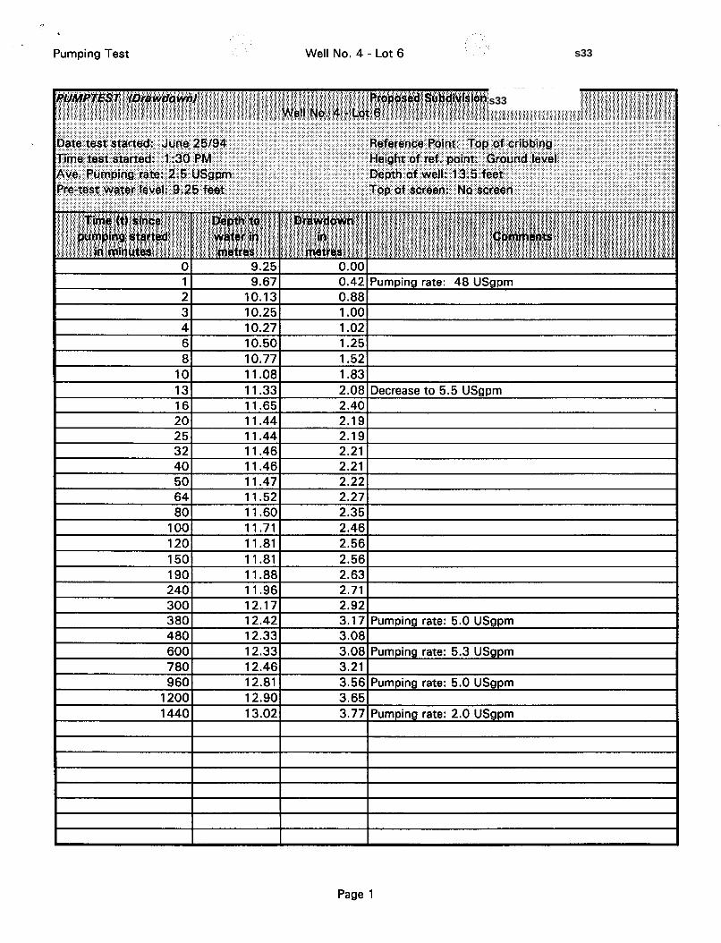
Pumping Test Well No. 4 - Lot 6
1 9.67 0.42 Pumping rate: 48 USgpm 2 10.13 0.88 3 10.25 1 .oo
64 11.52 2.27 80 11.60 2.35
100 11 -71 2.46 120 11.81 2.56 150 11.81 2.56
Page 1
s33
s33
Pumping Test
+ 0 0 y.
C .- C
0 U 3
3 El
0.00
0.50
1 .oo
1.50
2.00
2.50
3.00
3.50
4.00
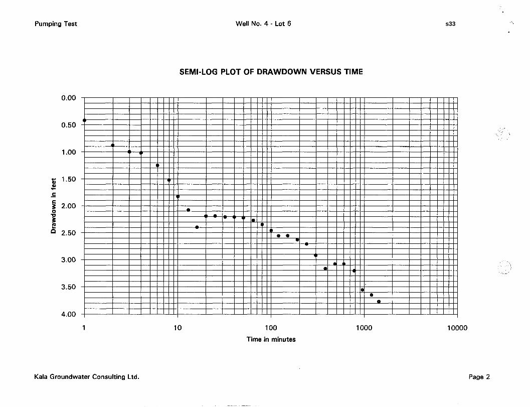
Well No. 4 - Lot 6
SEMI-LOG PLOT OF DRAWDOWN VERSUS TIME
T I I I I l l l l l I I I I l l 1 1 1 I I I I l l l l l 1 I I I l l l l l
1
Kala Groundwater Consulting Ltd.
10 100
Time in minutes
1000 10000
Page 2
s33
Frpm : KRLQ GROUNDWQTER CONSULTING PHONE No. : 604 545 1720 . I
1
Jul. 28 1994 3: 36PM P02
1 . b MLA GROUNDWATER COIVSULTlNC LTIl
#j - 3107A - 31st hve. - Vonon, U.C. - V1T 2G9 I 'I'clcplronclflnx (604) 565-1 720
July 281h, 1994
Rcyional District of Nor-lh Okana~nn 9848 Aberdeen Road Vcrnon, B.C. VIB 2K9
Attention: Mr. Steve Noakes
Dear Sirs:
Rcfcrcncc: Follow-up Watcr Supply Evnluntion - Proposcd Subdivision of Part of the SW 1/4 oFSec. 34, Twp. 14, O.D.Y.
Tlic following is to providc thc rcsults of furt.hcr invcstigalion, which was recently carried oul in conjunction with our walcr supply cvaluation for thc proposcd subdivision described above. The
additional work, which has involved the drilling o f a 120-foot bedrock well, was conductcd at our
requcsl lo:
prove that, in addition io thc cxisting shallow dug wells an the property, therc is othcr
groundwater supply oplions availrible; and, remove water level inonitoring conditions rccornmcnded in our original rcport of July , 1 st,
1994.
Bawd on the results of our original investigation (see report dated July 1, 1994), which centred
on results of pumping tests with four existing dug wells, we concludccl that there is AD adcquatc
supply of groundwater available on the property to incet thc rcquircincnts of a six-lot subdivision,
We did however express thc conccrn that because of the limited available drawdown in the shallow dug wells, cxtcnded drought periods will create a decline in the water table and
subsquently a decretwc in well yield.
Page 1
JUL-28-1994 16:19 604 545 1720 95% P. 02
s33
From : KQLR GROUNDWRTER CONSULTING PHONE NO. : 684 545 1728 Jul .28 1994 3: 36PM P83 - *
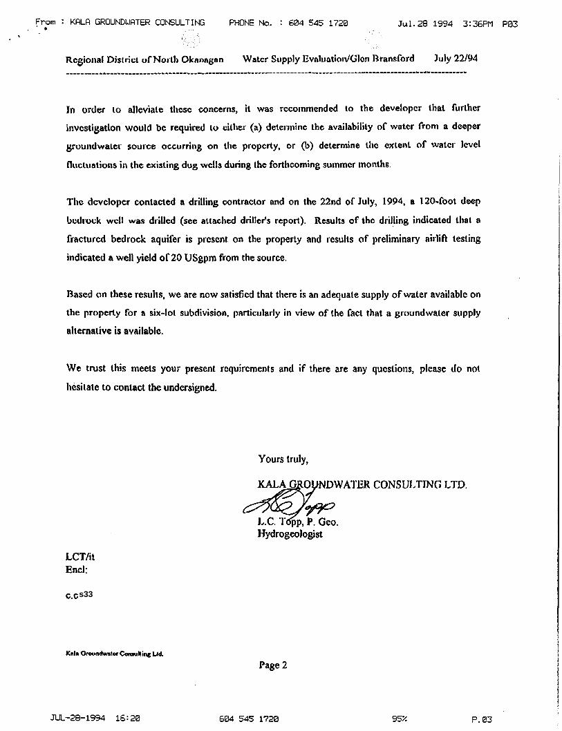
In order to alleviate tlicsc concerns, it was rccoinmended ta the developer Chat further
invcstigatlon would be required to cilher (a) determine the availability of water from a deeper
pundwaler source occurring on the proycrty, or @) deterinine thc cxtent of watcr level
fluctuations in the existing dog wclls during the forthcoming sutnmcr months.
Thc dcvcloycr contacted a drilling contractar and on the 22nd of' July, 1994, a 120-fool d e p
bcdrock wcll was drilled (see attached driller's report). Results of thc drilling indicated tbal a
fractured bedrock aquifer is prcscnt on the property and results of preliminary airlift testing
indicated a well yield of20 USgpm from the source.
Based on these results, we are now satisficd that there is an adequate supply of water available on
the property for a six-lot subdivision. partictilarly in view of the fact that a groundwater s\ipply
alternative is avnilablc.
We trust this meets your present requircments and if there are any questions, please do not
licsilatc to contact the undersigned.
Yours truly,
KALA G 0 NDWAI'EH CONSUJ,TWC; LTD.
&w L.C. I$p, P. Geo. Hydrogeologist
LCT/i t End:
C.C.
Page 2
JUL-29-1994 16:28 604 545 1720 95z P. a3
s33


![a100.gov.bc.caa100.gov.bc.ca/appsdata/acat/documents/r35888/Huntersmap_1372… · Map production enlarged from 1 scale to 1:] 25,000 scale Reference Map: Mapsheet #821- Vernon, British](https://img.pdfslide.us/doc/110x75/5f06b9287e708231d419698e/a100govbc-map-production-enlarged-from-1-scale-to-1-25000-scale-reference.jpg)