Embed Size (px)
Citation preview

HELLIWELL PROVINCIAL PARK
ECOSYSTEM BASED PLAN
Submitted to
BC Parks, Strathcona District
Rik Simmons
Bill Zinovich
by
Ecofocus Environmental Consultants
Jennifer Balke, Ecofocus Environmental Consultants
Jacqueline Booth, Jacqueline Booth and Associates
Kathy Dunster, Dunster Consulting
Briony Penn, Penn & Gunn Associates
March 2001

Helliwell Provincial Park Ecosystem Based Plan - March 2001 i
Executive Summary
Helliwell Provincial Park is located on Hornby Island in the Georgia Strait. The upland portion of the
park consists of 69 hectares on the southeast side of Hornby. The marine portion is 2,803 hectares of
foreshore and the park also includes Flora Islet. Helliwell Provincial Park has outstanding ecological
values nationally, provincially, regionally and locally. It is also a highly cherished park for its scenic,
cultural and recreational values. Its increasingly high profile as a tourist destination with estimated 60,000
visits a year, is causing Helliwell to be ―loved to death‖.
National significance of Helliwell Provincial Park includes the last extant population of Taylor‘s
Checkerspot—officially declared an endangered species on the COSEWIC list as of November 30, 2000.
Provincial significance of Helliwell Provincial Park includes five Red-listed (endangered or threatened)
and nine Blue-listed (vulnerable) vascular plants documented within the park and one Red-listed plant
association, Douglas-fir/ Garry Oak / Alaska Oniongrass, (Pseudotsuga menziesii/ Quercus garryana /
Melica subulata). The park also provides habitat for five rare mammals, twenty rare birds and two rare
invertebrates; seventeen of these are confirmed within the Park. Eight species are Red-listed, six of these
are confirmed; sixteen are Blue-listed, nine of these are confirmed; and three are S3 (vulnerable) species
noted by the BC Conservation Data Centre, two of these are confirmed.
The marine component provides significant habitat for six-gill sharks, Harlequin ducks, Harbour seals and
Steller and California sea lions. Over 175 marine faunal species have been recorded in the park waters.
The marine area is a popular recreational dive and fishing area, and a significant area for commercial
fishing. The coastal areas around Hornby Island have one of the largest herring spawns on the BC coast.
The following report is an Ecosystem Based Plan (EBP) for Helliwell Provincial Park. The current
understanding of ecosystems and management/restoration of systems and species suggests that any plan
must take into account the historical range of variability of ecosystems. To determine this requires an
understanding of the ecological and cultural history of the park, as well as establishing a baseline
inventory. The objectives of this report are to provide this information, together with management
recommendations,. The information will then be used by park managers and stewardship groups in
locating and protecting sensitive areas
anticipating seasonal and spatial movements of species through the park
restoring ecosystems and processes
planning infrastructure and park access in a sensitive manner.
The approach to the EBP was multidisciplinary in an attempt to fill out the ecological picture of the park
spatially and temporally. It included a literature review of palaeoecological research and Traditional
Ecological Knowledge (TEK), Terrestrial Ecosystem Mapping (TEM), Marine Ecosystem Mapping
(MEM), public consultations and management literature reviews.
Reviews of the palaeoecological research suggest that the Douglas-fir and grassland communities of
Helliwell Park have constantly fluctuated over time with changing global climate conditions.
Archaeological data, TEK and historical accounts suggest significant changes in species composition and
abundance over time. Grassland species have been very vulnerable to changes in both the climate and
human management regimes. The disappearance of culturally prescribed burns and the introduction of
invasive species are just two of the impacts.
Terrestrial and Marine Ecosystem Mapping provides
baseline information on ecosystems

Helliwell Provincial Park Ecosystem Based Plan - March 2001 ii
level and type of disturbance for different ecosystems
areas that would be sensitive or limiting to park development
identification of exotic or invasive plant species
relationship between ecosystems and wildlife use
.
Mapping was completed at a scale of 1:5,000 using Resource Inventory Committee (RIC) survey intensity
level one, following the Standards for Terrestrial Ecosystem Mapping in British Columbia (RIC 1998).
Because anthropogenic activities have disturbed the natural ecosystems on the island, several specific
interpretations were required. These included an indication of the type and degree of disturbance to each
polygon and information on areas that would be sensitive or limiting to park development. Naturalness
ratings were established to appraise the ecological condition of each ecosystem unit by considering the
degree of fragmentation, disturbance history and known threats. Viability was rated according to the
likelihood of a given ecosystem remaining in the current state of naturalness over time if management
strategies do not change. Additionally, the location of all trails and structures were mapped. Preliminary
terrain mapping and a working legend were completed during the autumn/winter of 2000/2001.
Helliwell Park is classified in the Coastal Douglas-fir moist maritime (CDFmm) biogeoclimatic (BGC)
subzone. This subzone includes a range of different ecosystems from dry coastal Douglas-fir forests and
wetlands to Garry oak meadows and coastal bluffs. The CDFmm has a limited range and is one of the
smallest forested subzones in British Columbia. Urban development and agricultural modifications have
placed extreme pressures on ecosystems in this subzone. The upland plant communities of the park
contribute to the provincial representation of this rare ecosystem.
Seventeen Terrestrial Ecosystem types over 75 distinct areas (polygons) were mapped. Nine of the
Ecosystem types are forested site series; three are previously undescribed non-forested units including
wetlands and forb dominated communities, the remaining five Ecosystems are sparsely vegetated, non-
vegetated, or anthropogenic. One of these Ecosystems is a seral community, maintained at the seral stage
by disturbance.
Of the 75 polygons, 54 (73%) were mapped as pure units (i.e. only one ecosystem), the rest were
complexes of two or three units. The most frequent complex was the Douglas-fir / Lodgepole pine
/Arbutus (DAO) with Fescue / Camas. These were found on exposed gentle or hummocky slopes and
crest positions. Common also were complexes of Beach and Dunegrass / Beach Pea units that occupy
narrow shoreline margins that cannot be subdivided at 1: 5,000.
Helliwell is a good recruitment sites for endangered plant associations and somewhere to emphasize
protection and restoration efforts. Seven DAO polygons were mapped at structural stage 5 (mature forest),
and are in excellent condition. Several are approaching the cusp of becoming classified as structural stage
6 (old growth), and the diversity of age classes within the park again implies that there are good
opportunities to allow natural processes to carry on while concentrating on reducing the human-induced
pressures on the park.
Because of the somewhat rugged topography and the lack of surficial material, these coastal bluffs are the
most sensitive area of the park. Natural regeneration of areas damaged by high human traffic will be
extremely slow.
Eighty-two percent of the mapped units fell into the range of marginal (3) to poor (4) for naturalness and
viability, with the majority (approx. 51%) being rated as marginal for naturalness and poor for viability.
At the extremes of the scale, approximately four percent of the ecosystems were rated as excellent in both
naturalness and viability. These are mostly located on Paul Island and the surrounding islets.
Approximately eight percent were rated as poor in both categories. Viability ratings provide some
Helliwell Provincial Park Ecosystem Based Plan - March 2001 iii
indication of future conditions if present trends continue, e.g., non-management of use, fire suppression,
encroachment. They are only relevant if the disturbance regime remains unchanged, highlighting the need
to introduce active management prescriptions.
The shore-zone is one of the most heavily used and most sensitive areas of the Park. In addition to rich
marine algal and invertebrate communities, the shore-zone provides critical habitat for several species of
marine fish, birds and mammals. The objective of shore-zone mapping is to provide park managers with
the information they need to protect and restore the shore-zone species and processes. For this purpose the
mapping must be able to identify:
marine wildlife habitat
areas with high invertebrate or algal species richness or sensitivity
areas of high use (or potentially high use) by the public
shoreline features contributing to or indicating erosion or accretion processes
A total of eight Physical Shore-Zone Mapping units of five different classes fall within the Helliwell Park
boundaries. Within the park boundaries there are six shore-zone areas identified that are critical to marine
birds and mammals; all but one of these areas are offshore islets or reef: St. John Pt, South St. John Pt.,
southeast shore rock platforms, Flora Islet and reefs, Norris Rocks, Heron Rocks, Nash Rocks, Maude
Reef. Caves, clam beds, kelp beds, eelgrass and herring spawn areas are all special areas of concern.
A baseline inventory of flora and fauna species was conducted using existing data and data collected
during TEM and MEM. The list is far from complete with very little data on many organisms, e.g.,
invertebrates, fungi, and algae. The existing data collected are compiled in several lists in Appendices 2
and 3.
The objectives of the baseline inventory are to:
Provide baseline data on presence of species to monitor impacts of climate change, disturbance
and succession.
Identify gaps in the understanding of Helliwell‘s biodiversity.
Track loss of biodiversity with comparison to palaeoecological and historical accounts.
Identify future research on inventories and population distribution.
The list of flora includes 313 species of vascular plants from 59 families. The variety of species
demonstrates the range of ecological habitats within Helliwell Park from fresh and saltwater marshes, to
dry grasslands and rocky bluffs. A total of five Red-listed and nine Blue-listed plants are recorded for
Helliwell Park. The list of flora documents 65 introduced species.
The list of fauna, Appendix 2 and 3 contains 380 potential species; 311 of these species are confirmed
within the Park. The list includes terrestrial species, as well as marine mammals, invertebrates, fish and
birds. This list only deals with 2 known and rare terrestrial invertebrates. The number of species, in each
wildlife-category documented in this section of the report, is listed in Table 14. The Park provides habitat
for potentially twenty-seven rare wildlife species; seventeen of these are confirmed. Six species of
introduced terrestrial-wildlife in addition to domestic dogs and cats are potentially within Helliwell Park;
three of these species are confirmed in the Park.
To facilitate developing basic management principles that will encompass the significant habitat elements
of Helliwell Park, seven key species were selected for which detailed species accounts were written:
Harlequin Duck, Northern Alligator Lizard, Pacific Treefrog, Pelagic Cormorant, Propertius Duskywing,
Taylor's Checkerspot, Townsend's Big-eared Bat.

Helliwell Provincial Park Ecosystem Based Plan - March 2001 iv
A variety of other terrestrial wildlife species have specific or critical requirements to be considered by
managers. Garter Snake, Great Blue Heron, Turkey Vultures and other raptors, Blue and Ruffed Grouse,
Virginia Rail, Hutton‘s Vireo, Owls and Keen‘s Long-eared Myotis, Scoters and other Waterfowl, Marine
Mammals, Intertidal Life and Six-gill Sharks.
Special management attention is drawn to introduced species: Virginia Opossum, Norway Rat, European
Starling, English Ivy, Holly, non-native blackberries, Scotch broom and non-native grasses.
Fire suppression with encroachment of trees and shrub species has created the largest most complex
management concern in Helliwell Park. Lack of fire has led to a change in the structure, composition and
function of the ecosystem. The encroachment of Douglas-fir, shore pine and arbutus has created denser
forests (also called stagnating or overstocked forests) and increased shrub layers. This increases the fuel
loading and the risk of a high intensity fire (McLoud et al. 1979) as well as the risk of losing endangered
species because of habitat encroachment/invasion (Fuchs 2001).
There is little information available on the amount of recreational use in the park. The only use statistics
are estimates from the Helliwell Park Stewardship Committee of 60,000 visits/year (Carmichael pers
comm. 2000). There is some data available on impacts of recreation on wildlife populations, e.g.,
Warrington on waterfowl flight frights, although most research is for marine mammals. This information
is summarized in the BC Parks Viewing Guidelines Outreach Package (2000). The various researchers
contacted for information on species accounts (see Appendix 1) observed impacts from recreational
activities on wildlife populations, and provided management suggestions that are incorporated into the
Management Section.
Traditional resource land uses caused structural and compositional changes to Helliwell‘s ecosystems
through restricted logging, grazing and hay meadows. Today, adjacent subdivisions, commercial fishing
practices and recreational use pose the greatest human disturbance factors.
At the first two meetings with community stewardship groups, six key and related general issues were
identified:
Impacts of growing number of visitors
Conflict between year round local users vs summer tourists
Impacts of access to the bluffs and solutions (reactions to a boardwalk)
The need for seasonal park closures to protect key areas and populations of species at risk.
The problem of invasive species, e.g., opossums, broom.
The decreasing ability to manage the ecosystems of Helliwell with small resources.
The reintroduction of burning
The potential problems coming from adjacent subdivisions
Prior to the start of this contract, BC Parks‘ staff identified related issues and risks in the park.
The original list was added with further issues and problems arising out of TEM, MEM, species accounts,
research and consultation with specialists for the EBP. Issues were categorised by ecosystem so that map
layers could be linked to issues. These issues are often variations on the central themes raised by the
stewardship group.
Forested ecosystems 14 issues
Grassland/Garry oak ecosystems 21 issues
Wetlands 3 issues
Beach and marine ecosystems 15 issues
Key concepts proposed for management include:

Helliwell Provincial Park Ecosystem Based Plan - March 2001 v
Manage for ecological processes not just individual species.
Use adaptive management Start small and slow then watch. Very little is known about the
autoecology of rare species so management in areas with rare species should proceed cautiously.
The effect of management regimes such as fire or mowing is not known. Nor is the effect of
encroachment or invasion (i.e., no management). Until further studies are done, it is best to
confine management techniques to areas away from these populations. If a species is negatively
impacted by lack of management, ideally it will expand into adjacent, managed areas.
An important consideration for management is the affect of climate change on these grassland
and transitional forest communities. As annual temperatures increase, a shift if bound to occur
from the cooler, moister species to warmer, dryer species.
Monitoring is critical for determining success of management approach, to catch new invasive
species early, to provide information to other managers and to document ecosystem change over
time. It is especially critical for rare species (e.g., Marilyn Fuchs butterfly monitoring project with
Provincial Capital Commission).
In addition, there are important cultural dimensions to management of Helliwell Park on Hornby Island.
the rich heritage both of the First Nations and historic settlers,
the role, potential and limitations of volunteerism in the community,
the passion for this park and the range of values with regard to access, dog use
the range of values with regard to removal of invasives and restoration,
local vs. provincial objectives for the park and the seasonality of use
the role of artists in the interpretive and management role.
Six management plans/papers were reviewed for their applicability to management recommendations for
Helliwell Provincial Park:
1. Cowichan Garry Oak Preserve Management Plan Denman Island
2. Government House Garry Oak Management Plan
3. South Puget Sound Prairie
4. South Winchelsea Island Exotic Plant Species Management Plan 1999-2003
5. Ecological Investigation of the High Salal Garry Oak Grove, ―The Thousand Oaks‖,
6. Silva Forest Foundation - Role of Fire
Management prescriptions (detailed list of management tasks to resolve problems) were recommended,
based on the assumption that unless some management actions are taken to reduce recreational impacts
and reintroduce natural processes back into the park, the ecological integrity of the park will be seriously
threatened. These prescriptions are also based on the assumption that
resources for the management of the park might not be sizeably increased in the future;
stewardship groups do not have infinite time and resources and
creative, simple and inexpensive solutions are most likely to succeed.
Prescriptions are organized in categories somewhat by priority and also ability to be put into action
quickly and inexpensively. There is no silver bullet to any one issue and the matrix of ideas is meant to
cover a variety of approaches.
Landowner Contact and Public Education - including Landowner Contact Programs, Wildlife
Viewing Guidelines, interpretive signage, seasonal naturalists/wardens, Artist-in-residence
Programs
Inventory, Mapping and Monitoring – including, species at risk, intertidal features, project
species, the monitoring of restoration activities
Management of Access – including, restriction of wheeled vehicles, dogs on leash rule, staged
trail closures, boardwalk creation, seasonal closures of sensitive wildlife zones and islets.

Helliwell Provincial Park Ecosystem Based Plan - March 2001 vi
Management of Invasive Animal Species – including, trapping opossums, etc., education
programs for owners of stray cats and dogs, nest box programs to inhibit starlings.
Ecosystem Restoration of Douglas-fir Forest Ecosystems – including, invasive plant removal,
thinning, prescriptive burns, root impact mitigation, maintaining hydrology patterns and
enclosures for vulnerable species.
Ecosystem Restoration of Grassland and Garry Oak Ecosystems –invasive plant species
removal, encroachment removal, grassland species restoration including replanting, mulches and
prescriptive burning with stewardship groups trained through sponsored workshops and
enclosures for species at risk.
Subtidal Restoration – including, mooring buoys, fish closures on bottom gear, resident fish,
herring, guidelines of Six-gill Shark and scuba restrictions on collecting.
Other Jurisdictional Recommendations – including, federal, provincial and local government
jurisdictions on the protection of species at risk and the maintenance of adjacent natural areas.
Vegetation Management Zones: The Park has been divided into nine vegetation management zones
based on TEM ecosystem units. The vegetation management prescriptions follow by ecosystem type.
Zone 1. Grassland/ Garry Oak Core Conservation Area – West
This zone constitutes the western half of the grassland/Garry oak ecosystems. (This is the core
conservation area of the park where Taylor‘s Checkerspot are described. Management emphasis for this
core area will be
monitoring of rare plants and invertebrates
seasonal closures for butterflies, ground nesting birds and reptiles
minimising soil and vegetation disturbance
carefully removing encroaching conifers that could displace native herbaceous species
trail erosion repair and grassland species restoration (replanting, mulching and burns) for
butterfly habitat
enhancement of habitat for reptiles
Zone 2. Grassland/ Garry Oak Core Conservation Area – East
This zone constitutes the eastern half of this ecosystem. Again, just the eastern half of Polygon 25 (grey)
applies. Management emphasis for this area will be
minimising soil and vegetation disturbance which leads to invasive plant species
carefully removing encroaching conifers that could displace native herbaceous species
staged trail closures, and/or boardwalk creation with viewing spurs to point beyond rookery
managing access above the cormorant rookery
Zone 3. Grassland/Garry oak to Douglas-fir Transition Area
This zone is the next level of priority after the grasslands. Management emphasis for this area will be
thinning of stagnated shore pine and Douglas-fir stands, especially around Garry oak
enclosures of Garry oak saplings and other rare features
removal of invasive holly, etc.
research plots for burns
Zone 4. Second-growth Douglas-fir Forest Restoration Area
The second growth forest, composed of both Douglas-fir / shore pine / arbutus and Western redcedar /
Douglas-fir communities is the third level priority area for restoration. Management emphasis will include
thinning and monitoring
research plots for burns

Helliwell Provincial Park Ecosystem Based Plan - March 2001 vii
enhancement for wildlife habitat values
removal of invasives
Zone 5. Older growth Douglas-fir Core Conservation Area
This is another core conservation area. These stands have the highest viability ratings in present state.
Management emphasis for the core area will be
monitoring of rare species, e.g., bats, raptors
minimising soil disturbance which leads to invasive plant species and
removing invasive holly, ivy, etc. that could displace native herbaceous species.
creation of boardwalk in proposed interior trail so as to minimise root impaction
Zone 6. Wetlands
This zone includes all the wetland communities. Management emphasis for wetlands will be
minimising soil disturbance and access,
monitoring and removing invasive species and
maintaining hydrological processes.
Zone 7. Orchard
Orchard can either be restored as orchard or left to return back to Douglas-fir/wetland.
Zone 8. Beach and Cliff Conservation Area
Management emphasis for beach and cliffs will be
minimising soil disturbance especially at access points, archaeological sites
restricting access on Cladina and rare plant communities through approaches described in 7.2.4
seasonal closures for spring flowering, breeding season of shorebirds, moult of harlequins
managing access near cormorant colony
Zone 9. Rocky Headlands and Islets
This is the key conservation area for Harlequins, oystercatchers, seals and sea lions and spring flowers on
Flora Islet. Management emphasis of rocky headlands and islets will be seasonal restrictions of access
spring and late summer. Management areas of focus on Flora Islet could include
monitoring and removal of invasive species on islet
research burn plots
restricted landing zone and access on Flora during breeding/flowering season

Helliwell Provincial Park Ecosystem Based Plan - March 2001 viii
Figure 1 Management Zones of Helliwell Park.

Helliwell Provincial Park Ecosystem Based Plan - March 2001 ix
How to Use this Report
This Ecosystem Based Plan is written for anyone with an interest in Helliwell Park, whether they are a
manager, a scientist or a member of the public interested in stewardship. Although scientific data will be
presented in this report, every attempt will be made to make it clear to the readers. When a new concept is
introduced, a definition will be either close by in the text or in the glossary at the end.
Photographs and maps related to the text are found in an accompanying Photo Gallery and Map Atlas of
Helliwell Provincial Park. Photographs of ecosystems are also found attached to their respective legends
in the Expanded Legends section of the Terrestrial Ecosystem Mapping Appendix 5. Detailed background
information has been kept in Appendices. An ARCView database exists for all map layers.
Acknowledgements A great many people contributed their time, knowledge and expertise to this project. The names of all
these people may be found in the Contacts Appendix. We are extremely grateful to all these people who
contributed in so many ways. Special thanks to research subcontractors Amanda Heath, Linda Sheehan,
Brenda Beckwith, Carrina Maslovat and Ted Trueman. Also special thanks to Rik Simmons and Bill
Zinovich of BC Parks for their patience.

Helliwell Provincial Park Ecosystem Based Plan - March 2001 x
HELLIWELL PROVINCIAL PARK ECOSYSTEM BASED PLAN
TABLE OF CONTENTS
EXECUTIVE SUMMARY ......................................................................................................................................... I
HOW TO USE THIS REPORT .............................................................................................................................. IX
HELLIWELL PROVINCIAL PARK ECOSYSTEM BASED PLAN ................................................................... X
LIST OF TABLES ................................................................................................................................................. XIV
LIST OF FIGURES ................................................................................................................................................. XV
1 INTRODUCTION .............................................................................................................................................. 1
1.1 OBJECTIVES .................................................................................................................................................. 1 1.2 PARK LOCATION AND SIZE ........................................................................................................................... 2 1.3 PARK VALUES ............................................................................................................................................... 3 1.4 APPROACH .................................................................................................................................................... 3 1.5 INFORMATION GATHERING AND PUBLIC CONSULTATION METHODS .............................................................. 4
2 ECOSYSTEM DESCRIPTION OF HELLIWELL PARK............................................................................. 6
2.1.1 Geological History ................................................................................................................................... 6 2.1.2 Palaeoecological History ........................................................................................................................ 7 2.1.3 Archaeological Research ......................................................................................................................... 7 2.1.4 Traditional Ecological Knowledge .......................................................................................................... 8 2.1.5 Historic Accounts ................................................................................................................................... 10
2.1.5.1 Original Survey ............................................................................................................................................. 10 2.1.5.2 Early pioneer accounts .................................................................................................................................. 12 2.1.5.3 Accounts from the original homesteading family of Helliwell ..................................................................... 12
2.2 SUMMARY AND DISCUSSION ....................................................................................................................... 14
3 TERRESTRIAL ECOSYSTEM MAPPING .................................................................................................. 16
3.1 OBJECTIVES ................................................................................................................................................ 16 3.2 CLASSIFICATION ......................................................................................................................................... 16
3.2.1 Description of Ecosystems ..................................................................................................................... 17 3.3 METHODS ................................................................................................................................................... 18
3.3.1 Terrain mapping .................................................................................................................................... 18 3.3.2 TEM Mapping ........................................................................................................................................ 18
3.3.2.1 Field Sampling .............................................................................................................................................. 19 3.3.2.2 Rare Elements ............................................................................................................................................... 19 3.3.2.3 Conservation Evaluation Ratings .................................................................................................................. 19 3.3.2.4 Site Modifiers ............................................................................................................................................... 19 3.3.2.5 Structural Stages ........................................................................................................................................... 20 3.3.2.6 Survey Intensity ............................................................................................................................................ 21 3.3.2.7 Data Analysis ................................................................................................................................................ 22
3.4 RESULTS AND DISCUSSION ......................................................................................................................... 22 3.4.1 Terrain Mapping .................................................................................................................................... 22 3.4.2 Site Series and Ecosystem Units ............................................................................................................ 23 3.4.3 Introduced species, encroachment and trampling ................................................................................. 26 3.4.4 Rare Plant Communities ........................................................................................................................ 27 3.4.5 Conservation Evaluation Ratings .......................................................................................................... 28
4 MARINE ECOSYSTEM MAPPING .............................................................................................................. 30
4.1 MARINE ECOSYSTEM CLASSIFICATION ....................................................................................................... 30

Helliwell Provincial Park Ecosystem Based Plan - March 2001 xi
4.2 SHORE-ZONE MAPPING ............................................................................................................................... 30 4.2.1 Shore-Zone mapping methodology ........................................................................................................ 30
4.2.1.1 Methods for delimiting Physical Shore-Zone Mapping Units ....................................................................... 31 4.2.1.2 Integration of TEM coastal polygons with Physical Shore-Zone Units ........................................................ 31 4.2.1.3 Shore-Zone Feature Mapping ....................................................................................................................... 32
4.2.2 Results and Discussion of Marine Shoreline Ecosystem Mapping ........................................................ 33 4.2.2.1 Physical Shore-Zone Mapping Units ............................................................................................................ 33 4.2.2.2 Integration of TEM coastal polygons with Physical Shore-Zone Units ........................................................ 34 4.2.2.3 Shore-Zone Features ..................................................................................................................................... 34
5 WILDLIFE INVENTORY AND ECOLOGY ................................................................................................ 38
5.1 EXISTING RECORDS OF TERRESTRIAL AND MARINE SPECIES ...................................................................... 38 5.1.1 Flora ...................................................................................................................................................... 38
5.1.1.1 List of terrestrial and marine flora and sources ............................................................................................. 38 5.1.1.2 Rare floral species: ........................................................................................................................................ 39 5.1.1.3 Introduced Floral Species: ............................................................................................................................ 39
5.1.2 Fauna ..................................................................................................................................................... 39 5.1.2.1 List of terrestrial and marine fauna and sources ............................................................................................ 39 5.1.2.2 Rare species .................................................................................................................................................. 40 5.1.2.3 Introduced species ......................................................................................................................................... 41
5.2 SHORTENED SPECIES ACCOUNTS ................................................................................................................ 42 5.2.1 Taylor's Checkerspot Euphydryas editha taylori ................................................................................... 43
5.2.1.1 Additional management notes include: ......................................................................................................... 44 5.2.1.2 Management questions remaining to be answered: ....................................................................................... 44 5.2.1.3 Possible enhancement activities may involve: .............................................................................................. 44
5.2.2 Propertius Duskywing Erynnis propertius ............................................................................................ 45 5.2.2.1 Additional management notes ....................................................................................................................... 46 5.2.2.2 Management needs and questions ................................................................................................................. 46 5.2.2.3 Possible enhancement activities may involve: .............................................................................................. 47
5.2.3 Northern Alligator Lizard Gerrhonotus coeruleus ................................................................................ 47 5.2.3.1 Additional management notes include: ......................................................................................................... 48 5.2.3.2 Management needs and questions ................................................................................................................. 48 5.2.3.3 Possible assessment and enhancement activities may involve: ..................................................................... 48
5.2.4 Pacific Treefrog Pseudacris (Hyla) regilla ........................................................................................... 49 5.2.4.1 Additional management notes include: ......................................................................................................... 50 5.2.4.2 Management needs and questions: ................................................................................................................ 50 5.2.4.3 Possible assessment and enhancement activities may involve: ..................................................................... 50
5.2.5 Townsend's Big-eared Bat Corynorhinus townsendii ............................................................................ 51 5.2.5.1 Additional management notes include: ......................................................................................................... 52 5.2.5.2 Management needs and questions to be answered ........................................................................................ 52 5.2.5.3 Possible assessment and enhancement activities may involve: ..................................................................... 52
5.2.6 Harlequin Duck Histrionicus histrionicus ............................................................................................. 53 5.2.6.1 Additional management notes include: ......................................................................................................... 54 5.2.6.2 Management needs and questions to be answered ........................................................................................ 54 5.2.6.3 Possible management and enhancement activities may involve: .................................................................. 54
5.2.7 Pelagic Cormorant Phalacrocorax pelagicus ....................................................................................... 54 5.2.7.1 Additional management notes include: ......................................................................................................... 56 5.2.7.2 Management needs and questions to be answered ........................................................................................ 56 5.2.7.3 Possible management and enhancement activities may involve: .................................................................. 56
5.3 SPECIFIC NEEDS OF OTHER SIGNIFICANT SPECIES ........................................................................................ 56 5.3.1 Garter snake hibernacula: ..................................................................................................................... 56 5.3.2 Great Blue Heron .................................................................................................................................. 57 5.3.3 Raptors ................................................................................................................................................... 57 5.3.4 Blue and Ruffed Grouse: ........................................................................................................................ 57 5.3.5 Virginia Rail .......................................................................................................................................... 58 5.3.6 Hutton's vireo ......................................................................................................................................... 58 5.3.7 Owls ....................................................................................................................................................... 58 5.3.8 Keen's Long-eared Myotis: .................................................................................................................... 58 5.3.9 Scoters and other Waterfowl .................................................................................................................. 58

Helliwell Provincial Park Ecosystem Based Plan - March 2001 xii
5.3.10 Coastal Seabirds and Shorebirds ...................................................................................................... 59 5.3.11 Marine Mammals .............................................................................................................................. 59 5.3.12 Intertidal Life ..................................................................................................................................... 59 5.3.13 Six-gill Sharks.................................................................................................................................... 59
5.4 INTRODUCED FAUNA AND FLORA ............................................................................................................... 59 5.4.1 Virginia Opossum, Didelphis virginiana ............................................................................................... 60 5.4.2 Norway Rat Rattus norvegicus............................................................................................................... 60 5.4.3 European Starling Sturnus vulgaris ....................................................................................................... 60 5.4.4 Holly, Ivy and Non-native Blackberries ................................................................................................. 61 5.4.5 Scotch Broom ......................................................................................................................................... 61 5.4.6 Invasive Grasses .................................................................................................................................... 61 5.4.7 Introduced marine species ..................................................................................................................... 61
6 NATURAL AND HUMAN DISTURBANCE PROCESSES ......................................................................... 62
6.1 FIRE ECOLOGY AND HISTORY ...................................................................................................................... 62 6.1.1 Fire history data in Helliwell Park ........................................................................................................ 62 6.1.2 Fire Risk ................................................................................................................................................ 63
6.2 RECREATIONAL USE AND DISTURBANCE .................................................................................................... 65 6.3 LOGGING..................................................................................................................................................... 65 6.4 AGRICULTURE............................................................................................................................................. 65 6.5 ADJACENT DEVELOPMENT .......................................................................................................................... 66 6.6 WIND .......................................................................................................................................................... 66 6.7 INSECT/FUNGAL ATTACKS .......................................................................................................................... 66 6.8 COMMERCIAL AND RECREATIONAL FISHING .............................................................................................. 66
6.8.1 Direct Impacts of Fishing ...................................................................................................................... 68 6.8.2 Indirect Impacts of fisheries................................................................................................................... 68
6.9 RECREATIONAL DIVING .............................................................................................................................. 69 6.10 AQUACULTURE ........................................................................................................................................... 70 6.11 OIL SPILLS .................................................................................................................................................. 70 6.12 OCEAN CLIMATE CHANGE .......................................................................................................................... 70
7 MANAGEMENT .............................................................................................................................................. 71
7.1 SUMMARY OF ISSUES BY ECOSYSTEM ......................................................................................................... 71 7.2 MANAGEMENT PRINCIPLES AND BACKGROUND ......................................................................................... 73
7.2.1 Key Concepts for Management .............................................................................................................. 73 7.2.2 Cultural Considerations for Management ............................................................................................. 74
7.2.2.1 Land management traditions of both First Nations and historic settlers........................................................ 74 7.2.2.2 The role, potential and limitations of volunteerism in the community. ......................................................... 74 7.2.2.3 Passion for park and range of values with regard to access and dog use ....................................................... 74 7.2.2.4 Range of values with regard to removal of invasives and restoration. .......................................................... 75 7.2.2.5 Local vs provincial objectives for the park and the seasonality of use. ......................................................... 75 7.2.2.6 The role of artists in the interpretive and management role. ......................................................................... 75
7.2.3 Fire Prescriptions and Vegetation Management Options ...................................................................... 75 7.2.3.1 Management options for fire suppression issue ............................................................................................ 75 7.2.3.2 Indicator Species for Garry Oak Ecosystem Management ............................................................................ 76 7.2.3.3 Invasive grasses and native grassland restoration research ........................................................................... 77
7.2.4 Management options for recreational access issue ............................................................................... 77 7.3 COMPARATIVE MANAGEMENT PLANS ........................................................................................................ 79
7.3.1 Management Plan for the Cowichan Garry Oak Preserve .................................................................... 79 7.3.2 Government House Garry Oak Management Plan ................................................................................ 79 7.3.3 South Puget Sound Prairie .................................................................................................................... 80 7.3.4 South Winchelsea Exotic Plant Species Management Plan ................................................................... 81 7.3.5 An Ecological Investigation of the High Salal Garry Oak Grove (―The Thousand Oak Grove‖) ........ 81 (Erickson 1993) ................................................................................................................................................ 81 7.3.6 Silva Forest Foundation ........................................................................................................................ 81
7.4 MANAGEMENT PRESCRIPTIONS ................................................................................................................... 81 7.5 MATRIX OF ISSUES AND MANAGEMENT PRESCRIPTION .............................................................................. 87

Helliwell Provincial Park Ecosystem Based Plan - March 2001 xiii
7.5.1 A. Douglas-fir ........................................................................................................................................ 87 7.5.2 B. Grassland and Garry Oak Ecosystems .............................................................................................. 87 7.5.3 C. Wetland Ecosystems .......................................................................................................................... 87 7.5.4 D. Beaches and Marine Ecosystems ...................................................................................................... 88
7.6 ZONATION OF PARK INTO VEGETATION MANAGEMENT ZONES .................................................................. 88
8 GLOSSARY ...................................................................................................................................................... 98
9 BIBLIOGRAPHY ........................................................................................................................................... 100

Helliwell Provincial Park Ecosystem Based Plan - March 2001 xiv
List of Tables
Table 1 Ecosystem Classification System .................................................................................................. 16 Table 2 Site modifiers used for atypical conditions in Helliwell. ............................................................... 20 Table 3 Structural stages and codes
modified for Helliwell Park ............................................................... 21
Table 4 Ecosystem Units of Helliwell Provincial Park ............................................................................... 23 Table 5 Ecosystem units mapped for Helliwell Park .................................................................................. 25 Table 6 Ratings of Plant Associations and relationship to Ecosystem Units mapped in the study area. .... 27 Table 7 Examples of Conservation Evaluations for Douglas-fir Ecosystems ............................................ 28 Table 8: Marine Ecounits represented in Helliwell Park ............................................................................ 30 Table 9 Shore-Zone features mapped for Helliwell Park and adjacent areas. ............................................ 32 Table 10: Physical Shore-Zone Units present within Helliwell Park ......................................................... 34 Table 11 Areas within Helliwell Park identified as critical to marine wildlife ........................................... 34 Table 12 Other marine bird concentrations in and around marine and coastal portions of Helliwell Park 35 Table 13 Rare flora of Helliwell Provincial Park........................................................................................ 39 Table 14 Number of potential and confirmed wildlife species (total / confirmed) ..................................... 40 Table 15 Rare fauna of Helliwell Provincial Park. ..................................................................................... 41 Table 16 Introduced terrestrial fauna in Helliwell Provincial Park. ........................................................... 42 Table 17 Critical Habitat and Timing for the Management of Taylor's Checkerspot. ................................ 43 Table 18 Timeline of Checkerspot Activities ............................................................................................. 43 Table 19 Critical Habitat and Timing for the Management of the Propertius Duskywing ......................... 45 Table 20 Timeline of Duskywing activities. ............................................................................................... 46 Table 21 . Critical Habitat and Timing for the Management of the Northern Alligator Lizard. ................. 47 Table 22 Timeline of Northern Alligator Lizard Activities ........................................................................ 48 Table 23 Critical habitat and timing for the habitat of Pacific Treefrog .................................................... 49 Table 24 Timeline of Pacific Treefrog Activities ....................................................................................... 49 Table 25 Critical Habitat and Timing for the Management of Townsend‘s Big-eared Bat ........................ 51 Table 26 Timeline of Townsend‘s Big-eared Bat ....................................................................................... 51 Table 27 Critical Habitat and Timing for the Management of Harlequin Duck ........................................ 53 Table 28 Critical Timeline of Harlequin Duck ........................................................................................... 53 Table 29 Critical Habitat and Timing for the Management of Pelagic Cormorants ................................... 55 Table 30 Critical Timeline of Pelagic Cormorant ....................................................................................... 55 Table 31 Fuel Types and Hazard Rating ..................................................................................................... 63 Table 32 Present and former fisheries in and around Helliwell Park.......................................................... 67 Table 33 SCUBA charter participation for Hornby Islands Diving 1998-2000 ......................................... 69 Table 34 TEM Polygons and Ecosystems Associated with Management Zones ....................................... 98

Helliwell Provincial Park Ecosystem Based Plan - March 2001 xv
List of Figures
Figure 1 Management Zones of Helliwell Park. ........................................................................................ viii Figure 2 Location Map of Helliwell Park ..................................................................................................... 2 Figure 3: Traditional place names of Hornby Island. ................................................................................... 9 Figure 4: Map showing edge of ―grassy hills‖ in 1875 survey map and survey boundary lines. ............... 11 Figure 5 An early view of Tribune Bay showing open parkland structure of forest on Hornby Island in
1920s. .................................................................................................................................................. 12 Figure 6: Habitat areas for Taylor's Checkerspot Butterfly in Helliwell Provincial Park ........................... 44 Figure 7 Habitat areas for Propertius Duskywing Butterfly in Helliwell Provincial Park .......................... 46 Figure 8 Habitat areas for Northern Alligator Lizard in Helliwell Provincial Park .................................... 48 Figure 9 Habitat areas for Pacific Tree Frog in Helliwell Provincial Park ................................................. 50 Figure 10 Habitat areas for Townsend‘s Big-eared Bat in Helliwell Provincial Park ................................ 52 Figure 11 Habitat areas for Harlequin Ducks in Helliwell Provincial Park ................................................ 54 Figure 12 Habitat areas for Double-crested Cormorants in Helliwell Provincial Park ............................... 56 Figure 13: Fire Hazard Map from Fire Control survey, 1979 ..................................................................... 64 Figure 14 Management Zone 1: Grassland/Garry Oak Core Conservation Area – West ........................... 89 Figure 15 Management Zone 2: Grassland/Garry Oak Core Conservation Area - East ............................. 90 Figure 16 Management 3: Grassland to Douglas-fir Transition Area ......................................................... 91 Figure 17 Management Zone 4: Second-growth Douglas-fir Restoration Area ......................................... 92 Figure 18 Older growth Douglas-fir Core Conservation Area .................................................................... 93 Figure 19 Management Zone 6: Wetlands Conservation Area ................................................................... 94 Figure 20 Management Zone 7: Orchard Area ........................................................................................... 95 Figure 21 Management Zone 8: Beach and Cliff Conservation Area ......................................................... 96 Figure 22 Management Zone 9: Rocky Headlands and Islets Conservation Area ...................................... 97

Helliwell Provincial Park Ecosystem Based Plan - March 2001 1
1 Introduction
1.1 Objectives
This draft report includes all the information collected in preparation for an Ecosystem Based Plan
(EBP) for Helliwell Provincial Park, Hornby Island.
Ecosystem Based Plan (EBP): An ecosystem based plan is a broad type of planning that recognizes
interactions between all the elements of an ecosystem and human values and gives direction for the
maintenance or restoration of natural processes. (BC Parks 2000)
Ecosystem Restoration: The process of assisting the recovery and management of ecological integrity.
Ecological integrity is a critical range of variability of biodiversity and ecological processes,
regional/historical context and sustainable cultural practices. Society for Ecological Restoration, 2000
―Restoration is about restoring the story of a place so that people will care for it. The story will lead us
back to a place where people embrace modesty in deed, joy in participation, creativity in thought and a
better understanding of how to engage with ecological processes and when to back away.‖
Dr. Eric Higgs, President of the Society for Ecological Restoration, in his Lansdowne lecture at the
University of Victoria, October 2000.
The current understanding of ecosystems and management/restoration of systems and species suggests
that any plan takes into account the story of the place or what is called the historical range of variability.
This has to be done by reconstructing the ecological and cultural history of the park. That means
understanding the range of processes that have kept it functioning over time, what the range of species
have been over time and how much we can expect systems to adapt over time. The role of managers is to
keep the processes going, and allow animals and plants the ability to adapt and change. The objectives of
this report are to assist park managers and stewardship groups in these tasks.
BC Parks have developed a standard template for EBPs which includes the following:
Description of the park and its values in a national, provincial, regional and local context.
Terrestrial Ecosystem Mapping (see Glossary) that provides a framework and visual picture of the
different terrestrial ecosystems of the park.
Marine Ecosystem Mapping that provides a framework for the different marine habitats of the park.
Species accounts (life history and habitat requirements) of a variety of species at risk in the park as
well as species that are useful as indicators of conditions in different ecosystems of the park, e.g.,
wetlands, subtidal reefs, shoreline cliffs, grasslands and forest.
Review of the threats and risks to the natural functioning of ecosystems in the park.
Review of issues arising from adjacent landuses or provincial/national jurisdictions.
Incidence of invasive and exotic species in the park.
Historical review of landscape structure and species.
Review of fire and other disturbance patterns, traditional and historical land and resource use
patterns.
Roles of community participation in EBP.
Range of management options and restoration prescriptions for the park.

Helliwell Provincial Park Ecosystem Based Plan - March 2001 2
1.2 Park Location and Size
Helliwell Provincial Park is located on Hornby Island in the Georgia Strait. The upland portion of the
park consists of 69 hectares on the southeast side of Hornby. The marine portion is 2803 hectares of
foreshore and the park also includes Flora Islet. The upland portion was donated by H.J. Helliwell in
1966, the foreshore was added in 1992 and Flora Islet in 1996, Figure 2.
Helliwell Provincial Park is in the Georgia Lowlands Ecoprovince, which lies between the Vancouver
Island Mountains and the southern Coast Mountains. Hornby lies at about the centre of this ecoprovince,
in the rain shadow of the mountains. Summers are dry and warm; winters are mild and wet. Within this
ecoprovince, Helliwell lies in the Coastal Douglas-fir moist maritime (CDFmm) biogeoclimatic (BGC)
subzone. This subzone includes a range of different ecosystems from dry coastal Douglas-fir forests and
wetlands to Garry oak meadows and coastal bluffs.
Hornby IslandDenman
Island
Vancouver Island
Helliwell P
rovincial P
ark
Straight of Georgia
U.S.A.
Vancouver Island
N
Figure 2 Location Map of Helliwell Park

Helliwell Provincial Park Ecosystem Based Plan - March 2001 3
1.3 Park Values
Helliwell Provincial Park has outstanding ecological values nationally, provincially, regionally and
locally. It is also a highly cherished park for its scenic, cultural and recreational values. The park provides
an enormously diverse selection of habitats for marine and terrestrial species. The upland is a mosaic of
mature Douglas-fir forest, Garry oak meadows, mixed forest, wetlands and open bluffs with spectacular
spring flowers and 360º views into the Strait of Georgia. The shoreline ranges from steep cliffs along the
south shore to wide sandstone platforms on the eastern shore. Subtidal habitats include deep sand,
gravel/sand or sand/mud flats interspersed with rocky reefs. A steep rock wall extending from along the
south sore cliffs to the reefs off the south end of Flora Islet is a significant marine feature of the park. Its
increasingly high profile as a tourist destination with estimated 60,000 visits a year, is raising its
significance internationally but risking those very values from overuse.
Ecologically, Helliwell Provincial Park is of national significance because it contains the last extant
population of Taylor‘s Checkerspot-officially declared an endangered species on the COSEWIC list as of
November 30, 2000. It is of provincial significance because of the representative Garry oak ecosystems,
old growth Douglas-fir and provincially rare elements in the park. Helliwell is amongst the northern-most
Garry oak populations in British Columbia (Erickson 1993). Most of Helliwell Provincial Park was
identified in the Sensitive Ecosystems Inventory maintained by the Conservation Data Centre at the BC
Environment Ministry in Victoria. The Coastal Douglas-fir zone (CDFmm) has a limited range and is one
of the smallest forested subzones in British Columbia. Urban development and agricultural modifications
have placed extreme pressures on ecosystems in this subzone. The upland plant communities of the park
contribute to the provincial representation of this rare ecosystem.
Five Red-listed and nine Blue-listed vascular plants are documented for Helliwell Park in various
inventories. The Conservation Data Centre records have additional information on one Red-listed plant
association (community), Douglas-fir / Garry Oak / Alaska Oniongrass, Psuedotsuga menziesii / Quercus
garryana / Melica subulata. Helliwell also provides habitat for five rare mammals, twenty rare birds and
two rare invertebrates; seventeen of these are confirmed within the Park. Eight species are Red-listed, six
of these are confirmed; sixteen are Blue-listed, nine of these are confirmed; and three are S3 species noted
by the BC Conservation Data Centre, two of these are confirmed.
Notable marine species include Cloud Sponges and Six-gill Sharks along the ―wall‖ at Flora Islet, Yellow
and Blue-listed Harlequin Ducks and Pelagic Cormorants along the rocky shoreline, and concentrations of
seals and sea lions on the small rocky reefs. The marine park provides some of the best diving in the Gulf
of Georgia and has over 2,000 tourist divers annually. The region supports both commercial and
recreational fishing and the coastal areas around Hornby Island have one of the largest herring spawns on
the BC coast.
The area has a history of human modification that includes First Nation traditional use, and historic
logging, farming, and grazing. Over the last 40 years recreational pressures have increased steadily.
1.4 Approach
The approach to the EBP was multidisciplinary in an attempt to fill out the ecological picture of the park
spatially and temporally, given the short time frame for the project.
Geological and terrain data were gathered from literature reviews and fieldwork.

Helliwell Provincial Park Ecosystem Based Plan - March 2001 4
Palaeoecological data and Traditional Ecological Knowledge (TEK) were gathered through
literature reviews and specialist interviews.
Terrestrial Ecosystem Mapping (TEM) was the only fieldwork carried out. The province of BC
has standardized the methodology for TEM.
Spring ground truthing of the TEM and mapping of rare features is a critical element of this
process and needs to be done.
Detailed lists of observed and potential wildlife species were compiled from existing records and
interviews.
Notes of presence of fauna were made during the ecosystem mapping.
Distribution of terrestrial fauna was extrapolated using habitat suitability assumptions from TEM.
Marine Ecosystem Mapping was based on interpretation of existing data and visual high tide
surveys.
Marine fauna distribution was mapped from TEK, published and unpublished reports and
extrapolations from MEM.
Recognizing the enormous task of managing for all possible wildlife species, seven species were selected
to represent the range of habitats of Helliwell Park. Five of these species are at risk (Red, blue or yellow-
listed), and the remaining two were chosen to assist managers in planning for specific critical habitats.
Species accounts were written for
Taylor's Checkerspot,
Propertius Duskywing,
Townsend‘s Big-eared Bat,
Pelagic Cormorant,
Harlequin Duck,
Northern Alligator Lizard
Pacific Treefrog.
Species accounts: Written descriptions of the life history of animals including their status, distribution,
ecology and habitat use, key habitat requirements and attributes, and seasonal use patterns.
Throughout the document, risks and issues are identified in the context of
conservation evaluations of the different ecosystems assessed during TEM,
observations and comments from researchers and local islanders, and
existing data on declining populations and species diversity.
The management section summarises these risks, provides background data on existing research on
management and restoration of comparative case studies, and then makes recommendations for future
research and management prescriptions for Helliwell Park.
1.5 Information gathering and public consultation methods One of the critical elements of the Ecosystem Based Plan is information gathering and consultation. This
includes literature reviews, interviews with researchers and interviews with people who know and care
about the park. One of the objectives of the plan was to gather a wide range of information including
traditional ecological knowledge (TEK), historic accounts and local knowledge of species and processes
in the park. Information was also sought on the issues and conflicts perceived in the park. The task was
roughly organized into three categories:
terrestrial species, ecosystems and issues,
marine species, ecosystems and issues and

Helliwell Provincial Park Ecosystem Based Plan - March 2001 5
ethnographical/historical data and management prescriptions.
All references are contained in the bibliography at the end. References to specific areas are also included
with that section, e.g., species accounts. Material from interviews is incorporated throughout the report.
References to informants are cited as (name pers comm. date). The lists of contacts are included after the
bibliography. Summary of information gathered from contacts is included in a table at the end of this
report. Materials collected (including tapes of some of these interviews) will be archived by BC Parks.
Background information on flora and fauna was collected initially by reviews of the literature and
consulting with known individuals having any background in wildlife and wildlife habitat on Helliwell, or
having any background with the selected wildlife species. Interviews were carried out in-person or over
the phone. The initial contacts often led to further individuals or to unpublished data reports. Some
contributors also assisted by reviewing the species accounts. At the various public and committee
meetings, individuals were asked to contribute information and to recommend people with information.
Interviews were conducted with long-standing residents and First Nations of the Comox band on
traditional land uses and historic flora and fauna information. The provincial archives and Hornby
Archives were searched for any ethnographic accounts and early colonists accounts and/or images.
Ethnographic and historical researchers were interviewed or asked for sources. The Surveyor General‘s
Office Archives were searched for early surveyor‘s field notes on Hornby surveys.
No new surveys of marine species were conducted for this study. Winter conditions and the lack of low
tides during daylight hours precluded an intertidal species inventory and a subtidal species inventory was
beyond the scope of the project. Instead we relied on the existing literature and on the knowledge of local
residents. The list of marine species present in Helliwell Park was compiled by project team member
Amanda Heath who drew on her own experience and that of the Zielinski family who have been diving in
the waters around the park since the 1972. The Zielinskis along with other Hornby Island residents were
instrumental in establishing the marine portion of the park and undertook much of the inventory work that
helped lead to its establishment.
An initial meeting was held with the Park Advisory Committee on October 25, 2000, where the project
was outlined and Committee members‘ input was asked for. A subsequent meeting was held with the
Hornby Conservancy‘s Stewardship Committee on November 11, 2000, with the same objectives. A
public meeting was advertised and co-sponsored by the Stewardship Committee on November 20th, 2000
at the Hornby Community Hall. Fifty people attended over the course of 4 hours and the three consultants
attended three tables: marine, terrestrial and historical/ethnographic. A walk around the park was held the
following day with any interested community members to identify concerns, issues, rare occurrences etc.
A key aspect of the public consultation process was identifying community members who had
information, then following up with interviews. This way some of the residents who were not on the
committee or could not attend meetings were consulted.
Helliwell Provincial Park Ecosystem Based Plan - March 2001 6
2 Ecosystem Description of Helliwell Park
This section provides a cursory glimpse of change in Helliwell‘s landscape and species over the last
10,000 years. It is an area of research that is currently expanding and Helliwell may well play a role in
future research. There are certainly many avenues for research in dendrochronology (the study of fire
patterns through tree ring analysis) archaeology, soil, pollen and faunal analysis for determining the
changing ecosystems of Helliwell. The section touches on geological, glacial and post-glacial research,
the evidence of past land uses and ecosystems from the archaeological record, traditional ecological
knowledge and historic accounts.
2.1.1 Geological History
Recent geological mapping of Denman and Hornby Island has provided the basis for a detailed
interpretation of the geology of the area (Mustard et al. 1999). The bedrock of Helliwell Park consists
primarily of sandstone and conglomerate (and minor mudstone) of the Gabriola Formation. This is the
top unit for the Late Cretaceous Nanaimo Group. Fossils are abundant in the Nanaimo Group in general,
but none have yet been recovered from the Gabriola Formation here, so the exact age of these rocks is not
well constrained. They are younger than about 70 million years, based on the age of the youngest fossils
so far discovered on Hornby Island in units beneath the Gabriola Formation, and probably older than 55
million years, based on relationships of Gabriola Formation rocks to younger units in the southern
Georgia Strait region.
Thick beds of cobble- and pebble-rich conglomerates and massive sandstone dominate Helliwell Park.
These rocks were originally deposited in deep marine environments as parts of submarine fan complexes
that built out towards the west from an eastern source area. The sediments were eroded from mountainous
areas which existed about where the Coast Mountains are today, but from rocks which were once present
on top of the present Coast Mountains, which 70 million years ago were deeply buried many kilometres
below their present position. Rivers fed from these mountains westward into a marine basin and across a
narrow sandy shelf through submarine canyon systems out into deep water fans. A similar environment
today would be parts of the southern California coast and shelf areas.
The sand, gravel and mud which was deposited to form the Gabriola Formation was buried to several
kilometres depth after deposition and compacted and cemented over time to form the rock equivalents.
The rocks have also been very slightly deformed by tectonic forces several times in the last 40 million
years or so. Evidence of this is a few minor faults and common cracks (fractures) which crosscut the
rocks at high angles to their natural bedding. The rocks have also been tilted slightly from their original
almost horizontal position, and now generally dip about ten degrees to the northeast, meaning the oldest
part of the formation occurs in the Tribune Bay area, and the youngest part occurs a few hundred metres
northwest to St. John Point.
Glaciers filled the Strait of Georgia and covered Hornby Island to a depth greater than one kilometre as
recently as 14,000 years ago (Clague 1991, Halstead & Treichel 1966). The weight of this ice sheet
depressed the land below sea level. The ice gouged the land surface, removed rock and surface material,
and brought in rock fragments from distant locations. As the glaciers retreated, fine and coarse-grained
material carried by the glaciers was deposited. Angular boulders 0.5-2 metres in diameter were dropped
when the ice melted and are scattered over the surface of Helliwell Park. These erratics are composed of
granitic or volcanic material and were derived from the Coast Mountains on the mainland or from
Vancouver Island.

Helliwell Provincial Park Ecosystem Based Plan - March 2001 7
2.1.2 Palaeoecological History
After the retreat of the ice, the landscape of southern Vancouver Island was characterized by a lodgepole
pine community (Pinus contorta) between 14,000 and 11,5000 years before present (ybp) (Brown and
Hebda 1999). Sediment cores, including Enos Lake near Nanoose, suggest that this ecosystem
experienced no fire and was slowly replaced by a mixed forest of pine, spruce, fir and hemlock until the
start of the Holocene (10,000 ybp). The next three thousand years appear to have been 1-2 degrees
warmer than present with a high incidence of fire. Pollen records show predominantly Douglas-fir,
bracken and Garry oak in drier sites (Brow, 2000) and a profound increase in fire activity.
From 7,000 to 4,000 ybp, a moister climate prevailed and between 4,000 and the present there has been a
cooling trend. These moistening and cooling trends resulted in the establishment of western hemlock
forests over most of southern Vancouver Island, leaving the Douglas-fir and Garry oak on the driest sites
and rain shadow areas. Fire frequency and magnitude decrease although charcoal continues to turn up at
the Lake Enos site suggesting fire remained an important disturbance factor during the last 7,000 years.
Hebda (pers. comm. 2000) suggests that the persistence of fire and these remnant oak communities may
be related to aboriginal landscape management. Hebda also states that successional patterns may become
more comparable to those of the early Holocene as global warming trend progresses, (Brown and Hebda
1999).
2.1.3 Archaeological Research
Very little archaeological work has been done on Hornby Island, so there are little data to reconstruct a
way of life since the last Holocene. The only archaeological work done on the island is inventory—the
simple registration of sites like large middens and rock art that are highly visible and in predictable
locations. There has been no systematic inventory (Pike pers comm. 2000). The only archaeological site
in Helliwell is a shell midden at St. John‘s Point (Borden number DjSd11). Dave Hutchcroft recorded this
site in 1978 and observed during a brief reconnaissance that the site was 50 by 100 metres with two other
patches on the trail northward. He remarks that a close examination should be made of this site as it is
probably much more extensive. There have been no investigations of any of the sites on Hornby.
Accounts by the granddaughter of the original pre-emptors of Helliwell indicate that there were
substantial artifacts found in the park:
―Cartload after cartload of broken farm machinery...was dumped off at the deepest spot [off the
bluffs]. To my everlasting regret, along with the rubbish went priceless Indian relics, stone
hammers, a bow, arrowheads and three or four iron cannon shells which had been fired from early
day navy ships.‖(Sharcott 1966)
―We walked on toward the rocky tip of the point. Here all was as I remembered it. There was the
vague mound where lie buried the bones of an Indian whose coffin toppled out of a tree soon after
my grandparents came to the homestead.‖ (Sharcott 1965)
The closest archaeological work done geographically is on Denman Island at an inland midden/rock-
shelter/petroglyph/lithic site. Morley Eldridge did the mitigative excavation at DiSe10 (Eldridge 1987).
The findings of that evaluation give some clues to life 3,000 years ago. Eldridge finds that much of the
shell midden was in fact the shell from a natural raised beach. 3,000 years ago sea levels were about 2
metres higher than present. The rock shelter dated to this period of higher sea levels and was used
sporadically for short duration during the warm months by small groups of people. The faunal analysis of
the site revealed that people were hunting deer, waterfowl, seals and other mammals. Shellfish,
predominantly clams were gathered. Large numbers of small fish were occasionally trapped. Herring and
salmon may have been carried in a dried form to the site. Tools found relate to food preparation and a
carved antler spoon implies family groups used the rock shelters. An adjacent lithic site on Denman
Island, called the bluff top, dates earlier to 3,500 ybp. Eldridge suggests that the site was a specialized

Helliwell Provincial Park Ecosystem Based Plan - March 2001 8
workshop/ritual area. Stone tools and geometrically incised sandstone pebbles were found near two large
anvil stones. Eldridge suggests that rituals may have been carried out here that involved hunting magic
and the teaching of novice hunters.
On Hornby Island, outside of the park boundaries, and in particular along the sandstone coast, are
substantial numbers of incised sandstone petroglyphs. The first recorded archaeological sites are of these
petroglyphs by the Petroglyph Recording Group, Beth Hill and company. Motif and styles are similar to
those found around Nanaimo and Gabriola with figures of prominent genitals and ghostlike figures,
Orcas, canoes, etc. This might indicate the rock art culture was aligned with the southern groups (Pike
pers. comm. 2000).
2.1.4 Traditional Ecological Knowledge
According to the main ethnographers for this region, very little is known about the Island Comox people
(Bouchard and Kennedy 1983, Nancy Turner pers comm. 2000, Wayne Suttles pers comm. 2000) who
originally inhabited Hornby Island up until around 1800. Both oral and written histories of the region
describe the aggressive movement of the Lekwiltok people from the Johnstone Strait area (who had
obtained guns from the northern fur traders) into the Island Comox territory that included the east coast of
Vancouver Island from Salmon River to Kye Bay with portions of the neighbouring islands. Other
accounts, however, suggest the Lekwiltok had been in this area earlier (Munro pers comm. 2000).
According to Bouchard, by 1850 the Lekwiltok had displaced the Island Comox and the remaining
population were absorbed into the territory of a closely related Salish group the Pentlatch who were also
suffering from disease and raiding parties. By the time ethnographers reached this region, there were few
people alive from the original groups to interview.
Galiano, Valdes, Vancouver and Menzies had passed through this territory in summer of 1792 and
recorded Salish-speaking people at Cape Mudge on Quadra Island. Menzies description of the area and
people provides the only glimpse of this vanished culture and there is little in his descriptions to
reconstruct any land use history (such as burning or harvesting).
Ethnographic and archaeological work done on other Salish-speaking people, including the Sliammon-
speakers occupying the region to the northeast (Bouchard and Kennedy 1983) and the Squamish,
Halkomelem, Nooksack, Northern Straits and Clallum speakers (Suttles 1990) to the south, provide some
possible clues into the Island Comox traditional land uses prior to the mid-nineteenth century.
Fishing contributed the greatest amount of food, especially for winter consumption. Groups either fished
the saltwater with reef nets or were river fishers using traps and weirs depending on the species and time
of year. Herring was a major food source and was harvested with herring rakes. Rockfish and halibut
were taken with hooks, lures and spears. Different fish had different storage qualities so different species
were traded amongst the groups, e.g., oolichen, herring and chum lasted longer and were specific
fisheries. Seals, sea lions and porpoises were hunted and used as a source of oil. Of the Strait Salish
groups, only the Clallum were regular whale hunters.
At least 40 plants have been identified as providing edible sprouts, stems, bulbs, roots, berries, fruits and
nuts (Suttles 1990). Spring plant foods included: rhizomes of sword fern, shoots of bracken and lady fern,
salmonberry, thimbleberry and blackcaps, roots of fritillaria, camas and the wild onions. Women kept
their camas beds productive by weeding, thinning and burning (Turner and Kyhnlein 1983). All edible
berries were harvested, mostly by women, who also gathered sea urchins, crabs, barnacles and a variety of
shellfish. The Sliammon story of Mitlenatch Island, as told by Rose Mitchell, suggests that these islands

Helliwell Provincial Park Ecosystem Based Plan - March 2001 9
were exceedingly important for bird egg collection, plant food harvesting and shellfish gathering
(Bouchard 1983).
Brenda Beckwith, a PhD candidate at the University of Victoria was contacted for her expertise on
indigenous management of Garry oak ecosystems and John Parminter from the Research Branch of
Ministry of Forests on fire history. Based on her ethnographical and historical research, Beckwith has
formulated a hypothesis that intensive cultural management maintained a high productivity of blue camas
habitats; and it was anthropogenic influences such as this that resulted in the Garry oak parklands
described by the European colonists. Parminter comments that lightning-caused fires have not occurred in
the records. Although there is a possibility they could occur (Parminter pers comm. 2000), traditional
indigenous burning is a strong likelihood for all evidence of fire preceding the records.
If burning and harvesting were carried out by the Island Comox, these practices may well have ended at
the close of the 18th century. The incoming Lekwiltok people did not come from a camas-growing area
and might not have had a similar tradition of owning and tending camas beds. Notes written by the
surveyor, George Drabble, 19 August 1864 suggest that the population was in a drastic decline following
the small pox epidemics and raids of the turn of the century.
―Camped at Village Point Denman Island. Here is a deserted village with the remains of large
ledges, figure-heads in posts and all that there is to show it was once inhabited by the living is a
box or two in the trees of dead Siwash.‖
The oral traditions and place names of Hornby Island have been brought together in the Islands Comox
Land Use and Reserve History, Final Report, September 39th 1999 largely from three ethnographies
(Wayne Suttles in 1961, Cathy Vool between 1961-2 and Wayne Bouchard between 1971-81) This
included interviews with Mary Clifton, her brother Andy Frank and Irene Wilson of the Island Comox.
Mary was a member of the Comox band and first visited Helliwell when she was six in 1906. Mary‘s
family used to camp at the level flat area just beyond Saint John‘s Point (which is now identified as an
archaeological site-midden). Of significance for this project is that the place names are all geographic
referencers and evidence of use; although they don‘t provide specific clues to particular resources on
Helliwell. The island itself was referred to as ‗outside‘ or ‗trying to get there‘. St. John‘s Point was known
as ‗long point‘ and ‗long nose‘. The Comox name for Flora Islets does not include a definition. The
camping area at the midden site was described as ‗one trail‘.
Figure 3: Traditional place names of Hornby Island.

Helliwell Provincial Park Ecosystem Based Plan - March 2001 10
In the traditional use studies, recent interviews of Norman Franks, hereditary chief of the Comox, his wife
Barbara Franks and their daughter April Shopland, make reference to Hornby. Herring spawn areas are
identified at Hornby. Clam beds were important especially during cold winters with ―huge amounts of
snow‖ as ―you were more or less dependent on shellfish.‖ Shellfish were gathered on Hornby Island.
Cockles were important for keeping people healthy more so than clams. Easy access to berries and big
cedar trees they could fell into the water near the midden was the attraction of the camping area in
Helliwell Park.
Barbara Frank was also interviewed for this project and describes Mary Clifton‘s recollections (Frank
pers. comm. 2000) the aunt of her husband. In Barbara‘s words they spent the summer -
―picking berries, blackberries mostly, dug clams, dug cockles, any kind of shellfish they could
get, they fished...blueback, spring salmon, maybe codfish. They dried what they didn‘t need.
Father and son Isaac had cut down a nice big cedar close to the beach and made a gorgeous
canoe so that when they left here that first summer they had a huge food supply. Dried food or
smoked clams or whatever. They used skunk cabbage leaf and put the berries on them...They
would dry them... [they used] woven cedar baskets...any kinds of berries they could find—
huckleberries, thimbleberries were a big attraction.‖
This account is similar to that in Mike Wolf‘s Flora and Fauna Report - Helliwell Park 1977-78 in which
Jennifer McGowan collected information from Barbara Frank and Jessie French of Hornby Island and
Irene Walton of Denman Island.
Barbara Frank was asked if she remembered Mary Frank speaking about the harvest of bulbs or burning
in the Helliwell area. She did not recall hearing anything about burning but with regard to harvesting
bulbs -
―I‗ve head Auntie Mary talking about it but whether they did it here I‘m not sure.‖
She did recall Mary Frank speaking about prickly-pear cacti -
―I remember her saying...one of those repetitious things that mothers say to children...she said in
Indian you see, about remembering there were cactus... where she might well be running.‖
The occurrence of cactus in number is of note with relation to the changing species composition of the
park.
2.1.5 Historic Accounts
2.1.5.1 Original Survey
The earliest account of Helliwell‘s landscape is found in Joseph Carey‘s survey field notes and map (: )
from 1875. This is the only description there is with specific references to species and diameters of trees
for the landscape around this period. The significance of this material is that one can accurately delineate
the edge of the grassy hills and where the forested section starts. This is one of the best indicators of the
extent of the grasslands around time of contact. In the one hundred years after Menzies visited and Carey
arrived, traditional management of these camas beds (including burning) might have fallen off as the
population declined. Carey was describing a landscape that might have been unmanaged for one hundred
years.
Carey (1875) describes the west end of section 8 (page 20 of field notes) from the tops of the bluffs
through a forest of fir 34‖ to 22‖ in diameter. At the northwest pin of park he describes the landscape as
such

Helliwell Provincial Park Ecosystem Based Plan - March 2001 11
―Land rolling ridges. Soil last 30 chains first rate. The remainder 3rd rate timber cedar, fir and some
alder undergrowth. Some young cedar, elder, young fir, cherry tree, salal, fern and grass.‖
The northern boundary of section 7 (what is now the park, p. 21) is described as
―Land level, soil 2nd rate. Timber scrub cedar and fir undergrowth, wild cherry, alder, fern and grass.‖
Between sections 7 and 8 (what is now the western boundary of park), he starts at north pin by passing
through fir and cedar 20‖-28‖ (60-100 years old max.) in diameter then at 28 chains (563 metres), and
describes the landscape as,
―Leave woods and enter open rolling ridges. Land gradually rising to bluff. Soil alternately 2nd and 3rd
rate. Scrub cedar and fir, undergrowth young fir, salal, fern, grass and dwarf cactus.‖
Carey‘s map below shows a dotted line across section 8 and part of 7, delineating the ―grassy hills‖. The
age of the trees he is walking through north through 7 and 8 suggests that the grasslands might well have
extended further back in the past. Air photos dating back to 1951 provided an indication of the rate of
encroachment of the Douglas-fir/shore pine forest into the grassland polygons. An air photo sequence is
included in the Photo Gallery showing 1971 and the current 1997 colour air photo. These show the
present edge of the grassland by comparison. See 6.1Fire ecology and history for recommendations of
further research to determine the extent of the grasslands.
Figure 4: Map showing edge of “grassy hills” in 1875 survey map and survey boundary lines.

Helliwell Provincial Park Ecosystem Based Plan - March 2001 12
2.1.5.2 Early pioneer accounts
In an account of the early pioneers (Duncan 1937), the first two pre-emptors George Ford and Henry
Maude go to Hornby Island to ―raise sheep, there being a wide stretch of open land there and no wild
animals‖ (p. 100) (See Fig. 4 below). Both these men married Indian wives. ―Ford‘s holding included all
the open land of agricultural value on the island and it was on his land that I first saw the misnamed
―Canada‖ thistle which old manor house records show to have been a fodder plant in England more than
three hundred years ago. Maude had no family but his estate encircled the whole of Tribune Bay.‖(p.
100).
Figure 5 An early view of Tribune Bay showing open parkland structure of forest on Hornby Island
in 1920s.
2.1.5.3 Accounts from the original homesteading family of Helliwell
A description of the first homestead, on the present Helliwell Provincial Park, is found in Margaret
Sharcott's writings (1957, 1966), granddaughter of the original homesteader. She gives a vivid description
of both the scenery and the human habitation as she experienced it as a child. In 1914, Sharcott's
grandparents, Peter and Margaret Acton, pre-empted 240 acres on the southern tip of Hornby on what is
described as "virgin" land. Only two or three other families lived on Hornby at this time. Born in 1928,
she spent the first fourteen years of her life living in what is now Helliwell Park. She was a keen naturalist
and her writings record many species of the park. The family left in 1942.
Sharcott notes that for the pre-emption, the homesteaders had agreed to build a house and clear a certain
number of acres. The homestead was on the south-eastern side of St. John's Point and chosen because of
available water. The following land uses and observations have been extracted from her book and articles.
Livestock and Agriculture: The Actons created a hay field and a garden near the homestead but
apparently throughout their occupation, despite great plans, put little land under cultivation. However,
she notes that there was excellent natural grazing on the south-western side of the point, above the steep
cliffs, where wild grass grew luxuriantly. Sheep grazed the grasslands and sheltered in the trees along the
edges of the "open prairie land" above the cliffs.
The Actons also had about six milk cows that wandered freely; although a fence kept the cattle and sheep
off the point in the summer. Often milking involved long walks to find the cattle. The wild onions
(Brodiaea) on the bluffs were a hazard for the milk cows due to the garlic-flavours they imparted to the
milk and cream.
Helliwell Provincial Park Ecosystem Based Plan - March 2001 13
Flower gardening was an important occupation her grandmother. They also had "tame" fruit trees,
including plum and apple, although due to easily available fruit on the island, the family apparently took
little interest in their own fruit trees. The kitchen garden of lettuce, beans, carrots, beets, marrows, and
pumpkins had a six-foot fence but deer still got in periodically.
Fishing: Sharcott describes the rowboat fisherman who camped on Flora Islet in tiny driftwood shacks
for the summer months. These fishermen trolled for ―blue-back‖ salmon and she notes how difficult it
was for these fishermen during the Depression years. Margaret said there were also gas-powered boats
and that many of these fished during the opening week of the blue-back season in June. She watched the
trollers "spread from Hornby to Texada" during a run. "Bells jangled musically all day as fish took the
gear". In Margaret's family, the adults occasionally trolled for cod. There were also Japanese cod-
fishermen who worked most of the year, except for a short closed season. Margaret describes the conflict
between European and Japanese fishermen at that time. She states that the Europeans blamed the
Japanese' dedication to fishing long hours, in all weathers, and selling at low prices, for the declining fish
prices and the "depletion by over-fishing of some of the richest banks in the world".
Logging: Fuel-wood cutting was done by hand-saw and occupied a great deal of time. Wood, escaped
from the log booms that were continually passing or anchoring in the lee of the bluffs, was also gathered
from the beaches. Margaret Sharcott noted that some logging occurred on her family's homestead 2 or 3
times to open up small new patches of grazing land. She comments "never were these operations as
devastating as those of the big companies today" (today=1954). Apparently the family high-graded the
forest and the discarded limbs were piled and burned. She noted that grasses seemed to flourish where
they weren't too heavily shaded by trees. Red alder was considered good firewood, as it burned without
sparks. Tugboats with log booms anchored in the shelter of the bluffs in spring, waiting for calm waters
for crossing Georgia Strait to mainland mills.
Accounts of flora: Sharcott took great delight in the wild flowers of the future Helliwell Park. In her
1957 book, she commented that she had never seen such variety in a small area since. She listed (names
in brackets are interpretations of her common names): White dog-tooth violet (Erythronium oregonum-
Fawn lily), Brown chocolate lily, Orange tiger lily, Blue & White camas, Wild onion, Peacocks
(Dodecatheon spp.-Shooting stars), Blue-flowered creepers (Collinsia parviflora-Blue-eyed Mary?),
yellow Mimulus, and yellow Buttercups, Purple violets, Wild baby's breath (?), Wild orange and purple
honeysuckle, Red currant, Mock orange, Twin-flower and Prickly pear. Margaret described Prickly pear
as present on the dry bluffs where its spines might easily pierce a shoe. She noted that she never observed
Trilliums although they were so common on eastern Vancouver Island.
Sharcott described the trees of Helliwell in the early 1930s as "mostly fir with some cedar". She noted
that Rock (Cottonwood/Bigleaf maple?) and Vine maple (actually Douglas maples, as she wrote in her
1966 account) grew everywhere. She considered the giant vine-shape of some Vine/Douglas maples,
beautiful. Arbutus were thought of as "exotic" trees. Margaret describes some Arbutus as growing to
good heights with trunks so thick that she couldn't encircle them with her arms; although she notes that
most Arbutus were shrub-like and clung to the mossy outer slopes. She noted that a Blue Elderberry grew
near the house and that wild cherry was beautiful covered in its spring mantle of white flowers. The
homestead had several "swampy hollows" which filled with sufficient water in winter rains to be
miniature lakes. Red alder trees grew in these swampy hollows. Oaks are mentioned with relation to
their twisted shapes in her accounts.
These descriptions of flora are substantiated in an unpublished journal of an anonymous child from the
1940s, found in the archives, which describes the ―Wildflowers‖ of Hornby. The account includes
"mayflower (red), violet, bleeding heart, dandelion, trilliums, tiger lilies, curly lilies [Erythronium
oregonum], shooting stars, fireweed, flowering currant, daisies, ladyslipper, columbine, honeysuckle,

Helliwell Provincial Park Ecosystem Based Plan - March 2001 14
august flowers [Aliums and Brodiaea spp.?] forget-me-not?, snapdragon?, delphinium [Delphinium
menziesii]".
Accounts of the Terrestrial Fauna: Sharcott described deer as "everywhere". She noted that pigeons
fed off tall blue elderberry and that Mallards, Widgeon and tiny black and white Butterballs (Buffleheads)
were seen in winter on the flooded swampy hollows. She also noted that for approximately two weeks
each year "Brant blackened the salt water in front of the house.‖ The family observed V-formations of
geese flying north and south on migration but didn't observe them on the homestead. They did hear and
see Grouse "hooting and drumming". Margaret notes in her 1966 article that bluebirds were seen each
spring, pausing on the homestead for a few days before migrating northwards. At that time her old home
became a provincial park in 1966, she said she was impressed by the lack of change.
Again the journal of an anonymous child from the 1940s, describes the ―Wild life of Hornby Island‖.
"deer, coon, muskrat, mink, crows, robins, goats, rabbits and cats (originally tame) wrens, pidgeons,
woodpecker, scoots, flickers, mallards, grouse, swallows, pheasant, juncos, sparrows, chickadees, owl,
blackbird [?redwing], seagulls, blue heron, hawks, eagle, ravens, meadowlark [now extirpated], blue jay
[?Steller‘s] hell-divers [Western grebe] kingfisher, snipes, killdeer, nighthawks, cormorants, teal-
widgeon [teal?], as well as transients brant-goose, mallards, widgeon, gold-eye ducks, sawbills, butter
balls [bufflehead?], pin tails, canary[?], bluebirds, hummingbirds".
Historic Accounts of Marine Flora and Fauna: Sharcott (1966), describes Purple-shelled spiny sea
urchins and big rock oysters off St. John's Point where rocks sloped deeply into water fathoms deep.
Their family didn't eat either species; although in spring and fall, they did harvest the Butter clams, dug
from reefs that jutted out from the shore.
Exotic/Introduced Fauna: Sharcott (1957) notes, they also kept two or three outside cats to "keep the
rats and mice in check". One cat brought them home a recently caught grouse, which they salvaged for
their dinner.
2.2 Summary and discussion
In summary, there are some safe assumptions about the past range of variability in Helliwell. We know
that the climate in this region has varied several degrees over time. When it was 1 to 2 degrees warmer
10,000 –7,000 years ago, the entire region was largely oak savannah and fire was prevalent. In the cooling
trend, it is evident those Douglas-fir communities encroached onto the savannah with accompanying
changes in ecosystem composition and that only culturally-initiated fires maintained the remnant
savannah. With global warming indicating a 1º rise in temperature and sea levels rising 25 cm
(Independent World Commission on the Oceans 2000) over the last one hundred years, the cooling trend
seems to be reversing and the Garry oaks might once again be an expanding community especially in the
hottest driest sites. From observations on the slopes of Mount Maxwell on Saltspring Island,
encroachment seems checked by Douglas-fir die off with an insect interrelationship involved (Roemer
2000). The two communities are constantly in tension, an important dynamic to maintain with changing
global conditions. This is yet another indicator of the importance of this population overall, being one of
the most northerly Garry oak communities.
Marine ecosystems have proven to be also highly vulnerable to shifting oceanic currents and climate
change. Archaeological evidence describes rich middens of marine mammals, shellfish and fish. Although
no detailed faunal analysis has been made of the Helliwell midden, the results might point to some of the
same tensions with marine communities shifting with currents and ocean temperatures.

Helliwell Provincial Park Ecosystem Based Plan - March 2001 15
Historic wildlife accounts suggest significant changes in species composition and abundance. Grassland
species have been very vulnerable with changes in both the climate and human management regimes. The
disappearance of fire and the introduction of introduced species are just two of the impacts. Decline in
species such as the bluebirds and meadowlarks (described once as "common" birds but are now extirpated
on the coast) and seabirds ―blackening‖ the water, point to rapid declines of these communities. The
following sections on ecosystem and species‘ inventories and disturbance processes highlight what we
know of the park today and provide the opportunity to identify shifts and declines in biodiversity.

Helliwell Provincial Park Ecosystem Based Plan - March 2001 16
3 Terrestrial Ecosystem Mapping
3.1 Objectives When faced with the complexity of trying to care for a complex community of interconnected organisms,
a visual way of thinking is required about the landscape that provides the information a manager needs in
locating and protecting sensitive areas
anticipating seasonal and spatial movements of species through the park
restoring ecosystems and processes
planning infrastructure and park access in a sensitive manner.
The information required includes
baseline information on ecosystems
level and type of disturbance for different ecosystems
areas that would be sensitive or limiting to park development
identification of exotic or invasive plant species
relationship between ecosystems and wildlife use
3.2 Classification Terrestrial Ecosystem Mapping (TEM) provides a way of dividing the landscape into small units (called
polygons or ecosystem units) that make sense ecologically and are at a scale suitable for wildlife
management (1:5,000). Each ecosystem unit is defined by factors and features that include climate, terrain
bedrock geology, surficial material, soil, physiography and vegetation. Units are named after the
dominant plants that reflect these factors, such as Douglas-fir / Salal. The edges of ecosystem units are
recognizable and observable from biological features on the ground. In other words, you know when you
have passed from a Douglas-fir /Salal polygon and entered a Fescue / Camas grassland polygon.
Ecosystem units are the smallest unit of this mapping system that is made up of two types of
classification: Ecoregion and Biogeoclimatic classifications (BEC). These classifications are like a postal
address of which there are two parts: a geographic reference which identifies the area with increasing
detail (Ecoprovince, Ecoregion, Ecosection) and the description of the person (or in this case the
ecosystem) with increasing personal detail (biogeoclimatic zones and subzones, ecosystem units, status).
Family names are equivalent to the general zones and subzones (e.g., Coastal Douglas-fir CDFmm), while
the first name (ecosystem unit) is equivalent to the detailed description of the ecosystem (e.g., Douglas-fir
/ Salal). The title of the person (Mr. Master) is equivalent to the age of that community (old growth,
young forest). See Table 1 below for an explanation using Helliwell as an example.
Table 1 Ecosystem Classification System
Unit Description Scale Helliwell
Example
Ecodomain An area of broad climatic uniformity 1: 7 000 000 Humid Temperate
Ecodivision An area of broad climatic and physiographic
uniformity 1: 2 000 000
Humid Maritime
and Highlands
Ecoprovince An area with consistent climate or oceanography,
relief and plate tectonics 1: 1 000 000 Georgia Depression
Ecoregion An area with major physiographic and minor 1 250 000 Georgia – Puget
Basin

Helliwell Provincial Park Ecosystem Based Plan - March 2001 17
Ecosection An area with minor physiographic and macroclimatic
or oceanographic variation 1: 100 000 Strait of Georgia
Biogeoclimatic
Zone & Subzone
Areas that share physical attributes such as
vegetation, climate and soils, 1: 100,000
Coastal Douglas-fir
Moist maritime
(CDF mm)
Ecosystem Unit Areas that are capable of producing the same climax
plant communities
1:20 000 –
1:5,000 Douglas-fir / Salal
Structural stage (Part of ecosystem unit). Communities that are at the
same successional stage or age class, e.g., old growth same
Douglas-fir / Salal
4b
3.2.1 Description of Ecosystems
The region encompassed by the Georgia Depression Ecoprovince includes the southeast portion of
Vancouver Island, the Nanaimo Lowlands to the north, the Gulf Islands in the southwest, the Strait of
Georgia in the middle and the Fraser Lowlands in the east. This Ecoprovince was formed by major
seafloor spreading approximately 150 million years ago and covered by ice during glacial periods.
Helliwell Park lies within the Georgia – Puget Basin Ecoregion; within this Ecoregion, Hornby Island is
in the Strait of Georgia Ecosection. The climate of this Ecosection is greatly influenced by patterned
movement of coastal air masses. After these masses move over the Olympics and Vancouver Island
Mountains, they subside and create clearer and drier conditions than the coastal areas adjacent to the
Pacific Ocean. The waters of the Strait of Georgia modify temperatures throughout the Ecosection.
The oceanography of the Georgia – Puget Basin Ecoregion is characterized by protected coastal waters
with significant freshwater input, primarily from the Fraser River. The water has, high turbidity and
seasonal stratification. The northern portion of the Ecoregion, where Hornby Island lies, is typified by
weak and variable tidal currents (<10 cm/sec) (Thompson 1981). The prevailing winds are predominantly
from the northwest in summer and southeast in winter, following the orientation of the Strait. Summer
winds are generally light and the predominant northwesterlies may be overridden by night land breezes
(offshore) and day sea (onshore) breezes caused by the differential heating and cooling of the land and
water. Winter winds are generally stronger and more constant in direction. The mean tidal range in the
Strait of Georgia increases in a northerly direction from about 2 meters around Victoria to 3.2 and 3.35
metres in the area around Hornby Island. The surface waters of the Strait of Georgia in the region of
Helliwell Park can get very warm in summer reaching temperatures of over 20˚C in late summer.
The Georgia – Puget Basin Ecoregion is a semi-enclosed estuarine environment, strongly affected by
freshwater discharge, especially from the Fraser River. A nearshore zone surrounds all the islets, islands
and mainland, with an intertidal zone as the dominant interface between the land and sea. This Ecoregion
has no exposed waters, but is deep enough to have a mesopelagic zone (almost open water) as well as a
epipelagic layer (the top 100 metres of the sea into which light can penetrate and in which photosynthesis
takes place).
Ecosections still have considerable internal variation in climate, soils and vegetation. This is where the
second system, Biogeoclimatic ecosystem Classification (BGC) further divides ecosections into repetitive
units based on more detail of vegetation, soil, and climate (Pojar et. al 1987). Biogeoclimatic
classification system is hierarchical with zones, subzones and variants being the three basic units. While
there are 14 Biogeoclimatic zones, 95 subzones and over 115 variants in BC, the ecosystem of the
terrestrial portion of Helliwell Park is classified as a single variant; the Coastal Douglas Fir moist
maritime (CDFmm).

Helliwell Provincial Park Ecosystem Based Plan - March 2001 18
The Coastal Douglas Fir moist maritime (CDFmm) Biogeoclimatic variant is one of the smallest forested
variants in the BGC system. The CDFmm is found only within the Georgia Depression Ecoprovince from
sea level to approximately 150 m. It is limited to south-eastern Vancouver Island, parts of the Gulf Islands
south of Cortes Island, a small band along the Sunshine Coast near Halfmoon Bay and the western edge
of the Fraser Lowlands. The CDFmm lies in the rainshadow of the Vancouver Island Mountains and the
Olympic Mountains. Summers are dry and warm; winters are mild and wet, with a mean annual
temperature from 9.2 to 10.5˚C. Mean annual precipitation varies from 647 to 1263 mm with only about
five percent falling as snow between April and November.
Coastal Douglas-fir is the most common tree species. Western redcedar, grand fir, arbutus, Garry oak,
bigleaf maple and red alder are often associated with Douglas-fir. Vegetation of the CDFmm includes
about 50 rare species restricted to this subzone. Urban development and agricultural modifications have
placed extreme pressures on ecosystems in the CDFmm. As a result, alluvial forests and wetlands are
rare. Old growth forests now represent less than 1% of the subzone.
Ecosystem units raise the level of detail up one more level based on minor microclimatic differences.
Each ecosystem unit is described by fieldwork on the basis of plant communities, aspect, moisture, slope
and development (structural stages and seral community types). From a park management perspective it is
important to note these differences because management prescriptions are site specific, and not generic.
3.3 Methods
Mapping was completed according to the methodology described in Standard for Terrestrial Ecosystem
Mapping in British Columbia (RIC 1998). Full reports on the terrain mapping and TEM mapping are in
Appendices 4 and 5. The following section provides a summary of the methods used. The first step in the
TEM process is delineation of ecological polygons, based on surficial geology, topography and
vegetation, while also taking into account soil drainage, aspect and exposure.
3.3.1 Terrain mapping
The terrain mapping of Helliwell Park, excluding Flora Islet, was completed during December 2000 and
included three days field work. Mapping control was provided by air photographs (5791 33-38 & 73-76)
taken in July 1997, which are at a nominal scale of 1:5000. These photos are excellent quality, however,
within the heavily treed portions of the park it was usually impossible to determine exact locations
therefore pace and compass control was required. Procedures used and symbols employed during
mapping are outlined on the government publications WEB site. The full terrain report is included as
Appendix 4.
3.3.2 TEM Mapping
Pre-typed terrain map units were used to guide delineation of ecological polygons onto 1:5000 scale
colour aerial photographs flown in 1997 by Selkirk Remote Sensing. The preliminary polygons were then
used to select the general areas in which detailed sampling plots would be located. Following the
fieldwork, the ecological polygon lines, terrain symbols, and soil drainage classes were confirmed and
adjusted based on the field data and visual inspections.
Using the provincial standard of Survey Intensity Level 1, approximately 76 100% polygon inspections
were required. As a ratio, this translates as 2 Full Plots, 15 Ground Inspections and 83 Visual Checks
(walk-bys). Because Full Plots yield more useful data for EBP purposes, and for other agencies such as
the Conservation Data Centre, the number of full plots was increased to 36 Full Plots (location of plots is
in the database of the full TEM Report).

Helliwell Provincial Park Ecosystem Based Plan - March 2001 19
Quick tip Sometimes abbreviations are used for the dominant trees. 1 Bg / grand fir, Cw / western redcedar, Fd / Douglas-fir, Pl – lodgepole (or shore) pine, Qg / Garry oak.
3.3.2.1 Field Sampling
TEM fieldwork was conducted in the park on three separate site visits: October 18th to October 20th and
November 8th & 9th, 2000; and January 27th & 28th, 2001. Kathy Dunster collected vegetation data; Ted
Trueman collected soils and terrain data at various other times; Jenny Balke collected wildlife data
throughout the months of October through December 2000, and January 2001. A list of plant species
encountered during the fieldwork is incorporated into Appendix 2. Polygons were sampled using one of
three types of plots; full plots with detailed site, soil vegetation and wildlife descriptions (FS882 forms),
ground inspection plots (GIF), and visual inspections. The Field Manual for Describing Terrestrial
Ecosystems (RIC 1998) provides a detailed methodology for data collection at detailed and ground
inspection plots while the Standard for Terrestrial Ecosystem Mapping in British Columbia (RIC 1998)
provides guidelines for data collection at visual sites.
3.3.2.2 Rare Elements
Some rare plant species and plant communities (see Terrestrial Map in Map Atlas) are known to occur in
the park (CDC 1999), and rare plant inventories have been conducted in the past (see Section 5.1.1.2 page
40). Because the time of year available for this study precluded any opportunity to add to the list of spring
ephemeral flowering plants, the focus was on verifying existing rare plant communities, and identifying
new rare plant communities. The locations of rare plant communities were documented with photographs
and by completing a Field Observation Form: Rare Plant Associations provided by the CDC.
Measurements were taken of various big trees, and in several cases, documentation was completed for the
B.C. Big Tree Register maintained by the CDC.
3.3.2.3 Conservation Evaluation Ratings
Conservation Evaluation and Visual Inspection forms were used to record the site assessment of each full
plot polygon visited at Helliwell (database and full TEM mapping are in full TEM report). The CDC
typically completes site evaluations to determine if an area is suitable for conservation or to compare sites
being considered for protection, as well as to affirm plant community element occurrences. In this study,
the conservation evaluations were used to:
1) determine if any areas or ecosystem units in the park were in an undisturbed condition;
2) determine if certain areas or ecosystem map units were more or less damaged by recreational
activities; and
3) determine the extent of exotic species invasion.
Additionally, it is intended that the evaluations will provide a preliminary guide to determining where
restoration efforts could be most effective by evaluating the degree of naturalness for each polygon.
3.3.2.4 Site Modifiers
Site modifiers were mapped with many of the ecosystem designations to more specifically describe the
ecosystem. Table 2 provides a shortened version of the site modifiers used for ecosystems in Helliwell.
Up to two site modifiers may be present (in lower case letters).

Helliwell Provincial Park Ecosystem Based Plan - March 2001 20
Table 2 Site modifiers used for atypical conditions in Helliwell.
Code Criteria
Topography
k cool aspect – the site series occurs on cool, northerly or easterly aspects (285°–135°), on moderately steep slopes (25%–
100% slope in the interior and 35%–100% slope in the CWH, CDF and MH zones).
r ridge1(optional modifier) – the site series occurs throughout an area of ridged terrain, or on a ridge crest.
Moisture
x drier than typical (optional modifier)
y moister than typical (optional modifier) –
Soil
c coarse-textured soils2 – the site series occurs on soils with a coarse texture, including sand and loamy sand; and also
sandy loam, loam, and sandy clay loam with greater than 70% coarse fragment volume.
d deep soil – the site series occurs on soils greater than 100 cm to bedrock.
f fine-textured soils2 – the site series occurs on soils with a fine texture including silt and silt loam with less than 20%
coarse fragment volume; and clay, silty clay, silty clay loam, clay loam, sandy clay and heavy clay with less than 35%
coarse fragment volume.
m medium-textured soils – the site series occurs on soils with a medium texture, including sandy loam, loam and sandy clay
loam with less than 70% coarse fragment volume; silt loam and silt with more than 20% coarse fragment volume; and
clay, silty clay, silty clay loam, clay loam, sandy clay and heavy clay with more than 35% coarse fragment volume.
s shallow soils – the site series occurs where soils are considered to be shallow to bedrock (20–100 cm).
v very shallow soils – the site series occurs where soils are considered to be very shallow to bedrock (less than 20 cm).
3.3.2.5 Structural Stages
The following is a list of TEM standard codes for structural stages taken directly from Standard for
Terrestrial Ecosystem Mapping in British Columbia (RIC 1998).

Helliwell Provincial Park Ecosystem Based Plan - March 2001 21
Table 3 Structural stages and codes modified for Helliwell Park
Structural Stage Description
Post-disturbance stages or environmentally induced structural development
1 Sparse/bryoid2 Initial stages of primary and secondary succession; bryophytes and lichens often dominant.
Substages
1a Sparse2 Less than 10% vegetation cover;
1b Bryoid2 Bryophyte- and lichen-dominated communities (greater than 1/2 of total vegetation cover).
Stand initiation stages or environmentally induced structural development
2 Herb2 Early successional stage or herbaceous communities maintained by environmental conditions or disturbance
(e.g., wetlands, grasslands, flooding, intensive grazing, intense fire damage); dominated by herbs (forbs,
graminoids, ferns); some invading or residual shrubs and trees may be present.
Substages
2a Forb-
dominated2
Herbaceous communities dominated (greater than 1/2 of the total herb cover) by non-graminoid herbs,
including ferns.
2b Graminoid-
dominated2
Herbaceous communities dominated (greater than 1/2 of the total herb cover) by grasses, sedges, reeds, and
rushes.
2c Aquatic2 Herbaceous communities dominated (greater than 1/2 of the total herb cover) by floating or submerged
aquatic plants; does not include sedges growing in marshes with standing water (which are classed as 2b).
2d Dwarf shrub2 Communities dominated (greater than 1/2 of the total herb cover) by dwarf woody species
3 Shrub/Herb3 Early successional stage or shrub communities maintained by environmental conditions or disturbance (e.g.,
wetlands, grasslands, flooding, intensive grazing, intense fire damage); dominated by shrubby vegetation;
Substages
3a Low shrub3 Communities dominated by shrub layer vegetation less than 2 m tall; may be perpetuated indefinitely by environmental conditions or repeated disturbance.
3b Tall shrub3 Communities dominated by shrub layer vegetation that are 2–10 m tall; may be perpetuated indefinitely by
environmental conditions or repeated disturbance;
Stem exclusion stages
4 Pole/Sapling4 Trees greater than 10 m tall, typically densely stocked, have overtopped shrub and herb layers; younger
stands are vigorous (usually greater than 10–15 years old); older stagnated stands (up to 100 years old)
5 Young Forest4
Self-thinning has become evident and the forest canopy has begun differentiation into distinct layers
(dominant, main canopy, and overtopped); vigorous growth and a more open stand than in the pole/sapling.
Understory reinitiation stage
6 Mature Forest4 Trees established after the last disturbance have matured; a second cycle of shade tolerant trees may have
become established; understories become well developed as the canopy opens up
Old-growth stage
7 Old Forest4 Old, structurally complex stands composed mainly of shade-tolerant and regenerating tree species
3.3.2.6 Survey Intensity
All sites (Table 5) described have been identified in the field. Some sparsely vegetated and anthropogenic
units, for example, RO (rock outcrop), RP (road surface) and CL (cliff), were observed in the field and on
the air photos but no plot data was collected. A total of 74 polygons were delineated. Thirty-six Full Plots,
66 Ground Inspections, and 74 visual inspections were completed. The plot location map (Appendix 5)
indicates where each type of inspection was completed. Numerous polygons were re-visited without
formal visual plot cards being completed. In these cases notes were made on photos and in notebooks to
confirm airphoto pre-typing and these are not included in the plot location map. Sixty-six polygons were

Helliwell Provincial Park Ecosystem Based Plan - March 2001 22
visited equating to a survey intensity of 89% (equivalent to level 1 under the RIC standards). All other
areas were photo interpreted.
Although the scale of the airphotos did allow for significant detail to be captured, many small micro-
ecosystem types were too small to be delineated or even complexed with other units. Some of the micro-
ecosystems were determined to be important for the EBP plan, and include Beach (BE), Dunegrass-Beach
Pea (LM) and Vernal Pool (VP). Examples of excluded micro-ecosystems include patches where water
collected in bedrock basins often smaller than 2 metres square, cliff seepages and small seepage pools. In
these situations, small inclusions of ecosystems were noted in the comments field of the database.
3.3.2.7 Data Analysis
Upon completion of the fieldwork, collected specimens were identified and data from the full plots was
recorded in digital format using VENUS 4.2 software. Data collected from the visual plots was recorded
into an Excel format spreadsheet. An additional Excel format spreadsheet was prepared to record
environmental and miscellaneous data for each mapped polygon. These databases were used to sort the
plots into groups with similar physical attributes and ecosystem classifications. The range of
environmental conditions, terrain units, and vegetation communities over which site series were
distributed was obtained from these databases and used to create the Expanded Legend. The VENUS 4.2
database and visual plot spreadsheet data were sent to the Resources Inventory Branch (BC Ministry of
Environment) for QA/QC checking, and will be stored in the provincial TEM data warehouse.
3.4 Results and Discussion
3.4.1 Terrain Mapping
The Gabriola Formation conglomerate and sandstone beds underlying Helliwell Park, other than being
tilted slightly to the northeast, have not been greatly disturbed by tectonic activity since they were
deposited about 70 million years ago. With the exception of local irregularities caused by glaciation, and
more recent erosion and deposition of surficial deposits, the topography within the park follows the same
gentle, northeast slope. Prior to, during and after the last glacial period, thin and irregular layers of
unconsolidated clastic sediments were deposited on the bedrock surface. Within Helliwell Park, these
sediments are dominantly composed of silt, sand and well-rounded pebbles and cobbles.
During the last 13,000 years, a soil profile has developed on the unconsolidated surficial material and is
represented throughout the park by an organic-rich A horizon. Where the depth of surficial material is
greater than 20-30cm, surface water has percolated through the sediments and moved material from the A
horizon to the underlying B horizon. This process of eluviation has moved some organic material into the
B horizon and also oxidized the B. The variable development of the B horizon observed is interpreted to
reflect the degree of water movement; a visually subtle change from A to only a faint rusty colouration in
B is considered to represent low fluid movement and poor drainage, whereas an abrupt change from dark
brown A to a distinctly rusty, lighter coloured B is indicative of high fluid movement in a well-drained
soil.
Generally, all surficial deposits within Helliwell, at least to a depth of about one metre, are relatively
coarse grained with much less clay and silt size material than sand, pebbles and cobbles. Therefore,
drainage is probably largely dependent on topography, and if drainage is poor it is probably more a
function of a low hydraulic gradient rather than impermeable surficial deposits. Very little clay was
encountered in sample pits, although there could be impermeable layers of clay or other material beneath
wet areas which are difficult to sample. Precipitation that falls on the terrain units designated R will
primarily be removed as surface runoff. This is because there is little or no surficial material in these
areas, and the underlying rock, dominantly conglomerate, is not particularly porous or permeable.

Helliwell Provincial Park Ecosystem Based Plan - March 2001 23
The shoreline, and especially the bluffs along the south shore of Helliwell Park with its unique flora,
comprises one of the primary park attractions for both island residents and tourists. Unfortunately,
because of the somewhat rugged topography and the lack of surficial material, this area is also the most
sensitive area of the park. Natural regeneration of areas damaged by high human traffic will be extremely
slow. A partial solution to this problem may be in relocating portions of the trail, and enforcing ‗stay on
the trail‘ and ‗dogs on leashes‘ policies. The present trail, which is almost totally within the open area
along the shore, could be made more sinuous so that large segments are relocated within the treed area
thereby eliminating the trail in some of the most sensitive open areas.
3.4.2 Site Series and Ecosystem Units
Helliwell Park is located wholly within the CDFmm Biogeoclimatic subzonelists the various ecosystem
units mapped, the total area of each unit mapped and the percentage each represents of the total study
area. Six existing site series were mapped ranging from Moist (RK/05) and mesic sites (01/DS) to the
most dry and poor sites (02/DAO). Of the richer site series in the CDF, only two were mapped, the FdBg /
Oregon-grape (04/DG) and the Black Cottonwood / Red-osier Dogwood (08/CD). One site series with a
fluctuating water table was mapped (CS/14). This site series forms a complex of wetland types and ages
in the northern part of the park. Several non-forested ecosystems were described for the first time at
Jedediah Island Marine Park, and were also noted at Helliwell: (FC) Red Fescue / Death Camas/Camas,
and (OR) Oceanspray / Nootka Rose. Four previously undescribed, non-forested units were also mapped.
They include the Trembling aspen / Slough sedge (AS) seral wooded wetland, Beach (BE), Dunegrass /
Beach Pea (LM), and Vernal Pool (VP). Two anthropogenic units: Cultivated orchard (CO) and Road
surface (RP) were also mapped.
Table 4
Table 4 Ecosystem Units of Helliwell Provincial Park
Site Code Site Unit
Number Site Unit Name Typical Situation
Moisture Regime Mapped
Modifier
s
AS 00 Trembling aspen –
Slough sedge
Depression to flat, medium-textured, shallow, poorly drained
soils, seral woodland
mesic -subhygric
BE N/A Beach An area with sorted sediments reworked in recent times
by wave action.
xeric
CD 08 Act- Red osier
dogwood
Medium bench in association with colluvial and fluvial
surficial materials.
subhygric - hygric d, f,
s
CL N/A Cliff A steep, vertical or overhanging rock face. xeric
CO N/A Cultivated Orchard A cultivated agricultural area composed of single or
multiple fruit tree varieties planted in rows.
mesic
CS 14 Cw - Slough sedge Depression to flat, forested swamp, deep, medium textured soil, poorly drained.
subhygric - hygric f, s
CR 00 Cladina -
Racomitrium
Typically on outcropping sandstone and conglomerate,
and cliffs edges, very shallow medium textured soils. Not
mapped as separate unit, important at micro-landscape
level.
xeric - sub-mesic
DAO 02 FdPl - Arbutus Gentle slope, upper slope to crest positions, shallow,
medium textured, rapidly drained soils.
xeric - sub-mesic m,r,v
DO 03 Fd-Qg/ Alaska oniongrass
Rolling upper to mid-slope positions, dry and shallow medium to rich sandy loams. Rapidly drained soils.
xeric - sub-mesic m
DS 01 Fd - Salal Gentle slope, mid to upper slope position, deep, medium
textured soils. Well drained soils.
mesic -submesic

Helliwell Provincial Park Ecosystem Based Plan - March 2001 24
FC 00 Fescue - Camas Gentle slope, very shallow medium textured soils, coastal
bluffs and forest edge openings.
xeric to submesic f, r
LM 00 Dunegrass – Beach
Pea
Gentle slope, shallow coarse textured azonal beach
sediments, seral.
xeric to sub-mesic c
OR 00 Oceanspray - Rose Significant slope, shallow medium textured soils with seepage present.
mesic – sub-hygric k
RK 05 Cw-Fd/ Oregon
beaked moss
Gentle, lower slope moisture receiving positions with
deep, medium-textured imperfectly drained soils. Deep,
colluvial deposits.
mesic-subhygric c
RO N/A Rock Outcrop Gentle to steep bedrock escarpments or outcroppings
with little soil development; may have sparse vegetation
cover.
xeric
RP N/A Road Surface An area cleared and compacted for the purpose of transporting goods and services by vehicles.
variable
VP N/A Vernal Pool Small ephemeral water body found on Flora Islet in a
shallow depressional area with imperfect drainage.
subhygric
Complete accounts for each ecosystem unit are provided in the expanded legend (Appendix 5). Each unit
is described over several pages. The first includes a description of the ecosystem; the typical location,
site, soil and terrain characteristics, and a photo showing the appearance of the unit. (A small distribution
map indicates all polygons where the unit is mapped in at least one of the three deciles, regardless of how
small a component.) The second page provides a summary of dominant, indicator and associate plant
species at each developmental stage found in the park.
Dominant species are defined as those having 5% or higher cover and occurring in the unit with 75%
frequency; indicators are those species found greater than 60% of the time; and associates are all others
that occur with a minimum of 40% frequency. Six potential structural stages are listed for the forested
ecosystem units. Structural stages that were not sampled are extrapolated from other developmental
stages, known seral community types and plot information from other studies in similar areas. For the
edaphic units only the herb or shrub stages are described. Notes to further describe the unit or explain
how the findings at Helliwell may differ from sites found in other areas of the CDFmm are provided at
the bottom of the table.
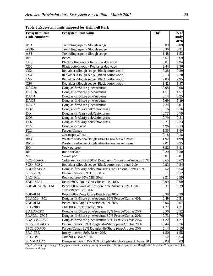
Helliwell Provincial Park Ecosystem Based Plan - March 2001 25
Table 5 Ecosystem units mapped for Helliwell Park
Ecosystem Unit
Code/Number*
Ecosystem Unit Name Ha2 % of
study
area
AS3 Trembling aspen / Slough sedge 0.09 0.09
AS3b Trembling aspen / Slough sedge 0.30 0.31
AS4 Trembling aspen / Slough sedge 1.48 1.53
BE Beach 0.67 0.69
CD5 Black cottonwood / Red osier dogwood 3.81 3.94
CD6 Black cottonwood / Red osier dogwood 3.44 3.56
CS2 Red alder /Slough sedge [Black cottonwood] 0.38 0.39
CS4 Red alder /Slough sedge [Black cottonwood] 2.13 2.20
CS5 Red alder /Slough sedge [Black cottonwood] 2.85 2.95
CS6 Red alder /Slough sedge [Black cottonwood] 1.42 1.47
DAO3a Douglas-fir/Shore pine/Arbutus 0.08 0.08
DAO3b Douglas-fir/Shore pine/Arbutus 1.51 1.57
DAO4 Douglas-fir/Shore pine/Arbutus 3.14 3.25
DAO5 Douglas-fir/Shore pine/Arbutus 5.69 5.89
DAO7 Douglas-fir/Shore pine/Arbutus 7.74 8.01
DO2 Douglas-fir/Garry oak/Oniongrass 0.16 0.16
DO4 Douglas-fir/Garry oak/Oniongrass 0.77 0.79
DO5 Douglas-fir/Garry oak/Oniongrass 0.79 0.81
DO7 Douglas-fir/Garry oak/Oniongrass 15.21 15.73
DS5 Douglas-fir/Salal 4.96 5.13
FC2 Fescue/Camas 1.35 1.40
OR Oceanspray/Rose 0.18 0.18
RK4 Western redcedar/Douglas-fir/Oregon beaked moss/ 1.92 1.99
RK5 Western redcedar/Douglas-fir/Oregon beaked moss/ 7.01 7.25
RO Rock outcrop 8.52 8.81
RP Road surface 0.29 0.30
VP Vernal pool 0.01 0.01
5CO-5DAO3b Cultivated Orchard 50%/ Douglas-fir/Shore pine/Arbutus 50% 0.65 0.67
5CS4-5CS2 Red alder /Slough sedge [Black cottonwood seral 2 &4 0.53 0.54
5DO3b-5FC2 Douglas-fir/Garry oak/Oniongrass 50% Fescue/Camas 50% 0.52 0.54
5FC2-5CL Fescue/Camas 50% Cliff 50% 0.11 0.12
5RO-5CL Rock outcrop 50% Cliff 50% 2.21 2.29
6BE - 4LM Beach 60% Dune Grass/Beach Pea 40% 0.09 0.09
6BE-4DAO3b-1LM Beach 60% Douglas-fir/Shore pine/Arbutus 30% Dune
Grass/Beach Pea 10%
0.37 0.39
6BE-4LM Beach 60% Dune Grass/Beach Pea 40% 0.38 0.39
6DAO3b-4FC2 Douglas-fir/Shore pine/Arbutus 60% Fescue/Camas 40% 0.49 0.51
7BE-3LM Beach 70% Dune Grass/Beach Pea 30% 0.06 0.07
8CL-2RO Cliff 80% Rock outcrop 20% 1.27 1.31
8DAO3-2FC Douglas-fir/Shore pine/Arbutus 80% Fescue/Camas 20% 0.50 0.52
8DAO3a-2FC2 Douglas-fir/Shore pine/Arbutus 80% Fescue/Camas 20% 0.73 0.76
8DAO3b-2FC2 Douglas-fir/Shore pine/Arbutus 80% Fescue/Camas 20% 1.22 1.27
8FC2 - 2DAO3a Fescue/Camas 80% Douglas-fir/Shore pine/Arbutus 20% 9.44 9.76
8FC2-2DAO3 Fescue/Camas 80% Douglas-fir/Shore pine/Arbutus 20% 0.14 0.15
8RO-2BE Rocky outcrop 80% Beach 20% 1.50 1.55
9CL-1BE Cliff 90% Beach 10% 0.52 0.54
9LM-1DAO2 Dunegrass/Beach Pea 90% Douglas-fir/Shore pine/Arbutus 10 0.03 0.03 * 5DAO3b = 5 is percentage of polygon when it is a mix of ecosystem units; DAO is ecosystem unit Douglas-fir/Shore Pine/Arbutus; and 3b is the structural stage

Helliwell Provincial Park Ecosystem Based Plan - March 2001 26
Seventy-six polygons were mapped, 54 (74%) were mapped as pure units (i.e. only one ecosystem), the
rest were complexes of two or three units. The most frequent complex was the DA/02 / FdPl / Arbutus
with the CV/00 / Red fescue / Death camas. These were found on exposed gentle or hummocky slopes
and crest positions. Common also were complexes of the BE/00 / Beach and LM/00 / Dunegrass / Beach-
pea units that occupy narrow shoreline margins that cannot be subdivided at 1: 5 000.
One seral community type was mapped. The CR seral community type persists despite disturbance to the
ecosystem by recreational trampling. This seral community is sparsely interspersed (<5% total cover)
within the extensive FC meadow community that dominates the southwestern area of the park, and has
not been mapped as a separate unit.
Soils are non-existent to very thin sandy veneers that are capable of supporting mat forming carpets of
reindeer lichens (Cladina spp.), broom moss (Dicranum scoparium), and very rarely Wallace‘s
selaginella (Selaginella wallacei). CR occurs on less-disturbed outcropping sandstone and conglomerate
exposed bedrock patches within the FC meadow areas, and its distribution has been reduced to a narrow
margin along the extreme edges of outcropping cliffs and the less frequently used meadow areas in the
southwestern part of the park, where recreational trampling disturbance is less problematic.
While trails and trampling across the open meadow areas have kept succession in check, heavy use has
taken its toll on this fragile plant community. Along with the FC community, the CR community may
continue to persist at the young seral stage, rather than be overtaken by the DAO/02 and DO/03
communities. Management decisions have implications for the Taylor‘s Checkerspot Butterfly, which
requires these open meadows for habitat.
3.4.3 Introduced species, encroachment and trampling
Observations at Helliwell indicate that the FC meadows adjacent to trails are the most heavily impacted
by recreational trampling. On the one hand, it is likely that most of the exotic plant species that are now
ubiquitous in the meadows were introduced from agricultural practices and footwear of visitors. On the
other hand, it is likely that recreational use of the meadows is playing an important role in holding back
succession. Less frequently used parts of the meadows (towards the western boundary of the park) are
slowly being invaded by woody plants such as Douglas-fir, shore pine and arbutus. Wind-pruning and
exposure to severe weather conditions also plays a role in limiting tree growth. One polygon was struck
by fire approximately six years ago and shore pine and other pioneer species are now thriving.
Elsewhere in the park, the forested communities are generally in good to excellent condition. While
selective logging may have occurred in the previous two centuries, recovery and regeneration is well
underway. Deer browse is minimal. Wetland communities are ―off the beaten trail‖ and are in excellent
condition. Only minor alteration of natural drainages has occurred to divert water from trails.
Flora Islet has been heavily impacted in the past by recreational cottage uses. Several years ago a major
effort was made to burn outbuildings and clean-up of debris. Since then the only disturbances are by
recreational visitors (kayakers, scuba divers and wild flower lovers). The islet retains much of its
ecological integrity, and should respond well to restoration efforts. Some exotic species still remain from
the cottage gardens (near the present lighthouse), and should be removed when flowering to avoid mis-
identification.
Bryophytes appear to be the most negatively impacted suite of plants in the park, and are highly
vulnerable to trampling. The very shallow soils over much of St. John‘s Point have become exposed and
the Ah horizon is very visible in many places. To the north of St. John‘s Point, trail compaction and
erosion has exposed midden material on the main trail.

Helliwell Provincial Park Ecosystem Based Plan - March 2001 27
3.4.4 Rare Plant Communities
The Conservation Data Centre (CDC 1999) tracks rare and endangered plant communities throughout the
province. The list and rank of plant associations tracked by the CDC, which were mapped in the study
area follows in Table 6. A full list of rare plant communities for the CDFmm is supplied in Appendix 2. It
should be noted that the CDC natural plant community tracking list is currently incomplete since there is
not yet enough data available for the CDC to rank all of the rare natural plant communities in B.C. This
applies especially to many wetland and non-forested plant communities.
In 2000-2001, Ministry of Forests will be classifying grassland and wetland plant communities
throughout B.C., and this will enable the CDC to produce a more comprehensive natural plant community
tracking list. The rarity ranks of those wetland and non-forested plant communities already on the
tracking list have the "Q" modifier (e.g. S2Q) to indicate that their classification is about to change.
Two previously undescribed plant community types were mapped: five occurrences of the Trembling
aspen / Slough Sedge (AS) wooded wetland; the seral bryophyte association, Cladina / Racomitrium (CR)
in association with the FC community, and the Dunegrass/ Beach-pea (LM) shoreline community. The
LM is relatively common elsewhere, but is rarely mapped and frequently disturbed by recreational beach
use. At Helliwell, the LM is in excellent condition.
The AS community has been placed on the Willamette/Puget/Georgia Ecoregion Vegetation Targets list
by the BC Conservation Data Centre and has been given a tentative rank of S1S2 (Red) and has not yet
been assigned a unit number.
Table 6 Ratings of Plant Associations and relationship to Ecosystem Units mapped in the study area.
Plant Association Common Name Equivalent Site
Series (map code)
CDC
Ranking1
Prov.
Listing
Populus tremuloides / Carex
obnupta
Trembling aspen / Slough
Sedge
CDFmm/00
S1/S2 Red
Populus balsamifera ssp.
trichocarpa / Cornus sericea
Black cottonwood / Red Osier
Dogwood
CDFmm/08 (CD) - -
Alnus rubra / Carex obnupta
[Populus balsamifera Ssp.
trichocarpa]
Red Alder / Slough Sedge
[Black Cottonwood]
CDFmm/14 (CS) S1 Red
Pseudotsuga menziesii / Pinus
contorta / Arbutus menziesii
Douglas-Fir / Lodgepole Pine
/ Arbutus
CDFmm/02 (DA) S2S3 Blue
Pseudotsuga menziesii / Gaultheria
shallon
Douglas-Fir / Salal CDFmm/01 (DS) S1S2 Red
Thuja plicata/Pseudotsuga
menziesii/Kindbergia oregana
Western redcedar / Douglas-
fir/Oregon beaked moss
CDFmm/05 (RK) S1S2 Red
1CDC ranking codes are explained on the CDC website – http://elp.gov.bc.ca/rib/wis/cdc
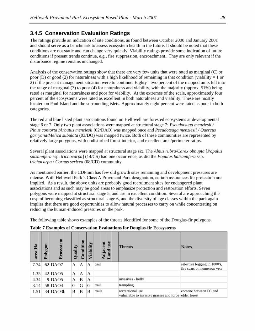
Helliwell Provincial Park Ecosystem Based Plan - March 2001 28
3.4.5 Conservation Evaluation Ratings
The ratings provide an indication of site conditions, as found between October 2000 and January 2001
and should serve as a benchmark to assess ecosystem health in the future. It should be noted that these
conditions are not static and can change very quickly. Viability ratings provide some indication of future
conditions if present trends continue, e.g., fire suppression, encroachment.. They are only relevant if the
disturbance regime remains unchanged.
Analysis of the conservation ratings show that there are very few units that were rated as marginal (C) or
poor (D) or good (2) for naturalness with a high likelihood of remaining in that condition (viability = 1 or
2) if the present management situation were to continue. Eighty - two percent of the mapped units fell into
the range of marginal (3) to poor (4) for naturalness and viability, with the majority (approx. 51%) being
rated as marginal for naturalness and poor for viability. At the extremes of the scale, approximately four
percent of the ecosystems were rated as excellent in both naturalness and viability. These are mostly
located on Paul Island and the surrounding islets. Approximately eight percent were rated as poor in both
categories.
The red and blue listed plant associations found on Helliwell are forested ecosystems at developmental
stage 6 or 7. Only two plant associations were mapped at structural stage 7: Pseudotsuga menziesii /
Pinus contorta /Arbutus menziesii (02/DAO) was mapped once and Pseudotsuga menziesii / Quercus
garryana/Melica subulata (03/DO) was mapped twice. Both of these communities are represented by
relatively large polygons, with undisturbed forest interior, and excellent area/perimeter ratios.
Several plant associations were mapped at structural stage six. The Alnus rubra/Carex obnupta [Populus
salsamifera ssp. trichocarpa] (14/CS) had one occurrence, as did the Populus balsamifera ssp.
trichocarpa / Cornus sericea (08/CD) community.
As mentioned earlier, the CDFmm has few old growth sites remaining and development pressures are
intense. With Helliwell Park‘s Class A Provincial Park designation, certain assurances for protection are
implied. As a result, the above units are probably good recruitment sites for endangered plant
associations and as such may be good areas to emphasize protection and restoration efforts. Seven
polygons were mapped at structural stage 5, and are in excellent condition. Several are approaching the
cusp of becoming classified as structural stage 6, and the diversity of age classes within the park again
implies that there are good opportunities to allow natural processes to carry on while concentrating on
reducing the human-induced pressures on the park.
The following table shows examples of the threats identified for some of the Douglas-fir polygons.
Table 7 Examples of Conservation Evaluations for Douglas-fir Ecosystems
are
a H
a
Po
lyg
on
Eco
syst
em
Qu
ali
ty
Co
nd
itio
n
Via
bil
ity
Ad
jacen
t
La
nd
use
Threats Notes
7.74 62 DAO7 A A A trail selective logging in 1800's,
fire scars on numerous vets
1.35 42 DAO5 A A A
4.34 9 DAO5 A B A invasives - holly
3.14 58 DAO4 G G G trail trampling
1.51 34 DAO3b B B B trails recreational use
vulnerable to invasive grasses and forbs
ecotone between FC and
older forest

Helliwell Provincial Park Ecosystem Based Plan - March 2001 29
0.08 26 DAO3a A A A trails recreational use, residential use krummholz Fd
0.03 54 9LM-
1DAO2
A A A
0.14 55 8FC2-
2DAO3
B B B trails Trampling
vulnerable to invasive grasses and forbs
9.44 25 8FC2 -
2DAO3a
B D D trails heavy trampling, compaction, trail
erosion, recreational use will continue
to impact quality of lich
vulnerable to invasive grasses and forbs
meadow heavily impacted by
trail braiding and recreational
use
1.22 41 8DAO3b-
2FC2
G G G trails recreational use
vulnerable to invasive grasses and forbs
ecotone between FC and
older forest
0.73 40 8DAO3a-
2FC2
A B/
I
E trails fire may have been caused by humans? Excellent pioneer succession
(P. contorta var. contorta)
following fire
0.50 66 8DAO3-
2FC
B B B park, scuba
diving
trampling, introduced invasive weeds
vulnerable to invasive grasses and forbs
Flora Islet, prone to climatic
extremes, outhouse at north
end of polygon
0.49 21 6DAO3b-
4FC2
B B B rural
residential,
trail
residential development to north and
west
vulnerable to invasive grasses and forbs
krummholz Fd, Qg producing
acorns
0.37 49 6BE-
4DAO3b-
1LM
B B B trails trampling, recreational beach use
0.65 57 5CO-
5DAO3b
C C C trail, outhouse,
rural
residential
trampling, introduced agronomic
plants, invasive weeds
preserve orchard or allow
forest succession?
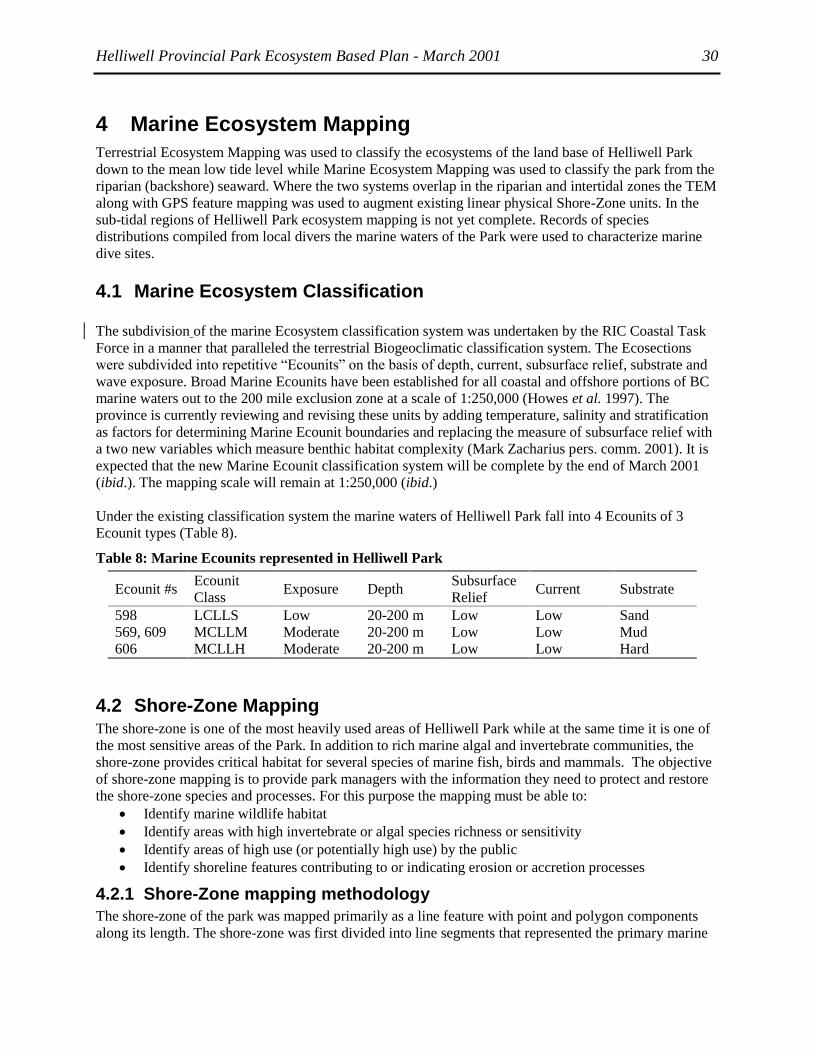
Helliwell Provincial Park Ecosystem Based Plan - March 2001 30
4 Marine Ecosystem Mapping
Terrestrial Ecosystem Mapping was used to classify the ecosystems of the land base of Helliwell Park
down to the mean low tide level while Marine Ecosystem Mapping was used to classify the park from the
riparian (backshore) seaward. Where the two systems overlap in the riparian and intertidal zones the TEM
along with GPS feature mapping was used to augment existing linear physical Shore-Zone units. In the
sub-tidal regions of Helliwell Park ecosystem mapping is not yet complete. Records of species
distributions compiled from local divers the marine waters of the Park were used to characterize marine
dive sites.
4.1 Marine Ecosystem Classification
The subdivision of the marine Ecosystem classification system was undertaken by the RIC Coastal Task
Force in a manner that paralleled the terrestrial Biogeoclimatic classification system. The Ecosections
were subdivided into repetitive ―Ecounits‖ on the basis of depth, current, subsurface relief, substrate and
wave exposure. Broad Marine Ecounits have been established for all coastal and offshore portions of BC
marine waters out to the 200 mile exclusion zone at a scale of 1:250,000 (Howes et al. 1997). The
province is currently reviewing and revising these units by adding temperature, salinity and stratification
as factors for determining Marine Ecounit boundaries and replacing the measure of subsurface relief with
a two new variables which measure benthic habitat complexity (Mark Zacharius pers. comm. 2001). It is
expected that the new Marine Ecounit classification system will be complete by the end of March 2001
(ibid.). The mapping scale will remain at 1:250,000 (ibid.)
Under the existing classification system the marine waters of Helliwell Park fall into 4 Ecounits of 3
Ecounit types (Table 8).
Table 8: Marine Ecounits represented in Helliwell Park
Ecounit #s Ecounit
Class Exposure Depth
Subsurface
Relief Current Substrate
598 LCLLS Low 20-200 m Low Low Sand
569, 609 MCLLM Moderate 20-200 m Low Low Mud
606 MCLLH Moderate 20-200 m Low Low Hard
4.2 Shore-Zone Mapping The shore-zone is one of the most heavily used areas of Helliwell Park while at the same time it is one of
the most sensitive areas of the Park. In addition to rich marine algal and invertebrate communities, the
shore-zone provides critical habitat for several species of marine fish, birds and mammals. The objective
of shore-zone mapping is to provide park managers with the information they need to protect and restore
the shore-zone species and processes. For this purpose the mapping must be able to:
Identify marine wildlife habitat
Identify areas with high invertebrate or algal species richness or sensitivity
Identify areas of high use (or potentially high use) by the public
Identify shoreline features contributing to or indicating erosion or accretion processes
4.2.1 Shore-Zone mapping methodology
The shore-zone of the park was mapped primarily as a line feature with point and polygon components
along its length. The shore-zone was first divided into line segments that represented the primary marine

Helliwell Provincial Park Ecosystem Based Plan - March 2001 31
shoreline mapping units. Physical Shore-Zone units had been previously mapped by the BC Land Use
Coordination Office (LUCO) using the provincial Physical Shore-Zone Mapping system. These line
segments or Physical Shore-Zone units were adopted as the primary marine shore-zone mapping units for
the Helliwell Park EBP.
The Physical Shore-Zone Mapping system is typically done at a scale (1:40,000) and in a manner that
does not show across-shore ecosystem variations that are important for park management. For example
the Parks NE shore, where a transition from coastal grasslands to beach to rock platform occurs is, like all
other units, mapped as a single line. These features are captured in the Terrestrial Ecosystem Mapping
(TEM) where they were mapped as polygon features using 1:5,000 air photos. The TEM mapping was
also used to refine the actual position and shape of the coastline and to correct the locations of break
points of the Physical Shore-Zone units line segments mapped by LUCO that were originally mapped at
much smaller map scale.
Other features that are of significance to marine wildlife and park management were captured as points
collected during field surveys with a GPS. Notes on the distribution of marine flora and fauna were
collected from local interviews and observations during the GPS field survey. Details of the mapping
methods are provided in the following sections.
4.2.1.1 Methods for delimiting Physical Shore-Zone Mapping Units
The Physical Shore-Zone Mapping system developed by the BC Ministry of Environment in 1979 has
been adopted as the standard method for intertidal physical shoreline mapping by the BC Resource
Inventory Committee (RIC) (Howes et al. 1994). The entire coastline of the Strait of Georgia has been
surveyed and mapped using this methodology. The field data are primarily collected using oblique aerial
video imagery (AVI) and incorporated into a GIS at a map scale of typically around 1:40,000. The data,
which are maintained by the Land Use Co-ordination Office (LUCO), were made available for this EBP
of Helliwell Park. The Physical Shore-Zone Units were adopted as the primary Shore-Zone Ecosystem
Mapping Units for Helliwell Park in order to maintain consistency with the existing provincial standards.
In assigning the Shore-Zone Units, the Physical Shore-Zone Mapping system first divides the shore-zone
into Exposure Units. Exposure Units are based on the maximum fetch and modified effective fetch for the
shoreline (see Howes et al. 1993 for an explanation of how these variables are defined). Physical Shore-
Zone units are then nested within Exposure Units with unit boundaries representing a change in the form
or texture of the shore. The physical shore-zone characteristics used to classify the form and texture of the
shorelines include the substrate (rock, rock and sediment, sediment, anthropogenic or current dominated),
sediment type (n/a, gravel, sand/gravel, sand, sand/mud, organics/fines) and width (wide or narrow) and
slope (steep, inclined or flat).
4.2.1.2 Integration of TEM coastal polygons with Physical Shore-Zone Units
The methodology for Terrestrial Ecosystem Mapping (TEM) is outlined in Section 3.3. The small rocks
and drying reefs (e.g. Norris Rocks and Toby Islet) outside of the area mapped by the TEM would each
be represented as a single TEM polygon with Rock and Beach ecotypes present. TEM coastal polygons
were overlaid with the Physical Shore-Zone Units and were used to:
a) Correct the shoreline associated with the Physical Shore-Zone map units.
b) Adjust the Physical Shore-Zone boundaries to match physical shore-zone changes captured at the
more detailed mapping scale.
c) Add a second dimension to the Physical Shore-Zone units (width and indicate how it varies over
the unit length).

Helliwell Provincial Park Ecosystem Based Plan - March 2001 32
d) Map the relative locations of Physical Shore-Zone components (e.g. in the Shore-Zone type ―Cliff
with platform beach‖ the TEM coastal polygons indicate the areas which are cliff and those
which are beach.
Together the TEM and Physical Shore-Zone mapping provide most of the information necessary to
predict coastal processes and wildlife habitats within the park.
4.2.1.3 Shore-Zone Feature Mapping
The combination of TEM and Physical Shore-Zone Unit Mapping still did not capture certain shore-zone
features of the park. These features were therefore recorded separately and mapped at 1:5,000 in
individual map layers as part of this project. Because of the short time frame of the project, information
collected from field surveys of the park using GPS were augmented by local and existing scientific
knowledge of the area. The features that were mapped included:
Marine Wildlife Features
All known marine bird and mammal distributions and known nest, roosting, haulout and rafting sites were
mapped as either polygon or point features. Features were mapped either from 1:5,000 colour air
photographs or from field observation taken from the shore of Helliwell Park November, 2000, with
positions verified using a Trimble GPS. As this survey was limited to a short field reconnaissance in
November 2000, most areas of wildlife use had to be mapped from existing knowledge. Amanda Heath of
Hornby Island Diving provided current information on the locations of many of these wildlife features. A
literature review was completed to locate documentation of former bird colony or marine mammal sites.
A list of the features mapped and data sources used to locate these features is provided in Table 9 below.
Table 9 Shore-Zone features mapped for Helliwell Park and adjacent areas.
Species – stage Feature Type Data
Source
Prickly-pear patches Point 1
Pelagic Cormorant nest sites Point 1, 9, 8
Glaucous-winged Gull nest sites Point 2, 7
Black Oystercatcher nest sites Point 2
Pigeon Guillemot nest sites Point 6
Harlequin Duck rafting or roost sites Polygon 1, 2, 3
Eagle nests Point 1
Eagle perching sites Polygon 2
Harbour seal haulouts Polygon 2, 4
Sea lion haulouts / rafting areas Point 2, 5
River Otter high use areas Polygons, Points 1, 2
Data sources:
1: Field survey Nov. 2000; 2: A. Heath pers. comm. 2000; 3: M. Rodway
pers. comm. 2001; 4: DFO 1988 survey data; 5: DFO 1995 survey data;
6: Emms and Morgan 1989; 7: Vermeer and Devito 1989; 8: Vermeer et
al. 1989; 9: Moul 2000
Areas with high intertidal species richness
Areas with high invertebrate or algal species richness or sensitivity were identified. The timing of this
project (Early October to February when all low tides are at night) precluded any new inventories of the
intertidal. At an open house meeting to present this project, Hornby Island residents were asked to
identify areas of local concern.

Helliwell Provincial Park Ecosystem Based Plan - March 2001 33
Clam beds
Areas of high clam abundance were mapped from the Department of Fisheries and Oceans‘ digital ―Clam
Atlas‖. The clam atlas is compiled by DFO fishery officers and maintained by the shellfish group of the
South Coast Division. Mapping is based on the largest scale hydrographic charts available for the area. In
the region of Helliwell Park this is Chart 3527 at a scale of 1:40,000. No attributes (e.g. species or
harvesting intensity) were provided with the atlas.
Herring spawn
The relative abundance of Herring Spawn was mapped from the DFO database of herring spawn collected
for the entire coast of BC. This database provides records of herring spawn dating back to the 1930s.
Areas of herring spawn are divided into 1-km segments that are referenced to a point in the middle of the
segment. A voronoi map of the point locations was used to cut the TRIM coastline into ≈1 km units
which were classified according to a ―spawn Index‖ that represents the relative magnitude of herring
spawn in that location. The spawn index is a function of the frequency, alongshore width and number of
egg layers of spawn in that location as determined by either fishery officers or dive surveys (Doug Hay
pers. comm. 1996) over the recorded time period to that coastal unit. These points were used based on the
physical habitat characteristics of the shore-zone as could be interpreted from high tide surveys
supplemented by air-photos and other sources such as the DFO Clam atlas.
Areas of potentially high public use or with features related to coastal erosion processes
The main trails within Helliwell Park were mapped using GPS. In shore-zone area of Helliwell Park that
is classified as ―cliff‖, only certain sections of the intertidal shoreline are accessible to the public. Within
units of this type points of accessibility from the backshore to the intertidal were mapped.
Intertidal or backshore features that could affect the rate and extent of erosion or accretion in the
foreshore are of significance to ecosystem based park planning. Features identified in Helliwell Park that
might affect these processes included small culverts, trails, and beach logs.
4.2.2 Results and Discussion of Marine Shoreline Ecosystem Mapping
4.2.2.1 Physical Shore-Zone Mapping Units
In terms of exposure, the shorelines within the park boundaries were rated as either:
Semi-protected: maximum wave fetch distance in the range of 10-50 km. Waves low most of the time
except during high winds.
or semi-exposed exposure: maximum wave fetch distance in the range of 50-500 km. Swells
generated in areas distant from the shore unit create relatively high wave conditions. During storms
extremely high waves may occur.
A total of 8 Physical Shore-Zone Mapping units of 5 different classes fall within the Helliwell Park
boundaries (Table 10). These units are included in the Helliwell Park GIS database as layer
LUCO_shunits.
Helliwell Provincial Park Ecosystem Based Plan - March 2001 34
Table 10: Physical Shore-Zone Units present within Helliwell Park
Unit Key Shoreline Type (Class) Exposure
4064 2: Rock Platform, wide 4: Semi-Exposed
4065 7: Platform with Gravel Beach, wide 4: Semi-Exposed
4079 8: Cliff with Gravel Beach 3: Semi-Protected
4080 5: Rock Platform, narrow 4: Semi-Exposed
4081 3: Rock Cliff, narrow 4: Semi-Exposed
4082 12: Platform with Gravel & Sand Beach, wide 3: Semi-Protected
4083 2: Rock Platform, wide 4: Semi-Exposed
4084 12: Platform with Gravel & Sand Beach, wide 4: Semi-Exposed
The 363 m on the extreme western section of park‘s shoreline coast (Unit key 4080) is classed as a
narrow rock platform. This changes to a narrow rock cliff (Unit key 4081) for the next 1295 m until Boyle
Point where it switches to a wide platform a gravel and sand beach (Unit key 4084) extending past the
north-eastern boundary of the park. Flora Islet is classed as a wide rock platform on the eastern shore
(Unit key 4083) and a wide platform with gravel and sand beach on the semi-protected western shoreline.
When the marine portion of Helliwell Park was established, very little of the Hornby Island shoreline was
included. The only sections of shoreline included in the marine portion of the park, which are not part of
the original terrestrial park or the Flora Islet addition, are on the shores of Norris Rocks and Toby Islet
(Unit keys 4064 and 4065 respectively). Norris Rocks is classed as a wide rock platform and Toby Islet as
a wide platform with a gravel beach.
4.2.2.2 Integration of TEM coastal polygons with Physical Shore-Zone Units
When overlaid with the coastline from either the TRIM or the Physical Shore-Zone Units mapping, the
TEM demonstrated the inaccuracy of their shapes when viewed at a mapping scale of 1:5,000. The most
seaward TEM coastal polygons approximate the low tide mark for Helliwell Park. The air photos from the
TEM was interpreted was taken on July 7, 1997 when the low daytime tide was at 15:22 PDT and was
1.71 meters; between 3 and 5 pm the tides were less than 2 meters. Both the low and high tide boundaries
should be correctly georeferenced using GPS during the low day time tides that occur in early summer.
The breakpoints of the Physical Shore-Zone Units were also modified to match the more accurate
breakpoints mapped by the TEM. In most cases the unit boundaries did not have to be moved more than
20 meters and were mostly related to the difference in the shape and position of the coastline as mapped
by the TEM.
The TEM units that lie along the coast of Helliwell Park (including Flora Islet but not the offshore rocks
and reefs) are shown in below.
4.2.2.3 Shore-Zone Features
Marine Wildlife Features
Within the park boundaries there are 6 shore-zone areas identified that are critical to marine birds and
mammals; all but one of these areas are offshore islets or reefs (Table 11).
Table 11 Areas within Helliwell Park identified as critical to marine wildlife
Area Name Wildlife Values
St. John Pt South
Former nesting site for Pelagic Cormorants, Glaucous-winged gulls,
Pigeon Guillemot on the cliffs; River otter latrine in small bay near Parks
western boundary
St. John Pt. South- Large concentrations of roosting / feeding Harlequin ducks

Helliwell Provincial Park Ecosystem Based Plan - March 2001 35
east shore rock
platforms
Flora Islet and
reefs
Black oystercatcher nest; 150-250 seal haulout; around 50 sea lions
haulout; evidence of high use by River otter; roosting/feeding area for
Harlequin ducks
Norris Rocks
Colony of 250-300 Glaucous-winged gulls, Black oystercatcher nest, Over
2000 sea lions (mixed species) haulout (Oct – April) and 100-150 Harbour
seals haulout (May-Sept)
Heron Rocks 175 Steller/25 California sea lions haulout over all rocks
Nash Rocks Harbour seal haulout
Maude Reef Harbour seal haulout
Nearby areas outside of the park where bird colonies or nesting sites have been recorded were also
mapped. These include:
A Pelagic cormorant colony on Chrome Island off the south tip of Denman Island that had 122 nests
in 1992 (Moul 2000). This colony has not produced any young for the last three years (1998-2000)
(Moul 2000).
A colony on Sisters Island to the east that had 51 nests in 1983 but was abandoned in 1986 (Vermeer
et al. 1989). This site was also recorded as having Pigeon Guillemot and Black Oystercatcher nests.
Solitary nest sites for Glaucous-winged Gulls, Pigeon Guillemot and Black Oystercatchers have also
been recorded at the ferry docks on either side of Denman Island, and on Finnerty and Fegan Islet to
the east.
Harbour seals are common throughout the region year round although some at haulout sites the seals are
seasonal displaced by sea lions. Numerous haulouts have been recorded in the Hornby Island region.
Notable nearby haulouts, outside the park boundaries, include the area between the shores of Hornby
Island and the marine park boundary east of Norman Point, Mud and Union bays on Vancouver Island
and the rocks on the north shore of Hornby Island.
Steller and California sea lions are seasonally present in the region from October until April. While the
sea lions haulout at a few specific locations, radio telemetry studies in the area have shown there is
movement between these sites (Peter Olesiuk pers. comm. 2000).
River Otters are probably use much of the coastline of Denman and Hornby Islands however outside of
the park boundaries only two areas were mapped as an area of high use by River otter. These areas are
found along the shore of Hornby Island between Ford Cove and Norman Point.
Other marine bird concentrations mapped for this project from information provided by Amanda Heath
are listed in Table 12 below and included in the maps of bird concentrations.
Table 12 Other marine bird concentrations in and around marine and coastal portions of Helliwell
Park
Location Comments Timing
Flora Islet Scoters small flocks Nov-March
0.7 to 1 km offshore from south coast
of St. John Point
Marbled Murrelet (50+), Common Loon
(100+), Bonaparte Gull (hundreds) August
Lambert Channel Marbled Murrelet year round
Maude Reef Scoters (mixed) flocks of several 100
feeding Nov-March

Helliwell Provincial Park Ecosystem Based Plan - March 2001 36
Rocky Reef along shore to NW of
Ford Cove
Harlequin Ducks Sept - June
up to 30 Back Oystercatchers on rock Oct-April
Ford Cove by breakwater Cormorants (Brandts, Pelagic, Double-
crested up to 500 for all species in total Oct-April
Along shoreline E of Norman Pnt. Scoters flocks of several 100 feeding Oct-April
On the shore of bay east of Norman
Point Bald Eagles 80-100 perching on trees Jan-March
Channel between Norris and Heron
Rocks Marbled Murrelet year round
Norris Rocks
Pelagic cormorants, Harlequin ducks, Back
oystercatchers, Bald eagles year round
Brandts, Double-crested Cormorants winter roost
In channel between Chrome I. &
Boyle Pnt. Pigeon Guillemot June-July
It is interesting to note that while the historical accounts of the park (Section 2.1.5) recount large numbers
of Brant, these geese do not concentrate around Hornby today although large flocks land at Qualicum to
the south on Vancouver Island. While the historic accounts indicate that smaller numbers of Mallards,
Goldeneye and Bufflehead Ducks were present, there is no mention of the distinctive Harlequin duck in
any of the species lists from the first half of the 20th century (see Section 2.1.5). Given that in recent year,
flocks of up to 5,000 Harlequin Ducks have been sighted around Hornby Island, it is unlikely that these
large flocks would have been missed. The conclusion is that waterfowl species compositions have likely
changed over the past 50 years.
Areas with high intertidal species richness
There were no intertidal surveys done as part of this project due to the short time frame in which there
were no low daytime tides. The one habitat identified by residents at the public meetings was the area of
caves present along the south shore of St. John Point (physical shore-zone unit 4081). These caves are
thought to support an especially rich intertidal community.
Clam beds
The Department of Fisheries and Oceans digital ―Clam Atlas‖ of all commercial, first nations and
recreational clam beds in the South Coast region did not indicate clam beds with the park boundaries. The
presence of large shell middens in the park combined with the TEK (Section 2.1.4) indicates that First
Nations people in or around the park area harvested clams. At the turn of the century a Comox family had
a campsite on St. John Point. Clam shells found in middens on St. John Point could have come from the
nearby Tribune or Whaling Station Bays or from one of the clam beds indicated by the Clam Atlas on the
north and west shores of Hornby Island.
Herring spawn
Herring spawn is found along the entire coastline of Denman and Hornby Islands. Although not all areas
have spawn deposits every year, there has been a nearly continuous record of spawning in this area
(Herring Fisheries Management Area 142) since 1928 with only one 3-year gap from 1968-70 (Hay et al.
1989). This area has the largest and most consistent herring spawn deposit in British Columbia (Hay et al.
1989). The mean spawning time for the area is mid-March.
The spawn index is moderate (rated as 3 on a scale of 1-6) along most of the south shore of St. John Point
and on Norris Rocks. The index is higher (4) on the northeast shore of the point and around Flora Islet

Helliwell Provincial Park Ecosystem Based Plan - March 2001 37
and rocks. Outside of its significance to the Strait of Georgia herring populations, the herring spawn is an
important seasonal food source for scoters, gulls and Harlequin Ducks in the region.
Areas of potentially high public use or with features related to coastal erosion processes
Trails along the coastal bluffs and points along the trails where beach access occurs were mapped for this
project using GPS. The erosion along the coastal trails was expressed as an area of concern during the
public consultation (Section 2). There is only one location along the south shore of St. John Point where
the beach is accessible; this point of access (in Physical Shore-Zone unit 4080) shows considerable use
and as evidence by the erosion of the path.
The trails along the top of the cliffs has the greatest human use; photos in the photo galley document the
trail pre- and post ―season‖ shown the degree of erosion resulting from heavy summer use. Access to the
beach is possible along most of Physical Shore-Zone unit 4084. Disturbance of wildlife, which includes
Harlequin ducks and Harbour seals, along this unit length in (TEM polygons 48, 52 and 75) is of greater
concern in this unit than is erosion.
Based on the Physical-zone mapping, all of the islets and rocks contained in Helliwell Park are accessible
by small boat or kayak along most of their shoreline.
This project was not intended to include a geotechnical analysis however certain features related to
coastal erosion were noted during it course. Beach logs, which may help to stabilize the high tide
shoreline, were most evident in the park in Physical Shore-Zone unit 4084 where they abundant in TEM
polygons 45, 49 and 53. Small culverts were noted in some areas along the paths however due to their
cryptic nature they were not consistently located and therefore not mapped for this project. Evidence of
erosion was seen in along Physical shore-zone unit 4081 where large boulders have broken off the cliff
(see discussion in Terrestrial Ecosystem mapping, section 3).

Helliwell Provincial Park Ecosystem Based Plan - March 2001 38
5 Wildlife Inventory and Ecology
5.1 Existing Records of Terrestrial and Marine Species Helliwell Provincial Park has a rich and diverse wildlife community. The inventory of flora and fauna of
the park is far from complete with very little data on many organisms, e.g., invertebrates, fungi, algae.
The existing data collected is compiled in several lists in Appendix 2 (Terrestrial) and 3 (Marine). .
List of Terrestrial Flora
Source of Terrestrial Flora
List of Terrestrial Fauna
Source of Terrestrial Fauna
List of Marine Flora and Fauna
The following section describes the sources and summarizes the species by groups that have been
inventoried to date in the park, probable and confirmed. The objectives are to
provide baseline data on presence of species to monitor impacts of climate change, disturbance
and succession.
identify gaps in the understanding of Helliwell‘s biodiversity
track loss of biodiverisity with comparison to paleoecological and historical accounts
,identify future research on inventories and population distribution.
5.1.1 Flora
5.1.1.1 List of terrestrial and marine flora and sources
The list of flora includes 313 species of vascular plants from 59 families Appendix 2. The variety of
species demonstrates the range of ecological habitats within Helliwell Park from fresh and saltwater
marshes, to dry grasslands and rocky bluffs. The Source List (Appendix 2) indicates the inventory source
for each of the species identified. The species list also includes common names.
The list of terrestrial flora is a compilation of various inventories, derived from both historical (those prior
to 1975) and more recent sources. There are four historical references (referred to in Section 2) annotated
as ―Hist.‖ in the list (Carey 1875, anonymous 1940s, Duncan 1937, Sharcott 1954, 1966).
Five recent sources of vegetation data are included in this inventory compilation. The most detailed recent
inventory is that of local Hornby botanist, Richard Martin (RM), who has been compiling a list of plants
for Hornby over the past 15 years. In 1999, Andy Wheatley (AW) completed a report for a university
course, titled "Footprints on Helliwell Park", that included a vegetation inventory. This inventory
indicates the frequency of these plants in the park. A vegetation inventory was also included in a BC
Parks report, believed to be written by Mike Wolfe (MW), based on his observations within the park, June
2 to August 28 1977. Wolfe's inventory indicates sites where the plants are found, plant phenology over
the summer period, and the frequency of the plants in the park. Information about rare species from the
Conservation Data Centre (CDC) is added to the compilation, as is data from the Terrestrial Ecosystem
Mapping work completed by Kathy Dunster (KD) and wildlife review Jenny Balke (JB), for this project.
Field notes were reviewed from Wayne Erickson and Hans Roemer for the adjacent High Salal
―Thousand Oak Meadow‖ and were cited in the Rare Flora List in Appendix 2 as ‗adjacent‘.
In the marine inventory two species of marine vascular plants were confirmed and 13 marine algae.

Helliwell Provincial Park Ecosystem Based Plan - March 2001 39
5.1.1.2 Rare floral species:
A total of five Red-listed and nine Blue-listed plants are recorded for Helliwell Park in the inventory
compilation. RM noted four Red-listed plants and nine Blue-listed plants. CDC records have information
on one additional Red-listed and two previously-noted Blue-listed vascular plant species, as well as, one
Red-listed plant association. The individual rare species are listed below in Table 13 Rare flora of
Helliwell Provincial Park. Data of distribution in the park will rely on spring fieldwork. The only Red-
listed plant association in the CDC's database is Douglas-fir – Garry Oak / Alaska Oniongrass,
Pseudotsuga – Quercus garryana / Melica subulata.
Table 13 Rare flora of Helliwell Provincial Park.
RARITY FAMILY LATIN NAME COMMON NAME
Red Portulacaceae (Purslane Family) Montia howellii Howell‘s Montia
Red Carophyllaceae (Pink Family) Sagina decumbens ssp
occidentalis
Creeping/Western
Pearlwort
Red Umbelliferae/Apiaceae (Carrot/Parsley
Family) Sanicula bipinnatifida Purple Sanicle
Red Leguminosae/Fabaceae (Pea Family) Trifolium depauperatum Poverty Clover
Red Juncaginaceae (Arrow-grass Family) Triglochin concinnum var.
concinnum Graceful Arrow-grass
Blue Cruciferae (Mustard Family) Arabis hirsuta Hairy Rockcress
Blue Primulaceae (Primrose Family) Centunculus minimus Dwarf Chaffweed
Blue Polypodiaceae (Common Fern Family) Dryopteris arguta Coastal Shield Fern
Blue Campanulaceae (Harebell Family) Heterocodon rariflorum Heterocodon
Blue Isoetaceae (Quillwort Family) Isoetes nuttallii Nuttall‘s Quillwort
Blue Juncaceae (Rush Family) Juncus arcticus Arctic Rush
Blue Ranunculaceae (Buttercup Family) Myosurus minimus Least Mousetail
Blue Hydrophyllaceae (Waterleaf Family) Nemophila pedunculata Meadow Nemophila
Blue Violaceae (Violet Family) Viola howelli Howell‘s Violet
5.1.1.3 Introduced Floral Species:
The list of flora documents 65 introduced species. These species are indicated on the complete list and
noted as introduced. A further discussion is written up of introduced species posing a risk to native
species in Section 5.4.
5.1.2 Fauna
5.1.2.1 List of terrestrial and marine fauna and sources
The list of fauna, Appendix 2 and 3 contains 380 potential species; 311 of these species are confirmed
within the Park. The list includes terrestrial species, as well as marine mammals, invertebrates, fish and
birds. This list only deals with 2 known and rare terrestrial invertebrates. The number of species, in each

Helliwell Provincial Park Ecosystem Based Plan - March 2001 40
wildlife-category documented in this section of the report, is listed in Table 14. A Source List is also
included in Appendix 2, and indicates the inventory source for each of the wildlife species identified.
The list of terrestrial fauna is also a compilation of historical (prior to 1975) and more recent inventories.
The historical list includes "potential" species whose known range could include Helliwell. Historical
accounts, e.g., Sharcott, document wildlife within the park. All historical accounts are listed under one
source in the list with the exception of the field notes of noted naturalist and birder, Walter Fitzpatrick
(WF) from 1973 to 1988. These notes are included as a separate field in the table.
Recent inventories include a variety of entries. Wolfe (MW) reports a number of terrestrial invertebrates,
(not recorded here as the compiled fauna list includes only rare invertebrate species). Wolfe also records
both observed locations and, when possible, a description of the reproduction of the wildlife species.
Observations collected monthly by naturalists on Hornby for the on-going Coastal Waterbird Survey
(CWS), sponsored by Bird Studies Canada, are included. Data from a study of bird species from Heron
Rocks, SW Hornby, by Denman naturalist, Mike Morrell (MM), are entered as "possible" species for the
terrestrial and "confirmed" for the marine species that are within the Park. Notes of species seen by High
Salal Ranch personnel, from Denman Island observations, and from range descriptions are included as
"potential" for the Park. Observations of wildlife made during the study are also entered.
All marine species were based on records of Hornby Island Diving Charter and compiled by Amanda
Heath. Only species which have definitely been seen within the park were included in this list. A
complete list of all species is included in Appendix 3 that also indicates habitats and locations where these
species are found in the park. The inventory is biased towards visible epibenthic (surface dwelling) and
pelagic species that are seen by divers and focuses on reef areas.
Table 14 Number of potential and confirmed wildlife species (total / confirmed)
All species Mammals Birds Reptiles &
Amphibians Invertebrates* Fish*
Terrestrial 136 / 59 21 / 6 105 / 67 8 / 4 2 -
Marine 67 / 53 10 / 4 59 / 51 None 135 / 135 40
TOTAL 205 / 112 31 / 10 164 / 118 8 / 4 N/A N/A
*Only rare terrestrial invertebrates were included and only known marine invertebrates and fish were
included.
5.1.2.2 Rare species
Helliwell Provincial Park provides habitat for potentially twenty-seven rare wildlife species; seventeen of
these are confirmed within the Park. Eight species are Red-listed, six of these are confirmed; sixteen are
Blue-listed, nine of these are confirmed; three are S3 species noted by the BC Conservation Data Centre,
two of these are confirmed. Overall the list includes five rare mammals, twenty rare birds and two rare
invertebrates. A complete list of the rare species is contained in Table 15.

Helliwell Provincial Park Ecosystem Based Plan - March 2001 41
Table 15 Rare fauna of Helliwell Provincial Park.
GENUS & SPECIES RARITY Confirmed
Common Name Latin Name
Brandt's Cormorant Phalacrocorax penicillatus RED-listed *
Common Murre Uria aalge RED-listed *
Keen's Long-eared Myotis Myotis keenii RED-listed
Marbled Murrelet Brachyramphus marmoratus RED-listed *
Northern Goshawk Accipiter gentilis RED-listed
Northern Sea Lion/Steller Sea Lion Eumetopias jubatus RED-listed *
Taylor's (Edith's) Checkerspot Euphydryas editha taylori RED-listed *
Western Grebe Aechmophorus occidentalis RED-listed *
Western Screech-Owl Otus kennicottii RED-listed
(subspecies)
.
California Gull Larus californicus BLUE-listed *
Caspian Tern Sterna caspia BLUE-listed
Doubled-crested Cormorant Phalacrocorax auritus BLUE-listed *
Great Blue Heron Ardea herodias BLUE-listed *
Harbour porpoise Phocoena phocoena BLUE-listed
Humpback whale Megaptera novaeangliae BLUE-listed
Hutton's Vireo Vireo huttoni BLUE-listed *
Killer whale Orcinus orca BLUE-listed *
Oldsquaw Clangula hyemalis BLUE-listed *
Peregrine Falcon Flaco peregrinus BLUE-listed
Propertius Duskywing Erynnis propertius BLUE-listed *
Sandhill Crane Grus canadensis BLUE-listed
Short-eared Owl Asio flameus BLUE-listed
Surf Scoter Melanitta perspicillata BLUE-listed *
Townsend's big-eared Bat Plecotus townsendii BLUE-listed
Wandering Tattler Heteroscelus incanus BLUE-listed *
Harlequin Duck Histrionicus histrionicus S3 *
Pelagic Cormorant Phalacrocorax pelagicus S3 *
Snowy Owl Nyctea scandiaca S3
5.1.2.3 Introduced species
Six species of introduced terrestrial-wildlife in addition to domestic dogs and cats are potentially within
Helliwell Park; three of these species are confirmed in the Park. These species are listed below in
Table 16. A longer discussion of Introduced fauna is written up in 5.4

Helliwell Provincial Park Ecosystem Based Plan - March 2001 42
Table 16 Introduced terrestrial fauna in Helliwell Provincial Park.
Common Name Latin Name Confirmed
North American Opossum Didelphis virginiana *
Norway Rat Rattus norvegicus *
Black Rat Rattus rattus
Ring-necked Pheasant Phasianus colchicus
Rock Dove Columba livia
European Starling Sturnus vulgaris *
5.2 Shortened Species Accounts The challenge of managing the two hundred plus recorded larger fauna species within Helliwell
Provincial Park is daunting. To facilitate developing basic management principles that will encompass the
significant habitat elements of Helliwell Park, seven key species were selected for which detailed species
accounts were written:
Harlequin Duck
Northern Alligator Lizard.
Pacific Treefrog
Pelagic Cormorant
Propertius Duskywing
Taylor's Checkerspot
Townsend's Big-eared bat
These species were selected to assist managers planning for a range of ecosystems in Helliwell Park and
understanding the range of issues facing the park. Each species represents specific habitats within
Helliwell Park, e.g., treefrogs use both wetland and forest; lizards use both rocky outcrops and coarse
woody debris of older trees; the two butterflies are recommended by the Garry Oak Ecosystem Recovery
Team (Marilyn Fuchs pers. comm. 2000) as indicators of functioning grassland and Garry oak
ecosystems; cormorants and harlequins are both terrestrial and marine using cliffs and rocky shores
respectively. Five of these species are at risk (yellow to red-listed) and most of the critical habitats are
sensitive or at risk.
Full species accounts are in Appendix 6. Shortened species accounts for each of these species are
included in this section. These accounts describe the life histories of these species in terms of type of
habitat. Also the timing of activities within the life cycles of these species is recorded, to illustrate the
seasonality of impacts from human disturbances. There is a discussion following this section of the
habitat requirements of other significant species. All accounts include some management considerations
and recommendations.

Helliwell Provincial Park Ecosystem Based Plan - March 2001 43
5.2.1 Taylor's Checkerspot Euphydryas editha taylori
Taylor's Checkerspot is a Red-listed invertebrate. The meadows in and adjacent to Helliwell Park remain
one of the last sites for this subspecies in the world. This site may be the only one that can sustain the
population; although smaller populations were observed on Hornby, in Tribune Bay Provincial Park and
on a powerline right-of-way. Table 17 and Table 18 outline the major management issues and significant
timing of activities in the critical habitats for the Taylor's Checkerspot.
Table 17 Critical Habitat and Timing for the Management of Taylor's Checkerspot.
SITE / FEATURE ACTIVITY TIME ISSUES
OPEN MEADOW &
GARRY OAK
MEADOW
With
Larval food plants
(Plantains /
Owlclovers)
Larval feeding (need to consume
enough to
become sufficient
size to survive
estivation &
hibernation
March-April
May-August
1. Availability of food plants. Depends on: previous
winter's moisture level & spring/summer moisture,
lack of plant competitors. 2. Uninhibited movement to
best feeding and diapause sites. Depends on: limited
tramping deaths, reduced vegetative impediments. 3.
Reduced predation. Depends on low predation
pressure particularly from introduced species e.g.
opossum. 4. Adequate security cover. Depends on
healthy plant mass.
Larval diapause (estivation &
hibernation)
July-Aug.
Sept.-
February
1. Limited predation. Depends on low predation
pressure particularly from introduced species e.g.
opossum. 2. Adequate security cover. Depends on
adequate litter layer and healthy food-plant mass.
Eggs (fixed to
larval food
plants)
April-June 1. Limited predation. Depends on low predation
pressure particularly from introduced species e.g.
opossum. 2. Adequate security cover. Depends on
healthy food-plant mass.
Pupae (below
larval plants)
March-May 1. Limited predation. Depends on low predation
pressure particularly from introduced species e.g.
opossum. 2. Adequate security cover. Depends on
adequate litter layer and healthy food-plant mass.
OPEN MEADOW &
GARRY OAK
MEADOW
with
Adults' nectar plants
Adults feeding,
breeding and
laying eggs.
(More nectar
consumed = more
& larger eggs)
April-June 1. Availability of nectar plants. Depends on: previous
winter's moisture level & spring/summer
climate/moisture, lack of plant competitors. 2.
Uninhibited egg laying. Depends on minimal
disturbance. 3. Limited predation. Depends on low
predation pressure particularly from introduced
species e.g. opossum. 4. Adequate security cover.
Depends on healthy food-plant mass.
Table 18 Timeline of Checkerspot Activities
ACTIVITY Jan Feb Mar Apr May Jun July Aug Sep Oct Nov Dec
Egg
Larva*
Pupa
Adult
(* For Larva feeding activity approximate diapause/ estivation or hibernation)

Helliwell Provincial Park Ecosystem Based Plan - March 2001 44
Figure 6: Habitat areas for Taylor's Checkerspot Butterfly in Helliwell Provincial Park
5.2.1.1 Additional management notes include:
Larvae may survive light surface fires, in winter, if they are deep in the leaf litter (C. Guppy pers.
comm. 2000). Before burning takes place, the presence of sufficient numbers of larvae, outside
the burn-zone must be ensured.
The application of Bt of other insecticides at any time of the year would be highly detrimental to
the Checkerspot population (ibid.).
The application of herbicides would be detrimental if the larval food-plant or nectar plants, or the
eggs/larvae/pupae/adults are detrimentally affected (ibid.).
5.2.1.2 Management questions remaining to be answered:
What other plants serve as larval food plants and nectar plants for the Checkerspot in Helliwell
Park?
What degree of trampling of larvae and disturbance of adults exists in Helliwell?
How is the population changing year to year?
How, where and when are the major movements of larvae? What are the facilitators and
impediments to their movements?
5.2.1.3 Possible enhancement activities may involve:
Encourage larval food-plants and nectar plants by opening up the grasslands, and removing or
limiting invasive plants.
Actively plant larval food-plants and nectar plants.
Possibly, water critical areas of food and nectar plants during excessively dry seasons.

Helliwell Provincial Park Ecosystem Based Plan - March 2001 45
Monitoring of the population within and adjacent to Helliwell Park will improve the understanding of the
butterfly population. Care must be taken to conduct the monitoring with the least disruption to the
Checkerspots. A recommendation is that one individual be responsible for counting adults or larvae.
Other individuals would be discouraged from counting the population, but encouraged to observe
individual larvae or butterflies and to make records of the animals' activities, in a way that is extremely
sensitive to the disruption of other butterflies and their habitat.
5.2.2 Propertius Duskywing Erynnis propertius
The Propertius Duskywing is a Blue-listed butterfly which is dependent on Garry Oak habitat. The most
recent survey, in 1995, found only six good sites for this butterfly on southern Vancouver Island, and one
of these is Helliwell Park. Table 19and Table 20 outline the major management issues and significant
timing of activities in the critical habitats for the Propertius Duskywing.
Table 19 Critical Habitat and Timing for the Management of the Propertius Duskywing
SITE / FEATURE ACTIVITY TIME ISSUES
GARRY OAK
MEADOW & SHRUB-
FOREST with Larval
food plants (Garry
Oaks)
Larval feeding (need to consume
enough to
become sufficient
size to survive
estivation &
hibernation
May-
July/early
August
1. Availability of food plants. Depends on:
health of Garry Oaks (these larvae may require
young leaves).
2. Reduced predation. Depends on low
predation pressure particularly from introduced
species e.g. opossum.
3. Adequate security cover. Depends on health
of Garry Oaks and accompanying shrubs.
Larval diapause (estivation &
hibernation)
July-Aug.
Sept.-
February
1. Limited predation. Depends on low predation
pressure, particularly from introduced species
e.g. opossum.
2. Adequate security cover. Depends on
adequate litter layer at base of Garry Oaks.
Eggs (fixed to
larval food
plants)
April-June 1. Limited predation. Depends on low predation
pressure, particularly from introduced species
e.g. opossum.
2. Adequate security cover. Depends on health
of Garry Oaks.
Pupae (below
larval plants)
March-May 1. Limited predation. Depends on low predation
pressure, particularly from introduced species
e.g. opossum.
2. Adequate security cover. Depends on
adequate litter layer at base of Garry Oaks.
OPEN MEADOW &
GARRY OAK
MEADOW & FOREST
with Adults' nectar
plants
Adults feeding,
breeding and
laying eggs.
(More nectar
consumed = more
& larger eggs)
April-July 1. Availability of nectar plants. Depends on:
previous winter's moisture level &
spring/summer climate/moisture, lack of plant
competitors.
2. Uninhibited egg laying. Depends on
minimal disturbance.
3. Limited predation. Depends on low predation
pressure particularly from introduced species
e.g. opossum.
4. Adequate security cover. Depends on health
of Garry Oaks.

Helliwell Provincial Park Ecosystem Based Plan - March 2001 46
Table 20 Timeline of Duskywing activities.
ACTIVITY Jan Feb Mar Apr May Jun July Aug Sep Oct Nov Dec
Egg
Larva*
Pupa
Adult
(For Larva known feeding activity approximate diapause/ estivation or hibernation)
Figure 7 Habitat areas for Propertius Duskywing Butterfly in Helliwell Provincial Park
5.2.2.1 Additional management notes
Larvae will survive light surface fires in the meadows in winter, as long as the fire does not
threaten the litter at the base of the Garry Oak trees.
The application of Bt of other insecticides at any time of the year would be highly detrimental to
the Duskywing population within Helliwell.
The application of herbicides would be detrimental if the larval food-plant or nectar plants, or the
eggs/larvae/pupae/adults are detrimentally affected (C. Guppy pers. comm. 2000).
5.2.2.2 Management needs and questions
Confirm the species of plants that Duskywings are using as nectar plants in Helliwell Park.

Helliwell Provincial Park Ecosystem Based Plan - March 2001 47
Confirm the location of pupation and larval hibernation to ensure that protecting the bases of
Garry Oaks also protects Duskywing larvae and pupae.
What degree of disturbance of adults exists in Helliwell?
How is the population changing year to year?
5.2.2.3 Possible enhancement activities may involve:
Enhancing the growth of nectar plants in meadows by planting native species and removing or
limiting invasive plants.
Encourage the growth and health of Garry Oak trees.
Possibly, water critical areas of nectar plants during excessively dry seasons.
Monitoring the adult Duskywing population will require attention to the disruption potentially
caused to the Checkerspots.
5.2.3 Northern Alligator Lizard Gerrhonotus coeruleus
Northern Alligator Lizards, while not listed as rare, occupy a limited range in southern BC and are
susceptible to human disturbance. They tolerate cooler and more moist environments than other lizards,
and are uniquely adapted to using habitats composed of forests as well as rocky bluffs and outcrops.
Table 21 . Critical Habitat and Timing for the Management of the Northern Alligator Lizard.
SITE / FEATURE ACTIVITY TIME ISSUES
ROCKY BLUFFS &
OUTCROPS Hibernating
(possibly mating
and bearing
young)
Nov-Feb
(Apr-June &
Aug-Sept)
1. Adequate security cover. Depends on:
available habitat structure, freedom from
disturbance, correct temperature
Foraging,
basking,
sheltering
March-Oct 1. Available and sufficient invertebrate prey.
2. Limited predation. Depends on low predation
pressure particularly from introduced species
e.g. opossum, as well as dogs and cats.
3. Adequate security cover. Depends on
available habitat structure.
MEADOWS Foraging March-Oct 1. Available and sufficient invertebrate prey.
2. Limited predation. Depends on low predation
pressure particularly from introduced species
e.g. opossum, as well as dogs and cats.
FOREST Large Coarse
Woody Debris
Foraging,
Sheltering
March-Oct 1. Available and sufficient invertebrate prey.
2. Limited predation. Depends on low predation
pressure particularly from introduced species
e.g. opossum, as well as dogs and cats.
3. Adequate security cover. Depends on
available habitat structure.
FOREST Large Coarse
Woody Debris Hibernating
(possibly mating
and bearing
young)
Nov-Feb
(Apr-June &
Aug-Sept)
1. Adequate security cover. Depends on:
available habitat structure, freedom from
disturbance, correct temperature

Helliwell Provincial Park Ecosystem Based Plan - March 2001 48
Table 22 Timeline of Northern Alligator Lizard Activities
ACTIVITY Jan Feb Mar Apr May Jun July Aug Sep Oct Nov Dec
Hibernating
Foraging & sheltering
Mating
Bearing young
Habitats
Figure 8 Habitat areas for Northern Alligator Lizard in Helliwell Provincial Park
5.2.3.1 Additional management notes include:
Alligator lizard populations are closely linked to the invertebrate population.
Undisturbed rocky bluffs, outcrops, and large woody debris are very significant features for these
lizards. To disturb a female as she emerges from her winter hibernation can have an impact on the
total breeding success of that female over her life and even influence the population.
5.2.3.2 Management needs and questions
Are Alligator lizards still present in Helliwell Park?
Are opossums, feral cats and free-ranging dogs significant predators on lizards within the Park?
Is the increasing population of Barred Owls affecting the lizard population within the Park?
Where are key hibernating, basking, foraging, sheltering areas for lizards within the Park?
5.2.3.3 Possible assessment and enhancement activities may involve:
A very sensitive population assessment and monitoring program.
Isolating proven hibernation site(s).

Helliwell Provincial Park Ecosystem Based Plan - March 2001 49
Ensuring that large coarse woody debris is allowed/encouraged to accumulate in the forest as
sheltering and hibernating habitat.
5.2.4 Pacific Treefrog Pseudacris (Hyla) regilla
The Pacific Treefrog is also not at risk in BC, but the treefrog requires aquatic habitat, scarce in Helliwell
Park and on Hornby, to complete its life cycle. The treefrog is linked to this limited habitat while also
using the entire park.
Table 23 Critical habitat and timing for the habitat of Pacific Treefrog
SITE /
FEATURE ACTIVITY TIME ISSUES
Standing
water
Adults mating
& egg-laying.
Mar-June
temperature
dependent
Availability of unpolluted, fresh water with vegetation cover
Availability of invertebrate prey.
Adequate security cover. Depends on water depth and
vegetative cover.
Limited predation by garter snakes, opossums, waterbirds
(e.g. herons).
Larval feeding
&
development.
Apr-Aug
temperature
dependent
Availability of unpolluted, fresh water with vegetation cover.
Availability of algae and soft-bodied vascular plants.
Adequate security cover. Depends on water depth and
vegetative cover.
Limited predation by garter snakes, opossums, waterbirds
(e.g. herons).
Forest trees,
foliage,
ground
Adults
foraging,
sheltering
Year-round
Availability of adequate invertebrate prey.
Adequate security cover.
Limited predation. Depends on low predation pressure.
Forest ground,
coarse woody
debris
Adults
hibernating
Extremely
cold periods
Nov-Mar
Adequate security cover. Depends on available habitat
elements (e.g. coarse woody debris)
Limited predation. Depends on low predation pressure
Table 24 Timeline of Pacific Treefrog Activities
ACTIVITY Jan Feb Mar Apr May Jun July Aug Sep Oct Nov Dec
Hibernating if extremely cold
Adults foraging,
sheltering on land
breeding adults in water
Mating & egg laying
Larvae hatch & develop
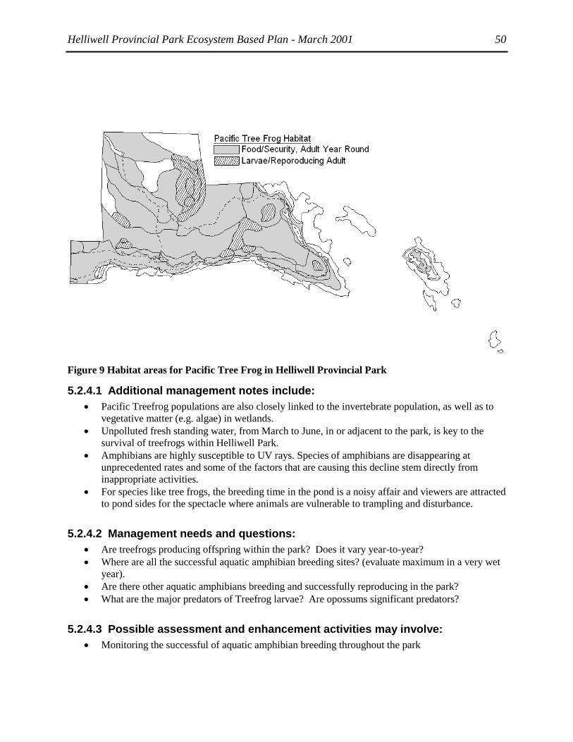
Helliwell Provincial Park Ecosystem Based Plan - March 2001 50
Figure 9 Habitat areas for Pacific Tree Frog in Helliwell Provincial Park
5.2.4.1 Additional management notes include:
Pacific Treefrog populations are also closely linked to the invertebrate population, as well as to
vegetative matter (e.g. algae) in wetlands.
Unpolluted fresh standing water, from March to June, in or adjacent to the park, is key to the
survival of treefrogs within Helliwell Park.
Amphibians are highly susceptible to UV rays. Species of amphibians are disappearing at
unprecedented rates and some of the factors that are causing this decline stem directly from
inappropriate activities.
For species like tree frogs, the breeding time in the pond is a noisy affair and viewers are attracted
to pond sides for the spectacle where animals are vulnerable to trampling and disturbance.
5.2.4.2 Management needs and questions:
Are treefrogs producing offspring within the park? Does it vary year-to-year?
Where are all the successful aquatic amphibian breeding sites? (evaluate maximum in a very wet
year).
Are there other aquatic amphibians breeding and successfully reproducing in the park?
What are the major predators of Treefrog larvae? Are opossums significant predators?
5.2.4.3 Possible assessment and enhancement activities may involve:
Monitoring the successful of aquatic amphibian breeding throughout the park

Helliwell Provincial Park Ecosystem Based Plan - March 2001 51
Ensuring that large coarse woody debris is allowed/encouraged to accumulate in the forest as
sheltering and hibernating habitat.
5.2.5 Townsend's Big-eared Bat Corynorhinus townsendii
The Townsend's Big-eared Bat is Blue-listed in BC. Hornby is included in an ongoing research project
on the presence and reproduction of this bat. The bat has been found on Hornby in 2000 and a large
breeding colony was located on Denman. This highly mobile bat is particularly adapted to foraging over
fields and through open forest and shrub lands. The meadow and Garry Oak forests of Helliwell seem
particularly suited to this bat.
Table 25 Critical Habitat and Timing for the Management of Townsend’s Big-eared Bat
SITE / FEATURE ACTIVITY TIME ISSUES
Meadows, shrub lands
& open forest
Adults foraging May-Oct Availability of invertebrate prey.
Wetlands Adults foraging May-Oct Availability of unpolluted, fresh water.
Availability of water breeding and foraging insects.
Forest old-growth trees
rocky crevices
Adults
sheltering
May-Oct Adequate security cover.
Limited predation. Depends on low predation
pressure.
Large secluded
Structure e.g. old
building in vicinity?
Females rearing
young
June-
August
Adequate security cover. Depends on available
structure. Suitable temperature.
Limited predation. Depends on low predation
pressure.
Table 26 Timeline of Townsend’s Big-eared Bat
ACTIVITY Jan Feb Mar Apr May Jun July Aug Sep Oct Nov Dec
Adults foraging,
sheltering
Females rearing young
Hibernating
.

Helliwell Provincial Park Ecosystem Based Plan - March 2001 52
Figure 10 Habitat areas for Townsend’s Big-eared Bat in Helliwell Provincial Park
5.2.5.1 Additional management notes include:
The use of pesticides or herbicides within or adjacent to the park would be detrimental to the prey
or the lives of Townsend's Big-eared Bats.
The points of contact that most people have with bats are at roosts. Like other colony roosters, if
one wakes up then they all are likely to wake up. Colonies are comprised of a high percentage of
a species‘ population. A disturbance can have an impact on the species as a whole. Females get
together in what are known as maternity roosts. Females and babies are just as vulnerable to
disturbance and one loud person can cause a whole year of young to be put at risk.
5.2.5.2 Management needs and questions to be answered
Are Townsend's Big-eared Bats present in Helliwell Park?
Are the bats foraging and roosting within the park? What are the key areas?
Do they use the small wetlands within the park as a water source or are they traveling outside the
park for water?
Are opossums or feral cats predators roosting Townsend's Big-eared bats?
5.2.5.3 Possible assessment and enhancement activities may involve:
Mist netting in the park as well as monitoring of the bats foraging activities may reveal whether
the bats are present and where they go.
Protection and enhancement of roost sites.
May consider the creation of a roost of sufficient size and qualities for a nursery roost.

Helliwell Provincial Park Ecosystem Based Plan - March 2001 53
5.2.6 Harlequin Duck Histrionicus histrionicus
The Harlequin duck is a small sea duck found inhabiting nearshore marine waters of the north Pacific and
north Atlantic. Populations are considered endangered in eastern North America and of special concern in
western North America (Goudie et al. 1994). The Harlequin duck moves onto the coast after it has
completed breeding in inland areas along the rocky shores of mountain streams. Goudie (1996) estimated
the overwintering population of Harlequin ducks in the Strait of Georgia at about 16,500 birds although
unpublished census data from M.S. Rodway and H.M. Regehr suggest that the overwintering population
my be closer to 10,000 birds (H.M. Regehr pers. comm. 2001).
Harlequin ducks are common year round in the marine portions of Helliwell Park (A. Heath, Ilsa
Ravolzins pers. comm. 2000). During the late summer moult period when Harlequin ducks are flightless
they are most vulnerable to disturbance (M. Rodway pers. comm. 2001). This is probably the most
important time to limit disturbance by beach walkers, dogs and kayakers who can push them along the
shore (M. Rodway pers. comm. 2001).
Large concentrated flocks of Harlequin ducks are also present along the Hornby Island shore, often
extending into the park area, during the annual herring spawn in early March. Though major disturbance
can occur from boats, dogs, and people in the vicinity of these flocks, the Harlequin ducks are less
vulnerable at this time than during the moult period. During the herring spawn Harlequins spend < 20%
of their time feeding during spawn, compared to 60 or 70% of the day during mid-winter (M. Rodway
pers. comm. 2001), and thus the consequences of disturbance may be less. The availability of the spawn
is the critical factor and thus any programs to protect the herring and the habitat for spawning are
important. Rodway (pers. comm. 2001) speculates that the period in April just after spawn and before
most of the resident birds on Hornby head to their breeding grounds is more important in relation to
disturbance, as the birds will be trying to maintain good body condition for migration and breeding.
Mid-winter when days are short, weather is inclement and feeding takes most of the Harlequins available
time, is possibly also a critical period (M. Rodway pers. comm. 2001). While this is fortunately not a
popular time for kayakers and hikers in the park, day use by residents with dogs could have a significant
Table 27 Critical Habitat and Timing for the Management of Harlequin Duck
SITE / FEATURE ACTIVITY TIME ISSUES
Rocky shores, islets,
rock platforms
Adults foraging,
roosting
Oct-
April
Availability of herring spawn and other forage.
Disturbance from dogs, walkers.
Rocky shores Adults moult July–
Sept.
Disturbance by kayakers, walkers and dogs
Table 28 Critical Timeline of Harlequin Duck
ACTIVITY Jan Feb Mar Apr May Jun July Aug Sep Oct Nov Dec
Adults foraging
Moult
.

Helliwell Provincial Park Ecosystem Based Plan - March 2001 54
Figure 11 Habitat areas for Harlequin Ducks in Helliwell Provincial Park
5.2.6.1 Additional management notes include:
The seasonal presence of herring spawn is critical and herring fishery should be restricted in the
park.
Intertidal rock platforms are roosting habitat and should be protected most of the winter and
moulting season from repeated disturbance by dogs.
5.2.6.2 Management needs and questions to be answered
Degree of disturbance caused by humans and dogs?
Distance kayakers and walkers can approach before fright flight or swim?
5.2.6.3 Possible management and enhancement activities may involve:
Placement of educational posters at strategic locations such as the park entrance, sites where
kayakers launch, ferries terminals, and at campgrounds and the main store. The posters could
describe how Harlequin ducks use the nearshore habitat and recommend appropriate behaviour
when flocks are present (eg. to paddle away from shore and go around visible flocks, don‘t walk
on low tide rocks and keep dogs on a leash); general information on the endangered status and
sensitivity of Harlequin ducks; and the sensitive periods (moult period) and locations in the park
(St. John Pt. to Whaling Station and Flora Island and other offshore reefs).
5.2.7 Pelagic Cormorant Phalacrocorax pelagicus
Pelagic Cormorants were first recorded as breeding on the cliffs at Helliwell Provincial Park in 1955-56
(Vermeer et. al. 1987). At that time 50 nests were reported. Between 1956 and 1987, the number of nests
recorded ranged from 9 to 127. In 1990, four nests were observed at the northwest end of the colony on

Helliwell Provincial Park Ecosystem Based Plan - March 2001 55
July 14; by July 31, a total of 124 nests were spread over five areas; then by August 29, 74 half to full-
grown Pelagic Cormorant chicks were examined for deformities, and in addition, five immature Brandt‘s
Cormorants were in the colony (Breault 1990).
Since 1990, there have been no formal counts, although naturalists in the area report that the cormorants
have not successfully nested at this site for at least 3 years, 1998-2000 (D. Carreck, A. Heath pers. comm.
2000). In 1999 the number of Pelagic Cormorants which successfully fledging offspring in 6 sample sites
along southeastern Vancouver Island, was 41% below their historic highs and three other sites also failed
to pledge any chicks in 1999 (Moul 2000). The reasons for this decline are not known. A large colony of
nesting Pelagic Cormorants is situated on Chrome Island at the southern tip of Denman Island and until
1983 a colony of up to 88 nesting pairs was located on Sisters Islets.
The appearance of natural predators near or within a colony often causes the sudden mass departure of
adults from nests; this departure may displace eggs or chicks out of the nest, exposing them to predation
or weather. (Siegel-Causey and Litvinenko 1993). The most critical times of the breeding season for
impacts from disturbance are the late egg incubation and first weeks of hatchlings and during these
periods an entire colony can be destroyed (ibid.). At sites in the Gulf Islands, Bald eagles have been seen
to prey on gulls near cormorant nest sites: this disturbance by eagles flushed the cormorants, whose nests
were then preyed upon by crows and gulls (Moul 2000). Repeated disturbance by pleasure boaters was
also thought to be a possible incitement of depredation of the cormorant nests by gulls; however, during a
provincial survey of nesting sites in the Southern Straits it was found that approaching the nest sites by
kayak created considerably more disturbance than approaching them in small motorized vessels (T.
Chatwin pers. comm. 2000). Disturbance from persons onshore at colony sites has also been reported
(ibid.) One colony in the San Juan Islands was abandoned due to human disturbance (children throwing
rocks and sticks from the cliff top above the nests) (Moul 2000). A visual barrier between humans and the
birds is probably sufficient to prevent disturbance of the birds (Moul pers. comm. 2000)
Table 29 Critical Habitat and Timing for the Management of Pelagic Cormorants
SITE / FEATURE ACTIVITY TIME ISSUES
Cliffs Adults
breeding April-Aug Disturbance by boaters, walkers and dogs.
Cliffs Roosting Sept.-March Disturbance during important feeding times.
Table 30 Critical Timeline of Pelagic Cormorant
ACTIVITY Jan Feb Mar Apr May Jun July Aug Sep Oct Nov Dec
Breeding season

Helliwell Provincial Park Ecosystem Based Plan - March 2001 56
Figure 12 Habitat areas for Double-crested Cormorants in Helliwell Provincial Park
5.2.7.1 Additional management notes include:
Dependence on resident ground fish, herring
Predation by eagles once disturbed.
Forage within 10 kilometres availability of food.
5.2.7.2 Management needs and questions to be answered
What is impact of humans on top of cliffs to cormorants on nesting sites below?
Role of eagle predation?
5.2.7.3 Possible management and enhancement activities may involve:
Develop guidelines for approach by boat or kayak in park. .
5.3 Specific needs of other significant species A variety of other terrestrial wildlife species have specific or critical requirements to be considered by
managers. Garter Snake, Great Blue Heron, Turkey Vultures and other raptors, Blue and Ruffed Grouse,
Virginia Rail, Hutton‘s Vireo, Owls, Keen‘s Long-eared Myotis, Scoters and other Waterfowl, Marine
Mammals, Intertidal Life and Six-gill Sharks.
5.3.1 Garter snake hibernacula:
Garter snakes hibernate during the winter in fractured rock sites or other suitable crevices. This period is
temperature dependent and ranges from October through April. Some species, including Thamnopis

Helliwell Provincial Park Ecosystem Based Plan - March 2001 57
ordinoides and T. sirtalis may be seen occasionally during warm periods in winter (Nussbaum et al.
1983). The significance to managers is the importance of these hibernacula to the survival of snakes, as
well as lizards. Potential or known sites must be preserved and protected from disturbance. Further
wildlife studies and observations within Helliwell Park will increase the natural history knowledge and
understanding that is essential to successfully managing for wildlife.
5.3.2 Great Blue Heron
Great Blue Herons are Blue-listed in BC. These herons forage along the shorelines of Denman and
Hornby and there are several heronries on both islands. Herons also use coastal trees as perch sites. These
birds are disturbed by the close proximity of humans and will continually move if humans approach.
Thus the impact of coastal walkers during daylight hours on herons, both foraging and perching in
Helliwell Park, may be significant. Studies of coastal foraging sites of Great Blue Herons are ongoing (K.
Morrison pers. comm. 2000). Heronries may be absent from Helliwell Park due to the lack of seclusion.
5.3.3 Raptors
The importance of relatively undisturbed areas for foraging and nesting are critical to retaining raptor
populations. In some cases, such as Bald Eagles, Red-tailed Hawks, Osprey, and the Red-listed Northern
Goshawks, large trees are required for nesting. There are two occupied eagle nests within Helliwell Park
that were mapped for this project. Offspring were produced in both nests, although no young were fledged
from one of the nests in 2000. The productivity (# of offspring) recorded by D. Carrick are shown in the
table below:
Year Nest 1 Nest 2
1996 1 1
1997 2 1
1998 1 1
1999 2 1
2000 0 1
Undisturbed cliff sites are important as Peregrine nest sites. All of these species have been seen along the
cliffs in Helliwell. They use the thermals, perch in coastal trees and may use the grasslands, sea and open
forests for foraging. Reproductive habitat must be identified, protected and possibly enhanced, and
foraging habitat must be respected. Key foraging areas may be identified and in general there must be
recognition of the impact of human disturbance. Visitors can be encouraged to keep their distance from
foraging raptors.
Eagles are reported to congregate at Strachan Lake on Crown land during certain times of the year. The
potential threat to these lands is noted as a possible adjacency issue.
5.3.4 Blue and Ruffed Grouse:
Grouse are reported to have been common on Hornby and now to be rare. The reduction in grouse is
often attributed to the growth of the opossum population, but other contributing factors include feral cats,
free-ranging dogs, and human disturbance. These birds are particularly susceptible when on their ground
nests. Many other ground- or near-ground-nesting birds, such as Orange-crowned Warbler, Spotted
Towhee, Winter Wren, Bewick's Wren, Hermit Thrush, shorebirds and many others, are similarly
vulnerable to predation and disturbance. Reduction in predators, general protection of some areas from
disturbance during nesting periods may assist the restoration of these species.

Helliwell Provincial Park Ecosystem Based Plan - March 2001 58
5.3.5 Virginia Rail
A Virginia Rail was observed in one of the small wetlands within Helliwell Park (BC Parks 1977). This
is another indication of the diversity and significance of these small pockets of wetland habitat. Their
small size and ease of access makes them very vulnerable to disturbance, which is particularly significant
when birds and amphibians are reproducing. Protection of these areas is warranted.
5.3.6 Hutton's vireo
Hutton's vireo are Blue-listed in BC. They occupy the same foraging niche as the Chestnut-backed
Chickadee, although they make nests in the fork of a twig, while Chickadees are cavity nesters. These
birds represent the foraging guilds of insect and some seedeaters that often move in large mixed flocks
through the forest. Management issues include protection of invertebrate populations from pesticides and
other treatments within the park.
5.3.7 Owls
The Short-eared owl is Blue-listed, and the Western Screech Owl subspecies is Red-listed. Other owls
which may use the park at some time include Great-horned, Barred, Barn, Northern Saw-whet, Northern
Pygmy, and in some years Boreal and Snowy. The Snowy Owl is designated S3 and is listed by the CDC.
In years when prey species in the north are reduced, Snowy Owls frequent both Vancouver Island and the
Gulf Islands. Many of the owls use cavities for nesting, thus "wildlife trees" are a critical resource. The
larger species require large trees.
Owls are subject to bird watching activities that use tapes of the birdcalls to bring them in to key watching
areas. Threatened western screech owl or northern pygmy-owl are very curious birds and will respond to
recorded calls. Unfortunately, other larger owls will come to the calls as well and recordings might
actually lead to greater predation of owls by their larger counterparts. If the birds are subjected to too
many ―false alarms‖ of recorded birdcalls, their limited energy will go to investigating the false alarms
instead of into the feeding of their young.
5.3.8 Keen's Long-eared Myotis:
Keens Myotis is Red-listed due to apparent rarity and the lack of information about the species. There are
no records of this species yet from Helliwell Park or Hornby Island. This bat is difficult to distinguish in
the field from the Western Long-eared Myotis (Nagorsen and Brigham 1993). Management would not
likely differ from that of other myotis species, which involves protecting from disturbance, tree and cavity
roost sites, as well as nest-roosts, ensuring unpolluted water sources and protecting invertebrate
populations from pesticides.
5.3.9 Scoters and other Waterfowl
Numerous waterfowl species are found in great abundance in the Hornby Island and Baynes Sound area.
By far the most abundant waterfowl species in the Helliwell Park area are scoters. Other species observed
include Common and Red-breasted mergansers, Mallards, Common Goldeneye, Buffleheads, Oldsquaw
and Common and Pacific Loons. During the non-breeding season (October to April), large flocks of
mixed species of scoters (Surf, White-winged and Black scoter) have been reported in the offshore marine
portions of the park (A. Heath pers. comm. 2000). Areas of concentration were mapped for this project
and include an area to the east of Norman Point near Heron Rocks and one to the west of Ford Cove (see
Map Atlas). These populations are under risk from repeated disturbance from recreational boating and
beach walkers if they are feeding inshore.

Helliwell Provincial Park Ecosystem Based Plan - March 2001 59
5.3.10 Coastal Seabirds and Shorebirds
Migrating seabirds and shorebirds land on Helliwell‘s shoreline exhausted from their long travels and
need all the nourishment and rest they can get. A dog chasing them during the precious hours of low tide
can mean the difference between a successful migration and dying along the way.
Helliwell‘s most threatened shore birds, such as oystercatchers, nest on the ground on the isolated rocky
islets, spits and shorelines. These birds lay their well-camouflaged eggs in what is called a scrape. These
birds relied on two tactics to scare off predators—distracting and fending off predators with defensive
behaviour and camouflage. For many years, these birds were left relatively undisturbed since there were
not many visitors to these isolated places. With the popularity of kayaking, these little delicate islets
became ecotourism destinations. With repeated arrival of visitors to the island and trampling of the rocky
areas, oystercatcher populations started to fall.
.
5.3.11 Marine Mammals
Viewing whales, seals, sea lions and porpoises are experiences that make boating in BC waters special. It
is critical that all boaters avoid disturbing or harassing them. Most whales are endangered species. Sea
lions have been declining for several years and were recently classified as threatened everywhere in their
range. Seal pups stay with their mothers for the first few months and a disturbed mother will temporarily
abandon her pup and swim away. While the mothers usually return once the disturbance is gone, this is
not always the case and pups with no mother will often die of starvation. Helliwell has overwintering
non-breeding sea lions during the months of September through April when they feed on the marine life
of the region. Typically the guidelines emphasise the common sense rule which is if the animal sees a
person then they are disturbing it. Buffers are suggested such as 100 metres but the real test is if the
animal displays signs that it is feeling nervous, e.g., sliding into the water from roosts, fin flapping,
hostile behaviour.
5.3.12 Intertidal Life
Intertidal areas are unique places. These are some of the richest areas for life in the world. Animals that
live in these areas are adapted to very specialized habitats. When rocks are turned over and left exposed
all habitats are disturbed. These fragile areas take a long time to recover. Tidal pools in popular coastal
parks inevitably experience declines in the plants and animals that are found there. According to (Murray
1998) trampling and collecting in intertidal areas diminishes the vigour, abundance and species
composition. Constant handling by hands covered in oils and lotions and moving causes these fragile
species to disappear one by one by one. In popular areas, tidal pools and intertidal areas need to be
viewed without handling.
5.3.13 Six-gill Sharks
An in-depth study of the impacts of diving by submersibles in Helliwell Park made particular reference to
the six-gilled shark (Axys Environmental Consulting Ltd 2000). The report reviewed the status and
behaviour of this shark species both in general and specifically within Helliwell Park. Helliwell Park is
one of the few areas known where the sharks are found routinely in shallow water accessible for viewing
by divers. Although they do not seem agitated by the presence of divers, the local dive community has
developed guidelines to limit the potential for disturbance (ibid.). The presence of the sharks in Helliwell
Park is a significant attraction to divers from around the world (A. Heath pers. comm. 2000).
5.4 Introduced Fauna and Flora The following is a description of the major introduced species, known or suspected within Helliwell Park
that are posing risks to native populations.

Helliwell Provincial Park Ecosystem Based Plan - March 2001 60
5.4.1 Virginia Opossum, Didelphis virginiana
The opossum Didelphis virginiana was introduced to Hornby Island in the mid 1980's. Since then, the
population increased due to favourable climate, plentiful food resources and limited natural predation.
The BC Ministry of Environment instigated a trapping program for opossum on Hornby in 1993, and this
program has been continuing annually. Hornby residents and various contract trappers have been
removing several hundred opossum per; however the trapping success of the contractors has varied little
over the years (Balke 2000). The continual trapping success indicates that opossums remain in significant
numbers on Hornby.
Opossum are North America's only marsupial. Extremely efficient reproduction is the key to their
success. Opossum are opportunistic, omnivorous, nocturnal, and highly mobile on the ground and in
trees. Thus the native fauna of Hornby Island, including small mammals, birds, particularly ground and
cavity nesters, as well as amphibians, reptiles and invertebrates has faced considerable predation pressure
from opossum.
Opossums have been trapped in Helliwell Provincial Park as part of the Ministry of Environment's
trapping program. Since March 2000, eight opossums have been trapped in the park in twenty-four trap-
nights for a trapping success of 21% (Balke, unpublished data). The Ministry's traps are situated near the
parking lot, but trapping has also occurred on the High Salal properties, north-west of the park and on
adjacent landowners' properties to the northeast. Opossum males travel up to one kilometre while
foraging and females approximately 0.5 km (Hossler et al. 1994, Seidensticker et al. 1987). Home ranges
of approximately 51 ha for females and 108 ha for males are overlapping. Thus the entire park is likely
included in the ranges of several opossums, which prey opportunistically on whatever is available
throughout the seasons.
The opossum is probably the only introduced species for which additional management may be warranted
at this time. Trapping and euthanizing opossums on a continual basis on Hornby is the only method of
keeping the opossum population from escalating due to abundant food, mild weather, and few natural
predators. Additional trapping for opossums within the park on an annual or semi-annual basis may help
to reduce the pressure of opossums on sensitive native species in this area of Hornby. This could be
managed by setting up a trapline of approximately twenty traps across the Park and trapping for two days
per week for two weeks in spring (March-April) and late fall (October-November).
5.4.2 Norway Rat Rattus norvegicus
The Norway rat is larger than the Black rat and, on the BC coast, tends to displace them at foraging sites
along the seashore (Carl and Guiguet 1957, Cowan and Guiguet 1965). The Norway rat is usually more
associated with human habitation. Due to the proximity of occupied properties adjacent to the park, as
well as to the presence of tourists and incidental human debris throughout the park, Norway rats may be
assumed to present throughout the park, particularly the shoreline. In 1977, a Norway rat was observed
consuming a carrot on the trail to the north beach (BC Parks 1977). This rat is omnivorous, consuming
fruits and nuts off trees, as well as, other available seeds or animal matter (Jackson 1982). The impacts of
this rat may include displacement of native small mammals, an increased consumption of available seeds,
possible spread of infectious disease and parasitism to native species, as well as, potential predation on
native fauna. Rats, like opossums, particularly young animals, become prey for other species, including
owls.
5.4.3 European Starling Sturnus vulgaris
Starlings are particularly adapted to Helliwell Park's grasslands and open woodland. Their diet includes
both invertebrates and seeds. As cavity nesters, their chief impact is competition with other species for
cavities, particularly bluebirds. Their consumption of insects is competition for native species that feed

Helliwell Provincial Park Ecosystem Based Plan - March 2001 61
on invertebrates, may negatively impact native invertebrate populations, but also may help to control
other non-native invasive invertebrate species.
Other introduced fauna that may be present in Helliwell include the Black Rat, and Rock Dove. Specific
trapping and observations within the park would assist in ascertaining if these species were present in the
park, as well as determining their distribution.
5.4.4 Holly, Ivy and Non-native Blackberries
Holly has spread extensively through the park, especially in the moister margins of the second growth
Douglas-fir forest. Stewardship group efforts to cut and remove the trees need to be continued. Holly
competes effectively with native shrubs and shades out the herb layer and other shrubs. Ivy is a serious
invasive species in other parts of the coastal Douglas-fir range when left unmanaged. It is a serious
problem that usually occurs with problems of adjacency to subdivisions where ivy is planted and garden
waste thrown into adjacent parks. It typically chokes out the ground cover and kills trees and can form a
single monoculture in Douglas-fir forests. Blackberry creates a similar problem but is more prone to moist
disturbed soil areas. All attempts to limit soil disturbance should be made for the prevention of
blackberry.
5.4.5 Scotch Broom
Broom is a shade-intolerant, nitrogen-fixing invasive shrub species that is one of the most serious risks to
coastal grassland and Garry oak ecosystems across their range. To date there has not been a serious
invasion of broom to Helliwell Park or on Hornby Island. Stewardship Groups are monitoring the
situation and removing broom as found. Broom forms impenetrable, solid mats which inhibit growth of
all grassland species..
5.4.6 Invasive Grasses
Introduced grasses have dispersed so widely that there are no longer true unmodified ―native‖ grassland
communities in the CDF zone. These exotic species tend to alter nitrogen levels in the soil and, with a
combination of shading out and enrichening the soil, they inhibit native plants, including many of the rare
species listed in the park. This is turn has had serious impact on larval populations for butterflies in other
regions (Kaye et al. 1997) dependent on certain larval feed plants.
I
5.4.7 Introduced marine species
Most introduced marine species have been introduced into British Colombian waters by one of two
means:
Via the introduction/culture of Japanese and Atlantic oysters from commercial aquaculture
(Waldichuck et al. 1994).
Via discharge of ballast water from ships arriving from foreign ports (Levings et al. 1998).
Introduction of exotic species into marine waters is increasingly common as marine traffic continues to
rise. A recent study in San Francisco harbour found over 250 introduced species. In Helliwell Park,
Japanese oysters and Manila clams, both introduced into BC earlier in this century, are both common
along the shores and are now considered an integral part of the marine intertidal community.
A more recent arrival to BC waters is the Green crab that came from European waters via the US west
coast. It is feared that this species may impact on the indigenous crab populations and DFO has instigated
a coast wide ―Crab Watch‖ to monitor its presence in BC waters and remove it as it arrives. Details of the
―Crab Watch‖ may be fund on the DFO web site.
Helliwell Provincial Park Ecosystem Based Plan - March 2001 62
6 Natural and human disturbance processes
6.1 Fire ecology and history
Fire suppression with encroachment of trees and shrub species have created the largest most complex
management concern in Helliwell Park. Lack of fire has led to a change in the structure, composition and
function of the ecosystem. The encroachment of Douglas-fir, shore pine and arbutus has created denser
forests (also called stagnating or overstocked forests) and increased shrub layers. This increases the fuel
loading and the risk of a high intensity fire (McLoud et al. 1979) as well as the risk of losing endangered
species because of habitat encroachment/invasion (Fuchs 2001).
Because Garry oak ecosystems are a mid-successional landscape that was maintained by fire, they are
more prone to invasion by conifers and exotic species than "climax communities". Both encroaching and
invasive species have developed strategies to invade early seral landscapes. The impact of exotic species
is not fully understood since they may change an ecosystem at many levels including ecosystem structure,
soil dynamics and nutrient cycling.
Some research has addressed the role of fire in structuring, maintaining and restoring oak/grassland
ecosystems (Roemer 1972, Turner 1991, Lutz 1995) and coastal Douglas-fir forest (see literature review
by Silva 1998). The Garry Oak Ecosystems Recovery Team have prepared a review (Fuchs, 2000 draft) in
which ―fire exclusion has been described as the most serious ecological problem facing remnant Garry
oak stands.‖ Species at risk include the rare plants and two butterfly species if natural processes are not
able to be restored.
While there seems to be no argument that fire is critical, there is very little traditional knowledge of
burning in this area (pers. comm. Frank and Turner 2000) and virtually no prescriptive burning has been
carried out with accompanying research on its impact to other species in the Coastal Douglas-fir zone
(pers. comm. Gayton, Beckwith and Parminter, 2000; Silva 1998). Imper (1997) in Oregon suggests that
for comparative grassland species at risk such as the western lily, habitat will remain suitable for perhaps
less than 20 years before it is extirpated by encroachment.
Beckwith recommends coring trees and doing additional soil analysis in the encroached areas to
determine the extent of the original savannah area and some idea of the fire patterns.
6.1.1 Fire history data in Helliwell Park
A review was made of all fire data for the park and two researchers were contacted for their information
on the history of fire in the park as well as recommendations for the reintroduction of fire as a
management option into Helliwell: Brenda Beckwith, a PhD candidate at the University of Victoria was
contacted for her expertise on indigenous management of Garry oak ecosystems and John Parminter from
the Research Branch of Ministry of Forests on historic burns. Beckwith is currently working on a research
project in the Capital Regional Parks doing small scale burns to develop a better understanding of the
specific ecological objectives of Indigenous landscape management, and the resulting environmental
impacts on blue camas populations and habitat using scientific methods. Her recommendations for how to
approach the fire ecology of Helliwell are included in the Management chapter.

Helliwell Provincial Park Ecosystem Based Plan - March 2001 63
John Parminter fire ecologist with the Ministry of Forests Research Branch (Maps x, y and z) provided a
recent fire history on the island, including the park itself. Map 1 displays all known fires on Hornby from
1919 to 1999. Five fires larger than 20 ha burned in the early years on the western half of the island and
were most likely escaped slash burns (pers, con, Parminter, 2000). There were additional slash burns (that
did not technically ―escape‖) that are not recorded on this map. There were two small fires in 1944 and
1950 on section 8 adjacent to Helliwell. But the only fires recorded in the park in the first part of the
century are two small ones in 1975 and 1966 on Flora Islet (see map x). These small, low intensity ground
or surface fires are evident by the high number of trees displaying burn scars.
The incidence of fires between 1979 and the present shows a marked trend for increased fires. Of the 24
fires on Hornby over this period, only one is from industrial causes. All the rest were primarily escaped
campfires. Most fires were less than .1 ha in size. Ten of those 24 fires occurred in Helliwell Park along
the bluffs and one in Flora Islet. Cloud-to-ground lightning strikes have been recorded from the period
1983-95. Of the 47 strikes, 28 came from just three storms. There are no lightning-caused fires in the
records (Parminter pers comm. 2000). As described in the TEM notes in the DAO3 polygons, where
historic fires are noted, shore pine, arbutus and fir have sprung up over the burnt area in dense single-age
stands that date the fires by their age, indicating a rapid succession of growth after fire which will
ultimately lead to more stand stagnation. See Photo Gallery Photo 3 and 4.
6.1.2 Fire Risk
Around 1979, BC Parks and Canadian Forestry Service conducted a fire control survey (McLoud et al,
c.1979) on Helliwell Park to determine the extent of the fire risk. The survey identified five ―fuel types‖
within the park (Table 31): grasslands, transition zone of shore pine, closed understory (second growth).
mature forest type and beach. The survey points to the various factors of fire suppression, logging
creating closed story forest and halting of grazing that led to the fuel build up. Each ―fuel type‖ was rated
on the basis of overall hazard.
Table 31 Fuel Types and Hazard Rating
Fuel Type Hazard Rating
Grasslands moderate
Transition extreme
closed understory extreme
mature forest low to moderate
beach low
The fire risk evaluation determined that adjacency to trails posed the highest risk of fire especially in the
extreme hazard areas and delineated on the Map in Figure 13 a general area of risk surrounding the trail
system.

Helliwell Provincial Park Ecosystem Based Plan - March 2001 64
Figure 13: Fire Hazard Map from Fire Control survey, 1979

Helliwell Provincial Park Ecosystem Based Plan - March 2001 65
6.2 Recreational Use and Disturbance There is little information available on the amount of recreational use in the park. The only use statistics
are estimates from the Helliwell Park Stewardship Committee of 60,000 visits/year (Carmichael, pers
comm. 2000). There is some data available on impacts of recreation on wildlife populations, e.g.,
Warrington on waterfowl flight frights, although most research is for marine mammals. This information
is summarized in the BC Parks Viewing Guidelines Outreach Package (2000). The various researchers
contacted for information on species accounts (see Appendix 1 and 6) observed impacts from recreational
activities on wildlife populations, and provided management suggestions which are incorporated into the
Wildlife Ecology Section 5 and summarised in the management section, e.g., Mike Rodway on harlequin
disturbance, Dr. Ian Moul on cormorants, Cris Guppy on butterflies, Dr. Philip Dearden and Dr. Dave
Duffus of University of Victoria on marine mammals. Barry Booth of the BC Important Bird Areas (IBA)
is currently developing viewing guidelines for birds.
The BC Parks Wildlife Viewing document (BC Parks, 2000) points to five issues with regard to wildlife
viewing:
1. There's a lack of public knowledge of the critical biology of many wildlife species. People often don't
realize how sensitive populations really are.
2. There are misconceptions out there based on outdated views and traditions - for example, many
people still think that feeding wildlife is a good idea. Often visitors may think they can approach an
animal, because they saw it in a TV show.
3. The Paparazzi Effect - What is seemingly suitable behaviour for one or a few people may be
damaging when repeated by dozens or even hundreds of viewers. The problem is referred to as the
―Paparazzi effect‖. In short there is often a danger that we are loving our wildlife to death.
4. The Final Straw Effect. In some circumstances the actions of one or a few irresponsible people can
have drastic effects on wildlife populations, e.g., lead to the extirpation of the pelagic cormorants.
The majority of cormorants like to nest in large colonies and the numbers of large colonies are
diminishing. One person can cause an entire colony to abandon during the breeding season just by
inadvertently entering the colony or releasing a dog. The loss of one colony, in turn, could seriously
influence the long-term viability of populations on the coast.
6.3 Logging The forested northwest side of the park was logged in the 1930s according to Sharcott (1966). TEM notes
indicate springboard marks in stumps indicating earlier highgrading. The Fire Control Survey of Helliwell
Park states a portion of the park was logged in 1951. It has grown up into a dense pole sapling forest
(Stage 6). The eastern half of the forest has not been logged and it shows classic old growth
characteristics with burn scars. No specific information was gathered on details of the logging from any
of the local people interviewed.
6.4 Agriculture The Actons cleared five acres (2 hectares) of land for dwellings, farm buildings, gardens and a small
orchard. The orchard is still evident today with some old apples, plums, walnut, pear and cumquat (pers
comm. Wheatley). This area is largely reverting back to forest.
Cows and sheep grazed Helliwell at least between 1914 and 1942 and possibly earlier if Maude grazed his
cattle over these lands prior to pre-emption by Acton. After 1942, feral goats and sheep are mentioned in
the schoolchild‘s accounts on the island and might have grazed in the park area. Fletcher (pers comm.),
however, describes walking through the Helliwell‘s property in the 1960s and the grasses and wildflowers
being waist high after having nearly two decades of rest from grazing.

Helliwell Provincial Park Ecosystem Based Plan - March 2001 66
Grazing pressures would have had positive and negative impacts on the grasslands. There was
undoubtedly many detrimental impacts on vegetation abundance, vigour and species composition.
Cultivating of land for hay and introduction of non-native grass species would have had serious impacts
on species composition. A spring ground truthing of the TEM should reveal substantial differences
between Helliwell and ungrazed islets. (It is not clear whether Flora was ever grazed.) Grazing on the
other hand would have inhibited encroachment of shrubs and trees into the grasslands and repressed non-
native species growth once established. In interior grassland communities, light grazing can mimic fire
patterns (Gayton, pers.comm. 2000).
6.5 Adjacent development Adjacent development has not been a major issue to date in Helliwell as the High Salal subdivision is
relatively new and undeveloped. High Salal itself have developed their own management plan and are
carrying out forest restoration prescriptions (Veale pers comm. 2000). Landowners in the subdivision
have covenants protecting the oak area adjacent to the park, are not supposed to have gardens of their
own, have metered water, and have restrictions on tree removal. Some of the biggest threats are with the
potential increase in cats, gardens and any spraying. Landowners could play a large role in the restoration
of Helliwell‘s bluffs and butterfly monitoring programs by being active participants.
6.6 Wind Wind is a factor in the management of this exposed ecosystem. Winds maintain stand structures on the
islets and at the edges. Storms, particularly in winter, remove single trees, as well as small patches.
Instability factors such as root rot may make trees wind-prone, but rogue gusts of wind may remove
perfectly healthy trees. See Photo 9 in the Photo Gallery, an example of a wind-maintained stand.
6.7 Insect/Fungal Attacks No specific information was available on insect or fungal attacks of Helliwell‘s forest and their role in
natural succession or impacts to forest health and wildlife populations. This is one area of future research.
6.8 Commercial and Recreational Fishing
The area in and around Hornby Island has supported commercial and recreational fisheries since the early
1900s and prior to that was fished by the First Nations people for food. Sharcott (1957, 1966) describes
row-boat salmon fishermen camping on Flora Islet during the 1930s and salmon trollers spread across the
strait between Hornby and Texada Islands at that time. Sharcott also noted that there were already
concerns of overfishing (Ling) cod at that time. Commercial and recreational fishing in Canada is
managed exclusively by the Department of Fisheries and Oceans. While Helliwell Park has official
provincial park status, this confers no restrictions on the harvesting of fish or shellfish.
Maps of the distribution of commercial and recreational fisheries in the region were compiled from
information collected from local fisheries officers in 1992 at map scales of 1:40,000 (Benthic invertebrate
species) to 1:80,000 (groundfish, salmon, shrimp and prawns) (J. Morrison unpublished data). These were
reviewed by local resident Amanda Heath and maps were modified to reflect her knowledge of the current
distribution of fishing in the area of the park (see Map Atlas for maps of location of commercial and
recreational fishing). The fisheries management plans for the area were reviewed for current closures and
concerns of the Department of Fisheries and Oceans.
The fisheries, that have occurred in and around Helliwell Park are shown in Table 32.

Helliwell Provincial Park Ecosystem Based Plan - March 2001 67
Table 32 Present and former fisheries in and around Helliwell Park
Target Gear Current Status
Geoducks and
Horse Clams
Divers with high powered
hoses to dig clams from soft
bottom substrates
Active along shoreline in three areas adjacent to park.
Shrimp and
Prawn
Trawl and traps Active in area on south border of marine park
boundary, extending southwards and in areas NE of
Hornby.
Shrimp Trawl Large area active to northwest of Hornby Island
Pink scallop Diver collecting off the bottom
or trawls
One operator active from Gravelly Bay to Repulse
Pnt. Arounf Boyle Pnt.
Red Urchins Diver collected No fishery at present. Former fishery off Comox
harbour
Abalone Diver collected No fishery coastwide due to overfishing. Former
fishery around entire periphery of Hornby Island.
Sea Cucumber Diver Collected Closed in this area. Former fishery around entire
periphery of Hornby Island.
Rock Scallop Diver Collected Closed in this area. Former fishery around entire
periphery of Hornby Island.
Pacific cod Trawl, handline One area from Qualicum Bay to Lambert Channel off
Norman Pt.
Pacific cod
English sole
Trawl One area off NW Denman Island.
Hake Trawl One area south of park of Qualicum.
Groundfish Recreational hand line
Rockfish Trawl Closed throughout the Strait of Georgia due to
overfishing. Former fishery on southern park border
and in Strait between Hornby and Texada Islands.
Salmon Recreational hand line
Salmon Troll
Both commercial and recreational fishing can have varying impacts upon the marine species and their
habitat. Impacts vary from direct impacts on the habitat such as may occur when a propeller scours an
eelgrass bed or a prawn trap is dropped on a sponge or coral formation, to the indirect impact that results
from removal of predators, prey or competitors from the ecosystem.

Helliwell Provincial Park Ecosystem Based Plan - March 2001 68
6.8.1 Direct Impacts of Fishing
Some fisheries have a much greater impact on subtidal benthic habitats and the associated benthic species.
These include bottom trawl fisheries (Shrimp, Pacific cod and Pink scallop), the Geoduck dive fishery,
and the Prawn trap fishery.
Studies have shown that bottom trawl fisheries reduce the abundance and biodiversity of benthic
organisms (Collie et al. 1997). ―Bushy‖ epifauna such as hydroids, sea pens, worm tubes and bryozoans
are the most impacted (ibid.) In video imagery off the adjacent shores of Vancouver Island in similar
sediment types to those found in parts of Helliwell Park, Harper observed dense beds of sea whips (J.
Harper pers. comm. 2001). On Georges Bank it was found that disturbed sites tended to be dominated by
larger, hard shelled molluscs, scavenging crabs and echinoderms (ibid.). While it has been noted that
trawling can increase bottom fish productivity, this is probably at the expense of other organisms that are
made more readily available for predation by groundfish when the bottom is disrupted (Kaiser and
Spenser 1994, Fonds and Groenewold 2000).
The Geoduck dive fishery uses high power water jets to ―dig‖ geoducks from soft bottom sediments.
Other organisms which live in these sediments are displaced at the same time. The geoduck fishery is
―rotated‖ around beds throughout BC to give harvested areas a chance to recover. Geoduck fisheries
occur in the marine areas of the park although they are mostly in the nearshore areas that are excluded
from it.
The Prawn trap fishery drops large baited traps onto the bottom where they sit and passively attract
prawns. The potential impacts of this fishery arise when the traps are dropped on sensitive species such as
the delicate Cloud and Chimney sponges that occur along the ―wall‖ off Flora Islet. The Cloud and
Chimney sponges in particular do not appear to regenerate quickly from damage (Bill Austin pers. comm.
2000). Prawn traps vary in size and shape but are usually about 1 m across with a ridged frame covered
with netting. In areas away from those with delicate rock reef fauna the impact is probably minimal but
further studies are needed.
A final, minor but cumulative direct impact of fishing is that caused by anchors dropped by recreational
groundfish fishers. Like the prawn traps, these anchors can result in local damage to delicate reef fauna.
6.8.2 Indirect Impacts of fisheries
The Hornby-Denman Island region (extending down along Vancouver Island in DFO management area
142) has the largest herring spawn in British Columbia. This concentration of herring attracts large flocks
of marine birds and mammals to the region that feed on the herring and/or the spawn. The management of
the herring fishery attempts to set annual quotas at about 20% of the stock. There is some concern that
insufficient stock is ―assigned‖ to marine wildlife and it is speculated that eagle predation on herons and
seabirds is in response to a depletion of their fish prey. While herring stocks are currently healthy in the
Strait of Georgia spawning has become more concentrated in DFO area 142 and less abundant elsewhere
over the last two decades (Doug Hay pers. comm. 2001). In response to overfishing of the herring stock in
the Strait of Georgia in the 1960s, no herring spawned in this region from 1968-1970 (Hay et al. 1989).
While DFO management now has a far more cautious approach to management of this species, local
depletions might still occur with major implications to the many marine wildlife species that depend on it
for food.
There are three invertebrate fisheries that no longer occur in the Helliwell due to overfishing: Abalone,
Sea cucumbers, and Rock scallops. Abalone is closed to fishing coastwide and it is unknown if or when
the fishery might re-open. The other two species are fished elsewhere but are currently closed in the

Helliwell Provincial Park Ecosystem Based Plan - March 2001 69
Helliwell area. The removal of species from an ecosystem can impact on community structure although
the exact nature of these impacts is not always well understood.
6.9 Recreational Diving Recreational diving began as a commercial venture within the area that is now Helliwell Park in 1976
when the Zielinski family set up Hornby Island Diving charter. Initially the use was low and has only
really begun to increase since 1995. Detailed records of the number of divers has been kept only since
1998 (Table 33). The main diving attractions in the park are the six-gill sharks, sealions and the rich biota
on the shallow (<100‘) reefs in the area (A. Heath pers. comm. 2000). In the summer time about half of
the dives are focussed on the six-gill sharks Hexanchus griseus and the other half on other marine life
(ibid.). In winter when the sealions are present about half of the charter dives are focussed on diving with
these marine mammals and the other half on seeing the rich marine life at a time when water clarity is
greatest (ibid.).
The potential impacts specific to recreational diving include removal of species by spear fishing or
―collecting‖ and disturbance of sensitive species (e.g. six gill sharks and sealions). Other impacts that are
more generic in nature and apply also to recreational boaters include:
pollution from improperly disposed the garbage,
oil, lubricant or gas spills and bilge water discharges,
and destruction of delicate bottom fauna from anchoring.
Hornby Island Diving has implemented a policy of ―no take‖ of marine life within the park on a volunteer
basis. They were one of the main driving forces behind the establishment of a marine portion for
Helliwell Park and had lobbied for its creation since 1976 (ibid.).
Hornby Island Diving has contributed to developing guidelines for diving with marine wildlife.
Guidelines for diving with six-gill sharks involve educating divers on the behaviour of the sharks and
instruct divers to follow beside or remain behind the sharks and to follow them for no more than five
minutes (ibid.). When diving with the sealions, divers are warned of the inquisitive nature of sealions
which can sometimes result in aggressive behaviour such as ―nipping‖ of fins. Divers are instructed not to
touch the sealions and to avoid eye-contact or other activities that might attract the attention of the
sealions when their behaviour begins to get too aggressive. Divers are also instructed not to surface near
haul outs as this can result in disturbance of the animals.
Table 33 SCUBA charter participation for Hornby Islands Diving 1998-2000
Month Number of Divers
1998 1999 2000
January 0 0 0
February 28 31 46
March 0 14 0
April 0 32 0
May 0 0 19
June 59 51 48
July 120 73 9
August 76 95 25
September 13 22 8
October 0 0 0
November 9 6 0
December 0 0 0
Total 305 324 155

Helliwell Provincial Park Ecosystem Based Plan - March 2001 70
6.10 Aquaculture Salmon farms are not allowed within the Islands Trust region. The area around the park has one of the
highest densities of shellfish leases, primarily for manila clams and oysters. Much of Baynes Sound
between Denman and Vancouver Island has shellfish leases along it shores. As part of the culture method
for clams the shores are covered with netting to prevent predation from marine ducks such as Harlequin
ducks and Scoters. The displacement of the ducks from these feeding areas makes the shores of Helliwell
Park even more critical to these species.
6.11 Oil Spills Response to major oil Spills in Canada is undertaken by the Canadian Coast Guard with assistance from
the provinces and other federal government departments. Working with the province of BC the Coast
Guard has developed Oil Spill Response Plans for the entire coast of BC. Equipment, such as oil booms,
are strategically placed around the province to ensure quick response. BC Parks can contribute to the Oil
Spill Response Plan by identifying resources at risk and working with the Coast Guard to ensure that a
response team is in place to deploy equipment.
6.12 Ocean Climate Change
There is evidence that the ocean climate regime throughout the north Pacific has changed over the last 50
years. This trend has been especially evident in the Strait of Georgia in the last two decades. Helliwell
Park is situated in an area with some of the warmest waters found in BC. Many species are already at
their southern limit in BC and are under stress by this increase in temperature. Around Helliwell Park
anecdotal evidence indicates that Kelp beds have disappeared in the last 5 years; studies off the California
coast indicated that loss of kelp beds there was related to increases in ocean temperature. There is little
that BC Park manages can do to stop climate change however they can help to monitor the accompanying
changes in community and reduce further stresses resulting from local human activities within the park.

Helliwell Provincial Park Ecosystem Based Plan - March 2001 71
7 Management
7.1 Summary of Issues by Ecosystem
At the first two meetings with community stewardship groups, eight key and related issues were
identified:
Impacts of growing number of visitors
Conflict between year round local users vs summer tourists
Impacts of access to the bluffs and solutions (reactions to a boardwalk)
The need for seasonal closures of sections of the park to protect key areas and populations of
species at risk.
The problem of invasive species, e.g., opossums, broom.
The decreasing ability to manage the ecosystems of Helliwell with small resources.
The reintroduction of burning
The potential problems of adjacent subdivisions
Prior to the start of this contract, BC Parks‘ staff identified related issues and risks in the park.
A table of issues is a requisite part of the BC Parks template for an Ecosystem Based Plan. The original
list, submitted by BC Parks to the consultants, has been added to with further issues and problems arising
out of TEM, MEM, species accounts, research and consultation with specialists for the EBP. Issues were
categorised by ecosystem so that map layers could be linked to issues. These issues are often variations on
the central themes raised by the stewardship group.
A. Douglas-fir Forest Ecosystems (Ecosystem Units DAO, DO, DS and RK) 1. Ecosystem is at risk from further fragmentation from increased trail development within the park and
changing adjacent land uses (subdivision).
2. Landscape loses mosaic quality and ecosystem diversity from loss of natural processes, e.g., fire,
introduction of invasive species.
3. Stagnation of pole/sapling successional stage of second growth Douglas-fir forest from loss of natural
processes, leads to declining diversity of shrub layer and structural diversity and fungal/insect attacks.
4. Large diameter trees aren‘t able to develop leading to declining wildlife trees, large bark slabs and
large coarse woody debris habitat for bats, woodpeckers, raptors, reptiles, etc
5. Fire suppression has resulted in the disruption of natural processes and increased the risk of
catastrophic, ecosystem-damaging fires.
6. Exotic invasive plant species such as holly, ivy, laurel-leaved Daphne, and blackberry reduce
diversity in Douglas-fir forest.
7. Exotic animal species including, starling, opossums, etc. displacing and preying on native species.
8. Perceptual constraints to the reintroduction of fire. Public perception of fire as a bad thing. Threat of
escaped burns to adjacent landowners. Risk of fire to residential area is very high.
9. Public perception of removal of exotic species variable. Some philosophically opposed to any
management activities.
10. Adjacent landowners and residential development bringing in further invasive, exotic species,
including cats and dogs. Cats, possums devastating on alligator lizard, native rodent and ground
nesting bird populations, e.g. nighthawks.
11. Dogs in the park increase disturbance of pelagic cormorants, other roosting birds, ground nesting
birds (ruffed grouse, nighthawks, oystercatchers) shore birds and overwintering seabirds (harlequin)
in bays.

Helliwell Provincial Park Ecosystem Based Plan - March 2001 72
12. Climate change affects vegetation, timing coincidence of flowering plants and pollination vectors
(insects, birds), hydrology patterns, ocean productivity and diversity.
13. Creation of new trails causing impact into herb layer or trampling of roots when they are adjacent to
big trees.
14. Potential overgrazing by deer impacting on shrub layer and tree seedling regeneration. Lack of large
natural predators.
B Grassland and Garry oak ecosystems (DO and FC) 1. Encroachment of conifers into grasslands leads to declining biodiversity and declining habitat for
species at risk (Taylor‘s Checkerspot, etc.).
2. Changes to vegetation structure affect pollination and seed dispersal patterns, wind disturbance
patterns and recycling of nutrients.
3. Fire suppression has resulted in the disruption of natural processes and increased the risk of
catastrophic, ecosystem-damaging fires. Impact to Garry oak functioning and succession.
4. Exotic invasives such as introduced grasses, (potentially broom, gorse, carpet burrweed) could
displace plantain and nectar wildflowers that the butterflies depend on.
5. Larval mobility of Taylor‘s Checkerspot checked by invasive grass species but improved by some
degree of trampling by improving habitat connectivity to larval plant sources if separated.
6. Availability of food plants, adequate litter layer and healthy security cover for butterfly larvae.
7. Exotic species including, starling, opossums, etc. displacing and preying on native species including
tree swallows, grouse, nighthawks, butterflies, cormorants etc.
8. Adjacent landowners and residential development bringing in further invasive, exotic species,
including cats and dogs. Cats, possums devastating on native reptile, rodent and ground nesting bird
populations, e.g. nighthawks, grouse.
9. Adjacent landowners use of pesticides and herbicides impacts invertebrates both butterflies and prey
for bats, lizards etc.
10. Response of exotic species to burning unknown. Burning could increase certain weedy species.
11. Response of red listed butterflies, larval food and other species, (e.g., alligator lizards, insects) to
burns unknown, but probably related to burn size, burn magnitude and micro-topography. Caution
with high-risk species, populations not robust enough to recover from harmful burns.
12. Loss of knowledge of burning from First Nations about traditional burns.
13. Perceptual constraints to the use of fire. Public perception of fire as a bad thing. Threat of escaped
burns to adjacent landowners. Risk of fire to residential area is very high.
14. Public perception of removal of exotic species variable. Some philosophically opposed to any
management activities.
15. Expansion of trails and erosion of trails has impacted rocky outcrop/terrestrial herbaceous
communities, including larval plants for butterflies.
16. Bicycles and other wheeled modes of transportation are causing rutting and increased erosion and
widening of trails.
17. Creation of new trails causing trampling of roots when they are adjacent to big trees.
18. Climate change affects vegetation, timing coincidence of flowering plants and pollination vectors
(insects, birds), hydrology patterns, ocean productivity and diversity.
19. Already stressed system from climate change and fragmentation overly sensitive to human-induced
activities.
20. Recreational values decline with declining grasslands.
21. Browsing of young Garry oak seedlings and rare plants by deer and feral sheep.
C Wetlands (AS, CD, CS)
1. Trails between wetlands and forest interrupt migration of amphibian species and increase their risk of
predation and trampling.
2. Availability of fresh water for amphibian breeding.

Helliwell Provincial Park Ecosystem Based Plan - March 2001 73
3. Exotic species potential to choke wetlands, e.g., purple loosestrife
D. Beaches and Marine Environment (BE, LM, CL, RO, OR)
1. Loss of fish leading to switch in eagle diet from fish to eggs and young of pelagic cormorants and
herons.
2. Harlequin ducks dependent on herring and herring related species. Potential loss of herring as in other
areas a risk.
3. Recreational use of near shore by kayakers and pedestrians/dogs, especially in the spring affects most
species, oystercatchers and ground nesters, cormorant nesting areas affected, harlequin ducks affected
during moulting phases, seals and sea lions at haulouts.
4. Commercial herring fishery competes with species that forage on herring.
5. Commercial fishery impacts on community structure.
6. Commercial fishery impacts on and sea bottom.
7. Oil spills and marine contaminants have a high potential of impacting seabirds.
8. Collecting during dives will impact sea life.
9. Removal of species from the ecosystem through fishing is not well understood but will have impacts
on ecosystem, e.g., rockfish, abalone.
10. Aquaculture and the impacts of escapees, interbreeding and disease on wild populations.
11. Exotic species including green crab, zebra mussels, etc. impacting on native populations.
12. Climate change affects vegetation, timing coincidence of flowering plants and pollination vectors
(insects, birds), hydrology patterns, ocean productivity and diversity.
13. Trampling of beach ecosystems and fragile Cladina and dunegrass communities. Removal of logs.
14. Exploitation of caves.
15. Decline of kelp beds.
7.2 Management Principles and Background
―Restoration requires a nitty-gritty, hands-on, ―boots not suits‖ approach. Field-tested experience,
common sense, clear science and a measure of luck are necessary ingredients. Restoration is more than
an environmental practice. It is a cultural mode, a way of thinking about and acting in the world that
urges a different way of being. It points us past the strict division between preservationism and
industrialism to a place where people embrace modesty in deed, joy in participation, creativity in thought
and a better understanding of how to engage with ecological processes and when to back away.‖
Eric Higgs, 2000 Lansdowne Address, President of the international Society for Ecological Restoration
7.2.1 Key Concepts for Management
1. Manage for ecological processes not just individual species.
2. Use adaptive management (very little Garry oak/coastal Douglas-fir ecosystem management has been
done and each site may respond differently to techniques depending on species composition,
microclimate, etc.) Start small and slow then watch.
3. An important consideration for management is the affect of climate change on these grassland and
transitional forest communities. As annual temperatures increase, a shift if bound to occur from the
cooler, moister species to warmer, dryer species (e.g., C4 grasses, prickly pear cactus, decline of
western redcedar even Douglas-fir)
4. Monitoring is critical for determining success of management approach, to catch new invasive species
early, to provide information to other managers and to document ecosystem change over time. It is
especially critical for rare species (e.g., Marilyn Fuchs butterfly monitoring project with PCC).
According to Imper (1995), in his assessment of long term monitoring needs for stewardship groups,

Helliwell Provincial Park Ecosystem Based Plan - March 2001 74
a monitoring program requires a committed leader, training and a landowner contact program who
might be assisted under an ongoing endowment
5. Very little is known about the autecology of rare species so management in areas with rare species
should proceed cautiously. The effect of management regimes such as fire or mowing is not known.
Nor is the effect of encroachment or invasion (i.e., no management). Until further studies are done, it
is best to confine management techniques to areas away from these populations. If a species is
negatively impacted by lack of management, ideally it will expand into adjacent, managed areas.
7.2.2 Cultural Considerations for Management
There are important cultural dimensions to management of Helliwell Park on Hornby Island.
7.2.2.1 Land management traditions of both First Nations and historic settlers.
Both First Nations and early pioneers heavily managed this landscape; the former with fire and wild
harvesting and the latter with clearing, ploughing and grazing. What is important about these two cultures
of land management is that there is some opportunity to bring some practices back into the park to
enhance the protection of biodiversity. This is a new concept to many members of the public who might
think of pre-contact landscapes as ―virgin‖. Although the traditional knowledge of camas harvesting and
burns in this region is virtually gone, the palaeoecological evidence of this region suggests that humans
have actively participated as a natural disturbance process much like wind or floods for thousands of
years. The challenge is to try and mimic the human use developed over thousands of years. On Discovery
Island, Songhees First Nations are harvesting and managing again camas beds and although the Comox
Band expressed no present interest in a restoration of these practices, it is always a possibility.
7.2.2.2 The role, potential and limitations of volunteerism in the community.
There is rich tradition of volunteer stewardship on Hornby Island. There are over 60 volunteer
organizations alone on Hornby with a population less than 1000. However, volunteerism for park
stewardship is finite in that Hornby is a depopulating and aging island and the volunteers‘ other tasks can
only grow in the future not diminish. Hornby has incredible expertise within the island and adjacent
Denman in the form of botanists, naturalists, educators and artists. This is the one of the parks most vital
assets and needs to be used strategically but not overtapped. There is also a limit on what types of
activities volunteers can do. Some of the work to be done in monitoring and restoration is highly
specialized and labour intensive.
7.2.2.3 Passion for park and range of values with regard to access and dog use
Helliwell Park is a much-loved park. Poetry, artwork and installations of Helliwell are already a common
feature. As a summer destination it has attracted returning generations to it. It is a good candidate for
being loved to death. It is such a popular park both with residents, visitors and dog walkers that any
attempts to restrict use will be met with a range of opinions, from wanting to keep unrestricted access:
―I believe it is important to recognize the value of Helliwell as a ―family park‖. There could be more
trails.‖ ―Concern over dogs is greatly overblown. Emphasis should be placed on encouraging people to
keep their dogs under control and not necessarily keeping them on the leash. They are part of the ―family
experience‖ in a park which should be dedicated to family use.‖ ―Limiting the park seems very drastic
and would cost a fortune to manage with manpower, considering we can‘t keep campers out now.‖
to wanting to restrict access,
―Reduce ―social trails‖ potential at St. John‘s through an educational brochure‖.―Reduce trail to St.
John‘s Point.‖

Helliwell Provincial Park Ecosystem Based Plan - March 2001 75
7.2.2.4 Range of values with regard to removal of invasives and restoration.
There is similar range of values with regard to the removal of invasives, encroachment and the restoration
of ecosystems.
―Move encroaching shore pine—sell as Xmas trees‖. ―Prune and thin ingrown Douglas-fir stand.‖
to
―Everything should be left the way it is.‖
7.2.2.5 Local vs provincial objectives for the park and the seasonality of use.
Helliwell is two different parks to two different users/cultures. A special place for daily winter walks by
locals and a national destination spot for visitors. Tourists have not been interviewed about the values of
Helliwell Park. Hornby Island experiences a massive explosion of summer visitors and the use shifts from
sporadic local use to intense summer use. The seasonality of use in some way corresponds to quiet times
for some species, e.g., breeding season is over, spring flowering is over. Managing the summer peaks is
paramount with regard to erosion issues and protection of some species, e.g., Harlequins in moult,
trampling diapause stage of Checkerspots, fire risk etc.
7.2.2.6 The role of artists in the interpretive and management role.
Helliwell is an island of artists who could be used in both an interpretive and management role. Creativity
in getting critical ecological and stewardship messages should be explored.
7.2.3 Fire Prescriptions and Vegetation Management Options
Fire suppression with encroachment of trees and shrub species has created the largest most complex
management concern in Helliwell Park. Almost all research has gone on in southerly or interior
grasslands so management tools and prescriptive burn information have been drawn from these examples.
Beckwith is the only researcher in this region that has experimented with fire and monitored burns in
Garry oak ecosystems for return of camas species, native grasses and exotics. Her research has only
included anecdotal reporting of impact to reptiles and no other species, e.g., snakes are moving in burn
sites shortly after burns. Bob Gray, fire specialist out of Chilliwack, has considerable experience with this
region and would be someone to contact about future prescriptive burns in the forested ecosystem units,
although he is not a wildlife specialist (pers comm. Gayton 2000). Most of the experts with some
experience with invertebrates are from Oregon (Kay et al. 1995).
Research and monitoring involving wildlife and fire experts should be encouraged to assist any
future work done in this regard.
The following is a range of options that are currently being used in the field in similar ecosystems, with
accompanying summaries of the advantages and disadvantages of each option.
7.2.3.1 Management options for fire suppression issue
1) Prescriptive fire
Using controlled burns is compelling because of the history of the ecosystem. Fires create a short-lived
nutrient pulse much of which is leached away by winter rains. This creates a desired nutrient-poor
ecosystem which probably gives native species a competitive edge. Controlled burns have also been
recently reintroduced as a part of cultural restoration on the coast (Beckwith, Bryce, pers. com, 2000)
If fire is to be used in Helliwell, conifers and shrubs would have to be manually removed first (see
below). Once fuel loads are decreased, fires should burn relatively coolly and quickly. The impact on
reptiles is probably minimal but the impact on invertebrates, bats and ground nesting birds is not known.

Helliwell Provincial Park Ecosystem Based Plan - March 2001 76
The disadvantages of controlled burns are that they may favour some exotics such as Holcus lanatus and
Agrostis cappillaris. Burns should be avoided in any area with exotics known to respond positively to
fire. The disturbance created by burns may also promote invasion by exotics that are not necessarily
favoured by fire. A controlled burn protocol would have to address community concerns, species at risk
issues and include prescriptions for the size, intensity, duration and frequency of the fires and should be
carried out be an expert on a very small scale to start.
2) Mowing
Mowing will favour some species over others and this will depend on the timing and frequency of
mowing. Government House volunteers have found that mowing seems to reduce the thatch buildup of
exotic grasses. Mowing in late spring when the native bulbs have set seed but before perennial exotic
grasses have seeded helps favour native bulbs. This will also select against late blooming natives such as
the Brodiaea sp. and will favour early seeding exotic annuals such as Anthoxanthum odoratum. Mowing
may also impact Garry oak recruitment.
Mowing and butterflies is another complex interaction. In some instances mowing might aid larvae
mobility to alternate plantain patches and increase the competitive edge of their larval food, but it is not
known what impact mowing has on the larvae themselves.
3) Manual removal of encroaching and exotic species
Manual removal of trees and shrubs that have encroached into the grasslands could be done providing
there is minimal impact to the park with regard to noise, disturbance of soil, hydrology and wildlife.
If manual cutting or fire is not going to be used, girdling of conifers is an option to create wildlife trees,
although this again leaves a high fuel loading. Douglas-fir forests and mixed deciduous/conifer forests are
important parts of the Garry oak ecosystem and connectivity between them should be retained wherever
possible. Manual removal of exotic shrubs and trees is a good option again provided there is minimal
impact to the soil, hydrology, wildlife. Manual removal is not practical for grasses and forbs.
Management techniques such as raking or adding sugar (see below) to select against exotic perennials and
grasses depend on what species are present.
4) Replanting
In seriously degraded areas especially in areas of high visibility, replanting may be necessary.
Transplanting nursery grown grasses and forbs is expensive but seems to have the best success rate.
5) Nitrogen depletion through mulching of straw and sugar
The addition of straw, sawdust or sugar to the soil surface has been used to assist native plant restoration
through two mechanisms: 1) it can stimulate the cryptogrammic crust of fungi/cyanobacteria/bacteria and
protozoa and 2) deplete the soil of nitrogen, both of which have the effect of giving the native grass
species a competitive edge. In some tall-grass prairie experiments in Manitoba, a mixture of sawdust and
sugar (10kg(22lbs)) sugar mixed with 80 litres (21Imp. gal) sawdust was raked into 5m2. This gave a
significant reduction in weed growth with no decrease in the growth of native prairie species on poorer
sites. (Morgan 1994). This option is low risk especially over a small area and might be an obvious first
step for stewardship initiatives to try then monitor.
7.2.3.2 Indicator Species for Garry Oak Ecosystem Management
While doing adaptive management techniques, it is recommended by the Garry Oak Ecosystem Recovery
Team subcommittee on ecosystem management that indicator species be used to monitor impacts. A table
has been prepared accompanying management issues and which indicator species to watch out for; a list
of the key indicators is listed below.
Positive species
Garry oaks, Steller‘s jays, songbirds, Cooper‘s hawk, bats, woodpeckers, raptors, alligator lizards, camas,
native grass species, e.g., Danthonia californica, Bromus stichesis, B. corinatus, Festuca idahoensis,
Propertius Duskywing
Negative species
invasive blackberries, broom, exotic grass species, snowberry and Douglas-fir fire suppression

Helliwell Provincial Park Ecosystem Based Plan - March 2001 77
7.2.3.3 Invasive grasses and native grassland restoration research
Invasive grasses is another major issue of Helliwell. Carrina Maslovat, a Masters student at the University
of Victoria, is currently conducting research on the influence of temperature, substrate conditions and
vegetation cover on the germination of native grass species found in Garry oak ecosystems. Her work has
examined the relationship between the presence of native grasses and fewer invasive exotic species, since
the native grasses provide soil cover during the winter months when other forbs are dormant. She has
been particularly interested in the potential to restore native grass communities to enhance biodiversity in
parks through a variety of management tools.
The ecology of Garry oak savannas has many similarities to other grasslands in North America, such as
the California grasslands, for which much more research exists on the ecology and management tools.
Exotic grasses and native grasses are both perennial C3 species. There is no clear difference in life cycle
or physiology between these species making restoration of these grasslands difficult. There are some
management tools that have been successful in other grasslands that may be used to favour native over
exotic species. All of these management techniques are linked to reducing nitrogen levels through the
addition of organic matter (like straw or sugar), seasonal prescribed burns, mowing and raking and the
removal of standing vegetation.
Other management techniques used in conjunction with nitrogen depletion include replanting severely
degraded sites which poses major challenges due to the ease of germination of exotic grasses and
persistence of exotic grasses in the seed bank. Plug planting appears to give the best results in
comparative areas. The health and development of the cryptogrammic crust might be an important
element of success.
Her literature review (in particular Johnston and Belnap 1997) suggests there is no ―magic bullet‖ for
native grass restoration. Prescribed burns do decrease nitrogen but careful consideration of the site is
crucial to determine the species composition and their responses to fire. Adding sugar or sawdust to the
soil can be an extremely useful technique in small sites but is time consuming and must be repeated as
organic matter decomposes. Mowing can be used to reduce the litter layer and nutrients and be timed for
individual species seed set so that exotics are mowed before their seed set.
7.2.4 Management options for recreational access issue
Recreational access is another critical management issue. Community members identify this issue as one
of their prime concerns (Carmichael pers comm. 2000). Access issues include impacts to vegetation and
disturbances to wildlife.
TEM evaluations of polygons identified some serious issues of grassland degradation through trampling
and soil erosion. As use increases, there is a trend of trail widening as people use the trail 3-5 abreast.
Peak viewpoints are obvious high impact areas such as St. John Point and the first viewpoint as you come
out of the forest onto the bluffs at the central trail, which also corresponds with cormorant roosting areas.
There is little data to document the nature of the impacts. Residents state that prior to the creation of the
park (after the cattle and sheep had been removed), the wildflowers were ―up to our waists‖ (Fletcher
pers. comm. 2000). There is no doubt that trail widening, too much trampling and social trail creation has
led to decline in flowering on the eroded bluffs.
The ecology of trampling on Helliwell is complex. Impacts to the Taylor‘s Checkerspot population are
unknown but could be substantial since the greatest recreational use coincides with the spring/summer

Helliwell Provincial Park Ecosystem Based Plan - March 2001 78
migrations of larvae to their larval food patches and the adult butterfly breeding season. On the other
hand, some trampling seems to limit the competitive edge of exotic grasses (Guppy pers. comm. 2000)
and semi-trampled edges are often colonized by native flowers and create the pathways by which larvae
move. This trampling has the same positive effect as mowing in the Government House scenario (7.3.2).
The Stewardship Committee has already initiated access management in the worst areas. They use a very
simple, but effective, method of halibut line weighted down with concrete blocks moulded in margarine
cups. A photo documentation of the differences over two years shows a return of vigour of the vegetation.
(see Photo 10 and 11 in Photo Gallery). Other solutions used at High Salal in the Thousand Oak Grove is
a snake fence (split rail) which is very inexpensive (use thinned Douglas-fir), has a rustic look and is
already used to great effect in Ruckle Provincial Park.
Undoubtedly trampling down to soil, intense compaction and subsequent soil erosion is the critical
problem. Light trampling that mimics traditional browsing and historic use might in fact aid native plant
restoration. This management issue needs to be viewed in light of seasonal peaks and intensity of
trampling. Closing off sensitive areas during peak seasons is highly recommended. Visitors rarely object
to restricted seasonal access for wildlife protection (Penn 1988). Probably the greatest objection might
come from local residents (Appendix 7) and if access is available to them throughout the rest of the year,
this might be a non-issue. Other alternatives that should be considered in conjunction with
spatial/seasonal restrictions include:
create a boardwalk along the most well-travelled trail and restricting off-trail use during the peak
season period—spring and summer.
relocate portions of the trail and restrict off-trail use. The present trail, which is almost totally within
the open area along the shore, could be made more sinuous so that large segments are relocated
within the treed area, eliminating the trail in some of the most sensitive open areas.
create a seasonal bypass trail that cuts off St. John Point during the peak season to help alleviate
pressures on the point.
One of the most important tools for access management will be public education and establishing Best
Viewing Practices by promoting Responsible Wildlife Viewing Guidelines as developed by BC Parks
(BC Parks 2000) for many groups of species. BC Important Bird Areas (IBAs) are currently developing
viewing guidelines for birds. Excerpts of relevant wildlife viewing tips from Responsible Wildlife
Viewing are included in Appendix 8.
Public education can be delivered in a variety of ways. Seasonal naturalists are a high priority as they
provide both an ongoing interpretive role and management role, able to patrol restricted zones and gently
guide visitors to the less sensitive areas and provide reasons why. Another approach, given Hornby‘s high
proportion of artists, is to form partnerships with artists‘ groups and set up an artist/naturalist-in-residence
program for peak seasons to work in the park. Artists/naturalists would work at high volume times at
critical access points to the restricted areas. As they work on natural history themes of the park,
artist/naturalists would provide both a management and interpretive role. Part of the installation of the
artist might include signs and temporary restrictions such as snake fences (split rail) done in imaginative
ways.
Traditional signage can be used for access restrictions but should be temporary and low key, simply
explaining that the area has been closed off for a specific time period for the protection of key wildlife
populations or restoration measures. A more permanent sign identifying the reasons for seasonal
restrictions throughout the park (and telling people what to look out for), and natural history interpretation
could be erected at the parking lot where it could be incorporated into the kiosk display.

Helliwell Provincial Park Ecosystem Based Plan - March 2001 79
7.3 Comparative Management Plans Six management plans/papers were reviewed for their applicability to management recommendations for
Helliwell Provincial Park:
1. Cowichan Garry Oak Preserve Management Plan
2. Government House Garry Oak Management Plan
3. South Puget Sound Prairie
4. South Winchelsea Island Exotic Plant Species Management Plan 1999-2003
5. Ecological Investigation of the High Salal Garry Oak Grove, ―The Thousand Oaks‖,
6. Silva Forest Foundation - Role of Fire
Relevant material has been drawn out of all of these plans and papers and will form the basis for a
management framework for this report. They constitute the most up to date comparable plans presently
available. Other than the material from the South Puget Sound Prairie there is very little specific and
applicable material on wildlife management issues in any of these plans.
7.3.1 Management Plan for the Cowichan Garry Oak Preserve
(Nature Conservancy of Canada 2000)
This is one of the most recent management plans prepared for Garry oak ecosystems on the B.C. coast.
Cowichan is a 12-hectare preserve northeast of Duncan. It is largely Garry oak with a small forested area
and modified homestead area. Many similar issues to Helliwell exist for fire policies, adjacent landowners
and vegetation management (plant species at risk and invasive plant species). As part of their
management approach, they have created four management zones:
1. Garry oak core area
Management emphasis for the core area will be minimising soil disturbance, which leads to invasive plant
species, and removing encroaching conifers, and other native and non-native shrubs that could displace
native herbaceous species.
2. Garry oak ecosystem restoration area
The restoration zone will include all the above as well as seeding and planting of native species and some
enhancement of habitat for reptiles and other wildlife.
3. Regenerating moist forest
Soil analysis of this area will be done to find out if this was previously oak habitat. Otherwise this moist
forest will be retained and enhanced for wildlife habitat values of the moister forest site associations.
Some thinning will occur to maintain herbaceous vegetation and reduce fuel load.
4. Degraded natural area
Has long-term restoration potential.
Adjacent Landowners
Management policies on minimizing impacts from adjacent landowners include clearly identifying
boundary and posting information on interpretative signs. Use of volunteers as volunteer wardens.
Landowner contact program initiated to inform all adjacent landowners.
Vegetation management
Monitoring existing populations of rare elements and encouraging research before any major restoration
work is done was a critical recommendation of this management plan. Adaptive management was the
main approach and develop restoration strategies in consultation with appropriate people with expertise
prior to undertaking restoration activities on the preserve.
Invasive animal management
Trapping was to be carried out immediately for all non-native mammals, e.g., grey squirrels, rats, etc.
7.3.2 Government House Garry Oak Management Plan
(Friends of Government House Garden Society 1997)

Helliwell Provincial Park Ecosystem Based Plan - March 2001 80
Government House in Victoria has an 80-hectare Garry oak woodland that contains a variety of rare and
endangered species in the heart of the urban centre and is managed by a group of volunteers under the
direction of a Garden Management Board. They have not done any extensive ecosystem mapping
however, they have delineated management polygons on the basis of degrees of disturbance/naturalness
and appropriate management:
1. No action category
2. Minimal maintenance category
3. Conservation which is active ecological maintenance including removal of invasive species and
allowing processes of burning and mowing.
4. Reclamation that involves returning the biophysical processes of a disturbed site back to a healthy state.
5. Full restoration that might include transfer to site of native species and physical changes to hydrology.
In their general management recommendations they are suggesting
Controlling access through viewing stations on high ground and limited paths, and blocking off
access to more sensitive areas.
Removal of invasives through Integrated Pest Management techniques, e.g., broom. Controlled
burns are being explored but proposals have been met with considerable opposition from the fire
department.
Mowing as an alternative to a fire regime and they are evaluating best times for mows. There are
some research projects currently underway and this committee might have some valuable material
coming out of their experiences.
7.3.3 South Puget Sound Prairie
(Dunn and Fleckenstein 1997)
The South Puget Sound Prairie landscape has produced a multitude of research projects into management
of state lands and land trusts. It is worth quoting fully the management recommendations for prairie
management for the Taylor‘s Checkerspot (known as Whulge in Washington).
Distribution
Current distribution in the south Puget Sound prairies includes two substantial and three minor
populations.
Active management is needed to maintain the habitat required by prairie butterflies. Scotch broom,
Douglas-fir and other invasive plants are significant threats to these prairies. Different control strategies
for these threats have different effects on butterfly populations, and until recently these effects were not
considered.
Fire prescription
Managers now explicitly plan for butterfly refugia by limiting the amount of prairie burned in a season
and also develop fire return cycles based on butterfly recolonization patterns. (80)
Current fire management recommendations are that no more than 25% of a site by burned in a year and
that fire return intervals be four years or greater. This should minimise the negative impact of fire on
prairie obligate invertebrates while still allowing use of an important management tool. More importantly,
fire must be considered as only one of a number of tools to be used to restore and manage prairie. (80)
Invasive plant removal
When managing for pest plants such as Scotch broom, managers should consider utilizing Integrated Pest
Management methodology using a full suite of control tools. Manual control of several pest plants by
volunteers (e.g., Glacial Heritage park) can be effectively used on larger scales. Volunteers are especially
effective as follow-up to large-scale and initial control efforts. (80)

Helliwell Provincial Park Ecosystem Based Plan - March 2001 81
7.3.4 South Winchelsea Exotic Plant Species Management Plan
South Winchelsea Island is one of 19 islands in the Winchelsea Archipelago north of Nanaimo, owned by
The Land Conservancy of B.C. On this small island, two management issues have been identified
comparable to Helliwell: recreational access and trampling of coastal bluffs and invasive species.
Removal of invasive species is being accomplished entirely by hand removal by volunteers after
hand applied chemical trials proved ineffective.
Visitor control is being done through appropriate signage, a directed nature trail and volunteer
wardens on busy weekends.
7.3.5 An Ecological Investigation of the High Salal Garry Oak Grove (“The Thousand Oak Grove”)
(Erickson 1993)
This ecological investigation was commissioned by the Islands Trust as a result of a proposed
development that would include the grove of Garry oak, known locally as ―The Thousand Oaks‖ in the
High Salal subdivision directly adjacent to Helliwell. It was prepared in 1993 by Wayne Erickson,
grassland ecologist with the Ministry of Forests and researcher in Garry oak ecology. Erickson makes
three recommendations for the proposed development, which are relevant to the ongoing management of
Helliwell. Erickson notes the impact of overbrowsing by deer. Some of these management prescriptions
have been carried out and in fact now constitute a model for Helliwell.
1. Natural processes should be emphasized in any management cycle. Death and decay are part of the
grove and biological cycle.
2. Any efforts toward the active management of the grove should be addressed in a vegetation
management plan. This would cover the issues of Douglas-fir encroachment, stand health and
recruitment. The plan objective should be to restore and complement natural processes, including insect
inter-relationships, fire, browsing patterns, etc.
3. Boundaries of development should correspond to the ridge top and drainage zone of the oak grove, plus
an additional buffer of 10 metres.
7.3.6 Silva Forest Foundation
This document has guided recommendations by Silva Forest Foundation (1998) for many of the coastal
forests for which management plans have been drawn up, e.g., Denman, Cortes. Most of Silva‘s
references to the reintroduction of fire to old growth Douglas-fir forests cite the work done by Harrington
and Sackett in New Mexico (1990). They typically recommend that the safest course of action be to
siviculturally treat the forest to reduce fuel loads prior to burning, especially coarse woody debris on deep
forest floors and understory. They cite a comparative prescribed burn but warn that this should not be
treated as a cookbook remedy and that consultants should be called in. They recommend a patchy manner
of fire applied over time. They recommend that it is a practical and achievable goal over time through
patient hand cutting and piling of dense understory and reduction of soil litter levels around old growth
trees prior to patchy burns.
7.4 Management Prescriptions The following management prescriptions are recommendations only. They are based on the assumption
that unless some management actions are taken to reduce recreational impacts and reintroduce natural
processes back into the park, the ecological integrity of the park will be seriously threatened. These
prescriptions are also based on the assumption that
resources for the management of the park might not be sizeably increased in the future;

Helliwell Provincial Park Ecosystem Based Plan - March 2001 82
stewardship groups do not have infinite time and resources and
creative, simple and inexpensive solutions are most likely to succeed.
To this end the prescriptions attempt to meet these criteria. They are organized in categories somewhat by
priority and also ability to be put into action quickly and inexpensively. Within the categories themselves,
the highest priorities are listed first, although the actions in the category C on Control of Access are
equally rated, as they are seasonal closures for different species. There is no silver bullet to any one issue
and the matrix of ideas is meant to cover a variety of approaches. The tables showing how prescriptions
match to issues are shown in Section 7.5.
A. Landowner Contact and Public Education
A1 Landowner contact on park values and stewardship tips.
A landowner contact program with adjacent landowners providing an initial information package, e.g.,
―Living next to a park tips‖ with a follow-up phone call and visit with some services offered for solutions
to cat trespass, herbicide and pesticide alternatives and introduced species, etc.
A2 Brochures on wildlife viewing guidelines
Interpretive literature and programs at Helliwell should try and direct viewers first to GOOD VIEWING
PRACTICES. See Appendix 8. People respond favourably to restrictions if they know critical facts such
as more than ten disturbances (fright flights) of a migratory seabird by walkers or dogs daily will kill it.
A3 Signage for seasonal trail closures showing nesting/breeding areas
Signage on ecological values of park, viewing guidelines and impacts from disturbance should be posted
on a year round basis (at entrance) Temporary signage for seasonal closures should be made for St. John
Point, Flora Islet, cormorant rookery, Checkerspot meadows (see C. Management of Access)..
A4 Other public education
Hire a seasonal park naturalist hired from the island that can provide interpretation, guided walks and help
with access control. Job descriptions for the management of this park should be revised to include
naturalist in the criteria. Partnerships with youth employment schemes and conservancy grants should be
explored.
Artists in residence programs hiring field botanical and wildlife illustrators could provide another
presence in the park during peak times to help interpret ecological values and species life histories. They
could be working at edges of restrictive zones and talk to the public about the values. These programs
could be explored though arts funding.
B. Inventory, Monitoring and Mapping
B1 Inventory and Mapping of species at risk
There is no data on distribution of species at risk in the park and this must be done as soon as possible in
the spring.
B2 Monitor species at risk
It is essential that some form of monitoring be initiated as soon as possible. A committed leader and
group who might be assisted under an ongoing endowment (e.g., a Friends of Helliwell Park type
endowment similar to Haida Gwaii monitoring program of ancient murrelets) is essential. For rare
features (plants and butterflies) a monitoring project needs to be designed. Help from research institutions
should be sought, in conjunction with the Conservation Data Centre. A program might require 2-4 days
per year to map and census at each site. A further vegetation survey could be completed every couple of
years.
B2 Monitor project species - alligator lizard, Townsend’s bat, etc.
Once a monitoring program is set up for rare and endangered species, further indicator species could be
added to the list to monitor the health of the wetlands, rocky outcrops and forest.
B3 Monitor invasive species, e.g., broom, rats
Part of the rare features monitoring should include invasive plants monitoring. It might also be useful to
establish a once a year ―Biodiversity Blitz‖ where naturalists spend the day recording species of all types

Helliwell Provincial Park Ecosystem Based Plan - March 2001 83
and this could act as a benchmark for noting new introductions and education of volunteers and wardens.
B4 Monitor restoration activities
In any of the restoration activities proposed for grasslands and forest, it is essential that they are
monitored for their relative success or failure in achieving objectives, i.e., return of native flora, arrival of
invasives, recolonization by larvae, etc. Monitoring should be part of a larger research design proposed
for the reintroduction of fire and/or other comparable activities.
B5 Inventory and mapping of marine habitats at risk
High and low tide marks should be correctly mapped during plus tides of the summer. Monitoring and
mapping of kelp beds needs to be done too.
C. Management of Access
C1 Access restrictions to wheeled vehicles
Restrict all wheeled vehicles on bluffs park. If boardwalk is constructed, prams and wheelchairs allowed
on the boardwalk.
C2 Dogs on Leash at all times
C3 Staged trail closures: grassland restoration Figure 14 and Figure 15
Presently eroded areas should be closed off in stages, as has already been initiated, especially secondary
trails and potentially-widening trails. The halibut line and sinker barriers are low-key, inexpensive and
already accepted by the public so they should be continued. Encourage use away from St. John Point
through signage and seasonal trail closures (see Harlequins C5).
C4 Boardwalk creation: grassland protection Figure 15
Control access in high use areas to a boardwalk. This boardwalk could go from the central opening of the
meadow to the junction of a proposed interior boardwalk trail and include two spurs to points outside of
the cormorant nesting area for controlled views.
C5 Seasonal closures: Harlequin duck areas Figure 22
Restrict kayaking and boating activity to a 400 metre buffer around St. John Point/Flora Islet during
moult and spring peak (see 5.2.6 for dates) prior to leaving for breeding grounds. Limit beach access to
walkers at St John Point during moult and spring peak through temporary signage and encouraging
shorter loop through interior trail/boardwalk..
C6 Seasonal closures: cormorants Figure 21
Limit disturbance to rookery from walkers above on cliffs, through boardwalk and restricted viewing
points along cliffs during breeding season.
Guidelines are currently being developed for marine bird viewing and protection by the BC IBA Program,
e.g. buffer for sea approach to colonies.
C7 Seasonal closures: butterflies Figure 14
Close off whole meadow east of main trail from April to August. Post with seasonal closure sign stating
significance of two butterflies and their life cycle.
C8 Seasonal closures: amphibians Figure 19
Post amphibian crossing signs on trails where there is amphibian activity during spring and fall
migrations March/April and Sept. /Oct.
C9 Seasonal closures: islets Figure 22
Keep access to restricted landing spot and trail April to August.
.
D. Management of Invasive Animal Species
D1 Opossums and other introduced rodents
Trapping opossums in Helliwell should be stepped up to two weeks twice a year with 20-30 traps on the
trapline. This amounts to about $4,000 in labour and $2,500 in traps. The possibility of trapping rats and

Helliwell Provincial Park Ecosystem Based Plan - March 2001 84
introduced rodents and feral cats should be monitored.
D2 Neighbouring cats and stray dogs
There is no animal control program on Hornby, so peer influences, signage and live trapping stray cats are
main options. Signage referring to sensitive wildlife studies, warnings about ticks and Lyme disease risks
for dogs; and fines for stray dogs or dogs off the trails are others.
D3 Starlings
Western bluebird and tree swallow nesting boxes could enhance wildlife habitat in the park and
discourage starling use by creating starling-proof nest boxes, etc
.
E. Ecosystem Restoration: Douglas-fir forest Figure 16, Figure 17 and Figure 18
E1 Invasive removal: holly, ivy etc.
The present program of holly and ivy removal by hand should continue, with continual monitoring of
methods used.
E2 Thinning
Small scale thinning 1% of the second growth forest (Polygon x) could precede a larger program of
ecosystem restoration. Any thinning has the potential to impact certain wildlife populations, e.g., nesting
songbirds etc. so it should be done slowly and carefully in the winter after the areas to be thinned have
been walked during the flowering season and rare features have been marked. Thinning should be done
by hand, using the principles of ecoforestry, where you are selecting the smallest, weakest trees with no
wildlife values. This would probably involve one week a year by volunteers.
E3 Thinning and prescriptive burns
Fire ecologists and burn specialists should be hired to prepare a forest restoration program involving
thinning and burns. No more than 5% of the forest should be managed in any one year.
E4 Root impaction mitigation
Avoid or reconstruct any trails that run within the drip line of older trees so as to avoid root impaction.
E5 Hydrology restoration
Any activities in the park should be aware of any impacts to, maintain existing and restore hydrological
patterns.
E6 Enclosures to protect against browsing and overgrazing
Overgrazing/browsing of plant species at risk. Regeneration could be enhanced by the enclosure of
isolated seedlings (redcedar) etc.
E7 Enhancement of habitat for amphibians, reptiles, bats and cavity nesters.
Placement of large coarse woody debris for security cover of both amphibians and reptiles. Creation of
bat roosting areas and cavity nest boxes.
F. Ecosystem Restoration: Garry oak and grassland ecosystems Figure 14 and Figure 15
F1 Invasive plant species (other than grasses, see below) removal: broom, carpet burrweed.
Tied in with the monitoring activities on invasive plant species should be the removal of these invasives
as soon as they are spotted.
F2 Encroachment removal: shore pine and Douglas-fir
In the grasslands, the encroachment of Douglas-fir and shore pine could be initiated. Recommend that no
more than 20% annually are removed (one week‘s work).
F3 Grassland species restoration (erosion repair): soil reintroduction, replanting, straw/sugar
mulch
This whole area of restoration is untested in this region except for Carrina Maslovat‘s research. It is
recommended that she be brought up for workshops with stewardship groups to demonstrate trial plots
and native grass restorations for restoring the damage in the high erosion areas. Recommended trial size

Helliwell Provincial Park Ecosystem Based Plan - March 2001 85
of plot would be 5 square metre as in the Manitoba tall grass prairie restoration site where their
prescriptions would serve as a good starting point.
F4 Grassland species restoration (invasive grasses): replanting, straw/sugar mulch and prescriptive
burning
After restoration of damaged areas has proven successful, and species distribution is known, there is an
ongoing opportunity to restore grasslands to pre-contact species compositions with a higher percentage of
native grasses and food plants for butterfly larvae. The best place to start this restoration is adjacent to
known butterfly areas so that the larvae can move into them if the restoration is successful. Again,
bringing of specialists like Brenda Beckwith/Songhees First Nations up for workshops to demonstrate
burn plots is highly recommended.
F5 Enhancement of habitat for reptiles
Protection of known hibernacula and resting places of snakes and lizards. Creation of habitat by
arrangement of rocks and placement of large slabs of bark. Protection of these areas from visitors.
F6 Enclosures to protect against browsing and overgrazing
Overgrazing/browsing of plant species at risk. Regeneration could be enhanced by the enclosure of
isolated seedlings (redcedar) etc.
G. Subtidal Prescriptions/ Fish Management/Harvesting Restrictions
G1. Placement of mooring buoys
To protect sensitive marine life from anchors, placement of mooring buoy should be done immediately
and in areas adjacent to dive sites.
G2 Fish closures for fisheries with bottom gear (geoducks, shrimp, groundfish.)
Although this is in the federal jurisdiction, BC Parks should be recommending that these closures be
initiated.
G3 No take zone for resident species
Rock fish, scallop, clams (including geoduck) sea cucumber, abalone and urchins are all at risk of over-
harvesting, this should be a no take zone for all users.
G4 Scuba viewing guidelines for Six-gill Sharks and Sealions
Viewing guidelines should establish viewing guidelines in conjunction with Hornby Island Diving.
G5 No take of any species for scuba incorporated into park management plan.
G6 No harvesting of herring spawn within park.
H Other Government Jurisdictions.
BC Parks should alert these jurisdictions of the implications to the park of legislation, or need to enact
specific legislation.
H1 Federal
Endangered species legislation, Fisheries Act, Biodiversity Accord, Climate Change Accord
H2 Other provincial ministries
Forest Land Reserve Act, Public Lands Strategy, Islands Trust Act, Park Act, fish farm leases
H3 Regional
Growth Strategy
H4 Local government

Helliwell Provincial Park Ecosystem Based Plan - March 2001 86
Development permit areas over sensitive ecosystems, e.g., Garry oak meadow, sensitive shorelines; water
licensing, local area land use legislation restricting density of development,

Helliwell Provincial Park Ecosystem Based Plan - March 2001 87
7.5 Matrix of Issues and Management Prescription
7.5.1 A. Douglas-fir
Issue Prescription 1 Prescription 2 Prescription 3
A1. A1 E C
A2 E2 E3
A3 E2 E3
A4 E2 E3 E7
A5 E2 E3
A6 E1 C3
A7 D1 D2 D3
A8 A1 A4
A9 A1 A4
A10 A1 A4 D1 AND 2
A11 C2 D2 A2
A12 H1
A13 C1 C3 C4
A14 B4 E6
7.5.2 B. Grassland and Garry Oak Ecosystems
Issue Prescription 1 Prescription 2 Prescription 3
B1. F2
B2 F1 F2
B3 F4
B4 F1
B5 C3 F3
B6 F3 F4
B7 C7 D1 D3
B8 A1 D2 A2
B9 A1 A2
B10 F4 E3 B4
B11 F4 E3 B4
B12 F4
B13 A1 A4 A2
B14 A1 A4 B4
B15 C1, C3 C4, C7 A3, A4
B16 C1
B17 C3 C4
B18 I1
B19 F1 ALL C B4
B20 F2 F3 F4
B21 F5
7.5.3 C. Wetland Ecosystems
Issue Prescription 1 Prescription 2 Prescription 3
C1 C4 C8 C3
C2 E5
C3 B3 B2

Helliwell Provincial Park Ecosystem Based Plan - March 2001 88
7.5.4 D. Beaches and Marine Ecosystems
Issue Prescription 1 Prescription 2 Prescription 3
D1 H1 G2, G3 G6
D2 G6 H1 C5
D3 A2 C5 and C6 C9
D4 G6 H1
D5 G2 G3
D6 G1 G2
D7 H1
D8 G1 G4 G5
D9 G2 G3
D10 H1 H2
D11 H1 H2
D12 H1
D13 A2 C3 C5
D14 A2
D15
7.6 Zonation of Park into Vegetation Management Zones
Nine vegetation management zones have been created based on the ecosystem units. The zones
correspond to vegetation management prescriptions, e.g., Garry oak/grassland restoration, but are also
divided into geographic zones for management purposes. Each zone has an accompanying map and
polygon numbers to show the area. See Table 34 for which TEM polygons and ecosystem units are
associated with each management zone.

Helliwell Provincial Park Ecosystem Based Plan - March 2001 89
Zone 1. Grassland/ Garry Oak Core Conservation Area – West
This zone constitutes the western half of the grassland/Garry oak ecosystems. (Note that Polygon 25
appears grey in the map below) is very large, so just the portion of the polygon west of the trail head
applies to this zone. The eastern half is Management Zone 2. This is the core conservation area of the
park where Taylor‘s Checkerspot are believed to exist. Management emphasis for this core area will be
monitoring of rare plants and invertebrates
seasonal closures for butterflies, ground nesting birds and reptiles
minimising soil and vegetation disturbance
carefully removing encroaching conifers that could displace native herbaceous species
repairing trail erosion and grassland species restoration (replanting, mulching and burns) for
butterfly habitat
enhancing habitat for reptiles
Figure 14 Management Zone 1: Grassland/Garry Oak Core Conservation Area – West
Reference Photos:
Photos in TEM Expanded Legend (Appendix 5B) Douglas-fir / Shore Pine / Arbutus; Douglas-fir
Onion Grass and Fescue /Camas
Photo Gallery 5 Head of Trail showing Polygon 24, classic Douglas-fir Onion Grass community,
where Checkerspot larvae have been sighted and Shore Pine are starting to encroach.
Photo Gallery 6 Looking west into Management Zone 1 showing encroachment of Shore Pine and
Douglas-fir

Helliwell Provincial Park Ecosystem Based Plan - March 2001 90
Zone 2. Grassland/ Garry Oak Core Conservation Area – East
This zone constitutes the eastern half of this ecosystem. Again, just the eastern half of Polygon 25 (grey)
applies. Management emphasis for this area will be
minimising soil and vegetation disturbance which leads to invasive plant species
carefully removing encroaching conifers that could displace native herbaceous species
staged trail closures, and/or boardwalk creation with viewing spurs to point beyond rookery
managing access above the cormorant rookery
Figure 15 Management Zone 2: Grassland/Garry Oak Core Conservation Area - East
Reference Photos:
Photos in TEM Expanded Legend (Appendix 5B) Douglas-fir / Shore Pine / Arbutus (DAO);
Douglas-fir / Onion Grass (DO) and Fescue /Camas (FC)
PhotoGallery 7 Looking east down Management Zone 2 of Polygon 25, classic Fescue / Camas,
Douglas-fir / Shore Pine / Arbutus mix. Trails heavily eroded above cormorant cliffs potential site
for a boardwalk

Helliwell Provincial Park Ecosystem Based Plan - March 2001 91
Zone 3. Grassland/Garry oak to Douglas-fir Transition Area
This zone is the next level of priority after the grasslands. Management emphasis for this area will be
thinning of stagnated shore pine and Douglas-fir stands, especially around Garry oak
enclosures of Garry oak saplings and other rare features
removal of invasive holly, etc.
research plots for burns
Figure 16 Management 3: Grassland to Douglas-fir Transition Area
Reference Photos:
Expanded Map Legend (Appendix 5B) Douglas-fir / Shore Pine / Arbutus; Douglas-fir / Onion
Grass and Fescue /Camas
Photo Gallery 8 Looking at Management Zone 3 transitional Douglas-fir / Onion Grass. Oaks
getting shaded out.
Photo Gallery 3 and 4 Young Shore Pine stands growing in burn areas.

Helliwell Provincial Park Ecosystem Based Plan - March 2001 92
Zone 4. Second-growth Douglas-fir Forest Restoration Area
The second growth forest, composed of both Douglas-fir / shore pine / arbutus and Western redcedar /
Douglas-fir communities is the third level priority area for restoration. Management activities will include
thinning and monitoring
research plots for burns
enhancement for wildlife habitat values
removal of invasives
enclosures for rare features.
Figure 17 Management Zone 4: Second-growth Douglas-fir Restoration Area
Reference Photos:
Photos in TEM Expanded Legend (Appendix 5B) Douglas-fir / Shore Pine / Arbutus; Douglas-fir
/ Salal and Western Redcedar / Douglas-fir / Oregon Beaked Moss
Photo Gallery 2 Sister cedars one of many unique natural features within this second growth
forest.
Coring and further soil analysis to determine extent of pre-contact grassland/forest edge

Helliwell Provincial Park Ecosystem Based Plan - March 2001 93
Zone 5. Older growth Douglas-fir Core Conservation Area
This is another core conservation area with fewer management prescriptions. These stands have the
highest viability ratings in present state. Management emphasis for the core area will be
monitoring of rare species, e.g., bats
minimising soil disturbance which leads to invasive plant species and
removing invasive holly, ivy, etc. that could displace native herbaceous species.
creation of boardwalk in interior trail so as to minimise root impaction
coring and further soil analysis to determine extent of pre-contact grassland/forest edge
Figure 18 Older growth Douglas-fir Core Conservation Area
Reference Photos:
Photos in TEM Expanded Legend (Appendix 5B) Douglas-fir / Shore Pine / Arbutus; Douglas-fir
/ Oniongrass
Photo Gallery 1 Two old growth Douglas-fir with huge wildlife habitat values on interior trail
within old growth Douglas-fir / Oniongrass forest. Roots need to be protected from trampling.

Helliwell Provincial Park Ecosystem Based Plan - March 2001 94
Zone 6. Wetlands
This zone includes all the wetland communities. Management emphasis for wetlands will be
minimising soil disturbance and access,
monitoring and removing invasive species and
maintaining hydrological processes.
Figure 19 Management Zone 6: Wetlands Conservation Area
Reference Photos:
Photos in TEM Expanded Legend (Appendix 5B) Trembling Aspen / Slough Sedge; Black
Cottonwood / Red-osier Dogwood; Red Alder / Slough Sedge

Helliwell Provincial Park Ecosystem Based Plan - March 2001 95
Zone 7. Orchard
Orchard can either be restored as orchard or left to return back to Douglas-fir/wetland.
Figure 20 Management Zone 7: Orchard Area
Reference Photos:
Photos in TEM Expanded Legend (Appendix 5B) Orchard

Helliwell Provincial Park Ecosystem Based Plan - March 2001 96
Zone 8. Beach and Cliff Conservation Area
Management emphasis for beach and cliffs will be
minimising soil disturbance especially at access points, archaeological sites
restricting access on Cladina and rare plant communities
seasonal closures for spring flowering, breeding season of shorebirds, moult of harlequins
managing access near cormorant colony with signage near approach, perhaps on buoy
Figure 21 Management Zone 8: Beach and Cliff Conservation Area
Reference Photos:
Photos in TEM Expanded Legend (Appendix 5B) Beach, Oceanspray / Rose; Rock outcrop,
Dunegrass / Beach Pea
Photo Gallery 6 Looking west showing cliffs where cormorants nest and erosion of bluffs.

Helliwell Provincial Park Ecosystem Based Plan - March 2001 97
Zone 9. Rocky Headlands and Islets
This is the key conservation area for Harlequins, oystercatchers, seals and sea lions and spring flowers on
Flora Islet. Management emphasis of rocky headlands and islets will be seasonal restrictions of access
spring and late summer. Management areas of focus on Flora Islet could include
Monitoring and removal of invasive species
Conduct research into prescriptive burning of Flora Islet (Yellow Islet of similar size in San Juans
has been burned annually, Beckwith pers. comm.)
Restricted landing zone and boardwalk
Figure 22 Management Zone 9: Rocky Headlands and Islets Conservation Area
Reference Photos:
Photos in TEM Expanded Legend (Appendix 5B) Rock Outcrop, Dunegrass / Beach Pea; Fescue
/ Camas; Beach
Photo Gallery 9 Wind-maintained Arbutus on Flora Islet.
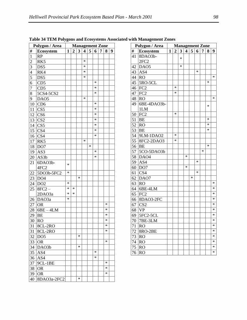
Helliwell Provincial Park Ecosystem Based Plan - March 2001 98
Table 34 TEM Polygons and Ecosystems Associated with Management Zones
Polygon / Area Management Zone
# Ecosystem 1 2 3 4 5 6 7 8 9
1 RP
2 RK5 *
3 DS5 *
4 RK4 *
5 DS5 *
6 CD5 *
7 CD5 *
8 5CS4-5CS2 *
9 DAO5 *
10 CD6 *
11 CS5 *
12 CS6 *
13 CS2 *
14 CS5 *
15 CS4 *
16 CS4 *
17 RK5 *
18 DO7 *
19 AS3 *
20 AS3b *
21 6DAO3b-
4FC2 *
22 5DO3b-5FC2 *
23 DO4 *
24 DO2 *
25 8FC2 –
2DAO3a
*
*
*
*
26 DAO3a *
27 OR *
28 6BE – 4LM *
29 BE *
30 RO *
31 8CL-2RO *
31 8CL-2RO *
32 DO5 *
33 OR *
34 DAO3b *
35 AS4 *
36 AS4 *
37 9CL-1BE *
38 OR *
39 OR *
40 8DAO3a-2FC2 *
Polygon / Area Management Zone
# Ecosystem 1 2 3 4 5 6 7 8 9
41 8DAO3b-
2FC2 *
42 DAO5 *
43 AS4 *
44 RO *
45 5RO-5CL *
46 FC2 *
47 FC2 *
48 RO *
49 6BE-4DAO3b-
1LM *
50 FC2 *
51 BE *
52 RO *
53 BE *
54 9LM-1DAO2 *
55 8FC2-2DAO3 *
56 BE *
57 5CO-5DAO3b *
58 DAO4 *
59 AS4 *
60 DO7 *
61 CS4 *
62 DAO7 *
63 RO *
64 6BE-4LM *
65 FC2 *
66 8DAO3-2FC *
67 CS2 *
68 VP *
69 5FC2-5CL *
70 7BE-3LM *
71 RO *
72 8RO-2BE *
73 RO *
74 RO *
75 RO *
76 RO *

Helliwell Provincial Park Ecosystem Based Plan - March 2001 98
8 Glossary
Biogeoclimatic classification: a multi-level, integrated system of ecological classification utilizing
climate, vegetation, and soils data to produce a classification of ecosystems. The ecosystem unit is
typically the highest level of classification.
Blue List: Any species considered vulnerable in BC.
Cladina: A medium-sized to large, upright shrub lichen, sometimes known as ―Reindeer Lichen‖ that can
form carpets over open sites.
Community: A group of living organisms connected by ecological processes to a particular ecosystem.
One named after the dominant vegetation, e.g., Western redcedar-Indian plum plant community
Conglomerate: sedimentary rock composed of rounded pieces of rock such as boulders and pebbles and
finer material, cemented together by calcite, iron oxide or silica
COSEWIC: the Committee on the Status of Endangered Wildlife in Canada determines the national
status of Canadian species, subspecies and populations suspected of being at risk. Three categories of risk
are used:
Disturbance: A discrete force that causes significant change in structure of composition through natural
events such as fire, flood, wind or earthquake.; mortality caused by insect or disease outbreaks; or by
human causing event such as the harvesting of a forest or draining of a wetland.
Ecoregion classification: categorises land in a hierarchical manner on the basis of macroclimate and
physiography. The ecoregion unit is an area with major physiographic, minor microclimatic or
oceanographic differences within each ecoprovince.
Edaphic: relating to ground and soils
Ecosystem Based Plan (EBP): An ecosystem based plan is a broad type of planning that recognises
interactions between all the elements of an ecosystem and human values and gives direction for the
maintenance or restoration of natural processes. BC Parks, 2000
Ecosystem Restoration: The process of assisting the recovery and management of ecological integrity.
Ecological integrity is a critical range of variability of biodiversity and ecological processes,
regional/historical context and sustainable cultural practices. Society for Ecological Restoration, 2000
Ecosystem Unit: a classification defined as being a combination of site series, site modifiers and
structural stage of a particular ecosystem.
Ecosystem: a system of living organisms interacting with the soil, land, water and nutrients that makes up
their environment. An ecosystem is the home place of living things, including humans.
Encroachment: the movement of species
Endangered, threatened or of special concern because of characteristics that make it particularly sensitive
to human activities. This is a national status list; there are separate provincial lists.
Epipelagic: the top 100 metres of the sea into which light can penetrate and in which photosynthesis
takes place
Exotic species: a species accidentally or purposefully introduced into an area where it did not formerly
occur. Exotic species often, but not always, have undesirable effects on native species and the ecological
integrity of the native ecosystem.
Extant: still surviving population:
Extirpation: the elimination of a species or subspecies from a particular area, but not from its entire
range.
Habitat: Those parts of the environment often typified by a dominant plant form or physical
characteristic, on which an organism depends, directly or indirectly, in order to carry out its life processes.
Hibernacula: Sheltered places where overwintering animals rest or dens where snakes hibernate.
Invasive species: an exotic species
Marine Ecosystem Mapping (MEM): stratifies the marine landscape into map units based upon

Helliwell Provincial Park Ecosystem Based Plan - March 2001 99
physical shoreline characteristics including slope, intertidal width, substrate, overlying sediments,
alongshore sediment transport and exposure.
Mesopelagic: almost open water
Mesic: wet
Peripheral population: An assemblage of individuals of one species at the edge of its geographic range.
Polygon: A series of points that are joined to form an unbroken line delineating the perimeter of a
discrete area on a map.
Red List: Any species that is designated or being considered for the more formal designation of
Extirpated (no longer in the wild in BC, but found elsewhere), Endangered (facing imminent extirpation
or extinction) or Threatened (likely to become endangered if threats are not dealt with and trends persist).
S3 Vulnerable provincially, either because very rare and local throughout its range, found only in a
restricted range (even if abundant at some locations), or because of other factors making it vulnerable to
extinction. Typically 21 to 100 occurrences or between 3,000 and 10,000 individuals
Sensitive ecosystems: those remaining natural terrestrial ecosystems that are considered fragile or rare in
the study area. In the case of the Sensitive Ecosystem Inventory of the southern Vancouver Island and the
Gulf Islands this includes: coastal bluffs, sparsely vegetated terrestrial herbaceous areas, older forest,
Woodlands (Garry oak, arbutus and aspen) wetland, riparian areas.
Site Series: All sites capable of producing the same late seral or climax plant communities within a
biogeoclimatic subzone or variant. Site series forms the basis of ecosystem units and indicate climax site
potential.
Species Accounts: Written descriptions of the life history of animals including their status, distribution,
ecology and habitat use, key habitat requirements and attributes, and seasonal use patterns.
Structural Stage: Describes current vegetation focussing on the age class of the ecosystem in questions.
Structural stage will depend on subzone designation and vegetation species.
Succession: A series of dynamic changes in a ecosystem structure, function and species composition over
time as a result of which one group of organisms succeeds another through stages leading to a potential
natural community or climax stage. The status of a plant community development with a defined seral
stages for a particular disturbance regime
Terrestrial Ecosystem Mapping (TEM): stratifies the landscape into map units (polygons) based upon
various ecological features including climate, topography, soils, surficial geology and vegetation.
Voronoi - also known as a Thiessen polygon. A Voronoi diagram defines an area about a point such that
all locations within that area are closer to that point than to any other point. A Voronoi diagram is used to
model zones of influence, for example, a catchment area.
Wildlife: any wild organism including wild mammals, birds, reptiles, amphibians, fishes, invertebrates,
plants, fungi, algae and bacteria.
Xeric: dry

Helliwell Provincial Park Ecosystem Based Plan - March 2001 100
9 Bibliography
Agriculture Canada Expert Committee on Soil Survey. 1987. The Canadian System of Soil Classification.
2nd ed. Agric. Can. Publ. 1646. Supply and Services Canada. Ottawa, Ont. 164 pp.
Ainley, D.G. and R. J. Boekelheide. 1990. Seabirds of the Farallon Islands: ecology, dynamics, and
structure in an upwelling-system community. Stanford University Press. Stanford, CA.
Axys Enviromental Consulting Ltd. 2000. Level 2 Detailed Environmental Screening. Proposed
Submersible Operations: Helliwell Provincial Park. Submission to BC Parks, Strathcona District
Office
Balke, J. 2000. Hornby Island opossum project: Winter 2000. Unpublished report submitted to K.
Morrison, Ministry of Environment Lands and Parks, Nanaimo, BC.
BC Conservation Data Centre. 2000. Draft Element Occurrence Criteria and Ranking, Assessment of
Matrix Forests. BC Ministry of Environment, Lands and Parks. Victoria, BC.
BC Ministry of Environment, Land and Parks, BC Parks. 1998. Management Plan for Jedediah Island
Marine Park.
BC Ministry of Forests and BC Ministry of Environment. 1999. Illustrated Flora of British Columbia.
(eds.) Douglas, G.W. et al. Province of British Columbia. Victoria, BC.
BC Ministry of Forests and BC Ministry of Environment. 1997. VENUS: Vegetation and Environment
NEXUS. BC Min. Forests, Research Branch. Victoria, BC.
BC Ministry of Forests and BC Ministry of Environment. 1998. Field manual for describing terrestrial
ecosystems. BC Min. Forests and BC Min. Environment, Lands and Parks, Victoria, BC.
BC Parks 2000. Responsible Wildlife Viewing, Natural Agents of Change in B.C. Parks: Insects, Fire,
Wind and Floods.
BC Parks. 1977. Flora and fauna of Helliwell Park – Hornby Island. Unpublished report submitted to BC
Ministry of Environment Lands and Parks, Parksville, BC.
Bellrose, F.C. 1976. Ducks, Geese and Swans of North America. Stockpile Books, Harrisburg, Pa. 540 p.
Booth, J. and H. Ruggeberg 1989. Marine Birds and Aquaculture in British Columbia: assessment of
geographical overlap. Tech. Rpt. Serv. No. 73. Can. Wild. Serv., Pacific and Yukon Region 53 p. +
appendices.
Brattstrom, B.H. and J.W. Warren. 1955. Observation on the ecology and behavior of the Pacific
Treefrog, Hyla regilla. Copeia 3:181-191.
Breault, A.M. 1990. Monitoring program of fish-eating birds in the Strait of Georgia. Unpublished
Report. Canadian Wildlife Service, Pacific and Yukon Region, BC 74pp.
Burford, L.S. and M.J. Lacki. 1995. Habitat use by Corynorhinus townsendii virginianus in the Daniel
Boone National Forest. American Midland Naturalist 134:340-345.
Campbell, R.W., N.K. Dawe, I. McTaggart-Cowan, J.M. Cooper, G.W. Kaiser, M.C.E. McNall. 1990.
The Birds of British Columbia Volume 1. Royal British Columbia Museum, Victoria, BC 514 pp.
Carey, Joseph. 1875. Leather-bound Field Book Catalogue and Maps. #Nanaimo Ph1 25/75 (1875).
Surveyor General‘s Archives: Victoria.

Helliwell Provincial Park Ecosystem Based Plan - March 2001 101
Carl, G.C. and C.J. Guiguet 1957. Alien Animals in British Columbia. British Columbia Provincial
Museum, Victoria, Canada.
CDC (Conservation Data Centre). 1997. CDC Web site. http://www.elp.gov.bc.ca/rib/wis/cdc
Clague, J.J. 1991. ―Quaternary glaciation and sedimentation‖ in Geology of the Cordilleran Oregon in
Canada, Geological Survey of Canada, Geology of Canada, n. 4, p. 419-434.
Collie, J.S., G.A. Escanero and P.C. Valentine. 1997. Effect of bottom trawling on the benthic mega fauna
of Georges Bank. Marine Ecology Progress Series. Vol. 155(0) 159-172
Comox Band. Islands Comox Land Use and Reserve History. Final Report. September 30th, 1999.
Kwakiutl Territorial Fisheries Commissions Traditional Use Study.
Corkran, C.C. and C. Thoms. 1996. Amphibians of Oregon, Washington, and British Columbia. Lone
Pine Publishing, Vancouver, BC.
De Vito, J., D.P. Chivers, J.M. Kiesecker, L.K. Belden and A.R. Blaustein. 1999. Effects of snake
predation on aggregation and metamorphosis of Pacific Treefrog (Hyla regilla) Larvae. Journal of
Herpetology 33: 504-507.
Demarchi, D.A. 1995. Ecoregions of British Columbia (Fourth Edition). 1:2,000 000 Map. BC Min.
Environment, Lands and Parks. Victoria, BC.
Demarchi, D.A. 1996. Introduction to Ecoregions of British Columbia. Ministry of Environment, Lands
and Parks, Wildlife Branch. Victoria, BC (available onMOE website).
Douglas, G.W., D. Meidinger, and J. Pojar. 1999. Illustrated Flora of British Columbia. BC Ministry of
Forests and BC Ministry of Environment, Victoria, BC.
Douglas, G.W., G.B. Straley, and D. Meidinger. 1998. Rare Native Vascular Plants of British Columbia.
Province of British Columbia, BC Ministry of Forests, Victoria, B.C.
Duncan, Eric. 1937. From Shetland to Vancouver Island: recollections of 75 years. Edinburgh [etc.]
Oliver and Boyd.
Dunn, P. and J. Fleckenstein 1997. ―Butterflies of the South Puget Sound Prairie Landscape‖,
Conservation and Management of Native Plants and Fungi: Proceedings from a Conference of the
Native Plant Society of Oregon. Edited by Thomas Kaye, et al. Native Plant Society of Oregon:
Corvallis, Oregon. 1997.
Ehrlich, P. R., D. D. Murphy, M. C. Singer, C B. Sherwood, R. R. White, and I. L. Brown. 1980.
Extinction, reduction, stability and increase: The responses of checkerspot butterfly (Euphydryas)
populations to the California drought. Oecologia 46:101-105.
Ehrlich, P.R. 1961. Intrinsic barriers to dispersal in Checkerspot butterfly. Science 134:108-109.
Ehrlich, P.R., D.S. Dobkin and D. Wheye. 1988. The Birders Handbook. Simon and Shuster Inc.
NewYork, NY.
Emms, S. K. and K. Morgan. 1989. The breeding biology and distribution of the Pigeon Guillemot
(Cepphus columba) in the Strait of Georgia. P. 100-106 In Vermeer, K. and R.W. Butler (eds.) The
ecology and status of marine and shoreline birds in the Strait of Georgia, British Columbia. Spec.
Publ. Can. Wild. Serv. Ottawa.
England, T.D.J. & R.N. Hiscott. 1991. ―Lithostratigraphy and deep-water setting of the upper Nanaimo
Group (Upper Cretaceous), outer Gulf Islands of southwestern British Columbia‖ in Canadian
Journal of Earth Sciences, v. 29, p. 574-595.

Helliwell Provincial Park Ecosystem Based Plan - March 2001 102
England, T.D.J. 1989. ―Lithostratigraphy of the Nanaimo Group, Georgia Basin, southwestern British
Columbia‖ in Current Research, Part E, Geological Survey of Canada, Paper 89-1E, p. 197-206.
Englestoft, C. and K. Ovaska. 1997. Sharp-tailed snake inventory within the coastal Douglas-fir
biogeoclimatic zone, June – November 1996. Unpublished report submitted to the BC Ministry of
Environment Lands and Parks, Nanaimo, BC.
Erickson, Wayne. ―An Ecological Investigation of the High Salal Garry Oak Grove (―The Thousand
Oaks‖) Hornby Island, B.C. prepared for Hornby Island Trust Committee, 1993.
Fitzpatrick, W. 1995. Bird Records - Denman & Hornby 1963-1988. unpublished field records.
Fonds, M. and S. Groenewold. 2000. Food subsidies generated by the beam-trawl fishery in the southern
North Sea. P. 130-150 In. M.J. Kaiser and S.J. de Groot. The Effects of Fishing on Non-Target
Species and habitats. Blackwell Science.
Friends of the Government House Gardens Society, 1997. ―Garry Oak Wildlands Planning Committee,
Government House Garry Oak Ecosystem Ecological Management Plan.‖
Fuchs, Marilyn. 2000. ―Ecological Assessment of Garry Oak and Associated Ecosystems in British
Columbia: A Literature Review‖ for the Garry Oak Ecosystems Recovery Team.
Gerow, D. and E. Smith. 1988. Hornby Island: The Ebb and Flow. Ptarmigan Press, Campbell River, BC.
79 p.
Goudie, R.I., 1996. Demography of Harlequin Ducks in coastal British Columbia; 1994-95 Unpublished
field report.
Green, D.M. and R.W. Campbell. 1984. The Amphibians of British Columbia. British Columbia
Provincial Museum, Victoria, BC.
Green, R.N. and K. Klinka. 1994. A Field Guide to Site Identification and Interpretation for the
Vancouver Forest Region. Land Manage. Handbook. 28. BC Min. For. Victoria, BC.
Gregory, P. T. and R.W. Campbell. 1984. The Reptiles of British Columbia. British Columbia Provincial
Museum, Victoria, BC.
Gregory, P.T. 1978. Feeding habits and diet overlap of three species of garter snakes (Thamnopis) on
Vancouver Island. Can. J. Zool. 56:1967-1974.
Guppy, C. S., J. H. Shepard, and N. G. Kondla. 1994. Butterflies and skippers of conservation concern in
British Columbia. Canadian Field-Naturalist 108(1): 31-40.
Halstead, E.C. & A. Treichel (1966) Groundwater resources of the coastal lowland and adjacent islands,
Nanoose Bay to Campbell River, east coast, Vancouver Island; Geological Survey of Canada,
Bulletin 144, 42p.
Hat, D. E., P.B. McCarter, R. Kronland and C. Roy. 1989. Spawning areas of British Columbia Herring:
A Review, Geographical Analysis and Classification. Volume 5: Strait of Georgia. Can. MS Rep.
Fish. Aquat. Sci. 2019: 268 p.
Higgs, Eric, et al. 1999. ―Culture, Ecology and Restoration in Jasper National Park.‖
Hitchcock, C.L. and A. Cronquist. 1973. Flora of the Pacific Northwest. University of Washington Press,
Seattle.
Holroyd, S.L., R.M.R. Barclay, L.M. Merk, and R.M. Brigham. 1994. A survey of the bat fauna of the
dry interior of British Columbia: a summary by species with recommendations for future work.
B.C. Ministry of Environment. Wildlife Working Report No. WR-63.

Helliwell Provincial Park Ecosystem Based Plan - March 2001 103
Hornby Island Residents‘ and Ratepayers Association Upland Crown Land Committee, 2000. ―Heart of
Hornby: A Forest and a Watershed Phase 1 Report - Basic Mapping, Initial Ecological Studies and
Tenure Options‖
Hossler, R.J., J.B. McAninch, and J.D. Harder. 1994. Maternal denning behavior and survival of juveniles
in opossums in southeastern New York. Journal of Mammalogy 75: 60-70.
Howes, D.E. and E. Kenk (ed.). 1988. Terrain Classification System for British Columbia. Revised
Edition. MOE Manual 10. BC Min. Environ. and BC Min. Crown Lands. Victoria, BC.
Humphrey, S.R. and T.H. Kunz. 1976. Ecology of a Pleistocene relict, the western big-eared bat (Plecotus
townsendii), in the southern Great Plains. Journal of Mammalogy 57:470-494.
Imper, David, K. 1997. ―Development of a long term monitoring program aimed at conservation and
recovery of endangered species‖ in Conservation and Management of Native Plants and Fungi:
Proceedings from a Conference of the Native Plant Society of Oregon. Edited by Thomas Kaye, et
al. Native Plant Society of Oregon: Corvallis, Oregon. pp. 19-22.
Independent World Commission on the Oceans. 2000. The Ocean Our Future: The Report of the
Independent World Commission on the Oceans, ed. Mario Soares Cambridge University Press:
Cambridge, England.
Jackson, W.B. 1982. Norway rat and allies. In: Wild Mammals of North America. J.A. Chapmand and
G.A. Feldhamer eds. John Hopkins University Press, Baltimore, USA p. 1077-1088.
Johnson, M.P., A.D. Keith and P.R. Ehrlich. 1967. The population biology of the butterfly, Euphydryas
editha VII. Has E. editha evolved a serpentine race? Evolution 22:422-425.
Johnston, R.L. and Jayne Belnap. 1997. ―Potential for influencing native bunchgrass restoration by
manipulating soil biota‘ in Conservation and Management of Native Plants and Fungi:
Proceedings from a Conference of the Native Plant Society of Oregon. Edited by Thomas Kaye, et
al. Native Plant Society of Oregon: Corvallis, Oregon. pp. 99-104.
Kaiser, M.J. and B.E. Spencer. 1994. Fish scavenging behaviour in recently trawled areas. Marine
Ecology Progress Series. Vol. 112:41-49
Lanarc Consultants, 1998. Rathtrevor Beach Provincial Park: Vegetation Management Plan. BC Parks.
Layberry, R. A., P. W. Hall, and J. D. Lafontaine. 1998. The Butterflies of Canada. University of Toronto
Press, Toronto. Frontispiece, 1-280.
Levings, C., G.E. Piercy, M. Galbraith and G.S. Jamieson. 1998. Invertebrate organisms transported
around the north Pacific ocean by ship‘s ballast water: results from British Columbia ports. P. 337-
340 In Proceedings of TechnoOcean 98, Kobe Japan. November 25-27, 1998.
MacLoud, W.A. M.B. Roberts, D.W. Ross, B.D. Lawson. c. 1979. ―Fire Control Survey for Helliwell
Park.‖ Park and Outdoor Recreation Division, Ministry of Lands, Parks and Housing and Pacific
Forest Research Centre, Canadian Forestry Service.
McAtee, W.L. 1959. Folk Names of Canadian Birds Bulletin No. 149 of the National Museum of Canada.
McLendon, T. and E.F. Redente. 1992. ―Effects of nitrogen limitation on species replacement dynamics
during early secondary succession on a semiarid sagebrush site. ― Oecologia 91. pp. 312-317.
McPhee, Michael, et al. 2000. Sensitive Ecosystem Inventory: East Vancouver Island and Gulf Islands,
1993-1997. Volume 1: Methodology, Ecological Descriptions and Results and Volume 2:
Conservation Manual. Technical Report Services No. 345, Canadian Wildlife Service, Pacific and
Yukon Region, British Columbia.

Helliwell Provincial Park Ecosystem Based Plan - March 2001 104
McTaggart Cowan, I. and C.J. Guiguet 1965. The Mammals of British Columbia. British Columbia
Provincial Museum, Victoria, BC.
Morgan, J.P. 1994. ―Soil Impoverishment: A little-known technique holds potential for establishing
prairie‖ in Restoration and Management Notes 12:1, pp.54-55
Morgan, K 1987. Birds of Saanich Inlet, a Vancouver Island fjord entering the Strait of Georgia. Can.
Wildl. Serv. Unpubl. Rpt.
Morgan, KJR and T.R. Seastedt. 1999. ―Effects of soil nitrogen reduction on nonnative plants in restored
grasslands‖ in Restoration Ecology. Vol 7:1 pp.51-55.
Moul, I.E. 2000. ―Population trends of Double-crested and Pelagic Cormorants nesting along the
southeast coast of Vancouver Island‖. Unpublished report submitted to Ministry of Environment
Lands and Parks, Nanaimo, BC.
Muller, J.E. & J.A. Jeletzky. 1970. ―Geology of the Upper Cretaceous Nanaimo Group, Vancouver Island
and Gulf Islands, British Columbia‖ in Geological Survey of Canada, Paper 69-25, 77p.
Murphy, D.D., A.E. Launer, and P.R. Ehrlich. 1983. The role of adult feeding in egg production and
population dynamics of the Checkerspot butterfly Euphydryas editha. Oecologia 56:257-263.
Murray, S. 1998. Visitor impact on rocky shores: Are marine protected areas really protected? In
Sanctuary Currents ‘98. Human Influence on the Coastal Ocean. Monterey Bay National Marine
Sanctuary.
Mustard, P.S., D.C. Katnick, J. Baker, R.J. Enkin, and J.B. Mahoney. 1999. Multidisciplinary studies of
the Upper Cretaceous Nanaimo Group, Hornby and Denman Islands, British Columbia. Current
Research 1999-A, Geological Survey of Canada p. 231-238.
Nagorsen, D.W. and R.M. Brigham. 1993. The Bats of British Columbia. UBC Press, Vancouver, 164pp.
Nature Conservancy of Canada, 2000. ―Management Plan for the Cowichan Garry Oak Preserve.‖
Nussbaum, R. A., E.D. Brodie and R.M. Storm. 1983. Amphibians and reptiles of the Pacific Northwest.
University of Idaho Press, Moscow, Idaho.
Obee, Bruce, 1998. ―Quiet kayakers worry wildlife.‖ Beautiful British Columbia, Vol. 118, No. 4
Orchard, S. 1984. Amphibians and reptiles of B.C.: An ecological review. Research Branch, Ministry of
Forests. WHR-15. Victoria, B.C.
Orchard, S. 1984. Amphibians and reptiles of B.C.: an ecological review. Research Branch, Ministry of
Forests. WHR-15. Victoria, B.C.
Penn, Briony 1988 ―Recreational Access in British Columbia and Scotland‖, unpublished Ph.D thesis
University of Edinburgh.
Pojar, J. and A. MacKinnon. 1994. Plants of Coastal British Columbia. Lone Pine Publishing.
Vancouver, B.C. pp 526.
Resources Inventory Committee (RIC) 1998. Standard for Terrestrial Ecosystem Mapping in British
Columbia. Ecosystem Working Group, Terrestrial Ecosystems Task Force. Victoria, BC.
Resources Inventory Committee (RIC). 1997. Provincial site series mapping codes and typical
environmental conditions. Ecosystems Working Group. Victoria, BC.
http://www.publications.gov.bc.ca
Roemer, H. 2000. ―An ecosystem creating its own space?‖ Visions: Vol 11 No. 3. p. 1

Helliwell Provincial Park Ecosystem Based Plan - March 2001 105
Savard J-P. 1988. A summary of current knowledge on the distribution and abundance of moulting sea
ducks in coastal waters of British Columbia. Tech. Rpt. 45. Can. Wild. Serv., Pacific and Yukon
Region 82 p.
Scholtz, Cheryl. 1997. ―Planting butterfly seeds: An experiment in restoring habitat for the Fender‘s Blue
butterfly‖ in Conservation and Management of Native Plants and Fungi: Proceedings from a
Conference of the Native Plant Society of Oregon. Edited by Thomas Kaye, et al. Native Plant
Society of Oregon: Corvallis, Oregon. pp. 88-98.
Scott, J. A. 1986. The Butterflies of North America. Stanford University Press. Stanford, CA. i-xii, 1-583,
pls. 1-64.
Seidensticker, J. M.A. O'Connell, A.J. T. Johnsingh 1987. Virginia opossum. In: Wild Furbearer
Management and Conservation in North America. M. Novak, J.A. Baker, M.E. Obbard and B.
Malloch eds. Min. of Natural Resources, Ontario, p. 247-261.
Sharcott, Margaret. 1957. Troller‘s Holiday. British Book Service. Toronto. 221 p.
Sharcott, Margaret. 1965. ―Hornby Island Revisited‖ Daily Colonist, August 22, p. 11, 1965
Sharcott, Margaret. 1966. "To See her Old Homestead Become Provincial Park" Daily Colonist October
30, 1966 p. 2 and 15.
Shepard, J. 1995. The status of butterflies of conservation concern on southeastern Vancouver Island and
the adjacent Gulf Islands. Final Report of 1995 Field Work. Unpubl. rep. submitted to the British
Columbia Conservation Data Centre Wildlife Branch, B.C. Ministry of Environment, Lands and
Parks, Victoria, BC.
Shepard, J. 2000. Status of five butterflies and skippers in British Columbia. Ministry of Environment
Lands and Parks, Wildlife Working report No. WR-101. Victoria, BC. 27pp.
Siegel-Causey, D. and N.M. Laitvinenko. 1993. Status, ecology and conservation of shags and
cormorants of the temperate North Pacific. p. 112-130. In: Vermeer, K. K.T. Briggs, K. Morgan
and D. Seigel-Causey. (eds.) The Status, Ecology and Conservation of Marine Birds of the North
Pacific. Can. Wildl. Serv. Spec. Publ. Ottawa
Silva Forest Foundation. 1998. Human Alteration of the Role of Fire in Dry Interior Forests.
State of California, Department of Parks and Recreation. 1979. Point Lobos State Reserve and Carmel
River State Beach, General Plan.
Suttles, Wayne. 1990. ―Central Coast Salish‖ in Northwest Coast Handbook of North American Indians.
Volume 7. Ed. W.C. Sturtevant. . University of Chicago Press.
The Land Conservancy of BC. 1998. ―South Winchelsea Island 1999 - 2003 Exotic Plant Species
Management Plan.‖
van Zyll de Jong, C.G. 1985. Handbook of Canadian Mammals. 2. Bats. National Museum of Natural
Sciences (Canada), Ottawa, 212pp.
Vermeer K. 1983. Marine bird populations in the Strait of Georgia: comparison with the west coast of
Vancouver Island. IOS DFO Can. Tech. Rpt. Hydro. And Ocean Sci. No. 19.
Vermeer, K. and K. Devito. 1989. Population trends of nesting Glaucous-winged gulls in the Strait of
Georgia. p. 88-93. In Vermeer, K. and R.W. Butler (eds.) The ecology and status of marine and
shoreline birds in the Strait of Georgia, British Columbia. Spec. Publ. Can. Wild. Serv. Ottawa.
Vermeer, K. and R.C. Ydenberg. 1989. Feeding ecology of marine birds in the Strait of Georgia. p. 62-73.
In Vermeer, K. and R.W. Butler (eds.) The ecology and status of marine and shoreline birds in the
Strait of Georgia, British Columbia. Spec. Publ. Can. Wild. Serv. Ottawa.

Helliwell Provincial Park Ecosystem Based Plan - March 2001 106
Vermeer, K., K.H. Morgan, and G.E.J. Smith. 1989. Population trends and nesting habitat of Double-
crested and Pelagic cormorants in the Strait of Georgia. p. 94-99. In Vermeer, K. and R.W. Butler
(eds.) The ecology and status of marine and shoreline birds in the Strait of Georgia, British
Columbia. Spec. Publ. Can. Wild. Serv. Ottawa.
Waldichuck, M., P. Lambert and B. Smiley. 1994. Exotic introductions into BC marine waters. In. L.
Harding and E. McCullum (eds.) Biodiversity in British Columbia: Our Changing Environment.
Environment Canada
Warrington, P.D. 1997. ―Some Impacts of Boating on the Aquatic Environment,‖ Technical Services Unit
Water Management Branch. BC Ministry of Environment, Lands and Parks.