Embed Size (px)
Citation preview
1'
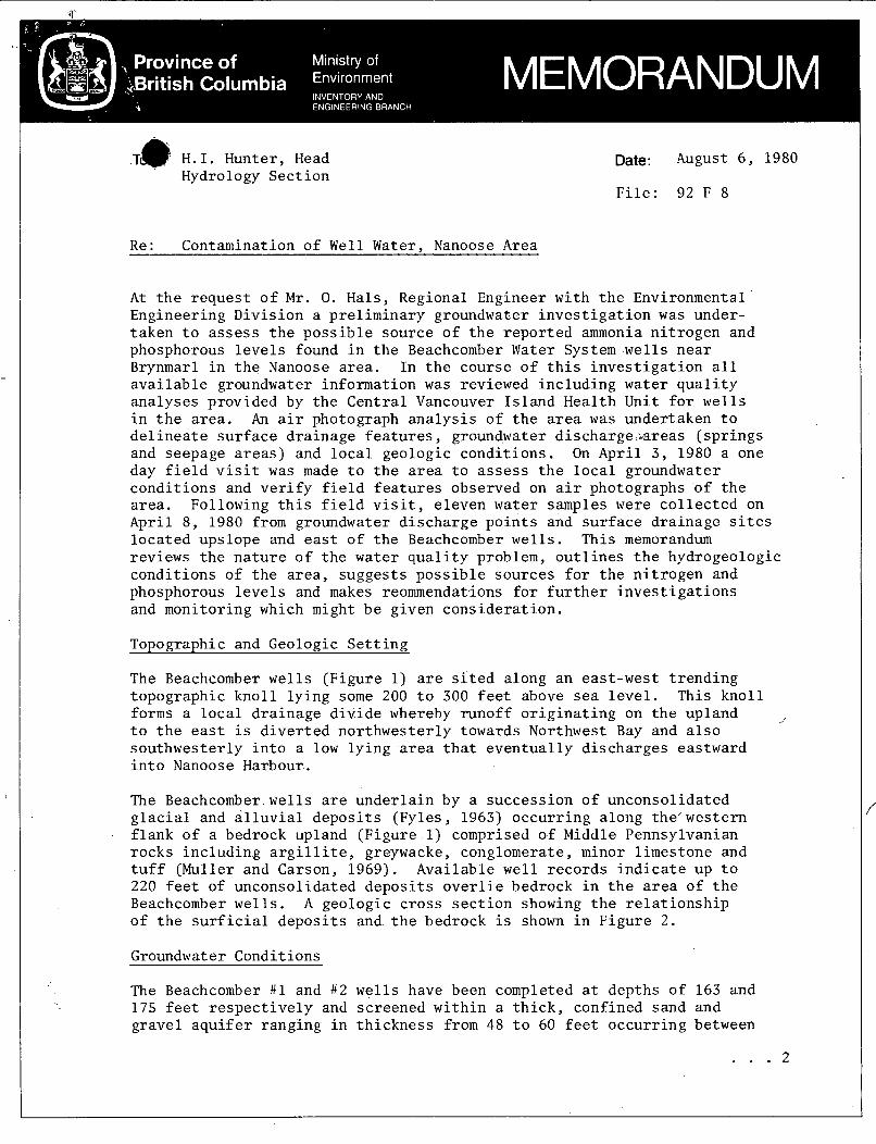
TI& H . I . Hunter, Head - Hydrology Sec t ion
Date: August 6 , 1980
F i l e : 92 F 8
R e : Contamination o f Well Water, Nanoose Area
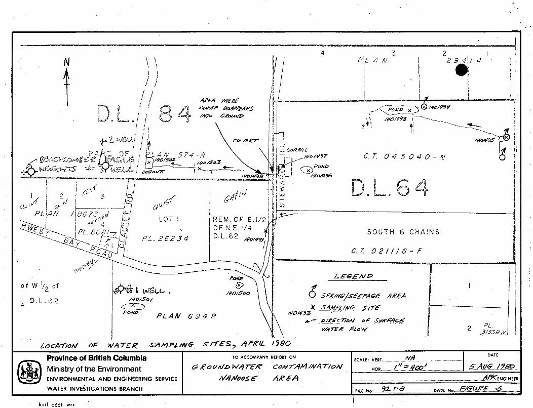
A t t h e r e q u e s t o f M r . 0. Hals, Regional Engineer w i th t h e Environmental Engineering Div i s ion a p re l imina ry groundwater i n v e s t i g a t i o n was under- taken t o assess t h e p o s s i b l e source o f t h e r e p o r t e d ammonia n i t r o g e n and phosphorous l e v e l s found i n t h e Beachcomber Water System wells n e a r Brynmarl i n t h e Nanoose area. In t h e course o f t h i s i n v e s t i g a t i o n a l l a v a i l a b l e groundwater information was reviewed inc lud ing water q u a l i t y analyses provided by t h e Cen t ra l Vancouver I s l a n d Heal th Unit f o r wells i n t h e a r e a . An a i r photograph a n a l y s i s o f t h e area was undertaken t o d e l i n e a t e s u r f a c e d ra inage f e a t u r e s , groundwater discharge-areas ( s p r i n g s and seepage a r e a s ) and l o c a l geologic cond i t ions . On Apr i l 3 , 1980 a one day f i e l d v i s i t was made t o t h e area t o assess t h e l o c a l groundwater cond i t ions and v e r i f y f i e l d f e a t u r e s observed on a i r photographs of t h e a rea . Following t h i s f i e l d v i s i t , e leven water samples were c o l l e c t e d on Apr i l 8 , 1980 from groundwater d i scha rge p o i n t s and s u r f a c e d ra inage s i tes l o c a t e d upslope and east o f t h e Beachcomber wells. This memorandum reviews t h e n a t u r e o f t h e water q u a l i t y problem, o u t l i n e s t h e hydrogeologic cond i t ions of t h e a r e a , sugges t s p o s s i b l e sou rces f o r t h e n i t r o g e n and phosphorous l e v e l s and makes reommendations f o r f u r t h e r i n v e s t i g a t i o n s and monitoring which might be given c o n s i d e r a t i o n .
ToDoeraDhic and Geologic S e t t i n g
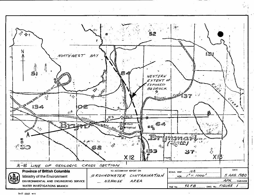
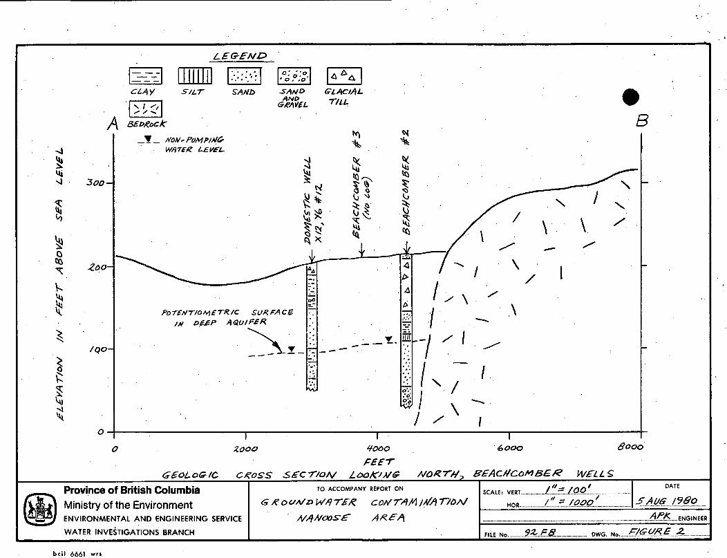
The Beachcomber wells (Figure 1) are s i t e d along an east-west t r e n d i n g topographic k n o l l l y i n g some 200 t o 300 fee t above sea l e v e l . This k n o l l forms a l o c a l d ra inage d i v i d e whereby runof f o r i g i n a t i n g on t h e upland t o t h e e a s t i s d i v e r t e d no r thwes te r ly towards Northwest Bay and a l s o sou thwes te r ly i n t o a low l y i n g area t h a t e v e n t u a l l y d i scha rges eastward i n t o Nanoose Harbour.
,,
The Beachcomber w e l l s are unde r l a in by a success ion o f unconsol idated g l a c i a l and a l l u v i a l d e p o s i t s (Fyles , 1963) o c c u r r i n g along the 'western f l a n k o f a bedrock upland (Figure 1) comprised o f Middle Pennsylvanian rocks i n c l u d i n g a r g i l l i t e , greywacke, conglomerate, minor l imestone and t u f f (Muller and Carson, 1969). Avai lable wel l r eco rds i n d i c a t e up t o 220 f e e t of unconsol idated d e p o s i t s o v e r l i e bedrock i n t h e area of t h e Beachcomber wells. A geologic c r o s s s e c t i o n showing t h e r e l a t i o n s h i p of t h e s u r f i c i a l d e p o s i t s and t h e bedrock is shown i n F igu re 2 .
Groundwater Conditions
The Beachcomber #1 and # 2 w e l l s have been completed a t depths o f 163 and 175 feet r e s p e c t i v e l y and screened w i t h i n a t h i c k , confined sand and gravel a q u i f e r ranging i n t h i c k n e s s from 48 t o 60 f e e t occu r r ing between
. . . 2
- 2 -
* 100 and 180 f e e t below ground. This confined a q u i f e r i s o v e r l a i n by c l a y , g l a c i a l till and i n t e r b e d s o f sand. The a q u i f e r materials
exposed a t t h e s u r f a c e below t h e 200 f o o t e l e v a t i o n a t Nanoose Harbour and west o f Northwest Bay. have been r e p o r t e d i n t h e range 93 t o 107 f e e t below ground s u r f a c e . Groundwater a l s o occurs under shal low wa te r - t ab le cond i t ions w i t h i n t h e s u r f a c e sand and g rave l d e p o s i t which o v e r l i e s g l a c i a l t i l l l o c a l l y . Some shallow dug wells (e .g . Te r r i en we l l ) have been completed i n t h i s a q u i f e r . A summary of t h e wel l logs i n t h e a r e a i s shown i n Table 1. On t h e bedrock upland east of t h e Beachcomber we l l s shallow groundwater i s found wi th in a t h i n veneer of sediments occupying a l o c a l dep res s ion i n D.L.64 (Figure 3 ) . Several small s p r i n g s and seepage a r e a s occur i n t h i s a r e a .
r t o belong t o t h e Quadra Sediments (Fyles , 1963) as t h e s e a r e found zs Non-pumping water l e v e l s i n t h e deep a q u i f e r
Chemical Analyses o f Well Waters
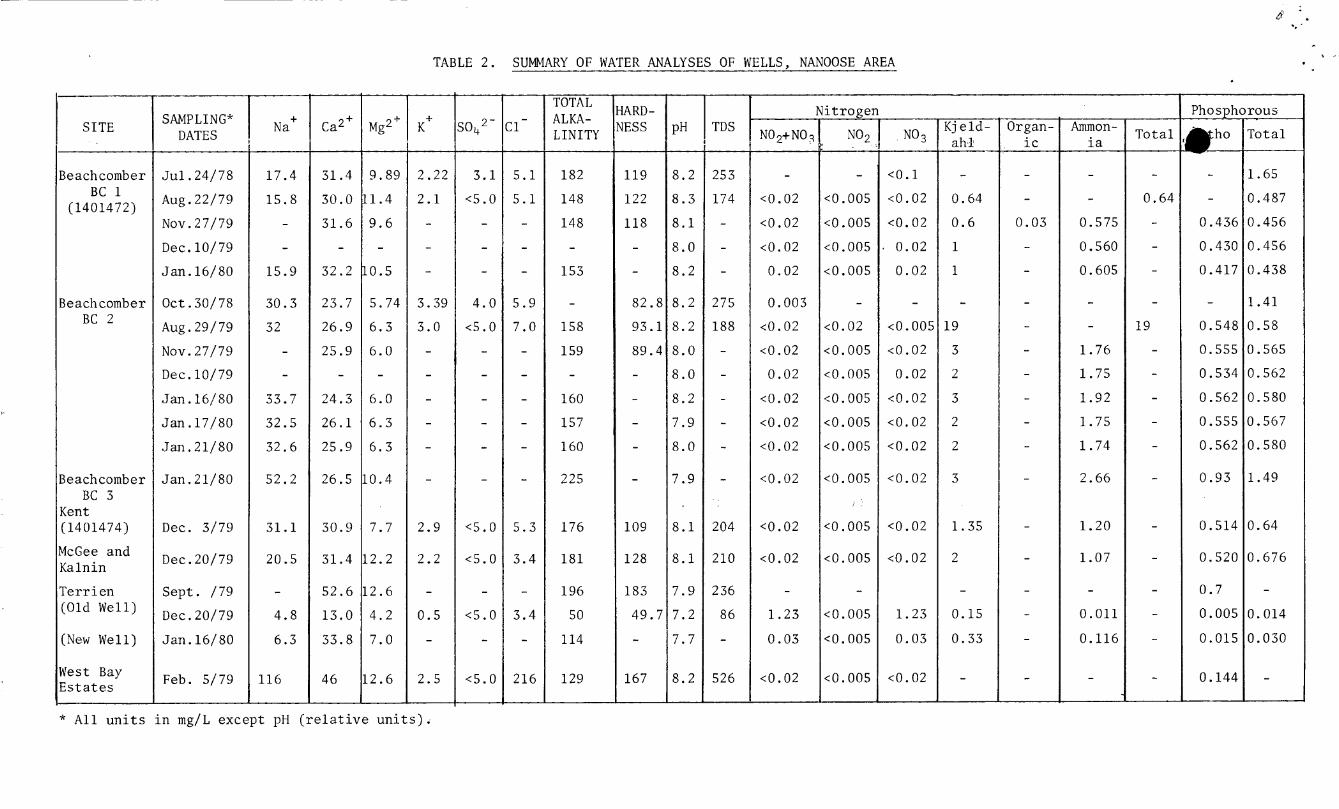
Resu l t s of water q u a l i t y analyses completed on samples taken from t h e t h r e e Beachcomber w e l l s and o t h e r we l l s i n t h e a r e a are l i s t e d i n Table 2 . In gene ra l , water q u a l i t y i n t h e deep a q u i f e r i s o f t h e calcium-sodium- b i ca rbona te , o r sodium-calcium-bicarbonate types with t o t a l d i s so lved s o l i d s i n t h e range 174 t o 275 mg/L. Reported t o t a l phosphorous l e v e l s range from 0.438 t o 1 .65 mg/L, phosphorous as orthophosphate from 0.417 t o 0.562 mg/L and t o t a l Kjeldahl n i t r o g e n i n t h e range 0 .6 t o 19 mg/L. Nitrogen as ammonia NH3 has been r e p o r t e d i n t h e range 0.56 t o 2.66 mg/L. Nitrogen as NO; ( n i t r i t e ) and NO, ( n i t r a t e ) has been e s s e n t i a l l y absent with l e v e l s of NO, g e n e r a l l y l e s s t han 0.02 mg/L and NO; less than 0.005 mg/L. From t h e s e analyses it i s apparent t h a t n i t r o g e n i n water from t h e deep a q u i f e r occurs p r i m a r i l y as ammonia NH3 and as some o rgan ic n i t r o g e n , with phosphorous p r i m a r i l y occur r ing i n t h e d i s so lved orthophosphate form. Samples ob ta ined from t h e shallow wa te r - t ab le a q u i f e r (Te r r i en w e l l s ) i n d i c a t e water of t h e calcium-bicarbonate type , low i n t o t a l phosphorous (0.014 t o 0.03 mg/L) and low i n Kjeldahl n i t r o g e n (0.15 t o 0 .33 mg/L) . N i t r a t e n i t r o g e n i n t h e o l d Te r r i en we l l was however r e p o r t e d a t 1 .23 mg/L i n December 1979.
Sources of Nitropen and PhosDhorous
There a r e i n general t h r e e p o s s i b l e sou rces , one o r more o f which may be c o n t r i b u t i n g t o t h e observed concen t r a t ions o f n i t r o g e n and phosphorous i n t h e Beachcomber wells. These p o s s i b l e sources a r e :
1. atmospheric p r e c i p i t a t i o n .
2 . man's a c t i v i t i e s , i nc lud ing t h e d i s p o s a l and/or spreading of animal wastes, domestic sewage, f e r t i l i z e r s o r i n d u s t r i a l chemi- c a l s on t h e land s u r f a c e o r i n t o t h e subsu r face ( i . e . , l a n d f i l l s ) .
3. n a t u r a l l y occur r ing d e p o s i t s (minerals , o rgan ic ma t t e r ) w i th in t h e a q u i f e r , i n ad jacen t d e p o s i t s o r a t t h e land s u r f a c e ( s o i l s , compost).
. . . 5
- 3 -
. A d i s c u s s i o n of each o f t h e s e p o s s i b l e sou rces i s given below:
mospheric P r e c i p i t a t i o n
NitTogenous compounds - g e n e r a l l y r epor t ed i n t h e forms NH3(ammonia), NH4 (ammonium), NO3 ( n i t r a t e ) and t o t a l n i t r o g e n are always p re sen t i n t h e atmosphere and a re c a r r i e d down i n p r e c i p i t a t i o n f a l l i n g on t h e e a r t h ' s s u r f a c e ( C a r r o l l , 1962). O r i g i n a l l y t h e s e compounds would be de r ived from terrestr ia l sou rces , introduced i n t o t h e atmosphere f o r example i n t h e form o f o rgan ic matter i n s o i l d u s t o r as a r e s u l t o f i n d u s t r i a l a i r d i scha rges . Data on n i t r o g e n concen t r a t ion i n r a i n f a l l over England and Wales f o r example i n d i c a t e s l e v e l s i n t h e range 1 t o 4 mg/L with h i g h e r l e v e l s a s s o c i a t e d with r a i n f a l l over urban areas (Cen t ra l Water Planning Uni t , 1977). C a r r o l l (1962) has r e p o r t e d n i t r a t e and ammonia l e v e l s i n r a i n f a l l i n n o r t h e r n Europe ranging from 0.27 t o 1 . 6 mg/L and 0.41 t o 8.7 mg/L r e s p e c t i v e l y . i n t h e conterminous United S t a t e s , C a r r o l l (1962) a l s o r e p o r t e d n i t r a t e concen t r a t ions i n t h e range 0.72 t o 4.68 mg/L and ammonia l e v e l s i n t h e range 0.05 t o 2 . 2 1 mg/L. From t h e above examples it would appear t o be p l a u s i b l e t h a t t h e l e v e l s of ammonia and t o t a l n i t r o g e n i n t h e Beachcomber wells might be de r ived from recha rge t o t h e a q u i f e r o f p r e c i p i t a t i o n con ta in ing t h e s e c o n s t i - t u e n t s . If de r ived from t h e atmosphere, i . e . , one common source , t h e levels o f n i t r o g e n i n t h e a q u i f e r however, would no t be expected t o vary cons ide rab ly from well t o wel l as shown i n Table 2 . Levels of ammonia and n i t r o g e n i n t h e shallow water-tab1.e a q u i f e r should a l s o be s i m i l a r t o t h e l e v e l s r epor t ed i n t h e deeper a q u i f e r i f p r e c i p i t a t i o n were t h e source o f t h e s e c o n s t i t u t e n t s .
From s e v e r a l l o c a l i t i e s
Data on phosphorous l e v e l s i n p r e c i p i t a t i o n a r e no t r e a d i l y a v a i l - a b l e . From t h e v a r i a b i l i t y i n l e v e l s and d i f f e r e n c e s observed i n t h e deep a q u i f e r and t h e w a t e r - t a b l e a q u i f e r it would appear t h a t p r e c i p i t a t i o n would n o t be t h e major sou rce o f t h e phosphorous l e v e l s observed i n t h e deep a q u i f e r .
2 . Man A c t i v i t i e s
Dissolved n i t r o g e n i n t h e form o f n i t r a t e (N03-) i s one o f t h e most common contaminants found i n groundwaters as a r e s u l t o f man's a g r i c u l t u r a l a c t i v i t i e s and t h e d i s p o s a l o f sewage on o r beneath t h e land s u r f a c e (Freeze and Cherry, 1979). Nitrates t h a t e n t e r t h e groundwater system may o r i g i n a t e as n i t r a t e s i n wastes o r f e r t i l i z e r s app l i ed t o t h e land s u r f a c e ( d i r e c t sou rces ) o r through t h e conversion o f o rgan ic n i t r o g e n sources i n t o ammo?ium and n i t r a t e . The process o f conversion o f o rgan ic n i t r o g e n t o NH4 ammonification and through t h e p rocess o f n i t r i f i c a t i o n , NH4 i s converted t o NO3-. t h a t normally occur above t h e wa te r - t ab le g e n e r a l l y i n t h e s o i l zone, where o rgan ic matter and oxygen a r e abundant. Ni t ra te because o f i t s a n i o n i c form i s ve ry mobile i n groundwater and may mig ra t e
i s knoyn as
Ammonification and n i t r i f i c a t i o n a r e processes
. . . 4
I. .
- 4 - + l a r g e d i s t a n c e s from inpu t areas (Freeze and Cherry, 1979). NH4
on t h e o t h e r hand because o f i t s p o s i t i v e valence can be r e a d i l y dsorbed on c l a y o r s i l t - s i z e d p a r t i c l e s i n geologic materials a nd does n o t migrate as r e a d i l y as n i t r a t e i n t h e subsu r face
environment. b a c t e r i a l systems i n s o i l above t h e w a t e r - t a b l e - are moreover capable o f dvni t r i fying l a r g e amounts o f NO3 t o N20 and N 2 and p o s s i b l y NH4 (Freeze and Cherry, 1979). In animal wastes n i t r o - gen is p r e s e n t i n u r e a and through t h e p rocess o f+hydro lys i s under d ry - ae rob ic s o i l cond i t ions t r ans fo rma t ion t o NH4 and even tua l ly NO3 ( through n i t r i f i c a t i o n ) can occur. In s i t u a t i o n s where t h e s o i l i s e s s e n t i a l l y s a t u r a t e d with water and anaerobic - cond i t ions are p r e v a l e n t , NH4 may no t be converted t o NO3 (Robertson e t a l , 1974).
- Given a source o f o rgan ic matter and abundant NO3 ,
Phosphorous may be introduced i n t o groundwaters through t h e wide- spread use o f f e r t i l i z e r s and d i s p o s a l o f sewage on land. Dissolved ino rgan ic phosphorous i n water occurs p r i m a r i l y as H3P04 , H2PO4-, H POb2-, and POL,-^ wi th t h e dominant s p e c i e s i n t h e normal pH range o f groundwater being HzP04- and HPOb2- (Freeze and Cherry, 1979). As t h e s e s p e c i e s a r e n e g a t i v e l y charged, t h e m o b i l i t y of d i s s o l v e d phosphorous i n groundwater below t h e o r g a n i c - r i c h horizons o f t h e s o i l zone i s n o t s t r o n g l y l i m i t e d by adso rp t ion . Dissolved phosphorous i n groundwater t h e r e f o r e could migrate cons ide rab le d i s t a n c e s . In t h e well d r i l l i n g i n d u s t r y , polyphosphate a d d i t i v e s a r e o c c a s i o n a l l y used du r ing d r i l l i n g and well development t o d i s p e r s e c l a y p a r t i c l e s around t h e well s c reen t o i n c r e a s e well e f f i c i e n c y . Any phosphate compounds introduced i n t o t h e a q u i f e r , however, would be expected t o be removed with prolonged well pumping.
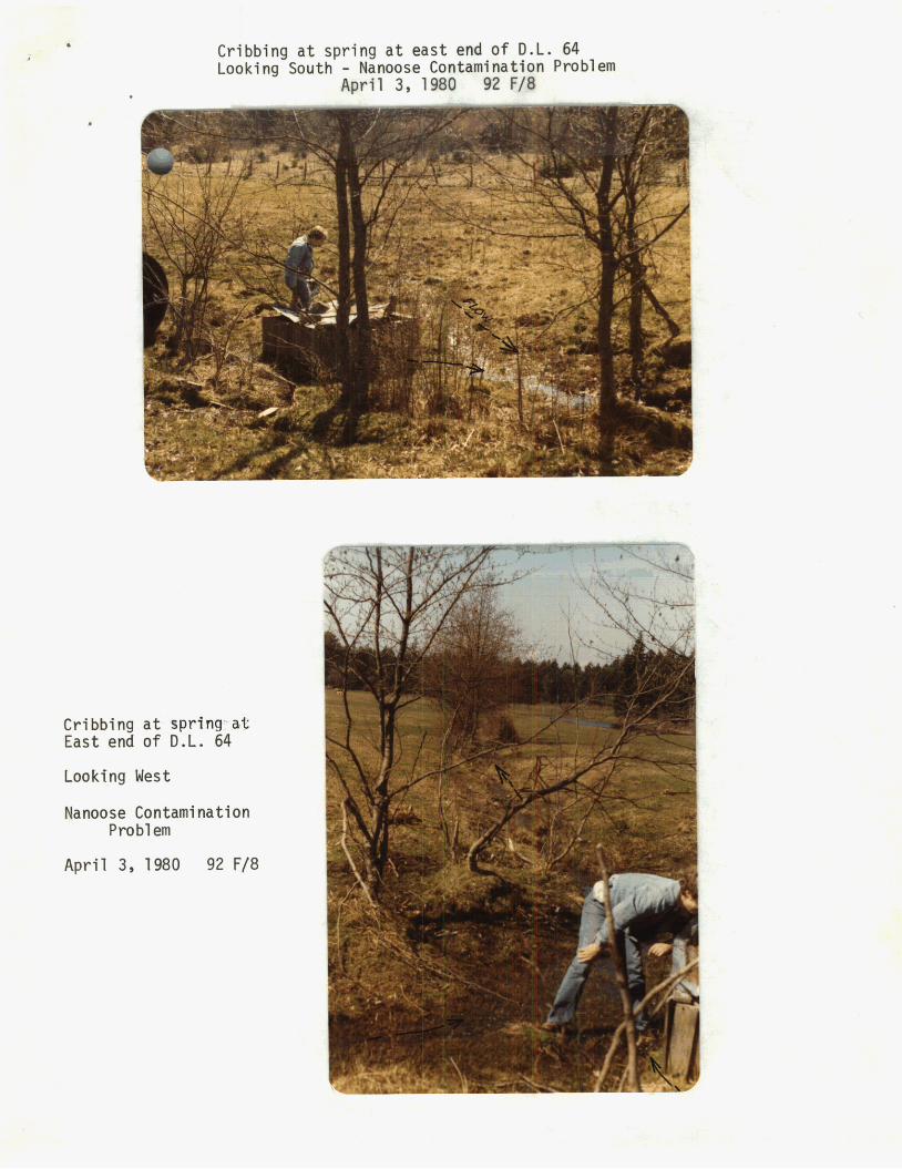
A f i e l d check o f l o c a l a g r i c u l t u r a l a c t i v i t i e s i n t h e area of t h e Beachcomber we l l s and subsequent water q u a l i t y sampling o f s p r i n g s and s u r f a c e runoff (Figure 3) i n d i c a t e d t h e presence o f moderate l e v e l s of ammonia (0.200 t o 0.210 mg/L) and o rgan ic n i t r o g e n (2.0 mg/L) i n runoff o r i g i n a t i n g from a l i v e s t o c k ho ld ing area loca ted i n t h e southwest co rne r o f D . L . 64 along Stewart Road. These ana lyses are l i s t e d i n Table 3 . In Apr i l 1980 runof f from t h e area o f t h e l i v e s t o c k o p e r a t i o n was flowing w e s t e r l y through a c u l v e r t under Stewart Road towards D . L . 84. Much o f t h i s runof f appears t o be generated by l o c a l l y high w a t e r - t a b l e cond i t ions and n a t u r a l groundwater d i scha rge i n D . L . 64 (Figure 3 ) . On t h e west s i d e o f Stewart Road t h i s runof f was observed t o d i sappea r i n t o t h e subsu r face . Fu r the r west downslope runoff r eappea r s and i s d i r e c t e d i n t o a dugout east o f Claudet Road. o rgan ic n i t r o g e n l e v e l s observed i n t h e dugout (0.022 and 0.34 mg/L r e s p e c t i v e l y ) and i n t h e runof f f lowing i n t o t h e pond (0.021 and 0.26) a r e however, cons ide rab ly less than t h o s e observed i n runoff from t h e l i v e s t o c k ope ra t ion upslope. Ni t r i te p l u s n i t r a t e l e v e l s i n t h e runof f from t h e l i v e s t o c k o p e r a t i o n were found t o be low and n o t g r e a t e r t han 0.08 mg/L. from t h e l i v e s t o c k ho ld ing a r e a were a l s o low with t o t a l phosphorous
The ammonia and
Phosphorous l e v e l s i n t h e runof f
. . . 5
- 5 -
i n t h e range 0.090 t o 0.105 mg/L and orthophosphate n o t g r e a t e r t han 0.005 mg/L. From t h e s e r e s u l t s it would appear t h a t t h e runof f
t h e l i v e s t o c k holding area could be a source f o r t h e ammonia nd o rgan ic n i t r o g e n l e v e l s observed i n t h e Beachcomber wells.
Although p r e s e n t , t h e ammonia l e v e l s however, i n t h e Beachcomber we l l s are ;.,n o r d e r o f magnitude h i g h e r t han those observed i n t h e r u n o f f . This runof f moreover does no t appear t o be a major sou rce o f phosphorous. In Apr i l 1980 only a few head o f l i v e s t o c k ( c a t t l e ) were be ing kept i n D . L . 64. I t i s n o t known whether l a r g e r numbers o f l i v e s t o c k may have been maintained i n t h i s area i n t h e p a s t and whether t h e water q u a l i t y o f t h e runof f may have v a r i e d accordingly. Seasonal v a r i a t i o n s i n n i t r a t e - n i t r o g e n and Kjeldahl n i t r o g e n l e v e l s i n f e e d l o t runoff and groundwater ad jacen t t o f e e d l o t s f o r example, have been r epor t ed elsewhere (Irwin and Robinson, 1974; S t a l e y e t a l , 1976). Seasonal changes i n t h e concen t r a t ions o f t h e s e parameters may be r e l a t e d t o s e v e r a l f a c t o r s such as , changes i n p r e c i p i t a t i o n , seasonal w a t e r - t a b l e f l u c t u a t i o n s , changes i n animal d e n s i t y and waste loading, climatic v a r i a t i o n s inc lud ing temperature and evaporat ion changes, v a r i a t i o n s i n waste spreading methods, t h i c k n e s s o f waste pack, e tc . A s t h e a q u i f e r supplying t h e Beachcomber wells i s o v e r l a i n by r e l a t i v e l y low pe rmeab i l i t y materials such as s i l t , c l a y and g l a c i a l till and t h e non-pumping water l e v e l s a r e c l o s e t o 100 feet below ground it i s u n l i k e l y t h a t any contaminants are being introduced from t h e ground s u r f a c e i n t h e immediate v i c i n i t y o f t h e wells. I f t h e we l l s were no t p rope r ly s e a l e d along t h e cas ing above t h e s c r e e n contaminated runoff o r contaminated shallow groundwaters could r e a d i l y make t h e i r way i n t o t h e a q u i f e r a long t h e well c a s i n g . There i s no evidence however, t o suggest t h a t t h e s e wells a r e n o t adequately s e a l e d above t h e a q u i f e r . Waste d i s p o s a l on t h e o t h e r hand a t o r nea r t h e boundaries o f t h e a q u i f e r away from t h e wel l s i t e s and over t h e f r a c t u r e d bedrock i n ad jacen t upland areas where t h e w a t e r - t a b l e i s c l o s e t o ground s u r f a c e could f a c i l i t a t e t h e r e l a t i v e r a p i d movement o f contaminants i n t o t h e a q u i f e r zone.
3. N a t u r a l l y Occurr ine DeDosits
The a q u i f e r (Quadra Sediments) i n which t h e Beachcomber wells are completed i s known t o c o n t a i n o rgan ic remains (Fy le s , 1963) which could be t h e source o f t h e o rgan ic n i t r o g e n and through subsequent mic rob io log ica l a c t i v i t y , t h e observed ammonia l e v e l s i n t h e ground- water . Fyles (1963) r e p o r t s t h e occurrence o f dr i f twood and pea ty beds wi th in t h e Quadra Sediments s p e c i f i c a l l y n e a r t h e head o f Nanoose Bay. Chunks o f wood have a l s o been r e p o r t e d i n t h e Kent wel l a t a depth o f 61 t o 85 f e e t (Table 1 ) . According t o Fyles (1963) " the pea ty materials o f t h e p l a n t - b e a r i n g s i l t - g r a v e l u n i t o f t h e Quadra sediments c o n s i s t e s s e n t i a l l y o f f i n e l y d iv ided p l a n t material mixed wi th a small t o l a r g e p ropor t ion o f mineral sediment .... f l a t t e n e d branches, stems, and r o o t s o f woody p l a n t s a r e p r e s e n t i n most o f t h e pea ty beds bu t only l o c a l l y a r e t h e y abundant". Fyles (1963) sugges t s a f r e sh -wa te r mode o f d e p o s i t i o n f o r t h e p l a n t - b e a r i n g d e p o s i t s with p o s s i b l e accumulation i n a r i v e r p l a i n o r lagoonal environment.
. . . 6
- 6 -
Natu ra l ly occur r ing d e p o s i t s t h a t con ta in apprec i ab le amounts o f phosphate (termed phosphori tes) a r e g e n e r a l l y o f f r e sh -wa te r o r i g i n
, 1962). The most common form o f sedimentary phosphate i s eang ollophane, a c r y p t o c r y s t a l l i n e phosphat ic admixture of s e v e r a l v a r i e t i e s o f a p a t i t e , Ca5(P0k)3(F, C 1 , O H ) . Much collophane i s of o rgan ic o r i g i n and i s p r e s e n t i n bones and t e e t h of animals, i n s h e l l material and f e c a l r e s i d u e s . The presence o f n a t u r a l l y occur r ing phosphates wi th in t h e Quadra sediments i s p r e s e n t l y unknown al though t h e mode o f d e p o s i t i o n was favourab le f o r i t s p o s s i b l e presence. Deep wells completed i n t h e unconsol idated d e p o s i t s a t t h e head of Nanoose Bay f o r West Bay E s t a t e s a l s o show phosphorous (0.144 mg/L) p r e s e n t i n t h e groundwater (Table 2 ) . Limestones and s h a l e s deposi ted by biochemical agen t s under cond i t ions o f slow sedimentat ion i n r e s t r i c t e d areas where reducing cond i t ions p r e v a i l , i n c l u d i n g submarine volcanism, development o f hydrogen s u l f i d e , e t c . , may a l s o be phosphat ic (Huang, 1962). Limestones a s s o c i a t e d with vo lcan ic rocks are r e p o r t e d i n t h e immediate area (Muller and Carson, 1969) bu t t h e i r chemical composition has n o t been documented t o a s c e r t a i n whether t hey may be a source o f phosphorous.
I Conclusions
Ava i l ab le background evidence sugges t s t h a t t h e presence o f both ammonia n i t r o g e n and d i s so lved phosphorous i n t h e Beachcomber wells could be de r ived r e s p e c t i v e l y from t h e ox ida t ion o f n a t u r a l l y occur r ing n i t r o g e n - r i c h o rgan ic m a t t e r w i th in t h e a q u i f e r and from p o s s i b l e presence o f mineral m a t t e r i n t h e a q u i f e r o r i n ad jacen t bedrock sources h y d r a u l i c a l l y connected t o t h e a q u i f e r . Runoff c o n t a i n i n g ammonia and o rgan ic n i t r o g e n from a l i v e s t o c k ho ld ing a r e a l o c a t e d upslope and e a s t o f t h e Beachcomber we l l s may a l s o be r echa rg ing t h e a q u i f e r d i r e c t l y a long t h e a q u i f e r boun- d a r i e s and/or through ad jacen t f r a c t u r e d bedrock materials. Dissolved phosphorous however, i s n o t evident i n t h i s l a t t e r sou rce .
i n s i t u phospha t i c
I Recommendat i ons
Long-term monitor ing (monthly samples f o r one y e a r f o r example) o f water q u a l i t y i n t h e Beachcomber wells should be undertaken t o determine whether any of t h e chemical parameters vary s e a s o n a l l y and t o what e x t e n t . I f t h e l e v e l s o f ammonia and phosphorous are found t o be i n c r e a s i n g d rama t i ca l ly , d e t a i l e d t e s t d r i l l i n g may be r e q u i r e d t o p inpo in t t h e source area f o r t h e s e c o n s t i t u e n t s . Routine chemical analyses should inc lude :
Nitrogen NO,, NO3 Nitrogen ammonia Nitrogen Kjeldahl Nitrogen o rgan ic Nitrogen t o t a1 Phosphorous orthophosphate Phosphomus t o t a l
. . . 7
- 7 -
Considerat ion should a l s o be given t o sampling t h e w e l l s f o r Tri t ium a n a l y s i s . um ana lyses would i n d i c a t e whether o r no t young wa te r s ( l e s s than 25
ye Tm o ld ) a r e e n t e r i n g t h e w e l l s . If present , Tri t ium would i n d i c a t e p o s s i b l e contamination from nea r s u r f a c e sou rces . Costs f o r Tri t ium a n a l y s i s are p r e s e n t l y $50 p e r sample. Two o r t h r e e samples only would be r e q u i r e d .
Runoff from t h e l i v e s t o c k holding area along Stewart Road should be r e t a i n e d on t h e p r o p e r t y D . L . 64 and n o t allowed t o flow downslope i n t h e d i r e c t i o n o f t h e Beachcomber w e l l s o r any neighbouring wells. Runoff from t h i s ope ra t ion should be c o n t r o l l e d i n accordance wi th t h e Environmental Guidel ines prepared by t h e Min i s t ry of A g r i c u l t u r e .
A .P . Kohut Senior Geological Engineer Groundwater Hydrology Sec t ion
APK/j m
~ References
11, D . (1962) Rainwater as a Chemical Agent o f Geologic Processes - A Review, U.S. Geological Survey Water-Supply Paper 1535-G.
Cen t ra l Water Planning Unit (1977) N i t r a t e and Water Resources wi th P a r t i c u l a r Reference t o Groundwater, Reading, United Kingdom.
Freeze, R . A . and Cherry, J . A . (1979) Groundwater, P ren t i ce -Ha l l I n c . , N e w J e r s e y .
Fyles , J . G . (1963) S u r f i c i a l Geology of Horne Lake and P a r k s v i l l e Map - Areas, Vancouver I s l a n d , B r i t i s h Columbia, Geological Survey o f Canada, Memoir 318.
Huang, W.T. (1962) Petrology, M c G r a w - H i l l Book Company.
I rwin, R.W. and Robinson, J . B . (1974) Runoff Volumes and Ground Water Qua l i ty From a Beef Feed lo t , Canadian Soc ie ty of A g r i c u l t u r a l Engineering Paper No. 74-410, Annual Meeting 1974 Lava1 Un ive r s i ty , Quebec.
Muller, J . E . , and Carson, D . J . T . (1969) Geology and Mineral Deposits o f Alberni Map - Area ( 9 2 F ) , Geological Survey o f Canada, Paper 68-50.
Robertson, J . A . , McQuitty, J . B . , and Barber, E.M. (1974) Feedlot P o l l u t i o n , Nitrogen Under Some Cen t ra l A l b e r t a Feed lo t s , Department o f Agricul- t u r a l Engineering, Un ive r s i ty o f A lbe r t a , Research B u l l e t i n , 74-2.
S t a l e y , L . M . , Podmore, T.H. and Cappelaere, B . (1976) In f luences of Land Spreading Livestock Wastes on Groundwater Qua l i ty , Canadian Soc ie ty o f A g r i c u l t u r a l Engineering Paper No. 76-204, Annual Meeting 1976, Ha l i f ax , Nova S c o t i a .
. . . . I I
Province of British Columbia .............................................................. HOR L! // = L.e.o.0 / 5AUG. /98C Ministry of the Environment - GROUMD LyA T€X' Con/7.4M/NAI/od .. ........ .............. ......................................................................
WATER INVESTIGATIONS BRANCH FILE No ................................................. PZ F8 DWG. No ..................................................... F/GL/R& /
. . ._
A--B L/&/E OF GEOLQCK CKOSS S E C ~ O N DATE
SCALE: VERT TO ACCOMPANY REPORT ON
ENVIRONMENTAL AND ENGINEERING SERVICE __ . NANboSE AREA .................................................................................................. &?!% ......... ENGINEEI
bcil 6661 wrs
LEGEND '
= / SCALE: VERT .......................... ...Loo Province of British Columbia TO ACCOMPANY REPORT ON ............................
G R o UMP W 4 7&R CON T 4 M /*A ?%A/ HOR / a = / o m /
2000
DATE
5ADG /980
4000 F € € 7
Ministry of the Environment ENVIRONMENTAL AND ENGINEERING SERVICE ' NdNmSE AREA WATER INVESTIGATIONS BRANCH
6000 8000
................................................................................................................
........................................................................................................................... APK ENGINEEE
FILE No .......... .%&..!!?.@ .................... DWG. No ....................................................... F/GURE 2
bci l 6661 wrs
N i
Province of British Columbia Ministry of the Environment ENVIRONMENTAL AND ENGINEERING SERVICE
WATER INVESTIGATIONS BRANCH
i . .
DATE SCALE: VERT ..................................................................... N# TO ACCOMPANY REPORT ON
G ROUMD W8Tii-R CdN7W'I/N&TlOM . . HOR ........... /... ........ .$a / ............................................................................ I 5 ' A V G /PA3 M4Noosr &?€A _ ~PKENGINEEI;
F/GOK€ 3 I ...................... ....................................................... I FILE No ........ ?&..E..@ DWG. No
PLAN 6 9 4 R PO#D
c.7: 045040-.2L~
SC)UTH 6 C i l A I N S
I '
. '
,
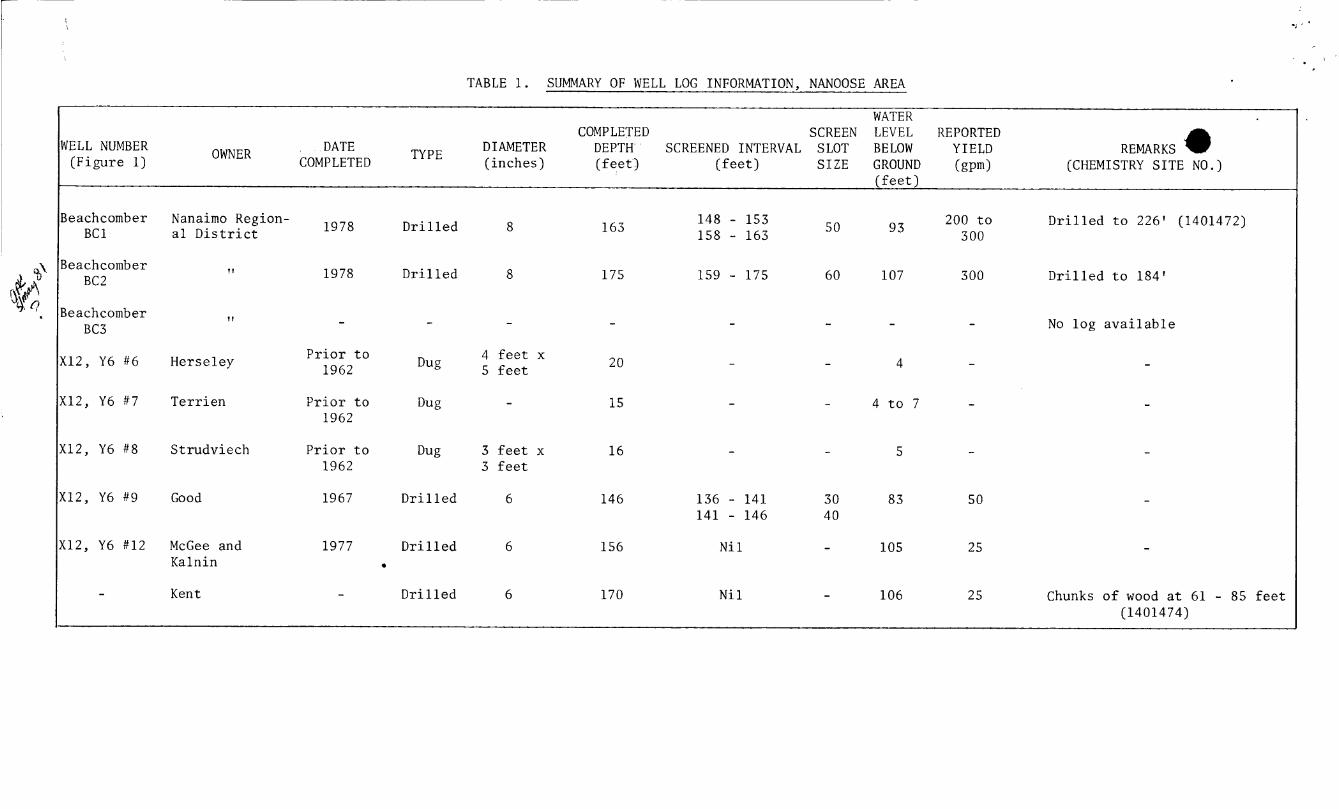
TABLE 1. SUMMARY OF WELL LOG INFORMATION, NANOOSE AREA
WATER * COMPLETED SCREEN LEVEL REPORTED DATE DIAMETER DEPTH SCREENED INTERVAL SLOT BELOW Y I E L D REMARKS
COMPLETED TYPE ( inches) ( f e e t ) ( f e e t ) SIZE GROUND (gpm) (CHEMISTRY SITE NO.) OWNER WELL NUMBER
(Figure 1) ( f e e t )
%\
',
Beachcomber BC 1
Beachcomber BC 2
Beachcomber BC3
X 1 2 , Y6 #6
X 1 2 , Y6 # 7
X12, Y6 #8
X 1 2 , Y6 #9
Nanaimo Region- a l D i s t r i c t
1 1
I I
Heme l e y
Te r r i en
Strudviech
Good
X12, Y6 #12
-
McGee and Kalnin
Kent
1978
1978
-
P r i o r t o 1962
P r i o r t o 1962
P r i o r t o 1962
1967
1977
D r i l l e d
D r i l l e d
-
Dug
Dug
Dug
D r i l l e d
D r i l l e d
- D r i l l e d
8
8
-
4 f e e t x 5 f e e t
-
3 f e e t x 3 f e e t
6
6
6
163
175
-
20
15
16
146
156
170
148 - 153 158 - 163
159 - 175
-
-
-
-
136 - 1 4 1 141 - 146
N i 1
N i 1
93
107
-
4
4 t o 7
5
83
105
106
200 t o 300
300
-
-
-
-
50
25
25
D r i l l e d t o 226' (1401472)
D r i l l e d t o 184'
No log a v a i l a b l e
-
-
Chunks o f wood a t 61 - 85 f e e t (1401474)
6 -. .. ' z .I TABLE 2 . SUMMARY OF WATER ANALYSES OF WELLS, NANOOSE AREA
PhosDhorous TOTAL
LINITY ALKA- it r o gel
NO2
-
:O. 005
:O. 005
~ 0 . 0 0 5
:O. 005
- c0.02
:o. 005
:O. 005
:O. 005
< O . 005
:O. 005
:O. 005
I
:0 .005
~ 0 . 0 0 5
-
:O. 005
< O . 005
:O. 005
IARD- JESS K+ SAMPLING*
DATES Na+
17.4
15 .8 -
- 15.9
30.3
32 - -
33.7
32.5
32.6
52.2
31.1
20.5
-
4.8
6.3
116
Mg2+
9.89
1 .4
9 .6 -
0.5
5.74
6 . 3
6 .0 -
6.0
6 . 3
6 . 3
0.4
7.7
2.2
2 .6
4 .2
7.0
2.6
PH -- Tota l
1.65
0.487
0.456
0.456
0.438
1.41
0.58
0.565
0.562
0.580
0.567
0.580
1.49
0.64
0.676
-
0.014
0.030
-
K j e l d - ah.1
-
0.64
0 .6
1
1
- 19
3
2
3
2
2
3
1.35
2
- 0.15
0.33
-
Ammon- i a
-
-
0.575
0.560
0.605
- -
1.76
1.75
1.92
1.75
1.74
2.66
1.20
1.07
-
0.011
0.116
-
TDS SITE N02+NOc
-
< o . 02
< o . 02
<0.02
0.02
0.003
<o. 02
< o . 02
0.02
<o . 02
< o . 02
< o . 02
<o . 02
<o . 02
< o . 02
-
1.23
0.03
<0.02
3e ach comber BC 1
(1401472)
3eachcomber BC 2
3eachcomber BC 3
(ent 11401474)
IcGee and ( a ln in
I'err i en (Old Well)
[New Well)
Vest Bay !states
J u l . 24/78
Aug. 22/79
Nov.27/79
Dec. 10/79
Jan . 16/80
Oct .30/ 78
Aug. 29/79
Nov. 27/79
Dec. 10/79
Jan . 16/80
Jan . 17/80
Jan, 21/80
Jan . 2 1 / 8 0
Dec. 3/79
Dec. 20/79
Sept . /79
Dec. 20/79
Jan . 16/80
Feb. 5/79
31.4
30.0
31.6 -
32.2
23.7
26.9
25.9 -
24.3
26.1
25.9
26.5
30.9
31.4
52.6
13 .0
33.8
46
2 . 2 2
2 . 1 - -
-
3.39
3.0 - -
- -
-
-
2.9
2 . 2
-
0.5 -
2.5
5.1
5 . 1 -
-
-
5.9
7.0 - -
-
-
-
-
5 .3
3.4
-
3.4 -
216
182
148
148 -
153
-
158
159 -
160
157
160
225
176
181
196
50
114
129
119
1 2 2
118 -
-
82.8
93.1
89.4 -
-
-
-
-
109
128
183
49.7 -
167
8.2
8 .3
8 . 1
8 .0
8.2
8.2
8.2
8.0
8 . 0
8.2
7.9
8 .0
7.9
8 .1
8 .1
7.9
7.2
7.7
8 .2 -
<o. 1
< o . 02
<o. 02
0.02
0.02
-
<o . 005
<o .02
0.02
< o . 02
< o . 02
<0.02
<0.02
<o . 02
<o .02
1 . 2 3
0 .03
<0.02
25 3
174 - -
-
275
188 -
- -
-
-
-
204
210
2 36
86 -
526
-
-
0.436
0.430
0.417
-
0.548
0.555
0.534
0.562
0.555
0.562
0.93
0.514
0.520
0 .7
0.005
0.015
0.144
* A l l u n i t s i n mg/L except pH ( r e l a t i v e u n i t s ) .
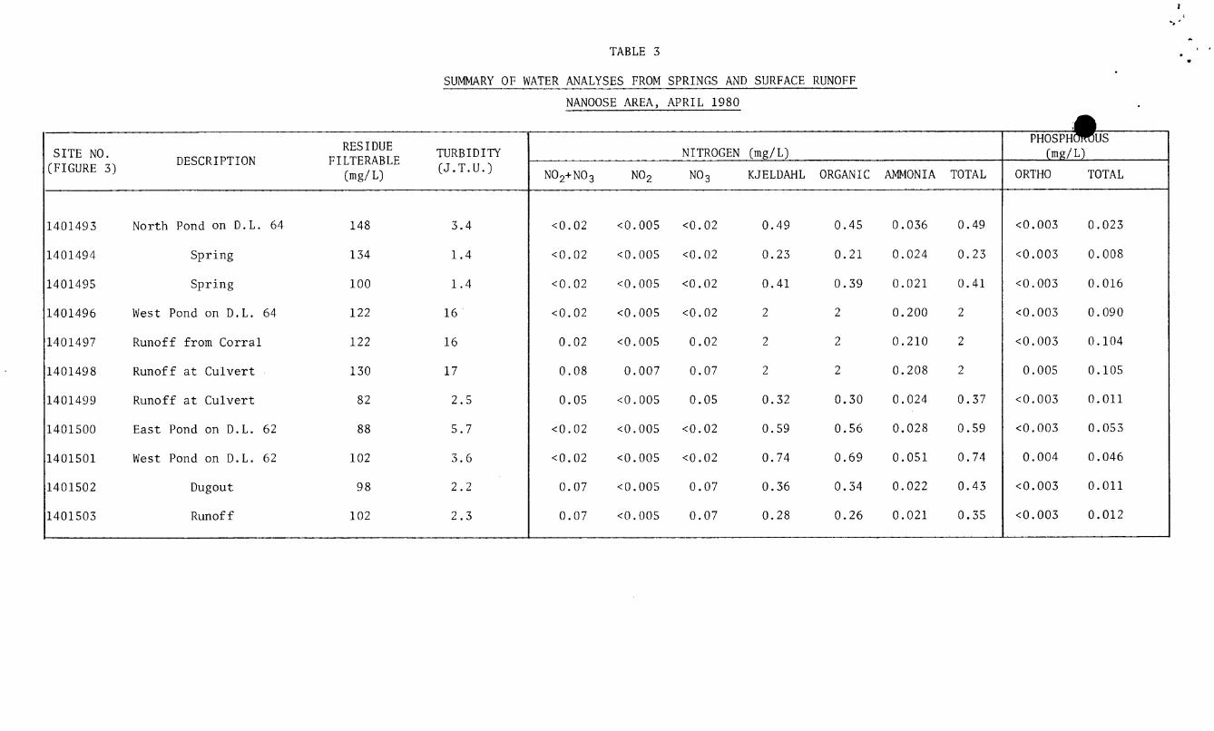
TABLE 3
SUMMARY OF WATER ANALYSES FROM SPRINGS AND SURFACE RUNOFF
TURBIDITY (J.T.U.)
RES I DUE DESCRIPTION FILTERABLE SITE NO.
( F I G U R E 3) (mg/ L)
140149 3 North Pond on D . L . 64 148 3.4
1401494 Spring 134 1 . 4
1401495 Spring 100 1 . 4
140 1496 West Pond on D . L . 64 122 16
1401497 Runoff from Corral 1 2 2 16
1401498 Runoff a t Culver t 130 1 7
1401499 Runoff a t Culver t 82 2.5
1401500 East Pond on D . L . 62 88 5 .7
1401501 West Pond on D . L . 62 102 3 .6
1401502 Dugout 98 2 . 2
1401503 Runoff 102 2 .3
NANOOSE AREA, APRIL 1980
N I T R O G E N (mg/L)
KJELDAHL ORGANIC AMMONIA TOTAL N02+N03 NO2 NO3 ~~ ~~
< o . 02 < o . 005
< o . 02 <0.005
<0.02 < O . 005
<0.02 < o . 005
0.02 < O . 005
0 .08 0.007
0.05 < o . 005
< o . 02 < O . 005
< o . 02 < O . 005
0.07 < O . 005
0.07 < o . 005
<0.02
<o. 02
<o . 02
< o . 02
0.02
0.07
0.05
<0.02
< o . 02
0.07
0.07
0.49
0.23
0.41
2
2
2
0.32
0.59
0.74
0.36
0.28
0.45 0.036 0.49
0.21 0.024 0 .23
0.39 0.021 0.41
2 0.200 2
2 0.210 2
2 0.208 2
0.30 0.024 0.37
0.56 0.028 0.59
0.69 0.051 0.74
0.34 0.022 0.43
0.26 0.021 0.35
(mg/ L) ORTHO TOTAL
< O . 003
< O .003
< O . 003
< O . 003
< O m 003
0.005
<0.003
< O . 003
0.004
<0.003
< O . 003
0.023
0.008
0.016
0.090
0.104
0.105
0.011
0.053
0.046
0.011
0.012
r e , _. :,* !
. . ‘ .$
1
j i
-11
Cribbing a t spring a t east end o f D.L. 64 Looking South - Nanoose Contamination Problem
April 3, lW 99 Fa
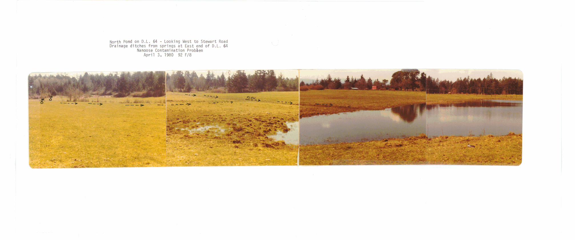
North Pond on D.L. 64 - Looking West t o Stewart Road Drainage di tches from springs a t East end o f D.L. 64
Nanoose Contamination Probaem A p r i l 3 , 1980 92 F/8
,
![MIL-S-901D [SHOCK TESTS. H.I. (HIGH-IMPACT ...Title MIL-S-901D [SHOCK TESTS. H.I. (HIGH-IMPACT) SHIPBOARD MACHINERY, EQUIPMENT, AND SYSTEMS, REQUIREMEN...] Author USA Information Systems,](https://img.pdfslide.us/doc/110x75/5ea810b1dacfc1112741812e/mil-s-901d-shock-tests-hi-high-impact-title-mil-s-901d-shock-tests-hi.jpg)


![MIL-S-901D [SHOCK TESTS. H.I. (HIGH-IMPACT) SHIPBOARD ...€¦ · mil-s-901d [shock tests. h.i. (high-impact) shipboard machinery, equipment, and systems, requiremen...] author: usa](https://img.pdfslide.us/doc/110x75/5eac88b75c12056feb5068ed/mil-s-901d-shock-tests-hi-high-impact-shipboard-mil-s-901d-shock-tests.jpg)


![Aluminum tris(dihydrogen phosphate) [Al(H PO ...ipcbee.com/vol6/no2/84-F30013.pdf · Aluminum tris(dihydrogen phosphate) [Al(H2PO4)3]: environmentally friendly catalyst for the preparation](https://img.pdfslide.us/doc/110x75/5c943a8f09d3f2c2238c0fe8/aluminum-trisdihydrogen-phosphate-alh-po-aluminum-trisdihydrogen-phosphate.jpg)