Embed Size (px)
Citation preview
NRC Earth Science Decadal Survey-Mission Concept
Earth Sciences from the Astronomer’s Perspective, a Deep Space Climate Observatory (DSCOVR)
Submitted by Francisco P.J. Valero, DSCOVR Principal Investigator- based on contributions by the DSCOVR Science Team
Scripps Institution of Oceanography, University of California, San Diego Francisco P. J. Valero, PI Brett C. Bush Shelly K. Pope V. Ramanathan
NASA Goddard Space Flight Center Jay Herman, GSFC Project Scientist Keith Ogilvie Warren J. Wiscombe National Institute of Standards and Technology Steven Lorentz Joseph Rice NASA Langley Research Center Patrick Minnis University of Colorado Peter Pilewskie National Center for Atmospheric Research William D. Collins
Laboratoire de Meteorologie Dynamique, Ecole Normale Superieure, France Claude Basdevant Bernard Legras Hector Teitelbaum Virginia Polytechnic Institute G. Louis Smith Boston University Alan Strahler Istituto di Scienze dell'Atmosfera e del Clima, Bologna, Italy and Italian Space Agency Claudio Tomasi KNMI, The Netherlands Ankie J.M. Piters University of Bremen, Germany John Burrows St Petersburg University, Russia Irina Melnikova
1
Earth Sciences from the Astronomer’s Perspective 1.0 Mission Concept and Purpose Earth observations from satellites located in deep space offer the exciting opportunity to look at the Earth in a bulk thermodynamic sense, particularly as an open system exchanging radiative energy with the Sun and space, in a way never done before – "the Earth as a whole planet", astronomers would say. This is a fundamental scientific goal with very appealing prospects for climate sciences. Climate research requires stable, accurate, long-term observations made with adequate spatial and temporal resolution in a synoptic context. From deep-space vantage points we can, with a single spacecraft, sample the outgoing energy from virtually an entire hemisphere of Earth at once with high temporal and spatial resolution. At present this is only partially possible by combining data from low Earth orbit (LEO) and geostationary orbit (GEO) satellites into an asynoptic composite of hundreds of thousands of pixels - rather like assembling an enormous jigsaw puzzle. Another advantage of the deep-space perspective is that, because of the integral view of the planet's hemispheres, the observations will simultaneously overlap the observations of every LEO and GEO satellite in existence, making possible a unique synergy with great potential benefits for the Earth sciences. For example, a satellite placed at the Lagrange 1 (L-1) point between the Sun and the Earth orbits the Sun with the same period as the Earth. (The Lagrange points mark positions where the gravitational pull of the two large masses precisely equals the centripetal force required to rotate with them. The net effect is that a satellite at the solar Lagrange points will orbit the Sun with the same orbital period as the Earth.) Therefore, a satellite placed at one of these Lagrange points would maintain the same relative position to the Sun and the Earth and be able to observe most points on the sunlit planet as the Earth rotates during the diurnal cycle. L-1 and L-2 are of particular interest because a satellite at either location remains on the Sun-Earth line and views, respectively, the entire daytime hemisphere and the entire nighttime hemisphere. Synoptic, high temporal-resolution observations would be obtained as every point on the planet transits from sunrise to sunset (L-1) or from sunset to sunrise (L-2). A pair of deep-space observatories, one at L-1 and one at L-2, could observe almost every point on Earth simultaneously. The combination of deep-space, LEO, and GEO satellites would certainly provide a powerful observational tool as well as enriched data sets for Earth sciences. Such synergism is greatly enhanced when one considers the potential of utilizing LEO, GEO, and deep-space satellites as an integrated observational system. For example, a satellite at L-1 will view the Earth plus the Moon (see Figure 1) while simultaneously having in its field of view (at one time or another) all Earth-orbiting satellites. This view offers the opportunity to use the Moon as a calibration reference that can in turn be shared with all other Earth observation satellites. In other words, the deep-space observatory can become an important link between LEO and GEO satellites while at the same time providing the data necessary to build an integrated Earth observational system. Such
2
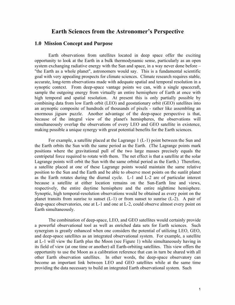
Figure 1. Simulated nearly instantaneous DSCOVR view of clouds constructed from actual cloud observations seen by the Galileo spacecraft near L-1. The Moon has been inserted from observations of the sunlit side using Clementine data. The Moon view will be used for in-flight calibration of the EPIC spectral channels.
synergism would certainly represent a major advance in Earth sciences and a greatly enhanced return for the nation's investment in space. The unified, synergistic observational system has been the dream of Earth scientists for many years.
The vision of developing an integrated observational system of LEO, GEO and deep-space satellites is very promising for Earth sciences research. The nation would benefit from the advanced and unique studies that would result at minimal additional cost to taxpayers since the LEO and GEO Earth observing satellites are already in place. Only the addition of one or two deep-space platforms will be needed in order to forge observations performed by multiple, mostly independent satellites into a single correlated data set. The benefit for science could be considerable. A synergistic system composed of LEO, GEO, and deep-space platforms is likely the way of the future.
In addition to the unique observations of the Earth system, the Lagrange 1 position offers the opportunity for simultaneous solar observations and monitoring of solar activity and its effect on the upper atmosphere of the Earth that respond to the variations in the solar ultraviolet, visible and particles emissions.
DSCOVR will have a continuous (from sunrise to sunset) and simultaneous view (see Fig. 2) of the sunlit face of the rotating Earth. This ability alone gives the DSCOVR observations a capability never available from any other spacecraft or Earth observing platform in the past. Additionally, DSCOVR will always observe from the near retro-reflection position, a unique viewing geometry. Spectral images and radiometric measurements will be made to obtain important atmospheric environmental data (e.g., ozone, UV-irradiance at the Earth’s surface, water vapor, aerosols, cloud height, etc.) and information related to the Earth’s energy balance. DSCOVR measurements will have the advantage of synoptic context, high temporal and spatial resolution, and accurate in-flight lunar calibrations. Except for the period immediately after launch, DSCOVR will observe from near the retro-reflection position and gain a unique piece of the Earth’s energy-balance data, along with having increased sensitivity to changes on the Earth’s surface.
3
In this document we describe the questions that can be addressed by the DSCOVR data. We also demonstrate the value of deep-space observatories for acquiring important data not available in other ways. A few key points emphasizing the unique features of the spacecraft’s L-1 view of the Earth will be presented here.
2.0 DSCOVR Scientific Goals 2.1 Earth’s Atmosphere and Surface with EPIC
Using the DSCOVR Earth Polychromatic Imaging Camera (EPIC) instrument, for the first time it will be possible to determine the daily cycles in total ozone, aerosols, and column water vapor at high temporal and spatial resolution. Ten global spectral images of the sunlit side of the Earth will be acquired within 2 minutes with a spatial resolution of 8 km at nadir to 14 km near the Earth’s limb.
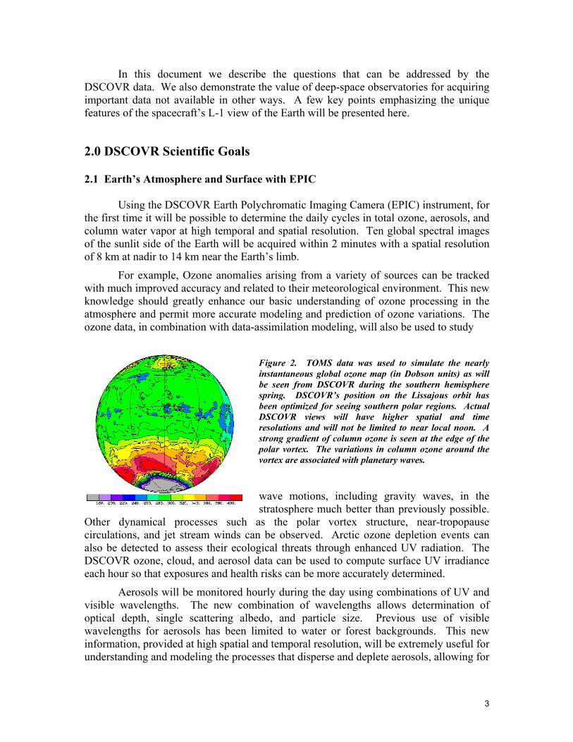
For example, Ozone anomalies arising from a variety of sources can be tracked with much improved accuracy and related to their meteorological environment. This new knowledge should greatly enhance our basic understanding of ozone processing in the atmosphere and permit more accurate modeling and prediction of ozone variations. The ozone data, in combination with data-assimilation modeling, will also be used to study
Figure 2. TOMS data was used to simulate the nearly instantaneous global ozone map (in Dobson units) as will be seen from DSCOVR during the southern hemisphere spring. DSCOVR’s position on the Lissajous orbit has been optimized for seeing southern polar regions. Actual DSCOVR views will have higher spatial and time resolutions and will not be limited to near local noon. A strong gradient of column ozone is seen at the edge of the polar vortex. The variations in column ozone around the vortex are associated with planetary waves.
wave motions, including gravity waves, in the stratosphere much better than previously possible.
Other dynamical processes such as the polar vortex structure, near-tropopause circulations, and jet stream winds can be observed. Arctic ozone depletion events can also be detected to assess their ecological threats through enhanced UV radiation. The DSCOVR ozone, cloud, and aerosol data can be used to compute surface UV irradiance each hour so that exposures and health risks can be more accurately determined.
Aerosols will be monitored hourly during the day using combinations of UV and visible wavelengths. The new combination of wavelengths allows determination of optical depth, single scattering albedo, and particle size. Previous use of visible wavelengths for aerosols has been limited to water or forest backgrounds. This new information, provided at high spatial and temporal resolution, will be extremely useful for understanding and modeling the processes that disperse and deplete aerosols, allowing for
4
better assessment and prediction of their chemical, cloud, and radiative impacts. Detection of aerosols in the Arctic Basin, where anthropogenic haze (Arctic Haze) is a significant factor, permits a more accurate determination of the aerosol impact in this extremely sensitive part of the world. The ability to detect aerosols each hour at high spatial resolution will be exploited to provide timely warnings of volcanic ash events and visibility anomalies (smoke and dust plumes) to the air transportation industry (through the FAA), the US Park Service, and the EPA.
EPIC data will also be used to develop valuable new information about cloud, water vapor, and surface properties. Since LEO/GEO satellites are being used to develop comprehensive climatologies of cloud properties at high spatial and temporal resolution, the unique viewing geometry of EPIC can be exploited in conjunction with these other satellites to determine cloud phase and particle shape. Cloud particle habit (shape) is an assumed parameter in current retrieval methods and in mesoscale models and GCMs. Retrieval of this parameter on a global basis will reduce the uncertainties in cloud and radiation modeling as well as in the retrievals of cloud particle size and ice water path. The atmospheric column water vapor will also be derived from reflected measurements over all surfaces on an hourly basis that will complement similar estimates from infrared retrievals of upper tropospheric water vapor column. The near retro-reflection geometry of the EPIC view can also be used to determine anisotropic reflectance properties of various types of vegetation and to improve characterization of canopy structure and plant condition. Diurnal variations of surface spectral albedo will also be derived to provide more accurate models for radiation calculations in GCMs and other atmospheric models.
DSCOVR is a valuable platform for half of a multi-angle remote sensing program because its EPIC images can be collocated with those from any other satellite with close temporal and spatial tolerances. Although only one multi-angle application has been noted, it is expected that the ease of matching EPIC and other satellite data will be an extremely valuable resource for remote sensing and, ultimately, climate modeling, especially in the area of validation. Conversely, other satellite and ground-based measurements taken at sparse temporal or spatial resolution will serve to verify DSCOVR’s hourly retrievals.
DSCOVR’s use of the “far side” of the Moon as a calibration reference (see Fig 1) can also help to assess the calibration of other satellite sensors through matching of co-angled collocated pixels. It is expected that the data will be used to characterize the spectral response of the lunar surface.
The global, high-resolution monitoring of the Earth with EPIC’s unique spectral complement will also be valuable for scientific field missions. Phenomena such as aerosol plumes that were only detectable with once-per-day satellite observations can be compared in the field each hour. Mission guidance can be provided for aircraft observations of aerosol plumes or ozone changes. Thus, large-scale context can be characterized more accurately and more information can be provided to mission planners.
5
2.2 Earth’s Radiation and Climate with NISTAR
The National Institute of Standards and Technology Active-cavity Radiometer (NISTAR) instrument will allow the first synoptic study the earth’s radiative balance utilizing the unique view of the integrated sunlit Hemisphere of the Earth system. Such synoptic and high-time resolution (a few minutes) view will provide much needed data with different scattering geometry, absolute calibration accuracy and spectral, space and time resolution.
NISTAR is a 4 channels absolute cavity radiometer that includes:
1) A UV to far infrared (0.2 to 100 µm) channel to measure total radiant power in the UV, visible, and infrared wavelengths
2) A solar (0.2 to 4 µm) channel to measure reflected solar radiance in the UV, visible, and near infrared wavelengths
3) A near infrared (0.7 to 4 µm) channel to measure reflected IR solar radiance
4) A non-absolutely calibrated photodiode (0.3 to 1 µm) channel for calibration reference for the spectroradiometer.
The absolute accuracy of the NISTAR is 0.1 to 0.2 % as tested after calibrations at the National Institute of standards and in its present condition. It is at the level of accuracy sufficient for climate studies and represents the most advanced absolute radiometry technology not employing cryogenic detectors.
The climate of Earth and its global mean surface temperature are the consequence of a balance between the amount of solar radiation absorbed by Earth’s surface and atmosphere and the amount of outgoing longwave radiation emitted by the system. The former is governed by the albedo (reflectivity) of the system, whereas the latter depends strongly on the atmospheric content of gases and particles (such as clouds and dust). While the theory of absorption of infrared radiation in the atmosphere [Arrhenius, 1896] is well accepted and embodied in climate models, the observational and theoretical treatments of albedo, aerosols and clouds (in particular radiative effects) and their interactions are still under development.
The buildup of CO2 (5), CH4 and other greenhouse gases during the past century leads to an increased absorption of infrared radiation in the atmosphere (enhanced greenhouse effect) and a consequent warming (“positive forcing”) of the climate. But, human-made changes in aerosols and clouds can cause enhanced albedo and hence cooling ("negative forcing"), and they may already have offset a substantial part of the enhanced greenhouse effect. Present trends suggest that by 2050, the magnitude of enhanced greenhouse effect will be so large that the net anthropogenic forcing will be unequivocally positive and substantial in magnitude [Anderson et al., 2003].
Changes in energy balance affect a host of climatic factors, such as temperature, sea level, meteorological patterns, and precipitation. To understand and quantify these effects, the enhanced greenhouse effect and all other forcings must be known accurately. To complicate matters further, the enhanced greenhouse effect is suspected of causing
6
changes in clouds and hence albedo, resulting in feedbacks on both incoming and outgoing radiation [Sun and Cess, 2004].
Increased albedo could counteract the enhanced greenhouse effect on a global scale. However, the spatial and temporal characteristics of aerosols, clouds, and greenhouse gases differ widely. Clouds change rapidly, and atmospheric residence times for aerosols are short compared to those for the key greenhouse gases (which remain in the atmosphere for centuries). Albedo therefore changes rapidly, whereas the enhanced greenhouse effect simply increases as a result of the slow accumulation of greenhouse gases. Local and regional changes in energy balance would occur even if the albedo change could offset the enhanced greenhouse effect globally. Light-absorbing aerosols further complicate the picture by cooling Earth’s surface, heating the atmosphere, and making clouds more absorbing; they may even reduce cloud cover, thereby decreasing albedo further.
These considerations underscore the importance of understanding the natural and anthropogenic changes in Earth's albedo and the need for sustained, direct, and simultaneous observations of albedo with all methods that are currently available. Albedo changes may be as important as changes in greenhouse gases for determining changes in global climate [Charlson et al., 2005].
Many methods have been used to estimate albedo, which cannot be measured directly. These methods differ in their scattering geometries, calibration accuracy, and in spectral, space, and time coverage. The different modes of observation include measurements of earthshine reflected from the Moon [Palle et al., 2004; Palle et al., 2003], broadband radiometer data from low orbits around Earth [Wielicki et al., 2005], geostationary cloud-cover observations [Zhang et al., 2004], deep space radiometry [NAS, Space Studies Board, 2001] and surface radiometry [Pinker et al., 2005; Wild et al., 2005]. All these methods require a theoretical model for relating the measured parameters to albedo, and they all rely on different assumptions. It is critical to compare the results from different approaches to test the consistency among them. DSCOVR’s deep space radiometry [NAS, Space Studies Board, 2001] would provide a crucial component to such studies by providing an alternative, different approach to global albedo determination.
When combined with the EPIC imagery and retrievals of cloud properties, the NISTAR shortwave radiances will produce estimates of the global albedo. The derived albedo values, or the original radiance data, can serve to evaluate the radiation calculations in GCMs. The NISTAR shortwave and longwave radiances will also be used to estimate errors in the albedos and longwave fluxes derived from interpolations of sparsely sampled LEO data, the more conventional technique for measuring the Earth radiation balance.
Because the near-infrared channel is sensitive to vegetation and snow/ice cover in addition to clouds, the NIR/VIS ratio is an attractively simple and fundamental analysis tool for studying global change, and DSCOVR is the perfect vantage point to begin using that tool. (No current or planned LEO or GEO Earth radiation budget satellites have a broadband near-infrared channel, although CERES is apparently planning to add one in the post-2003 timeframe, which should serve as a nice complement to that on DSCOVR.)
7
A modeling infrastructure will be developed based upon existing efforts at NCAR, participating NASA laboratories, and other institutions. This modeling infrastructure will be used to simulate the NISTAR signals and EPIC spectral imagery. Because of DSCOVR’s simple viewing geometry and relatively simple data processing requirements compared to LEO satellites, scientists and students would be able to study a wide variety of phenomena without many of the complexities usually associated with remote sensing. Because of the lunar calibration for EPIC and absolute calibration for NISTAR, the scientific community would be able to focus on geophysical applications of a stable, high-accurate data set. This could have important repercussions both for remote sensing and climate. 2.3 Solar Wind and Space Weather with Plasma-Mag The Plasma-Mag instruments will contribute to both the source and structure of the slow solar wind and the heating of the corona. The mechanisms for heating the solar corona to temperatures that are much hotter than the photosphere are not well understood. Waves in the solar wind almost certainly undergo a turbulent cascade to heat the wind at small scales, but our current descriptions of this are mostly phenomenological. More generally, the coupling between magnetic and electric fluctuations and particle distribution functions is a fundamental plasma interaction, important in a wide variety of contexts, but difficult to study directly. The improved time resolution of DSCOVR/Plasma-Mag provides an opportunity to determine the mechanism by which small-scale fluctuations dissipate in plasmas. A time resolution of less than 1s will provide information to determine how the plasma responds to the simultaneously measured magnetic fields.
DSCOVR would also provide a monitor of the solar wind in addition to any other spacecraft that may still be available at the time of its launch. This would allow the detailed study of the non-radial correlation with solar wind fluctuations. This study was begun with earlier spacecraft such as the Explorers, IMP, and ISEE, but new opportunities would now be available. For example, if WIND or a STEREO spacecraft were measuring the solar wind at a variety of positions away from L-1, this would provide correlation at multiple baselines. These measurements would help to determine the symmetry of the fluctuations in the wind that in turn determine the way in which energetic particles propagate in the heliosphere. This basic understanding is also central to determining how, for example, solar events affect the Earth and its near-space environment, and thus is important for determining the effects of solar activity on spacecraft and manned space flights.
The Plasma-Mag instruments will measure the magnetic field and the velocity distribution functions of the electron, proton, and alpha components of the solar wind with higher time resolution than existing spacecraft.
The three Plasma-Mag instruments (Faraday cup, magnetometer, and electron spectrometer) will obtain 3-dimensional measurements of the velocity distribution functions of protons, helium ions, and electrons, and the interplanetary magnetic field. The data can be collected with high temporal resolution because DSCOVR is a fixed
8
orientation spacecraft that permits the solar wind ions and electrons to strike the Faraday cup continuously. The data collected by Plasma-Mag will provide early warning of solar events that may cause damage to power generation, communications, and other satellites. Together, the Plasma-Mag suite of instruments will provide a 1-hour warning to the appropriate agencies that safeguard electrical equipment on Earth and satellites in Earth orbit. Present plans include routinely providing the data to NOAA with typically only a 5-minute data processing delay from detection of an event at the DSCOVR spacecraft position to the time that it is delivered. Monitoring of the solar weather has become a mandatory function of government due to the growth of civilian and military satellite communications. Plasma-Mag will add to, or replace, the first generation space-weather monitors, such as WIND, IMP-8, and ACE.
2.4 Possible Science Enhancements to the DSCOVR Mission A. The Sun-Earth Coupling.
A major enhancement to the DSCOVR existing scientific objectives would be to include solar activity forecasts and the Earth’s response into climate forecasts. To achieve such an objective it is necessary to characterize the coupling between the solar and Earth systems.
The original DSCOVR mission includes the “Plasma-Mag” instruments but we suggest taking further advantage of the L-1 location in space to enhance solar scientific observations by adding capabilities that will provide data directed to the above enhanced scientific objective. The selection of proper instrumentation, spectral coverage and accuracy is critical to achieve these objectives. Additional instrumentation should provide the following data (not a complete list):
1) spatial imaging of bolometric flux of solar photosphere,
2) rapid (~1min) global imaging spectroscopy of solar UV, EUV and soft X-rays at moderate resolution plus
3) imaging solar magnetograph. Such enhanced capabilities would allow the coupling of the Earth’s atmosphere to solar activity.
B. Second Focal Plane for the EPIC A second focal plane together with an appropriate detector array would allow the
extension of the EPIC’s wavelength coverage to the middle infrared. This improvement to the EPIC would extend the utility of the instrument in for example, the study of clouds and greenhouse gases. The infrared focal plane for the EPIC was considered originally, engineering studies were completed, but it was necessary to drop this option for financial and schedule reasons.
9
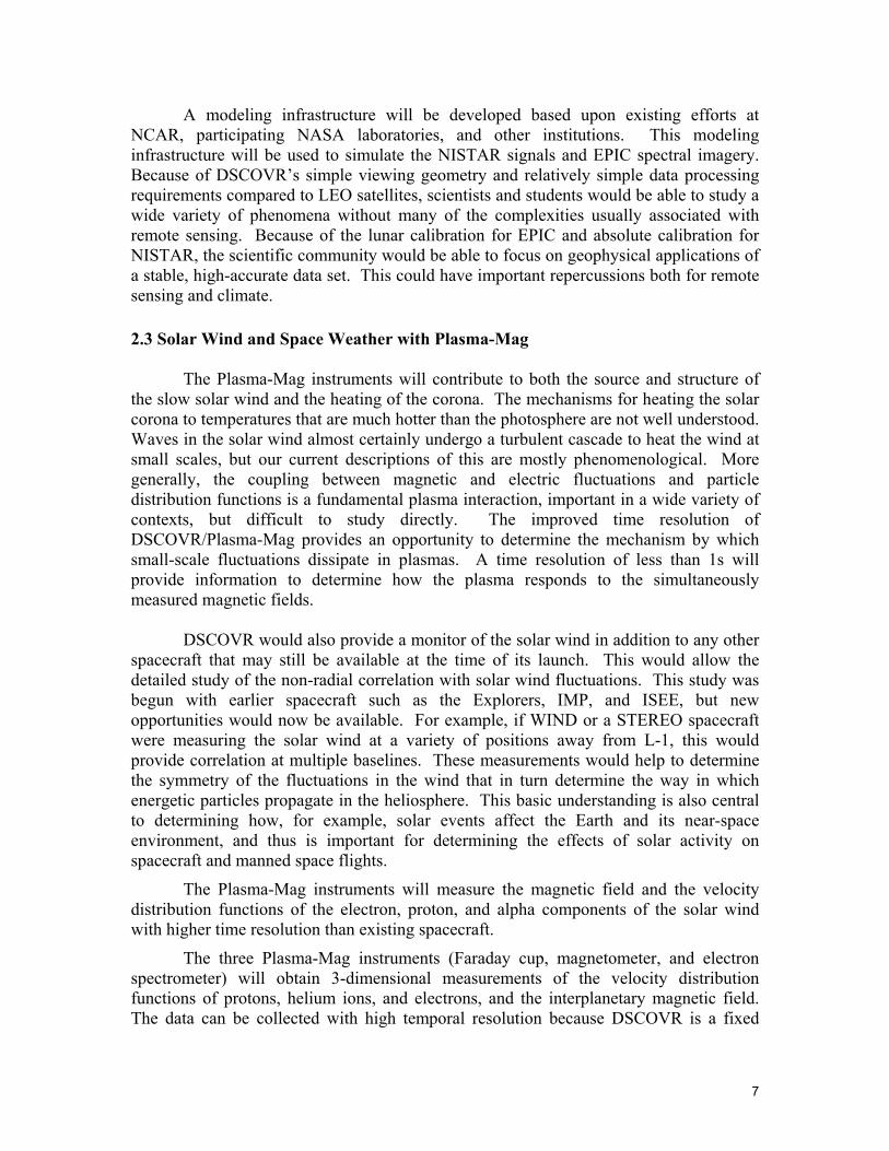
3.0 Existing Science Payload and Retrieved Quantities
The scientific (built, tested and integrated on the spacecraft, see Fig 3) payload for DSCOVR is composed of the following instruments:
Fig 3. Earth Side and Sun Side Photographs of DSCOVR Spacecraft with Integrated Science Instruments
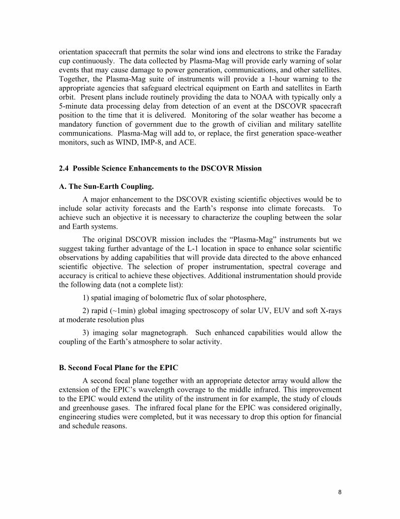
Scripps-EPIC is a 10-channel spectroradiometer (ultraviolet, visible, and near infrared) that uses a 30 cm telescope and a state of the art detector array (near infrared, visible, and ultraviolet sensitive 2048x2048 CCD) to achieve high sensitivity and spatial resolution.
Fig. 4. Scripps-EPIC on the DSCOVR Spacecraft
EPIC will send back Earth-reflected radiances that will be transformed into data products (e.g., ozone; aerosols; cloud fraction, thickness, optical depth, and height; sulfur
10
dioxide; precipitable water vapor; volcanic ash; and UV irradiance) every hour for the entire globe at 8-14 km surface resolution. EPIC will provide hourly observations from sunrise to sunset for the entire globe, instead of just once per day (as with TOMS, MODIS, SeaWifs, etc.), and will collect monthly measurements and images of the lunar surface in 10 wavelengths (317.5 to 905 nm) for calibration.
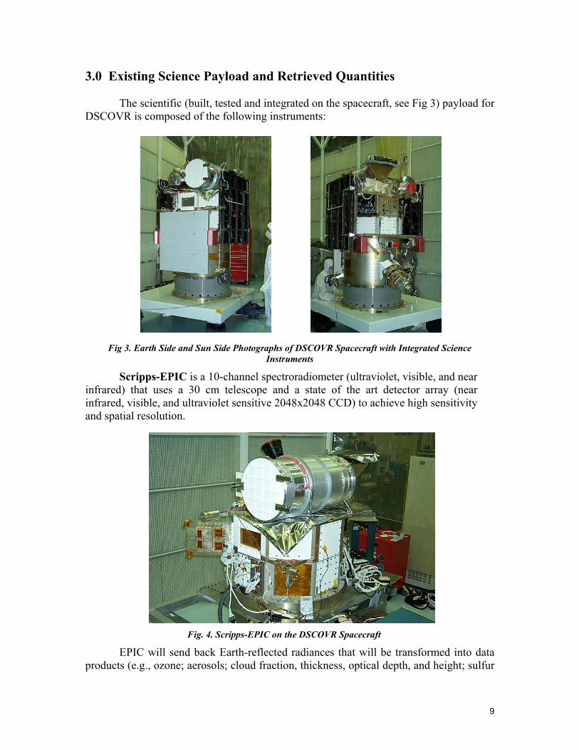
Scripps-NISTAR is a greatly improved, advanced technology version of the radiometer systems currently used to monitor total solar irradiance and the radiation reflected and emitted by the Earth. It consists of 4 radiometric channels (3 highly accurate and sensitive self-calibrating absolute cavities and 1 photo-diode) that will continuously measure the total UV, visible, and IR radiances (0.2 to 100 µm) reflected or emitted from the sunlit face of the Earth. DSCOVR’s location at the L-1 observing position, rather than in Earth orbit, will permit long integration times, since no scanning will be required. A radiometric accuracy of 0.1-0.2% is expected, a 10-fold improvement in accuracy over current Earth-orbiting satellite data. These will be the only measurements of the entire Earth’s reflected and emitted radiation at the retro reflection angle. As such, NISTAR will provide important missing data not obtainable by any Earth-orbiting satellite.
Fig. 5. Scripps NISTAR on the DSCOVR Spacecraft
NISTAR radiances will be used for: a) estimating the albedo for the Earth-atmosphere system, b) evaluating estimates of the Earth radiation budget (ERB) from other monitoring systems like CERES, c) validating the mean radiance fields that can be directly computed from GCMs, d) evaluating the theoretical ratios of near-infrared to total reflectance, which are of intrinsic interest to the vegetation, cloud and snow/ice communities, and e) attempting to use the thermal infrared as integrative measures of global change.
GSFC PlasMag instrument suite is a comprehensive science and space-weather package that includes a fluxgate vector magnetometer, not present on SOHO, a Faraday Cup solar wind positive ion detector and a top-hat electron electrostatic analyzer. This instrument cluster provides high time resolution measurements in real time and represents
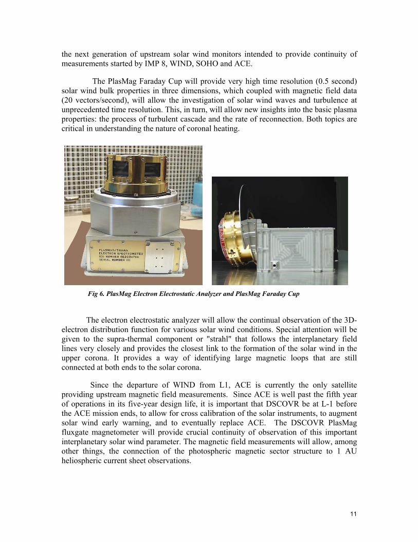
11
the next generation of upstream solar wind monitors intended to provide continuity of measurements started by IMP 8, WIND, SOHO and ACE.
The PlasMag Faraday Cup will provide very high time resolution (0.5 second) solar wind bulk properties in three dimensions, which coupled with magnetic field data (20 vectors/second), will allow the investigation of solar wind waves and turbulence at unprecedented time resolution. This, in turn, will allow new insights into the basic plasma properties: the process of turbulent cascade and the rate of reconnection. Both topics are critical in understanding the nature of coronal heating.
Fig 6. PlasMag Electron Electrostatic Analyzer and PlasMag Faraday Cup
The electron electrostatic analyzer will allow the continual observation of the 3D-
electron distribution function for various solar wind conditions. Special attention will be given to the supra-thermal component or "strahl" that follows the interplanetary field lines very closely and provides the closest link to the formation of the solar wind in the upper corona. It provides a way of identifying large magnetic loops that are still connected at both ends to the solar corona.
Since the departure of WIND from L1, ACE is currently the only satellite providing upstream magnetic field measurements. Since ACE is well past the fifth year of operations in its five-year design life, it is important that DSCOVR be at L-1 before the ACE mission ends, to allow for cross calibration of the solar instruments, to augment solar wind early warning, and to eventually replace ACE. The DSCOVR PlasMag fluxgate magnetometer will provide crucial continuity of observation of this important interplanetary solar wind parameter. The magnetic field measurements will allow, among other things, the connection of the photospheric magnetic sector structure to 1 AU heliospheric current sheet observations.
12
All DSCOVR PlasMag observations will be part of a coordinated effort, involving multiple satellites, to investigate the large-scale structure of such transients as CMEs/Magnetic Clouds, interplanetary shocks and discontinuities and high-speed stream interfaces. Specifically, the likely operational time period of DSCOVR will enable the PlasMag observations to provide 1 AU measurements connecting the "Living with a Star" solar and heliospheric elements to the geospace components, hence providing a crucial link in the chain of events connecting solar activity to geomagnetic disturbances. The DSCOVR PlasMag data set will also form part of the ISTP database.
4.0 Other Considerations
4.1 Mission Costs
Using the decadal survey guidance, the basic DSCOVR mission costs would be rated as Small (< $200M). Since the solar weather and Earth science instruments and the spacecraft have already been constructed, integrated, and environmentally tested, the costs to complete the basic mission are quite reasonable compared to the costs of a new start. A very detailed restart plan was produced by GSFC before the spacecraft and instruments were stored in an environmentally controlled facility. This restart plan provides the details on all remaining open items for the flight hardware and software and ground systems and will allow a new team to rapidly reassess the status of the flight hardware, to commence recalibration of the science instruments and to conduct another fully integrated spacecraft environmental test. The potential single largest remaining cost item is the choice of commercial launch vehicle. The maximum costs would be associated with a commercial Delta II class launcher, while much lower costs would be associated with use of an emerging commercial launch vehicle such as the SpaceX Falcon V. In either case, we envision the basic DSCOVR mission remaining well within the “Small” cost category of < $200M.
If it were deemed advantageous to add additional solar or Earth science instruments to the basic DSCOVR mission, this would most likely increase mission costs into the Medium category. However, until the specifications of additional instruments are available, more specific cost estimates for this modified mission are not available.
4.2 Complements other Observational Systems
A very significant contribution of DSCOVR to an Earth integrated observation system would result form its ability to view Earth scenes simultaneously with every other satellite in existence. When this ability is added to DSCOVR’s planned use of views of the “back” side of the Moon for calibration comparison and “flatfielding” of its detector arrays, a major synergism becomes apparent as discussed in section 1.0.
Another important example of complementarily (synergism) in the area of climate/radiative balance results from global albedo determinations from the integrated, synoptic and high time resolution observations from L-1. These observations with a different scattering geometry would provide an important component in helping
13
understand the large discrepancies between albedo measurements utilizing different approaches (earthshine, LEO, surface).
Correlation of data from the PlasMag with that from other spacecraft near L-1 would allow the detailed study of the non-radial solar wind fluctuations. This study was begun with earlier spacecraft such as the Explorers, IMP, and ISEE, but with DSCOVR, new opportunities would become available. PlasMag solar wind measurements could be correlated with those from other spacecraft at a variety of positions away from L-1, providing multiple baselines. These measurements would help to determine the symmetry of the fluctuations in the wind that in turn determine the way in which energetic particles propagate in the heliosphere. This basic understanding is central to determining how solar events affect the Earth and its near-space environment, and thus is important for determining the effects of solar activity on spacecraft and manned space flights.
4.3 Cost/Benefit
Co-observation with other Earth science satellites and maintenance of a high standard of on-orbit recalibration will allow DSCOVR to test the concept of sharing calibrations with LEO and GEO Earth observation satellites. This has great potential for cost savings within the various Earth observational systems. This can allow the other systems to spend less time and money on obtaining and maintaining a climate level calibration for each instrument. DSCOVR can also provide a means to share calibrations between following generations of an Earth observing satellite system.
5.0 References
Anderson, T. L., Charlson RJ, Schwartz SE, et al. (2003) Climate forcing by aerosols - a hazy picture, Science 300: 1103-1104 Arrhenius, S. (1896). Philos. Mag. 41, 237 Charlson, Robert J., Valero, Francisco P. J., Seinfeld, John H. (2005) In Search of Balance, Science 308: 806-807 National Academy of Sciences, Space Studies Board Annual Report 2000 (National Academies Press, Washington, DC, 2001), pp. 93-108 Palle, E., Goode, P. R., Montanes-Rodriguez, P., Koonin, S. E. (2004) Changes in Earth's Reflectance over the Past Two Decades, Science 304: 1299-1301 Pallé, E. et al., (2003) Earthshine and the Earth's albedo: 2. Observations and simulations over 3 years J. Geophys. Res. 108 (D22), 4710 Pinker, R. T., Zhang, B., Dutton, E. G. (2005). Do Satellites Detect Trends in Surface Solar Radiation? Science, 308: 850-854
14
Sun, M., Cess, R. D. (2004) A procedure for evaluating feedback mechanisms in coupled atmosphere/ocean climate models, Geophys. Res. Lett. 31, L12215 Wielicki, Bruce A., Wong, Takmeng, Loeb, Norman, Minnis, Patrick, Priestley, Kory, Kandel, Robert, (2005) Changes in Earth's Albedo Measured by Satellite, Science 308: 825- Wild, M., Gilgen, H., Roesch, A., Ohmura, A., Long, C. N., Dutton, E. G., Forgan, B., Kallis, A., Russak, V., Tsvetkov, A. (2005). From Dimming to Brightening: Decadal Changes in Solar Radiation at Earth's Surface. Science 308: 847-850 Zhang, Y., et al., (2004) J. Geophys. Res. 109, D19105