Embed Size (px)
Citation preview
No. 9
When Engineering Solutions to Coastal Surge and Flooding Are Not Sufficient to Meet the Threat
December 2016
Gordon L. DilmoreResearch Associate, Hobby School of Public Affairs
University of [email protected]
Jim Granato Executive Director, Hobby School of Public Affairs
Professor, Department of Political Science University of Houston
Alan WittProfessor, Department of Psychology and C. T. Bauer College of Business
Director, Industrial and Organizational PsychologyUniversity of Houston
Terry MayesResearch Associate, Hobby School of Public Affairs
University of [email protected]
Elizabeth Anderson FletcherAssoicate Professor, C. T. Bauer College of Business
University of [email protected]
Tom C. DuncavageAerospace Engineer, Lyndon B. Johnson Space Center
National Aeronautics and Space Administration (NASA) [email protected]
Project Team Members:Sophiya Das, Cong Huang, Indrajit Sinha Ray, Saadet Konak Unal,
Rodrigo F. Nunez, Kwok-Wai Wan, Ching-Hsing Wang
Hobby School of Public Affairs White Paper Series___________________________________________________
- 1 -
When Engineering Solutions to Coastal Surge and Flooding Are Not
Sufficient to Meet the Threat
Gordon L. Dilmore, Jim Granato, Alan Witt, Elizabeth Anderson Fletcher, Tom C. Duncavage,
Terry Mayes, Sophiya Das, Cong Huang, Indrajit Sinha Ray, Saadet Konak Unal,
Rodrigo F. Nunez, Kwok-Wai Wan, Ching-Hsing Wang
This study examines the threat and damage that coastal surge brings to Houston
Metroplex and points out the importance of well-planned evacuation. In particular, the
evacuation of several million people from a highly-populated area requires careful
planning, coordination of resources, and precise direction from the leadership. Given
widespread damages caused by severe weather over the past few decades to Houston
Metroplex, the related authorities should work together to develop the orderly
and coordinated evacuation plans so as to reduce loss of life and property.
Keywords: evacuation, coastal surge, flooding, disaster, Houston Metroplex.
Introduction
Throughout recorded weather history, the Houston Metroplex has experienced its share of
severe weather in the form of hurricanes, tornadoes, and tropical storms.1 When disaster strikes,
there are priorities to consider. Foremost among those priorities is the safety and protection of
human life; followed by preservation of infrastructure and industry. Infrastructure and industry
are different from human life because they must be protected in place. Humans can remain in
1 For the purposes of this document the Houston Metroplex is equal to the “Greater Houston Area” or the Houston
Metropolitan Statistical Area (MSA). It is comprised of the following nine counties (numbers in the parentheses
show population):
Harris County (4,092,459).
Fort Bend County (585,375).
Montgomery County (455,746).
Brazoria County (313,166).
Galveston County (291,309).
Liberty County (75,643).
Waller County (43,205).
Chambers County (35,096).
Austin County (28,417).
And includes the following Metropolitan Areas:
Houston (2,242,193).
The Woodlands (109,679).
Sugar Land (80,704).
Baytown (70,330).
Conroe (71,592).
Solutions to Coastal Surge and Flooding
- 2 -
place, or they can be moved out of harm’s way as necessary. Likewise, a solution that protects
infrastructure and industry may not be the best solution for humans.
Houston and the Metroplex
Demographics
The Greater Houston Metroplex is the fifth largest metropolitan area in the United States
with a population in excess of 6,500,000.
The gross metropolitan product (GMP) in 2012 of the Metroplex MSM was $449 billion,
fourth largest in the United States, making it a major industrial player.
About 25% of the petroleum products consumed in the United States are processed
within the Metroplex.
Home to three major seaports, the ports of Houston, Texas City and Galveston, makes the
Metroplex one of the most important shipping hubs in the world.
The Texas Medical Center is the largest medical center in the world.
Galveston is home to one of the two biocontainment labs in the United States.
Thus, the Houston Metroplex ranks high in all three areas of strategic concern - population,
infrastructure, and industry.
Houston Metroplex – Severe Weather History
Since 1980, more than 70 hurricanes and tropical storms have impacted Texas. Thirteen
major storms have directly impacted the Houston Metroplex; 3 storms resulted in significant
storm surge.
In any type of coastal cyclonic event, the principal threats involved include coastal surge, rainfall
flooding, and wind.
Hurricane Alicia in August, 1983, came ashore 25 mi. south of Galveston as a Category 3
hurricane. Alicia had a broad front extending out 125 mi. from the center, with maximum winds
of 115 mph. The highest recorded tides occurred in Baytown, Texas at 10-12 feet, not
particularly significant for tidal surge. Most of the surge damage occurred in areas not protected
by the Galveston seawall. The storm worked its way north up the I-45 corridor into downtown
Houston, and north from there. Twenty-three tornadoes were spawned by the storm in the
Galveston and Houston areas, all in the F2 category. Rainfall in the Metroplex averaged 8-11
inches. Away from the immediate coastal area, most of the damage was caused by strong winds
and rain.
Despite early hurricane warnings being issued for the area from Corpus Christi, Texas to
Morgan Point, Louisiana, and an early evacuation order for the low-lying areas, most residents
did not take the threat seriously and only about 10% evacuated. As the storm became more
intense, Galveston’s mayor ordered a full-scale evacuation, but by then the bridges to the
mainland were impassible making evacuation impossible. Twenty-one people died and the area
suffered $2.6 billion in damage.
Hobby School of Public Affairs White Paper Series___________________________________________________
- 3 -
Hurricane Ike in 2008, made landfall as a Category 2 hurricane. Storm surge of 20 feet above
normal tide occurred the coast from Galveston along the Bolivar Peninsula. Approximately 113
fatalities occurred in the UNITED STATES Property damage exceeded $24.9 billion.
Coastal Surge
History shows that coastal surge is a matter of concern and a force that is not entirely
understood or respected. In the case of the Houston Metroplex, several efforts are currently
underway with the purpose of mitigating the effects of storm surge in the coastal area.
SSpeed
Rice University’s Severe Storm Prediction, Education & Evacuation from Disasters (SSpeed)
Center, formed in 2007, has proposed a moveable gate structure system across the lower San
Jacinto River to, “...prevent the upstream propagation of a storm surge from Galveston Bay.”
Ike Dike
Texas A&M University at Galveston has proposed the Ike Dike, a coastal barrier system
extending across Galveston Island and the Bolivar Peninsula, theoretically protecting the
Metroplex from coastal surge.
Both projects stress the national security implications, preservation of the Houston Ship
Channel and its commerce, which would be addressed by their implementation. They are in the
developmental stage, seeking support and funding. There is no question but that these are
potentially worthwhile projects in terms of lessening the effects of coastal surge. That said, not
all storm events that occur in the Texas Gulf area, come from offshore or create tidal surge.
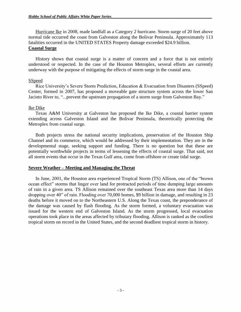
Severe Weather – Meeting and Managing the Threat
In June, 2001, the Houston area experienced Tropical Storm (TS) Allison, one of the “brown
ocean effect” storms that linger over land for protracted periods of time dumping large amounts
of rain in a given area. TS Allison remained over the southeast Texas area more than 14 days
dropping over 40” of rain. Flooding over 70,000 homes, $9 billion in damage, and resulting in 23
deaths before it moved on to the Northeastern U.S. Along the Texas coast, the preponderance of
the damage was caused by flash flooding. As the storm formed, a voluntary evacuation was
issued for the western end of Galveston Island. As the storm progressed, local evacuation
operations took place in the areas affected by tributary flooding. Allison is ranked as the costliest
tropical storm on record in the United States, and the second deadliest tropical storm in history.
Solutions to Coastal Surge and Flooding
- 4 -
Photo: Wikimedia
According to the Harris County Flood Control District website:
FLOODING IS OUR NATURAL DISASTER
Harris County doesn’t have earthquakes... doesn’t have blizzards... doesn’t have
avalanches. We have flooding. A major flood still occurs somewhere in Harris
County about every two years. Most of the flooding is in areas developed prior to the
current understanding of flood potential and prior to regulations restricting
construction in flood-prone areas. Fortunately, since the 1970’s, there has been flood
insurance to ease the financial impact of flooding. Despite tremendous flood damage
reduction projects that have indeed reduced the risk of flooding, more flood insurance
funds have been paid here than in any other National Flood Insurance Program-
participating community.
The Question – To evacuate or not evacuate
As well-intentioned as the efforts to control and dissipate storm surge are, events sometimes
occur that are beyond their influence. Concentrated rainfall, flooding, flash flooding, wind, fire,
and the after effects of those events are the phenomena that present the greatest threat to humans.
There are times when circumstances dictate that the prudent action to avoid serious injury or
even death is flight – Evacuation.
In disaster response & evacuation, a proactive response is better than a reactive response
(saves more lives, more easily accomplished, more cost effective)
Mass evacuation requires detailed planning, constant training, as well as close coordination
and precise execution.
Hobby School of Public Affairs White Paper Series___________________________________________________
- 5 -
Hurricane Rita
During the day on Tuesday, September 20, 2005, experienced Texas hurricane watchers and
interested parties began to take note of Hurricane Rita as it entered the Gulf of Mexico (GOM)
on a generally westerly course. Rita had formed as a hurricane in the Bahamas on Sunday,
September 18. It had drifted on a westerly course, passing through the Florida Straits, and
entering the GOM.
Just three weeks prior, on August 29, Hurricane Katrina made landfall as a Category 3
hurricane, southeast of New Orleans causing 1245 deaths and property damage in excess of $108
Billion. More than 1 million people were displaced and fled to other areas – over 375,000 to
Texas alone. Local, state, and federal authorities were struggling with housing and caring for the
evacuees, no small task.
In the case of Rita, there were differences of opinion and different predictions as to what
course the storm would take and the potential severity – threat- of the storm itself. As a matter of
caution, Gov. Perry declared Texas a disaster area. The State Emergency Operations Center
‘stood up’ on 24-hour watch status. A request for a declaration was made to the White House,
but was not immediately acted on. FEMA Region VI was still overwhelmed by the aftermath of
Katrina.
As it reached the warmer waters, Rita increased in intensity to 180 MPH. At that point it
began to cool and act erratically, making a slow turn to the northwest. The predictions were
erratic. On Wednesday, September 21, NWS/NHC forecast track did not look good for Houston.
The Wednesday 10:00 PM forecast projected a near direct hit on Houston predicted to occur
early on Saturday morning. The predicted storm track from Houston, was north, running
essentially parallel to the I-45 corridor.
On that same day, a mandatory evacuation by 6:00 PM was ordered for citizens of Galveston
County involving a population of 267,000. Arrangements were made to evacuate citizens without
transportation in a bus convoy of approximately 80 buses and take them to shelters in the
Huntsville area. At the same time, officials in Houston had decided against a mandatory
evacuation but encouraged people living as far inland from the coast as 35 miles to voluntarily
evacuate. Simultaneously, residents of other nearby areas, with the memories of the New Orleans
Katrina experience fresh in their mind, made the decision to evacuate on their own.
Unfortunately, but not surprisingly, different entities reacted on their own initiative, without
consultation or coordination with adjoining entities.
Solutions to Coastal Surge and Flooding
- 6 -
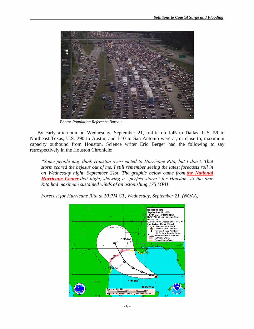
Photo: Population Reference Bureau
By early afternoon on Wednesday, September 21, traffic on I-45 to Dallas, U.S. 59 to
Northeast Texas, U.S. 290 to Austin, and I-10 to San Antonio were at, or close to, maximum
capacity outbound from Houston. Science writer Eric Berger had the following to say
retrospectively in the Houston Chronicle:
“Some people may think Houston overreacted to Hurricane Rita, but I don’t. That
storm scared the bejesus out of me. I still remember seeing the latest forecasts roll in
on Wednesday night, September 21st. The graphic below came from the National
Hurricane Center that night, showing a “perfect storm” for Houston. At the time
Rita had maximum sustained winds of an astonishing 175 MPH
Forecast for Hurricane Rita at 10 PM CT, Wednesday, September 21. (NOAA)
Hobby School of Public Affairs White Paper Series___________________________________________________
- 7 -
This track represented a worst-case scenario for Houston, with the stronger northeast
quadrant of the storm pushing a massive wall of water into Galveston Bay and up the
Houston Ship Channel into the heart of the region’s chemical industrial complex. The
strongest winds would travel directly up the densely-populated Interstate 45 corridor.
That night I was suitably (and uncharacteristically) freaked out: The current
track for Rita is just about as bad as you could imagine for the Houston-Galveston
area. Unless the storm turns south or north in the next 24 to 48 hours we are set up
for a truly horrific event. I am not going to sugar-coat this, my friends. If the storm
comes ashore as forecast, it would essentially be the worst-case scenario
described here. As a Houston resident and property owner, I am truly mortified right
now. If you are under a mandatory evacuation order, you should heed it. What
ensued next, of course, was mayhem.”
As KXII Fox 12 pointed out, “The Houston area’s geography makes evacuation particularly
tricky. Unlike other hurricane-prone cities where the big city is on the coast, Houston is 60 miles
inland. So, a coastal suburban area of 2 million people has to evacuate through a metropolitan
area of nearly 4 million.”
In the Rita situation, the primary evacuation route from Houston was I-45-N to north Texas.
The secondary routes were US-59 N to northeast Texas, US-290 to Austin, and I-10 W to San
Antonio. I-10 E to New Orleans was not considered to be an attractive option in the aftermath of
Hurricane Katrina except by some people who had evacuated to Houston from Louisiana in the
aftermath of Hurricane Katrina. That, exactly, was the crux of the situation and a problem of
mammoth proportions.
Making the situation even more complicated, there was a lack of adequate communication
between Galveston County officials and agencies in Harris, Montgomery and Waller Counties
which left the transient (pass through) counties unaware and unprepared for the onslaught of
motorists. By mid-afternoon, Wednesday, September. 21, I-45 was essentially a parking lot
stretching from Galveston, north to Huntsville and further north toward Dallas. As time went on,
the situation worsened as traffic increased, cars became disabled or ran out of gas, accidents
occurred, people became ill and unable to continue their trips. Services along the primary
evacuation route ran out of supplies and could no longer serve the public. Re-supply was out of
the question. The first responder community, including police, fire and EMS personnel were
overwhelmed. Secondary services diminished and then failed completely.
The overall scene stretching from Galveston to, and through, Houston to the northeast, north,
northwest, and west along the four major and numerous secondary evacuation routes became so
chaotic and confused that any meaningful sense of situational awareness was lost except in a few
select locations where the authorities had planned and prepared for this type of eventuality.
This was the situation at midnight, Friday night, as Hurricane Rita approached the Texas
coast with Houston dead in its sights. As typically happens in such situations, when the storm
front impacted with the coast, the storm slowed down and nearly stalled. Eventually, it weakened
slightly due to shore effect and started acting erratically. In one sweep of the weather radar, Rita
deviated about 3 degrees to the right and made landfall in the area of Sabine Pass shortly after
midnight on Saturday morning. It then proceeded on a northerly course roughly parallel to the
Texas-Louisiana border.
Solutions to Coastal Surge and Flooding
- 8 -
It was later estimated that had Rita not shifted course at the last minute, that approximately
85,000 people along the I-45 corridor would have been its victims. All things considered, the
Hurricane Rita evacuation was not done well.
Lesson #1 – The evacuation of several million people from a highly-populated area requires
careful planning, coordination of resources, and precise direction from the leadership.
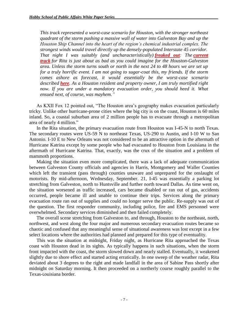
Evacuation - The Ultimate People Solution
While engineering solutions are important in consideration of all strategic concerns,
ultimately the safety of human life trumps all other considerations. History has shown time and
time again that some events in life are so threatening to the health and safety of human beings,
they must leave their domiciles, either on their own initiative or under direction from
government officials, and move to safe haven – evacuation.
Sometimes, evacuation is a matter of moving people away from a localized threat, such as a
flooding stream, to near-by high ground. Other occasions, such as oncoming hurricanes, forest
fires, etc., require a more complex evacuation process. Regardless of whether an evacuation is a
local evacuation or one of higher magnitude, there is no such thing as a simple evacuation.
Photo: Alison Nissen
Evacuation, even under the best of circumstances, is a complicated process fraught with
problems and complications. People under stress do not like to leave their homes and
possessions. They often do not have a place of sanctuary or means of support. Frequently, they
do not have transportation. The fear of the unknown prevails. Evacuation, particularly those that
involve rescue, can be a very scary experience. Statistically, one out of five evacuees suffers
from medical issues requiring medication and/or professional medical attention, a major
complication.
Hobby School of Public Affairs White Paper Series___________________________________________________
- 9 -
Photo: Reuters/ Tim Johnson
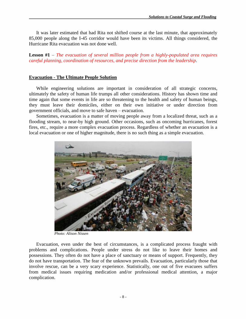
Local History of Evacuation
The first recorded evacuation in Texas occurred in 1900 during the Great Galveston
Hurricane when virtually all of Galveston Island was evacuated. There have been 19 recorded
evacuations of some level in the Houston Metroplex since the 1900 Galveston storm. The
Houston Metroplex experience with large scale evacuations is not unlike other similar areas in
the United States. The most notable examples are the Hurricane Rita evacuation in 2005 and the
Hurricane Ike evacuation in 2008.
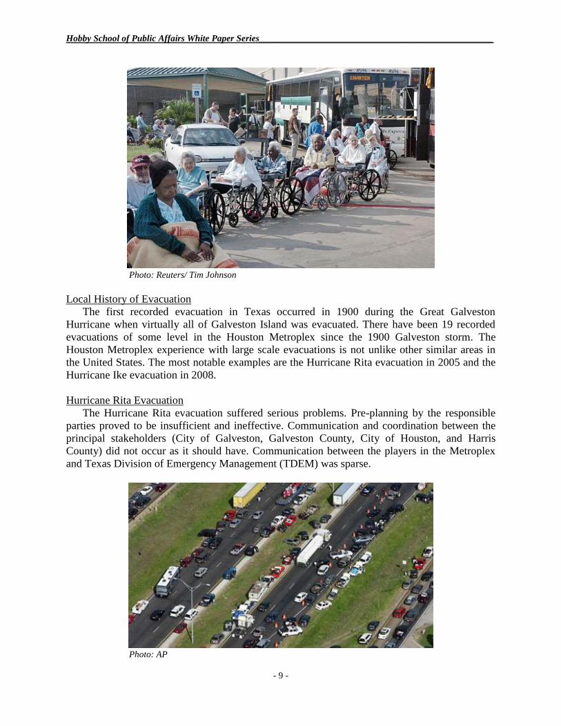
Hurricane Rita Evacuation
The Hurricane Rita evacuation suffered serious problems. Pre-planning by the responsible
parties proved to be insufficient and ineffective. Communication and coordination between the
principal stakeholders (City of Galveston, Galveston County, City of Houston, and Harris
County) did not occur as it should have. Communication between the players in the Metroplex
and Texas Division of Emergency Management (TDEM) was sparse.
Photo: AP

Solutions to Coastal Surge and Flooding
- 10 -
2016 Spring Storms
During the months of April, May, and June 2016, the Houston Metroplex experienced a
number of prolonged inland storms that dumped as much as 20 inches of rain on the Metroplex
area resulting in extensive flooding in areas adjacent to major and minor tributaries that flow
through the area. Sub-divisions in those areas suffered moderate to severe flooding, necessitating
local evacuations and swift water rescue operations. During April alone, more than 1800 high
water rescues were conducted in Harris County. To the extent possible, inhabitants of the
affected subdivisions has been evacuated before the flooding occurred.
The Dynamics of Evacuation
Evacuation, regardless of size, is a component of Incident Command, and it is usually early
in any disaster. It may, or may not, involve rescue operations. Time is of the essence – Human
lives are at risk.
Serious pre-planning and training are essential to success.
Coordination.
Situational Awareness.
Communications.
A Houston Metroplex Solution
Geographically, the Metroplex covers an area totaling 10,062 sq. mi., a large area with a
heavily distributed population. Currently, within the Metroplex, the level of coordination
between the various counties involved is not as robust as it should be. Some coordination exists,
but not at an optimum level to achieve an ideal solution. This is an organizational issue that can
be solved by the government leaders and emergency managers involved agreeing to build a
consensus organization.
The disaster evacuation command and control (C²) function across the nine member counties
in the Metroplex is bifurcated to the point that it impacts negatively on the mission. The
evacuation protocols in the Houston Metroplex require a careful re-examination in the form of a
requirements study. Houston and East Texas have equally as much, if not more, experience with
storm evacuations as any other U.S. entity. The potential exists for the Metroplex to build a
model evacuation system.
In a normal C² situation, this situation would call for a conveniently-located central
command center from which the evacuation function would be directed. In this instance, that
arrangement would be impractical. In times of turmoil, county and municipal leaders rightfully
want to operate from their respective emergency operations center, their home turf.
Sometimes the event itself makes travel to a central location impossible as Houston’s mayor
discovered during the 2016 spring storms when he was unable to travel from City Hall to
TranStar in West Houston for a press conference. The other disaster recovery functions are best
controlled in a county-by-county environment.
In the envisioned scenario, a Central Coordination Center (CCC) would serve an intelligence
function to gather, analyze, and disseminate storm information to all interested parties; in order
to establish and maintain situation awareness; but not operate as a command center, that function
being left in place in each county.
A recent survey of the Metroplex stakeholders by the Hobby School showed that there is an
abundance of communications infrastructure dedicated to the disaster recovery mission.
However, as is the case with coordination, the communications structure is primarily vertical
Hobby School of Public Affairs White Paper Series___________________________________________________
- 11 -
(stove piped) within agencies and entities, and lacks horizontal connectivity with other entities
and agencies. What would a regional disaster coordination center look like?
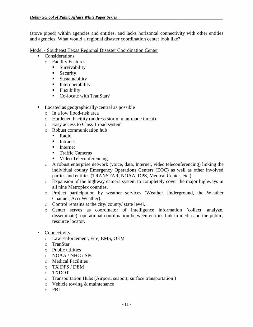
Model - Southeast Texas Regional Disaster Coordination Center
Considerations
o Facility Features
Survivability
Security
Sustainability
Interoperability
Flexibility
Co-locate with TranStar?
Located as geographically-central as possible
o In a low flood-risk area
o Hardened Facility (address storm, man-made threat)
o Easy access to Class 1 road system
o Robust communication hub
Radio
Intranet
Internet
Traffic Cameras
Video Teleconferencing
o A robust enterprise network (voice, data, Internet, video teleconferencing) linking the
individual county Emergency Operations Centers (EOC) as well as other involved
parties and entities (TRANSTAR, NOAA, DPS, Medical Center, etc.).
o Expansion of the highway camera system to completely cover the major highways in
all nine Metroplex counties.
o Project participation by weather services (Weather Underground, the Weather
Channel, AccuWeather).
o Control remains at the city/ county/ state level.
o Center serves as coordinator of intelligence information (collect, analyze,
disseminate); operational coordination between entities link to media and the public,
resource locator.
Connectivity:
o Law Enforcement, Fire, EMS, OEM
o TranStar
o Public utilities
o NOAA / NHC / SPC
o Medical Facilities
o TX DPS / DEM
o TXDOT
o Transportation Hubs (Airport, seaport, surface transportation )
o Vehicle towing & maintenance
o FBI
Solutions to Coastal Surge and Flooding
- 12 -
o DHS
o Coast Guard
o FAA
o Fuel Supply
o Media
Other Input
If properly supported, all of the improvements discussed in this document are candidate for
federal grant funding.