Embed Size (px)
Citation preview
Local Development PlanPreparatory Studies
Paper 6: Environmental Assets
January 2016
Contents Page
Number
Figure Table 3
Purpose and Content 4
1.0 Introduction 5
2.0 Regional Planning Context 6(a) Regional Development Strategy 2035 6(b) Strategic Planning Policy Statement 7(c) Regional Planning Policy Statements 10(d) A Planning Strategy for Rural Northern Ireland 14(e) Other Relevant Strategies 14(f) Key Legislative Requirements during LDP Preparation Process in relation to Environmental Assets
16
3.0 The Environmental Assets of Newry, Mourne and Down District Council
18
4.0 Archaeological and Built Heritage Features within Newry, Mourne and Down District Council Area
19
4.1 Historic Monuments in State Care 194.2 Scheduled Monuments 194.3 Unscheduled Monuments 204.4 Listed Buildings 224.5 Historic Parks, Gardens and Demesnes 234.6 Industrial Heritage 254.7 Areas of Significant Archaeological Interest/Areas of Archaeological Potential
26
4.8 Conservation Areas 284.9 Areas of Townscape Character 284.10 Local Landscape Policy Areas 30
5.0 Natural Heritage and Nature Conservation Designated Sites within Newry, Mourne and Down District Council area
34
5.1 Special Protection Areas 345.2 Special Areas of Conservation 355.3 RAMSAR Sites 365.4 Areas of Special Scientific Interest 395.5 Areas of Scientific Interest 485.6 National Nature Reserves/Nature Reserves 495.7 Marine Conservation Zones 52
Page | 1
5.8 Areas of Outstanding Natural Beauty 525.9 Northern Ireland Landscape Character Assessment 535.10 Northern Ireland Regional Landscape Character Assessment
55
5.11 Northern Ireland Regional Seascape Character Assessment
55
5.12 Sites of Local Nature Conservation Importance 565.13 Special Countryside Areas 615.14 Trees 615.15 Ancient and Long-established Woodlands 62
6.0 Conclusions 63
Appendix 1Acronyms 64
Page | 2
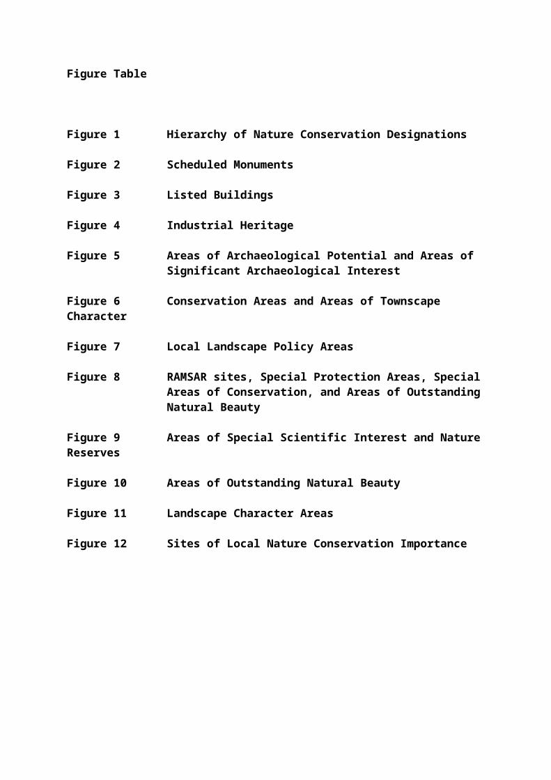
Figure Table
Figure 1 Hierarchy of Nature Conservation Designations
Figure 2 Scheduled Monuments
Figure 3 Listed Buildings
Figure 4 Industrial Heritage
Figure 5 Areas of Archaeological Potential and Areas of Significant Archaeological Interest
Figure 6 Conservation Areas and Areas of Townscape Character
Figure 7 Local Landscape Policy Areas
Figure 8 RAMSAR sites, Special Protection Areas, Special Areas of Conservation, and Areas of Outstanding Natural Beauty
Figure 9 Areas of Special Scientific Interest and Nature Reserves
Figure 10 Areas of Outstanding Natural Beauty
Figure 11 Landscape Character Areas
Figure 12 Sites of Local Nature Conservation Importance
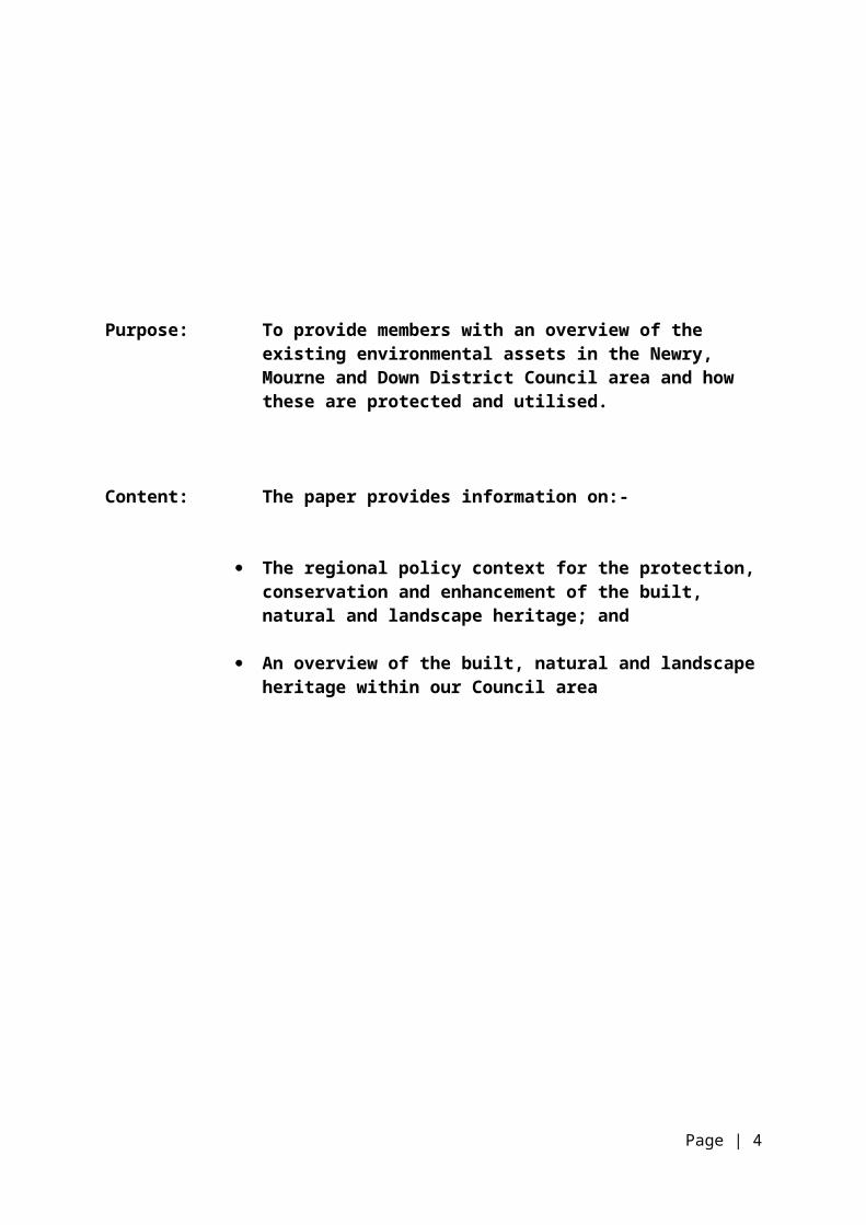
Purpose: To provide members with an overview of the existing environmental assets in the Newry, Mourne and Down District Council area and how these are protected and utilised.
Content: The paper provides information on:-
The regional policy context for the protection, conservation and enhancement of the built, natural and landscape heritage; and
An overview of the built, natural and landscape heritage within our Council area
Page | 4
1.0 Introduction
1.1 This paper allows members to commence consideration of the diverse range of environmental assets that exist across Newry, Mourne and Down and develop and understanding of their importance and value, and contribution they make to the District. The paper aims to provide a foundation for future decision making which will need to be further developed and informed through the local development plan (LDP) process in the consideration, protection and utilisation of our environmental assets.
The paper sets out to inform members of: protected site obligations in relation to the natural and landscape
heritage, obligations with regards to the protection, conservation and
enhancement of the built heritage and archaeological resources, and
further awareness of the link between built, natural and landscape heritage and the LDP function
1.2 The LDP process will play an important role in identifying key features and assets of the countryside and balancing the needs of rural areas/communities with protection of the environment. This is facilitated by the preparation of Countryside Assessments which will normally include the following interrelated strands:
an Environmental Assets Appraisal; a Landscape Assessment; a Development Pressure Analysis; and a Strategic Settlement Appraisal.
1.3 This paper provides the first strand of the Countryside Assessment of the plan area incorporating an overview of nature conservation resources and historic, architectural and archaeological resources. It also provides a background to the environmental statutory and policy framework for preparing an LDP. The paper also provides an overview of the main landscape character areas of the council area and the variations between them are also identified based on the ‘Northern Ireland Landscape Character Assessment 2000’, and the draft ‘Northern Ireland Regional Landscape Character Assessment’ (2015). This strand will be further explored in the Landscape Assessment paper.
Archaeological and built heritage assets such as ring forts, historic and vernacular buildings, planned parklands, buildings and features associated with industrial heritage, are all important sources of information about our past, and are often significant landmarks in the present townscape and countryside. This archaeological and built heritage constitutes an irreplaceable record which contributes to our
Page | 5
understanding of both the present and the past and is an important economic resource. Their presence usually adds to the quality of our lives and promotes a sense of local distinctiveness which is an important aspect of the character and appearance of cities, towns, villages and the countryside.
The Newry, Mourne and Down District, like Northern Ireland as a whole, is an area of dramatic landscape contrasts and subtle transitions. The inherent diversity of the underlying rocks, landforms and soils has been augmented by centuries of settlement and land management, resulting in rich, varied and unique landscape patterns and features within the District. Our natural and cultural landscapes are an essential aspect of our sense of place and belonging and are part of our national and community identity.
The diversity of Northern Ireland’s habitats, species, landscapes and earth science features (i.e. natural heritage) is an important and highly valued asset of our society. Our natural heritage provides a wide range of opportunities for enjoyment, recreation and sustainable economic activity. The conservation, enhancement and restoration of the abundance, quality, diversity, and distinctiveness of the region’s natural heritage are also fundamental to the overall health and well-being of our society.
2.0 Regional Planning Context
2.1 The regional policy context is provided by the Regional Development Strategy 2035 (RDS), the Strategic Planning Policy Statement (SPPS) and regional planning policy statements. A summary of these documents as they pertain to plan making, archaeology and built heritage and natural heritage and nature conservation is provided.
(a) Regional Development Strategy 2035
2.2 The RDS aims to protect and enhance the environment, both the built and natural heritage, for current and future generations. It recognises that Northern Ireland’s environment is one of its greatest assets which has benefits in terms of the economy and quality of life. The RDS sets out regional guidance to conserve, protect, and where possible, enhance our built heritage and our natural environment (RG11).
In respect of built heritage, the RDS recognises that Northern Ireland has a rich and diverse archaeological and built heritage which contributes to our sense of place and history. It also regards built heritage as a key marketing, tourism and recreational asset that, if managed in a sustainable way, can make a valuable contribution to the environment, economy and society. In this context it is important to:
Identify, protect and conserve the built heritage, including archaeological sites and monuments and historic buildings;
Page | 6
Identify, protect and conserve the character and built heritage assets within cities, towns and villages; and
Maintain the integrity of built heritage assets, including historic landscapes.
2.3 In respect of the natural environment, the RDS recognises that effective care of the environment provides very real benefits in terms of improving health and well-being, promoting economic development and addressing social problems which result from a poor quality environment. The RDS also notes there has been a substantial reduction in the total area of semi-natural habitats due to on-going land use intensification from agriculture and urbanisation. It is therefore important to:
Sustain and enhance biodiversity; Identify, establish, protect and manage ecological networks; Protect and encourage green and blue infrastructure within urban
areas; Protect and manage important geological and geomorphological
features; Protect enhance and manage the coast; Protect, enhance and restore the quality of inland water bodies; Recognise and promote the conservation of local identity and
distinctive landscape character; Conserve, protect and where possible enhance areas recognised for
their landscape quality; Protect designated areas of countryside from inappropriate
development (either directly or indirectly) and continue to assess areas for designation; and
Consider the establishment of one or more National Parks.
(b) Strategic Planning Policy Statement
2.4 The Strategic Planning Policy Statement (SPPS) was published in September 2015; this document consolidates twenty separate policy publications into one document and sets out strategic planning policy for a wide range of planning matters including archaeological and built heritage, and natural heritage. Fundamental to the achievement of sustainable development, when plan making, the Council as planning authority, must balance and integrate a variety of complex social, economic, environmental and other matters that are in the long term public interest. As part of this approach, one of the core planning principles of the reformed two tiered planning system is:
Preserving and improving the Built and Natural Environment.
In respect of this core planning principle, it is recognised that the quality of our local environment is world renowned. Its exceptional quality provides an important contribution to our sense of place, history and cultural identity. Our region has a rich and diverse archaeological and built heritage as well as a distinctive and beautiful landscape. It also plays
Page | 7
a critical role in supporting the local economy, and must continue to do so through sustainable economic development activity. The quality of our local environment can also influence our health and well-being, and help tackle social deprivation.
Our environment must therefore be managed in a sustainable manner in accordance with the Executive’s commitment to preserve and improve the built and natural environment and halt the loss of biodiversity. This requires an integrated approach to the management of the natural and cultural aspects of the landscape. Whilst all of us share a collective responsibility in this regard the planning system plays an important role in conserving, protecting and enhancing the environment whilst ensuring it remains responsive and adaptive to the everyday needs of society. This is a key aspect of the wider objective of furthering sustainable development which the Council should take into account in the preparation of the LDP and carrying out of its development management functions.
It must also be recognised that the importance of the environment however goes far beyond the immediate benefits it can provide. Safeguarding our unique landscape (including heritage assets) and biological diversity also makes an important contribution to the protection of the wider global ecosystem. It is therefore critical that this vital asset is preserved and improved for the enjoyment and benefit of future generations.
Archaeology and Built Heritage
The planning system has a key role in the stewardship of our archaeological and built heritage. The aim of the SPPS in relation to Archaeology and Built Heritage is to manage change in positive ways so as to safeguard that which society regards as significant whilst facilitating development that will contribute to the ongoing preservation, conservation and enhancement of these assets.
The regional strategic objectives for archaeology and built heritage are to: secure the protection, conservation and, where possible, the
enhancement of our built and archaeological heritage; promote sustainable development and environmental stewardship
with regard to our built and archaeological heritage; and deliver economic and community benefit through conservation that
facilitates productive use of built heritage assets and opportunities for investment, whilst safeguarding their historic or architectural integrity.
The potential for loss or damage to archaeological sites and the built heritage as a result of unsympathetic development is a material consideration in the determination of planning applications and the outworking of this through the development management system will be the primary mechanism for the implementation of the regional strategic
Page | 8
policy. However, an essential prerequisite for this, particularly in the context of a plan-led system, will be the LDP.
The LDP, should identify the main built and archaeological heritage features, where they exist within the plan area (as detailed below), and bring forward appropriate policies or proposals for their protection, conservation and enhancement. It should also take into account the implications of its other local policies and proposals on all features of the archaeological and built heritage and their settings.
Word Heritage Sites Archaelogical Sites and Monuments Listed Buildings Conservation Areas Areas of Townscape or Village Character Local Landscape Policy Areas
Natural Heritage
Sustaining and enhancing biodiversity is fundamental to furthering sustainable development. The Northern Ireland Biodiversity Strategy and EU Biodiversity Strategy seek to halt the loss of biodiversity and ecosystems services by 2020. Furthermore, the Wildlife and Natural Environment Act (Northern Ireland) 2011 places a statutory duty on every public body to further the conservation of biodiversity. However, all of us share the collective responsibility to preserve and improve the natural environment and halt the loss of biodiversity for the benefit of future generations.
The regional strategic objectives for natural heritage are to: protect, conserve, enhance and restore the abundance, quality,
diversity and distinctiveness of the region’s natural heritage; further sustainable development by ensuring that natural heritage
and associated diversity is conserved and enhanced as an integral part of social, economic and environmental development;
assist in meeting international (including European), national and local responsibilities and obligations in the protection and enhancement of the natural heritage;
contribute to rural renewal and urban regeneration by ensuring developments take account of the role and value of natural heritage in supporting economic diversification and contributing to a high quality environment; and
take actions to reduce our carbon footprint and facilitate adaptation to climate change.
In the preparation of the LDP, and in the determination of planning applications, the Council should apply the precautionary principle when
Page | 9
considering the impacts of a proposed development on national or international significant landscape or natural heritage resources.
Appropriate weight must be given to designated sites of international, national and local importance; protected species; priority habitats and priority species; and to other biodiversity and geological interests within the wider environment.The Council should take full account of the implications of proposed land use zonings, locations for development and settlement limits on natural heritage features and landscape character within or adjoining the plan area. Natural heritage features and designated sites should be identified as part of the plan-making process. Where appropriate, policies should be brought forward for their protection and / or enhancement. The LDP should also identify and promote the design of ecological networks throughout the plan area which could help reduce the fragmentation and isolation of natural habitats through a strategic approach.
The LDP should seek to protect and integrate certain features of the natural heritage when zoning sites for development through ‘key site requirements’. In addition LDPs should seek to identify and promote green and blue infrastructure where this will add value to the provision, enhancement and connection of open space and habitats in and around settlements.The LDP should also consider the natural and cultural components of the landscape and promote opportunities for the enhancement or restoration of degraded landscapes, particularly those affecting communities.
Councils are also required to ensure that potential effects on landscape and natural heritage, including the cumulative effect of development are considered when preparing the LDP. With careful planning and design the potential for conflict can be minimised and enhancement of features brought about.
(c) Regional Planning Policy Statements
2.5 Planning Policy Statement 2 (PPS 2) – Natural Heritage, Planning Policy Statement 6 (PPS 6) - Planning, Archaeology and the Built Heritage, and Planning Policy Statement 6 Addendum - Areas of Townscape Character (ATCs) set out the current regional policy for the protection of conservation interests. Planning Policy Statement 21 (PPS 21) - Sustainable Development in the Countryside, and the Planning Strategy for Rural Northern Ireland (PSRNI) contain current regional policies in relation to the environment including protection of rural landscapes and the coast. These policy documents will continue to apply until the Plan Strategy of the LDP is adopted.
Planning Policy Statement 2 – Natural Heritage
2.6 PPS 2 advises that the policy objectives for natural heritage are to:
Page | 10
seek to further the conservation, enhancement and restoration of the abundance, quality, diversity and distinctiveness of the region’s natural heritage;
further sustainable development by ensuring that biological and geological diversity are conserved and enhanced as an integral part of social, economic and environmental development;
assist in meeting international (including European), national and local responsibilities and obligations in the protection and enhancement of the natural heritage;
contribute to rural renewal and urban regeneration by ensuring developments take account of the role and value of biodiversity in supporting economic diversification and contributing to a high quality environment;
protect and enhance biodiversity, geo-diversity and the environment; and
take actions to reduce our carbon footprint and facilitate adaptation to climate change.
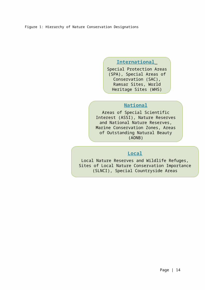
2.7 A hierarchy of designations is available under European and local legislation and designation is primarily the responsibility of NIEA. Generally sites are selected for their rarity value or for the diversity of species and habitats they contain, or as a representative example of their habitat type on a local, national or international scale. Some designations are brought forward under the LDP process. The range of nature conservation designations are outlined in Figure 1.
Figure 1: Hierarchy of Nature Conservation Designations
Page | 11

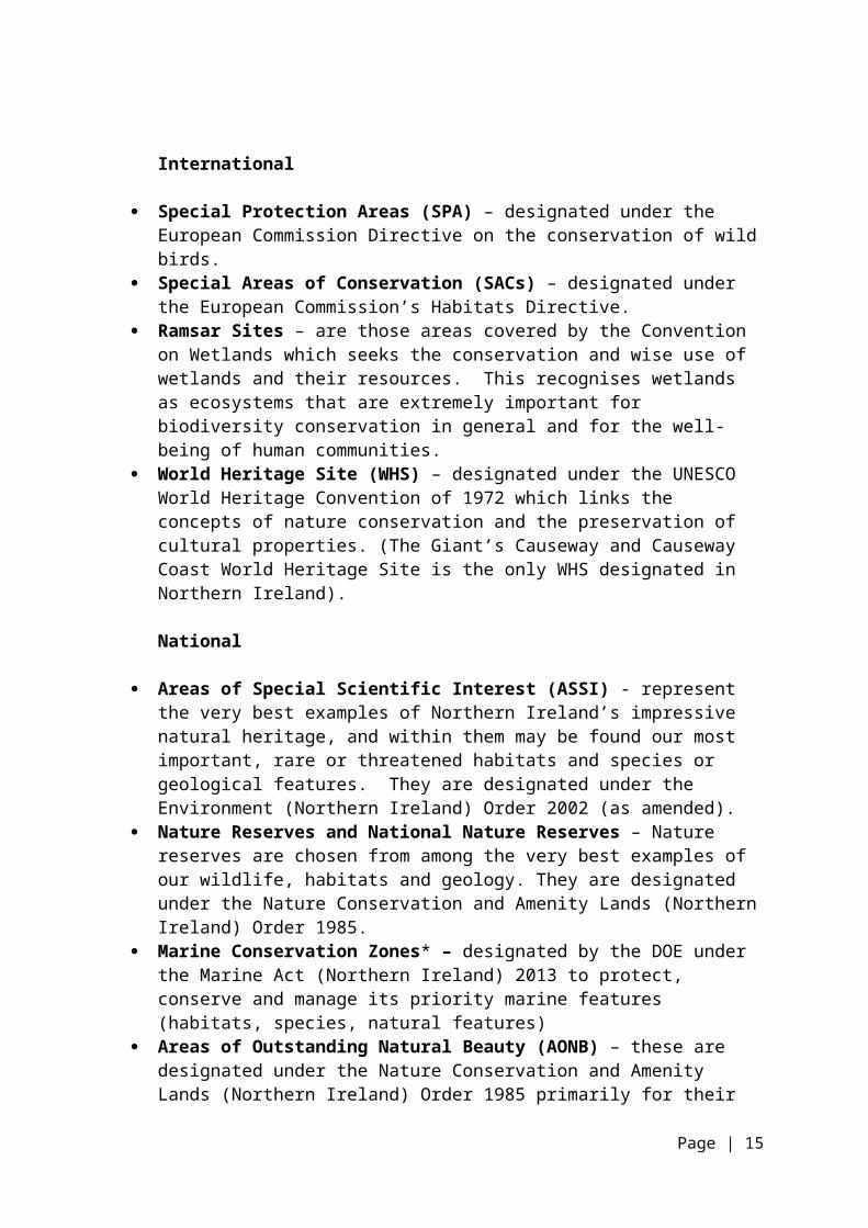
International
Page | 12
International Special Protection Areas (SPA), Special Areas of Conservation
(SAC), Ramsar Sites, World Heritage Sites (WHS)
NationalAreas of Special Scientific Interest (ASSI), Nature Reserves and National Nature Reserves, Marine
Conservation Zones, Areas of Outstanding Natural Beauty (AONB)
LocalLocal Nature Reserves and Wildlife Refuges, Sites of Local Nature
Conservation Importance (SLNCI), Special Countryside Areas
Special Protection Areas (SPA) – designated under the European Commission Directive on the conservation of wild birds.
Special Areas of Conservation (SACs) – designated under the European Commission’s Habitats Directive.
Ramsar Sites – are those areas covered by the Convention on Wetlands which seeks the conservation and wise use of wetlands and their resources. This recognises wetlands as ecosystems that are extremely important for biodiversity conservation in general and for the well-being of human communities.
World Heritage Site (WHS) – designated under the UNESCO World Heritage Convention of 1972 which links the concepts of nature conservation and the preservation of cultural properties. (The Giant’s Causeway and Causeway Coast World Heritage Site is the only WHS designated in Northern Ireland).
National
Areas of Special Scientific Interest (ASSI) - represent the very best examples of Northern Ireland’s impressive natural heritage, and within them may be found our most important, rare or threatened habitats and species or geological features. They are designated under the Environment (Northern Ireland) Order 2002 (as amended).
Nature Reserves and National Nature Reserves – Nature reserves are chosen from among the very best examples of our wildlife, habitats and geology. They are designated under the Nature Conservation and Amenity Lands (Northern Ireland) Order 1985.
Marine Conservation Zones* – designated by the DOE under the Marine Act (Northern Ireland) 2013 to protect, conserve and manage its priority marine features (habitats, species, natural features)
Areas of Outstanding Natural Beauty (AONB) – these are designated under the Nature Conservation and Amenity Lands (Northern Ireland) Order 1985 primarily for their high landscape quality, wildlife importance and rich cultural and architectural heritage.
Local
Local Nature Reserves (LNR) and Wildlife Refuges – LNRs can be provided by District Councils for nature conservation under powers conferred to them under the Nature Conservation and Amenity Lands (Northern Ireland) Order 1985. They are particularly appropriate for educational, recreational or public information services. The Department can also provide a Wildlife Refuge under the Wildlife Order.
* Marine Conservation Zones replaced Marine Nature Reserves following the introduction of the Marine Act (Northern Ireland) 2013
Page | 13
Sites of Local Nature Conservation Importance (SLNCI) – identified through the LDP process with policies provided in the plan for their protection and /or enhancement.
Special Countryside Areas – identified through the LDP process with local policies to protect their unique qualities
Planning Policy Statement 6 - Planning, Archaeology and the Built Heritage and Planning Policy Statement 6 – Addendum, Areas of Townscape Character
2.8 The policy objectives of PPS 6 are to: secure the protection, conservation and, where possible, the
enhancement of our built and archaeological heritage; promote sustainable development and environmental stewardship
with regard to our built and archaeological heritage; and encourage the link between conservation and economic prosperity.
2.9 In preparing LDPs, councils should take into account the implications of local policies and proposals on all features of the archaeological and built heritage and their settings, and the implications of proposed land use zonings, locations for development and settlement limits on natural heritage features within or adjoining the plan area. LDPs should identify the range of built and archaeological heritage features within the plan area and bring forward policies or proposals for their protection, conservation and enhancement. These include the following:
Archaeological Sites and Monuments (State Care, scheduled and other);
Areas of Archaeological Potential/Significant Archaeological Interest – areas within settlements where archaeological remains are likely to be encountered during development;
Historic Parks, Gardens and Demesnes – a register of parks, gardens and demesnes of special historic interest is held by NIEA;
Listed Buildings – buildings designated as being of ‘special architectural or historic interest’ (NIEA responsibility);
Conservation Areas – Areas of special architectural or historic interest;
Areas of Townscape Character or Areas of Village Character – areas of unique identity within settlements (designated through the LDP process);and
Local Landscape Policy Areas (LLPAs) – features or areas within and adjoining settlements considered to be of greatest amenity value, landscape quality or local significance (designated through the LDP process).
2.10 The Addendum to PPS 6 provides additional planning policies relating to Areas of Townscape Character/Areas of Village Character, for demolition of buildings, new development and the control of
Page | 14
advertisements, this must be read in conjunction with the policies contained within PPS 6.
Planning Policy Statement 21 – Sustainable Development in the Countryside
2.11 The aim of PPS 21 is to manage development in the countryside in a manner which strikes a balance between the need to protect the countryside from unnecessary or inappropriate development, while supporting rural communities.
2.12 The objectives of PPS 21 are to: manage growth in the countryside to achieve appropriate and
sustainable patterns of development that meet the essential needs of a vibrant rural community;
conserve the landscape and natural resources of the rural area and to protect it from excessive, inappropriate or obtrusive development and from the actual or potential effects of pollution;
facilitate development necessary to achieve a sustainable rural economy; including appropriate farm diversification and other economic activity; and
promote high standards in the design, siting and landscaping of development in the countryside.
(d) A Planning Strategy for Rural Northern Ireland
2.13 The majority of the policies within A Planning Strategy for Rural Northern Ireland (PSRNI) have been superseded by Planning Policy Statements. The Strategy does however outline the regional policies to protect and to guide development in the coastal zone.
(e) Other Relevant Strategies
2.14 The EU Biodiversity Strategy seeks to halt the loss of biodiversity and ecosystems services by 2020 and this is reflected in both Priority 3 of the Programme for Government (PfG) and the RDS. Furthermore, the Wildlife and Natural Environment Act (Northern Ireland) 2011 places a statutory duty on every public body to further the conservation of biodiversity. The Northern Ireland Biodiversity Strategy 2002 sets the framework for biodiversity action. The Biodiversity Strategy describes the main features of biodiversity in Northern Ireland, identifies the main factors affecting it and proposes a number of measures to support biodiversity conservation up to 2016. A new biodiversity strategy is being prepared to help halt the loss of biodiversity and degradation of ecosystems up to 2020.
Page | 15
2.15 Biodiversity is the total variety of all living things – of wildlife habitats, wild plants and animals. At the larger scale, biodiversity relates to the variation in landscapes and habitats and at the smallest scale to genetic differences in plants and animals. Biodiversity is vital to the health of the planet and to quality of life. The enhancement of biodiversity will be one of the most powerful indicators of progress towards sustainability.
2.16 It is important to recognise the biodiversity significance of Northern Ireland’s habitats in the British Isles and beyond. As one of the most westerly outliers of Europe, many of our communities of plants and animals represent extreme oceanic (mild and wet) examples.
2.17 The Biodiversity Strategy initially identified 40 habitat types as priorities for conservation action in Northern Ireland. This was later revised to 51 in April 2010. Northern Ireland Priority Species (NIPS) requiring conservation action are also identified and the list now stands at 481 species, an increase of 271 on the ‘old’ list when the Northern Ireland Biodiversity Strategy was being prepared.
2.18 The range of priority habitats and species listed through the Northern Ireland Biodiversity Strategy will be protected from development and proposals that could harm their integrity, continuity, links or ecological relationships.
2.19 The most common form of conserving biodiversity is designation, protection and management of the best sites of nature conservation importance. While areas of international and national nature conservation importance are already protected from development through other statutory designations, conservation of biodiversity is enhanced through the Plan by designating Sites of Local Nature Conservation Importance (SLNCIs), 187 of which are currently designated in the District.
2.20 In addition to the Northern Ireland Biodiversity Strategy, LDPs should also have regard to the 3 existing Local Biodiversity Action Plans (LBAPs) within the Newry, Mourne and Down District Council area, these documents were produced by the 3 former Councils i.e. Newry and Mourne District Local Biodiversity Action Plan 2009, Down District Local Biodiversity Action Plan 2012 and Banbridge District Local Biodiversity Action Plan 2007. No Biodiversity Action Plan has yet been prepared for the new Newry, Mourne and Down District Council area.
2.21 LBAPs, as prepared by individual councils, aim to conserve biodiversity through local partnerships, taking into account both national and local priorities by involving local people and local organisations through practical delivery of biodiversity conservation.
Newry and Mourne District Local Biodiveristy Action Plan 2009
Page | 16
2.22 The Newry and Mourne District Local Biodiversity Action Plan 2009 states that the District supports 24 of the 42 Northern Ireland priority habitats and sustains approximately 164 of 457 Northern Ireland Species of Conservation Concern (SoCC) and 78 of 272 Northern Ireland Priority Species.
Down District Local Biodiversity Action Plan 2012
2.23 The Down District Local Biodiversity Action Plan 2012 states that of the 51 Northern Ireland Priority Habitats at least 39 occur in the District and of the 481 Northern Ireland Priority Species, 185 have been recorded in the District.
Banbridge District Local Biodiversity Action Plan 2007
2.24 The Banbridge District Local Biodiversity Action Plan 2007 does not appear to provide figures in respect of the numbers of priority habitats and priority species within the area.
2.25 It should be noted that the figures included within this paper regarding biodiversity are representative of the data sources currently available and it is recognised that these sources may not be comparable and figures may since have been revised.
(f) Key Legislative Requirements during LDP Preparation Process in relation to Environmental Assets
2.26 Combined with the comprehensive coverage of European Directives, it is a legal requirement on any planning authority to ensure that plans, programmes and projects likely to have significant effects on the environment are made subject to an environmental assessment, prior to their approval or authorisation. Consultation with the public is a key feature of environmental assessment procedures. The level of environmental assessment is proportionate to the scale of the plan, programme or project proposed.
2.27 The Planning Act (Northern Ireland) 2011 now places a statutory duty on those planning authorities producing an LDP to undertake a Sustainability Appraisal (SA). This incorporates the principles of sustainable development when preparing such plans and assesses not just the potential environmental impacts of the plan but any economic and social impacts too.
2.28 To assess the environmental implications, the SA will incorporate a Strategic Environmental Assessment (SEA). European Directive 2001/42/EC ‘on the assessment of the effects of certain plans and programmes on the environment’, commonly referred to as the Strategic
Page | 17
Environmental Assessment (SEA) Directive, is transposed into Northern Ireland law by the Environmental Assessment of Plans and Programmes Regulations (NI) 2004 (EAPP (NI) 2004). The objective of SEA is to provide for a high level of protection of the environment and to contribute to the integration of environmental consideration into the preparation and adoption of plans and programmes with a view to promoting sustainable development.
2.29 An SEA must be carried out in conjunction with, and parallel to, the development of any plan and integrated with the plan process. Under the provisions of the SEA Directive and the Regulations, an Environmental Report is published with the draft plan and must be taken into account before the adoption of the LDP.
2.30 Under the provisions of the Habitats Regulations, plan-making authorities are required to undertake an Appropriate Assessment for any development plan (or development proposal) which either individually, or in combination with other plans or projects, is likely to significantly affect a European Site such as a SPA or SAC.2.31 The purpose of an Appropriate Assessment is to assess the impacts of a land-use plan against the conservation objectives of a European site and to ascertain whether the plan is likely to adversely affect site integrity. Where significant negative effects are identified, alternative options should be examined to avoid any potentially damaging effects.
2.32 The Shared Environmental Service (Mid & East Antrim Borough Council) will provide advice to the Council to support the preparation of LDPs and will carry out Habitats Regulations Assessments of these plans. However, the undertaking of an SA incorporating a Strategic Environmental Assessment will be the responsibility of the Council.
Page | 18
3.0 The Environmental Assets of Newry, Mourne and Down District Council
3.1 Our Council area is one which is rich in built, natural and landscape heritage. Development at whatever scale has the potential to adversely impact on our environment. There is therefore a significant responsibility on all involved in the planning process to ensure that any potential environmental impacts are identified in order to allow the effects to be considered, avoided or mitigated.
3.2 As the planning authority, we must pursue our economic and social priorities whilst simultaneously being aware of our legislative obligations in relation to our environmental assets.
3.3 Within this Paper the environmental assets of Newry, Mourne and Down District Council have been classified into two categories: (a) archaeological and built heritage and (b) natural heritage and nature conservation. The format of this Paper follows that sequence.
3.4 The boundary of the newly formed Newry, Mourne and Down District Council encompasses the former Newry and Mourne District Council, Down District Council and the Ballyward Ward which was formerly within Banbridge District Council.
3.5 This Paper therefore includes references to the Area Plans for each of these areas i.e. Banbridge/Newry and Mourne Area Plan 2015 and Ards and Down Area Plan 2015. Within this Paper the environmental designations within Newry, Mourne and Down District Council are, on occasion, subdivided into geographical lists for each of the former Council
Page | 19
areas i.e. former Newry and Mourne Council area, former Down Council area and Ballyward Ward from the former Banbridge Council area.
3.6 The figures quoted throughout this Paper were taken from the most accurate sources available at the time of publication. It should be noted that these figures are subject to continual review and updates.
4.0 Archaeological and Built Heritage Features within Newry, Mourne and Down District Council Area
Within Newry, Mourne and Down District Council there are:
2016 Archaeological Sites and Monuments643 Listed Buildings35 Historic Parks, Gardens and Demesnes924 Industrial Heritage Sites33 Areas of Significant Archaeological Interest/ Areas of Archaeological Potential10 Conservation Areas 27 Areas of Townscape Character 216 Local Landscape Policy Areas
Each of these designations are detailed below, for ease of reference and where relevant, the designations within each category have been identified within each of the legacy council areas.
Archaeological Sites and Monuments
4.1 Historic Monuments in State Care
Archaeological sites and monuments are taken into the guardianship of the Department of the Environment (DOE) under the Historic Monuments and Archaeological Objects (NI) Order 1995. State care sites and monuments represent all periods of human settlement in Ireland from around 7,000BC to the 20th century, include some of the premier
Page | 20

examples of monument types in Northern Ireland, and within the District these including pre-historic Ballynoe Stone Circle, the Neolithic King’s Ring and Court Tomb in Clontygora, late medieval Narrow Water Castle in Warrenpoint and 14th Century Ringhaddy Church.
Monuments in State Care have many values, they are a tangible link to our past and hold information on how our predecessors lived, and for this reason they are fascinating places to visit. They are also located in both rural and urban environments, so that State Care Monuments often provide important habitats for wildlife that may not survive in the surrounding area. State care sites are also used as an important educational tool as some facilitate educational programmes and events.
There are currently 42 Historic Monuments in State Care within the District.
4.2 Scheduled Monuments
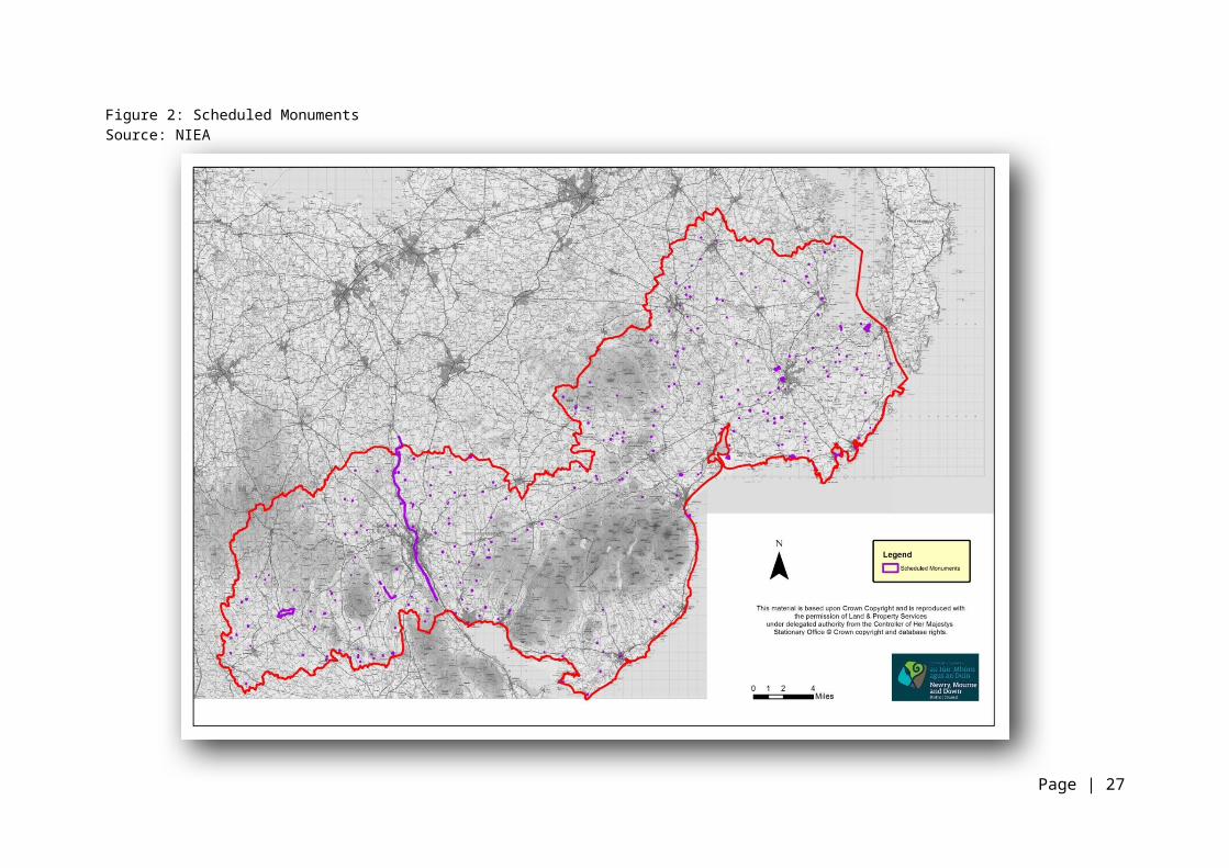
Under the Historic Monuments and Archaeological Objects (NI) Order 1995 the DOE has a duty to compile and maintain a schedule of monuments. Monuments on the schedule have statutory protection and inclusion is at the DOE’s discretion. In practice most proposals for scheduling originate within NIEA and consultation is required with the Historic Monuments Council before a monument is added to or removed from the schedule. They include sites dating from 7000 BC to the 20th century such as prehistoric tombs, earthworks of all kinds, castles, churches, maritime sites, canals and World War 2 defences. There are currently 286 Scheduled Monuments within the District; these are illustrated in Figure 2.
4.3 Unscheduled Monuments
Large numbers of known archaeological sites are likely to remain unscheduled and whether or not they are preserved will depend on the value of the remains, the commitment of the owners and the public and the policies of public agencies.
There are currently 1688 Unscheduled Monuments within the District.
Page | 21
Figure 2: Scheduled MonumentsSource: NIEA
Page | 22
4.4 Listed Buildings
Article 80 of the Planning Act (Northern Ireland) 2011 requires the DOE to compile a list of buildings of special architectural or historic interest. Such buildings are important for their intrinsic value and for their contribution to the character and quality of settlements and the open countryside of Northern Ireland.
The list of buildings of special architectural or historic interest records the best of our architectural heritage. It includes every type of building, ranging from grand mansions and cathedrals to warehouses and vernacular architecture. As well as conventional buildings, the list may include man made objects or structures not normally considered as buildings, for example tombstones, telephone kiosks, post-boxes, gates, war memorials, bridges, docks and other industrial structures.
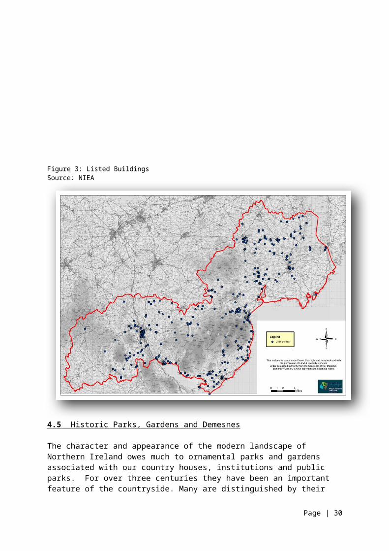
There are approximately 643 Listed Buildings within the District; these are illustrated in Figure 3.
There are approximately 379 Listed Buildings within the former Newry and Mourne Council area (HB 16).
There are approximately 249 Listed Buildings within the former Down Council area (HB 18).
There are approximately 15 Listed Buildings within the Ballyward Ward (HB17) which was part of the former Banbridge Council area.
Page | 23
Figure 3: Listed BuildingsSource: NIEA
4.5 Historic Parks, Gardens and Demesnes
The character and appearance of the modern landscape of Northern Ireland owes much to ornamental parks and gardens associated with our country houses, institutions and public parks. For over three centuries they have been an important feature of the countryside. Many are distinguished by their carefully composed design of trees, meadow and water, perhaps as a setting for a building; some boast a valuable collection of trees, shrubs or plants; others may provide a significant historic record, either of a particular era or showing how the design has changed over the centuries. Aside from their contribution to the quality and character of our local landscape, those that are open to the public provide an important recreational resource. However, it is a fragile heritage, for unlike other works of art, these gardens and designed landscapes are living, growing and evolving. As such they need careful management. NIEA has prepared a register of parks, gardens and demesnes of special historic interest in Northern Ireland, there are 35 within the District, these are listed below.
Page | 24
There are 14 Historic Parks, Gardens and Demesnes within the former Newry and Mourne Council area:
1. Ballyedmond2. Derrymore House and The Woodhouse3. Dromantine House4. Drumbanagher5. Green Park6. Hawthorne Hill7. Killevy Castle8. Mourne Park9. Narrow Water Castle10. Warrenpoint Park11. Rostrevor House
Supplementary Sites
12. Ballymoyer 13. Fairy Hill14. Forkhill House
There are 20 Historic Parks, Gardens and Demesnes within the former Down Council area:
1. Ballytrim 2. Castleward 3. Castlewellan Castle 4. Crossgar House (Tobar Mhuire) 5. Delamont 6. Finnebrogue House 7. Killyleagh Castle 8. Monalto House9. Mount Panther 10. Myra Castle 11. Ringdufferin 12. Rademon 13. Rowallane 14. Saintfield House 15. Seaforde House 16. Tollymore Park 17. Tyrella House
Supplementary Sites
18. Ballee House 19. Ballydugan House 20. Church Hill
Page | 25
There is 1 Historic Park, Garden and Demesne within the Ballyward Ward which was formerly in the Banbridge Council area:
1. Ballyward Lodge
4.6 Industrial Heritage
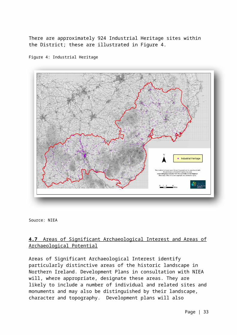
The Newry, Mourne and Down District Council area contains a wealth of remains of industrial heritage, all of which are reminders of the economic development of the area. The NIEA holds and updates a record of industrial heritage sites, including features such as former railway structures, viaducts and mill buildings. Some of these may have been lost or only retain a few elements of their original form. The most important sites are afforded statutory protection as archaeological sites or listed buildings.
There are approximately 924 Industrial Heritage sites within the District; these are illustrated in Figure 4.
Figure 4: Industrial HeritageSource: NIEA
Page | 26
4.7 Areas of Significant Archaeological Interest and Areas of Archaeological Potential
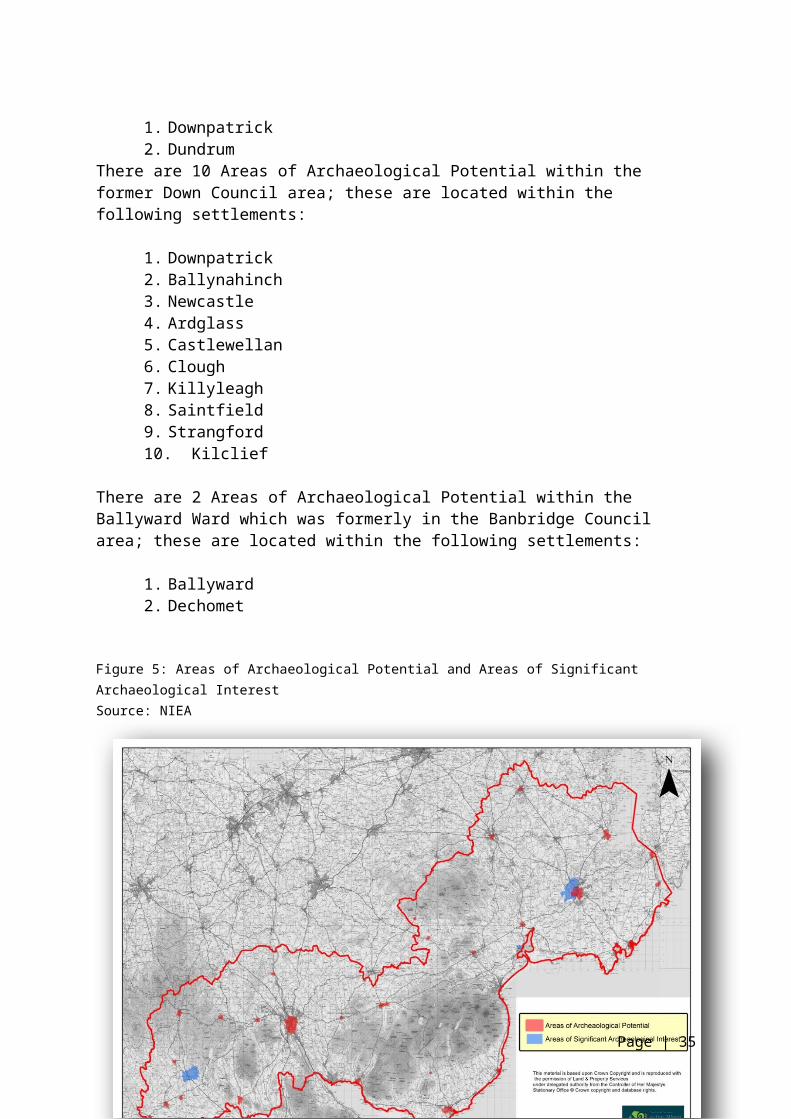
Areas of Significant Archaeological Interest identify particularly distinctive areas of the historic landscape in Northern Ireland. Development Plans in consultation with NIEA will, where appropriate, designate these areas. They are likely to include a number of individual and related sites and monuments and may also be distinguished by their landscape, character and topography. Development plans will also highlight, for the information of prospective developers, those areas within the historic cores of towns and villages, where, on the basis of current knowledge, it is likely that archaeological remains will be encountered in the course of continuing development and change. These will be referred to as areas of archaeological potential. Within the District there are 3 designated Areas of Significant Archaeological Interest and 30 designated Areas of Archaeological Potential; these are listed below and are illustrated in Figure 5.
There is 1 Area of Significant Archaeological Interest within the former Newry and Mourne Council area; this is located within the following settlement:
1. The Dorsey
There are 18 Areas of Archaeological Potential within the former Newry and Mourne Council area; these are located within the following settlements:
1. Newry 2. Crossmaglen 3. Kilkeel 4. Newtownhamilton 5. Annalong 6. Attical 7. Camlough8. Cullyhanna 9. Forkhill 10. Hilltown 11. Mayobridge 12. Rostrevor 13. Belleek 14. Creggan 15. Cullaville 16. Greencastle 17. Jerretspass 18. Killowen
There are 2 Areas of Significant Archaeological Interest within the former Down Council area; these are located within the following settlements:
Page | 27

1. Downpatrick 2. Dundrum
There are 10 Areas of Archaeological Potential within the former Down Council area; these are located within the following settlements:
1. Downpatrick 2. Ballynahinch 3. Newcastle 4. Ardglass 5. Castlewellan 6. Clough 7. Killyleagh 8. Saintfield 9. Strangford 10. Kilclief
There are 2 Areas of Archaeological Potential within the Ballyward Ward which was formerly in the Banbridge Council area; these are located within the following settlements:
1. Ballyward 2. Dechomet
Figure 5: Areas of Archaeological Potential and Areas of Significant Archaeological InterestSource: NIEA
Page | 28
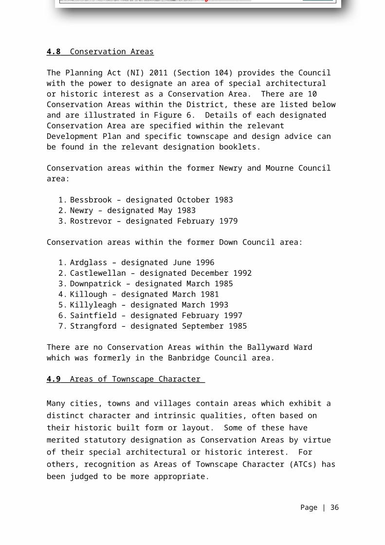
4.8 Conservation Areas
The Planning Act (NI) 2011 (Section 104) provides the Council with the power to designate an area of special architectural or historic interest as a Conservation Area. There are 10 Conservation Areas within the District, these are listed below and are illustrated in Figure 6. Details of each designated Conservation Area are specified within the relevant Development Plan and specific townscape and design advice can be found in the relevant designation booklets.
Conservation areas within the former Newry and Mourne Council area:
1. Bessbrook – designated October 19832. Newry – designated May 1983 3. Rostrevor – designated February 1979
Conservation areas within the former Down Council area:
1. Ardglass – designated June 19962. Castlewellan – designated December 19923. Downpatrick – designated March 1985 4. Killough – designated March 19815. Killyleagh – designated March 19936. Saintfield – designated February 19977. Strangford – designated September 1985
There are no Conservation Areas within the Ballyward Ward which was formerly in the Banbridge Council area.
4.9 Areas of Townscape Character
Many cities, towns and villages contain areas which exhibit a distinct character and intrinsic qualities, often based on their historic built form or layout. Some of these have merited statutory designation as Conservation Areas by virtue of their special architectural or historic interest. For others, recognition as Areas of Townscape Character (ATCs) has been judged to be more appropriate.
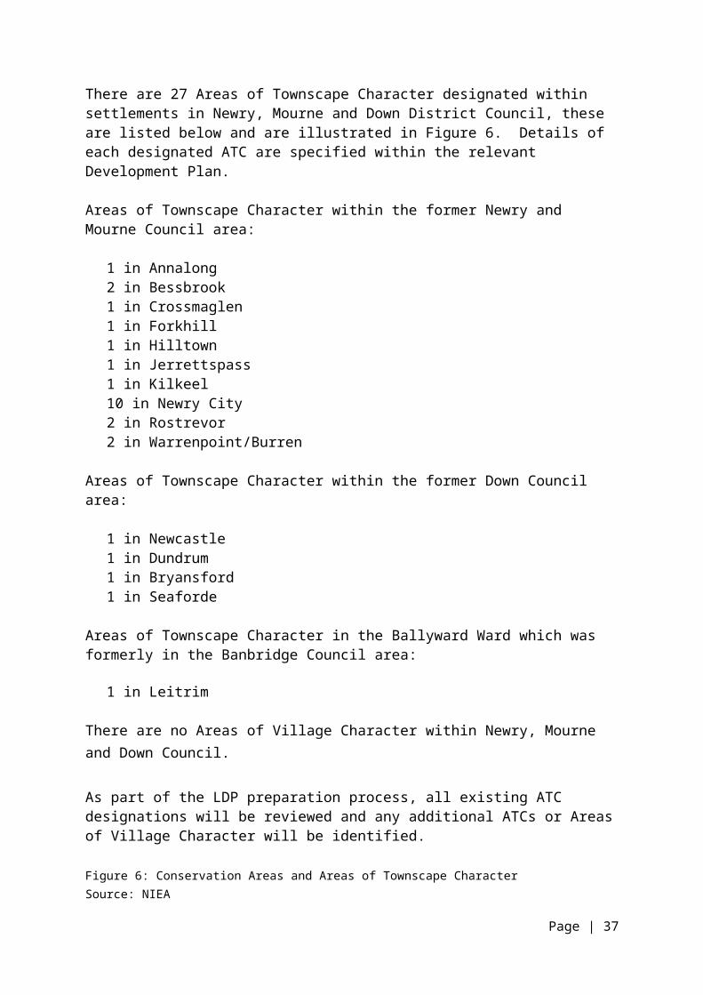
There are 27 Areas of Townscape Character designated within settlements in Newry, Mourne and Down District Council, these are listed below and are illustrated in Figure 6. Details of each designated ATC are specified within the relevant Development Plan.
Areas of Townscape Character within the former Newry and Mourne Council area:
1 in Annalong 2 in Bessbrook
Page | 29
1 in Crossmaglen 1 in Forkhill 1 in Hilltown 1 in Jerrettspass 1 in Kilkeel 10 in Newry City 2 in Rostrevor 2 in Warrenpoint/Burren
Areas of Townscape Character within the former Down Council area:
1 in Newcastle1 in Dundrum1 in Bryansford1 in Seaforde
Areas of Townscape Character in the Ballyward Ward which was formerly in the Banbridge Council area:
1 in Leitrim
There are no Areas of Village Character within Newry, Mourne and Down Council.
As part of the LDP preparation process, all existing ATC designations will be reviewed and any additional ATCs or Areas of Village Character will be identified.
Figure 6: Conservation Areas and Areas of Townscape CharacterSource: NIEA
Page | 30
Figure 6
Conservation Areas and Areas of Townscape Character
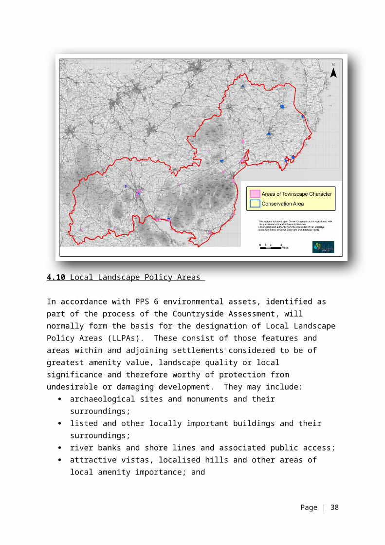
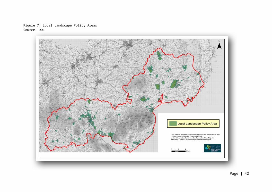
4.10 Local Landscape Policy Areas
In accordance with PPS 6 environmental assets, identified as part of the process of the Countryside Assessment, will normally form the basis for the designation of Local Landscape Policy Areas (LLPAs). These consist of those features and areas within and adjoining settlements considered to be of greatest amenity value, landscape quality or local significance and therefore worthy of protection from undesirable or damaging development. They may include:
archaeological sites and monuments and their surroundings; listed and other locally important buildings and their surroundings; river banks and shore lines and associated public access; attractive vistas, localised hills and other areas of local amenity
importance; and areas of local nature conservation interest, including areas of
woodland and important tree groups.
There are 216 LLPAs within the District, these are listed below and are illustrated in Figure 7. Details of each designated LLPA are specified within the relevant Development Plan.
There are 112 LLPAs in the former Newry and Mourne Council area:
23 in Newry2 in Crossmaglen10 in Kilkeel3 in Newtownhamilton10 in Warrenpoint/Burren4 in Annalong1 in Attical2 in Ballymartin3 in Bessbrook4 in Camlough2 in Cullyhanna1 in Forkhill3 in Hilltown2 in Jonesborough2 in Mayobridge4 in Meigh1 in Mullaghbane1 in Rostrevor3 in Altnamackan/Cortamlet2 in Barnmeen4 in Belleek
Page | 31
1 in Creggan1 in Drumintee2 in Dunaval/Ballyardle1 in Glassdrumman3 in Glassdrumman/Mullartown1 in Glen2 in Greencastle1 in Jerrettspass1 in Killowen2 in Lislea1 in Longstone1 in Lurganare2 in Mullaghglass2 in Sheeptown1 in Silverbridge1 in Tullyherron2 in Whitecross
There are 98 LLPAs in the former Down Council area:
6 in Downpatrick13 in Ballynahinch7 in Newcastle4 in Annsborough3 in Ardglass6 in Castlewellan1 in Clough2 in Crossgar3 in Drumaness2 in Dundrum3 in Killough9 in Killyleagh9 in Saintfield3 in Shrigley2 in Strangford9 in The Spa1 in Annacloy2 in Bryansford1 in Carricknab 1 in Drumaghlis1 in Kilclief1 in Kilcoo1 in Kilmore1 in Loughlinisland1 in Maghera2 in Raholp1 in Saul3 in Seaforde
Page | 32
There are 6 LLPAs in the Ballyward Ward which was formerly in the Banbridge Council area:
1 in Glasker1 in Leitrim1 in Finnis1 in Dechomet2 in Ballyward
As part of the LDP preparation process, all existing LLPA designations will be reviewed and any additional LLPAs identified.
Page | 33
Figure 7: Local Landscape Policy AreasSource: DOE
Page | 34
5.0 Natural Heritage and Nature Conservation Designated Sites within Newry, Mourne and Down District Council area
Within Newry, Mourne and Down District Council there are:
3 Special Protected Areas (SPAs)11 Special Areas of Conservation (SACs)4 RAMSAR Sites62 Areas of Special Scientific Interest (ASSIs)2 Areas of Scientific Interest7 National Nature Reserves/Nature Reserves1 Marine Conservation Zone3 Areas of Outstanding Natural Beauty25 Landscape Character Areas5 Regional Landscape Character Areas7 Regional Seascape Character Areas187 Sites of Local Nature Conservation Importance (SLNCIs) Special Countryside Areas114 confirmed Tree Preservation OrdersAncient and long-established Woodlands
5.1 Special Protection Areas
Special Protection Areas (SPAs) are designated under the European Commission Directive on the Conservation of Wild Birds. All European community member states are required to identify internationally important areas for breeding, over-wintering and migrating birds and designate them as SPAs.
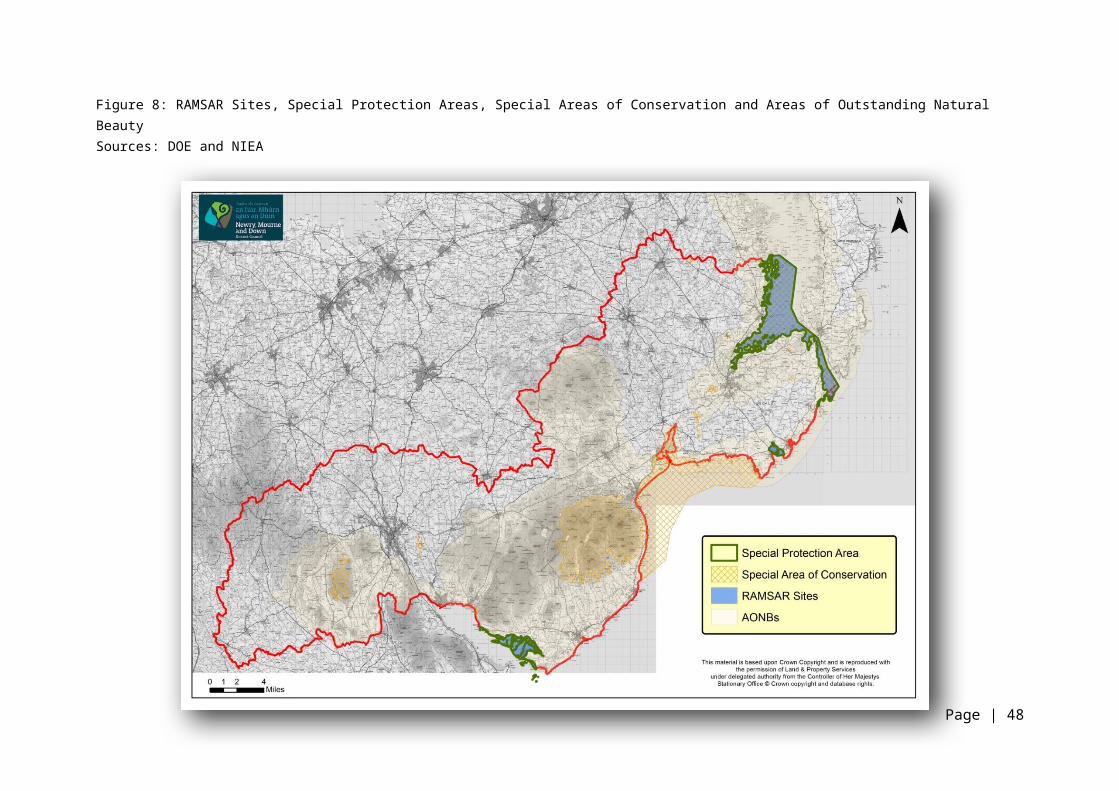
There are currently 15 SPA sites designated in Northern Ireland, 3 of which are within the District, these 3 are listed below and are illustrated in Figure 8.
1. Killough Bay SPA
Killough Bay encompasses the inter-tidal areas, and additional adjoining areas of notable habitat. These include mudflats, sand dominated beaches, gravel and cobble units and rocky shore. The principal interest is the wintering population of light-bellied Brent goose. The boundary of the Killough Bay SPA includes Killough Harbour and Coney Island Bay.
Page | 35
2. Strangford Lough SPA
Situated on the east coast of Northern Ireland, Strangford Lough is a large shallow sea lough with an indented shoreline and a wide variety of marine and intertidal habitats. The west shore has numerous islands typical of flooded drumlin topography. The Lough contains extensive areas of mudflat and also sandflats, saltmarsh and rocky coastline. This is Northern Ireland’s most important coastal site for wintering waterfowl, and it is particularly important for breeding terns. The landward boundary of the SPA is entirely coincident with the landward boundary of the following five ASSIs: Strangford Lough Part 1, Strangford Lough Part 2, Strangford Lough Part 3, Killard and Ballyquintin Point.
3. Carlingford Lough SPA
This SPA lies between Killowen Point and Soldiers Point on the northern shores of Carlingford Lough and the landward boundary is entirely coincident with that of the Carlingford Lough Area of Special Scientific Interest (ASSI). The SPA boundary is also entirely coincident with that of the Carlingford Lough Ramsar Site; it includes all lands and intertidal areas seawards to the limits of territorial waters.
5.2 Special Areas of Conservation
Special Areas of Conservation (SACs) are those which have been given greater protection under the European legislation of The Habitat's Directive. They have been designated because of a possible threat to the special habitats or species which they contain and to provide increased protection to a variety of animals, plants and habitats of importance to biodiversity both on a national and international scale.
There are currently 57 SAC sites designated in Northern Ireland, 11 of which are within the District, these 11 are listed below and are illustrated in Figure 8.
1. Aughnadarragh Lough SAC2. Turmennan SAC 3. Lecale Fens SAC4. Hollymount SAC 5. Ballykilbeg SAC6. Murlough SAC7. Eastern Mournes SAC 8. Strangford Lough SAC
Page | 36
9. Derryleckagh SAC10. Rostrevor Wood SAC11. Slieve Gullion SAC
5.3 Ramsar Sites
The Convention on Wetlands, called the Ramsar Convention, is an intergovernmental treaty that provides the framework for national action and international cooperation for the conservation and wise use of wetlands and their resources. This recognises wetlands as ecosystems that are extremely important for biodiversity conservation in general and for the well-being of human communities. Ramsar sites often overlap other designations.
There are 20 designated Ramsar sites in Northern Ireland, 4 of which are within the District, these 4 are listed below and are illustrated in Figure 8.
1. Turmennan Ramsar Site
Turmennan is situated some 5km north of Downpatrick. It consists of a series of wetlands and adjoining habitat that support a wide range of plant communities and includes a number of notable plant species. In addition, the invertebrate community of the wetland is important for its overall diversity and includes several rare species. The boundary to the Ramsar site is entirely coincident with Turmennan ASSI.
2. Killough Bay Ramsar Site
Killough Bay site is situated 8km south-west of Downpatrick, along the County Down coast in the south-east of Northern Ireland. It is a small harbour with tidal mudflats and shingle banks which includes the intertidal areas and adjoining areas of notable habitat – mudflats, sand dominated beaches, gravel and cobble units and rocky shore. The boundary of the Ramsar site includes Killough harbour and Coney Island Bay.
3. Strangford Lough Ramsar Site
Situated on the east coast of Northern Ireland, Strangford Lough is a large shallow sea lough with an indented shoreline and a wide variety of marine and intertidal habitats. The west shore has numerous islands typical of flooded drumlin topography. The Lough contains extensive areas of mudflat and also sandflats, saltmarsh and rocky coastline and is Northern Ireland’s most important coastal site for wintering waterfowl; it is also an
Page | 37
important site for breeding terns. The landward boundary of the Ramsar site is entirely coincident with the landward boundary of the following five ASSIs: Strangford Lough Part 1, Strangford Lough Part 2, Strangford Lough Part 3, Killard and Ballyquintin Point. All lands, intertidal, subtidal areas and freshwater habitats, along with the Quoile Pondage Nature Reserve are included in the Ramsar site.
4. Carlingford Lough Ramsar Site
This Ramsar Site lies between Killowen Point and Soldiers Point on the northern shores of Carlingford Lough and the landward boundary is entirely coincident with that of the Carlingford Lough ASSI. The Ramsar Site boundary is also entirely coincident with that of the Carlingford Lough SPA. The Ramsar site includes all lands and intertidal areas seawards to the limits of territorial waters.
It should be noted that there is 1 proposed Ramsar site within the District, this is Derryleckagh, and it is located within the former Newry and Mourne Council area. It is a matter of policy that both listed Ramsar sites and proposed Ramsar sites in the UK are treated as European Sites.
Page | 38
Figure 8: RAMSAR Sites, Special Protection Areas, Special Areas of Conservation and Areas of Outstanding Natural BeautySources: DOE and NIEA
Page | 39
5.4 Areas of Special Scientific Interest
Areas of Special Scientific Interest (ASSIs) represent the very best examples of Northern Ireland’s impressive natural heritage, and within them may be found our most important, rare or threatened habitats and species or geological features. They are designated under the Environment (Northern Ireland) Order 2002 (as amended).
There are 62 ASSIs within the District, these are listed below and are illustrated in Figure 9.
There are 28 ASSIs within the former Down Council area:
1. Ardglass ASSI Ardglass is of importance because of its geology. It is one of a series of sites that describes the Newry Igneous Complex (NIC) and continues to be of considerable importance for research.
2. Aughnadarragh Lough ASSIThe area is particularly notable as one of the longest established colonies of the marsh fritillary butterfly in Northern Ireland. Of particular importance is the marginal mossy fen, which is extensive to the south and east behind the swamp and tall herb fen that fringes Aughnadarragh Lough. The range of vegetation types associated with the site makes it one of the most diverse wetlands in County Down.
3. Ballybannan ASSI This site forms part of a shallow basin in intensive farmland, bisected by a road with some rocky outcrops, to the west of the road is a small area of fen and to the east of the road is an area which is a mosaic of fen and gorse scrub. Another fen vegetation type occupies a small area on the northern margins of the sub site, although small this stand is very species rich with an interesting collection of plants.
4. Ballycam ASSIA shallow inter-drumlin hollow with varied communities including some interesting plants. Although small, Ballycam contains a number of fen communities, including the only known example in Northern Ireland of one that is generally only found locally in lowland England and Wales.
5. Ballykilbeg ASSIBallykilbeg is a large wetland site with a complex mosaic of habitats ranging from swamp, fen and wet grassland to woodland and scrub. The fen contains a number of scarce plants and also provides valuable
Page | 40
habitat for a number of wetland birds and invertebrates including a well-established colony of the marsh fritillary butterfly.
6. Ballynagross Lower ASSI A shallow sided valley in undulating enclosure landscape of improved pasture fields. This is a species rich site although it does not support many rare species.
7. Black Lough ASSI Black Lough is a large, complex site. Wetland plant communities are diverse and include several rare species. The site also includes areas of lowland heath and species rich grasslands.
8. Carrowcarlin ASSICarrowcarlin is a basin wetland supporting a range of plant communities including species rich type of fen that are rare in Northern Ireland. The site is also important for invertebrates.
9. Castlewellan Lake ASSI The site is a mid-altitude lake that lies in the valley between Slievenaslat and Slievebeg, within the grounds of Castlewellan Forest Park. It has been declared an ASSI because of its aquatic flora and fauna which are dependent on the unpolluted water and low levels of nutrients. The diverse substrate of the lake ranges from boulder and rock to sand and gravel on the deeper waters. This provides a variety of niches for a wide range of plants and animals.
10. Corbally ASSICorbally is an inter drumlin wetland. The area is particularly diverse with open water, swamp and fen plant communities. The fen communities are diverse and include a stand of fen meadow which is a rare plant community in Northern Ireland. Corbally also provides valuable habitat for wetland birds and invertebrates.
11. Gransha ASSIGransha is of importance because of its geology. It is one of a series of sites that describes the Newry Igneous Complex (NIC) and continues to be of considerable importance for research.
12. Heron and Carrigullian Loughs ASSI Heron and Carrigullian Loughs, together with the surrounding fen, scrub, woodland and unimproved grassland represent a large area of
Page | 41
semi natural habitat which supports a number of rare plants and invertebrates.
13. Hollymount ASSIHollymount represents an area of well-developed swamp carr woodland dominated by mature alder and grey willow. Within the swamp woodland, fluctuating water filled ditches represent the principal site for water violet in Northern Ireland.
14. Killard ASSI Killard Point is of special scientific interest because of the physiography, flora and fauna. It is one of the best examples of a coastal system in Northern Ireland and is notable for its extent and the wide range of plant communities present. It is largely unmodified and there are a number of rare plants and animals recorded. Killard Point is considered to be one of the best sites in Northern Ireland for grassland and dune heath invertebrates. The butterflies and moths of Killard have been documented and are known to be of high interest.
15. Killough Bay and Strand Lough ASSI Killough Bay and Strand Lough ASSI is a coastal site with linked tidal lough, swamp, fen and wet meadows. Killough Bay is an important over-wintering site for many birds, but it especially supports nationally important numbers of light-bellied Brent geese.
16. Loughkeelan ASSIA small eutrophic lough with high calcium levels, surrounded by an extensive swamp of common reed with a narrow fringe of calcicolous (rich in calcium/limestone) fen. The aquatic flora is of particular interest, with extensive stonewort cover, and soft hornwort being recorded here and only two other sites in Ireland.
17. Loughmoney ASSI A small site occupying a depression at the junction of three pasture fields and influenced from the surrounding improved pasture. There is only a limited area of diverse fen on the site, which occupies a small area at the southern end and narrow margins to the north.
18. Murlough ASSI The area is of special scientific interest because of the coastal flora, fauna and physiography. It is internationally important for wintering wildfowl and waders, a haul-out site for common and grey seals and it
Page | 42
accommodates a wide range of invertebrates including rare species and communities.
19. Quoile ASSI Quoile is centred around the former tidal estuary of the Quoile River. The open waters hold a range of aquatic plant species, with emergent swamp around the margins backed by a species rich fen. The area includes a further transition from fen to wet grassland and mature woodland giving a wide range of habitats. As a result of this diversity, plant and animal communities are very rich and include a number of scarce species. Significant numbers of birds use the area and the Quoile is notable for mammals and invertebrates.
20. Sheepland Coast ASSI This area is of special scientific interest because of its coastal flora and fauna and earth science features.
21. Shimna River ASSIThe area which includes the Shimna River and one of its main tributaries the Trassey River is of special scientific interest because of the physical features of the river and its associated riverine flora and fauna. It is one of the best examples in Northern Ireland of an upland oligotrophic (base poor) river and the only known location of Portuguese feather moss in Northern Ireland.
22. St John’s Point ASSIThis area is of special scientific interest because of its coastal and intertidal flora, fauna and geology.
23. Strangford Lough Part 2 ASSIThis coastal site comprises intertidal foreshore with extensive mudflats and steeply shelving rocky shores, including Strangford Narrows. Strangford Lough is the most important breeding site in Ireland for the common seal; over half of the breeding population of Strangford Lough is found in The Narrows, the largest colonies being at Barr Hall Bay, Angus and Garter Rocks and Cloghy Rocks. Small numbers of grey seal regularly occur in The Narrows of Strangford Lough.
24. Strangford Lough Part 3 ASSIThe part 3 area is an integral part of the Lough as a whole. It contains a great diversity of intertidal habitats with The Dorn being an area of
Page | 43
exceptional note. The lough provides very important over wintering feeding grounds for large numbers of waterfowl, including species such as the Slavonian Grebe. The numbers of Light-bellied Brent geese are of international importance. The mudflats on the south side of the Comber estuary are one of the most important sources of eel grass for the geese. The Lough is the most important breeding site in Ireland for common seals. Approximately 30% of the total adult population of the Lough is found on a number of small islands and pladdies.
25. Tullyratty ASSI This area is of special scientific interest due to it being a type of species rich grassland (lowland meadow) which is a scarce resource in Northern Ireland. The variation in topography and related soil hydrology and the effects of past and present management have resulted in the presence of a wide range of grassland plant species. Further diversity is provided through the presence of scrub which can be a valuable habitat for invertebrates.
26. Turmennan ASSITurmennan consists of a valley mire, which is in a transitional stage between fen and bog. It supports a wide range of plant communities, ranging from swamp to a variety of fen types and wet grasslands.
27. Tyrella and Minerstown ASSITyrella and Minerstown has been declared as an ASSI because of its intertidal sand and rock communities, sand dune systems and the associated flora and fauna. Minerstown and Tyrella are also important for the Common Seal.
28. Woodgrange ASSI The Irish type locality for the Woodgrange Interstadial, the late glacial climatic oscillation following deglaciation.
There are 33 ASSIs within the former Newry and Mourne Council area:
1. Aughnagon Quarry ASSIAughnagon Quarry is a special place because of its earth science interest. The area provides access to exposures of a granite-like rock called granodiorite and Silurian sedimentary rocks that together with a number of other sides describe the Newry Igneous Complex. The rocks at Aughnagon Quarry form part of the central pluton and are of great importance as they display the complex relationships between the
Page | 44
granodiorite and other igneous rock types, and the Silurian sedimentary ‘host’ rock.
2. Cam Lough ASSICam Lough is a special place because of its aquatic flora and fauna which are dependent on unpolluted water and low levels of plant nutrients. The diverse substrate of the lake, which ranges from boulder and rock to gravel with sand predominating in deeper water, provides a variety of niches for a wide range of plants and animals. This type of lake is fast becoming rare in the Northern Ireland countryside due to pollution. 3. Camlough Quarry ASSIThe area is of special scientific interest because of its geology, which is seen in outcrop at a disused quarry on the west side of Camlough Mountain. The Slieve Gullion volcanic complex, of which Camlough Quarry is a part, is the finest example of a Palaeogene igneous centre in Ireland and is among the best topographic expressions of a ring-dyke system in the British Isles.
4. Carlingford Lough ASSIMill Bay supports the largest intact block of saltmarsh in Northern Ireland. Internationally important numbers of wildfowl and waders overwinter on the site, including pale-bellied Brent geese, great crested grebes, shelduck, scaup, redshank and oystercatchers. Carlingford Lough is also important for terns and has historically been an important site for breeding Roseate terns. 5. Carrickastickan ASSIThe two fields at Carrickastickan are typically grass dominated with a wide range of associated herbs.
6. Carrivemaclone ASSICarrivemaclone is a special place because of its earth science interest. The area provides access to exposures of a granite like rock called granodiorite that together with a number of other sites describes the Newry Igneous Complex.
7. Cashel Loughs ASSICashel Loughs is an extensive area of semi natural vegetation in an ice-scoured rock basin. It takes in a wide range of habitats including dry heath, acid grassland, scrub and woodland. The wetlands are of particular importance, with a range of communities including the open
Page | 45
waters of the three loughs in addition to adjoining fen, cut over bog, wet heath and rush pasture.
8. Castle Enigan ASSICastle Enigan is an extensive inter-drumlin basin with a wide range of wetland communities lying between ridges of higher ground. These raised areas support a range of habitats including wet heath, acid grasslands, scrub and wood which add considerable diversity to the site.
9. Clermont and Anglesey Mountain ASSIClermount and Anglesey Mountain has been declared an ASSI because if its heathland vegetation, in addition to its associated plant and animal species. Complex patterns of dry and wet heath with associated habitats form a mosaic of vegetation within a varied topography.
10. Cloghinny ASSIThe area is of special scientific interest because of its geology, which is seen in outcrop at Cloghinny. The Slieve Gullion volcanic complex, of which Cloghinny is a part, is the finest example of a Palaeogene igneous centre in Ireland and is among the best topographic expression of a ring-dyke system in the British Isles. 11. Derryleckagh ASSIDerryleckagh Wood is notable for its intact native woodland, virtual absence of introduced alien species and its high species diversity, reflecting the sites range of physical features which include boulder ridges, rock outcrops, a small stream and several flushed sections. The site is also of importance for the mosaic of other habitat and community types found which include localised communities of mixed sedge swards and common reed beds around old flooded peat cuttings, with associated soakaways, peaty margins supporting tall herb rich vegetation. The diversity of wetland habitats supports one of the most species rich invertebrate sites in Ireland, the site also contains a number of notable individual species.
12. Drumlougher Lough ASSIDrumlougher Lough is a large, diverse site, situated in an irregular hollow with many rocky outcrops. A wide range of habitats occur as a mosaic. Substantial areas of cut-over bog support various fen and swamp communities, which occur in scattered stands throughout the
Page | 46
site. The site also supports a rich invertebrate fauna with a large number of notable and rare species present. 13. Eastern Mournes ASSIThe area is of special scientific interest because of its geological and physiographical features, its heathland and upland flora and fauna. The Mourne Mountains consists of a compact range of mountains forming the highest ground in Northern Ireland with twelve summits extending over 600m and Slieve Donard rising to 852m. The Mourne Mountains are significant as they are the largest outcrop of tertiary granites and associated series in the British Isles. The area supports the most extensive heathland in Northern Ireland. Biological interest of the site relates to the size, quality and diversity of the habitats within the area and the presence of particular plant and animal species.
14. Fathom Upper ASSIFathom Upper ASSI is species rich grassland. The site is composed of four fields and an area of gorse scrub. Such species rich grasslands are now a rare habitat in Northern Ireland.
15. Glendesha ASSIThe area is of special scientific interest because of its geology, which is visible in an outcrop on the western side of Slievebrook. The rocks found here are of international geological importance.
16. Goraghwood Quarry ASSI Goraghwood Quarry is a special place because of its earth science interest. The area provides access to exposures of granite like rocks called granodiorite, as well as Silurian sedimentary rocks that together with a number of other designated sites, describe the Newry Igneous Complex. 17. Greenan ASSIAlthough small Greenan has a range of vegetation types including some notable fen communities and species. 18. Greenan Lough ASSIGreenan Lough includes open water, reedbeds and a range of associated vegetation types including notable fen communities and species. Adjoining areas of grassland and scrub woodland provide
Page | 47
additional habitat diversity and the open waters of the lough contain a variety of aquatic plant species.
19. Gruggandoo ASSIGruggandoo is a special place because of its Earth Science interest. The area provides access to important rocks in the Western Mournes area.
20. Kilbroney River ASSIKilbroney River is a special place because of its earth science interest. The area provides access to important rocks in the Western Mournes area.
21. Kilkeel Steps ASSIKilkeel Steps is a special place because of its earth science interest. The area provides access to important features formed towards the end of the last ice age.
22. Levallymore ASSILevallymore is a series of fields with species rich grassland communities rich in old meadow indicators. It is particularly important because of the extent of species rich dry grassland present on the site and the presence of some locally notable plant species.
23. Lislea ASSI The area is of special scientific interest because of its geology, which is expressed in outcrop at Lislea.
24. Loughaveely ASSILoughaveeley is a small site in an extended basin. A number of fen communities occur to the west around the large pool, the eastern part contains a complex of small pools and pockets of wet grassland and scrub around the periphery add diversity to the site.
25. Lurgan Lough ASSIThe wetlands associated with Lurgan Lough form a series of irregular basins within gently undulating land, separated by gently rising ground which is only a few metres above the level of the basins. These low ridges still retain semi-natural vegetation over most of their area and thus link the basins as an ecological unit with a total area of 16.20 hectares.
26. Mourne Coast ASSI
Page | 48
The Mourne Coast area is of special scientific interest because of its coastal flora, fauna and geology. Important habitats include Sabellaria alveolata reef, intertidal rock, coastal vegetated shingle and maritime cliff and slope. The area is also important for breeding seabirds and higher plants.
27. Mullaghbane ASSIThe area is of special scientific interest because of its geology, which is expressed in outcrop at several discrete localities.
28. Rostrevor Wood ASSIRostrevor Wood is a mature Oak Woodland known to be at least 250 years old and may be a remnant of the original forest which once covered the region.
29. Samuel’s Port ASSISamuel’s Port is a special place because of its earth science interest and the species biodiversity of the intertidal rock communities. This site is important because it is the best occurrence of a Tertiary age, igneous dyke with variable magma composition in the Mourne area.
30. Slieve Gullion ASSISlieve Gullion is one of the largest heathlands in Northern Ireland. The variety of heathland types reflects the different environmental conditions on the site with the most extensive community dominated by heather. Some of the lowland heath communities are especially important for Northern Ireland. A number of notable species have been recorded.
31. Tullyard ASSIThe two fields at Tullyard are managed as hay meadows. They contain a range of species typical of dry grasslands that have been managed at low intensity.
32. Western Mournes and Kilfeaghan Upper ASSIThe Western Mournes and Kilfeaghan Upper are Palaeogene in age. Biological interest relates to the size, quality and diversity of the habitats within the area, in addition to the presence of particular plant and invertebrate species of note. A number of rare and notable plants have been recorded for the Western Mournes and Kilfeaghan Upper.
Page | 49
33. White Water River ASSIThe White Water River has been declared an ASSI because of the physical features of the river and its associated riverine flora and fauna.
There is 1 ASSI in the area formerly within the Banbridge Council area:
1. Slieve Croob ASSI Slieve Croob is a special place because of its earth science interest. The area provides access to exposures of a granite-like rock called granodiorite and Silurian sedimentary rocks that together with a number of other sites, describe the Newry Igneous Complex.
5.5 Areas of Scientific Interest
Areas of Scientific Interest (ASI) were designated under the Amenity Lands Act (Northern Ireland) 1965 because of the importance of their flora, fauna, geological or physiographical or other features. These designations merely amount to lines on maps and there are no protective legislative or policy provisions for them, where they have been superseded by ASSI or SLNCI designations it is suggested that they will not be replicated on the new LDP. There are 2 ASIs within the District, these are listed below:
1. Mourne Coast 2. South Mourne Coast
5.6 National Nature Reserves/Nature Reserves
Nature reserves are chosen from among the very best examples of our wildlife, habitats and geology. They contain a wide range of species, communities and geology and their designation is a public recognition by Government of their importance.
The primary aim of managing these sites is to conserve their features now and for future generations through the development of experience and techniques in managing land for conservation. A secondary aim is to provide opportunities, where practical, for the public to experience these natural habitats and landscape features and to interact quietly with nature.
National Nature Reserves/Nature Reserves are designated under the Nature Conservation and Amenity Lands (Northern Ireland) Order 1985.
A National Nature Reserve is defined as an area of land designated by government because of its national importance for flora, fauna and/or geological features of special interest. NNRs are managed with the
Page | 50

primary purpose of biodiversity and/or geodiversity conservation and to provide special opportunities for public access, study or research.
A Nature Reserve is interpreted as any area reserved, managed and used for the purpose of
i. conserving flora, fauna or features of geological, physiographical or other scientific or special interest therein or
ii. providing, under suitable conditions and control, special opportunities for the study of, and research into, matters relating to flora and fauna and the physical conditions in which they live, or for the study of features of geological, physiographical or other scientific or special interest therein;
iii. or for both of those purposes.
There are 7 National Nature Reserves (NNR)/Nature Reserves (NR) within the District, these are listed below and are illustrated in Figure 9.
There are 2 NNRs within the former Down Council area:
1. Hollymount Forest
A low-lying, regularly flooded marshland largely surrounded by wooded drumlins. Wet woodland or carr has developed undisturbed on the site since 1745 when a tidal barrage across the Quoile estuary excluded the sea from the Downpatrick marshes.
2. Killard
Many of the plants found here are uncommon or rare in Ulster. Thousands of orchids flowering in late June produce a display unequalled in the province. Notable birds include Fulmars and Sand Martins on the cliffs and stonechats amongst the scrub.
There are 4 NRs within the former Down Council area:
1. Murlough
Murlough Nature Reserve is situated on the County Down coast below the Mourne Mountains. It is a fragile 5,000 year old sand dune system with heathland and woodland surrounded by estuary and sea. The varied habitats within the reserve are home to a wide range of animals, plants and rare and colourful butterflies.
2. Cloughy
Page | 51
The reserve covers a large area of foreshore between the high and low water marks. The variety of habitats, from rocks to fine mud are home to many small shellfish and worms, providing a rich feeding ground for shore birds.
3. Quoile Pondage Basin
The present freshwater lake was created by the construction of a tidal barrier across the estuary of the River Quoile in 1957. The resulting dramatic change from salt water to fresh water is illustrated by the succession of developing habitats rich in wildlife. The natural colonisation of the former seashore has resulted in marsh plants growing along the river fringes, with reed-beds, rushy grassland and alder or willow scrub in old muddy bays.
4. Bohill Forest
This small reserve was established to protect the Holly Blue butterfly, once considered rare in County Down but now more widespread. A colony still exists here and management is directed towards providing the sunny clearings that the butterfly favours.
There is 1 NR within the former Newry and Mourne Council area:
1. Rostrevor Forest
Rostrevor Forest Nature Reserve is a mature oak woodland covering 41 acres on a steep west-facing slope overlooking Carlingford Lough. Such woodlands are rare in Northern Ireland and at Rostrevor the wood, though natural in form, is possibly the product of regeneration after extensive felling during the late 1730s.
There are no NNRs/NRs in the area formerly within Banbridge Council.
Figure 9: Areas of Special Scientific Interest and Nature ReservesSource: NIEA
Page | 52
Although a small area, Northern Ireland has a great variety of scenic countryside, reflecting its contrasting geology and topography as well as a long history of settlement and land use. The mosaic of prehistoric monuments, traditional farms and buildings, forest plantations and wildlife habitats all contribute to the special landscapes that are part of our culture and heritage. The legislative basis for the Department of Environment’s (DOE) actions is the Nature Conservation and Amenity Lands Order (NI) 1985 (NCALO). Through this, the DOE designates the finest landscape areas as either Areas of Outstanding Natural Beauty (AONB) or National Parks land, and takes steps to manage them for both conservation and recreation.
The purpose of designation is to make sure that policies are created and action carried out about:
Conserving or enhancing the natural beauty or amenities of that area
Conserving wildlife, historic objects or natural phenomena within it Promoting its enjoyment by the public Providing or maintaining public access to it
5.7 Marine Conservation Zone
Page | 53
Marine Conservation Zones (MCZs) are designated under the Marine Act (Northern Ireland) 2013.
The designation of MCZs seeks to safeguard vulnerable or unique habitats and species of national importance in the Northern Ireland inshore region (within 12 miles of the coast). MCZs form part of the NI Marine Protected Network (Marine SPA, SAC, Ramsar and ASSI). There may be circumstances where MCZ sites fully or partially overlap with other designations but this will be to protect different features.
There is currently 1 MCZ designated within the District, Strangford Lough and 1 proposed MCZ for Carlingford Lough.
5.8 Areas of Outstanding Natural Beauty
There are 3 AONBs within the District, these are listed below and are illustrated in Figure 10.
1. Ring of Gullion, designated 1991.
The Ring of Gullion is the most spectacular example of a ring-dyke intrusion in the British Isles. The rocks of the area are complex and have featured in international geological debate over the past 60 or so years. The site has attracted geologists from all over the world and featured in a number of theories that have been put forward to explain the unusual rock relationships. Some of these theories have now become an accepted part of geological science. Within the Ring of Gullion trees and small woods are significant landscape features and valuable wildlife habitats.
2. Mourne, designated 1986.
Since their formation some 50 million years ago, periodic climate changes have altered the mountains' appearance, notably the erosion and deposition which occurred during a series of Ice Ages. The Mournes' coastal scenery has been shaped by the interaction of the sea with the land, by fluctuating sea levels and by erosion and deposition.
3. Strangford and Lecale, designated 2010.
This coastal area follows the shores of a nearly landlocked inland sea and extends inland up the Quoile River, dominated by the historic town of Downpatrick, and south along the outward-facing shore of the Irish Sea. The lowland landforms tell the story of Northern Ireland's glacial past; drumlin hilltops poking from sea to form the hundreds of islets of Strangford Lough.
Figure 10: Areas of Outstanding Natural BeautySource: DOE
Page | 54
5.9 Northern Ireland Landscape Character Assessment
In 1999 a document called “Northern Ireland Landscape Character Assessment 2000” (NILCA) was published. This document provided for the first time, a full and detailed record of all of Northern Ireland’s landscapes and through the use of accepted, systematic methods of landscape character assessment, the countryside was subdivided into 130 different landscape character areas, each with a distinctive character based upon local patterns of geology, land form, land use, cultural and ecological features. The District encompasses 25 Landscape Character Areas (LCAs), some of which are shared with neighbouring council areas; these LCAs are illustrated in Figure 11 and listed in the associated table.
Figure 11: Landscape Character AreasSource: NILCA Booklet
Page | 55
CODE NAME CODE NAME
66 Armagh Drumlins 84 Mourne Foothills67 Armagh/Banbridge Hills 85 Newcastle Valleys68 Carrigatuke Hills 86 Tyrella Coastal Dunes69 Newry Basin 87 Slieve Croob Summits70 Crossmaglen Drumlins and Loughs 88 Craggy Dromara Uplands71 Ring of Gullion 90 Ravarnet Valley72 Slieve Roosley 91 Quoile Valley Lowlands73 Kilkeel Coast 92 Ballyquintin and Lecale Coast74 The Kingdom of Mourne 93 Portaferry and North Lecale75 Mourne Mountains 94 Strangford Drumlins and Islands76 Ballyroney Basin 95 Ballygowan Drumlins77 Iveagh Slopes 96 Castlereagh Plateau83 Lower Slieve Croob Foothills
The NILCA also identifies Areas of Scenic Quality (ASQ). These represent a second tier (below AONBs) in the hierarchy of landscape classifications. Within Newry, Mourne and Down District Council there are no designated ASQs.
A full examination of these LCAs will be addressed in Newry, Mourne and Down’s Landscape Assessment which is accompanied with a Pressure
Page | 56
Analysis identifying areas of landscape that are particularly vulnerable to development. These inform decisions on environmental designations such as ASQs, Special Countryside Areas (SCAs) or alternatively Dispersed Rural Communities (DRCs).
5.10 Northern Ireland Regional Landscape Character Assessment - draft
In April 2015 the Northern Ireland Environment Agency (NIEA) published a consultation draft report called the Northern Ireland Regional Landscape Character Assessment (NIRLCA). This document divides Northern Ireland into 26 discrete areas, referred to as regional landscape character areas (RLCA). It is intended that each of these areas is a recognisable landscape; with its own distinct character and sense of place and their names should be locally understood and clearly associated with the area. Northern Ireland is covered by an existing LCA (published in 1999) as outlined above, the purpose of the NIRLCA is to provide a regional overview of landscape character, which will form a framework for updating of local-scale assessments that could replace the 1999 study. As such, the NIRLCA does not draw directly from the 1999 study, though it served as a valuable source of detailed information on the landscape.
This paper identifies 5 Regional Landscape Character Areas within the District, these are:
1. North Down Drumlins and Hills 2. Newry Valley and Upper Bann 3. Slieve Gullion and South Armagh Hills 4. Mourne and Slieve Croob 5. Strangford, Ards and Lecale
5.11 Northern Ireland Regional Seascape Character Assessment
The NIEA commissioned a Regional Seascape Character Assessment of Northern Ireland the aim of which was to provide a strategic understanding of different areas of regional seascape character along the entire Northern Ireland coast. This will contribute to the aims of the European Landscape Convention through promoting the protection, management and planning of the seascape, and to support European co-operation on landscape issues. The objectives of the study includes relating the description of each seascape character area to its neighbouring terrestrial landscape character areas (as described in the NILCA) and take account of boundaries identified in relation to neighbouring seascape areas for the British and Irish coastline. A Seascape Character Area is defined as a unique geographic area of land, intertidal and marine area with a recognisable sense of place and identity.
The 7 Regional Seascape Character Areas within the District include:
1. Strangford Lough
Page | 57
2. Lecale Coast 3. Dundrum Bay 4. Mourne Coast 5. Carlingford Lough 6. Newry Estuary 7. Irish Sea (South Down)
5.12 Sites of Local Nature Conservation Importance
Sites of Local Nature Conservation Importance (SLNCIs) are designated for their habitats, species and or earth science. As well as making a contribution to the local natural heritage, they contribute to National and European biodiversity. Their location is identified through the relevant area plan, detailed descriptions of their characteristics are provided in the Countryside Assessment supplement.
There are 187 SLNCIs within the District, these are listed below and are illustrated in Figure 12.
There are 120 SLNCIs in the former Newry and Mourne District Council area:
1. Drumantine Grassland2. Dromantine College3. Canal Wood4. Gransha5. Goragh Wood and Goraghwood Quarry6. Drummilt Railway, Lough Gilly and Dane’s Lough7. Ballintate Woodland8. Black Hill9. Bessbrook10. Eshwary Fen11. Drumilly12. Camlough Mountain13. Duburren Pastures 14. Ballymacdermot Mountain15. Cullywater16. Dorsy17. Garvagh Lough18. Aghmakane Fen19. Bernish Rock20. Aghmakane Fen West21. Aghanduff Lower Mountain22. Aghmakane Fen South23. Dorsy Hearty Fen24. Tamnaghbane25. Slievenacappel26. Longfield Road
Page | 58
27. Clarkill28. Levallymore Grassland29. Aughanduff Upper Mountain30. Cashel31. Hawthorn Hill Upper32. Lisleitrim Lough33. Aughadanove34. Cullyhanna Lough35. Foughilletra Fen36. Hawthorn Hill37. Kiltybane Lough38. Lough Patrick39. Sheetrim Lough40. Ummeracam41. Slievegullion Grassland42. Lough Alina43. Teer44. Carrigans Grassland45. Annaghmare Lough46. Aghadavoyle Ponds47. Foughilletra East and Foughellitra Mountain48. Longfield Grassland49. Jonesborough Fen and Grasslands50. Mullaghbane Mountain51. Silverbridge52. Creenkill Grassland53. Carran Fen54. Carnally Fen North55. Crosslieve Pond Fen56. Crosslieve57. Creggan Bane Fen58. Drumintee59. Lough Ross60. Crossmaglen North Fen61. Carnally Fen South62. Carnally Grassland63. Lurgan Lough64. Glassdrumman Fen65. Tullydonnell Grassland66. Tievecrom67. Carrickastickan Grassland68. Glassdrumman Lough69. Lisamry Lough70. Crossmaglen Fen 71. Carrickbroad72. Cornahove Lough73. Cappagh Lough Fen and Cappagh Grassland74. Drummackavale Lough75. Annaghgad Grassland
Page | 59
76. Clonalig Lough77. Drumboy Lough78. Cullion Fen79. Tamary80. Croreagh, Newry81. Sheeptown Fen82. Damolly83. Creeve84. Derryleckagh Lake85. Western Mournes Habitat and Geology incorporating Rocky
Mountain86. Aughnagon Quarry87. Ghann River88. Granite View89. Betty’s Hill Fen90. Milltown Lough91. Dublin Road Bridge92. Commons Hall Road93. Fathom Lower Woods and Grasslands 94. Cloghoge95. Maginnis Villas96. Greenan Wood97. Carrickmacstay98. Upper Burren Lake and Fen99. Burren Lowlands incorporating Donaghaguy Reservoir100. Narrow Water Forest101. Bunarilla102. Killeen Fen North103. Cassy Water104. Flagstaff105. Clontygora106. Carrickbawn Wood107. Carrickbawn108. Anglesey Mountain109. Rostrevor River110. Kilbroney Park111. Spelga Dam incorporating Spelga Dam Stream112. Annalong River113. Mullartown Moraine114. Ballymartin Moraine incorporating Ballyveagh Beg115. Glassdrumman116. Mourne Park incorporating White Water River and Cranfield
Moraine117. Attical Moraine Complex118. St. Pious Hill119. South Down Coast120. Carrogs – Carnbane Wood and Daisy Hill Wood (both within
Newry City)
Page | 60
There are 59 SLNCIs in the former Down Council area:
1. Altnadua Lough 2. Annesley Demesne 3. Ardglass Bay 4. Ardglass – Cloghan Head 5. Ardglass – Ringfad Point 6. Ardmeen Fen 7. Ballybeg Fen 8. Ballydugan Lake 9. Ballydyan 10. Ballygallum Ponds 11. Ballylough Grasslands 12. Ballymenagh Fen Site 13. Ballynoe Fen Site 14. Ballyvaston 15. Bohill 16. Bow Lough 17. Brookvale Bog and Lough 18. Burren, Shimna and Trassey Rivers 19. Carrickmannon Lough 20. Castlemahon Fen 21. Claragh Lough 22. Clea Lakes 23. Creevy Lough and Rocks 24. Cuttyshane Bog 25. Downpatrick Marshes 26. Drumgooland Lake 27. Dundrum Wood 28. Dunnanelly 29. Glassdrumman Fen and Lake 30. Glebe House, Rathmullan 31. Great Dam 32. Knocksticken 33. Lecale Coast 34. Leesans Cottage 35. Lough Money 36. Loughinisland 37. Magheracranmoney Wood 38. Magheralone 39. McAuley’s Lake 40. Mill Pond 41. Moneycarragh River 42. Pollramer Lake 43. Portulla Wood 44. Rathmullan Point 45. Rathmullan West 46. Ringawaddy Reedbed 47. Sandy Port
Page | 61
48. Seaconnell 49. Seaforde Lakes 50. Shague Hill 51. Slieve Croob 52. Slievenagriddle 53. St John’s Point 54. Tannaghmore Reservoir 55. Tullynacree 56. Tullyratty 57. Tullyree 58. Tyrella/Minerstown 59. Yates Corner
There are 8 SLNCIs in the area formerly with Banbridge Council area:
1. Drin Wood 2. Loughran’s Lane 3. Slieve Croob 4. Slievenaboley Road 5. Ardglass 6. Gargarry Fen 7. Ballymagreehan Quarry 8. Altnadua Lough
Figure 12: Sites of Local Nature Conservation Importance
Page | 62
Source: DOE
5.13 Special Countryside Areas
There are some areas of the countryside with exceptional landscapes, such as the High Mournes, stretches of the coast or lough shores, and certain views or vistas, wherein the quality of the landscape and unique amenity value is such that development should only be permitted in exceptional circumstances. Based upon the Countryside Assessment, these areas will be identified and designated as Special Countryside Areas (SCA) in development plans and local policies brought forward to protect their unique qualities. There are three areas designated as SCAs within the District, these are illustrated in the Banbridge/Newry and Mourne Area Plan 2015:
Mournes Special Countryside Area; Ring of Gullion Special Countryside Area; and Slieve Croob Special Countryside Area.
5.14 Trees
Trees can have a high amenity value and can make an important contribution to the environment, creating a varied, interesting and attractive landscape. Trees can help define the character of an area; they
Page | 63
create a sense of place and can help to screen and integrate development. They can provide wildlife habitat and contribute to the health and wellbeing of humans.
Tree Preservation Orders (TPOs) are imposed in order to protect selected trees or woodland if their removal is likely to have a significant impact on the local environment and its enjoyment by the public. Priority will be given to the protection of those trees deemed to be at immediate risk from active felling or damage from development on site.
The Council has a specific duty in relation to Tree Preservation Orders under Section 122 of the Planning Act (Northern Ireland) 2011.
There are currently 114 confirmed TPOs within the District.
5.15 Ancient and Long-established Woodlands
Ancient woods are areas that have been continuously wooded since at least 1600; this definition applies across the UK. Over the centuries they have developed rich and complex ecosystems, containing many rare and vulnerable species. They are living history books, containing archaeological features and clues to past land use, and form some of our most treasured landscapes. For many people, the tranquillity and beauty of ancient woodland is a welcome retreat from the increasingly frenzied pace of modern life.
Some of the most beautiful and tranquil places to walk in and enjoy, they are also very rare, making up a tiny fraction of Northern Ireland’s sparse woodland cover. Unfortunately, they are increasingly under threat, particularly from development.
The Woodland Trust has created the first ever record of Northern Ireland’s ancient woods. It has also recorded long-established woods, those which have been present since the first Ordnance Survey maps were produced in the early 19th century, as these are also significant in a country where truly ancient woodland is so rare. Using old maps and historical records, and by carrying out extensive woodland surveys, the Woodland Trust has created an inventory of Northern Ireland’s most valuable woods. More information on ancient and long established woods can be found at www.backonthemap.org.uk
Page | 64
6.0 Conclusions
This paper has described the range of environmental assets, both built and natural, which are to be found within the Newry, Mourne and Down District Council area. It also sets out the statutory obligations which a local authority must adhere to when preparing an LDP. The Newry, Mourne and Down Local Development Plan will need to balance development with the protection of the environmental assets already identified at international, national, regional and local level.
Page | 65
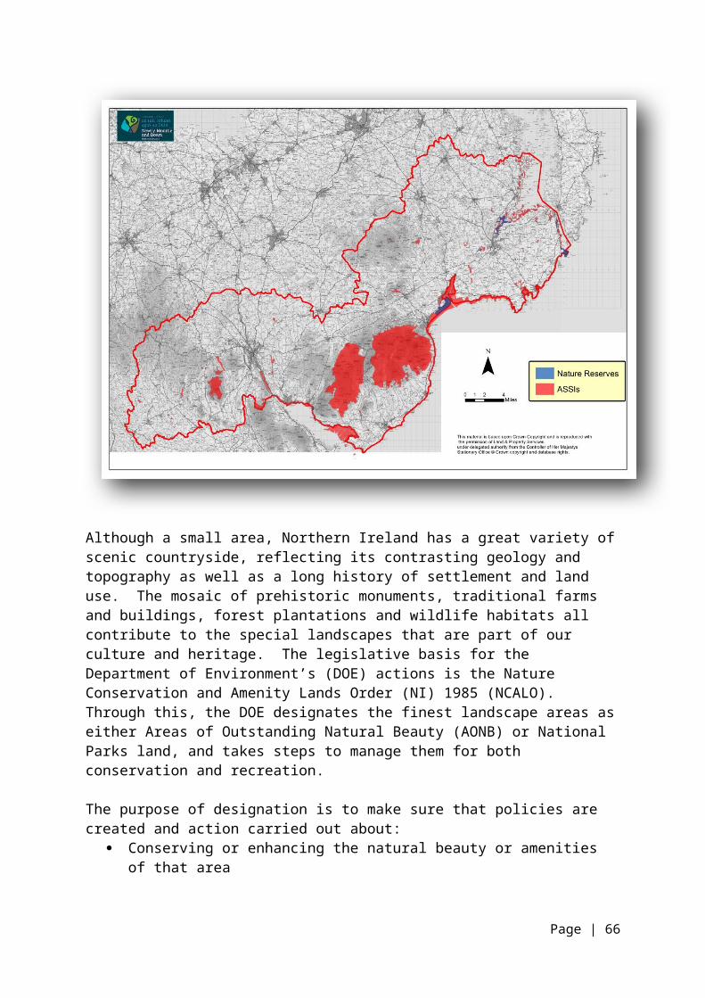
Appendix 1: Acronyms
AONB Area of Outstanding Natural Beauty
ASI Area of Scientific Interest
ASQ Areas of Scenic Quality
ASSI Area of Special Scientific Interest
ATC Area of Townscape Character
DRCs Dispersed Rural Communities
EIA Environmental Impact Assessment
LBAP Local Biodiversity Action Plan
LCA Landscape Character Area
LDP Local Development Plan
LLPA Local Landscape Policy Area
NIEA Northern Ireland Environment Agency
NILCA Northern Ireland Landscape Character Assessment
NIPS Northern Ireland Priority Species
NIRLCA Northern Ireland Regional Landscape Character Assessment
NNR National Nature Reserve
NR Nature Reserve
PfG Programme for Government
PSRNI Planning Strategy for Rural Northern Ireland
RDS Regional Development Strategy
RLCA Regional Landscape Character Areas
Page | 66
SA Sustainability Appraisal
SAC Special Areas of Conservation
SCA Special Countryside Areas
SEA Strategic Environmental Assessment
SLNCI Site of Local Nature Conservation Importance
SoCC Species of Conservation Concern
SPA Special Protection Area
SPPS Strategic Planning Policy Statement
TPO Tree Preservation Order
Page | 67