Embed Size (px)
Citation preview
Local Development PlanPreparatory Studies
Paper 11: Mineral Developments
February 2017
Contents Page No
Purpose & Content 31.0 Introduction 42.0 Legislative Background 4
2.1 Mineral Licencing 42.3 The Planning Act (Northern Ireland) 2011 52.4 Permitted Development Rights for Mineral Exploration
6
2.6 Review of Old Mineral Permissions 62.15 Waste from Extractive Industries 8
3.0 Regional & Local Planning Policy Context 93.2 Regional Development Strategy 2035 93.3 Strategic Planning Policy Statement 93.8 Areas of Constraint on Mineral Development
10
3.12 The Planning Strategy for Rural Northern Ireland
11
3.14 Banbridge, Newry & Mourne Area Plan 2015
12
3.18 Ards & Down Area Plan 2015 124.0 Geological Survey of Northern Ireland 13
4.2 Mineral Resource Maps of Northern Ireland 144.8 Adits, Collapses, Shafts & Working Mines 15
5.0 Mineral Activities & the Northern Ireland & Local Economies
15
6.0 Conclusion 17
2
APPENDICES
Appendix 1: Mineral Prospecting & Mining Licences within Newry, Mourne & Down
Appendix 2: Mineral Extraction within Newry, Mourne & Down
Appendix 3: Mineral Extraction within Kilkeel Area
Appendix 4: Review of Old Mineral Permissions Within Newry,
Mourne & Down
Appendix 5: Mineral Resource Maps, South Armagh & South Down Areas
Appendix 6: Mineral Resource Maps Kilkeel Area
Appendix 7: Mineral Resource Maps for Northern Ireland Summary
Appendix 8: Mine Shafts & Adits
Appendix 9: 2015 Super Council Quarry Data based on 10 year average
Appendix 10: DETI Annual Minerals Statement 2010
3
Minerals
Purpose: To provide the Council with an overview of matters relating to Mineral Developments and implications for land use in the Newry, Mourne & Down District Council Area.
Content: The paper provides:
(i) The legislative and policy context for Mineral Developments within the District;
(ii) An overview of Mineral Resources within the District and their importance to the local economy; and
(iii) An outline of the main issues for consideration in formulation of Planning Policy for Minerals Developments.
4
1.0 Introduction
1.1 The purpose of this paper to provide Members with background information relating to the preparation of the Local Development Plan (LDP).
1.2 The paper relates to minerals and the implications for land use. It provides information on:
The legislative background and regional planning context for mineral developments;
The role of minerals in the economy of Northern Ireland and the Council area; and
An overview of known existing mineral activity within the Council area.
1.3 The minerals industry largely encompasses existing quarries, as well as a range of other products such as oil and gas, lignite, sand and gravel, salt, base metals, precious metals, road aggregate and building stone.
2.0 Legislative Background
Mineral Licencing
2.1 The Mineral Development Act (Northern Ireland) 1969 meant that most minerals in the ground in Northern Ireland were vested to the Ministry of Commerce (functions now carried out by the Department for the Economy (DfE)). This enables the Department to grant licenses for exploration and development of minerals. There are a few exceptions to this legislation which mean that minerals in the following categories were not vested to the Department and do not require the granting of a license to be extracted:
Gold and silver resources which belong to the crown estate1. Mineral deposits which were being worked at the time of the
commencement of the Act. These were mainly salt deposits. Common substances e.g. Sand, gravel, crushed rock, brick clays,
agricultural soil. Mines belonging to any religious or educational institution.1 This means that a prospecting licence must be obtained from the Crown Estate Commissioners (CEC) which grants the right of lease to prospect for precious metals. The physical process of mining is not controlled by the CEC, therefore companies wishing to explore and develop these metals must apply for a separate mining licence from DfE. Guidance on applying for mineral licences suggests that companies can apply simultaneously to CEC and DfE for concurrent licences. Asides licencing, there is still a requirement to obtain Planning Permission.
5
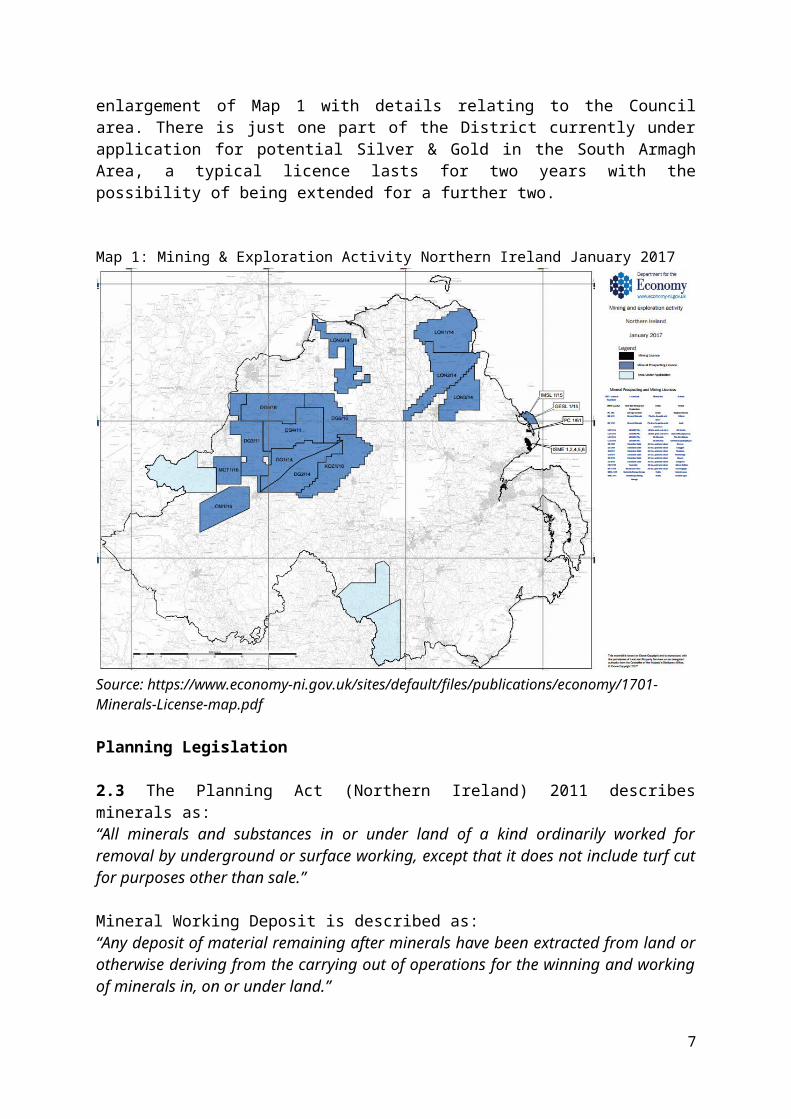
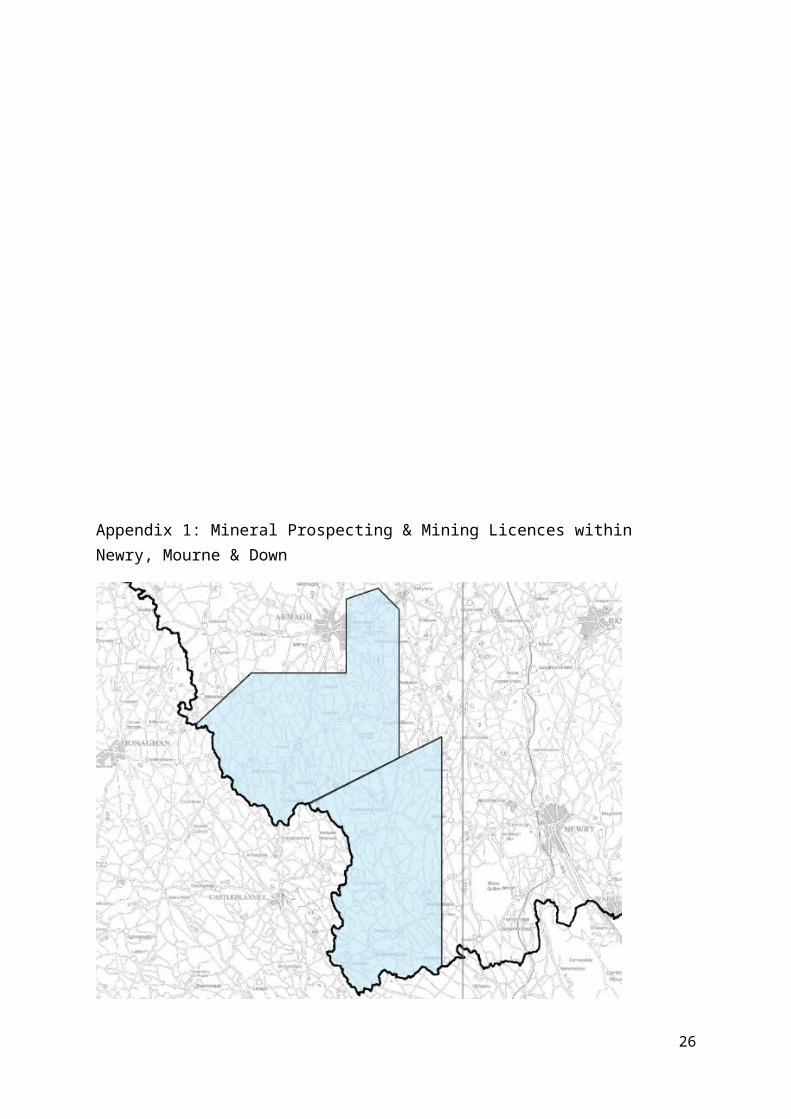
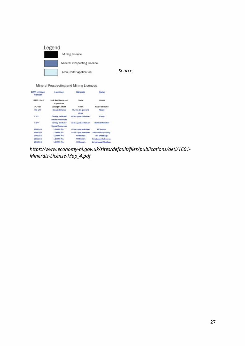
2.2 At present, there are eighteen Mineral Prospecting and Mining licences in Northern Ireland with sixteen of these being Prospecting Licences. Map 1 overleaf shows the distribution across Northern Ireland. Appendix 1 provides an enlargement of Map 1 with details relating to the Council area. There is just one part of the District currently under application for potential Silver & Gold in the South Armagh Area, a typical licence lasts for two years with the possibility of being extended for a further two.
Map 1: Mining & Exploration Activity Northern Ireland January 2017
Source: https://www.economy-ni.gov.uk/sites/default/files/publications/economy/1701-Minerals-License-map.pdf
Planning Legislation
2.3 The Planning Act (Northern Ireland) 2011 describes minerals as: “All minerals and substances in or under land of a kind ordinarily worked for removal by underground or surface working, except that it does not include turf cut for purposes other than sale.”
Mineral Working Deposit is described as: “Any deposit of material remaining after minerals have been extracted from land or otherwise deriving from the carrying out of operations for the winning and working of minerals in, on or under land.”
6
Mineral Operations are:
(a) “the winning and working of minerals in, on, or under land whether by surface or underground working;” and(b) “the management of waste resulting from the winning, working, treatment andstorage of minerals.”for the purposes of paragraph (b), treatment does not include smelting, thermal manufacturing processes (other than the burning of limestone) and metallurgical processes.
Permitted Development Rights for Minerals Exploration
2.4 Members will be aware of the recent Department for Infrastructure (DFI) ‘Call for Evidence’ on Permitted Development Rights for Minerals Exploration. This consultation document was considered by the Councils Planning Committee on 2nd February 2017. In its response dated 3rd
February the Council agreed to support changes to Permitted Development Rights as outlined in the consultation document. Public consultation on this review closed on 3rd February 2017.
2.5 Article 3 of The Planning (General Permitted Development) Order (NI) 2015 currently grants planning permission for a range of minerals development described in its Schedule (Parts 16 & 17)2 subject to provisions of this Order and Regulations 55 & 56 of the Conservation (Natural Habitats, etc) Regs (NI) 1995(a). This review seeks to amend Part 16 following concerns in relation to the scale of explorative petroleum borehole operations as opposed to other forms of non-energy mineral exploration.
Review of Old Mineral Permissions (ROMPs)
2.6 European legislation, in the form of the Environmental Impact Assessment (EIA) Directive, implemented via the Planning (Assessment of Environmental Effects) Regulations (NI) in 1989 and the subsequent Planning (Environmental Impact Assessment) Regulations (NI) 1999 (re-enacted in 2015) introduced more stringent assessment criteria for the environmental impacts of mineral development than had occurred historically.
2.7 The 2011 Planning Act allows councils to review existing mineral permissions granted in Northern Ireland to ensure the activity meets modern standards, for example in terms of noise and amenity impacts
2 Part 16 – The drilling of boreholes, the carrying out of seismic surveys or the making of other excavations for a period not exceeding 4 months Part 17 - Development ancillary to mining operations e.g. plant / machinery / rail line / services etc..
7
and environmental matters. The review would bring Northern Ireland in line with the rest of the UK and the Republic of Ireland.
2.8 However, the Act requires further legislation, in the form of an Order, to implement ROMPs. As yet, this legislation has not been implemented.
Long Standing Quarries
2.9 Historically, quarries did not have planning permission and operated under the permitted development rights granted under the Planning (Interim General Development) Order (NI) 1944. Therefore, planning conditions normally found on more recent planning permissions, such as the restoration of land after mineral workings cease, could not be applied as no planning permission was required.
2.10 The Planning (General Development) Order (NI) of 1973 sought to rectify this situation by providing that permitted development rights for mining undertakers only applied for one year from 1st October 1973. In effect, this meant that existing quarries operating under permitted development rights had one year to apply for and obtain planning permission.
2.11 Prior to the function of Planning moving to Local Government in April 2015, The Department of the Environment (DOE) established a specialised minerals unit in Planning Service that dealt with all mineral planning matters across Northern Ireland. The Department generally accepted that planning permissions for mineral developments granted since 1990 had appropriate and effective environmental conditions attached in line with the EIA regulations.
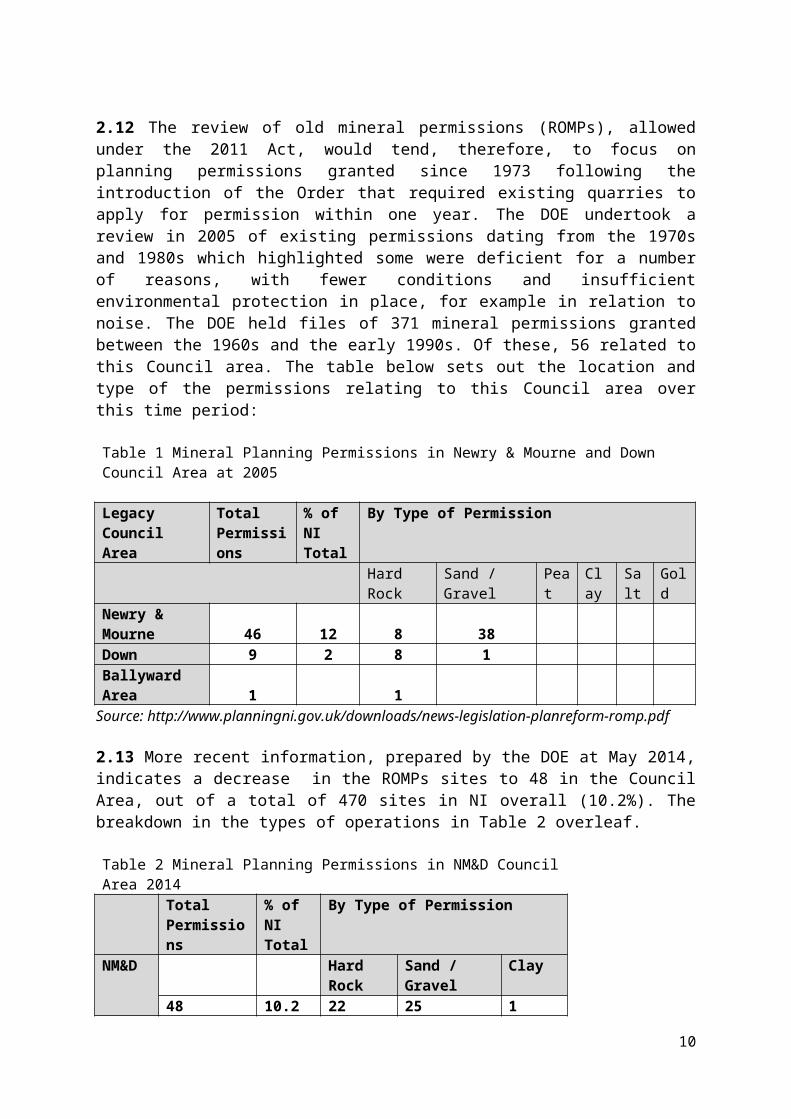
2.12 The review of old mineral permissions (ROMPs), allowed under the 2011 Act, would tend, therefore, to focus on planning permissions granted since 1973 following the introduction of the Order that required existing quarries to apply for permission within one year. The DOE undertook a review in 2005 of existing permissions dating from the 1970s and 1980s which highlighted some were deficient for a number of reasons, with fewer conditions and insufficient environmental protection in place, for example in relation to noise. The DOE held files of 371 mineral permissions granted between the 1960s and the early 1990s. Of these, 56 related to this Council area. The table below sets out the location and type of the permissions relating to this Council area over this time period:
Table 1 Mineral Planning Permissions in Newry & Mourne and Down Council Area at 2005
Legacy Council Area
Total Permissions
% of NI Total
By Type of Permission
Hard Rock Sand / Gravel PeatClay Salt Gold
Newry & 46 12 8 38
8
MourneDown 9 2 8 1Ballyward Area 1 1
Source: http://www.planningni.gov.uk/downloads/news-legislation-planreform-romp.pdf
2.13 More recent information, prepared by the DOE at May 2014, indicates a decrease in the ROMPs sites to 48 in the Council Area, out of a total of 470 sites in NI overall (10.2%). The breakdown in the types of operations in Table 2 overleaf.
Table 2 Mineral Planning Permissions in NM&D Council Area 2014
Total Permissions
% of NI Total
By Type of Permission
NM&D Hard Rock Sand / Gravel Clay
48 10.2 22 25 1Source:http://www.planningni.gov.uk/index/advice/advice_apply/advice_special_studies/romps-2.pdf
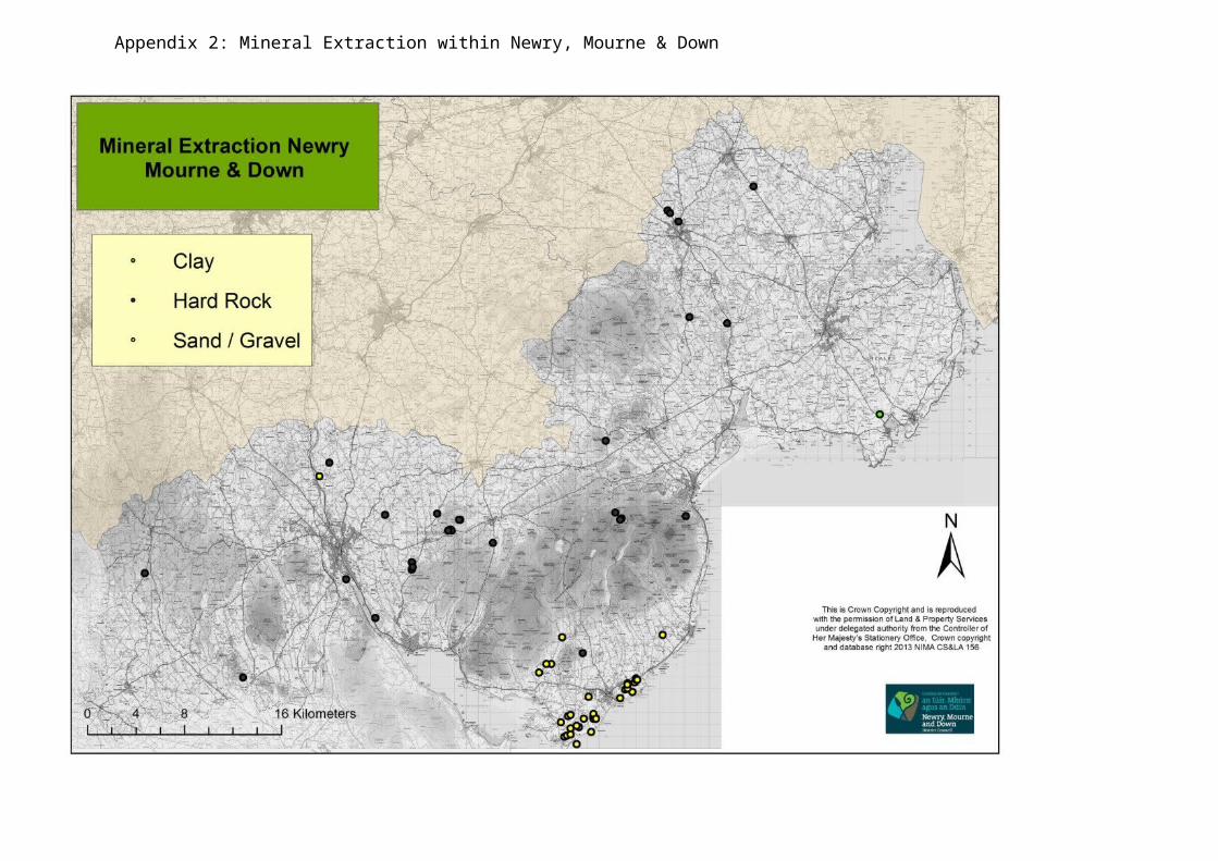
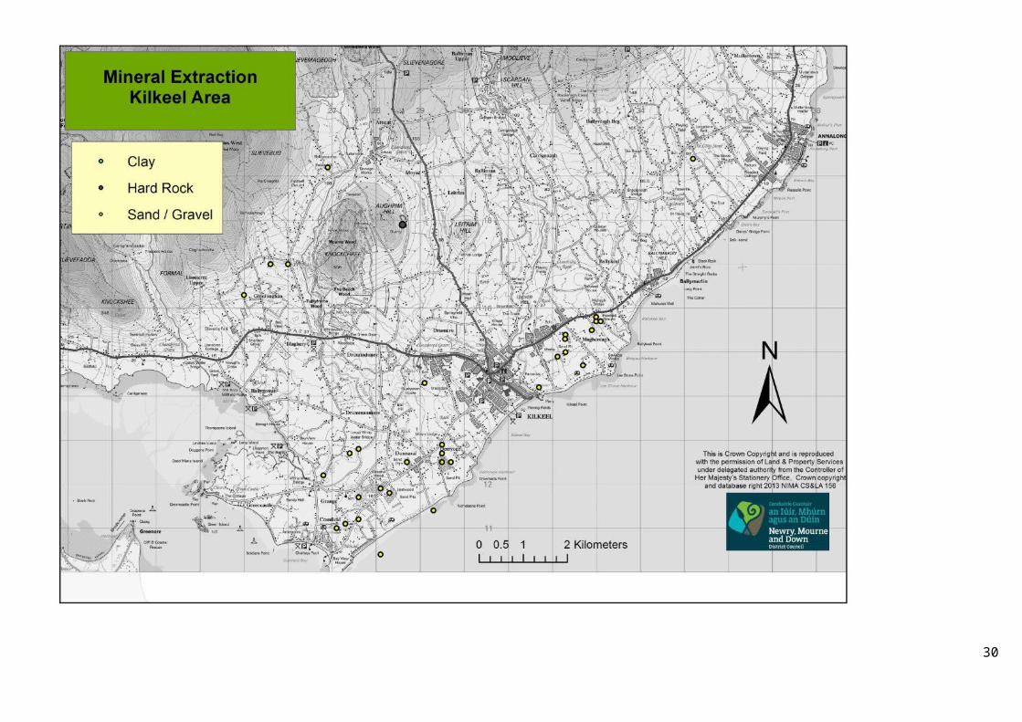
2.14 Appendix 2 & 3 show the locations of the ROMPs produced by the DOE at May 2014 and their activities. This map illustrates a generally even spread of hard rock quarries across the District with a concentration of sand and gravel extraction in the Kilkeel area. A complete list of the ROMP quarries is attached in Appendix 4.
Waste from Extractive Industries
2.15 EC Directive 2006/21/EC, the Mining Waste Directive, introduces measures to prevent or minimise adverse effects on the environment and risks to health from the management of waste from extractive industries. It applies to waste resulting from extraction, treatment and storage of mineral resources and the working of quarries. The Planning (Management of Waste from Extractive Industries) Regulations (Northern Ireland) transpose the Directive to NI legislation.
2.16 The Regulations came into effect on 1st April 2010, subsequently updated on the 1st April 2015, and apply to both new and existing sites where the management of extractive waste takes place. The Regulations set out specific requirements on operators for the management of waste material and are intended to ensure that all extractive waste is managed in a way which is compliant with the Directive.
2.17 The Planning (Management of Waste from Extractive Industries) Regulations NI 2015 states that planning permission will not be granted unless a Waste Management Plan has been submitted to and approved by the Council.
9
2.18 Regulation 4 confirms that no operator can commence or continue extractive waste operations without planning permission after 1st April 2010. All planning applications for mineral extraction decided after that date should include, as part of the accompanying documentation a Waste Management Plan (WMP) demonstrating how the operator intends to ensure compliance with regulations. 2.19 Under Regulation 5(4) a WMP is not required under Regulation 6, if the extractive waste is inert and is not deposited in a Category A3 Waste facility. Guidance issued by the DOE Minerals Unit states that it is likely that the majority of quarries in Northern Ireland will produce extractive waste that is inert and will not be deemed to be a category A facility.
3.0 Regional and Local Planning Policy Context
3.1 The regional planning context is provided by the Regional Development Strategy (RDS) 2035, the Planning Strategy for Rural Northern Ireland and Planning Policy Statements (PPSs). The Adopted Banbridge, Newry & Mourne Area Plan 2015 and Ards & Down Area Plan 2015 also contain mineral policy and designations.
Regional Development Strategy 2035 (RDS)
3.2 The RDS does not contain any specific aims or policies relating to minerals. Rather, SFG 13 recognises the need to sustain rural communities living in smaller settlements and the open countryside. It also recognises that there are wide variations across Northern Ireland in terms of economic, social and environmental characteristics of rural areas, and there is a need for local development to reflect these regional differences. Approaches should be sensitive to local needs and environmental issues, including the ability of landscapes to absorb development.
Strategic Planning Policy Statement (SPPS)
3.3 The SPPS recognises that minerals, including valuable minerals, are an important natural resource and their responsible exploitation is supported by Government. It also recognises that the minerals industry make an essential contribution to the economy and to our quality of life, providing primary minerals for construction, such as sand, gravel and crushed rock, and is a valued provider of jobs and employment, particularly in rural areas.
3.4 The SPPS acknowledges that there are a number of challenges arising from minerals development that fall to be addressed through the planning
3 Category A - Under The Planning (Management of Waste from Extractive Industries) Regulations (Northern Ireland) 2015 means a facility that could give rise to a major incident in the event of a failure identified through a risk assessment e.g. flooding or else a facility containing waste identified as hazardous or dangerous as identified through EU Directives & Regulations within specified parameters.
10
system. There can be significant adverse impacts on the environment and on the amenity and well-being of people living in proximity to operational mineral sites. The restoration of sites upon completion of work associated with the extraction and processing of materials is another challenge.
Regional Strategic Objectives
3.5 The SPPS’s objectives for mineral development are to:
Facilitate sustainable minerals development through balancing the need for specific mineral development proposals against the need to safeguard the environment;
Minimise the impacts of mineral development on local communities, landscape quality, built and natural heritage, and the water environment; and
Secure the sustainable and safe restoration, including the appropriate re-use of mineral sites, at the earliest opportunity.
Regional Strategic Policy
3.6 The policy approach for minerals development must be to balance the need for mineral resources against the need to protect and conserve the environment. The SPPS states that, in preparing LDPs, the Council should bring forward appropriate policies and proposals that must reflect the policy approach of the SPPS, tailored to the specific circumstances of the plan area. In particular, LDPs should:
Ensure that sufficient local supplies of construction aggregates can be made available for use within the local, and where appropriate, the regional market area and beyond, to meet likely future needs over the plan period;
Safeguard mineral resources which are of economic or conservation value, and seek to ensure that workable mineral resources are not sterilized by other surface development which would prejudice future exploitation;
Identify areas (normally referred to as Areas of Constraint on Minerals Development) which should be protected from minerals development because of their intrinsic landscape, amenity, scientific or heritage value (including natural, built and archaeological heritage). There should be a general presumption against minerals development in such areas. However, where a designated area such as an AONB covers expansive tracts of land, the LDP should carefully consider the scope for some mineral development that avoids key sites and that would not unduly compromise the integrity of the area as a whole or threaten to undermine the rationale for the designation.
3.7 Given the importance of peatland in nature conservation as well as minerals, the SPPS’s position in relation to peat and natural heritage, is also relevant. Active peatland is recognised as being of particular
11
importance to NI for its biodiversity, water and carbon storage qualities. Paragraph 6.192 of the SPPS states that planning permission should only be granted for a development proposal which is not likely to result in the unacceptable adverse impact on, or damage to, known active peatland.
Areas of Constraint on Minerals Development
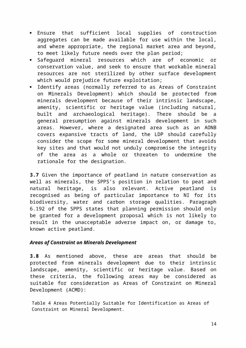
3.8 As mentioned above, these are areas that should be protected from minerals development due to their intrinsic landscape, amenity, scientific or heritage value. Based on these criteria, the following areas may be considered as suitable for consideration as Areas of Constraint on Mineral Development (ACMD):
Table 4 Areas Potentially Suitable for Identification as Areas of Constraint on Mineral Development.Value of Area
Designation
Landscape
Areas of Outstanding Natural Beauty (AONBs); Local Landscape Policy Areas
Amenity Public safety and residential amenity particularly for those living in proximity to workings
Scientific RAMSARs, Special Areas of Conservation (SACs), Special Protection Areas (SPAs), Areas of Special Scientific Interest ASSIs), Areas of Scientific Interest (ASIs), Sites of Community Importance (SCIs), World Heritage Site(WHS)
Heritage Ancient Monuments; Archaeological Sites; Listed Buildings
3.9 The type and extent of environmental designations within the District are discussed in detail in LDP Preparation Paper 6 (Environmental Assets) and the forthcoming LDP Preparation Paper 12 (Landscape Character Assessment.) 3.10 Caution should be taken in the application of a wholesale exclusion of mineral development in the areas of environmental designation. This approach was advocated in relation to the Banbridge, Newry & Mourne Area Plan 2015, and the PAC report was critical of this, as it did not seek to balance the needs of the environment with the local economy. A detailed assessment of mineral resources and extraction and the needs of the mineral industry in the plan area should be part of the plan preparation process and ideally within a regional context and overview.
Areas Where Mineral Development Would be Suitable
3.11 The converse of the ACMD approach is that the SPPS states that LDPs may also specify areas that may be suitable for minerals developments in their LDPs. These areas will normally include areas of mineral reserves where exploitation is likely to have the least environmental and amenity impacts, as well as offering good accessibility to the strategic transport network. The SPPS refers to the fact that minerals which are particularly valuable to the economy may be discovered from time to time, and states there will not be a presumption
12
against their exploitation in any area, however, in considering a proposal where the site is in a stationary policy area, due weight will be given to the reason for the statutory zoning. In relation to unconventional hydrocarbon4 extraction, there should be a presumption against their exploitation until there is sufficient and robust evidence on all environmental impacts.
Planning Strategy for Rural Northern Ireland (PSRNI)
3.12 In the absence of a planning policy statement for mineral development, the PSRNI constitutes prevailing planning policy. The concept of sustainability is a notable element of the strategy; however it does recognise the difficulties this can pose in the context of mineral development. It recommends that the rate of consumption of finite minerals should be reduced by encouraging the use of renewable and recycled alternatives wherever this is economically viable and practical. The PSRNI recognizes the need to facilitate mineral development while also affording sufficient protection to the environment; this is carried forward into the SPPS. The main difference between the two documents is the stipulation within SPPS that there is a presumption against development for the extraction of hydrocarbons (including ‘fracking’).
3.13 The PSRNI contains eight policies to guide the development of mineral workings. The areas covered relate to Environmental Protection, Visual Implications, Areas of Constraint, Valuable Minerals, Mineral Reserves, Safety and Amenity, Traffic, and Restoration. These have been largely carried over into the SPPS generally within the sections: Regional Strategic Policy and Implementation.Banbridge, Newry & Mourne Area Plan 2015
3.14 The Banbridge, Newry & Mourne Area Plan 2015 (BNMAP) sets the context for Minerals within the Plan area stating they comprise of greywacke/gritstones which are quarried at a number of locations from Cullyhanna in the south west to Edentrillick outside Dromore in the north east. Newry granite is extracted from two quarries in the area. One such quarry operates north east of Newry while the other is located off the Newry to Warrenpoint dual carriageway. All supplies of sand and gravel in the area originate from the superficial deposits located along the coastal lowlands south of the Mourne Mountains.
3.15 The BNMAP further elaborates on the origins of these materials and destination ranging from direct use in the construction and roads industry or use as for a range of secondary purposes such as ready-use concrete production, tarmacadam or concrete blocks. 4 Hydrocarbon is a substance, such as coal, crude oil or natural gas that contains only carbon and hydrogen. Unconventional hydrocarbon extraction relates to oil and gas which comes from sources such as shale or coal seams which act as the reservoirs. Conventional hydrocarbons are oil and gas where the reservoir is sandstone or limestone.
13
3.16 In formulating its mineral policies for Banbridge and Newry and Mourne Districts, it is stated the Department sought to balance the need for extraction in the Districts against the need to protect and conserve the environment. As a result, the extraction of sand and gravel minerals in environmentally sensitive areas is stated to be controlled in the public interest.
3.17 It should be noted that unlike the Ards & Down Area Plan 2015, the BNMAP does not contain any Areas of Constraint on Mineral Development. In preparing the new Area Plan, members may wish to explore a more unified policy approach across the entire District.
Ards & Down Area Plan 2015
3.18 The Ards & Down Area Plan 2015 (ADAP) sets the context for mineral development within the Plan Area by providing a summary of the nature of minerals and quarrying activity within the Plan Area.
3.19 Notable Mineral resources within ADAP area comprise sandstone/gritstones which are quarried at a number of locations between Newtownards and Ballynahinch, granite which is extracted from one small quarry in the Mournes, and clay, used in the manufacture of bricks, which has been extracted outside Killough.
3.20 The ADAP also provides detail on the origin of Minerals within the district and the level of extraction at the time of the Plans writing and destination of such materials. This plan also details how small scale sand extraction has been a problem in coastal areas such as Tyrella and highlights the need to control the extraction of sand/gravel from within the coastal zone in order to ensure no irreparable damage to ecology, shoreline stability and the environmental amenity of such areas.
The ADAP contains one minerals policy and one designation.
Policy MIN 1 - Hydrocarbon exploration
3.21 Whilst no Hydrocarbons were identified at the time of the Plans adoption, the plan does not rule out potential future exploration. This policy does not operate a presumption against their exploitation in any part of the Plan area, including Areas of Constraint on Mineral Developments. Rather, applications will be treated on their individual merits having regard to impact of the specific development on nearby residents, and sites or features designated for their scientific, landscape or heritage interests.
14
Designation COU 8 - Areas of Constraint on Mineral Developments
3.22 Areas of Constraint upon Mineral Developments have been identified in order to safeguard the most valuable and vulnerable areas of the environment within the Plan area from the detrimental effects of mineral extraction. Their identification has taken account of nature conservation interests, the archaeological and built heritage, landscape quality and character as identified in the Northern Ireland Landscape Character Assessment 2000, visual prominence, amenity value, geological interest and beaches in the coastal zone.
3.23 Designated Areas of Constraint on Mineral Developments also include, in view of their nature conservation importance and/or scientific value:
ASSI’s, ASIs, Ramsar sites, SPA’s, SAC’s, Nature Reserves and Strangford Lough Marine Nature Reserve.
3.24 Proposals for the development of mineral resources within sites of important nature and conservation importance as identified in the ADAP are determined in accordance with prevailing regional policy, which is set out in Policy MIN 3 of ‘A Planning Strategy for Rural Northern Ireland’.
4.0 Geological Survey of Northern Ireland
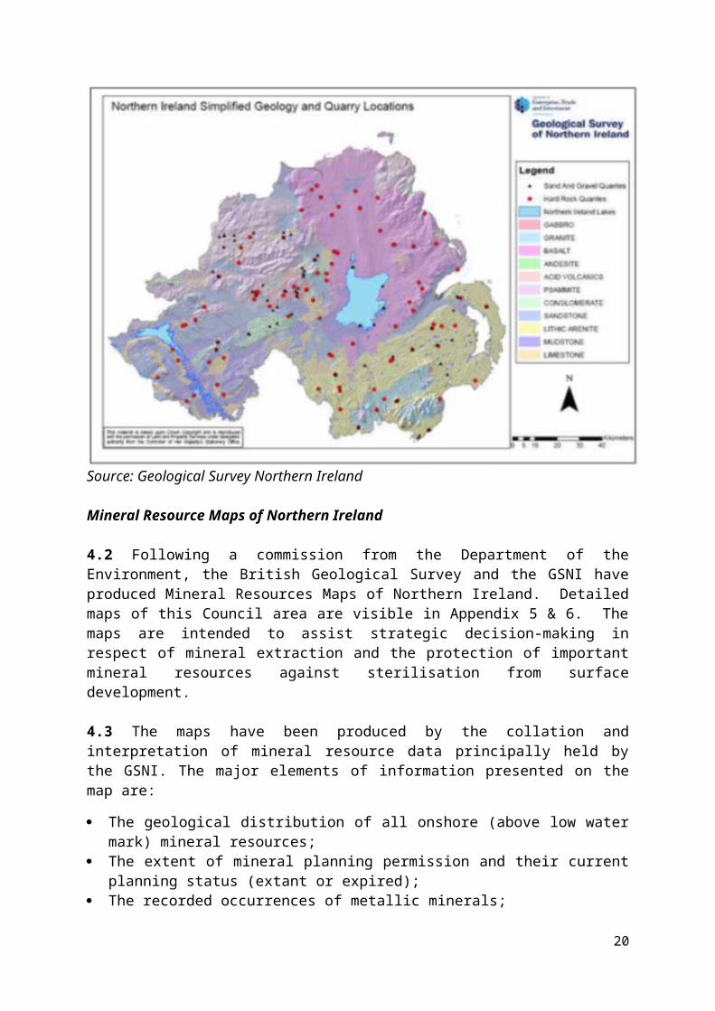
4.1 The Geological Survey of Northern Ireland (GSNI) is the regional source of information on natural resources and hazards within the Department for the Economy. Map 2 overleaf shows a simplified Geology of Northern Ireland and its Quarry Locations.
Map 2: NI Geology Map and Quarry Locations
15
Source: Geological Survey Northern Ireland
Mineral Resource Maps of Northern Ireland
4.2 Following a commission from the Department of the Environment, the British Geological Survey and the GSNI have produced Mineral Resources Maps of Northern Ireland. Detailed maps of this Council area are visible in Appendix 5 & 6. The maps are intended to assist strategic decision-making in respect of mineral extraction and the protection of important mineral resources against sterilisation from surface development.
4.3 The maps have been produced by the collation and interpretation of mineral resource data principally held by the GSNI. The major elements of information presented on the map are: The geological distribution of all onshore (above low water mark)
mineral resources; The extent of mineral planning permission and their current planning
status (extant or expired); The recorded occurrences of metallic minerals; The recorded location of building stone quarries; The extent of selected landscape and nature–conservation
designations (SACs, SPAs, RAMSAR sites, AONBs, ASSIs, NNR and scheduled monuments) and planning designations (Area of Constraint on Mineral Developments).
4.4 It should also be noted that the data depicted on the map relates only to inferred extent and location of a particular mineral resource. Inferred
16
resources are those defined from geological information and assumed, but not verified geological continuity. Thus the inferred boundaries are approximate and only indicate the areas within which potentially working workable minerals may occur.
4.5 Key mineral assets of interest to the Quarrying and extractive industries identified within the maps include building stone and crushed rock aggregates from the Newry Igneous Complex, Mourne Granite which is particularly extracted from the Eastern Mournes used for purposes ranging from cobble streets to commemorative monuments, brick clay along the coastal strip surrounding Dundrum Bay and a concentration of sand and gravel in the Kilkeel area.
4.6 In terms of precious metals, although not currently being commercially extracted within the district, the resource maps highlight the potential for silver and gold in the South Armagh area. As discussed under Mineral Licencing, licence applications have been submitted in this area. Also, there has been historic extraction of Lead to the west of Strangford at Castleward Mine and Tullyratty and in Co Armagh where there are records of some 57 shafts and adits which were worked on a relatively large scale by the standards of the 1800’s.
4.7 No significant reserves of Hydrocarbons such as Oil, Coal, Gas, Peat, Lignite etc have been identified within the District. In terms of Geothermal Energy however, the Mournes is one of two areas identified within Northern Ireland where potential exists within the deep, grantic, igneous rocks. As mentioned, a comprehensive summary of the Mineral Resource Maps has been provided in Appendix 7.
Adits, Collapses, Shafts and Working Mines
4.8 Appendix 8, shows the location of known occurrences of adits5, collapses, shafts and working mines which are concentrated along the eastern coastal strip and south-western area of the District. These may have a bearing on the location of future development, particularly where these are located in proximity to settlements, for example in terms of land stability in relation to the depth and length of the former mine.
5.0 Mineral Activity, the Northern Ireland and Local Economies
5.1 As stated in the SPPS, minerals play a vital economic role in Northern Ireland. Minerals provide raw materials for the construction, manufacturing, energy creation and agricultural sectors. Each of these sectors generates employment and stimulate other parts of our economy. In Northern Ireland the extraction of minerals and their exploration makes a very significant contribution to property and quality of life given the large proportion of income derived from this industry and particularly in
5 An adit is an entrance to an underground mine which is horizontal or nearly horizontal.
17
rural areas. The NI Census 2011 provides the following information on those directly involved in mining and quarrying.
Table 5 Local Employment in Mining and Quarrying from 2011 CensusAll Usual Residents in Employment 16-74 Years
All Residents Employed in Mining and Quarrying 16-74 Years
Percentage of Total
NI 795,263 1989 0.25NM&D 73,458 184 0.25Source: NI Census 2011 - Key Statistics Summary Report Table KS605NI
5.2 The above table relates only to those employed at mines and quarries, it does not take into account employment in related activities, such as concrete products.
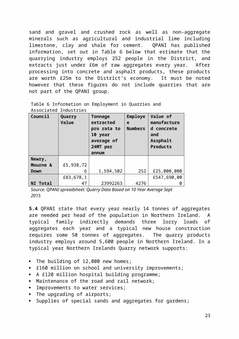
5.3 The Quarry Products Association Northern Ireland (QPANI) is a trade association for the quarry industry. QPANI members are stated to produce more than 90% of aggregates extracted – sand and gravel and crushed rock as well as non-aggregate minerals such as agricultural and industrial lime including limestone, clay and shale for cement. QPANI has published information, set out in Table 6 below that estimate that the quarrying industry employs 252 people in the District, and extracts just under £6m of raw aggregates every year. After processing into concrete and asphalt products, these products are worth £25m to the District’s economy. It must be noted however that these figures do not include quarries that are not part of the QPANI group.
Table 6 Information on Employment in Quarries and Associated IndustriesCouncil Quarry Value Tonnage
extracted pro rata to 10 year average of 24MT per annum
Employee Numbers
Value of manufactured concrete and Assphalt Products
Newry, Mourne & Down £5,938,726 1,594,502 252 £25,000,000NI Total £83,678,147 23992263 4276 £547,690,000Source: QPANI spreadsheet: Quarry Data Based on 10 Year Average Sept 2015
5.4 QPANI state that every year nearly 14 tonnes of aggregates are needed per head of the population in Northern Ireland. A typical family indirectly demands three lorry loads of aggregates each year and a typical new house construction requires some 50 tonnes of aggregates. The quarry products industry employs around 5,600 people in Northern Ireland. In a typical year Northern Irelands Quarry network supports:
The building of 12,000 new homes; £160 million on school and university improvements; A £120 million hospital building programme;
18
Maintenance of the road and rail network; Improvements to water services; The upgrading of airports; Supplies of special sands and aggregates for gardens; The turnover of the Northern Ireland quarry industry is approximately
£400 million, 1.75 % of NI GDP. Source: http://www.qpani.org/pro_figures01.htm
5.5 As Members will appreciate, the distribution of minerals is not consistent across Northern Ireland, and minerals may only be mined where they are found. As an example, there is only one quarry within the administrative boundary of Belfast City Council yet that Council area would consume significantly more quarry materials or subsequently derived products than what would originate within that administrative area.
6.0 Conclusion
6.1 The extraction of minerals is essential to maintain the ability of the Northern Ireland economy to sustain and grow and to maintain the quality of life of its residents. Minerals may only be worked where they are found, and the Council’s economy benefits from the existence of quarries within its area, which provide a resource to the District and beyond. The mineral prospecting licences presently issued within the Council area indicate potential for silver and gold operations.
6.2 However, there is also a potential environmental cost to mineral workings that can affect the amenity of the immediate area and, also, the wider contribution that the landscape and its biodiversity make to the Districts economic base. The regional planning framework contained in the SPPS acknowledges there is a need to balance mineral development needs with the protection of the environment. The identification of Areas of Constraint on Mineral Development, together with the possibility of adopting a proactive approach in other suitable areas based on future needs of the minerals industry and on the mineral resources found in the District is one way of addressing this. Further information on the quality of mineral deposits in the District, rates of consumption and alternative potential sources in and outside of the District, and the proposed approach of neighbouring authorities where reserves cross administrative boundaries, would assist in determining the best approach for the LDP to adopt in relation to minerals within the District.
19
Appendices
20
Appendix 1: Mineral Prospecting & Mining Licences within Newry, Mourne & Down
21
Source: https://www.economy-ni.gov.uk/sites/default/files/publications/deti/1601-Minerals-License-Map_4.pdf
22
Appendix 2: Mineral Extraction within Newry, Mourne & Down
Appendix 3: Mineral Extraction within Kilkeel Area
24

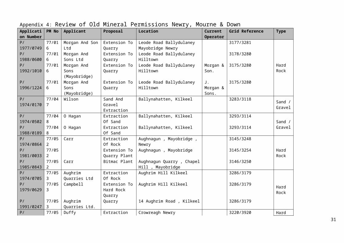
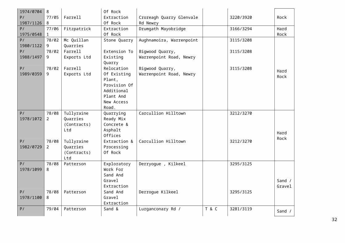
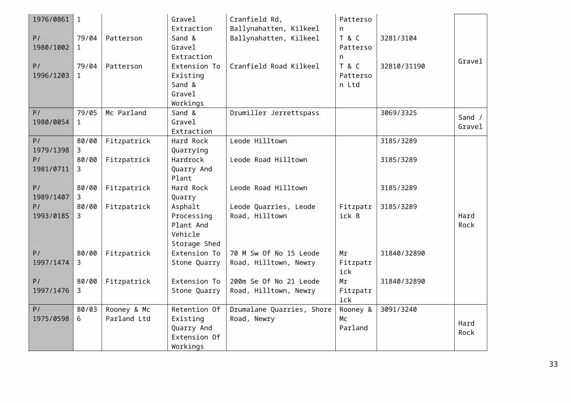
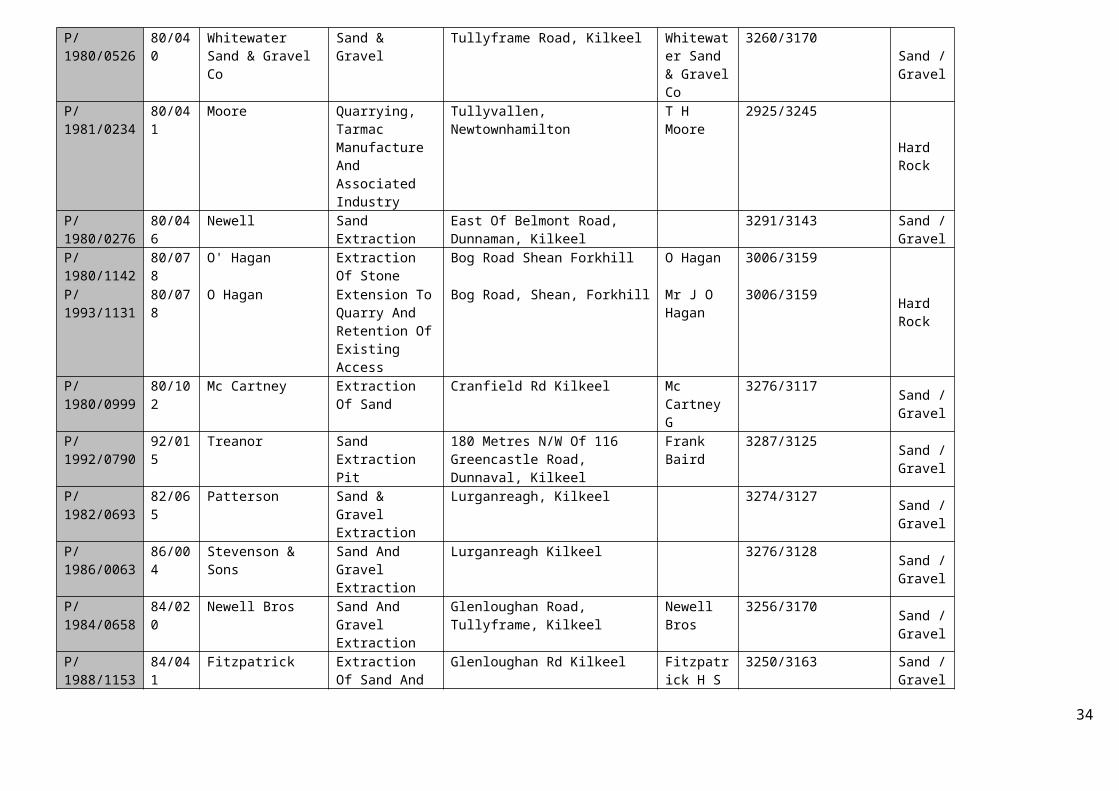
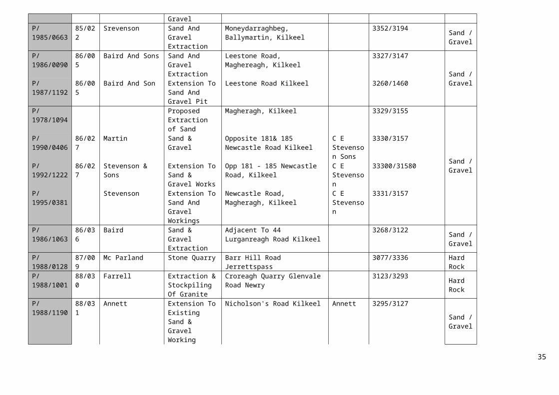
Appendix 4: Review of Old Mineral Permissions Newry, Mourne & DownApplication Number
PM No Applicant Proposal Location Current Operator
Grid Reference Type
P/1977/0749 77/016 Morgan And Son Ltd Extension To Quarry
Leode Road Ballydulaney Mayobridge Newry
3177/3281
Hard Rock
P/1988/0600 77/016 Morgan And Sons Ltd
Extension To Quarry
Leode Road Ballydulaney Hilltown 3178/3280
P/1992/1010 77/016 Morgan And Sons (Mayobridge)
Extension To Quarry
Leode Road Ballydulaney Hilltown Morgan & Son.
3175/3280
P/1996/1224 77/016 Morgan And Sons (Mayobridge)
Extension To Quarry
Leode Road Ballydulaney Hilltown J. Morgan & Sons.
3175/3280
P/1974/0170 77/047 Wilson Sand And Gravel Extraction
Ballynahatten, Kilkeel 3283/3118 Sand / Gravel
P/1974/0502 77/048 O Hagan Extraction Of Sand Ballynahatten, Kilkeel 3293/3114 Sand / GravelP/1988/0189 77/048 O Hagan Extraction Of Sand Ballynahatten, Kilkeel 3293/3114
P/1974/0864 77/052 Carr Extraction Of Rock Aughnagun , Mayobridge , Newry 3145/3248
Hard Rock
P/1981/0033 77/052 Extension To Quarry Plant
Aughnagun , Mayobridge 3145/3254
P/1985/0843 77/052 Carr Bitmac Plant Aughnagun Quarry , Chapel Hill , Mayobridge
3146/3250
P/1974/0705 77/053 Aughrim Quarries Ltd
Extraction Of Rock Aughrim Hill Kilkeel 3286/3179
Hard Rock
P/1979/0629 77/053 Campbell Extension To Hard Rock Quarry
Aughrim Hill Kilkeel 3286/3179
P/1991/0247 77/053 Aughrim Quarries Ltd.
Quarry 14 Aughrim Road , Kilkeel 3286/3179
P/1974/0704 77/058 Duffy Extraction Of Rock Crowreagh Newry 3220/3920 Hard RockP/1987/1126 77/058 Farrell Extraction Of Rock Croreagh Quarry Glenvale Rd Newry 3220/3920
P/1975/0548 77/061 Fitzpatrick Extraction Of Rock Drumgath Mayobridge 3166/3294 Hard Rock
P/1980/1122 78/029 Mc Quillan Quarries Stone Quarry Aughnamoira, Warrenpoint 3115/3208Hard RockP/1988/1497 78/029 Farrell Exports Ltd Extension To
Existing QuarryBigwood Quarry, Warrenpoint Road, Newry
3115/3208
25
P/1989/0359 78/029 Farrell Exports Ltd Relocation Of Existing Plant, Provision Of Additional Plant And New Access Road.
Bigwood Quarry, Warrenpoint Road, Newry
3115/3208
P/1978/1072 78/082 Tullyraine Quarries (Contracts) Ltd
Quarrying Ready Mix Concrete & Asphalt Offices
Carcullion Hilltown 3212/3270
Hard RockP/1982/0729 78/082 Tullyraine Quarries
(Contracts) LtdExtraction & Processing Of Rock
Carcullion Hilltown 3212/3270
P/1978/1099 78/088 Patterson Exploratory Work For Sand And Gravel Extraction
Derryogue , Kilkeel 3295/3125
Sand / Gravel
P/1978/1100 78/088 Patterson Sand And Gravel Extraction
Derrogue Kilkeel 3295/3125
P/1976/0861 79/041 Patterson Sand & Gravel Extraction
Lurganconary Rd / Cranfield Rd, Ballynahatten, Kilkeel
T & C Patterson
3281/3119
Sand / Gravel
P/1980/1002 79/041 Patterson Sand & Gravel Extraction
Ballynahatten, Kilkeel T & C Patterson
3281/3104
P/1996/1203 79/041 Patterson Extension To Existing Sand & Gravel Workings
Cranfield Road Kilkeel T & C Patterson Ltd
32810/31190
P/1980/0054 79/051 Mc Parland Sand & Gravel Extraction
Drumiller Jerrettspass 3069/3325 Sand / Gravel
P/1979/1398 80/003 Fitzpatrick Hard Rock Quarrying
Leode Hilltown 3185/3289
Hard Rock
P/1981/0711 80/003 Fitzpatrick Hardrock Quarry And Plant
Leode Road Hilltown 3185/3289
P/1989/1407 80/003 Fitzpatrick Hard Rock Quarry Leode Road Hilltown 3185/3289P/1993/0185 80/003 Fitzpatrick Asphalt
Processing Plant And Vehicle Storage Shed
Leode Quarries, Leode Road, Hilltown
Fitzpatrick B
3185/3289
P/1997/1474 80/003 Fitzpatrick Extension To Stone Quarry
70 M Sw Of No 15 Leode Road, Hilltown, Newry
Mr Fitzpatrick
31840/32890
P/1997/1476 80/003 Fitzpatrick Extension To Stone Quarry
200m Se Of No 21 Leode Road, Hilltown, Newry
Mr Fitzpatrick
31840/32890
26
P/1975/0598 80/036 Rooney & Mc Parland Ltd
Retention Of Existing Quarry And Extension Of Workings
Drumalane Quarries, Shore Road, Newry
Rooney & Mc Parland
3091/3240
Hard Rock
P/1980/0526 80/040 Whitewater Sand & Gravel Co
Sand & Gravel Tullyframe Road, Kilkeel Whitewater Sand & Gravel Co
3260/3170Sand / Gravel
P/1981/0234 80/041 Moore Quarrying, Tarmac Manufacture And Associated Industry
Tullyvallen, Newtownhamilton T H Moore 2925/3245
Hard Rock
P/1980/0276 80/046 Newell Sand Extraction East Of Belmont Road, Dunnaman, Kilkeel
3291/3143 Sand / Gravel
P/1980/1142 80/078 O' Hagan Extraction Of Stone
Bog Road Shean Forkhill O Hagan 3006/3159
Hard Rock
P/1993/1131 80/078 O Hagan Extension To Quarry And Retention Of Existing Access
Bog Road, Shean, Forkhill Mr J O Hagan
3006/3159
P/1980/0999 80/102 Mc Cartney Extraction Of Sand Cranfield Rd Kilkeel Mc Cartney G
3276/3117 Sand / Gravel
P/1992/0790 92/015 Treanor Sand Extraction Pit
180 Metres N/W Of 116 Greencastle Road, Dunnaval, Kilkeel
Frank Baird 3287/3125 Sand / Gravel
P/1982/0693 82/065 Patterson Sand & Gravel Extraction
Lurganreagh, Kilkeel 3274/3127 Sand / Gravel
P/1986/0063 86/004 Stevenson & Sons Sand And Gravel Extraction
Lurganreagh Kilkeel 3276/3128 Sand / Gravel
P/1984/0658 84/020 Newell Bros Sand And Gravel Extraction
Glenloughan Road, Tullyframe, Kilkeel
Newell Bros 3256/3170 Sand / Gravel
P/1988/1153 84/041 Fitzpatrick Extraction Of Sand And Gravel
Glenloughan Rd Kilkeel Fitzpatrick H S
3250/3163 Sand / Gravel
P/1985/0663 85/022 Srevenson Sand And Gravel Extraction
Moneydarraghbeg, Ballymartin, Kilkeel
3352/3194 Sand / Gravel
P/1986/0090 86/005 Baird And Sons Sand And Gravel Extraction
Leestone Road, Maghereagh, Kilkeel 3327/3147Sand / GravelP/1987/1192 86/005 Baird And Son Extension To Sand
And Gravel PitLeestone Road Kilkeel 3260/1460
27
P/1978/1094 Proposed Extraction of Sand
Magheragh, Kilkeel 3329/3155
Sand / Gravel
P/1990/0406 86/027 Martin Sand & Gravel Opposite 181& 185 Newcastle Road Kilkeel
C E Stevenson Sons
3330/3157
P/1992/1222 86/027 Stevenson & Sons Extension To Sand & Gravel Works
Opp 181 - 185 Newcastle Road, Kilkeel
C E Stevenson
33300/31580
P/1995/0381 Stevenson Extension To Sand And Gravel Workings
Newcastle Road, Magheragh, Kilkeel C E Stevenson
3331/3157
P/1986/1063 86/036 Baird Sand & Gravel Extraction
Adjacent To 44 Lurganreagh Road Kilkeel
3268/3122 Sand / Gravel
P/1988/0128 87/009 Mc Parland Stone Quarry Barr Hill Road Jerrettspass 3077/3336 Hard Rock
P/1988/1001 88/030 Farrell Extraction & Stockpiling Of Granite
Croreagh Quarry Glenvale Road Newry
3123/3293Hard Rock
P/1988/1190 88/031 Annett Extension To Existing Sand & Gravel Working
Nicholson's Road Kilkeel Annett 3295/3127Sand / Gravel
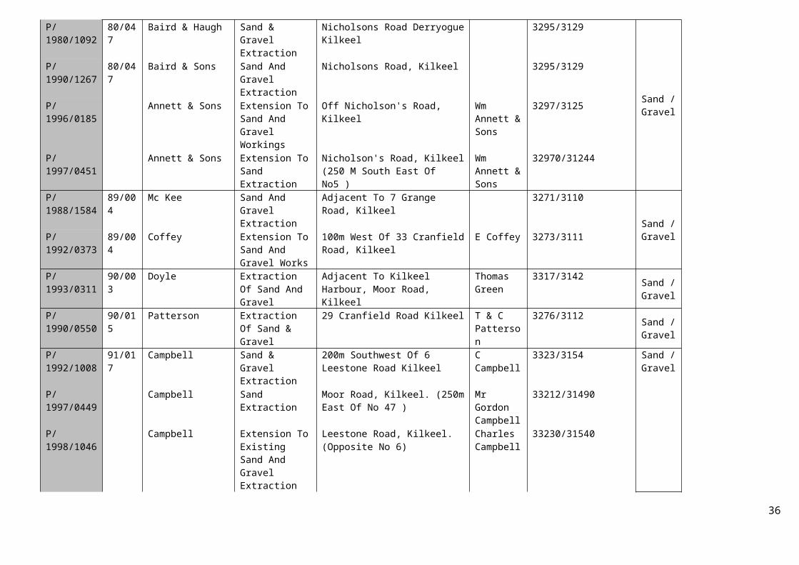
P/1980/1092 80/047 Baird & Haugh Sand & Gravel Extraction
Nicholsons Road Derryogue Kilkeel 3295/3129
Sand / Gravel
P/1990/1267 80/047 Baird & Sons Sand And Gravel Extraction
Nicholsons Road, Kilkeel 3295/3129
P/1996/0185 Annett & Sons Extension To Sand And Gravel Workings
Off Nicholson's Road, Kilkeel Wm Annett & Sons
3297/3125
P/1997/0451 Annett & Sons Extension To Sand Extraction
Nicholson's Road, Kilkeel (250 M South East Of No5 )
Wm Annett & Sons
32970/31244
P/1988/1584 89/004 Mc Kee Sand And Gravel Extraction
Adjacent To 7 Grange Road, Kilkeel 3271/3110Sand / GravelP/1992/0373 89/004 Coffey Extension To Sand
And Gravel Works100m West Of 33 Cranfield Road, Kilkeel
E Coffey 3273/3111
P/1993/0311 90/003 Doyle Extraction Of Sand And Gravel
Adjacent To Kilkeel Harbour, Moor Road, Kilkeel
Thomas Green
3317/3142 Sand / Gravel
P/1990/0550 90/015 Patterson Extraction Of Sand & Gravel
29 Cranfield Road Kilkeel T & C Patterson
3276/3112 Sand / Gravel
P/1992/1008 91/017 Campbell Sand & Gravel Extraction
200m Southwest Of 6 Leestone Road Kilkeel
C Campbell 3323/3154 Sand / Gravel
28
P/1997/0449 Campbell Sand Extraction Moor Road, Kilkeel. (250m East Of No 47 )
Mr Gordon Campbell
33212/31490
P/1998/1046 Campbell Extension To Existing Sand And Gravel Extraction
Leestone Road, Kilkeel. (Opposite No 6)
Charles Campbell
33230/31540
P/1998/1445 Campbell New Sand And Gravel Extraction Pit
280m West Of No. 17 Leestone Road, Kilkeel
Mr D. Campbell
33230/31500
P/2001/1169 Campbell Extension To Existing Sand And Gravel Extraction
Leestone Road, Maghereagh T D, Kilkeel.
Mr Charles Campbell
332292/3153
P/1991/1030 91/019 Annett And Sons Sand And Gravel Extraction
Sandy Brae Road, Ballymageough Kilkeel 3269/3192 Sand / Gravel
R/1977/0431 77/019 Tyrone Poroton Ltd Clay Extraction Downpatrick Road Killough Tyrone Brick
3531/3376 Clay
R/1974/0652 77/073 Mc Cormick & Sons Hardrock Ballynahinch Co Down 3365/3535Hard RockR/1978/0359 77/073 Mc Cormick And
Sons LtdHardrock & Plant Quarry
Ballynahinch Co Down 3365/3535
R/1974/599 77/074 Martin Hardrock Glassdrummond Quarries Ballynahinch
3356/3544
Hard Rock
R/1979/0260 77/074 Martin Hardrock Glassdrumman Ballynahinch 3356/3544R/1985/0674 77/074 Martin Replacement
Plant37 Magheraknock Road Glassdrummond Ballynahinch
3358/3542
R/1993/0021 77/075 Stevenson & Sons Extension To Existing Quarry
Lisowen, Saintfield Stevensons 3427/3564Hard RockR/1993/0021 77/075 Stevenson & Sons Hard Rock Lisower T D Saintfield Co Down 3427/3564
R/1974/0691 77/078 Clanawhillan Hardrock Clanwhillan Bryansford Newcastle 3313/3295 Hard Rock
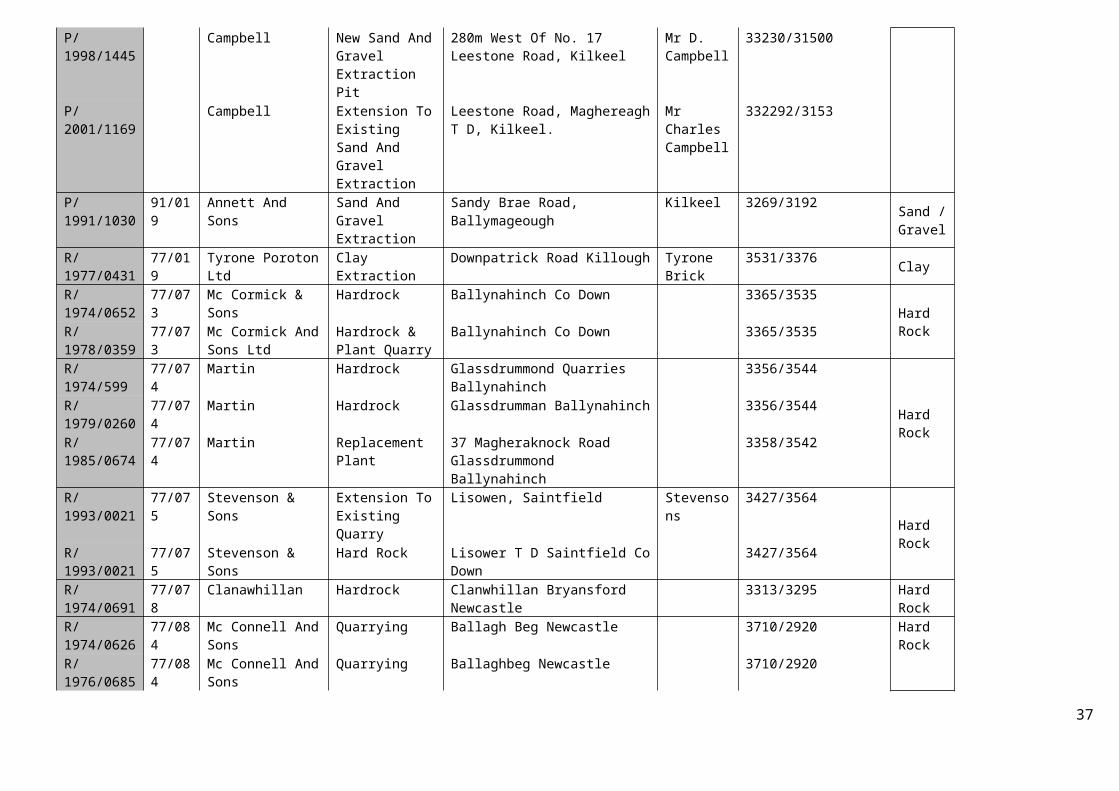
R/1974/0626 77/084 Mc Connell And Sons Quarrying Ballagh Beg Newcastle 3710/2920Hard Rock
R/1976/0685 77/084 Mc Connell And Sons Quarrying Ballaghbeg Newcastle 3710/2920R/1988/0620 77/084 Mc Connell And Sons Quarry Ballaghbeg Newcastle 3371/3292R/1979/0038 79/002 Robinson & Son Granite Quarry Clanawhillan ' Hares Gap '
Bryansford3318/3290
Hard Rock
R/1995/0310 79/002 Robinson & Son To Continue Working Existing Quarry And Small Extension
Clanawhillan Quarry, Hare's Gap, Bryansford , Newcastle , Co Down
A Robinson & Son
3317/3289
80/032 D O E ( N I ) Roads Quarry, Castlenavan Quarry, 131 Newcastle 3405/3451 Hard
29
Service Processing Plant, Laboratory, Maintenance Depot Etc
Road, Seaforde, Downpatrick
Rock
R/1992/0005 80/032 D O E Roads Service Extension To Existing Quarry
Castlenavan Quarry 131 Newcastle Rd, Stoneyford
D O E Roads Service
3405/3451
R/1995/0150 80/032 District Valuer Extraction Of Rock Within Existing Boundary And Deepening And Retention Of Plant
Castlenavan Quarry,131 Newcastle Road, Seaforde
Roads Service
4306/3453
R/1999/0895 Stevenson & Sons Extension To Existing Quarry
Castlenavan Quarry, 131 Newcastle Road, Seaforde
3405 3451
R/1980/0876 81/001 Maralin Quarries Quarry,Stone Crusher And Conveyor
Edendarriff Ballynahinch C. E. Stevenson & Sons
3374/3456Hard Rock
Q/1983/0051
83/005 Jones Continuation Of Quarrying
Largy Road Castlewellan 3305/3354 Hard Rock
Source: http://www.planningni.gov.uk/index/advice/advice_apply/advice_special_studies/romps-2.pdf
This is for information only, has not been verified as official Planning Service statistics.Owners/operators should be pro-active in identifying their permission and ensuring that the status is appropriate. The onus is on the owner/ operator to submit conditions where appropriate.
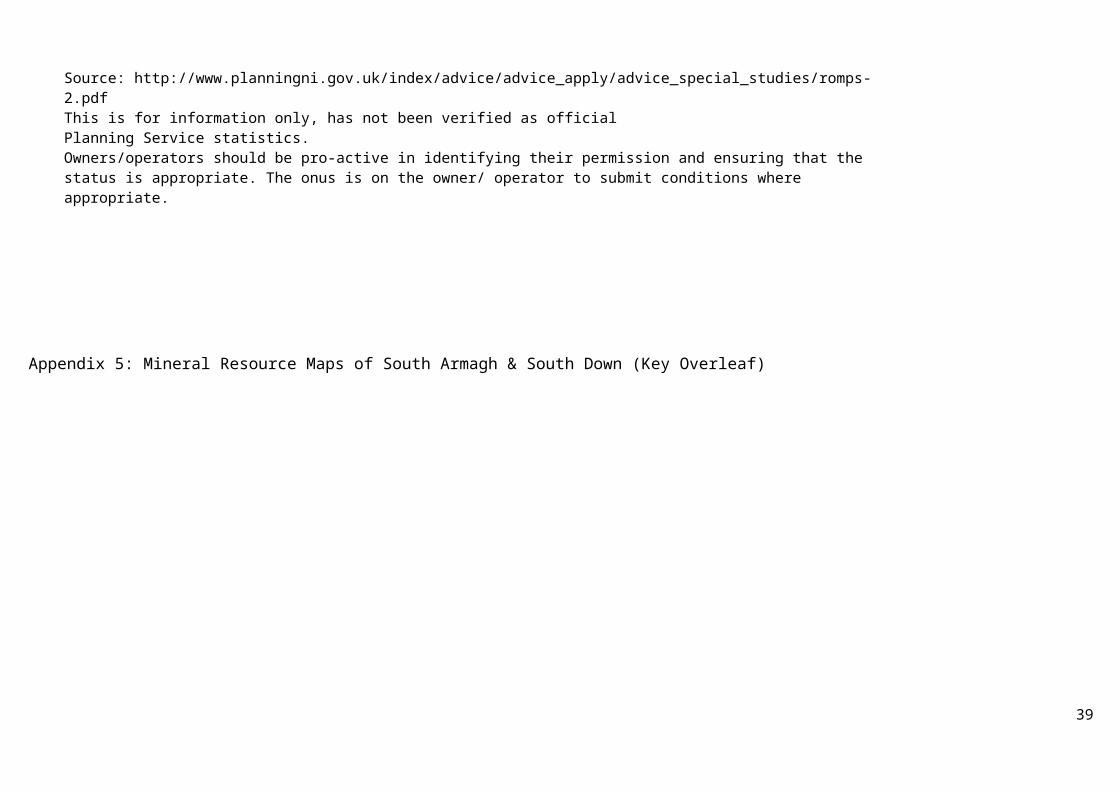
Appendix 5: Mineral Resource Maps of South Armagh & South Down (Key Overleaf)
30
Source: http://www.bgs.ac.uk/mineralsuk/planning/resource.html
31
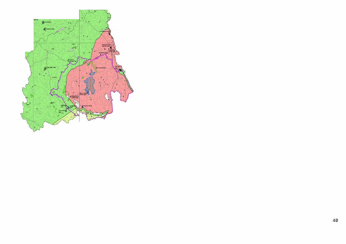
Appendix 6: Mineral Resource Map Kilkeel Area Key
Source: http://www.bgs.ac.uk/mineralsuk/planning/resource.h
32
Appendix 7: Mineral Resource Maps for Northern Ireland SummaryBuilding Stones
A wide range of rock types are used as a source of building stone for masonry, field walling, roofing and flooring purposes, all of which give a specific character to an area. The stones can be used as coarsely dressed ‘rubble walling’, but there is also a need for finer, more easily worked stones for details such as sills on buildings. The suitability of particular rock types depends not only on aesthetic qualities such as colour and textural consistency but also factors such as strength and durability, as well as other commercial considerations.
A wide variety of hard rocks are suitable for use as building stone including igneous, sedimentary and their metamorphic equivalents (igneous or sedimentary rocks that have been altered by heat or pressure). Many rock types suitable for building stone are also suitable for crushed rock aggregate. Some units, notably the thicker sandstone formations, lend themselves to being used as freestone or dimension stone as they can be worked in any direction without splitting or falling. A continuing supply of building stone is important for new build and conservation work.
Igneous and meta-igneous rocks:
The Newry Igneous Complex is actively exploited for building stone and crushed rock aggregate. The granodiorite is a bluish-grey granite rock that makes an extremely hard and resistant building material. It has been used as facing stones on buildings and for kerbstones in Newry and Belfast. Stone from Goraghwood Quarry was used in the construction of the Craigmore railway viaduct. Drumalane Quarry is currently worked for crushed rock aggregates.
Granite was quarried in the Mourne Mountains for many years and exported for use as paving stones in London and New York. The principal quarry sites are located in the granite of the Eastern Mournes . Traditional uses were for cobble stones (setts) for paving streets, roadside kerbs and stones, millstones and in the construction of buildings (steps, lintels etc.) However, Mourne Granite has also been used to create decorative or commemorative stone pieces and provide a range of products from hand crafted granite worktops, floor tiles, hard landscaping, memorials and other building products. It was used for the Millenium stone erected at Delamont Park and to make the base of the 9/11 memorial in New York. The granitic rocks of Slieve Gullion Complex in the south of the county have been exploited for building stone at the Mullaghbawn Central, Slieve Gullion Forest and Camlough quarries. In the case of Camlough Quarry, thermally metamorphosed greywackes and shales are also present.
Sedimentary and meta-sedimentary rocks
Well-bedded sandstones/gritstones, which underline much of Co Armagh, have been subject to very low grade metamorphism, making them good structural building stone as well as high specification aggregate. Gala Group greywackes
33
have been exploited for building stone at Drumalane.
Limestone
Limestones are sedimentary rocks composed mainly of calcium carbonate (CaCO3). Dolomites are limestones which also contain between 10-15 percent magnesium carbonate (MgCO3). As well as being relatively hard and durable, most limestones and dolomites form bedded deposits which are generally easy to work. These properties mean that they are commonly worked for construction aggregate and building stone. Limestones are also valued for their chemical properties in applications such as cement manufacture, glass making, iron ore smelting, flue gas desulphurisation, as a soil conditioner, food supplement and white filler. The strict chemical limits applied to material used in these applications restricts extraction to high purity stone (>97% CaCO3). County Down has relatively small limestone resources and currently there is no extraction of limestone. Whilst Armagh has much more significant deposits, the majority of these fall outside the Council Area, primarily in the area around Armagh City.
Clay
‘Brick Clay’ is a term used to describe clay and shale used predominantly in the manufacture of bricks and, to a lesser extent, roof tiles and clay pipes. These clays may sometimes be used in cement manufacture, as a source of construction fill and for lining and sealing landfill sites. The suitability of the raw material depends principally upon its behaviour during its shaping, drying and firing. This dictates the properties of the red fired brick such as strength and frost resistance and importantly architectural appearance.
Most facing bricks, engineering bricks and related clay-based building products are manufactured in large automated factories. These represent a high capital investment and are increasingly dependent, therefore, on raw materials with predictable and consistent firing characteristics in order to achieve high yields of saleable products. Blending different clays to achieve improved durability and to provide a range of fired colours and textures is an increasingly common feature of the brick industry. Continuity of supply of consistent raw materials is of paramount importance.
Quaternary-age marine beach deposits, which comprise clay interbedded with sand and gravel, locally constitute suitable raw material for brick manufacture. These deposits occur along the coastal strip around Dundrum Bay and are perched upon glacial sands and gravels further inland.
Crushed Rock Aggregates
Crushed rock aggregates are a key component of construction materials such as concrete and asphalt where aggregate adds low-cost reinforcement to these composite materials. Loose aggregates are also used as a stable foundation or road/rail base with predictable, uniform properties.
A wide variety of hard rocks suitable for use as aggregates including igneous,
34
sedimentary and their metamorphic equivalents (igneous or sedimentary rocks which have subsequently been altered by heat and/or pressure). Their technical suitability for different applications depends upon physical characteristics, such as crushing strength and resistance to impact and abrasion.
High specification aggregates (HSA) are needed to produce skid-resistant road surfacing. They must have high resistance to polishing. This is expressed as a ‘Polished Stone Value’ (PSV) of 58 or higher. HSA materials must also meet strict specifications for resistance to abrasion, fragmentation and weathering, as well as compositional restrictions. For less demanding applications such as constructional fill and drainage media, a wider variety rocks with lower specifications are acceptable.
Igneous and meta-igneous rocks
A felsite dyke and/or a crosscutting basalt sill, is worked at the Swan Rock quarries located to the east of Crossmaglen in the south-west part of the District. Also, the Newry Igneous Complex and the adjacent contact metamorphosed meta-sedimentary rocks are worked for crused rock aggregate.
Sedimentary and meta-sedimentary rocks
In South Down sandstone and siltstones, commonly with thick mudstone interbeds, generally produce inferior aggregate material, except in the vicinity of the Newry & Mourne granitic intrusive complexes where they have been thermally metamorphosed. In particular, a three kilometre-wide corridor of sandstone between the Newry & Mourne granite complexes has been thermally metamorphosed twice, which has imparted enhanced qualities for aggregate use to the rocks. HAS aggregates are exploited at various sites in the vicinity of these granite complexes.
Sandstones and siltstones, commonly with thick mudstone interbeds, in the southernmost parts of Co Armagh, generally produce inferior aggregate material except in the vicinity of the Newry and Slieve Gullion igneous complexes where they have been thermally metamorphosed. HAS’s are exploited at various sites in the vicinity of these granitic complexes.
Superficial Sand and Gravel
Sand and gravel are defined on the basis of particle size rather than composition. In current commercial practice, following the introduction of the European standards in 2004 (BS EN 1260), the term ‘gravel’ (or more correctly ‘coarse aggregate’) is used for general and concrete applications to define particles between 4 and 80 mm. The term ‘sand’ (or more correctly ‘fine aggregate’) is used for material that is finer than 4 mm, but coarser than 0.063 mm. For use in asphalt, 2 mm is the break point between coarse and fine aggregate. Most sand and gravel is composed of particles that are durable and rich in silica (quartz, quartzite and flint).
The principal uses of sand are as fine aggregate in concrete, mortar and asphalt,
35
and the main use of gravel is a coarse aggregate in concrete. Substantial quantities of sand and gravel may also be used for construction fill.
The variability of sand and gravel deposits, together with their possible concealment within or beneath till (boulder clay), means that it is difficult to infer their location and the likely extent of potentially workable resources.
Most workable deposits of sand and gravel formed at the end of the last ice age. They lie on top of the bedrock geology and generally concentrated in the river valleys where they were deposited directly by ice at the margins of glaci6ers (glacial) or by melt water flowing from the ice margin (glaciofluvial). Glacial ice-contact deposits tend to be poorly-sorted and of inconsistent quality and thickness. Glaciofluvial deposits are generally well-sorted and more predictable in terms of quality and quantity.
County Down is a relatively small producer of sand and gravel in Northern Ireland, currently accounting for eight percent of total output, with the major part of the sand and gravel reserves being located in deposits in the southernmost part of the county.
Glaciofluvial sand and gravel deposits
Glaciofluvial sand and gravel extraction is currently taking place on the coastal plain in the area of Kilkeel. Here the interstratified sands, gravel and cobble conglomerates overlie glacial till. Deposits are laterally continuous and texturally uniform. Similar deposits on the west side of the White Water River and on the coastal plain on the south-east side of the Mourne Mountains, to the north and west of Annalong, have also been worked for sand and gravel.
Raised beach deposits
Raised beach deposits of sand and gravel occur around the northern side of Carlingford Lough west of Cranfield Point, to the east of Kilkeel around Dundrum Bay and on the north-west side of Killough Bay. Those raised beach deposits west of Cranfield extend well inland and are fronted on their seaward margin by blown sand. Gravel workings exploited raised beach deposits at the mouth of the Cassy Water and to the east of Kilkeel.
Blown Sand
Blown sand, which comprises fine to medium grained, subrounded to well-rounded quartz grains, results from aeolian reworking of beach, fluvial and glaciofluvial deposits. This type of sand is typically worked for mortar production, but might also be suitable for plastering and as moulding sand. Blown sand deposits occur on the north side of Carlingford Lough, west of Cranfield Point and around Dundrum Bay east of Dundrum where exploration has taken place at the Rathmullen sand pits.
Geothermal Energy
Geothermal energy is derived from naturally occurring heat from rocks at depth.
36
Naturally heated groundwater can contribute to heating buildings and, if hot enough, to drive turbines, thus providing a renewable source of heat and electricity. In Northern Ireland there are two provinces prospective for intermediate and deep geothermal energy. The first comprises the Permian to Triassic (Permo-Triassic) age sedimentary rocks deposited in the Rathlin, Lough Allen, Larne and Lough Neagh basins. These basins are also potential hosts for oil and gas (see Hydrocarbons), the second is the Mourne Mountains, where geothermal potential exists in the deep, grantic, igneous rocks.
The dry and impermeable granitic rocks underlying the Mourne Mountains have the potential to be utilised as an ‘Enhanced Geothermal System’ (EGS). In an EGS, boreholes are drilled deep into the rock which is then fractured at depth. Cold water from the surface is pumped down a feeder borehole and is then naturally heated by the rock as it passes through the fractures before returning to the surface via collection boreholes. The returning water is hot enough to drive turbines and then be used for heating buildings. Once cooled, water is injected back into the ground to heat up again in a closed loop. A 3-5 megawatt ESG demonstration project is currently being developed at the Eden Project in Cornwall. Exploratory drilling for the UK’s first commercial geothermal plant (10 megawatt) has begun in Redtruth in Cornwall.
Hydrocarbons
Exploration for Oil and gas in Northern Ireland began in 1965 and whilst gas has been detected, it has yet to be discovered in commercial quantities. The hydrocarbon potential of most sedimentary rock ‘basins’ in Northern Ireland has yet to be fully tested and so these remain ‘prospective’ for oil and gas.
The Lower Carboniferous-age rocks of southern County Tyrone and most of Co. Fermanagh form one of the two major provinces in Northern Ireland most prospective for oil and gas. The second prospective province comprises the younger Permian and Triassic (Permo-Triassic) age rocks beneath Lough Neagh and the Antrim Plateau.
Underlying a small part of north-west Co Down are sedimentary rocks deposited in the Lough Neagh Basin. This is the deepest, and possibly the most prospective, of the Permo-Triassic basins in Northern Ireland. An exploration borehole (Annaghmore No 1 in Co Antrim) identified a black bituminous oil in the Permain-age sandstones. Underlying Carboniferous-age coals and shales are the likely ‘source’ rocks for this oil and gas, although data from boreholes indicate that these rocks are missing (have been eroded) from some areas in the basin. The younger Triassic-age Sherwood Sandstone (which forms important reservoirs in the East Irish Sea gas field), along with Permian-age sandstoens form potential ‘reservoir’ rocks into which any oil and gas generated from the source rocks might migrate and become trapped. The overlying Traissic-age Mercia Mudstone Group is likely to provide a good ‘seal’ for any hydrocarbons trapped in the underlying sandstones.
Shale Gas
37
Shale gas is extracted directly from murdocks and shales which have previously been considered too impermeable (tight) to allow economic recovery of gas. Unlike conventional gas, which collects in porous reservoir rocks (such as sandstone) and can be released simply by drilling boreholes into those rock formations, shale gas is locked in the matrix of much less permeable murdocks and shales. It can be accessed only by using a specialised drilling and production technique, called hydraulic fracturing or ‘fracking’, which enhances the limited natural micro-porosity to free the gas from the rock for extraction via a borehole.
In Co Down and Armagh, the Carboniferous-age organic rich shales underlying the Lough Neagh Basin may have potential for unconventional shale gas production. The distribution of shales at depths suitable for shale gas production is unknown, because few exploration wells have been drilled in these basins, no known reserves have been identified within this Council Area.
Peat
Peat is an unconsolidated deposit formed by decaying organic matter which accumulates in a water-saturated environment such as bog or moss. Bogs occur in areas where they are dependent on rainfall for supply of water or in sedimentary basins such as former lakes. Vegetation is characterised by acid tolerant plant communities of which the genus Sphagnum is dominant. The two main types of bog are (i) raised bogs, characterised of flat underlying topography and found on plains and broad valley floors and (ii) blanket bogs, which occur mainly in upland areas where conditions are suitable cool and wet.
Although most widespread in the west and north of Northern Ireland, blanket bog also occurs in eastern upland areas. Peat depth is variable, with an average 0.5-3 metres being fairly typical, but depths in excess of five metres are not usual. Raised bogs occur across Northern Ireland which may be infilling former lagoons or glacial lakes behind other coastal deposits or older glacial deposits respectively. Peat bogs in Northern Ireland, being generally smaller, were never developed on an industrial scale for power generation as they were in the Irish Midlands. Whilst peat is cut locally for fuel, its main usage is as a horticultural growing medium, although its potential as a carbon sink has been recognised.
Whilst peat is widespread in Co Down and Armagh, it commonly occurs as small areas of limited extent. There are currently no extant planning permissions for extraction of peat within the District.
Lignite
Lignite (brown coal) is a fossil fuel derived from dead plant material which has been transformed by burial and compression at elevated temperatures over a long period of time into combustible sedimentary rocks. Lignite is present within the Ballycastle and Lough Neagh area. There are not known to be substantial deposits within the Newry, Mourne & Down Area.
38
Metalliferous Minerals
The principal metal occurrences in Down & Armagh are historically important lead veins, frequently associated with zinc, copper and barytes, hosted with sedimentary rocks, which have significant potential for hosting gold mineralisation.
Precious metals (gold and silver)
Gold always occurs alloyed with silver and other elements and, as deposits of silver alone are not known in Northern Ireland, the two metals are discussed together.
Sedimentary rocks, which represent an extension of the Southern Uplands Terrane of Scotland into Ireland (the Southern Uplands-Down-Longford Terrane) dominate the southern two thirds of Co Armagh. A number of significant gold occurrences occur in these rocks in Scotland and along the Armagh/Monaghan border. Gold in association with quartz veins has long been known at Clontibret in Co Monaghan. The Clontibret mineralisation contains antimony and is part of the same vein swarm that includes the lead veins of South Armagh. Some six kilometres to the east, in Co Armagh, bedrock gold has been identified at a number of localities. Drilling north of Derrynoose at Cargalisgorran, close to this District, has identified a mineralised zone extending for at least 150 metres and consisting of three steeply dipping, gold bearing quartz-carbonate veins. At Tivnacree, one kilometre south-west of Cargalisgorran, trenching and drilling has identified low-grade gold mineralisation. Drilling to the north-east of these occurrences, in an area known as ‘Clay Lake’, has intersected further bedrock gold mineralisation. By analogy the extension of the Southern Uplands-Down-Longford Terrane through Co Down is highly prospective. Alluvial gold occurrences (gold eroded from weathered bedrock occurrences and dispersed in streams) are scattered throughout Co Down and Co Armagh. Particular concentrations occur over the central part of the Newry Igneous Complex and surrounding the Mourne Mountains Granite Complex. Although alluvial gold is unlikely to ever become an economic source of gold in Northern Ireland, it does provide physical evidence of gold in bedrock. Insofar as alluvial gold is common in areas where wein-hosted gold is not presently known, the occurrence of gold in bedrock may be much more widespread.
Lead, Zinc, Copper, Uranium, Tin and Barytes
Lead and zinc occurrences are scattered throughout the sedimentary rocks of the Southern Uplands-Down-Longford Terrane. Lead has been historically worked at two locations to the west of Strangford, at Castleward Mine and Tullyratty. Minor vein-hosted copper, lead, zinc and iron occurrences are reported from the Eastern Mournes. Barytes occurs in the sedimentary rocks of Co Down, commonly as a gangue mineral in metal-bearing veins. Barytes as a gangue in metaliferous veins is rarely ever of economic importance.
The Newry, Mourne & Down Area has been the focus of a number of mineral
39
exploration campaigns, originally focussed on base metals and uranium and subsequently on gold. Much of the exploration work has focussed on the Newry Igneous Complex and its immediate surroundings. Uneconomic copper-bearing mineralisation was identified in the Guiness Mountain area, south-east of Dromara. Geochemical exploration, whilst identifying encouraging areas of coincident gold and base metal enrichment, has identified little in the way of bedrock mineralisation. Stream-sediment geochemistry and radiometric surveying indicates anomalous uranium concentrations over both the Mourne Mountains and Newry Igneous complexes, although primary uranium-bearing mineralisation has not been identified. Tin occurs in quartz veins at Pollaphuca, south-west of Bryansford in the Mourne Mountains.
The South Armagh- Monaghan Mining District is centred on the town of Keady, close to the District boundary. In Co Armagh there are records of 57 shafts and adits. A few of the veins were worked on a relatively large scale by the standards of the 1800s.
Source: Mineral Resource Maps for Northern Ireland (GSNI)
Appendix 8: Mine Shafts & Adits
40

Source: Geological Survey Northern Ireland
41
Appendix 9: 2015 Council Quarry Data based on 10 year average
2015 Council Quarry Data based on 10 year average
Council
Quarry Value Tonnage extracted pro rata to 10 year average of 24MT per annum
Employee Numbers
Value of manufactured concrete and Assphalt Products
Antrim and Newtownabby £458,751.00 182,044 340 £8,000,000Armagh Banbridge and Craigavon
£14,528,241.00 3,166,972 250 £30,000,000
Belfast No return 86 £11,000,000Causewaycoast and Glens £6,446,303.00 1,797,449 300 £37,000,000Derry and Strabane £1,581,663.00 564,970 212 £25,000,000North Down & Ards £10,484,988.0
0 4,190,897 106 £13,250,000Fermanagh and Omagh £11,860,195.0
0 3,107,820 737 £88,440,000Lisburn and Castlereagh £8,465,129.00 2,932,138 340 £40,000,000Mid and East Antrim £13,697,997.0
0 3,246,192 396 £60,000,000Mid Ulster £10,216,154.0
0 3,209,279 1257 £210,000,000Newry, Mourne & Down £5,938,726.00 1,594,502 252 £25,000,000
Total £83,678,147.00
23,992,263 4276 £547,690,000
NOTESThe detail in this document is based on the last recorded mineral statement collected by DETI - 2011. It has then been pro rata up based on a ten year average of the DETINI Mineral Statement figures in order to present a more accurate assessment of production over a given period.The information does not represent the full value of aggregates to any of the council areas as not all operators completed a return for the year.
42
The operator information is believed to be correct for the time of the return - changes in ownership may have occurred in the intervening timeSource: QPANI
43
Appendix 10: DETI Annual Minerals Statement 2010
Source: DETI
45