Embed Size (px)
Citation preview
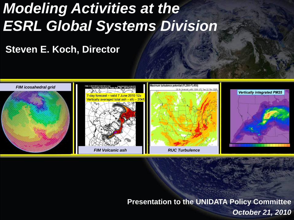
FIM icosahedral grid
FIM Volcanic ash RUC Turbulence
Steven E. Koch, Director
Modeling Activities at the
ESRL Global Systems Division
Presentation to the UNIDATA Policy Committee
October 21, 2010
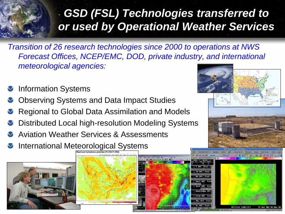
GSD (FSL) Technologies transferred to
or used by Operational Weather Services
Transition of 26 research technologies since 2000 to operations at NWS
Forecast Offices, NCEP/EMC, DOD, private industry, and international
meteorological agencies:
Information Systems
Observing Systems and Data Impact Studies
Regional to Global Data Assimilation and Models
Distributed Local high-resolution Modeling Systems
Aviation Weather Services & Assessments
International Meteorological Systems
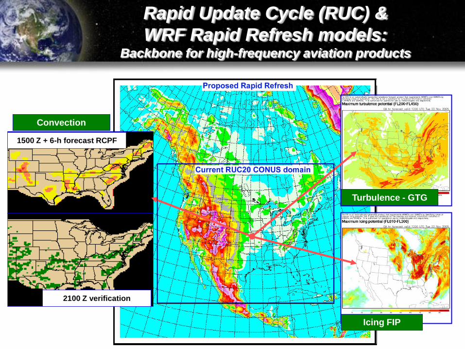
Rapid Update Cycle (RUC) &
WRF Rapid Refresh models:Backbone for high-frequency aviation products
1500 Z + 6-h forecast RCPF
2100 Z verification
Turbulence - GTG
Icing FIP
Convection
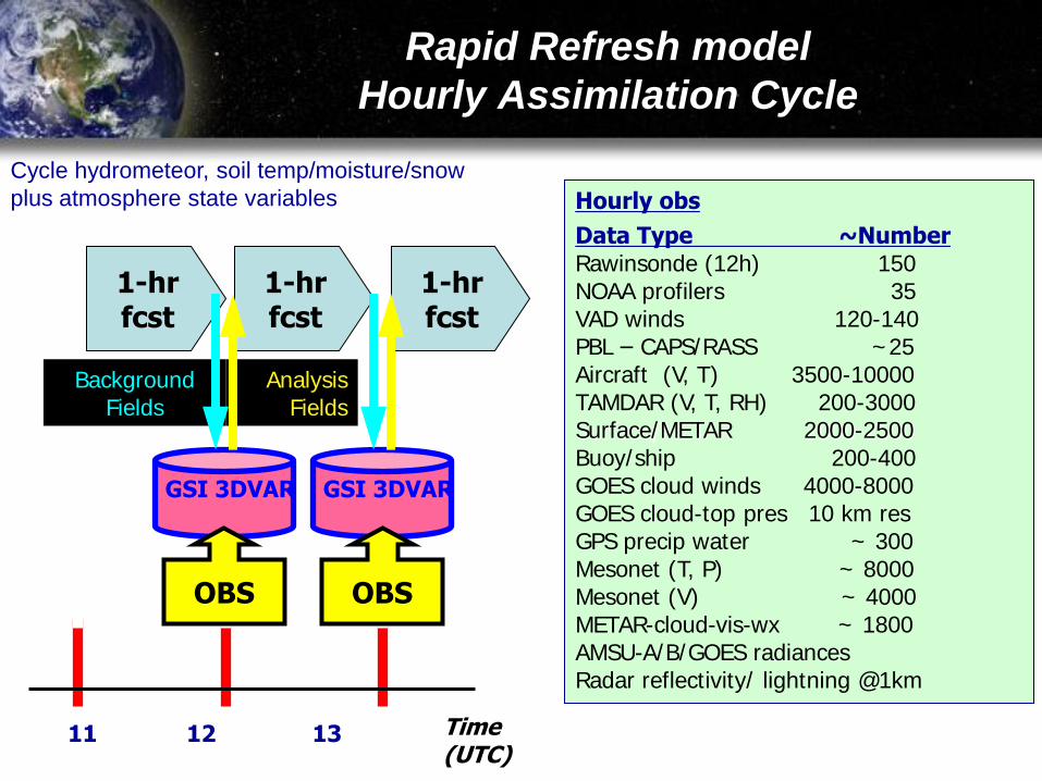
Rapid Refresh model
Hourly Assimilation Cycle
11 12 13 Time (UTC)
1-hrfcst
BackgroundFields
AnalysisFields
1-hrfcst
GSI 3DVAR
OBS
1-hrfcst
GSI 3DVAR
OBS
Cycle hydrometeor, soil temp/moisture/snow
plus atmosphere state variables Hourly obs
Data Type ~NumberRawinsonde (12h) 150NOAA profilers 35 VAD winds 120-140 PBL – CAPS/RASS ~25Aircraft (V, T) 3500-10000 TAMDAR (V, T, RH) 200-3000Surface/METAR 2000-2500 Buoy/ship 200-400 GOES cloud winds 4000-8000 GOES cloud-top pres 10 km res GPS precip water ~ 300Mesonet (T, P) ~ 8000Mesonet (V) ~ 4000METAR-cloud-vis-wx ~ 1800AMSU-A/B/GOES radiancesRadar reflectivity/ lightning @1km
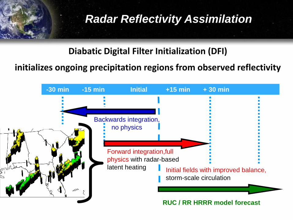
Radar Reflectivity Assimilation
Forward integration,full
physics with radar-based
latent heating
-30 min -15 min Initial +15 min + 30 min
RUC / RR HRRR model forecast
Backwards integration,
no physics
Initial fields with improved balance,
storm-scale circulation
Diabatic Digital Filter Initialization (DFI)
initializes ongoing precipitation regions from observed reflectivity
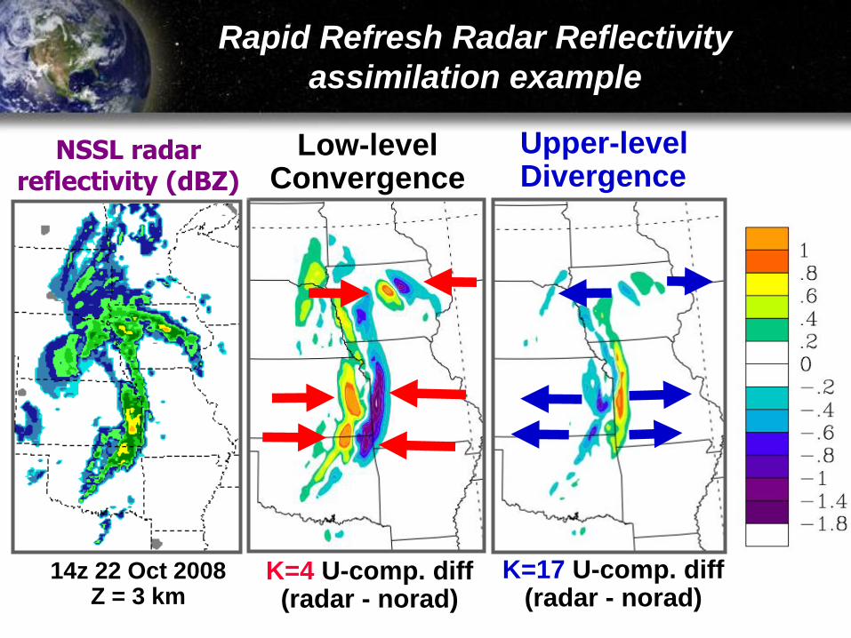
Rapid Refresh Radar Reflectivity
assimilation example
Low-levelConvergence
Upper-levelDivergence
K=4 U-comp. diff (radar - norad)
K=17 U-comp. diff (radar - norad)
NSSL radar reflectivity (dBZ)
14z 22 Oct 2008Z = 3 km
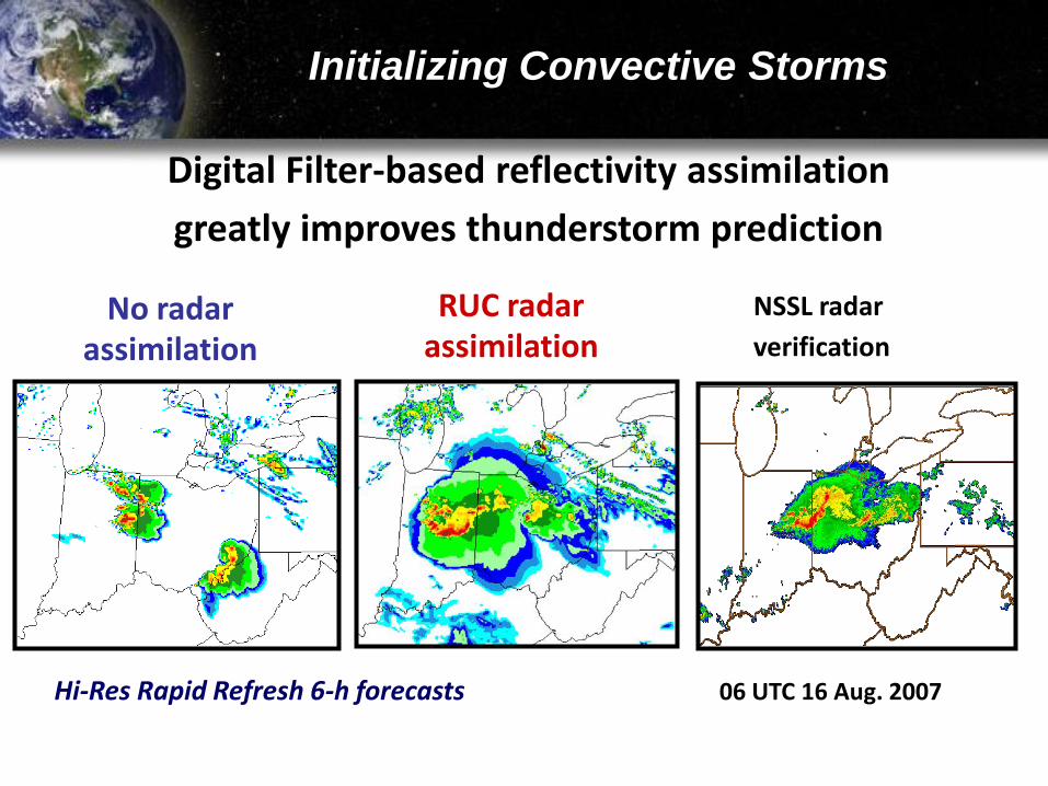
Initializing Convective Storms
Hi-Res Rapid Refresh 6-h forecasts
NSSL radar
verification
No radarassimilation
RUC radarassimilation
06 UTC 16 Aug. 2007
Digital Filter-based reflectivity assimilation
greatly improves thunderstorm prediction
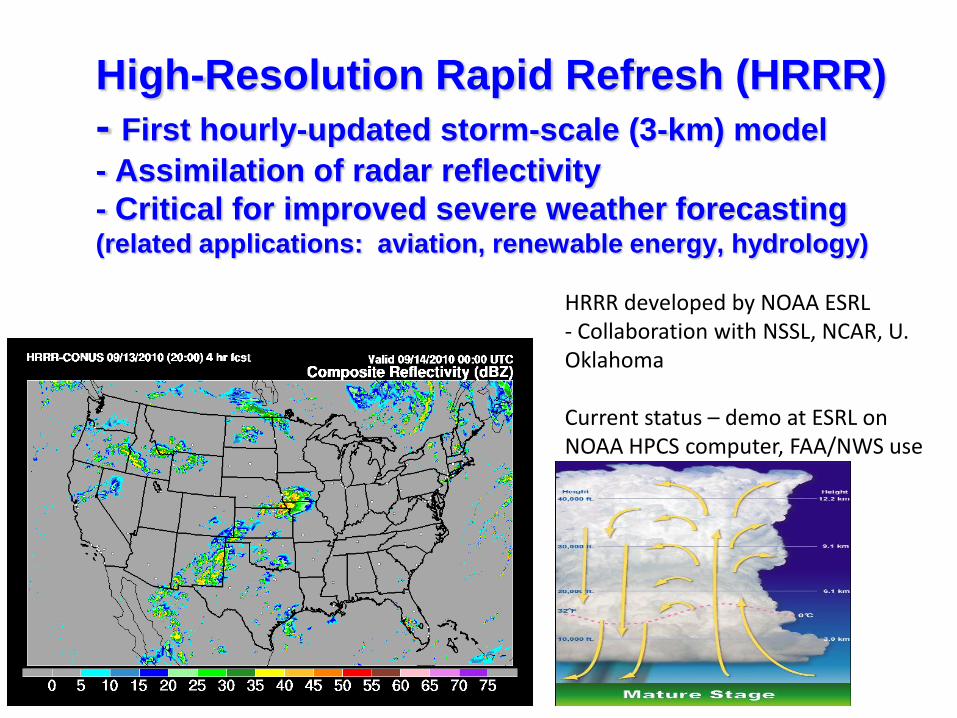
High-Resolution Rapid Refresh (HRRR)
- First hourly-updated storm-scale (3-km) model
- Assimilation of radar reflectivity
- Critical for improved severe weather forecasting (related applications: aviation, renewable energy, hydrology)
HRRR developed by NOAA ESRL- Collaboration with NSSL, NCAR, U. Oklahoma
Current status – demo at ESRL on NOAA HPCS computer, FAA/NWS use
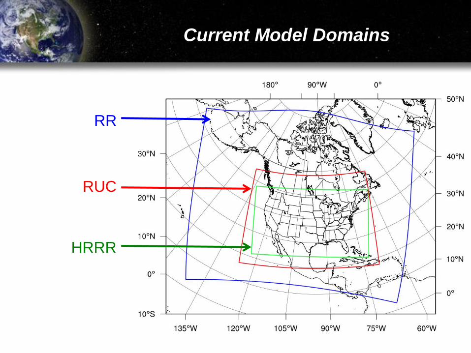
Current Model Domains
RR
RUC
HRRR
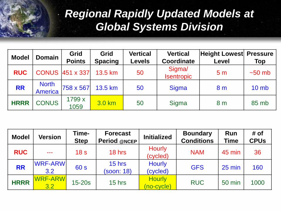
Regional Rapidly Updated Models at
Global Systems Division
Model DomainGrid
Points
Grid
Spacing
Vertical
Levels
Vertical
Coordinate
Height Lowest
Level
Pressure
Top
RUC CONUS 451 x 337 13.5 km 50Sigma/
Isentropic5 m ~50 mb
RRNorth
America758 x 567 13.5 km 50 Sigma 8 m 10 mb
HRRR CONUS1799 x
10593.0 km 50 Sigma 8 m 85 mb
Model VersionTime-
Step
Forecast
Period @NCEPInitialized
Boundary
Conditions
Run
Time
# of
CPUs
RUC --- 18 s 18 hrs Hourly
(cycled)NAM 45 min 36
RRWRF-ARW
3.260 s
15 hrs
(soon: 18)
Hourly
(cycled)GFS 25 min 160
HRRRWRF-ARW
3.215-20s 15 hrs
Hourly
(no-cycle)RUC 50 min 1000
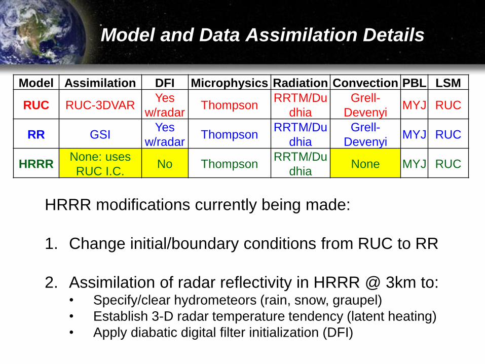
Model and Data Assimilation Details
Model Assimilation DFI Microphysics Radiation Convection PBL LSM
RUC RUC-3DVARYes
w/radarThompson
RRTM/Du
dhia
Grell-
DevenyiMYJ RUC
RR GSIYes
w/radarThompson
RRTM/Du
dhia
Grell-
DevenyiMYJ RUC
HRRRNone: uses
RUC I.C.No Thompson
RRTM/Du
dhiaNone MYJ RUC
HRRR modifications currently being made:
1. Change initial/boundary conditions from RUC to RR
2. Assimilation of radar reflectivity in HRRR @ 3km to:• Specify/clear hydrometeors (rain, snow, graupel)
• Establish 3-D radar temperature tendency (latent heating)
• Apply diabatic digital filter initialization (DFI)
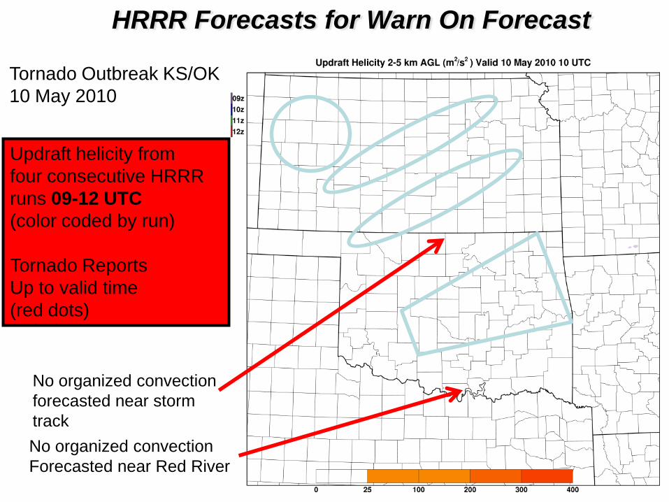
HRRR Forecasts for Warn On Forecast
Updraft helicity from
four consecutive HRRR
runs 09-12 UTC
(color coded by run)
Tornado Reports
Up to valid time
(red dots)
Tornado Outbreak KS/OK
10 May 2010
No organized convection
Forecasted near Red River
No organized convection
forecasted near storm
track
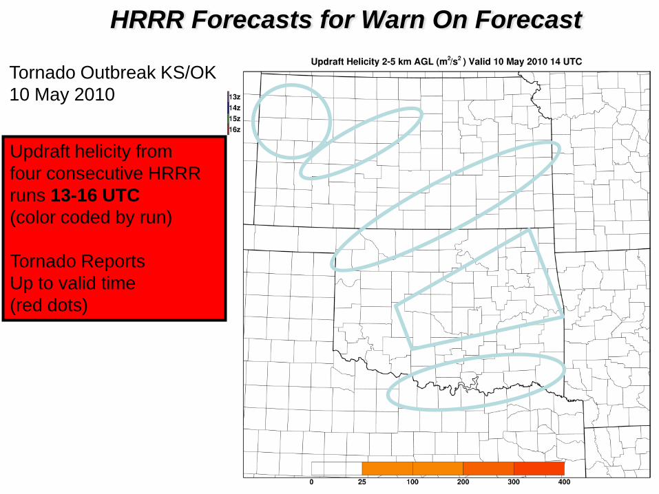
Updraft helicity from
four consecutive HRRR
runs 13-16 UTC
(color coded by run)
Tornado Reports
Up to valid time
(red dots)
HRRR Forecasts for Warn On Forecast
Tornado Outbreak KS/OK
10 May 2010
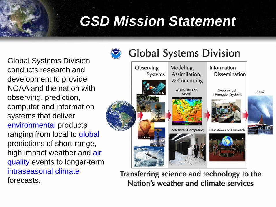
GSD Mission Statement
Global Systems Division
conducts research and
development to provide
NOAA and the nation with
observing, prediction,
computer and information
systems that deliver
environmental products
ranging from local to global
predictions of short-range,
high impact weather and air
quality events to longer-term
intraseasonal climate
forecasts.

NOAA Grand Challenge
Develop and apply holistic, integrated Earth
system approaches to understand the
processes that connect changes in the
atmosphere, ocean, space, land surface,
and cryosphere with ecosystems, organisms
and humans over different scales.
*As identified at the NOAA Science Workshop (April 2010) + NGSP
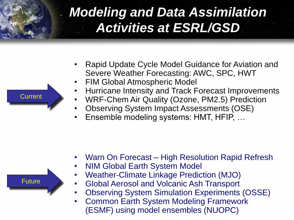
Modeling and Data Assimilation
Activities at ESRL/GSD
• Rapid Update Cycle Model Guidance for Aviation and Severe Weather Forecasting: AWC, SPC, HWT
• FIM Global Atmospheric Model• Hurricane Intensity and Track Forecast Improvements• WRF-Chem Air Quality (Ozone, PM2.5) Prediction• Observing System Impact Assessments (OSE)• Ensemble modeling systems: HMT, HFIP, …
Current
Future
• Warn On Forecast – High Resolution Rapid Refresh• NIM Global Earth System Model• Weather-Climate Linkage Prediction (MJO)• Global Aerosol and Volcanic Ash Transport• Observing System Simulation Experiments (OSSE)• Common Earth System Modeling Framework
(ESMF) using model ensembles (NUOPC)
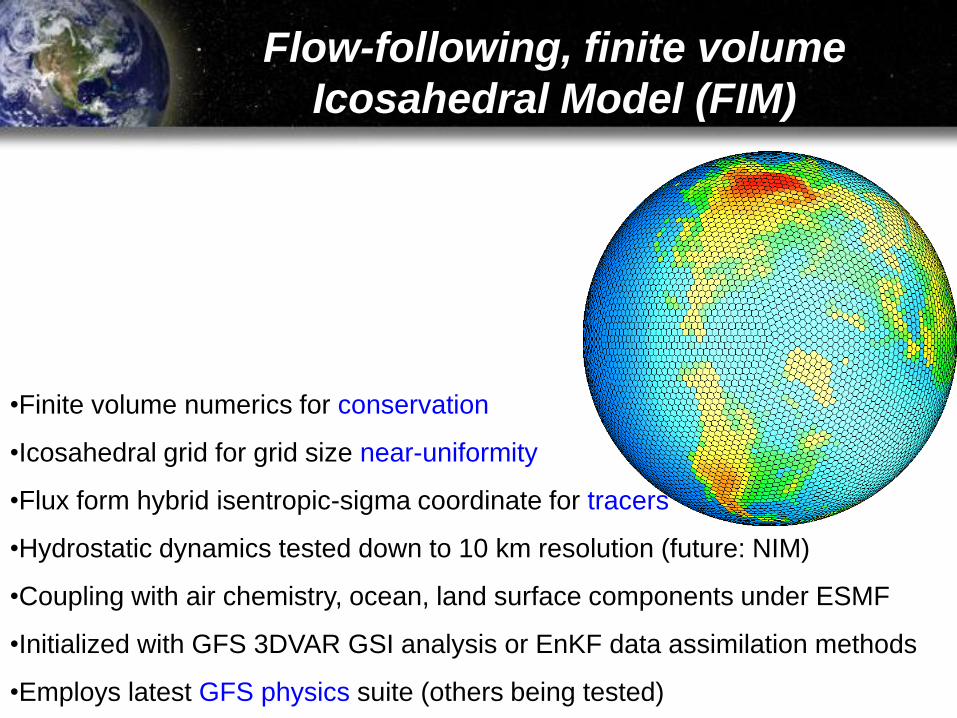
•Finite volume numerics for conservation
•Icosahedral grid for grid size near-uniformity
•Flux form hybrid isentropic-sigma coordinate for tracers
•Hydrostatic dynamics tested down to 10 km resolution (future: NIM)
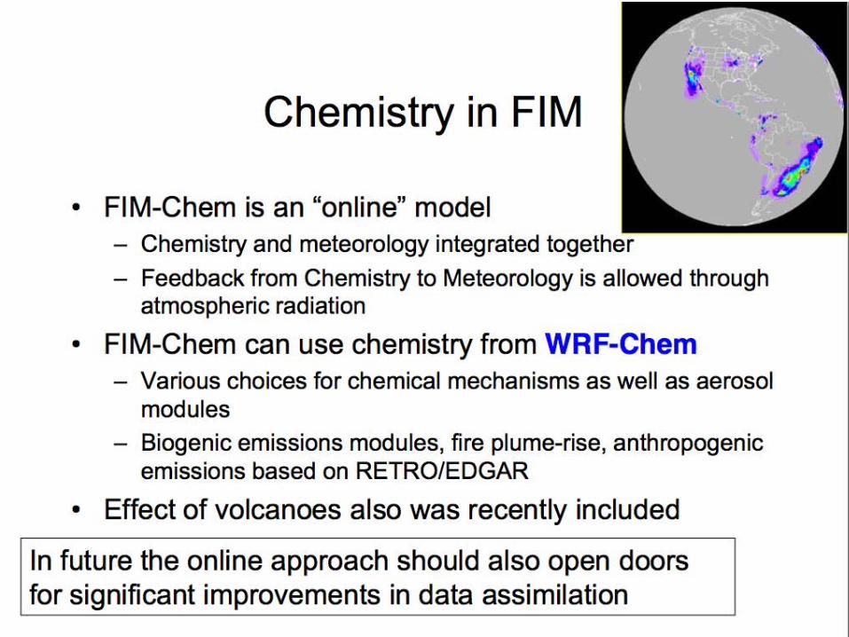
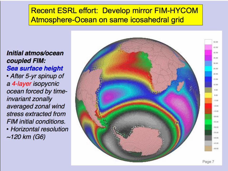
•Coupling with air chemistry, ocean, land surface components under ESMF
•Initialized with GFS 3DVAR GSI analysis or EnKF data assimilation methods
•Employs latest GFS physics suite (others being tested)
Flow-following, finite volume
Icosahedral Model (FIM)
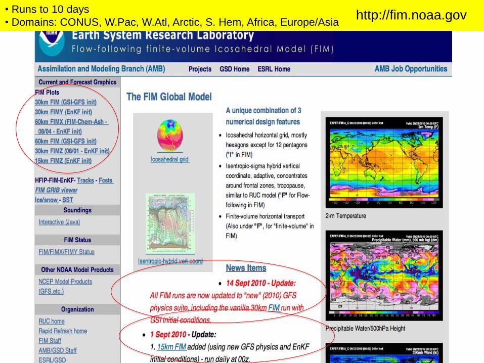
• Runs to 10 days
• Domains: CONUS, W.Pac, W.Atl, Arctic, S. Hem, Africa, Europe/Asiahttp://fim.noaa.gov
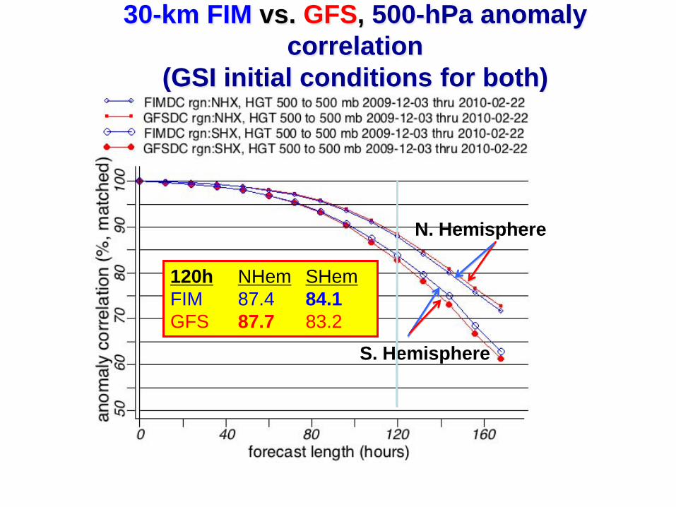
30-km FIM vs. GFS, 500-hPa anomaly
correlation
(GSI initial conditions for both)
N. Hemisphere
S. Hemisphere
120h NHem SHem
FIM 87.4 84.1
GFS 87.7 83.2

NCEP is in the process of building a new operational modeling system, fully compatible
with the community-based Earth System Modeling Framework (ESMF). This National
Environmental Modeling System (NEMS) will house model components for both
Development and Testing (D&T) and operational applications.
The NOAA/OAR/ESRL and NOAA/N WS/NCEP are mutually agreed to collaborate on a
phased D&T, ev aluation, and possible transition of the FIM for operational application if
criteria for Transition to Operations (T2O) are satisfied. The first two phases will cover
incorporation of the FIM into the NEMS D&T code and evaluation of the FIM as a
potential component for NAEFS. In addi tion, the FIM may be used to evaluate advanced
horizontal and vertical coordinates with potential for operational use.
LOA for Possible Implementation
of FIM into NCEP Operations
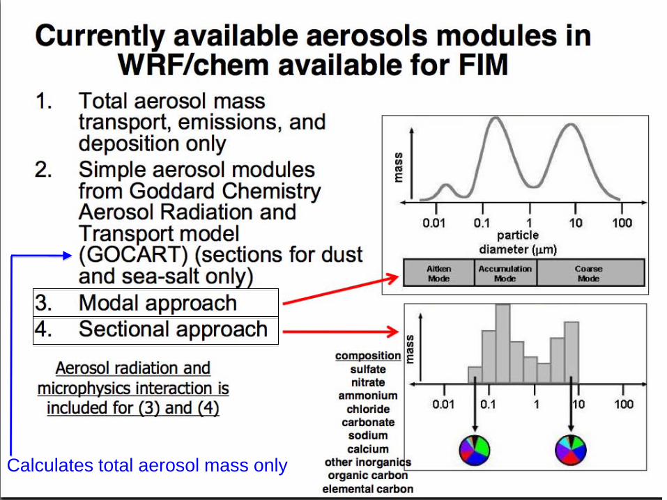
Calculates total aerosol mass only
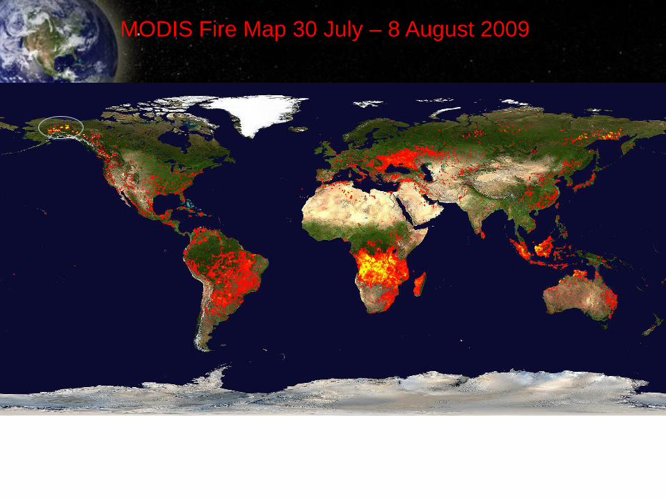
MODIS Fire Map 30 July – 8 August 2009
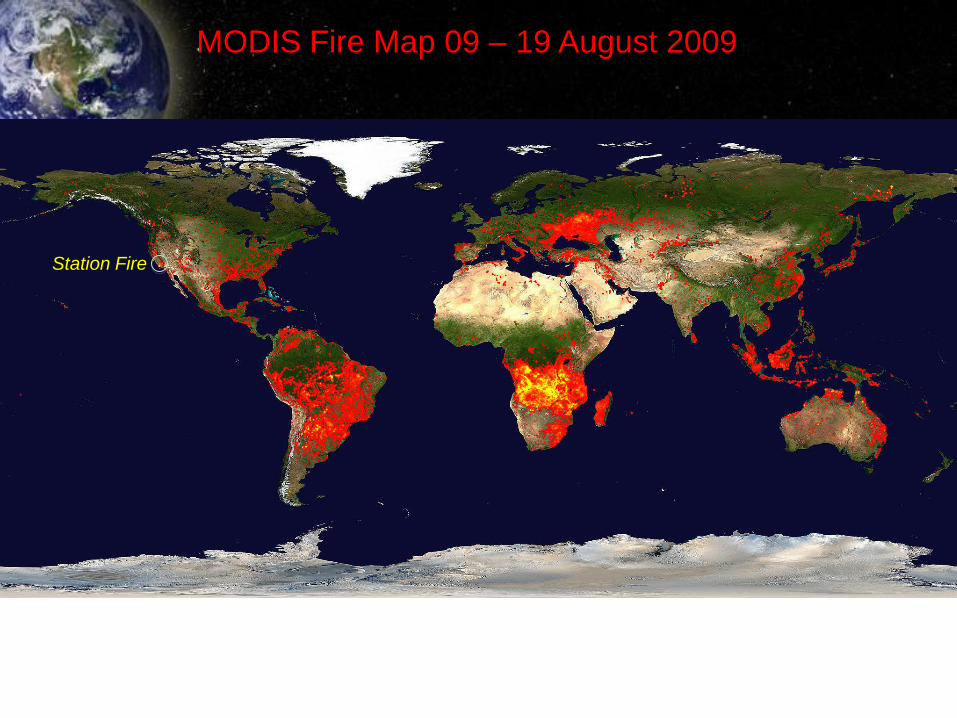
MODIS Fire Map 09 – 19 August 2009
Station Fire
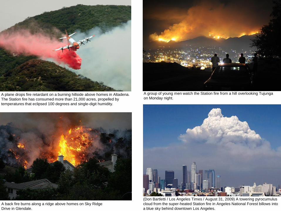
(Don Bartletti / Los Angeles Times / August 31, 2009) A towering pyrocumulus
cloud from the super-heated Station fire in Angeles National Forest billows into
a blue sky behind downtown Los Angeles.
A group of young men watch the Station fire from a hill overlooking Tujunga
on Monday night. A plane drops fire retardant on a burning hillside above homes in Altadena.
The Station fire has consumed more than 21,000 acres, propelled by
temperatures that eclipsed 100 degrees and single-digit humidity.
A back fire burns along a ridge above homes on Sky Ridge
Drive in Glendale.
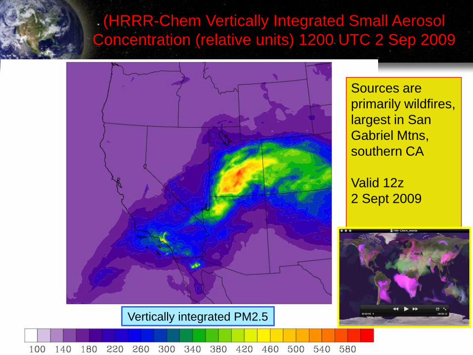
(HRRR-Chem Vertically Integrated Small Aerosol
Concentration (relative units) 1200 UTC 2 Sep 2009
Sources are
primarily wildfires,
largest in San
Gabriel Mtns,
southern CA
Valid 12z
2 Sept 2009
Vertically integrated PM2.5
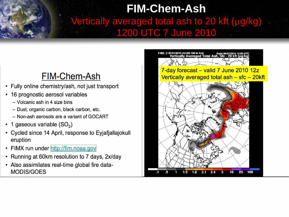
FIM-Chem-Ash Vertically averaged total ash to 20 kft ( g/kg)
1200 UTC 7 June 2010
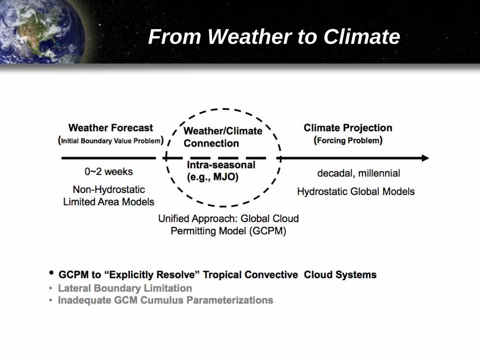
From Weather to Climate
Predictability
Limit for mid-latitude weather systems = two weeks
Why? Sensitivity of forecasts to atmospheric initial conditions
But, longer-range forecasts can be made using predictions from a
fully coupled atmosphere – ocean system
Sources of predictability:
Inertia or “Memory” of a climate variable (e.g., ocean heat content, soil moisture)
Feedbacks between climate variables (e.g., teleconnections, equatorial waves)
External forcing of climate (e.g., volcanoes)
Necessary to improve accuracy of intraseasonal predictions:
Better representation of Madden-Julian Oscillation (MJO) – and other types of
equatorial waves
MJO requires global explicit representation of organized tropical convection
Need fully coupled atmosphere – ocean models

?
Future Outlook for NWP/DA at GSD
The hydrostatic FIM model is a contender for implementation as a member of NCEP global ensemble. A non-hydrostatic, finite volume, icosahedral model (NIM) is under development for study of intraseasonal weather/climate linkages.
FIM contains models for chemistry, ash, ocean. GFS and WRF physics packages are being incorporated into NIM as they have been for FIM. Need to add additional earth system model components and test.
Develop hybrid Ensemble Kalman Filter/4DVAR approaches to data assimilation incorporating continued advances in cloud and precipitation data assimilation.
Implement 3-km HRRR at NCEP by 2013, North American Rapid Refresh Ensemble (NARRE) by 2016, and HRRR Ensemble by 2020.
Develop advanced software engineering tools and GPU computing for managing complex forecast model work flows, assuring fault tolerance for model ensemble reliability, attaining true performance portability across diverse computer architectures, and dramatically increasing computational power.
Lead the DTC Ensemble Testbed – research will include new methods for capturing nonlinear, non-Gaussian analysis errors; estimating forecast error covariance; optimally linking data assimilation and initial ensemble perturbation generation methods; representing model uncertainty; post-processing ensemble members using Bayesian and debiasing techniques.