Embed Size (px)
Citation preview
HMT modeling activitiesHMT modeling activities
Paul Schultz, GSDfor
John McGinley, Isidora Jankov, Huiling Yuan, Linda Wharton,
Steve Albers,
and Dan Birkenheuer
Paul Schultz, GSDfor
John McGinley, Isidora Jankov, Huiling Yuan, Linda Wharton,
Steve Albers,
and Dan Birkenheuer
ESRL theme presentation
November 6, 2008

2
Ensemble Mean Precipitation Forecast 4-5 Jan 2008 00GMT (24 hr forecast ending 5/00GMT): Most intense period
Ensemble Mean Precipitation Forecast 4-5 Jan 2008 00GMT (24 hr forecast ending 5/00GMT): Most intense period
3
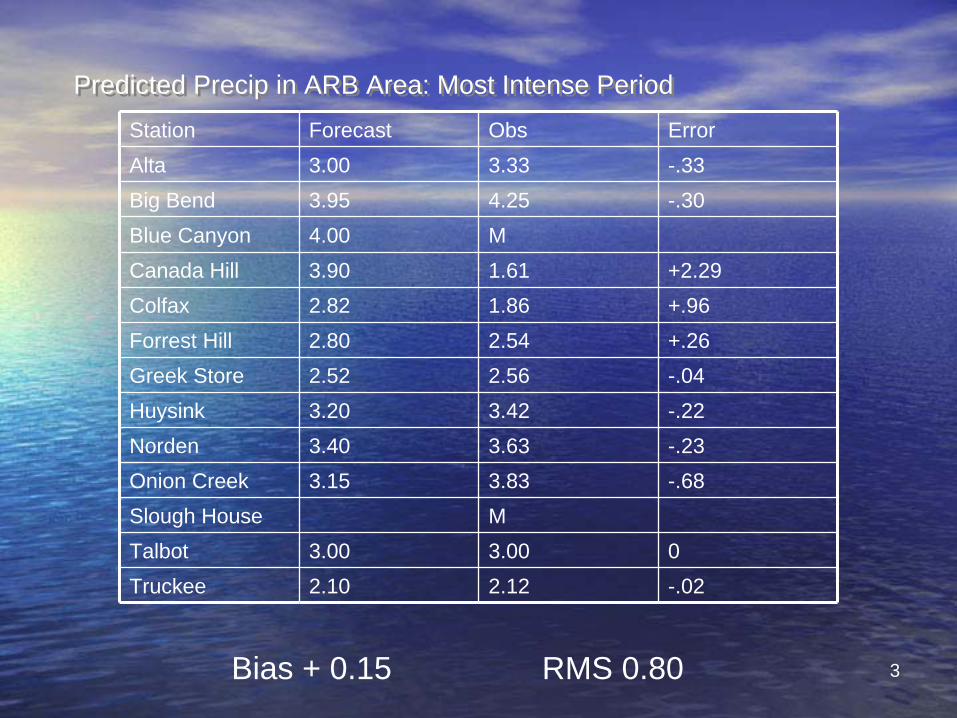
Predicted Precip in ARB Area: Most Intense PeriodPredicted Precip in ARB Area: Most Intense PeriodStation Forecast Obs ErrorAlta 3.00 3.33 -.33Big Bend 3.95 4.25 -.30Blue Canyon 4.00 MCanada Hill 3.90 1.61 +2.29Colfax 2.82 1.86 +.96Forrest Hill 2.80 2.54 +.26Greek Store 2.52 2.56 -.04Huysink 3.20 3.42 -.22Norden 3.40 3.63 -.23Onion Creek 3.15 3.83 -.68Slough House MTalbot 3.00 3.00 0Truckee 2.10 2.12 -.02
Bias + 0.15 RMS 0.80

WRF-NMM cross-section along ARB axis
just prior to heaviest rain: solid colors, temperature (< 0C is darkest green); orange contours -
cloud ice (g/m3); green contours cloud water (g/m3). Melting level clearly seen, with snow reaching the surface on the upper slopes.
WRF-NMM cross-section along ARB axis
just prior to heaviest rain: solid colors, temperature (< 0C is darkest green); orange contours -
cloud ice (g/m3); green contours cloud water (g/m3). Melting level clearly seen, with snow reaching the surface on the upper slopes.
Published resultsPublished results
Yuan, H., J.A. McGinley, P. Schultz, C.J. Anderson, and C. Lu, 2008: Short-
Range Precipitation Forecasts from Time-lagged Multimodel Ensembles during the HMT-West-2006 Campaign. J. Hydrometeor. 7, 477-491.
Jankov, I., P. Schultz, C.J. Anderson, and S.E. Koch, 2007: The impact
of different physical parameterizations and their interactions on cold season QPF in the American River Basin. J. Hydrometeor. 8, 1141-1151.
Jankov, I., Bao, J.-W., P.J. Neiman, P. Schultz, H. Yuan, and A.B. White, 2008:
Evaluation and comparison of microphysical algorithms in WRF-ARW model simulations of atmospheric river events affecting the California
coast. J. Hydrometeor. In press.
Yuan, H., J.A. McGinley, P. Schultz, C.J. Anderson, and C. Lu, 2008: Short-
Range Precipitation Forecasts from Time-lagged Multimodel Ensembles during the HMT-West-2006 Campaign. J. Hydrometeor. 7, 477-491.
Jankov, I., P. Schultz, C.J. Anderson, and S.E. Koch, 2007: The impact
of different physical parameterizations and their interactions on cold season QPF in the American River Basin. J. Hydrometeor. 8, 1141-1151.
Jankov, I., Bao, J.-W., P.J. Neiman, P. Schultz, H. Yuan, and A.B. White, 2008: Evaluation and comparison of microphysical algorithms in WRF-ARW model simulations of atmospheric river events affecting the California
coast. J. Hydrometeor. In press.
New for this winterNew for this winter
•
Migration to CA/DWR focus shifts emphasis
to the RFC problem
–
Less useful for WFOs–
Larger domain, out to 120 hrs
–
Lower spatial, temporal resolution•
∆x = 9 km, was 4 km
•
Output every 3 hrs, was 1 hr–
Four WRF v3 models run every
3 hrs
•
3 microphysics variations of ARW, plus
1 NMM•
Time-lagging to enlarge ensemble
•
LAPS
initialization, GFS lateral boundaries
•
Migration to CA/DWR focus shifts emphasis
to the RFC problem–
Less useful for WFOs
–
Larger domain, out to 120 hrs–
Lower spatial, temporal resolution
•
∆x = 9 km, was 4 km•
Output every 3 hrs, was 1 hr
–
Four WRF v3 models run every
3 hrs•
3 microphysics variations of ARW, plus
1 NMM•
Time-lagging to enlarge ensemble
•
LAPS
initialization, GFS lateral boundaries
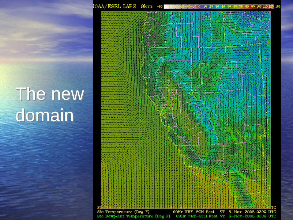
The new domain
The new domain
Similar domain size as the other runsHigher horizontal grid spacing (5 km)Hourly update12-18 hrs forecastLAPS initial conditions radars, satellite, mesonets, profilers, GPS …
GFS/RUC boundary conditions
Plus, a
separate high-res run
to compare to PSD’s moisture flux forecasting tool
Plus, a
separate high-res run
to compare to PSD’s moisture flux forecasting tool
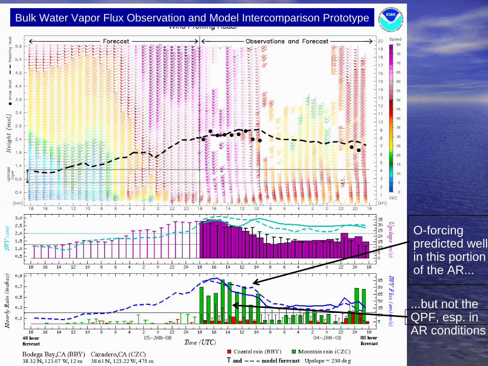
Bulk Water Vapor Flux Observation and Model Intercomparison Prototype
O-forcingpredicted wellin this portionof the AR...
...but not theQPF, esp. inAR conditions
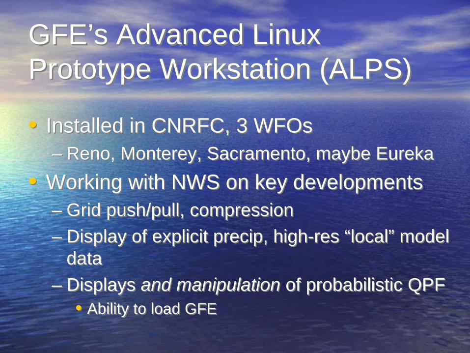
GFE’s Advanced Linux Prototype Workstation (ALPS)
GFE’s Advanced Linux Prototype Workstation (ALPS)
•
Installed in CNRFC, 3 WFOs–
Reno, Monterey, Sacramento, maybe Eureka
•
Working with NWS on key developments–
Grid
push/pull, compression
–
Display of explicit precip, high-res “local”
model data
–
Displays and manipulation of probabilistic QPF•
Ability to load GFE
•
Installed in CNRFC, 3 WFOs–
Reno, Monterey, Sacramento, maybe Eureka
•
Working with NWS on key developments–
Grid
push/pull, compression
–
Display of explicit precip, high-res “local”
model data
–
Displays and manipulation of probabilistic QPF•
Ability to load GFE
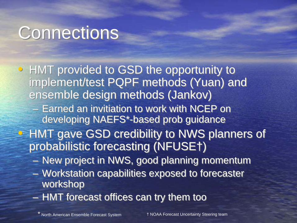
ConnectionsConnections
•
HMT provided to GSD the opportunity to implement/test PQPF methods (Yuan) and ensemble design methods (Jankov)
–
Earned an invitiation to work with NCEP on developing NAEFS*-based prob guidance
•
HMT
gave GSD credibility to NWS planners of probabilistic forecasting (NFUSE†)
–
New project in NWS, good planning momentum–
Workstation capabilities exposed to forecaster workshop
–
HMT forecast offices can try them too
•
HMT provided to GSD the opportunity to implement/test PQPF methods (Yuan) and ensemble design methods (Jankov)–
Earned an invitiation to work with NCEP on developing NAEFS*-based prob guidance
•
HMT
gave GSD credibility to NWS planners of probabilistic forecasting (NFUSE†)–
New project in NWS, good planning momentum
–
Workstation capabilities exposed to forecaster workshop
–
HMT forecast offices can try them too*
North American Ensemble Forecast System †
NOAA Forecast Uncertainty Steering
team
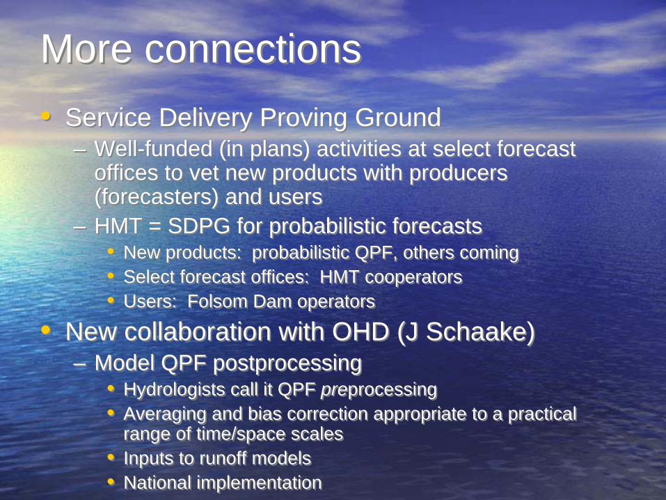
More connectionsMore connections•
Service Delivery Proving Ground–
Well-funded (in plans) activities at select forecast offices to vet new products with producers (forecasters) and users
–
HMT
= SDPG for probabilistic forecasts•
New products: probabilistic
QPF, others coming•
Select forecast offices: HMT cooperators
•
Users: Folsom Dam operators
•
New collaboration with OHD (J Schaake)–
Model QPF postprocessing
•
Hydrologists call it QPF
preprocessing•
Averaging and bias correction appropriate to
a practical range of time/space scales
•
Inputs to runoff models•
National implementation
•
Service Delivery Proving Ground–
Well-funded (in plans) activities at select forecast offices to vet new products with producers (forecasters) and users
–
HMT
= SDPG for probabilistic forecasts•
New products: probabilistic
QPF, others coming•
Select forecast offices: HMT cooperators
•
Users: Folsom Dam operators
•
New collaboration with OHD (J Schaake)–
Model QPF postprocessing
•
Hydrologists call it QPF
preprocessing•
Averaging and bias correction appropriate to
a practical range of time/space scales
•
Inputs to runoff models•
National implementation

EFREP Tiered Modeling Effort (0-5 days)EFREP Tiered Modeling Effort (0-5 days)
Observation-based Forecasting TechniquesNational Product Suite
Experimental Hi-Res/Down Scaled ModelingBasic Model Verification
Reforecasting
Techniques
Distributed (NWS) Hi-Res Local Models/HardwareNational (low res) and Experimental (hi-res)
Probabilistic Forecasts/Hydro forecastsAdvanced Data Assimilation of HMT observations
Probabilistic Hydro ForecastsData Assimilation of Offshore
ObservationsHydro-forecast linking to FBO Decisions
FBOWeather /
Hydro-drivenOperational
System