Embed Size (px)
Citation preview
MIT ICATMIT ICAT
DECISION-SUPPORT FOR ENHANCING AVIATION WEATHER INFORMATION SYSTEMS AND SAFETY
MIT ICATMIT ICAT
DECISION-SUPPORT FOR ENHANCING AVIATION WEATHER INFORMATION SYSTEMS AND SAFETY
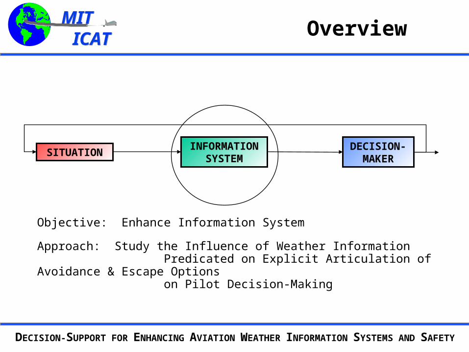
Overview
SITUATIONDECISION-
MAKERINFORMATION
SYSTEM
Objective: Enhance Information System
Approach: Study the Influence of Weather Information Predicated on Explicit Articulation of Avoidance & Escape Options on Pilot Decision-Making
MIT ICATMIT ICAT
DECISION-SUPPORT FOR ENHANCING AVIATION WEATHER INFORMATION SYSTEMS AND SAFETY
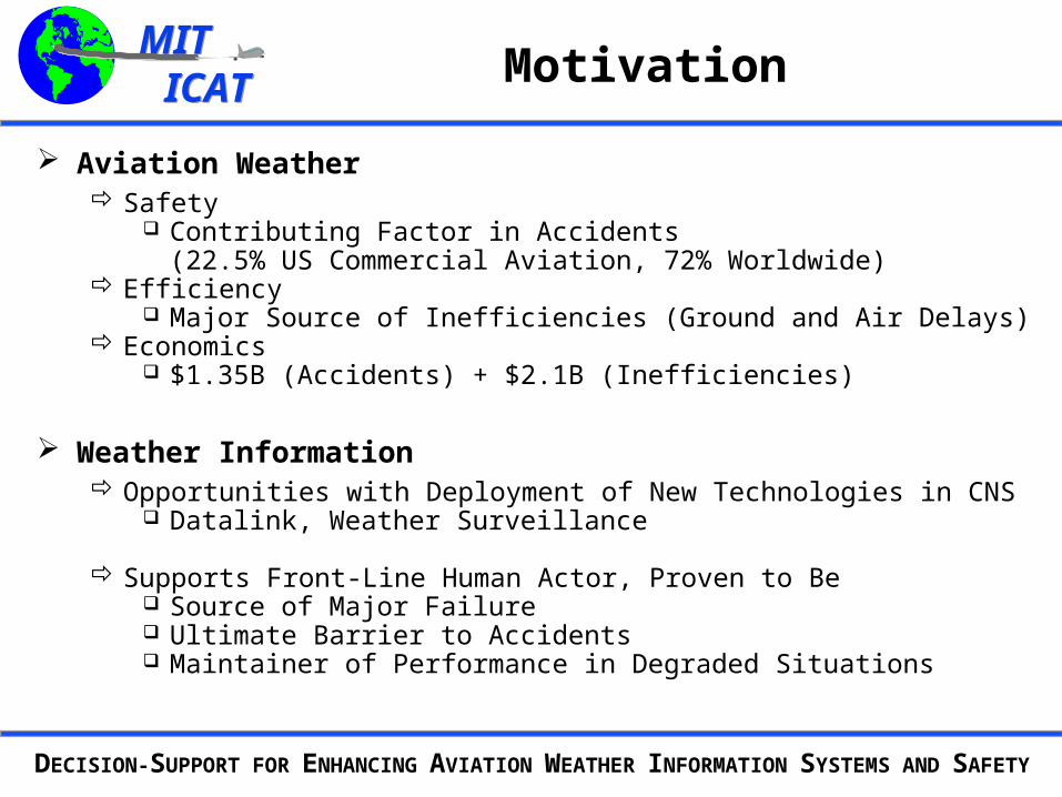
Motivation
Aviation Weather Safety
Contributing Factor in Accidents(22.5% US Commercial Aviation, 72% Worldwide)
Efficiency Major Source of Inefficiencies (Ground and Air Delays)
Economics $1.35B (Accidents) + $2.1B (Inefficiencies)
Weather Information Opportunities with Deployment of New Technologies in CNS
Datalink, Weather Surveillance
Supports Front-Line Human Actor, Proven to Be Source of Major Failure Ultimate Barrier to Accidents Maintainer of Performance in Degraded Situations
MIT ICATMIT ICAT
DECISION-SUPPORT FOR ENHANCING AVIATION WEATHER INFORMATION SYSTEMS AND SAFETY
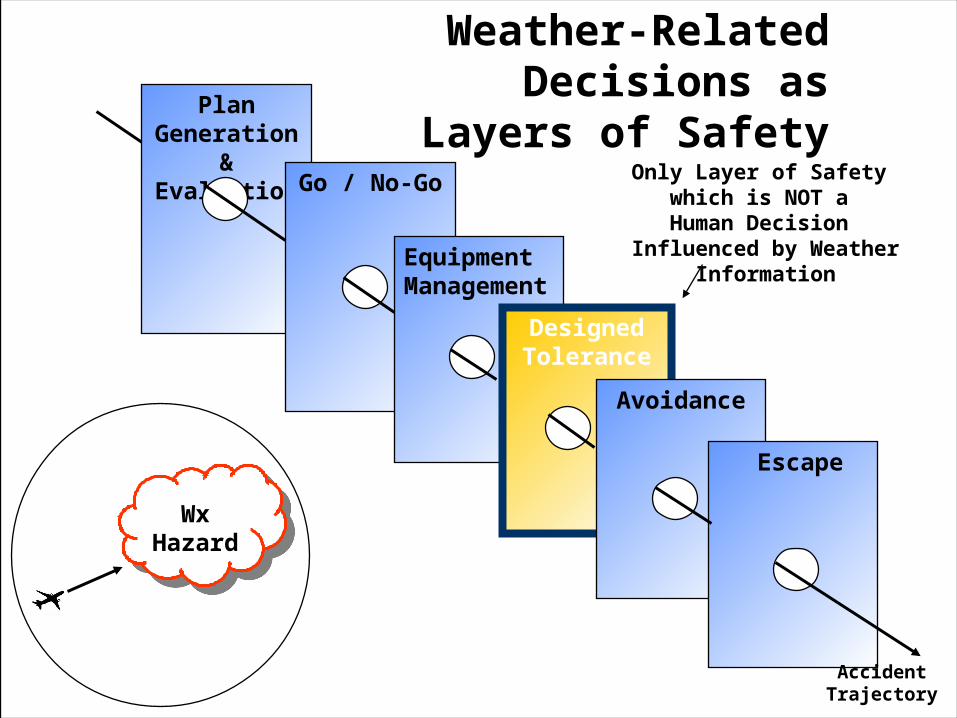
Plan Generation
& EvaluationGo / No-Go
Equipment Management
DesignedTolerance
Weather-Related Decisions asLayers of Safety
Avoidance
Escape
Accident Trajectory
Only Layer of Safety which is NOT a
Human Decision Influenced by Weather Information
WxHazard
MIT ICATMIT ICAT
DECISION-SUPPORT FOR ENHANCING AVIATION WEATHER INFORMATION SYSTEMS AND SAFETY
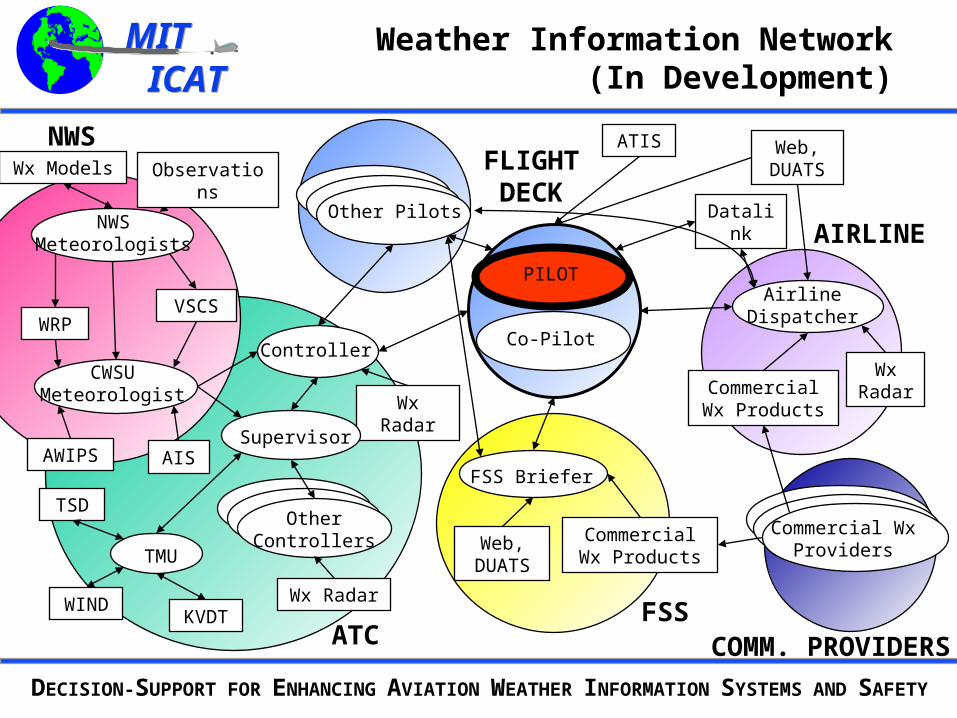
PILOTAirline
Dispatcher
Controller
FSS Briefer
Datalink
Web, DUATS
Wx Radar
Wx Radar
Other Pilots
Co-Pilot
Supervisor
OtherControllers
ATIS
CWSU Meteorologist
WRP
AWIPS AIS
VSCS
Commercial Wx Products
Wx Radar
Commercial Wx Products
Web, DUATS
Commercial Wx Providers
NWSMeteorologists
Weather Information Network (In Development)
TMU
KVDT
TSD
WIND
NWS
ATCFSS
AIRLINE
FLIGHTDECK
COMM. PROVIDERS
ObservationsWx Models
MIT ICATMIT ICAT
DECISION-SUPPORT FOR ENHANCING AVIATION WEATHER INFORMATION SYSTEMS AND SAFETY
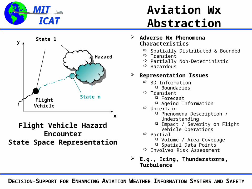
Aviation Wx Abstraction
x
y
Flight Vehicle Hazard EncounterState Space Representation
State 1
State n
Hazard
Flight Vehicle
Adverse Wx Phenomena Characteristics Spatially Distributed & Bounded Transient Partially Non-Deterministic Hazardous
Representation Issues 3D Information
Boundaries Transient
Forecast Ageing Information
Uncertain Phenomena Description /
Understanding Impact / Severity on Flight Vehicle
Operations Partial
Volume / Area Coverage Spatial Data Points
Involves Risk Assessment
E.g., Icing, Thunderstorms, Turbulence

MIT ICATMIT ICAT
DECISION-SUPPORT FOR ENHANCING AVIATION WEATHER INFORMATION SYSTEMS AND SAFETY
Problem Statement
Weather Information Can Take Multiple Forms Inform on Exposure to Hazard, or Risk [Certainty x Severity]? Support Routing Optimization Based on Seeing and Avoiding Threat in Field? Support Avoidance and Escape Evaluation?
Investigate Decision-Support Model Predicated on Escape Plan Value of Information About Non-Hazard Areas
(Vigeant-Langlois & Hansman, 2000)
Value in Supporting Option-Based Decision-Making (Dershowitz, 1997)
Technically Easier to Detect Hazard-Free Space with High Confidence
If True, Can Pose “No-Safe-Escape” Avoidance Problem
Draw Analogy Between “Soft” and “Hard” Hazard Avoidance(Kuchar, 1995; Yang, 2000)
MIT ICATMIT ICAT
DECISION-SUPPORT FOR ENHANCING AVIATION WEATHER INFORMATION SYSTEMS AND SAFETY
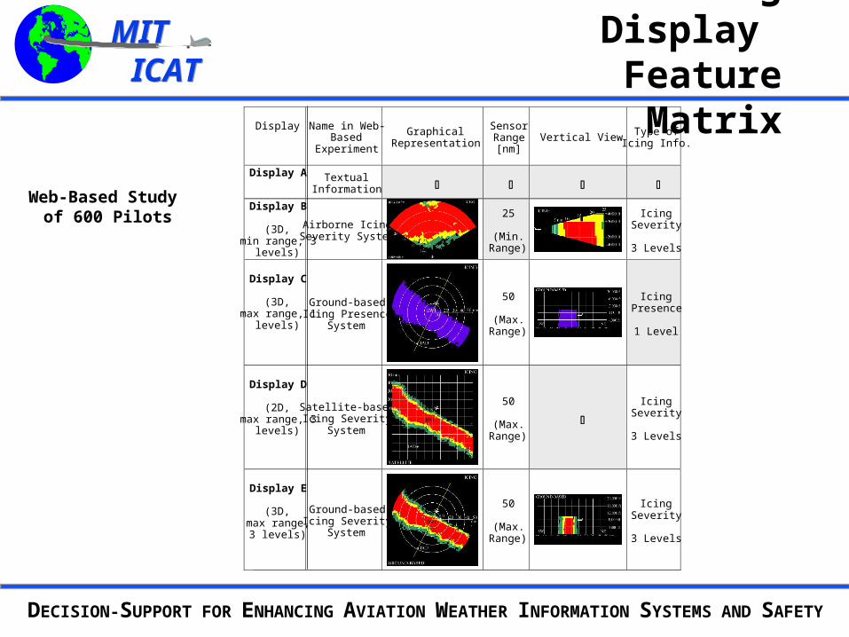
Icing Display Feature Matrix
Display Name in Web-Based
Experiment
GraphicalRepresentation
SensorRange[nm]
Vertical View Type ofIcing Info.
Display A TextualInformation
Display B
(3D,min range, 3
levels)
Airborne IcingSeverity System
25
(Min.Range)
IcingSeverity
3 Levels
Display C
(3D,max range, 1
levels)
Ground-basedIcing Presence
System
50
(Max.Range)
IcingPresence
1 Level
Display D
(2D,max range, 3
levels)
Satellite-basedIcing Severity
System
50
(Max.Range)
IcingSeverity
3 Levels
Display E
(3D,max range,3 levels)
Ground-basedIcing Severity
System
50
(Max.Range)
IcingSeverity
3 Levels
Web-Based Study of 600 Pilots
MIT ICATMIT ICAT
DECISION-SUPPORT FOR ENHANCING AVIATION WEATHER INFORMATION SYSTEMS AND SAFETY
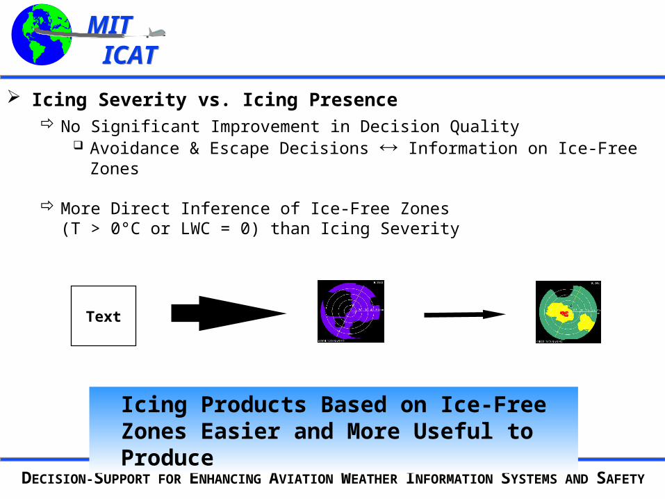
Icing Severity vs. Icing Presence No Significant Improvement in Decision Quality
Avoidance & Escape Decisions Information on Ice-Free Zones
More Direct Inference of Ice-Free Zones (T > 0°C or LWC = 0) than Icing Severity
Icing Products Based on Ice-Free Zones Easier and More Useful to Produce
Text
MIT ICATMIT ICAT
DECISION-SUPPORT FOR ENHANCING AVIATION WEATHER INFORMATION SYSTEMS AND SAFETY
Problem Statement
Weather Information Can Take Multiple Forms Inform on Exposure to Hazard, or Risk [Certainty x Severity]? Support Routing Optimization Based on Seeing and Avoiding Threat in Field? Support Avoidance and Escape Evaluation?
Investigate Decision-Support Model Predicated on Escape Plan Value of Information About Non-Hazard Areas
(Vigeant-Langlois & Hansman, 2000)
Value in Supporting Option-Based Decision-Making (Dershowitz, 1997)
Technically Easier to Detect Hazard-Free Space with High Confidence
If True, Can Pose “No-Safe-Escape” Avoidance Problem
Draw Analogy Between “Soft” and “Hard” Hazard Avoidance(Kuchar, 1995; Yang, 2000)
MIT ICATMIT ICAT
DECISION-SUPPORT FOR ENHANCING AVIATION WEATHER INFORMATION SYSTEMS AND SAFETY
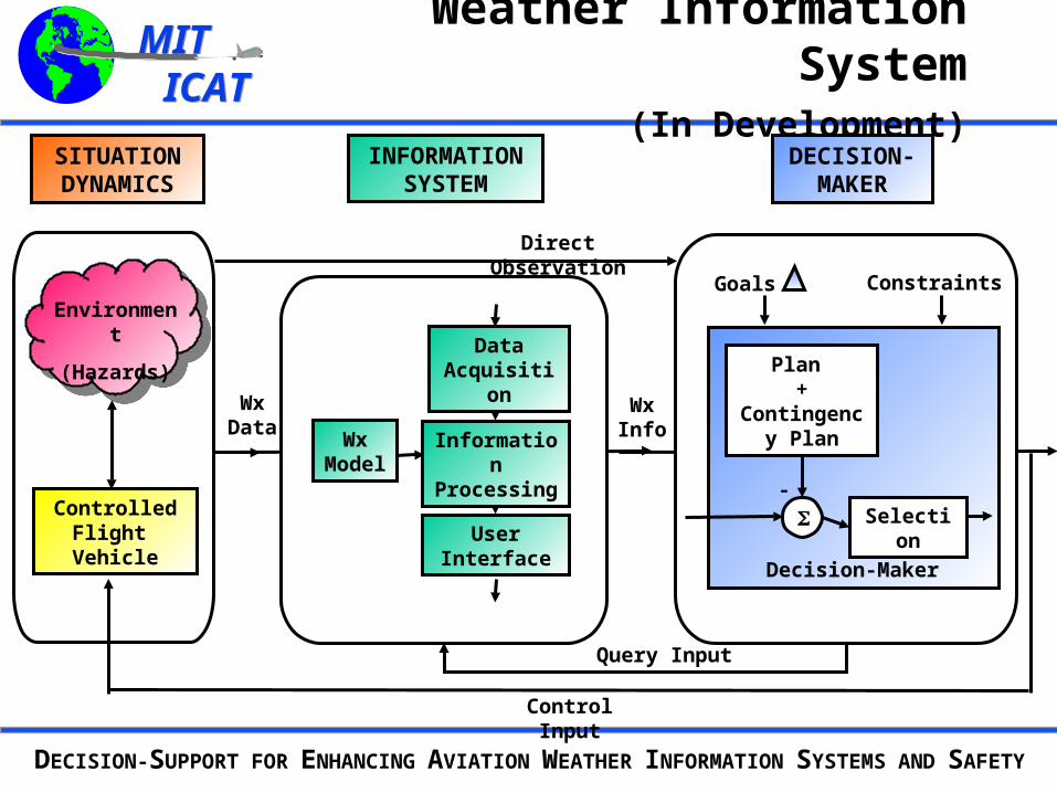
Weather Information System (In Development)
SelectionControlled Flight Vehicle
Environment
(Hazards)Plan
+ Contingency
Plan
Query Input
-
Control Input
Decision-Maker
SITUATION DYNAMICS
DECISION-MAKER
INFORMATION SYSTEM
Goals
Direct Observation
User Interface
Constraints
WxInfo
WxData
Wx Model
DataAcquisition
Information Processing
MIT ICATMIT ICAT
DECISION-SUPPORT FOR ENHANCING AVIATION WEATHER INFORMATION SYSTEMS AND SAFETY
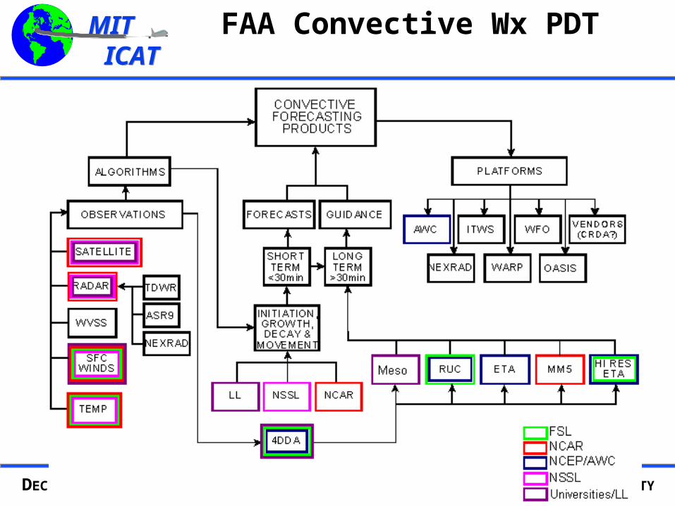
FAA Convective Wx PDT
MIT ICATMIT ICAT
DECISION-SUPPORT FOR ENHANCING AVIATION WEATHER INFORMATION SYSTEMS AND SAFETY
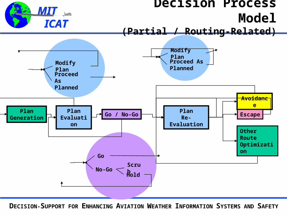
Decision Process Model(Partial / Routing-Related)
Go
No-GoHold
Scrub
Avoidance
PlanEvaluation
PlanGeneration
Go / No-Go
Other RouteOptimization
EscapePlan
Re-Evaluation
Modify Plan
Proceed As Planned
Modify Plan
Proceed As Planned
MIT ICATMIT ICAT
DECISION-SUPPORT FOR ENHANCING AVIATION WEATHER INFORMATION SYSTEMS AND SAFETY
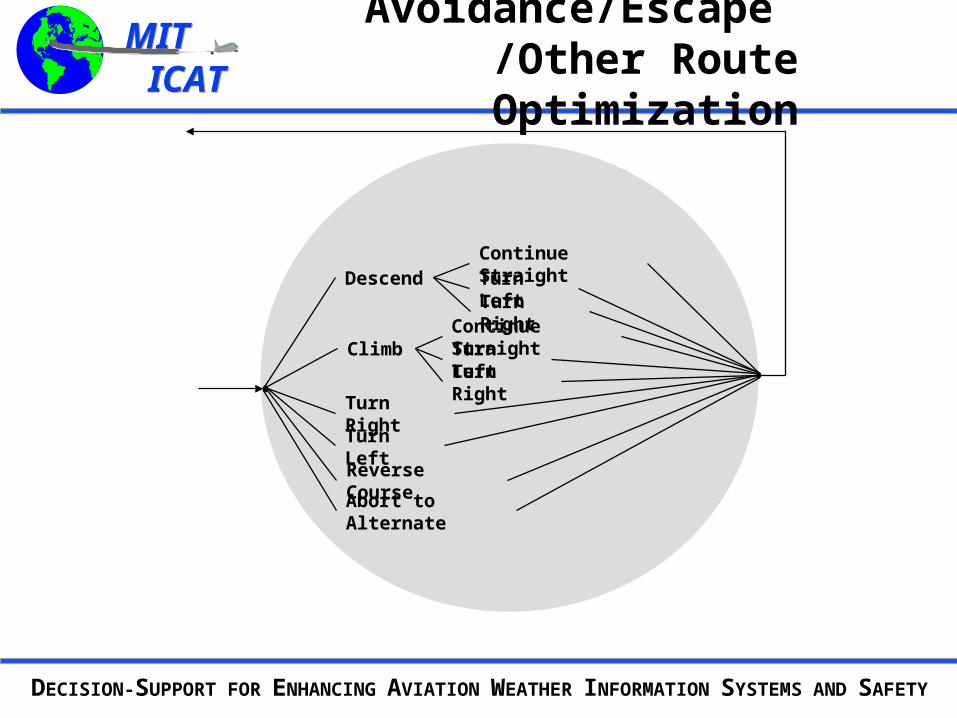
Avoidance/Escape /Other Route Optimization
Abort to Alternate
Turn Right
Reverse Course
Turn Left
Climb
DescendTurn RightTurn Left
Turn RightTurn LeftContinue Straight
Continue Straight
MIT ICATMIT ICAT
DECISION-SUPPORT FOR ENHANCING AVIATION WEATHER INFORMATION SYSTEMS AND SAFETY
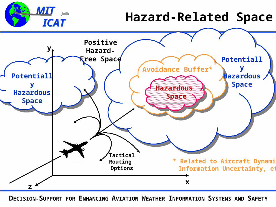
Hazard-Related Space
x
y
z
TacticalRouting Options
Positive Hazard-Free
Space
Hazardous Space
Potentially Hazardous
SpacePotentially Hazardous
Space
Avoidance Buffer*
* Related to Aircraft Dynamics, Information Uncertainty, etc.
MIT ICATMIT ICAT
DECISION-SUPPORT FOR ENHANCING AVIATION WEATHER INFORMATION SYSTEMS AND SAFETY
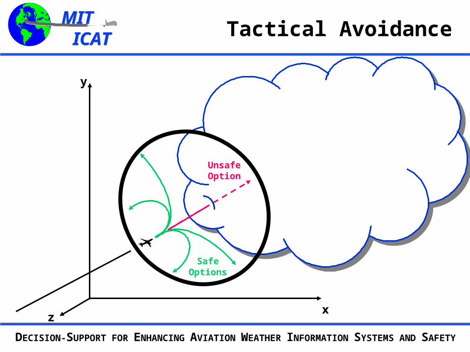
Tactical Avoidance
x
y
z
Safe Options
Unsafe Option
MIT ICATMIT ICAT
DECISION-SUPPORT FOR ENHANCING AVIATION WEATHER INFORMATION SYSTEMS AND SAFETY
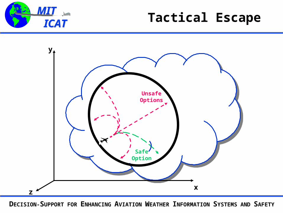
Tactical Escape
x
y
z
Safe Option
Unsafe Options
MIT ICATMIT ICAT
DECISION-SUPPORT FOR ENHANCING AVIATION WEATHER INFORMATION SYSTEMS AND SAFETY
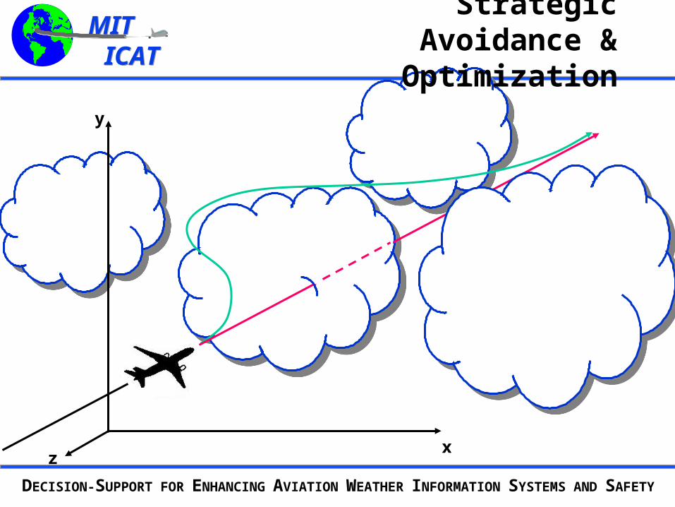
Strategic Avoidance & Optimization
x
y
z
MIT ICATMIT ICAT
DECISION-SUPPORT FOR ENHANCING AVIATION WEATHER INFORMATION SYSTEMS AND SAFETY
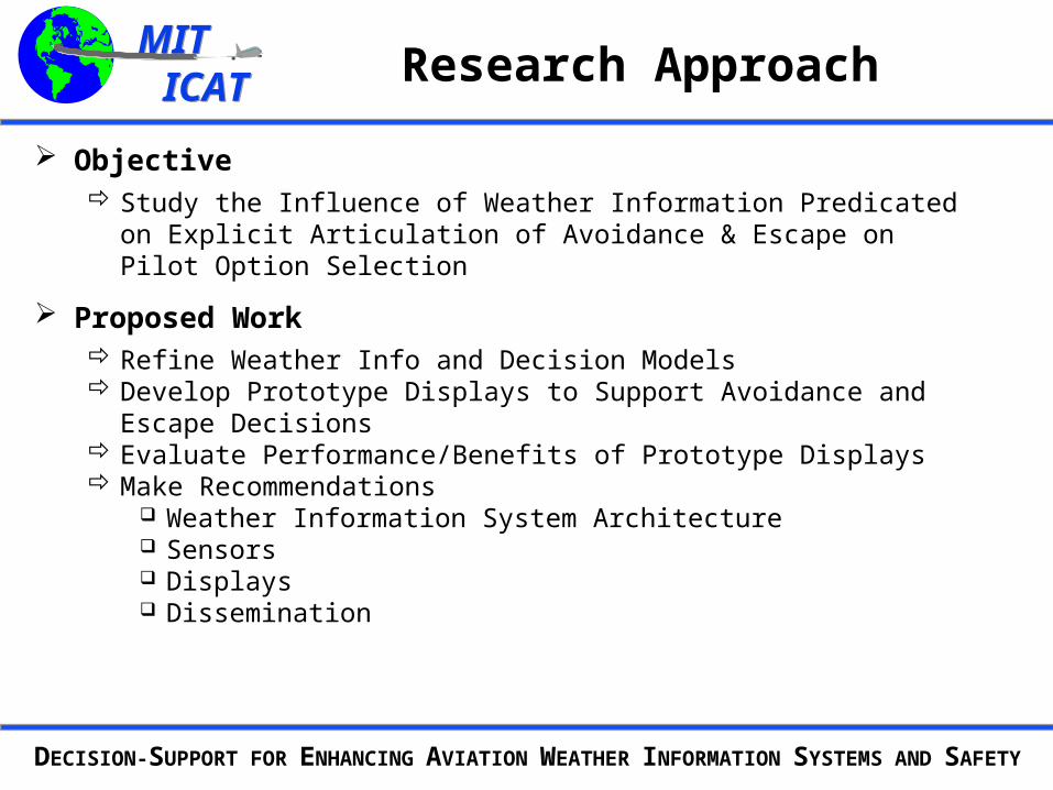
Research Approach
Objective Study the Influence of Weather Information Predicated on Explicit
Articulation of Avoidance & Escape on Pilot Option Selection
Proposed Work Refine Weather Info and Decision Models Develop Prototype Displays to Support Avoidance and Escape Decisions Evaluate Performance/Benefits of Prototype Displays Make Recommendations
Weather Information System Architecture Sensors Displays Dissemination
MIT ICATMIT ICAT
DECISION-SUPPORT FOR ENHANCING AVIATION WEATHER INFORMATION SYSTEMS AND SAFETY