Embed Size (px)
Citation preview
State Geospatial Data Coordination Procedure MINNESOTA October 2014

State Geospatial Data Coordination Procedure
Minnesota
Table of Contents Table of Contents ................................................................................................................................ i Purpose of the Procedure .................................................................................................................... 1 Default Flood Hazard Base Map for the State .................................................................................... 1 Geospatial Data Coverage .................................................................................................................. 1 Datasets for DFIRM Production ......................................................................................................... 2
Orthophotos .............................................................................................................................. 2 Transportation (roads, railroads, and airports) ......................................................................... 3 Hydrography (rivers, streams, lakes, and shorelines) .............................................................. 5 Political boundaries (county, municipal) ................................................................................. 6 Publicly owned lands (national, state, and local parks, forests, etc) ........................................ 8 Public land survey system (PLSS) (township and section lines) ............................................. 9 Cadastral (parcels) ................................................................................................................... 9 Terrain (elevation) ................................................................................................................. 10
Useful Risk MAP Discovery Data Sources ...................................................................................... 11 Data Distribution Process for State Data .......................................................................................... 14 Federal Nationwide Geospatial Data Holdings ................................................................................ 15 Finding and Accessing Other Existing Geospatial Data .................................................................. 15
Clearinghouses and Inventories for the State ......................................................................... 15 National Digital Orthophoto Program (NDOP) and National Digital Elevation Program
(NDEP) Tracking Systems .......................................................................................... 16 TED Query Tool .................................................................................................................... 16 Geospatial One-Stop .............................................................................................................. 16
Working with People ........................................................................................................................ 17 Useful State and Federal Contacts ......................................................................................... 17 Involving the State’s Geospatial Coordinator in Flood Studies ............................................. 17 State Coordination Process for Building Geospatial Partnerships ......................................... 17 Finding Local Geospatial Contacts ........................................................................................ 18
Provide Feedback on This Procedure ............................................................................................... 18
May 2014 i State Geospatial Data Coordination Procedure
State Geospatial Data Coordination Procedure
May 2014 ii State Geospatial Data Coordination Procedure
State Geospatial Data Coordination Procedure
Purpose of the Procedure
Flood insurance studies search for geospatial data during pre-scoping and scoping tasks. If needed data are not available, studies might fund the collection of new data and would like to know about other organizations that might share in these costs. Detailed information about the role of geospatial data coordination plays in studies is in the Geospatial Data Coordination Implementation Guide, which is available at https://hazards.fema.gov/femaportal/docs/GeoDataImplem_V3.pdf, and in Scoping Guidelines: Pre-scoping and the Scoping Meeting, which is available through the Regional Support Center (RSC).
Resources developed through FEMA’s geospatial data coordination activities provide information about data and contacts for organizations that have geospatial data that cover large areas (like states) in which many studies are initiated. Studies can avoid wasting time with dead-end searches and cold calls by starting with these proven sources of information.
One resource is this Geospatial Data Coordination Procedure. It outlines sources of geospatial data and contact information, preferences for base map data and state geospatial participation in studies, and other useful information for the State.
If you have questions about this procedure or other geospatial data coordination resources, contact the geospatial data coordination lead in your Regional Support Center:
Brian Killen, Geospatial Data Coordination Lead Region V Service Center (312) 262-2283 [email protected]
Default Flood Hazard Base Map for the State
The default base map for flood hazard maps for the State is an image base map (orthophoto).
Geospatial Data Coverage
Find below the information about and links to statewide (and Federal agencies’ national) geospatial datasets. The list is provided to save time during pre-scoping and scoping activities when building a list of candidate geospatial datasets available for the study; it is not a prescription of datasets that must be used in a flood insurance study.
May 2014 1 State Geospatial Data Coordination Procedure
State Geospatial Data Coordination Procedure
Datasets for DFIRM Production
Orthophotos Dataset name: Farm Service Agency (FSA) Color Orthophotos 2003-2004. Data currentness: 2003-2004, some 2010 photos are becoming available Accuracy/Scale: Within 5 meters of the reference USGS digital orthophotos (1-meter resolution, 1991-92). Ground sample resolution: 1 meter resolution. Horizontal datum: NAD 83 Fee associated? No. Available for redistribution? Yes Dataset source: Land Management Information Center, DNR Metadata: http://www.mngeo.state.mn.us/chouse/metadata/naip09.html Data download: See http://www.mngeo.state.mn.us/chouse/airphoto/index.html for many options to obtain this data. The WMS service option is highly recommended, but the files are also available for download as ECW-compressed tiles and MrSID county tiles. Dataset contact: Nancy Rader, GIS Data Coordinator, Minnesota Geospatial Information Office, 658 Cedar Street, St. Paul, MN 55155; (651) 201-2489; [email protected] Notes: NAIP imagery has many uses, and many states participate in NAIP. NAIP is leaf-on imagery and is not cloud-free, and so the ground might be obscured. So, while NAIP (and other such imagery) can be used as a base maps, the imagery must be checked to ensure that it provides a clear view of important features on the ground for areas of significance for flooding (see Appendix C of the Geospatial Data Coordination Implementation Guide for more discussion). Dataset name: U.S. Geological Survey Orthophotos 1991-92. Data currentness: 1991-92. Accuracy/Scale: USGS Digital Orthophoto standards; http://rockyweb.cr.usgs.gov/nmpstds/doqstds.html Ground sample resolution: 1 meter resolution Horizontal datum: NAD 83 Fee associated? No Available for redistribution? Yes Dataset source: Land Management Information Center Metadata: http://www.mngeo.state.mn.us/chouse/metadata/doq.html Data download: WMS service: http://www.mngeo.state.mn.us/chouse/wms/wms_image_server_description.html Dataset contact: Nancy Rader, GIS Data Coordinator, Minnesota Geospatial Information Office, 658 Cedar Street, St. Paul, MN 55155; (651) 201-2489; [email protected]
• For more information on other sources of air photos for Minnesota, either currently
available or planned, see MnGeo’s Aerial Photography first-stop information webpage at http://www.mngeo.state.mn.us/chouse/airphoto/index.html For example, the Minnesota DNR provides color-infrared photography for the forested areas of the state,
May 2014 2 State Geospatial Data Coordination Procedure
State Geospatial Data Coordination Procedure
and also scanned historical photography. Also, there is higher-resolution photography available for the Twin Cities metropolitan area from several different years.
• MnGeo’s Statewide Elevation and Imagery Inventory: http://www.mngeo.state.mn.us/SEII/
Transportation (roads, railroads, and airports) Dataset name: Mn/DOT Basemap Roads – All Types (county data sets) Data currentness: Basemap roads data is current through 1/1/2004 Accuracy/Scale: The Mn/DOT Basemap Roads originally contained roadway centerlines for roads found on the USGS 1:24,000-scale quadrangle maps; updated information has been provided by Mn/DOT and local agencies. Horizontal datum: NAD 83 Fee associated? No Available for redistribution? Yes Are road names part of the dataset? Yes Dataset source: Minnesota Dept of Transportation: Data download: http://www.dot.state.mn.us/maps/gisbase/html/county_text.html Dataset contact: Bob Wolbeck, Mn/DOT BaseMap Coordinator (Data Content), Geographic Information and Mapping Section, Office of Transportation Data and Analysis, Mn Department of Transportation, 395 John Ireland Blvd, Mail Stop 450, St. Paul, MN 55155. Phone: 651-215-1973; [email protected] Notes: These are are also viewable using an interactive mapping tool at: http://www.dot.state.mn.us/maps/gisweb/ Dataset name: Mn/DOT Basemap Railroads, Runways, Navigable Waterways (3 statewide data sets) Data currentness: These datasets are current through early 2003 Accuracy/Scale: These layers contain railroad and runway arcs originally found on the USGS 1:24,000-scale quadrangle maps, and navigable waterway arcs originally provided by the U.S. Army Corps of Engineers. Updated information has been provided by Mn/DOT and local agencies. Horizontal datum: NAD 83. Fee associated? No. Available for redistribution? Yes Are names part of the datasets? Yes Dataset source: Minnesota Dept of Transportation Data download: http://www.dot.state.mn.us/maps/gisbase/html/statewide.html Dataset contact: Bob Wolbeck, Mn/DOT BaseMap Coordinator (Data Content), Geographic Information and Mapping Section, Office of Transportation Data and Analysis, Mn Department of Transportation, 395 John Ireland Blvd, Mail Stop 450, St. Paul, MN 55155. Phone: 651-215-1973; [email protected] Notes: These are are also viewable using an interactive mapping tool at http://www.dot.state.mn.us/maps/gisweb/ . The dataset dates on the download page (1/10/06) indicate that the data may be newer than indicated by the metadata. Dataset name: Mn/DOT Official County Highway Map – Georeferenced Image files
May 2014 3 State Geospatial Data Coordination Procedure
State Geospatial Data Coordination Procedure
Data currentness: County Highway Map data is 2002 for Mn DOT core concerns (roads, railroads, airports, and city boundaries); all other map features (farms, industrial sites, recreation site, pipelines, high voltage transmission lines, etc.) are 1979. Accuracy/Scale: The DOT Basemap Roads contain roadway centerlines for roads found on the USGS 1:24,000-scale quadrangle maps, with updates from Mn/DOT and local agencies. The DOT Official County Highway Map is produced by combining GIS layers and exporting the map, creating an image product. The 2002 Map Series images were georeferenced. Horizontal datum: NAD 83. Fee associated? No. Available for redistribution? Yes Are road names part of the dataset? Image file only – names are on image. Dataset source: Mn/Dept of Transportation and LMIC Data Download: http://www.dot.state.mn.us/maps/gisbase/html/statewide.html Dataset contact: Richard Schlosser, Geographic Informaiton and Mapping Unit, Mn Dept of Transportation, MN 642, Transportation Building, John Ireland Blvd, St. Paul, MN, 55155. 651-296-5131 [email protected] Notes: Individual GIS Layers used to create these maps are available from Mn/DOT Basemap page: http://www.dot.state.mn.us/tda/basemap/index.html **PDF versions of the County Highway Map and City Highway Map sheets updated to 2006 are available from: http://www.dot.state.mn.us/tda/html/GIM.html . There are no corresponding downloadable georeferenced image maps. Dataset name: The Lawrence Group (TLG) Street Centerlines and Address Ranges. Data currentness: 12/1/2006 Accuracy/Scale: This street centerline and address range dataset for the Twin Cities Metropolitan Area and beyond includes the Minnesota counties of Anoka, Benton, Blue Earth, Carlton, Carver, Chisago, Dakota, Goodhue, Hennepin, Isanti, LeSueur, McLeod, Morrison, Olmsted, Ramsey, Rice, St. Louis, Scott, Sherburne, Stearns, Washington and Wright; as well as the western portions of the three Wisconsin counties of Pierce, Polk, and St. Croix. Dataset was created using multiple reference sources – see metadata. Horizontal datum: NAD 83. Fee associated? MetroGIS Endorsed dataset – available via license only Available for redistribution? No Are road names part of the dataset? Yes Dataset source: The Lawrence Group and MetroGIS Metadata: http://www.datafinder.org/metadata/tlg_roads.htm Data download (via license only): http://www.metrogis.org/data/datasets/street_centerlines/order_info/index.shtml Dataset contact: Non-MN Public Users: Jim Maxwell VP - GIS Services, The Lawrence Group, 1328 Helmo Avenue North, Oakdale, Minnesota 55128, Phone: 612-676-3950, [email protected] Minnesota Public Users: GIS Administrative Assistant, Metropolitan Council, 390 Robert Street North, St. Paul, Minnesota 55101-1805, 651-602-1363, [email protected]
May 2014 4 State Geospatial Data Coordination Procedure
State Geospatial Data Coordination Procedure
Notes: Same date, same distribution restrictions, see also: TLG Landmarks Data Set http://www.datafinder.org/metadata/tlg_landmarks.htm Notes: Some local road data is submitted to Mn/DOT for use in updating the state BaseMap data. For information on other county Transportation GIS holdings contact the counties directly. For county GIS contacts see http://www.mngeo.state.mn.us/cty_contacts.html. County E-911 activities may also have data.
Hydrography (rivers, streams, lakes, and shorelines) Dataset name: High-Resolution National Hydrography Dataset (NHD) for Minnesota Data currentness: Streams linework originally based on 1:24,000-scale USGS quadrangle maps; lakes linework based on National Wetlands Inventory; updates are ongoing; last updates 1/30/2007 (MN site) Accuracy/Scale: 1:24,000-scale; based on linework on USGS 1:24,000-scale quadrangle maps; lakes linework based on NWI open water and fringe wetlands categories; streams and lakes are integrated; wetlands (swamp/marsh category of waterbody) not included. Updates made by referring to various sources incl. 1991 DOQ and 2003 FSA imagery, local information. In Minnesota the DNR 24K Streams and Lakes layers (described below) became the basis for the high-resolution NHD. Horizontal datum: NAD 83. Fee associated? No. Available for redistribution? Yes Are hydrography names part of the dataset? Yes Dataset source: United States Geological Survey (& Mn partners) Metadata: (Mn): http://www.mngeo.state.mn.us/chouse/metadata/nhd_24k.html Data Download (USGS): http://nhd.usgs.gov Data Download (Mn): http://geoserver2.lmic.state.mn.us/nhdgeo_minn/viewer.htm Dataset contact: (Mn): Susanne Maeder, Land Management Information Center, Mn Dept of Administration, 658 Cedar Street, Suite 300, St. Paul, MN 55155 651-201-2488 [email protected] Dataset name: DNR 24K Streams; DNR 24K Lakes; Data currentness: Various Accuracy/Scale: The DNR 24K Streams data is 1:24,000-scale scale captured from USGS seven and one-half minute quadrangle maps. The DNR 24K Lakes are derived from the National Wetlands Inventory (NWI) polygons (open water and fringe wetlands – approximating Circular 39 category 5 wetlands) and MnDOT Basemap, and integrated with the DNR 24K Streams layer. Southeastern Minnesota streams linework was updated by DNR Fisheries to realign streams to the 1991 DOQ. Horizontal datum: NAD 83. Fee associated? No. Available for redistribution? Yes Are hydrography names part of the dataset? Partial Dataset source: Minnesota DNR
May 2014 5 State Geospatial Data Coordination Procedure
State Geospatial Data Coordination Procedure
Metadata: http://deli.dnr.state.mn.us/metadata/strm_baseln3.html – DNR 24K Streams http://deli.dnr.state.mn.us/metadata/lake_openwpy3.html – DNR 24K Lakes Data download: http://deli.dnr.state.mn.us/index.html Dataset contact: Hal Watson (Data Content), GIS Database Administrator, Minnesota DNR-MIS Bureau, 500 Lafayette Road, Saint Paul, MN 55155; (651) 259-5508; [email protected] Dataset name: Public Waters Inventory (PWI) Basin Delineations Data currentness: not stated Accuracy/Scale: Based on NWI Open Water and fringe wetland features, also based on DNR legal Public Waters Inventory maps – DNR used NWI, imagery, etc to approximate named, mapped wetland and lake features on DNR Public Waters Inventory base maps. Horizontal datum: NAD 83 Fee associated? No. Available for redistribution? Yes Are hydrography names part of the dataset? Yes Dataset source: Minnesota DNR Metadata: http://deli.dnr.state.mn.us/metadata/pwi_lakepy3.html Data download: http://deli.dnr.state.mn.us/index.html Dataset contact: Hal Watson (Data Content), GIS Database Administrator, Minnesota DNR-MIS Bureau, 500 Lafayette Road, Saint Paul, MN 55155; (651) 259-5508; [email protected] Dataset name: National Wetlands Inventory (NWI) Wetlands Data currentness: 1970s and1980s Accuracy/Scale: Compiled from multiple sources onto a USGS 1:24,000-scale quadrangle map base. Horizontal datum: NAD 83 Fee associated? No Available for redistribution? Yes Are hydrography names part of the dataset? No Dataset source: U S Fish and Wildlife Service. National Data Download: http://www.fws.gov/wetlands/Data/DataDownload.html Minnesota Data Download: Minnesota DNR Metadata: http://deli.dnr.state.mn.us/metadata/wetl_nwipy3.html Data download: http://deli.dnr.state.mn.us/index.html Dataset contact: (Mn) Hal Watson (Data Content), GIS Database Administrator, Minnesota DNR-MIS Bureau, 500 Lafayette Road, Saint Paul, MN 55155; (651) 259-5508; [email protected] Notes: There are issues with NWI in NE part of the state; some incorrect interpretations have been noted.
Political boundaries (county, municipal) Dataset name: 2000 Minnesota Counties Data currentness: 2000 Accuracy/Scale: From U.S. Census TIGER data Horizontal datum: NAD 83
May 2014 6 State Geospatial Data Coordination Procedure
State Geospatial Data Coordination Procedure
Fee associated? No. Available for redistribution? Yes. Dataset source: Land Management Information Center; http://www.lmic.state.mn.us/chouse/metadata/counties.html Dataset contact: Nancy Rader, GIS Data Coordinator, Minnesota Geospatial Information Office, 658 Cedar Street, St. Paul, MN 55155; (651) 201-2489; [email protected] Notes: These county boundaries match Census data. Dataset name: Minnesota County Boundaries Data currentness: Variable Accuracy/Scale: Variable; 1:24,000-scale Horizontal datum: NAD 83 Fee associated? No Available for redistribution? Yes Dataset source: Minnesota DNR Metadata: http://deli.dnr.state.mn.us/metadata/bdry_counpy2.html Data download: http://deli.dnr.state.mn.us/index.html Dataset contact: Hal Watson (Data Content), GIS Database Administrator, Minnesota DNR-MIS Bureau, 500 Lafayette Road, Saint Paul, MN 55155; (651) 259-5508; [email protected] Notes: These county boundaries were created from several source data sets and are widely used to tile DNR data and other Minnesota GIS data sets. Dataset name: Mn/DOT BaseMap - County. Data currentness: Variable. Accuracy/Scale: Variable; 1:24,000-scale Horizontal datum: NAD 83 Fee associated? No. Available for redistribution? Yes. Dataset source: Minnesota Department of Transportation; http://www.dot.state.mn.us/tda/basemap/metadata/County.htm Dataset contact: Bob Wolbeck, Mn/DOT BaseMap Coordinator (Data Content), Geographic Information and Mapping Section, Office of Transportation Data and Analysis, Mn Department of Transportation, 395 John Ireland Blvd, Mail Stop 450, St. Paul, MN 55155. Phone: 651-215-1973; [email protected] Notes: These county boundaries were digitized from USGS topographic quadrangle maps and are used to tile Mn/DOT data. Dataset name: Minnesota Minor Civil Division Boundaries (minor civil divisions are cities, townships and unorganized territories) Data currentness: 2003. Accuracy/Scale: Variable (see metadata). Horizontal datum: NAD 83. Fee associated? No. Available for redistribution? Yes.
May 2014 7 State Geospatial Data Coordination Procedure
State Geospatial Data Coordination Procedure
Dataset source: Land Management Information Center; http://www.mngeo.state.mn.us/chouse/metadata/mcd2003.html Dataset contact: Nancy Rader, GIS Data Coordinator, Minnesota Geospatial Information Office, 658 Cedar Street, St. Paul, MN 55155; (651) 201-2489; [email protected] Notes: For other statewide political boundaries (e.g., school districts, legislative districts, census geography), see: http://www.mngeo.state.mn.us/chouse/metalong.html#admin or for the Twin Cities metropolitan area, see: http://www.datafinder.org/catalog/index.asp#Administrative%20and%20Political%20Boundaries
Publicly owned lands (national, state, and local parks, forests, etc) Dataset name: State Land Ownership (separate layers showing Land Administration for: County; Ecological Services; Fisheries; Forestry; Parks and Recreation; Small Holdings; Trails and Waterways; and Wildlife, as well as DNR Fisheries Acquisitions). Data currentness: 2003. Accuracy/Scale: 1:24,000-scale; horizontal position accuracy variable; at its least accurate, the data is based upon points derived from manual digitizing of PLS section corners. Horizontal datum: NAD 83. Fee associated? No. Available for redistribution? Yes. Dataset source: Minnesota DNR; See “Land Ownership” section at http://deli.dnr.state.mn.us/data_catalog.html Dataset contact: Hal Watson (Data Content), GIS Database Administrator, Minnesota DNR-MIS Bureau, 500 Lafayette Road, Saint Paul, MN 55155; (651) 259-5508; [email protected] Dataset name: 1983 Minnesota Public Lands. Data currentness: Some 1983 but mostly earlier. Accuracy/Scale: Highly variable; see metadata and report introduction. Horizontal datum: NAD 83. Fee associated? No. Available for redistribution? Yes. Dataset source: Land Management Information Center; http://www.mngeo.state.mn.us/chouse/metadata/pub_own.html Dataset contact: Nancy Rader, GIS Data Coordinator, Minnesota Geospatial Information Office, 658 Cedar Street, St. Paul, MN 55155; (651) 201-2489; [email protected] Notes: For more resources, see M’s Land Ownership first-stop information webpage at: http://www.mngeo.state.mn.us/chouse/land_own.html, especially the Statewide Inventories page: http://www.mngeo.state.mn.us/chouse/land_own_general.html and the Data Sources for Property Boundaries page:
May 2014 8 State Geospatial Data Coordination Procedure
State Geospatial Data Coordination Procedure
http://www.mngeo.state.mn.us/chouse/land_own_property.html#data. Many county websites have information on publicly owned lands.
Public land survey system (PLSS) (township and section lines) Dataset name: Control Point Generated PLS – polygons. Data currentness: Variable. Accuracy/Scale: 1:24,000-scale; The positional accuracy of the data varies greatly, ranging from 40 feet to sub-meter accuracy in some areas. Horizontal datum: NAD 83. Fee associated? No. Available for redistribution? Yes. Dataset source: Minnesota DNR; http://deli.dnr.state.mn.us/metadata/pls_fortypy3.html Dataset contact: Hal Watson (Data Content), GIS Database Administrator, Minnesota DNR-MIS Bureau, 500 Lafayette Road, Saint Paul, MN 55155; (651) 259-5508; [email protected] Dataset name: Public Land Survey System: Sections (TRS), Minnesota. Data currentness: Between 1976 and 1994. Accuracy/Scale: 1:100,000; The positional accuracy is no better than the source USGS 1:100,000-scale topographic maps. Horizontal datum: NAD 83. Fee associated? No. Available for redistribution? Yes. Dataset source: Land Management Information Center; http://www.lmic.state.mn.us/chouse/metadata/trs.html Dataset contact: Nancy Rader, GIS Data Coordinator, Minnesota Geospatial Information Office, 658 Cedar Street, St. Paul, MN 55155; (651) 201-2489; [email protected] Notes: The Control Point Generated PLS is the most accurate data source, but if the quarter-quarter section detail is too much, the TRS provides a useful statewide file.
Cadastral (parcels) Dataset name: MetroGIS Regional Parcel Dataset – (7 Metropolitan Counties: Anoka, Carver, Dakota, Hennepin, Ramsey, Scott, Washington) Data currentness: 1/1/2007. Updated Quarterly; tax parcel polygon and point data provided by the seven named counties. Data is avilable through license only. Accuracy/Scale: Varies by county; see metadata (Lineage and horizontal positional accuracy) for the 7 county datasets – see http://www.datafinder.org/catalog/index.asp#Land%20Ownership. Tax parcel layers provided by the counties; combined into a single layer by Metropolitan Council; county data sets are not edgematched together. Horizontal datum: NAD 83. Fee associated? Depends on the requestor. MetroGIS license is required. (See Note) Available for redistribution? No
May 2014 9 State Geospatial Data Coordination Procedure
State Geospatial Data Coordination Procedure
Dataset source: Metropolitan Council (MetroGIS) and the counties of Anoka, Carver, Dakota, Hennepin, Ramsey, Scott, Washington. http://www.datafinder.org/metadata/metrogis_regional_parcels.htm Dataset contact: Mark Kotz, GIS Database Administrator, Metropolitan Council, 390 Robert Street North, St. Paul, Minnesota, 55101, 651-602-1644, [email protected] Notes: This is a licensed dataset. The licensing and data acquisition procedures differ depending upon the type of organization requesting the datasets. Qualifying governmental units and academic interests may obtain the dataset without fee directly from MetroGIS. More information about licensing for these organizations can be found at http://www.metrogis.org/data/datasets/parcels/public/index.shtml. All other organizations and individuals must obtain the dataset directly from each county. In most cases a fee is required. Dataset name: Statewide Parcel Map Inventory (SPMI): Inventory of the current status of digital parcel data throughout Minnesota. There is no geospatial parcel data at this site, but contact information for inventory respondents is provided. Inventory currentness: 2004 Accuracy/Scale: N/A. Horizontal datum: N/A. Fee associated? N/A. Available for redistribution? N/A. Dataset source: Minnesota Department of Transportation, Land Management Unit – and Land Management Information Center, Minnesota Department of Administration. See: http://www.mngeo.state.mn.us/chouse/SPMI/Reporting/ Dataset contact: Jay Krafthefer – Project Principal, Minnesota Department of Transportation, 395 John Ireland Blvd, 651-366-3463, [email protected] Notes: Inventory will be updated in 2007. Contact information for each couny is provided within the county report. See also state GIS County Contact List: http://www.mngeo.state.mn.us/cty_contacts.html
Terrain (elevation) Dataset name: Minnesota 1:24,000-scale Digital Elevation Model, statewide. Data currentness: Unknown. Accuracy/Scale: 1:24,000-scale; 30 Meter Resolution Vertical datum: NGVD 29. Fee associated? No. Available for redistribution? Yes. Dataset source: Land Management Information Center; http://www.mngeo.state.mn.us/chouse/metadata/dem24ras.html Dataset contact: Nancy Rader, GIS Data Coordinator, Minnesota Geospatial Information Office, 658 Cedar Street, St. Paul, MN 55155; (651) 201-2489; [email protected] Notes: This 30 Meter DEM was created from the USGS 1:24,000-scale scale Level 2 DEMs for the state. There are three quadrangles known to be Level 1 DEM data: Town Line Lake (q1925), Grand Portage (q1261), and Grand Portage OE N (q1161).
May 2014 10 State Geospatial Data Coordination Procedure
State Geospatial Data Coordination Procedure
For more information on other sources of elevation data for Minnesota, either currently available or planned, including local LIDAR projects, especially in the Red River Basin, see: MnGEO’s Statewide Elevation and Imagery Inventory: http://www.mngeo.state.mn.us/SEII/ Useful Risk MAP Discovery Data Sources Preliminary information on Discovery data sources is provided in this document to reduce the level of effort needed on each subsequent Discovery data collection effort. Coordination with local community sponsors for additional local data still remains an integral part of Discovery and local data should be used where appropriate.
The National Geospatial Data Coordination Procedure document contains information on data resources available from other Federal agencies (OFAs), including those that FEMA maintains at the national level, and should be used in conjunction with this State Geospatial Data Coordination Procedure document. In addition, FEMA and its contractors have created a geospatial Discovery Data Repository to host data that are not readily accessible through direct sources such as Web sites or subscription services and/or are not updated on a frequent basis. Instructions on accessing the Discovery Data Repository are given in the national Geospatial Data Coordination Procedure document.
Table 1 identifies data resources that are available at the regional and State levels, and also if there are no data available other than the national datasets. Resources in this table have been identified as appropriate for Discovery projects and may not represent the best data sources for FIRM production (please see the Preferred Base Map Sources section of this document for geospatial data that meets FIRM production requirements).
Table 1. Discovery Data Resources Data Data Source Location
Watershed boundaries National Discovery Data Repository
Jurisdictional boundaries National Discovery Data Repository
Tribal land boundaries National Discovery Data Repository
State lands Regional/State/Local
Federal lands National Discovery Data Repository
Major roads Regional/State/Local
National
Discovery Data Repository
Streams Regional/State/Local
National
Discovery Data Repository
Coastal Barrier Resource Areas National Discovery Data Repository
Coordinated Needs Management Strategy National See National Operating Procedure
May 2014 11 State Geospatial Data Coordination Procedure

State Geospatial Data Coordination Procedure
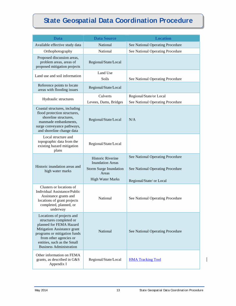
Data Data Source Location Topographic/ bathymetric
data National See National Operating Procedure
AAL data from HAZUS State
https://starrtrac.pbsjteamaccess.com/library/AAL/Forms/AllItems.aspx Contact the RSC if help is needed retrieving the data.
Coverage areas for known community and Tribal risk
assessment data Regional/State/Local
Status of Hazard Mitigation Plans
Regional
Flood control structure data National See National Operating Procedure
Locations of stream gages National Discovery Data Repository
Locations of past flood claims and repetitive loss
properties CIS Report
Contact the geospatial data coordination lead at your RSC referenced earlier in this document.
Locations of clusters of Letters of Map Change National See National Operating Procedure
Known flooding issues not represented on effective
FIRMs or listed in Coordinated Needs
Management Strategy database
Regional/State/Local
Areas of planned development Regional/State/Local
Areas of land use change datasets
National
Regional/State/Local
Locations of ongoing projects or updated stream studies
(e.g. highway improvements) Regional/State/Local
Locations of wave and tide gauges National N/A
Locations of wind gauges National N/A
Proposed inland limit of the Primary Frontal Dune, if
present Regional/State/Local N/A
Locations of any beach nourishment or dune restoration projects
SLOSH Zones N/A
Comparison of preliminary stillwater elevations with
effective stillwater elevations Regional/State/Local
May 2014 12 State Geospatial Data Coordination Procedure
State Geospatial Data Coordination Procedure
Data Data Source Location Available effective study data National See National Operating Procedure
Orthophotography National See National Operating Procedure
Proposed discussion areas, problem areas, areas of
proposed mitigation projects Regional/State/Local
Land use and soil information Land Use
Soils See National Operating Procedure
Reference points to locate areas with flooding issues Regional/State/Local
Hydraulic structures Culverts
Levees, Dams, Bridges Regional/State/or Local See National Operating Procedure
Coastal structures, including flood protection structures,
shoreline structures, manmade embankments,
surge conveyance pathways, and shoreline change data
Regional/State/Local N/A
Local structure and topographic data from the existing hazard mitigation
plans
Regional/State/Local
Historic inundation areas and high water marks
Historic Riverine Inundation Areas
Storm Surge Inundation Areas
High Water Marks
See National Operating Procedure See National Operating Procedure Regional/State/ or Local
Clusters or locations of Individual Assistance/Public
Assistance grants and locations of grant projects
completed, planned, or underway
National See National Operating Procedure
Locations of projects and structures completed or
planned for FEMA Hazard Mitigation Assistance grant
programs or mitigation funds from other agencies or
entities, such as the Small Business Administration
National See National Operating Procedure
Other information on FEMA grants, as described in G&S
Appendix I Regional/State/Local HMA Tracking Tool
May 2014 13 State Geospatial Data Coordination Procedure
State Geospatial Data Coordination Procedure
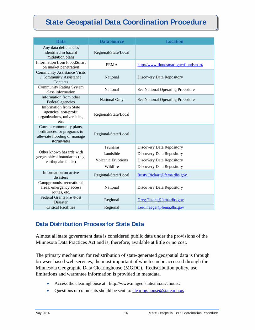
Data Data Source Location Any data deficiencies identified in hazard
mitigation plans Regional/State/Local
Information from FloodSmart on market penetration FEMA http://www.floodsmart.gov/floodsmart/
Community Assistance Visits / Community Assistance
Contacts National Discovery Data Repository
Community Rating System class information National See National Operating Procedure
Information from other Federal agencies National Only See National Operating Procedure
Information from State agencies, non-profit
organizations, universities, etc.
Regional/State/Local
Current community plans, ordinances, or programs to
alleviate flooding or manage stormwater
Regional/State/Local
Other known hazards with geographical boundaries (e.g.
earthquake faults)
Tsunami Landslide
Volcanic Eruptions Wildfire
Discovery Data Repository Discovery Data Repository Discovery Data Repository Discovery Data Repository
Information on active disasters Regional/State/Local [email protected]
Campgrounds, recreational areas, emergency access
routes, etc. National Discovery Data Repository
Federal Grants Pre /Post Disaster Regional [email protected]
Critical Facilities Regional [email protected]
Data Distribution Process for State Data
Almost all state government data is considered public data under the provisions of the Minnesota Data Practices Act and is, therefore, available at little or no cost.
The primary mechanism for redistribution of state-generated geospatial data is through browser-based web services, the most important of which can be accessed through the Minnesota Geographic Data Clearinghouse (MGDC). Redistribution policy, use limitations and warrantee information is provided in metadata.
• Access the clearinghouse at: http://www.mngeo.state.mn.us/chouse/ • Questions or comments should be sent to: [email protected]
May 2014 14 State Geospatial Data Coordination Procedure
State Geospatial Data Coordination Procedure
The MetroGIS program, representing the Twin Cities Metropolitan Region, provides many data sets at no cost through the Clearinghouse, but does distribute a selection of shared data under license to members of the cooperative. County Governments establish their own data distribution policies and those vary across the state.
Federal Nationwide Geospatial Data Holdings
Information about nationwide holdings and programs of Federal agencies is available from the Mapping Information Platform web site at https://hazards.fema.gov/femaportal/docs/ProgFacts.pdf.
Finding and Accessing Other Existing Geospatial Data
Find below the information about and links to ways of searching for additional geospatial data available for the State. These capabilities can be useful for finding geospatial data other than the statewide and Federal data listed above, including those of special government districts, counties and parishes, municipalities, tribes, universities, and other organizations.
Clearinghouses and Inventories for the State
The Minnesota Geographic Data Clearinghouse (MGDC) serves as a convenient source for geographic data, ranging from simple state maps to complex geospatial data needed to power Geographic Information Systems.
Coordinated by the Minnesota Geospatial Information Office, the MGDC provides access to a wide variety of sources making it your "First Stop" for geographic data for Minnesota. MGDC partners include the USGS, Bureau of the Census, Minnesota's DNR, DOT and PCA, the MetroGIS program and many others.
Access Minnesota’s Clearinghouse at http://www.mngeo.state.mn.us/chouse/
Important features of the Clearinghouse include:
• GeoGateway: a tool to help you quickly search for geographic data about Minnesota and its neighboring regions. http://geogateway.state.mn.us
• Department of Natural Resources Data Deli: http://deli.dnr.state.mn.us/index.html • Metropolitan Council of the Twin Cities DataFinder: http://www.datafinder.org/catalog/ • Legislative Coordinating Commission Geographic Information Services:
http://www.gis.leg.mn/
May 2014 15 State Geospatial Data Coordination Procedure
State Geospatial Data Coordination Procedure
• Statewide Elevation and Imagery Inventory: Sponsored by FEMA, the Minnesota SEII is a community effort designed to gather and share information about high density elevation and digital aerial photography data in and around the state. http://www.mngeo.state.mn.us/SEII/
• Statewide Parcel Map Inventory: SPMI provides a snapshot of digital parcel data development across Minnesota. http://www.mngeo.state.mn.us/chouse/SPMI/
National Digital Orthophoto Program (NDOP) and National Digital Elevation Program (NDEP) Tracking Systems
These systems allow the search of orthophoto and elevation project information entered by federal and other organizations. To access the NDOP system, go to the NDOP web site at http://www.ndop.gov and follow the link “Project Tracking.” For the NDEP system, go to the NDEP web site at http://www.ndep.gov and follow the link “Project Tracking.”
TED Query Tool
This tool provides access to information about Federal, state, and local government agency and private sector data holdings gathered by the Census Bureau. It is available through the geospatial data coordination lead at the Regional Support Center.
Geospatial One-Stop
Geospatial One-Stop, available at http://www.geodata.gov, provides access to geospatial data from many sources. Two parts of the site that should be investigated are the “data categories” for existing data and the “marketplace” for data that are planned or in-work and for potential partners for new data collection activities.
Notes: Because of Geospatial One-Stop (GOS) metadata publishing requirements that were not part of the original FGDC geospatial metadata content standard, the GOS search results mischaracterize many Minnesota GIS datasets that are freely downloadable as ‘offline data’ or ‘documents’. When using GOS to find data produced in Minnesota, search on ‘All Formats’ and read the FULL metadata very carefully to determine its availability.
As an alternative, Minnesota recommends searching for the data using the FGDC Metadata Clearinghouse Search or the Minnesota GeoGateway Search tool at http://geogateway.state.mn.us/index.html. See also the data catalog list outlined under ‘Clearinghouses and Inventories’. GOS can be used to supplement these searches to find data produced by the federal government or by neighboring states.
May 2014 16 State Geospatial Data Coordination Procedure
State Geospatial Data Coordination Procedure
Working with People
Useful State and Federal Contacts
The main contacts for the State’s geospatial activities and Federal agencies’ representatives in State are available on the Mapping Information Platform web site at https://hazards.fema.gov/contacts/statecontacts/contacts.asp?page=MN
Additional useful contacts for the State can be found at Minnesota Governor’s Council on Geographic Information http://www.gis.state.mn.us/Members/index.htm.
Involving the State’s Geospatial Coordinator in Flood Studies
In order to participate in the FEMA flood hazard mapping effort, please contact:
State National Floodplain Insurance Program (NFIP) Coordinator Ceil Strauss, CFM Minnesota Dept Natural Res. - Waters 500 Lafayette Road St. Paul, MN 55155-4032 651-259-5713 FAX 651-296-0445 [email protected] or State Flood Mapping Coordinator Suzanne Jiwani 651-259-5681 FAX 651-296-0445 [email protected]
State Coordination Process for Building Geospatial Partnerships
Minnesota Governor’s Council on Geographic Information http://www.gis.state.mn.us (651) 201-2491: The mission of the council is to promote efficient and effective use of geographic information in Minnesota. The council makes recommendations in areas including, but not limited to: policies, institutional arrangements, standards, education, and stewardship. Administrative support for the council is provided by the Land Management Information Center. Much of the council’s work is accomplished through its committees: Digital Elevation; Emergency Preparedness; Geospatial Architecture (Standards); Hydrography; Land Records Modernization; Outreach; Strategic Plan.
Minnesota GIS/LIS Consortium: http://www.mngislis.org/: The Minnesota GIS/LIS Consortium is a forum for communicating information to, and improving cooperation among, those interested in Geographic Information Systems (GIS) and Land Information Systems (LIS) in the State of Minnesota. Members include GIS users in local, state and federal government agencies; business and industry; and educational institutions. The
May 2014 17 State Geospatial Data Coordination Procedure
State Geospatial Data Coordination Procedure
Consortium hosts an annual statewide conference, establishes committees that deal with specific GIS/LIS-related issues, and publishes a quarterly newsletter.
Finding Local Geospatial Contacts
Local contacts, including those from special government districts (for example, a regional planning commission); counties, parishes, or equivalent governments; tribes, municipal governments; and other organizations (for example, local universities) also have geospatial data that can help a flood insurance study. Contact information is available from the FEMA archive and web searches at government link portals such as http://www.statelocalgov.net.
The State also maintains information about local geospatial contacts:
• County GIS Contacts: http://www.mngeo.state.mn.us/cty_contacts.html • Local government websites, including city, county, township, associations, local
government programs, special districts and regional government : http://www.state.mn.us/portal/mn/jsp/content.do?subchannel=-536879913&id=-8494&agency=NorthStar
• Tribal websites: http://www.state.mn.us/portal/mn/jsp/content.do?subchannel=-536888182&id=-8494&agency=NorthStar
• Minnesota Regional Development Organizations: http://www.mrdo.org/ • MetroGIS – is a collaborative organization representing over 250 local governments and
other organizations established to foster sharing of geospatial data in the seven-county Twin City Metropolitan Area of Minnesota. http://www.metrogis.org
• University of Minnesota Remote Sensing and Geospatial Analysis Lab: http://rsgl.gis.umn.edu/
• Regional GIS users groups: • Southeast Minnesota GIS Users Group: http://www.co.goodhue.mn.us/ (click on
Departments, Land Use Management, GIS) • Southwest Minnesota GIS Users Group: http://www.smsu.edu/swmngis/
Provide Feedback on This Procedure
When you find information in this Procedure or in other FEMA or State resources that are outdated, please tell the geospatial data coordination lead in the Regional Support Center what was wrong and the correct information (if you know it). Use the contact information for the lead listed in the section Purpose of the Procedure.
The lead will use your feedback to update and redistribute this Procedure.
May 2014 18 State Geospatial Data Coordination Procedure