Embed Size (px)
Citation preview
1
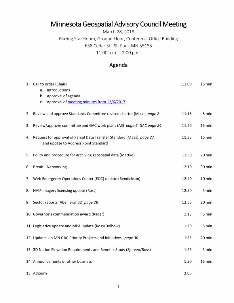
Minnesota Geospatial Advisory Council Meeting March 28, 2018
Blazing Star Room, Ground Floor, Centennial Office Building
658 Cedar St., St. Paul, MN 55155
11:00 a.m. – 2:00 p.m.
Agenda
1. Call to order (Chair) 11:00 15 min
a. Introductions
b. Approval of agenda
c. Approval of meeting minutes from 12/6/2017
2. Review and approve Standards Committee revised charter (Maas) page 2 11:15 5 min
3. Review/approve committee and GAC work plans (All) page 6 GAC page 24 11:20 15 min
4. Request for approval of Parcel Data Transfer Standard (Maas) page 27 11:35 15 min
and update to Address Point Standard
5. Policy and procedure for archiving geospatial data (Mattke) 11:50 20 min
6. Break Networking 12:10 30 min
7. Web Emergency Operations Center (EOC) update (Bendickson) 12:40 10 min
8. NAIP imagery licensing update (Ross) 12:50 5 min
9. Sector reports (Abel, Brandt) page 28 12:55 20 min
10. Governor’s commendation award (Rader) 1:15 5 min
11. Legislative update and MPA update (Ross/Dolbow) 1:20 5 min
12. Updates on MN GAC Priority Projects and Initiatives page 30 1:25 20 min
13. 3D Nation Elevation Requirements and Benefits Study (Sjerven/Ross) 1:45 5 min
14. Announcements or other business 1:50 15 min
15. Adjourn 2:05
2
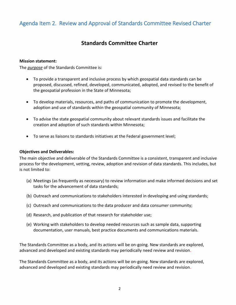
Agenda Item 2. Review and Approval of Standards Committee Revised Charter
Standards Committee Charter
Mission statement:
The purpose of the Standards Committee is:
To provide a transparent and inclusive process by which geospatial data standards can be proposed, discussed, refined, developed, communicated, adopted, and revised to the benefit of the geospatial profession in the State of Minnesota;
To develop materials, resources, and paths of communication to promote the development, adoption and use of standards within the geospatial community of Minnesota;
To advise the state geospatial community about relevant standards issues and facilitate the creation and adoption of such standards within Minnesota;
To serve as liaisons to standards initiatives at the Federal government level;
Objectives and Deliverables:
The main objective and deliverable of the Standards Committee is a consistent, transparent and inclusive process for the development, vetting, review, adoption and revision of data standards. This includes, but is not limited to:
(a) Meetings (as frequently as necessary) to review information and make informed decisions and set tasks for the advancement of data standards;
(b) Outreach and communications to stakeholders interested in developing and using standards;
(c) Outreach and communications to the data producer and data consumer community;
(d) Research, and publication of that research for stakeholder use;
(e) Working with stakeholders to develop needed resources such as sample data, supporting documentation, user manuals, best practice documents and communications materials.
The Standards Committee as a body, and its actions will be on-going. New standards are explored, advanced and developed and existing standards may periodically need review and revision. The Standards Committee as a body, and its actions will be on-going. New standards are explored, advanced and developed and existing standards may periodically need review and revision.
3
Resource requirements and timing:
Resources for the operation of the Standards Committee are anticipated to be primarily in-kind contributions of staff time for meeting, document preparation, document review and publication as well as to carry out various tasks associated with creation and maintenance of standards. The Standards Committee will assist in the refinement, maintenance and support of a state government standards approval process and to work with partners to provide a place to publish (e.g. website) the approved standards. The work will be on-going. Activities, periods of review, stakeholder engagement, research and other tasks will be aligned with each new standard or the revision of existing standards. The work of the Standards Committee will be on-going; deadlines, completion dates and milestones will arise in the context of each new standard or revision of existing standards.
Anticipated participants and their roles and responsibilities:
Participation in the Standards Committee is open to all members of the geospatial professional community in the State of Minnesota.
The role and responsibilities of the Standards Committee is to: (a) Coordinate strategies for integrating geospatial data and business processes across all levels of
government;
(b) Advise and inform the statewide geospatial community about relevant standards issues;
(c) Facilitate a clear, transparent and inclusive process for the creation, development and adoption of data standards within Minnesota with an emphasis on stakeholder engagement and interaction and to maintain a geospatial data standard development process that is:
Transparent and inclusive of all level of professional practice in the state;
Based upon meeting articulated business needs of stakeholders;
Provides ample opportunity for input, critique, comment and feedback;
(d) Serve as a liaison body to standards initiatives at the Federal government level;
(e) Communicate and advise the statewide geospatial community on opportunities for shared and standardized geospatial data, opportunities for defining data workflows and data architecture within Minnesota;
(f) Work as effectively and efficiently as possible with other governing bodies, agencies, committees,
review panels and boards whose activities are related or germane to the work of the Standards Committee;
(g) Receive, document and report on the input, suggestions, recommendations, inquiries and
proposals regarding geospatial data standardization from the professional geospatial community in the state;
(h) Recognize and respond effectively to all input received during the stakeholder review process;
(i) Respond, refine and revise standards development processes as circumstances warrant in the context of evolving legal, policy and technical practices impacting geospatial work in Minnesota;

4
Membership is open to members of representatives from, but not limited to:
(a) All levels of government
(township, special district, city, county, regional, state, federal, etc.) (b) Private sector interests, including vendors; (c) Academic sector interests; (d) Non-profit sector interests;
Emphasis on membership on the Standards Committee will be placed on members of the statewide geospatial professional community. So that the Standards Committee can function in an inclusive and transparent manner, membership is to reflect the full composition of the statewide geospatial professional community. The Standards Committee is encouraged to contain at least one representative member from the following specific categories:
City and/or Township Government
County Government
State Agency
Representative from the Geospatial Advisory Council
Regional Government Agency
Emergency Services Agency or Interest
Federal Government
Private Sector Interest
Non-Profit Interest
Academic Interest
6.4 The minimum number of members for the Standards Committee shall be seven (7) person. There is no maximum number of members of the Standards Committee. The Standards Committee shall have a chairperson. The chairperson is to be chosen from the membership of the Committee by the consensus of the Committee. The chair shall serve a term of two (2) years, after which a new chair is chosen. An incumbent chair may serve additional terms if they are chosen to do so by the Standards Committee membership. The specific roles of the Committee Chair are as follows:
To organize, schedule and lead the meetings of the Standards Committee;
To maintain the documents, resources and communication materials needed by the Standards Committee;
To ensure the proceedings of Standards Committee meetings are documented and published publicly in a timely manner;
To prepare and present the reports of the Standards Committee’s actions and current work for the Geospatial Advisory Council and other bodies as needed. (Members of the Standards Committee can be tasked to act on behalf of the chair as needed in the preparation and reporting of these materials.)
5
The Standards Committee shall have a vice chairperson. The vice chairperson is to be chosen from the membership of the Standards Committee, by the consensus of the membership. The vice chairperson is to perform the duties of the chair in their absence or inability to act.
Prepared by:
Geoff Maas, Chair Standards Committee MetroGIS Coordinator, Metropolitan Council [email protected] 651.602.1638
Date approved by the Geospatial Advisory Council:
Draft Charter Approved with revisions by the Standards Committee on February 26, 2018 Submitted to the Geospatial Advisory Council Chair and Vice Chair on March 5, 2018
6
Agenda Item 3. Review and Approval of Committee and GAC 2017
Accomplishments and 2018 Work Plans
3D Geomatics Committee Work Plan
Work Plan Date:
February 6, 2017
Chair and Vice Chair:
Sean Vaughn, Co-Chair
Minnesota IT Services@DNR
763-689-7100 x226
Gerry Sjerven, Co-Chair
Minnesota Power
218-355-3990
Link to Committee Charter:
The 3DGeomatics Charter (http://www.mngeo.state.mn.us/committee/3dgeo/3dgeo_committee_charter.pdf)
Accomplishments from 2017 - 18 January 11, 2018
o Officially formed the 3DGeo Hydro Landforms and Hydrography workgroup
Co-Chairs: Andrea Bergman, Rick Moore
January 25, 2018
o Officially formed the 3DGEo Vegetation workgroup
Chair: Erich Grebner
o Officially formed the 3DGeo Human Infrastructure workgroup
Chair: Collin Lee
7
Work Plan for 2018
Planned Activities and Deliverables:
Engage GIS, remote sensing, and 3D geospatial communities to determine needs for specific data
standards, products and workgroup focus. This will be accomplished by:
o Engaging users through email survey of past committee members
o Communications through MN GIS/LIS Consortium E-announcements
o Review previous surveys to identify potential needs and areas of focus
o Conduct surveys of other sectors of the state using the Geospatial Advisory Council’s (GAC) -
Outreach Committee, and Minnesota Geospatial Advisory Council meeting summary (GAC Yak
publication)
Create a Workgroup development template containing a generic mission statement, goals, and reporting
procedures to guide Workgroup work plan establishment.
Identify at least two 3DGeo Committee Workgroups by March 2018 and begin to solicit membership and
assist with the development of Workgroup work plans.
o Identify workgroup champions to lead formation of workgroups.
Each Workgroup will have a chair or co-chairs.
Each workgroup will have at least one member serving on the 3DGeo Executive Steering
Team
Each Workgroup will strive to represent a wide range of expertise with active participation,
minimum 6 meetings a year
Chair or Co-Chair will be available for 3D Geomatics Committee panel at the annual MN
GIS/LIS Consortium Conference
o Steer development of Workgroup mission statements, goals, work plans, and timelines
Establish timelines for Workgroups.
o Workgroups will develop drafts of work plans for 2018 for the March 2018 GAC meeting
Explore the potential for a Workshop or user group meetings in 2018
Expand content on MnGeo website for the distribution of 3D Geomatics Committee educational materials
and serve as a clearinghouse of 3D technology information
Committee Structure
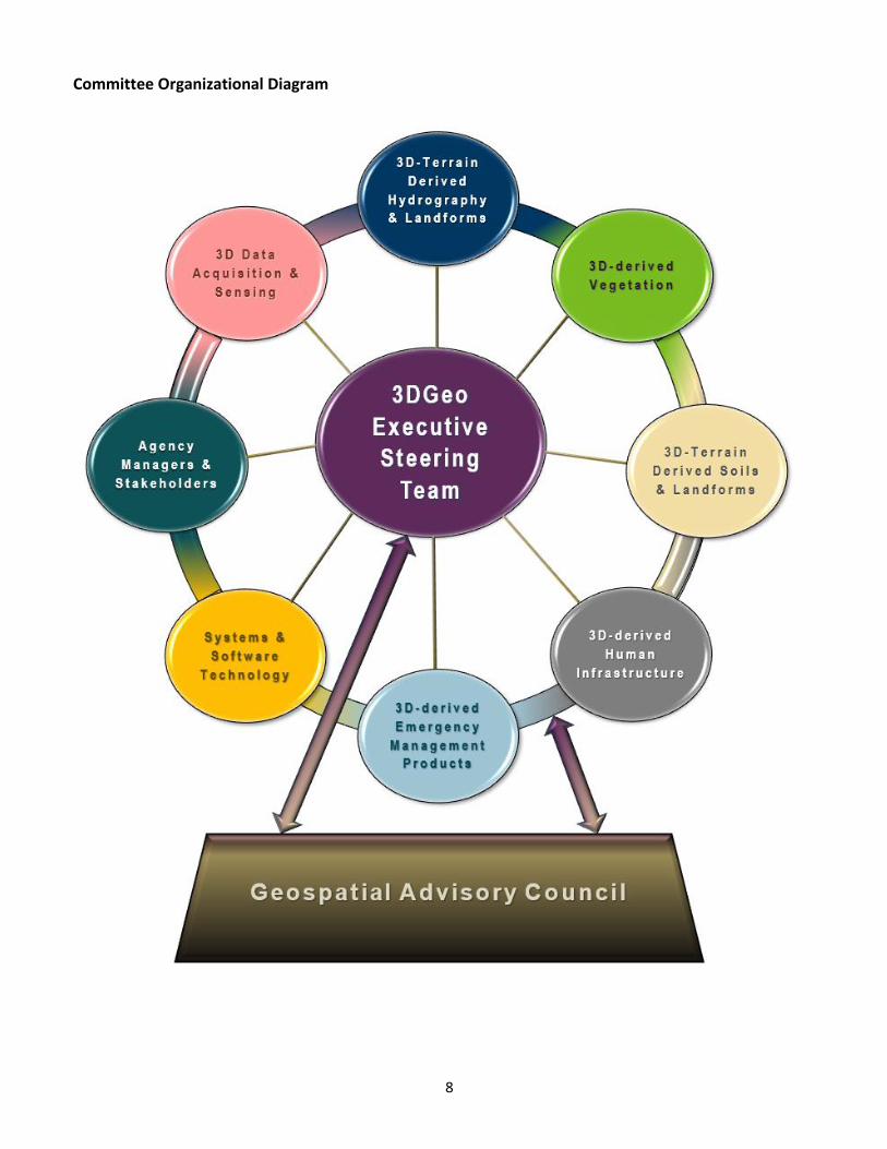
Potential Workgroups (sectors of expertise):
3D-Terrain Derived Hydro Landforms & Hydrography
3D-derived Vegetation
3D-Terrain Derived Soils & Landforms
3D-derived Human Infrastructure
Agency Managers and Stakeholders
3D-derived Emergency Management Products
3D Data Acquisition & Sensing
Systems & Software Technology
Outreach and Education
Data Standards, Management, and Governance
8
Committee Organizational Diagram
9
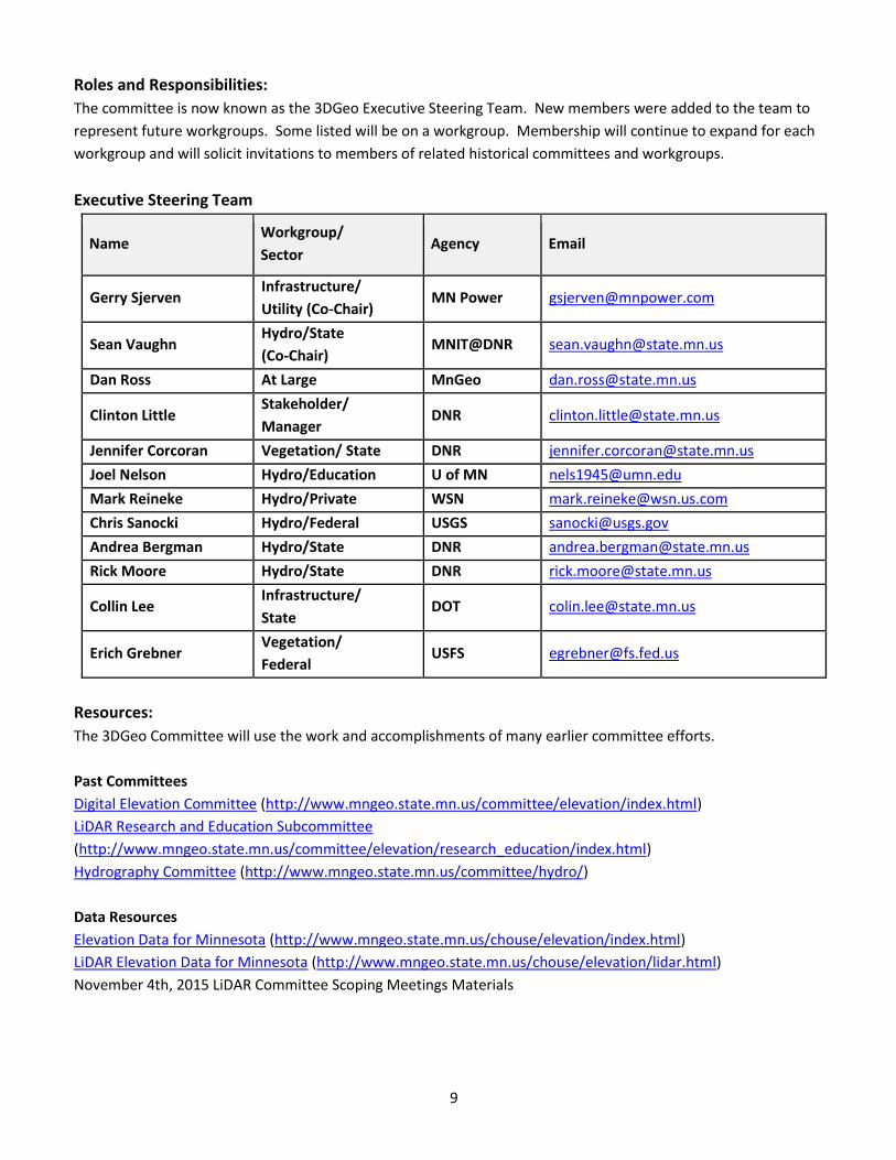
Roles and Responsibilities:
The committee is now known as the 3DGeo Executive Steering Team. New members were added to the team to
represent future workgroups. Some listed will be on a workgroup. Membership will continue to expand for each
workgroup and will solicit invitations to members of related historical committees and workgroups.
Executive Steering Team
Name Workgroup/
Sector Agency Email
Gerry Sjerven Infrastructure/
Utility (Co-Chair) MN Power [email protected]
Sean Vaughn Hydro/State
(Co-Chair) MNIT@DNR [email protected]
Dan Ross At Large MnGeo [email protected]
Clinton Little Stakeholder/
Manager DNR [email protected]
Jennifer Corcoran Vegetation/ State DNR [email protected]
Joel Nelson Hydro/Education U of MN [email protected]
Mark Reineke Hydro/Private WSN [email protected]
Chris Sanocki Hydro/Federal USGS [email protected]
Andrea Bergman Hydro/State DNR [email protected]
Rick Moore Hydro/State DNR [email protected]
Collin Lee Infrastructure/
State DOT [email protected]
Erich Grebner Vegetation/
Federal USFS [email protected]
Resources:
The 3DGeo Committee will use the work and accomplishments of many earlier committee efforts.
Past Committees
Digital Elevation Committee (http://www.mngeo.state.mn.us/committee/elevation/index.html)
LiDAR Research and Education Subcommittee
(http://www.mngeo.state.mn.us/committee/elevation/research_education/index.html)
Hydrography Committee (http://www.mngeo.state.mn.us/committee/hydro/)
Data Resources
Elevation Data for Minnesota (http://www.mngeo.state.mn.us/chouse/elevation/index.html)
LiDAR Elevation Data for Minnesota (http://www.mngeo.state.mn.us/chouse/elevation/lidar.html)
November 4th, 2015 LiDAR Committee Scoping Meetings Materials
10
Committee/Workgroup Needs:
The Executive Steering Team will be working with the GAC Outreach Committee and the MN GIS/LIS Consortium to
help solicit membership for each workgroup, and identify workgroups missing from this plan. The development
team and workgroups will utilize the GAC YAK as way to connect and inform state and local agencies.
Dependencies and Interrelationships:
As the workgroups are formed and identified, relationships and dependencies will be identified by those groups.
Risks:
LiDAR and other 3D data procurements will not be standardized.
Inaccuracies will be incorporated into future derived elevation data.
Lack of standards for data development and data application of 3-D data derived products.
Projects utilizing state funding will produce data not suitable for distribution and application in other
projects.
Additional Comments:
Date approved by the Geospatial Advisory Council:
11
Emergency Preparedness Committee Work Plan
Work Plan date: January 30, 2018
Chair and vice chair: Steve Swazee
[email protected] (612) 239-6981
Randy Knippel [email protected] 952-891-7080
Link to committee/workgroup charter: http://www.mngeo.state.mn.us/committee/emprep/EPC-Charter-2014.pdf
Accomplishments from 2017 Conducted 3 formal meetings, including a committee business meeting and an education presentation
open to anyone
General public safety presentations and forums
o September 13 - Richter, GIS Day, Blaine, MN
o October 5 - Richter, Where Are My Socks?, MN GIS/LIS, Bemidji, MN
o October 6 - Knippel, Richter, MGAC Brief, MN GIS/LIS, Bemidji, MN
o October 6 - Knippel, GIS in the County Emergency Operation Center (EOC), MN GIS/LIS, Bemidji, MN
U.S. National Grid Tiger Team
o Randy Knippel joined MEMA, designated as their GIS Liaison to provide updates on general GIS
activities in the metro area and the State
o Presented at several conferences and forums promoting the U.S. National Grid
March 14, 2017 – Swazee, CGA 811 Safety Conference & Expo, Orlando, FL
May 24, 2017 – Swazee, Knippel, Tri-State USNG Summit, UW La Crosse, La Crosse, WI
August 16, 2017 – Swazee, Gopher One Call, Mendota Heights, MN
September 19, 2017 – Knippel, MGAC, St. Paul, MN
October 5, 2017 – Knippel, Introduction to the U.S. National Grid, MN GIS/LIS, Bemidji, MN
November 15, 2017 – Swazee, Percora 20, Sioux Falls, SD
o Engaged with National USNG leaders on an on-going basis
Tom Terry, Geospatial Intelligence Officer, Geospatial Plans and Policy Branch, the original
leader of the “X/Y Project” which lead to the adoption of the U.S. National Grid
Talbot Brooks, Delta State University, one of the original National USNG leaders
Al Studt, Lieutenant, Cape Canaveral Fire Rescue, Florida Task Force 4 Urban Search &
Rescue Team
Rob Inouye – Cedar Falls Fire, USNG instructor
Joseph Elfelt – GMAP4 developer
Mark Whitney – U.S. Fire Academy
12
Jules McNeff, Vice President, Strategy & Programs at Overlook Systems Technologies, Inc. –
Private sector federal GPS/GNSS policy advocate
o Engaged local GIS and emergency response USNG leaders and implementers
Mark Erickson, Assistant Fire Chief, South Metro Fire
Vicki Nelson, Dispatch Supervisor, Dakota Communications Center
BJ Kohlsted, Emergency Manager, Lake County
Damage Assessment Tiger Team
o The Workgroup’s first meeting was January 10th 2017. The Workgroup met a total of six times in
2017.
o The Workgroup has collected requirements, documents, and best practices from a variety of
sources, such as FEMA, HSEM, AMEM, and NSGIC.
o Workgroup members engaged their local Emergency Managers, Fire Departments, and Building
Codes officials to inform them of our efforts and to gather information on their (current) processes.
o Cory Richter setup a Google drive location for the Damage Assessment Tiger Team to share and
make available meeting minutes, the working data standards and reference material documents.
o Brad Anderson compiled the existing data schemas of Damage Assessment collection for ESRI,
Dakota County, and Washington County and formatted them into a comparison style spreadsheet.
The first draft of the Minnesota Damage Assessment Data Standard was created by comparing
fields from all of the data schemas.
o The Workgroup conducted a Panel Discussion at the Minnesota GIS\LIS Fall Conference in Bemidji
in October. Attendance was limited, but a good group discussion ensued for the full 80 minutes of
the session. Copies of the Minnesota Damage Assessment Data Standard were handed out to the
audience in Draft format for peer review. Feedback was encouraged.
Work Plan for 2018
Planned activities and deliverables: Conduct at least 3 meetings of the full committee
o Discuss Tiger Team progress and provide guidance from the broader Committee
o Knowledge and idea sharing
o Educational presentations
Focus on existing Tiger Team activities
o U.S. National Grid
Mission: Promote the use of the U.S. National Grid
Increase participation in team
Identify and engage GIS and emergency services professionals in Minnesota who
are currently involved in implementing the USNG
Participate in efforts to formalize regional and national USNG workgroups
Participate in efforts to develop state and national USNG resources
o Websites, tools, procedures, documentation
Continue to pursue opportunities to increase awareness of the U.S. National Grid
Attend MEMA monthly meetings and provide updates on GIS activities in the State
January – USNG National Implementation Meeting, Online
February - HSEM Governor’s Conference, Brooklyn Center, MN
March – Intro to USNG, CGA 811 Conference, Phoenix, AZ
13
May – UMGEOCON, USNG Workshop and presentation, La Crosse, WI
October - Presentation at MNGISLIS Annual Conference
Others as they are identified
Continue to engage with National team
Continue to engage with local team
Create training videos
o Damage Assessment
The Workgroup has decided to suspend its activities and meetings pending outcome of the
WebEOC implementation at the State level.
John Moore, Recovery and Mitigation Branch Director with HSEM informed the Workgroup
during our November 6th 2017 meeting that the State purchased WebEOC from Intermedix
around June and the State is currently meeting and configuring the application for
deployment. WebEOC uses the Esri Damage Assessment schema and Collector. Counties
and cities of the first class will have access through the State to WebEOC and the field
Collector app. The goal is to deploy WebEOC and the Damage Assessment application
before the Super Bowl on February 4th 2018.
Workgroup members Todd Lusk and David Bendickson were appointed as liaisons for the
WebEOC implementation. Communication has been infrequent with HSEM, but Todd and
David will continue to be active in discussions with HSEM when they occur.
An update on the progress of the WebEOC integration is planned to be sent out to the
Workgroup following the Super Bowl.
Angela Brown, Disaster Recovery Coordinator and others from HSEM will be in Moorhead
for Damage Assessment training with the local Emergency Managers on March 14th.
Project owner Brad Anderson will be involved and will hopefully be able to learn more
information on the status of the WebEOC implementation. An update will be sent out to
the Damage Assessment Data Standard Workgroup.
NOTE: Although the Workgroup has agreed to put its activities on hold pending the State
WebEOC deployment, Matt Taraldsen, the ESRI member of our Workgroup felt strongly
that the team should maintain our goal of developing a Minnesota data standard for
Damage Assessment collection regardless of the implementation of WebEOC by the State.
The schema of the draft Damage Assessment Data Standard our Workgroup has prepared
closely parallels the ESRI Collector schema that will be used by WebEOC.
Roles and responsibilities:
U.S. National Grid
o Leader: Randy Knippel, Dakota County
o Randy is the primary participant in this group engages a cadre of other people in the GIS,
Emergency Management, and Public Safety communities that are also implementing the USNG, as
needed.
Damage Assessment
o Leader: Cory Richter, City of Blaine
o Cory has established a list of participants representing local government in the metro area and out-
state area, as well as the private sector.
14
Resources: Committee members primarily rely on the resources available to them through their employer, with their
employer’s endorsement:
o Time commitment
o Software and hardware
o Expenses
SharedGeo provides additional resources as they are able to, when it fits within their mission, business
plan, and budget
USNG Tiger Team
o Randy Knippel, Dakota County (Chair)
o Steve Swazee, SharedGeo
o Randy and Steve perform the direct work focused on outreach and education
Damage Assessment Tiger Team
o Adam Snegosky, Washington County
o Brad Anderson, City of Moorhead Project Owner
o Cory Richter, City of Blaine Project Co-Chair
o Geoff Maas, MetroGIS (Chair, GAC Standards Committee)
o John Mackiewicz, WSB & Associates
o Matt Taraldsen, ESRI (Solutions Engineer – part of ESRI’s Disaster Response Team)
o Philip Nagel, City of Waseca
o Todd Lusk, Dakota County Project Co-Chair
o Steve Swazee, SharedGeo (Emergency Preparedness Committee Chair)
o John Moore, HSEM (Recovery and Mitigation Branch Director)
o David Bendickson, MNARNG
Committee/workgroup needs:
Committee will work within the constraints of the capabilities and availability of its members
Dependencies and interrelationships: This Committee depends on support from MnGeo, to the extent they are able to provide it
o Publish and update statewide U.S. National Grid maps
o Provide formal endorsement when necessary
o Engage State agencies where applicable
o Promote the use of the USNG in State agencies
o Act as liaison to State agencies when necessary
Risks: Potential instability caused by leadership or participant availability
o Mitigation:
Ensure leaders and participants and their sponsoring organization (employer) have a vested
interest in their mission
15
Lack of MnGeo supporting resources
o Mitigation:
Keep MnGeo informed of activities that could benefit from their involvement so they can
plan accordingly
Minimize this dependency
Additional Comments: none
Date approved by the Geospatial Advisory Council:
16
Outreach Committee Work Plan
Work Plan date: February 1, 2018
Chair and vice chair: Len Kne, Co-Chair University of Minnesota 612-624-7591 [email protected] Kari Geurts, Co-Chair Minnesota Department of Natural Resources 651-259-5275 [email protected]
Link to committee/workgroup charter: http://www.mngeo.state.mn.us/committee/outreach/Outreach_Committee_charter.pdf
Accomplishments from 2017 Set promotion of free and open data as our priority.
Design survey of city GIS staff to measure perceptions and concerns about free and open data. This will be a modified version of the county survey completed in 2016.
o Develop list of city GIS staff using MnGeo, LMC and other resources. o Modify survey questions to meet city needs.
Look for presentation opportunities to promote free and open data.
Look for other organizations to collaborate on the promotion of free and open data.
Look for newsletters, blogs, other forms of media to promote free and open data.
Collect additional testimonials on the importance of GIS and free and open data. Focus will be to increasing the number of testimonials from policy makers and elected officials.
Working with other GAC Committees to see if there can be increased collaboration between working groups.
Added four new members.
17
Work Plan for 2018
Planned activities and deliverables: Execute survey of city GIS staff to measure perceptions and concerns about free and open data. This will be
a modified version of the county survey completed in 2016. o Collect data. o Draft report.
Look for presentation opportunities to promote free and open data.
Look for other organizations to collaborate on the promotion of free and open data.
Look for newsletters, blogs, other forms of media to promote free and open data.
Collect additional testimonials on the importance of GIS and free and open data. Focus will be to increasing the number of testimonials from policy makers and elected officials.
Help define methods of collaboration for committees of the GAC
Roles and responsibilities: Active Committee Members
Brad Anderson
Will Craig
Scott Freburg
Kari Geurts (co-chair)
Andrew King-Scribbins
Len Kne (co-chair)
Geoff Maas
Victoria Reinhardt
Cory Richter
Gerry Sjerven
Michelle Trager
Annette Theroux
Brandon Tourtelotte
Valquiria Quirino
David Kramar
Laure Charleux
The survey subgroup consisting of Kari Geurts, Geoff Maas, and Len Kne meet regularly to plan the next round of survey and what the best outlets (i.e. conferences, newsletters, etc.) are to advocate for free and open data.
The co-chairs will be responsible for calling four full committee meetings in 2018.
Resources: Equipment - none Software - none Data - none Other - none
Committee/workgroup needs: The Committee will be working with MnGeo staff to identify an appropriate collaborative workspace for the committee.
18
Dependencies and interrelationships: We work closely with MetroGIS in their effort to promote free and open data. We expect this year to increase our working relationship with the League of MN Cities and Association of MN Counties.
Risks: None
Additional Comments: None
Date approved by the Geospatial Advisory Council:
19
Parcels and Land Records Committee Work Plan
Work Plan date: 01/29/2018
Chair and vice chair: George Meyer, Chair Lead Developer Otter Tail County GIS Dept. Office# 218-998-8310 Direct# 218-998-8313 [email protected]
Link to committee/workgroup charter:
Accomplishments from 2017 Finalized version of Parcel standard completed. Currently awaiting suggestions for expansion and clarification of nomenclature and metadata. Currently out for review to end on 2/09/2018. To be reviewed by Standards committee after. Pending successful results, then to be submitted to GAC for approval/adoption in 2018
Work Plan for 2018
Planned activities and deliverables: Once standard is finalized, further development will be done on python scripting to assist counties and parcel data providers with tools to assist and simplify submitting data. Meetings to be held to begin development of a statewide PLSS standard, in keeping with 2017 goals, set forward to 2018.
Roles and responsibilities:
Resources: Current ember List:
BRANDT David Brandt [email protected] Washington County
HANNI Lisa Hanni [email protected] Goodhue County
JENKINS Peter Jenkins [email protected] MnDOT
MAAS Geoffrey Maas [email protected] MetroGIS
MARTINI Chad Martini [email protected] Stearns County
MEYER George Meyer [email protected] Otter Tail County
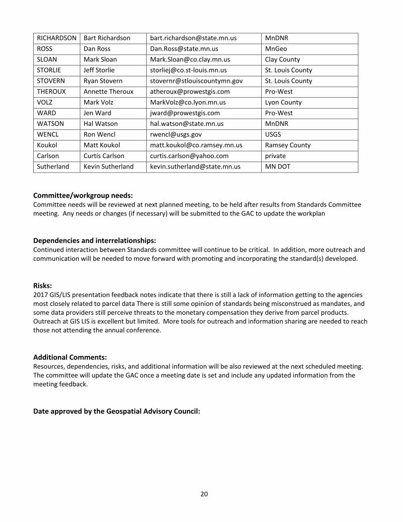
20
RICHARDSON Bart Richardson [email protected] MnDNR
ROSS Dan Ross [email protected] MnGeo
SLOAN Mark Sloan [email protected] Clay County
STORLIE Jeff Storlie [email protected] St. Louis County
STOVERN Ryan Stovern [email protected] St. Louis County
THEROUX Annette Theroux [email protected] Pro-West
VOLZ Mark Volz [email protected] Lyon County
WARD Jen Ward [email protected] Pro-West
WATSON Hal Watson [email protected] MnDNR
WENCL Ron Wencl [email protected] USGS
Koukol Matt Koukol [email protected] Ramsey County
Carlson Curtis Carlson [email protected] private
Sutherland Kevin Sutherland [email protected] MN DOT
Committee/workgroup needs: Committee needs will be reviewed at next planned meeting, to be held after results from Standards Committee meeting. Any needs or changes (if necessary) will be submitted to the GAC to update the workplan
Dependencies and interrelationships: Continued interaction between Standards committee will continue to be critical. In addition, more outreach and communication will be needed to move forward with promoting and incorporating the standard(s) developed.
Risks: 2017 GIS/LIS presentation feedback notes indicate that there is still a lack of information getting to the agencies most closely related to parcel data There is still some opinion of standards being misconstrued as mandates, and some data providers still perceive threats to the monetary compensation they derive from parcel products. Outreach at GIS LIS is excellent but limited. More tools for outreach and information sharing are needed to reach those not attending the annual conference.
Additional Comments: Resources, dependencies, risks, and additional information will be also reviewed at the next scheduled meeting. The committee will update the GAC once a meeting date is set and include any updated information from the meeting feedback.
Date approved by the Geospatial Advisory Council:
21
Standards Committee Work Plan
Work Plan Edit Date: Monday, March 5, 2018
Approved by Committee: Monday, February 26, 2018
Chair and Vice Chair: Geoff Maas, Chair
MetroGIS Coordinator
Metropolitan Council
651.602.1638
Andra Bontrager, Andra Bontrager
GIS Specialist
MN Center for Environmental Advocacy
51.233.5969
Link to Committee charter: http://www.mngeo.state.mn.us/committee/standards/
Accomplishments from 2017
Meetings. The Standards Committee convened three times during calendar 2017 (June 21, 2017, October 25, 2017
and November 30, 2017). These meetings yielded significant progress on advancement of standards, refining
needed details of standards in development, honing the standards development process and the identification of
clear next steps for action by committee members.
Strengthened relationships with other GAC Committees, geospatial workgroups and interests. The Standards
Committee has worked actively to build and strengthen its relationships with other active committees, work groups
and interests. Prime examples include working in tandem with the NextGen9-1-1 interests and Metro Address Work
Group for the advancement of the Address Point Data Standard and with the Parcel and Land Records Committee
on the advance of the Parcel Data Transfer Standard. Communications to other interests involved in the advance of
road centerlines and hydrographic data standards have been initiated as those standards begin to develop and
make their way toward draft status for consideration for review in the future.
Collection and publication of comments on standards published for stakeholder review. The Standards
Committee was active in the publishing of standards for review and the collection, publishing and responding to
this stakeholder input for advancement of proposed standards. The Parcel Data Transfer Standard was reviewed
form Oct 2016 through Jan 2017 and chair Maas conducted presentations about the standards around the state
during 2017 for additional input. Additionally, the Address Point Data Standards was published for review during
July through September 2017 with comments collected, reviewed and published during Fall
Outreach. Standards Committee chair Geoff Maas delivered a 25-minute presentation on the topic of standards at
the GIS/LIS Conference in Bemidji on October 5, 2017. A panel of presenters comprised of members of the Parcel
22
and Land Records Committee including George Meyer, Otter Tail County, Mark Sloan, Clay County and Bart
Richardson and Jeff Reinhart from the Minnesota Department of Natural Resources and Geoff presented on the
history of their Committee, the development, advancement and next steps for the Parcel Data Transfer Standard.
Maas also traveled around the state during 2017 (Duluth, Fergus Falls, Walker, Mankato and Red Wing) to make
brief presentations about the forthcoming parcel data standard and to collect additional comments, insights and
concerns on the standards in development.
Drafting and development of resource material supporting standards. The Committee drafted and subsequently
edited and refined its Standards Development Flow Chart. This chart delineates the general path and set of
procedures for the creation, refinement, advancement and approval of a standard in Minnesota.
This chart is available here: http://www.mngeo.state.mn.us/committee/standards/StandardsProcess.pdf
The Standards Committee will conduct further edits and refinements of this process as needed.
Adoption of Address Point Data Standard, V. 1.0; The Standards Committee advanced the candidate Address Point
Data Standard to the Geospatial Advisory Council on December 6, 2017. The Council voted unanimously to adopt
the standard as a resource for the geospatial community in the state. This standard is available here:
http://www.mngeo.state.mn.us/committee/standards/address/address_standard.html
Alignment of existing and future standards. With the adoption of the Address Point Data Standard, the Standards
Committee has the opportunity to align other standards containing address information (e.g. names, field widths
and other elements) to make interoperability and translation of data more efficient.
As of this writing the following standards in development have aligned their attribution to the adopted Address
Point Data Standard:
Parcel Data Transfer Standard, Draft Version 3.2
(Draft standard in review)
Metro Regional Centerline Collaborative (Centerline Standard), Version 1.7
(Regional standard in use among the Seven Metropolitan Counties)
Minnesota Road Centerline Standard Version 0.5
(Draft standard in development)
23
Standards Committee Work Plan for 2018
Deliverable #1 – Parcel Data Transfer Standard advancement
The Standards Committee published a Version 3.2 draft of the Parcel Data Transfer Standard out for a 30-day public
review period (January 8 – February 9, 2018). The Committee has collected the input from this review and will
assess these for needed changes to the proposed parcel standard and decide upon the fitness of the proposed
standard for recommendation to the GAC.
Deliverable #2 – Meetings in 2018
The Committee is scheduled to meet on February 26, 2018 (in person with conference call-in options available) and
will schedule additional meetings and conference calls as are warranted pending input received from proposed
standards or for other relevant business.
Deliverable #3 – Updating Work Plan and Standards Procedures as needed;
The committee will develop and edit resources and supporting material (sample datasets, metadata, FAQ
documents, etc.) as needed to support the candidate standards in their progress through the review process;
Deliverable #4 – Road Centerline Standard Review
The Committee anticipates continued work on a potential statewide road centerline standard during 2018, this is
dependent upon the stakeholders with a business need to shape and advance a candidate standard for publication
and review;
Roles and responsibilities. The Standards Committee’s primary responsibilities are to ensure a transparent and
inclusive process is retained for the creation, review and advancement of standards.
Resources. At present, the primary resource needed by the Committee are in-kind contributions of members’ time
and expertise to review documents, attend and participate in meetings and to review the input received by
stakeholders and assess their utility and impact on standards in development. The Committee makes use of MnGeo
staff time for basic updating and maintenance of its web presence:
http://www.mngeo.state.mn.us/committee/standards/
Committee needs. The Committee’s only core needs are the continued commitment of its membership to
participate and for MnGeo to continue to host its website giving access to its published materials.
Dependencies and interrelationships. As mentioned above, the Standards Committee has been committed to
maintaining solid relationships with other committees and work groups and is prepared to continue to maintain
these. The Standards Committee is dependent on stakeholder interests with a business need to develop and
advance candidate standards which aim to satisfy those needs.
Risks. Potential risks to the Standards Committee include meeting fatigue among the partners, reduction in interest
and participation of members and stakeholders, the danger of ‘paralysis of analysis’ halting advancement of
standards or the standards development process.
Geospatial Advisory Council Approval of Work Plan:
24
Geospatial Advisory Council
Work Plan date: 2/26/18
Chair and vice chair: Mark Kotz, David Brandt
Link to GAC Mission and Guiding Principles: Note: A new GAC member 2-year term began in July. Many existing GAC members were re-appointed and some new members were appointed.
Accomplishments from 2017
Approved the Minnesota Address Point Data Standard to provide a single, commonly accepted set of attribute specifications for transferring and aggregating address point data.
Launched the new 3D Geomatics Committee to identify and promote the need for planning, funding, acquisition, and management of three-dimensional geomatic data and derived products.
Launched a new subgroup under the Emergency Preparedness Committee to focus on developing an emergency management damage assessment data standard for MN.
Sunsetted the Digital Elevation and Hydrography Committees and the Metadata Workgroup.* See their accomplishment reports: Elevation, Hydrography, Metadata
Sent a letter of support for an LCCMR proposal on improving watershed management by modernizing hydrography data.
Sent letters of support to the Coalition of Geospatial Organizations and various federal elected officials in support of the Geospatial Data Act.
Presented to the Association of Minnesota Emergency Managers about the use of GIS in Emergency Management as well as the role of MnGeo for statewide GIS support.
Organized a panel presentation at the State GIS/LIS Consortium Conference about what the GAC is and why it is important to the geospatial community.
Made changes to the sectors that GAC members represent to provide more complete and consistent representation to the geospatial community.
Identified statewide geospatial projects important to the geospatial community and defined 2018 priorities
for the GAC and recommendations for MnGeo priorities.
* The 3D Geomatics Committee will continue work on elevation and hydrography, and the Standards Committee
will continue work on metadata.
25
Work Plan for 2018
Planned activities and deliverables: The GAC meets on a quarterly basis. The Leadership Team meets between GAC meetings. The bulk of the work is done by the committees and work groups of the GAC. Key goals of the GAC itself for 2018 include:
Approve a state parcel data transfer standard
Launch a group to identify and recommend policies and procedures for archiving and preserving historical geospatial data in Minnesota.
Promote and facilitate progress on the statewide geospatial projects and initiatives identified by the GAC. Some of this work will be done by MnGeo and some by GAC committees (e.g. free and open data, data standards)
Continue to increase outreach to the geospatial and related communities. This will be done both through the formal efforts of the Outreach Committee and less formally by GAC members further reaching out to and coordinating with their sectors.
Increase the outreach to and input from members of the geospatial community when defining GAC annual priorities.
2018 Priorities
GAC Rank
Project or Initiative Name
1 All public geospatial data in MN is free and open to everyone
2 Assurance that the current MnGeo imagery service will be maintained and improved via a sustainable funding model, including policies on what layers are added and removed over time
3 State wide publicly available address points data (including a data standard)
4 State wide publicly available street centerline data (including a data standard)
5 Improvements to MnGeo imagery service capabilities, such as HTTPS, tiling, downloading options, and increased refresh frequency
6 A policy and procedures for archiving and preserving historical geospatial data
7 State wide publicly available parcel data (including a data standard)
8 Updated and aligned boundary data from authoritative data
9 Having aerial photography collections from dozens of years and geographic areas, with no retirement or removal of layers within a freely accessible imagery service
10 An emergency management damage assessment data standard for rapid, post-event damage assessment GPS field collection
11 Support to move us forward toward updated LiDAR data and related standards.
12 MN-focused basemap services
13 Parks and trails data standard
26
Roles and responsibilities: Chair: Mark Kotz Vice Chair: David Brandt MnGeo Ex-Officio member/CGIO: Dan Ross Leadership Team: (acts as an executive group to develop agendas, identify strategic items, etc.)
Members: Mark Kotz, David Brandt, Dan Ross, Victoria Reinhardt, Cory Richter, Jeff Bloomquist, Len Kne
Resources: No significant resource commitments for the GAC beyond the time/talent of members.
Council needs: The GAC relies on MnGeo staff for scheduling and hosting meetings, creating minutes and other administrative functions.
Dependencies and interrelationships: Committees and Workgroups: The GAC is completely dependent upon the committees and workgroups that do most of the actual work of the GAC. The GAC must also stay in touch with a wide group of stakeholders in the geospatial community to be able to represent their interests. Most GAC members represent a specific sector, though a few are at-large members.
Risks: A change in legislature or lack of MnGeo support could negatively affect the ability for the GAC to accomplish goals.
Additional Comments:
Date approved by the Geospatial Advisory Council: tbd
27
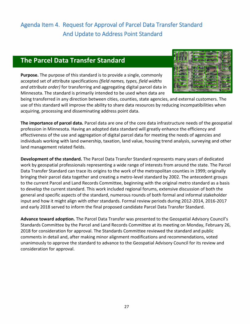
Agenda Item 4. Request for Approval of Parcel Data Transfer Standard
And Update to Address Point Standard
The Parcel Data Transfer Standard Purpose. The purpose of this standard is to provide a single, commonly accepted set of attribute specifications (field names, types, field widths and attribute order) for transferring and aggregating digital parcel data in Minnesota. The standard is primarily intended to be used when data are being transferred in any direction between cities, counties, state agencies, and external customers. The use of this standard will improve the ability to share data resources by reducing incompatibilities when acquiring, processing and disseminating address point data. The importance of parcel data. Parcel data are one of the core data infrastructure needs of the geospatial profession in Minnesota. Having an adopted data standard will greatly enhance the efficiency and effectiveness of the use and aggregation of digital parcel data for meeting the needs of agencies and individuals working with land ownership, taxation, land value, housing trend analysis, surveying and other land management related fields. Development of the standard. The Parcel Data Transfer Standard represents many years of dedicated work by geospatial professionals representing a wide range of interests from around the state. The Parcel Data Transfer Standard can trace its origins to the work of the metropolitan counties in 1999; originally bringing their parcel data together and creating a metro-level standard by 2002. The antecedent groups to the current Parcel and Land Records Committee, beginning with the original metro standard as a basis to develop the current standard. This work included regional forums, extensive discussion of both the general and specific aspects of the standard, numerous rounds of both formal and informal stakeholder input and how it might align with other standards. Formal review periods during 2012-2014, 2016-2017 and early 2018 served to inform the final proposed candidate Parcel Data Transfer Standard. Advance toward adoption. The Parcel Data Transfer was presented to the Geospatial Advisory Council’s Standards Committee by the Parcel and Land Records Committee at its meeting on Monday, February 26, 2018 for consideration for approval. The Standards Committee reviewed the standard and public comments in detail and, after making minor alignment modifications and recommendations, voted unanimously to approve the standard to advance to the Geospatial Advisory Council for its review and consideration for approval.
28
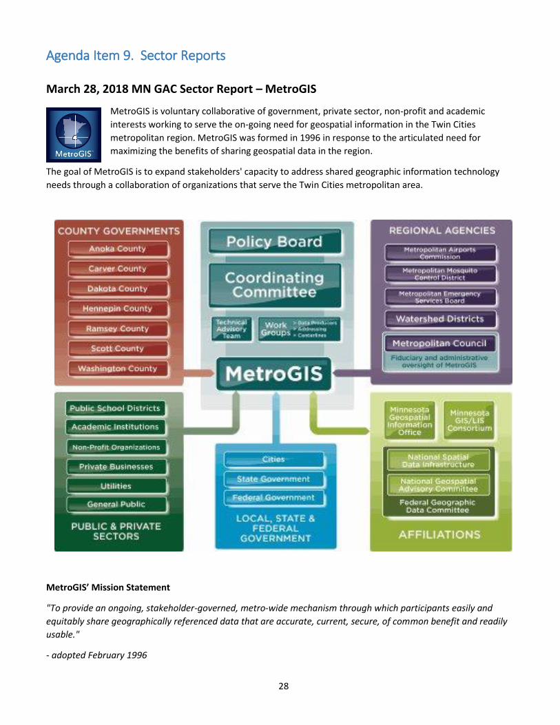
Agenda Item 9. Sector Reports
March 28, 2018 MN GAC Sector Report – MetroGIS
MetroGIS is voluntary collaborative of government, private sector, non-profit and academic
interests working to serve the on-going need for geospatial information in the Twin Cities
metropolitan region. MetroGIS was formed in 1996 in response to the articulated need for
maximizing the benefits of sharing geospatial data in the region.
The goal of MetroGIS is to expand stakeholders' capacity to address shared geographic information technology
needs through a collaboration of organizations that serve the Twin Cities metropolitan area.
MetroGIS’ Mission Statement
"To provide an ongoing, stakeholder-governed, metro-wide mechanism through which participants easily and
equitably share geographically referenced data that are accurate, current, secure, of common benefit and readily
usable."
- adopted February 1996
29
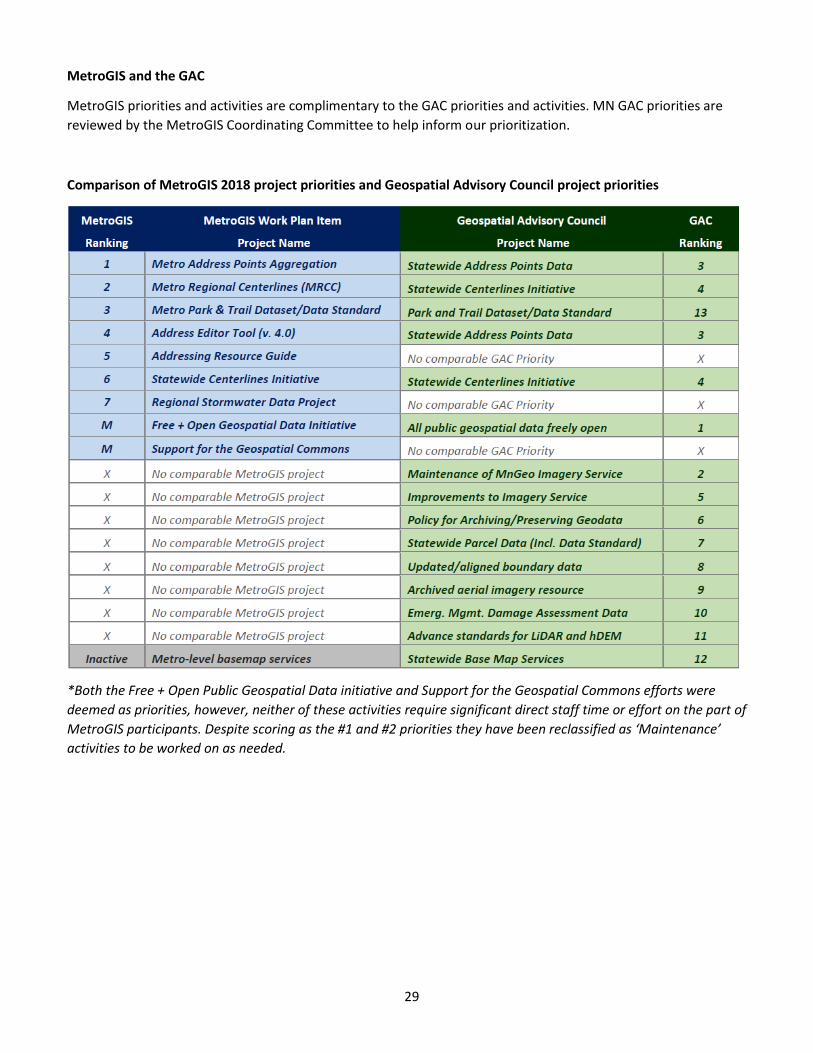
MetroGIS and the GAC
MetroGIS priorities and activities are complimentary to the GAC priorities and activities. MN GAC priorities are
reviewed by the MetroGIS Coordinating Committee to help inform our prioritization.
Comparison of MetroGIS 2018 project priorities and Geospatial Advisory Council project priorities
*Both the Free + Open Public Geospatial Data initiative and Support for the Geospatial Commons efforts were
deemed as priorities, however, neither of these activities require significant direct staff time or effort on the part of
MetroGIS participants. Despite scoring as the #1 and #2 priorities they have been reclassified as ‘Maintenance’
activities to be worked on as needed.
30
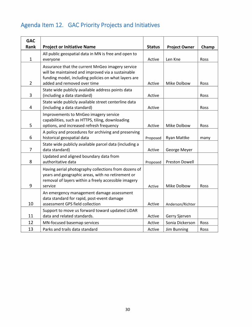
Agenda Item 12. GAC Priority Projects and Initiatives
GAC Rank Project or Initiative Name Status Project Owner Champ
1 All public geospatial data in MN is free and open to everyone Active Len Kne Ross
2
Assurance that the current MnGeo imagery service will be maintained and improved via a sustainable funding model, including policies on what layers are added and removed over time Active Mike Dolbow Ross
3 State wide publicly available address points data (including a data standard) Active Ross
4 State wide publicly available street centerline data (including a data standard) Active Ross
5
Improvements to MnGeo imagery service capabilities, such as HTTPS, tiling, downloading options, and increased refresh frequency Active Mike Dolbow Ross
6 A policy and procedures for archiving and preserving historical geospatial data Proposed Ryan Mattke many
7 State wide publicly available parcel data (including a data standard) Active George Meyer
8 Updated and aligned boundary data from authoritative data Proposed Preston Dowell
9
Having aerial photography collections from dozens of years and geographic areas, with no retirement or removal of layers within a freely accessible imagery service Active Mike Dolbow Ross
10
An emergency management damage assessment data standard for rapid, post-event damage assessment GPS field collection Active Anderson/Richter
11 Support to move us forward toward updated LiDAR data and related standards. Active Gerry Sjerven
12 MN-focused basemap services Active Sonia Dickerson Ross
13 Parks and trails data standard Active Jim Bunning Ross