Embed Size (px)
Citation preview

Document Title
Geospatial Coordination – Appendix B FEMA Data Collection in U.S. Urban Areas
Version 2.0 March 2007


FEMA Data Collection in U.S. Urban Areas
Document History
Document Location Location File Path: https://www.mapmodteam.com/Deliverables/DM/8082/Work%20in%20Progress/Forms/AllItems.aspx
Revision History Version Number Version Date Summary of Changes Team/Author
1.0 November 2005 Original document Jeff Tornatore and Alan Lundy-Ponce
1.1 June 30, 2006 Revised Appendix C for National and NGA Urban Area data searches J.McCarty
1.2 September, 2006 Revisions to Sections 2.1, 2.2, 3.1, 3.2 J.McCarty
2.0 April 13, 2007
Fall 2006 Appendix C renamed to Appendix B. All sections updated. Sections 3.3, 3.4 modified to list NGA Urban Area’s LiDAR and Imagery data availability.
J.McCarty
Approvals This document requires the approval of the following persons:
Role Name Phone
Ext Title (CLIN/RMC) Review
Date Approved
Date Originator Jerry McCarty 3115 Project Manager CLIN/ Proj Mgr Lillian Pitts 5334 Process Area Mgr 4/12/2007 4/12/2007Exec Reviewer Andrea Ryon 6259 Program Director 4/13/2007 4/13/2007
Client Distribution Name Title/Organization Location Paul Rooney FEMA

March 2007 i
FEMA Data Collection in U.S. Urban Areas
Table of Contents 1. Introduction ..............................................................................................................................1 2. FEMA Data Coordination: Known Imagery and Terrain Data Sets .......................................3
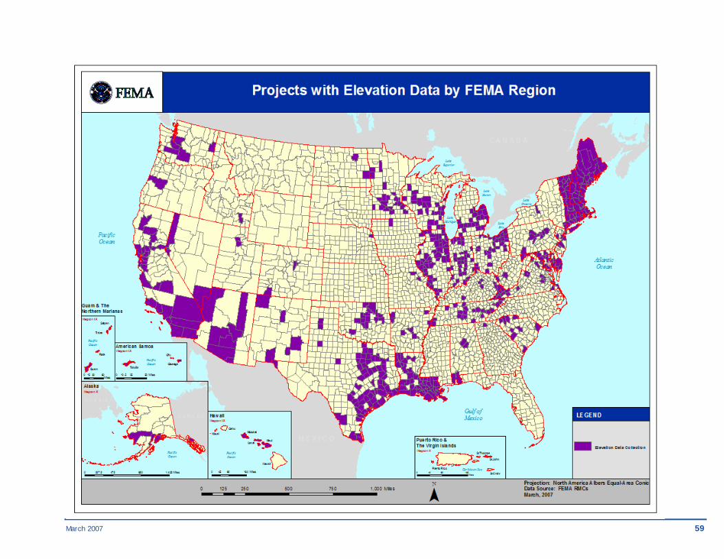
2.1. Projects with Elevation Data by FEMA Region ..........................................................5 2.2. Projects with Imagery Data by FEMA Region ..........................................................60
3. FEMA Data Coordination in U.S. Urban Areas...................................................................111 3.1. Map Mod Elevation Data Identified in Urban Areas ...............................................113 3.2. Map Mod Imagery Data Identified in Urban Areas .................................................123 3.3. NGA Urban Areas Initiative LiDAR Collection in FEMA Regions .......................135 3.4. NGA Urban Areas Initiative Imagery Collection in FEMA Regions ......................155 3.5. Planned FEMA Projects by Urban Area ..................................................................173


March 2007 1
FEMA Data Collection in U.S. Urban Areas
1. Introduction The intent of this report is to promote data sharing and cost sharing between FEMA, the U.S. Geological Survey (USGS), the National Geospatial-Intelligence Agency (NGA), the U.S. Census Bureau, and others. The report provides a nationally oriented list of existing elevation and orthoimagery data sets identified for use in FEMA projects which provides FEMA’s data partners a valuable reference when planning data production activities. Additionally, the report provides detail by fiscal year on the list of counties where FEMA has projects planned that identifies where additional data sharing opportunities may exist which are near the set of urban areas that have been designated by NGA for high-resolution orthophoto and LIDAR production. The data collection schedule, or sequencing, is revised and published annually under FEMA’s Map Modernization program, in the Multi-Year Flood Hazard Implementation Plan (MHIP). Sequencing data from MHIP Version 2.0, published September 2006, are used in this report.
Data collection by FEMA is done during the data development phase of flood restudies, which are done on a county-by-county basis. Terrain or basemap production will generally occur during the initial year of funding.
Data collection by NGA consists of high resolution orthoimagery and LIDAR of select major urban areas in the U.S.
• 1 foot resolution natural color orthophotography has been collected as listed at http://seamless.usgs.gov/website/seamless/products/listofortho.asp. This data meets FEMA’s accuracy specifications and is available via USGS from the Seamless Data Distribution System (http://seamless.usgs.gov/) and Earth Explorer (http://earthexplorer.usgs.gov/).
• NGA will make LIDAR data available to FEMA and FEMA contractors working on flood studies. However, the data can be used for flood studies only and not distributed to anyone else or used for other purposes. These data meet FEMA’s terrain mapping requirements for all risk classes, but some processing is required to ensure proper bare earth model for flood studies. There is not consistent funding, so the schedule of future collections is unpredictable. To order data, contact Alan Lundy-Ponce at (703) 317-6520 or [email protected].
The tables and maps described below are found in this Appendix in the order shown.
• Projects with Elevation Data by FEMA Region table lists existing FEMA projects with known elevation data sets in each FEMA Region. This table should be used by mapping partners whose data requirements are nationally oriented. (Sec. 2.1) – Projects with Elevation Data by FEMA Region map graphically reflects the data from the
Elevation Projects by FEMA Region table.

2 March 2007
FEMA Data Collection in U.S. Urban Areas
• Projects with Imagery Data by FEMA Region table lists existing FEMA projects with known imagery data sets in each FEMA Region. This table should be used by mapping partners whose data requirements are nationally oriented. (Sec. 2.2) – Projects with Imagery Data by FEMA Region map graphically reflects the data from the
Imagery Projects by FEMA Region table.
• Map Mod Elevation Data Identified in Urban Area table lists elevation data sets that FEMA has identified for use in its projects that intersect the NGA Urban Area LiDAR collection project extents. (Sec. 3.1) – Map Mod Elevation Data Identified in Urban Areas map shows the intersection of the
Urban Areas and FEMA projects with known elevation data sets.
• Map Mod Imagery Data Identified in Urban Areas table lists imagery data sets that FEMA has identified for use in its projects that intersect the NGA Urban Area orthophoto collection project extents. (Sec. 3.2) – Map Mod Imagery Data Identified in Urban Areas map shows the intersection of the Urban
Areas and FEMA projects with known imagery data sets.
• NGA Urban Areas Initiative LiDAR Collection in FEMA Regions table shows where the NGA has collected or plans to collect LiDAR data in Urban Areas and other areas of interest. (Sec. 3.3) – NGA Urban Areas LiDAR Collection map shows the extents of LiDAR collection projects
in each Urban Area.
• NGA Urban Areas Initiative Imagery Collection in FEMA Regions table shows where the NGA has collected or has plans to collect high-resolution imagery data in Urban Areas and other areas of interest. (Sec. 3.4) – NGA Urban Areas Initiative High Resolution Imagery Collection in FEMA Regions map
shows the extents of imagery collection projects in each Urban Area.
• Planned FEMA Projects by Urban Area table shows where FEMA has planned projects in FY07 and FY08 that intersect the NGA Urban Areas. (Sec. 3.5) – Planned FEMA Projects by Urban Area map shows the counties in each Urban Area where
FEMA has planned projects in FY07 and FY08.

March 2007 3
FEMA Data Collection in U.S. Urban Areas
2. FEMA Data Coordination: Known Imagery and Terrain Data Sets
FEMA flood map update projects generally take several years to complete. Framework data discovery and/or production generally takes place at the beginning of the project, but it may be some months before the data sets are loaded onto the Mapping Information Platform (MIP) and available for public search and download. Imagery and elevation data sets that have been captured and processed that are being managed by the MIP are now listed in Appendix C. These data sets are no longer listed in the tables below.
The following tables represent imagery and elevation data that has been identified for projects in each region, but has not yet been loaded and published on the MIP. These tables provide FEMA and its partners the opportunity to share and coordinate base map and terrain data collection for active and planned FEMA projects in the U.S. and its territories.
Since the Fall 2006 report was published, funding of the additional Fiscal Year 2006, and to a lesser extent, Fiscal Year 2007, scheduled projects has occurred resulting in increased imagery and terrain data discovery. These additional data sets have been added to the listings below.

March 2007 5
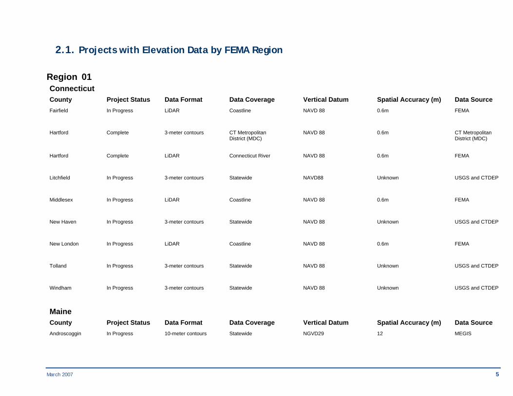
2.1. Projects with Elevation Data by FEMA Region
Region 01 Connecticut County Project Status Data Format Data Coverage Vertical Datum Spatial Accuracy (m) Data Source Fairfield In Progress LiDAR Coastline NAVD 88 0.6m FEMA
Hartford Complete 3-meter contours CT Metropolitan NAVD 88 0.6m CT Metropolitan District (MDC) District (MDC)
Hartford Complete LiDAR Connecticut River NAVD 88 0.6m FEMA
Litchfield In Progress 3-meter contours Statewide NAVD88 Unknown USGS and CTDEP
Middlesex In Progress LiDAR Coastline NAVD 88 0.6m FEMA
New Haven In Progress 3-meter contours Statewide NAVD 88 Unknown USGS and CTDEP
New London In Progress LiDAR Coastline NAVD 88 0.6m FEMA
Tolland In Progress 3-meter contours Statewide NAVD 88 Unknown USGS and CTDEP
Windham In Progress 3-meter contours Statewide NAVD 88 Unknown USGS and CTDEP
Maine County Project Status Data Format Data Coverage Vertical Datum Spatial Accuracy (m) Data Source Androscoggin In Progress 10-meter contours Statewide NGVD29 12 MEGIS
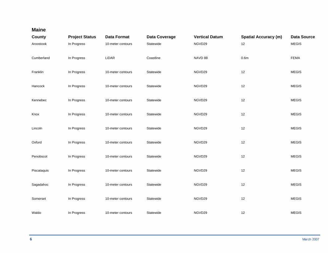
6 March 2007
Maine County Project Status Data Format Data Coverage Vertical Datum Spatial Accuracy (m) Data Source Aroostook In Progress 10-meter contours Statewide NGVD29 12 MEGIS
Cumberland In Progress LiDAR Coastline NAVD 88 0.6m FEMA
Franklin In Progress 10-meter contours Statewide NGVD29 12 MEGIS
Hancock In Progress 10-meter contours Statewide NGVD29 12 MEGIS
Kennebec In Progress 10-meter contours Statewide NGVD29 12 MEGIS
Knox In Progress 10-meter contours Statewide NGVD29 12 MEGIS
Lincoln In Progress 10-meter contours Statewide NGVD29 12 MEGIS
Oxford In Progress 10-meter contours Statewide NGVD29 12 MEGIS
Penobscot In Progress 10-meter contours Statewide NGVD29 12 MEGIS
Piscataquis In Progress 10-meter contours Statewide NGVD29 12 MEGIS
Sagadahoc In Progress 10-meter contours Statewide NGVD29 12 MEGIS
Somerset In Progress 10-meter contours Statewide NGVD29 12 MEGIS
Waldo In Progress 10-meter contours Statewide NGVD29 12 MEGIS
March 2007 7
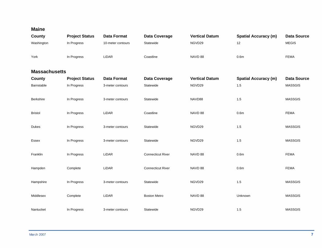
Maine County Project Status Data Format Data Coverage Vertical Datum Spatial Accuracy (m) Data Source Washington In Progress 10-meter contours Statewide NGVD29 12 MEGIS
York In Progress LiDAR Coastline NAVD 88 0.6m FEMA
Massachusetts County Project Status Data Format Data Coverage Vertical Datum Spatial Accuracy (m) Data Source Barnstable In Progress 3-meter contours Statewide NGVD29 1.5 MASSGIS
Berkshire In Progress 3-meter contours Statewide NAVD88 1.5 MASSGIS
Bristol In Progress LiDAR Coastline NAVD 88 0.6m FEMA
Dukes In Progress 3-meter contours Statewide NGVD29 1.5 MASSGIS
Essex In Progress 3-meter contours Statewide NGVD29 1.5 MASSGIS
Franklin In Progress LiDAR Connecticut River NAVD 88 0.6m FEMA
Hampden Complete LiDAR Connecticut River NAVD 88 0.6m FEMA
Hampshire In Progress 3-meter contours Statewide NGVD29 1.5 MASSGIS
Middlesex Complete LiDAR Boston Metro NAVD 88 Unknown MASSGIS
Nantucket In Progress 3-meter contours Statewide NGVD29 1.5 MASSGIS

8 March 2007
Massachusetts County Project Status Data Format Data Coverage Vertical Datum Spatial Accuracy (m) Data Source Norfolk In Progress 3-meter contours Statewide NAVD88 1.5 MASSGIS
Plymouth In Progress LiDAR Coastline NAVD 88 0.6m FEMA
Suffolk In Progress 3-meter contours Statewide Unknown 1.5 MASSGIS
Worcester Complete LiDAR Blackstone River NAVD 88 0.6m FEMA
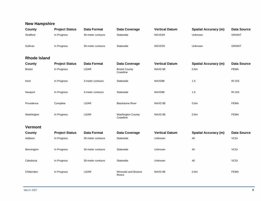
New Hampshire County Project Status Data Format Data Coverage Vertical Datum Spatial Accuracy (m) Data Source Belknap In Progress 30-meter contours Statewide NGVD29 Unknown GRANIT
Carroll In Progress 30-meter contours Statewide NGVD29 Unknown GRANIT
Cheshire In Progress 30-meter contours Statewide NGVD29 Unknown GRANIT
Coos In Progress 30-meter contours Statewide NGVD29 Unknown GRANIT
Grafton In Progress 30-meter contours Statewide NGVD29 Unknown GRANIT
Hillsborough Complete Contours Contoocook River NAVD 88 0.6m Town of Peterborough
Merrimack In Progress 30-meter contours Statewide NGVD29 Unknown GRANIT
Rockingham In Progress 30-meter contours Statewide NGVD29 Unknown GRANIT
March 2007 9
New Hampshire County Project Status Data Format Data Coverage Vertical Datum Spatial Accuracy (m) Data Source Strafford In Progress 30-meter contours Statewide NGVD29 Unknown GRANIT
Sullivan In Progress 30-meter contours Statewide NGVD29 Unknown GRANIT
Rhode Island County Project Status Data Format Data Coverage Vertical Datum Spatial Accuracy (m) Data Source Bristol In Progress LiDAR Bristol County NAVD 88 0.6m FEMA Coastline
Kent In Progress 3-meter contours Statewide NAVD88 1.5 RI GIS
Newport In Progress 3-meter contours Statewide NAVD88 1.5 RI GIS
Providence Complete LiDAR Blackstone River NAVD 88 0.6m FEMA
Washington In Progress LiDAR Washington County NAVD 88 0.6m FEMA Coastline
Vermont County Project Status Data Format Data Coverage Vertical Datum Spatial Accuracy (m) Data Source Addison In Progress 30-meter contours Statewide Unknown 40 VCGI
Bennington In Progress 30-meter contours Statewide Unknown 40 VCGI
Caledonia In Progress 30-meter contours Statewide Unknown 40 VCGI
Chittenden In Progress LiDAR Winooski and Browns NAVD 88 0.6m FEMA Rivers
10 March 2007
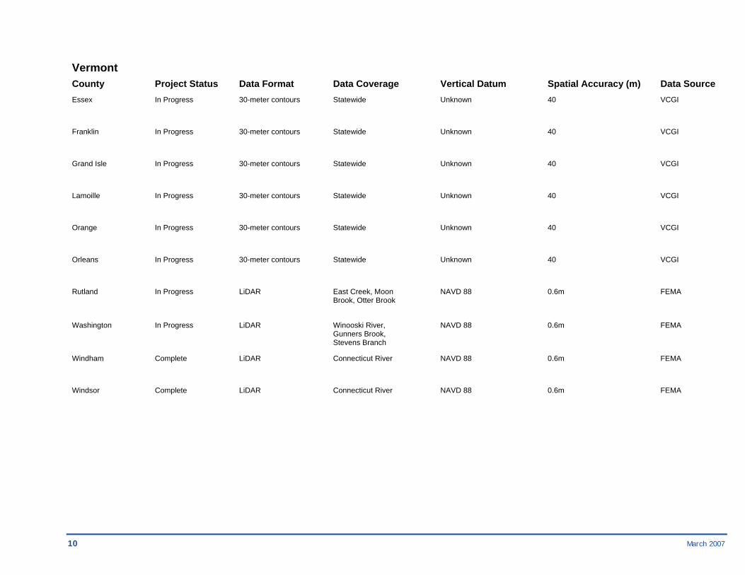
Vermont County Project Status Data Format Data Coverage Vertical Datum Spatial Accuracy (m) Data Source Essex In Progress 30-meter contours Statewide Unknown 40 VCGI
Franklin In Progress 30-meter contours Statewide Unknown 40 VCGI
Grand Isle In Progress 30-meter contours Statewide Unknown 40 VCGI
Lamoille In Progress 30-meter contours Statewide Unknown 40 VCGI
Orange In Progress 30-meter contours Statewide Unknown 40 VCGI
Orleans In Progress 30-meter contours Statewide Unknown 40 VCGI
Rutland In Progress LiDAR East Creek, Moon NAVD 88 0.6m FEMA Brook, Otter Brook
Washington In Progress LiDAR Winooski River, NAVD 88 0.6m FEMA Gunners Brook, Stevens Branch
Windham Complete LiDAR Connecticut River NAVD 88 0.6m FEMA
Windsor Complete LiDAR Connecticut River NAVD 88 0.6m FEMA
March 2007 11
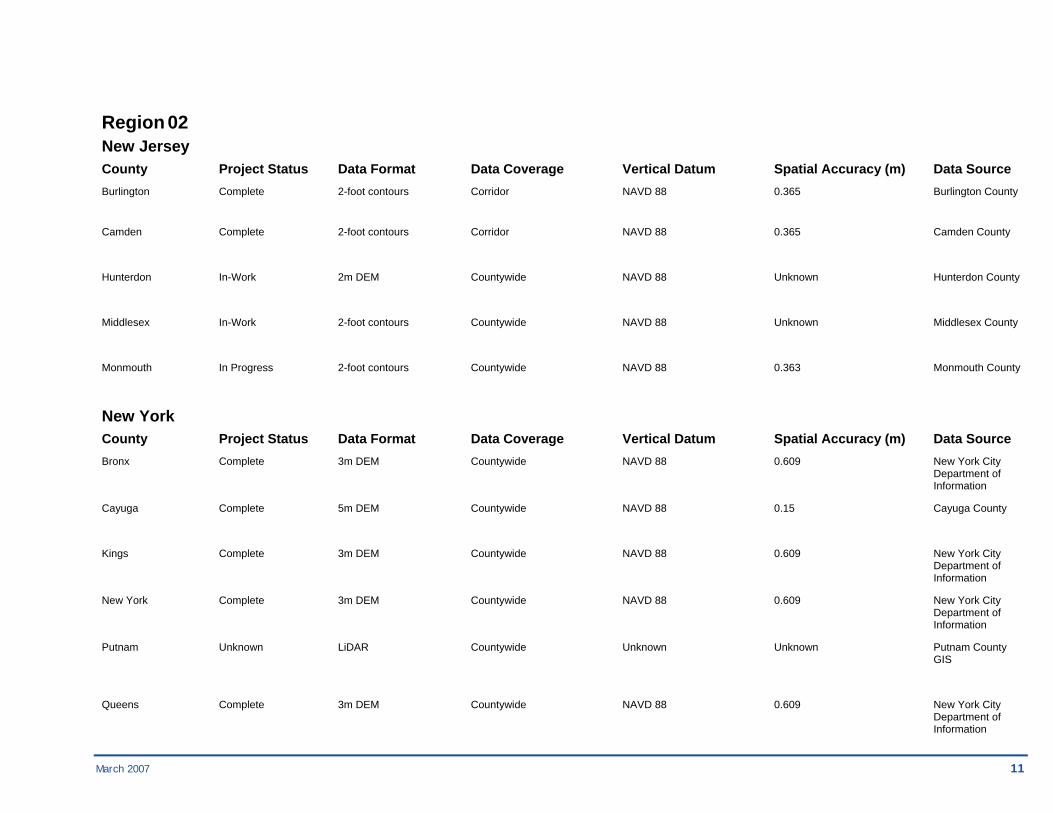
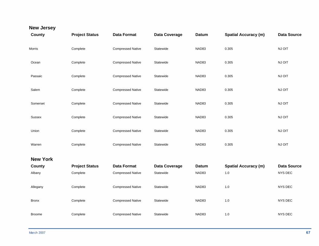
Region 02 New Jersey County Project Status Data Format Data Coverage Vertical Datum Spatial Accuracy (m) Data Source Burlington Complete 2-foot contours Corridor NAVD 88 0.365 Burlington County Camden Complete 2-foot contours Corridor NAVD 88 0.365 Camden County
Hunterdon In-Work 2m DEM Countywide NAVD 88 Unknown Hunterdon County
Middlesex In-Work 2-foot contours Countywide NAVD 88 Unknown Middlesex County
Monmouth In Progress 2-foot contours Countywide NAVD 88 0.363 Monmouth County
New York County Project Status Data Format Data Coverage Vertical Datum Spatial Accuracy (m) Data Source Bronx Complete 3m DEM Countywide NAVD 88 0.609 New York City Department of Information
Cayuga Complete 5m DEM Countywide NAVD 88 0.15 Cayuga County
Kings Complete 3m DEM Countywide NAVD 88 0.609 New York City Department of Information
New York Complete 3m DEM Countywide NAVD 88 0.609 New York City Department of Information
Putnam Unknown LiDAR Countywide Unknown Unknown Putnam County GIS
Queens Complete 3m DEM Countywide NAVD 88 0.609 New York City Department of Information

12 March 2007
Richmond Complete 3m DEM Countywide NAVD 88 0.609 New York City Department of Information
Suffolk Planned 1m DEM Countywide NAVD 88 Unknown NYSDEC
Westchester Complete 1m TIN Countywide NAVD 88 0.914 Westchester County
March 2007 13
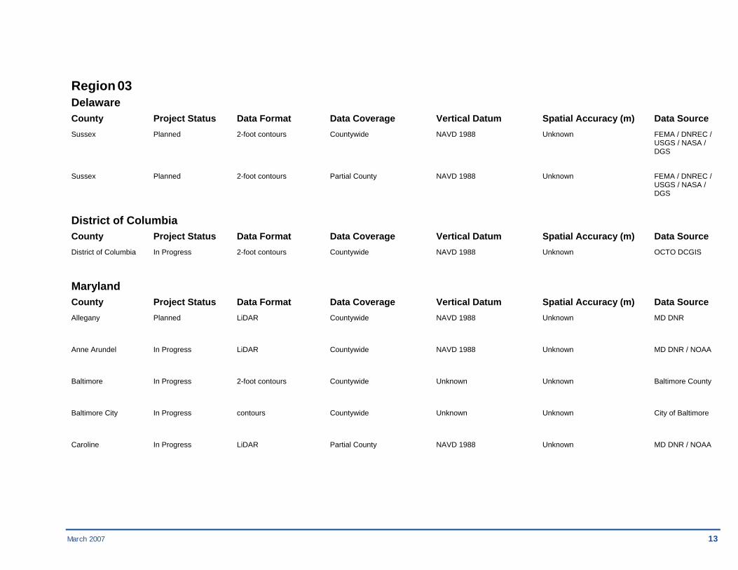
Region 03 Delaware County Project Status Data Format Data Coverage Vertical Datum Spatial Accuracy (m) Data Source Sussex Planned 2-foot contours Countywide NAVD 1988 Unknown FEMA / DNREC / USGS / NASA / DGS
Sussex Planned 2-foot contours Partial County NAVD 1988 Unknown FEMA / DNREC / USGS / NASA / DGS
District of Columbia County Project Status Data Format Data Coverage Vertical Datum Spatial Accuracy (m) Data Source District of Columbia In Progress 2-foot contours Countywide NAVD 1988 Unknown OCTO DCGIS
Maryland County Project Status Data Format Data Coverage Vertical Datum Spatial Accuracy (m) Data Source Allegany Planned LiDAR Countywide NAVD 1988 Unknown MD DNR
Anne Arundel In Progress LiDAR Countywide NAVD 1988 Unknown MD DNR / NOAA
Baltimore In Progress 2-foot contours Countywide Unknown Unknown Baltimore County
Baltimore City In Progress contours Countywide Unknown Unknown City of Baltimore
Caroline In Progress LiDAR Partial County NAVD 1988 Unknown MD DNR / NOAA

14 March 2007
Maryland County Project Status Data Format Data Coverage Vertical Datum Spatial Accuracy (m) Data Source Charles In Progress LiDAR Countywide NAVD 1988 Unknown MD DNR / NOAA
Dorchester In Progress LiDAR Countywide NAVD 1988 Unknown MD DNR / NOAA
Frederick In Progress 5-foot contours Partial County NAVD 1988 Unknown Town of Walkersville
Frederick In Progress 5-foot contours Town of Walkersville NAVD 1988 Unknown FEMA
Frederick In Progress 2-foot contours Ballenger Creek and NAVD 1988 Unknown City of Frederick Clifford Branch Watershed
Frederick In Progress 2-foot contours City of Frederick NAVD 1988 Unknown Frederick County DPW
Garrett Planned LiDAR Countywide NAVD 1988 Unknown MD DNR
Howard In Progress LiDAR Countywide NAVD 1988 Unknown MD DNR / NOAA
Kent Planned LiDAR SW portion of County NAVD 1988 Unknown MD DNR / NOAA
Montgomery In Progress 5-foot contours Countywide Unknown Unknown Unknown
Somerset In Progress LiDAR Countywide NAVD 1988 Unknown MD DNR / NOAA
St. Mary's In Progress LiDAR Countywide NAVD 1988 Unknown MD DNR / NOAA
Talbot In Progress LiDAR Countywide NAVD 1988 Unknown MD DNR / NOAA
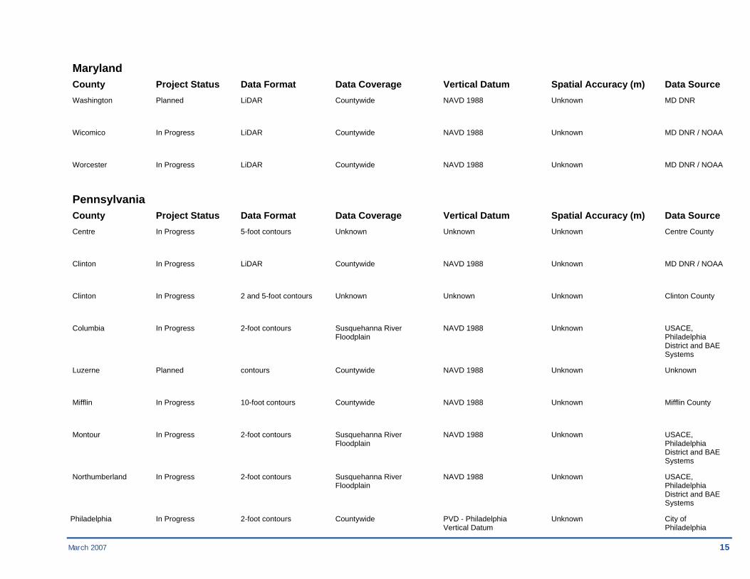
March 2007 15
Maryland County Project Status Data Format Data Coverage Vertical Datum Spatial Accuracy (m) Data Source Washington Planned LiDAR Countywide NAVD 1988 Unknown MD DNR
Wicomico In Progress LiDAR Countywide NAVD 1988 Unknown MD DNR / NOAA
Worcester In Progress LiDAR Countywide NAVD 1988 Unknown MD DNR / NOAA
Pennsylvania County Project Status Data Format Data Coverage Vertical Datum Spatial Accuracy (m) Data Source Centre In Progress 5-foot contours Unknown Unknown Unknown Centre County
Clinton In Progress LiDAR Countywide NAVD 1988 Unknown MD DNR / NOAA
Clinton In Progress 2 and 5-foot contours Unknown Unknown Unknown Clinton County
Columbia In Progress 2-foot contours Susquehanna River NAVD 1988 Unknown USACE, Floodplain Philadelphia District and BAE Systems
Luzerne Planned contours Countywide NAVD 1988 Unknown Unknown
Mifflin In Progress 10-foot contours Countywide NAVD 1988 Unknown Mifflin County
Montour In Progress 2-foot contours Susquehanna River NAVD 1988 Unknown USACE, Floodplain Philadelphia District and BAE Systems
Northumberland In Progress 2-foot contours Susquehanna River NAVD 1988 Unknown USACE, Floodplain Philadelphia District and BAE Systems
Philadelphia In Progress 2-foot contours Countywide PVD - Philadelphia Unknown City of Vertical Datum Philadelphia
16 March 2007
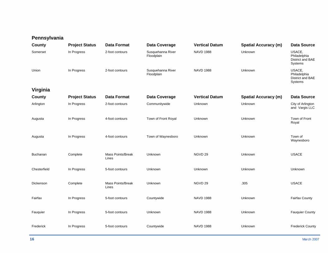
Pennsylvania County Project Status Data Format Data Coverage Vertical Datum Spatial Accuracy (m) Data Source Somerset In Progress 2-foot contours Susquehanna River NAVD 1988 Unknown USACE, Floodplain Philadelphia District and BAE Systems
Union In Progress 2-foot contours Susquehanna River NAVD 1988 Unknown USACE, Floodplain Philadelphia District and BAE Systems
Virginia County Project Status Data Format Data Coverage Vertical Datum Spatial Accuracy (m) Data Source Arlington In Progress 2-foot contours Communitywide Unknown Unknown City of Arlington and Vargis LLC
Augusta In Progress 4-foot contours Town of Front Royal Unknown Unknown Town of Front Royal
Augusta In Progress 4-foot contours Town of Waynesboro Unknown Unknown Town of Waynesboro
Buchanan Complete Mass Points/Break Unknown NGVD 29 Unknown USACE Lines
Chesterfield In Progress 5-foot contours Unknown Unknown Unknown Unknown
Dickenson Complete Mass Points/Break Unknown NGVD 29 .305 USACE Lines
Fairfax In Progress 5-foot contours Countywide NAVD 1988 Unknown Fairfax County
Fauquier In Progress 5-foot contours Unknown NAVD 1988 Unknown Fauquier County
Frederick In Progress 5-foot contours Countywide NAVD 1988 Unknown Frederick County
March 2007 17
Virginia County Project Status Data Format Data Coverage Vertical Datum Spatial Accuracy (m) Data Source
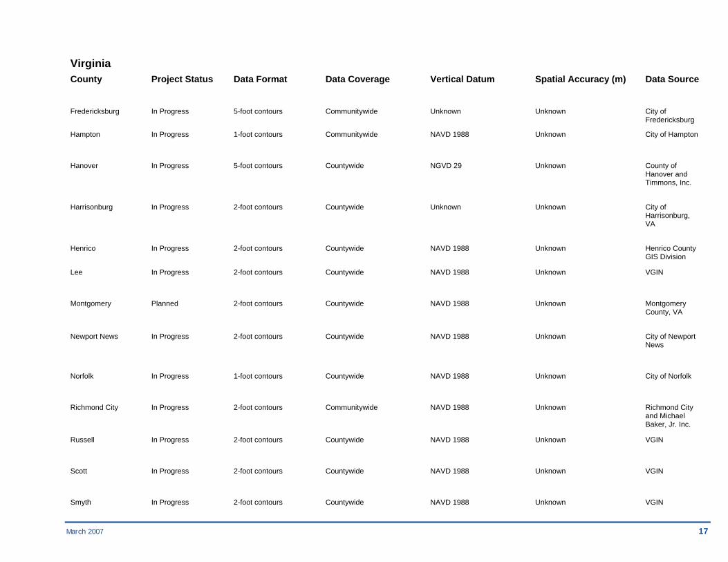
Fredericksburg In Progress 5-foot contours Communitywide Unknown Unknown City of Fredericksburg
Hampton In Progress 1-foot contours Communitywide NAVD 1988 Unknown City of Hampton
Hanover In Progress 5-foot contours Countywide NGVD 29 Unknown County of Hanover and Timmons, Inc.
Harrisonburg In Progress 2-foot contours Countywide Unknown Unknown City of Harrisonburg, VA
Henrico In Progress 2-foot contours Countywide NAVD 1988 Unknown Henrico County GIS Division
Lee In Progress 2-foot contours Countywide NAVD 1988 Unknown VGIN
Montgomery Planned 2-foot contours Countywide NAVD 1988 Unknown Montgomery County, VA
Newport News In Progress 2-foot contours Countywide NAVD 1988 Unknown City of Newport News
Norfolk In Progress 1-foot contours Countywide NAVD 1988 Unknown City of Norfolk
Richmond City In Progress 2-foot contours Communitywide NAVD 1988 Unknown Richmond City and Michael Baker, Jr. Inc.
Russell In Progress 2-foot contours Countywide NAVD 1988 Unknown VGIN
Scott In Progress 2-foot contours Countywide NAVD 1988 Unknown VGIN
Smyth In Progress 2-foot contours Countywide NAVD 1988 Unknown VGIN
18 March 2007
Virginia County Project Status Data Format Data Coverage Vertical Datum Spatial Accuracy (m) Data Source
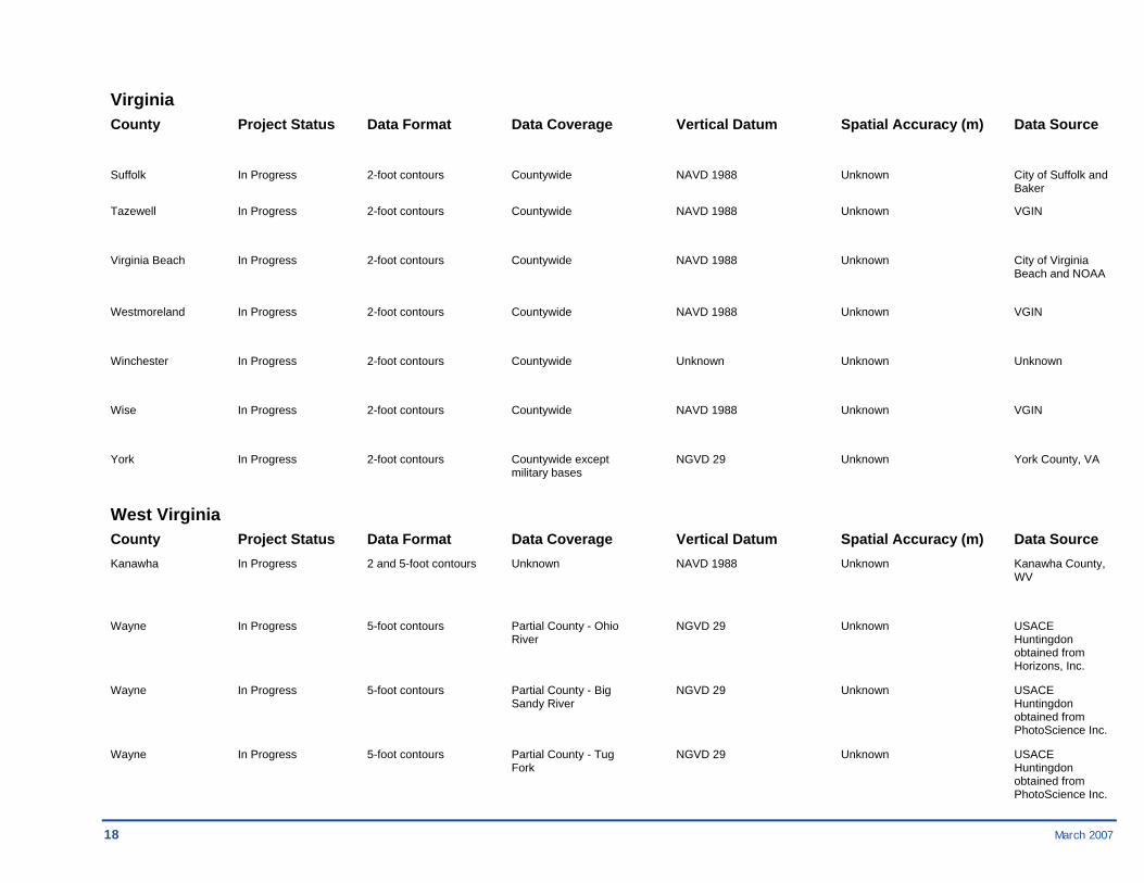
Suffolk In Progress 2-foot contours Countywide NAVD 1988 Unknown City of Suffolk and Baker
Tazewell In Progress 2-foot contours Countywide NAVD 1988 Unknown VGIN
Virginia Beach In Progress 2-foot contours Countywide NAVD 1988 Unknown City of Virginia Beach and NOAA
Westmoreland In Progress 2-foot contours Countywide NAVD 1988 Unknown VGIN
Winchester In Progress 2-foot contours Countywide Unknown Unknown Unknown
Wise In Progress 2-foot contours Countywide NAVD 1988 Unknown VGIN
York In Progress 2-foot contours Countywide except NGVD 29 Unknown York County, VA military bases
West Virginia County Project Status Data Format Data Coverage Vertical Datum Spatial Accuracy (m) Data Source Kanawha In Progress 2 and 5-foot contours Unknown NAVD 1988 Unknown Kanawha County, WV
Wayne In Progress 5-foot contours Partial County - Ohio NGVD 29 Unknown USACE River Huntingdon obtained from Horizons, Inc.
Wayne In Progress 5-foot contours Partial County - Big NGVD 29 Unknown USACE Sandy River Huntingdon obtained from PhotoScience Inc.
Wayne In Progress 5-foot contours Partial County - Tug NGVD 29 Unknown USACE Fork Huntingdon obtained from PhotoScience Inc.

March 2007 19
Region 04 Alabama County Project Status Data Format Data Coverage Vertical Datum Spatial Accuracy (m) Data Source Baldwin In Progress LiDAR Unknown NAVD 1988 Unknown Unknown
Jefferson In Progress 2-foot contours > 100 sq mi NAVD 1988 Unknown Unknown
Mobile In Progress LiDAR Unknown NAVD 1988 Unknown Unknown
Shelby In Progress 2-foot contours > 100 sq mi NAVD 1988 Unknown Unknown
Georgia County Project Status Data Format Data Coverage Vertical Datum Spatial Accuracy (m) Data Source Gilmer In Progress 2-foot contours Countywide NAVD 1988 Unknown Canaan Valley Institute
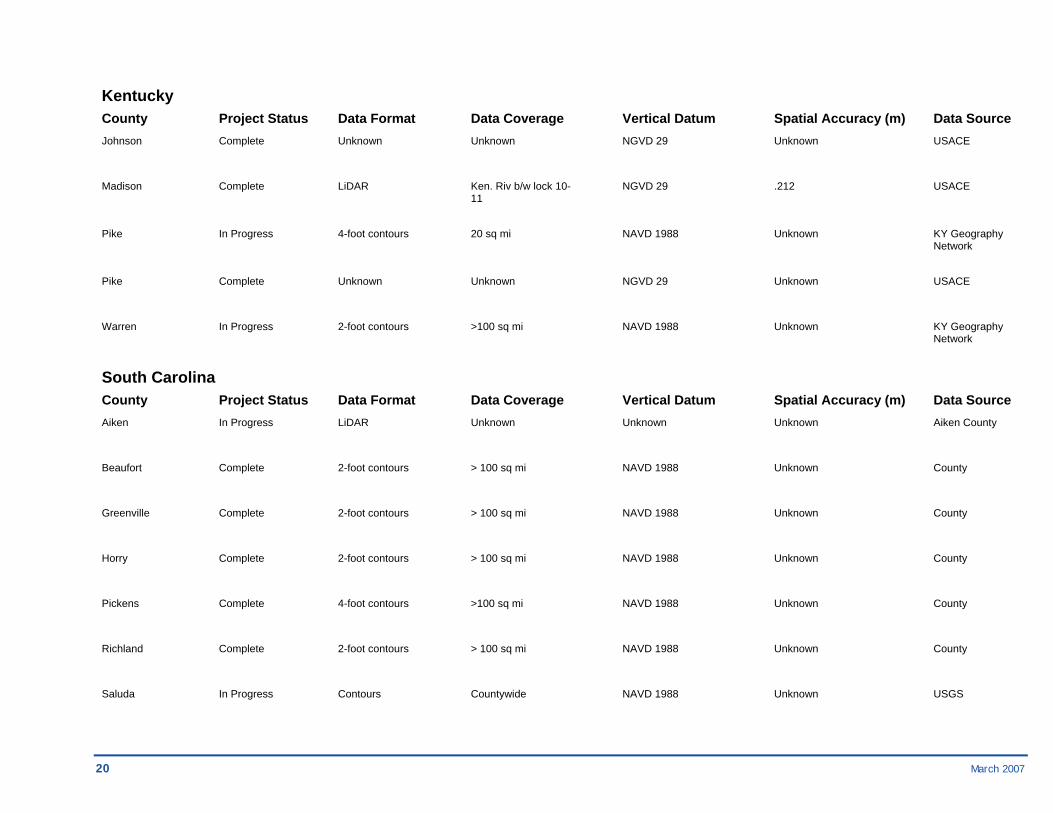
Kentucky County Project Status Data Format Data Coverage Vertical Datum Spatial Accuracy (m) Data Source Boone In Progress 2-foot contours >100 sq mi NAVD 1988 Unknown KY Geography Network
Boyd Complete Mass Points/Break Unknown NGVD 29 Unknown Unknown Lines
Fayette In Progress 2-foot contours >100 sq mi NAVD 1988 Unknown KY Geography Network
Floyd Complete Unknown Unknown NGVD 29 Unknown USACE
20 March 2007
Kentucky County Project Status Data Format Data Coverage Vertical Datum Spatial Accuracy (m) Data Source Johnson Complete Unknown Unknown NGVD 29 Unknown USACE
Madison Complete LiDAR Ken. Riv b/w lock 10- NGVD 29 .212 USACE 11
Pike In Progress 4-foot contours 20 sq mi NAVD 1988 Unknown KY Geography Network
Pike Complete Unknown Unknown NGVD 29 Unknown USACE
Warren In Progress 2-foot contours >100 sq mi NAVD 1988 Unknown KY Geography Network
South Carolina County Project Status Data Format Data Coverage Vertical Datum Spatial Accuracy (m) Data Source Aiken In Progress LiDAR Unknown Unknown Unknown Aiken County
Beaufort Complete 2-foot contours > 100 sq mi NAVD 1988 Unknown County
Greenville Complete 2-foot contours > 100 sq mi NAVD 1988 Unknown County
Horry Complete 2-foot contours > 100 sq mi NAVD 1988 Unknown County
Pickens Complete 4-foot contours >100 sq mi NAVD 1988 Unknown County
Richland Complete 2-foot contours > 100 sq mi NAVD 1988 Unknown County
Saluda In Progress Contours Countywide NAVD 1988 Unknown USGS
March 2007 21
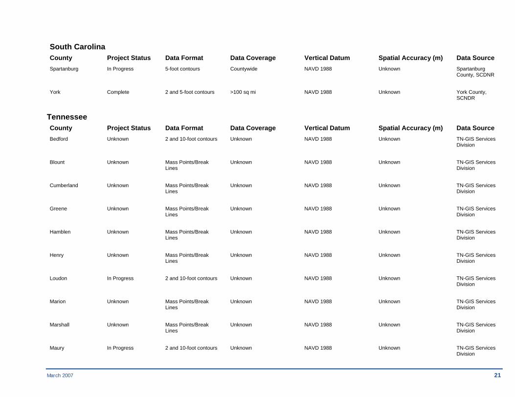
South Carolina County Project Status Data Format Data Coverage Vertical Datum Spatial Accuracy (m) Data Source Spartanburg In Progress 5-foot contours Countywide NAVD 1988 Unknown Spartanburg County, SCDNR
York Complete 2 and 5-foot contours >100 sq mi NAVD 1988 Unknown York County, SCNDR
Tennessee County Project Status Data Format Data Coverage Vertical Datum Spatial Accuracy (m) Data Source Bedford Unknown 2 and 10-foot contours Unknown NAVD 1988 Unknown TN-GIS Services Division
Blount Unknown Mass Points/Break Unknown NAVD 1988 Unknown TN-GIS Services Lines Division
Cumberland Unknown Mass Points/Break Unknown NAVD 1988 Unknown TN-GIS Services Lines Division
Greene Unknown Mass Points/Break Unknown NAVD 1988 Unknown TN-GIS Services Lines Division
Hamblen Unknown Mass Points/Break Unknown NAVD 1988 Unknown TN-GIS Services Lines Division
Henry Unknown Mass Points/Break Unknown NAVD 1988 Unknown TN-GIS Services Lines Division
Loudon In Progress 2 and 10-foot contours Unknown NAVD 1988 Unknown TN-GIS Services Division
Marion Unknown Mass Points/Break Unknown NAVD 1988 Unknown TN-GIS Services Lines Division
Marshall Unknown Mass Points/Break Unknown NAVD 1988 Unknown TN-GIS Services Lines Division
Maury In Progress 2 and 10-foot contours Unknown NAVD 1988 Unknown TN-GIS Services Division
22 March 2007
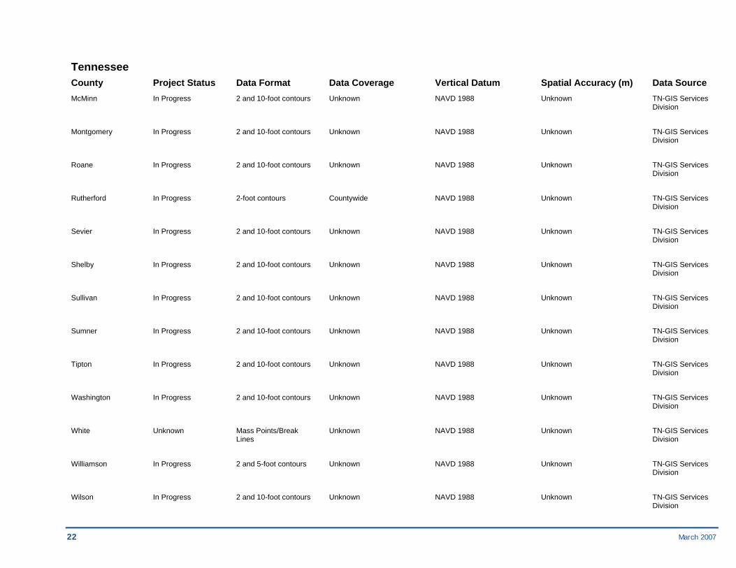
Tennessee County Project Status Data Format Data Coverage Vertical Datum Spatial Accuracy (m) Data Source McMinn In Progress 2 and 10-foot contours Unknown NAVD 1988 Unknown TN-GIS Services Division
Montgomery In Progress 2 and 10-foot contours Unknown NAVD 1988 Unknown TN-GIS Services Division
Roane In Progress 2 and 10-foot contours Unknown NAVD 1988 Unknown TN-GIS Services Division
Rutherford In Progress 2-foot contours Countywide NAVD 1988 Unknown TN-GIS Services Division
Sevier In Progress 2 and 10-foot contours Unknown NAVD 1988 Unknown TN-GIS Services Division
Shelby In Progress 2 and 10-foot contours Unknown NAVD 1988 Unknown TN-GIS Services Division
Sullivan In Progress 2 and 10-foot contours Unknown NAVD 1988 Unknown TN-GIS Services Division
Sumner In Progress 2 and 10-foot contours Unknown NAVD 1988 Unknown TN-GIS Services Division
Tipton In Progress 2 and 10-foot contours Unknown NAVD 1988 Unknown TN-GIS Services Division
Washington In Progress 2 and 10-foot contours Unknown NAVD 1988 Unknown TN-GIS Services Division
White Unknown Mass Points/Break Unknown NAVD 1988 Unknown TN-GIS Services Lines Division
Williamson In Progress 2 and 5-foot contours Unknown NAVD 1988 Unknown TN-GIS Services Division
Wilson In Progress 2 and 10-foot contours Unknown NAVD 1988 Unknown TN-GIS Services Division
March 2007 23
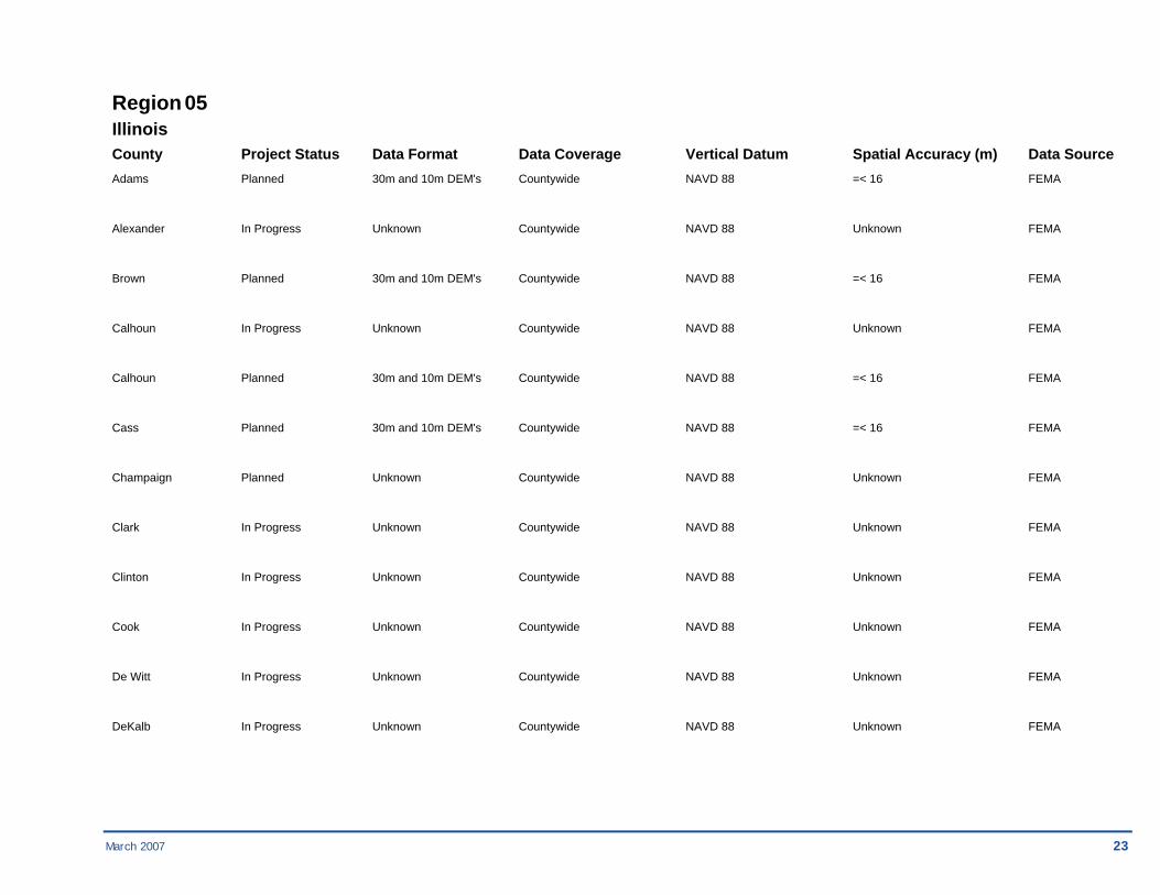
Region 05 Illinois County Project Status Data Format Data Coverage Vertical Datum Spatial Accuracy (m) Data Source Adams Planned 30m and 10m DEM's Countywide NAVD 88 =< 16 FEMA
Alexander In Progress Unknown Countywide NAVD 88 Unknown FEMA
Brown Planned 30m and 10m DEM's Countywide NAVD 88 =< 16 FEMA
Calhoun In Progress Unknown Countywide NAVD 88 Unknown FEMA
Calhoun Planned 30m and 10m DEM's Countywide NAVD 88 =< 16 FEMA
Cass Planned 30m and 10m DEM's Countywide NAVD 88 =< 16 FEMA
Champaign Planned Unknown Countywide NAVD 88 Unknown FEMA
Clark In Progress Unknown Countywide NAVD 88 Unknown FEMA
Clinton In Progress Unknown Countywide NAVD 88 Unknown FEMA
Cook In Progress Unknown Countywide NAVD 88 Unknown FEMA
De Witt In Progress Unknown Countywide NAVD 88 Unknown FEMA
DeKalb In Progress Unknown Countywide NAVD 88 Unknown FEMA

24 March 2007
Illinois County Project Status Data Format Data Coverage Vertical Datum Spatial Accuracy (m) Data Source Fulton Planned 30m and 10m DEM's Countywide NAVD 88 =< 16 FEMA
Greene Planned 30m and 10m DEM's Countywide NAVD 88 =< 16 FEMA
Grundy Planned 30m and 10m DEM's Countywide NAVD 88 =< 16 FEMA
Henderson In Progress Unknown Countywide NAVD 88 Unknown FEMA
Iroquois Planned 30m and 10m DEM's Countywide NAVD 88 =< 16 FEMA
Jackson In Progress Unknown Countywide NAVD 88 Unknown FEMA
Jersey In Progress Unknown Countywide NAVD 88 Unknown FEMA
Jersey Planned 30m and 10m DEM's Countywide NAVD 88 =< 16 FEMA
Jo Daviess In Progress Unknown Countywide NAVD 88 Unknown FEMA
Kane In Progress Unknown Countywide NAVD 88 Unknown FEMA
Kankakee Planned 30m and 10m DEM's Countywide NAVD 88 =< 16 FEMA
Kendall In Progress Unknown Countywide NAVD 88 Unknown FEMA
La Salle In Progress Unknown Countywide NAVD 88 Unknown FEMA

March 2007 25
Illinois County Project Status Data Format Data Coverage Vertical Datum Spatial Accuracy (m) Data Source Lake Complete 2-foot contours Unknown NAVD 88 Unknown Unknown
Lee Planned 30m and 10m DEM's Countywide NAVD 88 =< 16 FEMA
Livingston In Progress Unknown Countywide NAVD 88 Unknown FEMA
Madison In Progress Unknown Countywide NAVD 88 Unknown FEMA
Mason Planned 30m and 10m DEM's Countywide NAVD 88 =< 16 FEMA
McLean In Progress Unknown Countywide NAVD 88 Unknown FEMA
Menard Planned 30m and 10m DEM's Countywide NAVD 88 =< 16 FEMA
Monroe In Progress Unknown Countywide NAVD 88 Unknown FEMA
Morgan Planned 30m and 10m DEM's Countywide NAVD 88 =< 16 FEMA
Ogle Planned 30m and 10m DEM's Countywide NAVD 88 =< 16 FEMA
Pike Planned 30m and 10m DEM's Countywide NAVD 88 =< 16 FEMA
Randolph In Progress Unknown Countywide NAVD 88 Unknown FEMA
Rock Island In Progress Unknown Countywide NAVD 88 Unknown FEMA
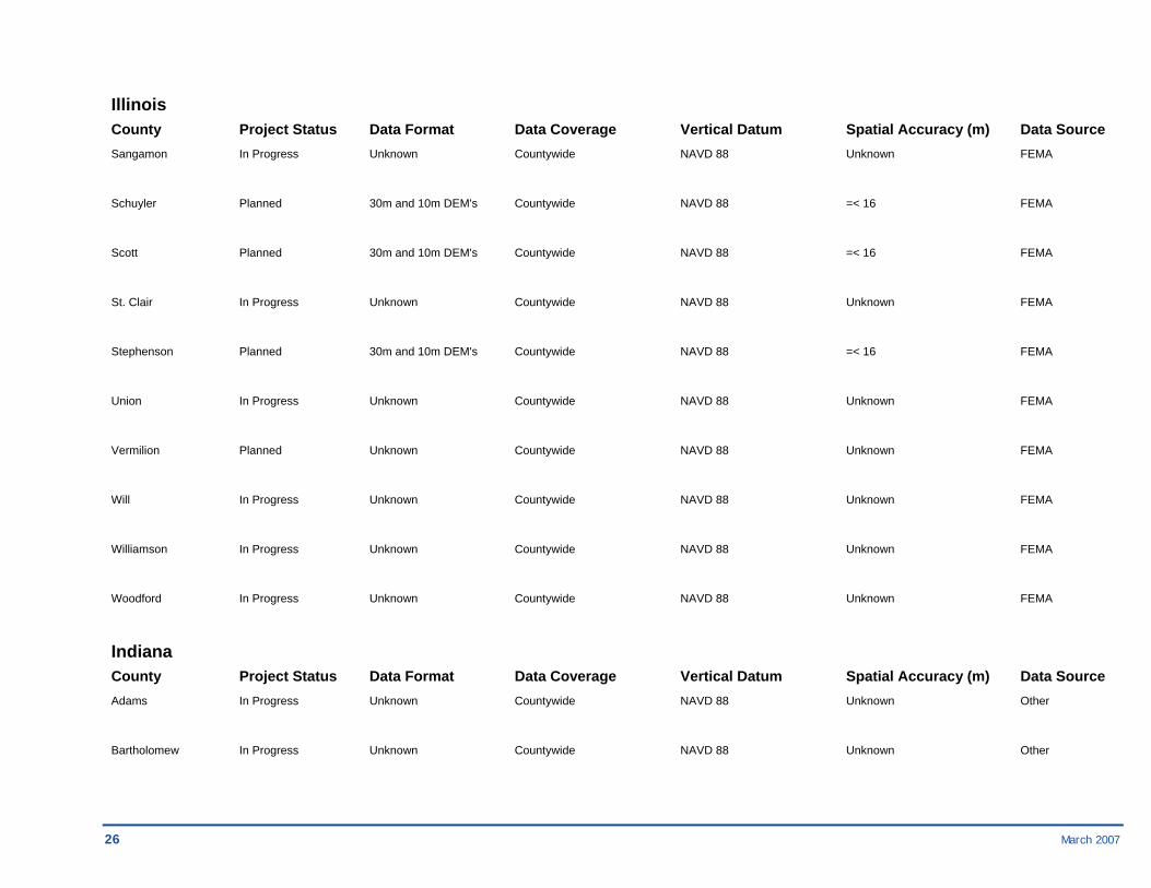
26 March 2007
Illinois County Project Status Data Format Data Coverage Vertical Datum Spatial Accuracy (m) Data Source Sangamon In Progress Unknown Countywide NAVD 88 Unknown FEMA
Schuyler Planned 30m and 10m DEM's Countywide NAVD 88 =< 16 FEMA
Scott Planned 30m and 10m DEM's Countywide NAVD 88 =< 16 FEMA
St. Clair In Progress Unknown Countywide NAVD 88 Unknown FEMA
Stephenson Planned 30m and 10m DEM's Countywide NAVD 88 =< 16 FEMA
Union In Progress Unknown Countywide NAVD 88 Unknown FEMA
Vermilion Planned Unknown Countywide NAVD 88 Unknown FEMA
Will In Progress Unknown Countywide NAVD 88 Unknown FEMA
Williamson In Progress Unknown Countywide NAVD 88 Unknown FEMA
Woodford In Progress Unknown Countywide NAVD 88 Unknown FEMA
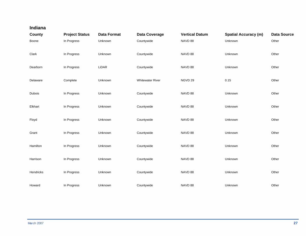
Indiana County Project Status Data Format Data Coverage Vertical Datum Spatial Accuracy (m) Data Source Adams In Progress Unknown Countywide NAVD 88 Unknown Other
Bartholomew In Progress Unknown Countywide NAVD 88 Unknown Other
March 2007 27
Indiana County Project Status Data Format Data Coverage Vertical Datum Spatial Accuracy (m) Data Source Boone In Progress Unknown Countywide NAVD 88 Unknown Other
Clark In Progress Unknown Countywide NAVD 88 Unknown Other
Dearborn In Progress LiDAR Countywide NAVD 88 Unknown Other
Delaware Complete Unknown Whitewater River NGVD 29 0.15 Other
Dubois In Progress Unknown Countywide NAVD 88 Unknown Other
Elkhart In Progress Unknown Countywide NAVD 88 Unknown Other
Floyd In Progress Unknown Countywide NAVD 88 Unknown Other
Grant In Progress Unknown Countywide NAVD 88 Unknown Other
Hamilton In Progress Unknown Countywide NAVD 88 Unknown Other
Harrison In Progress Unknown Countywide NAVD 88 Unknown Other
Hendricks In Progress Unknown Countywide NAVD 88 Unknown Other
Howard In Progress Unknown Countywide NAVD 88 Unknown Other
28 March 2007
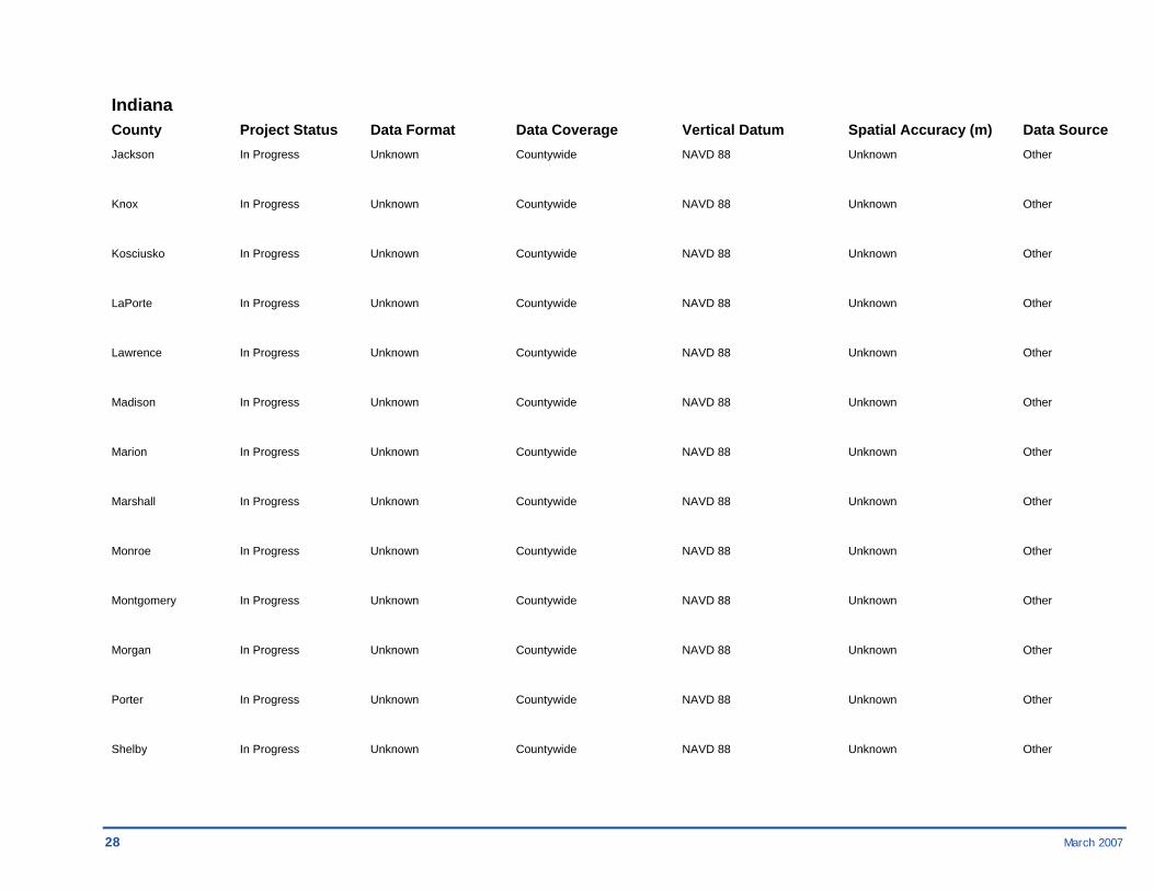
Indiana County Project Status Data Format Data Coverage Vertical Datum Spatial Accuracy (m) Data Source Jackson In Progress Unknown Countywide NAVD 88 Unknown Other
Knox In Progress Unknown Countywide NAVD 88 Unknown Other
Kosciusko In Progress Unknown Countywide NAVD 88 Unknown Other
LaPorte In Progress Unknown Countywide NAVD 88 Unknown Other
Lawrence In Progress Unknown Countywide NAVD 88 Unknown Other
Madison In Progress Unknown Countywide NAVD 88 Unknown Other
Marion In Progress Unknown Countywide NAVD 88 Unknown Other
Marshall In Progress Unknown Countywide NAVD 88 Unknown Other
Monroe In Progress Unknown Countywide NAVD 88 Unknown Other
Montgomery In Progress Unknown Countywide NAVD 88 Unknown Other
Morgan In Progress Unknown Countywide NAVD 88 Unknown Other
Porter In Progress Unknown Countywide NAVD 88 Unknown Other
Shelby In Progress Unknown Countywide NAVD 88 Unknown Other

March 2007 29
Indiana County Project Status Data Format Data Coverage Vertical Datum Spatial Accuracy (m) Data Source St. Joseph In Progress Unknown Countywide NAVD 88 Unknown Other
Tippecanoe In Progress Unknown Countywide NAVD 88 Unknown Other
Vigo In Progress Unknown Countywide NAVD 88 Unknown Other
Warrick In Progress Unknown Countywide NAVD 88 Unknown Other
Wayne In Progress Unknown Countywide NAVD 88 Unknown Other
Michigan County Project Status Data Format Data Coverage Vertical Datum Spatial Accuracy (m) Data Source Allegan In Progress 4-foot contours Countywide NAVD 88 Unknown
Barry Planned 30m USGS DEM Countywide NAVD 88 Unknown USGS
Bay Planned 30m USGS DEM Countywide NAVD 88 Unknown USGS
Cass In Progress 30m USGS DEM Countywide NAVD 88 Unknown USGS
Clinton In Progress 30m USGS DEM Countywide NAVD 88 Unknown USGS
Eaton In Progress 30m USGS DEM Countywide NAVD 88 Unknown USGS
Genesee In Progress LiDAR Countywide NAVD 88 Unknown

30 March 2007
Michigan County Project Status Data Format Data Coverage Vertical Datum Spatial Accuracy (m) Data Source Huron In Progress 30m USGS DEM Countywide NAVD 88 Unknown USGS
Ingham In Progress LiDAR Countywide NAVD 88 Unknown
Kalamazoo Planned 30m USGS DEM Countywide NAVD 88 Unknown USGS
Lapeer In Progress 30m USGS DEM Countywide NAVD 88 Unknown USGS
Livingston In Progress Regional DSM, Countywide NAVD 88 Less than 16 Other ESRI Float Grid
Midland Planned 30m USGS DEM Countywide NAVD 88 Unknown USGS
Ottawa Planned 30m USGS DEM Countywide NAVD 88 Unknown
Saginaw Planned 30m USGS DEM Countywide NAVD 88 Unknown USGS
Sanilac Planned 30m USGS DEM Countywide NAVD 88 Unknown USGS
St. Clair In Progress Regional DSM, Countywide NAVD 88 Less than 16 Other ESRI Float Grid
Tuscola Planned 30m USGS DEM Countywide NAVD 88 Unknown USGS
Washtenaw In Progress Regional DSM, Countywide NAVD 88 Less than 16 Other ESRI Float Grid
Wayne In Progress Regional DSM, Countywide NAVD 88 Less than 16 Other ESRI Float Grid
March 2007 31
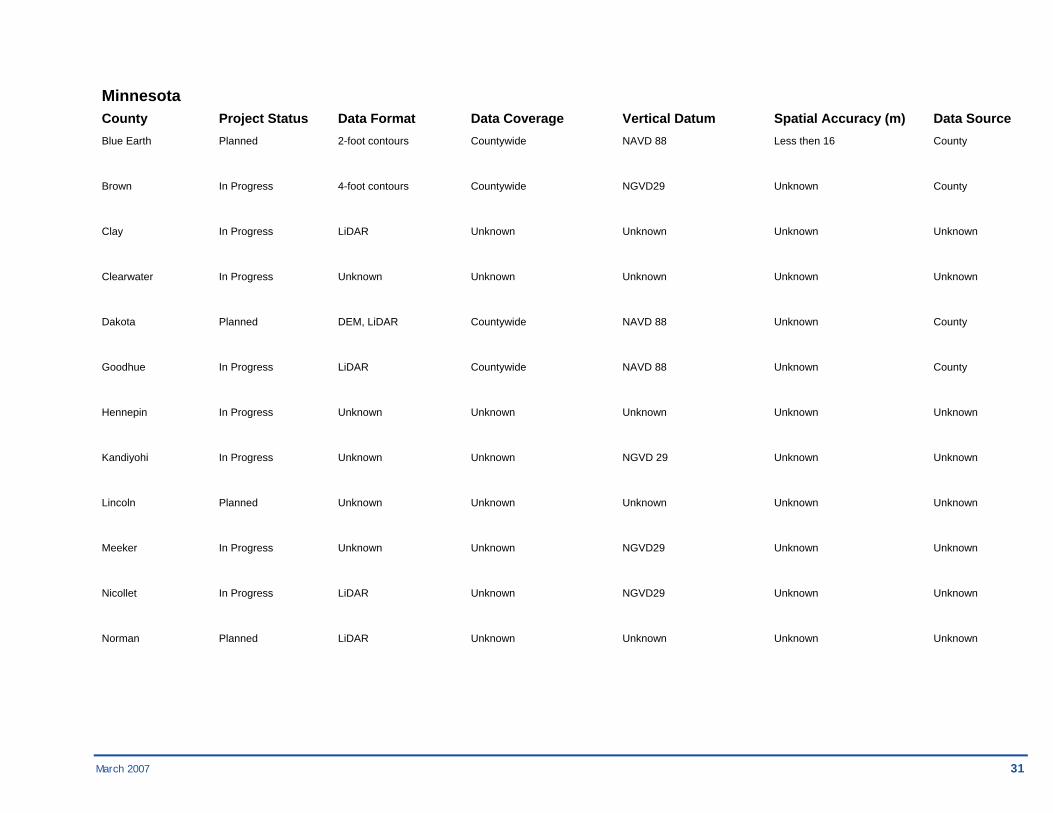
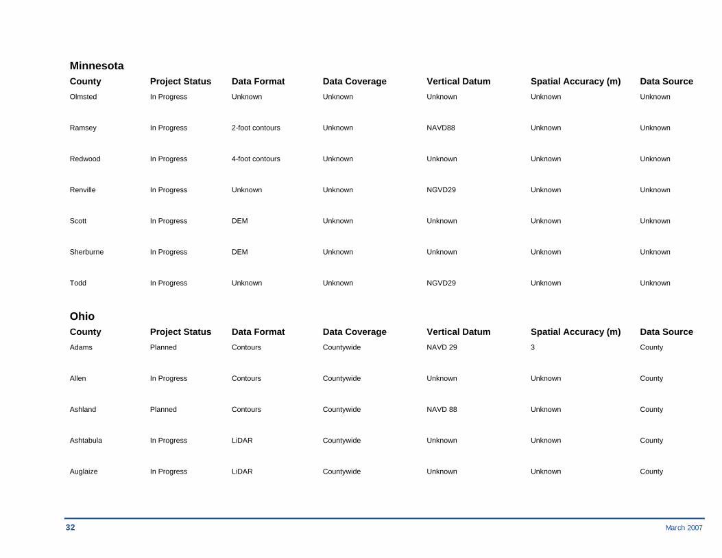
Minnesota County Project Status Data Format Data Coverage Vertical Datum Spatial Accuracy (m) Data Source Blue Earth Planned 2-foot contours Countywide NAVD 88 Less then 16 County
Brown In Progress 4-foot contours Countywide NGVD29 Unknown County
Clay In Progress LiDAR Unknown Unknown Unknown Unknown
Clearwater In Progress Unknown Unknown Unknown Unknown Unknown
Dakota Planned DEM, LiDAR Countywide NAVD 88 Unknown County
Goodhue In Progress LiDAR Countywide NAVD 88 Unknown County
Hennepin In Progress Unknown Unknown Unknown Unknown Unknown
Kandiyohi In Progress Unknown Unknown NGVD 29 Unknown Unknown
Lincoln Planned Unknown Unknown Unknown Unknown Unknown
Meeker In Progress Unknown Unknown NGVD29 Unknown Unknown
Nicollet In Progress LiDAR Unknown NGVD29 Unknown Unknown
Norman Planned LiDAR Unknown Unknown Unknown Unknown
32 March 2007
Minnesota County Project Status Data Format Data Coverage Vertical Datum Spatial Accuracy (m) Data Source Olmsted In Progress Unknown Unknown Unknown Unknown Unknown
Ramsey In Progress 2-foot contours Unknown NAVD88 Unknown Unknown
Redwood In Progress 4-foot contours Unknown Unknown Unknown Unknown
Renville In Progress Unknown Unknown NGVD29 Unknown Unknown
Scott In Progress DEM Unknown Unknown Unknown Unknown
Sherburne In Progress DEM Unknown Unknown Unknown Unknown
Todd In Progress Unknown Unknown NGVD29 Unknown Unknown
Ohio County Project Status Data Format Data Coverage Vertical Datum Spatial Accuracy (m) Data Source Adams Planned Contours Countywide NAVD 29 3 County
Allen In Progress Contours Countywide Unknown Unknown County
Ashland Planned Contours Countywide NAVD 88 Unknown County
Ashtabula In Progress LiDAR Countywide Unknown Unknown County
Auglaize In Progress LiDAR Countywide Unknown Unknown County

March 2007 33
Ohio County Project Status Data Format Data Coverage Vertical Datum Spatial Accuracy (m) Data Source Butler In Progress 2-foot contours Countywide Unknown Unknown County
Carroll Planned Contours Countywide NAVD 88 Unknown County
Cuyahoga In Progress LiDAR Countywide Unknown Unknown County
Delaware Planned 0.5-foot contours Countywide NAVD 88 Unknown County
Erie In Progress LiDAR Countywide Unknown Unknown County
Franklin In Progress 1-foot contours Countywide Unknown Unknown County
Geauga Planned 2-foot contours Countywide NAVD 88 Unknown County
Hamilton In Progress LiDAR Countywide Unknown Unknown County
Harrison Planned Contours Countywide NAVD 88 Unknown County
Holmes Planned 2-foot contours Countywide NAVD 88 Unknown County
Knox In Progress 5-foot contours Countywide NAVD 88 Unknown County
Lake In Progress 2-foot contours Countywide Unknown Unknown County
Lorain In Progress LiDAR Countywide Unknown Unknown County
34 March 2007
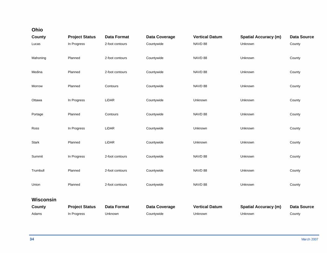
Ohio County Project Status Data Format Data Coverage Vertical Datum Spatial Accuracy (m) Data Source Lucas In Progress 2-foot contours Countywide NAVD 88 Unknown County
Mahoning Planned 2-foot contours Countywide NAVD 88 Unknown County
Medina Planned 2-foot contours Countywide NAVD 88 Unknown County
Morrow Planned Contours Countywide NAVD 88 Unknown County
Ottawa In Progress LiDAR Countywide Unknown Unknown County
Portage Planned Contours Countywide NAVD 88 Unknown County
Ross In Progress LiDAR Countywide Unknown Unknown County
Stark Planned LiDAR Countywide Unknown Unknown County
Summit In Progress 2-foot contours Countywide NAVD 88 Unknown County
Trumbull Planned 2-foot contours Countywide NAVD 88 Unknown County
Union Planned 2-foot contours Countywide NAVD 88 Unknown County
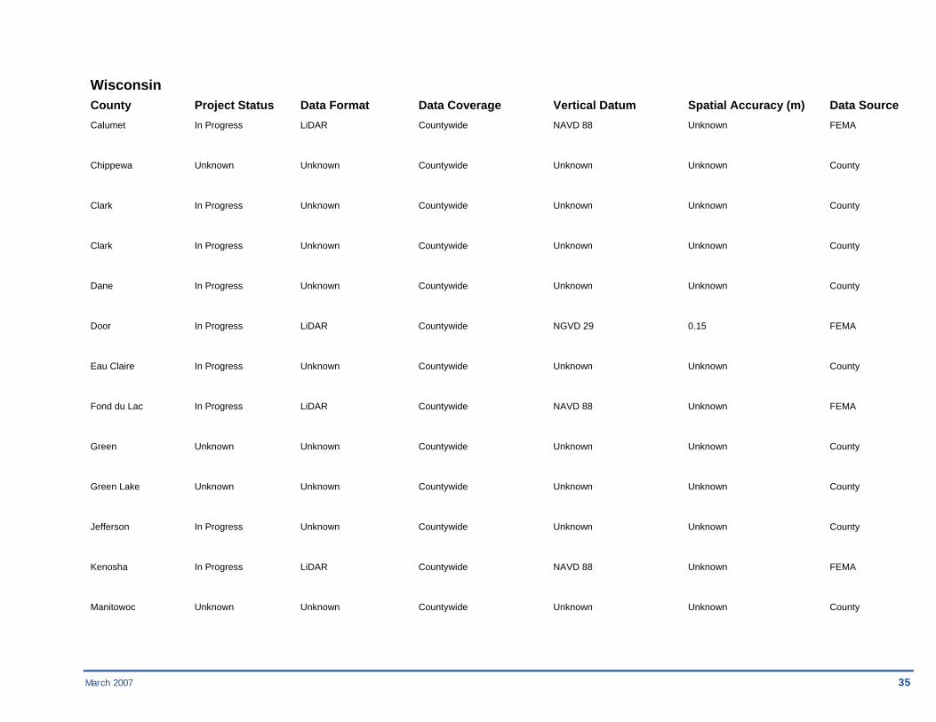
Wisconsin County Project Status Data Format Data Coverage Vertical Datum Spatial Accuracy (m) Data Source Adams In Progress Unknown Countywide Unknown Unknown County
March 2007 35
Wisconsin County Project Status Data Format Data Coverage Vertical Datum Spatial Accuracy (m) Data Source Calumet In Progress LiDAR Countywide NAVD 88 Unknown FEMA
Chippewa Unknown Unknown Countywide Unknown Unknown County
Clark In Progress Unknown Countywide Unknown Unknown County
Clark In Progress Unknown Countywide Unknown Unknown County
Dane In Progress Unknown Countywide Unknown Unknown County
Door In Progress LiDAR Countywide NGVD 29 0.15 FEMA
Eau Claire In Progress Unknown Countywide Unknown Unknown County
Fond du Lac In Progress LiDAR Countywide NAVD 88 Unknown FEMA
Green Unknown Unknown Countywide Unknown Unknown County
Green Lake Unknown Unknown Countywide Unknown Unknown County
Jefferson In Progress Unknown Countywide Unknown Unknown County
Kenosha In Progress LiDAR Countywide NAVD 88 Unknown FEMA
Manitowoc Unknown Unknown Countywide Unknown Unknown County

36 March 2007
Wisconsin County Project Status Data Format Data Coverage Vertical Datum Spatial Accuracy (m) Data Source Marathon In Progress Unknown Countywide NAVD 88 Unknown FEMA
Monroe Unknown Unknown Countywide Unknown Unknown County
Outagamie Planned Unknown Countywide Unknown Unknown County
Portage Unknown Unknown Countywide Unknown Unknown County
Racine In Progress LiDAR Countywide NAVD 88 Unknown FEMA
Rusk Unknown Unknown Countywide Unknown Unknown County
Sheboygan In Progress Unknown Countywide Unknown Unknown County
St. Croix In Progress Unknown Countywide Unknown Unknown County
Walworth In Progress Unknown Countywide NAVD 88 3.3' in Cities and FEMA Villages, 6.6' elsewhere
Walworth Planned Unknown Countywide Unknown Unknown County
Washburn Planned Unknown Countywide Unknown Unknown County
Washington In Progress LiDAR Countywide NAVD 88 To be determined FEMA
March 2007 37
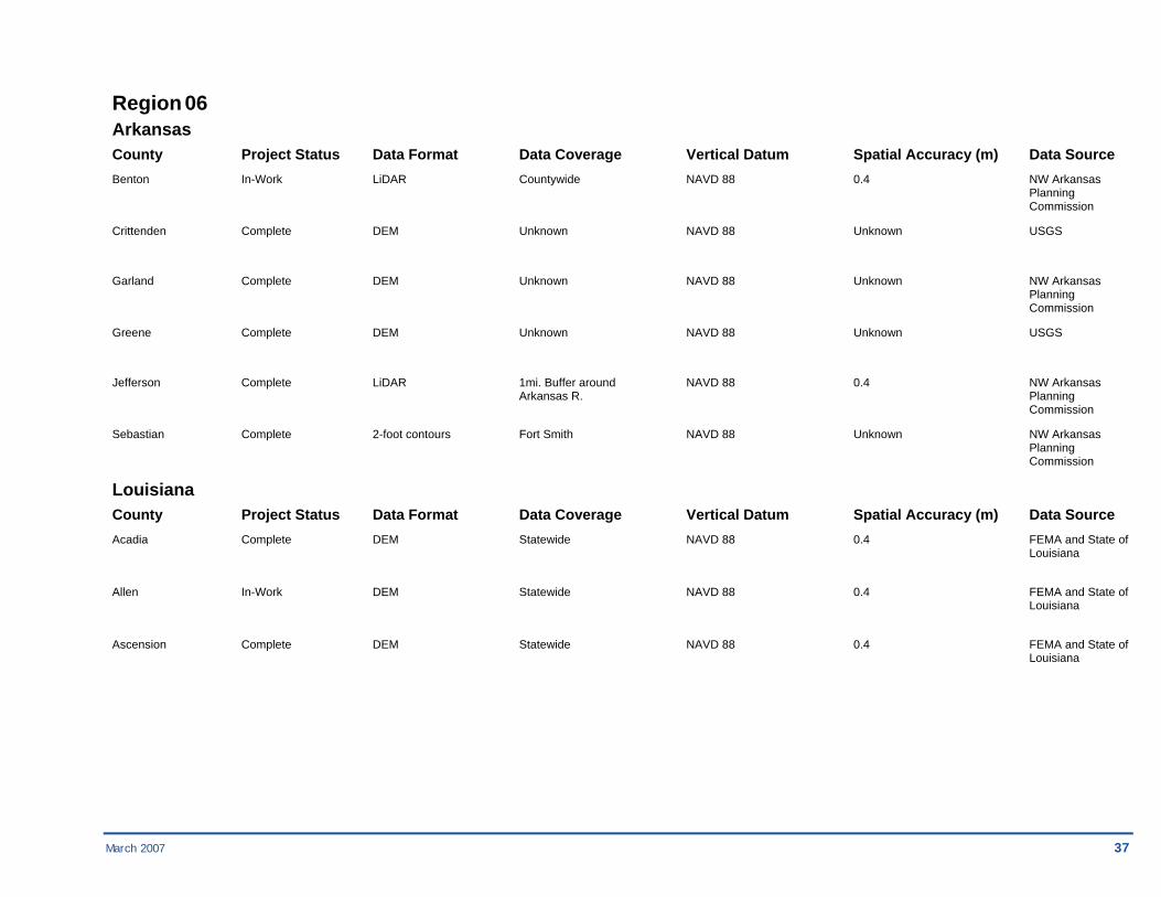
Region 06 Arkansas County Project Status Data Format Data Coverage Vertical Datum Spatial Accuracy (m) Data Source Benton In-Work LiDAR Countywide NAVD 88 0.4 NW Arkansas Planning Commission
Crittenden Complete DEM Unknown NAVD 88 Unknown USGS
Garland Complete DEM Unknown NAVD 88 Unknown NW Arkansas Planning Commission
Greene Complete DEM Unknown NAVD 88 Unknown USGS
Jefferson Complete LiDAR 1mi. Buffer around NAVD 88 0.4 NW Arkansas Arkansas R. Planning Commission
Sebastian Complete 2-foot contours Fort Smith NAVD 88 Unknown NW Arkansas Planning Commission
Louisiana County Project Status Data Format Data Coverage Vertical Datum Spatial Accuracy (m) Data Source Acadia Complete DEM Statewide NAVD 88 0.4 FEMA and State of Louisiana
Allen In-Work DEM Statewide NAVD 88 0.4 FEMA and State of Louisiana
Ascension Complete DEM Statewide NAVD 88 0.4 FEMA and State of Louisiana

38 March 2007
Louisiana County Project Status Data Format Data Coverage Vertical Datum Spatial Accuracy (m) Data Source Assumption Complete DEM Statewide NAVD 88 0.4 FEMA and State of Louisiana
Avoyelles In-Work DEM Statewide NAVD 88 0.4 FEMA and State of Louisiana
Beauregard In-Work DEM Statewide NAVD 88 0.4 FEMA and State of Louisiana
Bienville In-Work DEM Statewide NAVD 88 0.4 FEMA and State of Louisiana
Bossier In-Work DEM Statewide NAVD 88 0.4 FEMA and State of Louisiana
Caddo In-Work DEM Statewide NAVD 88 0.4 FEMA and State of Louisiana
De Soto In-Work DEM Statewide NAVD 88 0.4 FEMA and State of Louisiana
East Baton Rouge Complete DEM Statewide NAVD 88 0.4 FEMA and State of Louisiana
East Feliciana Complete DEM Statewide NAVD 88 0.4 FEMA and State of Louisiana
Evangeline In-Work DEM Statewide NAVD 88 0.4 FEMA and State of Louisiana
Grant In-Work DEM Statewide NAVD 88 0.4 FEMA and State of Louisiana
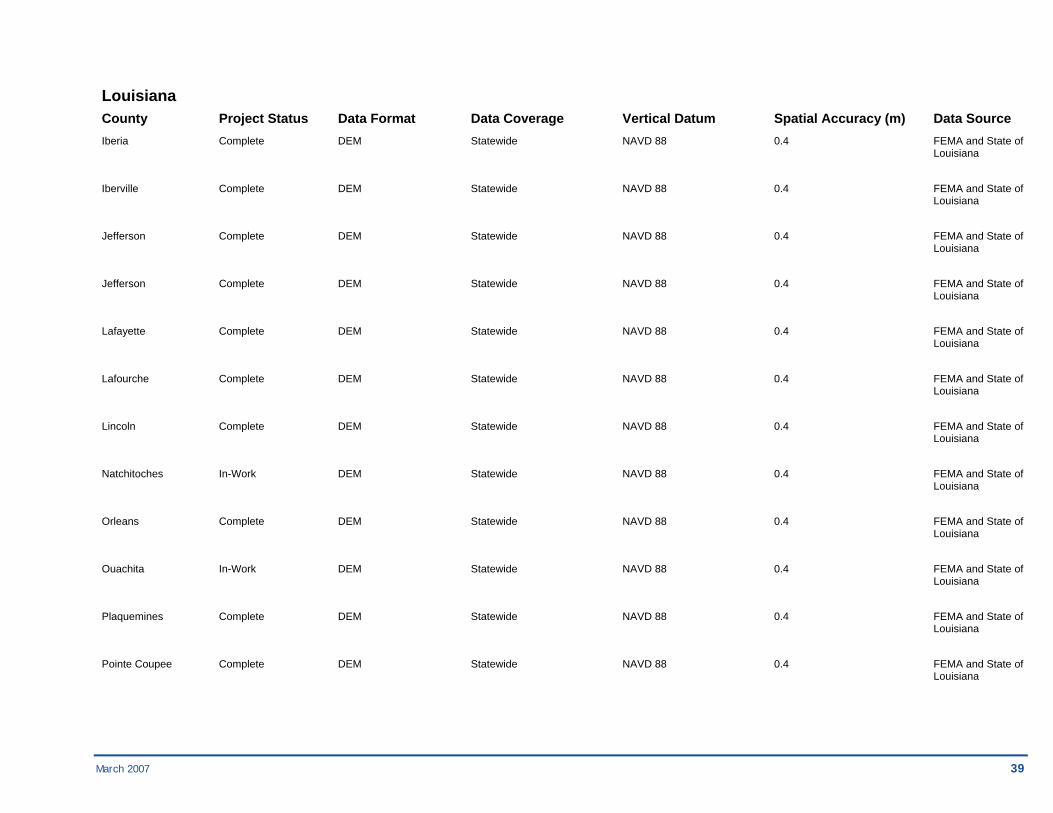
March 2007 39
Louisiana County Project Status Data Format Data Coverage Vertical Datum Spatial Accuracy (m) Data Source Iberia Complete DEM Statewide NAVD 88 0.4 FEMA and State of Louisiana
Iberville Complete DEM Statewide NAVD 88 0.4 FEMA and State of Louisiana
Jefferson Complete DEM Statewide NAVD 88 0.4 FEMA and State of Louisiana
Jefferson Complete DEM Statewide NAVD 88 0.4 FEMA and State of Louisiana
Lafayette Complete DEM Statewide NAVD 88 0.4 FEMA and State of Louisiana
Lafourche Complete DEM Statewide NAVD 88 0.4 FEMA and State of Louisiana
Lincoln Complete DEM Statewide NAVD 88 0.4 FEMA and State of Louisiana
Natchitoches In-Work DEM Statewide NAVD 88 0.4 FEMA and State of Louisiana
Orleans Complete DEM Statewide NAVD 88 0.4 FEMA and State of Louisiana
Ouachita In-Work DEM Statewide NAVD 88 0.4 FEMA and State of Louisiana
Plaquemines Complete DEM Statewide NAVD 88 0.4 FEMA and State of Louisiana
Pointe Coupee Complete DEM Statewide NAVD 88 0.4 FEMA and State of Louisiana

40 March 2007
Louisiana County Project Status Data Format Data Coverage Vertical Datum Spatial Accuracy (m) Data Source Rapides Complete DEM Statewide NAVD 88 0.4 FEMA and State of Louisiana
Red River In-Work DEM Statewide NAVD 88 0.4 FEMA and State of Louisiana
St. Bernard Complete DEM Statewide NAVD 88 0.4 FEMA and State of Louisiana
St. Charles Complete DEM Statewide NAVD 88 0.4 FEMA and State of Louisiana
St. Helena Complete DEM Statewide NAVD 88 0.4 FEMA and State of Louisiana
St. James Complete DEM Statewide NAVD 88 0.4 FEMA and State of Louisiana
St. John the Baptist Complete DEM Statewide NAVD 88 0.4 FEMA and State of Louisiana
St. Martin Complete DEM Statewide NAVD 88 0.4 FEMA and State of Louisiana
St. Mary Complete DEM Statewide NAVD 88 0.4 FEMA and State of Louisiana
St. Tammany Complete DEM Statewide NAVD 88 0.4 FEMA and State of Louisiana
Tangipahoa Complete DEM Statewide NAVD 88 0.4 FEMA and State of Louisiana
Washington Complete DEM Statewide NAVD 88 0.4 FEMA and State of Louisiana

March 2007 41
Louisiana County Project Status Data Format Data Coverage Vertical Datum Spatial Accuracy (m) Data Source Webster In-Work DEM Statewide NAVD 88 0.4 FEMA and State of Louisiana
West Baton Rouge Complete DEM Statewide NAVD 88 0.4 FEMA and State of Louisiana
West Feliciana Complete DEM Statewide NAVD 88 0.4 FEMA and State of Louisiana
New Mexico County Project Status Data Format Data Coverage Vertical Datum Spatial Accuracy (m) Data Source Chaves Complete Contours City of Roswell NAVD 88 Unknown City of Roswell
Dona Ana Complete LiDAR Las Cruces & River NAVD 88 0.4 Dona Ana Co. Valley Areas Flood Commission
San Juan Complete 2 and 4-foot contours Countywide NAVD 88 .363, .726 San Juan County GIS
San Juan Complete DEM Unknown NAVD 88 Unknown USGS
Santa Fe Complete Unknown 70% County NAVD 88 Unknown Santa Fe County GIS
Oklahoma County Project Status Data Format Data Coverage Vertical Datum Spatial Accuracy (m) Data Source Canadian Complete DEM Unknown NAVD 88 2 FEMA
Cleveland Complete DEM Unknown NAVD 88 2 FEMA
Comanche Complete 2-foot contours City of Lawton NAVD 88 0.363 City of Lawton

42 March 2007
Oklahoma County Project Status Data Format Data Coverage Vertical Datum Spatial Accuracy (m) Data Source Comanche In-Work DEM Unknown NAVD 88 2 FEMA
Kay Complete DEM Unknown NAVD 88 Unknown USGS
Lincoln Complete DEM Unknown NAVD 88 Unknown USGS
Logan Complete DEM Unknown NAVD 88 Unknown USGS
Muskogee Complete DEM Unknown NAVD 88 Unknown USGS
Oklahoma Complete Unknown City of Oklahoma NAVD 88 Unknown City of Oklahoma City City
Okmulgee Complete DEM Unknown NAVD 88 Unknown USGS
Osage Complete DEM Bird Creek Area Only NAVD 88 0.4 Unknown
Pawnee Complete DEM Unknown NAVD 88 Unknown USGS
Payne Complete Unknown City of Stillwater NAVD 88 Unknown City of Stillwater
Pottawatomie Complete DEM Unknown NAVD 88 Unknown USGS
Tulsa Complete Unknown Countywide NAVD 88 Unknown Tulsa County
Wagoner Complete DEM Unknown NAVD 88 Unknown USGS

March 2007 43
Texas County Project Status Data Format Data Coverage Vertical Datum Spatial Accuracy (m) Data Source Anderson Complete DEM Countywide NAVD 88 Unknown USGS
Aransas Complete DEM Countywide NAVD 88 Unknown USGS
Austin Complete DEM Countywide NAVD 88 Unknown USGS
Bee Complete Unknown Unknown NAVD 88 Unknown Bee County
Bell Complete IFSAR Countywide NAVD 88 2 FEMA
Bell Complete Contours Town of Harker NAVD 88 Unknown Town of Harker Heights Heights
Bell Complete Contours City of Killeen NAVD 88 Unknown City of Killeen
Bexar Complete Unknown Countywide NAVD 88 Unknown Bexar County
Bosque Complete DEM Countywide NAVD 88 Unknown USGS
Brazoria Complete Unknown Flood Control NAVD 88 Unknown USACE Channel
Brazoria Complete LiDAR Fort Bend NAVD 88 0.4 Brazoria County
Brazos Complete DEM Countywide NAVD 88 Unknown USGS
Calhoun Complete DEM Countywide NAVD 88 Unknown USGS
44 March 2007
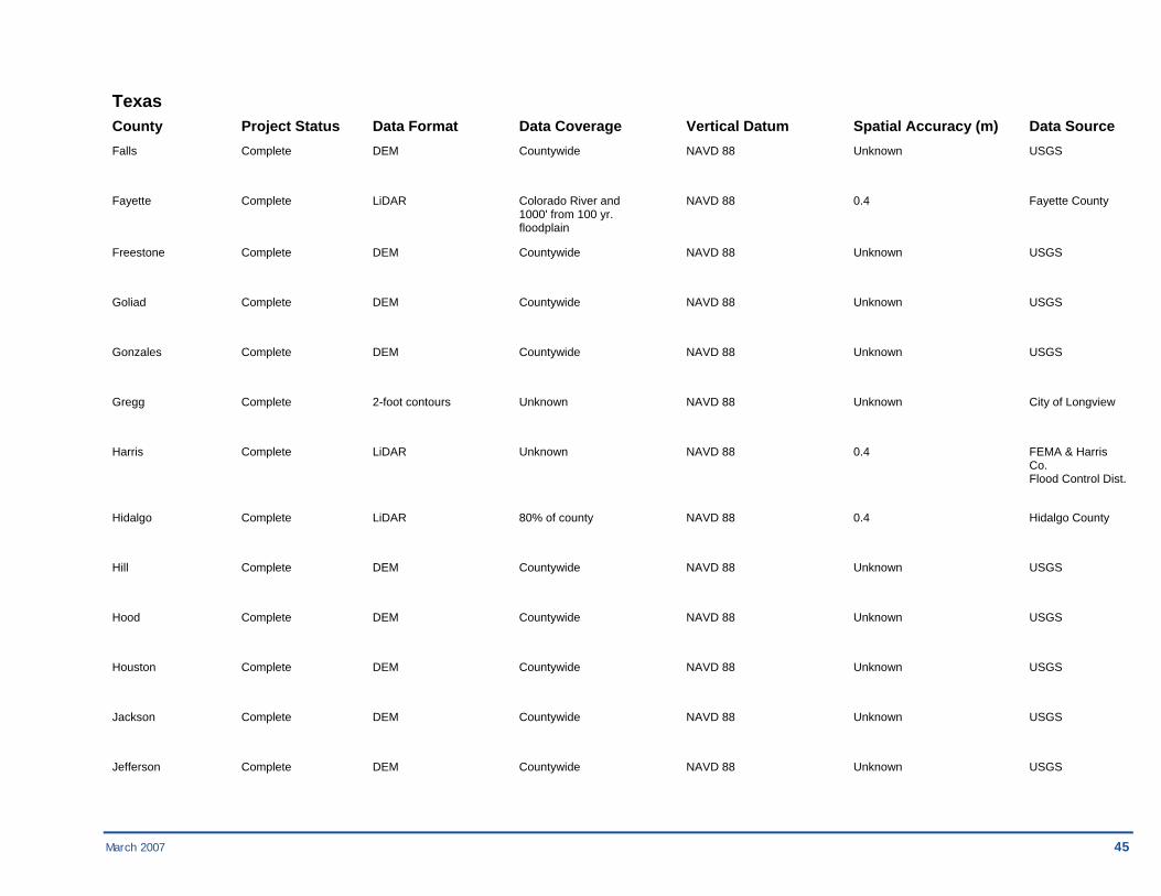
Texas County Project Status Data Format Data Coverage Vertical Datum Spatial Accuracy (m) Data Source Cameron Complete Contours City of La Feria NAVD 88 Unknown City of La Feria Engineering Dept
Chambers Complete DEM Countywide NAVD 88 Unknown USGS
Cherokee Complete DEM Countywide NAVD 88 Unknown USGS
Collin Complete LiDAR Countywide NAVD 88 0.4 North Central Texas COG
Colorado Complete DEM Countywide NAVD 88 Unknown USGS
Comal Complete Unknown 30 sq. miles NAVD 88 Unknown Comal County
Cooke Complete IFSAR Unknown NAVD 88 2 FEMA
Dallas Complete LiDAR Countywide NAVD 88 0.4 North Central Texas COG
Denton Complete LiDAR Countywide NAVD 88 0.4 North Central Texas COG
DeWitt Complete DEM Countywide NAVD 88 Unknown USGS
DeWitt Complete DEM Countywide NAVD 88 Unknown USGS
El Paso Complete DEM Countywide NAVD 88 0.4 North Central Texas COG
Ellis Complete 2-foot contours Northern edge of NAVD 88 0.363 North Central county Texas COG
March 2007 45
Texas
County Project Status Data Format Data Coverage Vertical Datum Spatial Accuracy (m) Data Source Falls Complete DEM Countywide NAVD 88 Unknown USGS
Fayette Complete LiDAR Colorado River and NAVD 88 0.4 Fayette County 1000' from 100 yr. floodplain
Freestone Complete DEM Countywide NAVD 88 Unknown USGS
Goliad Complete DEM Countywide NAVD 88 Unknown USGS
Gonzales Complete DEM Countywide NAVD 88 Unknown USGS
Gregg Complete 2-foot contours Unknown NAVD 88 Unknown City of Longview
Harris Complete LiDAR Unknown NAVD 88 0.4 FEMA & Harris Co. Flood Control Dist.
Hidalgo Complete LiDAR 80% of county NAVD 88 0.4 Hidalgo County
Hill Complete DEM Countywide NAVD 88 Unknown USGS
Hood Complete DEM Countywide NAVD 88 Unknown USGS
Houston Complete DEM Countywide NAVD 88 Unknown USGS
Jackson Complete DEM Countywide NAVD 88 Unknown USGS
Jefferson Complete DEM Countywide NAVD 88 Unknown USGS

46 March 2007
Texas County Project Status Data Format Data Coverage Vertical Datum Spatial Accuracy (m) Data Source Johnson Complete LiDAR Northern edge of NAVD 88 0.4 North Central county Texas COG
Karnes Complete DEM Countywide NAVD 88 Unknown USGS
Kaufman Complete LiDAR Northwestern part of NAVD 88 0.4 North Central county Texas COG
Lavaca Complete DEM Countywide NAVD 88 Unknown USGS
Liberty Complete DEM Countywide NAVD 88 Unknown USGS
Limestone Complete DEM Countywide NAVD 88 Unknown USGS
Lubbock Complete Unknown City of Lubbock NAVD 88 Unknown City of Lubbock
Matagorda Complete DEM Countywide NAVD 88 Unknown USGS
McLennan Complete IFSAR Brazos River area NAVD 88 2 FEMA
McLennan Complete 2-foot Contours Brazos River area NAVD 88 0.363 McLennan County
Navarro Complete DEM Countywide NAVD 88 Unknown USGS
Nueces Complete LiDAR 75% of county NAVD 88 0.4 Nueces County
Orange Complete DEM Countywide NAVD 88 Unknown USGS
March 2007 47
Texas County Project Status Data Format Data Coverage Vertical Datum Spatial Accuracy (m) Data Source
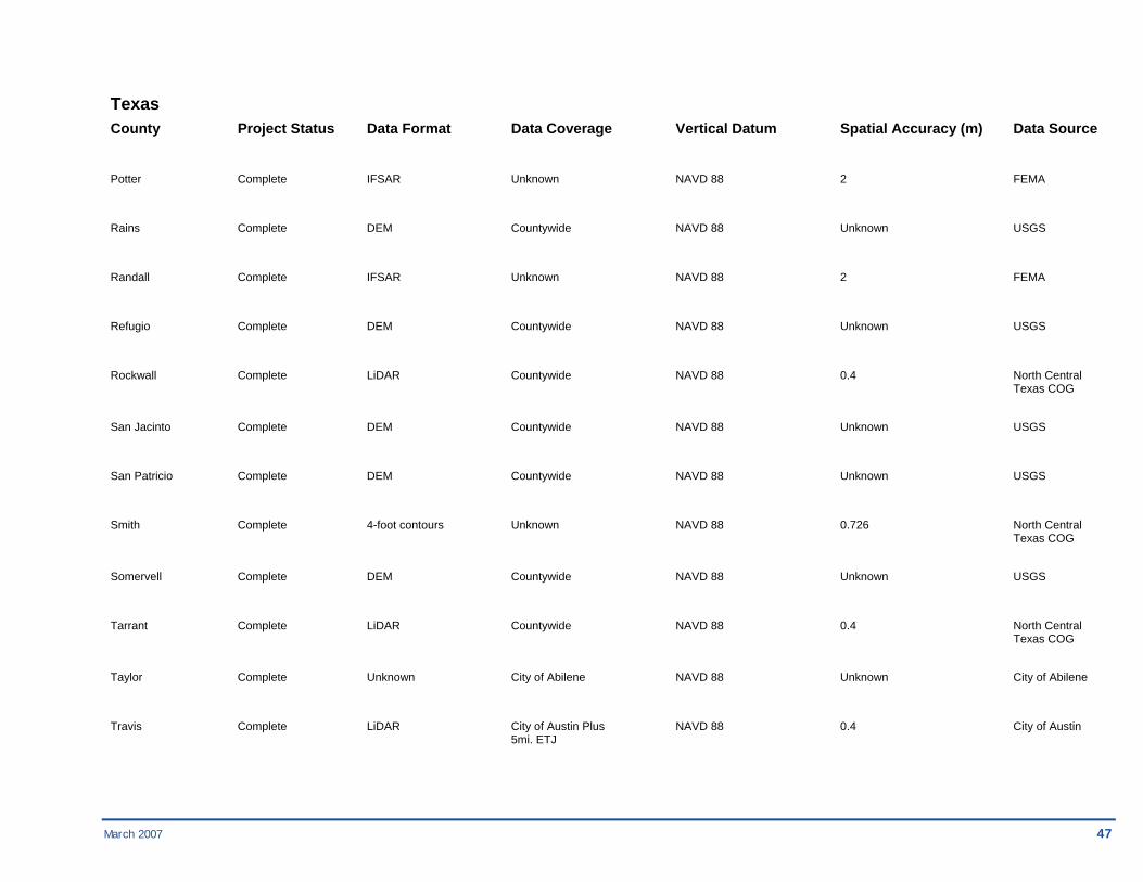
Potter Complete IFSAR Unknown NAVD 88 2 FEMA
Rains Complete DEM Countywide NAVD 88 Unknown USGS
Randall Complete IFSAR Unknown NAVD 88 2 FEMA
Refugio Complete DEM Countywide NAVD 88 Unknown USGS
Rockwall Complete LiDAR Countywide NAVD 88 0.4 North Central Texas COG
San Jacinto Complete DEM Countywide NAVD 88 Unknown USGS
San Patricio Complete DEM Countywide NAVD 88 Unknown USGS
Smith Complete 4-foot contours Unknown NAVD 88 0.726 North Central Texas COG
Somervell Complete DEM Countywide NAVD 88 Unknown USGS
Tarrant Complete LiDAR Countywide NAVD 88 0.4 North Central Texas COG
Taylor Complete Unknown City of Abilene NAVD 88 Unknown City of Abilene
Travis Complete LiDAR City of Austin Plus NAVD 88 0.4 City of Austin 5mi. ETJ

48 March 2007
Texas County Project Status Data Format Data Coverage Vertical Datum Spatial Accuracy (m) Data Source Trinity Complete DEM Countywide NAVD 88 Unknown USGS
Van Zandt Complete DEM Countywide NAVD 88 Unknown USGS
Walker Complete DEM Countywide NAVD 88 Unknown USGS
Waller Complete DEM Countywide NAVD 88 Unknown USGS
Webb Complete Contours Countywide NAVD 88 Unknown Webb County
Wharton Complete DEM Colorado River and NAVD 88 0.4 Unknown 1000 feet out from 100 year floodplain
Willacy Complete LiDAR Flood Control Unknown Unknown USACE Channel

March 2007 49
Region 07
Kansas County Project Status Data Format Data Coverage Vertical Datum Spatial Accuracy (m) Data Source Saline Unknown 2-foot contours City of Salina NAVD 88 Unknown USGS Missouri County Project Status Data Format Data Coverage Vertical Datum Spatial Accuracy (m) Data Source Benton Unknown Contours Unknown Unknown Unknown Unknown
Nebraska County Project Status Data Format Data Coverage Vertical Datum Spatial Accuracy (m) Data Source Thurston Unknown LiDAR Unknown Unknown Unknown Unknown

50 March 2007
Region 08 Colorado County Project Status Data Format Data Coverage Vertical Datum Spatial Accuracy (m) Data Source Denver Complete LiDAR Unknown NAVD 88 Unknown State of CO
Jefferson Complete LiDAR Unknown NAVD 88 Unknown State of CO
La Plata Complete Unknown Countywide NAVD 88 Unknown County
La Plata Complete Contours City of Durango NAVD 88 Unknown City of Durango
La Plata Complete Contours Countywide NAVD 88 Unknown County
North Dakota County Project Status Data Format Data Coverage Vertical Datum Spatial Accuracy (m) Data Source Cass Complete LiDAR Red & Wild Rice Unknown Unknown FEMA Rivers
Cass Complete LiDAR Fargo, ND & Unknown Unknown FEMA Moorhead, MN
Cass Complete LiDAR Unknown NAVD 88 Unknown State of ND
Cass Complete LiDAR Sheyenne River Unknown Unknown FEMA
Ramsey Complete LiDAR Unknown NAVD 88 Unknown State of ND
Ramsey Complete LiDAR Devils Lake Basin Unknown Unknown FEMA
Ramsey Complete LiDAR Sheyenne River Unknown Unknown USACE Corridor
March 2007 51
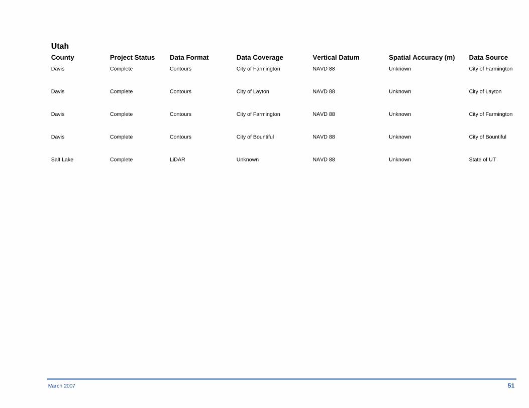
Utah County Project Status Data Format Data Coverage Vertical Datum Spatial Accuracy (m) Data Source Davis Complete Contours City of Farmington NAVD 88 Unknown City of Farmington
Davis Complete Contours City of Layton NAVD 88 Unknown City of Layton
Davis Complete Contours City of Farmington NAVD 88 Unknown City of Farmington
Davis Complete Contours City of Bountiful NAVD 88 Unknown City of Bountiful
Salt Lake Complete LiDAR Unknown NAVD 88 Unknown State of UT

52 March 2007
Region 09 American Samoa County Project Status Data Format Data Coverage Vertical Datum Spatial Accuracy (m) Data Source American Samoa Complete Contours Countywide Unknown 0.908 Government of Samoa
Arizona County Project Status Data Format Data Coverage Vertical Datum Spatial Accuracy (m) Data Source Gila In Progress Contours 20 sq mi NGVD 29 0.363 Gila County
Maricopa In Progress Contours Countywide NAVD 88 0.363 Maricopa County
Mohave In Progress Contours City of Kingman NGVD 29 0.363 Colorado City
Mohave In Progress Contours City of Golden Valley NGVD 29 0.363 Colorado City
Mohave In Progress Contours City of Bullhead NGVD 29 0.363 Colorado City
Mohave In Progress Contours City of Lake Havasu NGVD 29 0.363 Colorado City
Mohave Planned Mass Points/Variable Colorado City NAVD 88 0.363 Colorado City Spacing
Navajo In Progress Contours 20 sq mi NGVD 29 0.363 Navajo County
Pima In Progress Contours City of Tucson NAVD 88 0.363 Pima County
Pinal In Progress Contours Partial County NAVD 88 0.363 Pinal County

March 2007 53
Arizona County Project Status Data Format Data Coverage Vertical Datum Spatial Accuracy (m) Data Source Santa Cruz Planned Contours Nogales Creek NGVD 29 0.363 Santa Cruz County
California County Project Status Data Format Data Coverage Vertical Datum Spatial Accuracy (m) Data Source Alameda In Progress Mass Points/Break Coastal portion of NAVD 88 0.182 FEMA Lines county
Butte In Progress Contours Countywide Unknown 0.726 Butte County
Contra Costa In Progress Mass Points/Break Coastal portion of NAVD 88 0.182 FEMA Lines county
Imperial Complete Mass Points/Variable 76 sq mi NAVD 88 0.363 Coachella Valley Spacing Water District
Kings In Progress Contours Countywide Unknown 0.726 Kings County
Los Angeles Complete Contours Partial County NGVD 29 0.363 LA County
Los Angeles Complete Contours, Mass 3 streams in Santa NAVD 88 0.363 LA County Points/Breaklines Clarita
Marin In Progress Mass Points/Break Coastal portion of NAVD 88 0.182 FEMA Lines county
Monterey Complete Contours Partial County NGVD 29 0.182 Monterey County
Napa In Progress Mass Points/Break Non-watershed areas NAVD 88 0.182 FEMA Lines
Napa In Progress Contours Coastal portion of NAVD 88 0.908 County of Napa county ITS Department

54 March 2007
California County Project Status Data Format Data Coverage Vertical Datum Spatial Accuracy (m) Data Source Napa In Progress Contours Napa River NAVD 88 1.816 County of Napa Watershed ITS Department
Orange In Progress Contours Laguna Beach NAVD 88 0.363 City of Laguna Beach
Placer In Progress Contours Partial County NGVD 29 0.363 Placer County
Riverside Planned Unknown Unknown Unknown Unknown Riverside County
San Bernardino Complete Contours Hooke Creek study NGVD 29 0.182 San Bernardino area County Department of Public Works
San Diego In Progress Contours, DTM South Bay/Escondido NAVD 88 Unknown City of Chula Vista
San Francisco In Progress Mass Points/Break Coastal portion of NAVD 88 0.182 FEMA Lines county
San Mateo In Progress Contours, DTM Countywide NAVD 88 0.182 USGS, County of San Mateo, the San Mateo County Transit
San Mateo In Progress Mass Points/Break Coastal portion of NAVD 88 0.182 FEMA Lines county
Santa Barbara In Progress Contours Coastal portion of Unknown 0.182 Santa Barbara county County
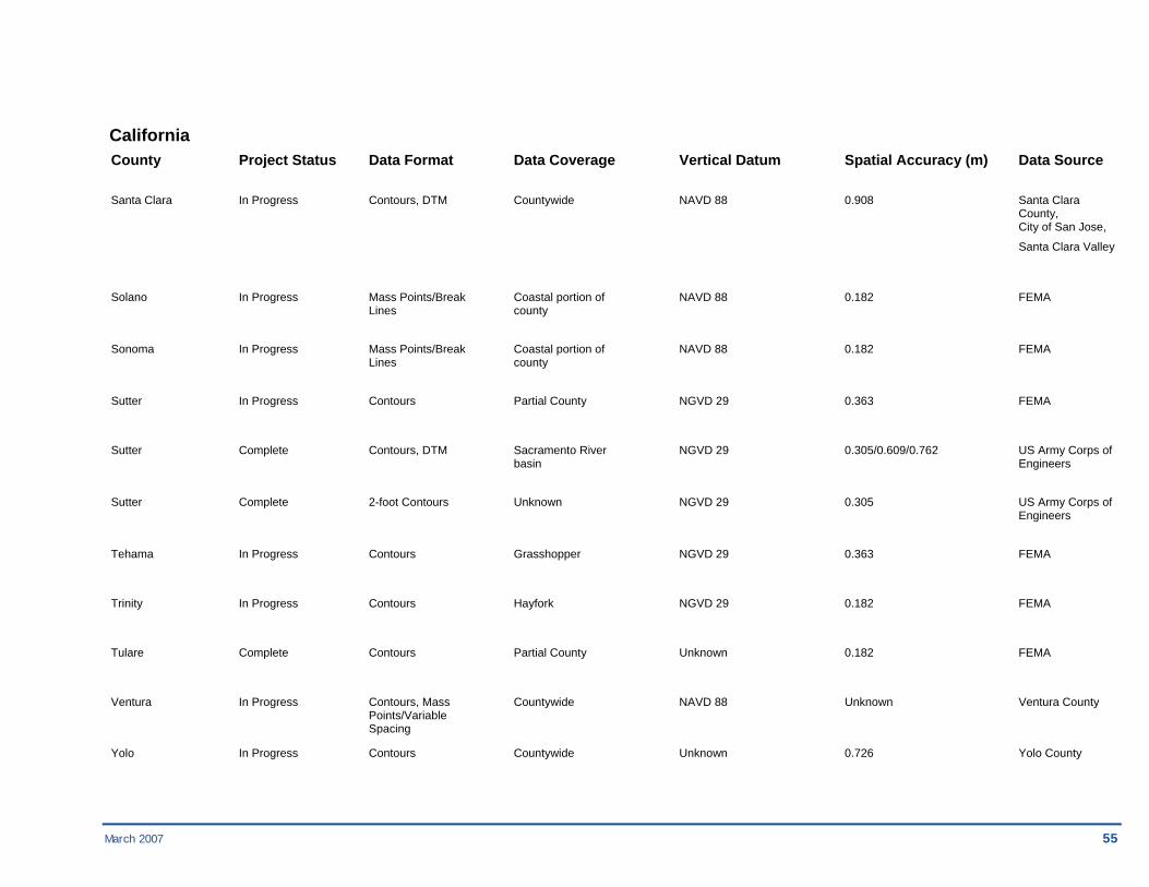
Santa Clara In Progress Contours, DTM Countywide NAVD 88 0.182 Santa Clara County, City of San Jose, Santa Clara Valley
Santa Clara In Progress Mass Points/Break Coastal portion of NAVD 88 0.182 FEMA Lines county
March 2007 55
California County Project Status Data Format Data Coverage Vertical Datum Spatial Accuracy (m) Data Source
Santa Clara In Progress Contours, DTM Countywide NAVD 88 0.908 Santa Clara County, City of San Jose, Santa Clara Valley
Solano In Progress Mass Points/Break Coastal portion of NAVD 88 0.182 FEMA Lines county
Sonoma In Progress Mass Points/Break Coastal portion of NAVD 88 0.182 FEMA Lines county
Sutter In Progress Contours Partial County NGVD 29 0.363 FEMA
Sutter Complete Contours, DTM Sacramento River NGVD 29 0.305/0.609/0.762 US Army Corps of basin Engineers
Sutter Complete 2-foot Contours Unknown NGVD 29 0.305 US Army Corps of Engineers
Tehama In Progress Contours Grasshopper NGVD 29 0.363 FEMA
Trinity In Progress Contours Hayfork NGVD 29 0.182 FEMA
Tulare Complete Contours Partial County Unknown 0.182 FEMA
Ventura In Progress Contours, Mass Countywide NAVD 88 Unknown Ventura County Points/Variable Spacing
Yolo In Progress Contours Countywide Unknown 0.726 Yolo County

56 March 2007
Guam County Project Status Data Format Data Coverage Vertical Datum Spatial Accuracy (m) Data Source Guam Complete LiDAR 35 sq mi NAVD 88 Unknown Guam Government Hawaii County Project Status Data Format Data Coverage Vertical Datum Spatial Accuracy (m) Data Source Honolulu In Progress LiDAR 285 sq mi NAVD 88 0.162 NOAA
Maui In Progress Mass Points/Variable Partial County NAVD 88 0.162 FEMA Spacing
Maui Planned LiDAR Kihei Kamaole NAVD 88 0.162 Maui County Kaluhihakoko watershed and coast
Nevada County Project Status Data Format Data Coverage Vertical Datum Spatial Accuracy (m) Data Source Carson City Complete LiDAR Floodplain areas NAVD 88 Unknown Carson Valley Carson R. watershed Conservation District
Clark Complete Contours, TIN, DEM Virgin River study area NAVD 88 0.363 Clark County Bureau of Reclamation
Douglas Complete Contours Alluvial fans in county Unknown Unknown Douglas County
Washoe In Progress Contours Countywide Unknown 0.726 Washoe County
Northern Mariana Islands County Project Status Data Format Data Coverage Vertical Datum Spatial Accuracy (m) Data Source Northern Mariana Complete Contours Rota, Tinian, NAVD 88 0.726 Government of Islands Saipan Marianas/USACE- Honolulu
March 2007 57
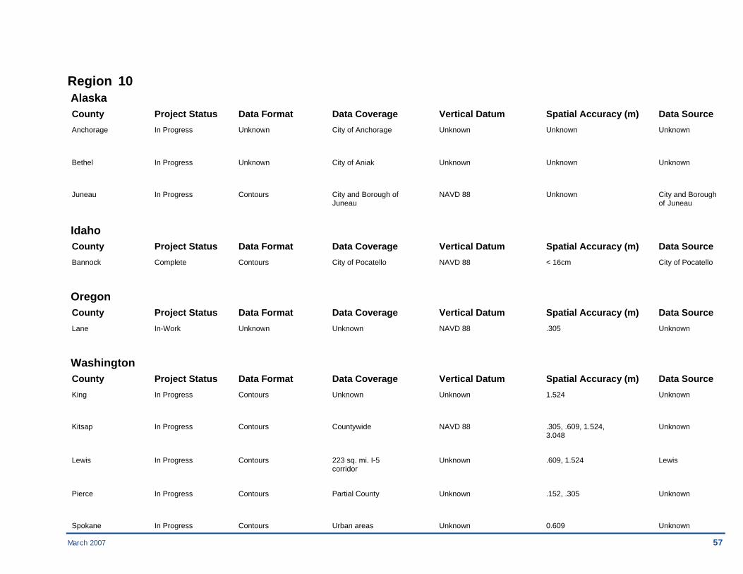
Region 10 Alaska County Project Status Data Format Data Coverage Vertical Datum Spatial Accuracy (m) Data Source Anchorage In Progress Unknown City of Anchorage Unknown Unknown Unknown
Bethel In Progress Unknown City of Aniak Unknown Unknown Unknown
Juneau In Progress Contours City and Borough of NAVD 88 Unknown City and Borough Juneau of Juneau
Idaho County Project Status Data Format Data Coverage Vertical Datum Spatial Accuracy (m) Data Source Bannock Complete Contours City of Pocatello NAVD 88 < 16cm City of Pocatello
Oregon County Project Status Data Format Data Coverage Vertical Datum Spatial Accuracy (m) Data Source Lane In-Work Unknown Unknown NAVD 88 .305 Unknown
Washington County Project Status Data Format Data Coverage Vertical Datum Spatial Accuracy (m) Data Source King In Progress Contours Unknown Unknown 1.524 Unknown
Kitsap In Progress Contours Countywide NAVD 88 .305, .609, 1.524, Unknown 3.048
Lewis In Progress Contours 223 sq. mi. I-5 Unknown .609, 1.524 Lewis corridor
Pierce In Progress Contours Partial County Unknown .152, .305 Unknown
Spokane In Progress Contours Urban areas Unknown 0.609 Unknown
58 March 2007
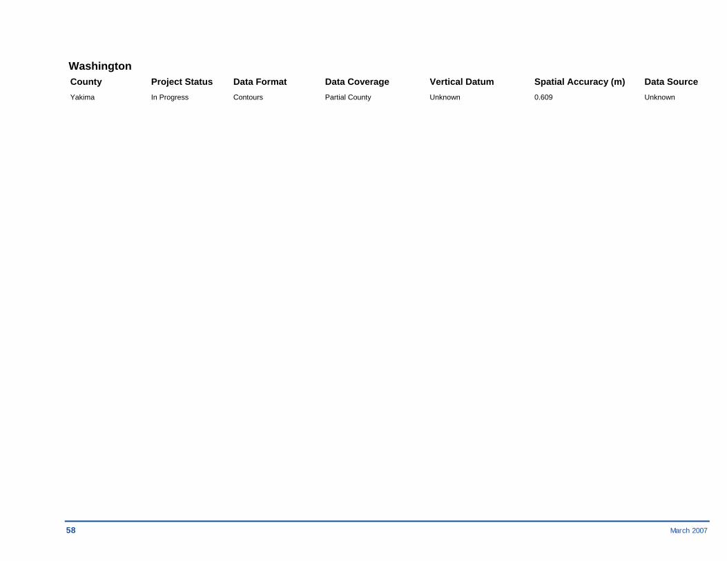
Washington County Project Status Data Format Data Coverage Vertical Datum Spatial Accuracy (m) Data Source Yakima In Progress Contours Partial County Unknown 0.609 Unknown
Imagery Projects by FEMA Region
March 2007 59

60 March 2007
2.2. Projects with Imagery Data by FEMA Region
Region 01 Connecticut County Project Status Data Format Data Coverage Datum Spatial Accuracy (m) Data Source Fairfield In Progress GeoTIFF Statewide NAD83 -1 CTDOT
Hartford In Progress GeoTIFF Statewide NAD83 -1 CTDOT
Litchfield In Progress GeoTIFF Statewide NAD83 -1 CTDOT
Middlesex In Progress GeoTIFF Statewide NAD83 -1 CTDOT
New Haven In Progress GeoTIFF Statewide NAD83 -1 CTDOT
New London In Progress GeoTIFF Statewide NAD83 -1 CTDOT
Tolland In Progress GeoTIFF Statewide NAD83 -1 CTDOT
Windham In Progress GeoTIFF Statewide NAD83 -1 CTDOT
Maine County Project Status Data Format Data Coverage Datum Spatial Accuracy (m) Data Source Androscoggin In Progress GeoTIFF Statewide NAD83 -0.5 ME GIS
Aroostook In Progress GeoTIFF Statewide NAD83 1 ME GIS

March 2007 61
Maine County Project Status Data Format Data Coverage Datum Spatial Accuracy (m) Data Source Cumberland In Progress GeoTIFF Statewide NAD83 -0.5 ME GIS
Franklin In Progress GeoTIFF Statewide NAD83 0.609 ME GIS
Hancock In Progress GeoTIFF Statewide NAD83 1 ME GIS
Kennebec In Progress GeoTIFF Statewide NAD83 0.305 ME GIS
Knox In Progress GeoTIFF Statewide NAD83 1 ME GIS
Lincoln In Progress GeoTIFF Statewide NAD83 0.305 ME GIS
Penobscot In Progress GeoTIFF Statewide NAD83 0.609 ME GIS
Piscataquis In Progress GeoTIFF Statewide NAD83 1 ME GIS
Sagadahoc In Progress GeoTIFF Statewide NAD83 0.305 ME GIS
Somerset In Progress GeoTIFF Statewide NAD83 0.609 ME GIS
Waldo In Progress GeoTIFF Statewide NAD83 1 ME GIS
Washington In Progress GeoTIFF Statewide NAD83 1 ME GIS
York In Progress GeoTIFF Statewide NAD83 0.305 ME GIS
62 March 2007
Massachusetts County Project Status Data Format Data Coverage Datum Spatial Accuracy (m) Data Source Berkshire In Progress GeoTIFF Statewide NAD83 0.5 MassGIS
Dukes In Progress GeoTIFF Statewide NAD83 0.5 MassGIS
Franklin In Progress GeoTIFF Statewide NAD83 0.5 MassGIS
Hampden In Progress GeoTIFF Statewide NAD83 0.5 MassGIS
Hampshire In Progress GeoTIFF Statewide NAD83 0.5 MassGIS
Middlesex In Progress GeoTIFF Statewide NAD83 0.5 MassGIS
Nantucket In Progress GeoTIFF Statewide NAD83 0.5 MassGIS
Norfolk In Progress GeoTIFF Statewide NAD83 0.5 MassGIS
Suffolk In Progress GeoTIFF Statewide NAD83 0.5 MassGIS
New Hampshire County Project Status Data Format Data Coverage Datum Spatial Accuracy (m) Data Source Belknap In Progress GeoTIFF Statewide NAD83 1 GRANIT
Carroll In Progress GeoTIFF Statewide NAD83 1 GRANIT
Cheshire In Progress GeoTIFF Statewide NAD83 1 GRANIT

March 2007 63
New Hampshire County Project Status Data Format Data Coverage Datum Spatial Accuracy (m) Data Source Coos In Progress GeoTIFF Statewide NAD83 1 GRANIT
Grafton In Progress GeoTIFF Statewide NAD83 1 GRANIT
Hillsborough In Progress GeoTIFF Statewide NAD83 1 GRANIT
Merrimack In Progress GeoTIFF Statewide NAD83 1 GRANIT
Rockingham In Progress GeoTIFF Statewide NAD83 1 GRANIT
Strafford In Progress GeoTIFF Statewide NAD83 1 GRANIT
Sullivan In Progress GeoTIFF Statewide NAD83 1 GRANIT
Rhode Island County Project Status Data Format Data Coverage Datum Spatial Accuracy (m) Data Source Bristol In Progress GeoTIFF Statewide NAD27 0.609 RI GIS
Kent In Progress GeoTIFF Statewide NAD27 0.609 RI GIS
Newport In Progress GeoTIFF Statewide NAD27 0.609 RI GIS
Washington In Progress GeoTIFF Statewide NAD27 0.609 RI GIS

64 March 2007
Vermont County Project Status Data Format Data Coverage Datum Spatial Accuracy (m) Data Source Addison In Progress LAN and BIP Statewide NAD83 -0.5 Vermont Mapping Program
Bennington In Progress LAN and BIP Statewide NAD83 -0.5 Vermont Mapping Program
Caledonia In Progress LAN and BIP Statewide NAD83 -0.5 Vermont Mapping Program
Chittenden In Progress LAN and BIP Statewide NAD83 -0.5 Vermont Mapping Program
Essex In Progress LAN and BIP Statewide NAD83 -0.5 Vermont Mapping Program
Franklin In Progress LAN and BIP Statewide NAD83 -0.5 Vermont Mapping Program
Grand Isle In Progress LAN and BIP Statewide NAD83 -0.5 Vermont Mapping Program
Lamoille In Progress LAN and BIP Statewide NAD83 -0.5 Vermont Mapping Program
Orange In Progress LAN and BIP Statewide NAD83 -0.5 Vermont Mapping Program
Orleans In Progress LAN and BIP Statewide NAD83 -0.5 Vermont Mapping Program
Rutland In Progress LAN and BIP Statewide NAD83 -0.5 Vermont Mapping Program
Washington In Progress LAN and BIP Statewide NAD83 -0.5 Vermont Mapping Program
Windham In Progress LAN and BIP Statewide NAD83 -0.5 Vermont Mapping Program

March 2007 65
Vermont County Project Status Data Format Data Coverage Datum Spatial Accuracy (m) Data Source Windsor In Progress LAN and BIP Statewide NAD83 -0.5 Vermont Mapping Program

66 March 2007
Region 02 New Jersey County Project Status Data Format Data Coverage Datum Spatial Accuracy (m) Data Source Atlantic Complete Compressed Native Statewide NAD83 0.305 NJ OIT
Bergen Complete Compressed Native Statewide NAD83 0.305 NJ OIT
Burlington Complete Compressed Native Statewide NAD83 0.305 NJ OIT
Camden Complete Compressed Native Statewide NAD83 0.305 NJ OIT
Cape May Complete Compressed Native Statewide NAD83 0.305 NJ OIT
Cumberland Complete Compressed Native Statewide NAD83 0.305 NJ OIT
Essex Complete Compressed Native Statewide NAD83 0.305 NJ OIT
Gloucester Complete Compressed Native Statewide NAD83 0.305 NJ OIT
Hudson Complete Compressed Native Statewide NAD83 0.305 NJ OIT
Hunterdon Complete Compressed Native Statewide NAD83 0.305 NJ OIT
Mercer Complete Compressed Native Statewide NAD83 0.305 NJ OIT
Middlesex Complete Compressed Native Statewide NAD83 0.305 NJ OIT
Monmouth Complete Compressed Native Statewide NAD83 0.305 NJ OIT
March 2007 67
New Jersey County Project Status Data Format Data Coverage Datum Spatial Accuracy (m) Data Source
Morris Complete Compressed Native Statewide NAD83 0.305 NJ OIT
Ocean Complete Compressed Native Statewide NAD83 0.305 NJ OIT
Passaic Complete Compressed Native Statewide NAD83 0.305 NJ OIT
Salem Complete Compressed Native Statewide NAD83 0.305 NJ OIT
Somerset Complete Compressed Native Statewide NAD83 0.305 NJ OIT
Sussex Complete Compressed Native Statewide NAD83 0.305 NJ OIT
Union Complete Compressed Native Statewide NAD83 0.305 NJ OIT
Warren Complete Compressed Native Statewide NAD83 0.305 NJ OIT
New York County Project Status Data Format Data Coverage Datum Spatial Accuracy (m) Data Source Albany Complete Compressed Native Statewide NAD83 1.0 NYS DEC
Allegany Complete Compressed Native Statewide NAD83 1.0 NYS DEC
Bronx Complete Compressed Native Statewide NAD83 1.0 NYS DEC
Broome Complete Compressed Native Statewide NAD83 1.0 NYS DEC
68 March 2007
New York County Project Status Data Format Data Coverage Datum Spatial Accuracy (m) Data Source
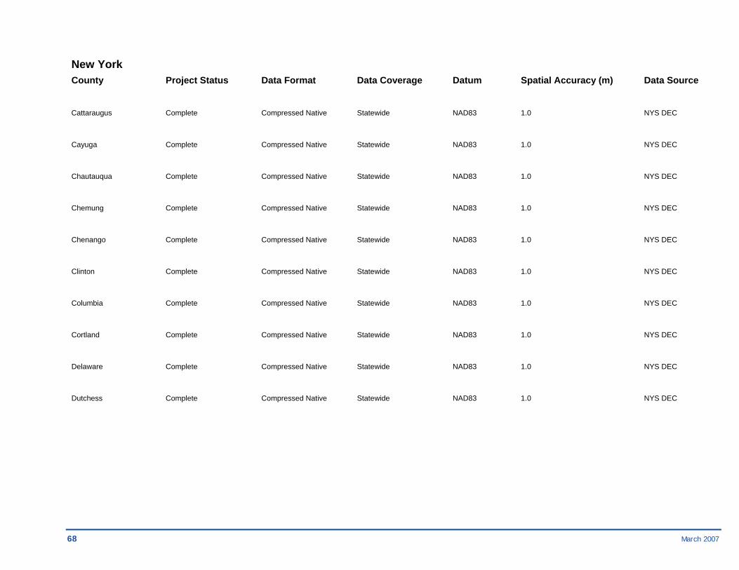
Cattaraugus Complete Compressed Native Statewide NAD83 1.0 NYS DEC
Cayuga Complete Compressed Native Statewide NAD83 1.0 NYS DEC
Chautauqua Complete Compressed Native Statewide NAD83 1.0 NYS DEC
Chemung Complete Compressed Native Statewide NAD83 1.0 NYS DEC
Chenango Complete Compressed Native Statewide NAD83 1.0 NYS DEC
Clinton Complete Compressed Native Statewide NAD83 1.0 NYS DEC
Columbia Complete Compressed Native Statewide NAD83 1.0 NYS DEC
Cortland Complete Compressed Native Statewide NAD83 1.0 NYS DEC
Delaware Complete Compressed Native Statewide NAD83 1.0 NYS DEC
Dutchess Complete Compressed Native Statewide NAD83 1.0 NYS DEC
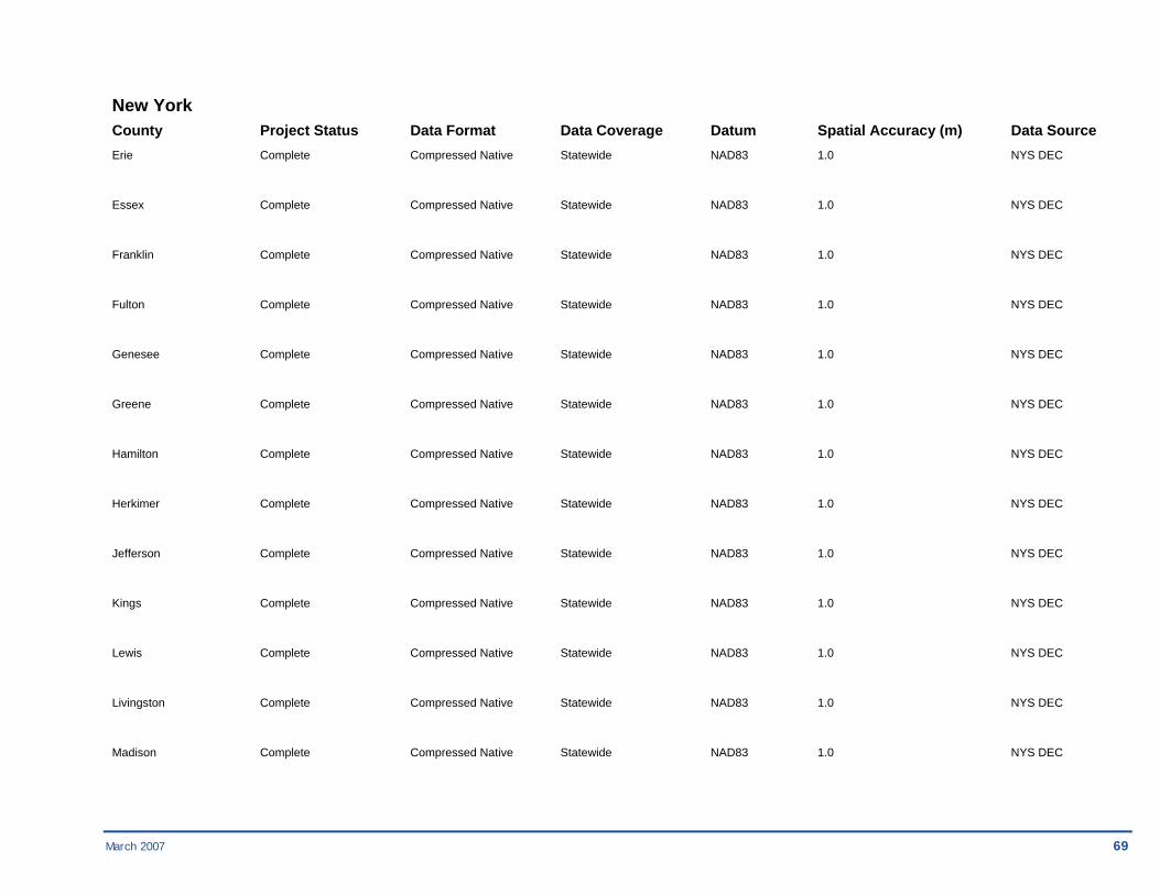
March 2007 69
New York County Project Status Data Format Data Coverage Datum Spatial Accuracy (m) Data Source Erie Complete Compressed Native Statewide NAD83 1.0 NYS DEC
Essex Complete Compressed Native Statewide NAD83 1.0 NYS DEC
Franklin Complete Compressed Native Statewide NAD83 1.0 NYS DEC
Fulton Complete Compressed Native Statewide NAD83 1.0 NYS DEC
Genesee Complete Compressed Native Statewide NAD83 1.0 NYS DEC
Greene Complete Compressed Native Statewide NAD83 1.0 NYS DEC
Hamilton Complete Compressed Native Statewide NAD83 1.0 NYS DEC
Herkimer Complete Compressed Native Statewide NAD83 1.0 NYS DEC
Jefferson Complete Compressed Native Statewide NAD83 1.0 NYS DEC
Kings Complete Compressed Native Statewide NAD83 1.0 NYS DEC
Lewis Complete Compressed Native Statewide NAD83 1.0 NYS DEC
Livingston Complete Compressed Native Statewide NAD83 1.0 NYS DEC
Madison Complete Compressed Native Statewide NAD83 1.0 NYS DEC
70 March 2007
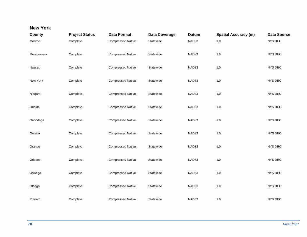
New York County Project Status Data Format Data Coverage Datum Spatial Accuracy (m) Data Source Monroe Complete Compressed Native Statewide NAD83 1.0 NYS DEC
Montgomery Complete Compressed Native Statewide NAD83 1.0 NYS DEC
Nassau Complete Compressed Native Statewide NAD83 1.0 NYS DEC
New York Complete Compressed Native Statewide NAD83 1.0 NYS DEC
Niagara Complete Compressed Native Statewide NAD83 1.0 NYS DEC
Oneida Complete Compressed Native Statewide NAD83 1.0 NYS DEC
Onondaga Complete Compressed Native Statewide NAD83 1.0 NYS DEC
Ontario Complete Compressed Native Statewide NAD83 1.0 NYS DEC
Orange Complete Compressed Native Statewide NAD83 1.0 NYS DEC
Orleans Complete Compressed Native Statewide NAD83 1.0 NYS DEC
Oswego Complete Compressed Native Statewide NAD83 1.0 NYS DEC
Otsego Complete Compressed Native Statewide NAD83 1.0 NYS DEC
Putnam Complete Compressed Native Statewide NAD83 1.0 NYS DEC
March 2007 71
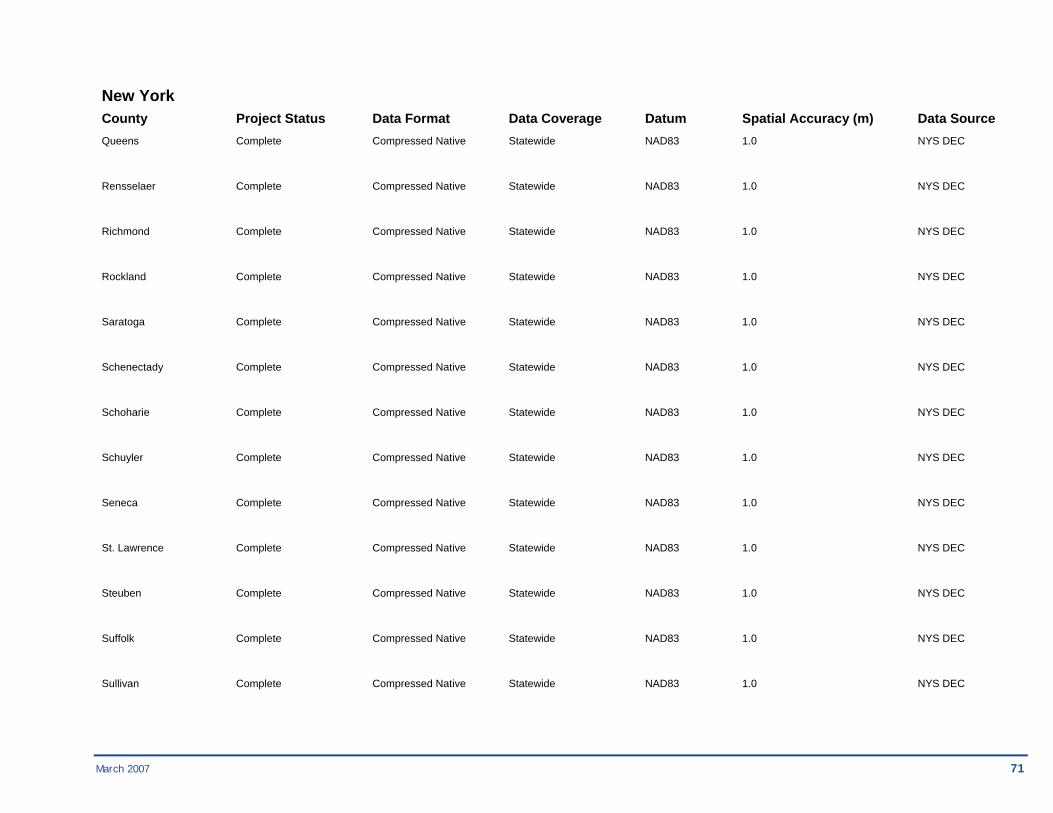
New York County Project Status Data Format Data Coverage Datum Spatial Accuracy (m) Data Source Queens Complete Compressed Native Statewide NAD83 1.0 NYS DEC
Rensselaer Complete Compressed Native Statewide NAD83 1.0 NYS DEC
Richmond Complete Compressed Native Statewide NAD83 1.0 NYS DEC
Rockland Complete Compressed Native Statewide NAD83 1.0 NYS DEC
Saratoga Complete Compressed Native Statewide NAD83 1.0 NYS DEC
Schenectady Complete Compressed Native Statewide NAD83 1.0 NYS DEC
Schoharie Complete Compressed Native Statewide NAD83 1.0 NYS DEC
Schuyler Complete Compressed Native Statewide NAD83 1.0 NYS DEC
Seneca Complete Compressed Native Statewide NAD83 1.0 NYS DEC
St. Lawrence Complete Compressed Native Statewide NAD83 1.0 NYS DEC
Steuben Complete Compressed Native Statewide NAD83 1.0 NYS DEC
Suffolk Complete Compressed Native Statewide NAD83 1.0 NYS DEC
Sullivan Complete Compressed Native Statewide NAD83 1.0 NYS DEC
72 March 2007
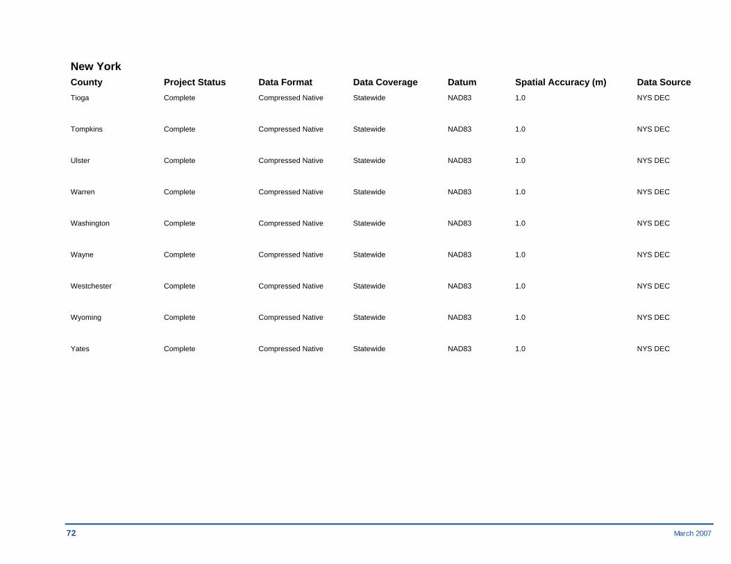
New York County Project Status Data Format Data Coverage Datum Spatial Accuracy (m) Data Source Tioga Complete Compressed Native Statewide NAD83 1.0 NYS DEC
Tompkins Complete Compressed Native Statewide NAD83 1.0 NYS DEC
Ulster Complete Compressed Native Statewide NAD83 1.0 NYS DEC
Warren Complete Compressed Native Statewide NAD83 1.0 NYS DEC
Washington Complete Compressed Native Statewide NAD83 1.0 NYS DEC
Wayne Complete Compressed Native Statewide NAD83 1.0 NYS DEC
Westchester Complete Compressed Native Statewide NAD83 1.0 NYS DEC
Wyoming Complete Compressed Native Statewide NAD83 1.0 NYS DEC
Yates Complete Compressed Native Statewide NAD83 1.0 NYS DEC

March 2007 73
Region 03 Maryland County Project Status Data Format Data Coverage Datum Spatial Accuracy (m) Data Source Montgomery Unknown Unknown Unknown Unknown Unknown Unknown Pennsylvania County Project Status Data Format Data Coverage Datum Spatial Accuracy (m) Data Source Chester In Progress Compressed Native Countywide NAD83 Unknown USGS DOQQs
Columbia In Progress GeoTIFF Countywide NAD83 Unknown BAE Systems, Inc.
Dauphin Unknown Unknown Countywide Unknown Unknown Unknown
Delaware In Progress Compressed Native Countywide NAD83 Unknown USGS DOQQs
Mifflin In Progress Compressed Native Countywide NAD83 Unknown Mifflin County 2003
Montour In Progress GeoTIFF Countywide NAD83 0.609 BAE Systems ADR
Northumberland In Progress GeoTIFF Countywide NAD83 Unknown BAE Systems ADR
Somerset In Progress GeoTIFF Countywide NAD83 Unknown BAE Systems ADR
Union In Progress GeoTIFF Countywide NAD83 Unknown BAE Systems ADR

74 March 2007
Virginia County Project Status Data Format Data Coverage Datum Spatial Accuracy (m) Data Source Accomack Unknown Unknown Countywide NAD83 Unknown Unknown
Lee In Progress GeoTIFF Countywide NAD83 0.610/0.305/0.152 VGIN (HARN)
Russell In Progress GeoTIFF Countywide NAD83 0.610/0.305/0.152 VGIN (HARN)
Scott In Progress GeoTIFF Countywide NAD83 Unknown VGIN (HARN)
Smyth In Progress GeoTIFF Countywide NAD83 0.610/0.305/0.152 VGIN (HARN)
Tazewell In Progress GeoTIFF Countywide NAD83 0.610/0.305/0.152 VGIN (HARN)
Westmoreland In Progress GeoTIFF Countywide NAD83 0.610/0.305/0.152 VGIN (HARN)
Wise In Progress GeoTIFF Countywide NAD83 0.610/0.305/0.152 VGIN (HARN)
West Virginia County Project Status Data Format Data Coverage Datum Spatial Accuracy (m) Data Source Harrison In Progress Compressed Native Countywide NAD83 0.609 WVSAMB
Logan In Progress Compressed Native Countywide NAD83 0.609 WVSAMB
Marion In Progress Compressed Native Countywide NAD83 0.609 WVSAMB
Mingo In Progress Compressed Native Countywide NAD83 0.609 WVSAMB
Ohio In Progress Compressed Native Countywide NAD83 0.609 WVSAMB
March 2007 75
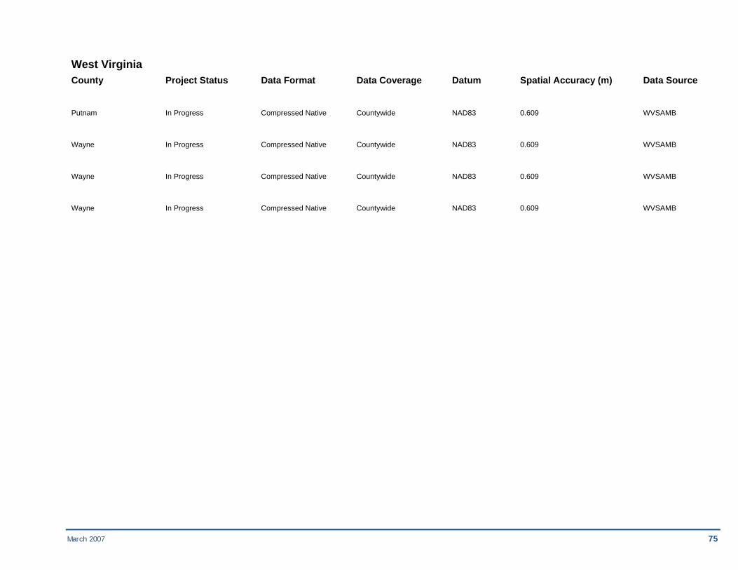
West Virginia County Project Status Data Format Data Coverage Datum Spatial Accuracy (m) Data Source
Putnam In Progress Compressed Native Countywide NAD83 0.609 WVSAMB
Wayne In Progress Compressed Native Countywide NAD83 0.609 WVSAMB
Wayne In Progress Compressed Native Countywide NAD83 0.609 WVSAMB
Wayne In Progress Compressed Native Countywide NAD83 0.609 WVSAMB
76 March 2007
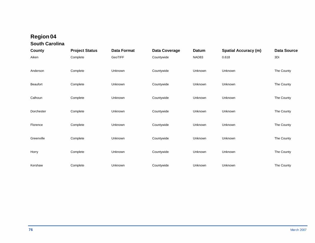
Region 04 South Carolina County Project Status Data Format Data Coverage Datum Spatial Accuracy (m) Data Source Aiken Complete GeoTIFF Countywide NAD83 0.618 3Di
Anderson Complete Unknown Countywide Unknown Unknown The County
Beaufort Complete Unknown Countywide Unknown Unknown The County
Calhoun Complete Unknown Countywide Unknown Unknown The County
Dorchester Complete Unknown Countywide Unknown Unknown The County
Florence Complete Unknown Countywide Unknown Unknown The County
Greenville Complete Unknown Countywide Unknown Unknown The County
Horry Complete Unknown Countywide Unknown Unknown The County
Kershaw Complete Unknown Countywide Unknown Unknown The County
March 2007 77
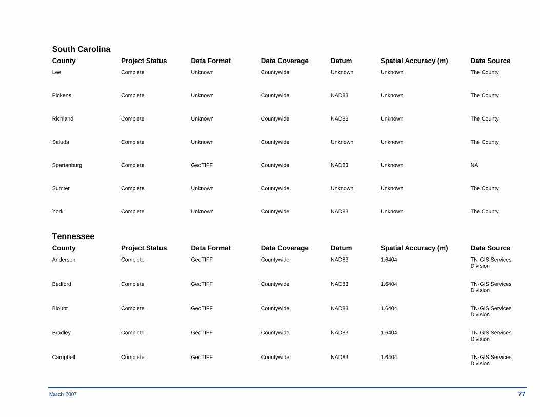
South Carolina County Project Status Data Format Data Coverage Datum Spatial Accuracy (m) Data Source Lee Complete Unknown Countywide Unknown Unknown The County
Pickens Complete Unknown Countywide NAD83 Unknown The County
Richland Complete Unknown Countywide NAD83 Unknown The County
Saluda Complete Unknown Countywide Unknown Unknown The County
Spartanburg Complete GeoTIFF Countywide NAD83 Unknown NA
Sumter Complete Unknown Countywide Unknown Unknown The County
York Complete Unknown Countywide NAD83 Unknown The County
Tennessee County Project Status Data Format Data Coverage Datum Spatial Accuracy (m) Data Source Anderson Complete GeoTIFF Countywide NAD83 1.6404 TN-GIS Services Division
Bedford Complete GeoTIFF Countywide NAD83 1.6404 TN-GIS Services Division
Blount Complete GeoTIFF Countywide NAD83 1.6404 TN-GIS Services Division
Bradley Complete GeoTIFF Countywide NAD83 1.6404 TN-GIS Services Division
Campbell Complete GeoTIFF Countywide NAD83 1.6404 TN-GIS Services Division

78 March 2007
Tennessee County Project Status Data Format Data Coverage Datum Spatial Accuracy (m) Data Source Cannon Complete GeoTIFF Countywide NAD83 1.6404 TN-GIS Services Division
Cheatham Complete GeoTIFF Countywide NAD83 1.6404 TN-GIS Services Division
Chester Complete GeoTIFF Countywide NAD83 1.6404 TN-GIS Services Division
Coffee Complete GeoTIFF Countywide NAD83 1.6404 TN-GIS Services Division
Crockett Complete GeoTIFF Countywide NAD83 1.6404 TN-GIS Services Division
Cumberland Complete GeoTIFF Countywide NAD83 1.6404 TN-GIS Services Division
Fayette Complete GeoTIFF Countywide NAD83 1.6404 TN-GIS Services Division
Franklin Complete GeoTIFF Countywide NAD83 1.6404 TN-GIS Services Division
Giles Complete GeoTIFF Countywide NAD83 1.6404 TN-GIS Services Division
Greene Complete GeoTIFF Countywide NAD83 1.6404 TN-GIS Services Division
Hamblen Complete GeoTIFF Countywide NAD83 1.6404 TN-GIS Services Division
Hamilton Complete GeoTIFF Countywide NAD83 1.6404 TN-GIS Services Division
Hardeman Complete GeoTIFF Countywide NAD83 1.6404 TN-GIS Services Division

March 2007 79
Tennessee County Project Status Data Format Data Coverage Datum Spatial Accuracy (m) Data Source Hardin Complete GeoTIFF Countywide NAD83 1.6404 TN-GIS Services Division
Hawkins Complete GeoTIFF Countywide NAD83 1.6404 TN-GIS Services Division
Henry Complete GeoTIFF Countywide NAD83 1.6404 TN-GIS Services Division
Jackson Complete GeoTIFF Countywide NAD83 1.6404 TN-GIS Services Division
Lauderdale Complete GeoTIFF Countywide NAD83 1.6404 TN-GIS Services Division
Lewis Complete GeoTIFF Countywide NAD83 1.6404 TN-GIS Services Division
Lincoln Complete GeoTIFF Countywide NAD83 1.6404 TN-GIS Services Division
Loudon Complete GeoTIFF Countywide NAD83 1.6404 TN-GIS Services Division
Marion Complete GeoTIFF Countywide NAD83 1.6404 TN-GIS Services Division
Marshall Complete GeoTIFF Countywide NAD83 1.6404 TN-GIS Services Division
Maury Complete GeoTIFF Countywide NAD83 1.6404 TN-GIS Services Division
McMinn Complete GeoTIFF Countywide NAD83 1.6404 TN-GIS Services Division
McNairy Complete GeoTIFF Countywide NAD83 1.6404 TN-GIS Services Division

80 March 2007
Tennessee County Project Status Data Format Data Coverage Datum Spatial Accuracy (m) Data Source Montgomery Complete GeoTIFF Countywide NAD83 1.6404 TN-GIS Services Division
Morgan Complete GeoTIFF Countywide NAD83 1.6404 TN-GIS Services Division
Putnam Complete GeoTIFF Countywide NAD83 1.6404 TN-GIS Services Division
Roane Complete GeoTIFF Countywide NAD83 1.6404 TN-GIS Services Division
Scott Complete GeoTIFF Countywide NAD83 1.6404 TN-GIS Services Division
Sevier Complete GeoTIFF Countywide NAD83 1.6404 TN-GIS Services Division
Shelby Complete GeoTIFF Countywide NAD83 1.6404 TN-GIS Services Division
Sullivan Complete GeoTIFF Countywide NAD83 1.6404 TN-GIS Services Division
Sumner Complete GeoTIFF Countywide NAD83 1.6404 TN-GIS Services Division
Tipton Complete GeoTIFF Countywide NAD83 1.6404 TN-GIS Services Division
Union Complete GeoTIFF Countywide NAD83 1.6404 TN-GIS Services Division
Washington Complete GeoTIFF Countywide NAD83 1.6404 TN-GIS Services Division
White Complete GeoTIFF Countywide NAD83 1.6404 TN-GIS Services Division

March 2007 81
Tennessee County Project Status Data Format Data Coverage Datum Spatial Accuracy (m) Data Source Williamson Complete GeoTIFF Countywide NAD83 1.6404 TN-GIS Services Division
Wilson Complete GeoTIFF Countywide NAD83 1.6404 TN-GIS Services Division
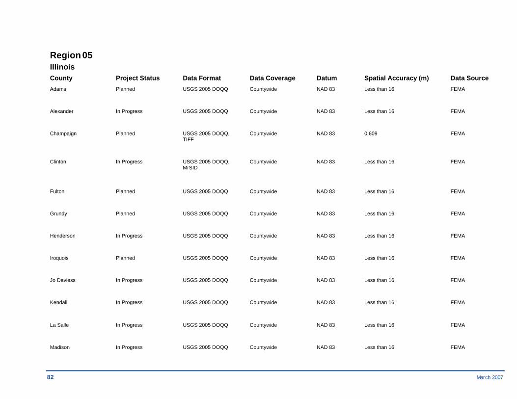
82 March 2007
Region 05 Illinois County Project Status Data Format Data Coverage Datum Spatial Accuracy (m) Data Source Adams Planned USGS 2005 DOQQ Countywide NAD 83 Less than 16 FEMA
Alexander In Progress USGS 2005 DOQQ Countywide NAD 83 Less than 16 FEMA
Champaign Planned USGS 2005 DOQQ, Countywide NAD 83 0.609 FEMA TIFF
Clinton In Progress USGS 2005 DOQQ, Countywide NAD 83 Less than 16 FEMA MrSID
Fulton Planned USGS 2005 DOQQ Countywide NAD 83 Less than 16 FEMA
Grundy Planned USGS 2005 DOQQ Countywide NAD 83 Less than 16 FEMA
Henderson In Progress USGS 2005 DOQQ Countywide NAD 83 Less than 16 FEMA
Iroquois Planned USGS 2005 DOQQ Countywide NAD 83 Less than 16 FEMA
Jo Daviess In Progress USGS 2005 DOQQ Countywide NAD 83 Less than 16 FEMA
Kendall In Progress USGS 2005 DOQQ Countywide NAD 83 Less than 16 FEMA
La Salle In Progress USGS 2005 DOQQ Countywide NAD 83 Less than 16 FEMA
Madison In Progress USGS 2005 DOQQ Countywide NAD 83 Less than 16 FEMA

March 2007 83
Illinois County Project Status Data Format Data Coverage Datum Spatial Accuracy (m) Data Source
Menard Planned USGS 2005 DOQQ Countywide NAD 83 Less than 16 FEMA
Morgan Planned USGS 2005 DOQQ Countywide NAD 83 Less than 16 FEMA
Rock Island In Progress USGS 2005 DOQQ, Countywide NAD 83 Less than 16 FEMA MrSID
Sangamon In Progress USGS 2005 DOQQ, Countywide NAD 83 Less than 16 FEMA MrSID
St. Clair In Progress USGS 2005 DOQQ Countywide NAD 83 Less than 16 FEMA
Stephenson Planned USGS 2005 DOQQ Countywide NAD 83 Less than 16 FEMA
Vermilion Planned USGS 2005 DOQQ Countywide NAD 83 Less than 16 FEMA
Will In Progress USGS 2005 DOQQ Countywide NAD 83 Less than 16 FEMA
Woodford In Progress USGS 2005 DOQQ Countywide NAD 83 Less than 16 FEMA
Indiana County Project Status Data Format Data Coverage Datum Spatial Accuracy (m) Data Source Adams In Progress MrSID Countywide NAD 83 1.11 USGS
Bartholomew In Progress MrSID Countywide NAD 83 1.11 USGS
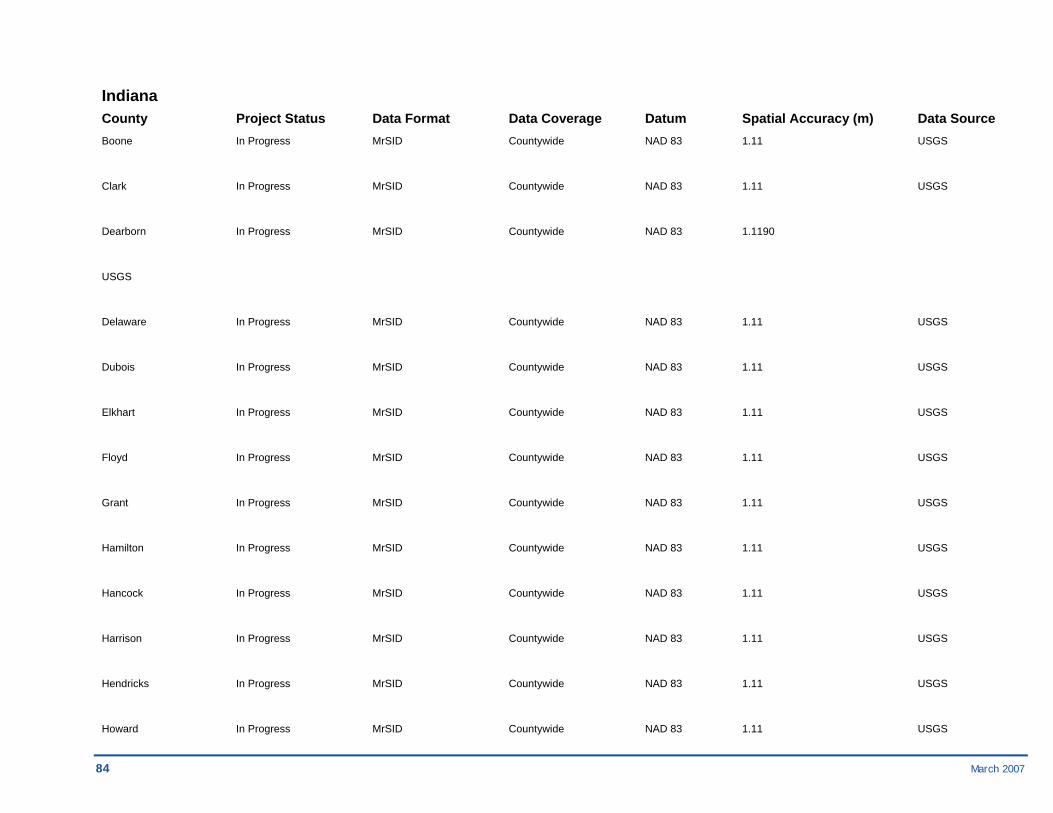
84 March 2007
Indiana County Project Status Data Format Data Coverage Datum Spatial Accuracy (m) Data Source Boone In Progress MrSID Countywide NAD 83 1.11 USGS
Clark In Progress MrSID Countywide NAD 83 1.11 USGS
Dearborn In Progress MrSID Countywide NAD 83 1.1190
USGS
Delaware In Progress MrSID Countywide NAD 83 1.11 USGS
Dubois In Progress MrSID Countywide NAD 83 1.11 USGS
Elkhart In Progress MrSID Countywide NAD 83 1.11 USGS
Floyd In Progress MrSID Countywide NAD 83 1.11 USGS
Grant In Progress MrSID Countywide NAD 83 1.11 USGS
Hamilton In Progress MrSID Countywide NAD 83 1.11 USGS
Hancock In Progress MrSID Countywide NAD 83 1.11 USGS
Harrison In Progress MrSID Countywide NAD 83 1.11 USGS
Hendricks In Progress MrSID Countywide NAD 83 1.11 USGS
Howard In Progress MrSID Countywide NAD 83 1.11 USGS

March 2007 85
Indiana County Project Status Data Format Data Coverage Datum Spatial Accuracy (m) Data Source Jackson In Progress MrSID Countywide NAD 83 1.11 USGS
Knox In Progress MrSID Countywide NAD 83 1.11 USGS
Kosciusko In Progress MrSID Countywide NAD 83 1.11 USGS
LaPorte In Progress MrSID Countywide NAD 83 1.11 USGS
Lawrence In Progress MrSID Countywide NAD 83 1.11 USGS
Madison In Progress MrSID Countywide NAD 83 1.11 USGS
Marion In Progress MrSID Countywide NAD 83 1.11 USGS
Marshall In Progress MrSID Countywide NAD 83 1.11 USGS
Monroe In Progress MrSID Countywide NAD 83 1.11 USGS
Montgomery In Progress MrSID Countywide NAD 83 1.11 USGS
Morgan In Progress MrSID Countywide NAD 83 1.11 USGS
Porter In Progress MrSID Countywide NAD 83 1.11 USGS
Shelby In Progress MrSID Countywide NAD 83 1.11 USGS
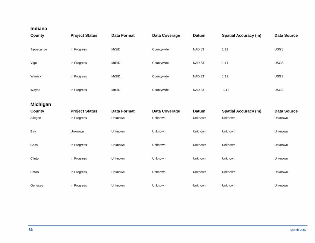
86 March 2007
Indiana County Project Status Data Format Data Coverage Datum Spatial Accuracy (m) Data Source
Tippecanoe In Progress MrSID Countywide NAD 83 1.11 USGS
Vigo In Progress MrSID Countywide NAD 83 1.11 USGS
Warrick In Progress MrSID Countywide NAD 83 1.11 USGS
Wayne In Progress MrSID Countywide NAD 83 -1.12 USGS
Michigan County Project Status Data Format Data Coverage Datum Spatial Accuracy (m) Data Source Allegan In Progress Unknown Unknown Unknown Unknown Unknown
Bay Unknown Unknown Unknown Unknown Unknown Unknown
Cass In Progress Unknown Unknown Unknown Unknown Unknown
Clinton In Progress Unknown Unknown Unknown Unknown Unknown
Eaton In Progress Unknown Unknown Unknown Unknown Unknown
Genesee In Progress Unknown Unknown Unknown Unknown Unknown
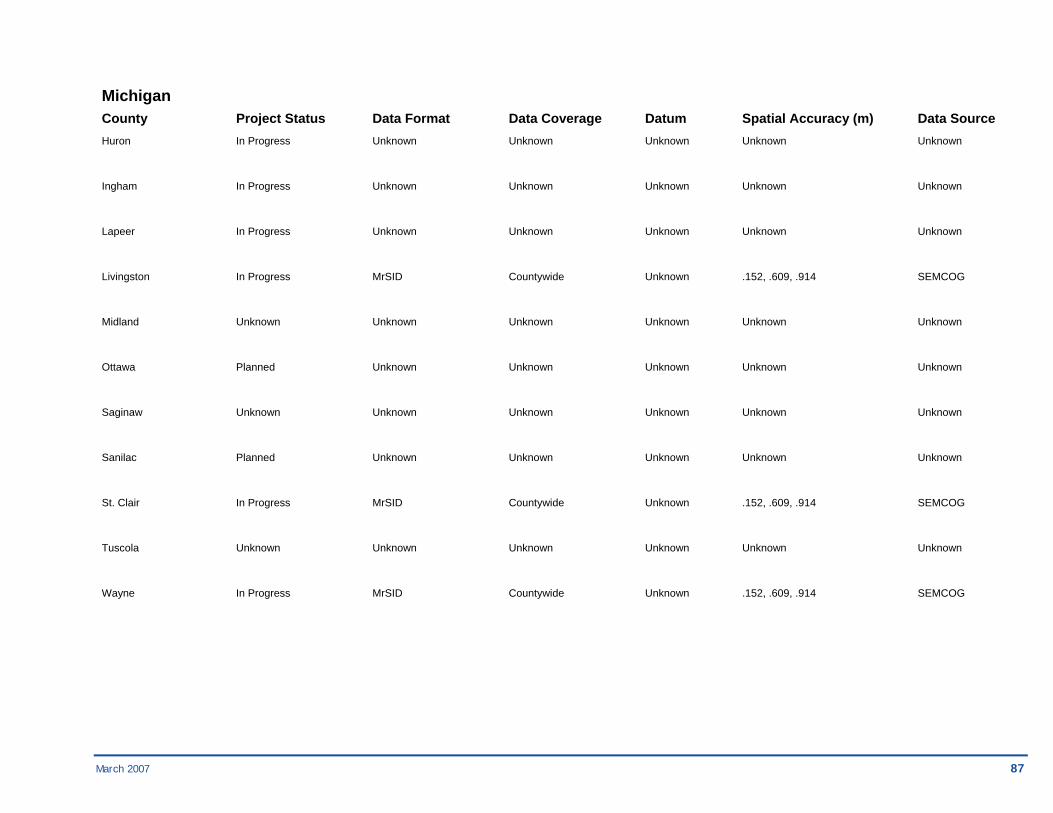
March 2007 87
Michigan County Project Status Data Format Data Coverage Datum Spatial Accuracy (m) Data Source Huron In Progress Unknown Unknown Unknown Unknown Unknown
Ingham In Progress Unknown Unknown Unknown Unknown Unknown
Lapeer In Progress Unknown Unknown Unknown Unknown Unknown
Livingston In Progress MrSID Countywide Unknown .152, .609, .914 SEMCOG
Midland Unknown Unknown Unknown Unknown Unknown Unknown
Ottawa Planned Unknown Unknown Unknown Unknown Unknown
Saginaw Unknown Unknown Unknown Unknown Unknown Unknown
Sanilac Planned Unknown Unknown Unknown Unknown Unknown
St. Clair In Progress MrSID Countywide Unknown .152, .609, .914 SEMCOG
Tuscola Unknown Unknown Unknown Unknown Unknown Unknown
Wayne In Progress MrSID Countywide Unknown .152, .609, .914 SEMCOG

88 March 2007
Minnesota County Project Status Data Format Data Coverage Datum Spatial Accuracy (m) Data Source Blue Earth In Progress MrSID and ECW Countywide NAD 83 < 3 meters FSA
Brown In Progress MrSID and ECW Countywide NAD 83 < 3 meters FSA
Chippewa In Progress MrSID and ECW Countywide NAD 83 < 3 meters FSA
Clay In Progress MrSID and ECW Countywide NAD 83 < 3 meters FSA
Clearwater In Progress MrSID and ECW Countywide NAD 83 < 3 meters FSA
Dakota Planned MrSID and ECW Countywide NAD 83 < 3 meters FSA
Goodhue In Progress MrSID and ECW Countywide NAD 83 < 3 meters FSA
Hennepin In Progress MrSID and ECW Countywide NAD 83 < 3 meters FSA
Kandiyohi In Progress MrSID and ECW Countywide NAD 83 < 3 meters FSA
Lincoln Planned MrSID and ECW Countywide NAD 83 < 3 meters FSA
Meeker In Progress MrSID and ECW Countywide NAD 83 < 3 meters FSA
Nicollet In Progress MrSID and ECW Countywide NAD 83 < 3 meters FSA
Norman Planned MrSID and ECW Countywide NAD 83 < 3 meters FSA
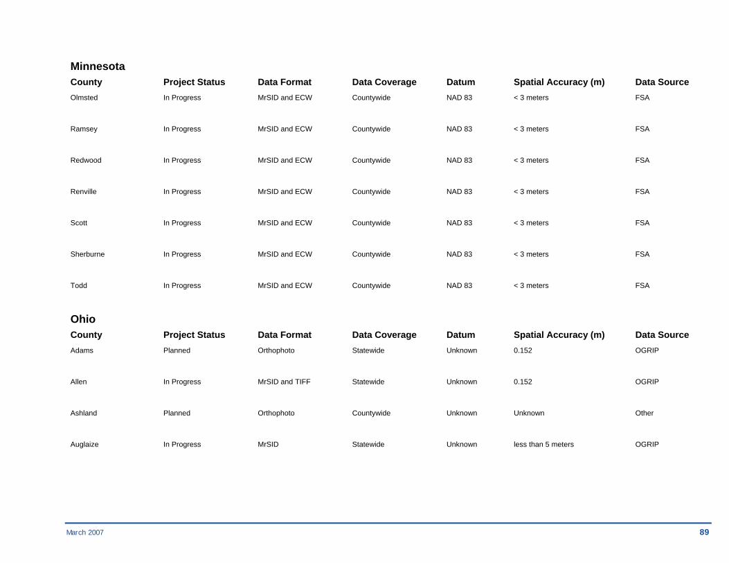
March 2007 89
Minnesota County Project Status Data Format Data Coverage Datum Spatial Accuracy (m) Data Source Olmsted In Progress MrSID and ECW Countywide NAD 83 < 3 meters FSA
Ramsey In Progress MrSID and ECW Countywide NAD 83 < 3 meters FSA
Redwood In Progress MrSID and ECW Countywide NAD 83 < 3 meters FSA
Renville In Progress MrSID and ECW Countywide NAD 83 < 3 meters FSA
Scott In Progress MrSID and ECW Countywide NAD 83 < 3 meters FSA
Sherburne In Progress MrSID and ECW Countywide NAD 83 < 3 meters FSA
Todd In Progress MrSID and ECW Countywide NAD 83 < 3 meters FSA
Ohio County Project Status Data Format Data Coverage Datum Spatial Accuracy (m) Data Source Adams Planned Orthophoto Statewide Unknown 0.152 OGRIP
Allen In Progress MrSID and TIFF Statewide Unknown 0.152 OGRIP
Ashland Planned Orthophoto Countywide Unknown Unknown Other
Auglaize In Progress MrSID Statewide Unknown less than 5 meters OGRIP
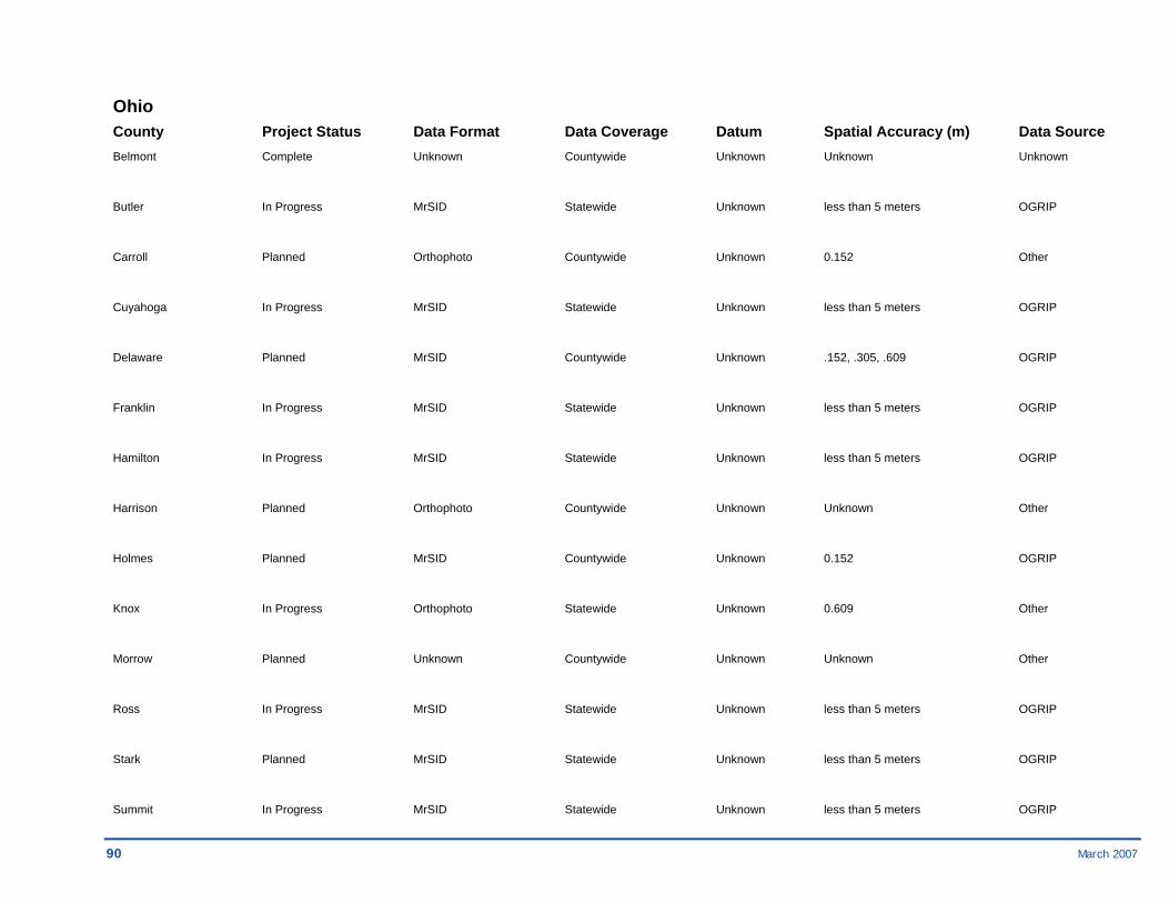
90 March 2007
Ohio County Project Status Data Format Data Coverage Datum Spatial Accuracy (m) Data Source Belmont Complete Unknown Countywide Unknown Unknown Unknown
Butler In Progress MrSID Statewide Unknown less than 5 meters OGRIP
Carroll Planned Orthophoto Countywide Unknown 0.152 Other
Cuyahoga In Progress MrSID Statewide Unknown less than 5 meters OGRIP
Delaware Planned MrSID Countywide Unknown .152, .305, .609 OGRIP
Franklin In Progress MrSID Statewide Unknown less than 5 meters OGRIP
Hamilton In Progress MrSID Statewide Unknown less than 5 meters OGRIP
Harrison Planned Orthophoto Countywide Unknown Unknown Other
Holmes Planned MrSID Countywide Unknown 0.152 OGRIP
Knox In Progress Orthophoto Statewide Unknown 0.609 Other
Morrow Planned Unknown Countywide Unknown Unknown Other
Ross In Progress MrSID Statewide Unknown less than 5 meters OGRIP
Stark Planned MrSID Statewide Unknown less than 5 meters OGRIP
Summit In Progress MrSID Statewide Unknown less than 5 meters OGRIP
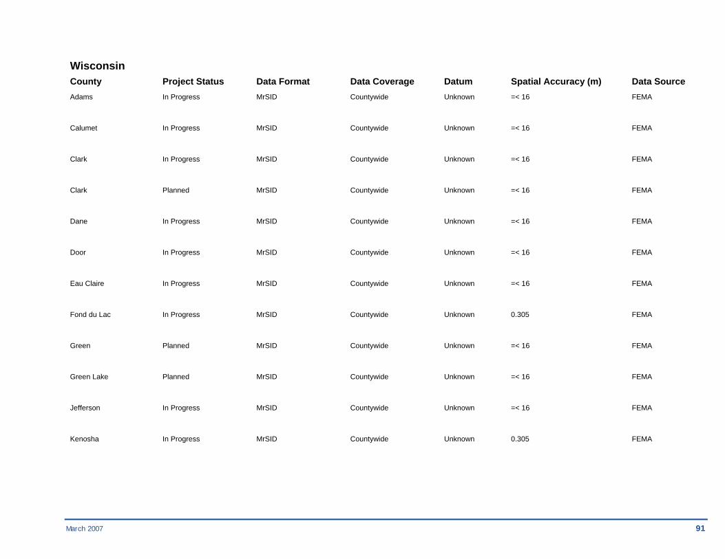
March 2007 91
Wisconsin County Project Status Data Format Data Coverage Datum Spatial Accuracy (m) Data Source Adams In Progress MrSID Countywide Unknown =< 16 FEMA
Calumet In Progress MrSID Countywide Unknown =< 16 FEMA
Clark In Progress MrSID Countywide Unknown =< 16 FEMA
Clark Planned MrSID Countywide Unknown =< 16 FEMA
Dane In Progress MrSID Countywide Unknown =< 16 FEMA
Door In Progress MrSID Countywide Unknown =< 16 FEMA
Eau Claire In Progress MrSID Countywide Unknown =< 16 FEMA
Fond du Lac In Progress MrSID Countywide Unknown 0.305 FEMA
Green Planned MrSID Countywide Unknown =< 16 FEMA
Green Lake Planned MrSID Countywide Unknown =< 16 FEMA
Jefferson In Progress MrSID Countywide Unknown =< 16 FEMA
Kenosha In Progress MrSID Countywide Unknown 0.305 FEMA

92 March 2007
Wisconsin County Project Status Data Format Data Coverage Datum Spatial Accuracy (m) Data Source Manitowoc Planned MrSID Countywide Unknown =< 16 FEMA
Marathon Planned MrSID Countywide Unknown =< 16 FEMA
Monroe Planned MrSID Countywide Unknown =< 16 FEMA
Outagamie Planned MrSID Countywide Unknown =< 16 FEMA
Racine In Progress MrSID Countywide Unknown 0.305 FEMA
Rusk Planned MrSID Countywide Unknown =< 16 FEMA
Sheboygan In Progress MrSID Countywide Unknown =< 16 FEMA
St. Croix In Progress MrSID Countywide Unknown =< 16 FEMA
Walworth Planned MrSID Countywide Unknown =< 16 FEMA
Walworth Planned MrSID Countywide Unknown =< 16 FEMA
Washburn Planned MrSID Countywide Unknown =< 16 FEMA
Washington In Progress MrSID Countywide Unknown 0.305 FEMA
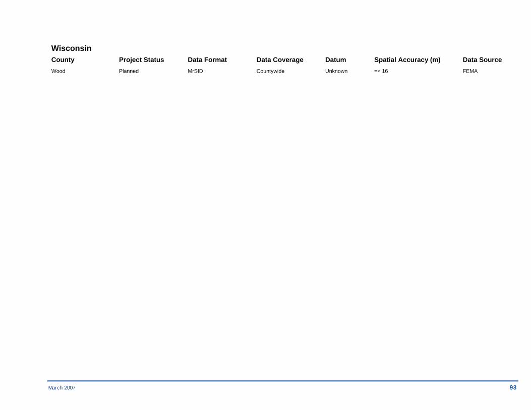
March 2007 93
Wisconsin County Project Status Data Format Data Coverage Datum Spatial Accuracy (m) Data Source Wood Planned MrSID Countywide Unknown =< 16 FEMA

94 March 2007
Region 06 Arkansas County Project Status Data Format Data Coverage Datum Spatial Accuracy (m) Data Source Crittenden Complete Unknown Countywide Unknown 1 Arkansas Geographic Information Office
Garland Complete Unknown Countywide Unknown 0.305 North West Arkansas Planning Commission
Greene Complete Unknown Countywide NAD 83 1 USGS
Louisiana County Project Status Data Format Data Coverage Datum Spatial Accuracy (m) Data Source Acadia Complete Unknown Countywide NAD 83 1 USGS
Assumption Complete Unknown Countywide NAD 83 1 USDA
Cameron Complete Unknown Countywide NAD 83 1 USDA
Iberville Complete Unknown Countywide NAD 83 1 USGS
St. James Complete Unknown Countywide Unknown Unknown Unknown
St. Martin Complete Unknown Countywide NAD 83 1 USGS
Tangipahoa Complete Unknown Countywide NAD 83 1 USGS

March 2007 95
Louisiana County Project Status Data Format Data Coverage Datum Spatial Accuracy (m) Data Source
Vermilion Complete Unknown Countywide NAD 83 1 USDA
Washington Complete Unknown Countywide NAD 83 1 USGS
New Mexico County Project Status Data Format Data Coverage Datum Spatial Accuracy (m) Data Source Chaves Complete Unknown City of Roswell Unknown Unknown City of Roswell
San Juan Complete Unknown Countywide Unknown 0.305 San Juan County
Oklahoma County Project Status Data Format Data Coverage Datum Spatial Accuracy (m) Data Source Lincoln Complete MrSID Countywide NAD 83 1 USDA
Logan Complete MrSID Countywide NAD 83 1 USDA
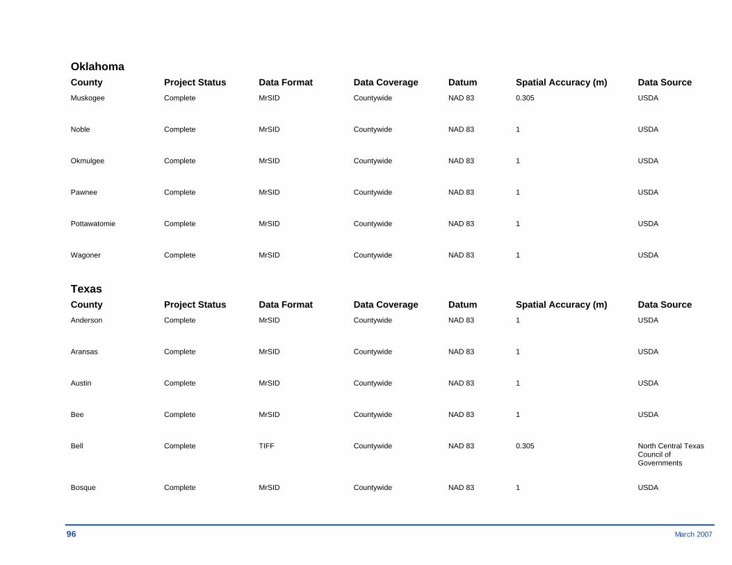
96 March 2007
Oklahoma County Project Status Data Format Data Coverage Datum Spatial Accuracy (m) Data Source Muskogee Complete MrSID Countywide NAD 83 0.305 USDA
Noble Complete MrSID Countywide NAD 83 1 USDA
Okmulgee Complete MrSID Countywide NAD 83 1 USDA
Pawnee Complete MrSID Countywide NAD 83 1 USDA
Pottawatomie Complete MrSID Countywide NAD 83 1 USDA
Wagoner Complete MrSID Countywide NAD 83 1 USDA
Texas County Project Status Data Format Data Coverage Datum Spatial Accuracy (m) Data Source Anderson Complete MrSID Countywide NAD 83 1 USDA
Aransas Complete MrSID Countywide NAD 83 1 USDA
Austin Complete MrSID Countywide NAD 83 1 USDA
Bee Complete MrSID Countywide NAD 83 1 USDA
Bell Complete TIFF Countywide NAD 83 0.305 North Central Texas Council of Governments
Bosque Complete MrSID Countywide NAD 83 1 USDA

March 2007 97
Texas County Project Status Data Format Data Coverage Datum Spatial Accuracy (m) Data Source Brazos Complete MrSID Countywide NAD 83 1 USDA
Calhoun Complete MrSID Countywide NAD 83 1 USDA
Cameron Complete Unknown Countywide Unknown 0.152 City of La Feria Engineering Department
Chambers Complete Unknown Countywide Unknown 1 Texas Natural Resources Information System
Cherokee Complete MrSID Countywide NAD 83 1 USDA
Colorado Complete MrSID Countywide NAD 83 1 USDA
Cooke Complete Unknown Countywide NAD 83 1 USGS
DeWitt Complete MrSID Countywide NAD 83 1 USDA
Ellis Complete TIFF Countywide NAD 83 0.152 North Central Texas Council of Governments
Ellis Complete TIFF Countywide NAD 83 0.305 North Central Texas Council of Governments
Falls Complete MrSID Countywide NAD 83 1 USDA
Freestone Complete MrSID Countywide NAD 83 1 USDA
Goliad Complete MrSID Countywide NAD 83 1 USDA

98 March 2007
Texas County Project Status Data Format Data Coverage Datum Spatial Accuracy (m) Data Source Gonzales Complete MrSID Countywide NAD 83 1 USDA
Gregg Complete Unknown Countywide Unknown 0.5 Gregg County
Henderson Complete MrSID Countywide NAD 83 1 USDA
Hill Complete MrSID Countywide NAD 83 1 USDA
Hood Complete TIFF Countywide NAD 83 0.305 North Central Texas Council of Governments
Houston Complete MrSID Countywide NAD 83 1 USDA
Jackson Complete MrSID Countywide NAD 83 1 USDA
Jefferson Complete Unknown Countywide Unknown 0.305 Jefferson County Engineering Department
Johnson Complete TIFF Countywide NAD 83 0.305 North Central Texas Council of Governments
Karnes Complete MrSID Countywide NAD 83 1 USDA
Kaufman Complete TIFF Countywide NAD 83 0.305 North Central Texas Council of Governments
Lavaca Complete MrSID Countywide NAD 83 1 USDA
Limestone Complete MrSID Countywide NAD 83 1 USDA

March 2007 99
Texas County Project Status Data Format Data Coverage Datum Spatial Accuracy (m) Data Source Matagorda Complete MrSID Countywide NAD 83 1 USDA
McLennan Complete Unknown Countywide Unknown Unknown McLennan County
Navarro Complete TIFF Countywide NAD 83 0.305 North Central Texas Council of Governments
Orange Complete Unknown Countywide Unknown 0.609 Orange County Water District
Parker Complete TIFF Countywide NAD 83 0.305 North Central Texas Council of Governments
Rains Complete MrSID Countywide NAD 83 1 USDA
Refugio Complete MrSID Countywide NAD 83 1 USDA
San Jacinto Complete MrSID Countywide NAD 83 1 USDA
San Patricio Complete MrSID Countywide NAD 83 1 USDA
Somervell Complete TIFF Countywide NAD 83 0.305 North Central Texas Council of Governments
Trinity Complete MrSID Countywide NAD 83 1 USDA
Van Zandt Complete MrSID Countywide NAD 83 1 USDA
Walker Complete MrSID Countywide NAD 83 1 USDA

100 March 2007
Texas County Project Status Data Format Data Coverage Datum Spatial Accuracy (m) Data Source Waller Complete Unknown Houston-Galveston Unknown 0.305 Houston-Galveston Area Council
Wilson Complete MrSID Countywide NAD 83 1 USDA
Wood Complete MrSID Countywide NAD 83 1 USDA

March 2007 101
Region 08 Colorado County Project Status Data Format Data Coverage Datum Spatial Accuracy (m) Data Source La Plata Complete Unknown Countywide Unknown Unknown County
La Plata Complete Unknown Countywide Unknown Unknown City of Durango
Montana County Project Status Data Format Data Coverage Datum Spatial Accuracy (m) Data Source Beaverhead Complete TIFF City Aerials NAD 83 Unknown State of MT
Big Horn Complete TIFF City Aerials NAD 83 Unknown State of MT
Cascade Complete TIFF City Aerials NAD 83 Unknown State of MT
Custer Complete TIFF City Aerials NAD 83 Unknown State of MT
Dawson Complete TIFF City Aerials NAD 83 Unknown State of MT
Deer Lodge Complete TIFF City Aerials NAD 83 Unknown State of MT
Fergus Complete TIFF City Aerials NAD 83 Unknown State of MT
Gallatin Complete TIFF City Aerials NAD 83 Unknown State of MT
Glacier Complete TIFF City Aerials NAD 83 Unknown State of MT

102 March 2007
Montana County Project Status Data Format Data Coverage Datum Spatial Accuracy (m) Data Source
Hill Complete TIFF City Aerials NAD 83 Unknown State of MT
Jefferson Planned TIFF City Aerials NAD 83 Unknown State of MT
Lake Complete TIFF City Aerials NAD 83 Unknown State of MT
Lewis and Clark Planned TIFF City Aerials NAD 83 Unknown State of MT
Lincoln Planned TIFF City Aerials NAD 83 Unknown State of MT
Missoula Complete TIFF City Aerials NAD 83 Unknown State of MT
Phillips Planned TIFF City Aerials NAD 83 Unknown State of MT
Pondera Planned TIFF City Aerials NAD 83 Unknown State of MT
Ravalli Complete TIFF Countywide NAD 83 Unknown State of MT
Richland Complete TIFF City Aerials NAD 83 Unknown State of MT
Roosevelt Planned TIFF City Aerials NAD 83 Unknown State of MT
Rosebud Planned TIFF City Aerials NAD 83 Unknown State of MT

March 2007 103
Montana County Project Status Data Format Data Coverage Datum Spatial Accuracy (m) Data Source
Sheridan Planned TIFF City Aerials NAD 83 Unknown State of MT
Silver Bow Planned TIFF City Aerials NAD 83 Unknown State of MT
Valley Planned TIFF City Aerials NAD 83 Unknown State of MT
Yellowstone Complete TIFF City Aerials NAD 83 Unknown State of MT
Utah County Project Status Data Format Data Coverage Datum Spatial Accuracy (m) Data Source Davis Complete Unknown Farmington Aerials Unknown Unknown City of Farmington
Davis Complete Unknown Bountiful Aerials Unknown Unknown City of Bountiful

104 March 2007
Region 09 American Samoa County Project Status Data Format Data Coverage Datum Spatial Accuracy (m) Data Source American Samoa In Progress GeoTIFF 44 panels NAD 83 0.609 Digital Globe
Arizona County Project Status Data Format Data Coverage Datum Spatial Accuracy (m) Data Source Gila In Progress GeoTIFF 20 panels NAD 83 Unknown Gila County
Maricopa Planned GeoTIFF, Compressed Countywide NAD 83 0.244 Flood Control District MrSID of Maricopa County
Mohave In Progress GeoTIFF Communitywide Unknown Unknown Colorado City, AZ
Mohave In Progress GeoTIFF Communitywide Unknown Unknown Colorado City, AZ
Mohave In Progress GeoTIFF Communitywide Unknown Unknown Colorado City, AZ
Mohave In Progress GeoTIFF Communitywide Unknown Unknown Colorado City, AZ
Pima In Progress GeoTIFF 150 panels Unknown 0.152 Pima County
Santa Cruz Planned GeoTIFF Countywide NAD 83 Unknown Local orthos
California County Project Status Data Format Data Coverage Datum Spatial Accuracy (m) Data Source Alameda Complete GeoTIFF City of San Leandro NAD 83 0.25 City of San Leandro
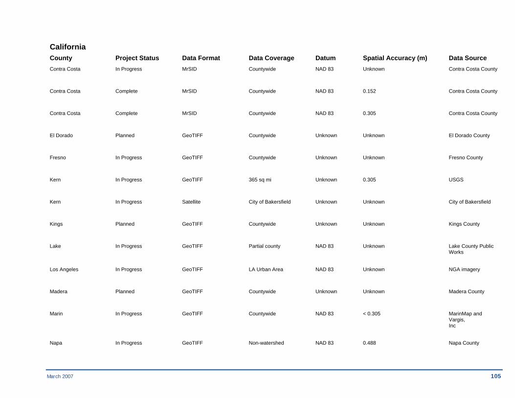
March 2007 105
California County Project Status Data Format Data Coverage Datum Spatial Accuracy (m) Data Source Contra Costa In Progress MrSID Countywide NAD 83 Unknown Contra Costa County
Contra Costa Complete MrSID Countywide NAD 83 0.152 Contra Costa County
Contra Costa Complete MrSID Countywide NAD 83 0.305 Contra Costa County
El Dorado Planned GeoTIFF Countywide Unknown Unknown El Dorado County
Fresno In Progress GeoTIFF Countywide Unknown Unknown Fresno County
Kern In Progress GeoTIFF 365 sq mi Unknown 0.305 USGS
Kern In Progress Satellite City of Bakersfield Unknown Unknown City of Bakersfield
Kings Planned GeoTIFF Countywide Unknown Unknown Kings County
Lake In Progress GeoTIFF Partial county NAD 83 Unknown Lake County Public Works
Los Angeles In Progress GeoTIFF LA Urban Area NAD 83 Unknown NGA imagery
Madera Planned GeoTIFF Countywide Unknown Unknown Madera County
Marin In Progress GeoTIFF Countywide NAD 83 < 0.305 MarinMap and Vargis, Inc
Napa In Progress GeoTIFF Non-watershed NAD 83 0.488 Napa County

106 March 2007
California County Project Status Data Format Data Coverage Datum Spatial Accuracy (m) Data Source Napa In Progress GeoTIFF Watershed NAD 83 0.244 Napa County
Orange Complete MrSID Laguna Beach City Unknown 1.159 City of Laguna Beach
Sacramento In Progress GeoTIFF Countywide NAD 83 < 0.305 Sacramento County
Sacramento Planned GeoTIFF Sacramento Urban Area NAD 83 0.305 USGS
San Diego In Progress GeoTIFF Countywide NAD 83 0.609 San Diego County/Digital Globe
San Diego Complete MrSID Countywide NAD 83 0.609 San Diego County & USGS
San Mateo In Progress GeoTIFF Town of Portola Valley NAD 83 0.609 San Mateo County
San Mateo In Progress GeoTIFF Countywide NAD 83 0.076 USGS, San Mateo County, San Mateo County Transit District
Santa Clara In Progress GeoTIFF Partial county NAD 83 0.609 Santa Clara County
Santa Cruz In Progress GeoTIFF City of Watsonville NAD 83 Unknown City of Watsonville
Sonoma Complete GeoTIFF City of Hearldsburg NAD 83 Unknown Sonoma County
Stanislaus In Progress GeoTIFF Countywide Unknown Unknown Stanislaus County
Ventura Planned GeoTIFF Oxnard Urban Area Unknown 0.305 USGS
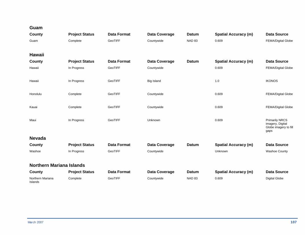
March 2007 107
Guam County Project Status Data Format Data Coverage Datum Spatial Accuracy (m) Data Source Guam Complete GeoTIFF Countywide NAD 83 0.609 FEMA/Digital Globe
Hawaii County Project Status Data Format Data Coverage Datum Spatial Accuracy (m) Data Source Hawaii In Progress GeoTIFF Countywide 0.609 FEMA/Digital Globe
Hawaii In Progress GeoTIFF Big Island 1.0 IKONOS
Honolulu Complete GeoTIFF Countywide 0.609 FEMA/Digital Globe
Kauai Complete GeoTIFF Countywide 0.609 FEMA/Digital Globe
Maui In Progress GeoTIFF Unknown 0.609 Primarily NRCS imagery, Digital Globe imagery to fill gaps
Nevada County Project Status Data Format Data Coverage Datum Spatial Accuracy (m) Data Source Washoe In Progress GeoTIFF Countywide Unknown Washoe County
Northern Mariana Islands County Project Status Data Format Data Coverage Datum Spatial Accuracy (m) Data Source Northern Mariana Complete GeoTIFF Countywide NAD 83 0.609 Digital Globe Islands
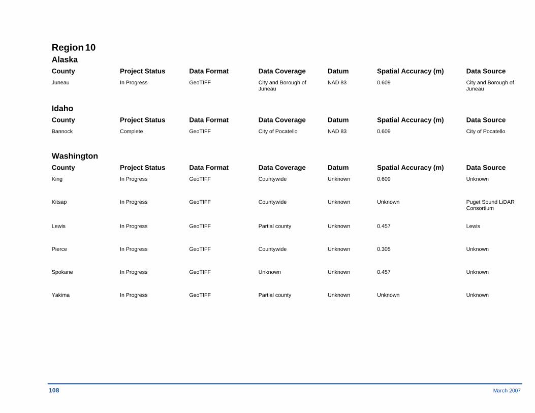
108 March 2007
Region 10 Alaska County Project Status Data Format Data Coverage Datum Spatial Accuracy (m) Data Source Juneau In Progress GeoTIFF City and Borough of NAD 83 0.609 City and Borough of Juneau Juneau
Idaho County Project Status Data Format Data Coverage Datum Spatial Accuracy (m) Data Source Bannock Complete GeoTIFF City of Pocatello NAD 83 0.609 City of Pocatello
Washington County Project Status Data Format Data Coverage Datum Spatial Accuracy (m) Data Source King In Progress GeoTIFF Countywide Unknown 0.609 Unknown
Kitsap In Progress GeoTIFF Countywide Unknown Unknown Puget Sound LiDAR Consortium
Lewis In Progress GeoTIFF Partial county Unknown 0.457 Lewis
Pierce In Progress GeoTIFF Countywide Unknown 0.305 Unknown
Spokane In Progress GeoTIFF Unknown Unknown 0.457 Unknown
Yakima In Progress GeoTIFF Partial county Unknown Unknown Unknown

March 2007 109

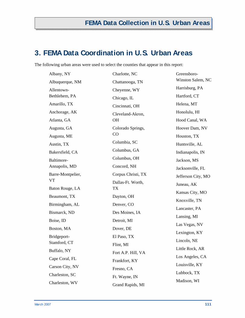
March 2007 111
FEMA Data Collection in U.S. Urban Areas
3. FEMA Data Coordination in U.S. Urban Areas The following urban areas were used to select the counties that appear in this report:
Albany, NY
Albuquerque, NM
Allentown-Bethlehem, PA
Amarillo, TX
Anchorage, AK
Atlanta, GA
Augusta, GA
Augusta, ME
Austin, TX
Bakersfield, CA
Baltimore-Annapolis, MD
Barre-Montpelier, VT
Baton Rouge, LA
Beaumont, TX
Birmingham, AL
Bismarck, ND
Boise, ID
Boston, MA
Bridgeport-Stamford, CT
Buffalo, NY
Cape Coral, FL
Carson City, NV
Charleston, SC
Charleston, WV
Charlotte, NC
Chattanooga, TN
Cheyenne, WY
Chicago, IL
Cincinnati, OH
Cleveland-Akron, OH
Colorado Springs, CO
Columbia, SC
Columbus, GA
Columbus, OH
Concord, NH
Corpus Christi, TX
Dallas-Ft. Worth, TX
Dayton, OH
Denver, CO
Des Moines, IA
Detroit, MI
Dover, DE
El Paso, TX
Flint, MI
Fort A.P. Hill, VA
Frankfort, KY
Fresno, CA
Ft. Wayne, IN
Grand Rapids, MI
Greensboro-Winston Salem, NC
Harrisburg, PA
Hartford, CT
Helena, MT
Honolulu, HI
Hood Canal, WA
Hoover Dam, NV
Houston, TX
Huntsville, AL
Indianapolis, IN
Jackson, MS
Jacksonville, FL
Jefferson City, MO
Juneau, AK
Kansas City, MO
Knoxville, TN
Lancaster, PA
Lansing, MI
Las Vegas, NV
Lexington, KY
Lincoln, NE
Little Rock, AR
Los Angeles, CA
Louisville, KY
Lubbock, TX
Madison, WI

112 March 2007
FEMA Data Collection in U.S. Urban Areas
McAllen, TX
Memphis, TN
Miami-Ft. Lauderdale, FL
Milwaukee, WI
Minneapolis-St. Paul, MN
Mission Viejo, CA
Mobile, AL
Modesto, CA
Montgomery, AL
Nashville, TN
New Haven, CT
New Orleans, LA
New York, NY-Newark, NJ
Norfolk, VA
Oklahoma City, OK
Olympia, WA
Omaha, NE
Orlando, FL
Oxnard, CA
Palm Bay-Melbourne, FL
Pensacola, FL
Philadelphia, PA
Phoenix, AZ
Pierre, SD
Pittsburgh, PA
Portland, OR
Poughkeepsie-Newburgh, NY
Providence, RI
Raleigh-Durham, NC
Reno, NV
Richmond, VA
Riverside-San Bernardino, CA
Rochester, NY
Sacramento, CA
Salem, OR
Salt Lake City-Ogden, UT
San Antonio, TX
San Diego, CA
San Francisco-Oakland, CA
San Juan, PR
Santa Fe, NM
Sarasota-Bradenton, FL
Savannah, GA
Scranton, PA
Seattle-Tacoma, WA
Shreveport, LA
Spokane, WA
Springfield, IL
Springfield, MA
St. Louis, MO
Stockton, CA
Sunny Point, NC
Syracuse, NY
Tallahassee, FL
Tampa-St. Petersburg, FL
Toledo, OH
Topeka, KS
Trenton, NJ
Tucson, AZ
Tulsa, OK
Valdez, AK
Washington, DC
White Sands, NM
Wichita, KS
Worcester, MA
Youngstown, OH

March 2007 113
FEMA Data Collection in U.S. Urban Areas
3.1. Map Mod Elevation Data Identified in Urban Areas Use the table below to find where FEMA has identified elevation data sets for use in its projects that intersect the NGA Urban Area LiDAR collection project areas.
Area Urban Area FIPS County State Data Format Region 1 Augusta, ME 23011 Kennebec Maine 10-meter contours 23015 Lincoln Maine 10-meter contours 23023 Sagadahoc Maine 10-meter contours Barre-Montpelier, VT 50023 Washington Vermont LiDAR 50017 Orange Vermont 30-meter contours Boston, MA 25027 Worcester Massachusetts LiDAR 25025 Suffolk Massachusetts 3-meter contours 44007 Providence Rhode Island LiDAR 33013 Merrimack New Hampshire 30-meter contours 25021 Norfolk Massachusetts 3-meter contours 33011 Hillsborough New Hampshire Contours 25009 Essex Massachusetts 3-meter contours 33015 Rockingham New Hampshire 30-meter contours 25005 Bristol Massachusetts LiDAR 25023 Plymouth Massachusetts LiDAR 25017 Middlesex Massachusetts LiDAR Bridgeport-Stamford, CT 09009 New Haven Connecticut 3-meter contours 09005 Litchfield Connecticut 3-meter contours 09001 Fairfield Connecticut LiDAR Concord, NH 33011 Hillsborough New Hampshire Contours 33013 Merrimack New Hampshire 30-meter contours 33015 Rockingham New Hampshire 30-meter contours Hartford, CT 09003 Hartford Connecticut LiDAR 25013 Hampden Massachusetts LiDAR 09013 Tolland Connecticut 3-meter contours 09003 Hartford Connecticut 3-meter contours 09007 Middlesex Connecticut LiDAR 09009 New Haven Connecticut 3-meter contours 09005 Litchfield Connecticut 3-meter contours 09011 New London Connecticut LiDAR
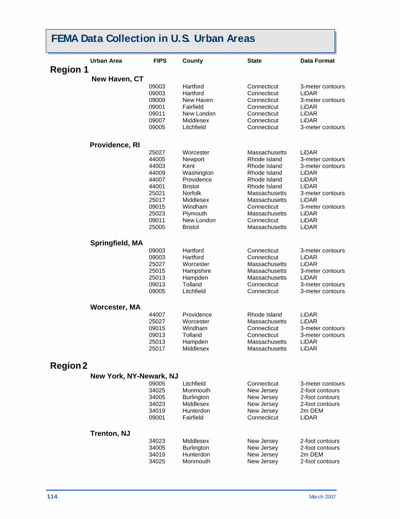
114 March 2007
FEMA Data Collection in U.S. Urban Areas Urban Area FIPS County State Data Format Region 1 New Haven, CT 09003 Hartford Connecticut 3-meter contours 09003 Hartford Connecticut LiDAR 09009 New Haven Connecticut 3-meter contours 09001 Fairfield Connecticut LiDAR 09011 New London Connecticut LiDAR 09007 Middlesex Connecticut LiDAR 09005 Litchfield Connecticut 3-meter contours Providence, RI 25027 Worcester Massachusetts LiDAR 44005 Newport Rhode Island 3-meter contours 44003 Kent Rhode Island 3-meter contours 44009 Washington Rhode Island LiDAR 44007 Providence Rhode Island LiDAR 44001 Bristol Rhode Island LiDAR 25021 Norfolk Massachusetts 3-meter contours 25017 Middlesex Massachusetts LiDAR 09015 Windham Connecticut 3-meter contours 25023 Plymouth Massachusetts LiDAR 09011 New London Connecticut LiDAR 25005 Bristol Massachusetts LiDAR Springfield, MA 09003 Hartford Connecticut 3-meter contours 09003 Hartford Connecticut LiDAR 25027 Worcester Massachusetts LiDAR 25015 Hampshire Massachusetts 3-meter contours 25013 Hampden Massachusetts LiDAR 09013 Tolland Connecticut 3-meter contours 09005 Litchfield Connecticut 3-meter contours Worcester, MA 44007 Providence Rhode Island LiDAR 25027 Worcester Massachusetts LiDAR 09015 Windham Connecticut 3-meter contours 09013 Tolland Connecticut 3-meter contours 25013 Hampden Massachusetts LiDAR 25017 Middlesex Massachusetts LiDAR Region 2 New York, NY-Newark, NJ 09005 Litchfield Connecticut 3-meter contours 34025 Monmouth New Jersey 2-foot contours 34005 Burlington New Jersey 2-foot contours 34023 Middlesex New Jersey 2-foot contours 34019 Hunterdon New Jersey 2m DEM 09001 Fairfield Connecticut LiDAR Trenton, NJ 34023 Middlesex New Jersey 2-foot contours 34005 Burlington New Jersey 2-foot contours 34019 Hunterdon New Jersey 2m DEM 34025 Monmouth New Jersey 2-foot contours
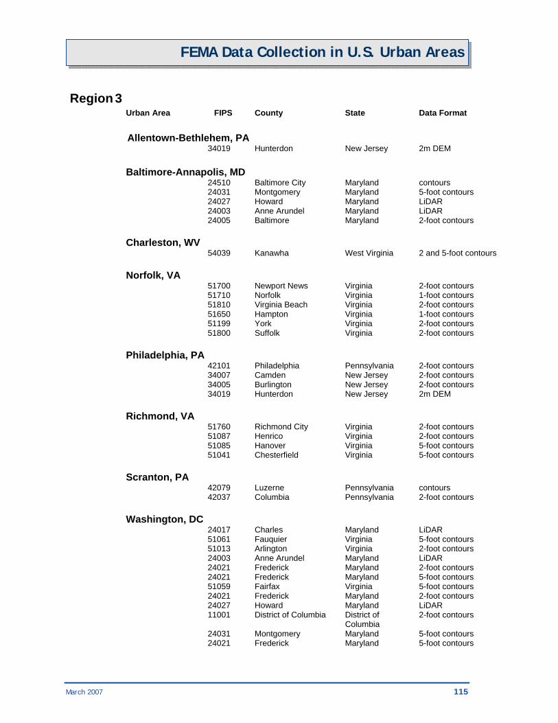
March 2007 115
FEMA Data Collection in U.S. Urban Areas Region 3 Urban Area FIPS County State Data Format Allentown-Bethlehem, PA 34019 Hunterdon New Jersey 2m DEM Baltimore-Annapolis, MD 24510 Baltimore City Maryland contours 24031 Montgomery Maryland 5-foot contours 24027 Howard Maryland LiDAR 24003 Anne Arundel Maryland LiDAR 24005 Baltimore Maryland 2-foot contours Charleston, WV 54039 Kanawha West Virginia 2 and 5-foot contours Norfolk, VA 51700 Newport News Virginia 2-foot contours 51710 Norfolk Virginia 1-foot contours 51810 Virginia Beach Virginia 2-foot contours 51650 Hampton Virginia 1-foot contours 51199 York Virginia 2-foot contours 51800 Suffolk Virginia 2-foot contours Philadelphia, PA 42101 Philadelphia Pennsylvania 2-foot contours 34007 Camden New Jersey 2-foot contours 34005 Burlington New Jersey 2-foot contours 34019 Hunterdon New Jersey 2m DEM Richmond, VA 51760 Richmond City Virginia 2-foot contours 51087 Henrico Virginia 2-foot contours 51085 Hanover Virginia 5-foot contours 51041 Chesterfield Virginia 5-foot contours Scranton, PA 42079 Luzerne Pennsylvania contours 42037 Columbia Pennsylvania 2-foot contours Washington, DC 24017 Charles Maryland LiDAR 51061 Fauquier Virginia 5-foot contours 51013 Arlington Virginia 2-foot contours 24003 Anne Arundel Maryland LiDAR 24021 Frederick Maryland 2-foot contours 24021 Frederick Maryland 5-foot contours 51059 Fairfax Virginia 5-foot contours 24021 Frederick Maryland 2-foot contours 24027 Howard Maryland LiDAR 11001 District of Columbia District of 2-foot contours Columbia 24031 Montgomery Maryland 5-foot contours 24021 Frederick Maryland 5-foot contours

116 March 2007
FEMA Data Collection in U.S. Urban Areas Urban Area FIPS County State Data Format Region 4 Augusta, GA 45003 Aiken South Carolina LiDAR Birmingham, AL 01117 Shelby Alabama 2-foot contours 01073 Jefferson Alabama 2-foot contours Charlotte, NC 45091 York South Carolina 2 and 5-foot contours Columbia, SC 45079 Richland South Carolina 2-foot contours Knoxville, TN 47155 Sevier Tennessee 2 and 10-foot contours 47105 Loudon Tennessee 2 and 10-foot contours 47145 Roane Tennessee 2 and 10-foot contours Lexington, KY 21067 Lexington-Fayette Kentucky 2-foot contours Memphis, TN 47157 Shelby Tennessee 2 and 10-foot contours 05035 Crittenden Arkansas DEM Mobile, AL 01003 Baldwin Alabama LiDAR 01097 Mobile Alabama LiDAR Nashville, TN 47149 Rutherford Tennessee 2-foot contours 47187 Williamson Tennessee 2 and 5-foot contours 47165 Sumner Tennessee 2 and 10-foot contours 47189 Wilson Tennessee 2 and 10-foot contours Pensacola, FL 01003 Baldwin Alabama LiDAR Region 5 Chicago, IL 17031 Cook Illinois Unknown 17089 Kane Illinois Unknown 17093 Kendall Illinois Unknown Cincinnati, OH 21015 Boone Kentucky 2-foot contours

March 2007 117
FEMA Data Collection in U.S. Urban Areas Urban Area FIPS County State Data Format Region 6 Amarillo, TX 48381 Randall Texas IFSAR 48375 Potter Texas IFSAR Austin, TX 48453 Travis Texas LiDAR Baton Rouge, LA 22063 Livingston Louisiana DEM 22047 Iberville Louisiana DEM 22033 East Baton Rouge Louisiana DEM 22037 East Feliciana Louisiana DEM 22005 Ascension Louisiana DEM 22093 St. James Louisiana DEM 22121 West Baton Rouge Louisiana DEM Corpus Christi, TX 48409 San Patricio Texas DEM Dallas-Ft. Worth, TX 48139 Ellis Texas 2-foot contours 48251 Johnson Texas LiDAR 48257 Kaufman Texas LiDAR 48121 Denton Texas LiDAR 48113 Dallas Texas LiDAR 48085 Collin Texas LiDAR 48367 Parker Texas IFSAR 48397 Rockwall Texas LiDAR 48439 Tarrant Texas LiDAR El Paso, TX 48141 El Paso Texas DEM 35013 Dona Ana New Mexico LiDAR Houston, TX 48339 Montgomery Texas LiDAR 48473 Waller Texas DEM 48291 Liberty Texas DEM 48039 Brazoria Texas LiDAR 48071 Chambers Texas DEM 48201 Harris Texas LiDAR Little Rock, AR 05119 Pulaski Arkansas Contours Lubbock, TX 48303 Lubbock Texas Unknown McAllen, TX 48215 Hidalgo Texas LiDAR
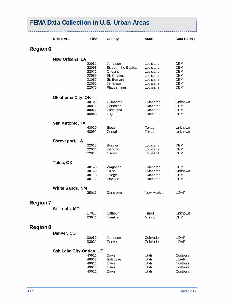
118 March 2007
FEMA Data Collection in U.S. Urban Areas Urban Area FIPS County State Data Format Region 6 New Orleans, LA 22051 Jefferson Louisiana DEM 22095 St. John the Baptist Louisiana DEM 22071 Orleans Louisiana DEM 22089 St. Charles Louisiana DEM 22087 St. Bernard Louisiana DEM 22051 Jefferson Louisiana DEM 22075 Plaquemines Louisiana DEM Oklahoma City, OK 40109 Oklahoma Oklahoma Unknown 40017 Canadian Oklahoma DEM 40027 Cleveland Oklahoma DEM 40083 Logan Oklahoma DEM San Antonio, TX 48029 Bexar Texas Unknown 48091 Comal Texas Unknown Shreveport, LA 22015 Bossier Louisiana DEM 22031 De Soto Louisiana DEM 22017 Caddo Louisiana DEM Tulsa, OK 40145 Wagoner Oklahoma DEM 40143 Tulsa Oklahoma Unknown 40113 Osage Oklahoma DEM 40117 Pawnee Oklahoma DEM White Sands, NM 35013 Dona Ana New Mexico LiDAR Region 7 St. Louis, MO 17013 Calhoun Illinois Unknown 29071 Franklin Missouri DEM Region 8 Denver, CO 08059 Jefferson Colorado LiDAR 08031 Denver Colorado LiDAR Salt Lake City-Ogden, UT 49011 Davis Utah Contours 49035 Salt Lake Utah LiDAR 49011 Davis Utah Contours 49011 Davis Utah Contours 49011 Davis Utah Contours

March 2007 119
FEMA Data Collection in U.S. Urban Areas Urban Area FIPS County State Data Format Region 9 Carson City, NV 32005 Douglas Nevada Contours 32031 Washoe Nevada Contours 32510 Carson City Nevada LiDAR Honolulu, HI 15003 Honolulu Hawaii LiDAR Hoover Dam, NV 32003 Clark Nevada Contours, TIN, DEM Las Vegas, NV 32003 Clark Nevada Contours, TIN, DEM Los Angeles, CA 06111 Ventura California Contours, Mass 06037 Los Angeles California Contours 06065 Riverside California Unknown 06071 San Bernadino California Contours 06059 Orange California Contours 06037 Los Angeles California Contours, Mass Points Mission Viejo, CA 06059 Orange California Contours 06065 Riverside California Unknown 06073 San Diego California Contours, DTM Oxnard, CA 06037 Los Angeles California Contours, Mass 06111 Ventura California Contours, Mass 06037 Los Angeles California Contours Phoenix, AZ 04021 Pinal Arizona Contours 04013 Maricopa Arizona Contours Reno, NV 06061 Placer California Contours 32031 Washoe Nevada Contours Riverside-San Bernardino, CA 06065 Riverside California Unknown 06059 Orange California Contours 06071 San Bernadino California Contours Sacramento, CA 06113 Yolo California Contours 06061 Placer California Contours 06095 Solano California Mass Points/Break Lines 06101 Sutter California Contours, DTM 06101 Sutter California Contours 06101 Sutter California 2-foot Contours
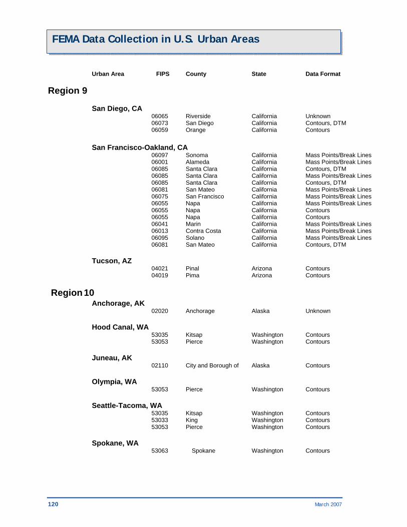
120 March 2007
FEMA Data Collection in U.S. Urban Areas Urban Area FIPS County State Data Format Region 9 San Diego, CA 06065 Riverside California Unknown 06073 San Diego California Contours, DTM 06059 Orange California Contours San Francisco-Oakland, CA 06097 Sonoma California Mass Points/Break Lines 06001 Alameda California Mass Points/Break Lines 06085 Santa Clara California Contours, DTM 06085 Santa Clara California Mass Points/Break Lines 06085 Santa Clara California Contours, DTM 06081 San Mateo California Mass Points/Break Lines 06075 San Francisco California Mass Points/Break Lines 06055 Napa California Mass Points/Break Lines 06055 Napa California Contours 06055 Napa California Contours 06041 Marin California Mass Points/Break Lines 06013 Contra Costa California Mass Points/Break Lines 06095 Solano California Mass Points/Break Lines 06081 San Mateo California Contours, DTM Tucson, AZ 04021 Pinal Arizona Contours 04019 Pima Arizona Contours Region 10 Anchorage, AK 02020 Anchorage Alaska Unknown Hood Canal, WA 53035 Kitsap Washington Contours 53053 Pierce Washington Contours Juneau, AK 02110 City and Borough of Alaska Contours Olympia, WA 53053 Pierce Washington Contours Seattle-Tacoma, WA 53035 Kitsap Washington Contours 53033 King Washington Contours 53053 Pierce Washington Contours Spokane, WA 53063 Spokane Washington Contours
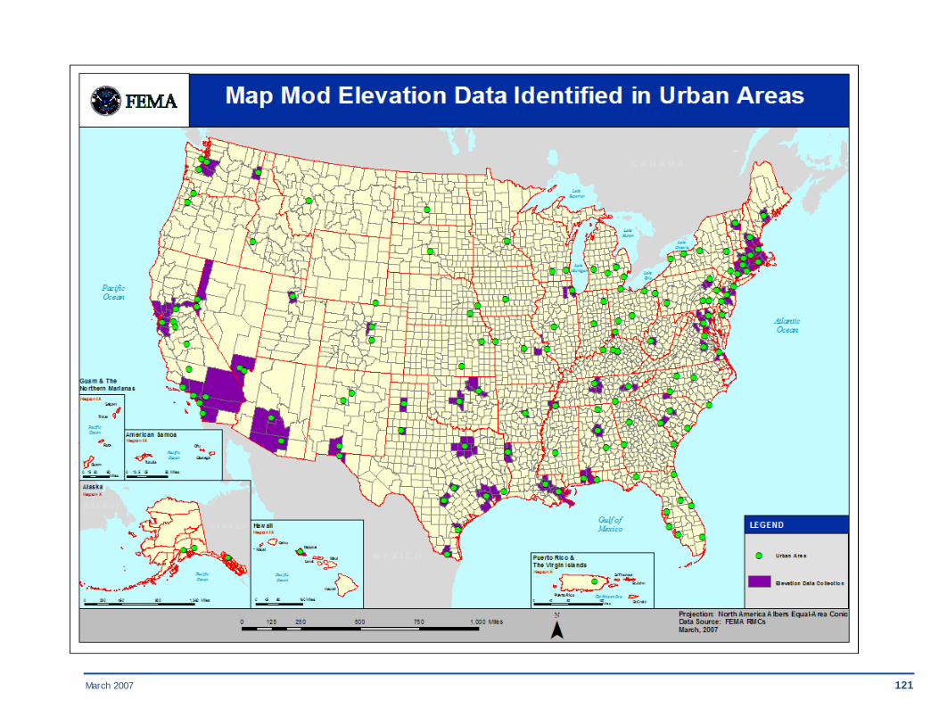
March 2007 121


March 2007 123
FEMA Data Collection in U.S. Urban Areas
3.2. Map Mod Imagery Data Identified in Urban Areas Use the table below to find where FEMA has identified imagery data sets for use in its projects that intersect the NGA Urban Area orthophoto collection project areas.
MA Imagery Data Collection by Urban Urban Area FIPS County State Data Format Region 1 Augusta, ME 23023 Sagadahoc Maine GeoTIFF 23015 Lincoln Maine GeoTIFF 23011 Kennebec Maine GeoTIFF Barre-Montpelier, VT 50023 Washington Vermont LAN and BIP 50017 Orange Vermont LAN and BIP Boston, MA 33015 Rockingham New Hampshire GeoTIFF 33013 Merrimack New Hampshire GeoTIFF 33011 Hillsborough New Hampshire GeoTIFF 25025 Suffolk Massachusetts GeoTIFF 25021 Norfolk Massachusetts GeoTIFF 25017 Middlesex Massachusetts GeoTIFF Bridgeport-Stamford, CT 36103 SUFFOLK New York Compressed Native 09005 Litchfield Connecticut GeoTIFF 09001 Fairfield Connecticut GeoTIFF 36119 WESTCHESTER New York Compressed Native 36079 PUTNAM New York Compressed Native 09009 New Haven Connecticut GeoTIFF Concord, NH 33011 Hillsborough New Hampshire GeoTIFF 33015 Rockingham New Hampshire GeoTIFF 33013 Merrimack New Hampshire GeoTIFF Hartford, CT 09011 New London Connecticut GeoTIFF 25013 Hampden Massachusetts GeoTIFF 09005 Litchfield Connecticut GeoTIFF 09013 Tolland Connecticut GeoTIFF 09009 New Haven Connecticut GeoTIFF 09003 Hartford Connecticut GeoTIFF 09007 Middlesex Connecticut GeoTIFF New Haven, CT 09005 Litchfield Connecticut GeoTIFF 09003 Hartford Connecticut GeoTIFF 09001 Fairfield Connecticut GeoTIFF 09011 New London Connecticut GeoTIFF

124 March 2007
FEMA Data Collection in U.S. Urban Areas
09009 New Haven Connecticut GeoTIFF 09007 Middlesex Connecticut GeoTIFF
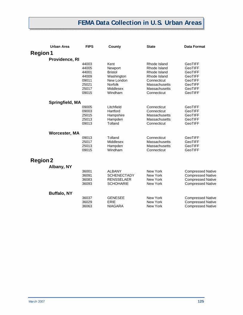
March 2007 125
FEMA Data Collection in U.S. Urban Areas
Urban Area FIPS County State Data Format Region 1 Providence, RI 44003 Kent Rhode Island GeoTIFF 44005 Newport Rhode Island GeoTIFF 44001 Bristol Rhode Island GeoTIFF 44009 Washington Rhode Island GeoTIFF 09011 New London Connecticut GeoTIFF 25021 Norfolk Massachusetts GeoTIFF 25017 Middlesex Massachusetts GeoTIFF 09015 Windham Connecticut GeoTIFF Springfield, MA 09005 Litchfield Connecticut GeoTIFF 09003 Hartford Connecticut GeoTIFF 25015 Hampshire Massachusetts GeoTIFF 25013 Hampden Massachusetts GeoTIFF 09013 Tolland Connecticut GeoTIFF Worcester, MA 09013 Tolland Connecticut GeoTIFF 25017 Middlesex Massachusetts GeoTIFF 25013 Hampden Massachusetts GeoTIFF 09015 Windham Connecticut GeoTIFF Region 2 Albany, NY 36001 ALBANY New York Compressed Native 36091 SCHENECTADY New York Compressed Native 36083 RENSSELAER New York Compressed Native 36093 SCHOHARIE New York Compressed Native Buffalo, NY 36037 GENESEE New York Compressed Native 36029 ERIE New York Compressed Native 36063 NIAGARA New York Compressed Native

126 March 2007
FEMA Data Collection in U.S. Urban Areas
Urban Area FIPS County State Data Format Region 2 New York, NY-Newark, NJ 34003 BERGEN New Jersey Compressed Native 34013 ESSEX New Jersey Compressed Native 36103 SUFFOLK New York Compressed Native 36119 WESTCHESTER New York Compressed Native 34001 ATLANTIC New Jersey Compressed Native 34041 WARREN New Jersey Compressed Native 34039 UNION New Jersey Compressed Native 34037 SUSSEX New Jersey Compressed Native 34035 SOMERSET New Jersey Compressed Native 34005 BURLINGTON New Jersey Compressed Native 34029 OCEAN New Jersey Compressed Native 34027 MORRIS New Jersey Compressed Native 34025 MONMOUTH New Jersey Compressed Native 34017 HUDSON New Jersey Compressed Native 34023 MIDDLESEX New Jersey Compressed Native 34019 HUNTERDON New Jersey Compressed Native 36087 ROCKLAND New York Compressed Native 34031 PASSAIC New Jersey Compressed Native 36047 KINGS New York Compressed Native 36081 QUEENS New York Compressed Native 36027 DUTCHESS New York Compressed Native 36079 PUTNAM New York Compressed Native 09005 Litchfield Connecticut GeoTIFF 34021 MERCER New Jersey Compressed Native 36059 NASSAU New York Compressed Native 36071 ORANGE New York Compressed Native 36061 NEW YORK New York Compressed Native 36005 BRONX New York Compressed Native 09001 Fairfield Connecticut GeoTIFF 36085 RICHMOND New York Compressed Native Poughkeepsie-Newburgh, NY 36119 WESTCHESTER New York Compressed Native 36027 DUTCHESS New York Compressed Native 36071 ORANGE New York Compressed Native 36111 ULSTER New York Compressed Native 36079 PUTNAM New York Compressed Native 36087 ROCKLAND New York Compressed Native Rochester, NY 36073 ORLEANS New York Compressed Native 36117 WAYNE New York Compressed Native 36055 MONROE New York Compressed Native 36037 GENESEE New York Compressed Native 36069 ONTARIO New York Compressed Native
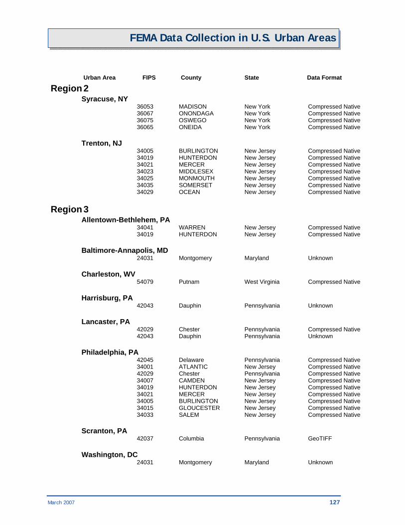
March 2007 127
FEMA Data Collection in U.S. Urban Areas
Urban Area FIPS County State Data Format Region 2 Syracuse, NY 36053 MADISON New York Compressed Native 36067 ONONDAGA New York Compressed Native 36075 OSWEGO New York Compressed Native 36065 ONEIDA New York Compressed Native Trenton, NJ 34005 BURLINGTON New Jersey Compressed Native 34019 HUNTERDON New Jersey Compressed Native 34021 MERCER New Jersey Compressed Native 34023 MIDDLESEX New Jersey Compressed Native 34025 MONMOUTH New Jersey Compressed Native 34035 SOMERSET New Jersey Compressed Native 34029 OCEAN New Jersey Compressed Native Region 3 Allentown-Bethlehem, PA 34041 WARREN New Jersey Compressed Native 34019 HUNTERDON New Jersey Compressed Native Baltimore-Annapolis, MD 24031 Montgomery Maryland Unknown Charleston, WV 54079 Putnam West Virginia Compressed Native Harrisburg, PA 42043 Dauphin Pennsylvania Unknown Lancaster, PA 42029 Chester Pennsylvania Compressed Native 42043 Dauphin Pennsylvania Unknown Philadelphia, PA 42045 Delaware Pennsylvania Compressed Native 34001 ATLANTIC New Jersey Compressed Native 42029 Chester Pennsylvania Compressed Native 34007 CAMDEN New Jersey Compressed Native 34019 HUNTERDON New Jersey Compressed Native 34021 MERCER New Jersey Compressed Native 34005 BURLINGTON New Jersey Compressed Native 34015 GLOUCESTER New Jersey Compressed Native 34033 SALEM New Jersey Compressed Native Scranton, PA 42037 Columbia Pennsylvania GeoTIFF Washington, DC 24031 Montgomery Maryland Unknown

128 March 2007
FEMA Data Collection in U.S. Urban Areas
Region 4 Augusta, GA 45003 Aiken South Carolina GeoTIFF Charlotte, NC 45091 York South Carolina Unknown Columbia, SC 45079 Richland South Carolina Unknown Knoxville, TN 47145 Roane Tennessee GeoTIFF 47155 Sevier Tennessee GeoTIFF 47105 Loudon Tennessee GeoTIFF Memphis, TN 05035 Crittenden County Arkansas Unknown 47157 Shelby Tennessee GeoTIFF Nashville, TN 47187 Williamson Tennessee GeoTIFF 47189 Wilson Tennessee GeoTIFF 47165 Sumner Tennessee GeoTIFF Region 6 Baton Rouge, LA 22093 St. James Parish Louisiana Unknown 22063 Livingston Parish Louisiana Unknown 22047 Iberville Parish Louisiana Unknown 22047 Iberia Parish Louisiana Unknown Corpus Christi, TX 48409 San Patricio County Texas MrSID Dallas-Ft. Worth, TX 48251 Johnson County Texas TIFF 48257 Kaufman Texas TIFF 48139 Ellis County Texas TIFF 48139 Ellis County Texas TIFF 48367 Parker County Texas TIFF Houston, TX 48473 Waller County Texas Unknown 48071 Chambers County Texas Unknown Oklahoma City, OK 40083 Logan County Oklahoma MrSID Tulsa, OK 40117 Pawnee County Oklahoma MrSID 40145 Wagoner County Oklahoma MrSID

March 2007 129
FEMA Data Collection in U.S. Urban Areas
Region 8 Helena, MT 30043 Jefferson Montana TIFF 30049 Lewis and Clark Montana TIFF Salt Lake City-Ogden, UT 49011 Davis Utah Unknown 49011 Davis Utah Unknown

130 March 2007
FEMA Data Collection in U.S. Urban Areas
Urban Area FIPS County State Data Format Region 9 Bakersfield, CA 06029 Kern California GeoTIFF 06029 Kern California Satellite Carson City, NV 32031 Washoe Nevada GeoTIFF 06017 El Dorado California GeoTIFF Fresno, CA 06039 Madera California GeoTIFF 06019 Fresno California GeoTIFF Honolulu, HI 15003 Honolulu Hawaii GeoTIFF Los Angeles, CA 06059 Orange California MrSID 06037 Los Angeles California GeoTIFF 06111 Ventura California GeoTIFF Mission Viejo, CA 06073 San Diego California GeoTIFF 06073 San Diego California MrSID 06059 Orange California MrSID Modesto, CA 06099 Stanislaus California GeoTIFF Oxnard, CA 06037 Los Angeles California GeoTIFF 06111 Ventura California GeoTIFF Phoenix, AZ 04013 Maricopa Arizona GeoTIFF, Compressed Reno, NV 32031 Washoe Nevada GeoTIFF Riverside-San Bernardino, CA 06059 Orange California MrSID Sacramento, CA 06067 Sacramento California GeoTIFF 06067 Sacramento California GeoTIFF 06017 El Dorado California GeoTIFF San Diego, CA 06059 Orange California MrSID 06073 San Diego California MrSID 06073 San Diego California GeoTIFF
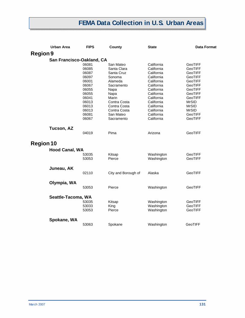
March 2007 131
FEMA Data Collection in U.S. Urban Areas
Urban Area FIPS County State Data Format Region 9 San Francisco-Oakland, CA 06081 San Mateo California GeoTIFF 06085 Santa Clara California GeoTIFF 06087 Santa Cruz California GeoTIFF 06097 Sonoma California GeoTIFF 06001 Alameda California GeoTIFF 06067 Sacramento California GeoTIFF 06055 Napa California GeoTIFF 06055 Napa California GeoTIFF 06041 Marin California GeoTIFF 06013 Contra Costa California MrSID 06013 Contra Costa California MrSID 06013 Contra Costa California MrSID 06081 San Mateo California GeoTIFF 06067 Sacramento California GeoTIFF Tucson, AZ 04019 Pima Arizona GeoTIFF Region 10 Hood Canal, WA 53035 Kitsap Washington GeoTIFF 53053 Pierce Washington GeoTIFF Juneau, AK 02110 City and Borough of Alaska GeoTIFF Olympia, WA 53053 Pierce Washington GeoTIFF Seattle-Tacoma, WA 53035 Kitsap Washington GeoTIFF 53033 King Washington GeoTIFF 53053 Pierce Washington GeoTIFF Spokane, WA 53063 Spokane Washington GeoTIFF


March 2007 133

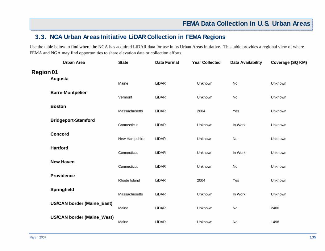
March 2007 135
FEMA Data Collection in U.S. Urban Areas
3.3. NGA Urban Areas Initiative LiDAR Collection in FEMA Regions Use the table below to find where the NGA has acquired LiDAR data for use in its Urban Areas initiative. This table provides a regional view of where FEMA and NGA may find opportunities to share elevation data or collection efforts.
Urban Area State Data Format Year Collected Data Availability Coverage (SQ KM)
Region 01 Augusta Maine LiDAR Unknown No Unknown
Barre-Montpelier Vermont LiDAR Unknown No Unknown
Boston Massachusetts LiDAR 2004 Yes Unknown
Bridgeport-Stamford Connecticut LiDAR Unknown In Work Unknown
Concord New Hampshire LiDAR Unknown No Unknown
Hartford Connecticut LiDAR Unknown In Work Unknown
New Haven Connecticut LiDAR Unknown No Unknown
Providence Rhode Island LiDAR 2004 Yes Unknown
Springfield Massachusetts LiDAR Unknown In Work Unknown
US/CAN border (Maine_East) Maine LiDAR Unknown No 2400
US/CAN border (Maine_West) Maine LiDAR Unknown No 1498
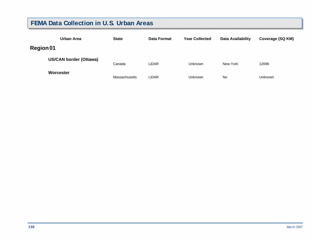
136 March 2007
FEMA Data Collection in U.S. Urban Areas Urban Area State Data Format Year Collected Data Availability Coverage (SQ KM)
Region 01 US/CAN border (Ottawa) Canada LiDAR Unknown New York 12696
Worcester Massachusetts LiDAR Unknown No Unknown

March 2007 137
FEMA Data Collection in U.S. Urban Areas
Urban Area State Data Format Year Collected Data Availability Coverage (SQ KM)
Region 02 Albany New York LiDAR Unknown In Work Unknown
Buffalo New York LiDAR 2004 Yes Unknown
JOHN F KENNEDY INTL NY LiDAR Unknown No 384
LA GUARDIA NY LiDAR Unknown No 424
New York-Newark New York LiDAR 2005 Yes Unknown
NEWARK LIBERTY INTL NJ LiDAR Unknown No 432
Poughkeepsie-Newburgh New York LiDAR Unknown No Unknown
Rochester New York LiDAR Unknown No Unknown
San Juan Puerto Rico LiDAR 2004 Yes Unknown
Syracuse New York LiDAR Unknown No Unknown
Trenton New Jersey LiDAR Unknown No Unknown

138 March 2007
FEMA Data Collection in U.S. Urban Areas Urban Area State Data Format Year Collected Data Availability Coverage (SQ KM)
Region 03 Allentown-Bethlehem Pennsylvania LiDAR Unknown In Work Unknown
Baltimore-Annapolis Maryland LiDAR 2004 Yes Unknown
Charleston West Virginia LiDAR Unknown No Unknown
Dover Delaware LiDAR Unknown No Unknown
Harrisburg Pennsylvania LiDAR Unknown No Unknown
Lancaster Pennsylvania LiDAR Unknown No Unknown
Norfolk Virginia LiDAR 2003 Yes Unknown
Philadelphia Pennsylvania LiDAR 2004 Yes Unknown
Pittsburgh Pennsylvania LiDAR 2004 Yes Unknown Richmond Virginia LiDAR Unknown No Unknown
Scranton Pennsylvania LiDAR Unknown No Unknown
Washington DC LiDAR 2004 Yes Unknown

March 2007 139
FEMA Data Collection in U.S. Urban Areas Urban Area State Data Format Year Collected Data Availability Coverage (SQ KM)
Region 03 Williamsburg Virginia LiDAR 2006 Yes Unknown

140 March 2007
FEMA Data Collection in U.S. Urban Areas Urban Area State Data Format Year Collected Data Availability Coverage (SQ KM)
Region 04 Atlanta Georgia LiDAR 2003 Yes Unknown
Augusta Georgia LiDAR Unknown No Unknown
Birmingham Alabama LiDAR Unknown No Unknown
Cape Coral Florida LiDAR Unknown No Unknown
Charleston South Carolina LiDAR 2005 Yes Unknown
Charlotte North Carolina LiDAR Unknown In Work Unknown
CHARLOTTE DOUGLAS INTL NC LiDAR Unknown No 427
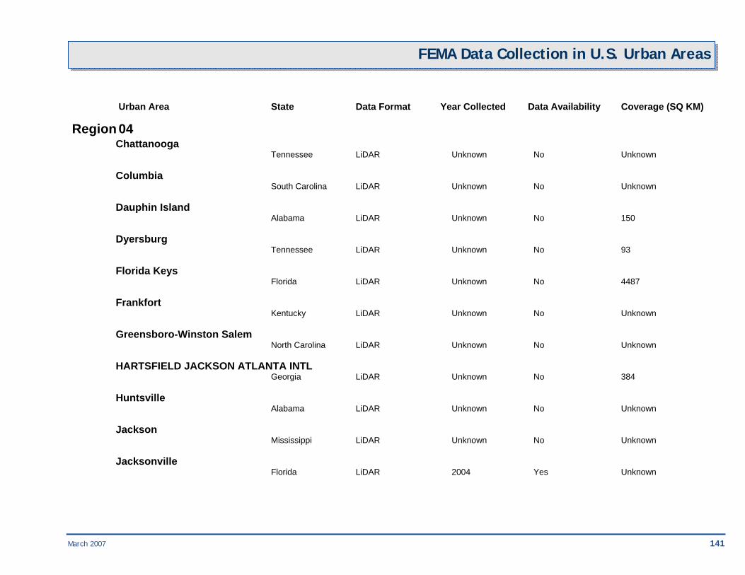
March 2007 141
FEMA Data Collection in U.S. Urban Areas
Urban Area State Data Format Year Collected Data Availability Coverage (SQ KM)
Region 04 Chattanooga Tennessee LiDAR Unknown No Unknown
Columbia South Carolina LiDAR Unknown No Unknown
Dauphin Island Alabama LiDAR Unknown No 150
Dyersburg Tennessee LiDAR Unknown No 93
Florida Keys Florida LiDAR Unknown No 4487
Frankfort Kentucky LiDAR Unknown No Unknown
Greensboro-Winston Salem North Carolina LiDAR Unknown No Unknown
HARTSFIELD JACKSON ATLANTA INTL Georgia LiDAR Unknown No 384
Huntsville Alabama LiDAR Unknown No Unknown
Jackson Mississippi LiDAR Unknown No Unknown
Jacksonville Florida LiDAR 2004 Yes Unknown

142 March 2007
FEMA Data Collection in U.S. Urban Areas Urban Area State Data Format Year Collected Data Availability Coverage (SQ KM)
Region 04 Knoxville Tennessee LiDAR 2003 Yes Unknown
Lexington Kentucky LiDAR Unknown No Unknown
Louisville Kentucky LiDAR Unknown In Work Unknown
Memphis Tennessee LiDAR 2003 Yes Unknown
Miami Florida LiDAR 2006 Yes Unknown
Mobile Alabama LiDAR Unknown No Unknown
Montgomery Alabama LiDAR Unknown No Unknown
Nashville Tennessee LiDAR 2003 Yes Unknown
Orlando Florida LiDAR 2004 Yes Unknown
Palm Bay-Melbourne Florida LiDAR Unknown No Unknown
Pensacola Florida LiDAR Unknown No Unknown

March 2007 143
FEMA Data Collection in U.S. Urban Areas
Urban Area State Data Format Year Collected Data Availability Coverage (SQ KM)
Region 04 Raleigh-Durham North Carolina LiDAR 2004 Yes Unknown
Sarasota-Bradenton Florida LiDAR Unknown No Unknown
Tallahassee Florida LiDAR Unknown No Unknown
Tampa-St. Petersburg Florida LiDAR 2003 Yes Unknown
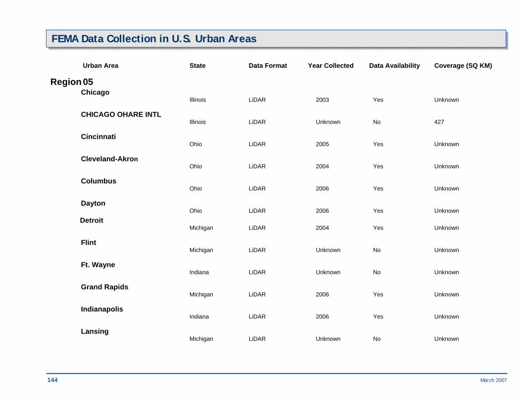
144 March 2007
FEMA Data Collection in U.S. Urban Areas Urban Area State Data Format Year Collected Data Availability Coverage (SQ KM)
Region 05 Chicago Illinois LiDAR 2003 Yes Unknown
CHICAGO OHARE INTL Illinois LiDAR Unknown No 427
Cincinnati Ohio LiDAR 2005 Yes Unknown
Cleveland-Akron Ohio LiDAR 2004 Yes Unknown
Columbus Ohio LiDAR 2006 Yes Unknown
Dayton Ohio LiDAR 2006 Yes Unknown Detroit Michigan LiDAR 2004 Yes Unknown
Flint Michigan LiDAR Unknown No Unknown
Ft. Wayne Indiana LiDAR Unknown No Unknown
Grand Rapids Michigan LiDAR 2006 Yes Unknown
Indianapolis Indiana LiDAR 2006 Yes Unknown
Lansing Michigan LiDAR Unknown No Unknown
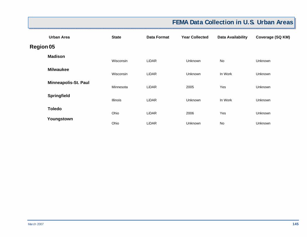
March 2007 145
FEMA Data Collection in U.S. Urban Areas Urban Area State Data Format Year Collected Data Availability Coverage (SQ KM)
Region 05 Madison Wisconsin LiDAR Unknown No Unknown
Milwaukee Wisconsin LiDAR Unknown In Work Unknown
Minneapolis-St. Paul Minnesota LiDAR 2005 Yes Unknown
Springfield Illinois LiDAR Unknown In Work Unknown
Toledo Ohio LiDAR 2006 Yes Unknown Youngstown Ohio LiDAR Unknown No Unknown

146 March 2007
FEMA Data Collection in U.S. Urban Areas Urban Area State Data Format Year Collected Data Availability Coverage (SQ KM)
Region 06 Albuquerque New Mexico LiDAR Unknown In Work Unknown
Amarillo Texas LiDAR Unknown No Unknown
Austin Texas LiDAR Unknown In Work Unknown
Baton Rouge Louisiana LiDAR Unknown In Work Unknown
Blytheville Arkansas LiDAR Unknown No 125
Corpus Christi Texas LiDAR Unknown No Unknown
Dallas-Ft. Worth Texas LiDAR 2004 Yes Unknown
El Paso Texas LiDAR Unknown In Work Unknown
Houston Texas LiDAR 2003 Yes Unknown
Little Rock Arkansas LiDAR Unknown No Unknown

March 2007 147
FEMA Data Collection in U.S. Urban Areas
Urban Area State Data Format Year Collected Data Availability Coverage (SQ KM)
Region 06 Lubbock Texas LiDAR Unknown No Unknown
McAllen Texas LiDAR Unknown No Unknown
New Orleans Louisiana LiDAR 2003 Yes Unknown
Oklahoma City Oklahoma LiDAR Unknown In Work Unknown
San Antonio Texas LiDAR 2003 Yes Unknown
Santa Fe New Mexico LiDAR Unknown No Unknown
Shreveport Louisiana LiDAR Unknown No Unknown
Tulsa Oklahoma LiDAR Unknown No Unknown

148 March 2007
FEMA Data Collection in U.S. Urban Areas Urban Area State Data Format Year Collected Data Availability Coverage (SQ KM)
Region 07 Caruthersville Missouri LiDAR Unknown No 194
Des Moines Iowa LiDAR 2005 Yes Unknown
Jefferson City Missouri LiDAR 2005 Yes Unknown Kansas City Missouri LiDAR 2005 Yes Unknown
LAMBERT ST LOUIS INTL Missouri LiDAR Unknown No 396
Lincoln Nebraska LiDAR Unknown No Unknown
Omaha Nebraska LiDAR Unknown In Work Unknown
St. Louis Missouri LiDAR 2005 Yes Unknown
Topeka Kansas LiDAR Unknown No Unknown
Wichita Kansas LiDAR Unknown No Unknown
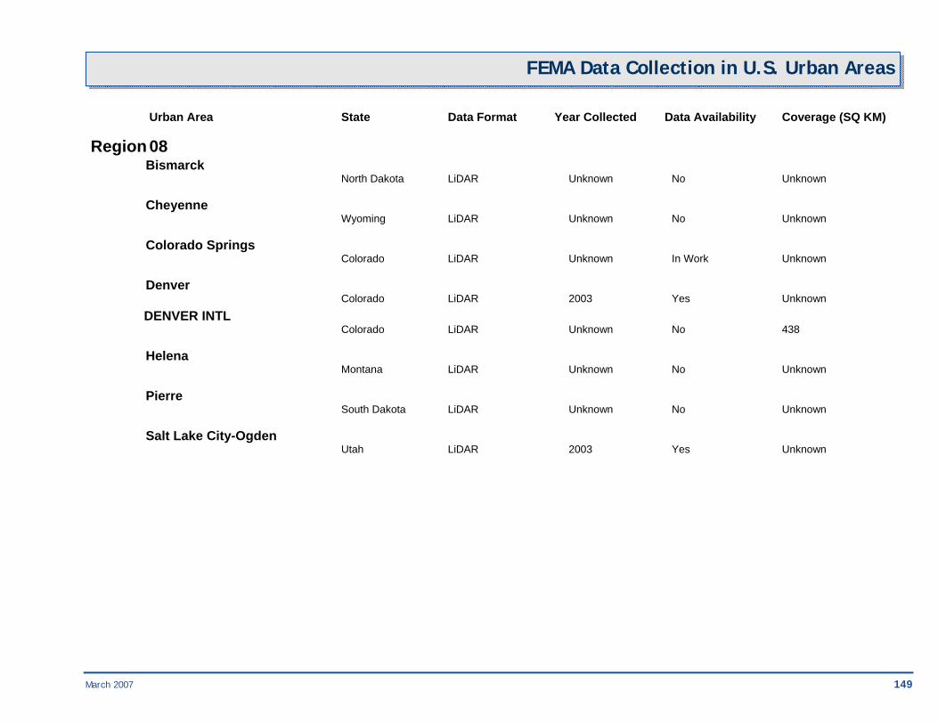
March 2007 149
FEMA Data Collection in U.S. Urban Areas
Urban Area State Data Format Year Collected Data Availability Coverage (SQ KM)
Region 08 Bismarck North Dakota LiDAR Unknown No Unknown
Cheyenne Wyoming LiDAR Unknown No Unknown
Colorado Springs Colorado LiDAR Unknown In Work Unknown
Denver Colorado LiDAR 2003 Yes Unknown DENVER INTL Colorado LiDAR Unknown No 438
Helena Montana LiDAR Unknown No Unknown
Pierre South Dakota LiDAR Unknown No Unknown
Salt Lake City-Ogden Utah LiDAR 2003 Yes Unknown

150 March 2007
FEMA Data Collection in U.S. Urban Areas Urban Area State Data Format Year Collected Data Availability Coverage (SQ KM)
Region 09 Bakersfield California LiDAR Unknown No Unknown
Carson City Nevada LiDAR Unknown No Unknown
Fresno California LiDAR Unknown In Work Unknown
Honolulu Hawaii LiDAR 2005 Yes Unknown
Las Vegas Nevada LiDAR 2003 Yes Unknown
Los Angeles California LiDAR 2003 Yes Unknown
Mission Viejo California LiDAR Unknown No Unknown Modesto California LiDAR Unknown No Unknown
Oxnard California LiDAR Unknown No Unknown
Phoenix Arizona LiDAR 2006 Yes Unknown
Reno Nevada LiDAR Unknown No Unknown
Riverside-San Bernardino California LiDAR 2003 Yes Unknown
Sacramento California LiDAR 2004 Yes Unknown

March 2007 151
FEMA Data Collection in U.S. Urban Areas Urban Area State Data Format Year Collected Data Availability Coverage (SQ KM)
Region 09 San Diego California LiDAR 2003 Yes Unknown
SAN FRANCISCO INTL California LiDAR Unknown No 445
San Francisco-Oakland California LiDAR 2003 Yes Unknown
Stockton California LiDAR Unknown No Unknown
Tucson Arizona LiDAR Unknown In Work Unknown

152 March 2007
FEMA Data Collection in U.S. Urban Areas Urban Area State Data Format Year Collected Data Availability Coverage (SQ KM)
Region 10 Anchorage Alaska LiDAR Unknown No Unknown
Boise Idaho LiDAR Unknown No Unknown
Juneau Alaska LiDAR Unknown No Unknown
Olympia Washington LiDAR Unknown No Unknown
Portland Oregon LiDAR 2005 Yes Unknown
Salem Oregon LiDAR Unknown No Unknown
Seattle-Tacoma Washington LiDAR 2002 Yes Unknown
Spokane Washington LiDAR Unknown No Unknown
US/CAN border (Vancouver) Washington LiDAR Unknown No 786

March 2007 153

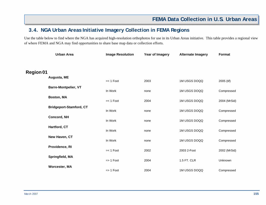
March 2007 155
FEMA Data Collection in U.S. Urban Areas
3.4. NGA Urban Areas Initiative Imagery Collection in FEMA Regions Use the table below to find where the NGA has acquired high-resolution orthophotos for use in its Urban Areas initiative. This table provides a regional view of where FEMA and NGA may find opportunities to share base map data or collection efforts.
Urban Area Image Resolution Year of Imagery Alternate Imagery Format
Region 01 Augusta, ME =< 1 Foot 2003 1M USGS DOQQ 2005 (tif) Barre-Montpelier, VT In Work none 1M USGS DOQQ Compressed Boston, MA =< 1 Foot 2004 1M USGS DOQQ 2004 (MrSid) Bridgeport-Stamford, CT In Work none 1M USGS DOQQ Compressed Concord, NH In Work none 1M USGS DOQQ Compressed Hartford, CT In Work none 1M USGS DOQQ Compressed New Haven, CT In Work none 1M USGS DOQQ Compressed Providence, RI =< 1 Foot 2002 2003 2-Foot 2002 (MrSid) Springfield, MA => 1 Foot 2004 1.5 FT. CLR Unknown Worcester, MA => 1 Foot 2004 1M USGS DOQQ Compressed

156 March 2007
FEMA Data Collection in U.S. Urban Areas Urban Area Image Resolution Year of Imagery Alternate Imagery Format
Region 02 Albany, NY =< 1 Foot 2004 2004 0.6-m Unknown Buffalo, NY => 1 Foot 2002 1M USGS DOQQ 2005 (tif) New York-Yonkers, NY-
Newark-Jersey City, NJ =< 1 Foot 2004 2002 1-Foot 2002 (MrSid) Poughkeepsie-Newburgh, NY =< 1 Foot 2004 1M USGS DOQQ Compressed Rochester, NY =< 1 Foot 2002 1M USGS DOQQ Compressed San Juan, PR =< 1 Foot 2004 1M USGS DOQQ Compressed Syracuse, NY =< 1 Foot 2003 2003 2-Foot Unknown Trenton, NJ =< 1 Foot 2002 1M USGS DOQQ Compressed
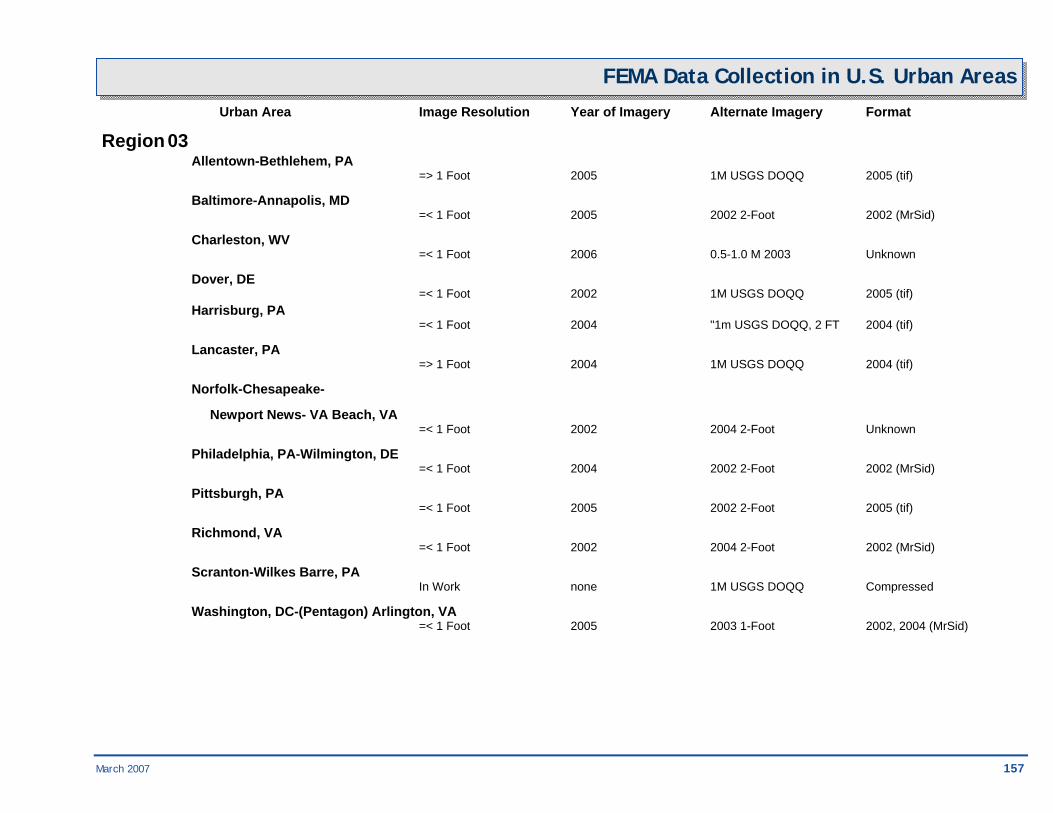
March 2007 157
FEMA Data Collection in U.S. Urban Areas Urban Area Image Resolution Year of Imagery Alternate Imagery Format
Region 03 Allentown-Bethlehem, PA => 1 Foot 2005 1M USGS DOQQ 2005 (tif) Baltimore-Annapolis, MD =< 1 Foot 2005 2002 2-Foot 2002 (MrSid) Charleston, WV =< 1 Foot 2006 0.5-1.0 M 2003 Unknown Dover, DE =< 1 Foot 2002 1M USGS DOQQ 2005 (tif) Harrisburg, PA =< 1 Foot 2004 "1m USGS DOQQ, 2 FT 2004 (tif) Lancaster, PA => 1 Foot 2004 1M USGS DOQQ 2004 (tif) Norfolk-Chesapeake-
Newport News- VA Beach, VA =< 1 Foot 2002 2004 2-Foot Unknown Philadelphia, PA-Wilmington, DE =< 1 Foot 2004 2002 2-Foot 2002 (MrSid) Pittsburgh, PA =< 1 Foot 2005 2002 2-Foot 2005 (tif) Richmond, VA =< 1 Foot 2002 2004 2-Foot 2002 (MrSid) Scranton-Wilkes Barre, PA In Work none 1M USGS DOQQ Compressed Washington, DC-(Pentagon) Arlington, VA =< 1 Foot 2005 2003 1-Foot 2002, 2004 (MrSid)
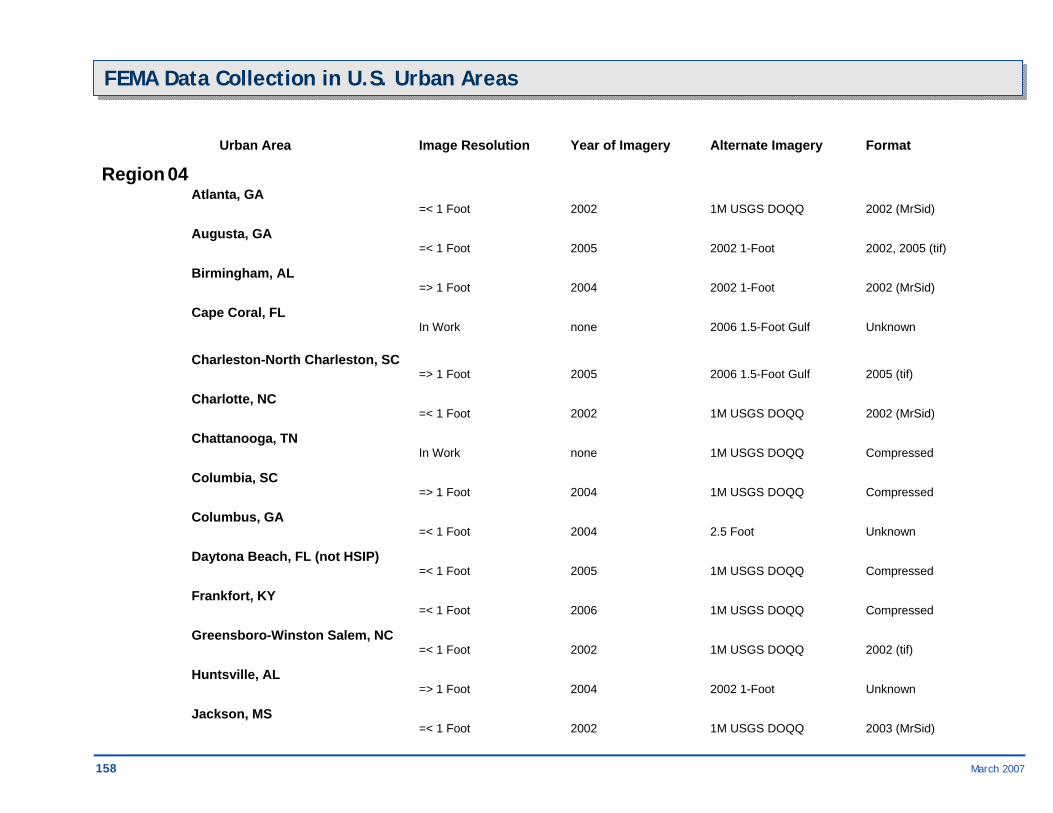
158 March 2007
FEMA Data Collection in U.S. Urban Areas
Urban Area Image Resolution Year of Imagery Alternate Imagery Format
Region 04 Atlanta, GA =< 1 Foot 2002 1M USGS DOQQ 2002 (MrSid) Augusta, GA =< 1 Foot 2005 2002 1-Foot 2002, 2005 (tif) Birmingham, AL => 1 Foot 2004 2002 1-Foot 2002 (MrSid) Cape Coral, FL In Work none 2006 1.5-Foot Gulf Unknown
Charleston-North Charleston, SC => 1 Foot 2005 2006 1.5-Foot Gulf 2005 (tif) Charlotte, NC =< 1 Foot 2002 1M USGS DOQQ 2002 (MrSid) Chattanooga, TN In Work none 1M USGS DOQQ Compressed Columbia, SC => 1 Foot 2004 1M USGS DOQQ Compressed Columbus, GA =< 1 Foot 2004 2.5 Foot Unknown Daytona Beach, FL (not HSIP) =< 1 Foot 2005 1M USGS DOQQ Compressed Frankfort, KY =< 1 Foot 2006 1M USGS DOQQ Compressed Greensboro-Winston Salem, NC =< 1 Foot 2002 1M USGS DOQQ 2002 (tif) Huntsville, AL => 1 Foot 2004 2002 1-Foot Unknown Jackson, MS =< 1 Foot 2002 1M USGS DOQQ 2003 (MrSid)
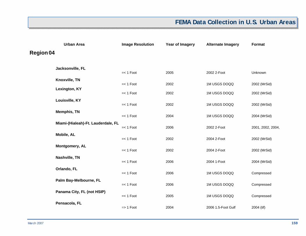
March 2007 159
FEMA Data Collection in U.S. Urban Areas
Urban Area Image Resolution Year of Imagery Alternate Imagery Format
Region 04
Jacksonville, FL =< 1 Foot 2005 2002 2-Foot Unknown Knoxville, TN =< 1 Foot 2002 1M USGS DOQQ 2002 (MrSid) Lexington, KY =< 1 Foot 2002 1M USGS DOQQ 2002 (MrSid) Louisville, KY =< 1 Foot 2002 1M USGS DOQQ 2002 (MrSid) Memphis, TN =< 1 Foot 2004 1M USGS DOQQ 2004 (MrSid) Miami-(Hialeah)-Ft. Lauderdale, FL =< 1 Foot 2006 2002 2-Foot 2001, 2002, 2004, Mobile, AL =< 1 Foot 2002 2004 2-Foot 2002 (MrSid) Montgomery, AL =< 1 Foot 2002 2004 2-Foot 2002 (MrSid) Nashville, TN =< 1 Foot 2006 2004 1-Foot 2004 (MrSid) Orlando, FL =< 1 Foot 2006 1M USGS DOQQ Compressed Palm Bay-Melbourne, FL =< 1 Foot 2006 1M USGS DOQQ Compressed Panama City, FL (not HSIP) =< 1 Foot 2005 1M USGS DOQQ Compressed Pensacola, FL => 1 Foot 2004 2006 1.5-Foot Gulf 2004 (tif)
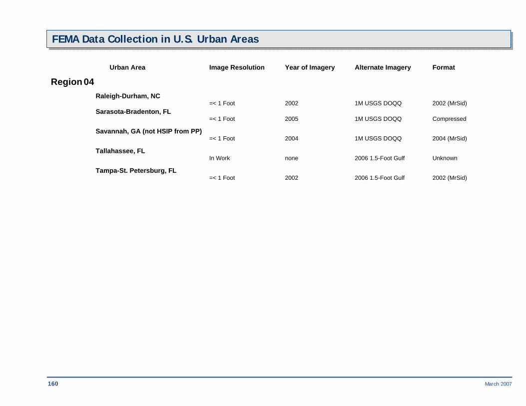
160 March 2007
FEMA Data Collection in U.S. Urban Areas
Urban Area Image Resolution Year of Imagery Alternate Imagery Format
Region 04 Raleigh-Durham, NC =< 1 Foot 2002 1M USGS DOQQ 2002 (MrSid) Sarasota-Bradenton, FL =< 1 Foot 2005 1M USGS DOQQ Compressed Savannah, GA (not HSIP from PP) =< 1 Foot 2004 1M USGS DOQQ 2004 (MrSid) Tallahassee, FL In Work none 2006 1.5-Foot Gulf Unknown Tampa-St. Petersburg, FL =< 1 Foot 2002 2006 1.5-Foot Gulf 2002 (MrSid)
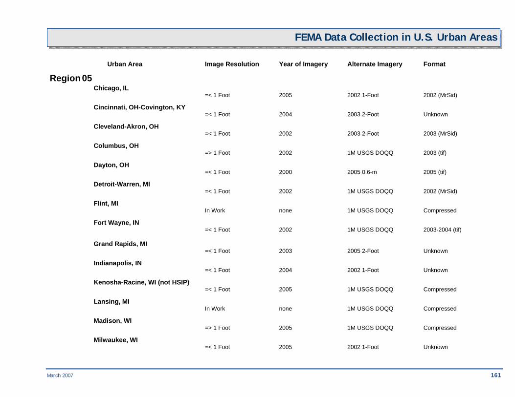
March 2007 161
FEMA Data Collection in U.S. Urban Areas Urban Area Image Resolution Year of Imagery Alternate Imagery Format
Region 05 Chicago, IL =< 1 Foot 2005 2002 1-Foot 2002 (MrSid) Cincinnati, OH-Covington, KY =< 1 Foot 2004 2003 2-Foot Unknown Cleveland-Akron, OH =< 1 Foot 2002 2003 2-Foot 2003 (MrSid) Columbus, OH => 1 Foot 2002 1M USGS DOQQ 2003 (tif) Dayton, OH =< 1 Foot 2000 2005 0.6-m 2005 (tif) Detroit-Warren, MI =< 1 Foot 2002 1M USGS DOQQ 2002 (MrSid) Flint, MI In Work none 1M USGS DOQQ Compressed Fort Wayne, IN =< 1 Foot 2002 1M USGS DOQQ 2003-2004 (tif) Grand Rapids, MI =< 1 Foot 2003 2005 2-Foot Unknown Indianapolis, IN =< 1 Foot 2004 2002 1-Foot Unknown Kenosha-Racine, WI (not HSIP) =< 1 Foot 2005 1M USGS DOQQ Compressed Lansing, MI In Work none 1M USGS DOQQ Compressed Madison, WI => 1 Foot 2005 1M USGS DOQQ Compressed Milwaukee, WI =< 1 Foot 2005 2002 1-Foot Unknown
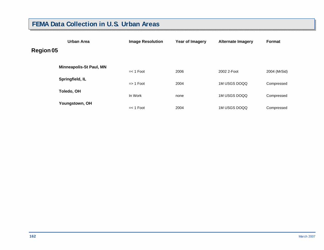
162 March 2007
FEMA Data Collection in U.S. Urban Areas
Urban Area Image Resolution Year of Imagery Alternate Imagery Format
Region 05
Minneapolis-St Paul, MN =< 1 Foot 2006 2002 2-Foot 2004 (MrSid) Springfield, IL => 1 Foot 2004 1M USGS DOQQ Compressed Toledo, OH In Work none 1M USGS DOQQ Compressed Youngstown, OH =< 1 Foot 2004 1M USGS DOQQ Compressed

March 2007 163
FEMA Data Collection in U.S. Urban Areas
Urban Area Image Resolution Year of Imagery Alternate Imagery Format
Region 06 Albuquerque, NM =< 1 Foot 2004 2002 1-Foot 2005 (MrSid) Amarillo, TX =< 1 Foot 2002 1M USGS DOQQ 2002 (MrSid) Austin, TX =< 1 Foot 2003 2003 1-Foot Unknown Baton Rouge, LA =< 1 Foot 2002 2006 1.5-Foot Gulf 2003 (tif) Corpus Christi, TX => 1 Foot 2004 1M USGS DOQQ 2005 (tif) Dallas-Ft. Worth-Arlington-
Garland-Irving, TX =< 1 Foot 2001 1M USGS DOQQ Compressed El Paso, TX =< 1 Foot 2002 1M USGS DOQQ 2002 (tif) Houston, TX =< 1 Foot 2004 2002 1-Foot 2003 (MrSid), 2004 (tif) Little Rock, AR => 1 Foot 2000 1M USGS DOQQ Compressed Lubbock, TX =< 1 Foot 2002 1M USGS DOQQ 2002 (MrSid) McAllen, TX =< 1 Foot 2002 1M USGS DOQQ Compressed New Orleans-Metairie, LA =< 1 Foot 2006 2002 1-Foot 2002 (MrSid) Oklahoma City, OK =< 1 Foot 2004 2002 1-Foot 2002 (MrSid) San Antonio, TX =< 1 Foot 2003 1M USGS DOQQ Unknown
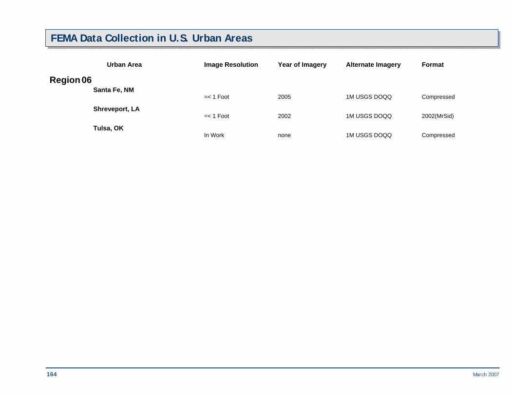
164 March 2007
FEMA Data Collection in U.S. Urban Areas Urban Area Image Resolution Year of Imagery Alternate Imagery Format
Region 06 Santa Fe, NM =< 1 Foot 2005 1M USGS DOQQ Compressed Shreveport, LA =< 1 Foot 2002 1M USGS DOQQ 2002(MrSid) Tulsa, OK In Work none 1M USGS DOQQ Compressed

March 2007 165
FEMA Data Collection in U.S. Urban Areas Urban Area Image Resolution Year of Imagery Alternate Imagery Format
Region 07 Des Moines, IA =< 1 Foot 2003 1M USGS DOQQ Compressed Jefferson City, MO =< 1 Foot 2002 1M USGS DOQQ Compressed Kansas City, MO-KS =< 1 Foot 2004 1M USGS DOQQ Compressed Lincoln, NE =< 1 Foot 2005 2002 1-Foot Unknown Omaha, NE =< 1 Foot 2004 1M USGS DOQQ Compressed St. Louis, MO =< 1 Foot 2004 2002 1-Foot 2002(MrSid) Topeka, KS =< 1 Foot 2002 1M USGS DOQQ Compressed Wichita, KS =< 1 Foot 2004 1M USGS DOQQ Compressed

166 March 2007
FEMA Data Collection in U.S. Urban Areas Urban Area Image Resolution Year of Imagery Alternate Imagery Format
Region 08 Bismarck, ND =< 1 Foot 2005 2001 6-in 2004 (MrSid) Cheyenne, WY =< 1 Foot 2005 1M USGS DOQQ Compressed Colorado Springs, CO =< 1 Foot 2002 1M USGS DOQQ 2002 (MrSid) Denver-Aurora, CO =< 1 Foot 2002 1M USGS DOQQ 2002 (MrSid) Helena, MT =< 1 Foot 2004 1M USGS DOQQ Compressed Pierre, SD =< 1 Foot 2005 1M USGS DOQQ Compressed Salt Lake City-Ogden, UT =< 1 Foot 2004 1M USGS DOQQ Compressed Yellowstone Nat. Park, WY-ID-MT Unknown Unknown Unknown Unknown
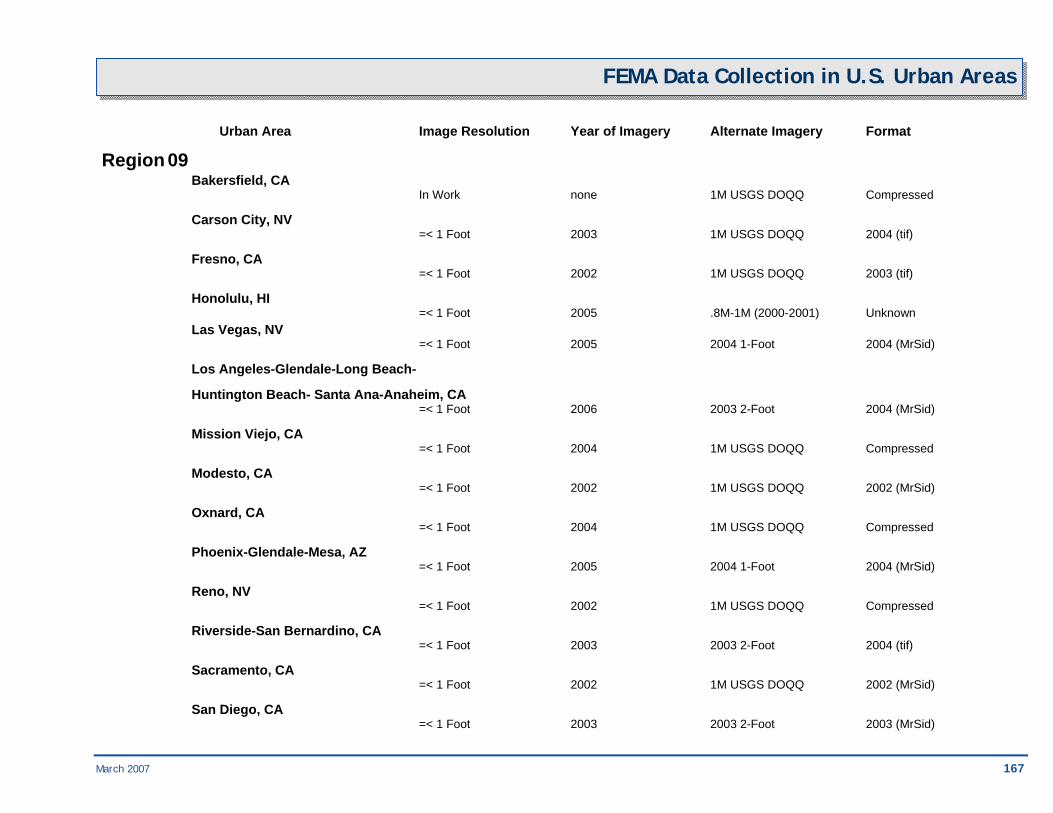
March 2007 167
FEMA Data Collection in U.S. Urban Areas Urban Area Image Resolution Year of Imagery Alternate Imagery Format
Region 09 Bakersfield, CA In Work none 1M USGS DOQQ Compressed Carson City, NV =< 1 Foot 2003 1M USGS DOQQ 2004 (tif) Fresno, CA =< 1 Foot 2002 1M USGS DOQQ 2003 (tif) Honolulu, HI =< 1 Foot 2005 .8M-1M (2000-2001) Unknown Las Vegas, NV =< 1 Foot 2005 2004 1-Foot 2004 (MrSid) Los Angeles-Glendale-Long Beach-
Huntington Beach- Santa Ana-Anaheim, CA =< 1 Foot 2006 2003 2-Foot 2004 (MrSid) Mission Viejo, CA =< 1 Foot 2004 1M USGS DOQQ Compressed Modesto, CA =< 1 Foot 2002 1M USGS DOQQ 2002 (MrSid) Oxnard, CA =< 1 Foot 2004 1M USGS DOQQ Compressed Phoenix-Glendale-Mesa, AZ =< 1 Foot 2005 2004 1-Foot 2004 (MrSid) Reno, NV =< 1 Foot 2002 1M USGS DOQQ Compressed Riverside-San Bernardino, CA =< 1 Foot 2003 2003 2-Foot 2004 (tif) Sacramento, CA =< 1 Foot 2002 1M USGS DOQQ 2002 (MrSid) San Diego, CA =< 1 Foot 2003 2003 2-Foot 2003 (MrSid)

168 March 2007
FEMA Data Collection in U.S. Urban Areas
Urban Area Image Resolution Year of Imagery Alternate Imagery Format
Region 09 San Francisco-Oakland-
San Jose-Fremont, CA =< 1 Foot 2004 2 FT CLR 2004 (MrSid) Stockton, CA =< 1 Foot 2002 1M USGS DOQQ 2002 (MrSid) Tucson, AZ =< 1 Foot 2002 1M USGS DOQQ Compressed

March 2007 169
FEMA Data Collection in U.S. Urban Areas
Urban Area Image Resolution Year of Imagery Alternate Imagery Format
Region 10 Anchorage, AK =< 1 Foot 2002 1M USGS DOQQ 2002 (MrSid) Boise, ID =< 1 Foot 2004 1M USGS DOQQ 2004 (tif) Fairbanks, AK Unknown Unknown Unknown Unknown Juneau, AK In Work none 1M USGS DOQQ Compressed Olympia, WA =< 1 Foot 2003 1M USGS DOQQ Compressed Portland, OR-Vancouver, WA =< 1 Foot 2002 1M USGS DOQQ 2002 (MrSid) Salem, OR =< 1 Foot 2005 1M USGS DOQQ Compressed Seattle-Tacoma, WA =< 1 Foot 2002 1M USGS DOQQ 2002 (MrSid) Spokane, WA =< 1 Foot 2003 1M USGS DOQQ Compressed Valdez, AK (not HSIP) Unknown Unknown 1M USGS DOQQ Compressed


March 2007 171

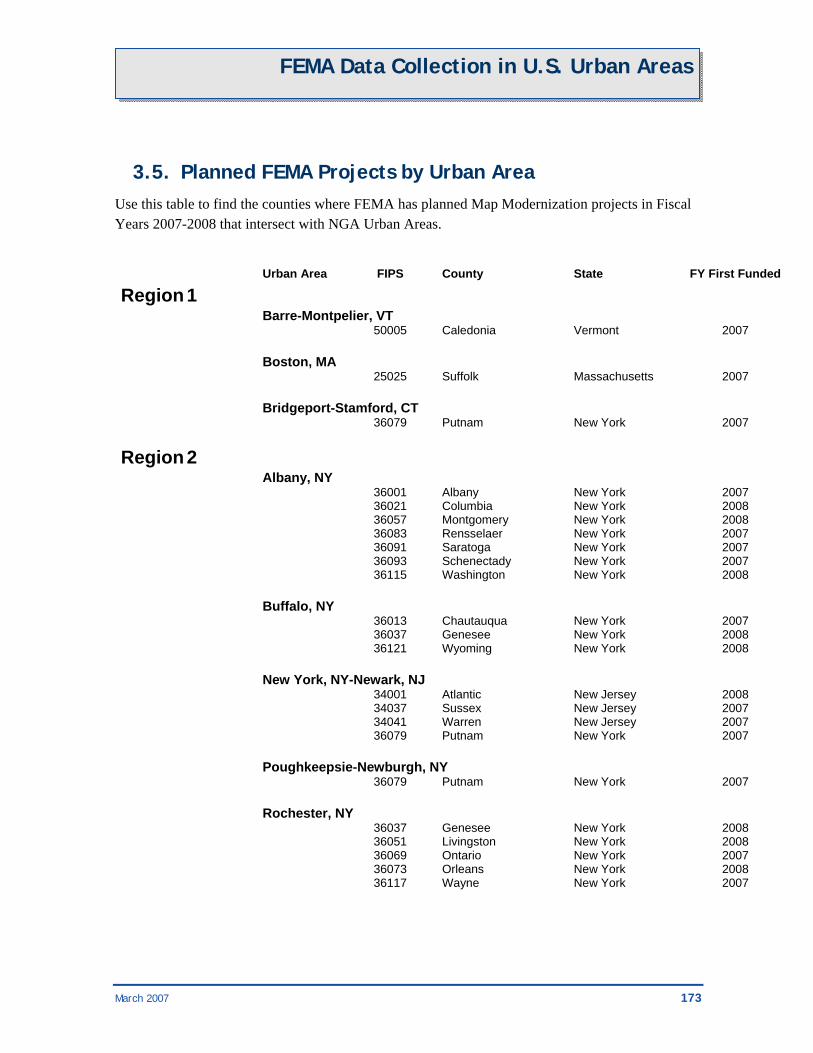
March 2007 173
FEMA Data Collection in U.S. Urban Areas
3.5. Planned FEMA Projects by Urban Area Use this table to find the counties where FEMA has planned Map Modernization projects in Fiscal Years 2007-2008 that intersect with NGA Urban Areas.
Urban Area FIPS County State FY First Funded Region 1 Barre-Montpelier, VT 50005 Caledonia Vermont 2007 Boston, MA 25025 Suffolk Massachusetts 2007 Bridgeport-Stamford, CT 36079 Putnam New York 2007 Region 2 Albany, NY 36001 Albany New York 2007 36021 Columbia New York 2008 36057 Montgomery New York 2008 36083 Rensselaer New York 2007 36091 Saratoga New York 2007 36093 Schenectady New York 2007 36115 Washington New York 2008 Buffalo, NY 36013 Chautauqua New York 2007 36037 Genesee New York 2008 36121 Wyoming New York 2008 New York, NY-Newark, NJ 34001 Atlantic New Jersey 2008 34037 Sussex New Jersey 2007 34041 Warren New Jersey 2007 36079 Putnam New York 2007 Poughkeepsie-Newburgh, NY 36079 Putnam New York 2007 Rochester, NY 36037 Genesee New York 2008 36051 Livingston New York 2008 36069 Ontario New York 2007 36073 Orleans New York 2008 36117 Wayne New York 2007
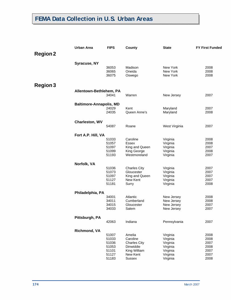
174 March 2007
FEMA Data Collection in U.S. Urban Areas
Urban Area FIPS County State FY First Funded Region 2 Syracuse, NY 36053 Madison New York 2008 36065 Oneida New York 2008 36075 Oswego New York 2008 Region 3 Allentown-Bethlehem, PA 34041 Warren New Jersey 2007 Baltimore-Annapolis, MD 24029 Kent Maryland 2007 24035 Queen Anne's Maryland 2008 Charleston, WV 54087 Roane West Virginia 2007 Fort A.P. Hill, VA 51033 Caroline Virginia 2008 51057 Essex Virginia 2008 51097 King and Queen Virginia 2007 51099 King George Virginia 2008 51193 Westmoreland Virginia 2007 Norfolk, VA 51036 Charles City Virginia 2007 51073 Gloucester Virginia 2007 51097 King and Queen Virginia 2007 51127 New Kent Virginia 2007 51181 Surry Virginia 2008 Philadelphia, PA 34001 Atlantic New Jersey 2008 34011 Cumberland New Jersey 2008 34015 Gloucester New Jersey 2007 34033 Salem New Jersey 2007 Pittsburgh, PA 42063 Indiana Pennsylvania 2007 Richmond, VA 51007 Amelia Virginia 2008 51033 Caroline Virginia 2008 51036 Charles City Virginia 2007 51053 Dinwiddie Virginia 2008 51101 King William Virginia 2007 51127 New Kent Virginia 2007 51183 Sussex Virginia 2008
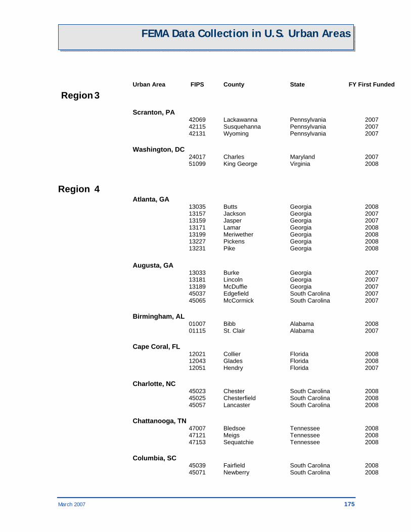
March 2007 175
FEMA Data Collection in U.S. Urban Areas
Urban Area FIPS County State FY First Funded Region 3 Scranton, PA 42069 Lackawanna Pennsylvania 2007 42115 Susquehanna Pennsylvania 2007 42131 Wyoming Pennsylvania 2007 Washington, DC 24017 Charles Maryland 2007 51099 King George Virginia 2008 Region 4 Atlanta, GA 13035 Butts Georgia 2008 13157 Jackson Georgia 2007 13159 Jasper Georgia 2007 13171 Lamar Georgia 2008 13199 Meriwether Georgia 2008 13227 Pickens Georgia 2008 13231 Pike Georgia 2008 Augusta, GA 13033 Burke Georgia 2007 13181 Lincoln Georgia 2007 13189 McDuffie Georgia 2007 45037 Edgefield South Carolina 2007 45065 McCormick South Carolina 2007 Birmingham, AL 01007 Bibb Alabama 2008 01115 St. Clair Alabama 2007 Cape Coral, FL 12021 Collier Florida 2008 12043 Glades Florida 2008 12051 Hendry Florida 2007 Charlotte, NC 45023 Chester South Carolina 2008 45025 Chesterfield South Carolina 2008 45057 Lancaster South Carolina 2008 Chattanooga, TN 47007 Bledsoe Tennessee 2008 47121 Meigs Tennessee 2008 47153 Sequatchie Tennessee 2008 Columbia, SC 45039 Fairfield South Carolina 2008 45071 Newberry South Carolina 2008
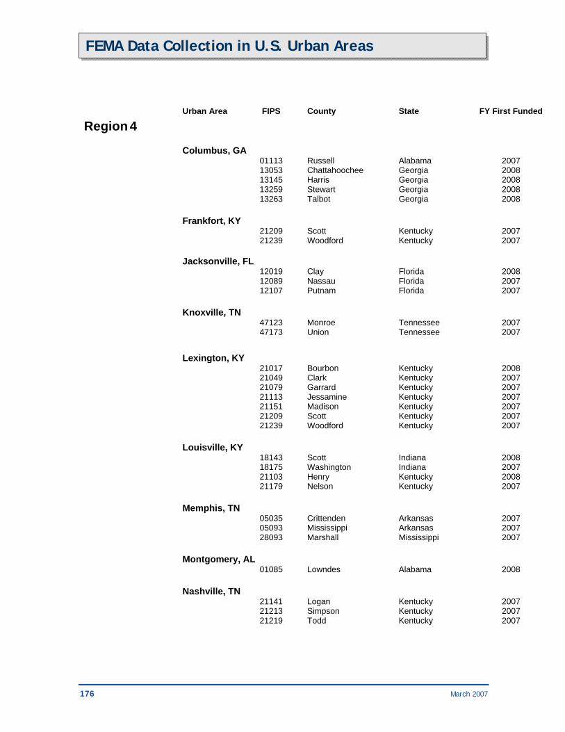
176 March 2007
FEMA Data Collection in U.S. Urban Areas
Urban Area FIPS County State FY First Funded Region 4 Columbus, GA 01113 Russell Alabama 2007 13053 Chattahoochee Georgia 2008 13145 Harris Georgia 2008 13259 Stewart Georgia 2008 13263 Talbot Georgia 2008 Frankfort, KY 21209 Scott Kentucky 2007 21239 Woodford Kentucky 2007 Jacksonville, FL 12019 Clay Florida 2008 12089 Nassau Florida 2007 12107 Putnam Florida 2007 Knoxville, TN 47123 Monroe Tennessee 2007 47173 Union Tennessee 2007 Lexington, KY 21017 Bourbon Kentucky 2008 21049 Clark Kentucky 2007 21079 Garrard Kentucky 2007 21113 Jessamine Kentucky 2007 21151 Madison Kentucky 2007 21209 Scott Kentucky 2007 21239 Woodford Kentucky 2007 Louisville, KY 18143 Scott Indiana 2008 18175 Washington Indiana 2007 21103 Henry Kentucky 2008 21179 Nelson Kentucky 2007 Memphis, TN 05035 Crittenden Arkansas 2007 05093 Mississippi Arkansas 2007 28093 Marshall Mississippi 2007 Montgomery, AL 01085 Lowndes Alabama 2008 Nashville, TN 21141 Logan Kentucky 2007 21213 Simpson Kentucky 2007 21219 Todd Kentucky 2007

March 2007 177
FEMA Data Collection in U.S. Urban Areas
Urban Area FIPS County State FY First Funded Region 4 Orlando, FL 12009 Brevard Florida 2008 12069 Lake Florida 2008 Palm Bay-Melbourne, FL 12009 Brevard Florida 2008 12061 Indian River Florida 2007 Sarasota-Bradenton, FL 12081 Manatee Florida 2008 Savannah, GA 45053 Jasper South Carolina 2007 Tallahassee, FL 12065 Jefferson Florida 2008 13087 Decatur Georgia 2007 13131 Grady Georgia 2007 13275 Thomas Georgia 2007 Tampa-St. Petersburg, FL 12081 Manatee Florida 2008
Region 5 Cincinnati, OH 18047 Franklin Indiana 2008 18155 Switzerland Indiana 2008 21081 Grant Kentucky 2008 39135 Preble Ohio 2008 39165 Warren Ohio 2008 Columbus, OH 39045 Fairfield Ohio 2007 39097 Madison Ohio 2007 39129 Pickaway Ohio 2007 Dayton, OH 39021 Champaign Ohio 2007 39023 Clark Ohio 2008 39027 Clinton Ohio 2007 39037 Darke Ohio 2008 39109 Miami Ohio 2008 39149 Shelby Ohio 2008 39165 Warren Ohio 2008 Detroit, MI 26115 Monroe Michigan 2007 Flint, MI 26155 Shiawassee Michigan 2007
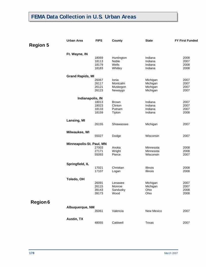
178 March 2007
FEMA Data Collection in U.S. Urban Areas
Urban Area FIPS County State FY First Funded Region 5 Ft. Wayne, IN 18069 Huntington Indiana 2008 18113 Noble Indiana 2007 18179 Wells Indiana 2008 18183 Whitley Indiana 2008 Grand Rapids, MI 26067 Ionia Michigan 2007 26117 Montcalm Michigan 2007 26121 Muskegon Michigan 2007 26123 Newaygo Michigan 2007 Indianapolis, IN 18013 Brown Indiana 2007 18023 Clinton Indiana 2007 18133 Putnam Indiana 2007 18159 Tipton Indiana 2008 Lansing, MI 26155 Shiawassee Michigan 2007 Milwaukee, WI 55027 Dodge Wisconsin 2007 Minneapolis-St. Paul, MN 27003 Anoka Minnesota 2008 27171 Wright Minnesota 2008 55093 Pierce Wisconsin 2007 Springfield, IL 17021 Christian Illinois 2008 17107 Logan Illinois 2008 Toledo, OH 26091 Lenawee Michigan 2007 26115 Monroe Michigan 2007 39143 Sandusky Ohio 2008 39173 Wood Ohio 2008 Region 6 Albuquerque, NM 35061 Valencia New Mexico 2007 Austin, TX 48055 Caldwell Texas 2007
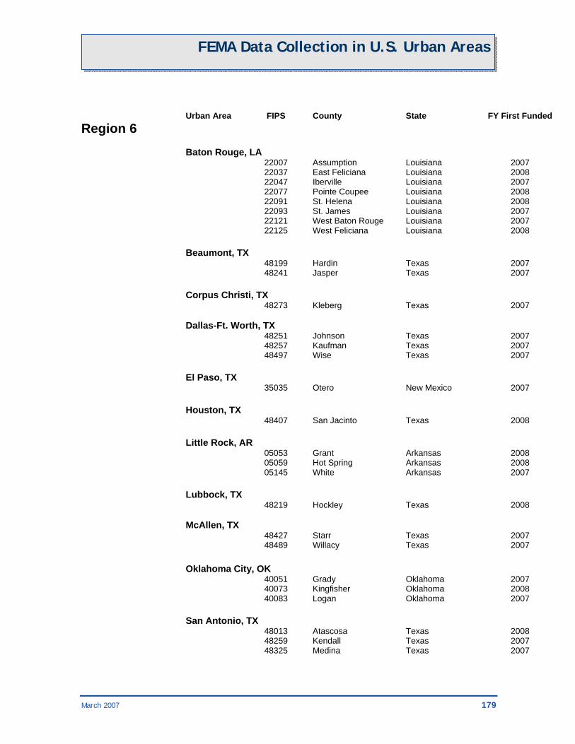
March 2007 179
FEMA Data Collection in U.S. Urban Areas
Urban Area FIPS County State FY First Funded Region 6 Baton Rouge, LA 22007 Assumption Louisiana 2007 22037 East Feliciana Louisiana 2008 22047 Iberville Louisiana 2007 22077 Pointe Coupee Louisiana 2008 22091 St. Helena Louisiana 2008 22093 St. James Louisiana 2007 22121 West Baton Rouge Louisiana 2007 22125 West Feliciana Louisiana 2008 Beaumont, TX 48199 Hardin Texas 2007 48241 Jasper Texas 2007 Corpus Christi, TX 48273 Kleberg Texas 2007 Dallas-Ft. Worth, TX 48251 Johnson Texas 2007 48257 Kaufman Texas 2007 48497 Wise Texas 2007 El Paso, TX 35035 Otero New Mexico 2007 Houston, TX 48407 San Jacinto Texas 2008 Little Rock, AR 05053 Grant Arkansas 2008 05059 Hot Spring Arkansas 2008 05145 White Arkansas 2007 Lubbock, TX 48219 Hockley Texas 2008 McAllen, TX 48427 Starr Texas 2007 48489 Willacy Texas 2007 Oklahoma City, OK 40051 Grady Oklahoma 2007 40073 Kingfisher Oklahoma 2008 40083 Logan Oklahoma 2007 San Antonio, TX 48013 Atascosa Texas 2008 48259 Kendall Texas 2007 48325 Medina Texas 2007

180 March 2007
FEMA Data Collection in U.S. Urban Areas
Urban Area FIPS County State FY First Funded Region 6 Shreveport, LA 22013 Bienville Louisiana 2008 22119 Webster Louisiana 2007 48203 Harrison Texas 2007 48365 Panola Texas 2008 Tulsa, OK 40101 Muskogee Oklahoma 2007 40111 Okmulgee Oklahoma 2007 40117 Pawnee Oklahoma 2008 40131 Rogers Oklahoma 2007 40145 Wagoner Oklahoma 2007 White Sands, NM 35035 Otero New Mexico 2007 Region 8 Colorado Springs, CO 08041 El Paso Colorado 2007 Denver, CO 08047 Gilpin Colorado 2007 Salt Lake City-Ogden, UT 49003 Box Elder Utah 2007 49029 Morgan Utah 2007 Region 9 Carson City, NV 32029 Storey Nevada 2007 32031 Washoe Nevada 2007 Reno, NV 06091 Sierra California 2007 32029 Storey Nevada 2007 32031 Washoe Nevada 2007
Region 10 Hood Canal, WA 53045 Mason Washington 2008 Olympia, WA 53045 Mason Washington 2008 Portland, OR 41071 Yamhill Oregon 2007 53059 Skamania Washington 2007
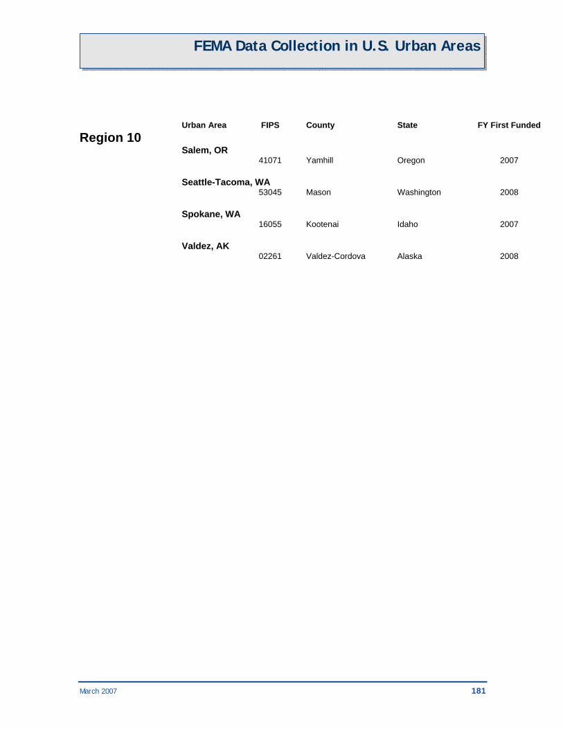
March 2007 181
FEMA Data Collection in U.S. Urban Areas
Urban Area FIPS County State FY First Funded Region 10 Salem, OR 41071 Yamhill Oregon 2007 Seattle-Tacoma, WA 53045 Mason Washington 2008 Spokane, WA 16055 Kootenai Idaho 2007 Valdez, AK 02261 Valdez-Cordova Alaska 2008


March 2007 183